

Federal Court of Australia
Stanbroke Pty Ltd v State Minister for the State of Queensland [2026] FCA 1468
File number: | QUD 184 of 2025 |
Judgment of: | MOSHINSKY J |
Date of judgment: | 30 September 2026 |
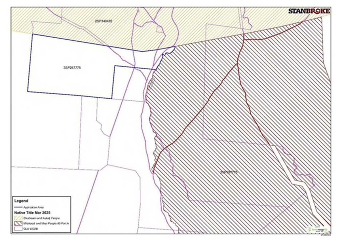
Date of publications of reasons: | 7 October 2026 |
Catchwords: | NATIVE TITLE – non-claimant application for determination that native title does not exist in respect of an area – where no native title determination covering the area – where no claimant application currently registered in respect of the area – where previous applications in respect of the area withdrawn or discontinued – where the relevant native title representative body did not appear to oppose the application – where no other person appeared to oppose the application despite public notification process – where evidence regarding use and recent history of the area consistent with native title not existing – determination made |
Legislation: | Native Title Act 1993 (Cth), ss 13, 61, 66 Land Act 1994 (Qld), s 164 |
Cases cited: | Mace v State of Queensland [2019] FCAFC 233; 274 FCR 41 Wagonga Local Aboriginal Land Council v Attorney General of New South Wales [2020] FCA 1113 |
Division: | General Division |
Registry: | Queensland |
National Practice Area: | Native Title |
Number of paragraphs: | 76 |
Date of hearing: | 30 September 2026 |
Counsel for the Applicant: | Mr J Sproule |
Solicitor for the Applicant: | Thynne & Macartney |
Counsel for the Respondent: | Ms H Blattman KC |
Solicitor for the Respondent: | Crown Law |
ORDERS
QUD 184 of 2025 | ||
| ||
BETWEEN: | STANBROKE PTY LTD (ACN 008 442 939) Applicant | |
AND: | STATE MINISTER FOR THE STATE OF QUEENSLAND Respondent | |
order made by: | MOSHINSKY J |
DATE OF ORDER: | 30 SEPTEMBER 2026 |
THE COURT DETERMINES THAT:
1. Native title does not exist in relation to the land and waters described as Lot 3 on Survey Plan 287775 (Tenure Reference TL 0/242148) excluding:
(a) any lands and waters subject to or within the external boundaries of QUD 556 of 2025 – Kum Sing on behalf of the Mitakoodi and Mayi People #5 v State of Queensland as determined by the Federal Court of Australia on 22 August 2024; and
(b) all land and waters within the external boundaries of QUD 29 of 2019 – George on behalf of the Gkuthaarn and Kukatj People v State of Queensland as determined by the Federal Court of Australia on 29 September 2020.
THE COURT ORDERS THAT:
2. There be no order as to costs.
Note: Entry of orders is dealt with in Rule 39.32 of the Federal Court Rules 2011.
REASONS FOR JUDGMENT
MOSHINSKY J:
Introduction
1 The applicant, Stanbroke Pty Ltd (Stanbroke), has applied for a determination that native title does not exist in relation to part of an area known as “Donors Hill South”, which is located in the Shire of Carpentaria local government area in Far North Queensland.
2 The precise description of the area that is the subject of this application is: Lot 3 on Survey Plan 287775 (Tenure Reference TL 0/242148), excluding:
(a) any lands and waters subject to or within the external boundaries of QUD 556 of 2025 – Kum Sing on behalf of the Mitakoodi and Mayi People #5 v State of Queensland as determined by the Federal Court of Australia on 22 August 2024; and
(b) all land and waters within the external boundaries of QUD 29 of 2019 – George on behalf of the Gkuthaarn and Kukatj People v State of Queensland as determined by the Federal Court of Australia on 29 September 2020,
(the Area).
3 The Area is approximately 18,200 hectares in size.
4 The application is made under s 61(1) of the Native Title Act 1993 (Cth). The application was commenced on 4 April 2025. The latest iteration of Stanbroke’s application is its amended application lodged on 14 July 2025 (the Application).
5 The Area is depicted in Attachment B to the Application, which is as follows:
6 In the above map, the Area is bounded by a blue line and has “3SP287775” written within it. It should be noted that the Area (as depicted by that blue line) does not comprise the whole of Lot 3 on Survey Plan 287775. In particular, the part of Lot 3 on Survey Plan 287775 that is the subject of the Mitakoodi and Mayi People #5 claim as determined by the Federal Court of Australia on 22 August 2024 is excluded from the definition of the Area (see [2(a)] above). The second exclusion (set out in [2(b)] above) is for the sake of clarity and out of abundance of caution.
7 The proceeding was the subject of a hearing on 30 September 2026. At the conclusion of the hearing, I granted the Application and made a determination that native title did not exist in relation to the Area. I said that I would publish my reasons later. The following are my reasons for making the determination.
Procedural matters
8 The proceeding was the subject of a case management hearing before me on 6 August 2026. At that hearing, I raised a number of questions with counsel for Stanbroke. These included whether it was feasible to obtain greater assurance that the relevant native title representative body (the Carpentaria Land Council) had received notice of the Application. I also asked whether it was feasible to have some evidence from relevant personnel at Stanbroke (as distinct from its solicitors) about how the Area has been used since Stanbroke became the lessee.
9 Following discussion at the case management hearing, orders were made requiring Stanbroke to personally serve the Carpentaria Land Council with the Application and certain other key documents. Further, an order was made that the Carpentaria Land Council notify the parties and the Court by 4.00 pm on 3 September 2026 if it wished to participate in the proceeding. An order was also made for Stanbroke to file and serve any further affidavit material and any supplementary submissions by 4.00 pm on 10 September 2026.
10 Stanbroke relies on the following affidavits:
(a) affidavits of Mark Boge (the solicitor acting for Stanbroke) dated 20 March 2026 and 6 August 2026;
(b) an affidavit of Brent Stevenson (the General Manager – Primary Production of Stanbroke) dated 18 September 2026;
(c) an affidavit of John Cameron (who formerly worked for Stanbroke) dated 18 September 2026; and
(d) an affidavit of Chanveer Singh (a solicitor) dated 14 August 2026, relating to service of documents on the Carpentaria Land Council.
11 The respondent, the State Minister for the State of Queensland (the State), does not oppose the Application. The State has filed an affidavit of Alyssa Kuether (a lawyer in the Office of the Crown Solicitor for the State of Queensland) dated 27 May 2026. The State has also filed an outline of submissions designed to assist the Court.
12 The evidence shows that, in addition to having been notified by mail by the National Native Title Tribunal (the Tribunal), the Carpentaria Land Council was personally served with the Application and certain other key documents, by the documents being hand delivered to Ryan Ellis, the Principal Legal Officer of the Carpentaria Land Council, on 12 August 2026. The Carpentaria Land Council has not sought to appear in the proceeding to oppose the Application.
13 No other person has sought to appear in the proceeding to oppose the Application.
Background facts and matters
Stanbroke
14 Stanbroke was previously known as Stanbroke Pastoral Company Pty Ltd. For ease of expression, I will refer to the company as “Stanbroke” in these reasons, regardless of whether it was called Stanbroke Pastoral Company Pty Ltd or its current name at the time.
15 Stanbroke is owned by members of the Menegazzo family, having been acquired by them in about September 2003. It was previously owned by AMP Limited.
Donors Hill
16 In about June 1968, Stanbroke acquired an area known as Donors Hill, which is situated in the Gulf country of north-west Queensland. At that time, Donors Hill was subject to Pastoral Development Holding No 70 and was described as Lot 70 on PH1136. On 21 October 1975, a new lease was created – Lot 2 on WON4. The lease was granted for a term of 50 years commencing on 1 October 1975 and expiring on 30 September 2025. Donors Hill was approximately 198,000 hectares in size.
17 On 3 August 2021, Donors Hill was sub-divided into two separate term leases for pastoral purposes:
(a) the northern portion of Donors Hill became Lot 2 on SP287775, known as “Donors Hill North” – 140,400 hectares in size; and
(b) the southern portion of Donors Hill became Lot 3 on SP287775, known as “Donors Hill South” – 57,760 hectares in size.
18 In relation to Donors Hill North (which is not part of the Application), I note the following:
(a) Donors Hill North has been converted to freehold tenure. It is now described as Lot 2 on SP340482.
(b) The northern portion of Donors Hill was the subject of a determination that native title does not exist made on 29 September 2020 in Phillip George and Anor on behalf of the Gkuthaarn and Kukatj People v State of Queensland (proceeding QUD29/2019) (the Gkuthaarn and Kukatj Determination).
(c) Prior to the Gkuthaarn and Kukatj Determination, an Indigenous Land Use Agreement with the Gkuthaarn and Kukatj People was negotiated and registered in which the Gkuthaarn and Kukatj People surrendered native title over the southern portion of their claim area including that part of Donors Hill subject to the Gkuthaarn and Kukatj claim (the Gkuthaarn and Kukatj Surrender ILUA). The Gkuthaarn and Kukatj Surrender ILUA was registered on 7 May 2019.
(d) The part of Donors Hill included in the surrendered area under the Gkuthaarn and Kukatj Surrender ILUA became Lot 2 on SP287775 and subsequently Lot 2 on SP340482.
(e) This proceeding does not relate to any land within Donors Hill North (Lot 2 on SP340482).
19 In relation to Donors Hill South, I note the following:
(a) Donors Hill South is subject to a rolling term lease within the meaning of s 164 of the Land Act 1994 (Qld).
(b) The lease was granted for a term of 30 years commencing on 10 August 2021 and expiring on 9 August 2051.
(c) Stanbroke is the registered lessee of the lease.
(d) On 24 November 2021, Stanbroke made an application under the Land Act to convert the tenure of Lot 3 on SP287775 from leasehold to freehold. Stanbroke received an offer of conversion from the Department of Resources (as it was then known) dated 5 April 2023. The offer was accepted by Stanbroke on 9 May 2023. The date for complying with the conditions of the offer has been extended to 31 March 2027.
(e) The offer of conversion is subject to a condition that Stanbroke address native title by either: a registered Indigenous Land Use Agreement evidencing the native title party’s consent to the surrender of native title over the conversion area; or an order of this Court that determines native title does not exist in relation to the land being converted.
20 The area that is the subject of the Application (referred to as “the Area” in these reasons) is the part of Donors Hill South that lies west of the Cloncurry River: see Mr Stevenson’s affidavit, para 11. As noted in the Introduction to these reasons, it is an area of approximately 18,200 hectares.
Notification of the Application
21 On 21 July 2025, Mr Boge received a letter by email from the Tribunal advising that a copy of the Application had been given to the State Government and the representative body for the area covered by the Application pursuant to ss 66(2) and 66(2A) of the Native Title Act.
22 On 20 August 2025, Mr Boge received a letter from the Tribunal which contains a list of persons and bodies who had been notified of the Application pursuant to s 66(3)(a) of the Native Title Act. The list notes that the Principal Legal Officer of Carpentaria Land Council received notice. The Tribunal publicly notified the Application in the Courier Mail and the Koori Mail on 27 August 2025. The notice specified a notification day of 10 September 2025 and identified the notification period as ending on 9 December 2025. The public notice also appeared on the Tribunal’s website.
No native title determination
23 On 17 December 2025, a search of the Register of Native Title Claims (the Register) conducted by the Tribunal found no relevant entries within the external boundary of the Application.
24 There is no approved determination of native title in relation to the Area within the meaning of s 13 of the Native Title Act.
25 Besides the Application, there are no applications seeking a determination of native title over the Area.
The Mitakoodi and Mayi #1 claim
26 This application seeking a determination of native title was:
(a) filed on 22 October 1996;
(b) recorded on the Register from 22 October 1996 to 4 January 2010; and
(c) dismissed on 8 December 2009.
27 The claim was amended in various ways on three occasions:
(a) 25 March 1999 – amended Form 1 filed (leave to amend granted 26 March 1999);
(b) 2 May 2003 – further amended Form 1 filed (leave to amend granted 20 June 2003); and
(c) 28 July 2006 – second further amended Form 1 filed (leave to amend granted 31 August 2006).
28 Among the amendments were changes to the claim group description and the name of the proceedings. The Mitakoodi and Mayi #1 claim was referred to as the Mitakoodi/Juhnjlar claim when filed until amendment in June 2003, after which it was described as the Mitakoodi #1 claim. The August 2006 amendments resulted in the claim being described as the Mitakoodi and Mayi #1 claim (although sometimes the “#1” was deleted).
29 The overlap of the Mitakoodi and Mayi #1 claim with the Area (approximately 17 square kilometres) is that part of the Area that lies between the Burke Development Road and the western bank of the Cloncurry River.
30 When filed, the western boundary of the Mitakoodi and Mayi #1 claim area insofar as it related to the Area was the Burke Development Road.
31 The western boundary of the Mitakoodi and Mayi #1 claim over the Area was amended in the second further amended Form 1 filed 28 July 2006 by adjusting the boundary eastwards to the western bank of the Cloncurry River.
32 In summary, to the extent that this native title application related to the Area, it was withdrawn (by amendment and before determination).
The Mitakoodi/Juhnjlar #2 claim
33 This application seeking a determination of native title was filed on 16 December 1996 and withdrawn on 3 April 1997.
34 The claim covered an area of approximately 31,592 square kilometres around Cloncurry, largely overlapping the Mitakoodi and Mayi #1 claim. This claim did not undergo the registration test, nor was the claim notified in accordance with s 66 of the Native Title Act.
35 In summary, this native title application (which related to part of the Area) was withdrawn.
The Page claim
36 This application seeking a determination of native title:
(a) was filed on 30 March 1998;
(b) was brought on behalf of the Pitta Pitta Clan Group, Kalkadoon Clan Group, Yulluna Clan Group, Mitakoodi Clan Group and Maiwali Karuwali Clan Group;
(c) covered an area of approximately 147,930 square kilometres;
(d) was not accepted for registration following consideration of the application on 20 May 1999 under the Tribunal’s abbreviated procedure for the registration test;
(e) was not notified in accordance with s 66 of the Native Title Act; and
(f) was discontinued on 30 September 1999.
37 In summary, this native title application (which related to the Area) was not accepted for registration by the Tribunal and was discontinued.
The Mitakoodi and Mayi #5 claim
38 This application seeking a determination of native title:
(a) was filed on 8 July 2015 by Queensland South Native Title Services;
(b) was accepted for registration on 25 September 2015;
(c) was notified in accordance with s 66 of the Native Title Act between 16 December 2015 and 15 March 2016; and
(d) resulted in consent determinations of native title on:
(i) 22 August 2024 over Part A – Kum Sing on behalf of the Mitakoodi and Mayi People #5 v State of Queensland (No 3) [2024] FCA 935; and
(ii) 20 February 2026 over Part B – Kum Sing on behalf of the Mitakoodi and Mayi People #5 v State of Queensland (No 4) [2026] FCA 118.
39 The Part A determination in the Mitakoodi and Mayi #5 claim includes the part of Donors Hill South excluded from the Area (as referred to in [2(a)] above).
No other claims
40 The native title applications described above are the only native title applications that have been made in relation to the Area: see Mr Boge’s first affidavit, para 27 and Ms Kuether’s affidavit, para 8.
41 There are no current native title applications in relation to the Area: see Mr Boge’s first affidavit, paras 22, 24 and Ms Kuether’s affidavit, para 8.
Mr Stevenson’s evidence
42 I make the following findings based on Mr Stevenson’s affidavit.
43 Mr Stevenson is the General Manager – Primary Production of Stanbroke, a position he has held since 19 July 2021. In that role he is responsible for the oversight and management of Stanbroke’s pastoral properties, including Donors Hill.
44 He commenced working for Stanbroke in 2002 as a Station Hand. From 2002 to 2010, he worked on various Stanbroke properties, working his way up through Leading Hand to becoming a Head Stockman.
45 During the period 2011 to 2017, he worked for another pastoral company.
46 In 2018, he was employed by Stanbroke as Maintenance Manager for Stanbroke’s Gulf properties. He was based at Stanbroke’s property, Kamilaroi, which is approximately 40 kilometres to the south-east of Donors Hill. In his position as Maintenance Manager, he was responsible for managing the infrastructure across all of Stanbroke’s properties in the Gulf country, including Donors Hill.
47 Since 2003, Stanbroke has undertaken a sustained and substantial program of capital investment in the development and improvement of Donors Hill. That program has been informed, in significant part, by Stanbroke’s commitment to animal welfare and to improving livestock performance outcomes, with the objective of ensuring that Donors Hill is operated and maintained to an excellent operational standard consistent with Stanbroke’s broader pastoral operations.
48 Donors Hill is operated as a single property with a single manager responsible for its daily operation. The administrative headquarters for Donors Hill is located on Donors Hill North, where the homestead, main sheds, yards and workers’ accommodation are situated.
49 Stanbroke employs 15 people on Donors Hill during the peak of the season and less than six during the wet season. In the period since 2003, Stanbroke has had two Indigenous employees on the property. They were employed for approximately 12 months in 2008/09 as part of the Beyond the Billabong Program. This was a program set up by the North Queensland cattleman Boyd Curram, aimed at giving Aboriginal young people life and work skills. One of the employees came from Doomadgee, a town located about 93 kilometres west of Burketown in Queensland, and the other from Kowanyama on the Cape of Carpentaria.
50 The Area is split into two parts by the Burke Development Road, which runs along a ridge. The road links Cloncurry and Normanton in a south-north direction and is the only road access to Donors Hill and the Area. The main entrance to Donors Hill from the Burke Development Road is located on Donors Hill North. During the 1990s, the road was partial gravel and bitumen. The road was progressively upgraded to widened bitumen in the mid-2000s.
51 During the wet season, access along the Burke Development Road is usually cut for weeks at a time to the north and south of Donors Hill, leaving the property isolated. It is usually cut north of Donors Hill at the Flinders Crossing at Walkers Bend and cut to the south of Donors Hill at the Cowan Flood Plain.
52 The part of the Area that is east of the Burke Development Road (to the Cloncurry River) is approximately 1,500 hectares in size. It is a mixture of gutter percha trees, Mitchell grass and Flinders grass, broken up by pebbly ridge. There are no permanent natural water holes in this area and the Cloncurry River runs dry during the dry season.
53 The part of the Area that is west of the Burke Development Road is approximately 16,500 hectares in size. It is yellow clay spear grass country broken by coolabah strips. It also has no permanent natural water holes. The country is all flat and has no rock formations or caves. This part of the Area does not flood.
54 In the period since 2003, Stanbroke has carried out an extensive program of infrastructure development on the Area, including:
(a) fencing and paddock subdivision – the re-fencing of boundary fences to ensure adequate containment of livestock, and the subdivision of paddocks by reference to land type, pasture type, terrain and water courses, so as to enable the management of smaller mobs of cattle and more effective pasture spelling and rotation;
(b) laneways – the construction of laneways to facilitate the efficient movement of cattle between paddocks, enabling more frequent access to fresh pasture and the spelling of other country;
(c) cattle handling infrastructure – the construction of additional cattle handling yards, positioned so as to reduce the distance cattle are required to walk to be processed;
(d) water infrastructure – the installation of additional water points and troughs so as to reduce the distance cattle are required to walk to access water and feed, thereby improving both animal welfare and pasture utilisation, together with the installation of additional tanks, poly pipelines and dams to provide greater water security during dry periods; and
(e) flood mitigation – the construction of refuge banks to enable cattle situated in low-lying areas to reach higher ground during flood events.
55 Employees move through the Area daily, either checking on stock or water points to ensure adequate water for cattle. Additionally, throughout the season, when mustering occurs, there will be teams of people and helicopters mustering the paddock and walking cattle through.
56 The Area is, and throughout the period of Stanbroke’s ownership has been, operated as a breeder operation within Stanbroke’s integrated, vertical supply chain.
57 The Area currently carries, and is capable of carrying, in the order of 1,200 head of cattle. This is comprised of, roughly, 100 head on the eastern side of the Burke Development Road and 1,100 head on the western side of the Burke Development Road. Progeny bred on the Area are moved through Stanbroke’s internal supply chain, transitioned down to backgrounding properties near Cloncurry or in the Western Downs Region, then transferred to Stanbroke’s feedlot in south-east Queensland for finishing, prior to processing at Stanbroke’s processing facility in the Lockyer Valley.
58 The managers of Stanbroke’s properties report to Mr Stevenson. Since 2021, there have been four different managers at Donors Hill.
59 Mr Stevenson gives evidence in his affidavit (which I accept) that:
22. I have not been advised by any of those managers of Donors Hill of any [I]ndigenous access to the … Area. Nor am I aware through those managers of any requests from [I]ndigenous people to access the … Area.
23. There is no access to the … Area by any third parties such as recreational shooters or campers.
Mr Cameron’s evidence
60 I make the following findings based on Mr Cameron’s affidavit.
61 Mr Cameron worked for Stanbroke from 1969 to 1995.
62 He first worked on Donors Hill in 1970 as the Head Stockman. He subsequently worked on other properties and returned to Donors Hill to manage the property from 1980 to 1990.
63 At the time he first started working on Donors Hill, the entire property was fully fenced. The Area in 1970 had a carrying capacity of approximately 1,500 head of cattle. In the 1980s, that capacity increased to approximately 2,500 head.
64 The Area is “breeder country” and was used solely for grazing cattle. The Area was old growth gidgee country during Mr Cameron’s time at Donors Hill; that is, it was a mixture of gidgee ironstone ridge country interspersed with coolibah black soil country. The grass in the Area includes Flinders grass, Mitchell grass and a large part of spinifex country. There are no natural water holes in the Area. The creeks run dry in the warmer and drier parts of the year. The Area would not have held cattle without the construction of watering points and dams.
65 In 1970, when Mr Cameron first worked on Donors Hill, the workforce comprised 15 people, seven of whom were Indigenous men. The men were all from Normanton and none of them spoke to Mr Cameron about their Indigenous heritage or their tribal affinity.
66 When he returned to manage Donors Hill in 1980, only one member of the workforce was Indigenous – a woman from Normanton who worked in the kitchen.
67 Mr Cameron never observed any Indigenous people fishing, hunting or moving about on Donors Hill when he worked there. This was different from other properties he had worked on such as Gregory Downs (located on the Gregory River south of Burketown in Queensland) and Rocklands (located on the Queensland/Northern Territory border near Camooweal), where he regularly observed Indigenous people.
68 Mr Cameron gives evidence in his affidavit (which I accept) that:
10. I was never told about any [I]ndigenous access to Donors Hill when I managed the property. Workers from Donors Hill would have been present in the … Area on a daily basis, carrying out their duties, during my time as manager. At the time, the Burke Development Road was a formed-up dirt road.
11. As far as I know, Donors Hill does not have any Aboriginal names for places like waterholes. I also did not hear anything about sacred sites, so I do not know if there are any. Again, this is different from other properties I have worked on.
Applicable principles
69 The principles applicable to an application for a determination that native title does not exist were considered by the Full Court of this Court in Mace v State of Queensland [2019] FCAFC 233; 274 FCR 41 at [33]-[98] per Jagot, Griffiths and Mortimer JJ.
70 The principles were also summarised by Jagot J in Wagonga Local Aboriginal Land Council v Attorney General of New South Wales [2020] FCA 1113 (Wagonga) at [10].
Consideration
71 Stanbroke has complied with all statutory requirements for a non-claimant application. Accordingly, the preconditions to the exercise of the Court’s power are met. I note that this is submitted in the State’s submissions, at para 35.
72 The question is whether Stanbroke has established on the balance of probabilities that native title does not exist in relation to the Area. This is to be assessed on the basis of the evidence before the Court. Relevant considerations include the nature of the land and the tenure involved, the presence or absence of any present or previous native title claims (and the nature and content of those claims), and any particular evidence adduced by the parties: Wagonga at [10].
73 In assessing these matters, it is necessary to take into account the gravity of a negative determination and its permanency: Wagonga at [10].
74 In my opinion, having regard to the following facts and matters, Stanbroke has discharged its burden of establishing on the balance of probabilities that native title does not exist in relation to the Area:
(a) There is no native title determination in respect of the Area.
(b) No claimant application is currently registered in respect of the Area.
(c) Despite public notification, and notice having been given to the appropriate representative body, no person has responded by claiming native title rights and interests in respect of the Area. In particular, the Carpentaria Land Council has not appeared to oppose the Application.
(d) All previous native title applications in relation to the Area have been either withdrawn or not accepted for registration and discontinued.
(e) The evidence of Mr Stevenson and Mr Cameron regarding the past usage of the Area is at least consistent with, if not supportive of, the proposition that native title does not exist in relation to the Area.
75 Having regard to these matters, I am satisfied that native title does not exist in relation to the Area.
Conclusion
76 It was for the above reasons that I made a determination on 30 September 2026 that native title did not exist in relation to the Area.
I certify that the preceding seventy-six (76) numbered paragraphs are a true copy of the Reasons for Judgment of the Honourable Justice Moshinsky. |
Associate:
Dated: 7 October 2026