
FEDERAL COURT OF AUSTRALIA
Wyles on behalf of the Gurambilbarra Wulgurukaba People for the GW Mada Claim v State Minister for Queensland [2025] FCA 833
File number: | QUD 176 of 2020 |
Judgment of: | MCDONALD J |
Date of judgment: | 24 July 2025 |
Catchwords: | NATIVE TITLE – consent determination of native title – agreement of parties – requirements of s 87 of Native Title Act 1993 (Cth) satisfied – orders made giving effect to determination of native title |
Legislation: | Corporations (Aboriginal and Torres Strait Islander) Act 2006 (Cth) s 29-5 Native Title Act 1993 (Cth) ss 55, 56, 61, 63, 66, 87, 94A, 190A, 190B, 190C, 225 Native Title (Prescribed Bodies Corporate) Regulations 1999 (Cth) reg 4 |
Cases cited: | Brown on behalf of the Ngarla People v Western Australia [2007] FCA 1025 Farrer on behalf of the Ngarrawanji Native Title Claim Group v Western Australia [2020] FCA 929 Forrest on behalf of the Kakarra Part A Claim Group v Western Australia (No 3) [2025] FCA 425 Lovett on behalf of the Gunditjmara People v Victoria [2007] FCA 474 Nelson v Northern Territory (2010) 190 FCR 344; [2010] FCA 1343 Tex on behalf of the Lappi Lappi and Ngulupi Claim Group v Western Australia [2018] FCA 1591 Wik and Wik Way Native Title Claim Group v Queensland (2009) 258 ALR 306; [2009] FCA 789 |
Division: | General Division |
Registry: | Queensland |
National Practice Area: | Native Title |
Number of paragraphs: | 47 |
Date of last submission: | 17 April 2025 |
Date of hearing: | Determined on the papers |
Solicitor for the Applicant: | North Queensland Land Council Native Title Representative Body Aboriginal Corporation |
Solicitor for the First Respondent: | Crown Law (Qld) |
Solicitor for the Second Respondent: | Australian Government Solicitor |
Solicitor for the Sixth, Seventh, Eighth and Ninth Respondents: | Atherton Tablelands Law |
Solicitor for the Tenth Respondent: | Corrs Chambers Westgarth |
Solicitor for the Eleventh Respondent: | Holding Redlich |
ORDERS
QUD 176 of 2020 | ||
| ||
BETWEEN: | VIRGINIA WYLES AND OTHERS ON BEHALF OF THE GURAMBILBARRA WULGURUKABA PEOPLE FOR THE GW MADA CLAIM Applicant | |
AND: | STATE MINISTER FOR THE STATE OF QUEENSLAND First Respondent COMMONWEALTH OF AUSTRALIA Second Respondent GREGORY KEITH BROOKING (and others named in the Schedule) Sixth Respondent | |
order made by: | MCDONALD J |
DATE OF ORDER: | 24 July 2025 |
THE COURT ORDERS BY CONSENT THAT:
1. There be a determination of native title in the terms set out below (Determination).
2. Each party to the proceedings bear its own costs.
THE COURT DETERMINES THAT:
3. The determination area is the land and waters described in Schedule 4 and depicted in the map attached to Schedule 6 to the extent those areas are within the External Boundary and not otherwise excluded by the terms of Schedule 5 (Determination Area). To the extent of any inconsistency between the written description and the map, the written description prevails.
4. Native title exists in the Determination Area.
5. The native title is held by the Gurambilbarra Wulgurukaba People described in Schedule 1 (Native Title Holders).
6. Subject to orders 8, 9 and 10 below the nature and extent of the native title rights and interests in relation to the land and waters described in Part 1 of Schedule 4 are the non-exclusive rights to:
(a) access, be present on, move about on and travel over the area;
(b) camp, and live temporarily on the area as part of camping, and for that purpose build temporary shelters;
(c) hunt, fish and gather on the land and waters of the area;
(d) access Natural Resources and take, for any purpose, Natural Resources from the area;
(e) take the Water of the area for personal, domestic and non-commercial communal purposes;
(f) conduct ceremonies on the area;
(g) bury Native Title Holders within the area;
(h) maintain places of importance and areas of significance to the Native Title Holders under their traditional laws and customs and protect those places and areas from physical harm;
(i) teach on the area the physical and spiritual attributes of the area;
(j) hold meetings on the area;
(k) light fires on the area for domestic purposes including cooking, but not for the purpose of hunting or clearing vegetation; and
(l) be accompanied on to the area by those persons who, though not Native Title Holders, are:
(i) spouses of Native Title Holders;
(ii) people who are members of the immediate family of a spouse of a Native Title Holder; or
(iii) people who are reasonably required by the Native Title Holders under traditional laws and customs for the performance of ceremonies or cultural activities on the area.
7. Subject to orders 8, 9 and 10 below the nature and extent of the native title rights and interests in relation to the land and waters described in Part 2 of Schedule 4 are the non-exclusive rights to:
(a) access, remain in, and use the area;
(b) access Natural Resources and take for any purpose, Natural Resources from the area;
(c) maintain places of importance and areas of significance to the Native Title Holders under their traditional laws and customs and protect those places and areas from physical harm; and
(d) be accompanied on to the area by those persons who, though not Native Title Holders, are:
(i) spouses of Native Title Holders;
(ii) people who are members of the immediate family of a spouse of a Native Title Holder; or
(iii) people who are reasonably required by the Native Title Holders under traditional laws and customs for the performance of ceremonies or cultural activities on the area.
8. The native title rights and interests referred to in orders 6 and 7 are subject to and exercisable in accordance with:
(a) the Laws of the State and the Commonwealth; and
(b) the traditional laws acknowledged and traditional customs observed by the Native Title Holders.
9. The native title rights and interests referred to in orders 6 and 7 do not confer possession, occupation, use or enjoyment to the exclusion of all others.
10. There are no native title rights in or in relation to minerals as defined by the Mineral Resources Act 1989 (Qld) and petroleum as defined by the Petroleum Act 1923 (Qld) and the Petroleum and Gas (Production and Safety) Act 2004 (Qld).
11. The nature and extent of any other interests in relation to the Determination Area (or respective parts thereof) are set out in Schedule 2.
12. The relationship between the native title rights and interests described in orders 6 and 7 and the other interests described in Schedule 2 (Other Interests) is that:
(a) the Other Interests continue to have effect, and the rights conferred by or held under the Other Interests may be exercised notwithstanding the existence of the native title rights and interests;
(b) to the extent the Other Interests are inconsistent with the continued existence, enjoyment or exercise of the native title rights and interests in relation to the land and waters of the Determination Area, the native title continues to exist in its entirety but the native title rights and interests have no effect in relation to the Other Interests to the extent of the inconsistency for so long as the Other Interests exist; and
(c) the Other Interests and any activity that is required or permitted by or under, and done in accordance with, the Other Interests, or any activity that is associated with or incidental to such an activity, prevail over the native title rights and interests and any exercise of the native title rights and interests.
13. The native title is held in trust.
14. The Gurambilbarra Wulgurukaba Aboriginal Corporation (ICN: 9181), incorporated under the Corporations (Aboriginal and Torres Strait Islander) Act 2006 (Cth), is to:
(a) be the prescribed body corporate for the purpose of ss 56(2)(b) and 56(3) of the Native Title Act 1993 (Cth); and
(b) perform the functions mentioned in s 57(1) of the Native Title Act 1993 (Cth) after becoming a registered native title body corporate.
15. In this Determination, unless the contrary intention appears:
“Animal” means any member of the animal kingdom (other than human), whether alive or dead;
“External Boundary” means the area described in Schedule 3;
“High Water Mark” has the meaning given in the Land Act 1994 (Qld);
“land” and “waters”, respectively, have the same meanings as in the Native Title Act 1993 (Cth);
“Laws of the State and the Commonwealth” means the common law and the laws of the State of Queensland and the Commonwealth of Australia, and includes legislation, regulations, statutory instruments, local planning instruments and local laws;
“Natural Resources” means:
(a) any Animals and Plants found on or in the lands and waters of the Determination Area; and
(b) any clays, soil, sand, gravel or rock found on or below the surface of the Determination Area,
but does not include:
(c) crops that are the private personal property of another;
(d) Animals that are the private personal property of another;
(e) minerals as defined in the Mineral Resources Act 1989 (Qld); or
(f) petroleum as defined in the Petroleum Act 1923 (Qld) and the Petroleum and Gas (Production and Safety) Act 2004 (Qld);
“Plant” means any member of the plant or fungus kingdom, whether alive or dead and standing or fallen;
“Water” means:
(a) water which flows, whether permanently or intermittently, within a river, creek or stream;
(b) any natural collection of water, whether permanent or intermittent;
(c) water from an underground water source; and
(d) tidal water;
“Works” has the same meaning as in the Electricity Act 1994 (Qld).
Note: Entry of orders is dealt with in Rule 39.32 of the Federal Court Rules 2011.
SCHEDULE 1: NATIVE TITLE HOLDERS
The native title holders are the Gurambilbarra Wulgurukaba People. The Gurambilbarra Wulgurukaba People are the biological and adopted descendants of one or more of the following people:
(a) Hilda Ambrym;
(b) Annie, mother of Peter Hegarty;
(c) Emily Underwood; and
(d) Jimmy White.
SCHEDULE 2: OTHER INTERESTS IN THE DETERMINATION AREA
The nature and extent of the other interests in relation to the Determination Area are the following as they exist as at the date of the Determination:
(1) The rights and interests of Ergon Energy Corporation Limited ACN 087 646 062:
(a) as the owner and operator of any Works within the Determination Area;
(b) as an electricity entity under the Electricity Act 1994 (Qld), including but not limited to:
(i) as the holder of a distribution authority;
(ii) to inspect, maintain and manage any Works in the Determination Area; and
(iii) in relation to any agreement or consent relating to the Determination Area existing or entered into before the date these orders are made; and
(iv) to enter the Determination Area by its employees, agents or contractors to exercise any of the rights and interests referred to in this clause.
(2) The rights and interests granted by the Commonwealth of Australia pursuant to statute and otherwise in the exercise of its executive power and under any regulations made pursuant to such legislation and including, for the avoidance of any doubt, but not limited to the “Defence Practice Area” otherwise declared and described as “Halifax Bay” in the Schedule to the Declaration of Defence Practice Areas made by the Minister for Defence pursuant to regulation 49 of the Defence Force Regulations 1952 (Cth) on 10 December 1997, and published in Commonwealth of Australia Gazette No. GN 8 on 25 February 1998.
(3) The rights and interests of the Australian Fisheries Management Authority in relation to plans of management made under the Fisheries Management Act 1991 (Cth), including for the Eastern Tuna and Billfish Fishery, the Eastern Skipjack Fishery and the Southern Bluefin Tuna Fishery.
(4) The rights and interests of the Great Barrier Reef Marine Park Authority and any other person existing by reason of the force of operation of:
(a) the Great Barrier Reef Marine Park Act 1975 (Cth);
(b) the Great Barrier Reef Marine Park Regulations 2019 (Cth);
(c) the Great Barrier Reef (Declaration of Amalgamated Marine Park Area) Proclamation 2004 (Cth); and
(d) the Great Barrier Reef Marine Park Zoning Plan 2003 (Cth).
(5) The rights and interests of the Port of Townsville Limited ABN 44 411 774 236, exercisable within its Port Limits, including:
(a) its powers, functions and responsibilities as a port under:
(i) the Transport Infrastructure Act 1994 (Qld) and regulations;
(ii) the Transport Operations (Marine Safety) Act 1994 (Qld) and regulations;
(iii) the Sustainable Ports Development Act 2015 (Qld) and regulations;
(iv) the Transport Operations (Marine Pollution) Act 1995 (Qld) and regulations;
(v) the Government Owned Corporations Act 1995 (Qld) and regulations;
(vi) the Coastal Protection and Management Act 1995 (Qld) and regulations;
(vii) the Planning Act 2016 (Qld) and regulations;
(viii) the Environmental Protection Act 1994 (Qld) and regulations;
(ix) the Land Act 1994 (Qld) and regulations;
(x) the Environment Protection and Biodiversity Conservation Act 1999 (Cth) and regulations;
(xi) the Environment Protection (Sea Dumping) Act 1981 (Cth) and regulations; and
(xii) any other Laws of the State and the Commonwealth applying to the powers, functions and responsibilities of a port,
including but not limited to, its rights and powers to own, use, operate, construct, maintain, and replace Port Facilities, berths, wharves, marinas, basins, channels, facilities, infrastructure, undertake and construct reclamation, dredging, earthworks, revetment and retaining walls, and other improvements within Port Limits in the Determination Area;
(b) the right to navigate and operate ships and boats within Port Limits located in the Determination Area;
(c) the rights of its employees, agents, contractors, lessees, sublessees, and licensees and Port Users to enter upon that part of the Determination Area located within Port Limits to exercise any of the functions, rights and interests referred to in this paragraph; and
(d) under any lease, sublease, licence or lawful authority related to that part of the Determination Area located within Port Limits.
(6) The rights and interests of the Port of Townsville Limited ABN 44 411 774 236 within or beyond the Port Limits to:
(a) dispose of dredge spoil; and
(b) undertake other activities in relation to operation of the Port; as authorised by any law of the State or the Commonwealth.
(7) In clauses 5 and 6:
(a) “Port of Townsville Limited ABN 44 411 774 236” includes its lawful successors;
(b) “Port User(s)” has the meaning given to that term in the Transport Infrastructure Act 1994 (Qld);
(c) “Port Limits” means the limits of the Port of Townsville as described in the Transport Infrastructure (Ports) Regulation 2016 (Qld); and
(d) “Port Facilities” has the meaning given to that term in the Transport Infrastructure Act 1994 (Qld).
(8) The rights and interests of the State of Queensland or any other person existing by reason of the force and operation of the laws of the State of Queensland, including those existing by reason of the following legislation or any regulation, statutory instrument, declaration, plan, authority, permit, lease or licence made, granted, issued or entered into under that legislation:
(a) the Fisheries Act 1994 (Qld);
(b) the Land Act 1994 (Qld);
(c) the Nature Conservation Act 1992 (Qld);
(d) the Forestry Act 1959 (Qld);
(e) the Water Act 2000 (Qld);
(f) the Petroleum Act 1923 (Qld) or the Petroleum and Gas (Production and Safety) Act 2004 (Qld);
(g) the Mineral Resources Act 1989 (Qld);
(h) the Planning Act 2016 (Qld);
(i) the Transport Infrastructure Act 1994 (Qld);
(j) the Fire and Emergency Services Act 1990 (Qld) or the Ambulance Service Act 1991 (Qld);
(k) the Marine Parks Act 2004 (Qld);
(l) the Coastal Protection and Management Act 1995 (Qld);
(m) the Transport Operations (Marine Safety) Act 1994 (Qld); and
(n) the Transport Operations (Marine Pollution) Act 1995 (Qld).
(9) The rights and interests of members of the public arising under the common law, including but not limited to the following:
(a) any subsisting public right to fish; and
(b) the public right to navigate.
(10) So far as confirmed pursuant to s 212(2) of the Native Title Act 1993 (Cth) and s 18 of the Native Title (Queensland) Act 1993 (Qld) as at the date of this determination, any existing rights of the public to access and enjoy the following places in the Determination Area:
(a) waterways;
(b) beds and banks or foreshores of waterways;
(c) coastal waters;
(d) beaches; or
(e) areas that were public places at the end of 31 December 1993.
(11) Any other rights and interests:
(a) held by the State of Queensland or the Commonwealth of Australia; or
(b) existing by reason of the force and operation of the Laws of the State and the Commonwealth.
SCHEDULE 3: EXTERNAL BOUNDARY
The Determination Area covers all the land and waters within the external boundary described as:
Commencing at the intersection of the centreline of Ross River and the High Water Mark of Cleveland Bay and extending northerly along that High Water Mark to the southernmost corner of Lot 302 on SP223346 (also being a point on the High Water Mark of Cleveland Bay), then generally north easterly and generally north westerly along that High Water Mark, across the mouths of any waterways flowing into Cleveland Bay, Rowes Bay, the Coral Sea or Halifax Bay between the seaward extremities at High Water Mark of each of the opposite banks of each such waterway to the centreline of Rollingstone Creek; then north easterly, generally south easterly and generally easterly to Cordelia Rocks (approximately Longitude 146.684407° East, Latitude 18.994857° South), passing through the following coordinate points:
Longitude (°East) | Latitude (°South) |
146.504010 | 18.947719 |
146.526666 | 18.965830 |
146.547891 | 18.980579 |
146.571634 | 18.990652 |
146.597177 | 18.997847 |
146.624158 | 18.999637 |
146.654017 | 18.999646 |
Then south to Longitude 146.684407° East, Latitude 18.996820° South; then due east along that line of Latitude to its intersection with Longitude 147.110361° East, then south westerly passing through coordinate point Longitude 146.955171° East, Latitude 19.151233° South back to the commencement point.
The Determination Area includes Lot 794 on SP308904.
Exclusions:
The Determination Area excludes:
(a) Cordelia Rocks and an area within a 100m buffer around those rocks;
(b) all land and waters subject to native title determination application QUD623/2016 Gurambilbarra Wulgurukaba People (QC2016/007) as accepted for registration on 4 October 2016. (Rattlesnake Island and Herald Island are specific exclusions); and
(c) the land and waters within the External Boundary which at the time the Determination application are, or had been, the subject of one or more surrenders of native title to which s 24EB(1)(d) of the Native Title Act 1993 (Cth) applies.
Data Reference and source
Application boundary compiled by National Native Title Tribunal based on information or instructions provided by the applicant.
Cadastral data (DCDB) sourced from DoR (QLD), 20 February 2023.
Rocks and reef locations sourced from Places Names Queensland sourced from DoR (QLD), 20 February 2023.
High Water Mark is as defined in the Queensland Land Act 1994 (Qld).
Cordelia Rocks 100m buffer calculated from Complete GBR Reef and Island Features dataset© Great Barrier Reef Marine Park Authority 2014.
Reference datum
Geographical coordinates have been provided by the NNTT Geospatial Services and are referenced to the Geocentric Datum of Australia 2020 (GDA2020), in decimal degrees and are based on the spatial reference data acquired from the various custodians at the time.
Use of Coordinates
Where coordinates are used within the description to represent cadastral or topographical boundaries or the intersection with such, they are intended as a guide only. As an outcome of the custodians of cadastral and topographic data continuously recalculating the geographic position of their data based on improved survey and data maintenance procedures, it is not possible to accurately define such a position other than by detailed ground survey.
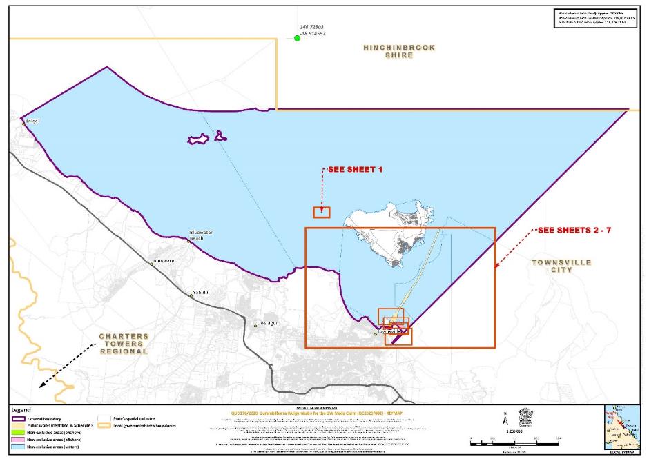
SCHEDULE 4: DESCRIPTION OF DETERMINATION AREA
The Determination Area comprises all of the land and waters described in Parts 1 and 2 below, to the extent that they are within the External Boundary and not otherwise excluded by the terms of Schedule 5.
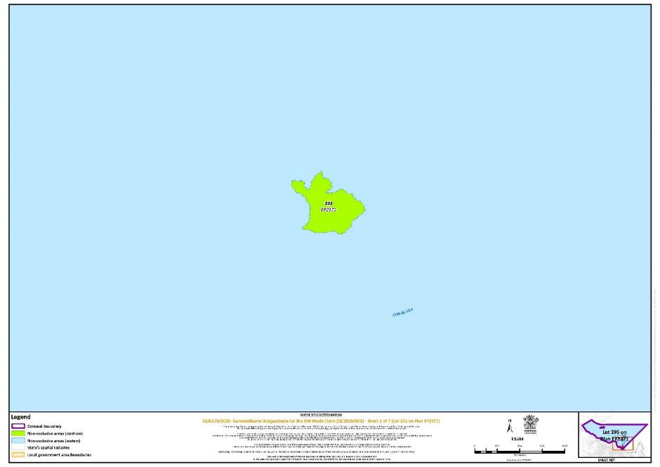
Part 1 – Non-Exclusive Areas (Onshore)
All of the land and waters described in the following table and depicted in green on the determination map in Schedule 6.
Area description (at time of Determination) | Determination Map Sheet Reference |
Lot 395 on Plan EP2371 | 1 |
Part 2 – Non-Exclusive Areas (Offshore)
(a) All of the land and waters below the High Water Mark and depicted in light blue on the determination map in Schedule 6; and
(b) All of the waters below the High Water Mark described in the following table by lots on plan, or relevant parts thereof, and depicted in pink on the determination map in Schedule 6:
Area description (at time of Determination) | Determination Map Sheet Reference |
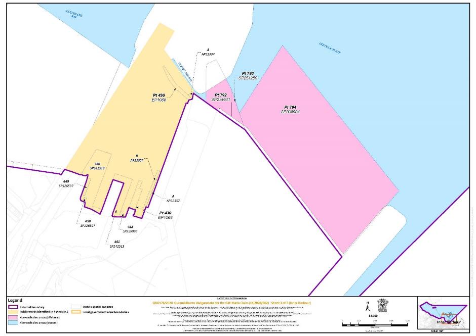
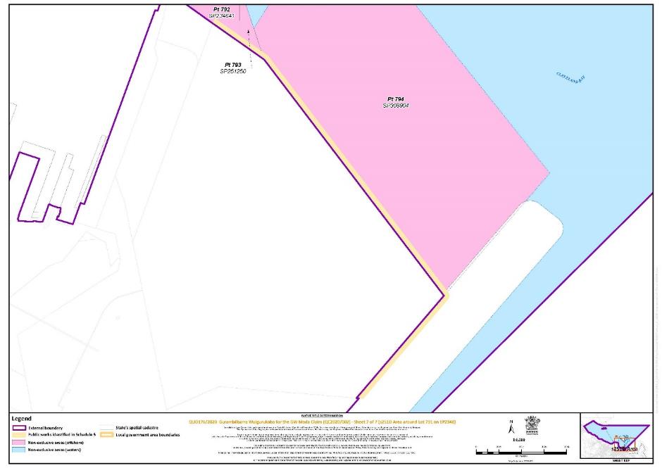
That part of Lot 792 on Plan SP234641 excluding an area of public works, as described in the second row of the table at paragraph 2 in schedule 5. | 3 |
That part of Lot 793 on Plan SP251250 excluding an area of public works, as described in the second row of the table at paragraph 2 in schedule 5. | 3 |
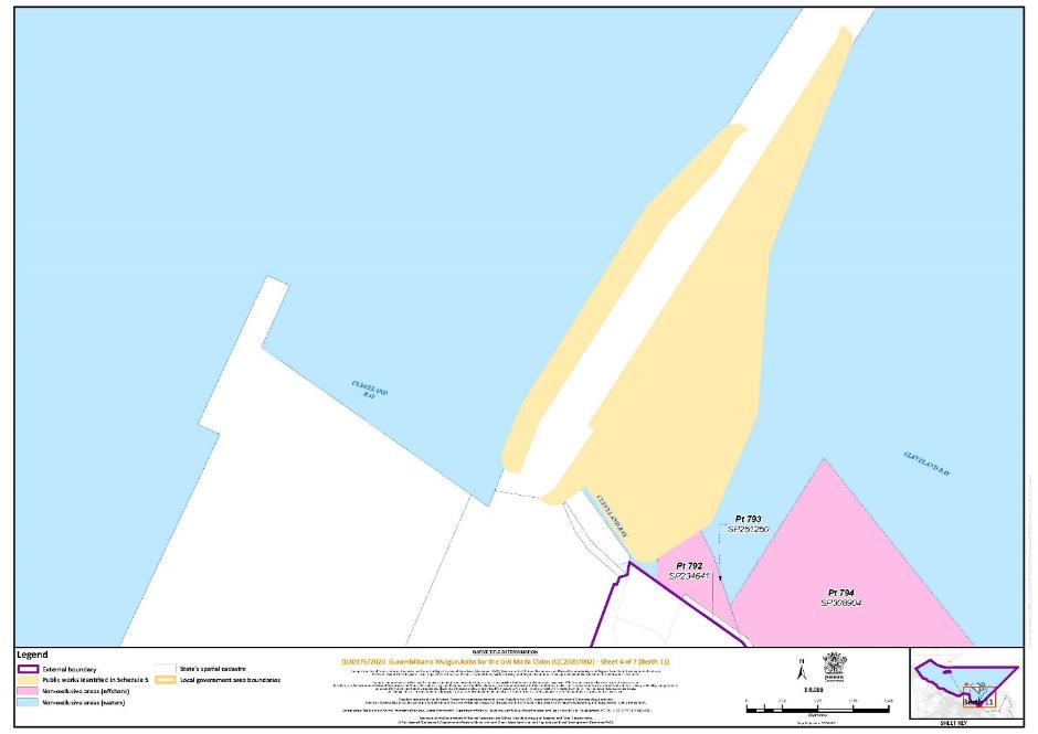
That part of Lot 794 on Plan SP308904 excluding an area of public works, as described in the second row of the table at paragraph 2 in schedule 5. | 3 |
SCHEDULE 5: AREAS NOT FORMING PART OF THE DETERMINATION AREA
The following areas of land and waters are excluded from the Determination Area as described in Schedule 4:
(1) The land and waters within the External Boundary which at the time the native title determination application was made were, or had been, the subject of one or more surrenders of native title to which s 24EB(1)(d) of the Native Title Act 1993 (Cth) applies.
(2) The land and waters within the External Boundary which at the time the native title determination application was made were, or had been, the subject of one or more Previous Exclusive Possession Acts, within the meaning of s 23B of the Native Title Act 1993 (Cth) as they could not be claimed in accordance with s 61A of the Native Title Act 1993 (Cth).
(3) Specifically, and to avoid any doubt, the land and waters described in (2) above includes the land and waters on which any public work, as defined in s 253 of the Native Title Act 1993 (Cth), is or was constructed, established or situated, and to which ss 23B(7) and 23C(2) of the Native Title Act 1993 (Cth) and s 21 of the Native Title (Queensland) Act 1993 (Qld), apply, together with any adjacent land or waters in accordance with s 251D of the Native Title Act 1993 (Cth), including the areas described in the table below and depicted in yellow in the map in Schedule 6:
Area description (at time of Determination) | Determination Map Sheet Reference | ||||||||||||||||||||||||||||||||||||||||||||||||||||||||||||||||||||||||||||||||||||||||||||||||||||||||||||||||||||||||||||||||||||||||||||||||||||||||||||||||||||||||||||||||||||||||||||||||||||||||||||||||||||||||||||||||||||||||||||||||||||||||||||||||||||||||||||||||||||||||||||||||||||||||||||||||||||||||||||||||||||||||||||||||||||||||||||||||||||||||||||||||||||||||||||||||||||||||||||||||||||||||||||||||||||||||||||||||||||||||||||||||||||||||||||||||||||||||||||||||||||||||||||||||||||||||||||||||||||||||||||||||||||||||||||||||||||||||||||||||||||||||||||||||||||||||||||||||||||||||||||||||||||||||||||||||||||||||||||||||||
1. Inner harbour between the eastern and western breakwaters, Townsville shaded yellow, in determination map, sheet 3, described as: | 3 | ||||||||||||||||||||||||||||||||||||||||||||||||||||||||||||||||||||||||||||||||||||||||||||||||||||||||||||||||||||||||||||||||||||||||||||||||||||||||||||||||||||||||||||||||||||||||||||||||||||||||||||||||||||||||||||||||||||||||||||||||||||||||||||||||||||||||||||||||||||||||||||||||||||||||||||||||||||||||||||||||||||||||||||||||||||||||||||||||||||||||||||||||||||||||||||||||||||||||||||||||||||||||||||||||||||||||||||||||||||||||||||||||||||||||||||||||||||||||||||||||||||||||||||||||||||||||||||||||||||||||||||||||||||||||||||||||||||||||||||||||||||||||||||||||||||||||||||||||||||||||||||||||||||||||||||||||||||||||||||||||||
Extending generally westerly along the High Water Mark from the High Water Mark at Longitude 146.834094° East, Latitude 19.253036° South to the High Water Mark at Longitude 146.833178° East, Latitude 19.252630° South
Extending generally westerly along the High Water Mark from the High Water Mark at Longitude 146.833106° East, Latitude 19.252827° South to the High Water Mark at Longitude 146.830220° East, Latitude 19.250273° South
which includes: Lot 449 on Plan SP126597; Lot 450 on Plan SP126597; Lot 460 on Plan SP242513; Lot 461 on Plan SP242513; Lot 462 on Plan SP259996; and That part of Lot 430 on Plan EP1068 within the External Boundary covered by an area of public works. | |||||||||||||||||||||||||||||||||||||||||||||||||||||||||||||||||||||||||||||||||||||||||||||||||||||||||||||||||||||||||||||||||||||||||||||||||||||||||||||||||||||||||||||||||||||||||||||||||||||||||||||||||||||||||||||||||||||||||||||||||||||||||||||||||||||||||||||||||||||||||||||||||||||||||||||||||||||||||||||||||||||||||||||||||||||||||||||||||||||||||||||||||||||||||||||||||||||||||||||||||||||||||||||||||||||||||||||||||||||||||||||||||||||||||||||||||||||||||||||||||||||||||||||||||||||||||||||||||||||||||||||||||||||||||||||||||||||||||||||||||||||||||||||||||||||||||||||||||||||||||||||||||||||||||||||||||||||||||||||||||||
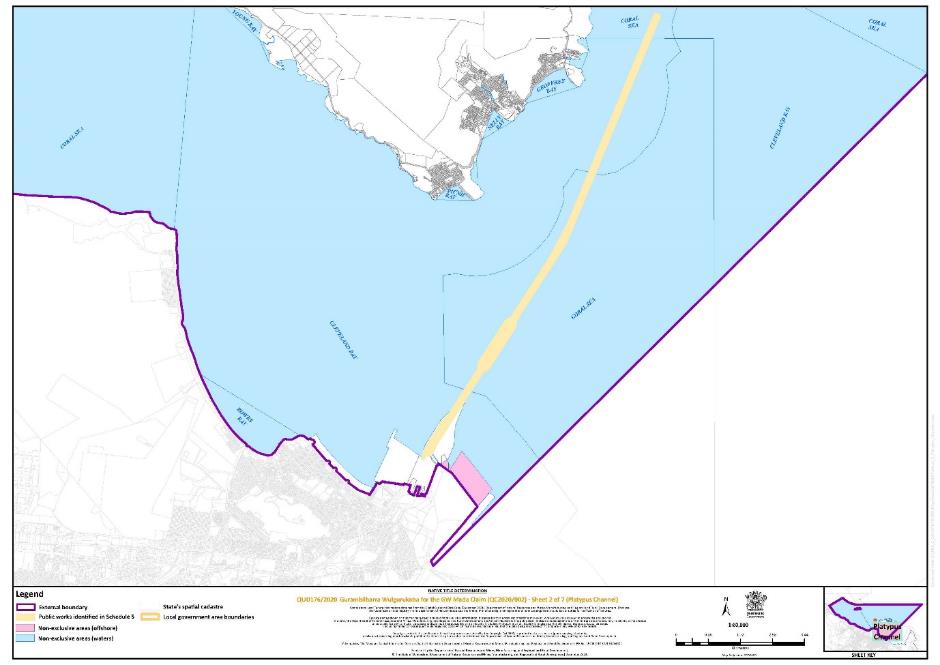
2. Section 251D area around Lot 791 on EP2348, shaded yellow, in determination map, sheet 7, described as:
which includes: That part of Lot 792 on Plan SP234641 covered by an area of public works; That part of Lot 793 on Plan SP251250 covered by an area of public works; and That part of Lot 794 on Plan SP308904 covered by an area of public works. | 7 | ||||||||||||||||||||||||||||||||||||||||||||||||||||||||||||||||||||||||||||||||||||||||||||||||||||||||||||||||||||||||||||||||||||||||||||||||||||||||||||||||||||||||||||||||||||||||||||||||||||||||||||||||||||||||||||||||||||||||||||||||||||||||||||||||||||||||||||||||||||||||||||||||||||||||||||||||||||||||||||||||||||||||||||||||||||||||||||||||||||||||||||||||||||||||||||||||||||||||||||||||||||||||||||||||||||||||||||||||||||||||||||||||||||||||||||||||||||||||||||||||||||||||||||||||||||||||||||||||||||||||||||||||||||||||||||||||||||||||||||||||||||||||||||||||||||||||||||||||||||||||||||||||||||||||||||||||||||||||||||||||||
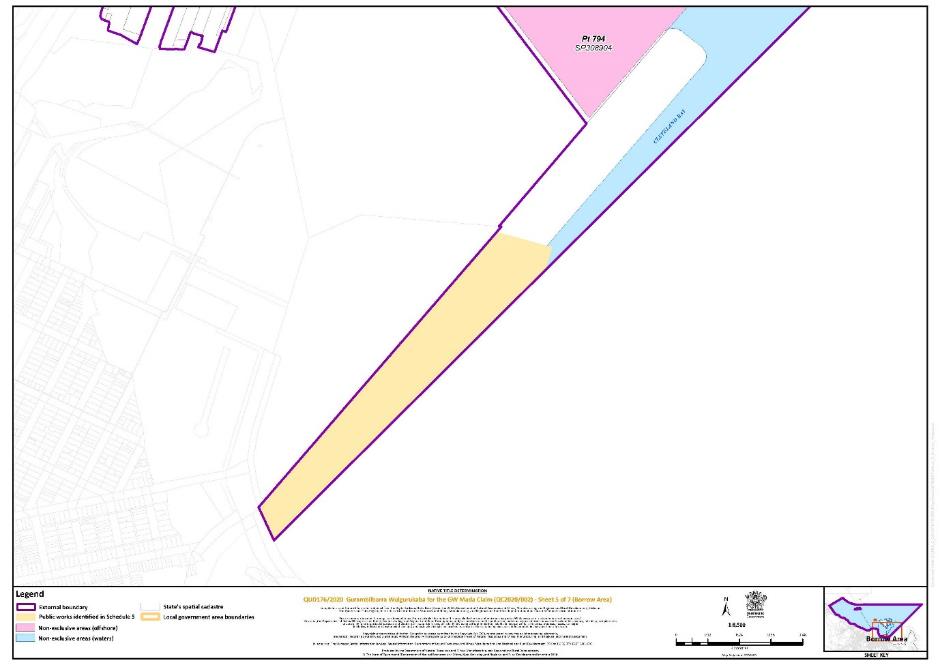
3. Borrow area adjacent to Lot 773 on Plan SP223346, shaded yellow, in determination map, sheet 5, described as:
| 5 | ||||||||||||||||||||||||||||||||||||||||||||||||||||||||||||||||||||||||||||||||||||||||||||||||||||||||||||||||||||||||||||||||||||||||||||||||||||||||||||||||||||||||||||||||||||||||||||||||||||||||||||||||||||||||||||||||||||||||||||||||||||||||||||||||||||||||||||||||||||||||||||||||||||||||||||||||||||||||||||||||||||||||||||||||||||||||||||||||||||||||||||||||||||||||||||||||||||||||||||||||||||||||||||||||||||||||||||||||||||||||||||||||||||||||||||||||||||||||||||||||||||||||||||||||||||||||||||||||||||||||||||||||||||||||||||||||||||||||||||||||||||||||||||||||||||||||||||||||||||||||||||||||||||||||||||||||||||||||||||||||||
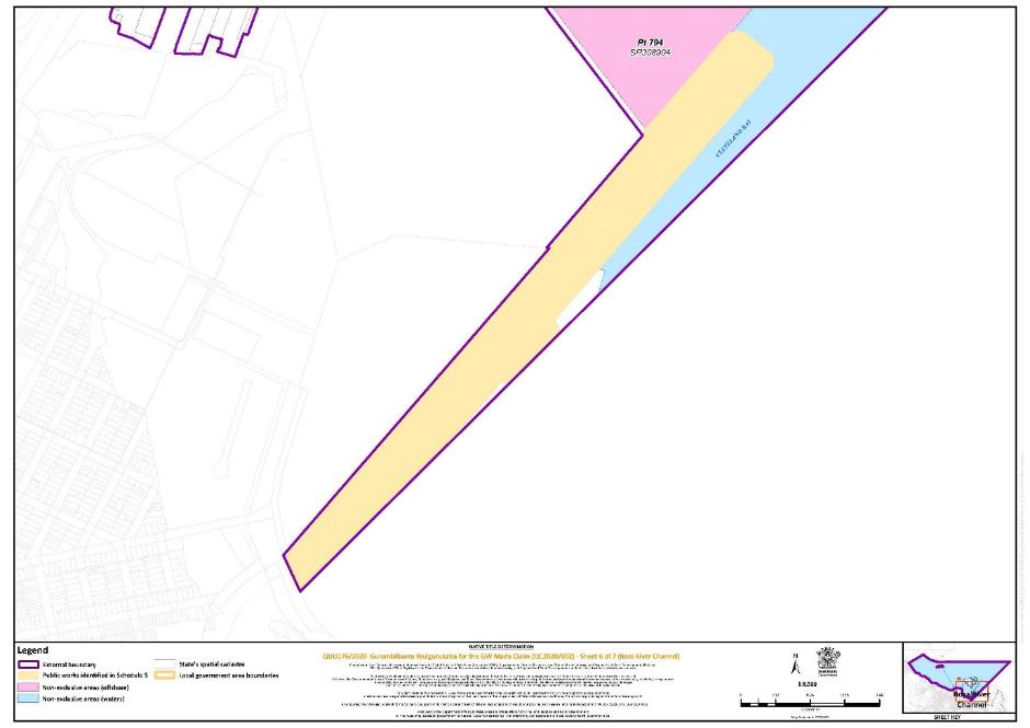
4. Channel extending from Ross River adjacent to Lot 773 on Plan SP223346, shaded yellow, in determination map, sheet 6, described as:
| 6 | ||||||||||||||||||||||||||||||||||||||||||||||||||||||||||||||||||||||||||||||||||||||||||||||||||||||||||||||||||||||||||||||||||||||||||||||||||||||||||||||||||||||||||||||||||||||||||||||||||||||||||||||||||||||||||||||||||||||||||||||||||||||||||||||||||||||||||||||||||||||||||||||||||||||||||||||||||||||||||||||||||||||||||||||||||||||||||||||||||||||||||||||||||||||||||||||||||||||||||||||||||||||||||||||||||||||||||||||||||||||||||||||||||||||||||||||||||||||||||||||||||||||||||||||||||||||||||||||||||||||||||||||||||||||||||||||||||||||||||||||||||||||||||||||||||||||||||||||||||||||||||||||||||||||||||||||||||||||||||||||||||
5. Platypus Channel, shaded yellow, in determination map, sheet 2, described as:
| 2 | ||||||||||||||||||||||||||||||||||||||||||||||||||||||||||||||||||||||||||||||||||||||||||||||||||||||||||||||||||||||||||||||||||||||||||||||||||||||||||||||||||||||||||||||||||||||||||||||||||||||||||||||||||||||||||||||||||||||||||||||||||||||||||||||||||||||||||||||||||||||||||||||||||||||||||||||||||||||||||||||||||||||||||||||||||||||||||||||||||||||||||||||||||||||||||||||||||||||||||||||||||||||||||||||||||||||||||||||||||||||||||||||||||||||||||||||||||||||||||||||||||||||||||||||||||||||||||||||||||||||||||||||||||||||||||||||||||||||||||||||||||||||||||||||||||||||||||||||||||||||||||||||||||||||||||||||||||||||||||||||||||
6. Berth No. 11 Port of Townsville, shaded yellow, in determination map, sheet 4, described as:
|
Reference datum
Geographical coordinates have been provided by the Port of Townsville and are Geographical coordinates referenced to the Geodetic Datum of Australia 2020 (GDA2020), in decimal degrees.
Use of Coordinates
Where coordinates are used within the description to represent cadastral or topographical boundaries or the intersection with such, they are intended as a guide only. As an outcome of the custodians of cadastral and topographic data continuously recalculating the geographic position of their data based on improved survey and data maintenance procedures, it is not possible to accurately define such a position other than by detailed ground survey.
SCHEDULE 6: MAP OF DETERMINATION AREA
REASONS FOR JUDGMENT
MCDONALD J:
Introduction
1 By an application filed on 5 June 2020 (and last amended on 14 July 2025) (Application) pursuant to s 61(1) of the Native Title Act 1993 (Cth), the Gurambilbarra Wulgurukaba people seek a determination of native title rights and interests over an area comprising land and waters in the vicinity of Townsville in North Queensland (Determination Area). The Application is made by eight named individuals ( applicant representatives) who have been authorised by the Gurambilbarra Wulgurukaba claim group (applicant) to make the Application on its behalf. The Application has been referred to as the “GW Mada Application” or the “GW Mada Claim”.
2 Since the filing of the Application, one of the original applicant representatives has died and has been replaced by another individual. The Application, as subsequently amended, is made by Virginia Wyles, Esalyn Ambrym, Gail Abrym, Brenton Creed, Gavin Kum Sing, Christina George, Pamela Petrina Hegarty and Florence Watson. The respondents to the Application are the State Minister for the State of Queensland (State), the Commonwealth, Gregory Keith Brooking, Neil Ashley Mogensen, Paul Thomas Newman, Starlaw Pty Ltd, Port of Townsville Ltd and Ergon Energy Corporation Ltd.
3 The parties now jointly seek orders for a determination of native title by consent in relation to the Determination Area pursuant to s 87 of the Native Title Act . A proposed consent determination reflecting an agreement between all parties as to the existence of native title rights and interests in the Determination Area (Agreement) was filed on 14 July 2025. Annexure A to the Agreement contains a draft of the orders sought, which are to the same effect as the orders set out above (Consent Determination Orders).
4 The Determination Area is described in Schedules 3 and 4 to the Consent Determination Orders and is depicted in the maps in Schedule 6. Areas that are within the external boundaries of the Determination Area but which are excluded from the Determination Area are identified in Schedule 5 to the Consent Determination Orders. The excluded areas include the land and waters that are the subject of the separate native title determination application in action QUD 623 of 2016.
5 The Determination Area is an area of sea country (including islands) off the coast of Townsville and around Magnetic Island. It is more precisely defined in the Consent Determination Orders but has been generally described by the applicant as the area defined by a boundary starting at the mid-point of the Ross River where it intersects with the high water mark of Cleveland bay; extending northwards along the coast until it reaches the midpoint of Rollingstone Creek; then extending seawards in a generally north east direction, until it intersects with the seaward boundary of the Manbarra people to the north; and then extending directly east until it intersects with a point directly north east of the starting location at Ross River.
6 For the reasons that follow, I am satisfied that orders to the effect of those sought by the parties should be made. The making of such orders is within the power of the Court and is appropriate in the circumstances of this case.
Procedural background and process towards consent determination
7 After the Application was filed, it was referred to the Native Title Registrar pursuant to s 63 of the Native Title Act. The Native Title Registrar considered the Application pursuant to s 190A of the Native Title Act and determined that it met the criteria set out in ss 190B and 190C. On 23 September 2020, the Application was notified by the Native Title Registrar pursuant to s 66 of the Native Title Act. The notification period ended on 22 December 2020.
8 On 26 March 2021, Reeves J made an order referring the matter to a registrar for case management. The applicant provided the State with material pertaining to the connection of the members of the claim group to the Determination Area (Connection Material) in the course of the case management process. All respondents were provided the opportunity to request a copy of the Connection Material and to conduct a review of the material. Only the Commonwealth exercised this option. The remaining respondents either did not engage with the Connection Material or stated that they would adopt the State’s position in relation to connection.
9 The discussions and negotiations that were encouraged by, and took place in the course of, the case management process resulted in the formation of the Agreement.
Material before the Court
10 The parties have filed the following documents in support of the Application:
(a) the Agreement, executed on behalf of the applicant and each of the respondents;
(b) written submissions in support of the Agreement, filed by the applicant on 17 April 2025; and
(c) an affidavit of the applicant’s solicitor, Ashley Jan, affirmed on 17 April 2025, in support of the applicant’s submissions, annexing copies of:
(i) a timetable for progressing matters towards a consent determination;
(ii) the Certificate of Registration, Rule Book and membership list for the Gurambilbarra Wulgurukaba Aboriginal Corporation;
(iii) an extract from the website of the Office of the Registrar of Indigenous Corporations;
(iv) a form of nomination and consent;
(v) a funeral notice for Iris Glenbar, one of the individuals originally authorised to make the Application, who died in September 2024;
(vi) a public notice published in the Townsville Bulletin, dated 9 November 2024;
(vii) a notification letter and meeting notice sent to the Gurambilbarra Wulgurukaba community, dated 6 November 2024; and
(viii) a document evidencing the consent of Gavin Kum Sing to act as an applicant representative in the Application, dated 6 December 2024.
11 Orders made by a registrar of the Court on 22 April 2025 permitted any of the respondents to file written submissions by 28 April 2025 should they wish to do so. None of the respondents has filed any submissions.
The claim group and the authorisation of the applicant representatives
12 The native title holders for the Determination Area are the Gurambilbarra Wulgurukaba people, who are described in Schedule 1 to the Consent Determination Orders as “the biological and adopted descendants of one or more of”: Hilda Ambrym; Annie, mother of Peter Hegarty; Emily Underwood; and Jimmy White. These apical ancestors are the same as those named in the Application.
13 Section 61(1) of the Native Title Act provides that a native title determination application may be made by:
A person or persons authorised [as defined by s 251B of the Native Title Act] by all the persons (the native title claim group) who, according to their traditional laws and customs, hold the common or group rights and interests comprising the particular native title claimed, provided the person or persons are also included in the native title claim group; …
14 Following a notification process, approximately 56 members of the Gurambilbarra Wulgurukaba people attended a meeting on 6 December 2024, at which the applicant representatives obtained authorisation from the native title claim group in the Application to agree to a draft of the Agreement. A resolution to this effect was passed at the meeting in accordance with an agreed and adopted decision-making process. The applicant representatives are therefore able to seek a native title determination under the Native Title Act .
Connection of the Gurambilbarra Wulgurukaba people to country
15 The Connection Material provided to the State and the Commonwealth consists of the following:
(a) report of an anthropologist, Daniel Leo, titled “Connection Report about the Gurambilbarra Wulgurukaba People of the Girringun Regional Society – Volume Two: Native Title Claim Group and its Continuity of Connection, Laws & Customs, And Rights & Interests”, dated 2016;
(b) report of Mr Leo titled “Connection Report about the Gurambilbarra Wulgurukaba People of the Girringun Regional Society – Volume One: Introduction, background, historical overview and pre-sovereignty society of the Townsville-Ayr area”, dated 2017;
(c) report of Mr Leo titled “Native Title Connection Report about Gurambilbarra Wulgurukaba Sea Country”, dated 2018;
(d) report of Mr Leo titled “Supplementary Gurambilbarra Wulgurukaba Connection Report”, dated 2018;
(e) report of Mr Leo titled “Addendum to the ‘Native Title Connection Report about Gurambilbarra Wulgurukaba Sea Country’”, dated 2021;
(f) supplementary mapping provided on 24 March 2022; and
(g) witness statements of Hayden Clifford Stewart Saltner dated 28 March 2023, Brian Johnson dated 29 March 2023, and Petrina Pamela Hegarty dated 3 April 2023.
16 The Connection Material has not been filed in the proceedings, but a summary of the accepted effect of the Connection Material is provided in Annexure A of the applicant’s submissions.
17 The applicant submits that the Connection Material establishes the acquisition and transfer of Gurambilbarra Wulgurukaba people’s cultural knowledge throughout the twentieth century. From this, it is reasonable to infer that the Gurambilbarra Wulgurukaba people today are descended from a community of people who spoke Gurambilbarra Wulgurukaba language and who used and occupied Gurambilbarra Wulgurukaba country prior to the date of the assertion of sovereignty by the Crown (being 26 January 1788).
18 The Connection Material identifies the Gurambilbarra Wulgurukaba ancestors in a community of Gurambilbarra Wulgurukaba people in the early days of European contact (ie, from the 1880s), and establishes the Gurambilbarra Wulgurukaba people today, and from soon after first European contact, as an organised society that possesses native title rights and interests in accordance with observed and acknowledged traditional laws and customs. The Connection Material is said to establish the intergenerational transfer of those laws and customs and to support an inference that they, and the rights possessed in accordance with them, have their origins in a pre-sovereignty society. The Gurambilbarra Wulgurukaba people have continued as a society and have continuously observed and acknowledged the traditional laws and customs of that society.
19 The Connection Material is further said to establish that, despite the impact of sustained settlement in the Determination Area, and the impacts of European settlement on the Gurambilbarra Wulgurukaba population, Gurambilbarra Wulgurukaba people have continued to possess native title in accordance with observed and acknowledged traditional laws and customs. Some of the laws and customs have adapted in response to the impacts of sustained European settlement, but it is still accurate to say that the rights and interests are possessed under the traditional laws and customs of the Gurambilbarra Wulgurukaba people.
20 Following its assessment of the Connection Material, on 23 June 2023, the State expressed that it was satisfied of the claim group’s connection to the Determination Area. The State’s acceptance of the applicant’s position after its rigorous assessment process enables me to have confidence in the correctness of the submissions made by the applicant. The Court is able to rely on the joint (or, as in this case, uncontested) submissions of the parties in relation to these matters: see, eg, Farrer on behalf of the Ngarrawanji Native Title Claim Group v Western Australia [2020] FCA 929 at [16]. I am satisfied that the State has sufficient information to be in a position to inform the Court that the State considers it appropriate for the Court to make orders to the effect of the Consent Determination Orders: Lovett on behalf of the Gunditjmara People v Victoria [2007] FCA 474 (Lovett) at [37]; Forrest on behalf of the Kakarra Part A Claim Group v Western Australia (No 3) [2025] FCA 425 at [46].
21 It is appropriate to record here some of the conclusions that are said (without demur) to arise from the Connection Material.
22 The members of the claim group identify themselves as Gurambilbarra Wulgurukaba, and are recognised by neighbouring groups as such. From first contact (and, by natural inference, since sovereignty), there were Aboriginal people in the area identified as the country of the Gurambilbarra Wulgurukaba people. The Gurambilbarra Wulgurukaba have been a seafaring people, utilising watercraft to access the sea around Townsville and Magnetic Island, and between there and the Palm Islands, since at least 1770. Identification with Gurambilbarra Wulgurukaba language remains an important marker of their identity.
23 The Gurambilbarra Wulgurukaba people are the southern-most of the groups forming a regional society associated with country extending northwards along the coast from Townsville. Their laws and customs are similar to, and derived from, the wider society known as the groups of the southern rainforest (Girringun) society, which incorporates neighbouring groups including Warrgamay, Girramay, Gulngay, Djiru, Mamu and Jirrbal. The traditional laws and customs have been acknowledged and observed by the pre-sovereignty society and each succeeding generation of that society, and that acknowledgement and observance has continued substantially uninterrupted since sovereignty.
24 The Gurambilbarra Wulgurukaba people identify themselves as separate from neighbouring groups, with social, cultural and linguistic differences from, as well as similarities to, those groups. Mr Leo has stated that:
“Gurambilbarra” has been accepted as another name for the land-and sea-owning grouping of Magnetic Island and the Townsville area. As such, “Gurambilbarra Wulgurukaba” and “Manbarra Wulgurukaba” are employed to highlight the linguistic, cultural, social and mythological commonalities between the two groupings while nonetheless distinguishing them as separate land- and sea-owning groupings.
25 Membership of the group is established by tracing back through either biological or adoptive descent to one of the known apical ancestors. The physical connection of the ancestors of the Gurambilbarra Wulgurukaba people to their country is demonstrated by, among other things, shell middens, burial sites, ancient rock art, and fish traps. Mr Leo has concluded that one of the lineages has maintained unbroken physical connection with the Determination Area and the others have maintained physical connection for many decades following earlier periods of interruption to physical connection. Traditional knowledge about identity and culture, and laws and customs, has been transmitted from generation to generation through a tradition of oral communication by elders (including elders from neighbouring groups). Members of the group speak of their spiritual connection to their country in the Determination Area, their obligations to look after this country and their knowledge of the spiritual stories connected with particular places in the Determination Area.
26 The laws and customs that are observed, and which have been documented in the anthropological reports of Mr Leo, include those relating to local organisation and sea and land tenure; group membership; religious beliefs; a regional system; a section system; punishment for transgressions; totemism; marriage; kinship; naming practices; age- and gender-based knowledge and authority; mythology; dispute settlements; avoidance behaviour; permission; and a system of subsistence based upon hunting, fishing, gathering, and knowledge of the medicinal value of natural resources and material culture.
Requirements of s 87 of the Native Title Act
27 It is an important purpose of s 87 of the Native TitleAct to encourage the parties to resolve native title proceedings without litigation: see, eg, Lovett at [36]; Tex on behalf of the Lappi Lappi and Ngulupi Claim Group v Western Australia [2018] FCA 1591 at [26]; Brown on behalf of the Ngarla People v Western Australia [2007] FCA 1025 at [22]-[23]. Section 87(1) sets out the circumstances in which the Court may make a consent determination in relation to native title rights and interests without holding a hearing. It provides as follows:
87 Power of Federal Court if parties reach agreement
Application
(1) This section applies if, at any stage of proceedings after the end of the period specified in the notice given under section 66:
(a) agreement is reached on the terms of an order of the Federal Court in relation to:
(i) the proceedings; or
(ii) a part of the proceedings; or
(iii) a matter arising out of the proceedings; and
(aa) all of the following are parties to the agreement:
(i) the parties to the proceedings;
(ii) the Commonwealth Minister, if the Commonwealth Minister is intervening in the proceedings at the time the agreement is made; and
(b) the terms of the agreement, in writing signed by or on behalf of the parties to the proceedings and, if subparagraph (aa)(ii) applies, the Commonwealth Minister, are filed with the Court; and
(c) the Court is satisfied that an order in, or consistent with, those terms would be within the power of the Court.
28 The notification day specified in the notice given under s 66 of the Native TitleAct , being 22 December 2020, has passed. The requirements of paragraphs (a) and (b) of s 87(1) are met by virtue of the Agreement, a copy of which has been filed with the Court.
29 To make the orders sought, I must also be satisfied that it is within the Court’s power to make orders in, or consistent with, the terms sought (Native Title Act, s 87(1)(c)) and that it would be appropriate to do so (Native TitleAct , s 87(1A)).
Does the Court have the power to make the orders sought?
30 It is within the power of the Court to make an order under s 87 of Native Title Act if the order “is consistent with s 94A of the [Native Title Act], the rights and interests included in the proposed determination are recognisable by the common law of Australia and there is no other determination in existence over the area the subject of the proposed determination”: Nelson v Northern Territory (2010) 190 FCR 344; [2010] FCA 1343 (Nelson) at 346 [4].
31 Under s 94A of the Native Title Act, “[a]n order in which the Federal Court makes a determination of native title must set out details of the matters mentioned in section 225”. Section 225 provides:
225 Determination of native title
A determination of native title is a determination whether or not native title exists in relation to a particular area (the determination area) of land or waters and, if it does exist, a determination of:
(a) who the persons, or each group of persons, holding the common or group rights comprising the native title are; and
(b) the nature and extent of the native title rights and interests in relation to the determination area; and
(c) the nature and extent of any other interests in relation to the determination area; and
(d) the relationship between the rights and interests in paragraphs (b) and (c) (taking into account the effect of this Act); and
(e) to the extent that the land or waters in the determination area are not covered by a non‑exclusive agricultural lease or a non‑exclusive pastoral lease—whether the native title rights and interests confer possession, occupation, use and enjoyment of that land or waters on the native title holders to the exclusion of all others.
(Note omitted.)
32 I am satisfied that the requirements of s 225 and consequently s 94A of the Native TitleAct are met because I am satisfied that the Consent Determination Orders:
(a) in order 5, state that the persons holding native title rights and interests in the Determination Area are the Gurambilbarra Wulgurukaba people described in Schedule 1 to the Consent Determination Orders;
(b) in orders 6-10, set out the nature and extent of the native title rights and interests in relation to the Determination Area;
(c) in Schedule 2, set out the nature and extent of any other interests in relation to the Determination Area;
(d) in order 12 and Schedule 2, consider the relationship between the rights and interests described in orders 6-10 and those described in Schedule 2;
(e) in order 6 and part 1 of Schedule 4, describe the areas within the Determination Area in which native title rights and interests are held non-exclusively by the Gurambilbarra Wulgurukaba people in relation to land and waters; and
(f) in order 7 and part 2 of Schedule 4, describe the areas within the Determination Area in which native title rights and interests are held non-exclusively by the Gurambilbarra Wulgurukaba people in relation to waters.
33 Having regard to the rights and interests which are identified in the Consent Determination Orders, I am satisfied that they are rights and interests that are capable of being recognised by the common law of Australia. I am also satisfied that there are no other determinations in existence over the Determination Area.
34 The Court therefore has the power to make orders, or consistent with, the terms sought.
Is it appropriate for the Court to make the orders sought?
35 In relation to s 87 of the Native Title Act, North J in Lovett said as follows (at [36]-[37]):
The focus of the section is on the making of an agreement by the parties. This reflects the importance placed by the [Native Title Act] on mediation as the primary means of resolving native title applications. Indeed, Parliament has established the National Native Title Tribunal with the function of conducting mediations in such cases. The [Native Title Act] is designed to encourage parties to take responsibility for resolving proceedings without the need for litigation. Section 87 must be construed in this context. The power must be exercised flexibly and with regard to the purpose for which the section is designed.
In this context, when the Court is examining the appropriateness of an agreement, it is not required to examine whether the agreement is grounded on a factual basis which would satisfy the Court at a hearing of the application. The primary consideration of the Court is to determine whether there is an agreement and whether it was freely entered into on an informed basis: Nangkiriny v State of Western Australia (2002) 117 FCR 6; [2002] FCA 660, Ward v State of Western Australia [2006] FCA 1848. Insofar as this latter consideration applies to a State party, it will require the Court to be satisfied that the State party has taken steps to satisfy itself that there is a credible basis for an application: Munn v Queensland (2001) 115 FCR 109; [2001] FCA 1229. …
36 Justice Reeves identified additional relevant considerations in Nelson (at 348 [14]), stating that:
… the process followed by the State party respondent, particularly how it goes about assessing the underlying evidence as to the existence of native title, is critical. Other critical factors, all directed to the processes that lead to the agreement and what was agreed, that have been previously identified by the Court include: whether the parties have independent and competent legal representation: Munn at [29], [39] and [40] and Lovett at [39]-[40]; whether the terms of the proposed order are unambiguous and clear: Munn at [32]; and whether the agreement has been preceded by a mediation process: Nangkiriny v Western Australia [2004] FCA 1156 at [6]; Close on behalf of the Githabul People v Minister for Lands [2007] FCA 1847 at [6] and Lovett at [41]-[42].
37 Having regard to these principles, I will be able to decide that it is appropriate to make the orders sought in this matter if I am satisfied that:
(a) there exists a free and informed agreement between the parties, which involves the State having taken steps to satisfy itself that there is a credible basis for the making of the determination;
(b) the parties have independent and competent legal representation;
(c) the terms of the proposed order are unambiguous and clear; and
(d) the agreement has been preceded by a mediation process.
38 On the material before me, I am satisfied that the parties entered into the Agreement freely and that, in doing so, they were informed by their involvement in an extended case management process which included negotiations and detailed analysis of the Connection Material. Whilst the Connection Material was not filed with the Court, in circumstances where the State has considered the Connection Material in detail and where no party has made any submission to the contrary, I find that the summary provided in Annexure A of the applicant’s written submissions and the information produced in the affidavit of Ashley Jan is sufficient to demonstrate that the Agreement is “rooted in reality”: see Wik and Wik Way Native Title Claim Group v Queensland (2009) 258 ALR 306; [2009] FCA 789 at 310 [16].
39 I am satisfied that the State has taken steps to ensure that there is a credible basis for the Consent Determination Orders, having taken an active role in the negotiation process which led to the formation of those orders.
40 The parties were legally represented throughout this process. I am satisfied that their representatives were independent and competent. I am also satisfied that the terms of the Consent Determination Orders are clear and unambiguous.
41 Accordingly, I find that, in addition to the Court having the power to make the orders sought, it is also appropriate for the Court to do so.
Nomination of a prescribed body corporate
42 If the Court proposes to make an approved determination as to the existence of native title, it must determine “whether the native title is to be held in trust, and if so, by whom”: N ative Title Act, ss 55, 56(1). The steps that the Court should take in making this determination are set out in s 56(2) of the Native Title Act, which in broad terms requires that the common law native title holders nominate a prescribed body corporate to hold the native title in trust.
43 The parties propose that the native title be held in trust by the Gurambilbarra Wulgurukaba Aboriginal Corporation, as a prescribed body corporate under s 56(2)(b) and (3) of the Native Title Act.
44 I am satisfied that the Gurambilbarra Wulgurukaba Aboriginal Corporation meets the requirements of reg 4 of the Native Title (Prescribed Bodies Corporate) Regulations 1999 (Cth) and is therefore a prescribed body corporate. In particular:
(a) the Gurambilbarra Wulgurukaba Aboriginal Corporation was incorporated and is registered under the Corporations (Aboriginal and Torres Strait Islander) Act 2006 (Cth) (CATSI Act) and so is an Aboriginal and Torres Strait Island corporation;
(b) the Gurambilbarra Wulgurukaba Aboriginal Corporation has among its objectives, as set out in cl 3(a) of its Rule Book, being and performing the functions of a prescribed body corporate pursuant to a determination under s 56 of the Native Title Act;
(c) all members of the Gurambilbarra Wulgurukaba Aboriginal Corporation are, and will in the future continue to be, persons who have native title rights and interests in relation to the Determination Area because, under cl 6.2.2 of the Rule Book, eligibility for membership is limited to “Common Law Holders”, who are at least 15 years of age, and that term is defined, in Schedule 1 to the Rule Book, in such a way that it refers to the Native Title Holders as defined in the Consent Determination Orders; and
(d) the Gurambilbarra Wulgurukaba Aboriginal Corporation meets the “Indigeneity requirement” in s 29-5 of the CATSI Act because its membership is limited to native title holders, who must all be Aboriginal or Torres Strait Islander persons.
45 At the meeting held on 6 December 2024, the native title claim group nominated the Gurambilbarra Wulgurukaba Aboriginal Corporation to be its registered native title body corporate for the purpose of these proceedings. The directors of the Corporation accepted the role and the obligations associated with this nomination at a meeting held on 11 April 2025. I am therefore satisfied that the requirements of s 56(2)(b) of the Native Title Act are met and it is appropriate to make orders 14 and 15 of the Consent Determination Orders.
Conclusion
46 The Agreement and the Consent Determination Orders, which give effect to it, acknowledge that the Gurambilbarra Wulgurukaba people have always held, and continue to hold, native title rights and interests in the Determination Area.
47 For the reasons that I have explained, I make the Consent Determination Orders in the terms set out at the beginning of these reasons.
I certify that the preceding forty-seven (47) numbered paragraphs are a true copy of the Reasons for Judgment of the Honourable Justice McDonald . |
Associate:
Dated: 24 July 2025
SCHEDULE OF PARTIES
QUD 176 of 2020 | |
Authorised representatives of the Gurambilbarra Wulgurukaba People for the GW Mada Claim | |
VIRGINIA WYLES | |
CHRISTINA GEORGE | |
BRENTON CREED | |
FLORENCE WATSON | |
PAMELA PETRINA HEGARTY | |
GAIL AMBRYM | |
ESALYN AMBRYM | |
GAVIN KUM SING | |
Respondents | |
Seventh Respondent: | NEIL ASHLEY MOGENSEN |
Eighth Respondent: | PAUL THOMAS NEWMAN |
Ninth Respondent: | STARLAW PTY LTD |
Tenth Respondent: | PORT OF TOWNSVILLE LIMITED |
Eleventh Respondent: | ERGON ENERGY CORPORATION LIMITED ACN 087 646 062 |

