
Federal Court of Australia
The Nyamal Palyku Proceeding (No 8) [2024] FCA 11
ORDERS
DATE OF ORDER: |
THE COURT NOTES THAT:
A. The applicant in proceedings WAD 20 of 2019 has made a native title determination application (Nyamal Application).
B. The applicant in proceedings WAD 23/2019 has made a native title determination application (Palyku #1 Application).
C. The applicant in proceedings WAD 483 of 2018 has made a native title determination application (Palyku #2 Application).
D. The Palyku #1 Application and the Palyku #2 Application are entirely overlapped by the Nyamal Application.
E. By orders of the Federal Court made on 9 November 2020 (as amended on 7 May 2021), pursuant to s 67(1) of the Native Title Act 1993 (Cth) and r 30.11 of the Federal Court Rules 2011 (Cth), the Nyamal Application, the Palyku #1 Application and the Palyku #2 Application were to be heard together. That proceeding (the Nyamal Palyku Proceeding) was given Federal Court file number WAD 392 of 2018.
F. The applicants in the Nyamal Application, the Palyku #1 Application, the Palyku #2 Application, the State of Western Australia and the other respondents to the Nyamal, Palyku #1 and Palyku #2 Applications (the parties) have reached an agreement as to the terms of the determination which is to be made in relation to the whole of the land and waters covered by those applications (the Determination Area). The external boundaries of the Determination Area are described in Schedule One to the determination.
G. Pursuant to s 87(1) and (2) of the Native Title Act the parties have filed with the Court a Minute of Proposed Consent Determination of Native Title setting out the terms of the agreement reached by the parties in relation to the Determination Area.
H. The terms of the agreement involve the making of consent orders for a determination pursuant to s 87 and s 94A of the Native Title Act that native title exists in relation to the land and waters of the Determination Area.
I. The parties acknowledge that the effect of the making of the determination is that the members of the native title claim groups, in accordance with the traditional laws acknowledged and the traditional customs observed by each of them, should be recognised as the native title holders for the Determination Area in the manner set out in the determination.
J. The parties agree that in the event that the Federal Court of Australia (from which there is no pending appeal), the Full Federal Court of Australia (from which there is no pending application for special leave to appeal to the High Court of Australia) or the High Court of Australia decides subsequently to this determination that the presence of a mining lease does not prevent the disregarding of extinguishment under s 47B(2) of the Native Title Act in respect of land or waters covered by such a lease, then:
(a) the Palyku-Jartayi Aboriginal Corporation RNTBC (ICN 9217) may apply to the Federal Court for a variation of this determination consistent with Recital K below; and
(b) in the event of:
(i) such a variation application being made within 12 months of delivery of the relevant decision of the Federal Court, Full Federal Court or the High Court (as the case may be), or such further period as may be agreed by the parties to this proceeding; and
(ii) the provision to, and acceptance by, each respondent to this proceeding which is a respondent to the variation application of evidence establishing occupation of the relevant areas for the purpose of s 47B(1)(c) of the Native Title Act,
each of those respondents will consent to the variation application.
K. The variations to the determination referred to in Recital J above are:
(a) in paragraph 2 of schedule 5 at UCL 22 (part), delete '(part)' after 'UCL 22' in the first column and delete 'that part of' and 'not subject to mining lease M46/009 and M46/263';
(b) in paragraph 2 of Schedule 5 at UCL 36 (part), delete the words 'or covered by mining leases M46/154, M46/009 or M46/063 at the time the claim was made (Palyku #1)';
(c) in paragraph 2 of Schedule 5 at UCL 39 (part), delete the words 'or covered by mining lease M46/154 at the time the claim was made (Palyku #1)';
(d) in paragraph 2 of Schedule 5 at UCL 45, delete the words 'or covered by mining lease 46/009 at the time the claim was made (Palyku #1)'; and
(e) in paragraph 2 of Schedule 5 at UCL 53, deleted the words 'or covered by mining lease M46/154 at the time the claim was made (Palyku #1)'.
L. Pursuant to s 87(2) of the Native Title Act, the parties have requested that the Court determine the proceedings that relate to the Determination Area without holding a final hearing.
M. In respect of the Nyamal Area (as defined in paragraph 13 of the determination), the applicant in the Nyamal Application has nominated the Nyamal Aboriginal Corporation RNTBC (ICN 8770) pursuant to s 56(2)(a) of the Native Title Act to hold the determined Nyamal native title in trust for the Nyamal native title holders.
N. In respect of the Palyku Area (as defined in paragraph 13 of the determination), the applicant in the Palyku #1 Application and the Palyku #2 Application has nominated the Palyku-Jartayi Aboriginal Corporation RNTBC (ICN 9217) pursuant to s 56(2)(a) of the Native Title Act to hold the Palyku determined native title in trust for the Palyku native title holders.
BEING SATISFIED that a determination of native title in the terms set out in Attachment A would be within the power of the Court and, it appearing to the Court appropriate to do so, pursuant to s 87 and s 94A of the Native Title Act and by the consent of the parties:
the court orders that:
1. In relation to the Determination Area, there be a determination of native title in WAD 20 of 2019, WAD 23 of 2019 and WAD 483 of 2018 in the terms provided for in Attachment A (the determination).
2. In respect of the Nyamal Area (as defined in paragraph 13 of the determination), the Nyamal Aboriginal Corporation RNTBC (ICN 8770) shall hold the determined Nyamal native title in trust for the Nyamal People pursuant to s 56(2)(b) of the Native Title Act 1993 (Cth).
3. In respect of the Palyku Area (as defined in paragraph 13 of the determination), the Palyku-Jartayi Aboriginal Corporation RNTBC (ICN 9217) shall hold the determined Palyku native title in trust for the Palyku People pursuant to s 56(2)(b) of the Native Title Act 1993 (Cth)
4. There be no order as to costs.
Note: Entry of orders is dealt with in Rule 39.32 of the Federal Court Rules 2011.
ATTACHMENT A
DETERMINATION
THE COURT ORDERS, DECLARES AND DETERMINES THAT:
Existence of native title: section 225 Native Title Act
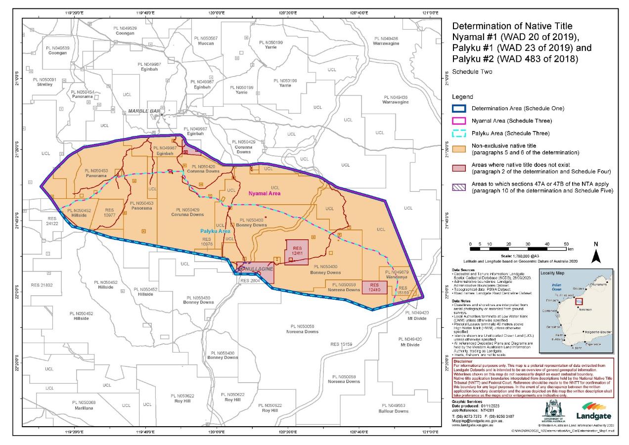
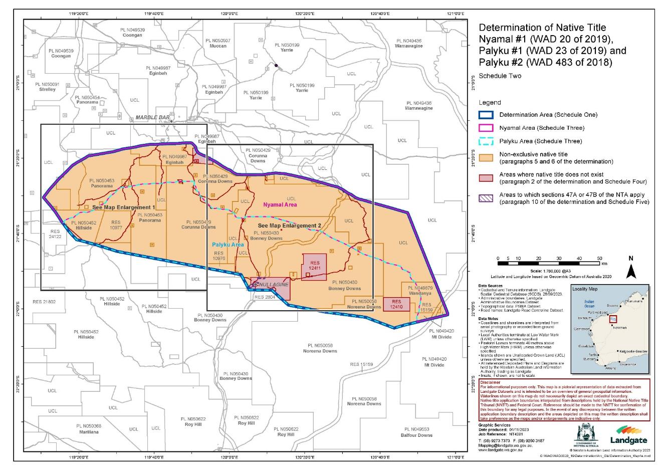
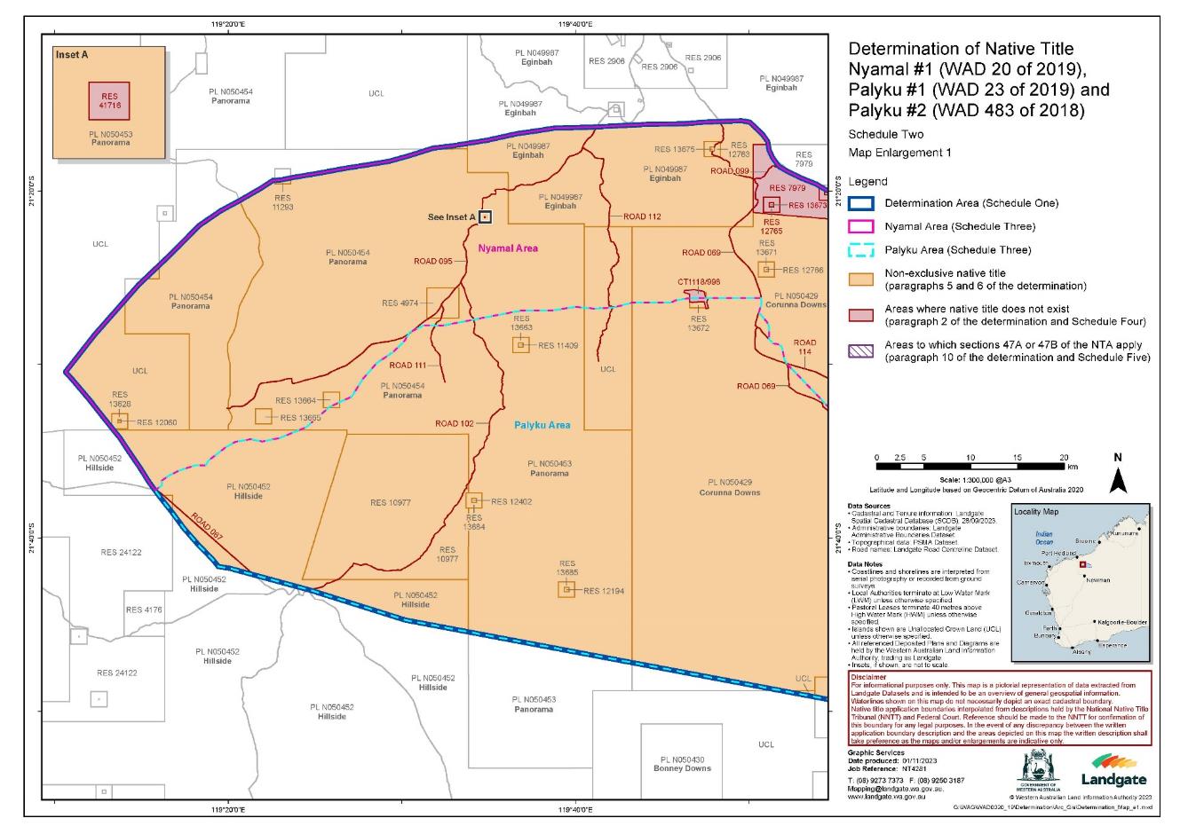
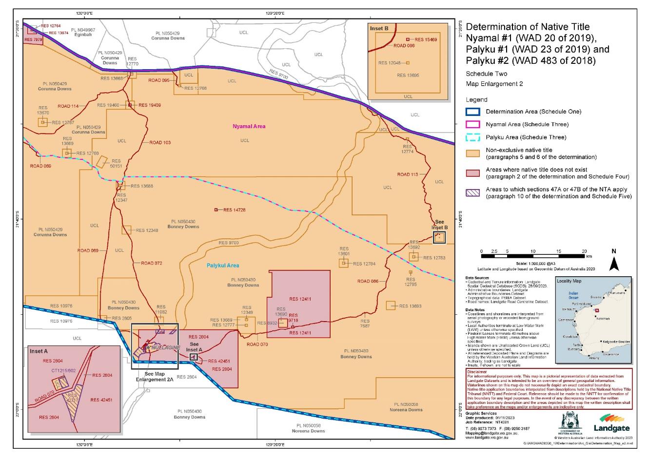
1. Subject to paragraph 2, native title exists in the Determination Area in the manner set out in paragraphs 5 and 6 of this determination.
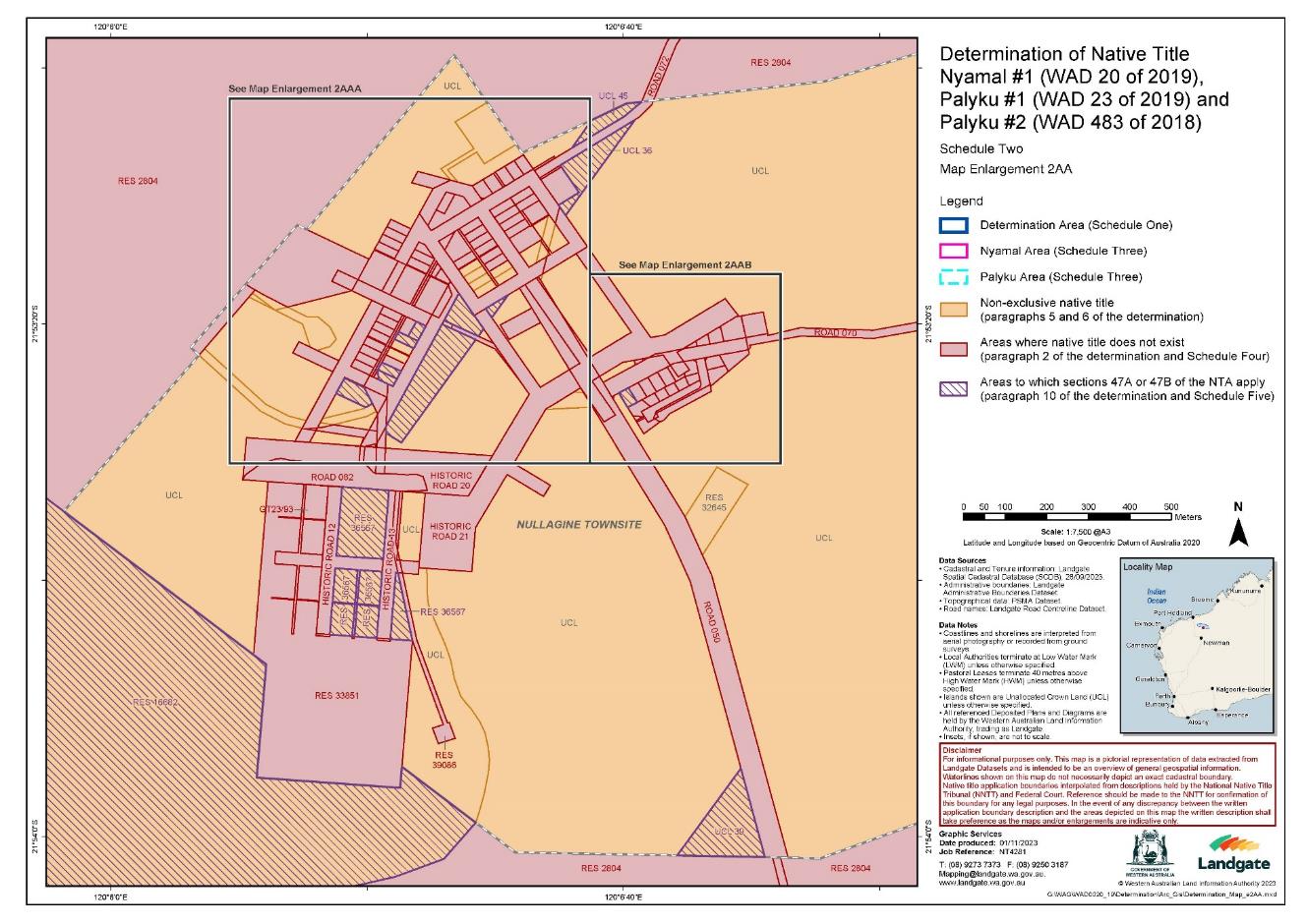
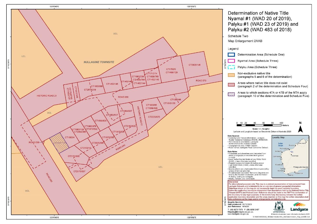
2. Native title does not exist in those parts of the Determination Area that are identified in Schedule Four which are shown as generally shaded pink on the maps at Schedule Two.
Native title holders: section 225(a) Native Title Act
3. In the Nyamal Area, native title is held by the Nyamal People.
4. In the Palyku Area, native title is held by the Palyku People.
The nature and extent of native title rights and interests and exclusiveness of native title: sections 225(b) and 225(e) Native Title Act
5. Subject to paragraphs 2, 7, 8, 9 and 12, the nature and extent of the Nyamal native title in relation to the Nyamal Area are that they confer the following non-exclusive rights on the Nyamal People, including the right to conduct activities necessary to give effect to them:
(a) the right to live, being to enter and remain, camp and erect temporary shelters and other temporary structures for that purpose and to travel over and visit any part of the land and waters;
(b) the right to hunt, fish, gather and use the traditional resources;
(c) the right to take and use water; and
(d) the right to engage in cultural activities and the transmission of cultural knowledge, including:
(i) visiting places of cultural or spiritual importance and protecting those places by carrying out lawful activities to preserve their physical or spiritual integrity; and
(ii) conducting burials, ceremony and ritual.
(e) the right to be accompanied by those people who, though not Nyamal People and who (for the avoidance of doubt) cannot themselves exercise any native title rights, are:
(i) the non-Nyamal spouses, parents or children of the Nyamal People; or
(ii) people required by traditional law and custom for the performance of ceremonies or cultural activities on the Nyamal Area.
6. Subject to paragraphs 2, 7, 8, 9 and 12, the nature and extent of the Palyku native title in relation to the Palyku Area are that they confer the following non-exclusive rights on the Palyku People, including the right to conduct activities necessary to give effect to them:
(a) the right to enter and remain on the land, camp, erect temporary shelters and travel over and visit any part of the land and waters;
(b) the right to hunt, fish, gather, take and use the traditional resources of the land;
(c) the right to take and use water;
(d) the right to engage in cultural activities and the transmission of cultural knowledge, including:
(i) visiting places of cultural or spiritual importance and maintaining, caring for, and protecting those places by carrying out activities to preserve their physical or spiritual integrity; and
(ii) conducting ceremony and ritual, including burial and burial rites; and
(e) the right to be accompanied by those people who, though not Palyku People and who (for the avoidance of doubt) cannot themselves exercise any native title right in the Palyku Area, are:
(i) the non-Palyku spouses, parents or children of the Palyku People; or
(ii) people entering in connection with, and subject to, traditional law and custom for the performance of ceremonies or cultural activities.
Qualifications on the native title rights and interests
7. The native title rights and interests are subject to and exercisable in accordance with:
(a) the laws of the State and the Commonwealth, including the common law; and
(b) the traditional laws and customs of the Nyamal People and/or the Palyku People (as the case may be) for personal, domestic and communal purposes (including social, cultural, religious, spiritual and ceremonial purposes).
8. Notwithstanding anything in this determination, there are no native title rights and interests in the Determination Area in relation to:
(a) minerals as defined in the Mining Act 1904 (WA) (repealed) and in the Mining Act 1978 (WA), except to the extent that ochre is not a mineral pursuant to the Mining Act 1904 (WA);
(b) petroleum as defined in the Petroleum Act 1936 (WA) (repealed) and in the Petroleum and Geothermal Energy Resources Act 1967 (WA);
(c) geothermal energy resources and geothermal energy as defined in the Petroleum and Geothermal Energy Resources Act 1967 (WA); or
(d) water captured by the holders of the Other Interests pursuant to those Other Interests.
9. The native title rights and interests set out in paragraphs 5 and 6 and do not confer:
(a) possession, occupation, use and enjoyment on the Nyamal People or the Palyku People to the exclusion of all others; or
(b) a right to control the access to, or use of, the land and waters of the Determination Area or its resources.
Areas to which s 47A or s 47B of the Native Title Act applies
10. Section 47A and s 47B of the Native Title Act apply to disregard any prior extinguishment in relation to the areas described in Schedule Five.
The nature and extent of any other interests: section 225(c) Native Title Act
11. The nature and extent of the Other Interests are described in Schedule Six.
Relationship between native title rights and Other Interests: section 225(d) Native Title Act
12. Except as otherwise provided for by law, the relationship between the native title rights and interests described in paragraph 5 and 6 and the Other Interests described in Schedule Six is that:
(a) to the extent that any of the Other Interests are inconsistent with the continued existence, enjoyment or exercise of the native title rights and interests, the native title rights and interests continue to exist in their entirety, but the native title rights and interests have no effect in relation to the Other Interests to the extent of the inconsistency during the currency of the Other Interests; and otherwise; and
(b) the existence and exercise of the native title rights and interests do not prevent the doing of any activity required or permitted to be done by or under the Other Interests, and the Other Interests, and the doing of any activity required or permitted to be done by or under the Other Interests, prevail over the native title rights and interests and any exercise of the native title rights and interests but do not extinguish them.
Definitions and Interpretation
13. In this Determination, unless the contrary intention appears:
'Determination Area' means the land and waters described in Schedule One and depicted on the maps at Schedules Two and Three;
'land' has the same meaning as in the Native Title Act and, for the avoidance of doubt, includes any natural collection of water found on the land which does not fall within the definition of 'waters';
'Native Title Act' means the Native Title Act 1993 (Cth);
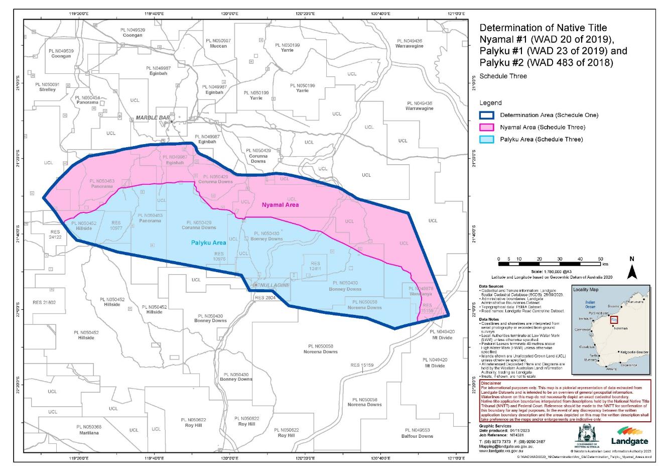
'Nyamal Area' means the land and waters described in Schedule Three and depicted on the map at Schedule Three, being generally shaded in pink;
'Nyamal People' means the people described in Schedule Seven;
'Other Interests' means the legal or equitable estates or interests and other rights in relation to the Determination Area described in Schedule Six and referred to in paragraph 11;
'Palyku Area' means the land and waters described in Schedule Three and depicted on the map at Schedule Three, being generally shaded in blue;
'Palyku People' means the people described in Schedule Eight;
'resources' means flora, fauna, and other natural resources such as charcoal, stone, soil, wood, resin and ochre (except, for the avoidance of doubt, ochres for use in the manufacture of porcelain, fine pottery or pigments which are minerals pursuant to the Mining Act 1904 (WA) (repealed));
'use' includes by way of share and exchange but does not include use by way of trade; and
'waters' has the same meaning as in the Native Title Act.
14. In the event of any inconsistency between the written description of an area in Schedule One, Three, Four, Five or Six and the area as depicted on the maps at Schedule Two or Three, the written description prevails.
SCHEDULE ONE
EXTERNAL BOUNDARY OF THE DETERMINATION AREA
The Determination Area, generally shown as bordered in blue on the maps at Schedule Two and Three, comprises all land and waters bounded by the following description:
All that land and waters commencing at Latitude 22.025695 South, Longitude 120.965628 East being a point on the present boundary of Native Title Determination WAD23/2019 Palyku Part A (WCD2019/002) and extending southwesterly and generally northwesterly along the northern boundaries of that native title determination to Latitude 21.982987 South, Longitude 120.260763 East; Then northwesterly to Latitude 21.917778 South, Longitude 120.188863 East being a point on the present boundary of Native Title Determination WAD23/2019, WAD483/2018 Palyku and Palyku #2 (Area 3) (WCD2021/003); Then westerly to Latitude 21.916020 South, Longitude 120.087871 East being a point on the present boundary of Native Title Determination WAD23/2019 Palyku Part A (WCD2019/002); Then northwesterly to Latitude 21.848444 South, Longitude 120.052088 East being a point on the present boundary of Native Title Determination WAD483/2018 Palyku #2 (WCD2021/006); Then northwesterly to Latitude 21.745504 South, Longitude 119.503750 East being a point on the present boundary of Native Title Determination WAD23/2019 Palyku Part A (WCD2019/002); Then generally northwesterly along the boundaries of that native title determination to the intersection with Longitude 119.324160 East being a point on the present boundary of Native Title Determination WAD23/2019, WAD483/2018 Palyku and Palyku #2 (Area 1) (WCD2021/003); Then generally northwesterly along the northeastern boundaries of that native title determination to a southern corner of Native Title Determination WAD20/2019 Nyamal People #1 (WCD2019/010) at approximate Latitude 21.507192 South, Longitude 119.177279 East; Then generally northeasterly and generally southeasterly along the boundaries of that native title determination back to the commencement point.
Note: Geographic Coordinates provided in Decimal Degrees.
For the avoidance of doubt the determination excludes any land and waters already claimed by:
• Native Title Determination WAD20/2019 Nyamal People #1 (WCD2019/010) as Determined in the Federal Court on 24 September 2019.
• Native Title Determination WAD6280/1998, WAD196/2013, WAD90/2020 Nyiyaparli and Nyiyaparli #3 (WCD2018/008) as Determined in the Federal Court on 26 September 2018.
• Native Title Determination WAD23/2019 Palyku Part A (WCD2019/002) as Determined in the Federal Court on 12 March 2019.
• Native Title Determination WAD23/2019, WAD483/2018 Palyku and Palyku #2 (WCD2021/003) as Determined in the Federal Court on 10 March 2021.
• Native Title Determination WAD483/2018 Palyku #2 (WCD2021/006) as Determined in the Federal Court on 6 September 2021.
Datum: Geocentric Datum of Australia 2020 (GDA2020)
Prepared By: Geospatial (Landgate) 25th October 2023
Use of Coordinates:
Where coordinates are used within the description to represent cadastral or topographical boundaries or the intersection with such, they are intended as a guide only. As an outcome to the custodians of cadastral and topographic data continuously recalculating the geographic position of their data based on improved survey and data maintenance procedures, it is not possible to accurately define such a position other than by detailed ground survey.
SCHEDULE TWO
MAPS OF THE DETERMINATION AREA
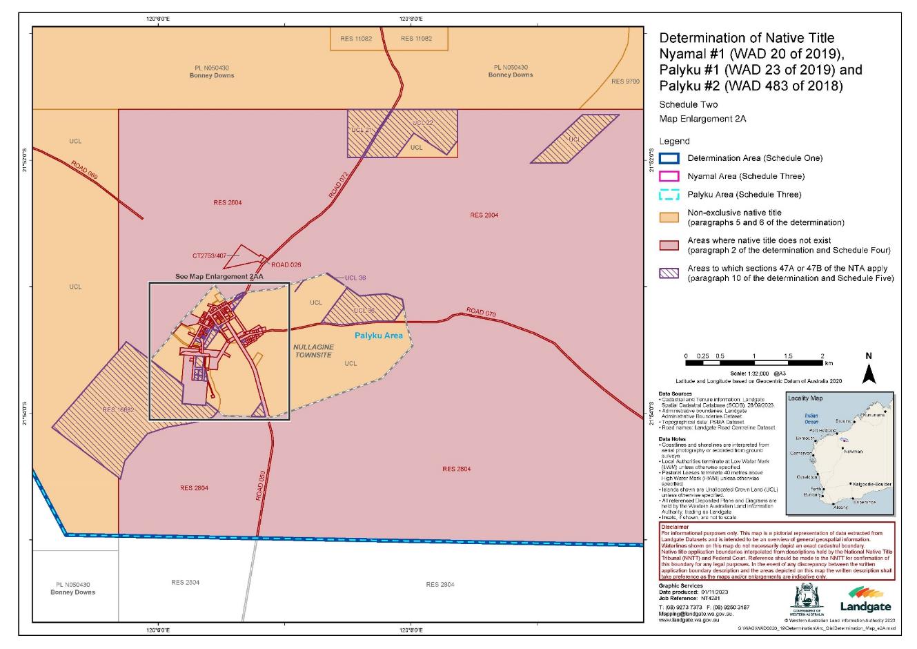
SCHEDULE THREE
DESCRIPTION AND MAP OF THE NYAMAL AREA AND PALYKU AREA
Nyamal Area
The Nyamal Area, generally shown as shaded in pink on the map at Schedule Three, comprises all land and waters bounded by the following description:
All that land and waters commencing at the intersection of the northeastern boundary of Native Title Determination WAD23/2019, WAD483/2018 Palyku and Palyku #2 (Area 1) (WCD2021/003) with Latitude 21.620591 South and extending generally northeasterly through the following coordinate points:
Latitude (South) | Longitude (East) |
21.616258 | 119.269649 |
21.611621 | 119.269649 |
21.607186 | 119.275316 |
21.601790 | 119.286511 |
21.596650 | 119.302358 |
21.596732 | 119.311768 |
21.592125 | 119.314452 |
21.579661 | 119.330769 |
21.574156 | 119.340277 |
21.571523 | 119.355182 |
21.573950 | 119.366175 |
21.570524 | 119.382879 |
21.560130 | 119.408149 |
21.540571 | 119.430849 |
21.531021 | 119.452122 |
21.513874 | 119.462829 |
21.498855 | 119.476135 |
21.488290 | 119.491697 |
21.477297 | 119.502832 |
21.469016 | 119.507829 |
21.462500 | 119.521389 |
21.462592 | 119.539095 |
21.448208 | 119.614322 |
21.447910 | 119.644958 |
21.444639 | 119.666968 |
21.446423 | 119.685408 |
21.445233 | 119.703254 |
21.440475 | 119.721695 |
21.440593 | 119.758577 |
21.438392 | 119.763098 |
21.436251 | 119.776661 |
Then easterly to an eastern boundary of Corunna Downs Road at Latitude 21.436191 South; Then generally southerly along the eastern boundary of that road to Latitude 21.450089 South; Then generally southeasterly through the following coordinate points:
Latitude (South) | Longitude (East) |
21.459236 | 119.850793 |
21.463447 | 119.852720 |
Then southerly to the northern boundary of an unnamed road at Longitude 119.852730 East (approximate Latitude 21.475569 South); Then generally southeasterly along the northern boundary of that road to the intersection with a northern boundary of an unnamed road at approximate Latitude 21.498854 South, Longitude 119.869380 East; Then southeasterly to the northern boundary of an unnamed road at Longitude 119.924790 East (approximate Latitude 21.556268 South); Then generally easterly and generally southeasterly along the northern boundary of that road to a northern boundary of Reserve 13688; Then easterly along the northern boundary of that reserve to an eastern boundary of Marble Bar Road; Then generally northeasterly along the eastern boundary of that road to a northern boundary of Pastoral Lease N050430 (Bonney Downs); Then easterly along the northern boundary of that pastoral lease to Longitude 120.182175 East; Then generally southeasterly through the following coordinate points:
Latitude (South) | Longitude (East) |
21.628577 | 120.309534 |
21.650809 | 120.358589 |
21.651869 | 120.383450 |
21.655083 | 120.402871 |
21.685371 | 120.451960 |
21.709376 | 120.505090 |
21.730180 | 120.545738 |
21.756928 | 120.590609 |
21.781702 | 120.667513 |
21.796067 | 120.695338 |
21.810767 | 120.757742 |
Then southeasterly to the intersection of the centreline of Skull Springs Road with Longitude 120.764565 East (approximate Latitude 21.824529 South); Then generally southeasterly along the centreline of that road to Longitude 120.811567 East; Then generally southerly through the following coordinate points:
Latitude (South) | Longitude (East) |
21.886884 | 120.824312 |
21.922576 | 120.840730 |
21.949345 | 120.847155 |
21.973615 | 120.845014 |
21.990390 | 120.839303 |
22.009307 | 120.840017 |
22.036076 | 120.828238 |
Then southerly to the intersection of a northern boundary of Native Title Determination WAD23/2019 Palyku Part A (WCD2019/002) with Longitude 120.830735 East; Then northeasterly along the boundary of that native title determination to Latitude 22.025695 South, Longitude 120.965628 East being a point on the present boundary of Native Title Determination WAD20/2019 Nyamal People #1 (WCD2019/010); Then generally northwesterly and generally southwesterly along the boundaries of that native title determination to a southern corner at approximate Latitude 21.507192 South and Longitude 119.177279 East being a point on the present boundary of Native Title Determination WAD23/2019, WAD483/2018 Palyku and Palyku #2 (Area 1) (WCD2021/003); Then generally southeasterly along the boundaries of that native title determination back to the commencement point.
Palyku Area
The Palyku Area, generally shown as shaded in blue on the map at Schedule Three, comprises all land and waters bounded by the following description:
All that land and waters commencing at the intersection of the northeastern boundary of Native Title Determination WAD23/2019, WAD483/2018 Palyku and Palyku #2 (Area 1) (WCD2021/003) with Latitude 21.620591 South and extending generally northeasterly through the following coordinate points:
Latitude (South) | Longitude (East) |
21.616258 | 119.269649 |
21.611621 | 119.269649 |
21.607186 | 119.275316 |
21.601790 | 119.286511 |
21.596650 | 119.302358 |
21.596732 | 119.311768 |
21.592125 | 119.314452 |
21.579661 | 119.330769 |
21.574156 | 119.340277 |
21.571523 | 119.355182 |
21.573950 | 119.366175 |
21.570524 | 119.382879 |
21.560130 | 119.408149 |
21.540571 | 119.430849 |
21.531021 | 119.452122 |
21.513874 | 119.462829 |
21.498855 | 119.476135 |
21.488290 | 119.491697 |
21.477297 | 119.502832 |
21.469016 | 119.507829 |
21.462500 | 119.521389 |
21.462592 | 119.539095 |
21.448208 | 119.614322 |
21.447910 | 119.644958 |
21.444639 | 119.666968 |
21.446423 | 119.685408 |
21.445233 | 119.703254 |
21.440475 | 119.721695 |
21.440593 | 119.758577 |
21.438392 | 119.763098 |
21.436251 | 119.776661 |
Then easterly to an eastern boundary of Corunna Downs Road at Latitude 21.436191 South; Then generally southerly along the eastern boundary of that road to Latitude 21.450089 South; Then generally southeasterly through the following coordinate points:
Latitude (South) | Longitude (East) |
21.459236 | 119.850793 |
21.463447 | 119.852720 |
Then southerly to the northern boundary of an unnamed road at Longitude 119.852730 East (approximate Latitude 21.475569 South); Then generally southeasterly along the northern boundary of that road to the intersection with a northern boundary of an unnamed road at approximate Latitude 21.498854 South, Longitude 119.869380 East; Then southeasterly to the northern boundary of an unnamed road at Longitude 119.924790 East (approximate Latitude 21.556268 South); Then generally easterly and generally southeasterly along the northern boundary of that road to a northern boundary of Reserve 13688; Then easterly along the northern boundary of that reserve to an eastern boundary of Marble Bar Road; Then generally northeasterly along the eastern boundary of that road to a northern boundary of Pastoral Lease N050430 (Bonney Downs); Then easterly along the northern boundary of that pastoral lease to Longitude 120.182175 East; Then generally southeasterly through the following coordinate points:
Latitude (South) | Longitude (East) |
21.628577 | 120.309534 |
21.650809 | 120.358589 |
21.651869 | 120.383450 |
21.655083 | 120.402871 |
21.685371 | 120.451960 |
21.709376 | 120.505090 |
21.730180 | 120.545738 |
21.756928 | 120.590609 |
21.781702 | 120.667513 |
21.796067 | 120.695338 |
21.810767 | 120.757742 |
Then southeasterly to the intersection of the centreline of Skull Springs Road with Longitude 120.764565 East (approximate Latitude 21.824529 South); Then generally southeasterly along the centreline of that road to Longitude 120.811567 East; Then generally southerly through the following coordinate points:
Latitude (South) | Longitude (East) |
21.886884 | 120.824312 |
21.922576 | 120.840730 |
21.949345 | 120.847155 |
21.973615 | 120.845014 |
21.990390 | 120.839303 |
22.009307 | 120.840017 |
22.036076 | 120.828238 |
Then southerly to the intersection of a northern boundary of Native Title Determination WAD23/2019 Palyku Part A (WCD2019/002) with Longitude 120.830735 East; Then southwesterly along the boundary of that native title determination and generally northwesterly along the boundaries of that native title determination to Latitude 21.982987 South, Longitude 120.260763 East; Then northwesterly to Latitude 21.917778 South, Longitude 120.188863 East being a point on the present boundary of Native Title Determination WAD23/2019, WAD483/2018 Palyku and Palyku #2 (Area 3) (WCD2021/003); Then westerly to Latitude 21.916020 South, Longitude 120.087871 East being a point on the present boundary of Native Title Determination WAD23/2019 Palyku Part A (WCD2019/002); Then northwesterly to Latitude 21.848444 South, Longitude 120.052088 East being a point on the present boundary of Native Title Determination WAD483/2018 Palyku #2 (WCD2021/006); Then northwesterly to Latitude 21.745504 South, Longitude 119.503750 East being a point on the present boundary of Native Title Determination WAD23/2019 Palyku Part A (WCD2019/002); Then generally northwesterly along the boundaries of that native title determination to the intersection with Longitude 119.324160 East being a point on the present boundary of Native Title Determination WAD23/2019, WAD483/2018 Palyku and Palyku #2 (Area 1) (WCD2021/003); Then generally northwesterly along the northeastern boundaries of that native title determination back to the commencement point.
Note: Geographic Coordinates provided in Decimal Degrees.
All referenced Deposited Plans and Diagrams are held by the Western Australian Land Information Authority, trading as Landgate.
Cadastral boundaries sourced from Landgate's Spatial Cadastral Database dated 28th September 2023.
Skull Springs Road centreline based on 250K vector data sourced from © Commonwealth of Australia (Geoscience Australia) 2006.
For the avoidance of doubt the Nyamal Area excludes any land and waters already claimed by:
• Native Title Determination WAD20/2019 Nyamal People #1 (WCD2019/010) as Determined in the Federal Court on 24 September 2019.
• Native Title Determination WAD6280/1998, WAD196/2013, WAD90/2020 Nyiyaparli and Nyiyaparli #3 (WCD2018/008) as Determined in the Federal Court on 26 September 2018.
• Native Title Determination WAD23/2019 Palyku Part A (WCD2019/002) as Determined in the Federal Court on 12 March 2019.
• Native Title Determination WAD23/2019, WAD483/2018 Palyku and Palyku #2 (WCD2021/003) as Determined in the Federal Court on 10 March 2021.
For the avoidance of doubt the Palyku Area excludes any land and waters already claimed by:
• Native Title Determination WAD6280/1998, WAD196/2013, WAD90/2020 Nyiyaparli and Nyiyaparli #3 (WCD2018/008) as Determined in the Federal Court on 26 September 2018.
• Native Title Determination WAD23/2019 Palyku Part A (WCD2019/002) as Determined in the Federal Court on 12 March 2019.
• Native Title Determination WAD23/2019, WAD483/2018 Palyku and Palyku #2 (WCD2021/003) as Determined in the Federal Court on 10 March 2021.
• Native Title Determination WAD483/2018 Palyku #2 (WCD2021/006) as Determined in the Federal Court on 6 September 2021.
Datum: Geocentric Datum of Australia 2020 (GDA2020)
Prepared By: Geospatial (Landgate) 25th October 2023
Use of Coordinates:
Where coordinates are used within the description to represent cadastral or topographical boundaries or the intersection with such, they are intended as a guide only. As an outcome to the custodians of cadastral and topographic data continuously recalculating the geographic position of their data based on improved survey and data maintenance procedures, it is not possible to accurately define such a position other than by detailed ground survey.
SCHEDULE FOUR
AREAS WHERE NATIVE TITLE DOES NOT EXIST
Paragraph 2
Native title does not exist in relation to land and waters the subject of the following interests within the Determination Area which, with the exception of public works (as described in clause 4 of this Schedule), are generally shown as shaded in pink on the maps at Schedule Two.
For the avoidance of doubt, the non-existence of native title is not necessarily a result of the grant or creation of these interests.
1. Freehold
The following grants of estates in fee simple within the Determination Area:
Certificate of Title | Certificate of Title | Certificate of Title | ||
CT0032500083 | CT0145200145 | CT0186300066 | ||
CT0048700037A | CT0145200146 | CT0187300502 | ||
CT0048700038A | CT0145200147 | CT0189400937 | ||
CT0057000114A | CT0149900129 | CT0189800630 | ||
CT0069000046 | CT0164800918 | CT0190300096 | ||
CT0107000328 | CT0165500284 | CT0190300128 | ||
CT0107000810 | CT0166100096 | CT0191200610 | ||
CT0107000811 | CT0168300239 | CT0191300826 | ||
CT0109500331 | CT0168400351 | CT0192500309 | ||
CT0111000752 | CT0168400352 | CT0193700786 | ||
CT0111800998 | CT0170900799 | CT0193700787 | ||
CT0118300017 | CT0171200074 | CT0194300066 | ||
CT0120100971 | CT0175500447 | CT0196300976 | ||
CT0124100438 | CT0178400082 | CT0199400988 | ||
CT0125901000 | CT0179500005 | CT0202500386 | ||
CT0140400634 | CT0180900764 | CT0204400082 | ||
CT0144400416 | CT0180900765 | CT0206300360 | ||
CT0144400417 | CT0181000130 | CT0206400388 | ||
CT0144600912 | CT0181200338 | CT0206400540 | ||
CT0144600913 | CT0181300137 | CT0206400861 | ||
CT0144600914 | CT0181300138 | CT0207500291 | ||
CT0144600915 | CT0181300157 | CT0210200141 | ||
CT0145000867 | CT0184900329 | CT0210300010 | ||
CT0145200143 | CT0185000517 | CT0211100688 | ||
CT0145200144 | CT0186300004 | CT0212000878 |
Certificate of Title | Certificate of Title | Certificate of Title | ||
CT0214100913 | CT0297900219 | GT0002200671 | ||
CT0215200992 | GT0002000148 | GT0002200787 | ||
CT0216200920 | GT0002000149 | GT0002300074 | ||
CT0217500557 | GT0002000150 | GT0002300093 | ||
CT0218900219 | GT0002000406 | GT0002300094 | ||
CT0222000875 | GT0002100780 | GT0002300095 | ||
CT0258500847 | GT0002200163 | GT0002300096 | ||
CT0275300407 | GT0002200327 | GT0002300217 | ||
CT0282000145 | GT0002200353 | GT0002300773 | ||
CT0286300890 | GT0002200354 | GT0002700132 | ||
CT0296100627 | GT0002200431 | LG0036100011 | ||
CT0296100628 | GT0002200432 | |||
CT0296100629 | GT0002200485 |
2. Reserves
The following Reserves:
Reserve No. | Current / Last Purpose |
02804 (part)1 | Common |
07865 | Warden's Court and Police (subject to a public work) |
07979 | Common (formerly subject to RL 332/0568) |
09049 | Road Board Office |
09718 | State Battery |
12375 | Historical Well |
12410 | Commonage |
12411 | Commonage |
12764 | Water (formerly subject to RL 332/0568) |
12765 | Water (formerly subject to RL 332/0568) |
13673 | Timber (formerly subject to RL 332/0568) |
13674 | Timber (formerly subject to RL 332/0568) |
14728 | Water Supply |
15469 | Water |
19459 | Water |
23347 | Aid Post |
23348 | Park |
25927 | School Site (subject to a public work) |
27496 | Caravan Park |
30548 | Hall and Community Service Centre |
32769 | Light Industry |
32770 | Shire Workshop and Depot |
33851 | Recreation |
Reserve No. | Current / Last Purpose |
38413 | Water Supply |
39086 | Water Supply |
39087 | Water Supply |
41327 | Use and Requirements of the Government Employees Housing Authority (subject to a public work) |
41328 | Recreation |
41716 | Communications Mast |
42451 | Aerodrome |
3. Roads
The following dedicated roads, roads set aside, taken or resumed or roads which are to be considered public works (as that expression is defined in the Native Title Act and the Titles Validation Act):
MapInfo ID. | Description | Shown on |
Road 026 | Portion of widening of Marble Bar Road | DP 51197 |
Road 029 | Unnamed rights of way and roads | DP 144241 |
Road 030 | Portion of Airport Road | DP 181171 |
Road 038 | Corner of Great Northern Highway and Airport Road | DP 213676 |
Road 040 | Howard Road | DP 216422 |
Road 043 | Portion of Gallop Road | DP 218031 |
Road 050 | Road No. 3857 | DP 213166 & Gaz 01/04/1977 & 14/09/1979 |
Road 054 | Road No. 16109 (Gallop Road) | DP 214379 & Gaz 01/12/1978 |
Road 055 | Road No. 16110 (Walters Street) | DP 214379 & Gaz 01/12/1978 |
Road 067 | Road No. 00389 | CPP 503165 & Gaz 07/06/1895 |
Road 069 | Road No. 00762 | CPP 503190, CPP 503163 & Gaz 02/12/1898 |
Road 070 | Road No. 01425 | Map SF 51-5 1:250,000 & Gaz 19/12/1902 |
Road 072 | Road No. 00762 (formerly Great Northern Highway) | CPP 503164 |
Road 077 | Portion of Cooke Street | CPP 504924 |
Road 078 | Unnamed right of way | DP 144242 |
Road 082 | Various roads in Nullagine | DP 222932 |
Road 083 | Unnamed right of way | DP 90335 |
Road 084 | Portion of Clemensen and Cooke Streets | DP 90336 |
Road 086 | Road No. 03437 | CPP 503165, CPP 503171 & Map SF 51-5 1:250,000 |
Road 095 | Road No. 06443 | Map SF 50-8 1:250,000, Map 2855 1:100,000, Map SF 51-5 1:250,000 & Gaz 29/04/1921 |
Road 099 | Road No. 06447 | CPP 503187 & Gaz 29/04/1921 |
Road 102 | Road No. 07345 | Map SF 50-8 1:250,000 & Gaz 29/05/1925 |
Road 103 | Road No. 07346 | CPP 503164, CPP 503187, DP 238589, DP 238674 & Gaz 29/05/1925 & 05/06/1925 |
Road 111 | Road No. 09365 | CPP 503190 & Gaz 21/09/1934 |
Road 112 | Road No. 09680 | CPP 503189, Gaz 07/08/1936 & Gaz 14/08/1936 |
Road 113 | Road No. 10217 | Map SF 51-5 1:250,000 & Gaz 09/05/1958 |
Road 114 | Road No. 10500 | CPP 503190, Map SF 50-8 1:250,000, Map SF 5105 1:250,000 & Gaz 29/11/1957 |
Road 117 | Corner of Cooke and Walters Streets | DP 67448 |
Hist. Road 001 | Howard Road and unnamed right of way | DP 213676 & Gaz 0606/1986 |
Hist. Road 010 | Portion of Walker Street | DP 144241 |
Hist. Road 011 | Grant Street, Hourigan Street and Clemensen Street | DP 93611& DP 222932 |
Hist. Road 012 | Various roads in Nullagine | DP 222932 |
Hist. Road 013 | Various roads in Nullagine | DP 222932 |
Hist. Road 016 | Portion of Walters Street | DP 222932 |
Hist. Road 018 | Portion of Massingham Street | DP 222932 |
Hist. Road 019 | Portion of Hourigan Street | DP 222932 |
Hist. Road 020 | McFie Street | DP 222932 |
Hist. Road 021 | Various roads in Nullagine | DP 222932 |
4. Public works
Any other public works as that expression is defined in the Native Title Act and the Titles Validation Act (including the land and waters on which a public work is constructed, established or situated as described in section 251D of the Native Title Act) and to which section 12J of the Titles Validation Act or section 23C(2) of the Native Title Act applies.
SCHEDULE FIVE
AREAS TO WHICH SECTIONS 47A and 47B OF THE NATIVE TITLE ACT APPLY
(Paragraph 10)
1. Section 47A
Section 47A of the Native Title Act applies with the effect that any extinguishment by the creation of the following interests (and by the creation of any other prior interests in relation to the area of the following interests) is to be disregarded:
Interest | Description / Purpose |
Reserve 16682 | Use and Benefit of Aborigines (Palyku #1) |
Reserve 36567 (part) | That part of Reserve 36567 (Use and Benefit of Aboriginal Inhabitants) not formerly subject to Historical Roads 12 and 13 (Palyku #1) |
Reserve 42717 | Use and Benefit of Aboriginal Inhabitants (Palyku #2) |
CT0209500726 | Freehold property held by the Irrungadji Group Association Inc (Palyku #1) |
CT0121500602 | Freehold property held by Irrungadji Group Association Inc (Palyku #2) |
CT0140400635 | Freehold property held by Western Desert Puntukurnuparna Aboriginal Corporation (Palyku #1) |
2. Section 47B
Section 47B of the Native Title Act applies with the effect that any extinguishment over the following areas by the creation of a prior interest (to the extent that the areas were not covered by an interest described in s.47B(1)(b)(i) or (ii) or subject to a resumption process as described in s.47B(1)(b)(iii) of the Native Title Act when the relevant native title determination application was made) is to be disregarded:
MapInfo ID. | Description |
UCL 21 | The whole of UCL 21, formerly subject to part of Reserve 02804 |
UCL 22 (part) | That part of UCL 022 not subject to mining leases M 46/009 and M 46/263 (being formerly subject to part of Reserve 02804 (Palyku #2) |
UCL 36 (part) | That part of UCL 36 that was not subject to Historic Roads 16 and 21 or covered by mining leases M46/154, M46/009 or M46/063 at the time that claim was made (Palyku #1) |
UCL 39 (part) | That part of UCL 39 that was not subject to Historic Roads 20 and 21 or covered by mining lease M46/154 at the time that the claim was made (Palyku #1) |
UCL 45 (part) | That part of UCL 45 that was not subject to Historic Road 16 or covered by mining lease M46/009 at the time the claim was made (Palyku #1) |
UCL 53 (part) | That part of UCL 53 that was not subject to Historic Road 21 or covered by mining lease M46/154 at the time the claim was made (Palyku #1) |
UCL 293 | The whole of UCL 293, formerly subject to CT0206300361 and part of CT0117000546 (Palyku #1) |
UCL 294 | The whole of UCL 294, formerly subject to CT0206300362 and part of CT0117000546. (Palyku #1) |
UCL 297 | The whole of UCL 297, formerly subject to CT0156600572 (Palyku #1) |
UCL 309 (part) | That part of UCL 309 formerly subject to part of Reserve 31317 (Palyku #1) other than that portion covered by Mining Lease M46/154 at the time that the claim was made (Palyku #1). |
- | That part of unallocated Crown land formerly subject to Reserve Lease RL 332/2179 (and Reserve 02804) (Palyku #2) |
SCHEDULE SIX
OTHER INTERESTS
Paragraph 11
The nature and extent of the Other Interests in relation to the Determination Area are as follows.
Land tenure interests registered with the Western Australian Land Information Authority are current as at 28 September 2023. Mining tenements and petroleum interests registered with the Department of Mines, Industry Regulation and Safety are current as at 1 November 2023. All other interests are current as at the date of the determination.
1. Freehold Titles
The following grants of estates in fee simple within the Determination Area:
Certificate of Title |
CT0121500602 |
CT0140400635 |
CT0209500726 |
2. Reserves
(a) the following reserves:
Reserve No. | Current / Last Purpose |
02805 | Water |
04974 | Water |
07587 | Water |
07588 | Water |
08932 | Water |
09700 | De Grey - Peak Hill Stock Route |
10976 | Common |
10977 | Common |
11082 | Water |
11409 | Water |
11293 | Water |
12048 | Water |
12060 | Water |
12194 | Water |
12347 | Water |
12348 | Water |
12349 | Water |
12402 | Water |
12763 | Water |
12766 | Water |
12767 | Water |
12768 | Water |
12770 | Water |
12771 | Water |
12774 | Water |
12777 | Water |
12783 | Water |
12784 | Water |
12785 | Water |
13628 | Timber |
13663 | Timber |
13664 | Timber |
13665 | Timber |
13668 | Timber |
13669 | Timber |
13670 | Timber |
13671 | Timber |
13672 | Timber |
13675 | Timber |
13684 | Timber |
13685 | Timber |
13688 | Timber |
13689 | Timber |
13690 | Timber |
13691 | Timber |
13692 | Timber |
13693 | Timber |
13695 | Timber |
15159 | Warrawagine to Battle Hill Stock Route |
16682 | Use and Benefit of Aborigines |
19460 | Timber |
24122 | Mining |
32645 | Cemetery |
36567 | Use and Benefit of Aboriginal Inhabitants |
42717 | Use and Benefit of Aboriginal Inhabitants |
50148 | Water Supply |
50151 | Preservation of Geological Features |
(b) The rights and interests of persons who have the care, control and management of the reserves identified in subclause (a) above;
(c) The rights and interests of persons entitled to access and use the reserves identified in subclause (a) above for the respective purposes for which they are reserved, subject to any statutory limitations upon those rights; and
(d) The rights and interests of persons holding leases over areas of the reserves identified in subclause (a) above.
3. Pastoral Leases
(a) The following pastoral leases and the rights and interests of the holders from time to time of those pastoral leases:
Lease No. | Description |
PL N049420 | Mt Divide |
PL N049879 | Wandanya |
PL N049987 | Eginbah |
PL N050058 | Noreena Downs |
PL N050429 | Corunna Downs |
PL N050430 | Bonney Downs |
PL N050452 | Hillside |
PL N050453 | Panorama |
(b) Any rights and obligations of the pastoralists pursuant to the pastoral leases referred to in subclause (a) above to adopt and exercise best practice management of the pasture and vegetation resources, livestock and soils within the boundaries of the pastoral leases in order to manage stock and for the management, conservation and regeneration of pasture for permitted uses.
4. Leases
The following leases and the rights and interests of the holders from time to time of those leases:
Lease No. | Purpose |
GE M390740 | Installation, Maintenance and Operation of Telecommunications Network Facility or Radio Communications |
RL K298954 | Grazing |
5. Easements
The following easements and the rights and interests of the holders from time to time of those easements:
Easement No. | Purpose |
H680000 | Water Pipeline |
L428602 | Access to, and construction, repair, maintenance, replacement and use of a seismic monitoring station |
6. Roads
The following roads and the rights and interests of the persons having the care, control and management of those roads from time to time:
MapInfo ID. | Description | Shown on |
Road 008 | Lots 252 - 4 (being a portion of Walker Street) | DP 219891 |
Road 027 | Lots 507 - 9 | DP 64270 |
7. Mining Tenements
The following mining tenements granted under the Mining Act 1904 (WA) (repealed) and / or the Mining Act 1978 (WA) and the rights and interests of the holders from time to time of those tenements:
(a) Mining Leases
Tenement ID | Tenement ID | Tenement ID | ||
M 45/0004 | M 45/0668 | M 45/1243-I | ||
M 45/0084 | M 45/0669 | M 45/1257-I | ||
M 45/0115 | M 45/0670 | M 45/1267 | ||
M 45/0238 | M 45/0671 | M 45/1290 | ||
M 45/0240 | M 45/0672 | M 46/0003 | ||
M 45/0346 | M 45/0678 | M 46/0009 | ||
M 45/0357 | M 45/0679 | M 46/0010 | ||
M 45/0521 | M 45/0682 | M 46/0011 | ||
M 45/0547 | M 45/0692 | M 46/0043 | ||
M 45/0552 | M 45/0725 | M 46/0044 | ||
M 45/0579 | M 45/0906 | M 46/0047 | ||
M 45/0589 | M 45/0987 | M 46/0050 | ||
M 45/0591 | M 45/1197-I | M 46/0056 | ||
M 45/0656 | M 45/1209-I | M 46/0057 |
Tenement ID | Tenement ID | Tenement ID | ||
M 46/0064 | M 46/0244 | M 46/0303 | ||
M 46/0098 | M 46/0245 | M 46/0426 | ||
M 46/0115 | M 46/0260 | M 46/0427 | ||
M 46/0124 | M 46/0261 | M 46/0428 | ||
M 46/0129 | M 46/0262 | M 46/0429 | ||
M 46/0142 | M 46/0263 | M 46/0430 | ||
M 46/0146 | M 46/0264 | M 46/0431 | ||
M 46/0163 | M 46/0265 | M 46/0432 | ||
M 46/0164 | M 46/0266 | M 46/0433 | ||
M 46/0165 | M 46/0272 | M 46/0434 | ||
M 46/0166 | M 46/0273 | M 46/0441 | ||
M 46/0167 | M 46/0274 | M 46/0442 | ||
M 46/0175 | M 46/0275 | M 46/0446 | ||
M 46/0177 | M 46/0276 | M 46/0447 | ||
M 46/0182 | M 46/0277 | M 46/0448 | ||
M 46/0187 | M 46/0278 | M 46/0524 | ||
M 46/0189 | M 46/0279 | M 46/0526-I | ||
M 46/0198 | M 46/0282 | M 46/0527 | ||
M 46/0199 | M 46/0283 | M 46/0532 | ||
M 46/0200 | M 46/0302 | |||
M 46/0225 | M 46/0303 |
(b) Miscellaneous Licences
Tenement ID | Tenement ID | Tenement ID | ||
L 45/060 | L 45/567 | L 46/088 | ||
L 45/280 | L 45/573 | L 46/089 | ||
L 45/371 | L 45/588 | L 46/090 | ||
L 45/372 | L 45/592 | L 46/091 | ||
L 45/394 | L 45/593 | L 46/092 | ||
L 45/399 | L 45/598 | L 46/098 | ||
L 45/406 | L 45/606 | L 46/105 | ||
L 45/407 | L 45/609 | L 46/109 | ||
L 45/408 | L 45/649 | L 46/113 | ||
L 45/410 | L 45/666 | L 46/115 | ||
L 45/418 | L 45/683 | L 46/122 | ||
L 45/427 | L 45/685 | L 46/123 | ||
L 45/523 | L 45/689 | L 46/127 | ||
L 45/526 | L 46/022 | L 46/147 | ||
L 45/527 | L 46/024 | L 46/158 | ||
L 45/564 | L 46/033 | L 46/166 | ||
L 45/565 | L 46/067 | L 46/178 | ||
L 45/566 | L 46/070 |
(c) General Purpose Leases
Tenement ID | Tenement ID | Tenement ID | ||
G 45/036 | G 45/347 | G 46/002 | ||
G 45/339 | G 45/348 | |||
G 45/345 | G 45/349 |
(d) Exploration Licences
Tenement ID | Tenement ID | Tenement ID | ||
E 45/2763-I | E 45/4696-I | E 45/5695 | ||
E 45/2870-I | E 45/4708 | E 45/5717 | ||
E 45/2922-I | E 45/4709 | E 45/5728 | ||
E 45/3321-I | E 45/4713 | E 45/5747 | ||
E 45/3381 | E 45/4734-I | E 45/5823 | ||
E 45/3474 | E 45/4764 | E 45/5834 | ||
E 45/3615 | E 45/4779 | E 45/5835 | ||
E 45/3655 | E 45/4824 | E 45/5846 | ||
E 45/3940 | E 45/4837 | E 45/5847 | ||
E 45/4060-I | E 45/4841-I | E 45/5849 | ||
E 45/4098 | E 45/4843 | E 45/5879 | ||
E 45/4169-I | E 45/4856 | E 45/5890 | ||
E 45/4175 | E 45/4857 | E 45/5891 | ||
E 45/4176 | E 45/4879 | E 45/5893 | ||
E 45/4177 | E 45/4905 | E 45/5933 | ||
E 45/4178 | E 45/4906 | E 45/5966 | ||
E 45/4180 | E 45/4934 | E 45/5967 | ||
E 45/4236 | E 45/4965 | E 45/5969 | ||
E 45/4275 | E 45/5036 | E 45/5972 | ||
E 45/4320 | E 45/5201 | E 45/5975 | ||
E 45/4419 | E 45/5203 | E 45/5976 | ||
E 45/4473 | E 45/5204 | E 45/5984 | ||
E 45/4474 | E 45/5205 | E 45/5985 | ||
E 45/4475 | E 45/5230 | E 45/5986 | ||
E 45/4476 | E 45/5231 | E 45/5987 | ||
E 45/4553 | E 45/5263 | E 45/6043 | ||
E 45/4555 | E 45/5322 | E 45/6054 | ||
E 45/4586 | E 45/5340 | E 45/6055 | ||
E 45/4587 | E 45/5453 | E 45/6069 | ||
E 45/4601 | E 45/5478 | E 45/6077 | ||
E 45/4622 | E 45/5597 | E 45/6097 | ||
E 45/4666 | E 45/5684 | E 45/6211 | ||
E 45/4681 | E 45/5685 | E 45/6215 | ||
E 45/4685-I | E 45/5693 | E 45/6224 |
Tenement ID | Tenement ID | Tenement ID | ||
E 45/6280 | E 46/1129-I | E 46/1399 | ||
E 45/6407 | E 46/1148 | E 46/1406 | ||
E 45/6471 | E 46/1190 | E 46/1413 | ||
E 46/0517-I | E 46/1197 | E 46/1415 | ||
E 46/0525-I | E 46/1198 | E 46/1416 | ||
E 46/0530-I | E 46/1201 | E 46/1417 | ||
E 46/0535-I | E 46/1202 | E 46/1421 | ||
E 46/0571-I | E 46/1277 | E 46/1422 | ||
E 46/0711-I | E 46/1280 | E 46/1428 | ||
E 46/0732-I | E 46/1317 | E 46/1430 | ||
E 46/0794 | E 46/1332 | E 46/1431 | ||
E 46/0795 | E 46/1335 | E 46/1455 | ||
E 46/0796 | E 46/1340 | E 46/1456 | ||
E 46/0797 | E 46/1357 | E 46/1457 | ||
E 46/0802-I | E 46/1363 | E 46/1458 | ||
E 46/0934 | E 46/1367 | E 46/1463 | ||
E 46/0951 | E 46/1368 | E 46/1464 | ||
E 46/1026 | E 46/1371 | E 46/1492 | ||
E 46/1065-I | E 46/1373 | E 46/1495 | ||
E 46/1066-I | E 46/1374 | E 46/1501 | ||
E 46/1079-I | E 46/1375 | |||
E 46/1086 | E 46/1382 | |||
E 46/1122-I | E 46/1390 | |||
E 46/1125-I | E 46/1393 |
(e) Prospecting Licences
Tenement ID | Tenement ID | Tenement ID | ||
P 45/2964 | P 45/2982 | P 46/1681 | ||
P 45/2965 | P 45/3002 | P 46/1682 | ||
P 45/2966 | P 45/3031 | P 46/1683 | ||
P 45/2967 | P 45/3033 | P 46/1684 | ||
P 45/2968 | P 45/3038 | P 46/1704 | ||
P 45/2970 | P 45/3100-S | P 46/1705 | ||
P 45/2971 | P 45/3132 | P 46/1706 | ||
P 45/2973 | P 45/3140 | P 46/1743 | ||
P 45/2974 | P 45/3141-S | P 46/1744 | ||
P 45/2975 | P 45/3154-S | P 46/1757 | ||
P 45/2976 | P 45/3170 | P 46/1758 | ||
P 45/2977 | P 45/3171 | P 46/1789 | ||
P 45/2979 | P 46/1618 | P 46/1790 | ||
P 45/2980 | P 46/1669 | P 46/1824 | ||
P 45/2981 | P 46/1675 | P 46/1855 |
Tenement ID | Tenement ID | Tenement ID | ||
P 46/1858 | P 46/1937 | P 46/2001 | ||
P 46/1864 | P 46/1939 | P 46/2002 | ||
P 46/1868 | P 46/1941 | P 46/2003 | ||
P 46/1869 | P 46/1942 | P 46/2004 | ||
P 46/1872 | P 46/1945 | P 46/2005 | ||
P 46/1874 | P 46/1947 | P 46/2006 | ||
P 46/1875 | P 46/1948 | P 46/2007 | ||
P 46/1876 | P 46/1950 | P 46/2008 | ||
P 46/1878 | P 46/1951 | P 46/2010 | ||
P 46/1879 | P 46/1952 | P 46/2011 | ||
P 46/1880 | P 46/1953 | P 46/2013 | ||
P 46/1881 | P 46/1954 | P 46/2014 | ||
P 46/1882 | P 46/1955 | P 46/2018-S | ||
P 46/1883 | P 46/1956 | P 46/2020-S | ||
P 46/1884 | P 46/1957 | P 46/2021-S | ||
P 46/1885 | P 46/1958 | P 46/2023 | ||
P 46/1886 | P 46/1960 | P 46/2025 | ||
P 46/1888 | P 46/1964 | P 46/2026 | ||
P 46/1900 | P 46/1965 | P 46/2027 | ||
P 46/1901 | P 46/1967 | P 46/2029 | ||
P 46/1902 | P 46/1968 | P 46/2030 | ||
P 46/1903 | P 46/1969 | P 46/2031 | ||
P 46/1904 | P 46/1972 | P 46/2032 | ||
P 46/1905 | P 46/1974 | P 46/2033 | ||
P 46/1906 | P 46/1975 | P 46/2034 | ||
P 46/1907 | P 46/1976 | P 46/2035 | ||
P 46/1908 | P 46/1978 | P 46/2036 | ||
P 46/1909 | P 46/1979 | P 46/2037 | ||
P 46/1910 | P 46/1980 | P 46/2038 | ||
P 46/1911 | P 46/1981 | P 46/2040 | ||
P 46/1912 | P 46/1982 | P 46/2041 | ||
P 46/1914 | P 46/1983 | P 46/2042 | ||
P 46/1915 | P 46/1984 | P 46/2046 | ||
P 46/1916 | P 46/1990 | P 46/2047 | ||
P 46/1917 | P 46/1991 | P 46/2048 | ||
P 46/1918 | P 46/1992 | P 46/2049 | ||
P 46/1919 | P 46/1993 | P 46/2050 | ||
P 46/1920 | P 46/1994 | P 46/2051 | ||
P 46/1922 | P 46/1995 | P 46/2052 | ||
P 46/1932 | P 46/1996 | P 46/2058 | ||
P 46/1933 | P 46/1997 | P 46/2059 | ||
P 46/1934 | P 46/1998 | P 46/2060 | ||
P 46/1935 | P 46/1999 | P 46/2061 | ||
P 46/1936 | P 46/2000 | P 46/2064 |
Tenement ID | Tenement ID | Tenement ID | ||
P 46/2065 | P 46/2081 | P 46/2097 | ||
P 46/2066 | P 46/2082 | P 46/2098 | ||
P 46/2067 | P 46/2083 | P 46/2099 | ||
P 46/2068 | P 46/2084 | P 46/2100 | ||
P 46/2069 | P 46/2085 | P 46/2101 | ||
P 46/2070 | P 46/2086 | P 46/2102 | ||
P 46/2071 | P 46/2087 | P 46/2103 | ||
P 46/2072 | P 46/2088 | P 46/2104 | ||
P 46/2073 | P 46/2089 | P 46/2105 | ||
P 46/2074 | P 46/2090 | |||
P 46/2075 | P 46/2091 | |||
P 46/2076 | P 46/2092 | |||
P 46/2077 | P 46/2093 | |||
P 46/2078 | P 46/2094 | |||
P 46/2079 | P 46/2095 | |||
P 46/2080 | P 46/2096 |
(f) Retention Licences
Tenement ID |
R 46/3 |
8. Access to Mining Tenements
(a) Without limiting the operation of any other clause in Schedule Six, but subject to clause 8(b) below, any rights of the holders from time to time of a mining tenement including those listed in clause 7 of this Schedule Six, to use (including by servants, agents and contractors) such portions of roads and tracks in the Determination Area (existing as at the date of this Determination) as are necessary to have access to the area the subject of the mining tenement for the purposes of exercising the rights granted by that tenement.
(b) Nothing in clause 8(a) above allows any upgrade, extension, widening or other improvement to the road or track other than work done to maintain it in reasonable repair and in order to leave it in substantially the same condition as it was prior to its use pursuant to clause 8(a).
9. Other
The following rights and interests in the Determination Area:
(a) Rights and interests, including licences and permits, granted by the Crown in right of the State or of the Commonwealth pursuant to statute or otherwise in the exercise of its executive power and any regulations made pursuant to such legislation;
(b) Rights and interests held by reason of the force and operation of the laws of the State or of the Commonwealth, including but not limited to, force and operation of the Rights in Water and Irrigation Act 1914 (WA);
(c) Rights and interests of members of the public arising under common law, including but not limited to:
(i) the public right to fish;
(ii) the public right to navigate; and
(iii) the right of any person to use and enjoy any roads in the Determination Area (subject to the laws of the State) over which, as at the date of this determination, members of the public have a right of access under the common law;
(d) The right to access the Determination Area by:
(i) an employee, agent or instrumentality of the State;
(ii) an employee, agent or instrumentality of the Commonwealth; or
(iii) an employee, agent or instrumentality of any local government authority,
as required in the performance of his or her statutory or common law duty, including for the purpose of pest management control and fire hazard management on areas of unallocated Crown land and unmanaged Crown reserves;
(e) So far as confirmed pursuant to section 212(2) of the Native Title Act and section 14 of the (Validation) and Native Title (Effect of Past Acts) Act 1995 (WA) as at the date of this determination, any existing public access to and enjoyment of, the following places in the Determination Area:
(i) waterways;
(ii) beds and banks or foreshores of waterways;
(iii) coastal waters;
(iv) beaches;
(v) stock routes; and
(vi) areas that were public places at the end of 31 December 1993;
(f) Any other:
(i) legal or equitable estate or interest in the land or waters of the Determination Area; or
(ii) right (including a right under an option and a right of redemption), charge, power or privilege over, or in connection with:
(A) the land or waters of the Determination Area; or
(B) an estate or interest in the land or waters of the Determination Area; or
(iii) restriction on the use of the land or waters of the Determination Area, whether or not annexed to other land or waters.
SCHEDULE SEVEN
NYAMAL PEOPLE
Paragraph 3
The Nyamal People are those persons who:
(a) are descended from Ngurrpangu @ Sally, Yirlkurani @ William Ball, Jarlapangu @ Billy Ball, Minparingu @ Daisy McColl, Wijiringu @ Joey, Ngamalykarinya @ Eginbah Murphy, Kutjikurtapa @ Fred Mitchell, Pularmu @ Albert, Martuwataranu @ Maryanne, Minjikarli @ Jimmy Woodman, Pularjiyi, Putangaja, Mikarnipirti, Mayinkapirti, Walykanpangu, Kujari @ Jenkins, Ngamalangu @ Nellie, Kalpimarra, Yirapinya, Warnangykuranya @ Tommy, Yatawaranu @ Yarriwawurru @ Dinah, Goondy @ Goondanee, Pilunjuji, Nyantipunu, Paddy Bung Bong, Amy Mirabung, Old Maybai, Mary (mother of Stella Ball), Minnie (mother of Allen Mitchell), Punkarli (mother of Alice Mitchell), Winturu, Susan Pontroy, Martin Pontroy or Jack Pontroy or are adopted by such biological descendants in accordance with the traditional laws acknowledged and the traditional customs observed by the Nyamal People; and
(b) identify themselves as Nyamal under traditional law and custom and are so identified by other Nyamal People as Nyamal.
SCHEDULE EIGHT
PALYKU PEOPLE
Paragraph 4
The Palyku People are those Aboriginal persons who:
(a) are the cognatic descendants of, or are culturally reared up (adopted) by such cognatic descendants of, one or more of the following apical ancestors:
(i) Pitawanu;
(ii) Pupu;
(iii) Winnie;
(iv) Wilyarpirna;
(v) Puyungayi;
(vi) Yurramara;
(vii) Munjarnpirna and Jukukayi;
(viii) Jujuna;
(ix) Fannie, Annie Patawani and Chinaman Janjanamarlu;
(x) Pijipangu;
(xi) Kijiempa;
(xii) Maggie Kuntuwarrpangu;
(xiii) Peter Long Wayalpa;
(xiv) Julimanga;
(xv) Wantungu;
(xvi) Kalurru;
(xvii) Alec Weatherall;
(xviii) Major and Judy;
(xix) Mary Barrdi; or
(xx) Sophie Bunbry; and
(b) identify themselves, and are recognised by a substantial number of the descendants of the above apical ancestors as, a Palyku person; and
(c) have rights and interests in, and a connection with, the land and waters of the Palyku Area, in accordance with the traditional laws acknowledged and the traditional customs observed by the Palyku People.
COLVIN J:
1 If you leave Port Hedland in the East Pilbara region of Western Australia and travel south along Marble Bar Road you will reach a junction where you can either go on to Marble Bar or you can turn and follow the road to the next town, Nullagine. If you take the turn at the junction you will see Mount Edgar rising on your left (to the east). Then, a bit further along, the road turns south and takes you through a part of the country where there are headwaters to a number of river systems. Waterholes within those river systems have long provided permanent sources of water for Aboriginal people.
2 The rivers lie on each side of Marble Bar Road and flow north back towards the coast. There are five rivers that cross the land in this area. Starting in the west is the Yule River, then going east, there is the Shaw River, the Coongan River, the Nullagine River and the Davis River. The Davis River flows into the Oakover River (and is sometimes itself described as part of the Oakover River). This area of land, which is roughly oval in shape, comprises approximately 9238 square kilometres of land and waters. It commences a short distance south of Marble Bar and extends down to and including Nullagine and reaches out about 100 km east and west from the Marble Bar Road which divides it roughly in half. It is a vast tranquil expanse, still sparsely populated. It is arid country with occasional substantial rainfall.
3 Considerable evidence of occupation of the land by Aboriginal people long before European settlement has been presented to the Court. Their experience of the hospitality of the land is long standing. It is based upon a deep connection to the land and a spiritual understanding of its origins. The significance for Aboriginal people of these matters transmits only dimly to those who do not share its sensibilities.
4 A dispute as to the identity of the holders of native title to the area just described (Area) has been resolved and consent determinations of native title are now sought.
5 The land around the Area has been the subject of native title determinations. As to the land to the north, it has been determined that native title in that land is held by the Nyamal People. To the south, native title has been determined to be held by the Palyku People. Those determinations were based upon findings to the effect that each of the Nyamal People and the Palyku People constitute a separate society with its own normative system of traditional laws and customs under which native title rights and interests in relation to land may be allocated. As to the Nyamal People, see Allen on behalf of the Nyamal People #1 v State of Western Australia [2019] FCA 1570; and Eaton on behalf of the Nyamal People #10 v State of Western Australia [2019] FCA 1571. As to the Palyku People, see O'Connor on behalf of the Palyku People v State of Western Australia [2019] FCA 330; O'Connor on behalf of the Palyku People State of Western Australia (No 2) [2021] FCA 195; and Stream v State of Western Australia (Palyku #2) [2021] FCA 1068.
6 By orders made on 9 November 2020 (as amended on 7 May 2021), applications for determination of native title over the Area brought by each of the Nyamal People and the Palyku People were to be heard together (the Nyamal Palyku Proceeding). The orders provided for the trial of a separate question to determine the holders of native title in the Area, subject to any extinguishment.
7 The position of the State of Western Australia has been that it accepts that native title rights and interests are held in the Area, subject to extinguishment, and the issue to be resolved is the identity of the people who hold those rights and interests. The consequence of that position was that the controversy as between the parties actively participating in the trial of the separate question was about identifying the right people for that country.
8 I presided at the trial of the separate question. I heard a considerable amount of oral evidence much of which was received on country, including in confidential session. Save for closing submissions, the hearing of the separate question concluded on 30 June 2022. At the direction of the Court, the Nyamal applicant and the Palyku applicant then participated in a mediation. The Court was informed that agreement had been reached. A map of the Area was provided to the Court which depicted a line which divided the Area into two areas, one to the north and one to the south. The area to the north was identified as 'Nyamal native title determination area' (Area N) and the area to the south was identified as 'Palyku native title determination area' (Area P).
9 An issue arose as to whether a binding agreement had been reached. It was determined that, in the events which had occurred, there was a binding and enforceable agreement and there was no basis to conclude that the agreement that had been reached could not be carried into effect: The Nyamal Palyku Proceeding (No 7) [2023] FCA 528.
10 The parties to the Nyamal Palyku Proceedings now propose the making of a consent determination of native title pursuant to s 87 and s 94A of the Native Title Act 1993 (Cth). The proposed consent determination is in the terms agreed at the mediation as approved at native title group meetings held on 3 August 2022.
11 In support of the application for a consent determination of native title, a statement of agreed facts has been provided by the Nyamal applicant, the Palyku applicant and the State. In considering whether to make a consent determination of native title, the Court may accept a statement of agreed facts that has been agreed to by some or all of the parties, but only if the statement is agreed to by the applicant and the 'principal government respondent': s 87(10). In considering whether to accept a statement of facts agreed by some but not all parties, the Court must take into account the objections made by other parties within 21 days of notice being given to them of the statement of agreed facts: s 87(11). Notice has been given and there has been no objection.
12 The applicant parties and the State are represented by experienced solicitors and counsel. By reason that (a) evidence (including preservation evidence) had been received during the conduct of the hearing of the separate question which occurred before the mediation at which agreement was reached; and (b) determinations of native title had been made in favour of each of the Nyamal People and the Palyku People as to adjoining areas, the Court can have considerable confidence that the agreed facts have been reached on an informed basis. In those circumstances, I have determined that it is appropriate to accept the statement of agreed facts.
13 The following account is taken principally from those facts as agreed.
14 The date of sovereignty in the Area is 29 May 1829. At that time, the lands and waters of the Area were occupied by Aboriginal people. However, significant European presence or settlement in the Area did not occur until around the final two decades of the nineteenth century.
15 There is a Palyku society, being a body of persons united in and by their observance of a body of traditional laws and customs. It existed at the time of acquisition of sovereignty and acknowledged and observed a normative system of laws and customs under which they held rights and interests in land. Palyku society has substantially maintained its identity and existence from that time until the present. The Palyku people (members of the Palyku society) are those people who:
(1) are the cognatic descendants of, or are culturally reared up (adopted) by such cognatic descendants of identified apical ancestors whose names are to be included in the proposed consent determination; and
(2) identify themselves, and are recognised by a substantial number of the descendants of those apical ancestors as, a Palyku person; and
(3) have rights and interests in, and a connection with, the land and waters of the Palyku People in accordance with the traditional laws acknowledged and the traditional customs observed by them.
16 The description of the Palyku system of traditional law and customs and connection to country in O'Connor on behalf of the Palyku People v State of Western Australia [2019] FCA 330 at [36] applies equally to the area of land identified as Area P.
17 The Palyku People hold the non-exclusive native title rights and interests in Area P that are to be included in the proposed consent determination. The Palyku People continue to exercise those rights in Area P, for example, by:
(1) residing in the area (at Nullagine);
(2) going on camping trips with family and otherwise visiting the area;
(3) hunting, fishing and gathering a variety of bush foods and preparing those foods in accordance with traditional practices;
(4) conducting activities to manage and protect country, spiritual beings and important places (such as singing and talking to country, avoiding dangerous or restricted places and actively checking on sites to ensure that they have not been damaged);
(5) taking the next generation onto country and teaching them about the country, its stories and special places and other Palyku traditional laws and customs; and
(6) participating in initiation and law business ceremonies and protecting places associated with the 'law' in the area.
18 There is a Nyamal society, being a body of persons united in and by their observance of a body of traditional laws and customs. It existed at the time of acquisition of sovereignty and acknowledged and observed a normative system of laws and customs under which they held rights and interests in land. Nyamal society has substantially maintained its identity and existence from that time until the present. The Nyamal people (members of the Nyamal society) are those people who:
(1) are descended from those people whose names are to be included in the proposed consent determination or are adopted by such biological descendants in accordance with the traditional laws acknowledged and the traditional customs observed by the Nyamal People; and
(2) identify themselves as Nyamal under traditional law and custom and are so identified by other Nyamal People as Nyamal.
19 The description of the Nyamal system of traditional law and customs and connection to country in Allen at [35] applies equally to the area of land identified as Area N.
20 The Nyamal People hold the non-exclusive native title rights and interests in Area N that are to be included in the proposed consent determination. The Nyamal People continue to exercise those rights in Area N, for example, by:
(1) going on camping trips with family and otherwise visiting the area;
(2) hunting, fishing and gathering a variety of bush foods and preparing those foods in accordance with traditional practices;
(3) conducting activities to manage and protect country, spiritual beings and important places (such as looking after yinta, avoiding ngulu (dangerous) places, actively checking on sites to ensure that they have not been damaged and talking to the old people or managing other spirits through particular rituals when on country);
(4) taking the next generation onto country and teaching them about the country, its stories and special places and other Nyamal traditional laws and customs; and
(5) participating in initiation and law business ceremonies.
21 I have had regard to the evidence received during the hearing of the separate question for the limited purpose of considering whether there is any aspect of that evidence that might mean that it is not appropriate to make the order sought without, at least receiving further submissions from the parties. It seems to me that such a course must be taken in the present circumstances where that evidence is before the Court even though the consent determination is not proposed on the basis of that evidence but rather rests upon the statement of agreed facts.
22 The evidence received on the separate question demonstrated that the Area has had a complex history since the arrival of Europeans. In consequence, it has been necessary for some adaption of the continuing culture of the Palyku People and the Nyamal People to those circumstances. Nevertheless, the evidence received during the hearing of the separate question demonstrated the maintenance of continuing cultural connection to the Area despite considerable external change. The evidence also demonstrated places within the Area of cultural significance and ongoing cultural practice. Significantly, it demonstrated the importance of ceremonial connection between different groups of people throughout the Pilbara and the ways in which those people came together for ceremony. Within that body of evidence there was reference to the ways in which traditional law allows for resolution of disputed claims to land.
23 The evidence showed that the observance of traditional law and custom as to traditional lands in the Area was disrupted but, subject to the issue of extinguishment as to some places, the people for the Area were not dispossessed of their land or their cultural connection to it. Aboriginal people continued to observe traditional law and custom. They maintained an understanding of cultural connection to land and responsibility for the land and its spiritually significant places. They kept accounts of who were the right people for different places. However, all those events occurred in circumstances that gave rise to the potential for dispute. That potential manifested in the contested claims by each of the Nyamal People and the Palyku People to native title over the Area.
24 Amongst other things, the Preamble to the Native Title Act expresses the intention of the people of Australia to ensure that Aboriginal peoples and Torres Strait Islanders 'receive the full recognition and status within the Australian nation to which history, their prior rights and interests, their rich and diverse culture, fully entitle them to aspire'. It further records: 'A special procedure needs to be available for the just and proper ascertainment of native title rights and interests which will ensure that, if possible, this is done by conciliation and, if not, in a manner that has due regard to their unique character'.
25 Therefore, the resolution of the dispute in the present case by the Aboriginal peoples concerned is an outcome that, for many reasons, is to be preferred to any determination according to the practices and procedures of this Court albeit undertaken with due regard to the unique character of the interests being ascertained. No doubt it has required give and take. The evidence suggests that for some it has been very painful. It has required competing accounts of what is required by traditional law and custom to be resolved.
26 In the circumstances as presented in the course of the hearing of the separate question, those competing accounts did not indicate an absence of native title. Rather, they indicated circumstances in which there was a need to work out according to the law and custom of the traditional systems that sustain native title an appropriate resolution of the dispute. It required leadership of a kind that would enable the possibility that wider relationships across the two people groups of ancient standing and significance, including ceremonial connection and observance, may be maintained into the future.
27 Settlement by agreement between Aboriginal peoples of the competing native title claims allows for traditional ways to guide the outcome in a case of genuine dispute. For that reason, it is to be encouraged. It is also a significant reason supporting the appropriateness of the making of the proposed consent determination in the present case.
28 The Court has power to make a determination as to the outcome of an application for native title where the parties have reached agreement as to the terms in which the application should be determined: see s 87(1A). The following conditions must be met before a determination of native title may be made pursuant to s 87 based upon the agreement of the parties. They are:
(1) Notice of the application for determination of native title must have been given as required by s 66 of the Native Title Act and the notice period must have expired.
(2) The agreement of the parties must relate to an area which is included in the area covered by the application.
(3) The terms of the proposed agreement must be in writing and signed by or on behalf of each of the parties and filed with the Court.
(4) There must have been no previous determination of the extent of native title over the area (or the order must be justified as a variation of the previous determination pursuant to s 13(1)(b) of the Native Title Act).
(5) The Court must be satisfied that an order in the proposed terms would be within the power of the Court. In that regard, the Federal Court has jurisdiction as to matters arising under the Native Title Act and must make any determination of native title in accordance with the procedures in the Act (see s 213). Those procedures require any determination of native title to set out the matters stated in s 225 (see s 94A). They require the determination to reflect the state of the common law as to the nature and extent of such interests and for there to be a factual basis for the making of an order and the determination must specify:
(a) the persons, or each group of persons, holding the common or group rights comprising native title;
(b) the nature and extent of the native title rights and interests;
(c) the nature and extent of any other interests;
(d) the relationship between the native title interests and any other interests; and
(e) whether the native title rights and interests confer possession, occupation, use and enjoyment to the exclusion of all others.
(6) It must appear to the Court that it is appropriate to make the order.
(7) If a determination of the existence of native title is to be made based on agreement then (as required by s 55 of the Native Title Act) the Court must at the same time or as soon as practicable thereafter make the determination required by s 56 as to how the native title interest will be held.
29 In addition to the joint submissions and agreed facts, the making of the proposed consent orders is supported by an affidavit of Mr Farrell, a lawyer acting for the Nyamal applicant and an affidavit by Ms Kilpatrick, a lawyer acting for the Palyku applicant.
30 For the following reasons, in the circumstances I have described, I am satisfied that it is appropriate for the proposed consent orders to be made.
31 On the affidavit material, I am satisfied that notice of the applications for native title has been given and the notice period has expired. The Area is within the area covered by the applications that were brought together by the orders concerning the Nyamal Palyku Proceedings.
32 The terms of the proposed agreement have been provided to the Court in writing and signed by or on behalf of each of the parties. They have been formally filed with the Court.
33 There has been no previous determination of native title over the Area.
34 The proposed consent determination has been authorised by native title meetings of each of the Nyamal People and Palyku People. This has occurred through meetings which approved the settlement as agreed at the mediation. Then, after the adjudication by the Court that the settlement of the proceedings was binding and may be given effect, there were further meetings at which authority to complete the consent determination process was given to the respective applicants.
35 The terms of the proposed consent determination accord with the requirements of s 94A and s 225 of the Native Title Act.
36 As has been mentioned, the applicants and the State have been represented throughout by experienced solicitors and counsel. The consent of all other parties has been given.
37 Finally, as I have explained there is a credible basis for the proposed consent determinations. In a case like the present, the support of the State provides a sufficient basis upon which a consent determination will be made and the State is 'not required to obtain proof from an applicant which would demonstrate to a civil standard of proof, on the balance of probabilities, that the native title rights claimed by the applicant exist': Widjabul Wia-Bal v Attorney General of New South Wales [2020] FCAFC 34; (2020) 274 FCR 577 at [51] (Reeves, Jagot and Mortimer JJ); see also Lander v State of South Australia [2012] FCA 427 at [11]-[13] (Mansfield J); and Drury on behalf of the Nanda People v State of Western Australia [2018] FCA 1849 at [52]-[56] (Mortimer J). Where the State signs an agreement that conforms with the requirements of s 87 of the Native Title Act, and agrees to recognise the existence of native title in the relevant area, then 'the Court is entitled to proceed on the basis that the State has made a reasonable and rational assessment of the material to which it has been given access' and 'will give considerable weight to the position taken by the State, on behalf of all members of its community': Ross on behalf of the Cape York United #1 Claim Group v State of Queensland (No 2) (Kuuku Ya'u determination) [2021] FCA 1464 at [92] (Mortimer J).
38 As has been noted, where a native title determination is made, the Court must also determine whether the native title is to be held in trust and if so by whom: s 56(1). The orders provide for the determined native title interests to be held in trust as to the interest of the Nyamal People by the Nyamal Aboriginal Corporation RNTBC (ICN 8770) and as to the Palyku People by the Palyku-Jartayi Aboriginal Corporation RNTBC (ICN 9217).
39 For those reasons I will make the orders sought.
I certify that the preceding thirty-nine (39) numbered paragraphs are a true copy of the Reasons for Judgment of the Honourable Justice Colvin. |
Associate:

