
FEDERAL COURT OF AUSTRALIA
David on behalf of the Torres Strait Regional Seas Claim v State of Queensland [2022] FCA 1430
ORDERS
LUI NED DAVID & ORS ON BEHALF OF THE SEA CLAIM APPLICANT (PART B) Applicant | ||
AND: | STATE OF QUEENSLAND and others named in the Schedule Respondents | |
QUD 26 of 2019 | ||
| ||
BETWEEN: | MILTON SAVAGE & ORS ON BEHALF OF THE KAURAREG PEOPLE #1 Applicant | |
AND: | STATE OF QUEENSLAND and others named in the Schedule Respondents | |
QUD 10 of 2019 | ||
| ||
BETWEEN: | MILTON SAVAGE & ORS ON BEHALF OF THE KAURAREG PEOPLE #2 Applicant | |
AND: | STATE OF QUEENSLAND and others named in the Schedule Respondents | |
QUD 24 of 2019 | ||
| ||
BETWEEN: | MILTON SAVAGE & ORS ON BEHALF OF THE KAURAREG PEOPLE #3 Applicant | |
AND: | STATE OF QUEENSLAND and others named in the Schedule Respondents | |
QUD 114 of 2017 | ||
| ||
BETWEEN: | BERNARD RICHARD CHARLIE & ORS ON BEHALF OF THE NORTHERN PENINSULA SEA CLAIM GROUP Applicant | |
AND: | STATE OF QUEENSLAND and others named in the Schedule Respondents | |
QUD 115 of 2017 | ||
| ||
BETWEEN: | BERNARD RICHARD CHARLIE & ORS ON BEHALF OF THE NORTH EASTERN PENINSULA SEA CLAIM GROUP Applicant | |
AND: | STATE OF QUEENSLAND and others named in the Schedule Respondents | |
QUD 227 of 2022 | ||
| ||
BETWEEN: | LUI NED DAVID & ORS ON BEHALF OF THE TORRES STRAIT REGIONAL SEAS CLAIM (PART C) Applicant | |
AND: | STATE OF QUEENSLAND and others named in the Schedule Respondents | |
DATE OF ORDER: |
THE COURT NOTES THAT:
A. The Applicant in proceeding QUD26/2019 has made an application for a determination of native title (Kaurareg #1 Application).
B. The Applicant in proceeding QUD10/2019 has made an application for a determination of native title (Kaurareg #2 Application).
C. The Applicant in proceeding QUD24/2019 has made an application for a determination of native title (Kaurareg #3 Application).
D. The Applicant in proceeding QUD114/2017 has made an application for a determination of native title (Northern Peninsula Application).
E. The Applicant in proceeding QUD115/2017 has made an application for a determination of native title (North Eastern Peninsula Application).
F. The Applicant in proceeding QUD27/2019 has made an application for a determination of native title (TSRSC Part B Application).
G. The Applicant in proceeding QUD227/2022 has made an application for a determination of native title (TSRSC Part C Application).
H. As part of the case management timetable annexed to the Court’s orders of 27 July 2020, the land and waters covered by the Kaurareg #1 Application, the Kaurareg #2 Application, the Kaurareg #3 Application, the Northern Peninsula Application, the North Eastern Peninsula Application, and the TSRSC Part B Application, taken together, were discretely defined as the Western Overlap Area, the Eastern Overlap Area, and the Southern Overlap Area. By orders made on 11 August 2022, the case management timetable was amended to include the TSRSC Part C Application.
I. Parts of the Kaurareg #1 Application, the Kaurareg #3 Application, the TSRSC Part B Application and the TSRSC Part C Application overlap and are within the Western Overlap Area.
J. Parts of the Kaurareg #1 Application, the TSRSC Part B Application and the North Eastern Peninsula Application overlap and are within the Eastern Overlap Area.
K. The whole of the Northern Peninsula Application, and parts of the Kaurareg #2 Application, and the Kaurareg #3 Application overlap and are within the Southern Overlap Area to the west of Cape York.
L. Parts of the North Eastern Peninsula Application, parts of the TSRSC Part B Application and parts of the TSRSC Part C Application overlap and are within the Southern Overlap Area to the east of Cape York.
M. On 8 November 2022, the Court made orders under section 67(1) of the Native Title Act 1993 (Cth) in respect of the Kaurareg #1 Application, the Kaurareg #2 Application, the Kaurareg #3 Application, the Northern Peninsula Application, the North Eastern Peninsula Application, the TSRSC Part B Application, and the TSRSC Part C Application, providing for them to be dealt with together.
N. By orders made on 8 November 2022, the area covered by the Northern Peninsula Application was administratively separated into:
(a) Part A, being onshore areas (Northern Peninsula Application (Part A)); and
(b) Part B, being offshore areas (Northern Peninsula Application (Part B)).
O. By orders made on 8 November 2022, the area covered by the North Eastern Peninsula Application was administratively separated into:
(a) Part A, being onshore areas (North Eastern Peninsula Application (Part A)); and
(b) Part B, being offshore areas (North Eastern Peninsula Application (Part B)).
P. This determination covers parts of the land or waters covered respectively by the Kaurareg #1 Application, the Kaurareg #2 Application, the Kaurareg #3 Application, the Northern Peninsula Application (Parts A and B), the North Eastern Peninsula Application (Parts A and B), the TSRSC Part B Application, and the TSRSC Part C Application.
Q. In relation to the Kaurareg #1 Application, the parties have agreed that:
(a) the application is to be dismissed to the extent that it covers any land or waters within the Gudang Yadhaykenu Area or the Kulkalgal and Kemer Kemer Meriam Area, as those areas are defined in order 9 below; and
(b) no determination is to be made at present in respect of the balance of the land or waters covered by the application.
R. In relation to the Kaurareg #2 Application, the parties have agreed that:
(a) the application is to be dismissed to the extent that it covers any land or waters within:
(i) the Ankamuthi Area, the Gudang Yadhaykenu Area or the Kulkalgal and Kemer Kemer Meriam Area, as those areas are defined in order 9 below; or
(ii) the balance of the land and waters in the Northern Peninsula Application (Parts A and B) and North Eastern Peninsula Application (Parts A and B); and
(b) other than the land and waters within the Kaurareg Area, no determination is to be made at present in respect of the balance of the land or waters covered by the application.
S. In relation to the Kaurareg #3 Application, the parties have agreed that:
(a) the application is to be dismissed to the extent that it covers any land or waters within:
(i) the Ankamuthi Area, the Gudang Yadhaykenu Area or the Kulkalgal and Kemer Kemer Meriam Area, as those areas are defined in order 9 below; or
(ii) the balance of the land and waters in the Northern Peninsula Application (Parts A and B) and North Eastern Peninsula Application (Parts A and B); and
(b) no determination is to be made at present in respect of the balance of the land or waters covered by the application.
T. In relation to the North Eastern Peninsula Application, the parties have agreed that:
(a) the application is to be dismissed to the extent that it covers any land or waters within the Kulkalgal and Kemer Kemer Meriam Area that are not also within the Gudang Yadhaykenu Area, as those areas are defined in order 9 below;
(b) a determination of native title is to be made for the Gudang Yadhaykenu Area; and
(c) no determination is to be made at present in respect of the balance of the land or waters covered by the application.
U. The parties have agreed that, in respect of the balance of the land or waters described in Schedule 6 and covered by the Kaurareg #2 Application, the Northern Peninsula Application (Parts A and B), the North Eastern Peninsula Application (Parts A and B), the TSRSC Part B Application and the TSRSC Part C Application, no determination is to be made at present.
V. The parties have filed in the Court agreements in writing made pursuant to section 87A of the Native Title Act 1993 (Cth), in respect of the Kaurareg #1 Application, the Kaurareg #2 Application, the Kaurareg #3 Application, the Northern Peninsula Application (Parts A and B), the North Eastern Peninsula Application (Parts A and B), the TSRSC Part B Application, and the TSRSC Part C Application.
BEING SATISFIED that an order in the terms set out below is within the power of the Court, and it appearing appropriate to the Court to do so, pursuant to s 87A of the Native Title Act 1993 (Cth) (NTA)
THE COURT ORDERS THAT:
1. There be a determination of native title in the terms proposed in these orders, despite any actual or arguable defect in the authorisation of the applicant in QUD 26 of 2019, QUD 10 of 2019, QUD 24 of 2019 or QUD 115 of 2017 to seek and agree to a consent determination pursuant to s 87A of the Native Title Act 1993 (Cth).
BY CONSENT THE COURT ORDERS THAT:
1. There be a determination of native title in the terms set out below (the determination).
2. The Kaurareg #1 Application is dismissed to the extent that it covers any land or waters that are within the Gudang Yadhaykenu Area or the Kulkalgal and Kemer Kemer Meriam Area, as those areas are defined in order 9 below.
3. The Kaurareg #2 Application is dismissed to the extent that it covers any land or waters that are within the:
(a) Ankamuthi Area, the Gudang Yadhaykenu Area, or the Kulkalgal and Kemer Kemer Meriam Area, as those areas are defined in order 9 below; or
(b) the balance of the land and waters in the Northern Peninsula Application (Parts A and B) and North Eastern Peninsula Application (Parts A and B).
4. The Kaurareg #3 Application is dismissed to the extent that it covers any land or waters that are within:
(a) the Ankamuthi Area, the Gudang Yadhaykenu Area, or the Kulkalgal and Kemer Kemer Meriam Area, as those areas are defined in order 9 below; or
(b) the balance of the land and waters in the Northern Peninsula Application (Parts A and B) and North Eastern Peninsula Application (Parts A and B).
5. The North Eastern Peninsula Application is dismissed to the extent that it covers any land or waters within the Kulkalgal and Kemer Kemer Meriam Area that are not also within the Gudang Yadhaykenu Area, as those areas are defined in order 9 below.
6. Each party to the proceeding is to bear its own costs.
BY CONSENT THE COURT DETERMINES THAT:
7. In this determination, unless the contrary intention appears:
Other words and expressions used in this determination have the same meanings as they have in Part 15 of the Native Title Act 1993 (Cth).
8. The Determination Area is the land and waters described in Schedule 5 and depicted in Map 1 of Schedule 7 to the extent those areas are within the External Boundary (as described in Part 1 of Schedule 4), and not otherwise excluded by the terms of Schedule 6. To the extent of any inconsistency between the written description and the map, the written description prevails.
9. The Determination Area is comprised of the following Group Areas:
(a) the Kaurareg Area, being the land and waters described in Schedule 5 and depicted in Map 2 of Schedule 7 to the extent those areas are within the External Boundary of the Kaurareg Area as described in Part 2 of Schedule 4, and not otherwise excluded by the terms of Schedule 6;
(b) the Ankamuthi Area, being the land and waters described in Schedule 5 and depicted in Map 3 of Schedule 7 to the extent those areas are within the External Boundary of the Ankamuthi Area described in Part 3 of Schedule 4, and not otherwise excluded by the terms of Schedule 6;
(c) the Gudang Yadhaykenu Area, being the land and waters described in Schedule 5 and depicted in Map 4 of Schedule 7 to the extent those areas are within the External Boundary of the Gudang Yadhaykenu Area as described in Part 4 of Schedule 4, and not otherwise excluded by the terms of Schedule 6;
(d) the Kulkalgal and Kemer Kemer Meriam Area, being the land and waters described in Schedule 5 and depicted in Map 5 of Schedule 7 to the extent those areas are within the External Boundary of the Kulkalgal and Kemer Kemer Meriam Area as described in Part 5 of Schedule 4, and not otherwise excluded by the terms of Schedule 6.
10. To the extent of any inconsistency between the written descriptions and the maps referred to in order 9 above, the written description prevails.
11. Native title exists in each of the Group Areas within the Determination Area.
12. Native title is held in each of the Group Areas within the Determination Area by one or more of the following Native Title Groups:
(a) the Kaurareg People, as defined in Section A of Schedule 1;
(b) the Ankamuthi People, as defined in Section B of Schedule 1;
(c) the Gudang Yadhaykenu People, as defined in Section C of Schedule 1;
(d) Kulkalgal, as defined in Section D of Schedule 1;
(e) Kemer Kemer Meriam, as defined in Section E of Schedule 1.
13. Native title in relation to each Group Area listed in order 9 above is held by the respective Native Title Group or Groups in accordance with Schedule 2.
14. Subject to orders 16, 17 and 18 below, the nature and extent of the native title rights and interests held by each Native Title Group in relation to the land and waters of their respective part or parts of the Determination Area described in Part 1 of Schedule 5, are:
(a) other than in relation to Water, the right to possession, occupation, use and enjoyment of the area to the exclusion of all others; and
(b) in relation to Water, the non-exclusive rights to:
(i) hunt, fish and gather from the Water of the area;
(ii) take and use the Natural Resources of the Water in the area; and
(iii) take and use the Water of the area,
for personal, domestic and non-commercial communal purposes.
15. Subject to orders 16, 17 and 18 below, the nature and extent of the native title rights and interests held by each Native Title Group in relation to the land and waters of their respective part or parts of the Determination Area described in Part 2 of Schedule 5, are the non-exclusive rights to:
(a) access, to remain in and to use the area;
(b) access resources and to take for any purpose, resources in the area;
(c) maintain places of importance and areas of significance to the Native Title Holders under their traditional laws and customs on the area and protect those places and areas from harm;
(d) be accompanied on to the area by those persons who, though not Native Title Holders, are:
(i) Spouses of Native Title Holders;
(ii) people who are members of the immediate family of a Spouse of a Native Title Holder; or
(iii) people reasonably required by the Native Title Holders under traditional law and custom for the performance of ceremonies or cultural activities on the area.
16. The native title rights and interests of each Native Title Group are subject to and exercisable in accordance with:
(a) the Laws of the State and the Commonwealth; and
(b) the traditional laws acknowledged and traditional customs observed by the respective Native Title Group.
17. The native title rights and interests referred to in orders 14(b) and 15 above do not confer possession, occupation, use or enjoyment to the exclusion of all others.
18. There are no native title rights in or in relation to minerals as defined by the Mineral Resources Act 1989 (Qld) and petroleum as defined by the Petroleum Act 1923 (Qld) and the Petroleum and Gas (Production and Safety) Act 2004 (Qld).
19. The nature and extent of any other interests in relation to the Determination Area (or respective parts thereof) are set out in Schedule 3.
20. The relationship between the native title rights and interests described in orders 14 and 15 above and the other interests described in Schedule 3 (the Other Interests) is that:
(a) the Other Interests continue to have effect, and the rights conferred by or held under the Other Interests may be exercised notwithstanding the existence of the native title rights and interests;
(b) to the extent the Other Interests are inconsistent with the continued existence, enjoyment or exercise of the native title rights and interests in relation to the land and waters of the Determination Area, the native title continues to exist in its entirety but the native title rights and interests have no effect in relation to the Other Interests to the extent of the inconsistency for so long as the Other Interests exist; and
(c) the Other Interests and any activity that is required or permitted by or under, and done in accordance with, the Other Interests, or any activity that is associated with or incidental to such an activity, prevail over the native title rights and interests and any exercise of the native title rights and interests.
Note: Entry of orders is dealt with in Rule 39.32 of the Federal Court Rules 2011.
LIST OF SCHEDULES
Schedule 1 – Native Title Groups
Schedule 2 – Description of which Group Areas are held by each Native Title Group
Schedule 3 – Other Interests in the Determination Area
Schedule 4 – External Boundaries
Schedule 5 – Description of Determination Areas
Schedule 6 – Areas Not Forming Part of the Determination Area
Schedule 7 – Maps of Determination Area
SCHEDULE 1 – NATIVE TITLE GROUPS
Section A: Kaurareg People
The Kaurareg People are the descendants of the Kaurareg People who were the traditional owners of the Kaurareg Area prior to the assertion of British sovereignty.
Section B: Ankamuthi People
The Ankamuthi People are the persons descended by birth or adoption from the following apical ancestors:
(a) Woobumu and Inmare;
(b) Bullock (father of Mamoose Pitt, husband of Rosie/Lena Braidley);
(c) Charlie Mamoose (father of Silas, Larry, Johnny and Harry Mamoose);
(d) Charlie Seven River;
(e) Toby Seven River (father of Jack Toby);
(f) Asai Charlie;
(g) Sam and Nellie (parents of George Stephen);
(h) Mammus/Mamoos/Mark/Mamoose plus his siblings Peter and Elizabeth;
(i) Charlie Maganu (husband of Sarah McDonnell);
(j) Polly (wife of Wautaba Charlie Ropeyarn).
Section C: Gudang Yadhaykenu People
The Gudang Yadhaykenu People are those Aboriginal persons who are descended by birth, or adoption in accordance with the traditional laws acknowledged and the traditional customs observed by the Gudang Yadhaykenu People, from one or more of the following apical ancestors:
(a) Wymarra (Wymara Outaiakindi);
(b) Tchiako (aka Chaiku/Chakoo) & Baki (siblings);
(c) Peter Padhing Pablo;
(d) Mathew Charlie Gelapa;
(e) Annie Blanco;
(f) Ila-Ela;
(g) Woonduinagrun & Tariba (parents of Tom Redhead);
(h) Charlotte (spouse of Billy Doyle and Wilson Ware);
(i) Pijame and Daudi (sisters);
(j) Mother of Thompson Olwinjinkwi;
(k) Nara Jira Para.
Section D: Kulkalgal
(1) Kulkalgal is a collective term for the following island communities:
(a) Iamalgal (Iama);
(b) Masigalgal (Masig);
(c) Porumalgal (Poruma); and
(d) Warraberalgal (Warraber).
(2) The members of the island communities referred to in (1) above are, respectively, the descendants of:
(a) Iamalgal – Kebisu, Rusia, Ausa, Auda, Porrie Daniel, Gawadi, Kelam;
(b) Masigalgal – Aclan, Alau Messiah, Apelu, Asiah Messiah, Auara, Gewe Jack, Kudin, Ikasa, Maudar, Sidmu, Seregay, Tabu, Wabu;
(c) Porumalgal – Laieh, Gauid, Kalai, Wawa, Mapoo; and
(d) Warraber – Gagabe, Wawa, Mapoo, Baki, Ulud.
Section E: Kemer Kemer Meriam
(1) Kemer Kemer Meriam is a collective term for the following island communities:
(a) Meriam Le (Mer);
(b) Erubam Le (Erub); and
(c) Ugarem Le (Ugar).
(2) The members of the island communities referred to in (1) above are, respectively, the descendants of:
(a) Meriam Le – Kopam, Naisi, Sibari, Koiop, Ano, Apap, Kaidam, Dabor, Masig, Nipuri, Sogoi, Wada, Busei, Bauba, Kebekut, Dudei, Awas, Malo, Odoro, Barigud, Taroa, Diri, Sakauber, Mogar, Kopam, Maki/Salgar, Kebei, Wasalgi, Udai, Komagaigai, Gaidan, Wamo, Eba/Matul, Madi, Maber/Garau, Maii, Pagem/Naii, Paipa, Siboko, Bina, Bade/Bagari, Zaiar, Kuniam, Kober, Koim, Sipo, Sesei/Mokar, Marau/Daueme, Galeka, Mabo, Lag, Mele, Toik, Urpi, Keisur, Soroi, Ekai, Mononi/Babi, Darima, Tagai, Beiro, Geigi, Nosarem, Mano, Kogikep,Opiso, Polpol, Kawiri, Geigi, Sawi, Serib, Nunu, Imai, Kadal, Enemi, Aiwa, Emeni, Koit, Namu, Kauta, Balozi, Geigi, Daugiri;
(b) Erubam Le – Amani, Odi (I), Saimo, Narmalai, Nazir Mesepa, Meo, Deri, Ape, Odi (II), Demag, Rebes, Buli, Damui, Baigau, Dako, Malili, Nazir, Bambu, Dobam, Bobok, Nokep, Wadai, Arkerr Malili, Aukapim, Isaka, Kaigod, Kapen, Petelu, Ale, Epei, Bailat, Ema, Boggo Epei, Ikob, Annai, Eti, Aib, Wagai, Gedor, Dabad, Nazir, Kaupa, Nanai Pisupi, Sagiba, Nuku Idagi, Diwadi, Gewar, In, Aukapim, Timoto, Suere, Gemai, Pagai, Pai, Kapen, Kapen Kuk, Spia, Konai, Ani, Morabisi, Koreg, Kuri, Damu, Wasi, Gi, Mamai, Sesei (I), Kakai, Sesei (II), Sida, Maima, Wakaisu, Whaleboat, Supaiya, Tau, Ulud, Waisie, Wasada, Wimet, Mogi, Yart, Ziai, Assau, Oroki, Zib, Nazir, Gaiba; and
(c) Ugarem Le – Janny, Maima, Baniam, Jack Oroki.
SCHEDULE 2 – DESCRIPTION OF WHICH GROUP AREAS ARE HELD BY EACH NATIVE TITLE GROUP
[See Order 13]
The native title in relation to each Group Area of the Determination Area listed in Column 1 (whose description is referenced in Column 2 and map referenced in Column 3) is held by the respective Native Title Group or Groups listed in Column 4 (whose description is referenced in Column 5) for that respective Group Area.
Group Area | Group Area Description | Group Area Map | Native Title Group/s | Native Title Group Description/s |
Kaurareg Area | Order 9(a) | Map 2, Schedule 7 | Kaurareg People | Section A, Schedule 1 |
Ankamuthi Area | Order 9(b) | Map 3, Schedule 7 | Ankamuthi People | Section B, Schedule 1 |
Gudang Yadhaykenu Area | Order 9(c) | Map 4, Schedule 7 | Gudang Yadhaykenu People | Section C, Schedule 1 |
Kulkalgal and Kemer Kemer Meriam Area | Order 9(d) | Map 5, Schedule 7 | Kulkalgal and Kemer Kemer Meriam (jointly) | Sections D and E, Schedule 1 |
SCHEDULE 3 – OTHER INTERESTS IN THE DETERMINATION AREA
The nature and extent of the other interests in relation to the Determination Area are the following as they exist as at the date of the determination.
1. The international right of innocent passage through the territorial sea.
2. The rights and interests of the parties under the Northern Cape York and Torres United Customary Rights and Permanent Arrangements Agreement signed on or before 12:00pm on 28 November 2022.
3. The rights and interests of the Commonwealth of Australia:
(a) in the West Cape York Marine Park, as defined by Part 8 of Schedule 3 of the Environment Protection and Biodiversity Conversation (Commonwealth Marine Reserves) Proclamation 2013 (Cth);
(b) in the management of the West Cape York Marine Park, as set out in the Environment Protection and Biodiversity Conservation (Commonwealth Marine Reserves) Proclamation 2013 (Cth), including the rights and interests of the Director of National Parks; and
(c) under the Environment Protection and Biodiversity Conservation Act 1999 (Cth), Environment Protection and Biodiversity Conservation Regulations 2000 (Cth), and North Marine Parks Network Management Plan 2018 in relation to the West Cape York Marine Park, including the rights and interests of the Director of National Parks.
4. The rights and interests of the Commonwealth of Australia:
(a) in the Coral Sea Marine Park, as defined by Schedule 4 of the Environment Protection and Biodiversity Conversation (Commonwealth Marine Reserves) Proclamation 2013 (Cth);
(b) in the management of the Coral Sea Marine Park, as set out in the Environment Protection and Biodiversity Conservation (Commonwealth Marine Reserves) Proclamation 2013 (Cth), including the rights and interests of the Director of National Parks; and
(c) under the Environment Protection and Biodiversity Conservation Act 1999 (Cth), Environment Protection and Biodiversity Conservation Regulations 2000 (Cth), and Coral Sea Management Plan 2018 in relation to the Coral Sea Marine Park, including the rights and interests of the Director of National Parks.
5. The rights and interests of the Australian Fisheries Management Authority in relation to plans of management made under the Fisheries Management Act 1991 (Cth) and the Torres Strait Fisheries Act 1984 (Cth), including for the Western Tuna and Billfish Fishery, Eastern Tuna and Billfish Fishery, Western Skipjack Fishery, Northern Prawn Fishery, Southern Bluefin Tuna Fishery, Torres Strait Beche-de-mer Fishery, Torres Strait Crab Fishery, Torres Strait Dugong Fishery, Torres Strait Finfish Fishery, Torres Strait Tropical Rock Lobster Fishery, Torres Strait Pearl Shell Fishery, Torres Strait Prawn Fishery, Torres Strait Trochus Fishery, Torres Strait Turtle Fishery, and Torres Strait Spanish Mackerel Fishery.
6. The rights and interests of the Great Barrier Reef Marine Park Authority and any other person existing by reason of the force of operation of:
(a) the Great Barrier Reef Marine Park Act 1975 (Cth);
(b) the Great Barrier Reef Marine Park Regulations 2019 (Cth);
(c) the Great Barrier Reef (Declaration of Amalgamated Marine Park Area) Proclamation 2004 (Cth); and
(d) the Great Barrier Reef Marine Park Zoning Plan 2003 (Cth).
7. The rights and interests of the Australian Maritime Safety Authority as the owner, manager and/or operator of aids to navigation pursuant to section 190 of the Navigation Act 2012 (Cth) and in performing the functions of the Authority under section 6(1) of the Australian Maritime Safety Act 1990 (Cth) including to be a national marine safety regulator, to combat pollution in the marine environment and to provide a search and rescue service; and in particular as the owner, manager and/or operator of the following aids to navigation:
(a) the Gannet Passage Buoy (AN256) located at 10°35.4860' S; 141°52.4110' E;
(b) Gannet Passage WaveRider Buoy (AN606) located 10°35.4100' S; 141°52.1800' E;
(c) Larpent Bank Buoy (AN560) located 10°34.7089' S; 142°04.3541' E;
(d) Pullar Rock Buoy (AN180) located 10°30.4400' S; 142°15.5900' E;
(e) Herald Patches Buoy (AN301) located 10°30.1620' S; 142°21.5050' E;
(f) Mecca Reef Buoy (AN306) located 10°32.3250' S; 142°10.1420' E;
(g) Quetta Rock Buoy located 10°40.2500' S; 142°37.5000' E;
(h) Nardana Patches (AN307) Buoy located at 10°30.2850' S; 142°14.6290' E;
(i) Alert Patches aid to navigation (AN300) located at 10°29.8060' S; 142°21.1690' E;
(j) Alert Patches North Buoy (AN607) located at 10°473587’ S; 142°376642’ E;
(k) Harrison Rock Buoy located at 10°33.2140' S; 142°7.9570' E;
(l) Varzin Passage C1 (AN331) located at 10°32.4030' S ; 141°52.1650' E;
(m) Varzin Passage C2 (AN332) located at 10°32.1681' S; 141°51.9498' E;
(n) Varzin Passage C3 (AN333) located at 10°31.9110' S; 141°56.0649' E;
(o) Varzin Passage C4 (AN334) located at 10°31.5231' S; 141°56.7908' E;
(p) Varzin Passage WaveRider Buoy (AN599) located at 10°31.00000' S; 141°57.0000' E.
8. The rights and interests of the Australian Institute of Marine Science, pursuant to its powers and functions under the Australian Institute of Marine Science Act 1972 (Cth) as the owner, manager or operator of the weather station located at coordinates 10°55.4806’ S; 142°25.2531’ E.
9. The rights and interests of Far North Queensland Ports Corporation Limited (trading as Ports North) ACN 131 836 014 as the port authority for the Port of Kennedy (Thursday Island) and the Port of Skardon River and the provider of port services under Chapter 8 of the Transport Infrastructure Act 1994 (Qld) and under the Transport Infrastructure (Ports) Regulation 2016 (Qld).
10. The rights and interests of the Torres Shire Council, Torres Strait Island Regional Council, Northern Peninsula Area Regional Council and Cook Shire Council under the Local Government Act and Local Government Regulations 2012 (Qld) for the respective parts of their Local Government Areas.
11. The rights and interests granted or available to RTA Weipa Pty Ltd (ACN 137 266 285), Rio Tinto Aluminium Limited (ACN 009 679 127) (and any successors in title) under the Comalco Agreement, including, but not limited to, rights and interests in relation to the “bauxite field” (as defined in clause 1 of the Comalco Agreement) and areas adjacent to or in the vicinity or outside of such bauxite field, where:
(a) "Comalco Act" means the Commonwealth Aluminium Corporation Pty Limited Agreement Act 1957 (Qld); and
(b) "Comalco Agreement" means the agreement in Schedule 1 to the Comalco Act, including as amended in accordance with such Act.
12. The rights and interests of the holders of any authority, permit, lease, licence or quota issued under the Fisheries Management Act 1991 (Cth) and the Torres Strait Fisheries Act 1984 (Cth), including for the Western Tuna and Billfish Fishery, Eastern Tuna and Billfish Fishery, Western Skipjack Fishery, Northern Prawn Fishery, Southern Bluefin Tuna Fishery, Torres Strait Beche-de-mer Fishery, Torres Strait Crab Fishery, Torres Strait Dugong Fishery, Torres Strait Finfish Fishery, Torres Strait Tropical Rock Lobster Fishery, Torres Strait Pearl Shell Fishery, Torres Strait Prawn Fishery, Torres Strait Trochus Fishery, Torres Strait Turtle Fishery, and Torres Strait Spanish Mackerel Fishery.
13. The rights and interests of the State of Queensland or any other person existing by reason of the force and operation of the laws of the State of Queensland, including those existing by reason of the following legislation or any regulation, statutory instrument, declaration, plan, authority, permit, lease or licence made, granted, issued or entered into under that legislation:
(a) the Fisheries Act 1994 (Qld);
(c) the Nature Conservation Act 1992 (Qld);
(d) the Forestry Act 1959 (Qld);
(e) the Water Act 2000 (Qld);
(f) the Petroleum Act 1923 (Qld) or Petroleum and Gas (Production and Safety) Act 2004 (Qld);
(g) the Mineral Resources Act 1989 (Qld);
(h) the Planning Act 2016 (Qld);
(i) the Transport Infrastructure Act 1994 (Qld);
(j) the Fire and Emergency Services Act 1990 (Qld) or Ambulance Service Act 1991 (Qld);
(k) the Marine Parks Act 2004 (Qld);
(l) the Coastal Protection and Management Act 1995 (Qld);
(m) the Transport Operations (Marine Safety) Act 1994 (Qld); and
(n) the Transport Operations (Marine Pollution) Act 1995 (Qld).
14. The rights and interests of members of the public arising under the common law, including but not limited to the following:
(a) any subsisting public right to fish; and
(b) the public right to navigate.
15. So far as confirmed pursuant to s 212(2) of the Native Title Act 1993 (Cth) and s 18 of the Native Title (Queensland) Act (1993) (Qld) as at the date of this determination, any existing rights of the public to access and enjoy the following places in the Determination Area:
(a) waterways;
(b) beds and banks or foreshores of waterways;
(c) coastal waters;
(d) beaches; or
(e) areas that were public places at the end of 31 December 1993.
16. Any other rights and interests:
(a) held by the State of Queensland or Commonwealth of Australia; or
(b) existing by reason of the force and operation of the Laws of the State and the Commonwealth.
SCHEDULE 4 – EXTERNAL BOUNDARIES
Part 1 – External boundary of Determination Area
The determination area falls within the external boundary described as:
Commencing at the intersection of the southern boundary of Native Title Determination QUD6040/2001 Torres Strait Regional Sea Claim (QCD2010/003) with the eastern boundary of the Torres Shire Council Local Government Authority and extending generally southerly along the eastern boundaries of that Local Government Authority and the Cook Shire Council Local Government Authority to the northern boundary of the Wuthathi Traditional Use of Marine Resources Agreement (TUMRA) Region Schedule 2 as defined by the Great Barrier Reef Marine Park Authority at approximate Latitude 11.367295° South; then generally north westerly and generally south westerly along northern boundaries of that Marine Resource Agreement Area, approximated by the following coordinate points:
Longitude (East) | Latitude (South) |
143.947742 | 11.361270 |
143.817141 | 11.309404 |
143.804758 | 11.309404 |
143.784275 | 11.298920 |
143.743375 | 11.397887 |
143.750958 | 11.477620 |
143.741208 | 11.484770 |
143.718592 | 11.548053 |
143.679808 | 11.593737 |
143.637692 | 11.604453 |
143.624542 | 11.622970 |
143.620474 | 11.628697 |
Then due west to the High Water Mark (at Captain Billy Landing); then generally northerly along that High Water Mark to an eastern corner of Lot 26 on NPW404 (about 520m south of Hunter Point), being a point on the external boundary of Area 1 of Native Title Determination QUD157/2011 Northern Cape York Group #1 (QCD2014/017); then generally northerly, generally westerly, generally north easterly, generally north westerly and generally south westerly along the external boundary of that native title determination to a point on the High Water Mark of the mainland at approximate Longitude 142.439405° East, Latitude 10.707819° South (being a point on the High Water Mark at Peak Point, about 17km north east of Seisia); then north westerly to Longitude 142.414081° East, Latitude 10.666402° South; then generally south westerly passing through the following coordinate points:
Longitude (East) | Latitude (South) |
142.411903 | 10.668136 |
142.407844 | 10.673561 |
142.405037 | 10.677602 |
142.400576 | 10.682504 |
142.395774 | 10.688253 |
142.391352 | 10.692639 |
142.384337 | 10.697673 |
142.382409 | 10.698764 |
142.368509 | 10.707439 |
142.366603 | 10.709057 |
142.361855 | 10.713892 |
142.359494 | 10.718169 |
142.343228 | 10.737603 |
142.334049 | 10.744291 |
142.332680 | 10.745314 |
142.324454 | 10.749383 |
142.319898 | 10.751406 |
142.314894 | 10.753420 |
142.306344 | 10.758448 |
142.302799 | 10.761454 |
142.299704 | 10.763950 |
142.295274 | 10.766929 |
142.288664 | 10.771372 |
142.283853 | 10.774809 |
142.277315 | 10.779202 |
142.269496 | 10.784048 |
142.257421 | 10.791251 |
142.250963 | 10.794583 |
142.243968 | 10.796463 |
142.233509 | 10.799272 |
142.223934 | 10.801599 |
142.216910 | 10.802512 |
142.213401 | 10.802967 |
142.202712 | 10.806688 |
142.182017 | 10.811269 |
142.157412 | 10.815331 |
142.148220 | 10.817764 |
Then south easterly to approximate Longitude 142.207696° East, Latitude 10.915040° South (being a point on the High Water Mark of the mainland at Van Spoult Head); then generally south westerly and generally southerly along that High Water Mark, crossing the mouths of any waterways between the seaward extremities of each of the opposite banks of each such waterway, to the intersection of the southern boundary of Lot 1 on SP120090 with the mouth of the Skardon River casement; then west to the intersection of a 30 kilometre buffer seaward from the High Water Mark of the mainland with Latitude 11.753658° South; then generally northerly along that 30 kilometre buffer to the intersection of the line joining Longitude 141.825674° East, Latitude 10.889081° South and Longitude 141.875261° East, Latitude 10.876652° South; then north easterly and generally northerly passing through the following coordinate points:
Longitude (East) | Latitude (South) |
141.875261 | 10.876652 |
141.893459 | 10.872617 |
141.898407 | 10.871008 |
141.894219 | 10.862271 |
141.847682 | 10.744509 |
141.834538 | 10.696874 |
141.829324 | 10.655291 |
141.829388 | 10.622364 |
141.834738 | 10.592893 |
Then north easterly to a corner of Native Title Determination QUD6040/2001 Torres Strait Regional Sea Claim (QCD2010/003) at approximate Longitude 141.854566° East, Latitude 10.556823° South; then generally easterly passing through the following coordinate points:
Longitude (East) | Latitude (South) |
142.134470 | 10.556816 |
142.201137 | 10.511814 |
142.251138 | 10.508479 |
142.276138 | 10.500145 |
Then easterly to again a corner of Native Title Determination QUD6040/2001 Torres Strait Regional Sea Claim (QCD2010/003) at approximate Longitude 142.539358° East, Latitude 10.500147° South and then easterly along the southern boundary of that native title determination back to the commencement point.
Exclusions
This determination area does not include land and waters subject to:
• Raine Island National Park (Scientific) Indigenous Land Use Agreement (QI2006/044) as registered by the NNTT on 13 August 2007.
• Mining Lease ML 7024.
• Comalco Indigenous Land Use Agreement (QIA2001/002) as registered with the NNTT on 24 August 2001.
• Native title determination application QUD24/2019 Kaurareg People #3 filed in the Federal Court of Australia on 30 August 2010.
• All the area above High Water Mark (HWM) of Prince of Wales Island, Horn Island, Port Lihou Island, Tarilag Island and Zuna Island.
For the avoidance of any doubt, the Determination Area excludes any area subject to:
• Native title determination QUD6023/1998 Kaurareg People (Ngurupai) (QCD2001/001) as determined by the Federal Court of Australia on 23 May 2001.
• Native title determination QUD6024/1998 Kaurareg People (Murulag #1) (QCD2001/002) as determined by the Federal Court of Australia on 23 May 2001.
• Native title determination QUD6025/1998 Kaurareg People (Zuna) (QCD2001/003) as determined by the Federal Court of Australia on 23 May 2001.
• Native title determination QUD6026/1998 Kaurareg People (Murulag #2) (QCD2001/004) as determined by the Federal Court of Australia on 23 May 2001.
• Native title determination QUD6027/1998 Kaurareg People (Mipa, Tarilag, Yeta, Damaralag) (QCD2001/005) as determined by the Federal Court of Australia on 23 May 2001.
• Native title determination QUD6073/1998 Warraber People (QCD2000/004) as determined by the Federal Court of Australia on 7 July 2000.
Note
Data Reference and source
• External Boundary of Determination Area compiled by National Native Title Tribunal based on information or instructions provided by the applicants.
• Local Government Authority data sourced from Department of Resources (QLD), December 2021.
• Cadastre, Mining Lease and river casement data sourced from Department of Resources (QLD), January 2022.
• Wuthathi Traditional Use of Marine Resources Agreement (TUMRA) Region – Schedule 2 as defined by the Great Barrier Reef Marine Park Authority, 2008.
Reference datum
Geographical coordinates have been provided by the NNTT Geospatial Services and are referenced to the Geocentric Datum of Australia 2020 (GDA2020), in decimal degrees and are based on the spatial reference data acquired from the various custodians at the time.
Use of Coordinates
Where coordinates are used within the description to represent cadastral or topographical boundaries or the intersection with such, they are intended as a guide only. As an outcome of the custodians of cadastral and topographic data continuously recalculating the geographic position of their data based on improved survey and data maintenance procedures, it is not possible to accurately define such a position other than by detailed ground survey.
Prepared by Geospatial Services, National Native Title Tribunal (28 September 2022).
Part 2 – External Boundary of the Kaurareg Area
The external boundary of the Kaurareg Area is described as:
Commencing at a corner of Native Title Determination QUD6040/2001 Torres Strait Regional Sea Claim (QCD2010/003) at approximate Longitude 142.539358° East, Latitude 10.500147° South and extending generally south westerly and generally northerly passing through the following coordinate points:
Longitude (East) | Latitude (South) |
142.537321 | 10.502230 |
142.534734 | 10.506243 |
142.533075 | 10.511943 |
142.531259 | 10.522655 |
142.527397 | 10.553357 |
142.526559 | 10.565071 |
142.526313 | 10.572951 |
142.525926 | 10.585381 |
142.528410 | 10.594063 |
142.529633 | 10.598616 |
142.529935 | 10.603137 |
142.529394 | 10.605634 |
142.528417 | 10.607624 |
142.525125 | 10.611089 |
142.518255 | 10.613540 |
142.510957 | 10.615980 |
142.500950 | 10.620358 |
142.488309 | 10.624699 |
142.478877 | 10.626607 |
142.474395 | 10.627559 |
142.468136 | 10.629469 |
142.465012 | 10.630419 |
142.460559 | 10.631846 |
142.454793 | 10.634223 |
142.449058 | 10.637068 |
142.446010 | 10.639616 |
142.444286 | 10.641799 |
142.433941 | 10.650695 |
142.426246 | 10.656713 |
142.411903 | 10.668136 |
142.407844 | 10.673561 |
142.405037 | 10.677602 |
142.400576 | 10.682504 |
142.395774 | 10.688253 |
142.391352 | 10.692639 |
142.384337 | 10.697673 |
142.382409 | 10.698764 |
142.368509 | 10.707439 |
142.366603 | 10.709057 |
142.361855 | 10.713892 |
142.359494 | 10.718169 |
142.343228 | 10.737603 |
142.334049 | 10.744291 |
142.332680 | 10.745314 |
142.324454 | 10.749383 |
142.319898 | 10.751406 |
142.314894 | 10.753420 |
142.306344 | 10.758448 |
142.302799 | 10.761454 |
142.299704 | 10.763950 |
142.295274 | 10.766929 |
142.288664 | 10.771372 |
142.283853 | 10.774809 |
142.277315 | 10.779202 |
142.269496 | 10.784048 |
142.257421 | 10.791251 |
142.250963 | 10.794583 |
142.243968 | 10.796463 |
142.233509 | 10.799272 |
142.223934 | 10.801599 |
142.216910 | 10.802512 |
142.213401 | 10.802967 |
142.202712 | 10.806688 |
142.182017 | 10.811269 |
142.157412 | 10.815331 |
142.126858 | 10.823417 |
142.104084 | 10.827794 |
142.079246 | 10.831641 |
142.055978 | 10.834488 |
142.031823 | 10.838772 |
141.992845 | 10.849188 |
141.973560 | 10.855277 |
141.960213 | 10.858517 |
141.944278 | 10.861728 |
141.921812 | 10.865350 |
141.906044 | 10.868522 |
141.898407 | 10.871008 |
141.894219 | 10.862271 |
141.847682 | 10.744509 |
141.834538 | 10.696874 |
141.829324 | 10.655291 |
141.829388 | 10.622364 |
141.834738 | 10.592893 |
Then north easterly to a corner of Native Title Determination QUD6040/2001 Torres Strait Regional Sea Claim (QCD2010/003) at approximate Longitude 141.854566° East, Latitude 10.556823° South; then generally easterly passing through the following coordinate points:
Longitude (East) | Latitude (South) |
142.134470 | 10.556816 |
142.201137 | 10.511814 |
142.251138 | 10.508479 |
142.276138 | 10.500145 |
Then easterly back to the commencement point.
For the avoidance of any doubt, the Kaurareg Area excludes any area subject to:
• Native title determination application QUD24/2019 Kaurareg People #3 filed in the Federal Court of Australia on 30 August 2010.
• All the area above High Water Mark (HWM) of Prince of Wales Island, Horn Island, Port Lihou Island, Tarilag Island and Zuna Island.
• Native title determination QUD6023/1998 Kaurareg People (Ngurupai) (QCD2001/001) as determined by the Federal Court of Australia on 23 May 2001.
• Native title determination QUD6024/1998 Kaurareg People (Murulag #1) (QCD2001/002) as determined by the Federal Court of Australia on 23 May 2001.
• Native title determination QUD6025/1998 Kaurareg People (Zuna) (QCD2001/003) as determined by the Federal Court of Australia on 23 May 2001.
• Native title determination QUD6026/1998 Kaurareg People (Murulag #2) (QCD2001/004) as determined by the Federal Court of Australia on 23 May 2001.
• Native title determination QUD6027/1998 Kaurareg People (Mipa, Tarilag, Yeta, Damaralag) (QCD2001/005) as determined by the Federal Court of Australia on 23 May 2001.
Note
Data Reference and source
• Kaurareg Area boundary compiled by National Native Title Tribunal based on information or instructions provided by the applicants.
Reference datum
Geographical coordinates have been provided by the NNTT Geospatial Services and are referenced to the Geocentric Datum of Australia 2020 (GDA2020), in decimal degrees and are based on the spatial reference data acquired from the various custodians at the time.
Use of Coordinates
Where coordinates are used within the description to represent cadastral or topographical boundaries or the intersection with such, they are intended as a guide only. As an outcome of the custodians of cadastral and topographic data continuously recalculating the geographic position of their data based on improved survey and data maintenance procedures, it is not possible to accurately define such a position other than by detailed ground survey.
Prepared by Geospatial Services, National Native Title Tribunal (28 September 2022).
Part 3 – External Boundary of the Ankamuthi Area
The external boundary of the Ankamuthi Area is described as:
Commencing at the intersection of the southern boundary of Lot 1 on SP120090 with the mouth of the Skardon River casement, being a point on the High Water Mark of the mainland and extending generally northerly along that High Water Mark, crossing the mouths of any waterways between the seaward extremities of each of the opposite banks of each such waterway, to approximate Longitude 142.207696° East, Latitude 10.915040° South (being a point on the High Water Mark of the mainland at Van Spoult Head); then north westerly to Longitude 142.148220° East, Latitude 10.817764° South, then generally south westerly passing through the following coordinate points:
Longitude (East) | Latitude (South) |
142.126858 | 10.823417 |
142.104084 | 10.827794 |
142.079246 | 10.831641 |
142.055978 | 10.834488 |
142.031823 | 10.838772 |
141.992845 | 10.849188 |
141.973560 | 10.855277 |
141.960213 | 10.858517 |
141.944278 | 10.861728 |
141.921812 | 10.865350 |
141.906044 | 10.868522 |
141.893459 | 10.872617 |
141.875261 | 10.876652 |
Then south westerly towards Longitude 141.825674° East, Latitude 10.889081° South until the intersection with a 30 kilometre buffer seaward from the High Water Mark of the mainland; then generally southerly along that 30 kilometre buffer to Latitude 11.753658° South and then east back to the commencement point.
Exclusions
The Ankamuthi Area does not include land and waters subject to:
Mining Lease ML 7024.
Comalco Indigenous Land Use Agreement (QIA2001/002) as registered by the NNTT on 24 August 2001.
Native title determination QUD157/2011 Northern Cape York Group #1 (QCD2014/017), as determined by the Federal Court of Australia on 30 October 2014.
Native title determination QUD780/2016 Northern Cape York Group #3 (QCD2017/005), as determined by the Federal Court of Australia on 26 July 2017.
Native title determination QUD6158/1998 Ankamuthi People (QCD2017/006), as determined by the Federal Court of Australia on 26 July 2017.
Note
Data Reference and source
• Ankamuthi Area boundary compiled by National Native Title Tribunal based on information or instructions provided by the applicants.
• Cadastre, Mining Lease and river casement data sourced from Department of Resources (QLD), January 2022.
Reference datum
Geographical coordinates have been provided by the NNTT Geospatial Services and are referenced to the Geocentric Datum of Australia 2020 (GDA2020), in decimal degrees and are based on the spatial reference data acquired from the various custodians at the time.
Use of Coordinates
Where coordinates are used within the description to represent cadastral or topographical boundaries or the intersection with such, they are intended as a guide only. As an outcome of the custodians of cadastral and topographic data continuously recalculating the geographic position of their data based on improved survey and data maintenance procedures, it is not possible to accurately define such a position other than by detailed ground survey.
Prepared by Geospatial Services, National Native Title Tribunal (28 September 2022).
Part 4 – External Boundary of the Gudang Yadhaykenu Area
The external boundary of the Gudang Yadhaykenu Area is described as:
Commencing at a point on the High Water Mark of the mainland at approximate Longitude 142.439405° East, Latitude 10.707819° South (being a point on the High Water Mark at Peak Point, about 17km north east of Seisia), also being a point on the external boundary of Area 1 of Native Title Determination QUD157/2011 Northern Cape York Group #1 (QCD2014/017) and extending north westerly to Longitude 142.414081° East, Latitude 10.666402° South; then generally north easterly passing through the following coordinate points:
Longitude (East) | Latitude (South) |
142.426246 | 10.656713 |
142.433941 | 10.650695 |
142.444286 | 10.641799 |
142.446010 | 10.639616 |
142.449058 | 10.637068 |
142.454793 | 10.634223 |
142.460559 | 10.631846 |
142.465012 | 10.630419 |
142.468136 | 10.629469 |
142.474395 | 10.627559 |
142.478877 | 10.626607 |
142.488309 | 10.624699 |
142.500950 | 10.620358 |
142.510957 | 10.615980 |
142.518255 | 10.613540 |
142.525125 | 10.611089 |
142.528417 | 10.607624 |
142.529394 | 10.605634 |
142.529935 | 10.603137 |
142.529633 | 10.598616 |
142.528410 | 10.594063 |
142.525926 | 10.585381 |
142.526313 | 10.572951 |
142.526559 | 10.565071 |
142.527397 | 10.553357 |
142.531259 | 10.522655 |
142.533075 | 10.511943 |
142.534734 | 10.506243 |
142.537321 | 10.502230 |
Then north easterly to a corner of Native Title Determination QUD6040/2001 Torres Strait Regional Sea Claim (QCD2010/003) at approximate Longitude 142.539358° East, Latitude 10.500147° South; then easterly along the southern boundary of that native title determination to Longitude 142.797073° East; then generally south easterly passing through the following coordinate points:
Longitude (East) | Latitude (South) |
142.797100 | 10.500168 |
142.800459 | 10.502594 |
142.805938 | 10.506551 |
142.814950 | 10.510585 |
142.821047 | 10.512356 |
142.822106 | 10.512664 |
142.831096 | 10.516685 |
142.838309 | 10.520659 |
142.845512 | 10.524629 |
142.852641 | 10.526693 |
142.859830 | 10.530657 |
142.867008 | 10.534614 |
142.870595 | 10.536592 |
142.881339 | 10.542511 |
142.888547 | 10.548338 |
142.893985 | 10.554114 |
142.899413 | 10.559878 |
142.906685 | 10.569418 |
142.912088 | 10.575150 |
142.917481 | 10.580874 |
142.924613 | 10.586627 |
142.929896 | 10.588601 |
142.938707 | 10.592512 |
142.947545 | 10.598272 |
142.954590 | 10.602131 |
142.958145 | 10.605913 |
142.965277 | 10.615309 |
142.972294 | 10.619149 |
142.977595 | 10.624786 |
142.984620 | 10.630450 |
142.989875 | 10.634232 |
142.998657 | 10.643573 |
143.005643 | 10.649200 |
143.012596 | 10.652993 |
143.021300 | 10.660455 |
143.031709 | 10.667934 |
143.040360 | 10.673548 |
143.045555 | 10.679079 |
143.050741 | 10.684602 |
143.057628 | 10.688347 |
143.064512 | 10.693887 |
143.069666 | 10.697587 |
143.074815 | 10.701282 |
143.081670 | 10.705009 |
143.088518 | 10.708727 |
143.093643 | 10.714197 |
143.100472 | 10.717902 |
143.108987 | 10.725202 |
143.112393 | 10.727049 |
143.122586 | 10.734359 |
143.129364 | 10.739812 |
143.141218 | 10.747121 |
143.146304 | 10.748986 |
143.156444 | 10.754477 |
143.166545 | 10.761719 |
143.178316 | 10.768973 |
143.186704 | 10.774391 |
143.193385 | 10.779769 |
143.201747 | 10.785169 |
143.208404 | 10.790528 |
143.211675 | 10.795816 |
143.224980 | 10.804753 |
143.233240 | 10.811841 |
143.239844 | 10.817154 |
143.244801 | 10.820701 |
143.251387 | 10.825998 |
143.254604 | 10.831222 |
143.264475 | 10.838273 |
143.275946 | 10.847053 |
143.282479 | 10.852303 |
143.285713 | 10.855778 |
143.295570 | 10.861071 |
143.300463 | 10.864565 |
143.310234 | 10.871539 |
143.316716 | 10.876744 |
143.328447 | 10.885849 |
143.346804 | 10.900743 |
143.352301 | 10.906767 |
143.355964 | 10.910776 |
143.365266 | 10.918820 |
143.374717 | 10.924888 |
143.380517 | 10.926957 |
143.389951 | 10.933014 |
143.395222 | 10.940935 |
143.400655 | 10.946895 |
143.408066 | 10.952881 |
143.417273 | 10.960833 |
143.424660 | 10.966797 |
143.433835 | 10.974722 |
143.441197 | 10.980663 |
143.448555 | 10.986596 |
143.457872 | 10.992555 |
143.466984 | 11.000425 |
143.470359 | 11.006254 |
143.481607 | 11.012218 |
143.488904 | 11.018101 |
143.496387 | 11.022066 |
143.503665 | 11.027933 |
143.508967 | 11.033756 |
143.521918 | 11.041613 |
143.530920 | 11.049382 |
143.541660 | 11.059063 |
143.552584 | 11.066832 |
143.561951 | 11.070783 |
143.569147 | 11.076576 |
143.580239 | 11.082431 |
143.587410 | 11.088204 |
143.598257 | 11.095915 |
143.603673 | 11.099765 |
143.614714 | 11.105584 |
143.618391 | 11.107522 |
143.631365 | 11.113365 |
143.640655 | 11.117267 |
143.644093 | 11.121060 |
143.657030 | 11.126883 |
143.664114 | 11.132592 |
143.671659 | 11.134587 |
143.682614 | 11.140355 |
143.688205 | 11.142311 |
143.705138 | 11.157789 |
143.715023 | 11.162054 |
143.722868 | 11.166280 |
143.728675 | 11.170465 |
143.736215 | 11.178753 |
143.741861 | 11.184957 |
143.751693 | 11.189192 |
143.759495 | 11.193385 |
143.767281 | 11.197576 |
143.775066 | 11.201760 |
143.780978 | 11.203885 |
143.790768 | 11.208097 |
143.798690 | 11.210253 |
143.806291 | 11.216436 |
143.814039 | 11.220598 |
143.821780 | 11.224756 |
143.827330 | 11.230883 |
143.835223 | 11.233025 |
143.842769 | 11.239173 |
143.848468 | 11.243277 |
143.864041 | 11.249538 |
143.871733 | 11.253664 |
143.877586 | 11.255758 |
143.887457 | 11.257918 |
143.897139 | 11.262064 |
143.902982 | 11.264153 |
143.910643 | 11.268260 |
143.924318 | 11.272462 |
143.932154 | 11.274577 |
143.937786 | 11.278641 |
143.949230 | 11.284778 |
143.956649 | 11.290840 |
143.970068 | 11.296990 |
143.977263 | 11.304999 |
Then south easterly to the eastern boundary of the Cook Shire Council Local Government Authority at Latitude 11.309177° South; then generally southerly along the eastern boundary of that Local Government Authority to the northern boundary of the Wuthathi Traditional Use of Marine Resources Agreement (TUMRA) Region Schedule 2 as defined by the Great Barrier Reef Marine Park Authority at approximate Latitude 11.367295° South; then generally north westerly and generally south westerly along northern boundaries of that Marine Resource Agreement Area, approximated by the following coordinate points:
Longitude (East) | Latitude (South) |
143.947742 | 11.361270 |
143.817141 | 11.309404 |
143.804758 | 11.309404 |
143.784275 | 11.298920 |
143.743375 | 11.397887 |
143.750958 | 11.477620 |
143.741208 | 11.484770 |
143.718592 | 11.548053 |
143.679808 | 11.593737 |
143.637692 | 11.604453 |
143.624542 | 11.622970 |
143.620474 | 11.628697 |
Then due west to the High Water Mark (at Captain Billy Landing); then generally northerly along that High Water Mark to an eastern corner of Lot 26 on NPW404 (about 520m south of Hunter Point), being a point on the external boundary of Area 1 of Native Title Determination QUD157/2011 Northern Cape York Group #1 (QCD2014/017); then generally northerly, generally westerly, generally north easterly, generally north westerly and generally south westerly along the external boundary of that native title determination back to the commencement point.
Exclusions
The Gudang Yadhaykenu Area does not include land and waters subject to:
Raine Island National Park (Scientific) Indigenous Land Use Agreement (QI2006/044) as registered by the NNTT on 13 August 2007.
For the avoidance of any doubt, the Gudang Yadhaykenu Area excludes any area subject to:
Native title determination QUD6040/2001 Torres Strait Regional Sea Claim (QCD2010/003) as determined by the Federal Court of Australia on 23 August 2010.
Native title determination QUD157/2011 Northern Cape York Group #1 (QCD2014/017) as determined by the Federal Court of Australia on 30 October 2014.
Data Reference and source
• Gudang Yadhaykenu Area boundary compiled by National Native Title Tribunal based on information or instructions provided by the applicants.
• Local Government Authority data sourced from Department of Resources (QLD), December 2021.
• Cadastre data sourced from Department of Resources (QLD), January 2022.
• Wuthathi Traditional Use of Marine Resources Agreement (TUMRA) Region – Schedule 2 as defined by the Great Barrier Reef Marine Park Authority, 2008.
Reference datum
Geographical coordinates have been provided by the NNTT Geospatial Services and are referenced to the Geocentric Datum of Australia 2020 (GDA2020), in decimal degrees and are based on the spatial reference data acquired from the various custodians at the time.
Use of Coordinates
Where coordinates are used within the description to represent cadastral or topographical boundaries or the intersection with such, they are intended as a guide only. As an outcome of the custodians of cadastral and topographic data continuously recalculating the geographic position of their data based on improved survey and data maintenance procedures, it is not possible to accurately define such a position other than by detailed ground survey.
Prepared by Geospatial Services, National Native Title Tribunal (28 September 2022).
Part 5 – External Boundary of the Kulkalgal and Kemer Kemer Meriam Area
The external boundary of the Kulkalgal and Kemer Kemer Meriam Area is described as:
Commencing at the intersection of the southern boundary of Native Title Determination QUD6040/2001 Torres Strait Regional Sea Claim (QCD2010/003) with Longitude 142.743222° East and extending easterly along that determination boundary to the eastern boundary of the Torres Shire Council Local Government Authority; then generally southerly along the eastern boundaries of that Local Government Authority and the Cook Shire Council Local Government Authority to the northern boundary of the Wuthathi Traditional Use of Marine Resources Agreement (TUMRA) Region Schedule 2 as defined by the Great Barrier Reef Marine Park Authority at approximate Latitude 11.367295° South; then generally north westerly and generally south westerly along that agreement boundary, approximated by the following coordinate points:
Longitude (East) | Latitude (South) |
143.947742 | 11.361270 |
143.817141 | 11.309404 |
143.804758 | 11.309404 |
143.784275 | 11.298920 |
143.743375 | 11.397887 |
143.750958 | 11.477620 |
143.741208 | 11.484770 |
143.718592 | 11.548053 |
143.679808 | 11.593737 |
143.637692 | 11.604453 |
143.624542 | 11.622970 |
143.620474 | 11.628697 |
Then west, north and generally north westerly passing through the following coordinate points:
Longitude (East) | Latitude (South) |
143.364800 | 11.628697 |
143.364800 | 11.220500 |
143.171400 | 10.998500 |
143.166038 | 10.990679 |
143.161664 | 10.986367 |
143.157271 | 10.980643 |
143.154321 | 10.974944 |
143.148432 | 10.966338 |
143.148217 | 10.966023 |
143.145481 | 10.962025 |
143.142495 | 10.954872 |
143.139502 | 10.947700 |
143.135040 | 10.940473 |
143.134717 | 10.939261 |
143.133509 | 10.934730 |
143.130493 | 10.927507 |
143.126004 | 10.920229 |
143.122992 | 10.914408 |
143.118463 | 10.905656 |
143.115435 | 10.899805 |
143.110929 | 10.893905 |
143.106415 | 10.887992 |
143.100384 | 10.880571 |
143.095852 | 10.874633 |
143.091305 | 10.868680 |
143.086779 | 10.864177 |
143.082217 | 10.858203 |
143.077646 | 10.852217 |
143.071541 | 10.844701 |
143.069955 | 10.840239 |
143.068033 | 10.837722 |
143.065354 | 10.834213 |
143.062234 | 10.828214 |
143.057542 | 10.819192 |
143.055974 | 10.816179 |
143.051302 | 10.808611 |
143.048555 | 10.803330 |
143.048154 | 10.802559 |
143.043502 | 10.796454 |
143.040297 | 10.788875 |
143.038671 | 10.784326 |
143.033993 | 10.778181 |
143.029304 | 10.772022 |
143.026157 | 10.767404 |
143.021452 | 10.761222 |
143.018293 | 10.756587 |
143.015081 | 10.750423 |
143.008889 | 10.745687 |
143.005713 | 10.741027 |
143.001112 | 10.738619 |
143.001111 | 10.715169 |
142.894661 | 10.634389 |
142.892627 | 10.630560 |
142.884569 | 10.623980 |
142.881135 | 10.617522 |
142.879887 | 10.616560 |
142.874684 | 10.612553 |
142.869769 | 10.607622 |
142.863387 | 10.604237 |
142.855351 | 10.599198 |
142.848948 | 10.595800 |
142.842440 | 10.590789 |
142.835921 | 10.585769 |
142.828236 | 10.580946 |
142.827833 | 10.580693 |
142.819730 | 10.575607 |
142.813279 | 10.572179 |
142.811393 | 10.571177 |
142.802508 | 10.564435 |
142.800138 | 10.562064 |
142.796576 | 10.555467 |
142.791542 | 10.550431 |
142.786501 | 10.545386 |
142.781453 | 10.540334 |
142.777957 | 10.535314 |
142.774461 | 10.530289 |
142.769384 | 10.525206 |
142.762964 | 10.523359 |
142.756418 | 10.519865 |
142.744017 | 10.501335 |
Then north westerly back to the commencement point.
Exclusions
This Kulkalgal and Kemer Kemer Meriam Area does not include land and waters subject to:
Raine Island National Park (Scientific) Indigenous Land Use Agreement (QI2006/044) as registered by the NNTT on 13 August 2007.
Native title determination QUD6073/1998 Warraber People (QCD2000/004) as determined by the Federal Court of Australia on 7 July 2000.
For the avoidance of any doubt, the Kulkalgal and Kemer Kemer Meriam Area excludes any area subject to:
Native title determination QUD6040/2001 Torres Strait Regional Sea Claim (QCD2010/003) as determined by the Federal Court of Australia on 23 August 2010.
Data Reference and source
• Kulkalgal and Kemer Kemer Meriam Area boundary compiled by National Native Title Tribunal based on information or instructions provided by the applicants.
• Local Government Authority data sourced from Department of Resources (QLD), December 2021.
• Wuthathi Traditional Use of Marine Resources Agreement (TUMRA) Region – Schedule 2 as defined by the Great Barrier Reef Marine Park Authority, 2008.
Reference datum
Geographical coordinates have been provided by the NNTT Geospatial Services and are referenced to the Geocentric Datum of Australia 2020 (GDA2020), in decimal degrees and are based on the spatial reference data acquired from the various custodians at the time.
Use of Coordinates
Where coordinates are used within the description to represent cadastral or topographical boundaries or the intersection with such, they are intended as a guide only. As an outcome of the custodians of cadastral and topographic data continuously recalculating the geographic position of their data based on improved survey and data maintenance procedures, it is not possible to accurately define such a position other than by detailed ground survey. Prepared by Geospatial Services, National Native Title Tribunal (28 September 2022).
SCHEDULE 5 – DESCRIPTION OF DETERMINATION AREAS
All of the land and waters described in the following table and depicted in dark blue on the determination maps contained in Schedule 7:
Group Area | Area description (at the time of the determination) | Determination Map Sheet Reference | Note |
Ankamuthi Area | Lot 70 on Plan TS234 | Map 3, Sheet 1 of 2 | ~ |
Ankamuthi Area | Lot 71 on Plan TS235 | Map 3, Sheet 1 of 2 | ~ |
Ankamuthi Area | Lot 2 on Plan SO23 | Map 3, Sheet 2 of 2 | ~ |
Gudang Yadhaykenu Area | Lot 14 on Plan AP22773 | Map 4, Sheet 1 of 16 | |
Gudang Yadhaykenu Area | Lot 38 on Plan SO65 | Map 4, Sheet 1 of 16 | |
Gudang Yadhaykenu Area | Lot 15 on Plan USL36635 | Map 4, Sheet 1 of 16 | |
Gudang Yadhaykenu Area | Lot 17 on Plan USL36635 | Map 4, Sheet 1 of 16 | |
Gudang Yadhaykenu Area | Lot 17 on Plan AP22773 | Map 4, Sheet 2 of 16 | |
Gudang Yadhaykenu Area | Lot 39 on Plan SO65 | Map 4, Sheet 3 of 16 | |
Gudang Yadhaykenu Area | Lot 40 on Plan SO65 | Map 4, Sheet 3 of 16 | |
Gudang Yadhaykenu Area | Lot 41 on Plan SO65 | Map 4, Sheet 3 of 16 | |
Gudang Yadhaykenu Area | Lot 42 on Plan SO65 | Map 4, Sheet 3 of 16 | |
Gudang Yadhaykenu Area | Lot 1 on Plan SP120091 | Map 4, Sheet 3 of 16 | ~ |
Gudang Yadhaykenu Area | Lot 27 on Plan SP120091 | Map 4, Sheet 3 of 16 | ~ |
Gudang Yadhaykenu Area | Lot 23 on Plan USL36618 | Map 4, Sheet 3 of 16 | |
Gudang Yadhaykenu Area | Lot 9 on Plan TS195 | Map 4, Sheet 4 of 16 | |
Gudang Yadhaykenu Area | Lot 10 on Plan TS195 | Map 4, Sheet 4 of 16 | |
Gudang Yadhaykenu Area | Lot 11 on Plan TS195 | Map 4, Sheet 4 of 16 | |
Gudang Yadhaykenu Area | Lot 12 on Plan TS195 | Map 4, Sheet 4 of 16 | |
Gudang Yadhaykenu Area | Lot 13 on Plan TS195 | Map 4, Sheet 4 of 16 | ~ |
Gudang Yadhaykenu Area | Lot 14 on Plan TS195 | Map 4, Sheet 4 of 16 | |
Gudang Yadhaykenu Area | Lot 15 on Plan TS195 | Map 4, Sheet 4 of 16 | |
Gudang Yadhaykenu Area | Lot 1 on Plan TS67 | Map 4, Sheet 4 of 16 | * |
Gudang Yadhaykenu Area | Lot 1 on Plan USL36618 | Map 4, Sheet 4 of 16 | |
Gudang Yadhaykenu Area | Lot 27 on Plan USL36618 | Map 4, Sheet 4 of 16 | |
Gudang Yadhaykenu Area | Lot 30 on Plan USL36618 | Map 4, Sheet 4 of 16 | |
Gudang Yadhaykenu Area | Lot 23 on Plan TS231 | Map 4, Sheet 5 of 16 | ~ |
Gudang Yadhaykenu Area | Lot 17 on Plan TS195 | Map 4, Sheet 6 of 16 | |
Gudang Yadhaykenu Area | Lot 18 on Plan TS195 | Map 4, Sheet 6 of 16 | |
Gudang Yadhaykenu Area | Lot 19 on Plan TS195 | Map 4, Sheet 6 of 16 | |
Gudang Yadhaykenu Area | Lot 50 on Plan USL36618 | Map 4, Sheet 7 of 16 | |
Gudang Yadhaykenu Area | Lot 1 on Plan AP22362 | Map 4, Sheet 9 of 16 | |
Gudang Yadhaykenu Area | Lot 2 on Plan AP22362 | Map 4, Sheet 9 of 16 | |
Gudang Yadhaykenu Area | Lot 6 on Plan SP252515 | Map 4, Sheet 9 of 16 | |
Gudang Yadhaykenu Area | Lot 7 on Plan SP252515 | Map 4, Sheet 9 of 16 | |
Gudang Yadhaykenu Area | Lot 2 on Plan SP252525 | Map 4, Sheet 9 of 16 | ~ |
Gudang Yadhaykenu Area | Lot 3 on Plan SP252525 | Map 4, Sheet 9 of 16 | ~ |
Gudang Yadhaykenu Area | Lot 8 on Plan SP252495 | Map 4, Sheet 11 of 16 | |
Gudang Yadhaykenu Area | Lot 9 on Plan SP252495 | Map 4, Sheet 11 of 16 | |
Gudang Yadhaykenu Area | That part of Lot 410 on Plan NPW603 described as Denham Group National Park (Cairncross Island) excluding former Portion 1 on Plan SO10 | Map 4, Sheet 12 of 16 | |
Gudang Yadhaykenu Area | Lot 14 on Plan SP241441 | Map 4, Sheet 12 of 16 | |
Gudang Yadhaykenu Area | Lot 11 on Plan SP241441 | Map 4, Sheet 13 of 16 | |
Gudang Yadhaykenu Area | Lot 13 on Plan SP241440 | Map 4, Sheet 14 of 16 | |
Gudang Yadhaykenu Area | Lot 9 on Plan SP252528 | Map 4, Sheet 14 of 16 | |
Gudang Yadhaykenu Area | Lot 10 on Plan SP252528 | Map 4, Sheet 15 of 16 | |
Gudang Yadhaykenu Area | Lot 5 on Plan SP241439 | Map 4, Sheet 16 of 16 | |
Gudang Yadhaykenu Area | Lot 7 on Plan SP241439 | Map 4, Sheet 16 of 16 | |
Kulkalgal and Kemer Kemer Meriam Area | Those parts, if any, of Awai (Pelican Sandbank), located in the vicinity of Longitude 143.019640° East, Latitude 10.638838° South, that are located on the landward side of the High Water Mark | Map 5, Key Map | ^ |
Kulkalgal and Kemer Kemer Meriam Area | Those parts, if any, of Big Boiag (Koey Boiag), located in the vicinity of Longitude 143.198644° East, Latitude 10.632882° South, that are located on the landward side of the High Water Mark | Map 5, Key Map | ^ |
Kulkalgal and Kemer Kemer Meriam Area | Those parts, if any, of Tiwalag, located in the vicinity of Longitude 143.070823° East, Latitude 10.591019° South, that are located on the landward side of the High Water Mark | Map 5, Key Map | ^ |
~ denotes areas to which s 47A of the Native Title Act 1993 (Cth) applies.
* denotes areas to which s 47B of the Native Title Act 1993 (Cth) applies.
^ denotes areas that have not been surveyed at the date of the determination
Note for Kulkalgal and Kemer Kemer Meriam Areas
Reference datum
Geographical coordinates have been provided by the NNTT Geospatial Services and are referenced to the Geocentric Datum of Australia 2020 (GDA2020), in decimal degrees and are based on the spatial reference data acquired from the various custodians at the time.
Use of Coordinates
Where coordinates are used within the description to represent cadastral or topographical boundaries or the intersection with such, they are intended as a guide only. As an outcome of the custodians of cadastral and topographic data continuously recalculating the geographic position of their data based on improved survey and data maintenance procedures, it is not possible to accurately define such a position other than by detailed ground survey.
Prepared by Geospatial Services, National Native Title Tribunal (28 September 2022).
Part 2 — Non-Exclusive Areas (Offshore)
(a) all of the waters below the High Water Mark within the External Boundary and depicted in teal on the determination maps contained in Schedule 7; and
(b) all of the waters below the High Water Mark within the External Boundary and described in the following table and depicted in light blue on the determination maps contained in Schedule 7:
Group Area | Area description (at the time of the determination) | Determination Map Sheet Reference | Note |
Kaurareg Area | Lot 4 on Plan SP187418 | Map 2, Sheet 5 of 8 | |
Kaurareg Area | Lot 142 on Plan SP152630 | Map 2, Sheet 5 of 8 | |
Kaurareg Area | Lot 1 on Plan SP118062 | Map 2, Sheet 5 of 8 | |
Kaurareg Area | Lot 156 on Plan SP108485 | Map 2, Sheet 5 of 8 | |
Kaurareg Area | Lot 169 on Plan TS224 | Map 2, Sheet 8 of 8 | |
Kaurareg Area | Lot 4 on Plan SP108474 | Map 2, Sheet 8 of 8 | |
Kaurareg Area | Lot 28 on Plan SP108492 | Map 2, Sheet 8 of 8 |
SCHEDULE 6 – AREAS NOT FORMING PART OF THE DETERMINATION AREA
The following areas of land and waters are excluded from the Determination Area as described in Order 8.
1. Those lands and waters within the External Boundary which at the time the native title determination application was made were the subject of one or more Previous Exclusive Possession Acts, within the meaning of s 23B of the Native Title Act 1993 (Cth) as they could not be claimed in accordance with s 61A of the Native Title Act 1993 (Cth).
2. Specifically, and to avoid any doubt, the land and waters described in (1) above includes:
(i) the Previous Exclusive Possession Acts described in ss 23B(2) and 23B(3) of the Native Title Act 1993 (Cth) to which s 20 of the Native Title (Queensland) Act 1993 (Qld) applies, and to which none of ss 47, 47A or 47B of the Native Title Act 1993 (Cth) applied; and
(ii) the land and waters on which any public work, as defined in s 253 of the Native Title Act 1993 (Cth), is or was constructed, established or situated, and to which ss 23B(7) and 23C(2) of the Native Title Act 1993 (Cth) and to which s 21 of the Native Title (Queensland) Act 1993 (Qld) applies, together with any adjacent land or waters in accordance with s 251D of the Native Title Act 1993 (Cth).
3. Those lands and waters within the External Boundary on which, at the time the native title determination application was made, public works were validly constructed, established or situated after 23 December 1996, where s 24JA of the Native Title Act 1993 (Cth) applies, and which wholly extinguished native title.
4. Those lands and waters within the External Boundary which, at the time the native title determination application was made, were the subject of one or more Pre-existing Rights Based Acts, within the meaning of s 24IB of the Native Title Act 1993 (Cth), which wholly extinguished native title.
5. The land and waters within the External Boundary in respect of which the parties have agreed that no determination is to be made at present and which are described in the following table:
Area description (at the time of the determination) |
Lot 140 on SP108487 |
Lot 191 on SP108475 |
Lot 11 on RP898338 |
Lot 12 on RP898338 |
Lot 1 on JD1 |
Lot 26 on NPW404 |
Lot 409 on NPW602 |
That part of Lot 410 on NPW603 formerly described as Portion 1 on Plan SO10 |
That part of Lot 410 on Plan NPW603 described as Denham Group National Park (Sinclair Islet, Milman Islet, Aplin Islet, Wallace Islet, Cholmondeley Islet and Boydong Island) |
Lot 18 on SP120091 |
The area within a radius of 150 metres from the respective centre points of each Commonwealth asset as follows: Harrington Reef Unlit Beacon; approximate Longitude 142.719600° East, Latitude 10.820483° South (WGS84). Shortland Reef Unlit Beacon; approximate Longitude 142.766350° East, Latitude 10.896850° South (WGS84). The area within a radius of 650 metres from the respective centre points of each Commonwealth asset as follows: Wyborn Reef Light; approximate Longitude 142.775050° East, Latitude 10.819167° South (WGS84). Note Data Reference and source • Area boundary compiled by the National Native Title Tribunal based on information or instructions provided by the applicants. • Commonwealth asset centre point details provided by the applicants. The Commonwealth have advised that AMSA maintains the coordinates in WGS84 for reasons relating to the international nature of shipping and navigation services. Reference datum Geographical coordinates have been provided by the NNTT Geospatial Services and are referenced to the Geocentric Datum of Australia 2020 (GDA2020), in decimal degrees and are based on the spatial reference data acquired from the various custodians at the time. Use of Coordinates Where coordinates are used within the description to represent cadastral or topographical boundaries or the intersection with such, they are intended as a guide only. As an outcome of the custodians of cadastral and topographic data continuously recalculating the geographic position of their data based on improved survey and data maintenance procedures, it is not possible to accurately define such a position other than by detailed ground survey. Prepared by Geospatial Services, National Native Title Tribunal (28 September 2022). |
The area within a radius of 150 metres from the respective centre points of each Commonwealth asset as follows: Booby Island Tide Gauge; approximate Longitude 141.910133° East, Latitude 10.602550° South (WGS84). Turtle Head Tide Gauge; approximate Longitude 142.213100° East, Latitude 10.520583° South (WGS84). Goods Island Tide Gauge; approximate Longitude 142.146650° East, Latitude 10.563350° South (WGS84). Ince Point Tide Gauge; approximate Longitude 142.304850° East, Latitude 10.514133° South (WGS84). Note Data Reference and source • Area boundary compiled by the National Native Title Tribunal based on information or instructions provided by the applicants. • Commonwealth asset centre point details provided by the applicants. The Commonwealth have advised that AMSA maintains the coordinates in WGS84 for reasons relating to the international nature of shipping and navigation services. Reference datum Geographical coordinates have been provided by the NNTT Geospatial Services and are referenced to the Geocentric Datum of Australia 2020 (GDA2020), in decimal degrees and are based on the spatial reference data acquired from the various custodians at the time. Use of Coordinates Where coordinates are used within the description to represent cadastral or topographical boundaries or the intersection with such, they are intended as a guide only. As an outcome of the custodians of cadastral and topographic data continuously recalculating the geographic position of their data based on improved survey and data maintenance procedures, it is not possible to accurately define such a position other than by detailed ground survey. Prepared by Geospatial Services, National Native Title Tribunal (28 September 2022) |
The area within a radius of 25 metres from the centre point of the Thursday Island Hospital helipad: approximate Longitude 142.20968° East, Latitude 10.58864° South; and The area within a radius of 16 meters from the centre point of the private helipad: approximate Longitude 142.227331° East, Latitude 10.570186° South. Note Reference datum Geographical coordinates have been provided by the NNTT Geospatial Services and are referenced to the Geocentric Datum of Australia 2020 (GDA2020), in decimal degrees and are based on the spatial reference data acquired from the various custodians at the time. Use of Coordinates Where coordinates are used within the description to represent cadastral or topographical boundaries or the intersection with such, they are intended as a guide only. As an outcome of the custodians of cadastral and topographic data continuously recalculating the geographic position of their data based on improved survey and data maintenance procedures, it is not possible to accurately define such a position other than by detailed ground survey. |
SCHEDULE 7 – MAPS OF DETERMINATION AREA
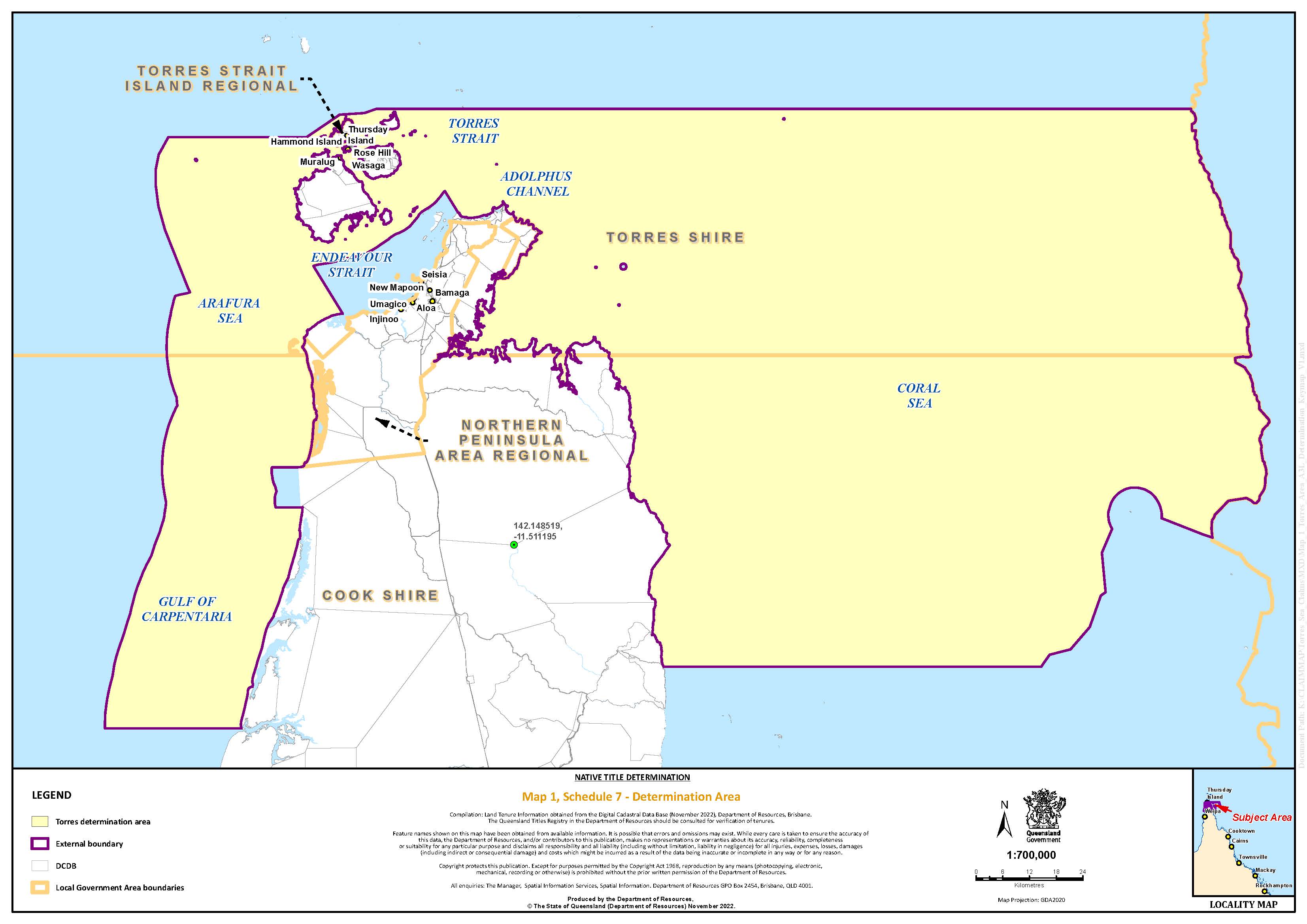 Map 1: Determination Area
Map 2: Kaurareg Area
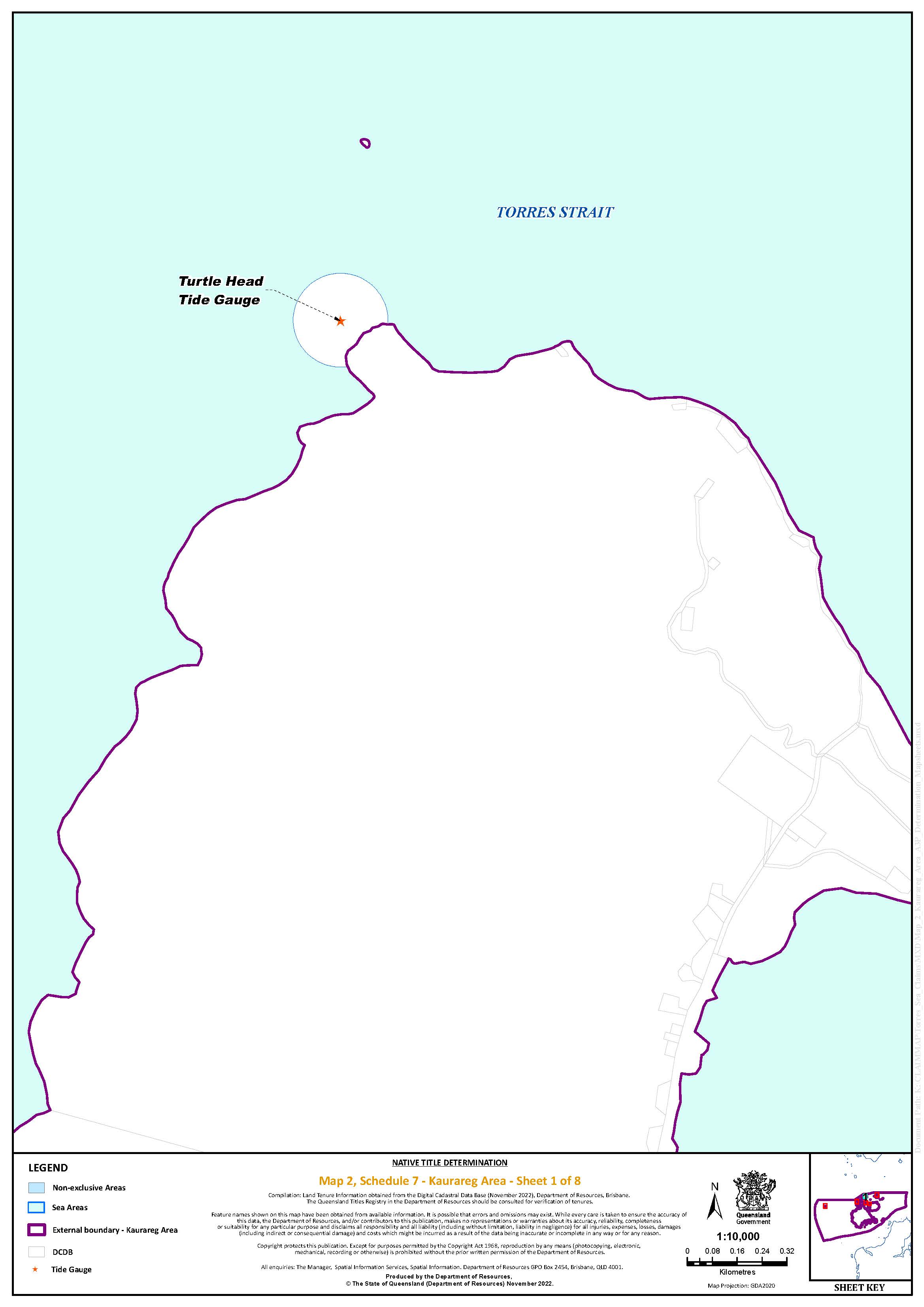
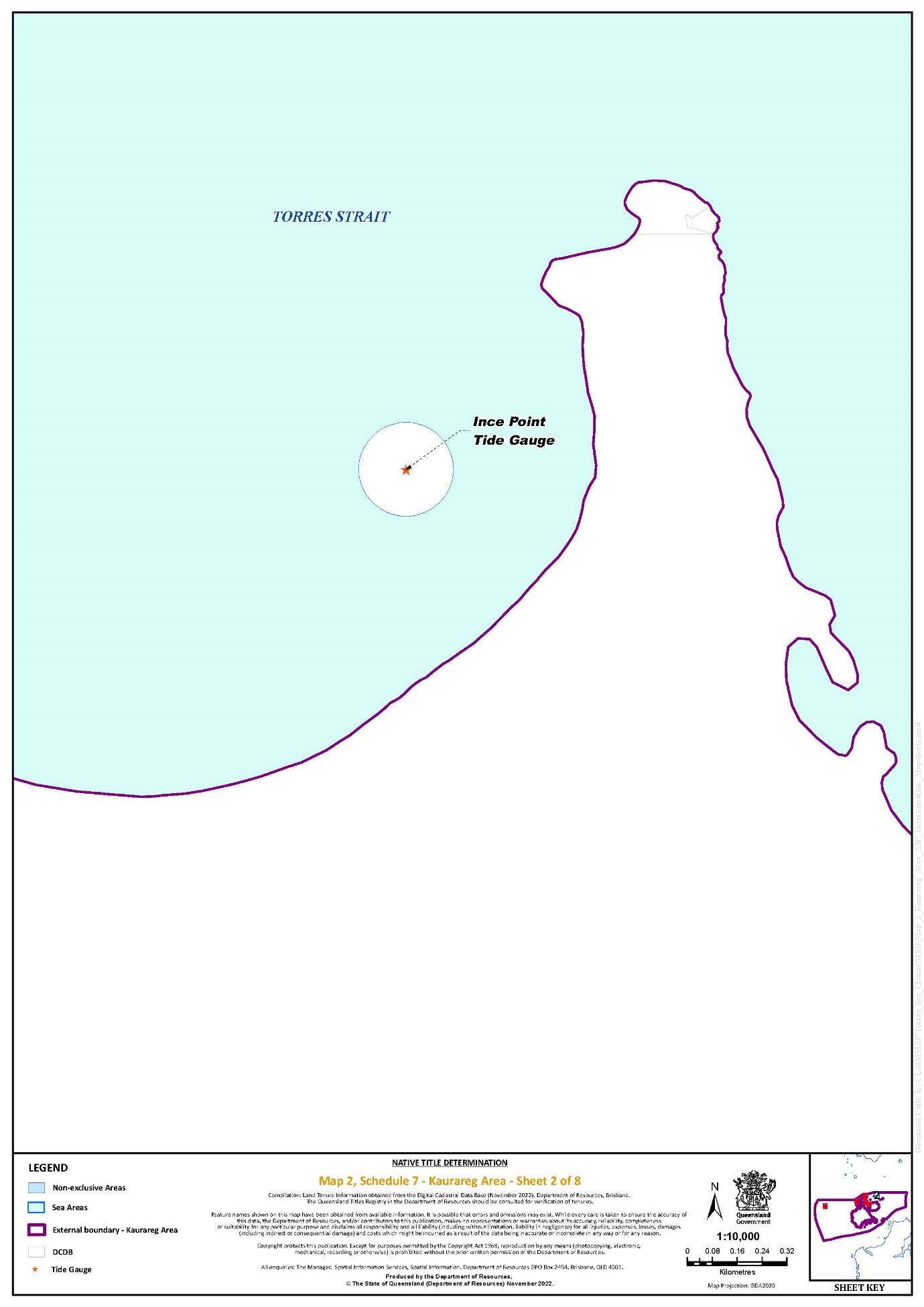
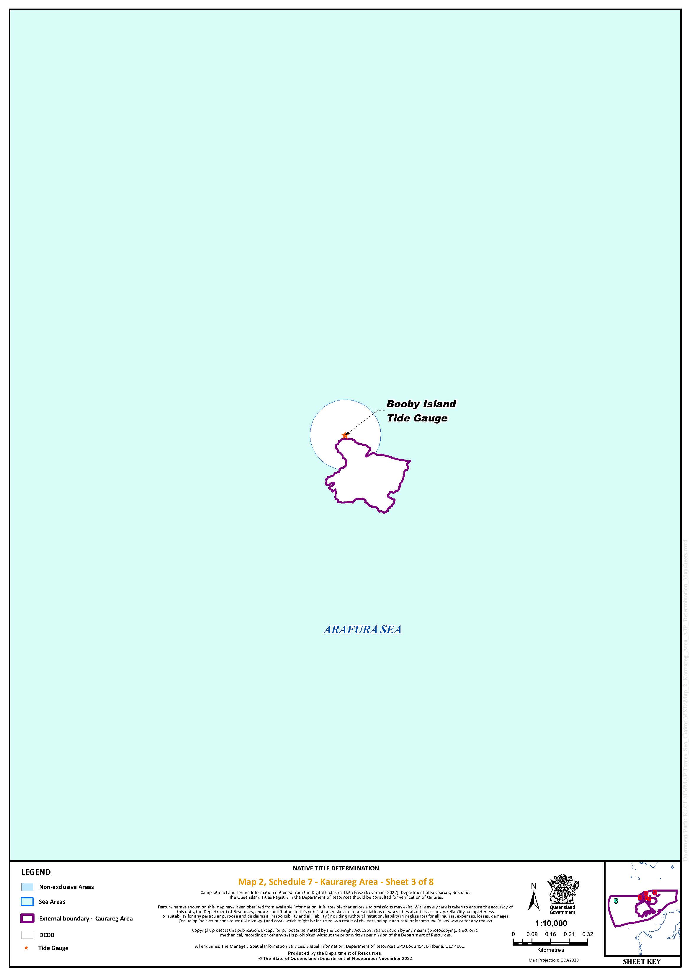
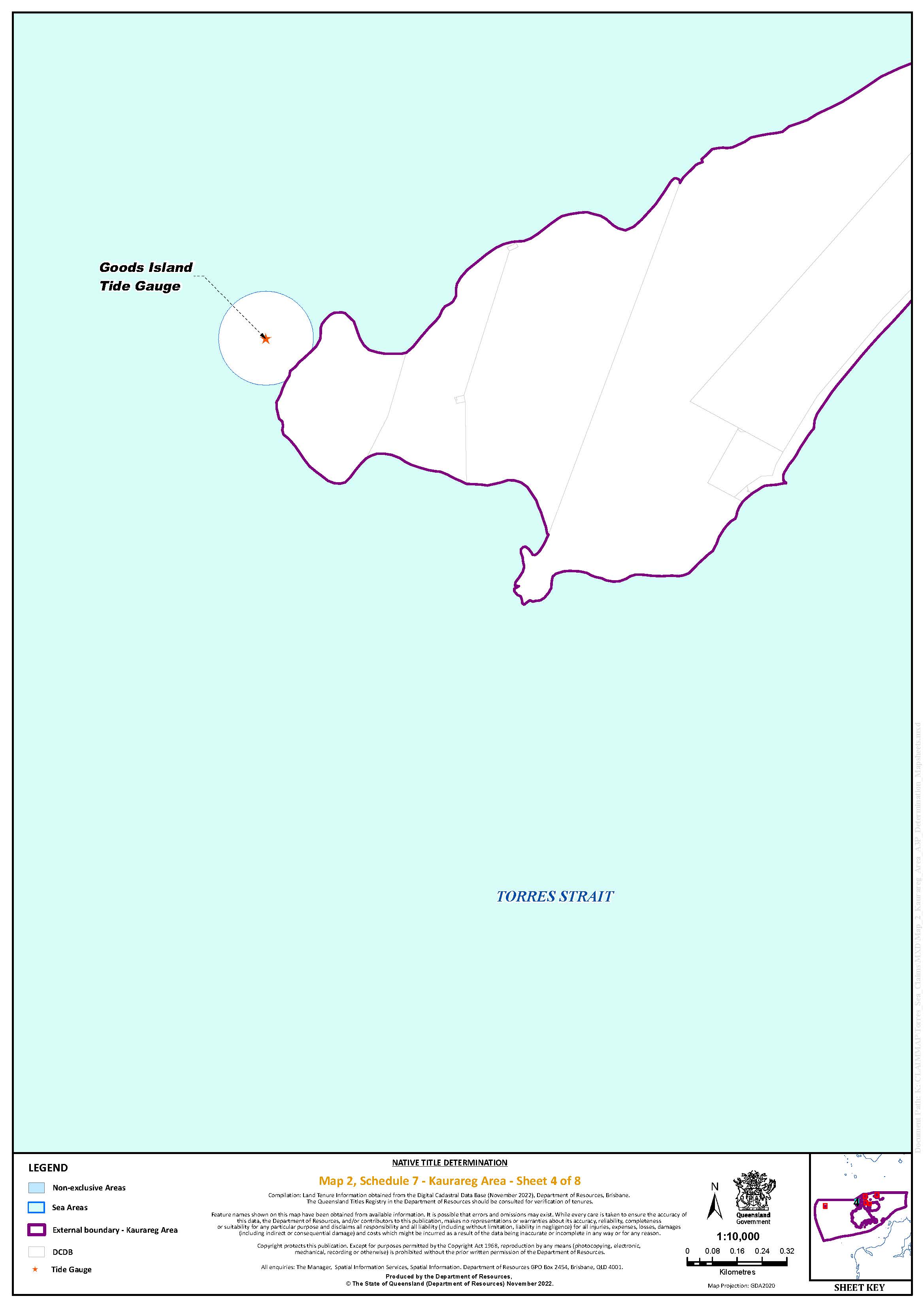
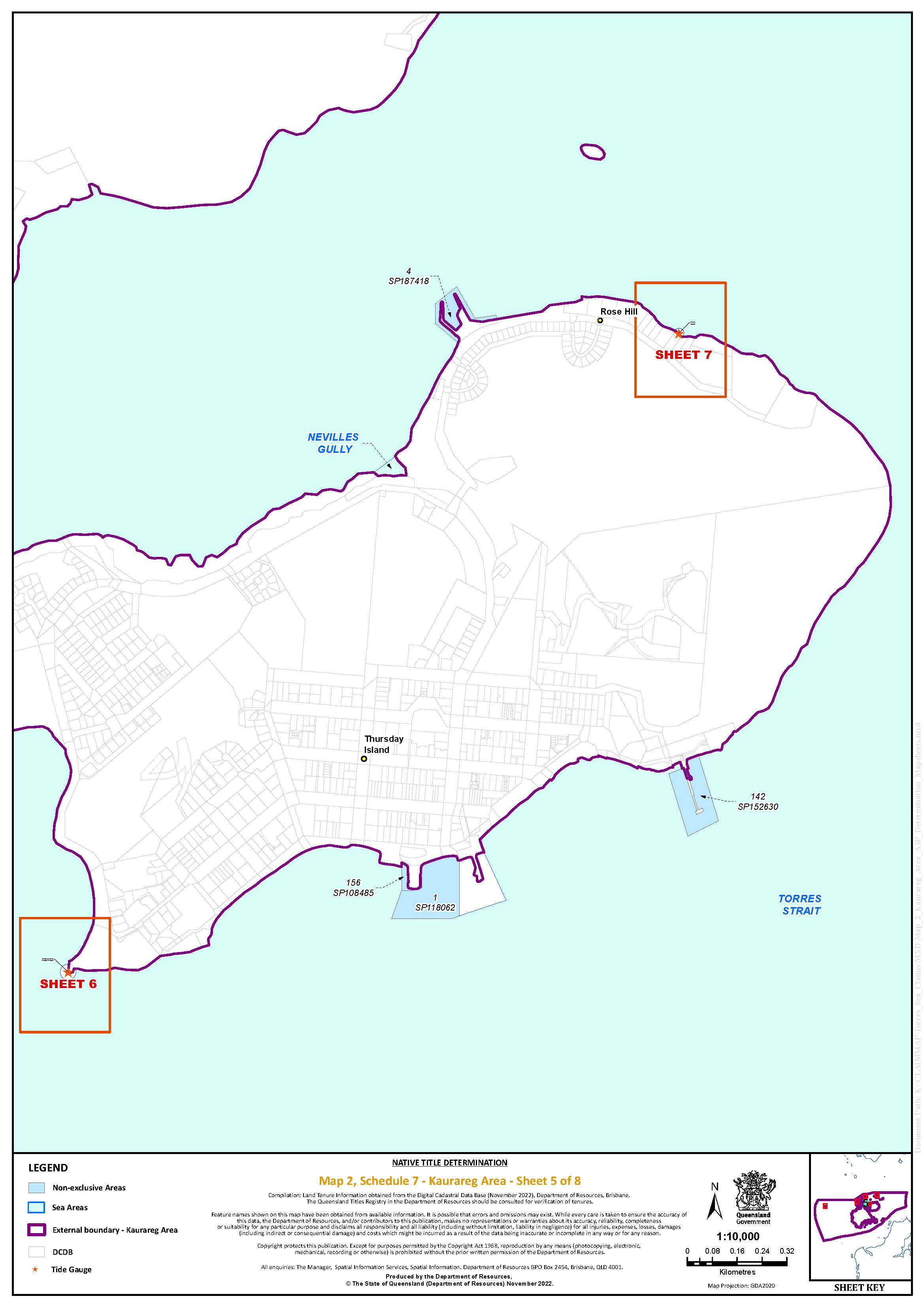
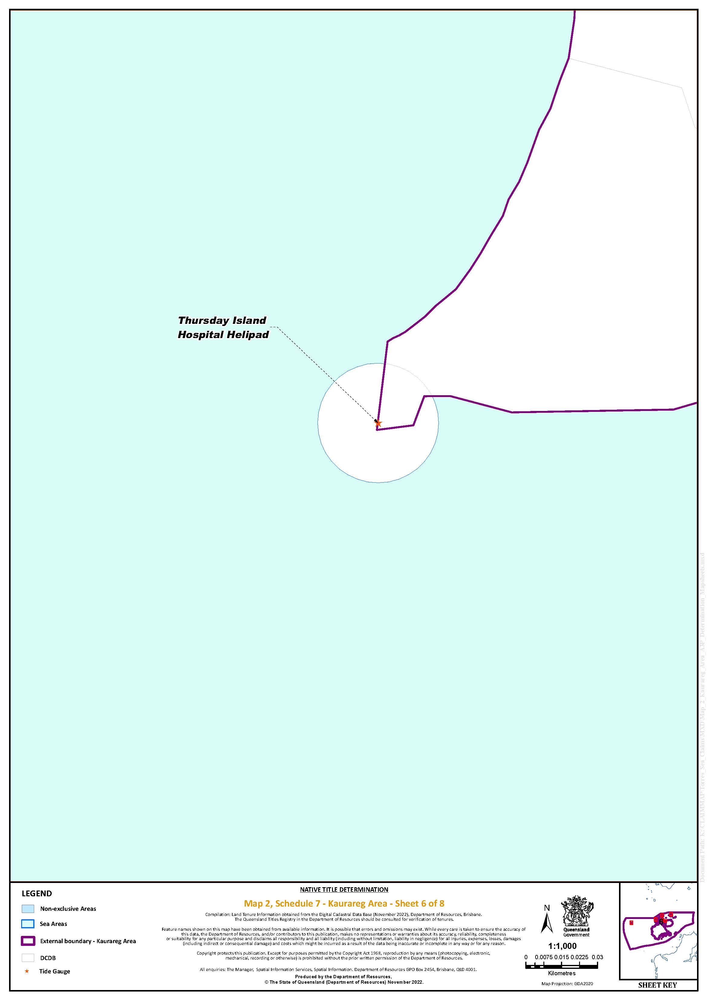
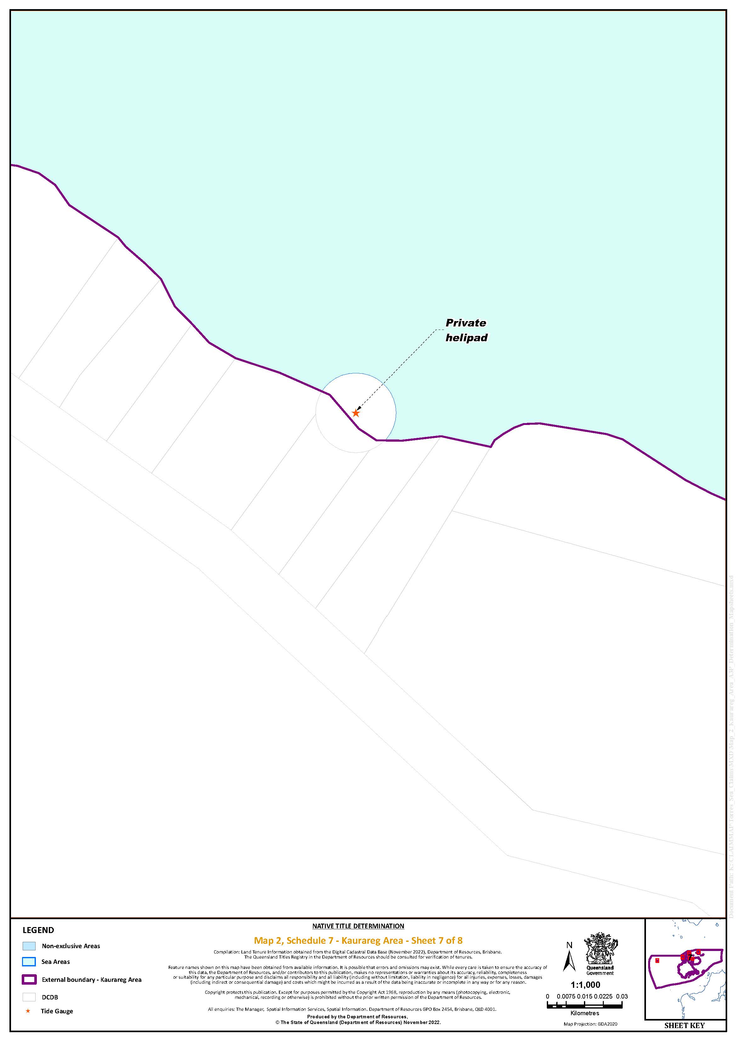
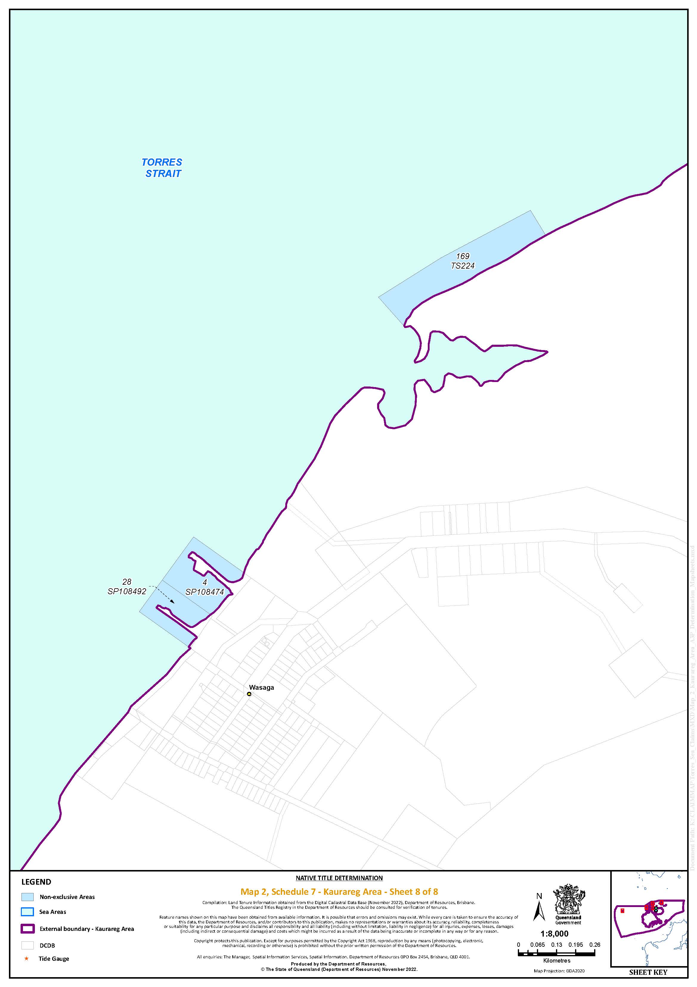
Map 3: Ankamuthi Area
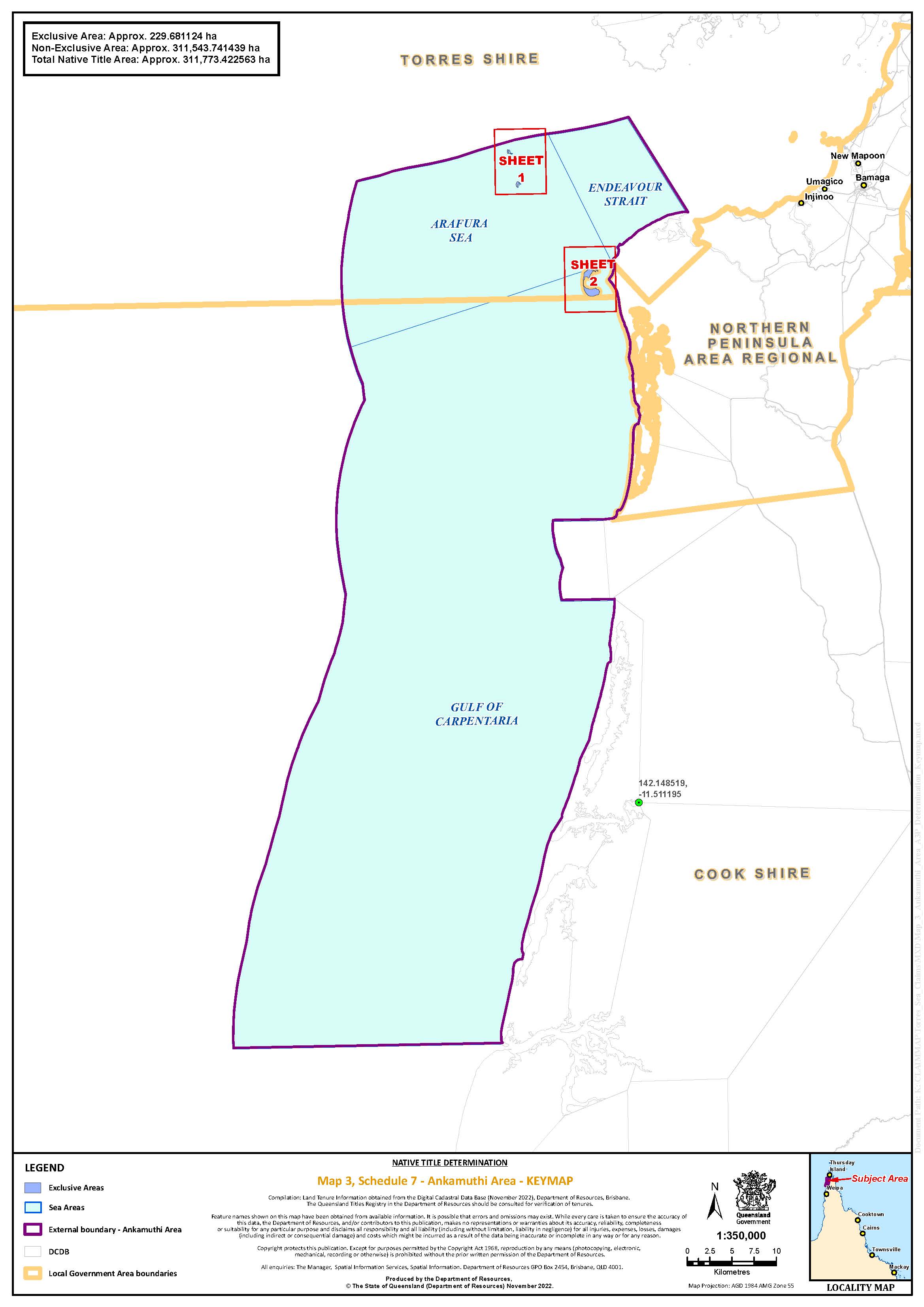
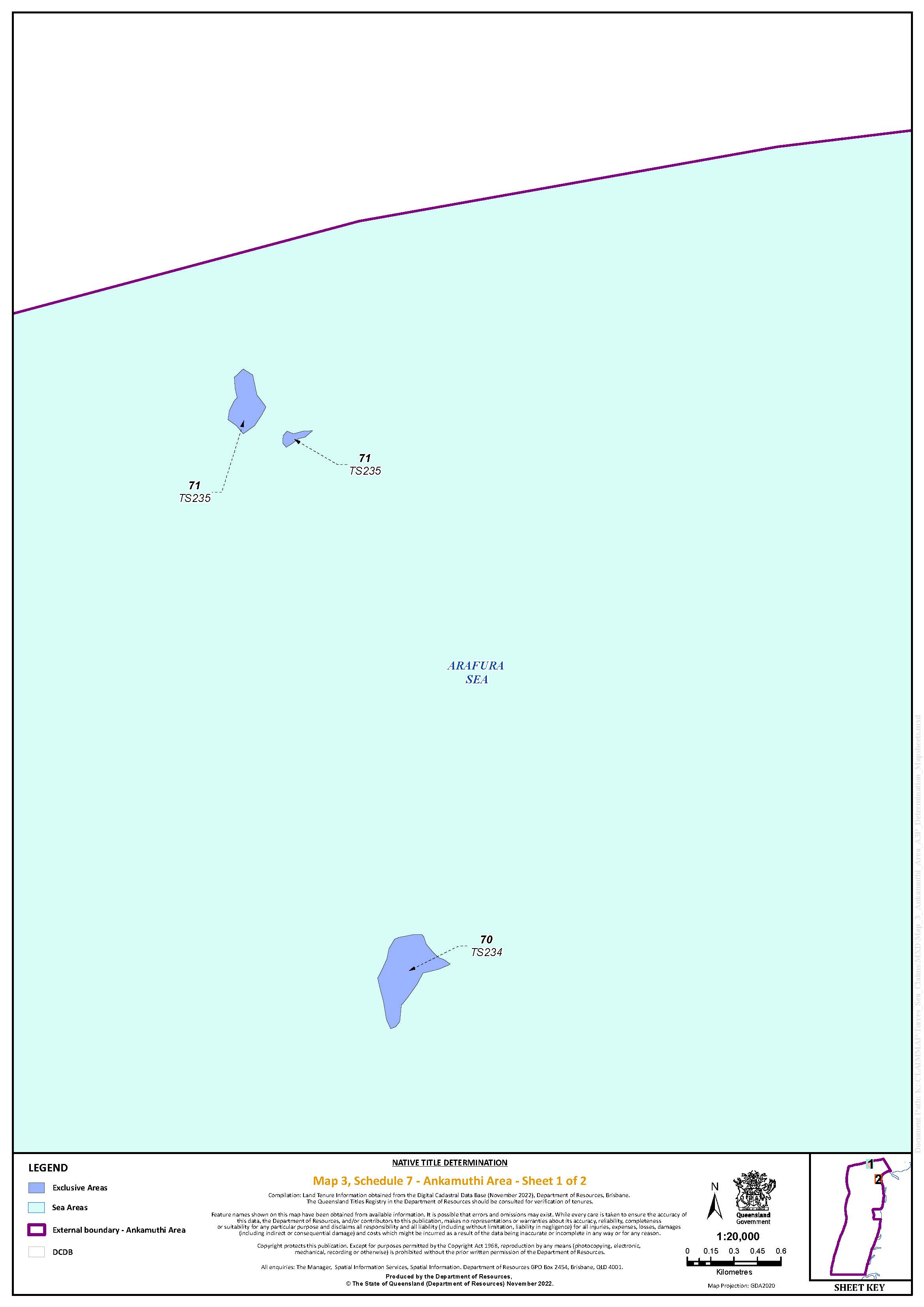
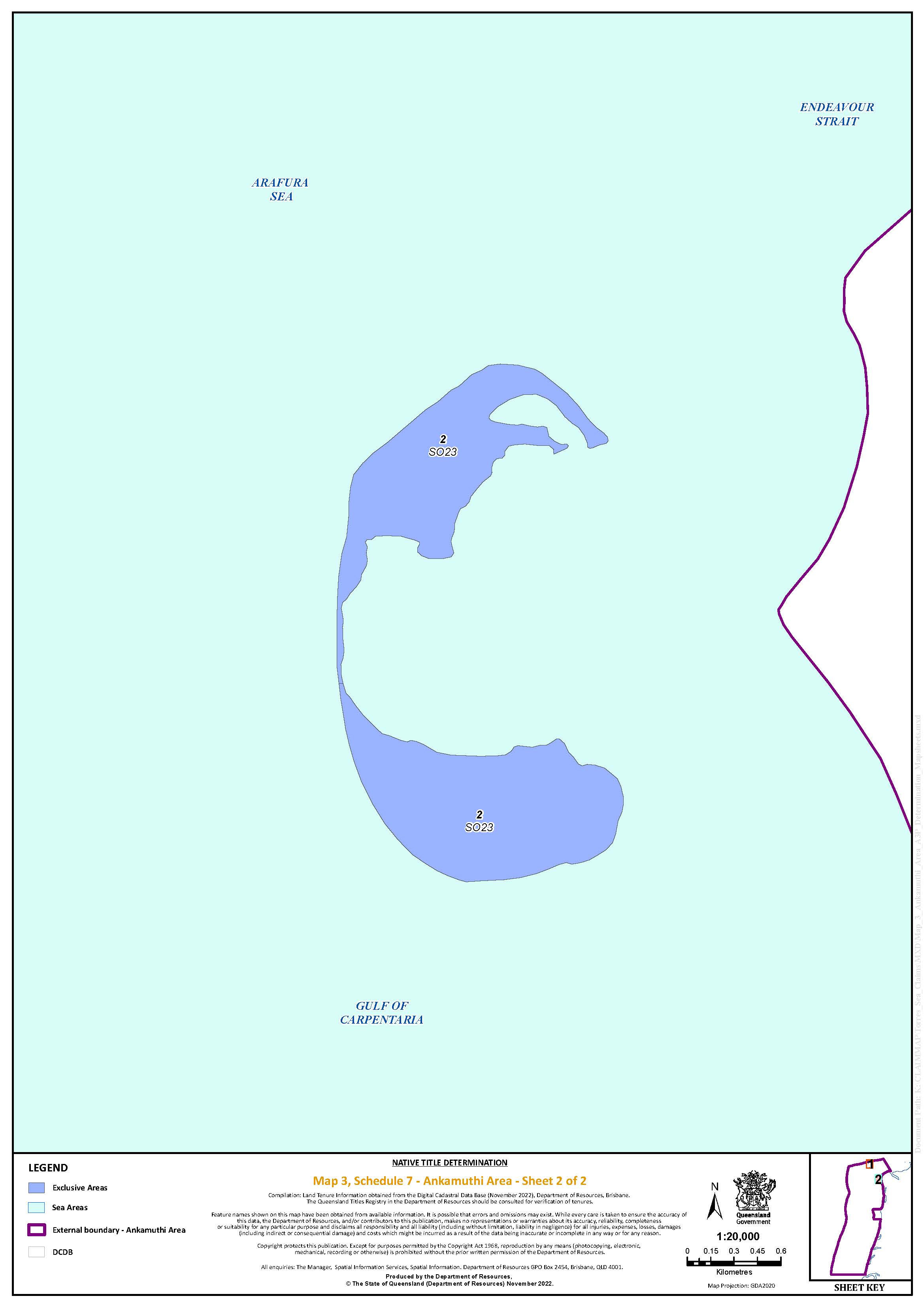
Map 4: Gudang Yadhaykenu Area
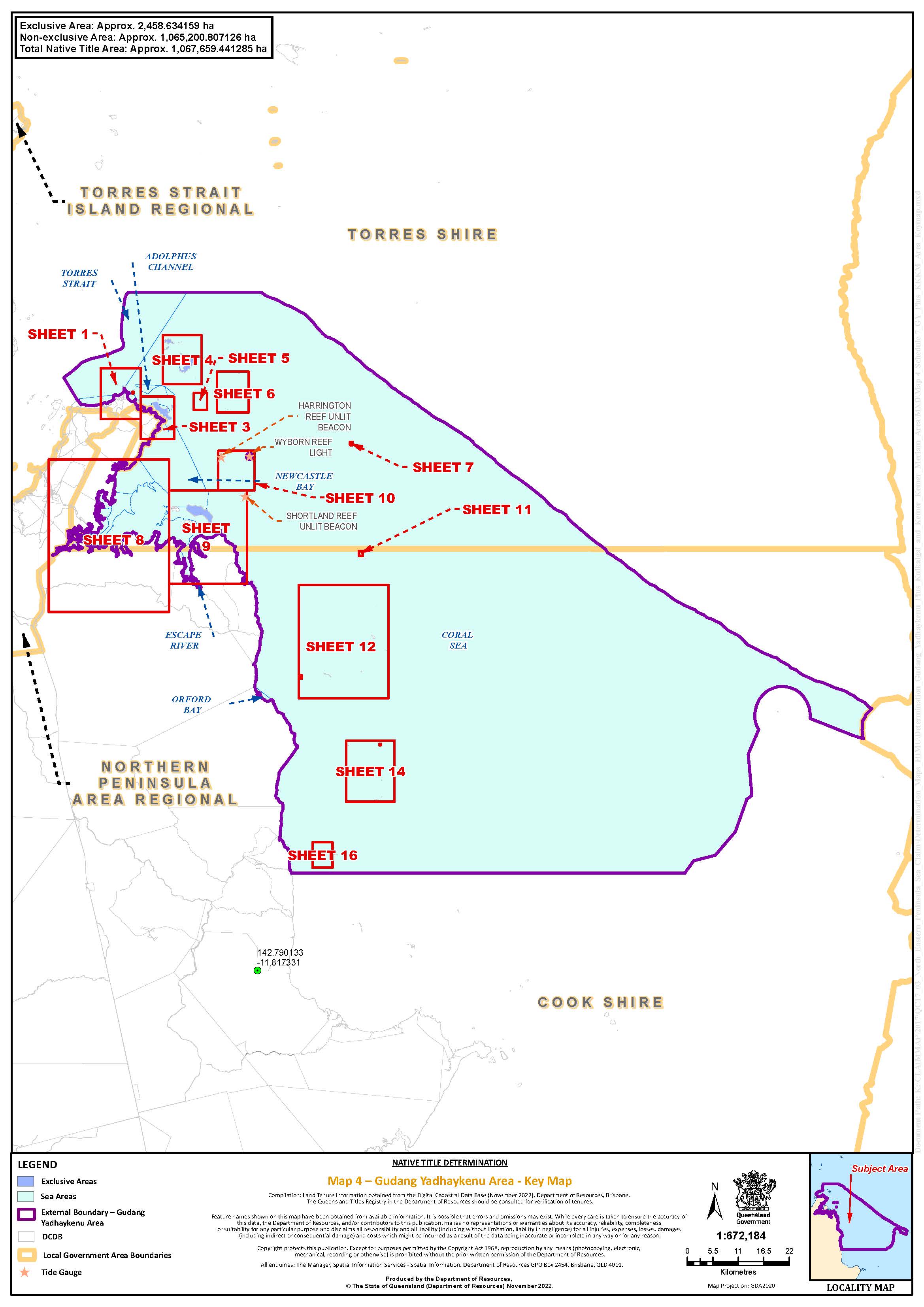
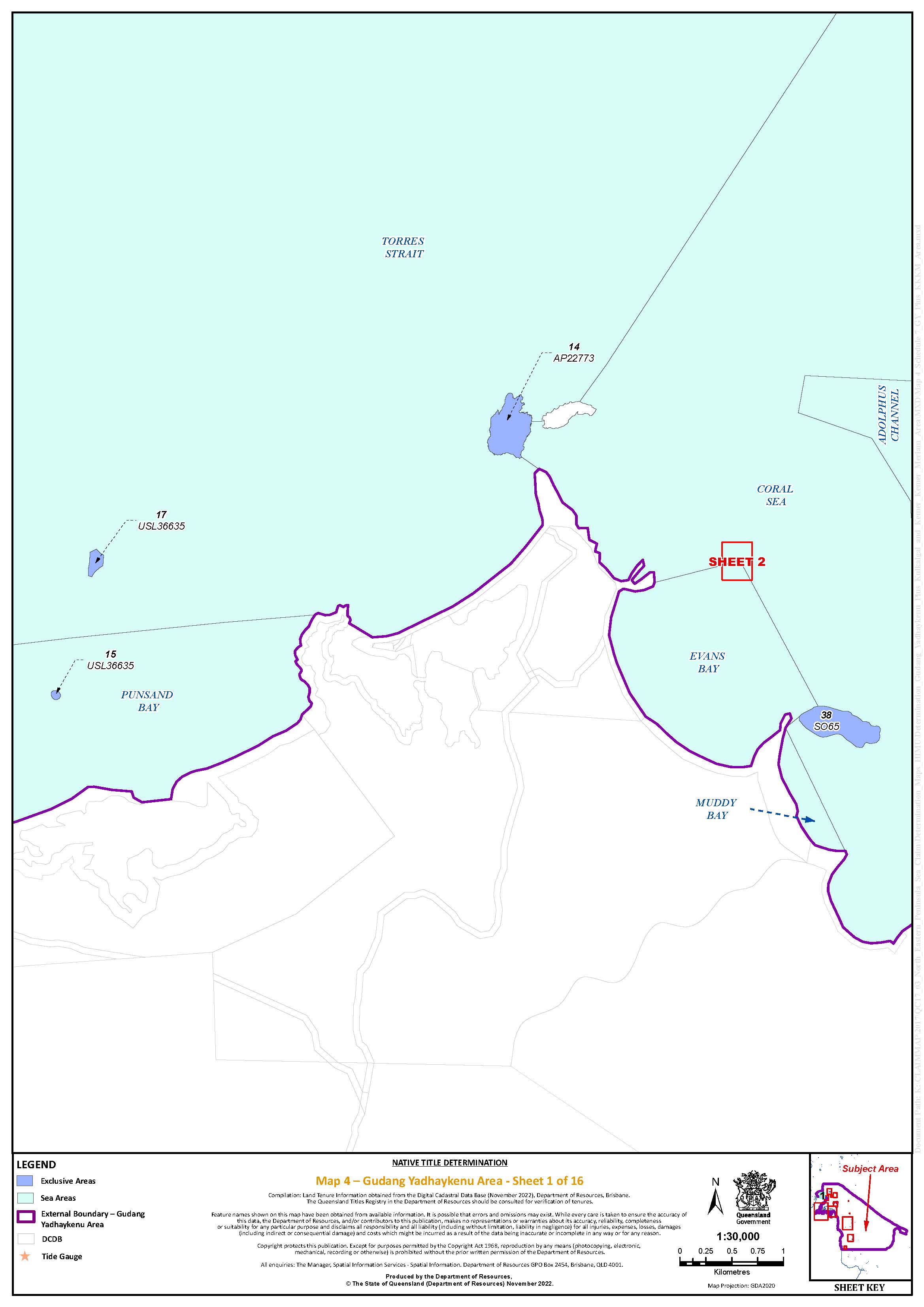
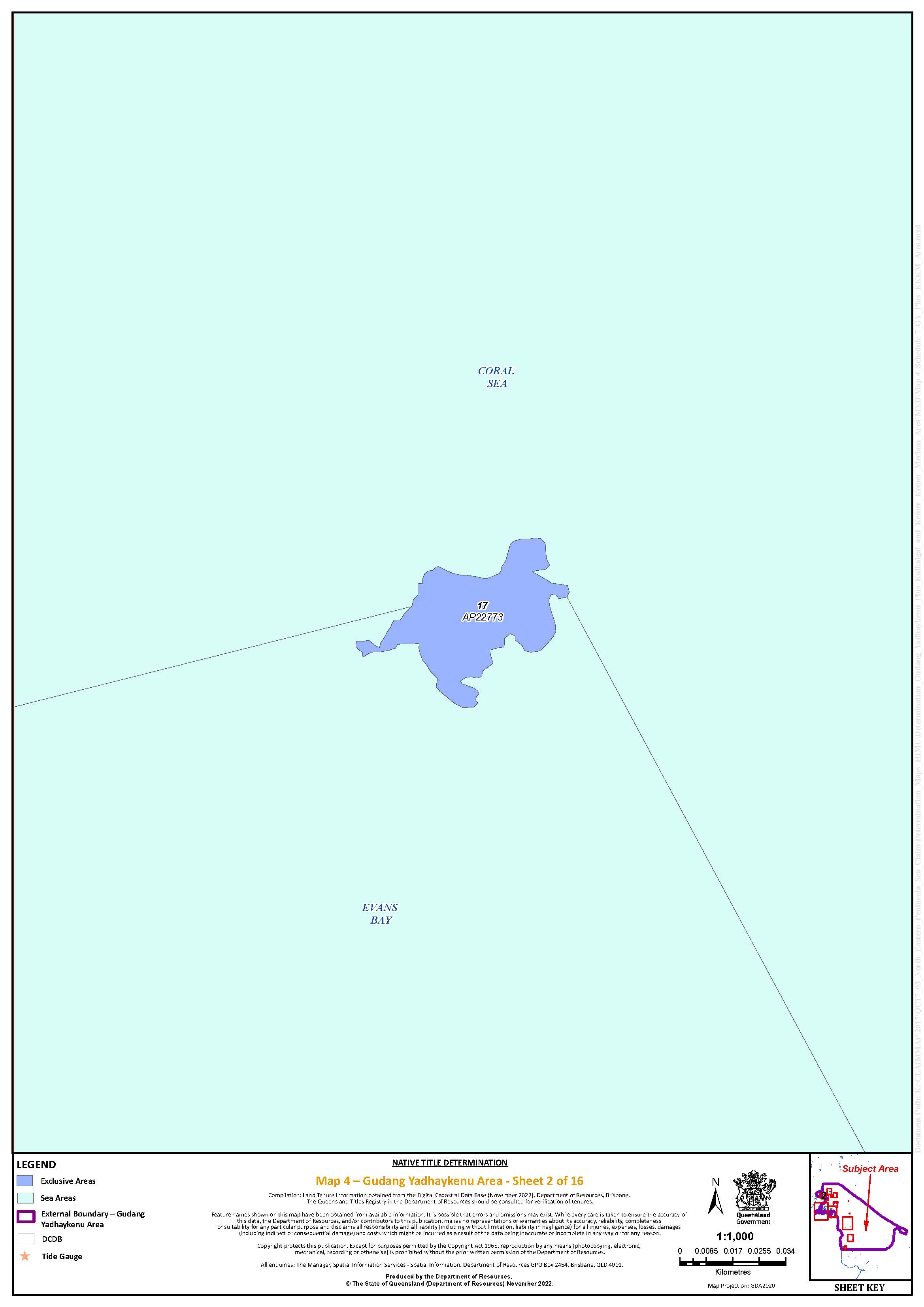
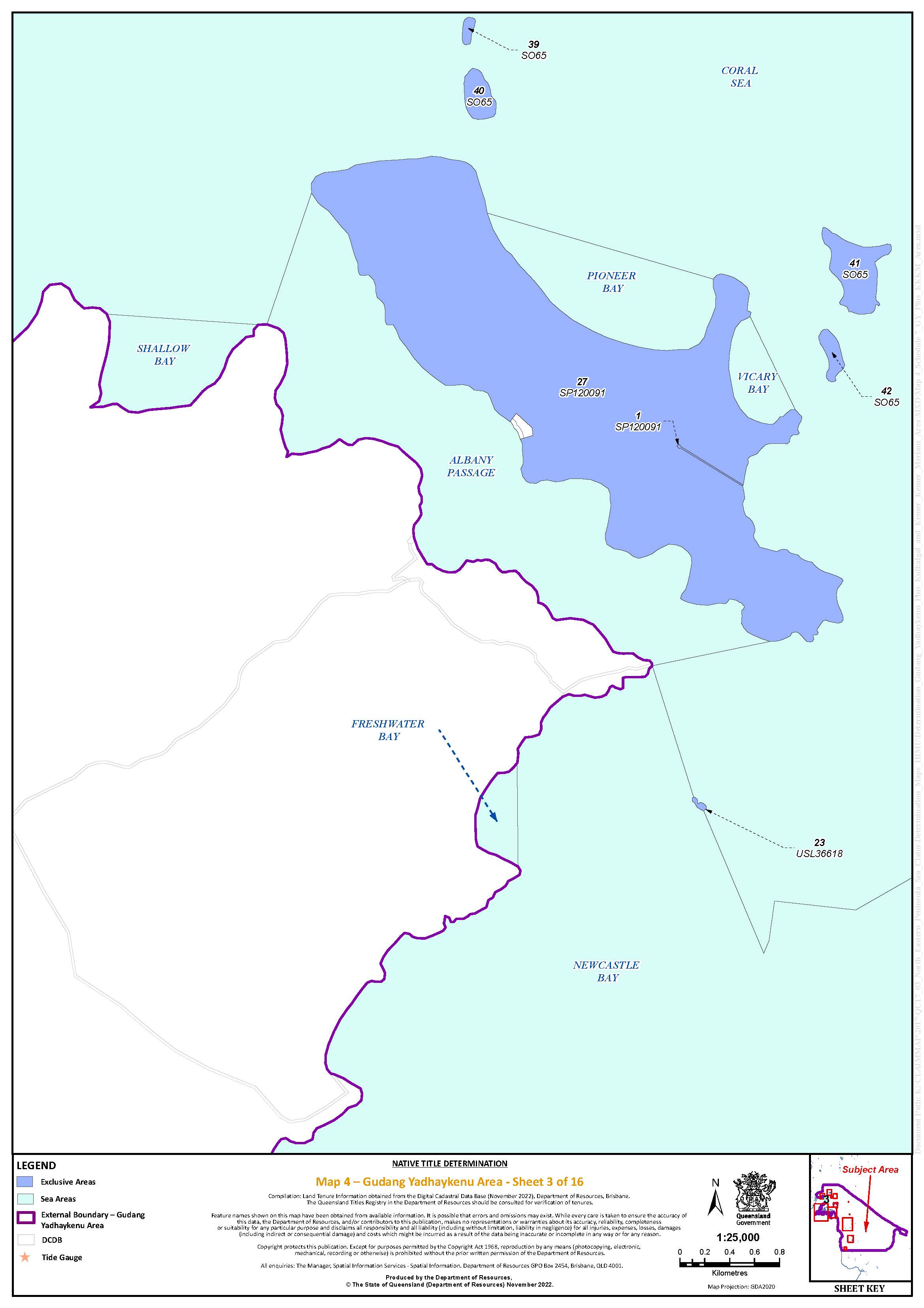
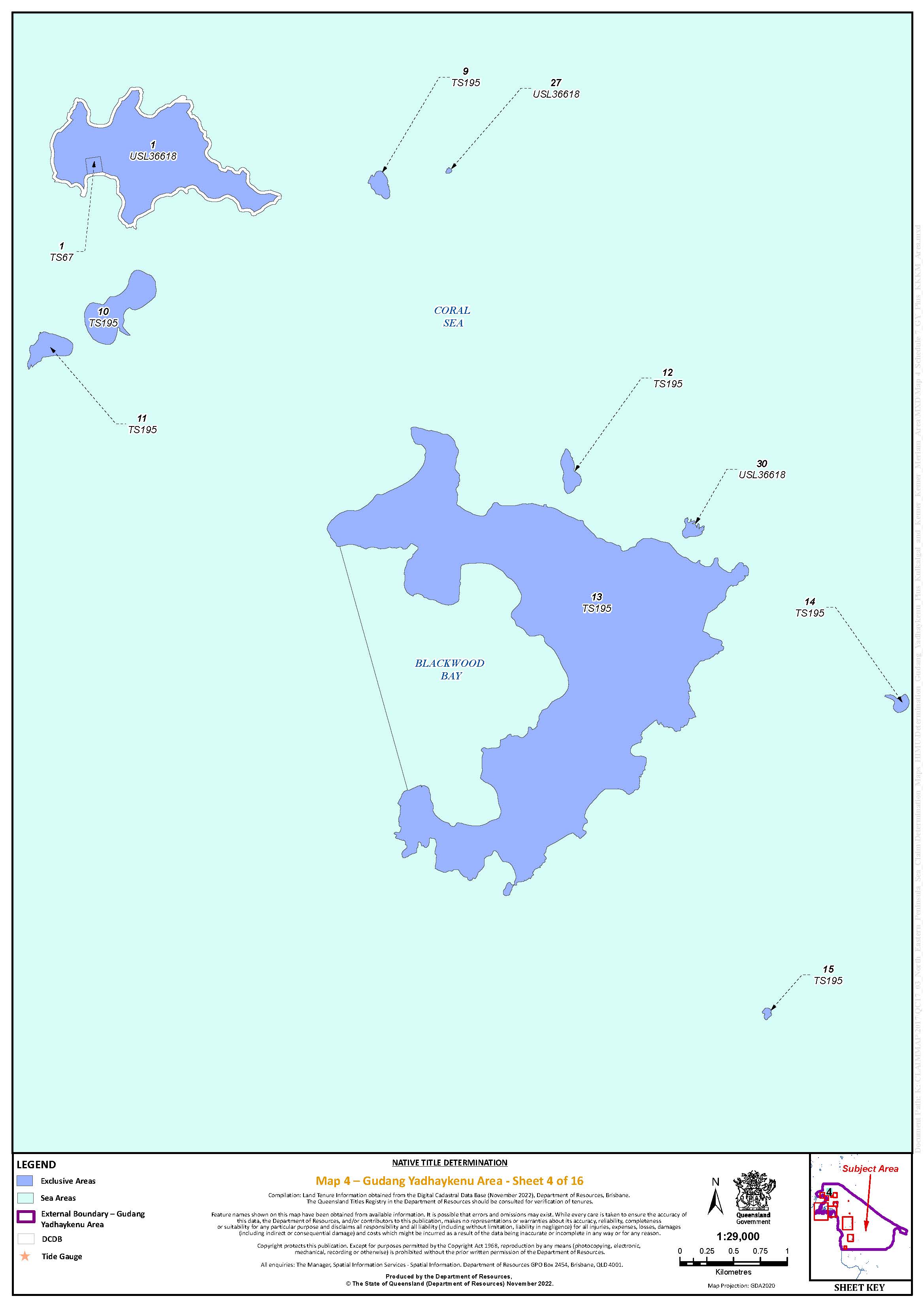
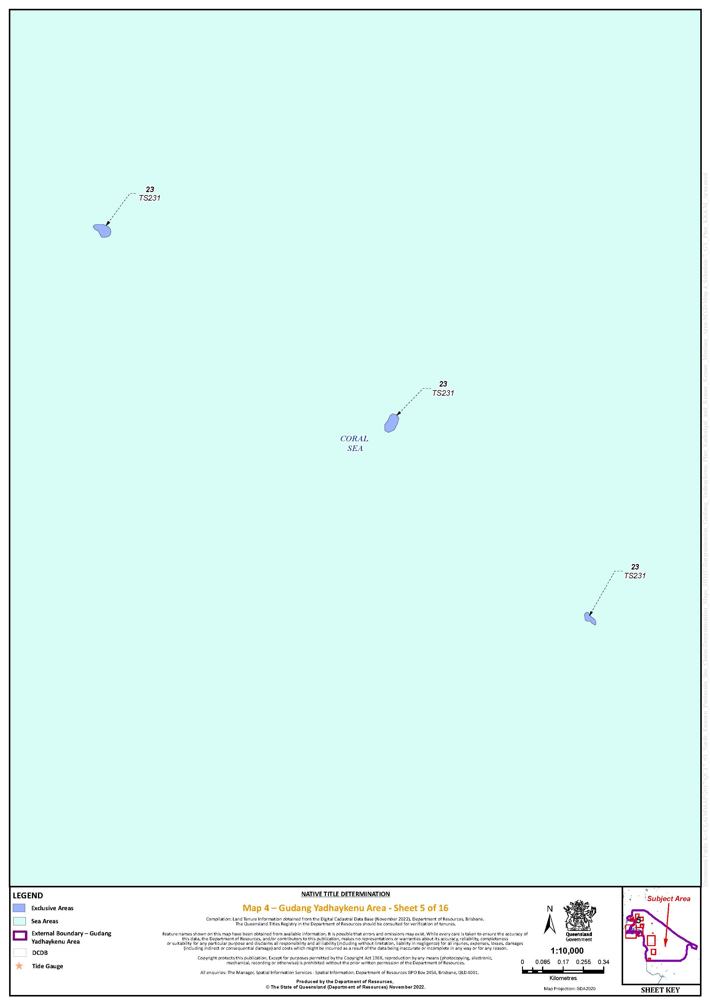
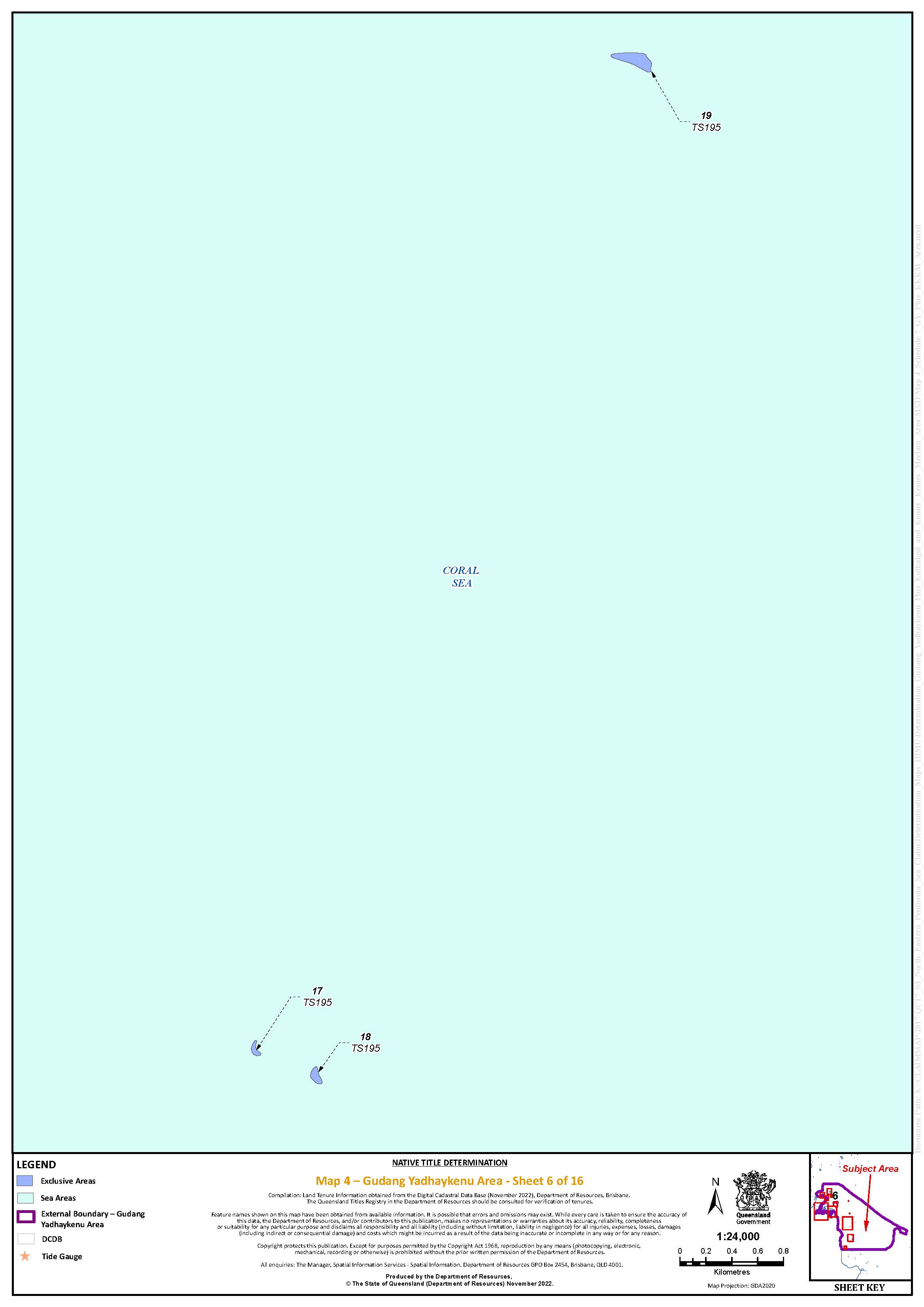
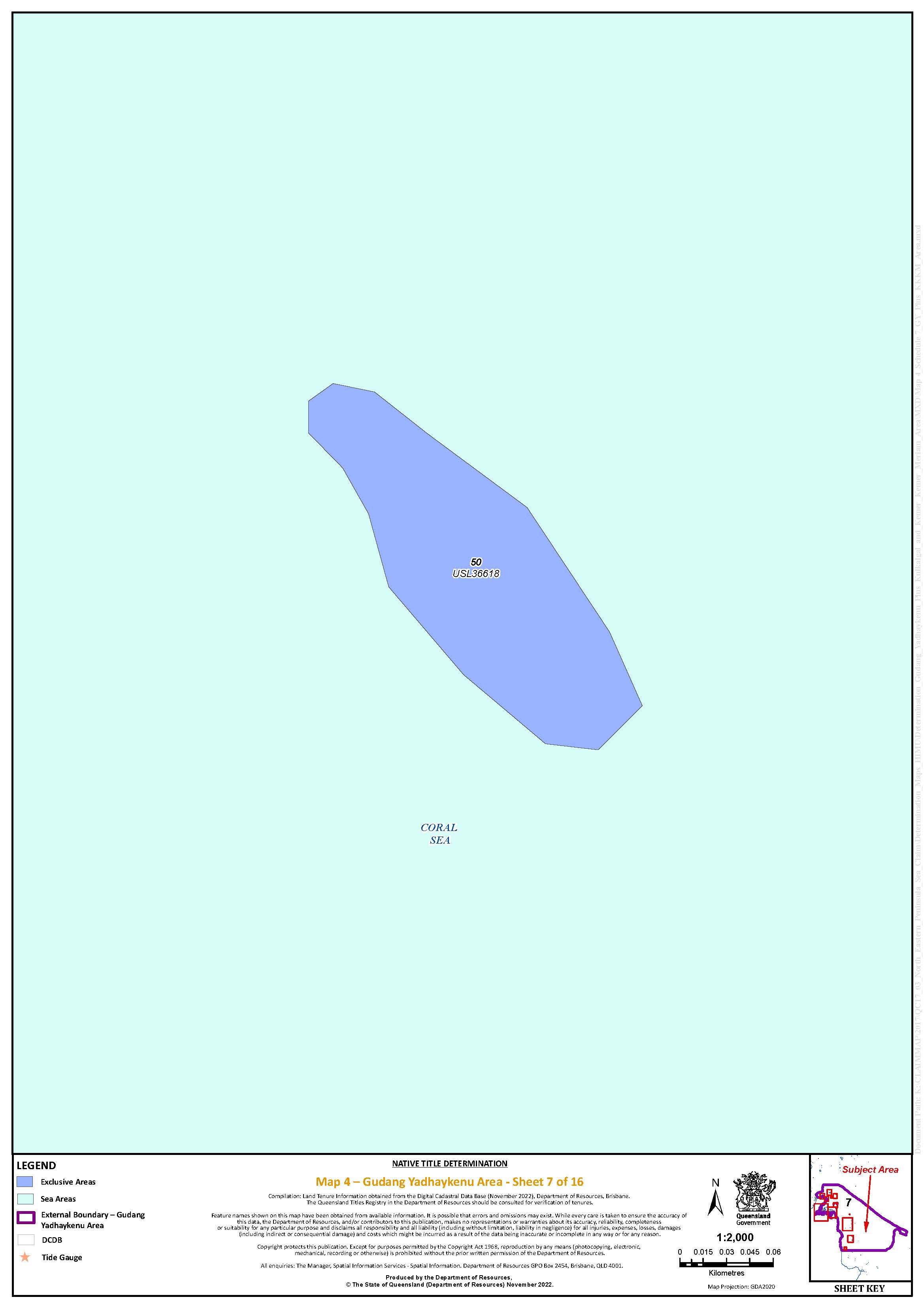
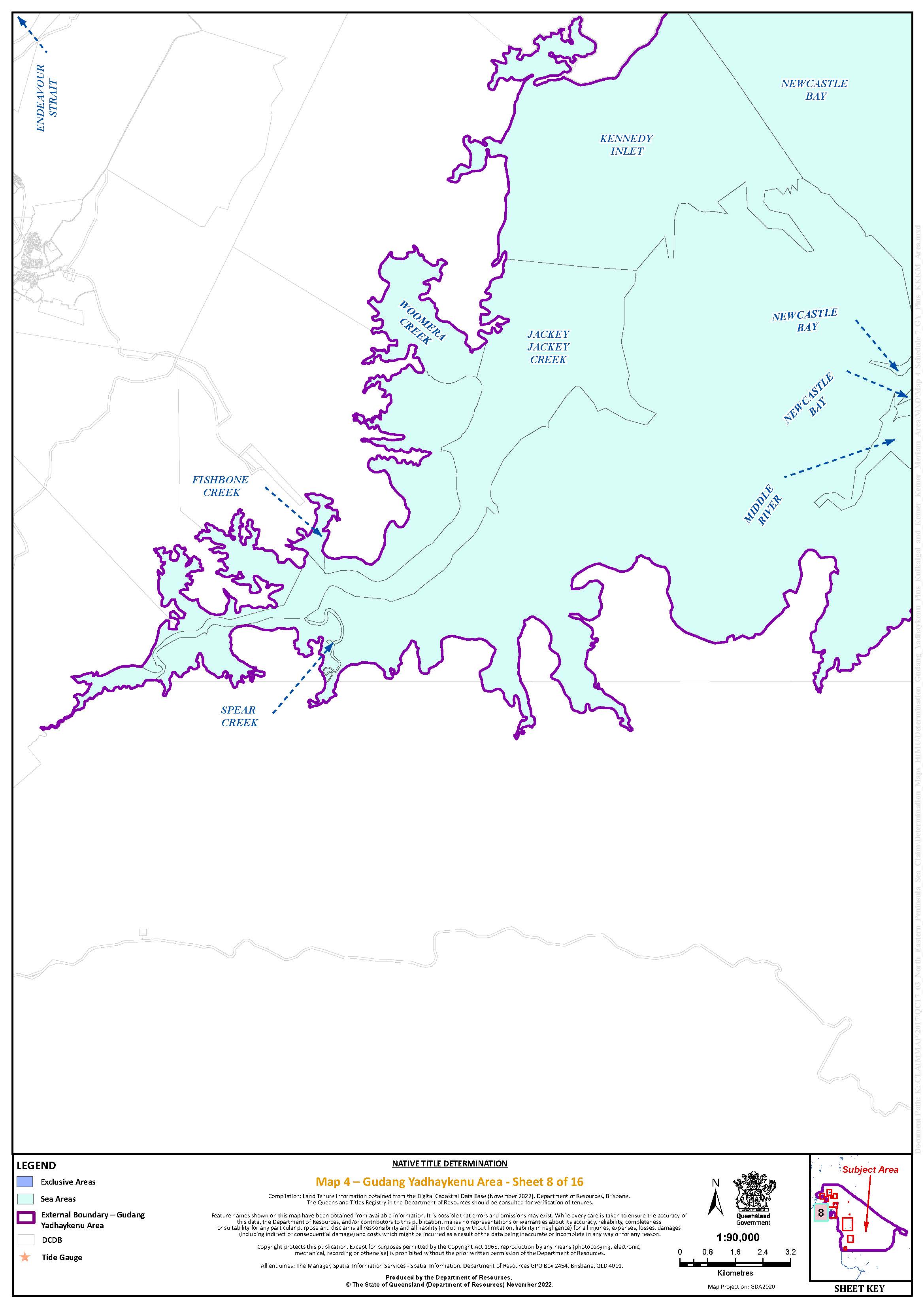
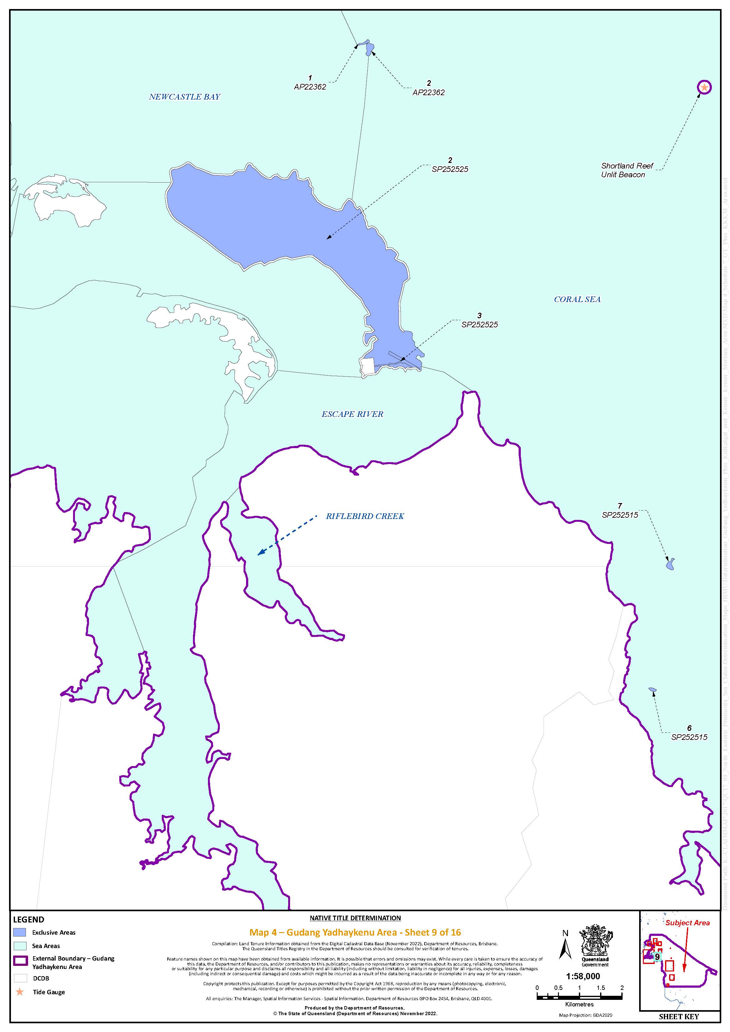
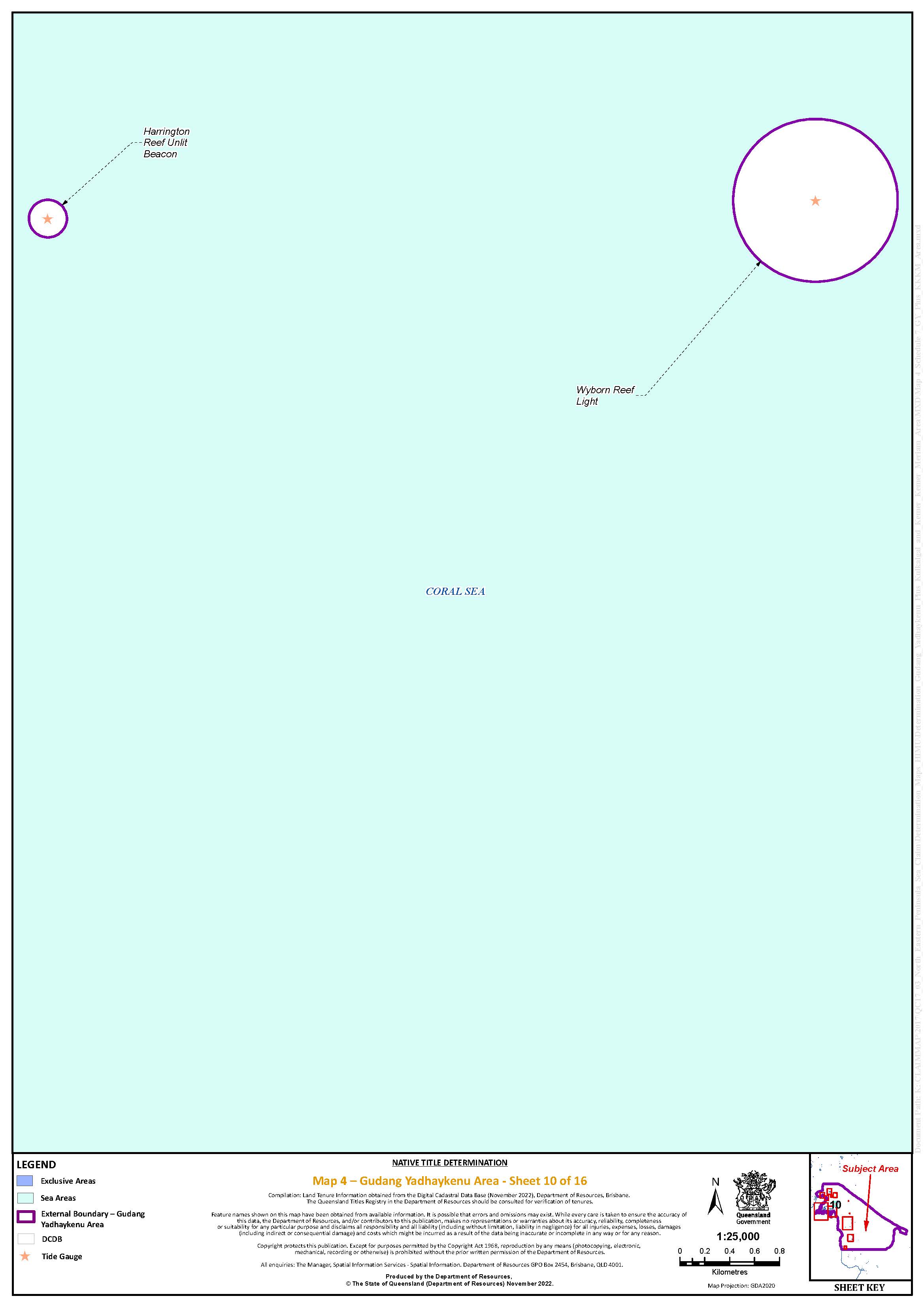
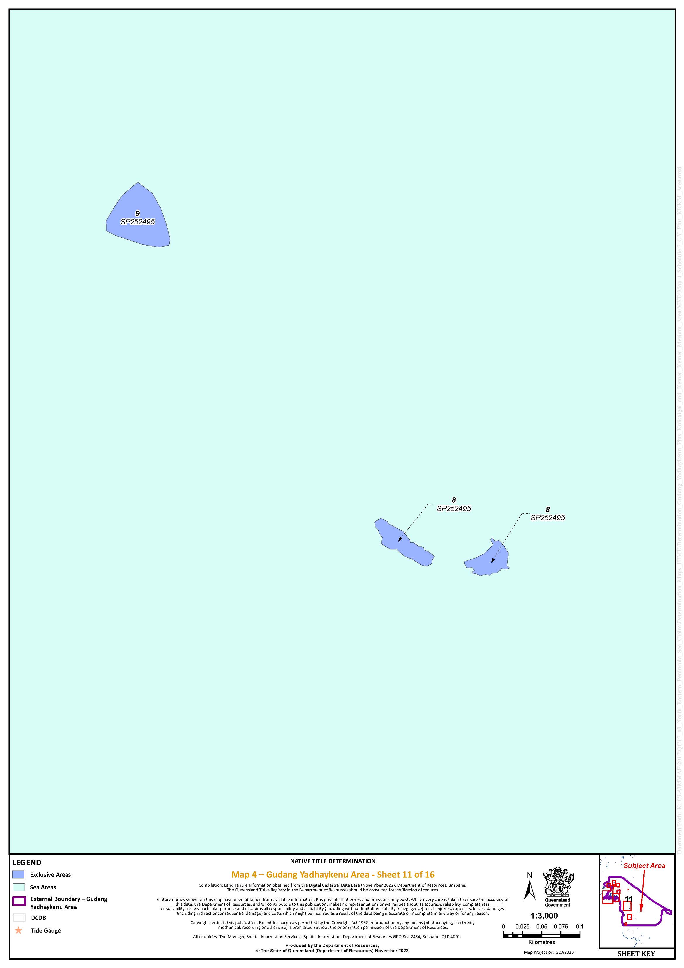
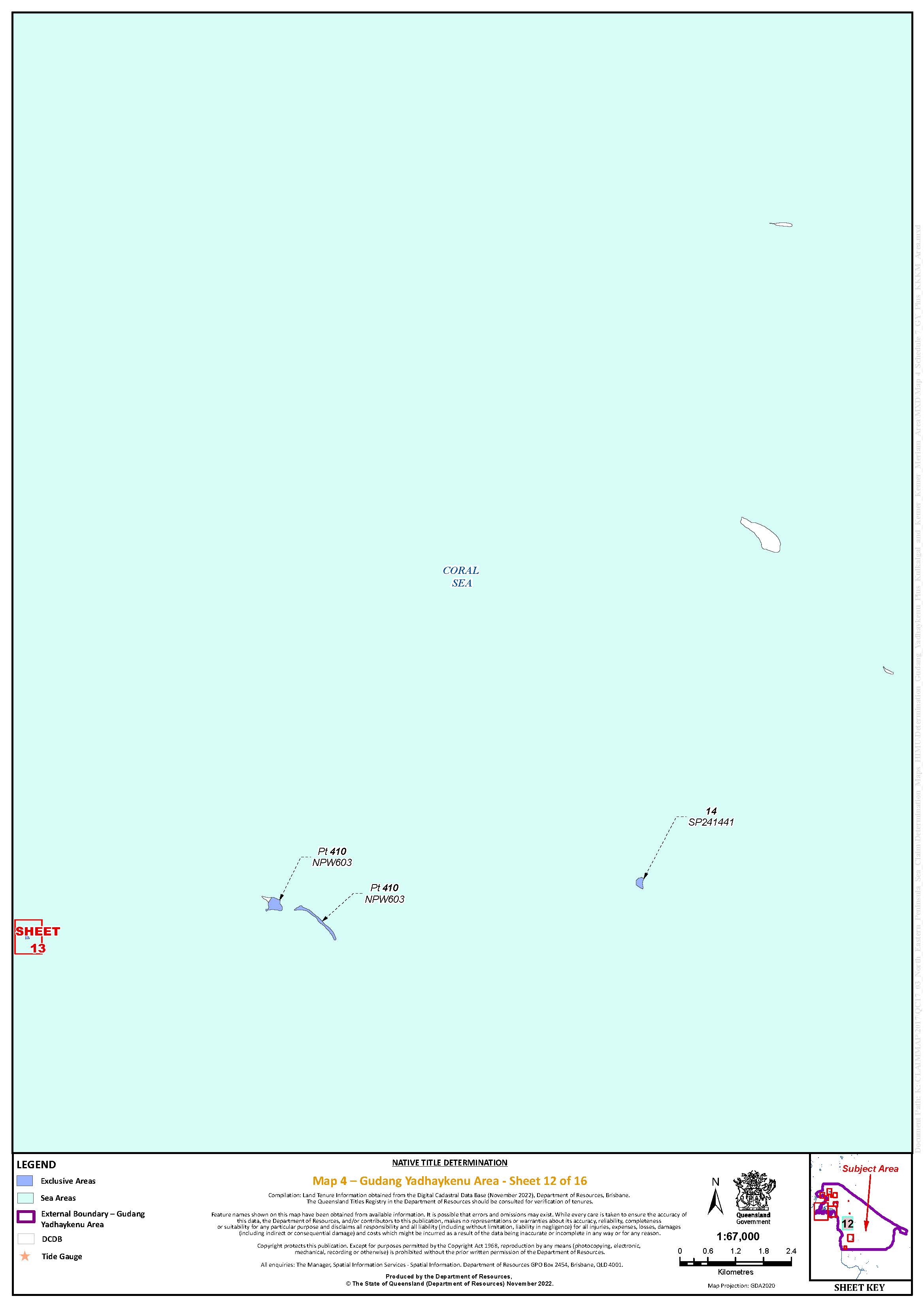
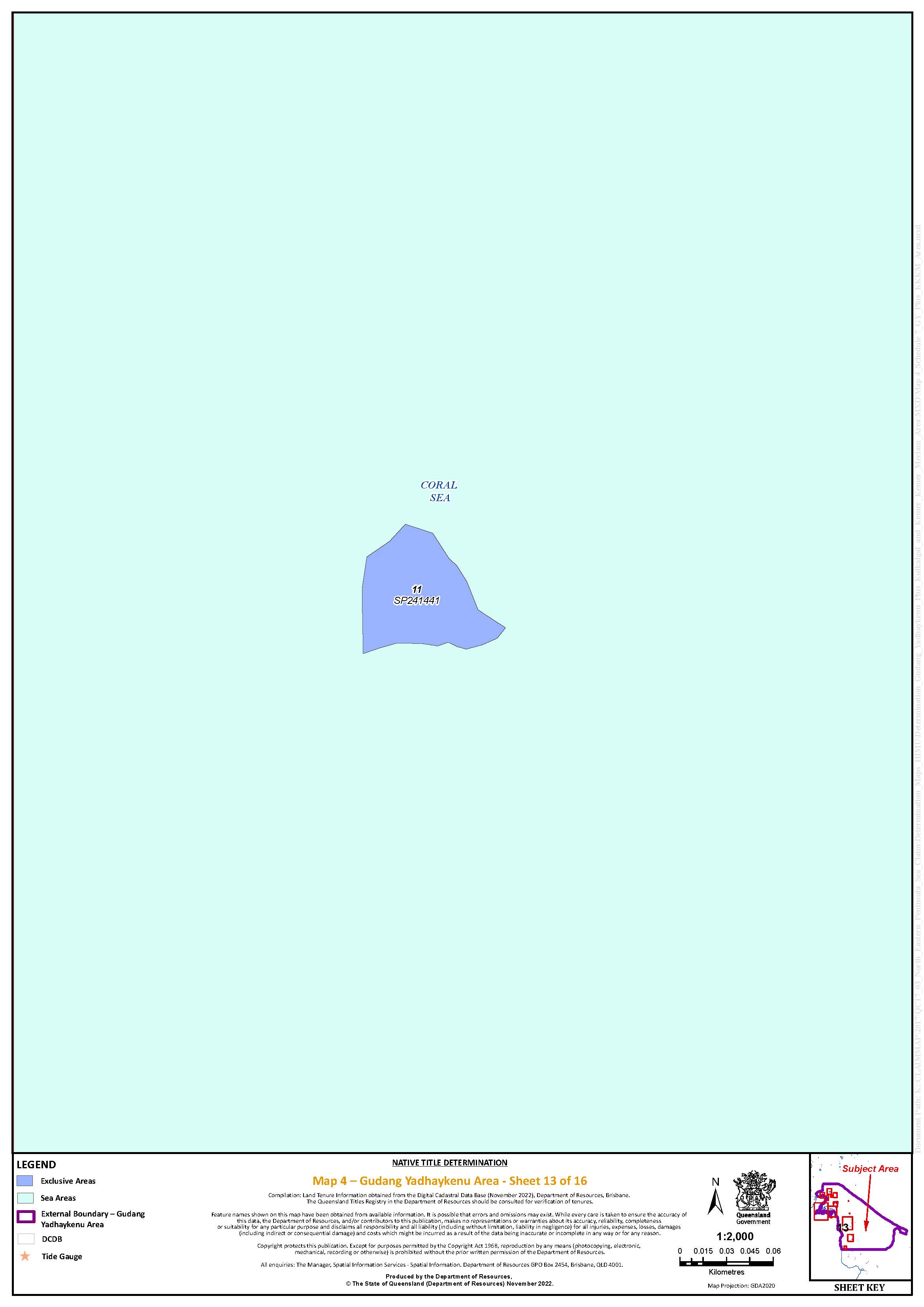
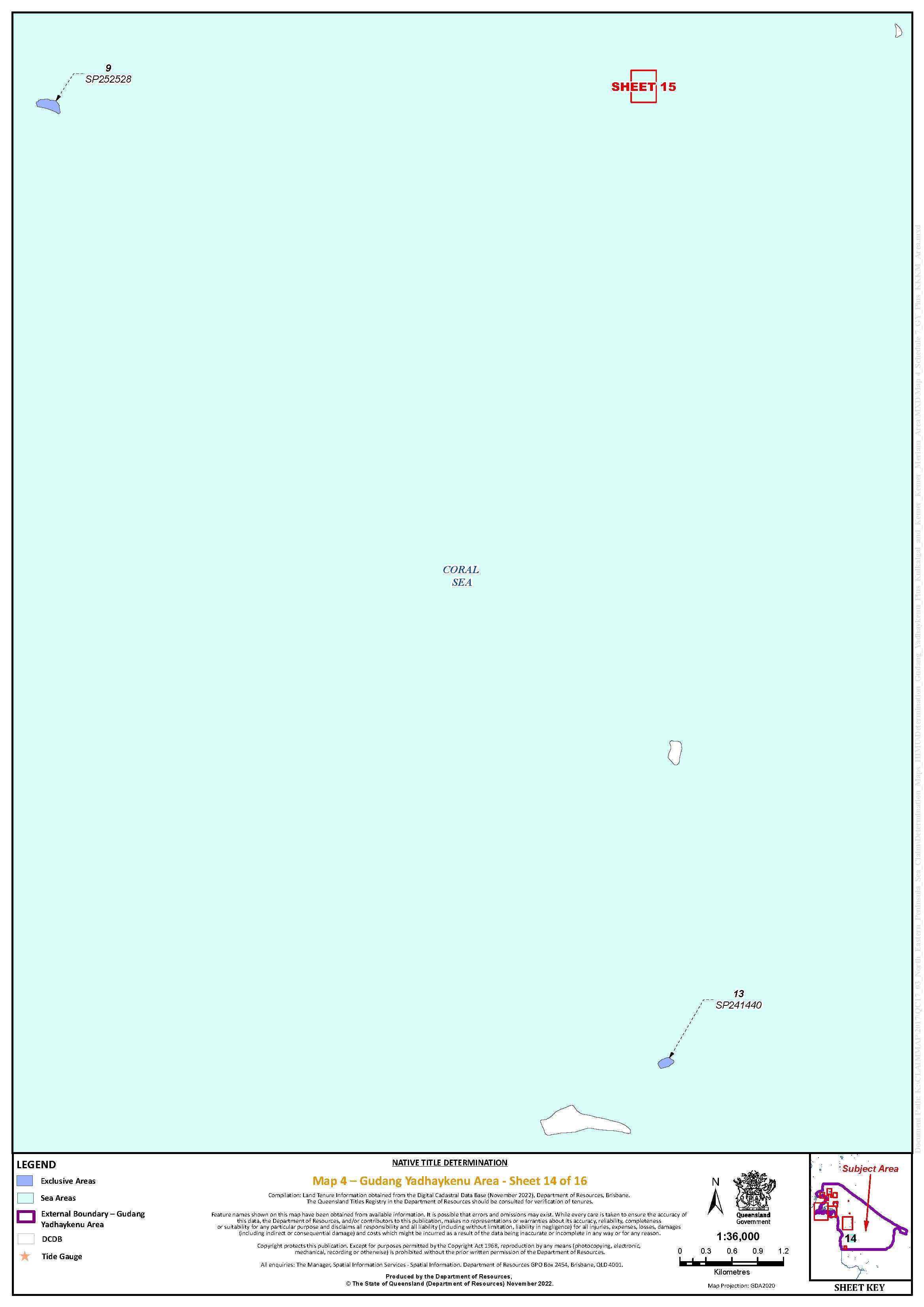
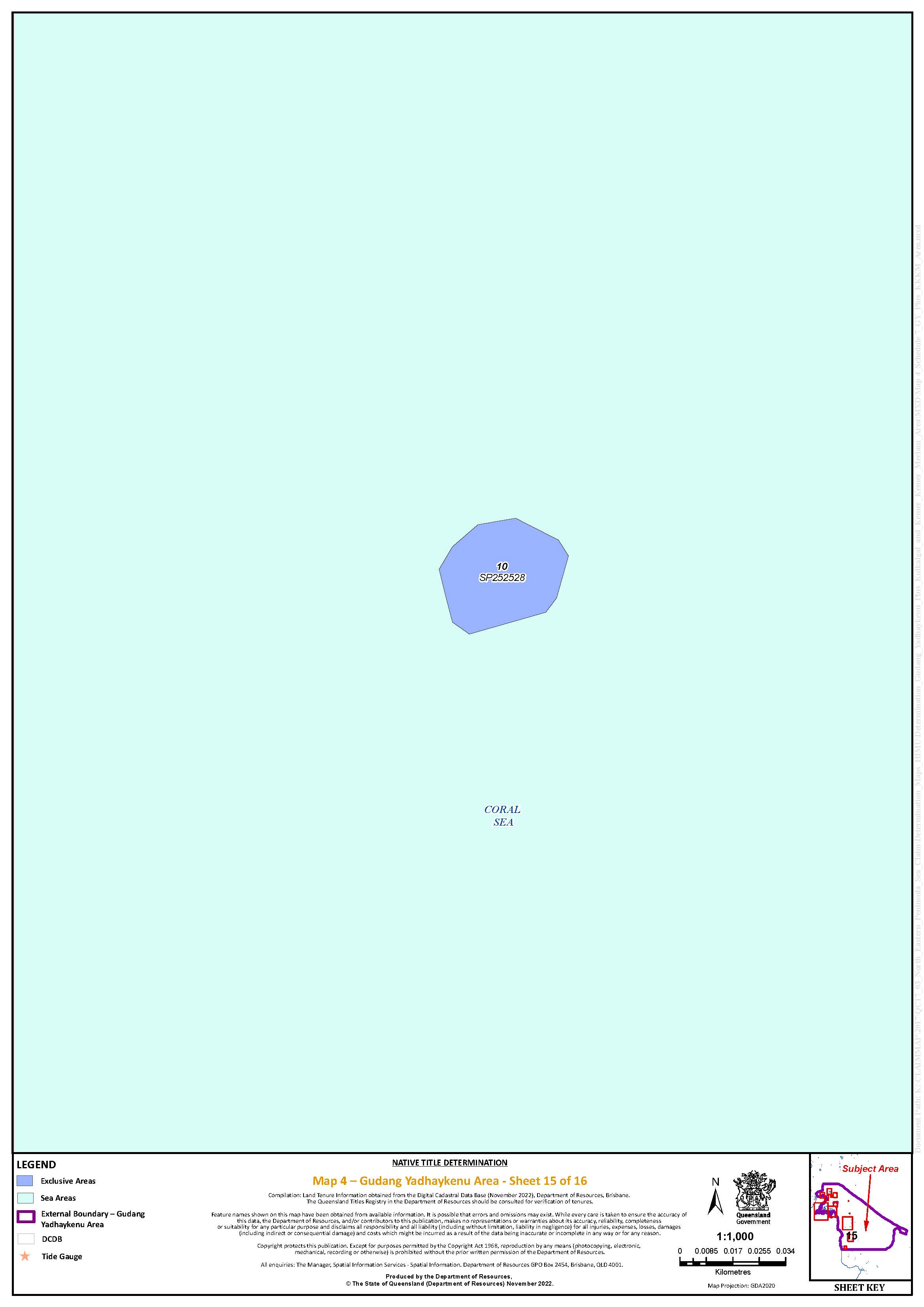
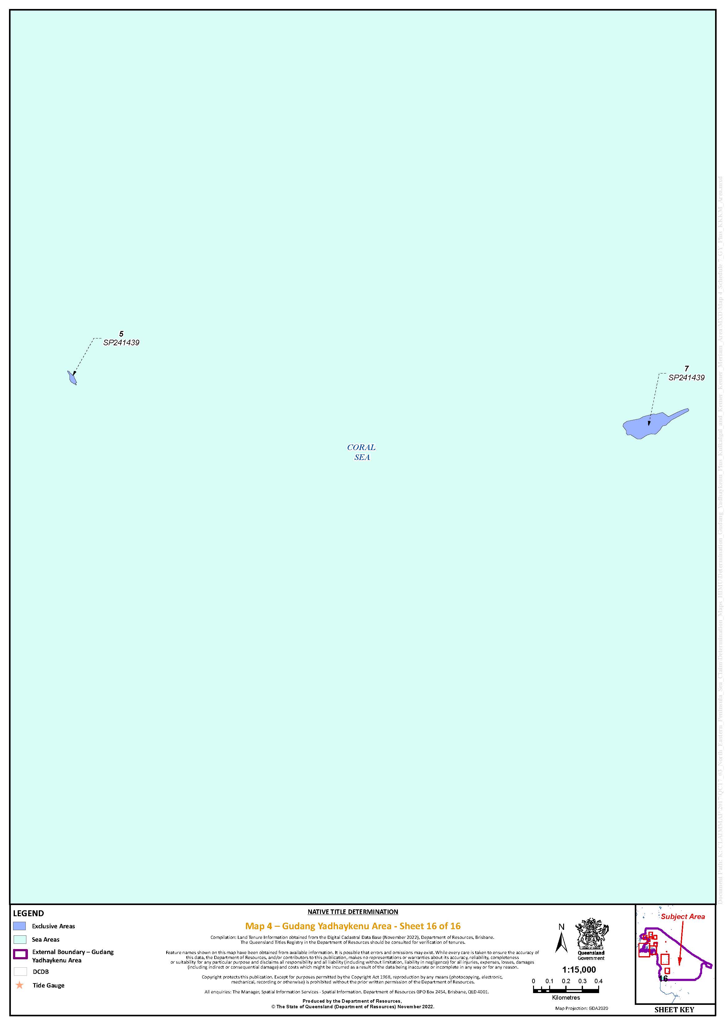
Map 5: Kulkalgal and Kemer Kemer Meriam Area
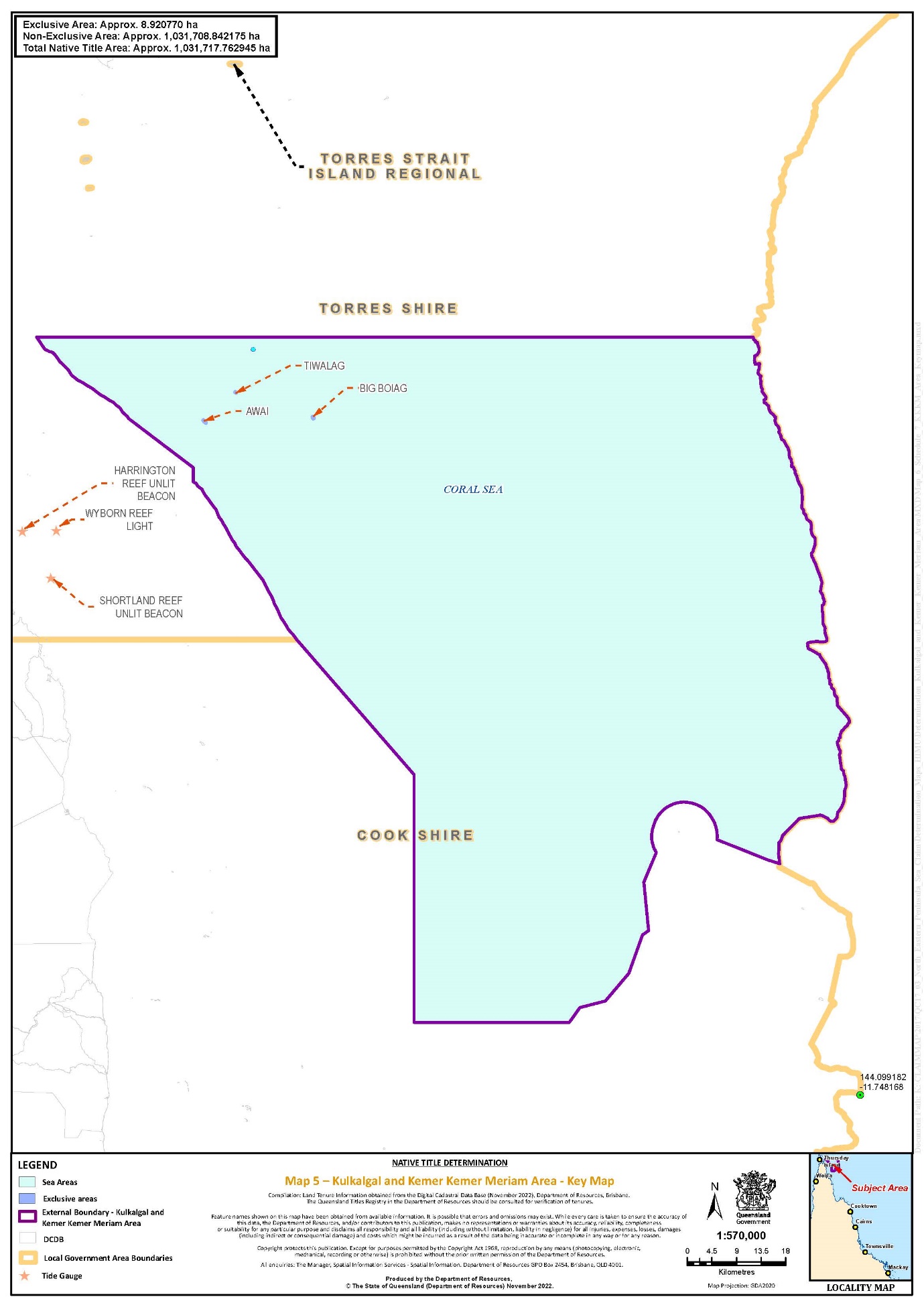
MORTIMER J:
INTRODUCTION
1 The parties to seven proceedings seek a determination of native title under s 87A of the Native Title Act 1993 (Cth) – that is, a determination of native title in relation to part of the native title claims by consent – to recognise the native title of the Kulkalgal, the Kemer Kemer Meriam, the Kaurareg People, the Gudang Yadhaykenu People and the Ankamuthi People in various waters and islands of the Torres Strait and northern Cape York (the determination).
2 The proceedings, which are collectively known as the Torres Strait and Northern Cape proceedings, comprise:
(1) Lui Ned David & Ors on behalf of the Torres Strait Regional Seas Claim v State of Queensland & Ors (proceeding number QUD 27 of 2019, formerly QUD 6040 of 2001) (the Torres Strait Regional Seas Claim);
(2) Milton Savage & Ors on behalf of the Kaurareg People #1 v State of Queensland & Ors (QUD 26 of 2019, formerly QUD 266 of 2008) (the Kaurareg #1 Claim);
(3) Milton Savage & Ors on behalf of the Kaurareg People #2 v State of Queensland & Ors (QUD 10 of 2019, formerly QUD 267 of 2008) (the Kaurareg #2 Claim);
(4) Milton Savage & Ors on behalf of the Kaurareg People #3 v State of Queensland & Ors (QUD 24 of 2019, formerly QUD 362 of 2010) (the Kaurareg #3 Claim);
(5) Bernard Richard Charlie & Ors on behalf of the Northern Peninsula Sea Claim Group v State of Queensland & Ors (QUD 114 of 2017) (the Northern Peninsula Claim);
(6) Bernard Richard Charlie & Ors on behalf of the North Eastern Peninsula Sea Claim Group v State of Queensland & Ors (QUD 115 of 2017) (the North Eastern Peninsula Claim); and
(7) Lui Ned David & Ors on behalf of the Torres Strait Regional Seas Claim (Part C) v State of Queensland & Ors (QUD 227 of 2022) (Part C of the Torres Strait Regional Seas Claim).
3 The determination area comprises four group areas:
(1) the Kulkalgal and Kemer Kemer Meriam determination area;
(2) the Kaurareg determination area;
(3) the Ankamuthi determination area; and
(4) the Gudang Yadhaykenu determination area.
4 It is agreed that native title exists in each of these four sea country areas. While many of the affidavits before the Court for the purposes of this determination emphasise that people do not see a distinction in connection between land and sea, this is primarily a determination of rights in sea country, and as such it has particular features and characteristics, as these reasons will demonstrate.
5 Mr Bernard Charlie, a Gudang Yadhaykenu man, describes what his sea country means to him:
When I come to my sea country, I sleep right. It feels like I’m in my lounge room, at home. In language we call it beiberr. That’s the feeling I get. I feel good. I feel like I’m looked after, I got the right. This feels different to just being welcomed to country, it’s like feeling you are right.
6 Mr Falen Douglas Passi is a Meriam man, a descendant of the apical ancestor Koit, who comes from Las village on Mer. His uncle was Nunei [Uncle] George Passi, with whom he travelled all over the Torres Strait. In the following passage from his affidavit, he describes a sense and a sound which resonated across much of the affidavit material before the Court:
You can hear maiso [the sea breakers] on the edge of the Barrier from Mer. The songs that our Elders composed can be very emotional. My cousin John Passi composed a song called Opnor Zeuber. Annexed to this Affidavit and marked “FP-5” is a recording of John Passi singing this song. The lyrics and their English translation are as follows:
Opnor ira zeuber eno
The breakers of the Barrier in front of Mer
Dub bakoli opem torupeli e
A swell of the ocean
Terge teskaisili maiso i esoli
The breakers hit the edge of the reef and cry out.
7 Many other claim group members provided similar accounts in their witness evidence. It is not possible in these reasons to capture the depth of feeling expressed in the evidence before the Court.
8 For the reasons set out below, the Court is satisfied that it can and should make orders to give effect to the determination.
THE MATERIAL BEFORE THE COURT
9 Before the Court is a copy of an agreement made under s 87A of the NTA to consent to orders giving effect to the determination (the s 87A agreement). The agreement is executed by all of the parties whose interests are affected by the determination. It was filed by the State of Queensland in each of the Torres Strait and Northern Cape proceedings on 24 November 2022.
10 The determination is the culmination of a tremendous amount of work undertaken by a wide range of people, notably:
(1) members of each applicant, working group members, those who gave affidavit or witness statement evidence and broader claim group members;
(2) the legal representatives of each applicant;
(3) anthropologists and other researchers engaged in the proceedings;
(4) the native title representative bodies and registered Aboriginal and Torres Strait Islander corporations active in the region;
(5) the State, the Commonwealth of Australia and the other respondents to the proceedings;
(6) external First Nations mediators engaged by the Court, notably Mr Murrandoo Yanner; and
(7) Judicial Registrar Grant, and the staff of the Federal Court.
11 In addition to the s 87A agreement, the Court has before it voluminous and detailed material provided by the applicant in each of the proceedings in support of the determination.
The Torres Strait Regional Seas Claim proceedings
12 On 16 November 2022, the applicant in Parts B and C of the Torres Strait Regional Sea Claim filed written submissions in support of the determination. An amended version of those submissions was filed on 17 November 2022. The applicant relied on an affidavit affirmed by their solicitor, Kerri Susan Nazzari, on 16 November 2022, and its annexures, dealing with the traditional connection of the Kulkalgal and the Kemer Kemer Meriam to the sea country the subject of the determination:
(1) an affidavit of Dan Mosby, dated 26 November 2021;
(2) an affidavit of George Mosby, dated 22 March 2022;
(3) an affidavit of Brian Williams, dated 24 March 2022;
(4) an affidavit of Frank Fauid, dated 24 March 2022;
(5) an affidavit of John Morris, dated 24 March 2022;
(6) an affidavit of Kapua Gutchen, dated 25 March 2022;
(7) an affidavit of Tom Ned Stephen, dated 28 March 2022;
(8) an affidavit of Father Simeon Noah, dated 29 March 2022;
(9) an affidavit of Francis Pearson, dated 30 March 2022;
(10) an affidavit of Harold Pearson, dated 30 March 2022;
(11) an affidavit of Moses Mene, dated 30 March 2022;
(12) an affidavit of Samuel Ned Tamu, dated 30 March 2022;
(13) an affidavit of Kemuel Kiwat, dated 31 March 2022;
(14) an affidavit of Barry Williams, dated 1 April 2022;
(15) an affidavit of Ned Mosby, dated 1 April 2022;
(16) an affidavit of Olandi Pearson, dated 31 March 2022;
(17) an affidavit of Alo Tapim, dated 7 April 2022;
(18) an affidavit of Lui Ned David, dated 8 April 2022;
(19) an affidavit of Falen Passi, dated 21 April 2022;
(20) a report by Dr Garrick Hitchcock with the title Torres Strait Regional Seas Claim QUD27/2019 Part B Eastern Overlap Area Connection Report, dated February 2020;
(21) a statement by Dr Tony Redmond, Raymond Wood, Dr Kevin Murphy and Dr Hitchcock with the title Joint Expert Statement, dated 19 April 2021;
(22) a report by Dr Hitchcock with the title Report provided in compliance with Mortimer J’s Orders 28 September 2021, Timetable A, Item 10B, dated 8 October 2021; and
(23) a report by Dr Hitchcock with the title Torres Strait Regional Seas Claim Group – Eastern Overlap Area and Southern Overlap Area Connection Report, dated April 2022.
13 The applicant also relied on an affidavit affirmed and filed by another of their solicitors, Jeffrey Martin Dillon, on 17 November 2022, relating to the applicant’s authorisation to enter into the s 87A agreement.
The Kaurareg Claims
14 The Kaurareg applicant’s submissions in support of the determination in respect of their claims were also filed on 16 November 2022. The Kaurareg applicant relied on an affidavit affirmed by Alexander Romano, a solicitor for the Kaurareg applicant, on 16 November 2022. The material annexed to that affidavit was:
(1) an affidavit of Rolford Nawia (deceased), dated 7 December 2010;
(2) an affidavit of Alice Tom (deceased), dated 26 May 2021;
(3) an affidavit of Reverend Dr Roney Wasaga (deceased), dated 27 June 2011;
(4) an affidavit of Roy Genai (deceased), dated 28 June 2011;
(5) an affidavit of Paul Tom, dated 10 April 2017;
(6) an affidavit of Jeffrey Bosuen (deceased), dated 18 March 2014;
(7) an affidavit of Eliziah Wasaga that was dated 10 October 2003 and filed in proceeding QUD 6005 of 2002 (now QUD 9 of 2019, Titom Nona & Ors on behalf of the Badulgal, Mualgal and Kaurareg Peoples (Warral & Ului) v State of Queensland & Ors (the Warral and Ului Claim));
(8) an affidavit of Thomas Savage that was filed on 24 November 2003 in the Warral and Ului Claim;
(9) a witness statement of Paul Tom dated 30 April 2021, which was prepared for the Warral and Ului Claim;
(10) a witness statement of Eliziah Wasaga dated 30 April 2021, also prepared for the Warral and Ului Claim;
(11) a witness statement of Enid Tom dated 27 April 2021, likewise prepared for the Warral and Ului Claim;
(12) a witness statement of Thomas Savage dated 3 May 2021, likewise prepared for the Warral and Ului Claim;
(13) a Joint Expert Statement by Dr Redmond, Mr Wood, Dr Murphy and Dr Hitchcock (see [12(21)] above);
(14) a report by Mr Wood with the title Anthropology Report on the Kaurareg Marine Tenure Application, dated March 2020;
(15) a draft report prepared by Michael Southon for the Cape York Land Council with the title The Kaurareg Native Title Claim over Muralag (Prince of Wales Island), Dumaralag, Tarilag (Packe Island), Yata (Port Lihou Island), Mipalag (Turtle Island), Zona (Entrance Island) and Ngurupai (Horn Island), dated 10 January 1997;
(16) a report by Mr Southon with the title Report to Queensland Government on Kaurareg Connection to Country and Continuity of Connection, dated 4 November 1997;
(17) a journal article by Liam Brady, Warren Delaney and Richard Robins with the title The Queensland Museum Expedition to Ngiangu (Booby Island): Rock Art, Archaeology and Inter-Regional Interaction in South-Western Torres Strait, dated 2013; and
(18) an essay by Mr Southon and ‘The Kaurareg Tribal Elders’ with the title The Sea of Waubin: The Kaurareg and their Marine Environment, which was published in a book dated 1998.
15 This Court has reserved judgment in relation to separate questions posed in the Warral and Ului Claim, concerning which groups hold native title over the islands of Warral and Ului. The Kaurareg People are one of the groups claiming native title over those islands. Nothing in these reasons should be taken to reflect any view of the Court, or findings of the Court, about the answers to the separate questions, or about issues arising in the Warral and Ului proceeding. It should also be understood that nothing in these reasons reflects any findings or conclusions by the Court about the areas in the Torres Strait and Northern Cape proceedings yet to be determined.
16 The Kaurareg applicant also relied on two affidavits affirmed and filed by their solicitor, James Konrad Walkley, on 16 November 2022. Mr Walkley’s affidavits dealt with the authorisation of the s 87A agreement.
The Northern Cape Claims
17 On 16 November 2022, the applicants in the Northern Peninsula Claim and the North Eastern Peninsula Claim (together, the Northern Cape Claims) also filed their written submissions in support of the determination. The applicant relied on two affidavits affirmed by Parkinson Wirrick, a legal officer at the Cape York Land Council. Together, these two affidavits annexed the following material relied on for the Northern Cape Claims:
(1) a report by Dr Redmond with the title A Northern Cape York Peninsula Regional Society – Identifying the Regionally Shared Level of Society for the NCY#1, NCY#2 and Proposed NCY#3 Native Title Claimant Groups, dated June 2012;
(2) a report by Dr Redmond with the title Northern Cape York #1 Native Title Connection Report, dated August 2012;
(3) a report by Dr Redmond with the title NCYP #1 and #2 Native Title Claims: Supplementary Report – Anthropologist’s Response to the State of Queensland’s Assessment and Request for Further Information in Regard to the Connection Materials, dated 26 June 2013;
(4) a report by Dr Redmond with the title Anthropological Report: Northern Peninsula Sea Claim QC2017/002 and North Eastern Peninsula Sea Claim Group QC2017/003, dated 31 October 2018;
(5) a report by Dr Redmond with the title Supplementary Anthropological Report: Marine Estates in the TSRSC Part B Eastern Overlap Area (EOA), dated 31 August 2020; and
(6) a Joint Expert Statement by Dr Redmond, Mr Wood, Dr Murphy and Dr Hitchcock (see [12(21)] above).
18 In relation to the determination sought on behalf of the Ankamuthi People, the applicant in the Northern Peninsula Claim also relied on the following material annexed to one of Mr Wirrick’s affidavits:
(1) an affidavit of Charles Woosup, dated 30 March 2022;
(2) an affidavit of Silas Woosup, filed in another proceeding brought on behalf of the Ankamuthi People in this Court (Ankamuthi People v State of Queensland & Ors, QUD 6158 of 1998) and dated 26 May 1999;
(3) an affidavit of Arthur Woosup (deceased), filed in QUD 6158 of 1998 and dated 31 May 1999;
(4) a witness statement of Asai Pablo, dated 8 February 2022;
(5) a witness statement of George Ropeyarn, dated 9 February 2022;
(6) a witness statement of Roger Williams, dated 9 February 2022;
(7) a witness statement of John Mark, dated 24 February 2022;
(8) an affidavit of Benjamin Tamwoy, dated 30 March 2022;
(9) a deed between the Director of National Parks and Ipima Ikaya Aboriginal Corporation RNTBC in relation to the management of the West Cape York Marine Park;
(10) a map of the West Cape York Marine Park;
(11) a map showing the waters off the western coast of Cape York titled “Field Report”; and
(12) a video recording of Goody Massy (deceased), Arthur Woosup (deceased) and Meun Lifu, dated 1992.
19 In relation to the determinations sought in favour of the Gudang Yadhaykenu People, the North Eastern Peninsula applicant also relied on the following material annexed to the other of Mr Wirrick’s two connection affidavits:
(1) a witness statement of George Pausa, dated 25 January 2022;
(2) a witness statement of Michael Solomon, dated 8 February 2022;
(3) a witness statement of Trevor Lifu, dated 9 February 2022;
(4) a witness statement of Elizabeth Pausa, dated 28 February 2022;
(5) an affidavit of Johnson Chippendale, dated 15 February 2022;
(6) an affidavit of Meun Lifu, dated 18 March 2022;
(7) an affidavit of Bernard Richard Charlie, dated 24 March 2022;
(8) an affidavit of Muen Lifu, filed in another proceeding brought on behalf of the Gudang Yadhaykenu People in this Court (Lifu & Ors on behalf of the Gudang Yadhaykenu People v State of Queensland & Ors, QUD 269 of 2008) and dated 26 August 2008;
(9) an affidavit of George Pausa, filed in QUD 269 of 2008 and dated 21 August 2008;
(10) an affidavit of Reginald Williams, filed in QUD 269 of 2008 and dated 18 August 2008;
(11) an affidavit of Hazel Wymarra, filed in QUD 269 of 2008 and dated 12 August 2008;
(12) an affidavit of Bernard Richard Charlie, filed in the Torres Strait Regional Seas Claim and dated 3 September 2007;
(13) an affidavit of Magdelene Cottis (deceased), filed in the Torres Strait Regional Seas Claim and dated 31 August 2007;
(14) an affidavit of Thomas Savage, dated 7 April 2022;
(15) a document by Dr Redmond with the title Gumakudin and their Near Neighbours’ Landed Relationships: Relevant Extracts from Redmond NCY#1 Reports, dated March 2022; and
(16) another video recording of Goody Massy (deceased), Arthur Woosup (deceased) and Meun Lifu, dated 1992.
20 Two further affidavits affirmed by Mr Wirrick, and filed on 16 November, were relied upon in relation to the authorisation of the s 87A agreement.
PROCEDURAL HISTORY
21 The procedural history of these claims is one of the longest and most complicated among the cases currently active in this Court. Claims in the region have a history of more than 20 years, although it was the people of the Torres Strait, and specifically the people of Mer, who drove the fundamental changes in the law, and in the structure of Australia as a nation, wrought by Mabo v Queensland (No 2) [1992] HCA 23; 175 CLR 1.
22 Claims to sea country in this region were made on 23 November 2001, when the application in the Torres Strait Regional Seas Claim was filed. That application sought a single determination of non-exclusive native title in the majority of the waters of the Torres Strait and parts of the Coral and Arafura Seas on behalf of the descendants of a long list of apical ancestors, each of whom was identified as a Torres Strait Islander.
23 The claim proceeded to a lengthy contested hearing before Finn J, which was conducted over 48 days spread between 26 September 2007 and 24 July 2009, in Cairns and Brisbane, and on the islands of Boigu, Moa, Badu, Saibai, Mer, Erub and Poruma. It remains one of the most complex contested native title trials undertaken in this Court.
24 During the hearing period, on 28 August 2008, the Kaurareg #1 and Kaurareg #2 Claims were filed. The Kaurareg #1 Claim covers waters in the Arafura Sea north of Kirriri Island (also known as Hammond Island) and south of the Bramble Channel, encompassing the waters around the islands of Warral and Ului. It also relates to a separate area of water off the north-eastern tip of Cape York, north-east of the Mt Adolphus group of islands, around the Kager Reef. The entirety of the Kaurareg #1 Claim area is overlapped by the Torres Strait Regional Seas Claim. The Kaurareg #2 Claim covers waters in the Arafura Sea, the Endeavour Strait and the Torres Strait surrounding the Kaurareg People’s home islands and down to the north-western coast of the Cape York Peninsula. The claim area extends eastwards out to the seas off the north-eastern tip of Cape York, including the waters surrounding the Mt Adolphus group of islands. It does not overlap with the Torres Strait Regional Seas Claim area.
25 Again during the hearing period of the Torres Strait Regional Seas Claim, on 2 September 2008, an application for the determination of native title in favour of the Gudang Yadhaykenu People was filed (proceeding QUD 269 of 2008). The claim area covered a large area of waters in the Torres Strait, the Coral Sea and the Pacific Ocean, stretching from north of the northern-most tip of Cape York along the north-eastern coast of the peninsula down to Orford Bay, and eastward out into the waters beyond the outer Great Barrier Reef. A large segment of the north-east of this claim area was overlapped by the south-east section of the Torres Strait Regional Seas Claim area.
26 The filing of these overlapping claims by the Kaurareg and Gudang Yadhaykenu Peoples led Finn J to make orders separating the Torres Strait Regional Seas Claim proceeding into two parts. This enabled that part of the claim area not subject to overlapping claims of native title (Part A) to proceed to a litigated outcome: see Akiba on behalf of the Torres Strait Regional Seas Claim People v State of Queensland (No 4) [2008] FCA 1446.
27 Part B, comprising the area in the west that was subject to the Kaurareg #1 Claim (the Western Overlap Area) and the area in the south-east that was subject to the Gudang Yadhaykenu claim (the Eastern Overlap Area), was to be determined after the finalisation of Part A.
28 On 2 July 2010, Finn J determined that native title exists in most of Part A of the Torres Strait Regional Seas Claim area: Akiba on behalf of the Torres Strait Islanders of the Regional Seas Claim Group v State of Queensland (No 2) [2010] FCA 643; 204 FCR 1. His Honour’s final orders, which were entered on 23 August 2010, determined that native title in the claim area was held by the members of 13 island communities, including the Imalgal, the Masigalgal, the Porumalgal and the Warraberalgal (together, the Kulkalgal), and the Meriam Le, the Erubam Le and the Ugarem Le (together, the Kemer Kemer Meriam). The native title holders were described by reference to the apical ancestors for each of those communities. Finn J determined that the native title rights and interests that exist in the Part A claim area include the right to access resources and to take those resources “for any purpose”. His Honour also determined that certain laws and customs founded upon the principle of reciprocity and exchange were personal and not rights and interests in relation to land or waters for the purposes of native title. Aspects of the reasoning for these determinations were the subject of appeals in the Full Court of the Federal Court of Australia and the High Court of Australia. The High Court confirmed that the Part A determination did not exclude a right to take fish and other aquatic life for commercial purposes, and that the reciprocal rights were personal in nature and not native title rights in relation to the waters of the Part A sea country: see Commonwealth v Akiba [2012] FCAFC 25; 204 FCR 260; Akiba v Commonwealth [2013] HCA 33; 250 CLR 209.
29 It is appropriate in these reasons to acknowledge and pay my respects to the work of Justice Paul Finn in the Part A claim, and the culmination of that work in Akiba. I recognise there are aspects of his Honour’s decision that were difficult for the native title holding communities to accept. Nevertheless, knowing now first-hand the nature of the task involved in writing reasons in the native title jurisdiction, it should be acknowledged that Finn J’s reasons in Akiba are one of the finest examples of the distillation of tremendous amounts of complex evidence, woven together with the application and development of legal principle.
30 After Finn J’s final orders but during the appeals processes, the Kaurareg #3 Claim was filed (on 30 August 2010). The Kaurareg #3 Claim seeks a determination in relation to several islands in the Torres Strait, including Kirriri, Waiben (Thursday Island), Maururra (Wednesday Island) and others, as well as several islands in the Endeavour Strait. The three Kaurareg Claims share the same claim group and, since 2 March 2020, the same applicant: see Savage on behalf of the Kaurareg People #1 v State of Queensland [2020] FCA 231.
31 Shortly after the High Court’s decision in Akiba, Greenwood J referred Part B of the Torres Strait Regional Seas Claim, the Kaurareg Claims and the Gudang Yadhaykenu claim to case management by the then Deputy Registrar of Native Title in the Federal Court, Registrar Fewings. Greenwood J also referred the Warral and Ului Claim to joint case management, given its close association with Part B of the Torres Strait Regional Seas Claim and the Kaurareg #1 Claim. Some of the history of the progress of this case management, and the procedural and other challenges associated with it, are recounted in Akiba on behalf of the Torres Strait Regional Sea Claim v State of Queensland [2017] FCA 1336.
32 On 27 February 2017, the Northern Cape Claims were filed. As filed, the Northern Peninsula Claim sought a determination of native title in offshore waters on the western side of Cape York, westwards from Gel Point, near Injinoo, down to the northern side of the mouth of the Skardon River. It also sought a determination of native title in relation to some islands and islets in the Endeavour Strait. The Northern Peninsula Claim overlapped with the Kaurareg #2 and #3 Claims. The North Eastern Peninsula Claim sought a determination of native title in a large area of offshore waters on the eastern side of Cape York. This area spans eastwards from Gel Point in the Endeavour Strait to the northern side of Captain Billy Landing, stretching eastwards to the outer edge of the Great Barrier Reef. The claim also sought a determination over various islands within that offshore area. It overlaps with each of the three Kaurareg Claims, and Part B of the Torres Strait Regional Seas Claim. It also overlapped with the Gudang Yadhaykenu claim QUD 269 of 2008; however, after the Northern Cape Claims were filed, QUD 269 of 2008 was discontinued. The Northern Cape Claims were case managed together with the Torres Strait Regional Seas Claim, the Kaurareg Claims and the Warral and Ului Claim.
33 In April 2019, on an application made under s 66B of the NTA, Murphy J ordered the replacement of the applicant for Part B of the Torres Strait Regional Seas Claim and granted the applicant leave to amend the claim group description to remove those members who do not hold rights and interests in relation to the Part B claim area: see Akiba on behalf of the Torres Strait Regional Seas Claim v State of Queensland [2019] FCA 651. By the amendments, the applicant accepted that Finn J’s determination in Part A conclusively determined the composition of native title holders for both Part A and Part B of the Sea Claim, and that the membership of the native title holding group for Part B must be determined by reference to the island communities and apical ancestors identified in the Part A determination: at [21].
34 Following Murphy J’s judgment, and the resolution of some matters which had impeded the progress of Part B of the Torres Strait Regional Seas Claim, on 8 November 2019, I made orders in the Torres Strait and Northern Cape proceedings to prescribe a timetable for the preparation and provision of evidence to work towards a final resolution of all the sea claims, and the Kaurareg #3 Claim. From this point, all active parties, and especially all applicant parties and the State and Commonwealth, were co-operative and proactive in a case management process that operated across all the sea claims. From this point, they worked together to comply with this timetable and subsequent iterations of it.
35 The principal matter carved out for separate management was the Warral and Ului Claim, which concerns land above the high-water mark. After a mediation in 2015, there was a proposal that the Badulgal, Mualgal and Kaurareg Peoples seek a determination of native title in favour of all three groups over these two islands. Following authorisation meetings in February 2020, an application was made by some Badulgal to be joined as respondents to the claim on the basis they opposed the proposal, and contended native title in the two islands was held only by the Badulgal. The Court made a joinder order and consequent orders to facilitate the hearing of the separate questions: see Nona on behalf of the Badu People (Warral & Ului) v State of Queensland [2020] FCA 983; Nona on behalf of the Badulgal, Mualgal and Kaurareg Peoples (Warral & Ului) v State of Queensland [2020] FCA 1353. Judgment on the separate questions is currently reserved.
36 Returning then to the narrative of the case management of the remainder of the claims, a conference of the anthropological experts engaged in the related proceedings was conducted before Judicial Registrar Grant in September 2020. Following that conference, the legal representatives of the various applicants met to discuss a possible restructuring of the claim. The experts expressed a common opinion that all the claim group members of the Torres Strait and Northern Cape proceedings form a ‘single society’. In October 2020, the applicants in all proceedings resolved to establish a unified working group to work towards joint determinations of native title in the region. This was Northern Cape and Torres Strait United Working Group. The initial plan of the working group was to replace all offshore areas of overlapping native title claims with a single, unified sea claim proceeding.
37 Meetings of the working group have contributed to most, if not all, of the significant developments towards the determination that have been achieved since the group’s establishment. Much credit goes to all the First Nations members of the working group, and to the assistance provided to them by their lawyers and experts, under the measured and encouraging guidance of Judicial Registrar Grant.
38 In December 2020, the applicants in the Torres Strait and Northern Cape proceedings filed a detailed timetable that, from that point onwards, was attached in its various iterations to the Court’s orders and provided the framework for steps towards determinations of native title in the areas of all proceedings.
39 Pursuant to that timetable, and with the benefit of a joint anthropological opinion about the traditional ownership of claim areas, the working group met in May 2021 and reached an agreement in principle. This in-principle agreement set out which parts of the claim areas were subject to native title of only one community, which parts were subject to native title shared by more than one community, and which parts were areas of ‘transition’ from one community to another. The working group also proposed to modify the concept of a single unified sea claim so that it would become a unified claim encompassing all offshore and onshore claim areas of all of the Torres Strait and Northern Cape proceedings, with the exception of certain islands that are asserted to be exclusively Kaurareg country, and which would remain within the Kaurareg #3 Claim.
40 Critically, and in a significant milestone for negotiations in this region, this proposal also involved the appointment of a single, regional prescribed body corporate to hold the native title subject of the claim, which would have a representative structure based on membership nominated by the prescribed bodies corporate for the onshore native title for the respective claim groups.
41 The proposal to bring a new, single, unified claim would have had a number of potential consequences, including a need for a new notification process under the NTA. In November and December 2021, the working group met and resolved, instead of proceeding with a single, unified claim, the applicants would propose that the Court deal with the Torres Strait and Northern Cape proceedings together, under s 67(1) of the NTA. The working group also proposed that a new claim would be made for areas claimed by the Kulkalgal and Kemer Kemer Meriam that were outside the claim area of Part B of the Torres Strait Regional Seas Claim. The new claim was filed as Part C of the Torres Strait Regional Seas Claim on 1 July 2022. It seeks determinations of native title in relation to:
(1) a large area of sea country south of the Part B claim area, all of which overlaps the North Eastern Peninsula Claim area;
(2) Ebur Bub Werwer (Raine Island), Moulter Cay and MacLennan Cay, which all lie above the high-water mark in the sea country of Part C;
(3) Awai (also known as Pelican Sandbank), Big Boiag (also known as Koey Boiag) and Tiwalag, which all lie above the high-water mark in the Part B claim area (but which were not included in that claim); and
(4) Travers Island, Twin Island and East Strait Island, which are all also subject to the Kaurareg #3 Claim.
42 Over the course of 2022, timetabling of steps continued towards consent determination. These steps included pre-authorisation and information meetings, and authorisation meetings of the various claim group members to approve the execution of the s 87A agreement on which the determination is based. Some of these meetings are described at [75]-[87] below.
43 The steps also included an agreement to exclude an area of the Endeavour Strait from the determination, so that further discussions could occur between members of the Gudang Yadhaykenu and Ankamuthi Peoples about how native title is held in that area. Also excluded from the determination is an area in the south-eastern corner of the North Eastern Peninsula Claim and Part C of the Torres Strait Regional Seas Claim in relation to which the Wuthathi Aboriginal Corporation RNTBC has indicated that an application for native title will be made on behalf of the Wuthathi People. This is yet another example of the co-operative approach between First Nations groups across the region, to ensure that all claims are dealt with in a manner which as far as possible reflects provision for appropriate time and inter-group processes so that agreement can be reached, but still allows other areas to move towards determination.
44 Further, in 2022 it was agreed by the parties that the Western Overlap Area would be excluded from the determination, pending judgment on the separate questions in the Warral and Ului Claim.
45 Negotiations continued on other areas within the claims (including with the State) and in October 2022, the Northern Peninsula Claim applicant filed an amended application, with the leave of the Court, to remove the western-most part of its claim area. The Torres Strait Regional Seas Claim applicant also filed an amended application, with the leave of the Court, to remove part of the Eastern Overlap Area that was resolved by the working group and the relevant claim group not to form part of the determination.
46 On 8 November 2022, the Court made orders to remove certain non-responsive respondents from the Torres Strait and Northern Cape proceedings and made the contemplated orders under s 67(1) of the NTA, so as to facilitate a determination of native title in areas covered by five out of the seven proceedings. The orders made on 8 November 2022 also provided that each of the Northern Cape proceedings would be divided into a ‘Part A’ for areas of land above the water at high tide, and a ‘Part B’ for areas below the high-water mark.
NATIVE TITLE IS IMPERFECT
47 In his affidavit, Poruma man Francis Pearson, says this about the native title system (at [20]):
Before time, the stopping on the island to ask permission was more like passing someone and saying hello. A friendly thing of respect. Now, people are asking “where are you going? You can't go without asking”. It was more relaxed in those days, Trying to draw lines on maps and saying “this is my sea country” and “this is your sea country” is tearing people apart and separating us. This separation is not our tradition. It comes from native title. We used to be more together, now it is “you stay there, and I stay here”. This is not the traditional way, the way of our ancestors since before time.
48 The observations of Mr Pearson reflect the experiences of many First Nations people within the native title system. “Lines on maps” are a necessary part of the system of native title under the NTA, because the rights recognised are rights against all the world. Nevertheless, boundaries are capable of being one of the most corrosive aspects of the process towards native title determinations.
49 This determination may go some way back towards the old ways, but it is important to acknowledge that the difficult path drawing specific boundaries is a process many First Nations people see as antithetical to their customary ways.
50 I also note that the part of the determination in favour of Ankamuthi People illustrates another aspect of the consent determination process – compromises on areas where native title is recognised that may not seem correct to some claim group members. The determined sea country for Ankamuthi covers a smaller area than many of the Ankamuthi deponents accept is correct (see, for example, the affidavit of Roger Anthony Williams). The Court has noted what they say, and this issue may well be a matter for another day.
51 Another Ankamuthi man, Benjamin Tamwoy, gives some evidence about how other uses of Ankamuthi sea country are presently tolerated, even if not especially welcome (at [119]-[120] of his affidavit):
We also want to protect our country from commercial fishing and tourist operators. Kerr Reef belongs to Ankamuthi; it is a Ankamuthi landmark. Big Daddy told me that the Ankamuthi hunters used come here. Those big ships that come in to take the Metro Mining bauxite away are anchored not far off Kerr Reef. The reef is good for spearing crayfish and catching red emperor and coral trout. The seawater at this reef is nice and clear so it is good for diving for the big painted crayfish and spearfishing. Commercial fishermen also go to this reef, but we can’t stop them because they have a license. We would like to stop them but we can’t. If we got our native title recognised, I would like to talk to those commercial fishers about not taking all the crayfish and not catching all the fish.
Some safari boats also use our areas to take tourists fishing and crocodile watching. We have no agreement with them and we can't stop them because they have a government licence. The tourists pay those operators big money to take them crocodile watching or fishing. Those safari people have never asked Ankamuthi people for permission and it makes me angry when I see them making money from my country. We don’t want those operators here and they should go back down south.
52 Native title is far from a perfect resolution for post-colonial effects on country, whether land or sea country, nor for effects on First Nations peoples’ sense of responsibility for country. Nevertheless, it is to be hoped this determination provides a platform for further dialogue, and the preparations for it have already provided a mechanism for native title holders to point to troubling parts of post-colonial relationships that are yet to be fully mended.
THE DETERMINATION
53 While the determination made today does not resolve the entirety of any of the Torres Strait and Northern Cape claims, it resolves a very significant proportion of them. The Court has determined that:
(1) the Kulkalgal and Kemer Kemer Meriam hold non-exclusive native title in relation to an area of the Coral Sea depicted in light blue shading in map 5 of Schedule 7 to the Court’s orders above, and exclusive native title in relation to Awai, Tiwalag and Big Boiag (the Kulkalgal and Kemer Kemer Meriam determination area);
(2) the Kaurareg People hold non-exclusive native title in relation to parts of the Arafura Sea, the Torres Strait and the Endeavour Strait depicted in light blue shading in map 2 of Schedule 7 to the orders (the Kaurareg determination area);
(3) the Ankamuthi People hold non-exclusive native title in relation to parts of the Endeavour Strait, the Arafura Sea and the Gulf of Carpentaria depicted in light blue shading in map 3 of Schedule 7 to the orders, and exclusive native title in areas depicted in darker blue shading on the various sheets of that map, which lie above the high-water mark (the Ankamuthi determination area); and
(4) the Gudang Yadhaykenu People hold non-exclusive native title in relation to part of the Torres Strait, the Adolphus Channel, Newcastle Bay, Orford Bay and an area of the Coral Sea, all depicted in light blue shading in map 4 of Schedule 7 to the orders, and exclusive native title in areas depicted in darker blue shading on the various sheets of that map, which lie above the high-water mark (the Gudang Yadhaykenu determination area).
54 A further feature of the s 87A agreement, again driven by the way that all groups have been able to work together to achieve this resolution, is that most of the overlapping claims within the Torres Strait and Northern Cape proceedings can be removed by the Court’s orders today.
55 In relation to the parts of the determination areas that are recognised as subject to exclusive native title, the Court recognises a right to possession, occupation, use and enjoyment of the area to the exclusion of all others. In relation to the parts of the determination areas that are recognised as subject to non-exclusive native title, the Court recognises rights to access, remain in and use the area, access and take the area’s resources for any purpose, maintain and protect culturally significant places in the area, and to be accompanied onto the area by spouses, the immediate family of spouses or people reasonably required to be in the area for ceremonies or cultural activities.
56 Both the exclusive and non-exclusive native title is expressed to be subject to the laws of the State and the Commonwealth and the traditional laws acknowledged by the respective native title groups. The determination does not recognise native title rights in or in relation to minerals or petroleum.
57 The determination recognises and preserves other interests in relation to the determination area and sets the relationship between those other interests and the rights of the native title holders. Included among these other interests are the international right of innocent passage through Australia’s territorial seas, the rights and interests of various Commonwealth governmental departments and agencies, the interests of Queensland State and local government authorities and infrastructure operators, mining interests in relation to a bauxite field, commercial fishing interests and public rights of access, navigation and fishing.
58 In yet another innovative development in the resolution of these claims, the other interests recognised include various traditional rights and interests of the kind described as ‘reciprocal rights’ in Akiba, which the various Torres Strait and Northern Cape claim groups have agreed between each other and recorded in the Northern Cape York and Torres United Customary Rights and Permanent Arrangements Agreement. The Customary Rights Agreement illustrates the capacity of negotiated outcomes under the NTA to go beyond mere recognition of native title rights and to provide more holistic outcomes for communities, on matters which are important to them and which they have taken control in negotiating.
59 Areas in which the existence or nature of native title has not been agreed will remain subject to case management, progressing to final determinations by this Court.
THE AGREED GROUP DESCRIPTIONS
The Torres Strait Regional Seas Claim proceedings
60 As noted above (at [33]), the Torres Strait Regional Seas Claim applicant acknowledges that the Kulgalgal and Kemer Kemer Meriam are a sub-set of the group of people that this Court determined hold native title in Part A of the Torres Strait Regional Seas Claim. Thus, the description of the native title holding group for the Kulkalgal and Kemer Kemer determination area is:
Section D: Kulkalgal
(1) Kulkalgal is a collective term for the following island communities:
(a) Iamalgal (Iama);
(b) Masigalgal (Masig);
(c) Porumalgal (Poruma); and
(d) Warraberalgal (Warraber).
(2) The members of the island communities referred to in (1) above are, respectively, the descendants of:
(a) Iamalgal – Kebisu, Rusia, Ausa, Auda, Porrie Daniel, Gawadi, Kelam;
(b) Masigalgal – Aclan, Alau Messiah, Apelu, Asiah Messiah, Auara, Gewe Jack, Kudin, Ikasa, Maudar, Sidmu, Seregay, Tabu, Wabu;
(c) Porumalgal – Laieh, Gauid, Kalai, Wawa, Mapoo; and
(d) Warraber – Gagabe, Wawa, Mapoo, Baki, Ulud.
Section E: Kemer Kemer Meriam
(1) Kemer Kemer Meriam is a collective term for the following island communities:
(a) Meriam Le (Mer);
(b) Erubam Le (Erub); and
(c) Ugarem Le (Ugar).
(2) The members of the island communities referred to in (1) above are, respectively, the descendants of:
(a) Meriam Le – Kopam, Naisi, Sibari, Koiop, Ano, Apap, Kaidam, Dabor, Masig, Nipuri, Sogoi, Wada, Busei, Bauba, Kebekut, Dudei, Awas, Malo, Odoro, Barigud, Taroa, Diri, Sakauber, Mogar, Kopam, Maki/Salgar, Kebei, Wasalgi, Udai, Komagaigai, Gaidan, Wamo, Eba/Matul, Madi, Maber/Garau, Maii, Pagem/Naii, Paipa, Siboko, Bina, Bade/Bagari, Zaiar, Kuniam, Kober, Koim, Sipo, Sesei/Mokar, Marau/Daueme, Galeka, Mabo, Lag, Mele, Toik, Urpi, Keisur, Soroi, Ekai, Mononi/Babi, Darima, Tagai, Beiro, Geigi, Nosarem, Mano, Kogikep,Opiso, Polpol, Kawiri, Geigi, Sawi, Serib, Nunu, Imai, Kadal, Enemi, Aiwa, Emeni, Koit, Namu, Kauta, Balozi, Geigi, Daugiri;
(b) Erubam Le – Amani, Odi (I), Saimo, Narmalai, Nazir Mesepa, Meo, Deri, Ape, Odi (II), Demag, Rebes, Buli, Damui, Baigau, Dako, Malili, Nazir, Bambu, Dobam, Bobok, Nokep, Wadai, Arkerr Malili, Aukapim, Isaka, Kaigod, Kapen, Petelu, Ale, Epei, Bailat, Ema, Boggo Epei, Ikob, Annai, Eti, Aib, Wagai, Gedor, Dabad, Nazir, Kaupa, Nanai Pisupi, Sagiba, Nuku Idagi, Diwadi, Gewar, In, Aukapim, Timoto, Suere, Gemai, Pagai, Pai, Kapen, Kapen Kuk, Spia, Konai, Ani, Morabisi, Koreg, Kuri, Damu, Wasi, Gi, Mamai, Sesei (I), Kakai, Sesei (II), Sida, Maima, Wakaisu, Whaleboat, Supaiya, Tau, Ulud, Waisie, Wasada, Wimet, Mogi, Yart, Ziai, Assau, Oroki, Zib, Nazir, Gaiba; and
(c) Ugarem Le – Janny, Maima, Baniam, Jack Oroki.
61 The Torres Strait Regional Seas Claim applicant submits that any differences between the rights and interests of the various group members is an intramural issue, to be managed between the group members in accordance with their traditional laws and customs. I accept that submission.
The Kaurareg proceedings
62 When the applications for determinations of native title were filed in the Kaurareg proceedings, the applications described their claim groups as:
… the Kaurareg Aboriginal people, being the descendants of the following people:
Makaku & Buiya
Kaugapiri [or Gaugabiri]
Zagra Snr/Jack Prince of Wales & Kamur
Kaitap & Serei
Urui
Daiam & Duni
Baetie
Bagie
Rattler Tom
Papoose & Pau Pai Kai
Kanamuri & Neru Pearson
Panipan
63 However, in relation to the Kaurareg determination area, the proposed native title holding group is described as:
… the descendants of the Kaurareg People who were the traditional owners of the Kaurareg Area prior to the assertion of British sovereignty.
64 This is substantially the same as the description that was used for the native title holding group in Kaurareg People v Queensland [2001] FCA 657. The change in group description was adopted by a resolution of the Kaurareg claim group at a meeting held on 5 November 2022.
65 On behalf of the Kaurareg applicant, it is submitted to be “imperfect” to describe Kaurareg People by reference to apical ancestors, because research into the genealogy of the Kaurareg People is currently still in progress: see Akiba on behalf of the Torres Strait Regional Sea Claim v State of Queensland [2017] FCA 11 at [28]. This is expressed to be, and I accept it is, a strong concern of the Kaurareg People which drove the decision to change the group description in November 2022.
66 Mr Walkley deposes that no Kaurareg person has ever told him that there are persons within the claim group who are not Kaurareg, nor has any Kaurareg person told him that there are Kaurareg people who are presently excluded from membership of that claim group. Mr Walkley also deposes that he is not aware of any disputes regarding anyone’s eligibility for membership of the Kaurareg Native Title Aboriginal Corporation, the registered prescribed body corporate in respect of other areas previously determined for the Kaurareg People. In Mr Walkley’s experience, based on the views expressed to him in the various claim group meetings and personal interviews he has attended, the Kaurareg People’s concern about defining their native title holding group by reference to apical ancestors has not arisen from any perceived present issue with group membership per se; rather, it turns on the Kaurareg People’s concern to see themselves described as accurately as possible. I accept that evidence.
67 The Kaurareg applicant submits that this Court is able to make a determination of native title that does not conform to the terms of a native title application, particularly where there are overlapping applications: Drury on behalf of the Nanda People v State of Western Australia [2020] FCAFC 69; 276 FCR 203 at [28].
68 The Kaurareg applicant submits there is an analogy with the description of the Ngarluma People in Daniel v State of Western Australia [2005] FCA 178; 141 FCR 426. In Daniel, this Court made a determination of native title in favour of “Aboriginal persons who recognise themselves as, and are recognised by other Ngarluma People as, members of the Ngarluma language group”. The Full Court of the Federal Court upheld this description as adequate in Moses v State of Western Australia [2007] FCAFC 78; 160 FCR 148 at [370]. In 2008, another application for native title was brought on behalf of the Ngarluma People, this time over an area adjacent to the area subject to the 2005 determination. The 2008 application described its claim group by reference to apical ancestors of the Ngarluma People. In Samson on behalf of the Ngarluma People v State of Western Australia [2015] FCA 1438, this Court made a determination of native title on the 2008 application. Rather than describing the native title holders by reference to the apical ancestors identified in that application, the orders of the Court used the same description as that used in Daniel.
69 At a case management hearing in the Torres Strait and Northern Cape proceedings on 8 November 2022, Mr Walkley advised the Court that, while the State had expressed an initial opposition to the proposal to describe the Kaurareg native title holding group without reference to apical ancestors, the State had reached an agreement to accommodate the resolution of the Kaurareg claim group. By executing the s 87A agreement in these proceedings, the State has confirmed it is content with the description of the Kaurareg native title holding group.
70 On the evidence before the Court, and in the particular circumstances of this determination, I am satisfied the description of the Kaurareg native title holders is appropriate. These are matters which depend very much on the circumstances of each case. Whether or not such a description will be appropriate for other determinations, even ones involving the Kaurareg People, will be a matter to be considered at the time of any further proposed determination.
The Northern Cape proceedings
71 The description of the native title holding group for the Ankamuthi determination area defines the native title holding group as:
… the persons descended by birth or adoption from the following apical ancestors:
(a) Woobumu and Inmare;
(b) Bullock (father of Mamoose Pitt, husband of Rosie/Lena Braidley);
(c) Charlie Mamoose (father of Silas, Larry, Johnny and Harry Mamoose);
(d) Charlie Seven River;
(e) Toby Seven River (father of Jack Toby);
(f) Asai Charlie;
(g) Sam and Nellie (parents of George Stephen);
(h) Mammus/Mamoos/Mark/Mamoose plus his siblings Peter and Elizabeth;
(i) Charlie Maganu (husband of Sarah McDonnell);
(j) Polly (wife of Wautaba Charlie Ropeyarn).
72 The native title holding group proposed for the Gudang Yadhaykenu determination area is defined as:
… those Aboriginal persons who are descended by birth, or adoption in accordance with the traditional laws acknowledged and the traditional customs observed by the Gudang Yadhaykenu People, from one or more of the following apical ancestors:
(a) Wymarra (Wymara Outaiakindi);
(b) Tchiako (aka Chaiku/Chakoo) & Baki (siblings);
(c) Peter Padhing Pablo;
(d) Mathew Charlie Gelapa;
(e) Annie Blanco;
(f) Ila-Ela;
(g) Woonduinagrun & Tariba (parents of Tom Redhead);
(h) Charlotte (spouse of Billy Doyle and Wilson Ware);
(i) Pijame and Daudi (sisters);
(j) Mother of Thompson Olwinjinkwi;
(k) Nara Jira Para.
73 The description of the Gudang Yadhaykenu native title holding group in the determination differs from the description of the native title claim group in the North Eastern Peninsula Sea Claim application. It also differs from the description of the Gudang Yadhaykenu People used in the determinations of native title in their favour in Woosup on behalf of the Northern Cape York Group #1 v State of Queensland (No 3) [2014] FCA 1148 and Anderson on behalf of the Northern Cape York #3 Native Title Claim Group v State of Queensland [2017] FCA 830. The differences result in the inclusion of descendants of some apical ancestors who were not identified as apical ancestors in the previous determinations.
74 The reasons for the different native title holding group description were explained in Ross on behalf of the Cape York United #1 Claim Group v State of Queensland (No 12) (Gudang Yadhaykenu determination) [2022] FCA 1177, which is the most recent determination of native title in favour of the Gudang Yadhaykenu People. For the same reasons as those I gave in that decision at [16]-[20], it is appropriate to accept the description of the Gudang Yadhaykenu People in this determination.
AUTHORISATION
The Torres Strait Regional Seas Claim
75 In his affidavit of 17 November 2022, Mr Dillon deposes to the public notification of information sessions about the determination in various news and social media, as well as through prescribed bodies corporate, the Torres Strait Island Regional Council, the Gur Baradharaw Kod Torres Strait Sea and Land Council (GBK), and community notice boards throughout the island communities. Emails and text messages were also sent to the members of the Torres Strait Regional Seas Claim applicant, the prescribed bodies corporate and members of the Regional Seas Claim group who had previously attended information sessions. A total of 14 meetings were conducted from 12 September 2022 to 7 October 2022, each in a different city or on a different island in the Torres Strait, to provide claim group members with information about the determination and about the authorisation meeting scheduled for 8 October 2022 on Waiben.
76 The authorisation meeting was attended by the legal representatives of the applicant, anthropologists Dr Hitchcock and Dr Murphy, support staff from GBK and approximately 44 members of the Regional Seas Claim group. Mr Dillon deposes that the number of group members in attendance was impacted by the death of a senior member of the Moa community in the week prior to the meeting. Following registration and a further information session, the group members present unanimously passed 14 resolutions in relation to the determination, including a resolution to consent to the determination, a resolution to consent to the Customary Rights Agreement, and resolutions to establish and nominate the Northern Cape and Torres Strait United Indigenous Corporation as the prescribed body corporate to hold the native title recognised by the determination. The resolutions also contained an acknowledgement that members of the Moa community had been unable to attend the meeting because of cultural mourning obligations and an agreement that, after the mourning period was finished, a meeting for members of that community will be offered, so that they had an opportunity to discuss and consider each of the matters decided at the meeting. Dr Hitchcock and Dr Murphy provided a statement attesting to their view that the claim group members in attendance were sufficiently representative and had sufficient authority to pass the resolutions made at the 8 October meeting.
77 On the basis of the evidence of Mr Dillon, including the material annexed to his affidavit, the Court is satisfied that the Regional Seas Claim group has authorised the determination, nominated a prescribed body corporate and consented to the Customary Rights Agreement.
The Kaurareg proceedings
78 In his first affidavit of 16 November 2022, Mr Walkley deposes to the public notification of information and authorisation meetings in the Cairns Post and the Townsville Bulletin. Mail notifications were sent to members of the KNTAC, and included a 12-page booklet providing information about the determination. The information and authorisation meetings were originally scheduled for 13 and 14 October on Ngurapai; however, on 28 September, the Kaurareg applicant decided to postpone the meetings until 4 and 5 November 2022, because of the death of senior Kaurareg elders and the need to make arrangements for their funerals. Further notifications were distributed to group members about the new dates by the aforementioned means and also by publication in the Torres News and via text message, phone calls and Facebook posts. Mr Walkley deposes that he was also informed that the new dates were conveyed by word of mouth at the funerals and other gatherings in memoriam of the Kaurareg elders.
79 The information meeting on 4 November was attended by 50 Kaurareg claim group members. There were 49 claim group members in attendance at the 5 November meeting. Mr Walkley’s first affidavit indicates that each resolution that was moved at the authorisation meeting was carried by a unanimous vote, including the resolutions to approve the determination, to nominate a prescribed body corporate for the Kaurareg determination area, and to consent to the Customary Rights Agreement.
80 On the basis of this material, the Kaurareg applicant submits that they are authorised to consent to the determination on behalf of the Kaurareg People. However, the applicant nevertheless submits that the Court should make an order under s 84D(4) of the Native Title Act, out of an abundance of caution.
81 Sub-sections 84D(3) and (4) provide that:
(3) Subsection (4) applies if:
(a) an application does not comply with section 61 (which deals with the basic requirements for applications) because it was made by a person or persons who were not authorised by the native title claim group to do so; or
(b) a person who is or was, or one of the persons who are or were, the applicant in relation to the application has dealt with, or deals with, a matter arising in relation to the application in circumstances where the person was not authorised to do so.
Note: Section 251B states what it means for a person or persons to be authorised to make native title determination applications or compensation applications or to deal with matters arising in relation to them.
(4) The Federal Court may, after balancing the need for due prosecution of the application and the interests of justice:
(a) hear and determine the application, despite the defect in authorisation; or
(b) make such other orders as the court considers appropriate.
82 The Kaurareg applicant submits that these provisions have been relied on in circumstances where the description of the native title holders in a determination proposed by consent differs from the description of the native title claim group in an application: see Barunga v State of Western Australia [2011] FCA 518; Cheinmora v Western Australia [2013] FCA 769; Watson v Western Australia (No 6) [2014] FCA 545; Sharpe v Western Australia [2013] FCA 599; Ashwin (on behalf of the Wutha People) v Western Australia (No 4) [2019] FCA 308; 369 ALR 1; and see also Billy Patch on behalf of the Birriburu People v Western Australia [2008] FCA 944. They submit that this Court should make an order under s 84D(4) in relation to the determination in respect of the Kaurareg applicant, because:
(1) this Court is able to determine who are the holders of native title in terms that differ from those used in the claimant application;
(2) the group descriptions in the determination have been approved by a duly notified meeting of the Kaurareg People concerned and, prior to that meeting, were the subject of extensive consultation and information sharing process; and
(3) there are no reasons why the Court should not exercise its power in s 84D(4): no formal interlocutory application is required to enliven the power, there would be no prejudice to any party if the Court were to exercise that power, and it would be in the interests of justice and consistent with the Court’s overarching purpose to address any procedural issues arising from the adoption of the Kaurareg claim group’s preferred description of native title holders to make an order under s 84D(4).
83 I accept those submissions.
Northern Cape proceedings
84 In his two affidavits regarding the authorisation of the Northern Cape applicants, Mr Wirrick deposes to the steps taken by the CYLC to notify members of the Ankamuthi and Gudang Yadhaykenu native title claim groups of various pre-authorisation meetings that were conducted in Cairns, Injinoo and New Mapoon. Mr Wirrick’s evidence is that, at these meetings, CYLC staff and junior counsel for the Northern Cape applicants, David Yarrow, explained aspects of the determinations proposed in the Torres Strait and Northern Cape proceedings. This included an explanation of the proposed description of the Ankamuthi and Gudang Yadhaykenu native title holding groups, and the proposed exclusion of the area in the Endeavour Strait that is to be subject to further discussions between the Ankamuthi and the Gudang Yadhaykenu. Each of the native title claim groups passed resolutions to give effect to this exclusion.
85 On 4 October 2022, the CYLC facilitated an authorisation meeting for the Gudang Yadhaykenu native title claim group in New Mapoon. Mr Wirrick’s evidence indicates that 50 members of the claim group were in attendance. Resolutions were moved and carried unanimously, including consent to the determination, consent to the Customary Rights Agreement and the nomination of prescribed bodies corporate for the Gudang Yadhaykenu determination area. The North Eastern Peninsula applicant submits that, on this basis, and on the basis of the applicant’s authorisation under s 62A(1) of the NTA to “deal with all matters arising under this Act in relation to the application”, the applicant is authorised to consent to the determination of native title in favour of the Gudang Yadhaykenu People. However, there are some apical ancestors of the Gudang Yadhaykenu People who were not included in the originating application for the North Eastern Peninsula Sea Claim. Therefore, the Northern Cape applicants also seek an order under s 84D(4) of the NTA, for the reasons given in relation to these issues in Ross on behalf of the Cape York United #1 Claim Group v State of Queensland (No 2) [2021] FCA 1464 at [39]-[50] and out of an abundance of caution. I accept that it is appropriate for the Court to make an order under s 84D(4) of the NTA in relation to authorisation in respect of the Gudang Yadhaykenu determination area.
86 On 5 October 2022, the CYLC facilitated an authorisation meeting for the Ankamuthi native title claim group in Injinoo. Mr Wirrick’s evidence indicates that 32 members of the claim group were in attendance. Resolutions were moved and carried by majority vote (there was one abstention and three votes against), including consent to the determination, consent to the Customary Rights Agreement, and the nomination of prescribed bodies corporate for the Ankamuthi determination area.
87 I accept that both Northern Cape applicants are authorised to consent to the determinations of native title in favour of the Ankamuthi People and the Gudang Yadhaykenu People.
CONNECTION
88 Given that this is a consent determination, there is no burden on the applicants to prove connection. The State and the other parties have accepted there is a “credible basis” for the connection for which the various groups contend, and that is sufficient, provided (as here) that the Court accepts the orders sought are appropriate in the sense I have referred to above.
89 That said, the parties have chosen to file a tremendous amount of connection material, including a joint expert statement which expresses the view that all the groups in this determination are part of one “society” for the purposes of the NTA. For each group within the determination, a considerable amount of expert material has been filed. The Court has taken the connection material into account, but it is unnecessary for it to do more than recognise that this material has formed the basis for the s 87A agreement, and to find that, by reason of that agreement and the other matters to which I have referred in these reasons, the Court considers it is appropriate to make the orders sought.
90 It should also be noted that a considerable portion of the Kaurareg material filed in this proceeding, and some of the expert material, has also been read and relied upon in the Warral and Ului separate question trial. While the Court accepts it may be appropriate to file that material for the purposes of this determination, because of the senior nature of some of the Kaurareg witnesses in those proceedings and the matters covered in the expert opinion, in approaching this consent determination, the Court has not actively considered the substance of the evidence of those witnesses or that expert opinion. I have also sought to avoid quoting that material in these reasons.
91 Notwithstanding that the Court does not need to engage at a fact-finding level with the connection material, I propose to extract some of it in these reasons. I have focused on the evidence from claim group members, but in doing so I do not wish to diminish the high quality and thorough anthropological material which has also been filed. The key anthropologists whose opinions are reflected in the material before the Court – Dr Kevin Murphy, Dr Garrick Hitchcock, Dr Tony Redmond and Ray Wood, have all engaged in a tremendous amount of work over a long period of time to assist the First Nations groups in this region to reach final agreement about recognition of their native title.
92 The connection material filed in support of this consent determination is a treasure trove of song, story and narrative about what the sea country, reefs, cays, islands and islets in this determination area mean to the people of this region. Some of it dates from times when the various claims were filed, some of it is newer. All of it is important. Some of the passages I have extracted are from people who may now have passed away. In these reasons, the Court names those people, but does so to pay respect to their knowledge, and the contribution of their knowledge to the achievement of the determination made today.
93 The material before the Court acutely demonstrates how, from “before time”, the lives of people in the determination area were interwoven with the sea, its resources and its moods, the winds and the weather, and how the sea country frames their history, cultural practices and traditions, and all aspects of their sense of self and community. The material will stand as a critical resource for current and future generations.
94 In these reasons, I can but capture some snapshots of my impressions of the connection material. Inevitably, material will be left out. I mean no disrespect to any person or group with my selections, which are no more than my own impressions from the material. It may also be the case that places mentioned in the extracts below are not in the determination area directly and may be the subject of ongoing negotiations between groups. Nevertheless, they are places which contribute to an understanding of people’s conceptions of sea country.
95 To begin this section, a passage from the joint expert statement (at [12]-[14]) contextualises the evidence from claim group members:
Torres Strait has long been recognised as both “bridge and barrier.” Up until about 9000-8000 years ago the continent of Australia and the mainland of New Guinea were joined as a single landmass across what is now Torres Strait and as far east as where the Great Barrier Reef now lies. Rising sea levels led to inundation of the strait, whereupon the earliest archaeological evidence for people in the region commences. Increases in activity are registered archaeologically at around 4000-3000 years ago, and especially at around 2500 years ago when immigration of New Guinea peoples is revealed by the introduction of pottery to Torres Strait. Linguistic diversification, sophisticated outrigger canoe technology, and extensive trading relationships between islands and with the adjacent mainlands probably dates back to at least 2500 years ago. The linguistic and material culture evidence indicates that from that time there was a series of migrations into the region, including from eastern New Guinea by bearers of Austronesian canoe technology and others from the Trans-Fly region adjacent to Torres Strait on mainland New Guinea, and who engaged in extensive interaction with the people they encountered on the islands and Cape York. Among the striking evidence for the geographical reach and time depth of that interaction is the linguistic situation at sovereignty: Meryam Mir, the Eastern Islands language, belongs to a Papuan language family of the adjacent Trans-Fly. The Western and Central Strait language belongs to the Australian Pama-Nyungan family but much of its lexicon derives from Meryam Mir and other Papuan languages, and it also shares a large part of its lexicon with the Cape York Gudang language which is also Pama-Nyungan. In addition, all three languages share a small corpus of Austronesian vocabulary from far east Papua to do with seafaring and canoe technology. In short, the mixed sources of these languages, plus the considerable degree of lexical convergence among them indicates a deep prehistory of interaction spanning the Strait from Papua to Cape York. It is reflected today in the regional Creole lingua franca of the Strait and the NPA, which the linguist Piper observes “is evidence that they are, at one level, a single social and cultural unit.”
The deep history of interaction necessarily implied in this mix of linguistic diversity and convergence is also reflected in other social and cultural characteristics. As Rumsey has remarked:
what we see in the Torres Strait is not a sharp boundary between two categorically distinct culture areas but a continuum of related peoples and sociocultural forms.
As the Subject Area of this report is at the southern end of Torres Strait and the northern part of Cape York Peninsula we focus primarily on the connections and distinctions manifested there, but just as we find no sharp boundaries between normative systems within Torres Strait or between it and the Australian mainland, it is also the case that lines of differentiation between Torres Strait and the New Guinea mainland do not extend to separate and distinct normative systems there either.
(Footnotes omitted.)
Kulkalgal
96 The four central home islands which comprise the Kulkalgal Nation are Iama, Masig, Poruma and Warraber.
97 George Mosby is a Masig man of the Kulkalgal Nation, and started work at sea when he was 15 years old, working on the luggers with his family. He is now in his seventies. He describes Kulkalgal sea country (at [16]-[17], [23] of his affidavit):
I worked as far south as Boydong Cay. My Father and grandfathers always told me that where we were working was our country. We always felt it was our country, all the way down. All the reefs through Torres Strait and down the east coast, but not as far as Lockhart River, are Kulkalgal. Kagar, Kaskoro, and the other nearby reefs around those areas are shared with mainland Aboriginals. The waters are shared between the Aboriginal and Torres Strait Islanders and we do not have to ask permission to work there.
The reefs in the Part B and the area that will be subject to the proposed Part C claim have always been occupied by Torres Strait Islanders; in canoe time and ever since. The knowledge of these reefs was passed down by my ancestors to my great-grandfather, my grandfather, and my dad who have all worked on those reefs. In the canoe days, all of the Torres Strait Islanders had canoes on the reefs. My old people also told me stories of people from Masig going all the way out to the Barrier Reef in canoes.
…
There are songs about all the islands and reefs in the Torres Strait. My Father, grandfather and great-grandfather used those songs as charts.
98 Frank Ned Fauid is a Poruma man and part of the Kulkalgal group. His affidavit very honestly explains the depth of his connection to Kulkalgal sea country (at [26], [29] of his affidavit):
When I think about these places, I get emotional. Thinking of my ancestors who have spent their lives in these places to provide for their families. It makes me happy that I have also travelled through our sea country and worked the reefs there, just as my ancestors have always done.
….
Our occupation in this sea country is not just for work. It allows us to maintain our connection to the areas, to feel connected to our country, our sea, our ancestors, and to the people that we have lost in the sea. The waters of the Torres Strait is the grave of many of our loved ones. Even though the industries and technologies have changed, from canoes to cutters, luggers and now dinghies, we still maintain that connection.
99 In speaking of the sharing of sea country with Kemer Kemer Meriam, Mr Fauid says (at [36] of his affidavit):
When we go to the reefs close to the Kemer Kemer Meriam home islands, we only go to the reefs we or our forefathers have been to before, out of respect. We have been told by our ancestors to not use other communities' home reefs for no reason. You have to let the Elders of that Island know that you are coming over. It is our sharing and caring system. The further away reefs and cays are from the inhabited islands, the more the sea country is shared between Kulkalgal and Kemer Kemer Meriam. There have never been any arguments between Kulkalgal and Kemer Kemer Meriam about the ownership of reefs. We all know when we are in each other's waters and when we are in our shared sea country.
100 John Morris is a Masig man. Masig is also known as Kai Lag (big place) and is one of the four Central Islands, which together make up the Kulkalgal Nation. He explains the relationship between Kulkalgal and Kemer Kemer Meriam (at [30]-[32] of his affidavit):
It is all about respect between the Kemer Kemer Meriam and Kulkalgal people. If Kemer Kemer Meriam people come over to the areas near our home islands, no one tells them to go away. They are always welcome. Since before time, there has been much trading and family connections between Kulkalgal and Kemer Kemer Meriam. It is the same when Kulkalgal go over to the Eastern Islands. As with the Eastern Islanders, people from the Western Islands are also welcome to come and fish the reefs near our home islands when they need to. We are all island people.
Further south of the home islands, are the shared sea country of Kemer Meriam and Kulkalgal, such as the Moon, Samson, Bucket and Tolain reef areas. However, there are no hard boundaries between the different communities, and it doesn't work by segregating reefs. It is about gud pasin, meaning having good manners and respecting protocol and apasin, which is about respecting elders. If people don't show gud pasin or apasin, that is wati pawa [no good]. Gud pasin means being respectful whether you are in your waters, someone else's waters or in shared sea country.
When Kemer Kemer Meriam and Kulkalgal are fishing or diving away from home islands, in the shared sea country of the Part B and Part C claim areas they do not need to ask permission. We can travel freely and work those reefs. If you are a long way out, there is no-one to ask.
101 Harold Pearson is a Warraber man, and in his affidavit he describes the way people from different islands use the resources of the sea, and when permission is needed (at [17]-[19]):
Warraber and Poruma people have always worked all the up to Seven Reefs, towards Mer without asking permission. And Eastern Islanders can work the reefs south of Atub without seeking permission as well. I was taught that Kulkalgal and Kemer Kemer Meriam have always shared the reefs and waters of the Part B and proposed Part C claim areas. Our grandfathers were sharing those reefs and their grandfathers before them, right to before time.
Masig and Iama can travel and work these shared sea areas like Atub, Big Boiag, Maiak Sandbank and Tiwalag too as they are Kulkalgal. Masig and Iama don’t come into these areas as often as we do, as it is further away from their home islands. They would let us know before working the home reefs around Warraber and Poruma, as a sign of respect. The same for the Eastern Islanders and Western Islanders. That is respect, it is a great thing, an important thing. It is ailan pasin, it is gud pasin. But the Central Islanders are all one family, and we share the reefs and waters away from the inhabited islands.
People coming from the Western or Eastern Islands will always come and talk to the Elders or the Council to ask permission to use the reefs near our home islands, but everyone can use the areas further away from the inhabited islands without permission. I recall, when I was about 12 or 13, a family from Badu coming and asking permission to dive for trochus shell around Warraber. The Elders said they were allowed to.
102 The traditions of the sea are what has brought people in this region their livelihoods, from before time to the present day. Moses Mene explains this well in his affidavit (at [10]-[11]):
I went to school until grade seven. There was no further study after that, it was just straight into the cultural way of making money. I had to learn cultural knowledge in order to support myself and my family through the kabar [trochus] industry. There was nothing else here in the Torres Strait at that time.
I sat and listened to my Uncles, mainly Big Awa, and they taught me all of our customs and cultural knowledge. They, and other Elders, taught me about Kulkalgal traditions, about our sea country and our cultural connections and family relations to our neighbours. They explained to me the different tides and what they mean, when the best time is to go out and fish, net sewing, spear making, like kayar spear, how to dive for kabar, and how and where to fish. I was taught sea knowledge. I then made it my business to go out apply that knowledge.
103 Kemuel Kiwat is an Erub man, who has worked the reefs all his life. He describes working the inner and outer reefs of the Barrier, along what he describes as the “Inside Line” and the “Outside Line”, marked by various reefs and small islands. He says (at [20] of his affidavit):
The shells on the Inside Line are smaller and thicker than on the Outside Line. They are known as dwarf shells. The Outside Line has the bigger shells. For example, the maber and bu shells [trumpet shells] which we used to call a public meeting, it brings the news, and izer [baler shell], used for baling water from a boat, or in the case of our ancestors, their canoes. I know every shell at every reef. If you show me a shell, I can tell you where it is from. I know these shells like the palm of my hand.
104 Mr Kiwat tells a story illustrating how well his elders knew the reef (at [26]):
Uncle Kailu George had lots of knowledge. I told him he must have a GPS inside of him. I know a story about when he was skippering on a lugger called the Dalassa. His second mate, Tom Sailor, passed away in his sleep near the Lockhart River. The crew found him dead when they went to wake him for breakfast. Kailu contacted Thursday Island to report it and they told him to bury Tom at Lockhart, but because he was Uncle George’s second man, Uncle decided to take him back to Darnley where [he] had a wife and child. He said ebap [heave up (anchor up)] and they took the lugger straight through. It got dark and they continued after sunset using only Uncle’s memory and navigation skills in the darkness. He said it was all in his head and he could smell the reef like a dog. The boat was silent, nobody talked. The only voice was a boy at the top of the mast calling out kepoi [keep off, meaning turn away from the headwind] and lapap [face the vessel into the wind].
105 Mr Lui Ned David is a Iamalaig (Yam Islander) and a Tudulaig (Tudu Islander), descended from Dawita son of Rusia and his wife Kasabad, daughter of Kebisu. Dawita, from whom his family name David comes, was born on Tudu (Warrior Island) about 1859 and was Mr David’s great-grandfather. In his affidavit he relates one particular incident when he was travelling with his father (at [19]-[20]):
My Father knew all of the reefs in the sea country south from the home islands, right down throughout the Part B and proposed Part C claim areas, and he fished those reefs with Byra. My Father worked under Seriako Stephen Snr on the Anniki. Seri was another renowned seafarer of the time. The areas they worked included Atub (Dugong Island), Kagar, Kaskoro and Ianakau (Boydong Cay). They knew all these waters and reefs very well and lived and worked them for many years. They were shown them by my grandfather.
I have a vivid memory from going on the Anniki as a boy. We were travelling to a tombstone opening before naiger. The weather was so rough that I was swept off the deck and they had to drop a dinghy to come and get me. It would have been very hard to row the dinghy in that weather.
106 He also describes travel down to Raine Island and how the small islands along the way were used (at [34]-[35]):
My Dad and Byra often went down to Raine Island to visit and collect provisions from the island and did not need to seek permission. On these journeys, they generally travelled down on the inside of the Barrier for protection from the elements but had the skill to go to the outside of the Barrier when the weather changed. Their extensive knowledge of the Barrier allowed them to find gaps in the reefs so that they could safely travel through. This would depend upon the seasons and the weather, for example, if there was a westerly or kuki wind blowing, it was safer to travel outside the Barrier. They would sometimes travel along the outside when returning to their home island.
Like our ancestors, he would collect bird eggs that he found on the sandy cays and islands. The crew on Dads boats were also known for breeding goats on small islands. They would take two goats and leave them on the island and when they came back next, there would be more goats there. This is the same practice that has been passed down from the ancestors. Whenever they went onshore to the mainland or stayed on an island or cay, they often planted coconut trees and meke [Sea almond]. The ancestors would leave something as proof of them being there. It was in memory of an area and as a marker, and they would be able to use the coconuts when they returned there next.
Kemer Kemer Meriam
107 The three home islands which comprise the Kemer Kemer Meriam Nation are Mer, Erub and Ugar. The islands of Dauar and Waier are also part of Kemer Kemer Meriam country.
108 In this proceeding, there are several affidavits from people who gave evidence before Finn J in Akiba. One was Mr Tom Stephen. He is a Ugarem and Kemer Kemer Meriam man. He has been diving for a living since he was nine years old. He describes how he learned about his sea country and its resources (at [13]-[19] of his affidavit):
I learnt about the sea and Kemer Kemer Meriam sea country from my Uncle Henry Stephen, who was a skipper on many boats such as the Amy and the Anna Stephen. My Father told me that he also learnt from him. When he was young, they forced him to go out on the boat, so he knew all the reefs. They worked all the reefs closer to the mainland on what we call the Inside Line, which starts at Duging Island and goes all the way down nearer the mainland, including Tawain, Ketai and Boydong Cay.
There are plenty of songs about those places that people would compose when they were out on the reefs. The songs are like a story to remember where people went and what they were doing. Most of those songs we still sing today.
When Kemer Kemer Meriam people travel and work Kemer Kemer Meriam sea country, we sometimes bring things back to our families, to bring life to our stories and to show all the places we have been. Families want to see something from where their fathers and uncles have been. For instance, we might bring back interesting rocks or feathers to use in our dari [headdresses].
When I was a kid, I saw all the different kinds of feathers. I know all of the different varieties and helped make dari with them. The main feather used for the dari is from Sir [White Reef Heron]. We also use the Frigatebird and the Torres Strait Pidgeon. The mainlanders mainly use Cassowary feathers. As a kid, I remember men returning from Raine Island with the long feathers from the Silakas [Red-Tailed Tropicbird] which was brought back as a souvenir. The Silakas look like the Serar [Tern], white birds with a black crown, that are also found on Raine Island, but the Silakas are mostly white with long red tail feathers. The Silakas is much more commonly found on Raine Island than on our home islands. That is a very special bird to us because is it so rare.
In before times, the narr [canoes] would travel everywhere. I was taught our ancestors used to travel to all the islands in their narr. From Cape York up to Papua New Guinea, and down to Raine Island. They travelled far and wide and while most returned, some did not.
Kemer Kemer Meriam have been making songs since canoe time. The songs tell the stories about where they have been. It was the knowledge that our ancestors passed down since canoe time that enabled us to travel all throughout the Torres Strait and down through the claim areas in the lugger time.
To this day, Islander skippers still use this knowledge, to navigate by way of the stars, seasons, tides, winds and weather patterns. That is why we train from when we are young; we have to know all of this before we go out. We know the dangers of being out on the seas away from our home islands near the Barrier [Great Barrier Reef]. There are all sorts of dangers, especially when you are out in the water. If you are a diver, you also must know how to protect yourself.
109 Mr Stephen explained the particular significance of Ebur Bub Werwer (Raine Island) (at [24]-[25], [28] of his affidavit):
… Ebur means bird in Meriam Mir [Meriam language]. Bub is the chest of a bird and werwer is the pattern or markings on the chest.
I was taught by my Elders that our people have been travelling to Ebur Bub Werwer since before time to collecting things such as feathers, shells, like clam and Cowrie, turtles and fish. Raine Island and Thursday Island are nearly the same distance from Mer.
….
It is very important for Kemer Kemer Meriam to keep connection to Ebur Bub Werwer. It is so precious to us, it is like gold because of our long history there, since our ancestors travelled there in outrigger canoes. We have to keep it inside our heart.
110 Raine Island itself was the subject of an indigenous land use agreement under the NTA, registered in 2007, between representatives of the Wuthathi People, representatives of the Erubam Le, the Meriam Le and the Ugarem Le, and the State of Queensland. It is also not part of the present determination, because it is part of what the working group has called the “Wuthathi interest area” and is still subject to further discussion. Nevertheless, I have referred to material dealing with it because of the obvious significance of it, and the areas around it, for many of the groups involved in this determination.
111 Mr Falen Douglas Passi also described onward travel from this island to the mainland (at [52]-[53] of his affidavit):
Our ancestors did not just collect resources from Bubwarwar Kaur to be used back on the Meriam home islands, they would also travel from Bubwarwar Kaur to the Australian mainland, to Vale, near Lockhart. Our ancestors needed mair [red ochre] and sam [cassowary] feathers for ceremony, other bird bones for their arrows, as well as yarn and other kaikai they needed for the voyage back home. I was taught that these were some of the reasons they would travel to the mainland.
My Elders told stories to me from a young age about how our ancestors would have a good rest at Bubwarwar Kaur before travelling from there to the mainland. I was taught that our ancestors traded the things from their home islands, things they collected on their voyages, items from Bubwarwar Kaur and even warup [drums] and canoes they got from PNG with the mainland Aboriginal people for red ochre, cassowary feathers and yams. The deomer [Torres Strait Pigeon] is more common on the mainland and I believe they would have traded for that too.
112 Kapua Gutchen was a witness in the Akiba trial before Finn J. He also explains how Kulkalgal and Kemer Kemer Meriam share the sea country (at [21]-[22] of his affidavit):
Sharing sea country is not because of intermarriage between Kulkalgal and Kemer Kemer Meriam. Kulkalgal still have their territory which we respect, and Kemer Kemer Meriam still have our territory that Kulkalgal respect, even though there has been intermarriage between the groups for a long time. We share, but we know the distinction between each other’s marine waters. But further away from those home islands, in the Eastern Overlap area and proposed Part C claim area, Kulkalgal and Kemer Kemer Meriam share marine territories. This is the Kulkalgal and Kemer Kemer Meriam shared sea country.
Taking resources some distance away from home islands prevents any resentments arising between island communities that might occur if you were taking resources close to the home islands. Also, outside, away from the home islands, people need to eat and survive on the way through when voyaging. This comes from the ancestors’ times. This has always been the common understanding between Kulkalgal and Kemer Kemer Meriam and it continues today.
113 Mr Gutchen describes in detail how his people used the resources of the sea (at [78]-[85], [98] of his affidavit):
The area of Garargarar Nor, all of the sea area to the inside and outside of the Barrier, was known to my ancestors and utilised to sustain themselves. Especially if the naiger [doldrum or calm weather time] came when there was little or no wind and they had to stay for some time. This delayed progress and required them to replenish their stocks of food from these areas and meant drawing upon the ocean around Garargarar Nor for food.
I was taught by my Elders that our arer would voyage in their canoes hugging the inside of Garargarar Nor for protection, and would, depending on the weather, beach themselves on wesor or sirid areas so that they could sleep, cook food, and restock provisions. Because of our strong cultivation culture, Eastern Islanders were able to travel with vegetables to be eaten with the seafood. They would mix bisi [sago] with their food which acted as a preservative and kept the food for a longer time. This was necessary on a long journey.
They would travel at daytime if they had to be careful of obstacles including driftwood which could damage the canoe, but could also travel at night if they needed to.
They would warm their food on fires using firewood and mes, the husk from u [coconut], which was burnt as fuel for cooking and roasting things, and mes was also used as a repellent for sand flies and mosquitoes, because it lets off lots of smoke.
Depending on weather, they would often go to sandy cays that they knew west of Garargarar Nor. These sandbars are only found on the west and north side of reefs. At these places, they would also search for turtle and bird eggs and other sources of food. Whilst they brought some provisions with them, those were often insufficient and they were required to sustain themselves from the sea, which included hunting for deger and turtle, fishing, and collecting shellfish.
One method of fishing was to put a lantern or fire torch, which we call ne, out at night. The squid and small fish would come, attracted to the light, and they would spear them. The next day our arer would then put out a floating line and used the squid .and small fish as bait to catch dabor. I have used this traditional way of catching dabor at Tawain when I was working on a trochus boat.
When spearing a deger, canoes were often dragged a long way, sometimes many hundreds of metres, before the kill was made. The deger was then cut up, cooked, and treated on the closest sandy cay which was known to our ancestors. They didn't like to cut it up on the canoe because the smell on the boat may attract sharks.
Some of the deeper waters to the west of Garargarar Nor are more turtle country. It is too deep for deger. The naiger time is sirwar [mating season] for turtles and the turtles are not so alert at this time. Since before time we have caught turtles when they come up to the surface and the males and females are joined together. We spear the females rather than the males as the females have more fat on them and taste better. Just like our ancestors, we still cut up the turtles and make nam sopsop [turtle sausage] and preserve it using bisi.
…
If there was a westerly blowing, then it may have become necessary to find a gap in Garargarar Nor and travel down on the outside of the Barrier, for protection. That is why the gaps in Garargarar Nor are important. The Barrier is not just one big line, it is broken up. The channels between the reefs of Garargarar Nor created passages that our ancestors used to travel between the Western and Eastern sides of the Barrier. The biggest channels are the to the north and south of Raine Island which are each about one mile wide. The size of these channels is why the area to the south of Raine Island is called the Great Detached Reef. The other channels along the Barrier are only from five to 10 metres wide. Our ancestors knew where all of these gaps were and would know which gaps could be used to go through to the other side of Garargarar Nor depending upon the direction of the wind.
114 Father Simeon Kedd Noah is a Meriam man, from the Komet Tribe of Mer. He describes receiving the news of the Mabo decision while living on Mer (at [13]-[16] of his affidavit):
I was living on Murray Island when the High Court handed down the Mabo decision. When we heard the news, the whole Murray Island community was moved. We were all so happy – people were calling out, singing and dancing and everything.
Even the spirit of those old people were happy too. We saw them and felt them, at nighttime, the spirits of the old people were all around Murray Island. It’s pretty hard to explain. They were glad that we won the case.
I saw maiere [shooting stars] everywhere that night. I saw them with my own eyes when we were outside on the beach. That is how they appeared. We said to one another “it was them kimere ata and kosker ata [grandfathers and grandmothers], them uncles, them spirits moving because they’re glad that we have our homeland back”.
I can remember the emotion of that moment to this day. It was a feeling that we had honoured our ancestors and righted a past wrong.
115 His affidavit is one of the affidavits full of accounts about the songs of this region. He says (at [35]-[37]):
Meriam men made songs of all the places they went through in their sea country to identify that they have been there. I know of Ketai Island, because of the songs that have been composed of that place. Ketai means ‘wild yam’ in our language. I was taught that the naming of Ketai in our language shows that we have had a long presence in the area. The grandfathers used to travel and work through that area, on boats named the Tagai, Roma, Tranton and Frankton, and the ancestors in canoes before them. A recording of me singing part of a song about Ketai Island forms Annexure SN-9 to this Affidavit.
In that song, they are singing that the north-east wind was blowing, nice and cold, debe gebgeb, at that strait where Ketai Island is, where the boat was working. The first boat there was the Yanner, and the other ones turned around and sailed to Ketai, the boats were the Tagai, Roma, Tranton and Frankton.
Everywhere the grandfathers and ancestors went, they composed songs to identify the places they were. It is a natural feeling for Meriam to do this. They also used to name places, to identify that they went there and worked there, and that the area was their area to work.
116 Mr Barry Balfe Williams is a Meriam man, who now lives on Waiben. He describes how he learned traditional ways and stories as a child, with his brother Brian (at [17] of his affidavit):
Part of the island law is that a child is to remain silent if they are to learn. You do not raise a hand in ‘around the fire’ conversations. You must listen and take all the information on board. I heard the stories and lessons repeated over and over until they became lodged in my mind, and that I would know exactly when the moon would rise, what to do if the wind changed direction, why it changed, when is the best time of year to plant vegetables, when is the best time of year to go hunting, what you could find out in the ocean to eat, on what islands there was food, locations that you can go if you need to survive, when to travel and how to navigate to avoid becoming sarup [lost or shipwrecked], the extent of and everything else about Kemer Kemer Meriam sea country through segar kub [story dances]. These are all things that were taught to Brian and me by our forefathers on Murray. They would sit and talk, and we would learn.
117 Several deponents described the embalming practices, susur, in the Torres Strait, and the gathering of materials from the islands and the sea for those practices. In his affidavit, Brian Williams, a Kemer Kemer Meriam man, describes those practices in detail. He described how his ancestors travelled their sea country to obtain the materials (at [14]-[20]):
To be able to practice sursur, the arer would need to go to Ebur Bub Werwer Kaur [Raine Island], which is over 180 kilometres from Mer as the frigatebird flies, to collect the materials for the embalming process.
My Father told me that when our arer would do their ati em to Ebur Bub Werwer Kaur they would read the seasons and the weather and wait until naiger season, which would be between August and October. Some indicators of this season included birds that were migrating down to Ebur Bub Werwer Kaur, sea life coming through such as gir [marlins] and even the stars. When the season is coming right, the Southern Cross constellation will turn north towards Papua New Guinea. This is naiger time. This was when the weather safest for them doing this voyage. They had to be careful because, whilst the Eastern Island pemnar [outrigger canoes] were the biggest in the Torres Strait, they were still small in comparison to the long journeys they were making, and despite their seafaring skills, they were in constant danger and could not afford to make any mistakes.
They would use the southeast wind to travel down to Ebur Bub Werwer Kaur and come back on the northwest wind and would also use the tatterwag to get the wind in line for them to travel. There were extremely good at tracking these weather changes and signs that would tell them when it was safest to make the ati [journey].
They would not leave Ugar until the first perper mud gali [lightning] was seen over Papua New Guinea. At this time, they knew that all the turtles would be laying their wer sor [turtle eggs] at Ebur Bub Werwer Kaur.
My Father taught me that they would then travel in a pemnar but with only 5 or so people in the canoe because they needed the extra room to carry back the all the materials for sursur. For safety, they would travel in convoys of at least three or four canoes.
Before leaving Ugar, they would go to the end of the beach to collect baker ti, which were volcanic stones with holes in them, for use as ballast in the canoe. They would take the baker ti from the front of the fish traps around Ugar. They would put dried banana leaf, which we call golab, through the holes of the baker ti and use that as a handle to carry the stones. They would put that at the front of the bow of the canoe.
My Father told me that our ancestors would leave at kiki limge [dusk]. For safety, to avoid potential conflicts, they would travel at night and would rest on cays during the daylight hours. They did not have sextants to assist with navigation and instead were guided by the moon and silhouettes from the moon, the stars, the north star, the tide, and poly botum [phosphorescent lights in the sea]. My father told me that they would even bring a zogo le [sorcerer] to spiritually guide them down and back.
118 Mr Williams also describes when he was travelling with his father, and how he knew when he was in his sea country (at [56]-[58]):
We were taught that our totem, the gulbol [whale] shows us our sea country. We know when we see gulbol that we are in our area. The marlin is another one. If we can see the marlin coming through, we know we are in our area.
Heading east, I know that once we get past Seven Reefs to Halfway Island, that we are heading into Kulkalgal home island areas.
I remember coming down with Dad from Cumberland Pass and Endeavour Passage in the Part A determined area. My Dad told me to go up the front of the boat and tell him if there were any signs of whales. If we saw them, we knew straight away we were in our area. My Dad used to dance and sing the old songs on the boat. I was taught this was all our sea country, all the way down to Raine Island. My Father learnt this from Willie Ather. They worked together. Willie learnt from the Iugiz. Those fellas were taught from their ancestors that this was all our sea country.
119 The vitality and importance of the Great Barrier Reef to both Kulkalgal and Kemer Kemer Meriam comes through strongly in the affidavit material. Mr Williams says (at [73]):
Maisor min a mir is saying throughout the Eastern Islands but is most often said on Murray Island. Maisor is the whooshing sound made when a low tide rolls across a reef. That indicates the part of the barrier that you should stay inside of and should not pass over. The western side of the Barrier has the siksik barki, where the waves crash on the reef and all the white caps splash over the Barrier. That also gives a sound. Because the ancestors were travelling at night, they needed to rely on those sounds to navigate. There are many different types of sounds near the Barrier but in the deep water, you cannot hear anything but the swells.
120 Mr Alo Titor Tapim says (at [15]):
We live here, it is our home: the Barrier, and all the waters of the Torres Strait are protected by the Barrier. This is the place where we belong. It is like the colour of our skin, there is not much you can do to change it. It is a part of us. The Barrier is part of our being, we are born into it. We are inseparable. The Barrier is our shelter, our protection, our home. Your left hand is part of you, same as your right hand. You are complete. For us, you can't say anything is complete without the reefs, dances, songs, beliefs, it has to be all of that together. We say this reef is ours, that wind is ours, this ged [land] is ours, this vessel is ours, the trip to Raine Island and back to Mer is our story. It is ours. This is how Meriam think, we are coming from our past, it is our birthright. This is our world. It is difficult for outsiders to understand the meaning and emotions. You must look at all of it, not just language only, not just sea rights only, not only just writing of history.
121 Mr Tapim also spoke about what he had learned about trade across the region (at [34]-[36]):
I was taught our ancestors used the two main seasons to help them voyage for this trade: the monsoon, and the southeast. During the monsoon season, our ancestors would go south, and during the southeast season, our ancestors would go north to Papua New Guinea to trade.
Trade included food, shells for the inner villages of Papua New Guinea and the mainland at Lockhart, Papua New Guinean spears or bow and arrow, ochre and canoes. In particular, war canoes that were made in Papua New Guinea and could travel from Murray Island to Raine Island. The war canoes had a proper hull and sail, and are called nar, which means vehicle in Meriam Mir.
I was taught that our ancestors would voyage in these nar from Mer under the shelter of the Barrier the whole way down to Raine Island and then go west from there to the mainland to trade with the mainland Aboriginal people there. This was the Kemer Kemer Meriam way to travel to the mainland safely.
The Barrier and Finn J’s findings
122 The affidavit evidence is full of stories and accounts about the Great Barrier Reef, and its deep, abiding place in the lives of people of this region. I cannot do justice to the evidence in these reasons, it repays careful reading in its entirety. Father Simeon Kedd Noah explains the Meriam names (at [17] of his affidavit):
We call the Barrier near Mer Op Nor in Meriam Mir. Op means face and nor means reef. Op Nor is the reef that faces to the east, in front of Murray Island. Garargarar Nor is another old and ancient name we have for the Barrier[.] We call the Barrier Garargarar because when it is low tide, you can see the rocks and bommies and corals.
123 There are a large number of accounts of the importance of the Barrier, and the connections to it. The anthropological material also deals with some of the debates between groups about rights in the sea around it. The s 87A agreement represents the working out of those debates within the determination area.
124 In many affidavits, and while affording respect to the Judge, Kulkalgal and Kemer Kemer Meriam in particular express their disappointment and disbelief at the fact that, in Akiba, Finn J found native title does not exist in a large section of sea both to the west and the east of the reef. The starkness of the finding is illustrated by a map in Dr Redmond’s August 2020 supplementary report regarding the Eastern Overlap area (see [17(5)] above).
125 For example, Alo Tapim, who was a witness in Akiba, says in his affidavit (at [8]):
I am aware that in the Part A hearing Justice Finn determined that native title does not exist south of Eur. I respectfully disagree with Justice Finn's finding. I was taught and have always known that Kerner Kerner Meriam sea country extends all the down the Barrier [Great Barrier Reef] from Mer past Eur and south to Au Eurwered Weser [Raine Island] and beyond.
126 There are many other statements to similar effect in the connection material.
127 In one of the opinions expressed in relation to the negotiations for the s 87A agreement, Dr Hitchcock expresses some views about what factors may have contributed to Finn J’s conclusion on this matter, and his Honour’s views that the lack of place names and features in the evidence before him was material to his finding that native title did not exist in some of this sea country around the Great Barrier Reef.
128 In any contested hearing, a Court is limited by the evidence before it. That said, I consider it is important for the Court to acknowledge in these reasons that there are obviously not only strong feelings, but substantive evidence and opinion, which might bear further consideration.
Kaurareg
129 In the Kaurareg material, a lot of evidence is given about Waubin, and the importance of the stories about Waubin to Kaurareg People and to how they identify their country, including their sea country. Alice Tom describes the importance of the Waubin story about the rock at the end of Kirriri (Hammond Island) (at [81]-[83] of her affidavit):
The rock on Kirriri, Hammond Island is a very important place. That is where Waubin is. It is a massive rock at the end of Kirriri, Hammond Island.
That rock on Kirriri used to have a bush on top, that was Waubin’s hair. But then the Government built a lighthouse there. The Government got rid of the bush and put the lighthouse on top of the rock.
The sea around that rock is very strong, the currents are very rough. That is because it is Waubin’s sea, this is his area. He is looking out for his area. My father taught me about Waubin. I teach my kids about Waubin, it is the story of the Kaurareg people and mother’s and father’s tell their kids about it. Sometimes they sit around a fire at night and would tell these stories about the importance of the land and sea and the story of Waubin.
130 Alice Tom also describes the effects of the tides and the weather (at [65]-[71]):
My father and other elders also taught me about the importance of the tides of the sea in telling me when I can fish or look for food. There are certain times of the year when the tides are good for catching fish at places, for example at certain reefs. The back of Prince of Wales Island, for example is good for all sorts of fish including mackerel, trout. We also gather trochus which is a type of cone shaped shell. This is good for eating.
Trochus is eaten by Kaurareg people and other people would have used the shells to make buttons, that was before there were plastic buttons. It is available from the reefs on all Kaurareg islands.
In Kaurareg country there are two seasons, a dry season and rough season.
June and July is the dry season. This is a good time for catching fish and hunting. The way Kaurareg describes this time is by saying the fish are ‘fat’ at this time, they are good to eat and there is plenty around. I was taught by my father and older people about how to tell when it is a good time for fishing. One of the ways you can tell is when the flowers are out on the trees. When the flowers are blooming on the Island, such as they are at this time, I can tell that the fishing will be good.
The bad time for fishing is around the season that we call the North West season this is when there are rough winds coming from the North West from around December until about March. The sea would also be rough, this is what we call a dirty sea and there would be storms, winds and light[n]ing and often thunder too.
At this time we have to rely more on coastal food. We still get some food from the sea, however, we also rely on coastal food such as yams, mangroves pod, crab, clam shells, mussel shells.
The mangrove pod is not eaten so much these days, however our ancestors ate a lot more of it long ago. These days we rely more on mussels and crabs and things like that which we can still get during the wet season. We do not eat mangrove pods so much today as the process is tricky. We had to scrape the inside out of the mangrove pod and soak it for a very long time to make it edible.
131 Finally, Alice Tom describes the traditions of Kaurareg people for the sea, and says (at [100]):
Any Kaurareg person can do these traditions, but we are taught that we must do them before we get food from certain places. For example, when women are mangrove hunting to get mussels from the salt water around the mangroves, we have been taught that we must speak to the sea and say “give us the soil, bring us the soil” this will bring up the water and soil and we will be able to find mussel shells. We will be able to eat. Also, when we were hunting or gathering mussels it is a rule that you must always break the first mussel shells and give it back to the sea or throw it back that way we are taught that we will get more mussels and we will be able to eat and sustain ourselves. We still do these things today. Talking to the sea when you go fishing will give you plenty of fish.
132 In terms of the traditional ways to hunt, Reverend Dr Roney William Wasaga describes a traditional way to catch dugong (at [40]-[43] of his affidavit):
When I was growing up on Ngurupai, my father used to out hunting dugong.
I learnt from him that there is a special method for hunting dugong from the mangrove areas. This method involves building a platform called a niath.
My father would build this platform in the mangroves near where the dugong would be feeding at night. Before they build the niath they would look to see when that water low they go inspect the grass to see where the dugong has been feeding. Then they know at high tide at night where the dugong come in so they know it’s the right place. He would go there at night and stand on top of the platform and when he saw the dugong, which would be slowly feeding near the mangroves. He would spear it from the platform.
My father told me about this method and I saw other Kaurareg men who also did it.
133 Other claim group members also described this practice, such as Roy Genai.
134 Kaurareg identity, as a distinct but connected identity to other groups in the region, comes through strongly in the material. This reflects the decision at the Kaurareg authorisation meeting about how Kaurareg People should be described in the determination. Jeffrey Bosuen says (at [1]-[3] of his affidavit)
My name is Jeffrey Japaneia Egito Namai Nawie Bosuen. Some old people call me Japenia. It is pronounced Zapenia. That was my grandfather’s name, He was born near Hammond Rock. Japaneia, it’s the name for Hammond Rock.
Egito is a rock a King Point on Ngurupai. It is just the otherside of the airport. My mother was a Namai and my father was a Nawie, so they gave me those names.
I am a Kaurareg man. We are not Torres Strait Islanders. We are Kaurareg.
135 Mr Bosuen also described how he was taught to hunt, and to take resources such as wood (at [39]-[46]):
We fished with spears. We build rock wall. I was told by attae Krismas, that when tide comes down we grab fish in the fish trap. We get stingray, snapper, mullet, garfish, long tom, and young crocodiles. We use the skin of young crocodiles for decorations. Turtle shells are also used for decorations. We never used to paint in those days.
We would also get crabs, mudshells, oysters, perriwinkle. We were told what not to eat. I was told not to eat bullmunkin. They are toad fish. Later I found out they eat those fish around Cook Town, but they do not eat the skin. We were taught not to eat it.
We also always get crabs. Apart from brown back crabs and green back crabs, we also get the red one which we find crawling in the creeks in the biggest rain. He is freshwater crab.
I learnt everything from my grandparents.
We not be greedy. What you get you got to eat. Not waste fish. Always take bone in saltwater. Don’t leave it on the beach. Even when we eat pig or bullock, we bury bones. I learnt that when I was young.
We were also taught that we should not talk when we are eating. You have to respect what you are eating. Nobody talked when they eat.
When we went places we were told to speak to the sea or speak to the land.
We also talked in language before we broke anything from tree. We told the tree what we were going to do. We used it every time. Attae Krismas taught me to do that. He used to talk to every tree as he cut no matter how many. He would say something like ‘I’m going to break this branch to make sleep please’. He wouldn’t say that in English. He would speak in Kaurareg language.
Ankamuthi
136 Charles Woosup describes how he came to learn about Ankamuthi country from his father, and describes the ongoing practices of addressing ancestors when visiting places (at [33]-[35] of his affidavit):
I know where Ankamuthi country is because I’ve been raised up by my father and he has taken me to the places on our land and to our sea claim area fishing and hunting since I was a small boy. I have been going to places like Jardine River, Vrilya Point and Skardon River for all of my life.
Whenever I went out on to country with my father I would watch and listen to him chuck talk to our ancestors. When I say chuck talk, I mean that he would talk to our ancestors. When we were in the dinghy going to Vrilya Point he would chuck talk when we passed different places. He would also light a cigarette and throw it into the sea and he told me that the cigarette was a gift for the ancestors and if we give them things like a cigarette or leave them some cooked fish, they will be happy and keep us safe.
Whenever I go to Vrilya Point by dinghy or by four wheel drive, I chuck talk to the ancestors on the way and as soon as I get there. My father told me that when Ankamuthi people die their spirit goes to Vrilya Point and that we must chuck talk to the ancestors to let them know that we are there and let them know who we are.
137 Describing his rights to his country, Charles Woosup says (at [45]-[48]):
In our way, our country is owned by all of the Ankamuthi people. There’s no empty land or sea on our country. In the sea claim area, the rocks, reefs, islands, sandbanks and the sea are not owned by one family. They are owned together by all of the Ankamuthi people.
Under Ankamuthi customs, I have the right to full access of our sea claim area. I have full rights to use and enjoy those areas. I have the right to travel over the sea down to Vrilya Point or to go hunting for turtle when its turtle mating season. This right has been handed down from my father and from his father. Nobody can stop me from exercising my rights. I don’t have to ask anyone for permission to use my country.
I have full rights to take from the land and sea the resource s from our country. I have the right to hunt dugong and turtle, to spear stingrays, drag a net to catch mullet or trawl and catch fish in the sea claim area. There are other things that may be in our sea claim area like shellfish, mud crabs and black tip sharks. I have the right to take things that are attached to rocks, reefs and things that are buried in the sand or mud. Nobody can stop me.
I am allowed to do what I want on our country but I must follow our rules like our ancestors did.
138 Mr Asai Victor Pablo is an Ankamuthi elder. In his witness statement he describes what he was told about his Ankamuthi ancestors’ use of the sea (at [16]-[18]):
The ancestors went out in the sea in the canoe. George Stephen told my grandmother this and she told my mother this and my mother told me. They left from all parts of the Western Cape: from Crab Island way down to Skardon river. The ancestors didn’t make big canoes like they did in New Guinea. New Guinea had big trees. The Ankamuthi canoes were smaller with maybe 3 or 4 people in them to paddle.
As I said, there’s no islands out there in that sea country. The ancestors couldn’t stay overnight out there. Went out for one full day and came back when they had enough food for them and their tribes. The ancestors caught cray, stingrays, turtle and dugong.
The ancestors looked up at the skies to see what was happening the next day. If the stars say it’s ok, the ancestors went back out.
139 Mr George Ropeyarn describes how his father used the resources of Ankamuthi country to provide for his family (at [13] of his witness statement):
My father, he was the one that gathered all the food. He was a great hunter. He fed his family and the whole community in Injinoo. All the family spread between all the other communities always got a share in the turtle, dugong, emu and wallaby. My father was the one that was always on the move to get something for his people and his family. My father taught me how to hunt and fish. What we give always come from the heart. My children and my grandchildren, they know how to go out and get the food and how to hunt and fish.
140 At [31]-[33], he emphasises the role of the seasons and the weather:
You have to watch the weather to know when is the right time to go out. The seasons tell you when it is the right time to go. Every month there’s leeway to know when is a good time to go. When the flowers come out, it’s when the fish are fat. You go out and fish and get food. Then it goes into the mating and stingray season. The stingray seasons starts at the start of the monsoon. Before the monsoon, it is the turtle and dugong season. Just after winter, when the rain comes, it brings the fruit like the mangoes and the wongai (red plum). The rain brings the fruit and kills the grass at the same time. That’s around June, July, August, September, October, November.
In January, during the wet season, it’s good to hunt for wallaby and emu. It’s not a good time go out on the west coast because of the northwest wind. You can go to the east coast and fish now though because it’s finer. On the west coast now is not a good time to go, it is the monsoon[.]
After the monsoon when the west coast is clear, that’s when we start going out west again. We go out probably once a month and go all the way right down to Skardon. My sons go out with me on those trips. We do everything, we line fish, trawl and crayfish. The reefs are higher and it’s pretty shallow. You can free drive for crays and sometimes pearl. The Ankamuthi need to set up a proper commercial business. There’s potential in our sea country, even with the sea cucumber.
141 Mr Ropeyarn also describes some of the stories for Ankamuthi (at [15]-[18]):
The history of the Ankamuthi is about the turtle and the frog. The turtle and frog story is the Ankamuthi story. My father speaks about the turtle and frog story and he talked to that turtle. The turtle sits up at Peak Point. We need to respect the turtle. The turtle came up from the West Coast and it went right up to Peak Point. We don’t know where the turtle came from, would have been further down south than Skardon River. The turtle created many rivers, like Jardine River and others, and today you’ll find turtle in them rivers that the turtle created. You go to those rivers all along there, you find turtle, you find food.
Along that trip, the turtle met the frog. The turtle gave the frog a ride all the way up to Peak Point. The frog wanted to go to New Guinea. At Peak Point the turtle said to the frog that it was too far to go to New Guinea, it’s a long way. The turtle and the frog then sat down and made Peak Point. This is the story my father always talk about. When we go hunting we sit down on that Peak Point and you talk to that turtle and that turtle bring in all of the mating turtle and that is our food. My father spoke in language to the turtle.
Vrilya Point is where the spirts go back to our country. When the people pass on, their spirits go to that area. I go every now and then to Vrilya Point to camp and fish and hunt.
When I am standing on shore, anywhere, and looking out at the sea country I get goosebumps. I know those old people have been out there. All the rivers had campsites for all the different seasons and the old people launched their canoes from there.
Gudang Yadhaykenu
142 Gudang Yadhaykenu man George Pausa was born on Waiben. When he was born, his family lived on Badu, but they moved to Waiben when he was a child, and then to Injinoo. He describes his childhood this way (at [4] of his 2022 witness statement):
As a youngster I spent a lot of time with Uncle Steven Ropeyarn at Somerset between ages of about 10 to 15. We used to go and camp there at weekends and go there for holidays. Uncle Ropeyarn was the caretaker of the buildings and cemetery at Somerset and lived there in the brown house. I spent a lot of time at Somerset and grew up a lot there with Uncle Ropeyarn passing on knowledge and taking us diving and fishing with him and talking about the sea and diving and fishing. I also spent time with my mother’s sister Aunty Ellen Savage on Horn Island before the government forced them to move to lnjinoo. When they moved to lnjinoo I was brought up with her five sons and we grew up and learned things together. Her sons identify as Kaurareg men but with strong Gudang Yadhaykenu connection.
143 As members of the other claim groups also do in their affidavit evidence, Mr Pausa explains (at [10]) how there is no division between land and sea country:
… our land and sea are joined together and when we speak about country it includes the sea and reefs and sandbanks off our mainland country and islands where the water is shallow and you can dive down and swim upwards from the bottom. Our people own this country all the way out from the shore to the outer reef and our country follows the reefs and sandbars that go out that far. When you look at the reefs and the sandbars many of them are exposed at low tide and can be seen and you can follow the reefs and sandbars and sand cays all the away out to the point where they finish and it falls off into deep water and our country ends at that deep water. Our country also ends where it meets our border with our neighbours and at that border there is usually sea country which is shared between us and our neighbours. This is the way we’re able to say where our sea country is. A long time ago our islands and reefs and sandbanks where not covered by water but the seas rose and covered the land but where the reefs and sandbanks run out to where the water is deep is still out country even though it is covered by the sea but the sea is shallower.
144 He also describes what he has learned about the time of travel by canoe (at [13]):
… our old people used to travel our country in canoes and used to go right out to the outer reef. They used to go there in large double outrigger canoes which were strong and could be paddled and also could sail with a sail made from the paper bark tree and steered with a large paddle at the stern. Some of the big canoes were around when my mother was young but they were gone when I was born. In earlier days people lived on Muri and Cairncross Islands so the old people used to go out, mainly from Escape River, to our offshore islands to camp and rest and get ready to follow our reefs and sandbanks to the outer areas hopping from one reef or sandbank to the next until they reached deep water where the reefs and sandbanks ended. Boydong Cay was a main stopping place and we have a special song about “Boydonkey” which I can sing to you and I was taught this song by our old people. There are stories about bringing meat and shells from giant claims on the outer reef and about there being sand islands out there where the old people could get turtle eggs and seabird eggs for food. I have heard stories about fresh water springs on the outer reef but I do not know these stories. I do know of fresh water on our offshore islands. Our people used their canoes to hunt for turtle and dugong and to fish and dive for fish crayfish, and shells with meat in them such as pearl, oysters, clams and other shells and oysters as well as to get turtle eggs and birds eggs. The giant clam shells on the outer reefs are very big, bigger than this desk, and too big to lift into the canoe. These were cut in the middle and squeezed out for the meat and after the meat was taken out of them some of the big shells were brought back for ceremonies.
145 In his witness statement, Michael Solomon described his father’s Gudang Yadhaykenu heritage, and what he was taught about using the resources of the sea country (at [4], [14]-[17]):
My family are seafarers. The Gudang Yadhaykenu are hunters and gathers and seafarers. We live off the land and the sea. We on seafood and do a lot of diving and fishing and netting all through the east coast and west coast. My dad and my uncles showed me all the places to go.
…
My father took me out to MacLennan Reef No 2, Siddons Reef and Cochin Reef. It’s a breeding place out there. We don’t need to go that far for the food source. This area is the breeding place for the sea animals and then they come closer to the coast. We only hunt closer to the mainland. Crayfish, turtle, dugong are all close to the mainland.
My father told me all about the springs and the waters coming out of MacLennan Reef No 2, Siddons Reef and Cochin Reef. My father told me our ancestors can go out that far. They didn’t have to carry the water because they knew where the freshwater was.
The ancestors went out to the Great Barrier reef to get the big bu shells and big clam shells for birth rites, death of a chief or a queen, and initiation. The clam shells were about two metres long. The ancestors were really strong people very lean and fit. There’s also a coral out at the Barrier Reef that the ancestors used to mummify bodies.
The bigger the clam shell, the bigger the honour, the bigger the respect. Those big shells are only right out there on the Great Barrier reef. When you go to the inner reef there’s only small clam shells.
146 Mr Solomon also described some of the traditional interactions between different groups who used the sea country in the Determination area (at [32]-[35]):
A lot of Gudang Yadhaykenu talk about Raine Island. There’s lots of turtle that nest out there. In the old times, before white people, there was trading on Raine Island. My brother Roy I think knows stories about Raine Island. Roy is connected to both Gudang Yadhaykenu and Lockhart River. Roy’s mum was my dad’s sister. Roy’s father was half Murray Islander. That’s how we got Murray Island people in Lockhart. The Murray Island people used the same trading route. You talk to Roy about that stuff.
In the before time, the society was governed by cods. Cods was where the initiation process happened, ceremonies happened, the lore, making decisions, all that sort of stuff. The stone arrangement marks where a cod is.
Raine Island was a meeting place on between the Gudang Yadhaykenu, the Murray Island people and the Wuthathi people and the Lockhart people.
There was trading on Mount Adolphus before the white fellows. They been trading there from the time of the land bridge time. When the water rises, they still do trading using the canoe as a trading canoe.
147 When she made her witness statement earlier this year, Mrs Elizabeth Pausa was 87 years old. She is the mother of Mr George Pausa. She grew up around Red Island Point and Injinoo. Although this evidence is not about connection to country directly, I think it important to extract her evidence about language. It is about connection being maintained, despite the oppressive consequences of colonisation. It demonstrates the mighty struggle of the First Nations people of her generation to hold onto language, and their loss of language. This is another example of stories that must be told more widely, to understand the destructive effects of colonisation (at [4]):
My mother spoke Gudang Language and my father spoke Atambaya language but they understood each other and we could understand them speaking language – three languages. When I was a young girl we were made to speak English and not to speak our language. We never talk in language because they been stop us. We used to speak broken – because we had too many white people come and that’s why in my days we only speak broken – the government stop us and I can’t talk language to my granddaughter because I don't know how to speak it. I think Raymond Wymarra had all the language in a language book. Today we got a lot of island people, all Torres Strait from Saibai right down and now we talk just like them (in creole) and they put their own names on everything.
148 Mrs Pausa describes some of the different traditional ways between men and women (at [7]):
When we sit down to tell our stories the women sit down together with the girls to tell their stories about women’s business, and the men sit down together with the boys to talk about men’s business and tell their stories. When we do our dancing and our songs the men do the songs and the dancing about the sea as that is men’s business. The sea country and hunting, fishing and diving in the sea is men’s business. Women only go fishing and collecting from the beach and in the river. Only men can go out to the outside reefs – not women. If women go out in the canoe when they are pregnant you will not catch anything. Some of these things have changed a bit since I was young.
149 Mrs Pausa is one of the few claim group members old enough to remember seeing Gudang men in canoes (at [10]):
My mother and her family told me how our Gudang men went right out to sea in canoes before they got dinghies. When I was a little girl, I saw some of the big canoes people call double outrigger canoes with my own eyes. The big canoes were made from a big strong special tree like a blood wood tree and the inside part was dug out to make them hollow inside so they would float. We had a Gudang name for this tree – this floating wood tree but we had to speak English and I cannot remember that name. Some of them big canoes were also traded from New Guinea. The men could sit at the front and the back to paddle because there were what people called outriggers on both sides in the middle of the canoes to hold them steady. The big canoes went a long way out to sea and to the outside reef. There were smaller canoes for the rivers. These big canoes also had sails to make it easier to travel. The experienced old men used to make sails out of bark from the paperbark tree but when I was young canvas was being used to make the sails.
150 She also describes the conflicts for her old people with the start of the lugger business (at [18]):
Most of the hunting and fishing and diving when I was a young girl was for food to eat and share among the families and we did not take more than we needed to eat. The luggers used to come down to our country and get our men to be crew on the luggers and to dive for them. Our old people did not like the government letting the luggers come and take pearl shell, trochus shell and beche de mer from our country without asking our permission but this had been going on since well before I was born and it provided work for a lot of our men and for their families. People said the luggers got our men because they were the best divers and because they knew our country and know where to find the pearl shell and trochus shell and beche de mer that the luggers were diving for.
151 There is a great deal of evidence across all the five groups about working on the luggers. It was a key post-colonial activity on peoples’ sea country that did allow them to maintain traditional connections, much as with the pastoral stations on land. But it came at cost for the abundance of the resources of peoples’ sea country, and in some cases, for the lives of people themselves.
152 Mr Meun Lifu, also known as “Shorty” or “Uncle Shorty” by many of the deponents, is a Gudang Yadhaykenu elder. He describes his sea country (at [11] of his affidavit):
My small father, George and Jerry told me about our sea country when we were out in the boat together. They told me how far to go out and what direction to go to stay in Gudang Yadhaykenu sea country. Gudang Yadhaykenu sea country goes out from Gel Point to Possession Island, from Possession Island to Smol Muri and Muri Island and then straight out east to the outer reef and then down to Raine Island. The boundary follows the islands and reefs the Rainbow Serpent, the big carpet snake, created. I talk about the Rainbow Serpent story later in my affidavit. You go right out from Captain Billy’s to the reef and then to Raine Island. You mark a straight line from Captain Billy to Raine Island. That is Gudang Yadhaykenu sea country. Gudang Yadhaykenu sea country does not go past the outer reef. It’s too deep over past the outer reef. You would die if you go past the outer reef. No one would find you out past the outer reef. It’s blue sea past the outer reef.
153 Like many other deponents, Mr Lifu emphasised the need to travel in the right way through sea country (at [34]-[36], [68]):
The Gudang Yadhaykenu can go anywhere in Gudang Yadhaykenu country, but it can be dangerous country and you have to do the right thing before you go to certain places. You have to talk to the spirits before you go. Some old people have travelled there before, out to those reefs, some of them canoes be drowned and they got killed and family lost people who belonged to them. We keep that sacred. The spirits are still there. When we want to go through we talk language. We tell the spirits who we are when we pass through. The spirits can kill the wind, kill the tide. That’s how the Gudang Yadhaykenu travel. We can ask them to stop the bad weather.
The spirits, the ancestors, same are in the reefs as I said. You talk in language to the reef to talk to the spirits. The spirits guide you and tell you the way. You make an offering to them. You smoke half a cigarette and then you give it to them. The half cigarette can be your offering. You light a cigarette and throw it behind you, don’t look back and talk to the spirits. That’s how Gudang Yadhaykenu do it. The spirits can be troublesome or friendly. The spirits will bring trouble to the people who shouldn’t be there. You can ask the spirits to show things to you, to make it easier to hunt.
If you went out to the outer reef and were worried about the rough sea you could take bark from a certain tree, chew it and then spit it out and it calms the sea. You talk language to the sea. I can’t tell you which tree you take the bark from. It’s a secret tree and I’m not supposed to tell you that. That’s Gudang Yadhaykenu culture.
…
You can’t take too much from the reef. You can’t be greedy. The spirits are watching you. When we are on the sea you must be careful. If you are not, you might lose your catch. Or your motor stops. Or your boat capsizes.
154 He also described navigating when at sea, and some magic sites for hunting (at [77]-[79]):
When you are on the outer reef, Mt Adolphus looks like a matchbox. When you see it you will know where the mainland is, it is like a big compass. We don’t need a map to navigate. We use the stars, the moon and the tide for a compass. Some of those stars are called “The Shark”. If the Shark’s head is up, the weather is rough. If the Shark’s head is facing down, the weather is fine. There is the seven sisters (seven stars). If the seven sisters turn, there will be wind. The Milky Way will tell us the low tide and the high tide.
In January and February the wind and rain come from the west. The east side has no wind and rain in January and February. It’s a good time to go out. You can go out to March and, at the latest, April. After then it is too rough. The wind then turns and it goes north and east.
There are hunting magic sites on the coast. At the hunting magic sites, you talk by the water and tell it want you want. Then you go out and get luck. I can’t tell you where the magic sites are, but everyone knows where the magic site at Peak Point is because you can see it. For the others, it is a secret. I learned this from my father. He showed me the sea and he told me the stories.
Effects of post-colonial actions
155 Some of the connection material describes the oppressive and unjust practices of European authorities, such as the Director of Native Affairs, in forcibly removing people from their islands to Bamaga, on the mainland, so that those people could be forced to perform hard labour.
156 These aspects of Australia’s history must be told more widely. In the present context, what they demonstrate is that despite this kind of oppression, groups stayed connected to their country. Kaurareg man Rolford Nawia says (at [52] of his affidavit):
The DNA did not care about our country and our culture, but those uncles that we talked to over there, like Wees Newia, they told us, they said “that is your country, you go back there, it[’]s yours”.
157 Another Ankamuthi man, John Mark, explains a different but equally negative aspect of post-colonial Australia (at [52] of his witness statement):
My father was also an unlisted person working for the Australian Navy, I think in the 1920s. He worked on the HMAS Viking and the HMAS Morning Star. My father once saved the skipper of a navy surveillance ship. The skipper got burnt and my father and some other Aboriginal men from Mapoon, including late Alick Reed, they washed that naval skipper in saltwater which saved his life. Years later one of his grand-daughters came to the opening of a monument at Mapoon looking for the Mark family to thank them. We were living in New Mapoon at that time so she did not find us. My father was never recognised for his service in the navy because he was Aboriginal. That is very hurtful.
158 While this material might on one view not be regarded as central to the Court’s explanation of the orders made today, on another view, it is important for the Court to acknowledge expressly all aspects of the personal stories, and lived experiences, of the claim group members who have taken the time to give evidence in the connection affidavits, including about very personal stories for them.
THE APPLICABLE REQUIREMENTS OF SECTION 87A
159 Section 87A of the NTA provides that the Court may make a determination of native title by consent without holding a hearing where:
(1) there is a proceeding in relation to an application for a determination of native title (NTA s 87A(1)(a));
(2) after the period specified in the notice given under NTA s 66 has ended, there is an agreement in writing for a proposed determination of native title in relation to part, but not all, of the application area (NTA s 87A(1)(b));
(3) all those who are set out in sub-s 87A(1)(c) who are parties to the proceeding are also parties to the s 87A agreement (NTA s 87A(1)(c));
(4) the terms of the agreement are in writing and signed by, or on behalf of, the requisite persons (NTA s 87A(1)(d));
(5) the Court considers that an order in, or consistent with, the terms of the proposed determination would be within the power of the Court (NTA s 87A(4)(a)); and
(6) the Court considers that it would be appropriate to make the orders sought (NTA s 87A(4)(b)).
160 For the reasons that follow, I am satisfied that each of those criteria is satisfied in relation to this determination.
Pre-requisites of sub-s 87A(1)
161 Each of the Torres Strait and Northern Cape proceedings is an application for the determination of native title made under s 61(1) of the NTA and therefore a “claimant application” in the meaning given to that term in s 253 of the NTA. The criterion in s 87A(1)(a) is therefore satisfied.
162 Each of the Torres Strait and Northern Cape proceedings has been notified by the Registrar of the National Native Title Tribunal, pursuant to s 66 of the NTA. Each of the periods specified in the notices that the Registrar issued in respect of the proceedings has ended, the most recent of these periods (that for Part C of the Regional Seas Claim) ending on 23 November 2022. The s 87A agreement filed on 24 November 2022 is a written agreement that proposes determinations of native title in relation to only part of each of the claim areas in the proceedings. The criteria in s 87A(1)(b) are therefore satisfied.
163 The s 87A agreement is signed by all of the persons specified in s 87A(1)(c), namely each applicant, each registered native title claimant and each person who claims to hold native title in the determination areas who is currently a party to any of the proceedings and whose interest is affected by the determination, the Aboriginal/Torres Strait Islander bodies that are parties to the proceedings, the persons who currently hold interests in relation to land or waters in the determination areas, the Commonwealth, the State and the local government bodies that are parties to any of the proceedings. The criteria in s 87A(1)(c) and s 87A(1)(d) are therefore satisfied.
Whether the orders are within the Court’s power
164 The applicants in these proceedings submit that it is within the Court’s power to make orders in terms consistent with the s 87A agreement because:
(1) each of the applications in the proceedings is an application validly made under s 61(1) of the NTA;
(2) there is no approved determination of native title in relation to any of the areas subject of the proposed determination;
(3) although Parts B and C of the Torres Strait Regional Seas Claim overlap the North Eastern Peninsula Sea Claim and the Kaurareg #1 claim, the Torres Strait and Northern Cape proceedings are the subject of orders made under s 67(1) of the NTA to enable the Court to deal with the proceedings together, as noted above at [41] and [46];
(4) the form of the proposed determination complies with s 94A and s 225 of the NTA, in that it specifies the identity of the persons who hold native title in the determination areas, the nature and extent of that native title, the nature and extent of any other interests in the area, the relationship between the native title and the other interests and whether the native title includes rights of exclusive possession; and
(5) the other requirements of s 87A of the NTA are also satisfied.
165 I accept that submission.
Whether it is appropriate to make the orders sought
166 The applicants in these proceedings submit that the Court should be satisfied that the orders sought in relation to the determination are appropriate because:
(1) the parties to the s 87A agreement have entered into that agreement freely and with the benefit of legal representation; and
(2) the State and the Commonwealth are satisfied as to the cogency of the applicants’ evidence about their authorisation and the connection of the claim groups to the land and waters subject of the determination, and the State has played an active role in the negotiation of the s 87A agreement on the basis of that satisfaction and on the basis of its analysis of the extent to which native title in the determination areas has been extinguished or impaired by other interests.
167 In reasons for a determination in favour of the Nanda People in Western Australia, I set out my approach to the question of “appropriateness” and the Court’s function: see Drury on behalf of the Nanda People v State of Western Australia [2018] FCA 1849 at [52]-[56], by reference to earlier authorities. In Taylor on behalf of the Yamatji Nation Claim v State of Western Australia [2020] FCA 42 at [63]-[65], I explained the particular importance of the role of the State in the consent determination process. As I have done in relation to consent determinations made in other proceedings before me, I adopt and apply the observations I made in Drury and Taylor here.
168 I am satisfied that the evidence adduced in support of the determination demonstrates that the parties have undertaken a thorough and careful approach to the descriptions of the native title holders and the authorisation of the applicants, and that there is a credible basis for connection of the claim group members to the land and waters subject of the determination, which was capable of being accepted by the State and other respondents. I afford considerable weight to the State’s support for the s 87A agreement, given the important role that the State plays in the recognition and preservation of native title and other interests within an area subject to a native title claimant application. In these circumstances, I am satisfied that it is appropriate for this Court to make orders in the terms sought by the parties to these proceedings.
NOMINATION OF PRESCRIBED BODIES CORPORATE
169 In relation to the native title proposed to be determined in offshore areas below the high-water mark in the claim areas of the various proceedings, each claim group in the Torres Strait and Northern Cape proceedings has passed a resolution directing its respective applicant to nominate the NCTSUIC as the prescribed body corporate to hold their native title as an agent for the native title holding group.
170 In relation to the native title proposed to be determined in favour of the Ankamuthi People in the parts of the determination area above the high-water mark, the Northern Peninsula Sea Claim applicant has nominated the Seven Rivers Aboriginal Corporation RNTBC (ICN 8522) as the prescribed body corporate to hold that native title on trust, and the applicant has filed a copy of that nomination and a copy of the SRAC’s written consent to the nomination.
171 In relation to the native title proposed to be determined in favour of the Gudang Yadhaykenu People in the parts of the determination area above the high-water mark, the North Eastern Sea Claim applicant has nominated the Gudang Yadhaykenu Native Title Aboriginal Corporation (ICN 9801) as the prescribed body corporate to hold that native title on trust, and the applicant has filed a copy of that nomination and a copy of the GYNTAC’s written consent to the nomination.
172 In these circumstances, the Court is satisfied that the nomination of each of the prescribed bodies corporate is appropriate.
CONCLUSION
173 The Court’s orders today mark a truly momentous occasion. The orders come after a long battle to have native title in sea country in this region recognised, and after years of debate within and between groups about the best way to approach sea country claims. The Court’s orders come after an intensive period of several years where First Nations people themselves have chosen how these claims would be resolved, and have come together in a united way not seen before in the native title jurisdiction between the people of the Torres Strait and those of the Northern Cape. Today is a milestone step in the unity and the autonomy of Torres Strait Islanders and the people of the Northern Cape about how their sea country is to be managed and protected for the benefit of future generations, while preserving customary ways and practices.
174 So many people have contributed to this outcome. The Court acknowledges the leadership of members of the applicant for each claim, and the claim group members who have faithfully and tirelessly continued to attend meetings and negotiations over such a long period of time and have remained dedicated to securing an outcome. The Court recognises in particular the contribution of the working group members over the last few years, and the claim group members who have been willing to put their personal and family stories and histories into writing in the affidavit evidence.
175 The Court thanks the lawyers for the applicants, and the staff of the representative bodies who have carefully advised and supported their clients throughout. The anthropologists referred to in these reasons have also been crucial to the outcome today; all of these experts have dedicated a large portion of their professional lives to assisting and supporting First Nations Peoples in this region. The Court acknowledges the important role played by Mr Murrandoo Yanner in mediations since October 2020. The expert staff of the National Native Title Tribunal who provide mapping for use in negotiations, and then in the determination, have been invaluable. The lawyers for the State have played a pivotal and essential role. The legal representatives of other respondents have acted properly in supporting the negotiated outcome. The Court’s staff in the Native Title Unit have always provided impeccable support, as have my Associates over the last eight years. I extend my thanks to my former colleague, Justice Andrew Greenwood, for his careful case management of Part B of the Torres Strait Regional Seas Claim until 2017.
176 I reserve my special thanks for the dedicated Registrars of this Court who have assisted me in these proceedings since my first involvement in 2017. First, Registrar Christine Fewings, now the National Native Title Tribunal Registrar but, prior to that, the person who introduced me to the Court’s native title work, and to the people and country of this region. From the middle of 2018, Judicial Registrar Simon Grant has been indispensable in all aspects of case management and mediation, and whose quiet, good-humoured, firm and thorough work has guided all parties.
177 This determination should serve as an inspiration to other native title claimants, State and federal government, and third party interest holders, of what First Nations-led negotiations are capable of achieving. The Court is proud to preside over this outcome.
I certify that the preceding one hundred and seventy-seven (177) numbered paragraphs are a true copy of the Reasons for Judgment of the Honourable Justice Mortimer. |
SCHEDULE OF RESPONDENTS
QUD 114 of 2017
QUD 115 of 2017
QUD 10 of 2019
QUD 24 of 2019
QUD 26 of 2019
QUD 27 of 2019
QUD 227 of 2022
Commonwealth of Australia
Australian Maritime Safety Authority
Torres Shire Council
Cook Shire Council
Northern Peninsula Area Regional Council
Torres Strait Island Regional Council
Ergon Energy Corporation Limited
Telstra Corporation Limited (ACN 33 051 775 556)
Amplitel Pty Ltd as trustee of the Towers Business Operating Trust ABN 75 357 171 746
Far North Queensland Ports Corporation Limited (trading as Ports North) ACN 131 836 014
Rio Tinto Aluminium Limited ACN 009 679 127
RTA Weipa Pty Ltd ACN 137 266 285
Lui Ned David
Kiwat Lui
Mabel Moore
Raymond Moore
Elfreda Petrou
Theophanis Petrou
Roko Pearls Pty Ltd
Bruce Ian Davey
Gregory James Neumann
Claudine Elizabeth Ward
Gary David Ward
Gregory Douglas Howard
Matt Quadrell
Danny George Brownlow
Beverley Joan Bruce
Guy Stewart Bruce
Carl Daguiar
Diaken Pty Ltd
Barry Ehrke
Robert George Giddins
Larry Hudson
Pamela Hudson
Dianne Maree Hughes
Phillip John Hughes
Richard Laurence Jones
Bob Lamacchia
Noel Lollback
Robert Bruce Lowden
MG Kallis Pty Ltd
Steven MacDonald
Markim Holdings t/a Barrier Reef Live Cray
John Stewart McKenzie
Kenneth James McKenzie
Mark Milward
Alison Newbold
Peter J Pahlke
Queensland Rock Lobster Association
Bruce Rose
Karen Skudder
Robert Stefan John Standen
Tasmanian Seafoods Pty Ltd
Neil Wade
Mark Willis
Barry Wilson
Gillian Jane Gilmore
Robert MacDonald Miller
Torres Pearls Pty Ltd
Johnson Moses Chippendale
Brian Gibson Macumboy
Keron Clinton Jomen Murray
Smithy Seriat Wilson
The Roman Catholic Trust Corporation for the Diocese of Cairns

