
FEDERAL COURT OF AUSTRALIA
Ross on behalf of the Cape York United #1 Claim Group v State of Queensland (No 8) (Ayapathu determination) [2022] FCA 772
ORDERS
QUD 673 of 2014 | ||
BETWEEN: | MICHAEL ROSS, SILVA BLANCO, JAMES CREEK, JONATHAN KORKAKTAIN, REGINALD WILLIAMS, WAYNE BUTCHER, CLARRY FLINDERS, PHILIP PORT, HS (DECEASED) Applicant | |
AND: | STATE OF QUEENSLAND COMMONWEALTH OF AUSTRALIA (and others named in the Schedule) Second Respondent | |
order made by: | MORTIMER j |
DATE OF ORDER: | 6 July 2022 |
BEING SATISFIED that an order in the terms set out below is within the power of the Court, and it appearing appropriate to the Court to do so, pursuant to s 87A of the Native Title Act 1993 (Cth)
THE COURT NOTES THAT:
A. Having regard to the need to balance the limited availability of public resources with the competing need to resolve applications for a determination of native title in an efficient, cost effective and timely manner, the parties agree that the question of whether s 47C of the Native Title Act 1993 (Cth) would apply to any park area within the External Boundary will be addressed after the matter has proceeded to determination.
B. The Ayapathu People (being the proposed native title holders described in Schedule 1 of the Determination) have indicated a desire to enter into negotiations with the State of Queensland (the State) in relation to whether s 47C of the Native Title Act 1993 (Cth) would have application to the land and waters within the following areas within the Determination Area:
i. that part of Lot 7 on SP189952;
ii. that part of Lot 8 on SP189952; and
iii. that part of Lot 9 on SP189952,
(together, the park areas).
C. Subject to paragraph D below, the parties agree that, if agreement is reached in accordance with s 47C(1)(b) of the Native Title Act 1993 (Cth) that s 47C is applicable to any of the park areas, the parties would not oppose an application being brought on behalf of the Ayapathu Aboriginal Corporation pursuant to ss 13(1)(b) and (5) of the Native Title Act 1993 (Cth) to vary the determination in relation to each park area within the Determination Area for which agreement is reached regarding the application of s 47C of the Native Title Act 1993 (Cth).
D. The agreement of the parties in paragraph C above not to oppose an application being brought to vary the determination in relation to each park area, is subject to the Applicant and the State having reached agreement on the nature and extent of the native title rights and interests that would be determined to exist in relation to the park areas, and any other relevant matters.
E. The Applicant agrees that the areas listed in Schedule 5 are areas where native title has been wholly extinguished.
THE COURT ORDERS THAT:
1. There be a determination of native title in the terms proposed in these orders, despite any actual or arguable defect in the authorisation of the applicant to seek and agree to a consent determination pursuant to s 87A of the Native Title Act 1993 (Cth).
BY CONSENT THE COURT ORDERS THAT:
1. There be a determination of native title in the terms set out below (the Determination).
2. Each party to the proceeding is to bear its own costs.
BY CONSENT THE COURT DETERMINES THAT:
DEFINITIONS AND INTERPRETATION
3. In this Determination, unless the contrary intention appears:
“Animal” has the meaning given in the Nature Conservation Act 1992 (Qld); “External Boundary” means the area described in Schedule 3; |
"land" has the same meaning as in the Native Title Act 1993 (Cth); |
"Laws of the State and the Commonwealth" means the common law and the laws of the State of Queensland and the Commonwealth of Australia, and includes legislation, regulations, statutory instruments, local planning instruments and local laws; “Local Government Area” has the meaning given in the Local Government Act 2009 (Qld); “Native Title Determination Application” means the Cape York United #1 native title claim filed on 11 December 2014 in QUD 673 of 2014; |
"Natural Resources" means: (a) an Animal, a Plant, or any other non-human life form; and (b) inorganic material; but does not include: (c) Animals that are the private personal property of any person; (d) crops that are the private personal property of another; (e) minerals as defined in the Mineral Resources Act 1989 (Qld); and (f) petroleum as defined in the Petroleum Act 1923 (Qld) and the Petroleum and Gas (Production and Safety) Act 2004 (Qld); |
“Plant” has the meaning given in the Nature Conservation Act 1992 (Qld); “Register of Indigenous Land Use Agreements” has the same meaning as in the Native Title Act 1993 (Cth); “Reserve” means a reserve dedicated, or taken to be a reserve, under the Land Act 1994 (Qld); “Spouse” has the meaning given in the Acts Interpretation Act 1954 (Qld); "Water" means: (a) water which flows, whether permanently or intermittently, within a river, creek or stream; (b) any natural collection of water, whether permanent or intermittent; (c) water from an underground water source; and (d) tidal water; “waters” has the same meaning as in the Native Title Act 1993 (Cth). Other words and expressions used in this Determination have the same meanings as they have in Part 15 of the Native Title Act 1993 (Cth). |
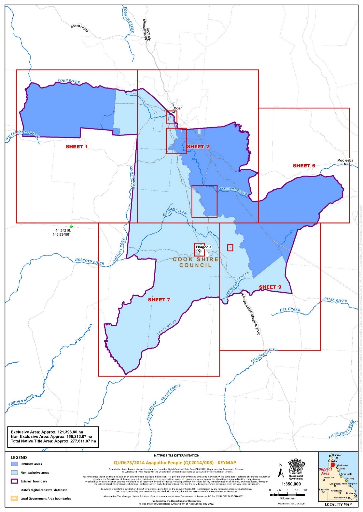
4. The determination area is the land and waters described in Schedule 4 and depicted in the maps attached to Schedule 6 to the extent those areas are within the External Boundary and not otherwise excluded by the terms of Schedule 5 (the Determination Area). To the extent of any inconsistency between the written description and the map, the written description prevails.
5. Native title exists in the Determination Area.
6. The native title is held by the Ayapathu People described in Schedule 1 (the Native Title Holders).
7. Subject to orders 9, 10 and 11 below the nature and extent of the native title rights and interests in relation to the land and waters described in Part 1 of Schedule 4 are:
(a) other than in relation to Water, the right to possession, occupation, use and enjoyment of the area to the exclusion of all others; and
(b) in relation to Water, the non-exclusive right to take the Water of the area for personal, domestic and non-commercial communal purposes.
8. Subject to orders 9, 10 and 11 below the nature and extent of the native title rights and interests in relation to the land and waters described in Part 2 of Schedule 4 are the non-exclusive rights to:
(a) access, be present on, move about on and travel over the area;
(b) live and camp on the area and for those purposes to erect shelters and other structures thereon;
(c) hunt, fish and gather on the land and waters of the area;
(d) take the Natural Resources from the land and waters of the area;
(e) take the Water of the area for personal, domestic and non-commercial communal purposes;
(f) be buried and to bury Native Title Holders within the area;
(g) maintain places of importance and areas of significance to the Native Title Holders under their traditional laws and customs on the area and protect those places and areas from harm;
(h) teach on the area the physical and spiritual attributes of the area and the traditional laws and customs of the Native Title Holders to other Native Title Holders or persons otherwise entitled to access the area;
(i) hold meetings on the area;
(j) conduct ceremonies on the area;
(k) light fires on the area for cultural, spiritual or domestic purposes including cooking, but not for the purpose of hunting or clearing vegetation; and
(l) be accompanied on to the area by those persons who, though not Native Title Holders, are:
(i) Spouses of Native Title Holders;
(ii) people who are members of the immediate family of a Spouse of a Native Title Holder; or
(iii) people reasonably required by the Native Title Holders under traditional law and custom for the performance of ceremonies or cultural activities on the area.
9. The native title rights and interests are subject to and exercisable in accordance with:
(a) the Laws of the State and the Commonwealth; and
(b) the traditional laws acknowledged and traditional customs observed by the Native Title Holders.
10. The native title rights and interests referred to in orders 7(b) and 8 do not confer possession, occupation, use or enjoyment to the exclusion of all others.
11. There are no native title rights in or in relation to minerals as defined by the Mineral Resources Act 1989 (Qld) and petroleum as defined by the Petroleum Act 1923 (Qld) and the Petroleum and Gas (Production and Safety) Act 2004 (Qld).
12. The nature and extent of any other interests in relation to the Determination Area (or respective parts thereof) are set out in Schedule 2 (the Other Interests).
13. The relationship between the native title rights and interests described in orders 7 and 8 and the Other Interests described in Schedule 2 is that:
(a) the Other Interests continue to have effect, and the rights conferred by or held under the Other Interests may be exercised notwithstanding the existence of the native title rights and interests;
(b) to the extent the Other Interests are inconsistent with the continued existence, enjoyment or exercise of the native title rights and interests in relation to the land and waters of the Determination Area, the native title rights and interests continue to exist in their entirety but the native title rights and interests have no effect in relation to the Other Interests to the extent of the inconsistency for so long as the Other Interests exist; and
(c) the Other Interests and any activity that is required or permitted by or under, and done in accordance with, the Other Interests, or any activity that is associated with or incidental to such an activity, prevail over the native title rights and interests and any exercise of the native title rights and interests.
THE COURT DETERMINES THAT:
14. The native title is held in trust.
15. The Ayapathu Aboriginal Corporation (ICN: 9757), incorporated under the Corporations (Aboriginal and Torres Strait Islander) Act 2006 (Cth), is to:
(a) be the prescribed body corporate for the purpose of ss 56(2)(b) and 56(3) of the Native Title Act 1993 (Cth); and
(b) perform the functions mentioned in s 57(1) of the Native Title Act 1993 (Cth) after becoming a registered native title body corporate.
LIST OF SCHEDULES
Schedule 1 – Native Title Holders
Schedule 2 – Other Interests in the Determination Area
Schedule 3 – External Boundary
Schedule 4 – Description of Determination Area
Schedule 5 – Areas Not Forming Part of the Determination Area
Schedule 6 – Map of Determination Area
Schedule 1 – Native Title Holders
1. The Native Title Holders are the Ayapathu People. The Ayapathu People are those Aboriginal persons who are descended by birth, or by adoption in accordance with the traditional laws acknowledged and the traditional customs observed by the Ayapathu group, from one or more of the following apical ancestors:
(a) Albert Bluewater;
(b) Kitty (wife of Peter Coleman);
(c) Jack Ebagoola;
(d) Rosie Ebagoola (aka Rosie Massey) (wife of Paddy Nyakum);
(e) Kathleen (Kuu’iy) Huddy (spouse of Tom Huddy);
(f) Nellie Jinkan/ Jenkins;
(g) Nellie King (Kaakunydyingu);
(h) Kitty (spouse of Tommy Walwal);
(i) Jinny Long (aka Jinny Bandfoot/Bamford) (wife of Willy Long);
(j) Rosie (Kaithempa);
(k) Willie Long (aka Willie Bandfoot/Bamford) (spouse of Jinny Long);
(l) Mailman (aka Gilbert Ahlers);
(m) Old Paddy (aka Paddy Kennedy) (Nyakum);
(n) Young Paddy (spouse of Annie ‘Thumupalu’ Laurie aka Massey);
(o) Nellie Puller;
(p) Maggie (mother of George Rocky 2);
(q) Rosie (mother’s mother of Willy and Lukin Harold);
(r) Shortjoe (Manpungka);
(s) Tommy Walwal;
(t) Charlie Whiteford/Whitefoot/Whitewood;
(u) Annie ‘Thumupalu’ Laurie aka Massey (spouse of Young Paddy);
(v) Friday Bush; or
(w) Mother of Jack Shephard.
Schedule 2 – Other Interests in the Determination Area
The nature and extent of the other interests in relation to the Determination Area are the following as they exist as at the date of the Determination:
1. The rights and interests of the parties under the following agreements registered on the Register of Indigenous Land Use Agreements:
(a) Oyala Thumotang National Park (Cape York Peninsula Aboriginal Land) and adjacent Aboriginal Land ILUA (QI2012/071) registered on 13 December 2012;
(b) PNG Gas Pipeline ILUA – Cape York Region (QI2006/043) registered on 15 May 2008;
(c) Peninsula Developmental Road ILUA (QI2016/049) registered on 11 July 2017; and
(d) Kulla (McIlwraith Range & Mount Croll) ILUA (QI2008/018) registered on 13 May 2009.
2. The rights and interests of the holders of the following leases granted pursuant to the Land Act 1994 (Qld):
(a) rolling term lease for pastoral purposes (PH 34/3874) over Lot 3874 on SP273462 (also known as Astrea), held by Patricia Lois Gordon and James Maurice Gordon;
(b) term lease (0/208116) for pastoral purposes (also known as Lochinvar Station) over that part of Lot 9 on SP211742 which falls within the External Boundary, held by Neville James Shephard;
(c) strata term lease for grazing over Lot 13 on CO8 held by Neville James Shepard;
(d) strata term lease for grazing over Lot 23 on CO8 held by Neville James Shepard; and
(e) rolling term lease (0/213543) over that part of Lot 10 on SP113659 that falls within the External Boundary, held by Victor Thomas Byrnes.
3. The rights and interests of Telstra Corporation Limited (ACN 051 775 556), Amplitel Pty Ltd as trustee of the Towers Business Operating Trust (ABN 75 357 171 746) and any of their successors in title:
(a) as the owner(s) or operator(s) of telecommunications facilities within the Determination Area;
(b) created pursuant to the Post and Telegraph Act 1901 (Cth), the Telecommunications Act 1975 (Cth), the Australian Telecommunications Corporation Act 1989 (Cth), the Telecommunications Act 1991 (Cth) and the Telecommunications Act 1997 (Cth), including rights:
(i) to inspect land;
(ii) to install, occupy and operate telecommunication facilities; and
(iii) to alter, remove, replace, maintain, repair and ensure the proper functioning of its telecommunications facilities;
(c) for their employees, agents or contractors to access their telecommunication facilities in and in the vicinity of the Determination Area in the performance of their duties; and
(d) under any lease, licence, access agreement, permit or easement relating to their telecommunications facilities in the Determination Area.
4. The rights and interests of Cook Shire Council:
(a) under its local government jurisdiction and functions under the Local Government Act 2009 (Qld), under the Stock Route Management Act 2002 (Qld) and under any other legislation, for that part of the Determination Area within the area declared to be its Local Government Area:
(b) as the:
(i) lessor under any leases which were validly entered into before the date on which these orders are made and whether separately particularised in these orders or not;
(ii) grantor of any licences or other rights and interests which were validly granted before the date on which these orders were made and whether separately particularised in these orders or not;
(iii) party to an agreement with a third party which relates to land or waters in the Determination Area;
(iv) holder of any estate or any other interest in land, including as trustee of any Reserves, under access agreements and easements that exist in the Determination Area;
(c) as the owner and operator of infrastructure, structures, earthworks, access works and any other facilities and other improvements located in the Determination Area validly constructed or established on or before the date on which these orders are made, including but not limited to any:
(i) undedicated but constructed roads except for those not operated by the council;
(ii) water pipelines and water supply infrastructure;
(iii) drainage facilities;
(iv) watering point facilities;
(v) recreational facilities;
(vi) transport facilities;
(vii) gravel pits operated by the council;
(viii) cemetery and cemetery related facilities; and
(ix) community facilities;
(d) to enter the land for the purposes described in paragraphs 4(a), (b) and (c) above by its employees, agents or contractors to:
(i) exercise any of the rights and interests referred on in this paragraph 4 and paragraph 7 below;
(ii) use, operate, inspect, maintain, replace, restore and repair the infrastructure, facilities and other improvements referred to in paragraph 4(c) above; and
(iii) undertake operational activities in its capacity as a local government such as feral animal control, erosion control, waste management and fire management.
5. The rights and interests held by the Commonwealth with respect to the seismic station located within the external boundaries of Lot 9 on SP211742.
6. The rights and interests held by the State of Queensland with respect to the global navigation satellite system reference station located within the external boundaries of Lot 9 on SP211742.
7. The rights and interests of the State of Queensland and Cook Shire Council to access, use, operate, maintain and control the dedicated roads in the Determination Area and the rights and interests of the public to use and access the roads.
8. The rights and interests of the State of Queensland in Reserves, the rights and interests of the trustees of those Reserves and the rights and interests of the persons entitled to access and use those Reserves for the respective purpose for which they are reserved.
9. The rights and interests of the State of Queensland or any other person existing by reason of the force and operation of the laws of the State of Queensland, including those existing by reason of the following legislation or any regulation, statutory instrument, declaration, plan, authority, permit, lease or licence made, granted, issued or entered into under that legislation:
(a) the Aboriginal Land Act 1991 (Qld);
(b) the Fisheries Act 1994 (Qld);
(c) the Land Act 1994 (Qld);
(d) the Nature Conservation Act 1992 (Qld);
(e) the Forestry Act 1959 (Qld);
(f) the Water Act 2000 (Qld);
(g) the Petroleum Act 1923 (Qld) or Petroleum and Gas (Production and Safety) Act 2004 (Qld);
(h) the Mineral Resources Act 1989 (Qld);
(i) the Planning Act 2016 (Qld);
(j) the Transport Infrastructure Act 1994 (Qld); and
(k) the Fire and Emergency Services Act 1990 (Qld) or Ambulance Service Act 1991 (Qld).
10. The rights and interests of members of the public arising under the common law, including but not limited to the following:
(a) any subsisting public right to fish; and
(b) the public right to navigate.
11. So far as confirmed pursuant to s 212(2) of the Native Title Act 1993 (Cth) and s 18 of the Native Title (Queensland) Act 1993 (Qld) as at the date of this determination, any existing rights of the public to access and enjoy the following places in the Determination Area:
(a) waterways;
(b) beds and banks or foreshores of waterways;
(c) stock routes; and
(d) areas that were public places at the end of 31 December 1993.
12. Any other rights and interests:
(a) held by the State of Queensland or Commonwealth of Australia; or
(b) existing by reason of the force and operation of the Laws of the State and the Commonwealth.
Schedule 3 – External Boundary
The area of land and waters:
Commencing at a point on the northern boundary of Lot 652 on SP177999, also being a point on the northern boundary of Wik and Wik Way Native Title Determination No. 3 (QCD 2004/003) at Longitude 142.893372° East, Latitude 14.010773° South and extending westerly along the northern boundary of that lot to Longitude 142.811473° East, Latitude 13.982793° South; then extending in a straight line in a north-westerly to an unnamed watercourse at Longitude 142.801751° East, Latitude 13.946058° South; then generally northerly along the centreline of that unnamed watercourse to its intersection with Horsetailer Creek at Latitude 13.894294° South; then generally north-easterly along the centreline of that creek to its intersection with Coen River at Latitude 13.869165° South; then generally easterly along the centreline of that river until its intersection with an unnamed watercourse at Longitude 143.073713° East, Latitude 13.894552° South; then generally easterly along the centreline of that unnamed watercourse and its southernmost tributary to a point located between two hills at Longitude 143.119514° East, Latitude 13.885423° South; then south-easterly in a straight line to a point at Longitude 143.148743° East, Latitude 13.908909° South and onwards in a straight line south-easterly to the intersection of the centrelines of Coen River and Oscar Creek at Longitude 143.191023° East; then south-easterly along the centreline of Oscar Creek and an unnamed tributary to its headwaters at Longitude 143.211373° East, Latitude 13.988902° South; then easterly to the centre point of an unnamed lagoon at Longitude 143.227744° East, Latitude 13.991032° South; then easterly along a straight line to a point at Longitude 143.326494° East, Latitude 13.983444° South; then in a straight line north-easterly until it intersects the foothills of the McIlwraith Range at Longitude 143.355071° East, Latitude 13.971448° South, also being a point on a line of the 100m contour elevation; then southerly along that contour until its intersection with the centreline of Port Stewart Road; then easterly along the centreline of that road until it intersects with the centreline of an unnamed road (also known as IWS (Irrigation Water Supply) Road) in an area known as Box Flat at Longitude 143.417308° East; then generally south-westerly and generally southerly along the centreline of IWS Road which passes through the following coordinates:
Longitude ° East | Latitude ° South |
143.413209 | 14.105504 |
143.410583 | 14.105814 |
143.408501 | 14.107902 |
143.408595 | 14.108734 |
143.407444 | 14.110204 |
143.405851 | 14.110390 |
143.404627 | 14.111310 |
143.401560 | 14.111734 |
143.397738 | 14.113946 |
143.394598 | 14.113993 |
143.393305 | 14.114535 |
143.392131 | 14.117996 |
143.391834 | 14.120952 |
143.390953 | 14.123557 |
143.391721 | 14.127300 |
143.393042 | 14.130535 |
143.392941 | 14.134401 |
143.394049 | 14.135327 |
143.393931 | 14.137598 |
143.395753 | 14.141900 |
143.394825 | 14.144736 |
143.398107 | 14.153035 |
143.398462 | 14.156006 |
143.397182 | 14.157957 |
143.395330 | 14.159082 |
143.391819 | 14.159675 |
143.390022 | 14.161160 |
143.390351 | 14.163110 |
143.392399 | 14.164661 |
143.392798 | 14.166785 |
then south-easterly to the centreline of Stewart River at Longitude 143.394076° East; then easterly along the centreline of that river until it intersects with the centreline of an unnamed road (also known as Running Creek Lilyvale Road) at Longitude 143.575456° East; then generally south-easterly along the centreline of that road until the intersection with an unnamed road (also known as Lava Hill Road) at the second Rocky Crossing at 143.635965° East; then generally south-westerly along the centreline of Lava Hill Road which passes through the following coordinates:
Longitude ° East | Latitude ° South |
143.635506 | 14.147600 |
143.634123 | 14.149262 |
143.633115 | 14.153591 |
143.633904 | 14.158187 |
143.632550 | 14.163011 |
143.633210 | 14.165262 |
143.629125 | 14.167696 |
143.626891 | 14.170060 |
143.623829 | 14.171075 |
143.621716 | 14.173022 |
143.617132 | 14.174336 |
143.609785 | 14.178803 |
143.608475 | 14.180773 |
143.605590 | 14.182273 |
143.601704 | 14.180173 |
143.596630 | 14.183727 |
143.595083 | 14.186263 |
143.590667 | 14.189278 |
143.587685 | 14.192798 |
143.583873 | 14.194850 |
143.579112 | 14.201936 |
143.574230 | 14.205863 |
143.572113 | 14.208261 |
then southerly to Longitude 143.572020° East, Latitude 14.209369° South, near where there is a large gum tree signing the boundary; then south-easterly until it intersects with the centreline of Balclutha Creek at Latitude 14.209567° South; then generally south-westerly along the centreline of Balclutha Creek until it reaches a point at Longitude 143.517333° East; then south-easterly to the north-eastern corner of the northern severance of Lot 1 on SP161903, being the Balclutha Creek Nature Reserve; then southerly along the eastern boundary of that reserve, crossing an unnamed road, to its intersection with the eastern boundary of another unnamed road (also known as the Old Telegraph Line) at a point on the north-western corner of the western-most severance of Lot 6 on SP189946; then westerly to the centreline of that road; then generally southerly along the centreline of that road to the intersection with the centreline of Annie River at Latitude 14.414312° South (a place known as 25 Mile or Hot Water Story); then westerly to a point on the Great Dividing Range just north of Mount Walsh at Longitude 143.449180° East, Latitude 14.407860° South; then extending in a straight line north-westerly to the eastern-most point of an unnamed watercourse in the upper headwaters of Lukin River at Longitude 143.433544° East, Latitude 14.403611° South; then generally westerly along that unnamed watercourse to its intersection with Duckholes Creek at Longitude 143.406225° East; then generally westerly along the centreline of that creek crossing the Peninsula Development Road just north of Duckholes Lagoon, until its intersection with Lukin River; then westerly along the centreline of that river until a point at Longitude 143.33699° East; then southerly, westerly and northerly to again intersect the centreline of that river at Longitude 143.321382° East, passing around Mount Ryan through the following coordinate points:
Longitude ° East | Latitude ° South |
143.338238 | 14.432602 |
143.337841 | 14.437100 |
143.336452 | 14.440160 |
143.333025 | 14.441119 |
143.328741 | 14.441065 |
143.325716 | 14.438504 |
then generally south-westerly along the centreline of Lukin River to its intersection with the centreline of the southern-most point of Fish Creek; then generally north-westerly along the centreline of that creek to its intersection with an unnamed tributary at Longitude 143.027881° East, Latitude 14.530430° South; then northerly along the centreline of that unnamed tributary until a point in the vicinity of Camp Oven Lagoon at Longitude 143.023356° East, Latitude 14.492834° South; then easterly along a straight line to a point on the southern boundary of Lot 1 on SP177772, also being the Wik and Wik Way Native Title Determination No. 4 (QCD 2012/010), at Longitude 143.024927° East, Latitude 14.492031° South; then generally north-easterly, northerly, westerly, northerly and westerly along the eastern and northern boundaries of the south-eastern most severance of that determination back to the commencement point, further defined as:
Extending north-easterly, northerly, westerly and northerly along the eastern boundaries of Lot 1 on SP177772 until a corner at Longitude 143.093571° East, Latitude 14.143398° South; then northerly along a straight line to a corner on the eastern boundary of again Lot 1 on SP177772 at Longitude 143.102110° East, Latitude 14.039017° South; then northerly and westerly along the eastern and northern boundaries of that lot back to the commencement point.
(All Subject to Survey).
Data Reference and source
Cadastral data sourced from Department of Resources, Qld (17 August 2021).
Watercourse lines sourced from Department of Resources, Qld (17 August 2021).
Baseline roads and tracks sourced from Department of Resources, Qld (17 August 2021).
Contour 10m data sourced from Department of Resources, Qld (17 August 2021).
Native title determination outcomes sourced from the National Native Title Tribunal (August 2021).
Reference datum
Geographical coordinates are referenced to the Geocentric Datum of Australia 1994 (GDA94), in decimal degrees.
Use of Coordinates
Where coordinates are used within the description to represent cadastral or topographical boundaries or the intersection with such, they are intended as a guide only. As an outcome to the custodians of cadastral and topographic data continuously recalculating the geographic position of their data based on improved survey and data maintenance procedures, it is not possible to accurately define such a position other than by detailed ground survey.
Schedule 4 – Description of Determination Area
The determination area comprises all of the land and waters described by lots on plan, or relevant parts thereof, and any rivers, streams, creeks or lakes described in the first column of the tables in the Parts immediately below, and depicted in the maps in Schedule 6, to the extent those areas are within the External Boundary and not otherwise excluded by the terms of Schedule 5.
Part 1 — Exclusive Areas
All of the land and waters described in the following table and depicted in dark blue on the Determination map contained in Schedule 6:
Area description (at the time of the Determination) | Determination Map Sheet Reference | Note |
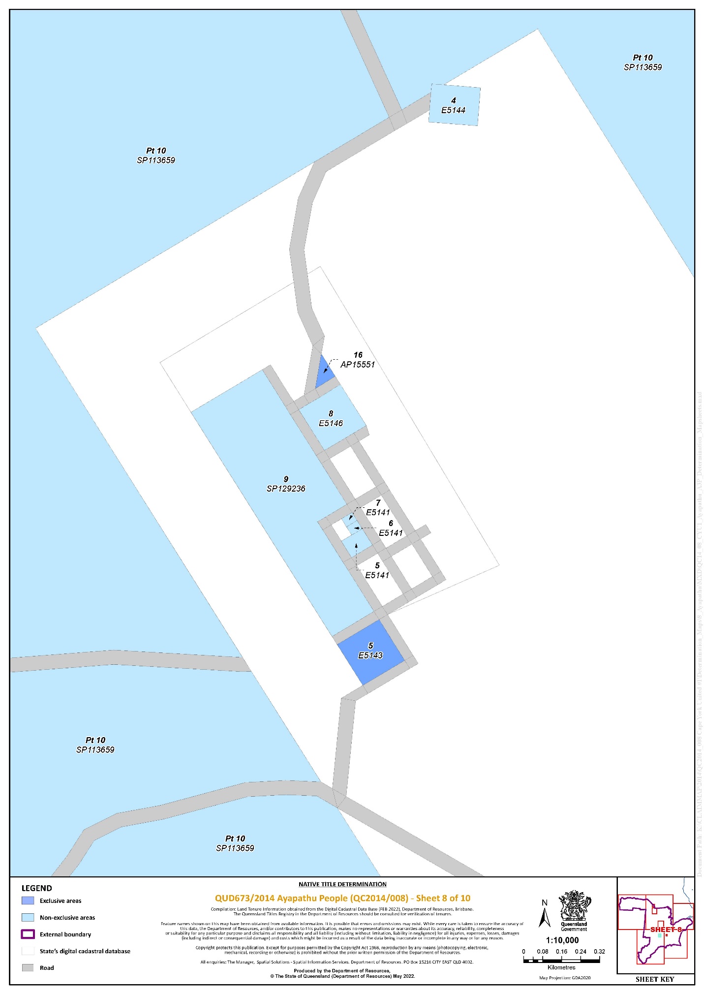
Lot 5 on E5143 | 8 | ^ |
Lot 16 on AP15551 | 8 | ^ |
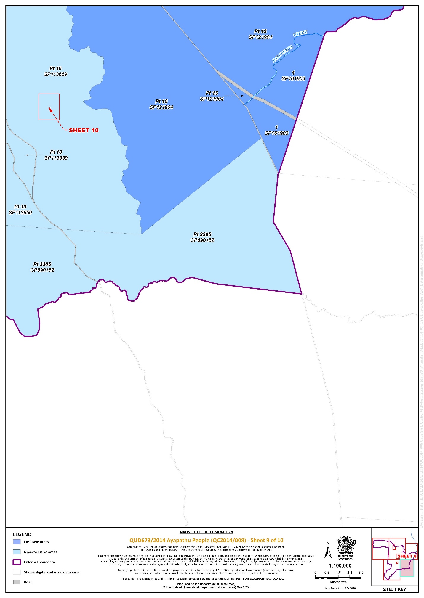
Lot 1 on SP161903 | 9 | * |
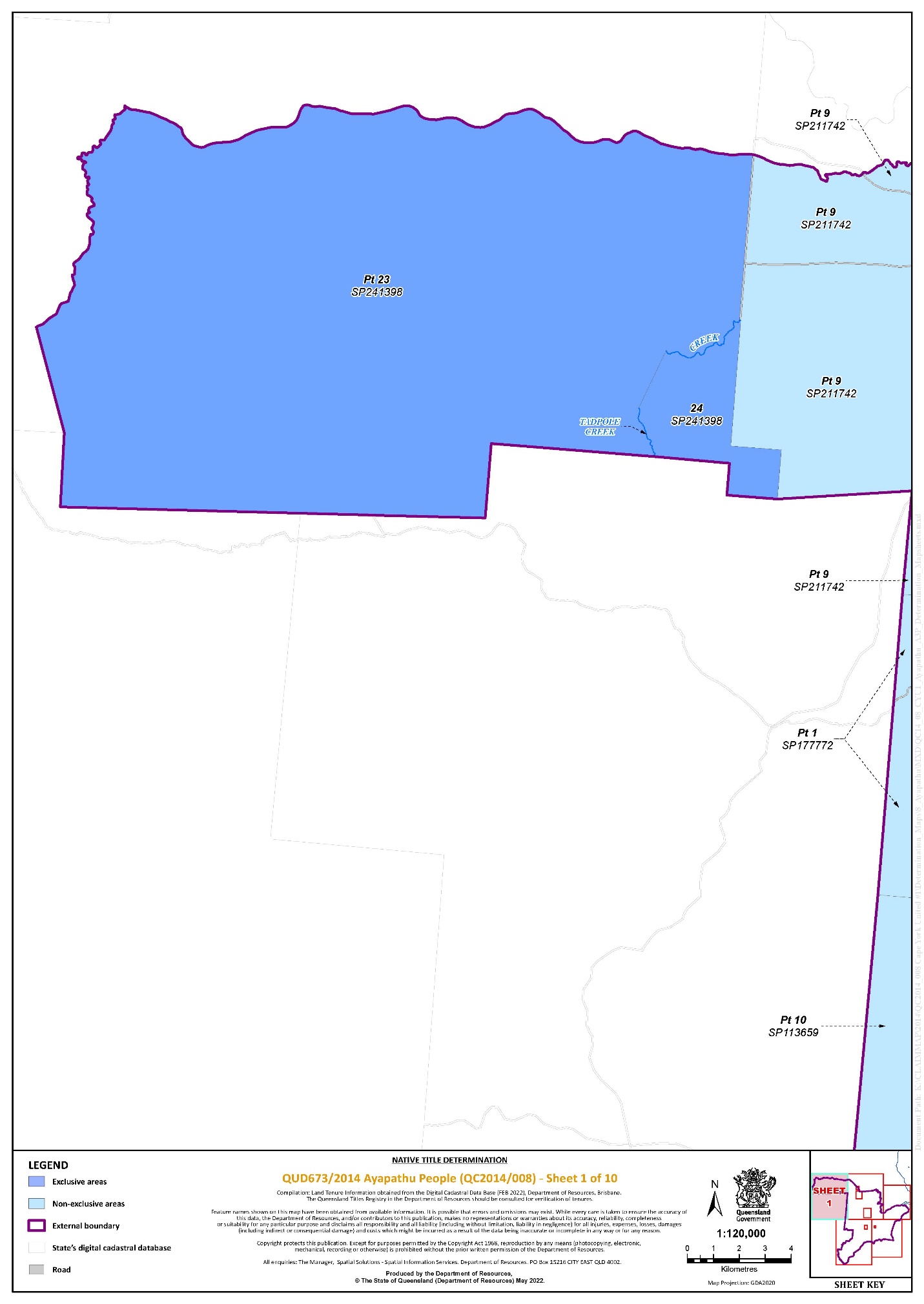
Lot 24 on SP241398 | 1 | * |
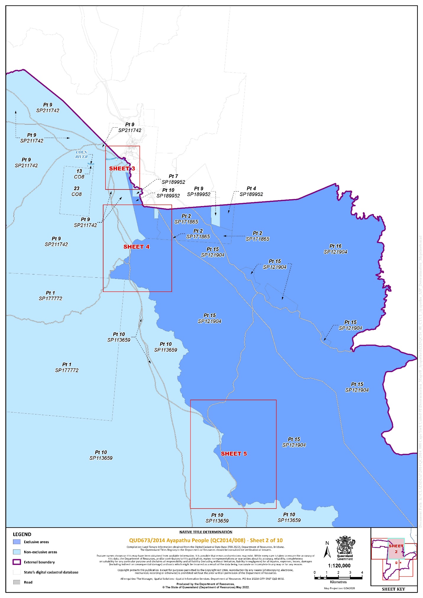
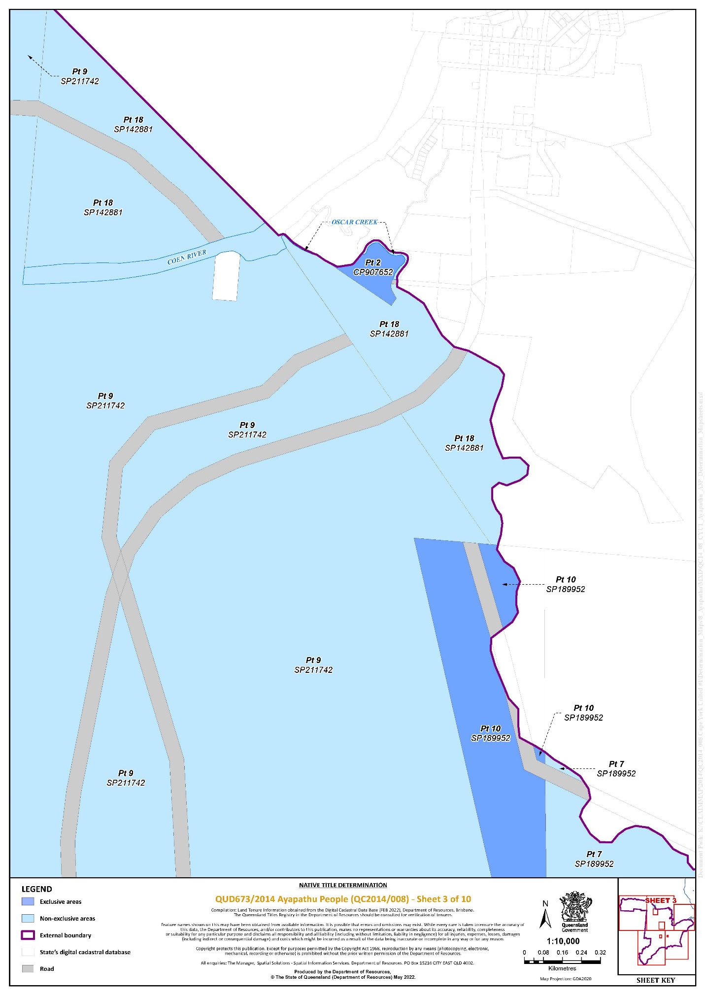
That part of Lot 10 on SP189952 that falls within the External Boundary | 2, 3, and 4 | * |
That part of Lot 2 on CP907652 that falls within the External Boundary | 3 | * |
That part of Lot 23 on SP241398 that falls within the External Boundary | 1 | * |
That part of Lot 4 on SP189952 that falls within the External Boundary | 2 | * |
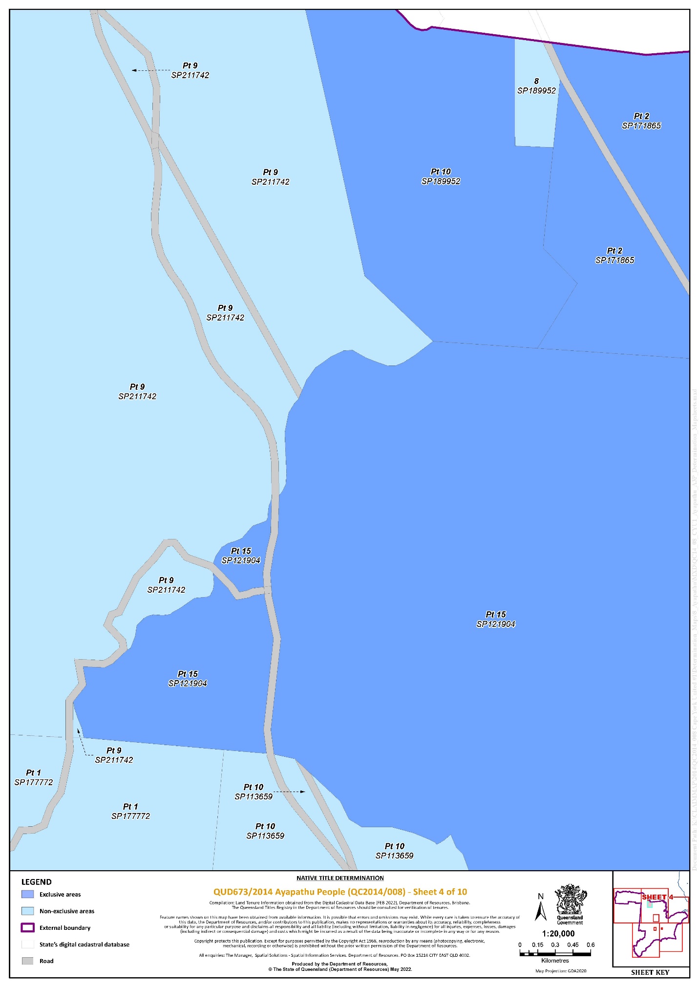
That part of Lot 16 on SP121904 that falls within the External Boundary | 2 | * |
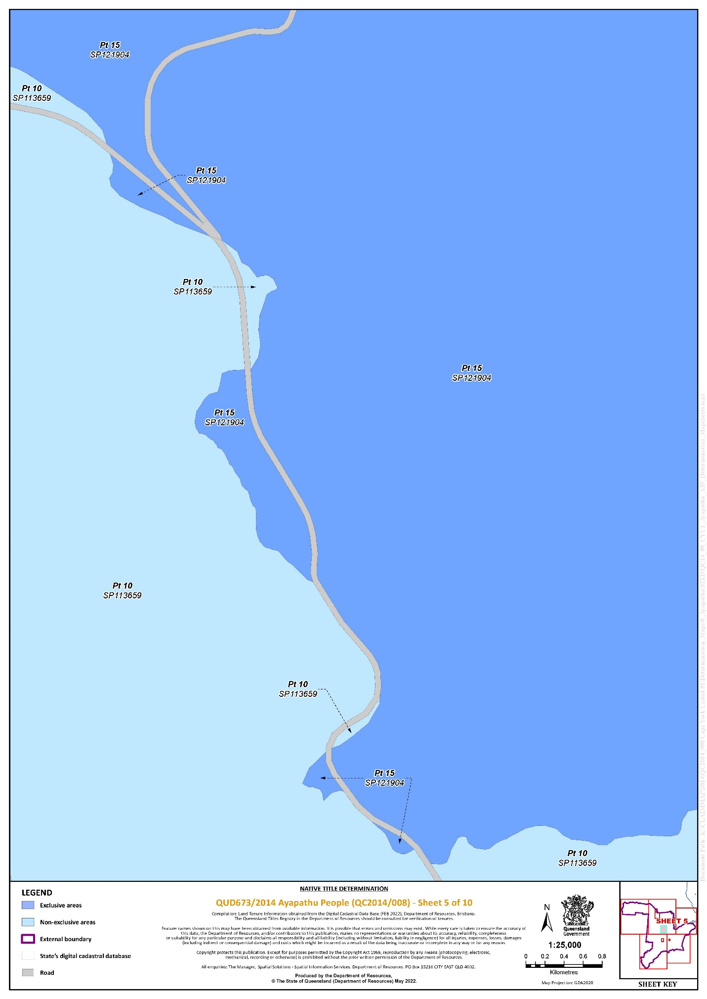
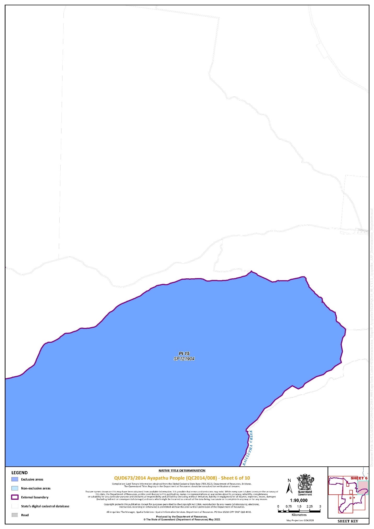
That part of Lot 15 on SP121904 that falls within the External Boundary | 2, 4, 5, 6, and 9 | * |
That part of Lot 2 on SP171865 that falls within the External Boundary | 2 and 4 | * |
* denotes areas to which s 47A of the Native Title Act 1993 (Cth) applies.
^ denotes areas to which s 47B of the Native Title Act 1993 (Cth) applies.
Part 2 — Non-Exclusive Areas
All of the land and waters described in the following table and depicted in light blue on the Determination map contained in Schedule 6:
Area description (at the time of the Determination) | Determination Map Sheet Reference |
Lot 4 on E5144 | 8 |
Lot 8 on E5146 | 8 |
Lot 9 on SP129236 | 8 |
Lot 5 on E5141 | 8 |
Lot 7 on E5141 | 8 |
Lot 6 on E5141 | 8 |
Lot 13 on CO8 | 2 |
Lot 23 on CO8 | 2 |
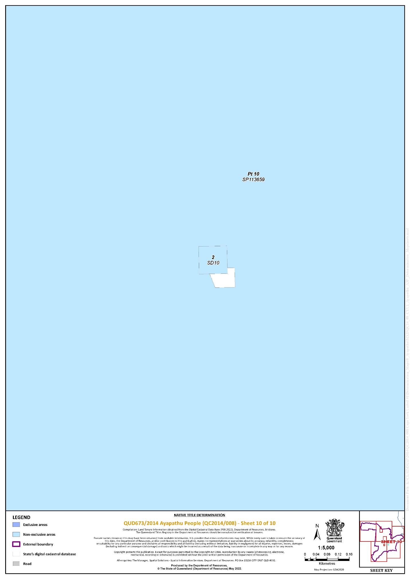
Lot 2 on SD10 | 10 |
That part of Lot 7 on SP189952 that falls within the External Boundary | 2 and 3 |
That part of Lot 8 on SP189952 that falls within the External Boundary | 4 |
That part of Lot 9 on SP211742 that falls within the External Boundary | 1, 2, 3, and 4 |
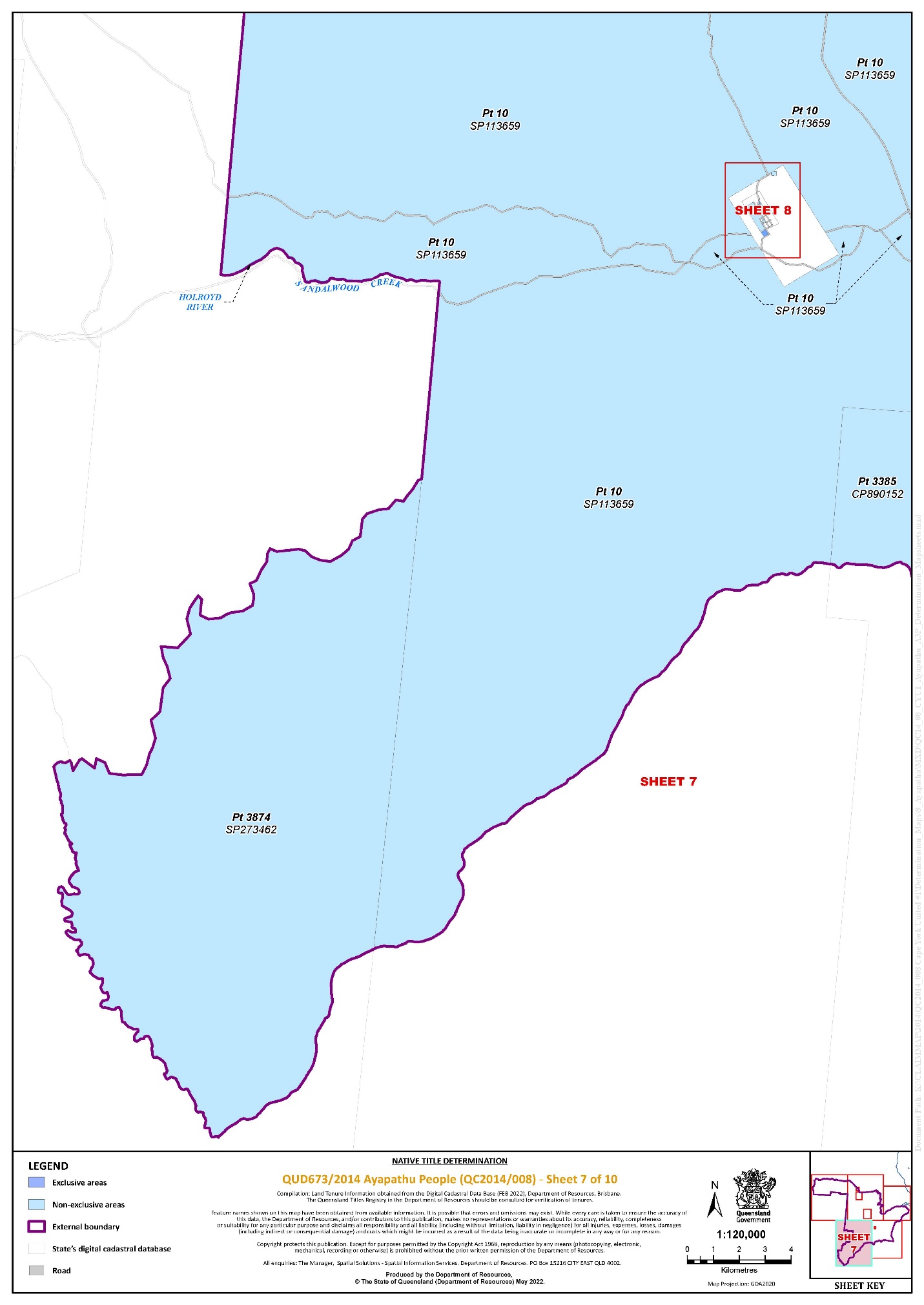
That part of Lot 10 on SP113659 that falls within the External Boundary | 1, 2, 4, 5, 7, 8, 9, and 10 |
That part of Lot 3385 on CP890152 that falls within the External Boundary | 7 and 9 |
That part of Lot 3874 on SP273462 that falls within the External Boundary | 7 |
That part of Lot 9 on SP189952 that falls within the External Boundary | 2 |
That part of Lot 18 on SP142881 that falls within the External Boundary | 2 and 3 |
That part of Lot 1 on SP177772 that falls within the External Boundary | 1, 2, and 4 |
Save for any waters forming part of a lot on plan, all rivers, creeks, streams and lakes within the External Boundary described in Schedule 3, including but not limited to: (a) Balcutha Creek; (b) Coen River; (c) Holroyd River; (d) Oscar Creek; (e) Sandalwood Creek; (f) Tadpole Creek; (g) Williamson Creek; (h) Kendle River; (i) Stewart River; and (j) Kirbys Camp Creek. | |
Schedule 5 – Areas Not Forming Part of the Determination Area
The following areas of land and waters are excluded from the Determination Area as described in Part 1 of Schedule 4 and Part 2 of Schedule 4.
1. Those land and waters within the External Boundary in relation to which one or more Previous Exclusive Possession Acts, within the meaning of s 23B of the Native Title Act 1993 (Cth) was done and was attributable to either the Commonwealth or the State, and to which none of ss 47, 47A or 47B of the Native Title Act 1993 (Cth) applied, as they could not be claimed in accordance with s 61A of the Native Title Act 1993 (Cth).
2. Specifically, and to avoid any doubt, the land and waters described in (1) above includes:
(a) the Previous Exclusive Possession Acts described in ss 23B(2) and 23B(3) of the Native Title Act 1993 (Cth) to which s 20 of the Native Title (Queensland) Act 1993 (Qld) applies, and to which none of ss 47, 47A or 47B of the Native Title Act 1993 (Cth) applied, including, but not limited to the whole of the land and waters described as:
Area description (at the time of the Determination) |
Lot 1 on MPH317 |
Lot 10 on SP287495 |
Lot 1 on SP287495 |
An area of road identified and delineated by stations 9-9a-50-43-43a-45-45a-50a-9 and 23-U-T-31-35-39-31a-23 on plan SP287495 |
(b) the land and waters on which any public work, as defined in s 253 of the Native Title Act 1993 (Cth), is or was constructed, established or situated, and to which ss 23B(7) and 23C(2) of the Native Title Act 1993 (Cth) and to which s 21 of the Native Title (Queensland) Act 1993 (Qld), applies, together with any adjacent land or waters in accordance with s 251D of the Native Title Act 1993 (Cth).
3. Those land and waters within the External Boundary that were excluded from the Native Title Determination Application on the basis that, at the time of the Native Title Determination Application, they were an area where native title rights and interests had been wholly extinguished, and to which none of ss 47, 47A or 47B of the Native Title Act 1993 (Cth) applied, including, but not limited to:
(a) any area where there had been an unqualified grant of estate in fee simple which wholly extinguished native title rights and interests; and
(b) any area over which there was an existing dedicated public road which wholly extinguished native title rights and interests.
4. Specifically, and to avoid any doubt, the land and waters described in (3) above includes Lot 3 :
Area description (at the time of the Determination) |
Lot 3 on SD12 |
5. Those land and waters within the External Boundary on which, at the time the Native Title Determination Application was made, public works were validly constructed, established or situated after 23 December 1996, where s 24JA of the Native Title Act 1993 (Cth) applies, and which wholly extinguished native title.
Schedule 6 – Map of Determination Area
MORTIMER J:
INTRODUCTION
1 The parties have sought a determination of native title under s 87A of the Native Title Act 1993 (Cth), with associated orders, recognising the native title of the Ayapathu People. This determination is being made a day after determinations recognising the native title of the Northern Kaanju People and the Southern Kaantju People, and on the same day as a determination recognising the native title of the Lama Lama People. I note that in the materials supplied to the Court there are a variety of spellings for the names of these groups. In these reasons I adopt the spellings used by the Cape York United #1 applicant in its submissions in support of the determinations.
2 Together, these determinations resolve four parts of the Cape York United #1 claim, within a geographic region that has come to be known as the ‘Kwok Report Area’ or the ‘Kwok Timetable Area’, after the anthropologist engaged by the Cape York United #1 applicant to prepare connection material about the area. It is important to note that, by orders made on 8 February 2022, parcels of land in respect of which the parties to the Cape York United #1 proceeding could not reach agreement were excluded from the consent determinations today and tomorrow. For this reason, the determinations do not reflect the entirety of the country claimed by each of the four native title holding groups.
3 Recognising that each of the groups is a distinct native title holding group, with rights and interests under traditional law and custom in the determination area which comprise separate and distinct native titles, the Court makes orders and gives reasons separately for each group.
4 Today’s determination recognises connection to country of the type that Douglas Ahlers describes in his witness statement, when he talks about how he felt when he heard the story of the two hills called Mt White and Mt Sister White:
That Story was told to me by my grandmother, Mum and my uncles, and was told to them by their old people before them. In the early days you picture yourself in that world, in that Dreamtime Story. Most of us who grew up around my grandmother knew that Story, because she would tell us the Story.
5 The Court’s orders, and the long overdue recognition by Australian law, will help preserve the country of the Ayapathu People and protect their deep connection to it. The determination should give confidence to Ayapathu elders to pass down their rules and knowledge about country to future generations in circumstances where their rights to this country are recognised by Australian law.
6 For the reasons set out below, the Court is satisfied it is appropriate to make the orders sought, and that it is within the power of the Court to do so.
THE MATERIAL BEFORE THE COURT
7 The application for consent determination was supported by a principal set of submissions filed on behalf of the applicant on 2 June 2022. The State filed submissions on 10 June 2022. The Court has been greatly assisted by the parties’ submissions.
8 The applicant relied on an affidavit of Kirstin Donlevy Malyon, filed on 2 June 2022 (the Malyon 2022 affidavit), and a further affidavit of Ms Malyon filed on 21 June 2022. Ms Malyon has been the Principal Legal Officer at the Cape York Land Council (CYLC) and has had the carriage of the Cape York United #1 claim. She deposed to how the Ayapathu s 87A Agreement was approved, and to how the Ayapathu Aboriginal Corporation was nominated as the prescribed body corporate (PBC) for the Ayapathu determination, annexing the notice of nomination for that PBC and its consent to act as the relevant PBC for the determination area.
9 In terms of connection material for the four determinations, the applicant relied on:
(a) the expert report by Dr Natalie Kwok entitled “Northern Central and Princess Charlotte Bay Region” filed on 16 November 2017 (the Kwok 2017 report);
(b) the amended expert report of Ms Kate Waters dated 5 March 2018 and filed on 6 March 2018 (the Waters 2018 report); and
(c) the supplementary expert report by Dr Kwok dated April 2019, which has been annexed to an affidavit of Parkinson Wirrick, a legal officer with the CYLC, affirmed and filed on 2 June 2022 (the Wirrick 2022 affidavit).
10 In terms of connection material for the Ayapathu determination in particular, the applicant relied on:
(a) the witness statement of Douglas Roy Ahlers dated 4 April 2019, which is annexed to the Wirrick 2022 affidavit;
(b) the apical report of Ms Waters regarding Annie (spouse of Possum Massey) dated 30 June 2020, and annexed to the Wirrick 2022 affidavit;
(c) the apical report of Ms Waters regarding Friday Bush dated 30 June 2020, and annexed to the Wirrick 2022 affidavit;
(d) the apical report of Ms Waters regarding Lena (spouse of Jack Ebagoola) dated 30 June 2020, and annexed to the Wirrick 2022 affidavit;
(e) the apical report of Ms Waters regarding Friday Chippendale aka Friday Larry dated 30 June 2020, and annexed to the Wirrick 2022 affidavit;
(f) the apical report of Ms Waters regarding George Rocky 1 dated 30 June 2020, and annexed to the Wirrick 2022 affidavit;
(g) the apical report of Ms Waters regarding Annie (spouse of Possum Massey) dated 6 October 2020, and annexed to the Wirrick 2022 affidavit;
(h) the apical report of Ms Waters regarding Sandy and Nelly-Lily dated 6 July 2021, and annexed to the Wirrick 2022 affidavit;
(i) the apical report of Ms Waters regarding Friday Chippendale dated 1 July 2022, and annexed to the Wirrick 2022 affidavit;
(j) the apical report of Ms Waters regarding Nellie King dated 14 March 2022, and annexed to the Wirrick 2022 affidavit; and
(k) the apical report of Ms Waters dated 16 March 2022, annexed to the Wirrick 2022 affidavit.
11 The applicant also relied on paragraphs [5] to [30] of an affidavit of Ms Malyon filed on 27 October 2021 (the Malyon 2021 affidavit), which concerned the re-authorisation process undertaken by the applicant in the period from April to September 2021.
PROCEDURAL HISTORY
12 The Cape York United #1 claim was filed in this Court in December 2014. It covers various types of tenure, including pastoral leases, protected areas, reserves and areas of unallocated State land. It is the largest native title claim currently before the Court, and covers a majority of the area of Cape York for which no determination under the Native Title Act has been made.
13 The complex procedural history and nature of the Cape York United #1 claim is summarised in the Court’s reasons for the Kuuku Ya’u and Uutaalnganu (Night Island) determinations made last year: Ross on behalf of the Cape York United #1 Claim Group v State of Queensland (No 2) (Kuuku Ya’u determination) [2021] FCA 1464 at [3], [12]-[19], [30]-[37]; Ross on behalf of the Cape York United #1 Claim Group v State of Queensland (No 3) (Uutaalnganu (Night Island) determination) [2021] FCA 1465 at [3], [13]-[20], [28]-[35].
AUTHORISATION
The Ayapathu s 87A agreement
14 As with the Kuuku Ya’u and Uutaalnganu determinations, the process undertaken by the CYLC with the Ayapathu native title group was methodical. The two major decision-making processes which needed closely to involve landholding groups were the processes to settle boundary descriptions, and the processes to settle group composition.
15 The Boundary Identification Negotiation and Mediation or ‘BINM’ process was adopted in April 2020 to deal with the reality that different groups hold different native titles in the claim area: see Kuuku Ya’u determination at [18], [25]-[26] and Uutaalnganu determination at [19], [23]-[24]. The BINM process was employed for the Northern Kaanju, Southern Kaantju, Lama Lama and Ayapathu claims. This is what Ms Malyon describes in the Malyon 2022 affidavit at [73]-[113].
16 Putative boundary descriptions for Ayapathu, Lama Lama, Northern Kaanju and Southern Kaantju were developed from desktop research by the CYLC and Dr Kwok in the middle of 2020. These descriptions were informed by consultations with the anthropologists engaged by the CYLC for neighbouring areas. The putative boundary descriptions were provided to the State on 24 July 2020 without prejudice to the applicant’s position. Thereafter the CYLC facilitated consultations with the Ayapathu, Lama Lama, Northern Kaanju and Southern Kaantju groups throughout Cape York and in Cairns. This involved engaging Dr Kwok and Mark Winters (another consultant anthropologist) to consult with relevant families, elders and important individuals for a combined total of 47 days, and engaging Dr Kevin Murphy, Dr Anthony Redmond, Dr Ray Wood, Dr Frank McKeown and Dr David Thompson to consult with relevant families, elders and important individuals in the neighbouring groups for a combined total of 35 days. The consultations helped identify who should attend meetings on behalf of the four groups and their neighbours, and helped ensure that those people would attend those meetings. The consultations also helped inform the proposed descriptions for the four groups (which were eventually agreed with the State in March 2021).
17 Following the consultations, in the second half of 2020, separate ‘preliminary meetings’ were held for each of the Ayapathu, Lama Lama, Northern Kaanju and Southern Kaantju native title groups, at which maps of the preliminary boundaries were provided and changes were proposed by group members. Afterwards, ‘boundary meetings’ were held between neighbouring groups, at which the applicant, through its legal representatives, took instructions as to the final descriptions of common boundaries, ultimately to be provided to the State.
18 At each boundary meeting were the relevant consultant anthropologists, a CYLC lawyer and a CYLC anthropologist. The intention was that the boundary meetings be attended by people with ancestral connections to, and specific knowledge of country, as well as those who had cultural authority to speak for and make decisions for country, as confirmed by the consultant anthropologists. The meetings commenced with an overview by the consultant anthropologists of the available anthropological materials. The consultant anthropologists then assisted the group representatives by providing advice, translation and feedback about anthropological and genealogical matters. Group representatives also had access to the CYLC’s genealogical records (subject to confidentiality), private break-out spaces, a series of maps and the State’s response to the putative boundary descriptions. At the end of the meetings agreement as to boundaries by consensus was sought, and if there was agreement, it was recorded in written resolutions.
19 In the case of the Ayapathu, preliminary meetings were held on 26 August 2020 and 14 October 2020. Ayapathu group members were notified of the meetings by post and email, and meetings were also publicised on the CYLC’s website and Facebook page, and community noticeboards. At these meetings, an appropriate description of the Ayapathu native title group was discussed and settled.
20 Boundary meetings were held for the Ayapathu native title group with the Lama Lama native title group, with the Kuku Thaypan native title group and with the Olkola Traditional Owner group on 20-22 April 2021, with the Southern Kaantju native title group on 7-8 June 2021, and with the Southern Kaantju and Central Wik native title groups on 29-30 June 2021.
21 The s 87A agreements were settled and authorised after the BINM process was complete. In the Malyon 2022 affidavit, Ms Malyon deposes to the notification of meetings to discuss, and subsequently authorise, the s 87A agreement for the Ayapathu determination. The Ayapathu authorisation meeting was conducted on 23 March 2022, and resolutions were passed by majority to authorise the s 87A agreement.
22 At a wider level, the Cape York United #1 applicant’s authority to enter into the Ayapathu s 87A agreement stems from the re-authorisation process between April and September 2021. Ms Malyon describes this process in her 2021 affidavit, and the Court describes and approves it in Kuuku Ya’u determination at [30]-[37] and Uutaalnganu determination at [28]-[35].
23 In Kuuku Ya’u determination at [38]-[50] and Uutaalnganu determination at [36]-[48], I explained why I considered it appropriate to make orders under s 84D(4) of the Native Title Act to deal with any uncertainty arising from differences between the claim group description in the original Cape York United #1 application and those in the proposed determinations at a more local level, both as regards the Court’s power to make a determination and the way in which a claim can be authorised.
24 In those determinations, I agreed with the State’s submission that the weight of authority supports the view that the Native Title Act affords flexibility to shape the content of the ultimate determination of native title, provided there is compliance with s 94A and s 225 of the Act. However, orders were made under s 84D(4) out of an abundance of caution and to avoid any doubt about the validity of the consent determinations. At [50] in Kuuku Ya’u determination and [48] in Uutaalnganu determination, I said:
It is plainly in the interests of the administration of justice to do so, in circumstances where the overall Cape York United #1 claim is gargantuan, and has already consumed seven years’ worth of resources, mostly sourced from public funds. Substantial, dedicated and methodical efforts have been made to comply with the requirements of the Native Title Act in each step along the way to these first two determinations. Despite significant factual and legal challenges, the two key parties have navigated a consensual path to the recognition of native title for the Kuuku Ya’u and Uutaalnganu (Night Island) groups. All other respondents have been consulted and given opportunities to participate in the process as it has progressed. They have been included in steps in the complex timetables. All consent to the Kuuku Ya’u and Uutaalnganu (Night Island) determinations. If ever there was a situation in the Court’s native title jurisdiction where a favourable exercise of discretion by the Court is appropriate to ensure resolution of a claim to which all parties agree, this is that situation.
25 In each of the present four determinations, the Cape York United #1 applicant proposed that similar orders be made. The State agreed with that proposal. For the reasons given in the extract above, I continue to consider such orders are appropriate.
THE CONNECTION OF THE AYAPATHU NATIVE TITLE GROUP TO THE DETERMINATION AREA, THROUGH THEIR TRADITIONAL LAW AND CUSTOM
26 In her 2017 report, Dr Natalie Kwok presents native title connection evidence in relation to the North Central Cape York and south-eastern Princess Charlotte Bay areas. This report covers all four determination areas for yesterday and today. This evidence is informed by the historical, anthropological and archival record, as well as on-site field research and interviews with people who were believed to have a traditional connection to those areas, and a range of environmental and linguistic data set out in the report.
27 Dr Kwok describes how Aboriginal people were in occupation of the determination areas at the time of the British assertion of sovereignty, and that laws and customs observed at that time recognised rights and interests in relation to lands and waters. While she acknowledges that the local peoples were placed under significant pressure from pastoralists and government authorities to leave their homelands, Dr Kwok describes and explains the strong efforts to resist this pressure, and how many people remained on country or connected to country, including by accepting exploitative work in order to remain in the area. Dr Kwok reviews and summarises the contemporary laws and customs in relation to land tenure in the North Central Cape York and south-eastern Princess Charlotte Bay areas, and concludes that these rights and interests originate in the pre-sovereignty contemporary laws and customs, having been passed down primarily patrilineally and shared by elders in didactic stories.
28 The applicant relies on this evidence as establishing a credible basis for the proposition that each of the Northern Kaanju, Southern Kaantju, Lama Lama and Ayapathu native title claim groups have maintained their connection to their respective determination area, under their respective traditional laws and customs, since prior to the British assertion of sovereignty. The State accepts such a credible basis exists. I accept the parties’ submissions.
29 In relation to the Ayapathu People, Dr Kwok states (at [711] of her 2017 report):
The Ayapathu name is a language-based reference, particularly constructed in contrast with the closely related Ayapakan language and people. The area with which the Ayapathu name is associated in the literature – as today – revolves around Ebagoola from south of Coen through the headwaters of the Coleman, Lukin and Holroyd Rivers. The name also occurs from early records in connection with the coastal strip about Port Stewart, tallying with Rigsby’s findings that there was a dialect of Ayapathu spoken there.
30 The evidence supporting the Ayapathu group descriptions, and the identification of apical ancestors, is found throughout the reports prepared by Dr Kwok and Ms Waters. I accept these matters were explored and presented to group members at a series of meetings described by Ms Malyon in the Malyon 2022 affidavit. They formed part of the s 87A authorisation process.
31 Finally, as had been done in the Kuuku Ya’u and Uutaalnganu determinations, it is appropriate to set out here some of the evidence of the Ayapathu group members, whose lived experiences and connections to culture and country provide the foundation for this determination. As I noted in the 2021 determinations, it is the group members who “live and understand their law and custom, and how it connects them to their country”: Kuuku Ya’u determination at [68]; Uutaalnganu determination at [59].
32 Douglas Roy Ahlers identifies as Wik Mungkan, through his maternal grandfather, and Ayapathu, through his father and maternal grandmother.
33 Mr Ahlers recounts how his father introduced him to parts of Ayapathu country, explaining how protocols for visiting different sites were passed down to him (at [68]-[72]):
I worked all through my father’s country around Coen. When I was about 8 or 9 years old, my dad took me on a horse ride and said ‘boy, I have to show you where these sacred sites and story places are’.
The first place my father took me to was at Thornbury, which is the site of the Moon Story. I do not want to record the location of that Story Place in this statement, but I know where it is. Dad warned me not to break anything such as ants’ nests, twigs, or leaves. If I disobeyed him, my hands and legs would become cripple and I would die. My dad told me that this place was me and my sister’s country. When we left that Story site, we had to do so very slowly to avoid breaking anything. While there, we looked through the scrub and saw a sandy patch which was very clean. I asked whether it stayed clean all year round and Dad said ‘yes’, because there were spirits keeping it clean.
Dad then took me to another place, to a hill. From the hill’s western slope, he showed me the Green Frog Story Place [N7-N8] [these were references to a map annexed to Mr Ahlers’ witness statement], but we didn’t go near it. That Story is sacred and I keep it to myself, in case people are tempted to visit that Story Place.
We kept travelling. He then took me to a Spring Water Place [N8], and I looked down inside of it and it was filled with little black jewfish. I asked him whether it was okay to touch them or eat them, and he said ‘no, they are part of the totem’ and then Dad started talking language.
Before he took me into those Story Places, my father put his underarm smell onto me so that I wouldn’t get sick, even though we were the traditional owners for those places. As he did that, he talked quietly to the old people saying "this is my boy and we are only here to visit you, and we don’t want you to harm us". That afternoon, as we were riding home to town I felt really good, and Dad looked at me and asked ‘what are you thinking boy?’ and I said ‘thank you Dad; I probably saw something nobody, else has seen’.
34 At [74], Mr Ahlers states that he tells these stories to his children and his grandchildren, and that he will one day take his grandchildren to visit the Black Jewfish Story Place and the Green Frog Story Place.
35 Mr Ahlers also describes in detail some of the rules regarding permission to enter, use and speak for country in Ayapathu culture (at [46]-[52]):
Right to speak for, make decisions about, and control access to, and use of, country
Under the law, if you are an Ayapathu man you speak for Ayapathu country. As an Ayapathu person you can come through both your mother and father’s side. Ayapathu people will speak for their respective family areas. For example, Old Phillip Port can speak for the Ayapathu area around Strathburn going towards Coen on the north side of the Lukin River [P7, P8 & O8]). I speak for my Ayapathu country, around the Coen area.
If they were to build a highway through my Wik Mungan country, I would sit together with the Kepples such as Old Man Morris Kepple, Rachel Kepple and Joylene Kepple, and the Wankulas such as Smithy Wankula Kepple, Leslie Kepple, Cedric Kepple, Katie Kepple, May Kepple, Lorraine Kepple and Marilyn Kepple. We would talk and decide what would need to be done.
Right to access and use country
In the past when I have ridden around somebody else’s country I would be alert all the time and try not to upset people. It is different on my own country, as I know who to speak to for permission and I can call out to the spirits. But even in my own country, I still need to be careful to avoid the poison places. There are a lot of dangerous places on Ayapathu country.
When it comes to using and taking things from the land, you need to first go to your elders to ask permission. After that, you would need to ask the old people, meaning those Dreamtime ancestors who look after the country. I would do that by singing out to the old people in language and tell them that it’s me and ask for their protection. For those who are not from that country, I would need to put an underarm smell on them.
Those rules were taught to me over the years by Mum, Dad, my grandmother and my uncle Wumpy, as we camped all over the Coen area and Merepah station [M5]. I have taught those rules to my children when I speak to them about the old days, and I tell them stories. I taught them about some of the rules about using country and accessing it. In those areas that are really sensitive, like the Moon Story Place, I would still prefer to have an elderly person alongside of me, but there are now none of that elderly generation left alive. Nowadays, I avoid a lot of poison places because the proper elderly people have all gone. I’m an elder now.
THE APPLICABLE REQUIREMENTS OF SECTION 87A
36 Section 87A applies to an agreement reached “at any stage” of an existing proceeding for a proposed determination of native title in relation to an area (the determination area) that is “part of, but not all of,” the area covered by the native title determination application under s 61 of the Native Title Act.
37 Sub-section 87A(1) requires:
(a) the existence of a proceeding in relation to an application for a determination of native title;
(b) after the period specified in a notice given under s 66 of the Act, an agreement in writing for a proposed determination of native title in relation to part, but not all, of the application area;
(c) that the requisite persons are parties to the agreement; and
(d) that the terms of the agreement are in writing and signed by, or on behalf of, the requisite persons.
38 Sub-section 87A(2) allows for the parties to file a proposed determination of native title and that has occurred on this application.
39 Sub-sections 87A(4) to (6) provide:
(4) The Court may make an order in, or consistent with, the terms of the proposed determination of native title without holding a hearing, or if a hearing has started, without completing the hearing, if the Court considers that:
(a) an order in, or consistent with, the terms of the proposed determination would be within its power; and
(b) it would be appropriate to do so.
Note: As the Court’s order involves making a determination of native title, the order needs to comply with section 94A (which deals with the requirements of native title determination orders).
(5) Without limiting subsection (4), if the Court makes an order under that subsection, the Court may also make an order under this subsection that gives effect to terms of the agreement that involve matters other than native title if the Court considers that:
(a) the order would be within its power; and
(b) it would be appropriate to do so.
(6) The jurisdiction conferred on the Court by this Act extends to making an order under subsection (5).
Sub-section 87A(1): pre-requisites
40 As the applicant sets out at [46]-[51] of its submissions, which the State adopts, each of the pre-requisites in s 87A(1) is satisfied. Each s 87A agreement has been signed by the requisite persons after appropriate notification.
Sub-section 87A(4)(a): orders within power
41 For the reasons set out at [52]-[57] of the applicant’s submissions, with which the State agrees, I am satisfied the orders sought are within the power of the Court.
42 The Cape York United #1 application is valid and there is no extant determination of native title in relation to the Northern Kaanju, Southern Kaantju, Ayapathu or Lama Lama determination areas. As the State notes, areas over which previous exclusive possession acts have occurred are expressly excluded. There are no other proceedings before the Court relating to native title applications that cover any part of the area the subject of the determinations that would otherwise require orders to be made under s 67(1) of the Act. I am satisfied that the form of the determinations complies with s 94A and s 225 of the Act and, for the reasons that follow, the requirements of s 87A of the Act are otherwise satisfied.
Sub-section 87A(4)(b): appropriate to make the orders sought
43 I set out my approach to the question of “appropriateness” and the Court’s function in the recent consent determination reasons relating to the Nanda People: see Drury on behalf of the Nanda People v State of Western Australia [2018] FCA 1849 at [52]-[56], by reference to earlier authorities. In Taylor on behalf of the Yamatji Nation Claim v State of Western Australia [2020] FCA 42 at [63]-[65], I explained the particular importance of the role of the State in the consent determination process. As I did in the Kuuku Ya’u and Uutaalnganu determinations, I adopt and apply the observations I made in Drury and Taylor here.
44 I am satisfied there has been a methodical and careful approach to group description, boundary description, connection and tenure adopted by all parties in relation to the four determinations, including Ayapathu. Other active respondents have been consulted and given the opportunity to comment on matters affecting their interests. The Court affords considerable weight to the position taken by the State, on behalf of all members of its community, that it is appropriate for the Court to make the proposed Northern Kaanju, Southern Kaantju, Ayapathu and Lama Lama determinations. The role of the State of Queensland in the detailed step by step process in the Cape York United #1 claim has involved considerable human and financial resources, and the Court can be confident the State has reached a carefully considered view before agreeing to these determinations.
45 Finally, I note the parties have agreed that the question whether s 47C of the Native Title Act might be applied to any park area within the Ayapathu determined area will be addressed after the matter has proceeded to consent determination. The Notes to the Court’s orders indicate the parties have an agreed process to discuss that question. It is appropriate for these matters to be noted in the Court’s orders.
NOMINATION OF A PRESCRIBED BODY CORPORATE
46 A separate PBC has been nominated under s 56 of the Native Title Act for each of the Northern Kaanju, Southern Kaantju, Ayapathu and Lama Lama determination areas. In the Malyon 2022 affidavit at [19]-[20], [35]-[36], [53]-[54] and [70]-[71], Ms Malyon describes how each PBC was nominated by the native title group concerned, and that each PBC has provided its consent to nomination. In these circumstances, the nomination of the PBCs is appropriate.
CONCLUSION
47 The Court acknowledges the dedication of Ayapathu group members, the members of the Cape York United #1 applicant and their legal representatives, anthropologists and other expert advisers, all of whom have worked together to achieve this determination.
48 In these four determinations, it is especially important to acknowledge the contribution of Ms Kirstin Malyon, who has recently left the Cape York Land Council, but whose tireless and high quality work assisting claim group members in securing recognition of their native title has been immensely valuable, and appreciated by the Court.
49 The Court also recognises the role played by the State and the other active respondents in this proceeding, and commends the work of National Judicial Registrar Stride and external mediators Glen Kelly and Joshua Creamer in the processes that have facilitated the Court’s decision today. The Court also thanks all its staff whose work behind the scenes in relation to mediations, hearings, travel, communications and preparation of orders and reasons is just as vital to the outcome as any of the more visible work a Judge might do.
50 These four determinations have been achieved despite the effects of the COVID-19 pandemic on the lives and work of all concerned over the last two years or more, and to have persisted in seeing these determinations through to a conclusion under such difficult circumstances is a particularly impressive achievement.
51 It bears repeating that every determination that native title exists is important. While there may be numerous determinations around Australia each year, there is only one for this country, the country of the Ayapathu People. This is their day. It is a day to remember elders and to remember, as Mr Ahlers says:
The spirits of those old people are not gone; the spirits of the old people are still there.
52 The recognition given by a determination of native title, for those who have long been denied any recognition by Australian law of their deep and abiding connection to their country, is a step in the struggle of Aboriginal and Torres Strait Islander peoples to regain what was taken away from them, and to make their own choices about how their country and its resources are protected, used and maintained.
I certify that the preceding fifty-two (52) numbered paragraphs are a true copy of the Reasons for Judgment of the Honourable Justice Mortimer. |
Associate:
SCHEDULE OF PARTIES
QUD 673 of 2014
Federal Court of Australia
District Registry: Queensland
Division: General
Third Respondent | AURUKUN SHIRE COUNCIL |
Fourth Respondent | CARPENTARIA SHIRE COUNCIL |
Fifth Respondent | COOK SHIRE COUNCIL |
Sixth Respondent | DOUGLAS SHIRE COUNCIL |
Seventh Respondent | KOWANYAMA ABORIGINAL SHIRE COUNCIL |
Eighth Respondent | NAPRANUM ABORIGINAL SHIRE COUNCIL |
Ninth Respondent | PORMPURAAW ABORIGINAL SHIRE COUNCIL |
Tenth Respondent | WUJAL WUJAL ABORIGINAL SHIRE COUNCIL |
Eleventh Respondent | ERGON ENERGY CORPORATION LIMITED ACN 087 646 062 |
Twelfth Respondent | FAR NORTH QUEENSLAND PORTS CORPORATION LIMITED (TRADING AS PORTS NORTH) |
Thirteenth Respondent | TELSTRA CORPORATION LIMITED |
Fourteenth Respondent | ALCAN SOUTH PACIFIC |
Fifteenth Respondent | BRANDT METALS PTY LTD |
Sixteenth Respondent | LESLIE CARL COLEING |
Seventeenth Respondent | MATTHEW BYRON COLEING |
Eighteenth Respondent | STEPHEN LESLIE COLEING |
Nineteenth Respondent | LANCE JEFFRESS |
Twentieth Respondent | RTA WEIPA PTY LTD |
Twenty First Respondent | AUSTRALIAN WILDLIFE CONSERVANCY |
Twenty Second Respondent | MICHAEL MARIE LOUIS DENIS BREDILLET |
Twenty Third Respondent | CRAIG ANTHONY CALLAGHAN |
Twenty Fourth Respondent | BERTIE LYNDON CALLAGHAN |
Twenty Fifth Respondent | GRAHAM EDWARD ELMES |
Twenty Sixth Respondent | JAMES MAURICE GORDON |
Twenty Seventh Respondent | PATRICIA LOIS GORDON |
Twenty Eighth Respondent | MARGARET ANNE INNES |
Twenty Ninth Respondent | COLIN INNES |
Thirtieth Respondent | KIM KERWIN |
Thirty First Respondent | WENDY EVA KOZICKA |
Thirty Second Respondent | CAMERON STUART MACLEAN |
Thirty Third Respondent | MICHELLE MARGARET MACLEAN |
Thirty Fourth Respondent | BRETT JOHN MADDEN |
Thirty Fifth Respondent | RODNEY GLENN RAYMOND |
Thirty Sixth Respondent | EVAN FRANK RYAN |
Thirty Seventh Respondent | PAUL BRADLEY RYAN |
Thirty Eighth Respondent | SUSAN SHEPHARD |
Thirty Ninth Respondent | SCOTT EVAN RYAN |
Fortieth Respondent | BARBARA JOAN SHEPHARD |
Forty First Respondent | NEVILLE JAMES SHEPHARD |
Forty Second Respondent | THOMAS DONALD SHEPHARD |
Forty Third Respondent | SILVERBACK PROPERTIES PTY LTD ACN 067 400 088 |
Forty Fourth Respondent | THE TONY AND LISETTE LEWIS SETTLEMENT PTY LIMITED ACN 003 632 344 |
Forty Fifth Respondent | MATTHEW TREZISE |
Forty Sixth Respondent | BOWYER ARCHER RIVER QUARRIES PTY LTD ACN 603 263 369 |
Forty Seventh Respondent | RAYLEE FRANCES BYRNES |
Forty Eighth Respondent | VICTOR PATRICK BYRNES |
Forty Ninth Respondent | GAVIN DEAR |
Fiftieth Respondent | SCOTT ALEXANDER HARRIS |
Fifty First Respondent | DEBORAH LOUISE SYMONDS |
Fifty Second Respondent | MICHAEL JOHN MILLER |
Fifty Third Respondent | MICHAEL DOUGLAS O'SULLIVAN |
Fifty Fourth Respondent | PATRICK JOHN O'SULLIVAN |
Fifty Fifth Respondent | ESTHER RUTH FOOTE |
Fifty Sixth Respondent | AMPLITEL PTY LTD AS TRUSTEE OF THE TOWERS BUSINESS OPERATING TRUST (ABN 75 357 171 746) |

