
FEDERAL COURT OF AUSTRALIA
Stuart v State of South Australia (Oodnadatta Common Overlap Proceeding) (No 4) [2021] FCA 1620
Table of Corrections | |
In the Cases cited on the cover page, the authority “Bodney v Benell” has been amended to “Bodney v Bennell”. | |
23 December 2021 | In the Appearances on the cover page in the field Counsel for the Second and Third Applicant the words “Mr T Jowett” have been amended to “Ms T Jowett”. |
23 December 2021 | In [123], the authority “Bodney v Bennett” has been amended to “Bodney v Bennell”. |
23 December 2021 | In [1043], the last row in Tenure Table 6 has been deleted. |
ORDERS
DATE OF ORDER: |
THE COURT ORDERS THAT:
1. The application by Aaron Stuart and others in Action SAD38/2013 be dismissed.
2. The parties in Action Nos SAD78/2013 and SAD220/2018 confer with a view to providing the Court with minutes of the orders to be made to give effect to these reasons.
3. The matter be adjourned to a date and time to be fixed for the making of orders.
4. The interlocutory application of Nappamurra Pty Ltd filed on 24 December 2020 is adjourned to the same date and time.
Note: Entry of orders is dealt with in Rule 39.32 of the Federal Court Rules 2011.
WHITE J:
[1] | |
[15] | |
[20] | |
[28] | |
[33] | |
[42] | |
[47] | |
[54] | |
[57] | |
[62] | |
[64] | |
[82] | |
[86] | |
[95] | |
[100] | |
[101] | |
[111] | |
[114] | |
[121] | |
[125] | |
[126] | |
[128] | |
[129] | |
[131] | |
[135] | |
[140] | |
[148] | |
[152] | |
[153] | |
[161] | |
[163] | |
[176] | |
[182] | |
[189] | |
[191] | |
[200] | |
[204] | |
[232] | |
[241] | |
[254] | |
[259] | |
[262] | |
[262] | |
[263] | |
[269] | |
[277] | |
[286] | |
[312] | |
[314] | |
[318] | |
[318] | |
[325] | |
[332] | |
[353] | |
[357] | |
[359] | |
[361] | |
[366] | |
[369] | |
[371] | |
[377] | |
[381] | |
[388] | |
[391] | |
[394] | |
[399] | |
[403] | |
[405] | |
[409] | |
[415] | |
[428] | |
[439] | |
Matters concerning the location of Western Desert language (e.g, Antakarinja and Yankunytjatjara) | [442] |
[458] | |
[459] | |
[460] | |
[478] | |
[481] | |
[487] | |
[491] | |
[497] | |
[512] | |
[519] | |
[522] | |
[526] | |
[531] | |
[537] | |
[538] | |
[581] | |
[582] | |
[603] | |
[623] | |
[628] | |
[640] | |
[648] | |
[655] | |
[658] | |
[661] | |
[662] | |
[668] | |
[680] | |
[698] | |
[701] | |
[729] | |
[738] | |
[741] | |
[745] | |
[745] | |
[752] | |
[772] | |
[782] | |
[787] | |
[794] | |
[796] | |
Matters recorded by Shaw and Gibson in the Oodnadatta Aboriginal Heritage Survey Final Report (1987) | [796] |
[797] | |
[797] | |
[797] | |
[797] | |
[797] | |
[797] | |
[797] | |
[802] | |
[804] | |
[805] | |
[811] | |
[812] | |
[813] | |
[815] | |
[815] | |
[816] | |
[817] | |
[818] | |
[819] | |
[820] | |
[821] | |
[822] | |
Some general matters relating to the Arabana mythology evidence | [823] |
[829] | |
[829] | |
[830] | |
[831] | |
[832] | |
[833] | |
[834] | |
[835] | |
[836] | |
[839] | |
[842] | |
[844] | |
[847] | |
[848] | |
[852] | |
(i) The matters established for the 2012 Arabana Determination; | [853] |
[855] | |
(iii) Continued use of the natural resources in the Overlap Area | [865] |
(iv) Continuity of learning, respecting and teaching the Ularaka | [872] |
[877] | |
[878] | |
[882] | |
[883] | |
[888] | |
[889] | |
[890] | |
Arabana claimant involvement in negotiations over protection of the Common | [891] |
[893] | |
(vii) Continuing internal and external assertion of traditional relationships to the Overlap Area | [897] |
The teaching of Arabana children that that Oodnadatta is part of Arabana country | [900] |
[901] | |
[903] | |
[904] | |
(x) Continuity of Arabana Peoples’ social connections with Oodnadatta | [905] |
[907] | |
[916] | |
[917] | |
[918] | |
[923] | |
[930] | |
[935] | |
[942] | |
[949] | |
[965] | |
[980] | |
[987] | |
[987] | |
[988] | |
[990] | |
[995] | |
[1002] | |
[1014] | |
[1026] | |
[1028] | |
[1030] | |
[1049] | |
[1050] | |
[1052] |
1 This judgment concerns overlapping applications for the determination of native title over the town of Oodnadatta in the far north of South Australia and surrounding areas including the stock reserve known as the Oodnadatta Common. Oodnadatta is approximately 160 km south of the border between South Australia and the Northern Territory.
2 There are three applications. The Arabana People filed an application on 1 March 2013 (the Arabana No 2 Application) (SAD38/2013). By that application, the Arabana seek a determination of native title over two separate areas, identified as Part 1 and Part 2 respectively. The Part 1 area is near Marree. A determination of native title has been made by consent over the Part 1 area (Stuart v State of South Australia (No 3) [2021] FCA 230). The part of the Arabana No 2 Application which concerns Oodnadatta is known as “Arabana No 2 (Part 2)” but, for the most part, I will refer to it in these reasons as the “Arabana Claim”.
3 The area which is the subject of the Arabana Claim is bounded by the black lines in Map 1.
Map 1: Area of the Arabana No 2 (Part 2) Application
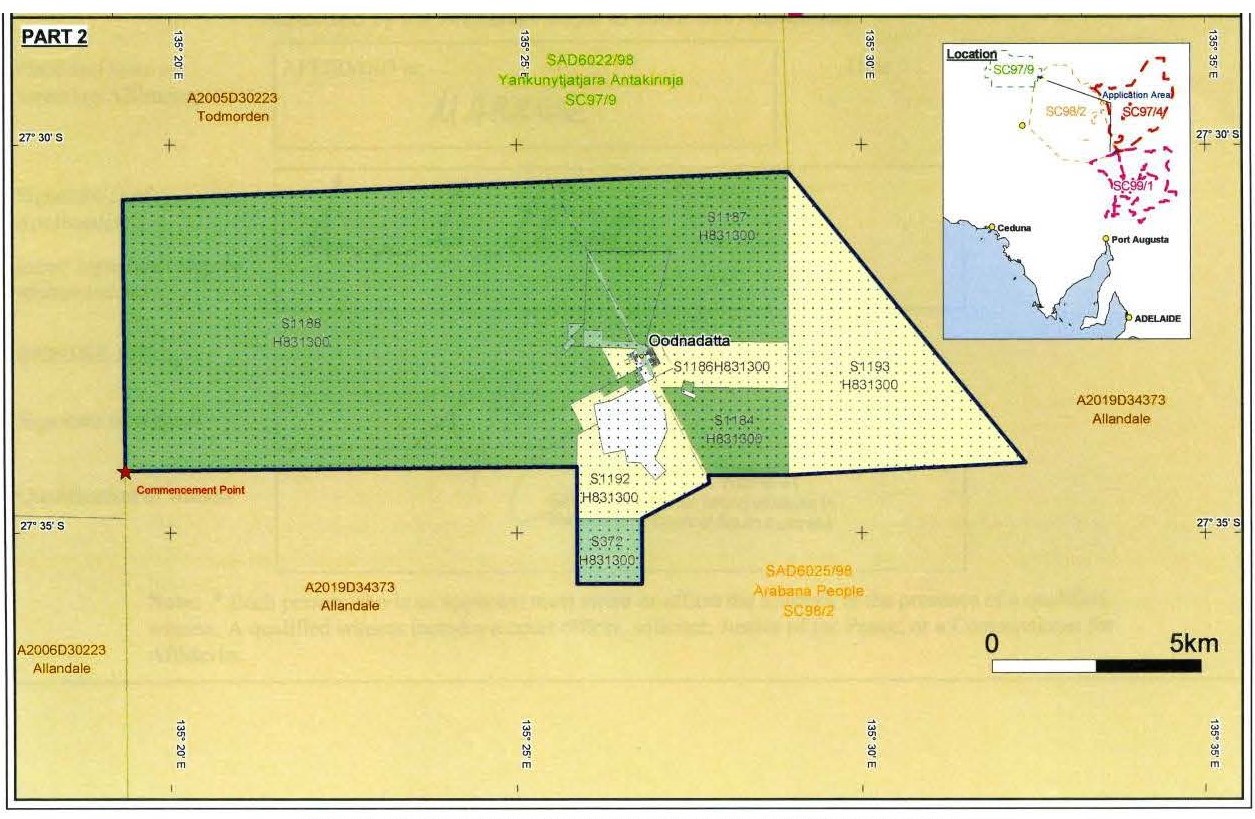
4 As is apparent, the Claim Area is relatively small, comprising less than 150 km2. Its east-west length at its longest point is approximately 25 km and its north-south length (ignoring the “protrusion” on the southern boundary) is approximately 7.2 km. The Claim Area comprises the township of Oodnadatta Common, the airport and an area held by the Aboriginal Land Trust (the ALT) established under the Aboriginal Land Trust Act 1966 (SA).
5 The Walka Wani People, who are comprised of Lower Southern Arrernte and Yankunytjatjara/Luritja People, have filed two applications. The first (SAD78/2013) was filed on 12 April 2013 and sought a determination of native title in respect of only part of the area claimed by the Arabana. The second (SAD220/2018) application was filed over five years later, on 14 September 2018, and seeks a determination of native title over the remaining portion of the area claimed by the Arabana. The two applications of the Walka Wani are known as Walka Wani No 1 and Walka Wani No 2. In combination, the areas which are the subject of Walka Wani No 1 and Walka Wani No 2 overlap exactly the area of the Arabana Claim. The inter-relationship between the areas which are the subject of the two Walka Wani applications is shown in Map 2 below.
Map 2: The Claim Areas of the Walka Wani No 1 and No 2 applications
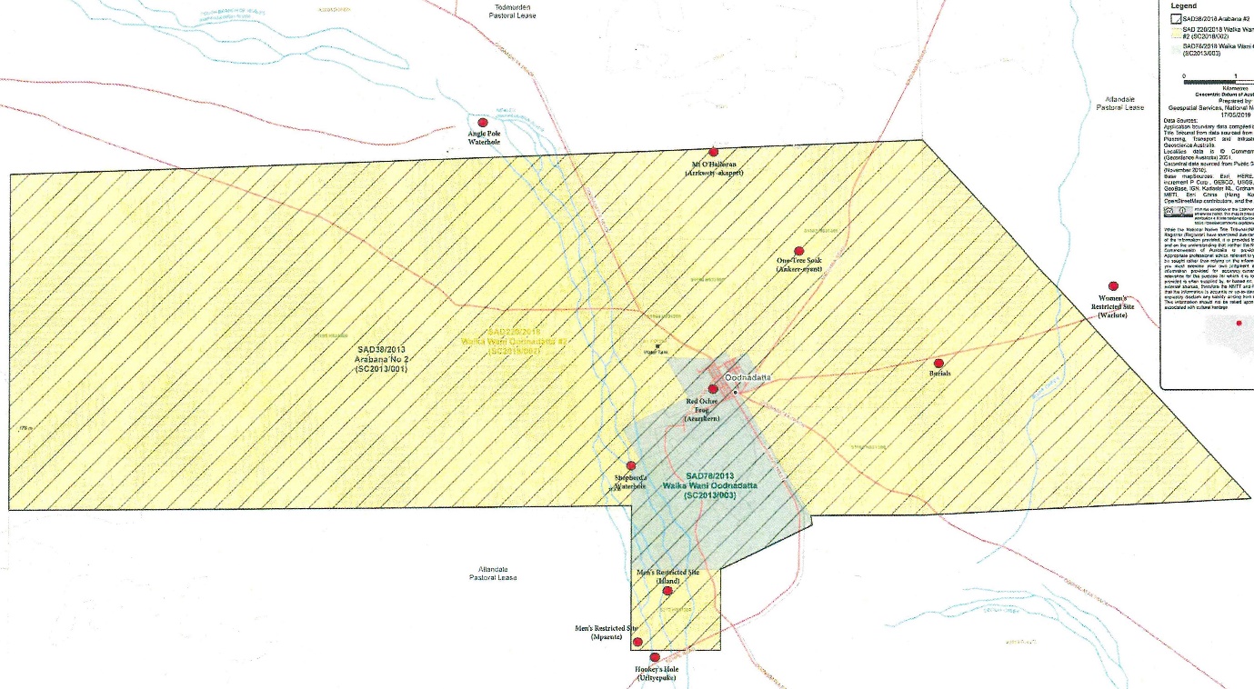
6 The darker shaded area is the area which is the subject of the Walka Wani No 1 application.
7 The evidence presented, and the submissions made, in relation to the Walka Wani applications did not distinguish between the areas which are the subject of Walka Wani No 1 and Walka Wani No 2. In particular, there was no suggestion that the Walka Wani could succeed on one application and not on another.
8 In these reasons, I will refer to the area in respect of which the overlapping claims are made as “the Overlap Area”.
9 There are several respects in which contested overlapping claims for the determination of native title are unfortunate. Amongst other things, the defence by each claim group of the claim of the other can result in a form of mutual destruction of the respective claims. This is especially so in a case like the present in which the primary cases presented by the applicants are mutually exclusive. Putting to one side an amendment by the Walka Wani which they did not ultimately pursue, neither the Arabana nor the Walka Wani seek any form of joint determination or any recognition of shared native title rights and interests (NTRI). As the State noted, several of the witnesses went to some lengths to disavow any possibility of members of the other claimant group having traditional rights and interests in the Overlap Area. Competing claims also result in divisions and tensions between Aboriginal Peoples who have hitherto lived peaceably together. That was recognised during the trial as several witnesses referred with regret to the tensions which the claims for native title have generated. One witness noted that the competing claims have “turned families against families”.
10 Because of the potential for consequences of these kinds, and because of the desirability of a negotiated outcome if at all possible, the Court ordered two mediations by Registrars of the claims to the Overlap Area. These were conducted between 13-16 July 2015 in Coober Pedy and on 18 September 2018 in Port Augusta. Neither resulted in a mediated outcome and the parties’ positions seemed intractable.
11 On 26 September 2018, the Court ordered, pursuant to s 67 of the Native Title Act 1993 (Cth) (the NT Act), that the Arabana No 2 (Part 2) native title claim, the Walka Wani No 1 Application and the Walka Wani No 2 Application be dealt with in the one proceeding to be known as the “Oodnadatta Common Overlap Proceeding” (in these reasons, “the Overlap Proceeding”). The Arabana People are the first applicant in the Overlap Proceeding, the applicant in Walka Wani No 1 are the second, and the applicant in Walka Wani No 2 are the third. Unless it is necessary to distinguish between them, I will refer to the second and third applicants as “the Walka Wani Applicants” or, more simply, as “the Walka Wani”.
12 Apart from the State of South Australia, there are two other respondents to the Arabana Claim. They are Airservices Australia which has an interest in the Oodnadatta Airport (which is within the Overlap Area) and Mr Douglas Lillecrapp, who holds the pastoral lease of Todmorden Station (immediately to the west and north of the Overlap Area). Neither Airservices Australia nor Mr Lillecrapp took any part in the trial, although Mr Lillecrapp did attend the first day of the hearings in Oodnadatta.
13 The trial commenced with on-country hearings between 30 September and 3 October 2019 at Oodnadatta and between 8 and 11 October 2019 in Alice Springs. It continued in Adelaide between 14 and 23 October 2019. The trial was then adjourned to 6 April 2020 for the purpose of hearing the expert evidence in a concurrent session. However, the restrictions caused by the COVID-19 pandemic prevented the trial from resuming at that time. The expert evidence was heard between 19 and 23 October 2020 and the parties made their finals submissions on 11 and 12 March 2021.
14 Shortly before the Court was to hear the final submissions, Nappamurra Pty Ltd, which holds the pastoral lease of Allandale Station (immediately to the south and east of the Overlap Area), applied for leave to intervene. Having regard in particular to the prejudice which the late intervention would cause the parties, I refused to permit the intervention before the final submissions were made, and adjourned Nappamurra’s application for further consideration after the Court had published its findings on the overlapping claims: Stuart v State of South Australia (Oodnadatta Common Overlap Proceeding) (No 2) [2021] FCA 194.
The determinations of native title in the surrounding areas
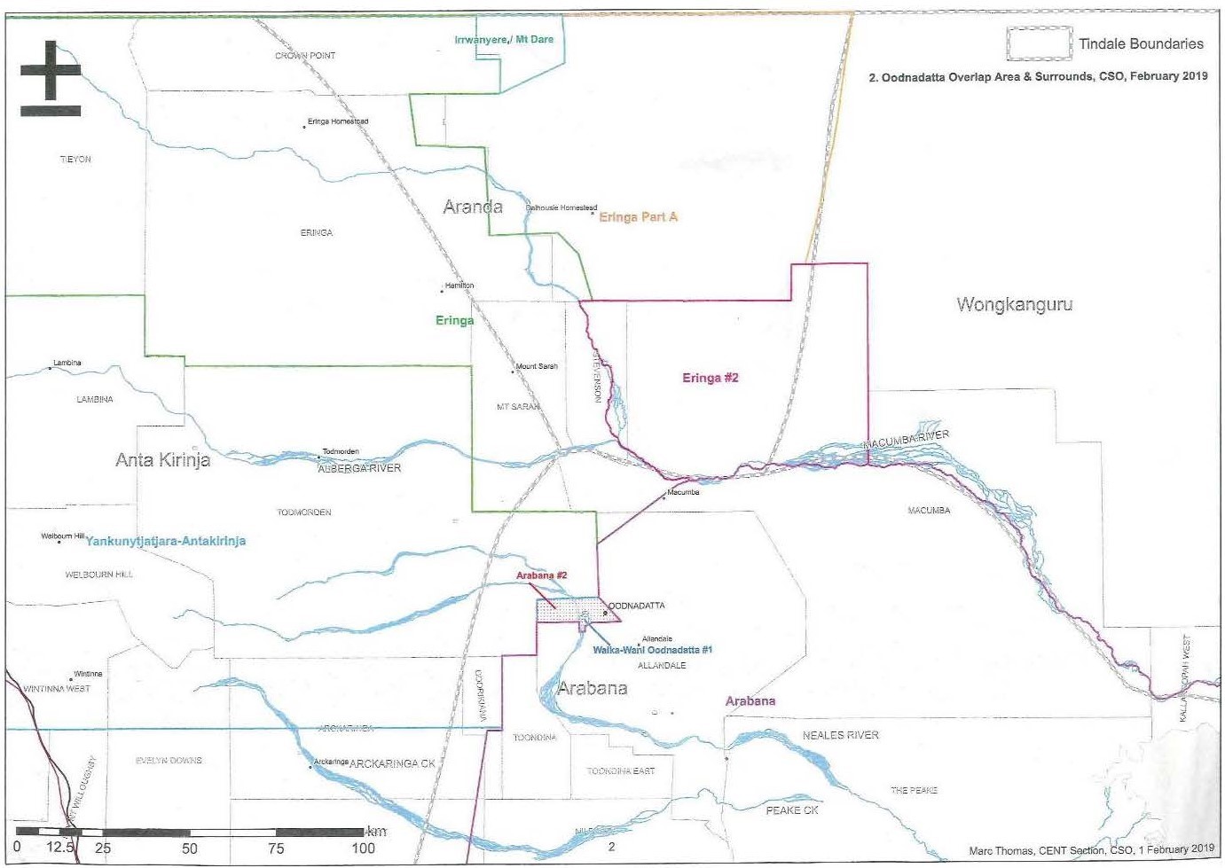
15 The whole of the Overlap Area is bounded by areas in respect of which determinations of native title have already been made.
16 On 28 August 2006, at Marla, the Court made a determination in respect of a large area abutting the Overlap Area on its northern and western boundaries: Yankunytjatjara/Antakarinja Native Title Claim Group v South Australia [2006] FCA 1142 (the 2006 Yankunytjatjara/Antakarinja Determination). With the exception of areas of extinguishment, this Determination recognised the native title of the Yankunytjatjara/Antakarinja People.
17 On 22 May 2012, at Finniss Springs Station, the Court made a determination in respect of a large area abutting the eastern and southern boundaries of the Overlap Area, which recognised, apart from areas of extinguishment, the native title of the Arabana People: Dodd v State of South Australia [2012] FCA 519 (the 2012 Arabana Determination).
18 The Court has also made determinations of native title in respect of areas further to the north of the 2006 Yankunytjatjara/Antakarinja and 2012 Arabana Determinations. These determinations are King on behalf of the Eringa Native Title Claim Group v South Australia [2011] FCA 1386 (the Eringa No 1 Determination) which at its closest point is approximately 25 km north of the Overlap Area and King on behalf of the Eringa Native Title Claim Group and the Eringa No 2 Native Title Claim Group v State of South Australia [2011] FCA 1387 (the Eringa No 2 Determination) (together the Eringa Determinations). The areas which are the subject of the Eringa Determinations lie immediately to the north and east of the area which is the subject of the 2006 Yankunytjatjara/Antakarinja Determination. Their southern boundaries abut the northern boundary of the 2012 Arabana Determination. The Eringa No 1 Determination recognises the native title rights and interests (NTRI) of members of the Lower Southern Arrernte (LSA) and Yankunytjatjara Peoples. The Eringa No 2 Determination recognises the NTRI of the LSA, the Luritja/Yankunytjatjara and the Wangkangurru Peoples.
19 The location of the Overlap Area in relation to the areas which have been subject to previous determinations is shown in Map 3.
Map 3: Interrelationship of Overlap Area with the surrounding Determinations
Further description of the Overlap Area
20 Oodnadatta is over 100 km in a west-north-west direction from Lake Eyre at its closest point (the north-western boundary of Lake Eyre).
21 The Neales River, which has its headwaters well to the west of Oodnadatta, runs in a generally west-east direction and flows into Lake Eyre. The river was named “The Neales” on 6 June 1859 by John McDouall Stuart after JB Neale, who was then a member of the Legislative Assembly in South Australia. A little to the west of Oodnadatta, the Neales River turns to run in a general north-south direction so that, west of Oodnadatta, it intersects the Oodnadatta Common on a general north-south axis.
22 A waterhole, known as Hookey’s Hole or Uthapuka in Arabana, on the Neales River is immediately south of (i.e, outside of) the Overlap Area and within the area of the 2012 Arabana Determination. Hookey’s Hole is an important feature because, except in periods of drought, it has been a permanent source of water.
23 Mt O’Halloran, given that name by John McDouall Stuart on 7 June 1859, is approximately 5 km north of Oodnadatta (within but close to the northern border of the Overlap Area). Its traditional name is Arkwety-Akaparta.
24 The Macumba River, which is further to the north of Oodnadatta, runs in a general west-east direction to Lake Eyre. It has two principal tributaries: the Alberga which also runs in a general west-east direction, and the Stevenson which runs in a general north-south direction. The Macumba commences at the confluence of the Alberga and the Stevenson, which confluence is only slightly east of due north of Oodnadatta, with the consequence that the Macumba is north of the eastern portion of the Overlap Area. The Alberga River is north of the remaining portion of the Overlap Area. From Lasso Water Hole to Lake Eyre, the Macumba is the boundary between the areas encompassed by the Eringa Determinations and the area of the 2012 Arabana Determination. The Macumba is approximately 45-50 kms from Oodnadatta. Some evidence suggested that, at its closest, that distance may be approximately 45 km.
25 Two Pastoral Leases are adjacent to (and abut) the Overlap Area: Todmorden Station to the north and west and Allandale Station to the south and east. The Peake Station (which now forms part of another Station and which was the subject of several references in the evidence) was located further to the south-east, being between Allandale Station and Lake Eyre.
26 Macumba Station, which has also been absorbed into a larger pastoral lease, was established in 1883 and was located to the north of Oodnadatta in the region of the Macumba River.
27 As will be seen, the Overlap Area is at the approximate boundaries of the lands of the Arabana People, the Southern Arrernte and those of the Western Desert Bloc. The evidence indicates that, by the late 19th Century, Oodnadatta had become the meeting point for a number of different Aboriginal Peoples.
The Arabana Part 2 Application
28 The Arabana Claim is brought by Aaron Stuart, Joanne Warren, Peter Watts, Greg Warren (Snr) and another person now deceased.
29 The description of the native title claim group in the Arabana Claim is as follows:
The Native Title Claim Group comprises those Aboriginal People who both self-identify as Arabana and are recognised as being Arabana by other Arabana People based on:
• filiation, including by adoption, from an Arabana parent or grandparent; or
• long term co-residence with Arabana People on Arabana country;
and who satisfy one or more of the following criteria:
• Being raised in Arabana country and being bound by its system of law and customs;
• Living and behaving appropriately with Arabana People in accordance with Arabana laws and customs;
• Having knowledge of Arabana country and its stories and taking appropriate responsibility, under Arabana custom and law, for that knowledge;
• Having knowledge of Arabana society and the relationships with people within it and seeking to maintain proper relationships among Arabana People;
• Having knowledge of Arabana language;
• Displaying an active interest and engagement in Arabana affairs.
(Emphasis added)
30 This description is identical with the description of the Arabana People recognised in the 2012 Arabana Determination as holding native title. It was common ground that the Arabana are part of the Lakes Cultural Group. Other peoples who are part of the Lakes Cultural Group are the Pilatapa, Warlpiri, the Dieri and the Kuyani. Lakes People have a matrilineal moiety system pursuant to which persons inherit from their mothers their “mardu” totem.
31 The NTRI claimed by the Arabana are described in Schedule E to the application:
1. The nature and extent of the native title rights claimed and interests in relation to the Claim Area are non-exclusive rights to use and enjoy in accordance with the native title holders’ traditional laws and customs the land and waters of the Claim Area, being:
(a) the right to access and move about the Claim Area;
(b) the right to live, to camp and, for the purpose of exercising their native title rights and interests, to erect shelters and other structures on the Claim Area;
(c) the right to hunt and fish on the land and waters of the Claim Area;
(d) the right to gather and use the natural resources of the Claim Area, such as food, medicinal plants, wild tobacco, timber, resin, ochre and feathers, but excluding those resources referred to in Paragraph 12;
(e) the right to share and exchange the subsistence and other traditional resources of the Claim Area;
(f) the right to use the natural water resources of the Claim Area;
(g) the right to cook on the Claim Area and to light fires for domestic purposes but not for the clearance of vegetation;
(h) the right to engage and participate in cultural activities on the Claim Area including those relating to births and deaths;
(i) the right to conduct ceremonies and hold meetings on the Claim Area;
(j) the right to teach on the Claim Area the physical and spiritual attributes of locations and sites within the Claim Area;
(k) the right to visit, maintain and protect sites and places of cultural and religious significance to Native Title Holders under their traditional laws and customs on the Claim Area; and
(l) the right to be accompanied on to the Claim Area by those people who, though not Native Title Holders, are:
(i) spouses of native title holders, or
(ii) people required by traditional law and custom for the performance of ceremonies or cultural activities on the Claim Area; or
(iii) people who have rights in relation to the Claim area according to the traditional laws and customs acknowledged by the native title holders.
The native title rights and interest claimed are also subject to the effect of:-
(a) all existing non native title rights and interests;
(b) all laws of South Australia and the Commonwealth of Australia;
(c) valid interest conferred under those laws.
32 Other than in respects which are not presently material, the NTRI claimed in the Arabana application match those recognised in the 2012 Arabana Determination.
33 The Walka Wani No 1 application is brought by Dean Ah Chee, Huey Tjami and Christine Lennon. The Walka Wani No 2 application is brought by Audrey Stewart and Dean Ah Chee.
34 The two Walka Wani applications identify the Walka Wani claim group in identical terms:
The native title claim group comprises the native title holders pursuant to King on behalf of the Eringa Native Title Claim Group v State of South Australia (SAD6010/1998, SAD189/2010), who are:
(a) All those Lower Southern Arrernte persons who have a traditional connection to the Claim Area, being all those described in Attachment A (1) who:
i. identify as Lower Southern Arrernte; and
ii are recognised under the relevant traditional law and custom by other Native Title Holders as having rights and interests in the Claim Area; and
(b) All those Yankunytjatjara and/or Luritja persons who:
• Have a spiritual connection to the Claim Area and the Tjukurpa associated with it because in the case of each of them:
• The Claim Area is his or her country of birth (also reckoned by the area where his or her mother lived during the pregnancy); or
• He or she has had a long term association with the Claim Area such that he or she has traditional geographical and religious knowledge of that country; or
• He or she has an affiliation to the Claim Area through grandparent with a connection to the Claim area as specified in sub-paragraph A or B above,
including all those of those derived in Attachment A (2) who identify as Yankunytjatjara or Luritja; and
• Are recognised under the relevant traditional law and custom by other Native Title Holders as having rights and interests in the Claim Area.
35 As is apparent, the Walka Wani People comprise two groups: the LSA and the Yankunytjatjara/Antakarinja. It was common ground that the Arrernte People occupy a large area in Central Australia which extends north of Alice Springs and that they belong to the Arandic group of Aboriginal Peoples. The Yankunytjatjara/Antakarinja/Luritja People are Western Desert People. The name Antakarinja was used by the Arrernte People to refer to Yankunytjatjara, the people of the south, but over time can to be used by the Yankunytjatjara themselves.
36 The Attachments A to the two applications list separately in respect of the “Lower Southern Arrernte Descent Groups” and “Yankunytjatjara/Luritja Descent Groups” the descendants of named apical ancestors. Seven of the apical ancestors are common to both Descent Groups.
37 The description of the native title claim group in each of the two Walka Wani applications matches the description of the group recognised in the Eringa No 1 Determination as having native title but differs from the description of the native title group in the Eringa No 2 Determination.
38 The description of the native title claim group in the Walka Wani applications does not match that of the native title holders in the 2006 Yankunytjatjara/Antakarinja Determination as those native title holders do not include the Lower Southern Arrernte. The description in the latter Determination, is as follows:
Under the relevant traditional laws and customs of the Western Desert Bloc, the native title holders comprise those Aboriginal People who have a spiritual connection to the Determination Area and the Tjukurpa associated with it because:
(a) the Determination Area is his or her country of birth (also reckoned by the area where his or her mother lived during the pregnancy); or
(b) he or she has had a long term association with the Determination Area such that he or she has traditional geographical and religious knowledge of that country; or
(c) he or she has an affiliation to the Determination Area through a parent or grandparent with a connection to the Determination Area as specified in sub-paragraphs (a) or (b) above;
and are recognised under the relevant Western Desert traditional laws and customs by other members of the native title claim group as having rights and interests in the Determination Area.
39 The NTRI claimed in the two Walka Wani applications are in substance identical:
• Over areas where a claim to exclusive possession can be recognised (such as areas where there has been no prior extinguishment of native title or where section 238 and/or sections 47, 47A and 47B apply), members of the native title claim group claim the right to possess, occupy, use and enjoy the lands and waters of the application (the Application Area) as against the whole world, pursuant to their traditional laws and customs.
• Over areas where a claim to exclusive possession cannot be recognised, the nature and extent of the native title rights and interests claimed in relation to the application area are the non-exclusive rights to use and enjoy the land and waters in accordance with traditional laws and customs being:
• The right to access and move about the Claim Area;
• The right to hunt and fish on the land and waters of the Claim Area without limitation of what purpose;
• The right to gather and use the natural resources of the Claim Area such as food, medicinal plants, wild tobacco, timber, resin, ochre and feathers;
• The right to share and exchange the subsistence and other traditional resources of the Claim Area;
• The right to use and take the natural water resources on the application area;
• The right to live, to camp and, for the purpose of exercising native title rights and interests, to erect shelters and other structures on the Claim Area;
• The right to cook on the Claim Area and to light fires for domestic purposes but not for the clearance of vegetation;
• The right to engage and participate in cultural activities on the Claim Area including those relating to births and deaths;
• The right to conduct ceremonies and hold meetings on the Claim Area;
• The right to teach on the Claim Area the physical and spiritual attributes of locations and sites within the Claim Area;
• The right to visit, maintain and protect sites and places of cultural and religious significance to Native Title Holders under their traditional laws and customs on the Claim Area;
• The right to be accompanied on to the Claim Area by those people who, though not members of the native title claim group, are:
(i) spouses of Native Title Holders; or
(ii) people required by traditional law and custom for the performance of ceremonies or cultural activities on the Claim Area; or
(iii) people who have rights in relation to the claim area according to the traditional laws and customs acknowledged by the Native Title Holders; and
• In relation to Aboriginal people who recognise themselves to be governed by the traditional laws and customs acknowledged by the Native Title Holders, the right to speak for country and make decisions about the use and enjoyment of the Claim Area by those Aboriginal persons.
• The rights described in paragraphs 2(b), (c), (d) and (e) are traditional rights exercised in order to satisfy personal, domestic, or communal needs.
• The native title rights and interests are subject to:
• The valid laws of the State of South Australia and the Commonwealth of Australia; and
• The rights (past or present) conferred upon persons pursuant to the laws of the Commonwealth and the laws of the State of South Australia; and
• The traditional laws and customs of the native title claim group.
40 The NTRI claimed by the Walka Wani differ from those recognised in the 2006 Yankunytjatjara/Antakarinja Determination in a number of respects:
(a) the Walka Wani claim “exclusive possession” over all areas except those over which native title has been extinguished or to which s 238 and/or ss 47, 47A or 47B of the NT Act apply, whereas the rights recognised in the 2006 Yankunytjatjara/Antakarinja Determination were expressly stated not to be exclusive;
(b) the Walka Wani claim the right to hunt and fish on the land and waters of the Overlap Area without any limitation of purpose;
(c) the Walka Wani claim the right to “share and exchange the subsistence of other traditional resources of the Claim Area”; and
(d) instead of claiming the right to light fires for domestic purposes (but not for the clearance of vegetation) on the Overlap Area, the Walka Wani claim the right to light fires “for all purposes” other than the clearance of vegetation.
41 The NTRI recognised in the 2006 Yankunytjatjara/Antakarinja Determination and in each of the Eringa Determinations are in substance identical. Accordingly, the Walka Wani are seeking in respect of the Overlap Area NTRI of greater extent than those recognised in each of those determinations.
42 The Arabana People first made a claim for land rights over a large area in the far north of South Australia by a writ filed in the High Court of Australia on 22 May 1993. That claim included the area of Oodnadatta and the Oodnadatta Common. It was discontinued on 31 August 1993 after the enactment of the NT Act.
43 In 1998, the Arabana commenced the application for a determination of native title which resulted in the 2012 Arabana Determination. They did not include the Overlap Area in that claim because the State had previously indicated that it intended to transfer the Oodnadatta Common to the ALT with a view to the ALT then providing a long term lease of the Common to the Dunjiba Community Council, this being the Council comprised of the residents in Oodnadatta. The Arabana recognised that, as many of the residents of Oodnadatta at the time were not Arabana, Dunjiba was more representative of its residents and they did not wish to create an impediment to the State transferring the land to the ALT. However, the transfer to Dunjiba did not proceed.
44 Having obtained the 2012 Arabana Determination on 22 May 2012, the Arabana People then lodged the application for a determination of native title on 1 March 2013.
45 As already noted, in the Walka Wani No 1 application filed on 12 April 2013, the Walka Wani sought a determination of native title over only part of the Overlap Area, being the town of Oodnadatta, the Oodnadatta Airport and the racecourse together with some land immediately surrounding those areas. The second Walka Wani application which seeks a determination of native title over the balance of the Overlap Area was not made until 14 September 2018.
46 As the Arabana noted, the Court has not been provided with any explanation for the Walka Wani not having earlier made a claim with respect to the Overlap Area, in particular, in the application leading to Eringa No 1 Determination in which the description of the native title claim group matches the description of the claim group in each of the two Walka Wani applications, or for the Walka Wani having initially claimed only part of the Overlap Area. They submitted that this circumstance supported the inference that the senior people who brought these applications had not considered Oodnadatta and its immediate surrounds to be the country of the Walka Wani.
Statutory provisions and principles
47 The High Court has emphasised that a determination of native title is a creature of the NT Act, and not of the common law, so that the circumstances in which a determination may be made are defined by the NT Act: The Commonwealth of Australia v Yarmirr [2001] HCA 56, (2001) 208 CLR 1 at [7]; Members of the Yorta Yorta Aboriginal Community v State of Victoria [2002] HCA 58, (2002) 214 CLR 422 (Yorta Yorta) at [32].
48 By s 13(1)(a) of the NT Act, applications may be made to this Court for “a determination of native title” in relation to an area for which there is no approved determination of native title. The expression “determination of native title” is defined in s 225 of the NT Act:
225 Determination of native title
A determination of native title is a determination whether or not native title exists in relation to a particular area (the determination area) of land or waters and, if it does exist, a determination of:
(a) who the persons, or each group of persons, holding the common or group rights comprising the native title are; and
(b) the nature and extent of the native title rights and interests in relation to the determination area; and
(c) the nature and extent of any other interests in relation to the determination area; and
(d) the relationship between the rights and interests in paragraphs (b) and (c) (taking into account the effect of this Act); and
(e) to the extent that the land or waters in the determination area are not covered by a non‑exclusive agricultural lease or a non‑exclusive pastoral lease—whether the native title rights and interests confer possession, occupation, use and enjoyment of that land or waters on the native title holders to the exclusion of all others.
Note: The determination may deal with the matters in paragraphs (c) and (d) by referring to a particular kind or particular kinds of non‑native title interests.
(Emphasis in the original)
49 The term “native title rights and interests” used in s 225 is explained in s 223 of the NT Act:
223 Native title
Common law rights and interests
(1) The expression native title or native title rights and interests means the communal, group or individual rights and interests of Aboriginal peoples or Torres Strait Islanders in relation to land or waters, where:
(a) the rights and interests are possessed under the traditional laws acknowledged, and the traditional customs observed, by the Aboriginal peoples or Torres Strait Islanders; and
(b) the Aboriginal peoples or Torres Strait Islanders, by those laws and customs, have a connection with the land or waters; and
(c) the rights and interests are recognised by the common law of Australia.
Hunting, gathering and fishing covered
(2) Without limiting subsection (1), rights and interests in that subsection includes hunting, gathering, or fishing, rights and interests.
Statutory rights and interests
(3) Subject to subsections (3A) and (4), if native title rights and interests as defined by subsection (1) are, or have been at any time in the past, compulsorily converted into, or replaced by, statutory rights and interests in relation to the same land or waters that are held by or on behalf of Aboriginal peoples or Torres Strait Islanders, those statutory rights and interests are also covered by the expression native title or native title rights and interests.
Note: Subsection (3) cannot have any operation resulting from a future act that purports to convert or replace native title rights and interests unless the act is a valid future act.
Subsection (3) does not apply to statutory access rights
(3A) Subsection (3) does not apply to rights and interests conferred by Subdivision Q of Division 3 of Part 2 of this Act (which deals with statutory access rights for native title claimants).
Case not covered by subsection (3)
(4) To avoid any doubt, subsection (3) does not apply to rights and interests created by a reservation or condition (and which are not native title rights and interests):
(a) in a pastoral lease granted before 1 January 1994; or
(b) in legislation made before 1 July 1993, where the reservation or condition applies because of the grant of a pastoral lease before 1 January 1994.
50 Although the issues on the present applications principally concern matters of connection, it is appropriate to record matters concerning the application of ss 223(1) and 225 of the NT Act more generally, as they inform the Court’s resolution of those issues. Relevantly for present purposes, these include:
(a) a determination of native title is a determination of the possession of rights and interests, and not of “ownership” or even “traditional ownership”. Section 223(1) does not use those terms. Section 253 of the NT Act does not define the term “right” but it does define the term “interest” in an expansive way, indicating that it is not confined to “ownership” according to conventional understandings of that term. As counsel for the Walka Wani noted, the NT Act does not use the concept of “traditional Aboriginal owner” adopted in the Aboriginal Land Rights (Northern Territory) Act 1976 (Cth) – see Risk v Northern Territory of Australia [2006] FCA 404 at [437] and Pareroultja v Tickner (1993) 42 FCR 32 at 42;
(b) NTRI are not limited to rights and interests of the kind understood in the common law: Yarmirr at [12]. In The State of Western Australia v Ward [2002] HCA 28, (2002) 213 CLR 1 (WA v Ward), the plurality said:
[95] [R]ecognising that the rights and interests in relation to land which an Aboriginal community may hold under traditional law and custom are not to be understood as confined to the common lawyer's one-dimensional view of property as control over access reveals that steps taken under the sovereign authority asserted at settlement may not affect every aspect of those rights and interests. The metaphor of "bundle of rights" which is so often employed in this area is useful in two respects. It draws attention first to the fact that there may be more than one right or interest and secondly to the fact that there may be several kinds of rights and interests in relation to land that exist under traditional law and custom. Not all of those rights and interests may be capable of full or accurate expression as rights to control what others may do on or with the land.
(c) nor are NTRI limited to rights capable of enforcement: Yarmirr at [16]. Regard should be had not only to the manner in which breaches of the rights or interests are addressed as a matter of traditional law, but also to the manner in which, as a matter of traditional custom, the law is observed: ibid;
(d) the existence and content of NTRI must be found in the traditional laws and customs of the claim group (s 223(1)(a)). That is the premise on which the NT Act proceeds: Yorta Yorta at [40]. In Fejo v Northern Territory of Australia [1998] HCA 58; (1998) 195 CLR 96, the plurality said:
[46] Native title has its origin in the traditional laws acknowledged and the customs observed by the indigenous people who possess the native title. Native title is neither an institution of the common law nor a form of common law tenure but it is recognised by the common law. There is, therefore, an intersection of traditional laws and customs with the common law. The underlying existence of the traditional laws and customs is a necessary pre-requisite for native title but their existence is not a sufficient basis for recognising native title.
(Emphasis in the original)
Likewise, in Yorta Yorta at [50], the plurality said:
[T]o speak of rights and interests possessed under an identified body of laws and customs is … to speak of rights and interests that are the creatures of the laws and customs of a particular society that exists as a group which acknowledges and observes those laws and customs.
Thus, s 223(1)(a) refers to rights and interests “possessed” under the traditional laws acknowledged and the traditional customs observed;
(e) not all rights which may be exercisable on an area of land or waters are rights “in relation to land or waters” for the purposes of s 223(1). In AB (decased) (on behalf of the Ngarla People) v State of Western Australia (No 4) [2012] FCA 1268 at [547], Bennett J said:
… A right to say what can occur on land is a right in relation to land. The right to participate in ceremonies is a personal right, a status-based right in the Akiba (No 3) sense, and is not a right in relation to land. Permission to attend Law ceremonies, generally given to all who wish to attend, does not amount to a grant of rights over the land. In the same way, the permission-based rights claimed by the Warram, such as the right to conduct rituals, to hunt and fish and to take materials from the land for the purposes of Law ceremonies, are dependent upon the core rights of the Ngarla as traditional owners of that land. They are personal or status-based rights. The giving of permission to be “free” in the country is a personal right that does not convey any interest in Ngarla land.
In Manado on behalf of the Bindunbur Native Title Claim Group v State of Western Australia [2018] FCAFC 238; (2018) 265 FCR 68, the Full Court at [88]-[103], upheld the primary judge’s finding that the rights and responsibilities of a ritual leader who did not have descent or succession rights in the determination area were not NTRI;
(f) section 225(a) contemplates that there may be more than one group having NTRI in the one area of land: Drury on behalf of the Nanda People v Western Australia [2020] FCAFC 69; (2020) 276 FCR 203 at [36], [165]. In Yanner v Eaton [1999] HCA 53; (1999) 201 CLR 351 at [37], the plurality quoted with approval the statement of Brennan J in R v Toohey; Ex parte Meneling Station Pty Ltd [1982] HCA 69; (1982) 158 CLR 327 at 358:
… [t]raditional Aboriginal land is not used or enjoyed only by those who have primary spiritual responsibility for it. Other Aboriginals or Aboriginal groups may have a spiritual responsibility for the same land or may be entitled to exercise some usufructuary right with respect to it.
(g) the term “traditional laws and customs” in s 223(1)(a) is a reference to a body of norms or a normative system: Yorta Yorta at [39]. They are those which “arise out of and, in important respects, go to define a particular society”: Yorta Yorta at [49]. In this context, “society” refers to “a body of persons united in and by its acknowledgment and observance of a body of law and customs”: ibid.
(h) the word “traditional” is apt to refer to a means of transmission of law and custom. A “traditional” law or custom is one which has been passed from generation to generation in a society, usually by word of mouth and common practice. But the word “traditional” carries with it two other elements: first, an understanding of the age of the traditions such that the origins are to be found in the normative rules of the societies which existed before the assertion of sovereignty, and, secondly, the reference to rights or interests in land or waters being possessed under traditional laws and customs acknowledged and observed requires that the normative system is one which has had “a continuous existence and vitality since sovereignty”: Yorta Yorta at [46]-[47]; Wyman v Queensland [2015] FCAFC 108; (2015) 235 FCR 464 at [158]. “Vitality” in this context does not connote an independent requirement, but rather that the normative system be described as “having life” (CG (Deceased) on behalf of the Badimia People v State of Western Australia [2015] FCA 204 at [353]), or as a “living system” (Narrier v State of Western Australia [2016] FCA 1519 at [303];
(i) the society’s acknowledgement and observance of the traditional laws and customs must have continued substantially uninterrupted since sovereignty: Yorta Yorta at [87]. If that is not the case, the laws and customs acknowledged and observed now cannot be properly described as the traditional laws and customs of the peoples concerned. NTRI cease to exist if the society which observes them ceases to exist, or ceases to acknowledge the laws and to observe the customs from which the NTRI derive: Yorta Yorta at [50];
(j) for these reasons, applicants for determinations of native title must establish not only the laws or customs now acknowledged and observed by their society but also that those laws and customs are the traditional laws and customs which were observed at sovereignty (but allowing for some change or adaptation of the laws and customs in the sense described above): Yorta Yorta at [56]. The NT Act does not allow to be recognised rights and interests in land or waters created after sovereignty and which owe their existence only to a normative system other than the new sovereign power asserted by the Crown: Yorta Yorta at [43];
(k) however, the mere fact that there has been some change to, or adaptation of, traditional laws and customs, or some interruption of the enjoyment or exercise of the native title rights and interests between sovereignty and the present time is not necessarily fatal to a native title claim: Yorta Yorta at [83]. The plurality in Yorta Yorta added in this respect:
[89] In the proposition that acknowledgment and observance must have continued substantially uninterrupted, the qualification "substantially" is not unimportant. It is a qualification that must be made in order to recognise that proof of continuous acknowledgment and observance, over the many years that have elapsed since sovereignty, of traditions that are oral traditions is very difficult. It is a qualification that must be made to recognise that European settlement has had the most profound effects on Aboriginal societies and that it is, therefore, inevitable that the structures and practices of those societies, and their members, will have undergone great change since European settlement. Nonetheless, because what must be identified is possession of rights and interests under traditional laws and customs, it is necessary to demonstrate that the normative system out of which the claimed rights and interests arise is the normative system of the society which came under a new sovereign order when the British Crown asserted sovereignty, not a normative system rooted in some other, different, society. To that end it must be shown that the society, under whose laws and customs the native title rights and interests are said to be possessed, has continued to exist throughout that period as a body united by its acknowledgment and observance of the laws and customs.
(Emphasis added)
(l) this means that the Court should consider whether, despite a change or adaptation in the laws and customs, they can still be regarded as the traditional laws or the traditional customs acknowledged and observed at sovereignty;
(m) a determination of native title under s 225(1) does not create new rights: it is instead a recognition of rights and interests possessed under traditional laws and customs of the group in question Yorta Yorta at [45], [76]; WA v Ward at [14]; and
(n) the determination of the existence and content of NTRI involves factual enquiries: one to identify the traditional laws acknowledged and the traditional customs observed by the claimant group, and the other as to whether the traditional laws and customs so identified give rise to NTRI, that is, to establish the connection between the claimed rights and interests and the traditional laws and customs: WA v Ward at [18].
51 Section 223(1)(b) requires expressly that the claimant group have a connection with the land or waters in question “by [the] laws and customs”, ie, by the traditional laws acknowledged and the traditional customs observed by the group: WA v Ward at [64]; Starkey on behalf of the Kokatha People v South Australia [2018] FCAFC 36, (2018) 261 FCR 183 (Lake Torrens Full Court). This requires an identification of the content of the traditional laws and customs as they relate to the area in question and, secondly, the characterisation of the effect of those laws and customs as constituting a “connection” of the peoples with the land or waters: ibid; Bodney v Benell [2008] FCAFC 63; (2008) 167 FCR 84 at [165]. The required connection with the land or waters is essentially spiritual: WA v Ward at [14] (“the spiritual or religious is translated into the legal”). Accordingly, s 223(1)(b) does not require that the connection be physical, although it may be of that kind: Western Australia v Graham (on behalf of the Ngadju People) [2013] FCAFC 143; (2013) 305 ALR 452 at [37]. See also Sampi v Western Australia [2005] FCA 777 at [1079]. Further, the required connection is not by the Aboriginal People’s rights and interests: it is by their laws and customs: Bodney v Bennell at [165]. An applicant must establish that the connection has, in reality, been substantially maintained since the time of sovereignty: Bodney v Bennell at [161], [179].
52 Native title claimants have both an evidentiary and an ultimate onus of proof, subject to the issue of extinguishment. I refer, without repeating, to the proposition stated by Mansfield J in Lake Torrens Overlap Proceedings (No 3) [2016] FCA 899 (Lake Torrens No 3) at [92]-[98].
53 These principles have now been discussed and applied in a number of decisions of the Court including Badimia People v Western Australia [2016] FCAFC 67, (2016) 240 FCR 466; Wyman on behalf of the Bidjara People v Queensland [2014] FCA 528; Narrier; and Banjima People v State of Western Australia [2015] FCAFC 84, (2015) 231 FCR 456 (Banjima People Full Court).
The effect of the determinations in the adjacent areas
54 It was common ground that each of the 2006 Yankunytjatjara/Antakarinja Determination and the 2012 Arabana Determination had “determined as a fundamental matter, once and for all” that NTRI existed in the areas to which those determinations related and that the NTRI were held by the Yankunytjatjara/Antakarinja People and the Arabana People respectively. This means that each has been recognised as a society or communal group of people holding rights and interests possessed under traditional law acknowledged and the traditional customs observed by them having a connection with the respective determination areas. These determinations and these recognitions cannot be called into question in the present proceedings – see Lake Torrens Full Court at [198]-[202], [401].
55 The same may be said with respect to the Eringa No 1 and Eringa No 2 Determinations. As the State submitted, each of these four determinations is to be taken to have established conclusively that the identified Aboriginal peoples held NTRI, as described in the determinations, with respect to each determination area “at sovereignty and [have] at all times since then”, so that the Court should not attach any weight to evidence which is directly inconsistent with those determined facts: Lake Torrens Full Court at [198]-[201].
56 This means that the principal question on each application is whether either or both the Arabana and the Walka Wani establish, in accordance with s 223(1)(b) of the NT Act, that their NTRI extend to the Overlap Area and if so, whether they have continued to be possessed by the current societies in accordance with an acknowledgement of their respective traditional laws and an observance of their respective traditional customs.
A summary of the parties’ contentions
57 The Arabana People contend that:
(a) they are the same group of people who were recognised in the 2012 Arabana Determination and that they form part of a group of societies known as the “Lakes Cultural Group”, which extends from South-west Queensland to Spencer Gulf in South Australia;
(b) from both the date of sovereignty and effective sovereignty, the Overlap Area has been wholly within their “traditional country” and it was not shared country;
(c) the claimants in their application, who are the descendants or successors of the native title holders at sovereignty, have continued to occupy the Overlap Area since those times, and continue to acknowledge and observe the traditional laws and customs connected to the Overlap Area;
(d) the traditional laws and customs are the same as those recognised in the 2012 Arabana Determination;
(e) the NTRI which they claim are non-exclusive rights;
(f) the Walka Wani People do not have any NTRI in the Overlap Area and any interest which they do have (apart from ceremony and by marriage) has arisen post-sovereignty; and
(g) the preponderance of the reliable anthropological and ethnographic evidence supports their claims.
58 The Walka Wani People contend that:
(a) the Aboriginal people who occupied the Overlap Area at sovereignty were the LSA (sometimes referred to as “the Arrernte”) and Luritja/Yankunytjatjara People (sometimes referred to as “the Antakirinja”) and that the members of the claim group are the descendants of those peoples;
(b) at sovereignty, the LSA and the Luritja/Antakarinja were members of a single society, although they could also be seen as members of two inter-related and inter-penetrating societies, who acknowledged and observed the same body of laws and customs relating to rights and interests in land and waters;
(c) they are the same persons, or the descendants of the persons, who are recognised as native title holders in the Eringa No 2 Determination;
(d) some of those persons were also recognised as native title holders in the 2006 Yankunytjatjara/Antakarinja Determination;
(e) the Walka Wani claimants and their ancestors have continued substantially uninterrupted since sovereignty to acknowledge and observe the same body of traditional laws and customs; and
(f) the Arabana People do not possess any NTRI in relation to any part of the Overlap Area. While the Walka Wani agree that the Arabana People have continued to acknowledge and observe some traditional laws and customs, they dispute that that acknowledgement and observance gives rise to any connection of the Arabana People with the Overlap Area. They assert that the Arabana People do not possess, and have never possessed, NTRI in the Overlap Area.
59 The State contends that neither the Arabana nor the Walka Wani had established connection for the purposes of s 223(1)(b) of the NT Act. In the case of the Arabana that is because the connection they had with the Overlap Area has not been maintained. In the case of the Walka Wani that is because they did not have the requisite connection at sovereignty.
60 Part way through the trial, the Walka Wani amended their Statement of Facts, Issues and Contentions (SFIC) to raise a claim in the alternative, namely, that if the Arabana are found to have NTRI in the Overlap Area, they are shared NTRI. However, in the final submissions counsel made only passing reference to this and that was in the Walka Wani rely to the State’s submissions.
61 The anthropologists from whom the Walka Wani (Drs Cane and Liebelt and Mr Graham) adduced evidence consider that there were three societies with rights and interests in the Overlap Area at effective sovereignty: Lakes Culture (Arabana), Western Desert (Antakarinja) and Arandic (Lower Arrernte). They consider that the Overlap Area was a transitional zone in which the interests of the three societies converged. The anthropologists from whom the Arabana and the State led evidence (Mr Lucas and Mr Sackett respectively) accept that there were three societies in the wider region at effective sovereignty, but do not accept that there was a Western Desert society in the Overlap Area at effective sovereignty and, by inference, at sovereignty. Drs Cane and Liebelt, and Mr Graham, consider that the weight of the ethnographic-historical evidence at effective sovereignty favours Antakarinja and Lower Arandic presence in the Overlap Area. Dr Lucas and Dr Sackett, on the other hand, consider that the weight of the ethnographic-historical evidence indicates that, at effective sovereignty, it was a Lakes Culture system of laws and customs which gave rise to interests in the land and waters of the Overlap Area.
62 It is well recognised that the Aboriginal boundaries to land may not be geographically precise and that the land of one people may merge gradually into the land of a neighbour. Mansfield J recognised this in Lake Torrens No 3 at [125]:
[T]here have been a number of cases that have recognised that “Aboriginal society does not mark out boundaries to land in western style”: De Rose v South Australia [2002] FCA 1342 at [908] per O'Loughlin J. So much is almost self-evident. I remarked in Barngarla at [778] that Aboriginal cultural groupings are not and were never, political entities and so there was never any need for them to be geographically demarcated with the precision one expects of nation states. In Banjima People v State of Western Australia (No 2) [2013] FCA 868 at [182], Barker J made the observation that, in some circumstances, particularly where the country of one group begins to run out and the country of another starts, there may well be a basis for concluding that both groups have rights and interests and in that sense “share” that area of country.
63 Dr Luise Hercus, to whom I will refer later, made a similar point in 1994:
Arabana … people did not think in terms of boundaries: there is in fact no such word in the language. They were however certainly conscious of a series of places where their territory ‘cut out’ and someone else’s began … The ‘cutting out’ may be viewed in some areas as quite definite, but mostly is used as gradual: the neighbouring people may ‘have a right’ in the area, that is they may come there freely for ceremonies without this being considered an act of aggression.
The time of effective sovereignty
64 It was common ground that the relevant date for sovereignty is 1788. It was also common ground that effective sovereignty had not occurred in the Overlap Area for a substantial time after 1788, but there was disagreement as to the time of its actual occurrence. In part this seemed attributable to different understandings of what is meant by the term “effective sovereignty” and the purpose of identifying the time at which it occurred.
65 The identification of the approximate time of effective sovereignty is a practical measure by which the absence of means of establishing the position at actual sovereignty can be overcome. The Court identifies the position at the time of effective sovereignty with a view to inferring from that position what the position must have been at actual sovereignty: Gudjala People #2 v Native Title Registrar [2007] FCA 1167 at [64]. Accordingly, the term “effective sovereignty” has generally been taken to be a reference to the time of first European observation (Lake Torrens No 3 at [212]) or the time of first contact between the Aboriginal people and European settlers (Ashwin on behalf of the Wutha People v State of Western Australia (No 4) [2019] FCA 308 at [276]; Banjima People v State of Western Australia (No 2) [2013] FCA 868, (2013) 205 ALR 1 at [82]), or “the period from which the claim area was progressively exposed to European settlement” (Croft on behalf of the Barngarla Native Title Claim Group v State of South Australia [2015] FCA 9, (2015) 325 ALR 213 at [209]).
66 The anthropologists from whom the Walka Wani led evidence (Dr Cane, Dr Liebelt and Mr Graham) considered that effective sovereignty was at the time at which there was “a meaningful impact on Aboriginal traditional law and custom caused by European settlement and the establishment of colonial law in the region”. On this basis, they considered that effective sovereignty occurred in the period between 1875-85 when pastoral stations were established in the area. Dr Liebelt and Mr Graham also suggested that, if effective sovereignty was determined by reference to the time of first European contact, such contact may have occurred when John McDouall Stuart went through the area on his expedition in 1859. In my view, this involved an over literal understanding of the notion of “first European contact” and the purpose for which one is identifying that time. In any event, as will be noted below, while Stuart and his men saw signs of “native” activity in the area, they did not see any Aboriginal people which suggests that any contact then had been minimal.
67 The experts called by the Arabana People and the State (Drs Lucas and Stockigt and Dr Sackett and Mr Gara respectively) considered that effective sovereignty occurred earlier, in the period 1872-73. This was the time of first European contact. This was in part because the establishment of pastoral stations to the south and north of the Overlap Area in 1872-73 (the Peake and Charlotte Waters respectively) and, in part, because construction of the Overland Telegraph Line between 1870 and 1872 had brought hundreds of workers to the area as well as people travelling along the Line. These matters contributed to sustained European contact.
68 The historical evidence supports the views of Drs Lucas, Stockigt, Sackett and Mr Gara.
69 The first white person to traverse the Overlap Area (or the region in close proximity to it) was John McDouall Stuart in the course of his 1859 expedition. In addition to naming the Neales on that expedition, he also named a creek south of Oodnadatta and running in a general west-east direction as the Peake. Stuart passed through the area again on his later expeditions between 1860 and 1862.
70 The explorers Babbage and Warburton had discovered the mound springs in the area south and south-east of the Overlap Area in 1858. That led to the establishment of sheep stations in the vicinity of those mound springs, including Finniss Springs, Strangways Springs and Mt Margaret which became the Peake Station and (in 1861) Mount Hamilton Station to the northeast of Oodnadatta. The Peake Station, which is now part of Anna Creek Station, was operating from 1870. A sheep run was established on the Macumba River in about 1870 but abandoned after two or three years. The first lease of Dalhousie Station (north of Oodnadatta) was taken up on 1 January 1873. Macumba Station (north of Oodnadatta) was operating from 1874, having been established in 1872-3. The introduction of large numbers of sheep, cattle and horses after 1870 must have had a significant impact on Aboriginal foraging patterns.
71 The incursion of white persons into the Overlap Area accelerated from June 1870 with the surveying for the Overland Telegraph Line between Port Augusta and Darwin. Construction of the line commenced in Port Augusta in October 1870. It was completed as far as the Macumba River (north of Oodnadatta) in January 1871 and completed to Darwin in August 1872. The construction was a significant undertaking, requiring large amounts of equipment and supplies which (from the south) were transported from Adelaide or Port Augusta by camels and horse drawn drays. Depots and other facilities for workers were established along the Line and repeater stations were erected at intervals of about 200 miles. In 1870 a tent city was established by telegraph line workers on the Neales, just north of Oodnadatta.
72 In the vicinity of the Overlap Area, the repeater stations were at Strangways Springs (now part of Anna Creek Station), The Peake Station and Charlotte Waters. These were completed by early 1872. Both Strangways Springs and the Peake are south-east of the Overlap Area and Charlotte Waters is just north of the Northern Territory border. Police stations were established at the Peake and Charlotte Waters in 1873. Graham and Liebelt described the Peake as “a significant settlement on the north-south route with numerous buildings and an inn for travellers”.
73 The route of the Overland Telegraph Line also quickly became a “jumping off point” for further exploration and pastoral development throughout the region.
74 The track following the Telegraph Line became the principal access route to Central Australia for pastoralists, explorers, missionaries, police, settlers, teamsters, hawkers, cameleers and travellers. The present Oodnadatta Track follows substantially the same route.
75 There were several references in the evidence to the movement of Aboriginal people up and down the Telegraph Line before the construction of the railway line. It seemed to be common ground that this had increased after the construction of the railway line.
76 Apart from impacts brought about by access to European food and perhaps employment, the workers brought diseases for which the indigenous populations did not have immunity. Even before the Spanish Flu of about 1919, this resulted in reductions in the Aboriginal populations.
77 Following the construction of the Overland Telegraph Line, new pastoral stations were established at Dalhousie Springs and Macumba (both north of the Overlap Area) in 1872-3. Shortly afterwards, smaller stations nearer to the Overlap Area (but south of it) were established at Nilpinna, Cootanoorinna and Allandale.
78 One indication of the impact of the construction of the Telegraph Line is seen in the report of FW Andrews, the “collecting naturalist” on the Lewis expedition to Lake Eyre in 1874-5. He reported that, at the Macumba, they met Tommy who “had a good smattering of English from having been with the telegraph construction parties for some time and was very useful as a guide and interpreter”.
79 Given this history, I consider that the opinions of Drs Lucas, Stockigt and Sackett and Mr Gara as to the date of effective sovereignty are likely to be correct and I accept them. Drs Cane and Liebelt and Mr Graham overlooked the developments before 1870 and the significant impact of the construction of the Overland Telegraph Line.
80 All parties accepted that the Court may draw the inference that the position at sovereignty was the same as it was at effective sovereignty.
81 It was also common ground that effective sovereignty does not mean that there was a collapse at that time of Aboriginal law and custom in the region.
82 Oodnadatta was announced as the terminus of the Great Northern Railway in October 1889. The proclamation of Oodnadatta as a town occurred in October 1890. Construction of the Great Northern Railway to Oodnadatta was completed in June 1891. Oodnadatta then became an important supply centre in Central Australia. It remained the terminus of the Great Northern Railway until 1926 when the rail line was extended to Alice Springs.
83 The precise origin of the name “Oodnadatta” is not clear. The South Australian Chronicle on 4 January 1890 reported that “the terminus of the line will no longer be called Angle Pole, but will in future be called Oodnadatta, a spot near Mount O’Halloran, the reason being the desire of the department to preserve the native names as far as possible”. The name had been recorded by the surveyor, Edward Lees, a few years earlier. I will refer later to the evidence indicating that it is more likely to be an Arrernte name than an Arabana name.
84 In 1892, local pastoralists lobbied a touring South Australian Parliamentary party to establish a stock reserve near to the rail terminus. This request was repeated by a petition in August 1897. The stock reserve was gazetted on 14 October 1897 and the area became known as the “Oodnadatta Common”. It comprises most of the area surrounding Oodnadatta shown in the map in [3] of these reasons.
85 The principal use of the Common was for holding and feeding of stock before it was loaded onto the Ghan to travel south. This continued until the closure of the railway line in 1980. Some 20 acres of the Oodnadatta Common were resumed in 1940 in order to establish a camping reserve for Aboriginal people. Apart from the areas used for Aboriginal camps, other uses of the Oodnadatta Common from time to time have included a market garden along the banks of the Neales River and, in addition, parts of the Common have been acquired for use as the airport, the Racing and Gymkhana Clubs, the cemetery and for the purpose of public utilities.
86 The Arabana led evidence from two experts. These were Dr Rodney Lucas, an anthropologist, and Dr Clara Stockigt, a linguist. Dr Lucas provided reports dated 19 March and 14 October 2019 and Dr Stockigt reports dated 19 March and 27 September 2019 and 12 October 2020.
87 The Walka Wani led evidence from four experts. These were Dr Scott Cane, Mr Robert Graham, Dr Belinda Liebelt and Dr Paul Black. Each of Dr Cane, Mr Graham and Dr Liebelt is an anthropologist, and Dr Black is a linguist. Drs Cane and Liebelt provided a joint report dated 22 March 2019. This report was drawn from field work and research undertaken by Dr Cane in 2005-2006 for the Yankunytjatjara/Antakarinja native title claim. Mr Graham and Dr Liebelt provided a joint report dated 22 March 2019. Mr Graham also provided a male gender restricted report dated 28 March 2019. Dr Black provided a report dated 30 July 2019 and an Addendum to that report on 16 July 2020.
88 The State led evidence from two experts: Dr Lee Sackett who is an anthropologist and from Mr Tom Gara, a historian. Dr Sackett provided two reports, dated 17 May 2019 and 25 November 2019. Mr Gara provided a report dated 20 May 2019 and, in addition, a very useful historical timeline for the Oodnadatta area.
89 Without intending any disrespect to any of the experts, I will hereafter refer to them in these reasons by their surnames only.
90 No issue was taken with respect to the expertise of any of the experts. Each, however, has had a different range of experience which affected the extent to which they could speak with expertise on some subject matters. The joint report of Graham and Liebelt disclosed that the examination of the anthropological materials, along with most of the writing of the report, had been completed by Graham, but that Liebelt had, since November 2018, assisted with some ethnographic-historical research, family histories, report writing and editing/formatting. Although Graham and Liebelt had discussed the opinions contained in the report and had reached consensus about them, they acknowledged that the opinions expressed in the report were generally those of Graham.
91 Stockigt and Black gave their evidence in concurrent session. Lucas, Cane, Liebelt, Sackett, Graham and Gara gave their evidence in a separate concurrent session.
92 By reason of the lateness with which he was retained, Black did not participate in the conference of experts on 9 and 10 July 2019 which the Court had ordered in preparation for the trial. However, he and Stockigt did confer in relation to the issues arising from their respective reports shortly before giving their evidence.
93 Subject to some matters which I will mention in the course of the reasons which follow, I considered that each expert was endeavouring to assist the Court. That does not mean of course that I have accepted all of their evidence, and there were significant differences on some topics.
94 As is perhaps inevitable, there were aspects of the evidence of each expert which were argumentative. That is a not uncommon given the natural human tendency to wish to defend a position on which one has previously settled, or because of alignment with the interests of the party calling them to give evidence. I thought that these features were particularly pronounced in the case of Graham and Liebelt, perhaps by reason of their employment by SANTS (the solicitors for the Walka Wani), which meant that they did not have the usual independence of an expert witness. As will be seen, I have less confidence in their evidence than I do in with respect to the evidence of Lucas, Sackett, Gara and Cane.
95 On 1 May 2019, in accordance with the Court’s programming orders for the trial, the Walka Wani filed an application seeking orders directed to the taking into account of particular cultural and customary concerns. In particular, the Walka Wani wished to lead evidence which should be heard by, and disseminated to, males only and other evidence which should be heard by, and disseminated to, females only. The supporting affidavit indicated that male restricted evidence would concern an important Tjukurrpa which goes through the Oodnadatta area which is part of the secret and dangerous men’s law known as the Red Ochre law. Knowledge concerning the law is imparted only to initiated Walka Wani men of a certain seniority. The Walka Wani referred to places within the Overlap Area to which women are not permitted to go and about which they are not permitted to be told stories.
96 The orders sought by the Walka Wani would have prevented any Arabana male from hearing the male gender restricted evidence. I declined to make orders to that effect and, instead, acceded to the application of the Arabana that one senior Arabana man be permitted to hear the male gender restricted evidence of the Walka Wani and that another be permitted to be informed of it for the purpose of providing instructions: Stuart v State of South Australia (Oodnadatta Overlap Proceeding) [2019] FCA 1282. Each of the two Arabana men would, however, first have to provide the Court with a solemn undertaking to keep confidential the material regarding the Red Ochre story.
97 An application by the Walka Wani for leave to appeal against that decision was refused: Ah-Chee v Stuart [2019] FCAFC 165. At the conclusion of its judgment, the Full Court endorsed the encouragement which I had given to the parties to continue discussions concerning the means by which the cultural and customary concerns of the Walka Wani could be accommodated. It raised the possibility of the Court’s orders being varied so that, instead of the two senior Arabana men being permitted to hear or be informed of the male gender restricted evidence as of right, Lucas as the expert anthropologist retained by the Arabana would be permitted to seek information from them as he thought necessary when the male gender restricted evidence was given. Despite that suggestion, no party sought any revision of the Court’s previous orders nor made any submissions as to how such an approach could be accommodated in the context of the trial. The Court was told only that the Walka Wani had decided not to lead the previously foreshadowed male gender restricted evidence.
98 The Walka Wani did, however, lead some evidence in which the Court sat with only males present. However, later the parties agreed that that evidence need not be the subject of any restriction and it was made part of the open transcript.
99 On 9 September 2019, the Court made orders concerning female gender restricted evidence. The Court did hear evidence on 2 October 2019 at a women’s site to the east of Oodnadatta and outside the Overlap Area from which all males (other than me as Judge) were excluded. Later the parties reached agreement on the portions of the transcript which should remain restricted pursuant to the Court’s orders. The remaining portions of the transcript were then incorporated into the open transcript.
100 Although each of the Arabana, Lower Souther Arrernte and Antakarinja peoples have been recognised in the neighbouring determinations, it is appropriate to record some matters about them.
101 In the reasons supporting the 2012 Arabana Determination (Dodd v South Australia [2012] FCA 519 at [35]), Finn J gave the following summary of the key features of Arabana society. The appropriateness of that summary is supported by the report of Dr Fergie and Dr Lucas prepared in 2011 in support of the then Arabana claim and the reports of Lucas prepared in connection with the present claim. I accept it as appropriate:
(i) A system of kinship and marriage, underpinned by the practice of exogamy and the avoidance of incest, which was central to defining relationships between Arabana people, and between Arabana people and the land. This classical Arabana kinship system was characterised by -
(a) a classificatory kin system which attributed kin terms to classes of relationships and in turn predicated normative behaviour between those classes of relationships;
(b) two exogamous matrilineal moieties known as Mutherri (Matthurie) and Kararru (Kirirawa) as well as by exogamous totemic divisions which regulated marriage and were significant in some ceremonial responsibilities; and
(c) preferential marriage rules which were indicated in the classificatory kin system and which oriented marriage (and ceremonial) relationships;
(ii) division into small localised groups with particular association with certain areas within Arabana country. Some members of those smaller groups would come together for ceremony, trade and major decision making;
(iii) A distinct language comprising a number of closely related dialects; and
(iv) A male initiation process that included the Wilyaru ceremony.
102 Earlier in these reasons, I identified the native title holders under the 2012 Arabana Determination. The report of Lucas indicates that the present claimants are descendants of the Arabana people who were found by the Court in 2012 to be native title holders according to the laws and customs of the Arabana.
103 Lucas concluded, at [270], that:
• the applicants are members of a society (‘Arabana’) that is defined by systematic principles of membership entailing normative prescriptions, this system being defined by way of recognised mechanisms of descent and filiation;
• the applicants are descended from Arabana antecedents, according to principles of filiation recognisable as traditional or as having been derived from a traditional system;
• this is a system by which identity as Arabana people is acknowledged by a body of persons united in their observation of law and custom (a ‘society’);
• this system allows identified families to be traced back to other families, local groups or key individuals in the ethnohistorical record; and
• this system articulates the relationship of people to places by way of inherited rights and interests that derive from, or are transformations of, the traditional system of land tenure.
104 Some elaboration of these propositions, derived from Lucas’ first report, follows.
105 In Arabana society, each man inherits a totemic name from his father, an area of country with which this totem and a culture hero were associated, a myth relating to the story of the culture hero and its travels, and a ceremony to ensure the propagation of the totem species. A person’s relationship with this patrifilially inherited complex of land, myth and mura is called Ularaka. The associated ceremonies had to be performed by men belonging to that Ularaka and thus owning it, but they were assisted by their sisters’ sons (Marduka) who were referred to as “bosses”.
106 The term Ularaka also has the extended sense of referring to sites, associated stories, ceremonies and objects, all of which are inherited through men. Rights in country, in the form of estates, were also apportioned (and sometimes named) by way of Ularaka. Fathers’ brothers (who usually shared the same Ularaka as a man’s father) were the principal teachers of the knowledge.
107 Lakes Group people such as the Arabana are divided into two matrilineal moieties, each of which is further subdivided into a number of matrilineal descent lines called Mardu which have associated with them a particular totemic species (e.g, the emu). People are not permitted to marry someone from their own moiety but, as the moieties cross over the regional clan divisions, marriages were commonly between people of different local groups. In addition to inheriting his father’s Ularaka, a man also has secondary rights passed down from his mother in her Ularaka, its rituals and associated sites (Abalga). Both men and women inherit Ularaka and Abalga.
108 Lucas described the Arabana principles of traditional tenure and involving a complex set of interaction between inheritance, knowledge and place. Persons may have unique and multiple rights arising from their birth place or from their mother’s or father’s mother’s birthplace. Rights in land in Arabana society are found in the membership of particular groups of people and in the entailments of those groups in complementary relationships and responsibilities for country. People shared in their group’s land and Ularaka by virtue of their membership in their father’s patrifilial group (pintara) and their mother’s pintara group (Maduka). Unlike Western Desert people, a person does not acquire “ownership” rights in land merely by being born on it, or by acquiring ceremonial seniority.
109 These principles established groupings of people linked by affiliation who could be said to own and hold ritual responsibility for particular areas of land surrounding Ularaka/pintara sites.
110 In the joint expert report following the experts’ conference, the anthropologists and Gara agreed that rights to country in Lakes culture were obtained by patrifilial descent and complementary matrifiliation. However, Cane, Graham and Liebelt claimed that these means of obtaining rights to country were also present in Western Desert culture whereas Lucas described them as being “not so prominent”. Sackett and Gara said that patrifilial descent and complementary matrifiliation were not present in Western Desert culture at all.
The (eastern) Western Desert people
111 In Western Desert culture, rights to land are characteristically found in the Tjukurrpa associations of a person’s birthplace (i.e, in the place the person is born) and, for men active in the ritual life of other Tjukurrpa associations gained during their lifetime, through knowledge of the geography of the spiritual associations, and through a parent with connection to the country.
112 In the 2006 Yankunytjatjara/Antakarinja Determination, Mansfield J accepted the following description of Dr Cane of the way in which rights in country were recognised by the Yankunytjatjara/Antakarinja people:
[16] Claimants express different rights in country and rights in different parts of country according to differing customary mechanism of associations: through birth, descent, long-term association, and knowledge of Tjukurrpa … Peoples express rights with different degrees of authority in differing social and geographic contexts. The strength of that authority is measured in socio-political terms – through age and gender, family connection, ritual and communal status …
113 In the joint expert report following the conference of experts, there was general agreement as to the way in which Western Desert people obtained rights to country. These include imbuement, birth place, patrifilial inheritance, song line inheritance and the relationship between patrifilial and matrifilial kin. The right so obtained are qualified by gender, age and accrued sacred knowledge. At least in respect of men, the rights in religious property are activated through initiation and subsequent revelatory experiences or ceremonies. All agreed that Western Desert landholding groups are “emergent” in the sense discussed by Mortimer J in Narrier at [361], [683] within the social geography subject to traditional law and custom. Lucas considered that landowners in Western Desert culture are not constituted as a group through their shared defined descent from prior land holders but are landowners through their shared association with and to the land itself. Sackett and Gara considered that, while it was formerly the case that landowners were not constituted as a group through their shared defined descent from prior landholders and were landowners through their shared association with, and to, the land itself, it is now the case that landowners are increasingly constituted as a group in the contemporary era through their descent from prior landholders. Cane, Graham and Liebelt agree with this latter view.
114 Unlike the Arabana with a two moiety system, the LSA have a four section system, which Pastor Carl Strehlow recorded in 1913 as Kamara, Pananka, Paltara and Purula. This distinguished them from a more northerly Arrernte who have an eight section system.
115 For the Arrernte, the country of a landholding group generally comprises a set of significant sites or areas associated with one or more dreamings. Arrernte people usually think of their country in terms of site and the dreamings connected to them, rather than as a bounded area. This seems also to be true of Western Desert people.
116 In the joint expert report, there was substantial but not complete agreement between Cane, Graham, Liebelt and Lucas as to the way in which rights to country are obtained in Arandic culture. Cane, Graham and Liebelt considered that those rights are obtained through conception and birth, patrilineal inheritance with patrikin and matrikin in owner/manager relationships, possession of validating sacred property, for example, sites, songs, objects and design, whereas Lucas considered that those rights were obtained through conception, patrilineal inheritance, possession of sacred property, songs, objects and design.
117 Whereas Cane, Graham and Liebelt considered that the way in which the three peoples obtained rights to property were compatible, neither Lucas nor Sackett agreed.
118 There are distinct differences between the LSA, on the one hand, and the more northern Arrernte, on the other. These are not limited to the differences in their language.
119 In the Eringa (No 1) Determination, Keane CJ said of the people now identified as the Walka Wani:
[32] The relevant societies to which the applicants belong are the Lower Southern Arrernte and the Luritja/ Yankunytjatjara. Any one claimant may identify with a different one of these labels at different times than a claimant who identifies as one label can be referred to by reference to another label by others. This flexibility in designation is common across the region and well-documented in the anthropological literature about the region.
…
[42] Examples of the claimants’ connection to the land include birth on the land, inheritance or transmission or rights from an ancestor and prolonged associations and knowledge of responsibilities for the Tjukurrpa or other relevant traditional laws and customs gained from older people while living or working on a station.
120 In the report which he prepared in 2006 in support of the Yankunytjatjara/Antakarinja Native Title Claim, Cane detailed 19 genealogies, noting the extensive inter-mixing of people with the genealogies and the strength and diversity of the family connections outweighed any sense of linguistic affiliation in the individual claimant groups (Yankunytjatjara, Aranda, Antakarinja or Pitjantjatjara).
121 Each of the Arabana and the Walka Wani sought to establish their connection in accordance with traditional law and custom in the Overlap Area at effective sovereignty and since by a combination of forms of evidence, comprising:
(a) the ethnographic-historical evidence;
(b) linguistic evidence;
(c) evidence from the respective applicant groups;
(d) anthropological opinion; and
(e) miscellaneous sources.
122 These will have to be addressed in turn.
123 The drawing of inferences from the evidence in contexts like the present has now been discussed in a number of authorities and it is sufficient to refer to them without repeating what has been said. See Lake Torrens (No 3) at [94]-[95] and [706]-[706] and Bodney v Bennell at [175].
124 As is commonly the case when litigants rely on circumstantial evidence, the conclusions to be reached by the Court will turn upon the combined effect of each piece of evidence. Just as in the commonly cited metaphor for circumstantial evidence, each strand in a rope may be insufficient to support a weight but the strands when woven together are strong enough to do so, so may each item of evidence, considered with other pieces of evidence, be sufficiently probative to discharge the onus of proof. An item of evidence is not discarded because it is not sufficient, by itself, to warrant the ultimate conclusion. It is to be used together with all the other evidence which the Court accepts.
The early ethnographical-historical material
125 As already indicated, John McDouall Stuart was the first white explorer to travel in the vicinity of the Overlap Area. On 6 June 1859, he came to, and named, Neales River (the name Stuart gave was “The Neale”). On 7 June 1859, Stuart camped near, and named, Mount O’Halloran, approximately 5 km north of the future site of Oodnadatta. Although Stuart and his men saw signs of “native” activity in the area, they did not see any Aboriginal people. On that expedition, Stuart travelled as far north as the Alberga River. Stuart travelled again through the vicinity of the Overlap Area on his expeditions in 1860 and 1861.
126 In December 1875, Christopher Giles, the Telegraph Station Master at Charlotte Waters (which is approximately 230 km north of Oodnadatta) responded to a number of questions from George Taplin regarding the Aboriginal people in his area. Giles did not indicate the source or sources of the information he provided, but it may readily be inferred that they were Aboriginal. Taplin published Giles’ responses in his work “The Folklore Manners, Customs, and Languages of the South Australian Aborigines” in 1879. Giles described the local tribe as “Antakerrinya”. The information he provided included:
(a) the language of the tribe is “Arrinda”;
(b) the country of the Antakerrinya is between “Parallels 26° 15’ and 25° 30’ and Meridians 134° and 130°”; and
(c) the tribe had a four section system, with the names Parroola, Panúngka, Booltára and Koomurra.
127 Despite Giles’ use of the name “Antakerrinya”, there was agreement among the anthropologists that he had been referring to LSA People and not to Western Desert People. His description of the location, the language, the vocabulary and the section system all indicated that this was so. Of particular relevance for present purposes is that the location of the area of the “Antakerrinya” which Giles gave was well to the north and west of present day Oodnadatta, which is 27° 32’ south and about 135° 45’ east. Accordingly, Giles’ account is inconsistent with Oodnadatta having been the country of the LSA or, for that matter, the “Antakarrinya” in 1875.
James Lewis and FW Andrews: 1874-1875
128 In 1875, James Lewis undertook a topographic survey of Lake Eyre to the east of Oodnadatta. FW Andrews was the “collector and naturalist” on the expedition. Both reported meeting Aboriginal people along the Lower Macumba Creek who spoke little English. They recorded some words spoken by the Aboriginal people which suggest that they were Arabana or Wangkangurru and not Arrernte or Yankunytjatjara. It seems that Lewis and Andrews did not travel further west to the vicinity of present day Oodnadatta.
129 Hermann Kempe was a Lutheran missionary at Hermannsburg. In a document written on or about 1 April 1876, he reported on the journey from Adelaide to Hermannsburg. Reverend Kempe reported that at the Peake he had “seen a lot of blacks and very strong figures/frames/builds. They belong to the tribe of the “Wadlhu”. Lucas said that the word “Wadlhu” is Arabana term meaning “country” and, accordingly, he regarded this report of Reverend Kempe as indicating that Arabana People were located on the Peake Pastoral Station in April 1876.
130 Liebelt said that she regarded Reverend Kempe as a reliable ethnographic source of the location of tribal groups shortly after effective sovereignty.
131 Georg Heidenreich was one of the Lutheran missionaries who accompanied Reverend Kempe to Hermannsburg. In a document written in or around May 1876, Heidenreich said:
I must also note that Angelpole is the centre of the Wadloo tribe of Aborigines. The tribe is healthy, strong, industrious and adaptive.
132 No challenge was made to the accuracy of the English translations from the German in which both the Reverend Kempe and Georg Heidenreich had written. Heidenreich’s reference to Angelpole can reasonably be understood as a reference to Angle Pole, a particular Pole on the Overland Telegraph Line located just north of the mid-point of the northern boundary of the Overlap Area and just to the north and west of present day Oodnadatta (which did not exist at the time that Heidenreich was writing). Again, Lucas regarded this statement of Heidenreich, although brief, as providing “strong evidence” that Arabana People were identifying their country at or around Angle Pole and within the Oodnadatta Common, at a time close to effective sovereignty. Sackett too regarded this evidence as an indication that the people were Arabana.
133 Stockigt considered the use of the term Wadlhu and the absence of any record of Arrernte or a Western Desert language being used in the Overlap Area close to effective sovereignty suggested that Arabana was the language belonging to that country. Black, who had initially agreed with Stockigt about this, revised his opinion and raised other possibilities, namely, that the missionaries had understood the name Wadlhu as a tribal name when there was no “Wadlhu tribe” or that it was an Arabana person travelling with Kempe and Heidenreich who had used the term Wadlhu, that is to say, had used a term with which he or she was familiar to describe the people who were present, rather than using the language of that country. While the matters raised by Black cannot be discounted altogether, they seemed to me more in the nature of logical possibilities rather than realistically plausible. The former does not explain the use of an Arabana term, even if it was misunderstood as a reference to a “tribe”. As to the latter, why would the missionaries have reported on what they had been told by someone accompanying them and whom they knew to be a stranger to the area? It is more natural to conclude that Heidenreich thought he was describing the “tribe” (characterised as “healthy, strong, industrious and adaptive”) who were “centred” at Angel Pole.
134 In my view, these records of Reverend Kempe and Heidenreich are some indication of the presence of the Arabana and, particularly in the case of Heidenreich, of their presence at Angle Pole.
135 Woods, who was described by Gara as a journalist and by Stockigt as a journalist and public servant, presented a paper entitled “The Aborigines of South Australia” which is recorded in the Transactions and Proceedings and Report of the Philosophical Society of Adelaide, South Australia” in 1878. It was in the nature of a generalised overview of knowledge gleaned to that time about Aboriginal people in South Australia (including what is now the Northern Territory) and in other States of Australia. Its potential relevance to the proceedings was identified only relatively shortly before the experts gave their concurrent evidence, and Black described it as one of the “very minor sources” he had found.
136 Woods referred to “the tribes near and beyond the Peake”. In particular, he said:
The Peake and Charlotte Waters tribes are divided into four classes of families or sub-tribes, called the Parula, the Pooninga, Pultara and Coomara. A Parula can only marry a Pooninga, and their children only become Pultara or Coomara. If the Parula is the father, the children are Coomara; but if the mother, the offspring are Pultara. A Pultara may only marry a Coomara. If male the children are Pooninga, if female Parula.
137 It was common ground that the sections which Woods described in this passage were Arrernte sections and not Arabana (which, as noted, has the two moiety systems).
138 Gara said that, so far as he could tell, Woods had not had experience with Aboriginal people and had not in any event travelled to the Peake or Charlotte Waters. He had been unable to identify Woods’ sources.
139 Black, and in turn the Walka Wani, placed considerable reliance on this and other sources recently identified by Black and it will be necessary to return to them.
140 Robert Hogarth’s father, Thomas Hogarth, acquired an interest in Strangways Springs Station (now part of Anna Creek Station) in 1866. Robert’s brothers John and Tom were the managers of the Station between 1866-1895 and 1895-1913 respectively. Robert worked on the Station for about 20 years, leaving it in 1886. In a letter dated 30 April 1884 to an intermediary of Alfred Howitt, the Victorian ethnographer, Robert described the local tribe as the Yandairunga and continued:
Having made full inquiry, I find that the Yandairunga tribe of natives are most probably an offshoot of the Dierie tribe, although they speak in almost totally different dialect. What strengthens me in the belief that they were an offshoot of the Dierie tribe is that the class divisions are known by the same name (although they are not so far as I know) subdivided into any other classes such as family names. The Yandairunga claim the country extending from Strangways Springs to the south, to about 30 miles north of the Peake in the north; a distance of about 140 miles and from the western shores of Lake Eyre on the east to Stuarts Range on the west, a distance of about 140 miles.
(Emphasis added)
141 Hogarth reported that the name “Yandairunga” did not apply to the “natives” themselves but to the country they claimed as “their hunting grounds”. It was common ground among most of the anthropologists that Hogarth’s reference to “Yandairunga” was a reference to the land of the Arabana. However, Graham and Liebelt suggested that the term “Yandairunga” closely matched the term “Antakirinja” and counsel for the Walka Wani drew attention to the fact that Tindale in 1974 had given Yandairunga as an alternative name for the Antakarinja.
142 I am satisfied that that Hogarth cannot reasonably be understood as having used the term Yandairunga with reference to Western Desert People. His reference to the class divisions makes that plain. I also accept Lucas’ evidence that he has never seen the name used as a synonym for the Antakarinja.
143 The “Peake” to which Hogarth referred seems to be the Peake Station located to the south-east of Allandale Station. It is unlikely to have been a reference to Peake Creek as that seems to be a relatively minor watercourse. It is unclear whether Hogarth’s statement that the country of the Yandairunga extended “about 30 miles north of the Peake in the north” was made with reference to the Peake homestead or to the northern boundary of the Peake Station. But in either event, Hogarth was placing the northern boundary of the Yandairunga south of present day Oodnadatta.
144 The handwritten map provided by Robert Hogarth at the same time also indicates that the northern boundary of the land of Yandairunga lay to the south of Oodnadatta (which did not then exist). Graham and Liebelt regarded this handwritten map as reliable and accordingly I set it out below.
Map 4 – Hogarth’s Map of the Overlap Area
145 However, only one year later, Hogarth modified his position (assuming that he had intended the 1884 Map to represent the full extent of Yandairunga country). In a paper presented in September 1885 (the same paper was presented to two audiences), Hogarth said:
The Yandairunga Tribe of Natives claim as a hunting-ground all the country extending from Strangways Springs on the south to Alberga Creek on the North, a distance of about 160 miles, and extending from Lake Eyre on the east to Stuart’s Range on the west, comprising in all an area of about 24,000 square miles. Although they had intermarried with other tribes but still their language is quite distinct from that of any other tribe; and their customs and ceremonies are quite different from those of the tribes in the southern portion of the colony.
(Emphasis added)
146 As is apparent, in September 1885, Hogarth was reporting that Yandairunga land extended to the Alberga River, well north of the future site of Oodnadatta. It seemed to be common ground that the later opinions of the anthropologists and ethnographers can be regarded as the more considered.
147 Like Gara, I consider that Robert Hogarth is a particularly important early source. He lived at the Peake for approximately 20 years, and had obtained detailed knowledge of the Arabana (he had learnt Arabana, understood the two moiety system of the Arabana and had obtained details of 20 or so totem groups).
JF Gillen and PE Warburton: 1886
148 In the work published by EM Curr entitled “The Australian Race” in 1886, there is a chapter by Gillen and Warburton entitled “Charlotte Waters Telegraph Station”. This too had been recently identified by Black as one of his “very minor sources”. The Court was provided with only an extract from this paper, which seemed to be a description of “the tribe” occupying the country around the Charlotte Waters Telegraph Station. The chapter includes the following statement:
The class system of marriage is in force, and it said that all the Blacks between Alice Springs and the Peake Telegraph Stations belong to one of the four following classes: - Paroola, Kammoora, Penunga, and Pooltara.
149 Gillen and Warburton make it plain that they are repeating a view of other[s] (“it is said”) and, as counsel for the Walka Wani noted, they thought that “all the Blacks” between the Alice Springs and Peake Telegraph Stations (which may be taken to include the Overlap Area) belonged to the class system they described.
150 As I understand it, JF Gillen is the same Gillen who teamed up later with Baldwin Spencer. I will refer to their work shortly.
151 As with Woods, it will be necessary to return to the significance of this paper.
152 Graham and Liebelt referred to evidence that someone named Belt had collected a list of Arrernte words along the Macumba. Stockigt accepted that that was so. I agree that that is evidence of the presence of Arrernte in that region, but that is north of the Overlap Area.
153 Joseph East was a policeman with an interest in geology. In 1886, he was stationed at the Peake and, in 1888, led a privately-funded geological expedition to the MacDonnell Ranges.
154 In 1889, East presented a paper to the Field Naturalists’ Section of the Royal Society in Adelaide entitled “The Aborigines of South and Central Australia”. In that paper, East presented the view that the Aboriginal “races” from the coast of the Northern Territory to the south-east of South Australia, could be grouped into seven divisions. Relevantly for present purposes, he considered that the Central Australian tribes occupied the eastern half of the MacDonnell Ranges and extending south to and including the Peake Ranges. With reference to “the Central tribes”, East said:
I divide into two sections – the “Urroban” [Arabana] reaching from Peake to Charlotte Waters, and the Urrundie [Arrernte], from that place to the MacDonnell Ranges. The language is almost the same in both sections, and the customs, rights and practices also. The name for water is “kwytcha” at the Peake, and “kwasha” at Alice Springs. A small racily-written pamphlet by Police-Trooper Willshire has just been published on the natives of Alice Springs, so that I need not dwell at length on their peculiarities … The most remarkable feature in their social economy is their division into four castes or division of consanguinity, which bespeak a lengthened isolation of the race from those surrounding it.
(Emphasis added)
155 East went on to identify the four divisions as Pultarra, Komarra, Perula and “P’Nunga” and to give a description of how the section system operated.
156 The “racily-written pamphlet” of Willshire to which East referred was in evidence. East’s description of the sectional system does seem to be derived from that pamphlet. I note that in that pamphlet, Willshire, who had been based at Alice Springs, did not claim to have any familiarity with the people in and around the Peake or Macumba, or even with that area. It is possible that he (Willshire) relied on the publication of Woods.
157 Graham and Liebelt referred to Tindale’s assessment of East, i.e, that he had “the poorest ear for Aboriginal words … although his distributional data [is] surprisingly accurate … where he had direct information from Aborigines [sic] his deductions were sound and his statements accurate”.
158 Black sought to attach a significance to the writing of East to which I will return, but I indicate now that I agree with Sackett, Graham and Liebelt that there are limitations on the inferences which can be drawn from his work. It is fair to Black, however, to record that this was another of the matters which he characterised as “very minor”. The paper East presented is written at a level of some generality. East’s suggestion that the land of the Arabana reached as far north as Charlotte Waters is inconsistent with the works of nearly everyone else, which indicate that Charlotte Waters is well within Arrernte land. Counsel for the Walka Wani characterised that suggestion as clearly a mistake. It is also unclear whether East’s reference to the four section kinship arrangement and his statement that the Arrernte word for water was in use at the Peake is in fact a record of an Arrernte presence there.
159 Gara pointed out that East served as a Police Constable at the Peake for only “a month or two at the most”, in March and April 1886. He also noted the clear inconsistencies between East’s description, on the one hand, and those of the much more experienced Robert Hogarth written almost contemporaneously, on the other.
160 In all these circumstances, I consider that the significance which can be attached to the work of East is limited.
161 On 2 December 1890, a paper authored by Reverend Kempe entitled “A Grammar and Vocabulary of the Language Spoken by the Aborigines of the MacDonnell Ranges, South Australia” was presented to the Royal Society of South Australia. In that paper, Reverend Kempe described the vocabulary as being that “of the tribe inhabiting the River Finke, and … with only slight variations in the dialect, that of the tribes in the MacDonnell Ranges eastward to Alice Springs, but not far westward of the River Finke, and extending southward to The Peake”. This account would support the Overlap Area being within the country of the LSA.
162 It is possible that the Reverend Kempe had had some contact with Arrernte people at the Peake, but I agree with Gara and Sackett that his statement about the southern extent of the language should not be regarded as reliable. First, at Hermannsburg, Reverend Kempe was approximately 500 km away from the Overlap Area. Secondly, the Oodnadatta Township had been proclaimed only two months before Reverend Kempe’s paper was presented to the Royal Society. He may well have prepared it before that proclamation. In that circumstance, the name Oodnadatta is unlikely to have been well known and it may be that Reverend Kempe used the term “the Peake” because it was one of the few places in the general region likely to have been known by his audience. In any event, it makes unlikely any view that Reverend Kempe was intending to differentiate between the Peake and Oodnadatta. Perhaps more fundamentally, Reverend Kempe was plainly wrong that the languages spoken between the Finke River and the Peake were the same, subject to variations in dialect. I have already referred to the differences in the languages spoken by the Arrernte, on the one hand, and the Arabana/Wongkarraru, on the other.
Alfred William Howitt: 1891-1904
163 Howitt was a well-known scholar of Aboriginal Australia at the end of the 19th Century. He had practical field experience, having led one search party for the missing members of the Burke and Wills Expedition. He has been described as an “explorer, natural scientist and pioneer authority on Aboriginal culture and social organisation”.
164 In 1891, Howitt published a paper entitled “The Dieri and Other Kindred Tribes of Central Australia”. He included the following map with the paper.
Map 5 – Howitt’s 1891 ‘Dieri and kindred tribes’ map
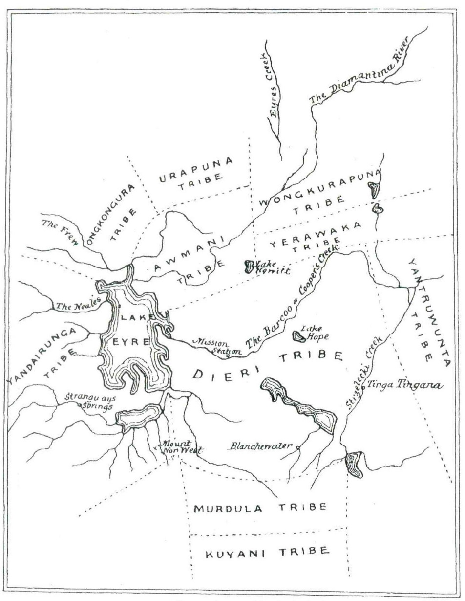
165 As is apparent, in this paper Howitt placed the Urapuna [Arabana] north-east of Lake Eyre, the Ongkongura [Wangkangurru] to the west of the Arabana and the Yandairunga to the west of Lake Eyre. His accompanying description indicates that, in preparing the map, he had relied very much on information he had received from Robert Hogarth and other informants rather than on his own field work. Howitt acknowledged the limitations in the accuracy of the boundaries drawn on his map, saying:
These do not pretend to extreme accuracy, but they will serve the purpose intended, namely, to aid the reader by giving a “local habitation and a name” to descriptions of geographical character which would otherwise be little better than mere words. It is possible, nay more than probable, that the boundaries do not give the full extent of the territory claimed by some of these tribes.
166 In the description of his map, Howitt said that “the Yandairunga occupied the country extending from the western shores of Lake Eyre for about 140 miles, and in a north and south direction for the same distance south of the Peake”. There is ambiguity in this statement. It is unclear whether Howitt was indicating that the Yandairunga extended only south of the Peake, or 140 miles north and south of the Peake. The former appears more consistent with the terminology used but is plainly inconsistent with the information on which Howitt relied from one of his principal informants, Robert Hogarth. Like Sackett, I incline to the view that Howitt was intending to convey the latter of the two alternatives: it is difficult to identify any basis on which he could have concluded that Arabana country was to the south of the Peake only.
167 It is also apparent that there are several inaccuracies in Howitt’s 1891 map. It is not necessary to stay with these because Howitt revised the position in 1904 in his book “The Native Tribes of South-East Australia”. In his preface to that book, Howitt said:
With the increase of information, due to a wider scope of inquiry, the mental horizon was necessarily widened, bringing the facts into a truer perspective. Thus it has come about that some of the views expressed in earlier papers have been modified, as will be pointed out in several places in this work.
168 Howitt also noted the difficulty in identifying tribal boundaries:
[T]he reader will kindly bear in mind the great difficulty which always presents itself, not only in defining the true boundaries of any tribal country, but also, in many cases, of giving the true and comprehensive name of the tribe.
169 In the body of his work, Howitt noted:
To the westward of Lake Eyre there is the Urabunna … This tribe adjoins the Arunta on the north …
170 At page 184 of his work, Howitt noted:
This gives a range of tribes, in which probably there was the pirrauru system of marriage, for 850 miles from Oodnadatta, the approximate northern boundary of the Urabunna, to the eastern boundary of the Dieri, or that of the Mardala, say immediately between the Flinders Range and the Barrier Range …
(Emphasis added)
171 Later, Howitt recorded:
On the opposite side of Lake Eyre, or more correctly, north-westerly from the Dieri, there is the Urabunna tribe, the southern division of which is called the Yendakarangu.
(Emphasis added)
172 Howitt and Siebert’s 1904 Map (Map 6) is as follows:
Map 6: Howitt and Siebert’s 1904 Map showing position of the tribes
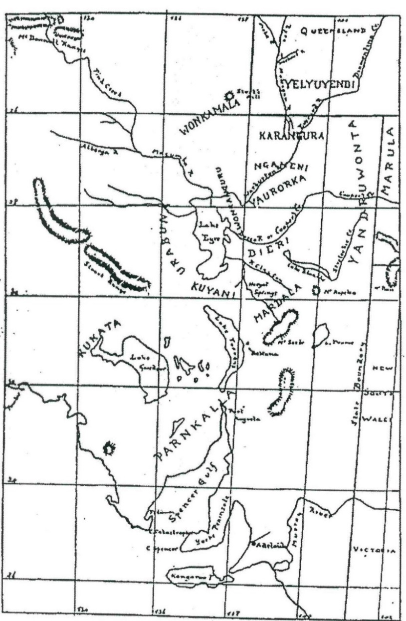
173 This showed the “Urabuna” west of Lake Eyre but did not show the Arrernte, Antakarinja or Luritja at all.
174 Howitt published a second map in 1904 which contains some revisions. It is Map 7 below.
Map 7: Howitt’s 1904 Map
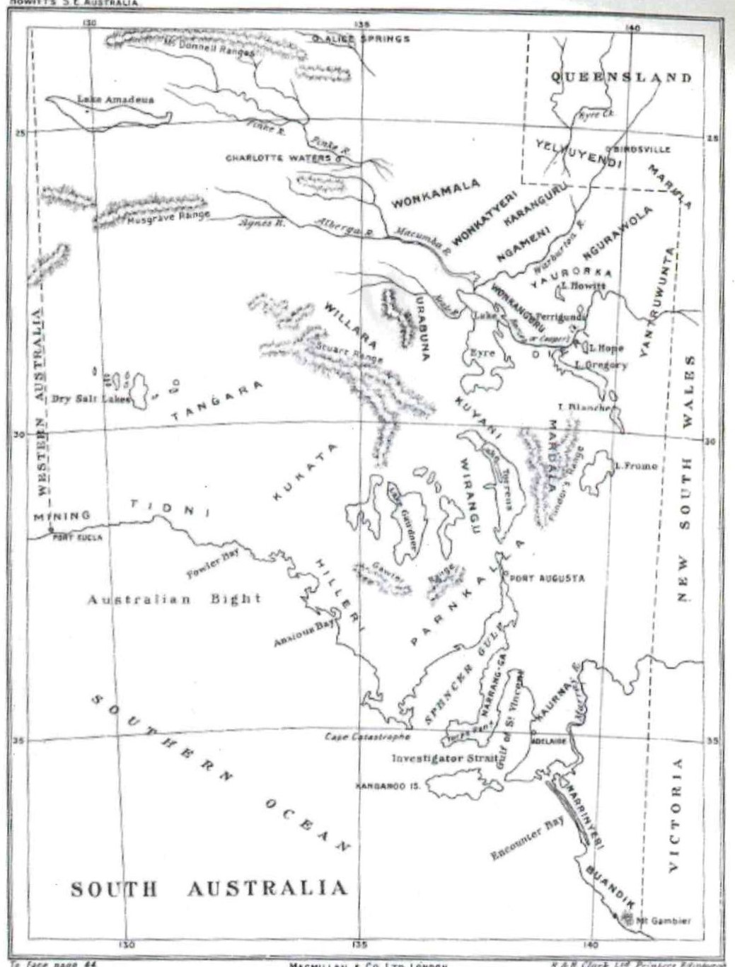
175 In his 1907 publication “The Native Tribes of South-East Australia”, Howitt referred to Oodnadatta as being “the approximate northern boundary of the Urabunna” in his description of the distribution of the Kararu and Mattari moieties.
176 Byrne commenced working on the Overland Telegraph Line in 1873 and continued doing so for 50 years. In 1892, while at Charlotte Waters, he responded to a request from AW Howitt for information concerning Aboriginal peoples. His letter included the following:
Name of tribe Aroondah - Boundaries 50 Miles North, 20 West, 90 South, 10 East – The country Eastward is destitute of water, and uninhabited for considerable distance. The tribes about here merge almost imperceptibly into each other, having many customs and words in Common from Oodnadatta to the McDonnell Ranges a distance of 360 miles.
(Emphasis in the original)
177 It was common ground that Byrne’s reference to the “Aroondah” was a reference to the Arrernte.
178 Both the Arabana and the Walka Wani sought to derive support from this statement of Byrne. Lucas described Byrne as a “particularly reliable source” and as “authoritative”.
179 Lucas noted that, at the time Byrne wrote this letter, he had been working on the Telegraph Line for close to 20 years and may be taken to have had some familiarity with the region. He considered that a point 90 miles south of Charlotte Waters is a place called “Three Sisters” which is north of Oodnadatta but south of the junction of the Alberga and the Macumba and about equal distance between the two. He considered that this corresponded approximately with the boundary between Arabana and Arrernte country given by Mick McLean and by Ted Strehlow, to whom I will refer shortly.
180 Graham and Liebelt thought that the distance of 90 miles brought one to a location between the Alberga River and the Murdarinna Water Hole, around 45 kms west-northwest of the Three Sisters site to which Lucas had referred. They also emphasised Byrne’s reference to there being many customs and words in common between the “tribes”.
181 I mention one further matter concerning Byrne. Lucas’ first quotation of Byrne omitted the words “into each other, having many customs and words in common from Oodnadatta”. Graham and Liebelt suggested that Lucas had done this “either deliberately or accidentally”. I accept Lucas’ explanation of the circumstances in which the omission occurred and reject the suggestion that it had been deliberate. With due respect to Graham and Liebelt, the suggestion that the omission may have been deliberate was unfortunate.
182 In 1894, William Horn led a scientific expedition into Central Australia which travelled north from Oodnadatta to Alice Springs and the MacDonnell Ranges in the Northern Territory. Edward Stirling had responsibility for anthropological studies in the expedition. In his report, Stirling said:
Simple as the matter appears it was not without much difficulty and repeated questioning that information could be elicited concerning the territorial distribution of the tribes of Central Australia. The natives with whom we came in contact do not habitually speak of individuals as belonging to such and such a tribe, specifically named and having defined territorial limits, but they designate them by the name of the direction in which their country lies. Thus among the Arunta tribe … the natives to the north are referred to as Aldolina, those to the south as Urlewaga or Urlewa, to the west to Andigraina, and to the east Aiyerara or Iyerara. Consequently, we were for some time under the impression that these names were those of different tribes and, indeed, some of them appear in various communications as tribal names, whereas, in fact, the natives so referred to are not necessarily members of the same tribe. Occasionally they attach the name of some important geographical feature, and it was not uncommon to hear a man of the Arunta tribe spoken of as a Larapinta (Finke River) blackfellow.
183 Later, Stirling reported encountering members of only two “tribes”:
In the large area of country traversed by the Expedition natives belonging to two tribes only were met with – the Arunta or Arunda, of which our principal “black boy”, a tracker of mature years in the service of the police at Oodnadatta, usually spoke as the Lurna Arunda and the Luritcha or Luritchi. The former occupies the tract of country traversed by the telegraph line stretching from Oodnadatta, or more strictly speaking, from the Macumba Creek in the south through Dalhousie Springs, Charlotte Waters, Crown Point, Mount Burrell and Owen Springs to Alice Springs in the McDonnell Ranges.
(Emphasis added)
184 Stirling also referred to the Arabana:
In the course of this paper I shall more than once refer to the tribe of the country now occupied by the Peake Station. Mr Kempe, who has for many years been manager of that Station, which lies to the west of Lake Eyre, informs me that the name of this tribe is Arrabunna. This does not accord with Mr Howitt’s map which places the Urapuna (doubtless the same tribe), to the north of the Lake and beyond the Peake country. As I can hardly believe that my informant, who is an intelligent observer, can have been mistaken in the name of the tribe at his doors, I shall use the name he supplies. It is, however, an exceedingly difficult matter to define tribal boundaries, especially where intermingling has taken place.
(Emphasis added)
185 With reference to the territory of the Luritja, Stirling said:
The territory of the Luritchas marches on the western boundary of the Aruntas, and comprises the country about Erldunda, Tempe Downs, Gill’s Range, Mereenie Bluff and Glen Helen, and extends certainly as far westward as Ayers Rock and Mount Olga, which latter (sic) was the most westerly point reached by the Expedition; probably it stretches still further to the westward.
186 Stirling said that the Luritcha language “differs entirely” from that of the “Aruntas”.
187 Stirling also referred to the Arabana as being the “tribe which adjoins the Arunta to the south, and which occupies the country to the west of Lake Eyre”.
188 As is apparent, Stirling considered it more accurate to describe Arrernte country as commencing at Macumba Creek, i.e, north of Oodnadatta.
189 In 1891, an expedition funded by Sir Thomas Elder explored western South Australia and parts of Western Australia. Richard Helms was the naturalist on that expedition. He reported having received information from “Billy Weaver, an intelligent half-caste living at Warrina, but who was born at Port Lincoln” concerning the territory of the “tribes”:
The territory of the Andijirigna extends from Alberga north to Mount Eba south; to the west past the Musgrave Range and in the east it joins the territory of the
Wungarabunna, which extends north from Oodnadatta to Strangways Springs south; east to Lake Eyre, and west to Cootanoorinna. The
Diyeri extends from Salt Creek north-west of Cooper’s Creek to Hergott Springs south; east to Lake Hope, and to the west joins the Wungarabunna territory. The
Kukatha joins the Andijirigna, and extends from Port Augusta north to Poonindie south-west … .
Wungaranda joins the Wungarabunna and Andijirigna tribes.
190 As is apparent, Weaver believed that the northern boundary of the Wungarabunna (Arabana) was at Oodnadatta, that their northern neighbours were the Arrernte (Wungaranda), and that the Antakirinja were the western neighbours of both the Arabana and the Arrernte. He placed the boundary between the Arabana and the Antakirinja (i.e, the western boundary of the Arabana) at Cootanoorinna (near the junction of the Arckaringa and Lora Creeks south-south-west of Oodnadatta).
191 Otto Siebert was a Lutheran Missionary working at Killalpaninna (east of Lake Eyre) from 1894 to 1902. While there, Siebert made some study of the Aboriginal people, including their languages, beliefs and myths and some of their laws and customs. He also corresponded with Alfred Howitt and in 1916 published a joint work with him.
192 In 1898, Siebert sent Howitt a map depicting the relative positions and approximate areas of a number of Aboriginal groups. The map below is the portion of Siebert’s map which is relevant for present purposes.
Map 8: Siebert’s 1898 Map of Tribal Territories
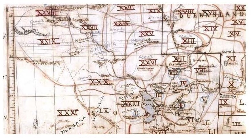
193 In his letter to Howitt explaining his map, Siebert said:
I could have sent a map some time ago, but had to include another tribe here, correct a boundary there and so on. Although the present circumstances no longer permit the clear definition of boundaries, I took greatest care to explore the tribes and their areas. Especially discovering the latter was often rather difficult, as presently 4, 5 and more tribes have settled down at one place. Thus in Oodnadatta I found: 1. Andigirinje, 2. Wonkarabana, 3. Kukata, 4. Wonkaranda, 5. Arentje, 6. Ulbaritja, 7. Willara – as well as some individually stranded Wongkanguru, Cujani etc. That it is not easy to discover their actual abode under such circumstances is understandable.
194 I agree with the assessment of a number of the anthropologists and of Gara that this passage indicates that Siebert had visited Oodnadatta before preparing his map.
195 As the anthropologists noted, Siebert’s map contained some entries made later by others, probably Howitt. Nevertheless, the original entries made by Siebert are apparent. Sackett summarised matters shown on Siebert’s map which are presently relevant (and which I accept) as follows:
a. XXIV related to the Arentje, who were shown having country extending south to the area of the Macumba River,
b. XXVI related to the Wonkatjerry, who were shown having country to the east of the southern portion of the Arentje, and whose country was shown as extending south to the area of the Macumba,
c. XXVII related to the Wonkaranda, who were show having country to the west of the Arentje, though it is not clear how far south their country extended,
d. XXX related to the Andigirinje, who were shown having country to the south of the Alberga River, and seemingly taking in Oodnadatta, and
e. XXXII related to the Wonkarabana, who were show having country west and northwest of Lake Eyre and extending north to the area of the Macumba, and taking in the area of the confluence of the North and South Branches of the Neales.
196 Lucas said of Siebert’s map:
In my reading, … the area of ‘Wonkarabana’ extends through The Neales to the Macumba River, which in my opinion can be read – given Siebert’s stated ‘care’ – as a distinction between the historical residence of certain name groups, and underlying ownership by the Arabana.
197 Sackett agreed with that view, saying that Siebert had “mapped the Overlap Area well within the extents of Wonkarabana lands, with the Andigirinje in lands off to the west and northwest and the Arentje in lands off to the north”. Gara also considered that Siebert’s map shows the Claim Area to be in Arabana country. In expressing those view, Gara and Sackett overlooked (understandably as the name is obscured) that Siebert had placed Oodnadatta outside the territory of the “Urabunna”.
198 Graham and Liebelt on the other hand thought that the area Siebert had marked XXX as “Andigirinje”, reflected an area which was once Arrernte country but by effective sovereignty more accurately reflected a group of Aboriginal people with both Arrernte and Western Desert affiliations.
199 I will defer further consideration of Siebert’s map until later.
200 Graham and Liebelt referred to the visit of the then Governor of South Australia, Lord Tennyson, to Oodnadatta in July 1899. Lady Tennyson, who accompanied the Governor, wrote about the trip in her letters. She referred to having attended a “corroboree” at which a large number of Aboriginal people were present. Graham and Liebelt record Lady Tennyson as saying “at our corroboree there were three different tribes – the Arrunta, Alberga & Macuna – who had congregated & had practised for it”.
201 Graham and Liebelt suggest that this record indicates that “the area retained a significant Aboriginal population [in July 1899], though some may well have come in from neighbouring homesteads, and that Arrernte people were there at the time”. They also suggest that the record indicates that “that groups to the north (i.e. Alberga and Macumba) were those responsible for ceremonial activity in 1899”. Finally, they note that Lady Tennyson had made “no mention of groups from south (i.e. Peake ‘tribes’)”.
202 Like Gara, I consider that there is good reason to be cautious about drawing inferences presently from Lady Tennyson’s account. In the first place, the corroboree appears to have been a specially arranged performance for the Governor and his wife, as Lady Tennyson records that the “tribes” had “been told to collect at sundown” and that they had “practised” for the corroboree. This suggests that local authorities, perhaps the Police, may have organised one group to present the corroboree. Secondly, as Gara notes, there were approximately 70 Aboriginal people at The Peake Station at that time whom Lady Tennyson does not mention. Thirdly, Lady Tennyson does not identify her informant(s). Fourthly, it is unclear what Lady Tennyson meant by the “Macuna”. It is not necessarily a misspelling of “Macumba” as Graham and Liebelt supposed.
203 For these reasons, while the observations of Lady Tennyson should not be disregarded, they can hardly be given the same weight as those of the more knowledgeable sources who spent extensive periods in the region.
204 Baldwin Spencer was a scientist who travelled on the Horn Expedition of 1894. Frank Gillen was for a time the Station-Master at the Alice Springs Telegraph Office. He was also a special magistrate and Sub-Protector of Aborigines in Alice Springs. Gillen had commenced work on the Overland Telegraph Line in 1875 working at both Charlotte Waters and Alice Springs and had become familiar with the Arrernte people as well as members of other groups. He is the same Gillen who published the work with Warburton referred to earlier. Graham and Liebelt said that it was appropriate to give considerable weight to his records and opinions. Gara gave a similar endorsement saying that, apart from Robert Hogarth, Baldwin and Gillen had the most experience and knowledge of the area around the Peake.
205 Gillen’s diary of his travel to Alice Springs in 1875 records that he spent several days at the Peake Station where he saw “dozens” of Aboriginal people. North of the Peake he witnessed:
Half a dozen naked women in The Neale’s Creek – they had half a dozen lizards (native name – Cadney) on the Coals, roasting for their evening meal.
206 Spencer and Gillen met in July 1894 when the Horn Expedition reached Alice Springs. In 1896, Spencer and Gillen spent four consecutive months working amongst the “Arunta” people. In 1901, they spent a year in further study of the Arunta. This included “[living]” in the native camps out in the bush, wandering freely in and out amongst them [and being] allowed … to see and hear everything that went on”. Spencer reported that he and Gillen had been “always treated as fully initiated members of the Arunta tribe”. Spencer also undertook his own expedition into Central Australia in 1901. Gillen accompanied Spencer on an overland expedition to Darwin in 1901 and 1902. In 1903, Spencer and Gillen spent several weeks at the Peake Station, working with a group of Arabana and Arrernte elders, recording language, songs and mythology and details of social organisation. They later co-authored a number of works about the Arrernte and other Central Australian tribes.
207 In a letter to Spencer in 1897, Gillen wrote:
There is a tribe up the Albinga and spreading away to the Musgraves who call themselves the “Antikeryina” and speak the Luritcha tongue.
Like Sackett, I consider that the name “Albinga” can be taken as a reference to the Alberga.
208 In an article published in April 1897, Spencer and Gillen referred to “the Urrabunna, living to the west of Lake Eyre”. Gara recorded that Spencer had referred to the “Urubunna” and “Arunta” tribes in a lecture which he gave in Melbourne in April 1897 but had not provided details.
209 In 1898, Gillen reported in a newspaper article that the Arunta tribe occupied “the country between Oodnadatta in the south and Hann’s Range, 70 miles north of Alice Springs”.
210 In an article published in the South Australian Register on 12 September 1898, Gillen said:
The Arunta tribe is a thousand strong. They range from Oodnadatta to west of the MacDonnell Ranges. They have some social organisation. In the north portion of the tribe there are eight classes, and in the south only four. There are eight class names, and there is evidence of a former higher state of social organisation; also, that they are moving upwards.
211 Spencer and Gillen’s first book, entitled “The Native Tribes of Central Australia”, was published in 1899. In that book, Spencer and Gillen reported:
We find, so far as their organisations concern, a sharply marked line of difference between the Urabunna tribe, the members of which are spread over the country which lies to the west and north-west of Lake Eyre, and the Arunta tribe, which adjoins their northern boundary. … [T]he Arunta is the most southern of the Central tribes.
212 In the same book, Spencer and Gillen included an “Outline Map” showing the distribution of the tribes to which they referred. The portion of the map which is presently relevant is set out below:
Map 9: Outline Map of the Central Area, showing the distribution of the Tribes referred to
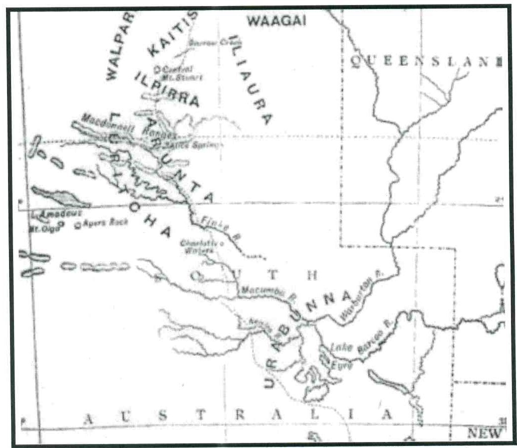
213 As is apparent, Spencer and Gillen did not include a dotted line boundary between the “Urabunna”, on the one hand, and the Arunta and Luritcha, on the other, but the location shown for each are generally consistent with the 1901-02 field work map to which I will refer shortly.
214 In the body of the work, Spencer and Gillen described a classificatory group of tribes which included the “Arunta” as occupying “a range of country extending from the latitude of Macumba River in the South to about that of Powell’s Creek in the north” (emphasis added).
215 Spencer and Gillen also noted that contact between the Arunta and the Urabunna was not infrequent and that inter-marriage occurred. Of relevance to some of the experts based upon places at which Arrernte speakers were found, it is pertinent to note the following statement of Spencer and Gillen in 1904:
It sometimes happens, in fact not infrequently, that a man from the neighbouring Arunta tribe comes to live among the Urabanna.
216 In a newspaper article following his 1901 expedition, Spencer described the Arrernte as inhabiting the country “extending from the Nacumba (sic) River in the south to 70 miles north of Alice Springs”. Gara also reports Gillen giving a similar account in 1902 as he described the Arrernte as inhabiting the country “extending from the Macumba River to a point 70 miles north of the MacDonnell Ranges”.
217 During their 1901-02 field work, Spencer and Gillen prepared a hand drawn map containing the notation “Map showing distribution of tribes roughly approximate”. Portion of this map is set out below.
Map 10: Portion of Spencer & Gillen, ‘Northern Territory: Map showing distribution of Tribes roughly approximate’
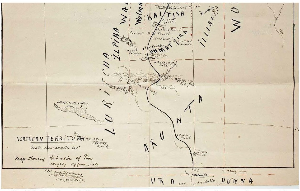
218 As is apparent, Spencer and Gillen indicated in Map 10 that the “Urapunna” were located to the east and west of Oodnadatta with the “Arunta” to the north of the Macumba. Their dotted line indicating the division between the “Urapunna” and the “Arunta” is very close to the course of the Macumba River, that is, north of Oodnadatta. Graham considered that, despite being described as “roughly approximate” this map of the distribution of the languages has generally stood the test of time.
219 In 1904, Spencer and Gillen published their book entitled “The Northern Tribes of Central Australia” which contains an account of their expedition from Oodnadatta to the Gulf of Carpentaria in 1901-2 and includes data they obtained at the Peake in 1903. They commenced their introduction to this book with a reference to their previous work in which they had, they said, been concerned especially “with the large and important Arunta tribe whose territory, before the white man made his appearance on the scene, extended from about the Macumba River in the south to 70 miles north of the MacDonnell Ranges” (emphasis added).
220 Spencer and Gillen included a map in the book but without indicating boundaries between the various Aboriginal peoples. A copy of this map is set out below.
Map 11: Extract of Spencer and Gillen’s 1904 published map
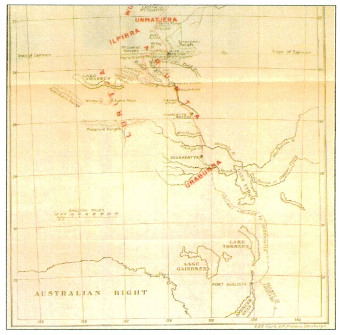
221 This map has the name Urabunna” between Lake Eyre and Oodnadatta and the “Arunta” to the north of the Macumba/Alberga. The Luritja are to the west.
222 In their 1904 book, Spencer and Gillen described the Luritja as occupying:
The sterile desert country extending southwards around Lake Amadeus [and] also extends over the relatively well-watered country, including the western end of the James and MacDonnell Ranges.
223 The map drawn by Spencer and Gillen during their 1901-02 fieldwork showing the “distribution of Tribes roughly approximate” is consistent with the delineation described in the preceding paragraph but, as Graham and Liebelt pointed out, the line of delineation did not appear in the map which they had published in 1904.
224 Gara referred to a newspaper report of a public lecture given by Gillen in October 1908 in which he stated that Arunta territory “lay between Oodnadatta and about 70 miles north of the MacDonnell Ranges”. In a public lecture three years later, Gillen was reported as saying that the territory of the “Arunta tribe” reached “from Macumba to 50 miles north of Alice Springs”.
225 Spencer and Gillen published another book entitled “Across Australia” in 1912 (again an account of their 1901-2 expedition) in which they said:
The Arunta is probably the largest tribe in Central Australia, and occupies a tract (sic) of country extending from the Macumba River in the south to seventy miles north of the MacDonnell Ranges, a total distance of about four hundred miles; how far the tribe extends east and west there is no means of knowing with anything like accuracy.
226 Later in “Across Australia”, Spencer and Gillen referred to the Arunta as being part of a group forming one large “nation” which occupies all the country from the Macumba River in the south to the Bonney Creek in the north”. Earlier, at pages 18-19, Spencer and Gillen said of the Arabana and the Arunta:
The remnants of the Urabunna tribe are gathered together at the few outlined cattle stations, such as the Peake … The Urabunna tribe occupies the country lying on the north-west side of Lake Eyre; southwards it is in contact with the Dieri tribe and northwards with the Arunta, whose southern boundary is approximately Oodnadatta.
(Emphasis added)
227 Finally, in this work, Spencer and Gillen noted that the Luritja inhabited “the utterly inhospitable country which stretches around the south, west, and north-west of the Arunta country, from Lake Torrens in the south to the far western limit of the MacDonnell Ranges”.
228 Frank Gillen died in June 1912. However in 1927, Spencer published another book in their joint names entitled “The Arunta: A Study Of A Stone Age People”. He commenced this book with the following paragraph:
The Arunta is, or rather was, one of the largest tribes in Central Australia, and still occupies a tract of country extending from the Macumba River on the south to seventy miles north of the MacDonnell Ranges, a total distance of about 400 miles. Thirty years ago, when we first studied it, its members must have numbered at least 2000, now there cannot be more than 300 or 400.
As is apparent, this statement was in part a repetition of the statement in “Across Australia” in 1912.
229 Later in the 1927 book, Spencer described the Arunta as divided into six main divisions with the southern-most division being:
Arunta illyair-Winna, extending from the southern limit of the tribe to about fifty miles north of Engurdina, Horseshoe Bend, on the Finke River.
230 The 1927 Book contained the following “outline map” of the central area:
Map 12: Outline map of the central area
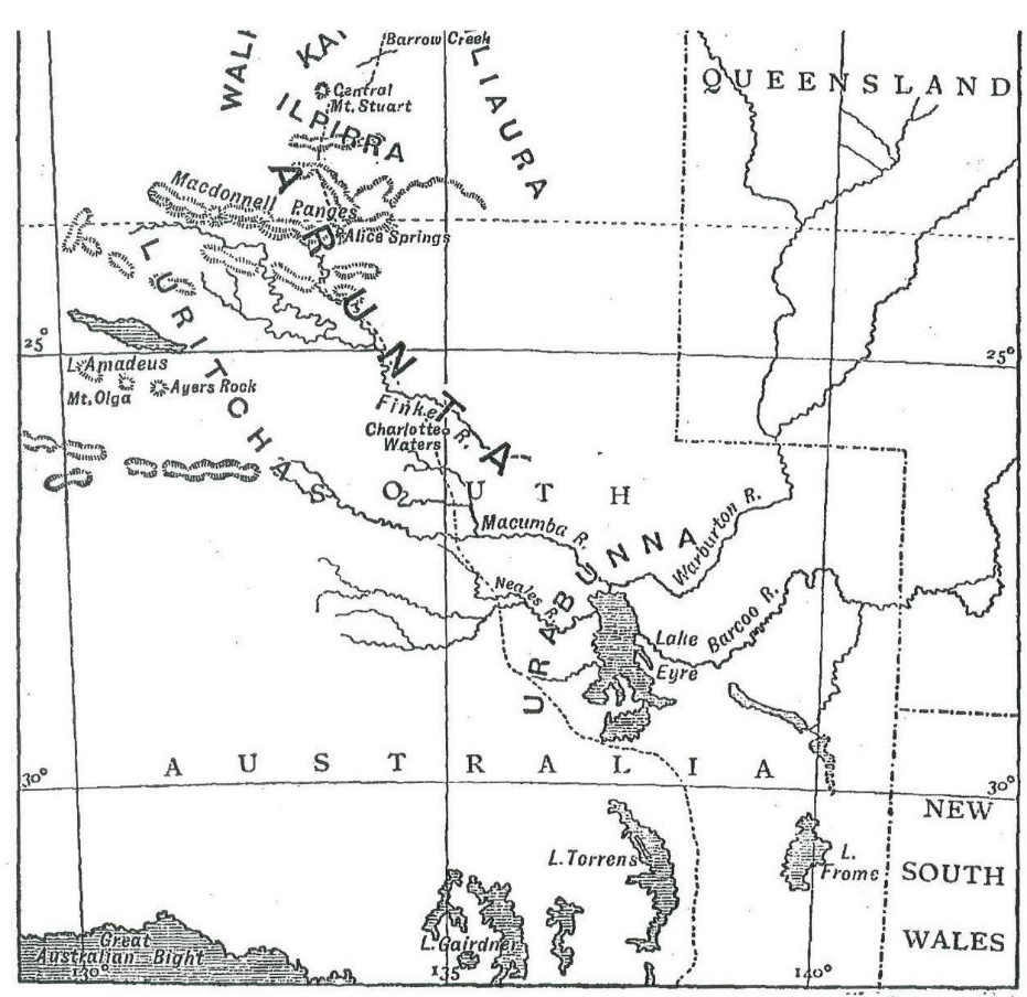
231 In summary, the books of Spencer and Gillen contain five references to the southern boundary of the Arrernte being at or near the Macumba River and one which places the boundary at Oodnadatta itself. I have referred to some but not all of the newspaper reports of statements by Spencer or Gillen. In three of these, the Macumba River is stated as the boundary whereas, in two, the boundary is stated as being at Oodnadatta. In my view, it is appropriate to attach greater weight to the later works of Spencer and Gillen, especially the works published after the period they spent in on-country work with the “Arunta” in 1903. Those works with one or two exceptions placed the southern boundary of the Arrernte at about the Macumba River. The maps accompanying the works are to the same effect.
232 Thomas E Hogarth was the younger brother of Robert Hogarth. He had worked on the stations at Strangways Springs and Anna Creek in the 1870s and 1880s and took over as manager of Anna Creek in the early 1890s. In 1913, he returned to live in Adelaide.
233 Tom Hogarth corresponded with Robert Mathews over a period of about two years commencing in 1898. In a letter in October 1898, Hogarth informed Mathews:
The Arabunna tribe extends northwards to the Macumba Creek, west to Stuart Range about 90 miles, south-east to Hergott Springs 135 miles and Lake Eyre to the east 50 miles. Anna Creek is in about the centre of their country.
(Emphasis added)
234 Hogarth also provided Mathews with a list of the totems associated with the “Matturri” and “Karrara” moieties.
235 In December 1898, Hogarth informed Mathews, apparently with reference to the northern boundary of the Arabana:
The north boundary is the Macumba and the same as you described as the accommodation house on the Overland coach changing station to Alice Springs and about 40 miles north of Oodnadatta. The Macumba runs into Lake Eyre on the north, that is the one I mean. The tribe name of the natives to the north and north-east of Lake Eyre is called Wongkacherra or Wonkooraroo both mixed up also the Arabunna tribe; they can all understand each other but have a different dialect or yabber.
236 In a later letter, Hogarth wrote:
The name of this tribe is Arabunna but does not extend north and south more than 200 miles, East and West about 60 miles. There are about 80 [50?] blacks and halfcastes all told here who have been so long mixed up with the whites that they have lost much of their old original habits.
237 A later letter from Hogarth indicates his understanding that the Matturri and Karrara moieties extended from south of Lake Eyre to Charlotte Waters. Other evidence indicates that that is incorrect in so far as it involves Charlotte Waters.
238 In a letter dated 6 February 1899, Hogarth wrote:
The Neal (sic) River or Creek is not the Alberga. The Alberga is a creek about 25 miles north of the headwaters of the Neal. The Alberga branches out, as you say, into the Angus [sic - Agnes] and Marryatt to the north of the Neals. The Neals goes up to the Everard Range. The Arrabunna tribe of blacks go north past the Neals but not west as far as the Everard Range.
(Emphasis added)
239 In April 1899, Hogarth recorded being told by “a young lubra from the Alberga” who described herself as “Andikarina”, that the “Alberga natives are classed as the same as the Macumba” and named the four sections.
240 It is not necessary to refer to the remainder of Tom Hogarth’s correspondence to which Gara referred. I note that Gara described Tom Hogarth as “a careful and sympathetic observer of the Aboriginal people” whose “descriptions of tribal boundaries in the country west of Lake Eyre are unusually detailed for the time”.
Robert Hamilton Mathews: 1898-1908
241 Robert Mathews described himself in 1900 as having travelled in “all the Australian colonies” over the previous 25 years whilst working as a surveyor and whilst engaged in grazing and mining pursuits. As already noted, Tom Hogarth corresponded with him frequently in the two years between 1898 and 1900. Mathews does not appear to have had any personal knowledge of the Arabana, the Luritja or the Arrernte and instead to have relied on the knowledge he acquired from informants. Tom Hogarth was not his only informant as, in a work published in 1898, Mathews referred to information acquired by “Mr Jackson” from natives he had met “about Oodnadatta, Macumba and Charlotte Waters”.
242 In his paper entitled “Australia Divisional Systems” read to the Royal Society of New South Wales on 1 June 1898, Mathews said:
I have traced the two divisions, Mattiri and Karraru, through a wide extent of territory, reaching from Port Lincoln, via Port Augusta and Farina, to somewhere about Oodnadatta, a distance of over seven hundred miles. From the latter place northerly to the neighbourhood of the James Ranges the tribes are divided into four sections; and thence to the Gulf of Carpentaria they are divided into eight sections …
243 In his paper presented to the American Philosophical Society in 1899 entitled “Divisions of North Australian Tribes”, Mathews said:
The southern portion of the Arrinda and adjoining tribes occupy the Middle Finke and Charlotte Waters, reaching as far south as the Macumba River.
(Emphasis added)
244 In a paper presented to the American Philosophical Society in 1900 entitled “Divisions of the South Australian Aborigines”, Mathews described the Arabana as being part of the “Parnkalla [Barngarla] Nation” which included the Parnkalla, the Nauo, the Nookoona [Nukunu] and the Dieyerie [Dieri]. This was because of their shared cultural features such as initiation rights and the Kararru/Matahari Moieties. Mathews described the “Arrabunna” people as inhabiting “the country from near the Macumba southerly along the western side of Lake Eyre as far as Margaret Creek …” and then extending “up the Neale and Peake Creeks till met by the Andigirina People”. A portion of the map published by Mathews in this work is set out below.
Map 13: Portion of Mathews’ 1900 Map
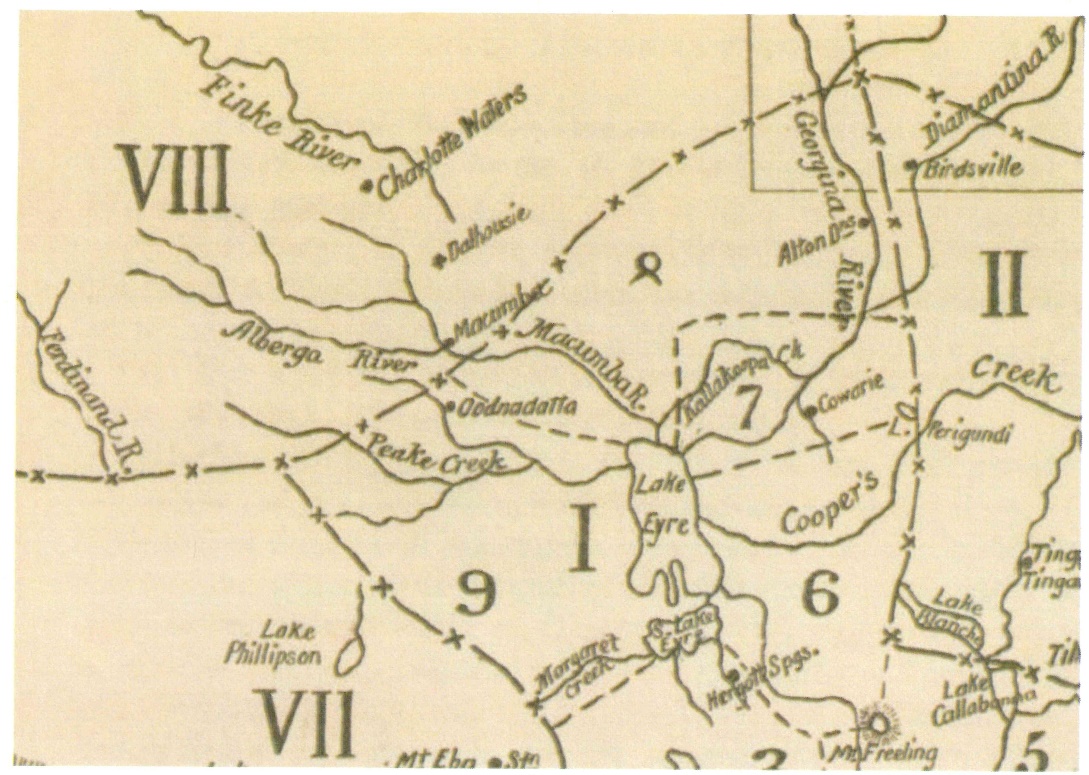
245 In Map 13, “I” is the Parnkalla (Barngarla) Nation (part of the wider Lakes Group) and the Arrabunna are in the area marked “9”. As is apparent, Map 13 locates Oodnadatta inside Arabana country. The area numbered 8 is identified as that of the “Wonkasora” and “Wonkamudla” which seems generally consistent with Siebert’s map.
246 Mathews described the “Andigarina Nation” (comprised of the Andigarina, Loorudgee [Luritja] and Arrinda [Arrernte] tribes) as:
Bounding the Arrabunna country on the north-west are the Andigarina and friendly tribes, occupying the country up the Alberga river to the Musgrave range and onward to the Petermann ranges and Lake Amadeus where they meet the Loorundgee tribe. The Andigarina and Loorudgee are divided into four sections, called Koomara, Panungka, Bultara and Parulla … This organization, with some modifications in the names of the sections, and in the order of their intermarriage, extends westwards across the colony of Western Australia to the Indian Ocean …
Lying northward of the Andigarina … is the Arrinda tribe, occupying the country at Macumba, Dalhousie, Charlotte Waters and the Lower Finke River, and stretching northwards a considerable distance. They have the same four sections as the Andagrina, and their rules of intermarriage and descent are identical. The Arrinda and Andigarina people have a similar language.
(Emphasis added)
247 Mathews also noted in 1900:
Lying north of the Andigarina, and adjoining also the Wonkaoora and Wankamudla … is the Arrinda tribe, occupying the country at Macumba, Dalhousie, Charlotte Waters and the Lower Finke River … They have the same four sections as the Andigarina and their rules of intermarriage and descent are identical.
248 In a paper which he read on 5 October 1906 and entitled “The Arran’Da Language, Central Australia”, Mathews commenced by saying:
We encounter the southern limit of the Arranda language about Oodnadatta, the present terminus of the trans-continental railway from Adelaide towards Port Darwin. The language continues northerly from Oodnadatta to Charlotte Waters and onward to Glen Helen Cattle Station and Alice Springs, in the MacDonnell Ranges.
(Emphasis added)
249 In a paper presented to the Royal Society of New South Wales in November 1906, Mathews stated:
All the way from about Oodnadatta or Alberga Creek to Alice Springs, and Glen Helen Cattle Station, the people speak the Arran’da language, or dialects of it.
(Emphasis added)
250 Later in the same paper, Mathews said:
The Lō-rit-ya or Lō-ritch-a tribe adjoins the Ar-an‘-da on the west.
251 In 1908, Mathews published “Marriage and Descent in the Arranda Tribe, Central Australia”. He commenced by saying:
As there is a difference of opinion among ethnologists respecting the line of descent in the Ar-ran’-da tribe at Alice Springs and the Finke River in Central Australia, I have endeavoured to obtain correct details on this important point. The sources of my information are men who have resided in the country of the Arranda tribe for many years. These men have taken a vast amount of trouble and have spent much time in answering my inquiries, which have been repeated in various forms and at different period during the past 12 years.
The territory of the Arranda (or Arunta of Spencer and Gillen), reaches from about Macumba River to Alice Springs and the upper Finke River.
(Emphasis added)
252 It was common ground that Mathews’ works are well regarded. His contributions to ethnography have been acknowledged by Ronald and Catherine Berndt, Norman Tindale and AP Elkin to whom I will refer shortly. His experience as a surveyor may well have made him particularly conscious of precision in map-making. Tindale in his 1974 book “Aboriginal Tribes of Australia” wrote of Mathews:
[M]y years of field survey have convinced me that the facts given by Mathews, where they have been checked and properly understood, pass all tests. The manner in which Mathews’ data on tribes has fallen squarely into place, item by item, has given me profound respect for his integrity and zeal in the pursuit of knowledge of the aborigines.
253 While on two occasions Mathews showed the Aranda or Antakarinja country extending to “about” Oodnadatta, the otherwise consistently identified Arrernte country as extending northwards from the Alberga and the Macumba.
254 Liebelt referred to a letter from AM Helling to RH Mathews dated 11 March 1899 in which Helling said that he had made “enquiries of several different Blacks” in order to answer questions asked by Mathews. He said that “the Wonkarrabannas [reach] as far as the “Peake Station” and not to “Oodnadatta” as stated in your pamphlet, [t]heir southern boundary being about Hergott Springs and Lake Eyre on the East”. Helling also said that he was able to speak the “Ahminny, Wonkaooroo [and] Wonkarrabanna dialects”.
255 The Walka Wani relied on this as another piece of evidence indicating that the country of the Arabana was south of Oodnadatta.
256 I agree that the Helling letter does point in the direction for which the Walka Wani contend. However, Corrarie Station from where Helling wrote the letter is located north-east of Lake Eyre and almost due east of Oodnadatta, well away from the Overlap Area. There is no indication of Helling ever visiting Oodnadatta. Moreover, the places to which he referred in the letter or for which he gave descriptions all seem to be located north or north-east of Corrarie Station and none are in the vicinity of Oodnadatta. There is accordingly uncertainty about Helling’s sources.
257 Helling’s statement is inconsistent with the 2012 Arabana Determination which does have Arabana country extending north of Oodnadatta (to the north-east).
258 For these reasons, while I do not disregard the Helling letter, I do not consider that it would be appropriate to give it significant weight.
Summary of the early ethnographical-historical material
259 If one paused at this point, one would say that Giles, Robert Hogarth (in his 1885 paper) and Patrick Byrne (insofar as he thought that the Aroondah (Arrernte) extended 90 miles south), Howitt, Stirling, Spencer and Gillen, Tom Hogarth and RH Matthew consistently put the boundary between the Arabana and the Lower Southern Arrernte north of Oodnadatta and, mostly, at the Alberga/Macumba Rivers. Those who would have the present Overlap Area within the land of the Arrernte are Woods, possibly Gillen and Warburton (but at least with respect to Gillen, his view must be taken to have been overtaken by his later investigations), East, Kempe, Siebert and Helling. Helms would have the boundary at Oodnadatta itself.
260 The obvious point of difference between these two groups is that it is those who themselves spent time in the region and/or who undertook investigations in some detail who expressed the former view. The latter group comprises persons who did not themselves visit the region at all or who spent only limited time there. As counsel for the Walka Wani put to Sackett, the fact that the Arrernte language and the Arabana language are very different, and the fact that many of their customs, rights and practices differ, should make one suspicious about aspect of East’s statement. The same may be said of the others who thought that the Arrernte country extended northwards from the Peake. It is also appropriate to keep in mind Black’s description of several of the sources on which the Walka Wani relied (Woods, East, Kempe and Gillen and Warburton) as “very minor”.
261 Nevertheless, there does remain the question of how it was that Arrernte speaking people, or people associated with the four section system, were at locations south of Oodnadatta. There are a number of possible reasons, as Sackett pointed out: marriage, ceremony or visiting a kinsperson and there are other explanations including early dislocation associated with, or consequent upon, the construction of the Overland Telegraph Line, trade, or general mobility. There is support in the evidence for each of these explanations. In particular, there is support for the view that the construction of the Overland Telegraph Line, and the route associated with it, led to considerable Aboriginal mobility up and down the Line. However, the presence of Arrernte speaking people may also be attributable to their exercise of “user” rights, a concept which looms large in the resolution of the Walka Wani applications.
Early 20th Century ethnographic-historical material
Erhard Eylmann: 1908 (Sackett [148])
262 Sackett referred to the work of this German ethnologist who worked in Australia intermittently between 1896 and 1912. During that time he went on several expeditions from Adelaide to Darwin and return. In 1908 he published (in German) “The Aborigines of the Colony of South Australia”. This included a map in which placed the Wonkagnurra to the east-northeast of Lake Eyre, the “Urabunna” to the west of Lake Eyre and the “Arapani” to the west of the Arabana. In addition, it shows the “Arunta” north of Charlotte Waters and the “Lurritja” west of the “Arunta”. On this basis, Sackett considers that Eylmann had Oodnadatta in the lands of the Urabunna. I accept that this is so but do not think that its evidential value rises above consistency with other more cogent evidence.
263 Pastor Carl Strehlow spent many years as a missionary at Hermannsburg in the Northern Territory. Before commencing at that mission he spent a short time at the Killalpaninna mission located to the east of Lake Eyre. Pastor Strehlow was in Hermannsburg initially from 1894 to 1910 and returned to it in 1912.
264 In 1910, Pastor Strehlow published in German a major work on the “Aranda” and “Loritja” tribes in Central Australia. He described the Aranda as comprising sub-groups with the southern-most being the “Aranda Tanka”. The map which he included in the work (a portion of which is set out below) shows the southern-most boundary of the “Aranda Tanka” as being a little to the south of Oodnadatta.
Map 14: Portion of Pastor Strehlow’s 1910 Map
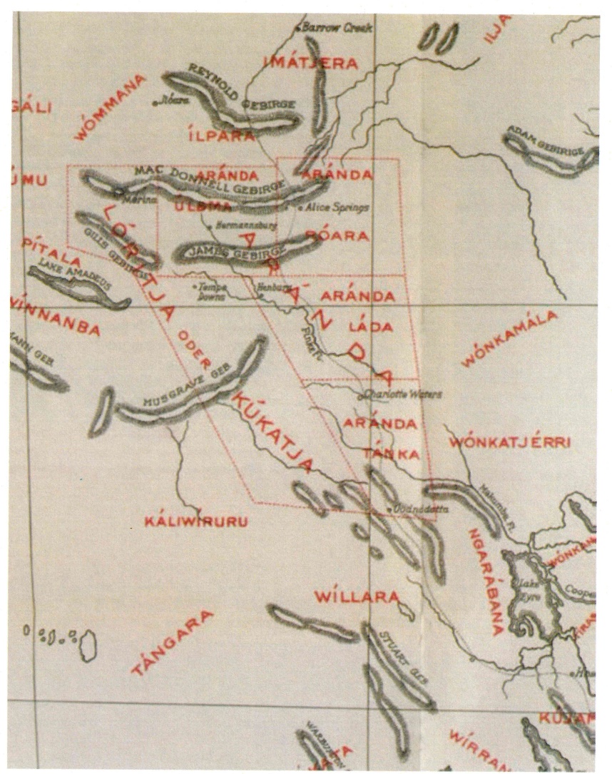
265 Graham and Liebelt, and the Walka Wani, assumed that the term “Aranda Tanka” was a reference to the LSA, but there was no evidence as to what Pastor Strehlow meant by that term.
266 Graham and Liebelt placed reliance on Pastor Strehlow’s map as supporting the Walka Wani claim. They suggested that Pastor Strehlow had acquired an understanding of “group distributions” during his time at Killalpanina Mission and that the map reflected that understanding. However, Pastor Strehlow’s son, TGH Strehlow, the well-known Australian linguist and anthropologist, identified his father’s principal informants as being men from the north and west of “Aranda” country. If this be correct (and there is no reason to doubt it), it is likely to have affected the reliability of Pastor Strehlow’s identification of the southern extent of Aranda country, as Hermannsburg is about 500 km north of Oodnadatta. Providing some support for the assessment of TGH Strehlow is that there is no evidence that Pastor Strehlow travelled extensively in the area of the LSA.
267 In the oral evidence, it emerged that Pastor Strehlow had not drawn the map himself. The editor of the section in Pastor Strehlow’s work in which the map appears (von Leonhardi), said that “the residential area of the tribes have been entered [on the map] according to information supplied by Strehlow and Missionary Siebert. For the sake of completion we have used the map from the works of W.E. Roth, Howitt and Spencer and Gillen” (emphasis added). It is accordingly not a map drawn by Pastor Strehlow himself. While Siebert, Howitt and Spencer and Gillen are familiar, there was no evidence as to the identity of W.E. Roth. The description of the map as a map of “residential areas” may imply that it was a map about where people were found at the time, rather than an identification of their country. There is no other description of the map. Graham acknowledged that the mapping in Pastor Strehlow’s map went beyond the areas of his expertise. Graham also agreed that Anna Kenny, who had written a significant work entitled “the Aranda’s Pepa” in relation to Pastor Strehlow’s work, had noted that Pastor Strehlow had not in his writings defined exactly the territories of (relevantly) the eastern and southern Aranda. Ms Kenny also considered it impossible to judge what Strehlow’s names and language reasons orally indicated.
268 In my view, these matters diminish significantly the weight which can be attached to Pastor Strehlow’s map.
269 Graham and Liebelt referred to the work of Fr Wilhelm Schmidt, a Catholic priest, published in 1919 entitled “Classification of the Australian Languages”, being a substantial work on Australian languages. They reproduced a map published by Fr Schmidt which they submitted indicated that Oodnadatta was within “Aranda” country. The map has the title “Map of the Indigenous Languages of Australia” written in German. It became Map 29 in the book of maps tendered at trial.
270 Graham and Liebelt noted that Fr Schmidt had founded “the prestigious journal, Anthropos, which remains to this day a premier anthropology and linguistic journal”. On this basis they regarded his map as providing support for their view of the boundary between Arrernte and Arabana country.
271 Father Schmidt had written in German, and the Walka Wani did not produce either the original German work or an English translation for it. Nor did Graham and Liebelt seek to identify the sources on which Fr Schmidt had relied.
272 The Arabana led evidence from Stockigt and Black about Fr Schmidt’s map. Stockigt described Fr Schmidt’s work as the first attempt by a linguist to classify Australian languages using the entire body of sources then available. She noted that there had been a debate in the 19th Century about whether Aboriginal languages comprised a single language with many dialects or multiple languages. In that context, Fr Schmidt had looked at all the early literature about Australian languages and had tried to group them into higher level families. Stockigt has studied Fr Schmidt’s classifications and has compared them with later classifications.
273 Father Schmidt did not himself draw the map on which Graham and Liebelt relied. In fact, he did not ever come to Australia to conduct his own field work. Stockigt said that someone called Streit had drawn the map on the basis of information supplied by Fr Schmidt. The extract of the Map is as follows:
Map 15: Map extract from Schmidt 1919
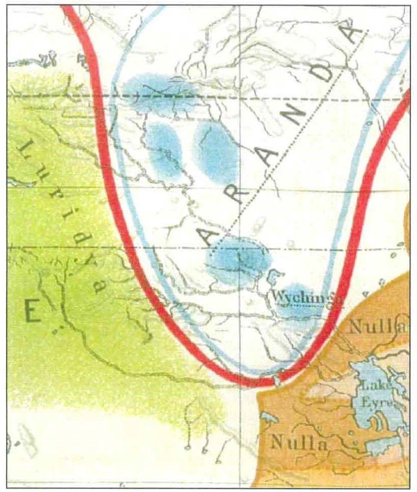
274 Stockigt’s assessment of the sources used by Fr Schmidt, coupled with his own acknowledgements, indicated, in effect, that there were only two maps which may have been the sources for Fr Schmidt’s map (so far as relevant to the Overlap Area), one of which was Pastor Strehlow’s 1910 map. The other was RH Mathews but, as noted earlier, he consistently had the southern boundary of the Arrernte as being at the Macumba and Oodnadatta within Arabana country. See Map 13 above. Gara thought that Fr Schmidt had followed Pastor Strehlow’s map. Otherwise, Fr Schmidt had made use of word lists, not all of which he (Fr Schmidt) regarded as reliable. I accept Stockigt’s evidence about these matters. Graham seemed to recognise the limitations in Fr Schmidt’s map as he said that it was “just here to give an idea as to where [the languages] were spoken” and that “any high school student could look at these articles and then sort of draw lines based on them”.
275 Father Schmidt’s map seems to be in the nature of a broad brush indication (indicated, amongst other things, by its closely parabolic shape in this region) of language distribution, rather than an attempt at geographic precision.
276 In these circumstances, I am disinclined to attach significance to Fr Schmidt’s map in the determination of the country of the LSA and the Arabana. I note, however, that it does not provide any support for the claim that Yankunytjatjara country extended over the Overlap Area.
277 Dr Basedow was a medical doctor and anthropologist who carried out three expeditions between 1919 and 1920 in the north and west of South Australia. On those expeditions, he conducted a survey of Aboriginal health. In particular, between May and September 1920, Basedow travelled throughout the northern central part of South Australia and the southern part of the Northern Territory, visiting Finniss Springs, Stuart Creek, Oodnadatta, Macumba, Dalhousie, Charlotte Waters and other stations and settlements along the rail and telephone lines. As part of his work, Basedow recorded the names and other details of about 250 Aboriginal People to whom he talked or provided treatment.
278 Basedow reported to the South Australian Government on the “Tribal Organisations” as follows:
The country extending centrally northwards from Hergott Springs [Marree] to the Northern Territory boundary is occupied by three tribes, - the Arrabonna, the Aluridja and Arunndta. The Arunndta is the largest of all Central Australian tribes, and its domain includes all ground along the northern overland track between Mount Dutton and the MacDonnell Ranges. The Aluridja territory adjoins it on the west and embraces the eastern Musgrave Ranges. The Arrabonna area lies immediately south of the Arunndta. A subdivision of the Aluridjas living at Indulkinna goes by the name of Unndagerrinya.
279 Mount Dutton is approximately 50 km south-east from Oodnadatta so Basedow’s report places Oodnadatta within “Arrunndta” country. However, Basedow gave some further context to his observations. He noted that the recent influenza epidemic had had a disastrous effect in many centres and, in Hergott Springs and Oodnadatta, had “almost completely annihilated resident groups”. He described the decrease in the numbers at Anna Creek as “appalling” and said that the entire Aboriginal population in the settled districts between Hergott Springs and the Northern Territory border was approximately 300.
280 Basedow recorded the name, location and “tribe” of each Aboriginal person he examined. Somewhat curiously, he does not record the examination of any Aboriginal person at Oodnadatta, although he visited Oodnadatta twice. This may indicate that there were no Aboriginal persons in Oodnadatta at the times of his visits.
281 Lucas provided a bar graph demonstrating pictorially the locations and “tribes” recorded by Basedow, which I reproduce below.
282 Like Lucas, I consider that Basedow’s data gives a snap shot picture of where the Aboriginal populations in and around the Overlap Area were centred at the time of his expedition.
283 Graham and Liebelt concluded with reference to Basedow’s data:
[T]here is a pattern, the Arabana are overwhelmingly where Pastor Strehlow, Stirling, Spencer and Gillen suggests they will be; that is, in the vicinity of Lake Eyre. The Arrernte again are where we would expect to find them, going from previous sources, some south of Oodnadatta at Anna Creek and Algebuckina, nearby on Allandale, and north of Oodnadatta at Todmorden and Dalhousie and its vicinity. The Antikarinya were examined by him on Todmorden and at Federal, again consistent.
284 In my view, this assessment is a gloss on the works of Pastor Strehlow, Stirling and Spencer and Gillen referred to above. It also overlooks that Robert Hogarth, Stirling, Spencer and Gillen, Tom Hogarth, Mathews and probably Helms, considered (expressly or implicitly) that Arabana country extended north to the Macumba River and makes no allowance for the prospect that the locations of the Antakarinja People were the result of easterly movement post European contact. Likewise, the presence of some individual Arrernte at Allendale, Algebuckina and Anna Creek may be the result of post effective sovereignty movement by those people. In any event, Basedow’s data suggests that the LSA in 1920 were concentrated north, and the Arabana south, of Oodnadatta.
285 It is also unclear that Basedow’s account can be regarded as independent of Pastor Strehlow’s. There is no direct evidence of liaison between Pastor Strehlow and Dr Basedow but, like Sackett, I consider that it would be a remarkable coincidence if both had concluded, independently of one another, that the southern extent of Arrernte land took in Oodnadatta.
286 Professor Elkin was Professor of Anthropology at Sydney University from 1933 to 1956, Graham and Liebelt described him as having been, for many decades of the 20th Century, the foremost authority on Aboriginal social anthropology. Elkin conducted some fieldwork with Arabana People at Warrina 60 miles south of Oodnadatta in March 1930 and subsequently with members of various Western Desert groups at Oodnadatta, Macumba, Welbourn Hill, Todmorden and Ernabella. He described his purpose as being “to make a study of the social organisation of the remaining tribes of South Australia”.
287 Elkin described Oodnadatta as being a “valuable base” for the first six months of his work by reason of being “conveniently situated” and also because it “is usually frequented by natives from further west, with whom I was able to work whenever I was delayed for a few days in the township” (emphasis added).
288 Elkin recorded in his field book for his 1930 fieldwork:
Arabana goes west from Warrina to Nilpinna Station – down to Anna Ck + to Stuart’s Ck – and up to Macumba.
289 In another notebook, Elkin recorded:
Aluridja country – east to Mt Sarah (this side of line) – south to Angle Pole – north – to just below (south of) Horseshoe Bend Station.
Alaruna = lang just south of Horseshoe Bend.
Aranda starts up old Crown – down Finke + Macumba to Oodnadatta …
290 In 1931, Elkin published in Oceania an article entitled “The Social Organisation of South Australian Tribes” reporting results of his fieldwork. He said (relevantly) that he had spent a week at Warrina “with a few Arabana and Wongkongaru, and then a few days at Oodnadatta with some Madutara”.
291 Elkin then travelled north into Central Australia before returning to Oodnadatta. He recorded:
I spent a very profitable week at Macumba working with the southern most extension of the Aranda; the social and totemic organisation of this sub-tribe shows affinity to both the Madutara and Aluridja on the west and the Wongkongaru on the east. Another week was then spent in Oodnadatta working over some of my results with western natives who happen to be there.
(Emphasis added)
292 On the basis of his research, Elkin proposed a “division” of the Aboriginal people in South Australia into social groups based upon features he had identified in their organisation. In particular, he proposed a major “eastern” or “Lakes” and “western” division of groups. Elkin then reported that “a southern portion or sub-tribe of the Aranda occupies the country along the Macumba River almost to Lake Eyre, and so forms a buffer between the northern tribes of the first two groups” (emphasis added). He used the expression “Macumba sub-tribe” more than once in the article.
293 Elkin included a map of the social divisions he had identified, which I set out below.
Map 16: Elkin’s 1931 Map
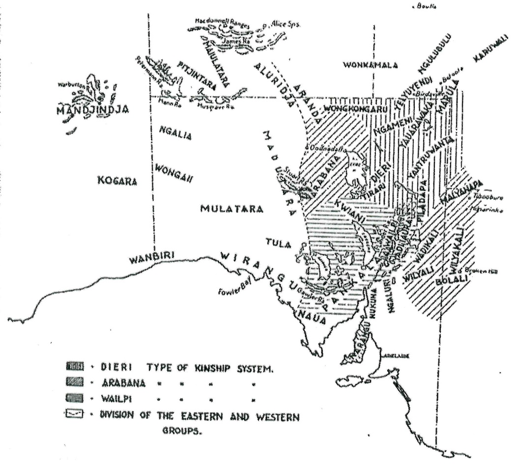
294 Graham and Liebelt seemed reluctant to acknowledge that this map of Elkin was inconsistent with their thesis concerning the country of the LSA. They said:
As the Arabana kinship shading extends well to the north of the town, one could assume [Elkin] intended Oodnadatta to be, at least partially within an area that shared at least some Arabana sociology though he is unclear on this …
295 Graham and Liebelt also considered that the fact that Elkin had drawn his line through Oodnadatta indicated that it was “divided ‘50-50’ between Arabana and Western Desert kinship systems” and that this had “to show that his opinions included that people possessing Western Desert social features were located this far to the east in South Australia”.
296 Elkin also recorded:
The totemism of the Macumba sub-tribe has thus affinities with both the Eastern and Western Groups, while its altjira mythology and aknaninidja (knaninja of Spencer and Gillen) totemism show its relationship to the northern Aranda.
297 In an article published in 1938 in Oceania entitled “Kinship in South Australia”, Elkin revised his map of the social division of tribes in South Australia. The revised map is as follows:
Map 17: Elkin’s 1938 Map of Kinship and Social Organisation in South Australia
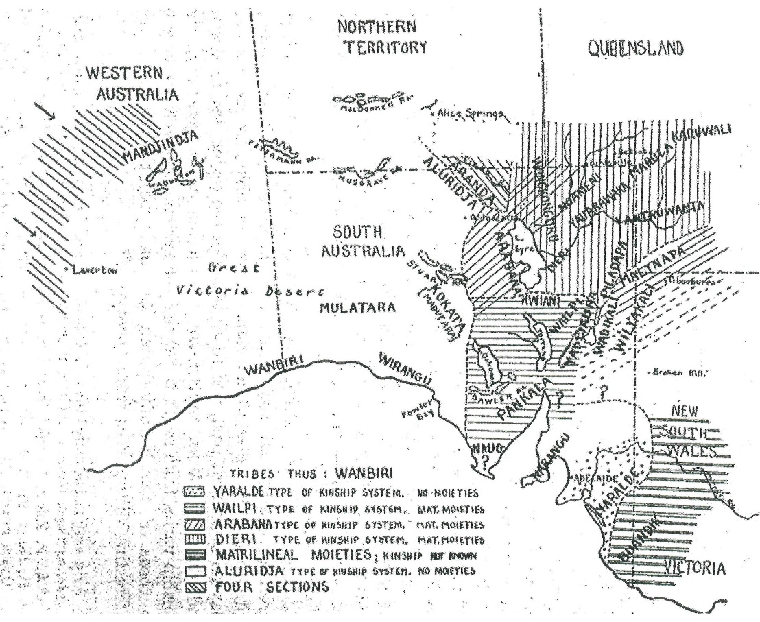
298 As is apparent, this map placed Oodnadatta within the area of the Aluridja but south of the area of the Aranda.
299 In the same publication, Elkin said:
[A] third region is the country of the Southern Aranda, extending from about Charlotte Waters on the Northern Territory boundary down the Finke and the Macumba to the vicinity of Lake Eyre; on their south of the Arabana, on the east the Wongkonguru, and on the west the Aluridja. The Southern Aranda are distinguished from the rest of the Aranda by the absence of the subsection system which had not spread to them; in its place they have the section system. They are different in this respect from the ‘Lakes’ Group, as also in not possessing matrilineal moieties and clans.
300 Generally, in relation to the LSA (whom he distinguished from the Arrernte more generally), Elkin had their country extending south to the Macumba and then east towards Lake Eyre. He has, however, shown Oodnadatta as either being in the lands of the Antakarinja or at least on its border. Given the relatively small size of the Overlap Area, that is not inconsistent with the 2006 Yankunytjatjara/Antakarinja Determination.
301 It was common ground among the anthropologists that the maps of Elkin were intended to illustrate aspects of his discussion of social organisation (kinship) rather than being a representation of tribal boundaries or geography. However, taken at face value, Elkin’s 1931 map locates Oodnadatta west of the dividing line between the Arabana and Western Desert kinship systems but also shows Arabana country as extending north from Oodnadatta. Elkin referred on several occasions to the “Macumba sub-tribe of the Aranda” and that he found members of this sub-tribe at Oodnadatta or on nearby Macumba Station. This may be taken as an indication of the presence of LSA at Macumba and Oodnadatta at the time of Elkin’s field work (I note that Gara considered that Graham and Liebelt’s statement that Elkin had found about 50 members of the Macumba sub-tribe either at Oodnadatta or on nearby Macumba Station to be incorrect as he had not located any statement by Elkin that he had found Macumba people in the Oodnadatta area).
302 Elkin published another map in 1940, which I set out below as Map 18.
Map 18: Elkin’s 1940 Map
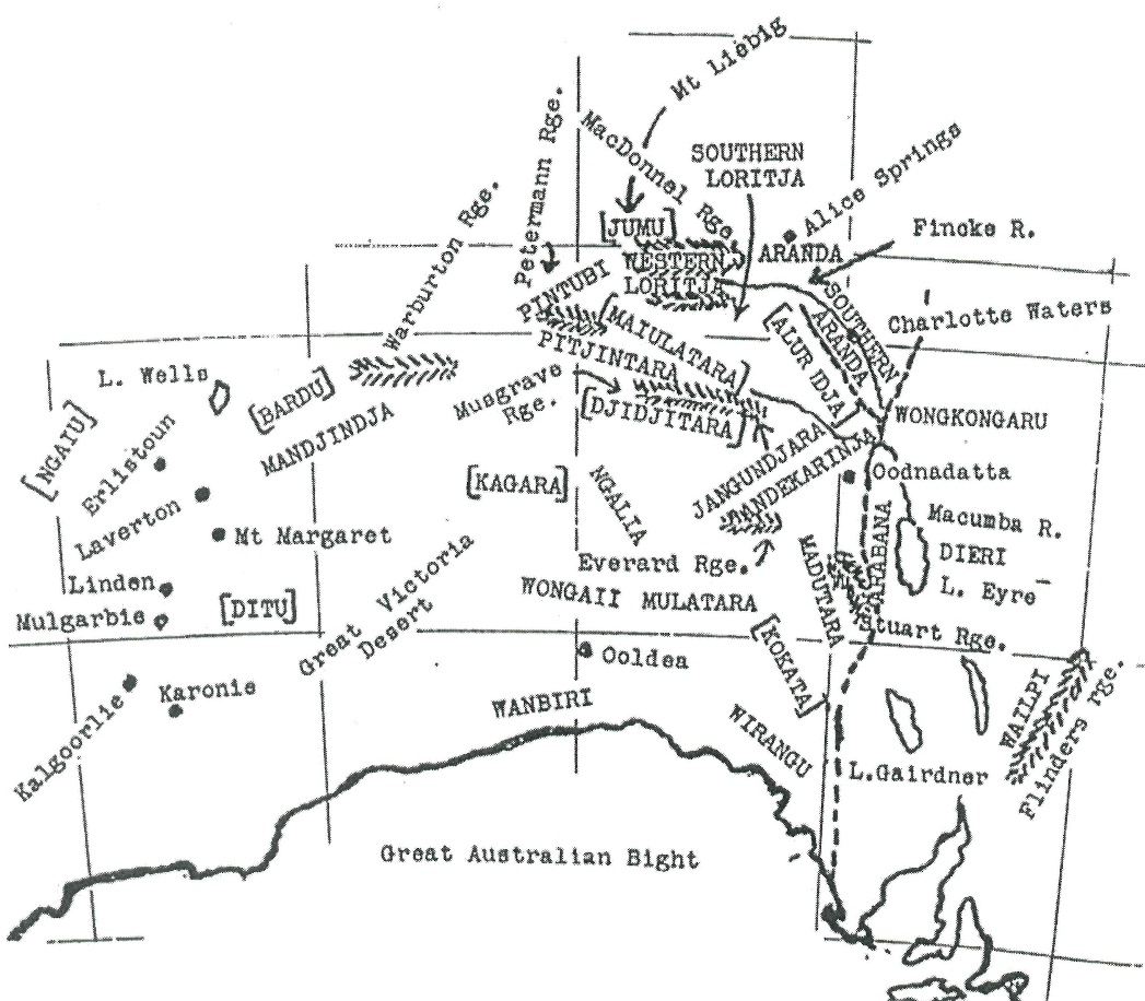
303 As is apparent, in Map 18, Elkin again placed Oodnadatta on the western side of the east-west divide, that is, outside the area of the Arabana and within the area of the “Alur Idja” and the Andekarinja.
304 Elkin also recorded the difference between the “Southern Aranda” and their northern neighbours, saying:
The third region is the country of the southern Aranda extending from about Charlotte Waters on the Northern Territory boundary down the Finke and the Macumba to the vicinity of Lake Eyre; on their south are the Arabana, on the east the Wongkonguru, and on the west the Aluridja. The Southern Aranda are distinguished from the rest of the Aranda by the absence of the subsection system which had not yet spread to them; in its place they have the section system. They are different in this respect from the “Lakes” Group, as also in not possessing matrilineal moieties and clans. The kinship system is the same as amongst the Aranda …
305 Elkin also reported:
[A]ccording to one of my Alurija [Luritja] informants, the Aluridja people moving South, displaced a portion of the Arabana tribe from the Oodnadatta district, so in between these two movements of people, the Aranda spread down the Finke south of Horseshoe Bend and Charlotte Waters and so across into South Australia.
306 Elkin recorded in his third notebook of his 1930 field trip that he had been informed by Butcher Dick at Welbourn Hill (approximately 160 km west of Oodnadatta):
This station really = Arabana country
first time
307 Lucas also noted a reference by Luise Hercus to Butcher Dick:
Hercus (1994:21) refers to Dick Butcher (seen at Indulkana in 1966) as ‘… an old man belonging to the Ngunthiya-Ngunthara, the easternmost of the Western Desert groups’. He ‘… recalled having heard from his father of ‘war’ that must have been waged in the middle of the nineteenth century in which Aranda people were ousted from the Mt Chandler-Lambina area by the easterly push of the Western Desert people, the Yangkuntyatyara and Antikirinya. This meant that some of the evicted Lower Aranda came to settle in Arabana country and there was considerable intermarriage between them and the Arabana people’. Elkin recorded Butcher Dick’s totem as ‘Kalea’ (karlaya/kalaia, emu) and that he was born at Lambina.
(Emphasis added)
308 Elkin considered that there had been westerly movement by the Western Desert people and southerly movement by the Arrernte. In his 1934 work entitled “Cult Totemism and Mythology in Northern South Australia”, Elkin said:
These Aluridja [Luritja] groups seems to have been migrating west and south and east in the far past, as they have been doing since the white settlement of South and Western Australia.
(Emphasis added)
309 In his 1939 work entitled “Kinship in South Australia”, Elkin spoke again of the movement of Arrernte and Aluridja people into the Oodnadatta area:
Just as the Dieri have a tradition of being pushed south to their present location by the Wongkonguru, and as, according to one of my Aluridja informants, the Aluridja peoples moving south, displaced a portion of the Arabana tribe from the Oodnadatta district, so in between these two movements of peoples, the Aranda spread down the Finke south of Horseshoe Bend and Charlotte Waters and so across into South Australia. Their movements may even have been a contributory cause of the southern migrations of the Wongkonguru and Aluridja, their eastern and western neighbours respectively.
310 Later in the same work, Elkin wrote again of the migration southwards:
[T]he Aborigines of western South Australia have been in a continuous state of migration southwards for some decades; a movement which I believe was in progress before the coming of the white man. This explains the similarities of dialects, kinship systems and mythology over such a vast area, and also the difficulty of fixing definite tribal boundaries and names.
311 Sackett concluded with respect to Elkin that, while he provided much information concerning aspects of the broad socio-cultural groupings of the region, his “mentions and mappings of the Oodnadatta area are too minimal, mixed and inconsistent to be able to ascertain from them in whose lands the township lies”.
312 Frank Fenner was the Professor of Microbiology at the Australian National University and, in 1934, participated in an expedition of the Board for Anthropological Research to Pandi Pandi and Mirra Mitta Stations. In a report on the expedition, Fenner included a map containing “the approximate boundaries of the territories of the various Aboriginal tribes of north-eastern South Australia”. This map was constructed from information supplied to him by Norman Tindale (to whom I will refer shortly). The map (Map 19) is as follows:
Map 19: Map of Frank Fenner
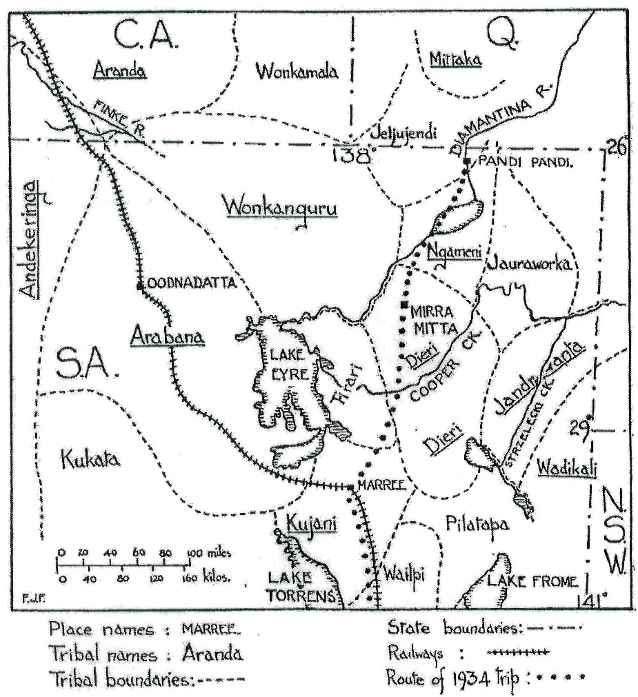
313 I am disinclined to attach much weight to this map. It shows Arabana land extending all the way to the Northern Territory border and the Arrernte not extending below that border. To this extent it is not consistent with any other historian or ethnographer. The precise basis upon which Fenner prepared the map has not been shown.
Ronald and Catherine Berndt: 1939
314 Graham and Liebelt referred to the work of the well-known anthropologists, Ronald and Catherine Berndt. In 1939, Ronald Berndt carried out field work at the Ooldea Soak, four miles to the north of the Ooldea siding on the east-west transcontinental railway line. Berndt recorded meeting Anta’kirinja People (and others) at the Ooldea Soak. In the work published in September 1941 on this field work entitled “Tribal Migrations and Myths Centering on Ooldea, South Australia”, Berndt recounted the report which he had received from Mr Wakerley of the United Aborigines Mission (UAM) at Oodnadatta that there were five different tribes congregated in the vicinity of that town, being Anta’kirinja, Aranda, Pitjandjara, Arabana and Unganoora. He also reported on the gradual movement south and east of the Anta’kirinja (at 5).
315 At 268 of the 1945 “A Preliminary Report of Field Work in Ooldea Region Western SA 1945”, the Berndts said “the ‘Antinari seemed to have belonged to the country adjacent to and south of the Alberga Creek; their territory did not include Oodnadatta. Those Antinari who were the prominent group in the Oodnadatta native camp during our recent visit to that region pronounced their tribal name as ‘Antinari or ‘Antinarinja”. Like Graham and Liebelt, I regard this as evidence that the Berndts had found Arrernte and Western Desert people in the claim area in 1945.
316 However, the Berndts also reported:
The ‘Andingari seemed to have belonged to the country adjacent to and south of the Alberga Creek; their territory did not include Oodnadatta. Those ‘Andingari’ who were the predominant group in the Oodnadatta native camp during our recent visit to that region pronounced their tribal name as ‘Andingari’ or ‘Antingaringja’ a considerable portion of these people were allied by ties of marriage to ‘Pitjandja’ (of the Ernabella area), ‘Aranda’, ‘Aluridja’ and ‘Arabana’.
(Emphasis added)
317 Graham and Liebelt also referred to extracts from the Berndts’ 1951 book “From Black to White in South Australia”, to which it will be necessary to return on one topic. I do note, however, the Berndts’ report that “historically the Antingari of the Alberga and desert country always possessed some associations with the southern Aranda”.
318 TGH Strehlow was the son of Pastor Carl Strehlow and a Reader in Linguistics at the University of Adelaide. He grew up speaking western (Hermannsburg) Arrernte, trained at the University of Adelaide and began detailed anthropological fieldwork with Arrernte people in 1932. He continued to do so for much of his later life, although primarily with the Northern Arrernte.
319 TGH Strehlow published a number of maps showing Arrernte boundaries. Graham and Liebelt referred to two, being those published in 1947 and 1971. In relation to the 1947 map, Strehlow indicated that he had less familiarity with the Arrernte in South Australia but did say:
Southern Aranda area with which I am personally familiar extends from Running Waters on the Finke River in the north-west, and Bad Crossing on the Hugh River in the north, to Old Crown Point on the lower Finke in the south-east. I am, of course, fully aware that Aranda dialects are spoken much further south than Old Crown Point. It has been stated by writers that the Aranda tribe once extended as far south as Oodnadatta in South Australia; and my northern Aranda informant Gurra, who, when he was a young man, was employed on a station situated near Quorn, confirmed this statement, saying that Aranda was once spoken from Central Mount Stuart in the north to Oodnadatta in the south. I have been unable to visit the area below Old Crown Point personally.
320 The Old Crown Point to which Strehlow referred is in the Northern Territory, well north of Charlotte Waters.
321 In his 1971 map, which Graham, Liebelt and Sackett accepted should be regarded as “more considered” than the 1947 map, TGH Strehlow showed the areas of the Lower Southern “Aranda” and the Arabana with the boundary between them just to the south of the Alberga and the Macumba Rivers and approximately 25 kms north of Oodnadatta. Strehlow’s 1971 map is as follows:
Map 20: TGH Strehlow’s 1971 ‘Lower Southern Aranda’ map
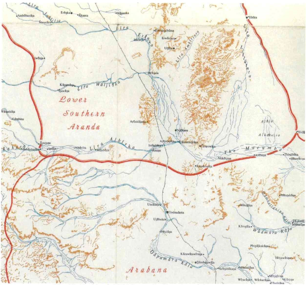
322 As is apparent, Strehlow, who had now identified the Lower Southern “Aranda” (as an extension of the Southern Aranda) placed them well north of Oodnadatta and Western Desert people well west of Oodnadatta.
323 In his 1971 field diary, Strehlow recorded (with underlining) “the whole of the Neales River is Arabana country”.
324 In her work entitled “The Western Desert Boundaries with Aranda and Arabana”, Dr Luise Hercus (to whom I will return shortly) gave the following endorsement of the reliability of TGH Strehlow’s work by reason of his insistence in obtaining information only from senior people who had acquired their knowledge from persons who were alive at or shortly after the time of effective sovereignty:
It was well known he was ultra-correct and conservative: he did not speak to, never mind elicit information from, any junior person, anyone whose knowledge was suspect or he thought might not have authority to speak … Because of this conservatism it is certain that he got much of his early information from people who grew up in the eighties of the last Century, and his later information (just as I did) from people who had constantly heard about the situation in the eighties from their seniors, and who had learnt songs and stories based on even older material. His map therefore on the whole appears to reflect the situation of the period of the eighties. It shows young Yankunytjatjara people having caused the Antakirinja to move further east with the boundary of the Aranda-Arabana vs Antakirinja being near Todmorden.
325 In his “Distribution of Australia Aboriginal Tribes” published in 1940, Tindale gave descriptions of the lands held by the Antakarinja, Aranda, Arabana and Wongkanguru respectively. He reflected these descriptions in the following map:
Map 21: Tindale’s 1940 Map of the Area of the Overlap
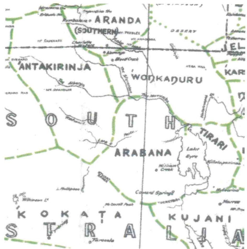
326 As is apparent, Tindale depicted the Overlap Area as well within Arabana land. The Antakarinja were to the north-west and the Southern Aranda to the north.
327 Tindale’s 1974 map of the area around Oodnadatta showed the Lower Southern “Aranda”, the Antakirinja, the Arabana and the Wongkanguru. Tindale based this map on the information provided to him by TGH Strehlow. It shows the Lower Southern “Aranda” area as extending south to about the Macumba but, in any event, north of Oodnadatta; the Arabana area extending at its northern most point to abut the Lower Southern “Aranda” area and therefore as encompassing Oodnadatta; and the Antakirinja area well to the west.
Map 22: Tindale’s ‘Tribal Boundaries in Aboriginal Australia’ 1974 Map
328 Both Lucas and Sackett regarded Tindale’s map as being a summation of the reports of others rather than based on Tindale’s own field work. Tindale had recorded that he had relied heavily on information provided by TGH Strehlow.
329 Hercus described Tindale’s map as representing a later stage than that of TGH Strehlow. She also said that Tindale’s map “probably represents Western Desert expansion as the date of about 1900”, noting that Oodnadatta in 1900 was “still very much an Arabana place, with some Aranda people there too”.
330 Graham and Liebelt said of the map of TGH Strehlow used by Tindale:
TGH Strehlow does have Macumba within Aranda land along with the Western Desert speaking group to the immediate west of Oodnadatta, again essentially consistent with the present Applicant Group members’ understanding.
That may be so (although Sackett suggested that it was “wide of the mark” for Graham and Liebelt to say that TGH Strehlow and Tindale had a Western Desert speaking group to “the immediate west of Oodnadatta”), but it is plain that both maps show the whole of the Overlap Area as being within Arabana country. That accords with the accompanying written descriptions given by Tindale.
331 Tindale also appeared to give an endorsement of TGH Strehlow’s findings:
The detailed work over many years of T.G.H. Strehlow has produced very detailed data about the boundaries and character of the several tribes that fall together under the name Aranda. Strehlow was happy to supply data, incorporating his field observations up to the year 1960. He is now sure that the Southern Aranda country touched on Arabana lands at Macumba, which is an Arabana, not Aranda, place name.
(Emphasis added)
332 Hercus, who died in 2018, was recognised as one of Australia’s most senior and authoritative linguists. She authored numerous publications with references to the languages in northern South Australia and it was common ground that she had a good overview of the anthropology of the Lakes Group. Arabana was one of the principal languages on which she worked. Hercus conducted extensive field work in the Oodnadatta region. That field work included work with the Arrernte and the Wangkangurru, as well as the Arabana.
333 In many of her publications, Hercus provided maps showing the locations of the languages which she discussed, including Arabana. An extract from her 1971 languages map is set out below as Map 23:
Map 23: Hercus’ 1971 languages map
334 Graham and Liebelt suggested that this map is consistent with the late 19th Century findings of Carl Strehlow, Stirling, Spencer and Gillen. With due respect, this inference is not convincing, and appears to be based on little more than Hercus having placed the name “Arabana” to the west of Lake Eyre and south east of the Peake Station. That reasoning is plainly unsound. Hercus did not show the LSA or the Antakarinja at all in her 1971 map, even though the Macumba and Neales Rivers were clearly marked. The understanding of the map proposed by Graham and Liebelt is also inconsistent with the languages map which Hercus published only one year later, in 1972, which shows Oodnadatta well within Arabana country:
Map 24: Hercus’ 1972 Map
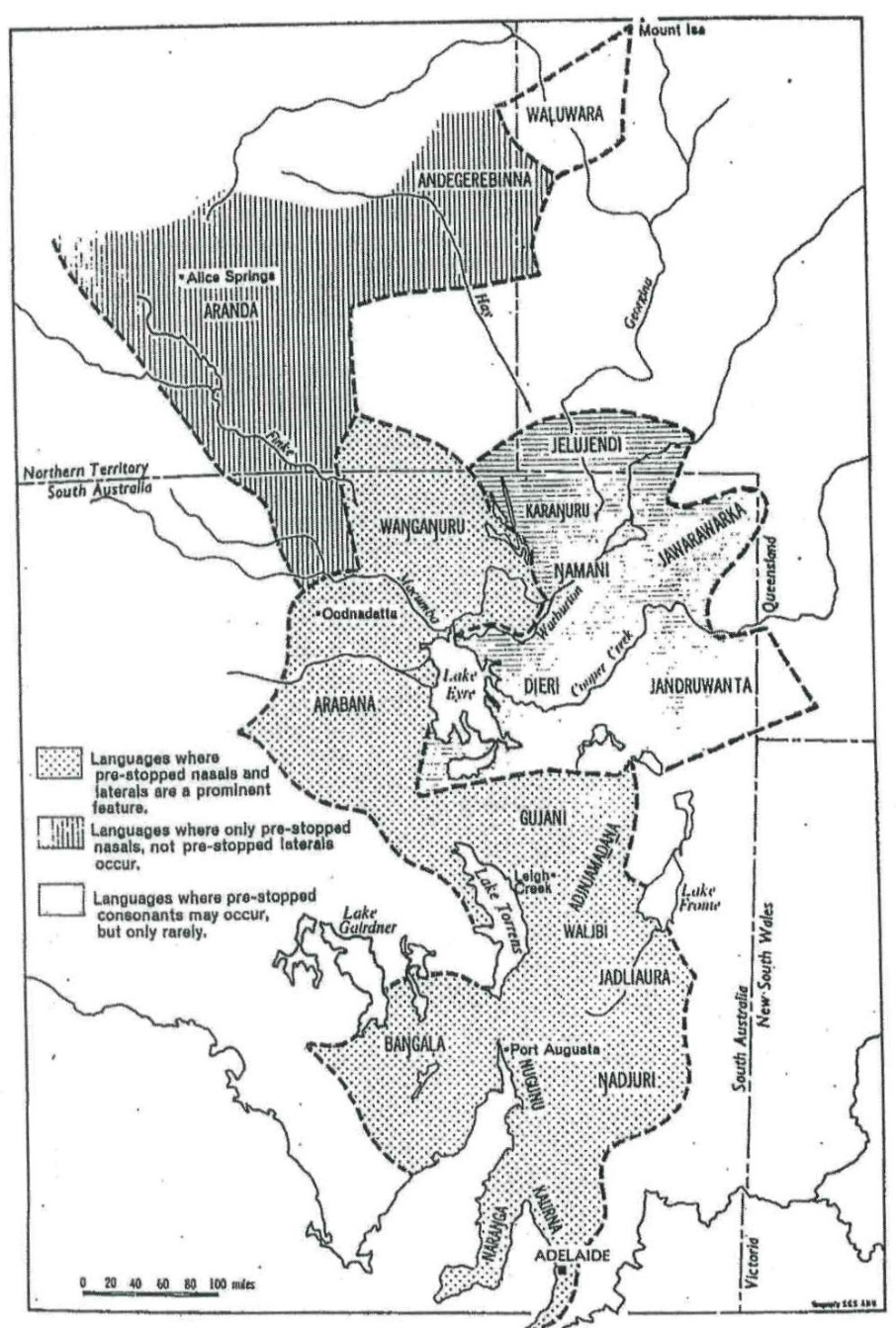
335 In the publication entitled “A Grammar of the Arabana-Wangkangurru Language” (1994), Hercus said:
Since Basedow's day Antikirinya people have gradually taken over the Oodnadatta area, and in the 1960s there were many of them even in the heartland of Arabana country at Anna Creek. Today there is not one single person of predominantly Arabana descent at Oodnadatta and only one at Anna Creek. The majority of the remaining Arabana people live outside their own traditional country at Marree and Port Augusta.
336 In this 1994 work, Hercus published a map drawn by Vlad Potenzy entitled “More detailed map of Arabana-Wangkangurru Country”:
Map 25: “More detailed map of the Arabana-Wankangurru Country”
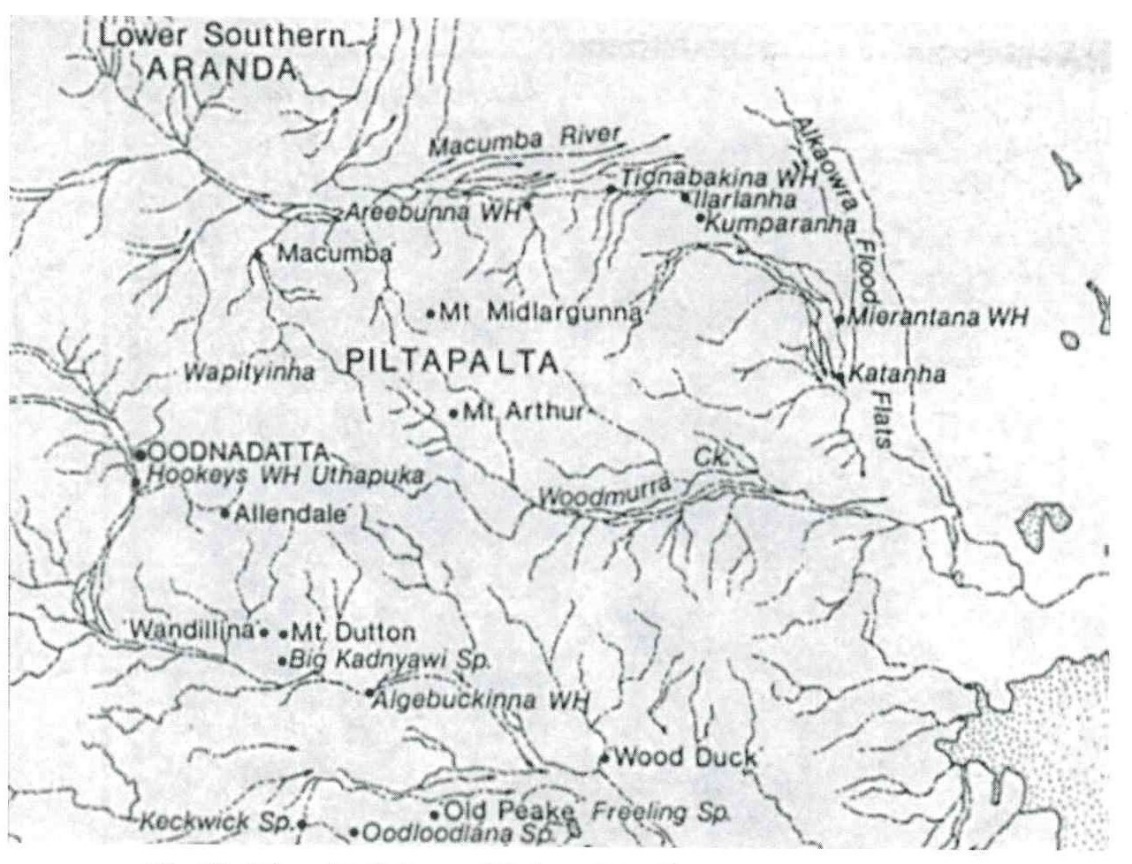
337 The name “Piltapalta” on the map is a regional dialect of Arabana. Mr Strangways, a senior Arabana man, described Piltapalta, Midlarilri and Wangkakupa as subgroups of the Arabana.
338 As is apparent, Map 25 shows the country of the LSA as north of the Macumba River.
339 In her work entitled “The Assessment of Aboriginal Cultural Significance of Mound Springs in South Australia” prepared for the South Australian Department of Environment & Planning in December 1985, Hercus reported:
Since the early years of this Century, persons of Antikirinja (Western Desert) origin had been coming to live and work in Arabana country, particularly at Oodnadatta and Anna Creek. Some senior men, such as the late Yumpy Jack, were actually born there. It would not occur to the more traditionally minded among them to dispute Arabana custodianship, but they like to be kept informed about any developments that might affect the mound springs.
(Emphasis added)
340 In her 1989 work entitled “The Status of Women’s Cultural Knowledge” with the subtitle “Aboriginal society in north-east South Australia”, Hercus included:
The worst blow for the status of women’s cultural knowledge in the Lake Eyre Basin was the arrival from about 1900 onwards of large numbers of people of Western Desert origin, particularly Antakarinja on Anna Creek station, at Oodnadatta and Macumba, and of Kukata people on Stuart Creek station. Amongst these Western Desert people women had separate knowledge and separate sites, but the overall responsibility was male. Arabana women had not previously had the same need for separate sites, and so they found themselves altogether disinherited.
(Emphasis added)
341 With respect to the LSA, Hercus reported that the oldest surviving LSA woman had knowledge of sites in the Dalhousie area (well north of Oodnadatta).
342 In her chapter entitled “Aboriginal People” in the Natural History of the North-East Deserts published by the Royal Society of South Australia in 1990 (eds MJ Tyler et al), Hercus included a map based on Tindale’s 1974 map. This indicated Oodnadatta and its surrounds within Arabana country and the country of the LSA well to the north. Hercus also said:
The views of Howitt, Elkin and Tindale about this area cannot simply be ignored: they were there when traditional systems were much more in place. However, it has become evident that traditional territorial boundaries were far more sophisticated than was originally thought. This increased understanding has come about gradually, and is mainly due to the important paper by Stanner (1953) and the 1973 discussions of Peterson (1976). The situation is particularly intricate in the north east where there were complex social and cultural links. Wangkangurru people did not talk about ‘boundaries’, there is in fact no such word in the language. They thought of the matter positively in terms of who ‘owned’ an area. They were conscious of a series of places where their territory ‘cut out’ and someone else’s began. Another way of talking about it was to say that one was ‘sorry’ because ‘that is the end of the country’. This ‘cutting out’ was viewed in some areas as quite definite, but sometimes it was viewed as more gradual, the neighbouring people may have had ‘a right in’ an area, ie. they could come there freely for ceremonies without this being considered an act of aggression.
343 In the same work, Hercus said of the Arabana and Wangkangurru:
People knew in meticulous detail who owned land: this is clear from all the comments made by traditional people on the subject.
344 In her work entitled “The Fire History” published in 1992 and co-authored with Vlad Potezny, Hercus recorded that Mick McLean, a part Wangkangurru and part LSA man who was born in 1888 in the Central Simpson Desert and who died in August 1977, “resented the fact that Antikarinja people had taken over much of LSA country and by the 1920s had come in considerable numbers into traditional Arabana country”. Hercus described him as having “outstanding traditional knowledge for most of the central north of South Australia” and that his main interests were the songs, stories and totemic geography of the Wangkangurru, Arabana and LSA People.
345 In her 1994 work entitled “A Grammar of the Arabana-Wangkangurru Language, Lake Eyre Basin, South Australia”, Hercus gave the following translation of statements from Mick McLean on 16 May 1969:
The (Northern) Arabana are right from Yardiya (Old Peake), and from Warrina. They went back to Oodnadatta, Uthapuka (Hookey's Waterhole) that was all one language along that creek (the southern side of the Macumba), Ipithanha, Mount Midlargunna. They went right up to Thurluwarangka, Mount Sarah and back to Paya-parrakanha and Wampityinha (a Rainbow Centre just south of Macumba station) and right down to Mundrupa and down along the Woodmurra Creek. They went to Mount Midlargunna, Thidnapakanha (Mount Tidnabakina), and Aripanha (Erebena waterhole), they went right up to Ilarlanha (just east of the Tidnabucca Waterhole) they followed the sandhills along to Kumparanha, and then to the Alkaowra flood flats.
(Emphasis in the original and footnoted omitted)
346 Mount Sarah, to which Mick McLean referred in this passage, is approximately 80 kms north of Oodnadatta. As Hercus noted, both TGH Strehlow and Tindale placed Mt Sarah in LSA country but she said that it had a ritual significance for Arabana people and that the name given for it by Mick McLean (Thurluwarangka) is an Arabana name.
347 In the same work, Hercus recorded a conversation she had had with Mick McLean and Tom Bagot (a LSA man) which included:
Hercus: They had a special place for that?
McLean: Midlaruku.
Hercus: Mount Midlargunna. And Thidnapakanha (Mount Tidnabakina)?
McLean: I suppose they were just living about … Only Thamunha (sacred site) for Wilyaru was Midlargunna, all on the north side … Irlalanha (water hole) is back from Kumparanha sand field. That’s Arabana country …
Hercus: So the border between Arabana and Aranda goes from the Todmorden road across to Macumba?
McLean: South of Macumba just a bit. Then Arabana run right across to that creek (the Macumba) then. There is Wangkatyaka along the Kallakoopah, the whole lot …
Bagot: Arakapaninha (hill).
McLean: That is all my country (i.e. Wangkangurru).
Hercus: Where do Aranda come in there?
McLean: You got to find Macumba Creek west side, we are east side altogether.
348 Hercus then referred to other information provided to her by her informants and concluded:
In this fashion we gradually pieced together an account of the full extent of ArabanaWangkangurru territory. The resulting picture does not deviate much from what is shown of the northern areas on Strehlow's map. The main difference is that Strehlow, who got his information from Southern Aranda speakers, included in Aranda country places where Arabana people had rights, while I, getting my information from Arabana and Wangkangurru people, have tended to include in Arabana-Wangkangurru country places in which Aranda and other neighbours had rights. The only other difference is with regard to the northwestern edges of Arabana country, where Strehlow has excluded the Coongra Creek.
349 As is apparent, TGH Strehlow and Hercus, working independently, came to remarkably similar conclusions as to the location of the boundary between the LSA and the Arabana.
350 Before leaving Hercus, I should record that Graham and Liebelt attempted something of a “rewrite” of Hercus’ opinion and map. They did so, first, by assuming that when in the conversation set out above, Mick McLean had said “… we are east side altogether”, he was referring to the Allowrie Flood Flats (north of Lake Eyre and well north-east of the Overlap Area and an acknowledged shared area) shown in the Hercus 1994 map; secondly, by plotting on that map the mythological sites to which Hercus had referred; thirdly, by inferring that the area within the lines so plotted had been the area intended by Mick McLean; and then reasoning further by saying that it was “a reasonable inference from [the] map that Lower Southern Arrernte country commences in the vicinity of Areebunna (sic) water hole on the mid-Macumba and extends west … and south (to include the Hookey’s Hole and other sites) and also including the Alkowara Flood Flats to the east as a shared country”.
351 In my view, this reasoning was highly speculative and, with respect to Graham and Liebelt, seemed to comprise an endeavour to make facts fit a predetermined thesis. Their reasoning is inconsistent with the conclusion repeatedly expressed by Hercus as to the extent of Arrernte and Arabana country, and I note that Graham and Liebelt made no attempt to reconcile their speculation with the conclusions of Hercus.
352 The same willingness to attempt a “rewriting” of the opinions of Hercus is evident in the following passage in the second report of Graham and Liebelt:
[85] Had Hercus been able to hear restricted men’s knowledge regarding Hookey’s Hole, we believe she [would] have also recorded Arrernte associations to that site also … Given that Hookey’s Hole and Mount O’Halloran are in fact, within in a mere 10 km of one another (on either side of Oodnadatta), we have no doubt that Hercus [would] have agreed with us that Lower Southern Arrernte people have interests in the claim area and Oodnadatta, based on the evidence available.
(Emphasis added)
353 Graham and Liebelt record that Paul Reader, who had been a Community Development Officer at Oodnadatta, had later been engaged by the Community to undertake a survey of Aboriginal heritage and sites across the wider region around the township. They included in their report a copy of Reader’s 1983 map of the “survey area” which I set out below:
26: Reader’s 1983 ‘survey area’ map
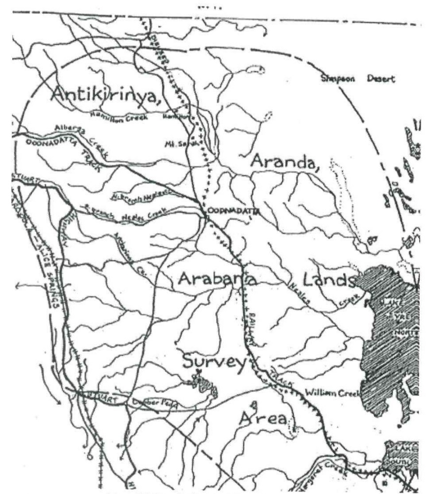
354 I would regard this map as non-conclusive for present purposes, although it could be regarded as consistent with Reader regarding the country of the Antakarinja and the Aranda as being north of the Alberga and the Macumba. As Reader’s report was not included in the tendered material, the Court does not have any accompanying text. In these circumstances, I do not consider that it would be appropriate to attach significant weight to Reader’s map.
355 Moreover, Sackett reported Reader as saying that “in the early 1950’s the Antakirinja (Yankunytjatjara) moved across to Anna Creek, and as a result of the mixing up of people inherited a section of Arabana heritage. This explained why I was able to talk with Antikiri people about the lands to the South”.
356 It is not clear what Reader meant by saying that the Antakarinja had “inherited a section of Arabana heritage”, but his reference to the Antakarinja having “moved across” is evidence of the easterly movement of Western Desert People into Arabana country, a matter to which I will return.
Daniel Vachon and Kym Doohan: 1986
357 In their 1986 anthropology report in connection with the claim to the Finke and Charlotte Waters Stock Reserves, Vachon and Doohan said:
Intermarriage, and resulting co-residence, between the Arapana and Southern Arrernte occurred “not infrequently” as early as the 1890s … The Wangkanguru of the Simpson Desert retreated to Lower Southern Arrernte permanent waters in times of drought by drawing upon ties of marriage and common sacred traditions … Our genealogical data shows that Arapana/Arrernte and Wangkanguru/Arrernte marriages occurred in the past, but not since and including the generation of the senior claimants. The obvious reason for the break-down in marital alliances between these groups is the depopulation of Arapana and Wangkanguru lands.
Unions between both subgroups of Southern Arrernte and Western Desert people have been recorded from around the turn of the Century.
358 Later, Vachon and Doohan commented again on the decline of “Arapana” population:
With the decline of Arapuna and Wankanguru traditions, the subsequent migration of these people to southern centres such as Port Augusta, and the influx Pitjantjatjara and Yankunytjatjara people from the west into the eastern pastoral zone, relationships between the Southern Arrernte and Luritja would have become all the stronger.
359 Isabel McBryde is an archaeologist who in 1987 published a Chapter entitled “Goods From Another Country: Exchange Networks and the People of the Lake Eyre Basin”. She described Arabana speakers occupying the west side of Lake Eyre “from Oodnadatta in the north and Coober Pedy in the west to Coward Springs in the south”. McBryde included the following map:
Map 27: McBryde’s 1987 Lakes Map
360 However, as Graham and Liebelt pointed out, McBryde did not provide information as to her informants. Again, I am disinclined to attach much weight to it for present purposes.
Bruce Shaw and Jen Gibson: 1987
361 Bruce Shaw is an anthropologist and, in company with the historian Jen Gibson, carried out extensive work with Aboriginal people in the Oodnadatta area in the 1980s. They recorded a number of the dreaming narratives of the people in the region, describing them in “Invasion and Resistance” (1988) as the “religious repertoire of Arabana and other Lake Eyre people”:
The stories are always associated with some part of the natural environment. Where they are retold below [in their report] it is important to know that for the Oodnadatta region they come second hand having once been the religious repertoire of Arabana and other Lake Eyre peoples. They are remembered and told now by Antakarinja and southern Aranda residents who inherited them from the original owners. For example Tom Brady though he has strong Antakarinja background through his mother sang in the Aranda language, and the Wangkangurru and Aranda traditionally shared territory and religious knowledge. The Antakarinja and southern Aranda people of the Oodnadatta region hold these stories in trust. They are custodians for other people.
(Emphasis added and footnote omitted)
362 One year earlier, in 1987, Shaw and Gibson stated in “Aboriginal History of the Oodnadatta Region”:
Although the folk whose history is recorded here for the most part call themselves Aluritja, Aranda or Antakarinja, those who peopled the Oodnadatta region earlier were the Arabana. The Antakarinja represented Western Desert culture; the Arabana were Lake Eyre Basin people.
(Emphasis added)
363 Shaw and Gibson recorded in the same publication:
It is evident that the Arabana lived west of Lake Eyre at the time of early Aboriginal-European contact and that representatives of the Aranda from the north and the Antakarinja from the west migrated towards Oodnadatta after the turn of the [20th] century. There was also some Arabana migration to the township. The area close to Oodnadatta appears to have lain on the fringes of Arabana territory and to have been a cross roads where Western Desert and central Australian cultures met with those of the Lake Eyre Basin.
(Emphasis added)
364 In his book entitled “Our Heart is the Land: Aboriginal Reminiscences from the Western Lake Eyre Basin” published in 1995, Shaw said:
Oodnadatta is situated at what appears to have been the fringes of Arabana territory, a crossroads where Western Desert and Central Australian peoples met with those of the Lake Eyre Basin. The Arabana were living west of Lake Eyre at the time of first Aboriginal-European contact. Representatives of the Aranda from the north and Antakarinja from the west migrated towards Oodnadatta at the beginning of the century. The southern Aranda had strong associations with the Macumba station area, intermarrying and sharing ceremonial and trade networks with the Wangkangurru. Later there was intermarriage between some Antakarinja and Arabana, but it was more usual between Antakarinja and southern Aranda and between southern Aranda and Arabana. Oodnadatta itself was not the focus of traditional Arabana life. That was a little further south, centring (sic) on what is today Anna Creek station, and descendants of Arabana people live in Maree and Port Augusta. In general, Arabana country seems to have been part of the great north-south trade route along which were exchanged pigments (ochres), grinding stones and pituri. Descendants of the Antakarinja, southern Aranda and Arabana maintain strong intergroup links.
365 I agree with Sackett that it does appear from these works of Shaw and Gibson that knowledge of stories and places around Oodnadatta for which Arabana people formerly were responsible has in more recent times been taken on by the LSA and Antakarinja. At least in the 1980s, this arrangement was regarded as one of trusteeship or custodianship and not ownership.
Finke River Land Claim: 1989-1990
366 Graham and Liebelt referred to the report of Olney J on the Finke River Land Claim published in October 1990 concerning the area of the Southern Arrernte in which he said:
It is our conclusion that this estate encompassed land as far south as Macumba and Oodnadatta. Its northern extremity was Urlita (not located on the site map but probably in South Australia) and Pmer’ Ulperre …
367 However, the focus of Olney J was not on the southern boundary of the LSA and I do not think that any significant weight can be attached to this statement.
368 However, if regard is to be had to the report of Olney J, I agree with Gara that further references are also pertinent:
Boundary sites between the lands of the Lower Southern Arrernte, Wangkanguru and Arapana are not specifically recognized probably due to the fact that the latter two groups have not occupied their traditional lands for many decades. However, general areas, expressed in such phrases as “Oodnadatta way” or “Simpson Desert country”, are still seen to be predominantly Arapana or Wangkanguru lands.
369 Graham and Liebelt also referred to an article published by Ms Nursey-Bray in 2013 which included a map of the “indicative distribution of Arabana country”.
370 This map did not show Arabana country extending to Oodnadatta. I am disinclined to attach much weight to this map bearing in mind its description as “indicative” only, which implies that it was not intended to be specific. Moreover, the map does not seem to correspond with the area which is the subject of the 2012 Arabana determination.
The reliability of the works of TGH Strehlow and Dr Hercus
371 It is convenient to refer at this point to the evidence in the trial which bears on the reliability of both the anthropological-ethnographic and linguistic aspects of the work of TGH Strehlow and Hercus. Their works are an important body of evidence which is inconsistent with the thesis of Graham and Liebelt. It is therefore understandable that they sought to diminish the value of the evidence. For example, Graham and Lucas said of Hercus:
[75] While Hercus’ work is fascinating and impressive in its scope, we expect it would include a number of omissions, mis-recordings and mis-interpretations, as all ethnographic recordings do. We would not expect it to reflect the total mythological significance for the region.
372 And in respect of TGH Strehlow, Graham said that there was nothing in the material to show that his southern boundary of the LSA boundary was “based on anything but what he referred to as the scraps from his later work in … ‘66, ‘67”. Graham and Liebelt also said that TGH Strehlow’s work “was not based on any immersion at or near Oodnadatta for a considerable length of time” but included “short visits working primarily with one or two informants”. They speculated that, if TGH Strehlow had based himself at pastoral stations or Oodnadatta “for some time”, he would have encountered knowledgeable informants who may have provided him with different information.
373 The matters which indicate that the Court is justified in relying on the works of TGH Strehlow and Hercus include:
(a) Strehlow and Hercus each undertook sustained research over a long period in the region and there were several attestations by the anthropologists as to the depth and value of their scholarship;
(b) Strehlow and Hercus did not engage only in forms of tribal mapping but were concerned to understand the societies, the vocabularies, the Ularakas and Tjukurrpas and the ceremonies and their relationship with the land;
(c) each of Strehlow and Hercus obtained information from informants whose memory did reach back to, or was informed by, the position at effective sovereignty. The value in doing so was confirmed by Cane who said that his experience had been that “traditional law and custom [had] existed in a fairly unadulterated form for at least a generation of the original contact group”. All the anthropologists agreed that there would not have been an immediate collapse of law and custom from 1870 onwards. It is likely to have been more gradual;
(d) some indication of the range of persons who had knowledge and memory derived in the way just explained and from whom Hercus obtained information is seen in her “A Grammar of the Arabana-Wangkangurru Language” (1994) in which she names 10 informants, two whom were born in the 19th Century and seven in the first three decades of the 20th Century. A further indication is obtained from Appendix A to the report of Graham and Liebelt of 22 November 2019 which lists 23 informants of Hercus, all of whom appear to be persons of some seniority. One of these was Arthur McLean, born around 1898 who said, “I am an Arabana man … I know my own site, it is Hookey’s waterhole …”;
(e) the Walka Wani submissions tended to disparage reliance of TGH Strehlow, saying that his opinions had been based on information from only one informant, Mick McLean. However, Mick McLean, who was also a principal informant of Hercus, had been born in 1888 so that it is reasonable to infer that his knowledge had been derived from persons who knew the position at or about the time of effective sovereignty. It is true that he was a Wangkangurru man but he was initiated as Arabana and was regarded as having good knowledge of Arabana law and culture. It is to be noted in any event that Mick McLean was not Strehlow’s sole informant in relation to the southern extent of LSA country. He also obtained information from Tom Bagot Inolja, a senior Lower Southern Arrernte man;
(f) each of Strehlow and Hercus was rigorous in their methodology. In her work entitled “The Western Desert Boundaries with Aranda and Arabana”, Hercus gave the endorsement of the reliability of Strehlow’s work to which I referred earlier:
It was well known he was ultra-correct and conservative: he did not speak to, never mind elicit information from, any junior person, anyone whose knowledge was suspect or he thought might not have authority to speak … Because of this conservatism it is certain that he got much of his early information from people who grew up in the eighties of the last Century, and his later information (just as I did) from people who had constantly heard about the situation in the eighties from their seniors, and who had learnt songs and stories based on even older material. His map therefore on the whole appears to reflect the situation of the period of the eighties. It shows young Yankunytjatjara people having caused the Antakirinja to move further east with the boundary of the Aranda-Arabana vs Antakirinja being near Todmorden.
(g) Strehlow’s confidence that he had information with which to delineate accurately the LSA boundaries is seen in the record he made in his 1971 field trip report:
My memory takes me back to those hard months of 1936 … when I took my unsuccessful journey from Hermannsburg to Macumba by camels in order to contact the last old LSA men of the Macumba region.
And so in the end all the Macumba men had died, [and] I had got nothing at all, from or about this southernmost part of the Aranda-speaking area.
Yet now, thirty one years after I had “missed” my “last” opportunity, Mick McLean has given me such an unexpectedly rich store of geographical names, of myths, [and] of verses from this very region, that I now know a very great deal about the mythology and totemic landscape of the whole country from Oodnadatta to Charlotte Waters. And I can delineate the southern boundaries of the Aranda-speaking area with confidence at last.
In his 1974 field trip report, Strehlow said:
These myths and songs go far to completing the sacred traditions of the LSA area, and are linked with neighbouring Arabana and Andekerinja traditions of ritual importance … with the aid of detailed maps previously held in my possession, a great deal of information was also gathered about the totemic geography of the area in which the above traditions have been placed, and my future maps of the LSA and adjacent tribal territories, will be greatly enriched by my 1970s Research trip.
(Emphasis added)
(h) not only did TGH Strehlow and Hercus name their informants, they kept the field books in which they recorded what they had been told. This contrasts with several of the early sources on whom Graham and Liebelt relied;
(i) the extent and rigor of Hercus’ methodology is evident in her substantial writings which were in evidence; and
(j) Strehlow undertook field trips to LSA country in 1965, 1970 and 1971. The Arabana closing submissions suggesting that TGH Strehlow had not undertaken field work at Oodnadatta is inconsistent with the evidence and is seemingly based on incomplete understanding of part of Strehlow’s writings. As already noted, Graham and Liebelt accepted that TGH Strehlow had performed field work at Oodnadatta. Their criticism was of its sufficiency.
374 I note in passing that, despite their critique of TGH Strehlow and Hercus, Graham and Liebelt were prepared to give credence to the opinions of ethnographers and anthropologists whose contact with the Oodnadatta region was fleeting, whose informants are unnamed, and for whom there are no field books.
375 To my mind, it is significant that both TGH Strehlow and Hercus, acting independently, placed the boundary between the Arrernte and Arabana in the same vicinity. This cannot be attributed solely to the fact that Mick McLean was a principal informant of both. Hercus explained the position:
In this fashion we gradually pieced together an account of the full extent of Arabana-Wangkangurru territory. The resulting picture does not deviate much from what is shown of the northern areas of Strehlow’s map. The main difference is that Strehlow, who got his information from Southern Aranda speakers, included in Aranda country places where Arabana people had rights, while I, getting my information from Arabana and Wangkangurru people, have tended to include in Arabana-Wangkangurru country places in which Aranda and other neighbours had rights.
376 In my view, the works of TGH Stehlow and Hercus are reliable, and it is appropriate for the Court to place significant weight on them.
377 A significant part of the evidence of the anthropologists and Mr Gara in the concurrent evidence was directed to the issue of whether the maps prepared near to the time of effective sovereignty were more definitive in their representation of the location of country.
378 In the joint report prepared following the conference of experts (the JER), Cane, Graham and Liebelt expressed the view that the early maps were more definitive than the later maps. In the evidence at trial, Graham and Liebelt maintained that position. Liebelt identified the early maps to which she and Graham were referring as those of Robert Hogarth (1884), Otto Siebert (1898), JG Reuther (1890s), Pastor Strehlow (1910) and, “to an extent”, RH Mathews (1900). Graham added the map of Fr Schmidt (1919) to that list. In effect, Graham and Liebelt preferred the maps of the early ethnographers or anthropologists which favoured the Walka Wani case over those which did not, particularly those of TGH Strehlow and Hercus.
379 None of Lucas, Sackett and Gara agreed that the identified maps were more definitive than the later maps. Cane said at trial that he had not looked at the maps. I understood that Cane had not regarded it as part of his role as an expert witness retained by the Walka Wani to do so.
380 For the reasons which follow, I conclude that the maps to which Graham and Liebelt referred cannot, considered objectively, be regarded as “more definitive” of the location of the country of the various peoples than the later maps. I preface my reasons for this conclusion by indicating my acceptance of the common sense proposition stated by Lucas that all maps are only as good as the data on which they are based and it is common experience that, as the data increases, the reliability of the maps on which they are drawn also increases.
381 Hogarth provided Howitt with a handwritten map in 1884, probably under cover of his letter of 13 April 1884. This is Map 4 set out above.
382 As previously noted, that map placed the northern boundary of the Yandairunga (Arabana) country north of the Peake but south of Oodnadatta (which did not then exist). Given Hogarth’s familiarity with the area (he had at that stage been at Anna Creek Station for approximately 20 years) and his familiarity with the Arabana and their language and customs, this would on its face constitute evidence from a person well placed at the time to provide a considered assessment. However, given that Oodnadatta did not then exist, Hogarth could not have been directing his attention specifically to the location of the boundary in relation to Oodnadatta. It may also be pertinent that Hogarth did not include any indication of the boundary with reference to Hookey’s Hole. A third qualifying factor is that the Court was not provided with Hogarth’s description of what he intended to represent in the map.
383 However, those matters can be put aside because, as previously noted, only 16 months later Hogarth presented the paper (to two audiences) in which he said that the Yandairunga claimed as a hunting-ground all the country extending from Strangways Springs in the south to the Alberga Creek in the north. This is seemingly inconsistent with the depiction in the map.
384 A number of explanations are available for the inconsistency:
(i) Hogarth was not purporting to indicate the full extent of Arabana country in the 1884 map;
(ii) Hogarth was drawing a distinction between Arabana country, on the one hand, and Arabana hunting grounds, on the other;
(iii) the 1885 description is more authoritative because it was part of a formal presentation by Hogarth to two public audiences, so that Hogarth was exercising particular care to be accurate; and
(iv) Hogarth had obtained further information between his sending of the 1884 map and his preparation of the formal paper.
385 Counsel for the Walka Wani suggested that the record of the address of Hogarth to the two audiences was only a journalist’s report of Hogarth’s presentation, rather than his own paper, with the possibility for error by the journalist. I consider that implausible as, not only does the document describe itself as the paper read to the two audiences, it is in the nature of such a paper, rather than a journalist’s report.
386 The development of Hogarth’s information over time is indicated by reference to Howitt’s 1891 map (based on information provided by Hogarth and others) which located the Yandairunga people boundary only a little south of the Frew (Macumba River).
387 In my view, there is no reason to regard the 1884 map as more reliable than Hogarth’s 1885 description. In fact, there are three reasons to regard it as less reliable: the general presumption that a later work of an ethnographer can be regarded as more considered; in the 1885 paper, Hogarth was quite specific as to the location to the north to which Arabana country extended, i.e, Alberga Creek; and, even though lines of latitude and longitude were included on the 1884 map, it is plain that there were elements of approximation in the way the map is drawn.
388 The extract of the relevant portion of this map is Map 8 set out earlier in these reasons. Matters which favour the reliability of Siebert’s map are that he knew the purpose for which it was being prepared, i.e, to show “tribal boundaries”; that he took great care in its preparation; and that he had visited Oodnadatta before providing the map to Howitt.
389 However, there are matters which detract from its reliability. First, Siebert located Oodnadatta too far to the west from its true position (it is partly obscured on the map by the third X in the “XXX”). Although this was initially disputed by the Walka Wani, it later became an agreed fact. That by itself indicates some approximation in Siebert’s markings. Graham agreed with Gara that Siebert had drawn the location of Oodnadatta inappropriately and said that the map had “geographical inaccuracies all over it”; that it cannot be taken “as being gospel as geographic accuracy”; and that all it really indicated was that Oodnadatta was somewhere near the boundary between Arabana and Lower Southern Arrernte country. Graham (but not Liebelt) also agreed that Siebert should have shown the western boundary of the Arabana further to the west than he did.
390 The combined effect of these two errors is that it is possible that, on Siebert’s own map, Oodnadatta should be located within Arabana country. Even if that not be correct, these matters undermine confidence in any view that the Siebert map be regarded as definitive.
391 I will refer to Reuther’s map (Map 25) in my discussion of the linguistic evidence. For the reasons I there state, there are reasons to be cautious about placing reliance on Reuther’s map, including that he was linguistically “untrained” and Stockigt’s disparagement of the quality of his analysis of the Wangkangararru language.
392 To these reasons can be added other matters. The first is that there is no evidence of Reuther ever having come to the Oodnadatta region. The second, related to the first, is that the focus of Reuther’s interest was on the Dieri people, who are located east of Lake Eyre (although one may accept that it was not his sole focus). A third matter is that it is evident that Reuther derived his map and its details almost completely from Siebert’s map (or an earlier version of that map). A simple comparison of the two maps indicates that that is so. Whether this was with, or without, Siebert’s authority, and whether it occurred before Siebert sent his map to Howitt, is immaterial for present purposes.
393 It is accordingly not easy to understand how Reuther’s map can reasonably be regarded, any more than Siebert’s map, as more definitive of the locations of the Arrernte and the Arabana.
394 Pastor Strehlow’s map is Map 14 set out above.
395 As I noted earlier, the information on which Pastor Strehlow relied is unclear. Graham and Liebelt thought that he had acquired a good understanding of group distributions while at Killalpaninna but TGH Strehlow thought that his father’s informants had been Arrernte men from north and west of Arrernte country. Their detailed knowledge of the boundaries of LSA country some 500 kms away must have been limited.
396 Even if Pastor Strehlow had relied on information obtained when he was at Killalpaninna, the opportunities for him to have then obtained detailed information about boundaries in the Oodnadatta region must also have been limited. He was at Killalpaninna for only 17 months before moving to Hermannsburg. In that 17 months, he learnt Dieri and undertook and completed the major task of translating the New Testament into the Dieri language. This, together with his other work, must have limited his opportunities for obtaining details regarding the boundaries of the country of the “Aranda Tanka”.
397 Even if those issues are put to one side, there are other matters affecting the reliability of Pastor Strehlow’s map:
(i) there is no evidence that the LSA called themselves Aranda Tanka (which allows for the possibility that the name is one applied to them from further north);
(ii) the boundaries of the Aranda Tanka are shown by straight lines, and it was common ground that the boundaries between country of Aboriginal peoples are not of that kind;
(iii) Pastor Strehlow did not draw the map himself. Instead, it was drawn by others using information from Pastor Strehlow, Siebert, WE Roth, Howitt and Spencer and Gillen. Graham and Liebelt did not even refer to this important information concerning the manner in which Pastor Strehlow’s map was drawn;
(iv) Pastor Strehlow had not in his writings defined exactly the territory of (relevantly) the eastern and southern Arrernte; and
(v) Graham acknowledged that Pastor Strehlow’s map had, insofar as it purported to show the countries of other peoples, gone beyond the area of his expertise.
398 All these matters raise real issues about the reliability of Pastor Strehlow’s map and its ability to be definitive of the boundary between the LSA, on the one hand, and the Arabana, on the other.
399 Mathews’ map is Map 13 set out above.
400 Graham and Liebelt regarded Mathews’ map as more definitive “to an extent”. The basis of their qualification was not made clear.
401 As is apparent from the map, Mathews showed Oodnadatta within Arabana country. I have previously noted that Mathews was a surveyor, was well regarded, and that he made use of information provided by more than one informant.
402 Moreover, the later works of Mathews consistently indicate that it is the Alberga/Macumba which is the boundary between the LSA, on the one hand, and the Arabana, on the other. There is no reason not to regard Mathews’ 1900 map as reliable for its time as a depiction of the approximate country of the Arabana and the Andijarina.
403 The map of Father Schmidt is Map 15 set out above. It is to be noted that Graham and Liebelt are now relying on a map published 45-46 years after effective sovereignty.
404 For the reasons given earlier, Father Schmidt’s map cannot reasonably be regarded as definitive (or more definitive) of the boundary between the Arabana and the LSA. It is instead in the nature of a broad brush indication of the distribution of the Aranda language in the entire Australian continent. It does not purport to descend to the detail of the boundary of two Aboriginal peoples. Graham’s observation that any high school student could, with the same data, have drawn the map tends to belie the significance which he and Liebelt sought to attach to it.
405 Graham and Liebelt passed over other early maps set out earlier in these reasons (which, I note, were generally inconsistent with the Walka Wani case). These included the maps of Howitt and Spencer and Gillen.
406 The maps of Tindale in the 20th Century are generally inconsistent with the Walka Wani case. Elkin’s maps do, however, provide some support for the thesis of Graham and Liebelt.
407 It is not necessary to repeat the matters set out above which support the reliability of the maps drawn by TGH Strehlow and Hercus. The closeness of their depictions of the boundary seem more than coincidence. Each had undertaken considerable field work in order to obtain the data on which the maps were based. Each had been astute to speak to the old people who had memories stretching back to the early 20th Century and who had themselves been informed by people who were alive at the time of effective sovereignty. The position they were in may not have been quite as good as it would have been had they been able to speak to persons at the time of effective sovereignty but it would be odd for their maps to be regarded as less definitive than those prepared by persons who did not ever go to the region themselves or whose research was much more limited.
408 Of course, it is not only the maps but the written descriptions which were given of the extent of country which are important. There are some which support the Walka Wani, and some which may be regarded as inconclusive. But overwhelmingly, the maps and the written descriptions of the extent of country are not consistent with the Overlap Area having been the country of the Antakarinja or the LSA.
Conclusion on the ethnographic-historical material
409 Graham and Liebelt concluded from their review of the ethnographic material that the evidence shows that, in the majority of cases:
(1) Lower Southern Arrernte people were associated with the Oodnadatta –Macumba area north to Moorilperinna Waterhole and other sites straddling the Northern Territory – South Australian border;
(2) Western Desert speaking people variously described as Yankunytjatjara, Antakirinya or sometimes Luritja were associated with an area to the immediate west of but also on some maps including Oodnadatta;
(3) A close social relationship exists and can be inferred from the record to have long existed, between Arrernte and Yankunytjatjara people to the extent that they consider themselves as living under one joint ‘Law’. This includes a shared form of communication, kinship, ceremonial life, mythology and shared responsibility for sites.
(4) Arabana people were considered as being associated with the immediate area south of Oodnadatta and down in vicinity of western Lake Eyre past Peake and Anna Creek.
(Citation omitted)
410 In my view, and contrary to the opinion of Graham and Liebelt, the ethnographical-historical evidence overwhelmingly supports the conclusion that the Overlap Area was Arabana country at the time of effective sovereignty. That is also the opinion of the ethnographic-historical material taken by Lucas, Sackett and Gara.
411 The sources on which Graham and Liebelt and the Walka Wani relied do not provide a credible case to the contrary. For the most part, the Walka Wani relied on persons who had not even been to the region (for example, Woods and probably Helling), or whose presence had been only transient (Herman Kempe, Gillen and Warburton (if confined to the 1886 publication), East and Lady Tennyson).
412 The evidence of those who spent sustained periods in the region and who were familiar with the Arabana and the Arrernte or both, generally support the view that the Overlap Area was within Arabana country. In this group, I include Giles, Robert Hogarth (his later publication), Byrne (with qualification), Stirling, Spencer and Gillen, Tom Hogarth, the Berndts, TGH Strehlow, Hercus and Shaw and Gibson. There are those who did not themselves go to the region but who did obtain information from a range of informants from within the region. These include Howitt (although his papers are less definitive) and RH Mathews.
413 There are some who provide support for the Arrernte position (Siebert, Pastor Strehlow, Elkin and Dr Basedow) but the analyses of the works of Siebert, Pastor Strehlow and Dr Basedow in particular indicate reason to doubt the reliability of their depictions of the position at effective sovereignty. It is not entirely clear that Elkin was intending to indicate the position at the time of effective sovereignty. Even if he was, his conclusions are, as Sackett noted, “too minimalised and inconsistent” to indicate reliably the boundaries and they are in any event outweighed by the significant evidence to the contrary.
414 I conclude that the ethnographic-historical evidence supports strongly the Arabana claim as to the position at effective sovereignty and is inconsistent with that advanced by the Walka Wani. However, the identification of whose country the Overlap Area was in at effective sovereignty, i.e, who “owned” it, is not conclusive of the question of whether the Walka Wani also had NTRI in it.
415 Arabana is a Karnic language; Lower Arrernte is an Arandic language; and Antakarinja is a Western Desert dialect. Each is a Pama-Nyungan Aboriginal language, described by Stockigt as the “large over-arching family of languages … [covering] 90% of the Australian continent and comprises some 290 languages”.
416 As previously noted, the Court received linguistic evidence from two experts: Stockigt called by the Arabana and Black called by the Walka Wani. Stockigt has undoubted expertise in the specialised field of linguistics and, in particular, with Pama-Nyungan languages. Her PhD thesis, which compared 19th Century and early 20th Century grammatical descriptions of all Pama-Nyungan languages, was awarded a 2017 University of Adelaide Doctoral Research Medal and the 2018 University of Adelaide Post-Graduate Alumni Medal. In 2018, through the University of Newcastle, Stockigt conducted linguistic fieldwork in Alice Springs with Sydney Strangways, one of the Arabana witnesses.
417 Black is also well qualified having been engaged in the study of linguistics since 1964. He was awarded a PhD by Yale University in 1975. Black moved to Australia in 1974 and, between 1990 and 2015, was Senior Lecturer in Applied Linguistics at Charles Darwin University. Before that, Black had held other tertiary or research positions in linguistics. Although well qualified as a linguist, it was not clear that Black has the same specialised knowledge of Arabana and Arrernte as does Stockigt. As he himself acknowledged, his main linguistic work in Australia had been on Cape York Peninsula.
418 The evidence of Stockigt and Black was directed to the extent to which place names and vocabularies recorded in and around the Overlap Area at or shortly after effective sovereignty were Arabana, Southern Arrernte or Western Desert in origin. The linguistic evidence, in particular the evidence as to the origin of place names, does not of itself indicate whether there existed the requisite connection with land in accordance with traditional law and custom but it can assist in identifying the language to which a country belongs and therefore in answering the enquiry as to connection.
419 Stockigt provided a report dated 19 March 2019 in which she addressed two principal questions, being the location of Arandic, Karnic and Western Desert languages, in around the Overlap Area at sovereignty and the language belonging to the Overlap Area at sovereignty.
420 Black provided a report dated 30 July 2019 in response to a request that he address two matters:
(i) consideration and analysis of Stockigt’s report of 19 March 2019; and
(ii) the linguistic data provided by SANTS and any other data which may provide evidence of a correlation between the Aboriginal language words recorded by ethnographers or linguists in and around the Overlap Claim and the likely Aboriginal people who lived in and around Oodnadatta.
421 However, for the most part, Black’s report of 30 July 2019 comprised a review and critique of Stockigt’s report (a matter confirmed by the sub-title he gave to the report).
422 Stockigt provided a report on 26 September 2019 which was responsive to Black’s report of 30 July 2019.
423 Pursuant to the Court’s order, Stockigt and Black conferred on 14 and 15 October 2019 with a view to identifying the matters on which they agreed, with or without qualification, and those on which they disagreed. They provided a joint report arising from that conference on 16 October 2019.
424 On 16 July 2020, Black provided a further report entitled “Addendum to the Joint Linguistic Report” and, on 9 October 2020, Stockigt provided a report with the title “Responses to Black’s Addendum to ‘Joint Expert Linguistic Report’”.
425 Stockigt and Black gave evidence concurrently on 19 and 20 October 2020. There was understandably some development in the opinions of each over time as they responded to the critique or new material provided by the other or by the parties themselves.
426 While I considered both Stockigt and Black to be impressive witnesses, I have more confidence in the opinions of Stockigt. Her opinions seemed to be well researched, well-reasoned and her evidence revealed a deep knowledge of the subject matter, greater than that of Black. Amongst other things, she had delved more deeply into source materials. Black showed the valuable ability to consider alternative explanations for many of the matters on which Stockigt relied. In some instances, these seemed to be more in the nature of theoretic logical possibilities rather than realistic alternatives but I regarded them as a good check against a too ready acceptance of Stockigt’s opinions. There were also particular matters in Black’s evidence which undermined my confidence in the reliability of his evidence. I will refer to particular aspects in the following reasons.
427 To a significant extent, the issues about which Stockigt and Black provided opinions required their identification and assessment of matters which are in the nature of circumstantial evidence. Earlier, I referred to the way in which the Court proceeds when considering whether matters which are the subject of circumstantial evidence have been established. Each item of evidence although insufficient by itself to warrant a conclusion, may, when considered with other pieces of evidence, be sufficiently probative to discharge the onus of proof. An item of evidence is not discarded because it is not sufficient by itself to warrant the ultimate conclusion. It is to be used together with all the other evidence which the Court accepts. I had the impression more than once in Black’s evidence that he tended to disregard an item of evidence simply because it did not, by itself, lead necessarily to the conclusion advanced by Stockigt. It is the combined effect of the matters to which Stockigt referred, supported in many instances by other evidence in the trial, which I have found persuasive.
428 One consequence of the way in which the reports were prepared, in particular, Black’s report being in the nature of a critical review of Stockigt’s first report, is that the first Stockigt report provides a convenient framework by which to assess the respective opinions.
429 Stockigt commenced by noting that different languages can share features by diffusion across linguistic boundaries and continued:
[22] That three different types of languages converge close to the claim area at Oodnadatta was recognised by the Austrian philologist W. Schmidt (1919), who made the earliest attempt to systematically classify Australian languages. Early anthropologists/ethnographers took account of linguistic information when demarcating Aboriginal people into tribal/linguistic entities on maps. All researchers have agreed that Arrernte belonged to country to north of Oodnadatta, that Western Desert language belonged to country reaching far to the west of Oodnadatta, and that Arabana belonged to country to the east and south of Oodnadatta, the exact location of the boundary between these three linguistic/cultural entities has been differently represented by different researchers, as summarised by Lucas (2018: 8-10).
[23] Lines that are drawn on maps demarcating boundaries between one language and another are, however, in most cases an inaccurate representation, and in my view, this is especially true in the region surrounding the claim area. When considering the nature of boundaries in the region Hercus stresses that:
Arabana-Wangkangurru people did not think in terms of boundaries: there is in fact no such word in the language. They were however certainly conscious of a series of places where their territory ‘cut out’ and somebody else’s began. (Hercus 1994: 15)
Hercus goes on to explain that ‘the situation in (sic) particularly intricate in the Lake region, which has such complex social and cultural links’.
430 Stockigt identified vocabularies and word lists compiled by the early white explorers, ethnographers and anthropologists. She said that “the early records of Arabana that are available in mapped place-names, manuscripts, and in publications provide a solid database from which the association between language and country can reasonably be deduced”. Black did not disagree with that proposition and indeed expressed a preference for the early records over the works of TGH Strehlow and Hercus.
431 As her source material for place names, Stockigt relied on Pastoral Run Sheets for the period 1893-1910, the 1971 map of TGH Strehlow and on the Ularaka histories published by Hercus. She referred to these as names which were mythologically embedded in the landscape. Although Strehlow and Hercus had published their material well after the time of effective sovereignty, Stockigt regarded it as appropriate to rely on that material as the information they had obtained had “reached back to at least the earliest years of the 20th Century and [had been] informed by intact understandings of Classical societies in the region”, in particular, the informants Mick McLean and Maudie Naylon.
432 Stockigt also reviewed the word lists or vocabularies from seven sources prepared in the period 1875-1903. These comprised words recorded by FW Andrews (1875), F Gillen (1875), Taplin (1879) (which included vocabularies recorded by Trooper Born), Curr (1886) and Spencer (1903). She concluded that the language “overwhelmingly recorded” to the south east of the claim area, and within the area of the 2012 Arabana Determination, was Arabana. Stockigt also concluded that the language “overwhelmingly recorded’ to the north of the Overlap Area and north of the Macumba River was Arandic and (in her first report) that there was no evidence of any Western Desert language in any of the earliest lexical records for the vicinity of the Overlap Area. While there were some Arrernte words in word lists which were otherwise Arabana, and vice versa, Stockigt surmised that these resulted from the post-colonial movement of individual Arrernte and Arabana people.
433 Stockigt’s analysis of the place names in the early sources led her to conclude:
(i) the vast majority of place names in the Arabana language in the vicinity of the Overlap Area are located in the area of the 2012 Arabana Determination;
(ii) the vast majority of place names in the Arrernte language are located in country north of the Macumba River;
(iii) there are no place names in the Western Desert language at all in in the vicinity of the Overlap Area; and
(iv) both the Arabana and the Arrernte were associated with the region close to the Macumba River.
434 Stockigt also examined the language in the Arabana Ularakas, noting that the language in which an Ularaka is told or sung frequently changes to reflect the language associated with the country through which the ancestor travels. Her examination of the Ularakas tended to confirm the results derived from her examination of the place names.
435 Stockigt said that she had concluded “beyond reasonable doubt” that at effective sovereignty:
(i) Arabana language belonged to country to the south of the Macumba River, including the Overlap Area and that other Karnic languages were spoken to the east of Arabana;
(ii) Lower Arrernte language belonged to country north of the Macumba River; and
(iii) Western Desert language belonged to country well to the west of the Overlap Area and to the area of the 2012 Arabana Determination.
436 Stockigt also concluded that linguistic features had been shared over a Lower Arrernte and Arabana “boundary” over a sustained period of time, at least some centuries prior to sovereignty. She concluded that the boundary comprised a “transitional zone”, or a “liminal linguistic and geo-mythological zone”, in which the Lower Arrernte and the Arabana owned country, with the northern boundary of the zone being well within Lower Arrernte country and the Overlap Area being at its most southern edge. Stockigt noted in particular that there is no evidence of Arandic presence south of Oodnadatta.
437 Stockigt said that she had then formed the opinion “on the balance of probability” that the language belonging to Oodnadatta and the Overlap Area was Arabana, and indicated that she had relied in particular on Gillen’s 1875 record of the Arabana term Kadni recorded at Angle Pole, the high frequency of place-names ending the suffix – nha to the north of Oodnadatta and the works of TGH Strehlow (1971) and Hercus (1994), both of which were based on information provided by Arrernte and Arabana people whose memory, or sources of understanding, reached back to effective sovereignty.
438 While repeating the caution sounded by Hercus to the effect that lines drawn on maps to demarcate boundaries between one language and another are often inaccurate, Stockigt concluded that:
(a) the line demarcating the Western Desert linguistic/cultural bloc has been consistently depicted as running in a roughly north-south direction and to the west of the Overlap Area; and
(b) although the demarcation is less clear in the case of the Southern Arrernte language, the majority of the material has the demarcation following the course of the Macumba River from the junction of the Alberga and Stevenson Rivers to a point of little upstream from its point of entry into Lake Eyre. I agree with Stockigt on this point.
439 Both Stockigt and Black recognised the distinction between the locations at which a language is spoken and the country to which a language intrinsically belongs and the distinction between a speaker of a language and an owner of a language. They accepted that these principles (described by Stockigt as “near Pan-Aboriginal Australian principles”) applied in relation to the Overlap Area.
440 Stockigt also said, and I did not understand Black to contest, that there may be sound reasons why places may be named in a language other than that belonging to the location, including shared mythology between different language groups and the travels of ancestors through country other than their own.
441 Stockigt and Black agreed on a number of matters of overall approach, although in some instances with qualifications. The matters upon which they agreed included:
(a) the early maps and anthropological materials provide evidence from which it is possible to infer the likelihood of language belonging to country around the Overlap Area near the time of effective sovereignty. Stockigt added the qualification that, of these two sources, she had been referring particularly to the maps. Black added the qualification that, while it is possible to suggest etymologies, there is often no basis for confirming them, and noted that some suffixes are common to both Arabana and Arrernte and possibly other languages. Black also said that, even when one can be confident that the Arabana suffix “-nha” is used on a name, it means only that the name is being cited in an Arabana context, and not that the name is itself an Arabana name. Although Black gave one example of this (and another in which he thought it had been confirmed), his conclusion that this was the only meaning to be derived seemed to constitute a form of inappropriate reasoning from the particular to the general. Stockigt noted that, in addition to the mythological associations in place names, those names were part of the means by which the people navigated their way around the country;
(b) the linguistic and geo-mythological materials gathered by Hercus since the 1960s provide valuable evidence from which to infer the likelihood of language belonging to country in/or around the Overlap Area near the time of effective sovereignty. Black, however, said that he also looked for the etymologies of place names and added other qualifications to his agreement to which I will return;
(c) early word lists and related linguistic data do provide analysable evidence of the language belonging to the country around the Overlap Area near the time of sovereignty but the linguistic data from within the Overlap Area which may be used for this purpose is limited; and
(d) the language of traditional songs in this area is not reliably diagnostic of the language belonging to the country to which the songs relate. It is rather an indication of ceremonial connection. I do, however, take into account Black’s point that the use of Antakarinja along with Arabana and Arrernte in the Emu, Kangaroo and Western Fire histories of Hercus may suggest some interaction between the Arabana and Antakarinja people in the wider region.
Matters concerning the location of Western Desert language (e.g, Antakarinja and Yankunytjatjara)
442 The closest Western Desert place name in evidence in the vicinity of the Overlap Area upon which Stockigt and Black agreed is Punyuru, some 160 kms southwest of Oodnadatta. Two other names were mentioned in the oral evidence, Thiwa and Intinti but these locations were north or north-west of the claim area and were not regarded by either Stockigt or Black as relevant.
443 Stockigt and Black also agreed that there is no convincing evidence of Western Desert language around the Overlap Area in the vocabularies collected during the first half Century after sovereignty. That may be so but it is necessary to keep in mind that the Yankunytjatjara/Antakarinja have been recognised in the 2006 Yankunytjatjara/Antakarinja Determination as native title holders for the area immediately to the west and north of the Overlap Area.
444 Black pointed out that the absence of Western Desert vocabularies may simply be because they had not been collected within the Overlap Area or in the area immediately to its west. This was an aspect of a point which Black made more generally, i.e, that the absence of evidence may reflect limitations in the available evidence rather than indicating anything about the circumstances of the Indigenous people within the Overlap Area at the time. That is to say, an absence of evidence is not equivalent to evidence of absence. The prospect that this is so cannot be excluded altogether.
445 I note, however, that Black did not maintain his critique of Stockigt’s report based on 15 “Andijiringna” words which he said had been collected at Warrina in 1891 by Richard Helms on the Elder expedition (and published in 1895). At one stage Black had also considered it appropriate to have regard to early data collected in the Everard Ranges. It is understandable that Black did not press reliance on these matters given that the Everard Ranges are approximately 300 kms west of the Overlap Area and the use of Antakarinja names in that area could not reasonably be regarded as relevant to the Overlap Area. With respect to the vocabulary compiled by Helms, Stockigt noted that Black had identified only 15 words in the four pages of vocabulary which Helms had compiled, of which 107 were ‘Wangarabunna’ and 83 were ‘Dieri’. Moreover, Stockigt identified that some of the 15 words which Black regarded as “Andijiringna” were “irrefutably” Karnic and not Western Desert. )
446 I consider that there is considerable force in Stockigt’s opinion:
If Western Desert language had been spoken at [the] Charlotte Waters Telegraph Station or at the Macumba Homestead or at the Peake Telegraph Station or at any of those other centres of European settlement where people like Taplin and Curr posted their survey … there was ample opportunity for it to be recorded. The absence of Western Desert vocabulary is indicative to my mind of the absence of Western Desert language in those regions.
447 Stockigt considered that the name Uthapuka (Hookey’s Hole) was the only “solid and widely attested” evidence of an Arabana place name in the Overlap Area. In the joint report following his conference with Stockigt, Black advanced a possible Western Desert etymology for the name Uthapuka, based on the word puka being a Kokatha (Western Desert) word. However, in his report of 16 July 2020, Black accepted that the word puka had been mistakenly attributed to the Kokatha when it was in fact a word of the Wirangu people.
448 While abandoning reliance of the usage of the word puka by reason of the mistaken attribution of the word to the Kokatha, Black maintained that Uthapuka could nevertheless be understood as having Western Desert etymology. His reasoning was that the name Uthapuka lacks the distinctive Arabana place name suffix – nha and that TGH Strehlow had transcribed the name as Utjiaboka (shown here without the diacritics) in a mud map of Oodnadatta and its immediate surrounds. He noted that tj is found in Western Desert languages whereas th does not seem to be. Stockigt discounted Black’s reliance on the tj on the basis that it was a probable Western Desert pronunciation of the Arabana name and because the linguistic analysis of Hercus in 1994 indicated that Strehlow’s record of Utjiaboka could be either a modern-day Arabana variant of Uthapuka or that it could represent an older Arabana form of the place name.
449 I consider the list of place names along Neales River recorded by TGH Strehlow in 1967 to be particularly pertinent in resolving this difference of opinions. Strehlow described all the names as Arabana. Stockigt said that she understood Strehlow to be indicating the country to which the place belonged, rather than its language. Although the 1967 publication of Strehlow was not tendered in evidence, this evidence of Stockigt was not challenged so that I am prepared to attach weight to it. To my mind, this is a significant matter as it indicates that Strehlow did not regard himself as recording a Western Desert name for one of prominent features on the Neales River. I agree with Stockigt that Black’s hypothesis to the contrary with respect to the name Uthapuka is speculative only.
450 The Walka Wani drew attention to the fact that TGH Strehlow had also given an Arrernte name for Hookey’s Hole, namely, Arakana Pmara Kngoritja. Strehlow indicated that it meant “the main place”. That entry followed his entry of the name Uthapuka. Stockigt thought that it meant “frog’s camp”. I note that the Walka Wani witness Jeffrey Doolan also referred to Ankerr-Nyent, a water soak north of Oodnadatta as the “main place”.
451 Black also suggested that the name Pitjamulkamulka which Strehlow had entered in his notebook for a location between the Oodnadatta Dam and Hookey’s Hole may have a Lower Arrernte or more distant Western Desert derivation. As Stockigt noted, while Black had searched for Arrernte or Western Desert etymologies for this name, he had not made an equivalent search for Arabana etymons. Stockigt herself advanced such etymons and concluded that “Pitjamulkamulka seems highly likely to be Arabana”. Black said that he trusted “very much” Stockigt’s judgment about this etymology. In any event, the fact that Strehlow himself had said that all the names on Neales River were Arabana, counts against the accuracy of Black’s surmise.
452 Black also critiqued Stockigt’s statement that the line demarcating the Western Desert linguistic/cultural bloc had been consistently depicted as running roughly north/south and to the west of Oodnadatta. He drew attention to a map (Map 25 below) drawn by Reuther in the 1890s which suggests that the area of the ‘Andagirinje’ (Antikirinya) could have extended east past Oodnadatta to reach as far as ‘Wonkanguru’ (Wangkangurru) country.
Map 25: Reuther’s 1989 Map of language distribution in the Oodnadatta area
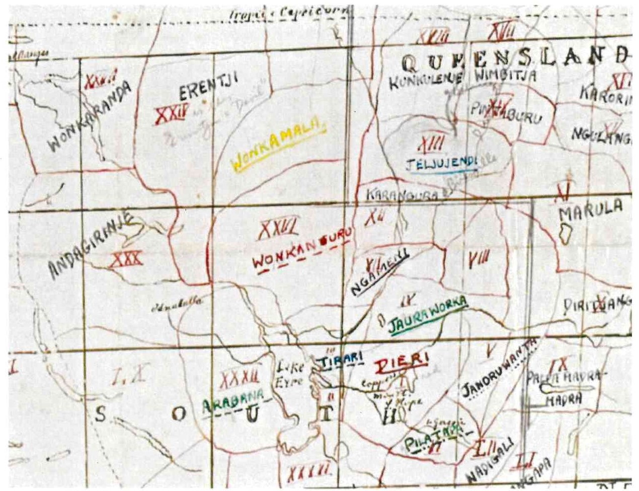
453 Reuther was a German missionary at Killalpaninna, east of Lake Eyre. Black noted that Hercus had described Reuther as having written the “first reasonably comprehensive grammatical study” of Wangkangurru and suggested therefore that he “might have had especially good knowledge of [Wangkangurru] location and neighbours”.
454 Stockigt accepted that Hercus had described Reuther’s work published in 1899 as the “first reasonably comprehensive study” of Wangkangurru. She pointed out, however, that, contrary to the belief of Hercus, Reuther’s work had not been the first grammatical study of Wangkangurru because his Lutheran predecessor at Killalpaninna, J Flierl, had in 1880 produced a Wangkangurru grammar. Stockigt said moreover that she had worked extensively on Flierl’s material, having “transcribed, translated and studied” it and, further, that she had compared it with Reuther’s and “all other early grammatical material of Pama-Nyungan languages”. On the basis of this study, she had concluded that Reuther “did not have a nuanced understanding of Wangkangurru language”. Stockigt also noted that Johannes Deinzer, who had provided the missionary training to Reuther, had described him as linguistically “untrained”. This circumstance, together with the sparseness and quality of Reuther’s Wangkangurru analysis, made it doubtful in her view that Reuther could be regarded as having had “especially good knowledge” of the location and neighbours of the Wangkangurru. This evidence of Stockigt was not challenged, and I accept it.
455 Stockigt accepted, however, that the existence of Reuther’s map meant that she should have said that the Western Desert boundary is “fairly consistently” drawn west of Oodnadatta. With that qualification, I accept Stockigt’s evidence on this point as it is consistent with all the other evidence.
456 It is appropriate to record that, before providing her report, Stockigt had taken the precaution of having a professional linguist who speaks Yankunytjatjara check the place names for which she had been unable to determine a language.
457 In short, the linguistic evidence does not support a view that there were Western Desert place names in the Overlap Area at effective sovereignty, let alone that it was the language belonging to the Overlap Area at that time.
Matters relating to the location of LSA language
458 On this topic, Stockigt and Black agreed on the following:
(a) there is at least one Arrernte place name in the Overlap Area, namely, Arrkwetye Akapwerte (Mt O’Halloran) which is Southern Arrernte, but disagreed as to whether there may be more. I will return shortly to the origins of the name “Oodnadatta”;
(b) there is limited evidence of Arrernte place names between the Overlap Area and the Macumba and Alberga Rivers. Stockigt identified Apmarl-Akert close to New Macumba as being the only Arrernte name in this area. Black agreed, although he had earlier noted that the Arabana place name Wilparanha had been attested to having a similar Arrernte name in 1901;
(c) there is strong evidence of Arrernte place names along and north of the Macumba River;
(d) early vocabularies suggest that Arrernte was spoken north of the Macumba River and at the Charlotte Waters Telegraph Station; and
(e) early vocabularies suggest that some Arrernte speakers may have been at the Peake Telegraph Station (south east of the Overlap Area) in the four decades after effective sovereignty. Black gave examples that this was so. Stockigt accepted that some early ethnographers had recorded Arrernte being spoken as far south as the Peake. However, she considered that the presence of Arrernte speakers at the Peake Telegraph Station was unsurprising given inter-marriage between the Lower Arrernte and the Arabana and because of the post-sovereignty movement of people along the telegraph line.
Matters relating to the location of the Arabana language
459 Stockigt and Black agreed on the following:
(a) there is evidence of Arabana place names to the south of the Overlap Area and within the area of the 2012 Arabana Determination;
(b) there is evidence of Arabana place names between the Overlap Area and the Macumba and Alberga Rivers to the north. Black thought that there was only one clear case (Wilparanha) but Stockigt referred in addition to Wampityi and Midlargunna;
(c) the relative frequency of Arabana place names compared with Arrernte place names decreases north of the Macumba River. Stockigt thought that the most northern Arabana place name, Thurluwarangka (Mount Sarah) (north of the Alberga River and some 65 kms north of the Overlap Area) suggests that the Arabana had a mythological connection to that site through the travels of Thunpila Ularaka; and
(d) early vocabularies suggest that Arabana was spoken at the Peake Telegraph Station, south of the Overlap Area near the time of effective sovereignty.
Disagreement about matters of approach
460 Stockigt considered the relative absence of name places within the Overlap Area at sovereignty to be unsurprising as she thought that, apart from notable features such as water holes or mountain peaks, there would have been little motivation for naming places in the Overlap Area until it became significant post-effective sovereignty by reason of immigrant Aboriginal people spending longer periods of time in the area. Black considered this to be mere speculation, noting that the mere fact that the Overlap Area had attracted relatively little European interest before Oodnadatta was established as a town in 1890 need not mean that the area had not been of interest to Indigenous Australians before then. That cannot be excluded as a logical possibility but Stockigt’s surmise does, to my mind, explain more plausibly the absence of Aboriginal names for sites within the (relatively small) Overlap Area.
461 As noted earlier, Black added qualifications to his agreement that the material gathered by Hercus provided valuable evidence from which to infer the likelihood of language belonging to country in/or around the Overlap Area near the time of effective sovereignty. He considered first that the dreaming narratives from which Stockigt had extracted the evidence of place names usually related to Arabana and/or Wangkangurru stories (even if also shared by other peoples) and therefore may have tended to favour names which can be identified with the Arabana and/or Wangkangurru.
462 I indicate now that I do not regard this qualification as significant because I accept Stockigt’s evidence that the dreaming narratives from which she extracted the place name evidence were chosen because they are the narratives which pass through or near to the Overlap Area. That is to say, I accept that Stockigt had not proceeded in a biased way by selecting or giving preference to Arabana and/or Wangkangurru stories. I will return shortly to further matters concerning the thoroughness with which Hercus had undertaken her field work.
463 Black’s second qualification was that the Hercus materials cannot be guaranteed to provide reliable evidence of place names for times earlier than the early decades of the 20th Century unless those names were also found on the early maps. He had also been critical of Stockigt’s reliance on the 1971 map of TGH Strehlow and on the Ularaka histories recorded by Hercus.
464 Black’s second point is sound to the extent that it depends upon the informants of Strehlow and Hercus having obtained the place names and mythology from elders whose own knowledge had been acquired as far back as effective sovereignty. Black’s point concerning the lack of “guarantee” is a sound caution but it overlooks the nature of circumstantial evidence to which I referred earlier. It is in the very nature of such evidence that there cannot be guarantees.
465 Black pointed out that, while Stockigt had maintained that the knowledge base of Strehlow and Hercus had been informed by intact understandings of classical societies in the region, she had not indicated how that was so or why the same consideration would not apply to other contemporaneous materials. Later, at [147] of his first report, Black said that the determinations of TGH Strehlow (1971) and Hercus (1994) on which Stockigt had relied did not seem to be based on linguistic evidence and accordingly that he would not attempt to address them as part of his final discussion and opinion.
466 In his oral evidence, Black said that instead of relying on the information collected by TGH Strehlow and Hercus, he preferred to focus on sources recorded earlier which seemed “to tell a bit of a different story”. The material to which Black referred was from Wood, Gillen and Warburton, Kempe and East.
467 To my mind, this indicated some narrowness in the manner of Black’s approach. It is noteworthy that he himself did not maintain that position consistently in all of his evidence as there were instances in which he relied on ethnographic evidence. Moreover, Stockigt noted:
[T]here are very few linguists today who study language out of social context, and many linguists advocate for the importance of understanding the speaker’s world view and social structures when describing a language.
468 I have already given my reasons for concluding that the opinions of TGH Strehlow and Hercus can be regarded as reliable, with respect to both the ethnographic and linguistic aspects.
469 The reliability of the works of Strehlow and Hercus is confirmed by a comparison of the place names they were given by their informants with those on the early Pastoral Run Sheets. Eight of the place names recorded by Strehlow and Hercus are on the Pastoral Run Sheets prepared approximately 50 years earlier. Hercus had also compared her recordings of the mythology of the region with those made by the Lutheran missionaries in Killalpaninna in the 1890s and with those of Spencer and Gillen. Strehlow had compared the information he recorded with that obtained by his father.
470 Contrary to Black’s understanding expressed at [97] and [154] of his first report that Hercus’ work is “relatively recent (1992 and later)”, Hercus had been working in the region since 1965. She continued to visit people on country regularly thereafter, commonly 2-3 times per year, until the late 1990s. As Stockigt noted at [5], many of the Ularaka histories had been published in Hercus’ earlier works. Black has wrongly assumed that the Hercus publications were contemporaneous with the field work on which she was reporting. That Black described the work of Hercus as “relatively recent” seemed to involve not only a misunderstanding about the basis for her opinions but a lack of detailed familiarity with her work.
471 I also agree with Stockigt that Black’s initial disregard of the work of TGH Strehlow and Hercus on the basis that they were not linguists involves an underestimation of their work. The primary training of both had been in linguistics. Stockigt described Hercus as “an extraordinarily well trained linguist”. Black acknowledged in his evidence that she was one of Australia’s foremost linguists. Strehlow had been employed for many years as a Reader in Linguistics at the University of Adelaide. His Masters’ thesis was a comparison of Arrernte dialects. Moreover, as Stockigt pointed out, the fact that they had broadened their investigations beyond linguistics and had taken a multi-disciplinary ethnographic approach does not diminish the significance of their linguistic research to their findings.
472 An underestimation by Black of the usefulness of the material of Hercus was also apparent in his suggestion that Stockigt’s reliance on Hercus’ material had given rise to the possibility that her results were “seriously biased” (because Hercus’ accounts were of Arabana Ularakas only). This suggestion is belied by the evidence which indicated that Hercus had spent considerable time with senior and knowledgeable Antakarinja men and women, including in areas well west of the Overlap Area. This evidence was confirmed by, amongst other things, the 53 Language Elicitation Tapes obtained by Dr Hercus between 1 September 1965 and 31 January 1970 from informants who were, or who included, Antakarinja informants. It was also confirmed by the summary of Hercus’ informants which Graham and Liebelt included in Appendix A to their second report.
473 I agree with Stockigt that, given Hercus’ sustained and intense interest in the geo-mythology of the wider region and her work with Aboriginal people belonging to the three language groups associated with the Overlap Area, it is unlikely that place names in either Western Desert, Lower Arrernte or Arabana within the Overlap Area with mythologically associated meaning would have escaped her attention.
474 This evidence of Stockigt about the extent and thoroughness of the work of Hercus was not challenged and I did not understand Black ultimately to persist with his suggestion that Stockigt’s reliance on her works may have resulted in a biased representation. In fact, by the time he gave evidence, Black had come to accept that the work of Hercus was valuable, although he regarded the available data concerning some places as being “uneven”.
475 In these circumstances, I do not attach significance to the qualification which Black attached to his agreement that the linguistic and geo-mythological materials gathered by Hercus since the 1960s provided valuable evidence from which to infer the likelihood of language belonging to country in and or around the Overlap Area near the time of effective sovereignty.
476 Like Stockigt, I consider it reasonable to infer that the rigor which Strehlow applied to his collection of data supports the view that his 1971 map is a well-informed representation of the position at or about the time of effective sovereignty.
477 In short, I am well satisfied that it was appropriate for Stockigt to rely on the materials of both TGH Strehlow and Hercus.
The data obtained close to effective sovereignty
478 As noted earlier, Stockigt and Black agreed that the linguistic data from within the Overlap Area itself near the time of effective sovereignty is limited.
479 Black noted that Gillen in 1875 had collected approximately 50 words but that his list included both Arabana and Arrernte words. For reasons which Black gave, and which seem sound, it may well be the case that Gillen had collected the Arabana words south of the Overlap Area and the Arrernte words north of the Overlap Area, so that the inferences which may be drawn from his collection of words is limited.
480 Black suggested, however, that there was other early data suggesting that the language of Oodnadatta was Arrernte. It is convenient to refer first to the material which Black himself had identified before turning to other evidence identified by the parties by the time Stockigt and Black gave oral evidence.
481 Black referred first to the report of David Lindsay of the expedition which he had undertaken in 1885-6. The report included a “Vocabulary of the Languages spoken by the Natives in Latitudes 23 degrees to 28 degrees south as obtained by a Member of my Expedition”. It seemed to be common ground that the words in the vocabulary were Arrernte words. Black noted that Oodnadatta, being 27.54º south is within the area to which Lindsay’s expedition member had referred, giving rise to the inference that Arrernte was spoken in the Overlap Area. He also surmised (I consider reasonably) that Lindsay’s expedition had passed through the Oodnadatta area following the telegraph line to the Finke River which was the particular subject of his expedition. I also think it fair to surmise that at least one member of Lindsay’s expedition had been able to calculate latitude and longitude.
482 Nevertheless, given that there are approximately 110 kms between each line of latitude, the selection of 28º south seems, at least for present purposes, a rather broad brush form of demarcation. I note that Black had been willing to attach significance to this report in Lindsay without knowing the actual distance between two lines of latitude, without knowing the possible extent of rounding in the statement of Lindsay’s expedition member, and without knowing the area on an east-west axis to which the expedition member had been referring.
483 In my view, and contrary to the opinions of Black and, later, Liebelt, it would not be appropriate to take literally the reference of Lindsay’s expedition member to Latitude 28º south. It is implausible to regard a line of latitude (expressed as a whole number) which has no regard to topography or other local features as the point at which a language commenced, or ceased, as the case may be. It is more natural to suppose that the expedition member intended to indicate generally an area within which a language was spoken and did so by use of the next latitude expressed as a whole number. If that be correct, the expedition member may have been intending to indicate only that the Arrernte language was commenced to be spoken at some unidentified place between the 27th and 28th latitudes.
484 I also accept the point made by Stockigt that the statement of Byrne in 1892 that the southern boundary of the Arrernte was 90 miles south of Charlotte Waters is a much more precise statement than is the use of Latitude 28. That coincides approximately with the boundary suggested by TGH Strehlow and Hercus.
485 For these reasons, I am disinclined to attach significant weight to this piece of evidence.
486 It is in any event possible, as Sackett and Stockigt pointed out, that Lindsay’s expedition member had spoken to one or more Arrernte speakers who happened to be in Oodnadatta at the time but without it being their country.
487 Next, Black referred to the paper presented by RH Mathews to the Royal Society of New South Wales on 1 June 1898 entitled “Australian Divisional Systems”. In that paper, Matthews said:
I have traced the two divisions, Mattiri and Karraru, through a wide extended territory, reaching from Port Lincoln, via Port Augusta and Farina, to somewhere about Oodnadatta, a distance of over 700 miles.
(Emphasis added)
488 Black also referred to the paper presented by Mathews in 1907 (actually on 5 October 1906) in which he stated that “[w]e encounter the southern limit of the Arranda language about Oodnadatta”.
489 I indicate now my view that very limited weight can be attached to the statements on which Black relies. Later publications of Mathews place Oodnadatta within Arabana country and show Arrernte country commencing 10-15 miles to its north-west. Black did not refer to this material because he had been confining himself to the linguistic material. It seems improbable in any event that Mathews was intending to be precise in his 1898 paper (perhaps because of a lack of close familiarity by his non-South Australian audience with the region). Mathews’ use of the expression “somewhere about Oodnadatta” seems to reflect an approximation on his part. That is understandable, as Mathews did not ever visit Arrernte or Arabana country or speak with an Arabana or Arrernte person. Mathews’ knowledge in 1898 of the Arrernte language seems to have been based on Pastor Kempe’s 1891 published grammar, supplemented by material provided to him in correspondence with Carl Strehlow.
490 Accordingly, I do not consider that the Mathews’ material warrants the significance which Black had sought to attach to it. In fairness to Black, I note that in the oral evidence he said that he was content “to leave Mathews aside”.
491 Next, Black referred to the story recounted by Hercus and Sutton in “The Assessment of Aboriginal Cultural Significance of Mound Springs in SA” published in 1985. At page 58, Hercus and Sutton recount the story of an ancestor who had “killed his father’s sister there, cutting off her head with his boomerang. This time he hurled his weapon with so much force that the head landed in Aranda country, on the other side of Oodnadatta and it became Mt O’Halloran North, which is still known as Arkutja Kakuta, ‘women’s head’” (emphasis added). It was common ground that the current name for Mt O’Halloran of Arkutya-Akaparta means “woman’s head” in Arrernte.
492 Stockigt noted the curious fact that there is a second location with the name Arkutja-Akaparta (women’s head) located some 290 kms north of Oodnadatta and well within Arrernte country. Strehlow had noted this on his 1971 map (rendering it as Arugutjakaputa without diacritics). Stockigt raised the possibility that there may have been some confusion between the names for the two locations. The reference by Hercus and Sutton to Mt O’Halloran North increases the possibility for confusion but there is no evidence that the more northern location is also known as Mt O’Halloran North.
493 In my view, the evidence of Stockigt on this point did not rise above speculation. Like the Walka Wani, I consider it pertinent that Hercus and Sutton referred not only to the Arrernte name, but associated it specifically with Mt O’Halloran near Oodnadatta. The Court ought to proceed on the basis that a prominent feature in the Overlap Area, Mt O’Halloran, does have an Arrernte name.
494 I am, however, inclined to attach weight to Stockigt’s evidence that, while the use of the Arrernte name for Mt O’Halloran suggests some mythological significance for the Arrernte people, the Ularaka concerning the naming of Arkutya-Akaparta is an Arabana Ularaka and is told in Arabana language.
495 Further, as noted previously noted, Hercus repeatedly described, and showed in her maps, that the area around Oodnadatta is Arabana country. This included a work which she published in 1985, i.e, the same year as the publication of her work with Sutton. These later works overwhelm the statement on which Black relied.
496 Having regard to these matters, while the 1985 record of Hercus and Sutton cannot be ignored, I do not think it appropriate to attach significant weight to it. In context, I doubt that the focus of Hercus and Sutton in the passage to which Black referred was on the identification of the country at which the woman’s head landed but on its location, i.e, Mt O’Halloran.
The further contemporary data identified by Dr Black
497 I now turn to the additional sources identified by Black in his oral evidence, which he described as “generally very minor sources”. These were the papers of JD Woods (1878), JF Gillen and RE Warburton (1886), Joseph East (1889) and Reverend Kempe (1890). Relevant extracts from the papers of these persons are set out in the section of these reasons summarising the early ethnographic-historical material.
498 Black said that he regarded the statements of these persons as evidence of Arrernte being spoken south of the Overlap Area (with the implication that the country in which it was being spoken was Arrernte and the further implication that the intervening Overlap Area was Arrernte country). This was so in the case of Woods (1878) and Gillen and Warburton (1886) because the section system which they described was Arrernte and not Arabana. Black also drew attention to the different spelling of the section names by Woods, on the one hand, and Gillen and Warburton, on the other, which indicated, he thought, that they were using different sources.
499 Black said that the term which East (1889) gave for “water’ was Arrernte in both cases. East had also reported that the language reaching from the Peake to Charlotte Waters and then from Charlotte Waters to the MacDonnell Ranges was “almost the same in both sections, and the customs, rights and practices also”. He said that this too suggested that Arrernte was being spoken shortly after the time of effective sovereignty well south of the Overlap Area.
500 As the next of these sources, Black referred to the paper entitled “A Grammar and Vocabulary of the Language spoken by the Aborigines of the MacDonnell Ranges, South Australia” read by the Reverend Kempe on 2 December 1890. Reverend Kempe described the vocabulary as being “that of the tribe inhabiting the River Finke, and is also, with only slight variations in the dialect, that of the tribes in the MacDonnell Ranges eastward to Alice Springs, but not far westward of the River Finke, and extending southward to the Peake”.
501 Black said that this was still further evidence of Arrernte being spoken through Oodnadatta and as far south as the Peake. He attached significance to the combined effect of the Woods, Gillen and Warburton, East and Kempe statements, suggesting that they were all consistent. That meant, he suggested, that there were a further four early accounts indicating that Arrernte was being spoken further south from the Overlap Area and, by inference, in the Overlap Area itself.
502 Stockigt noted that Woods was a journalist and public servant and not known to have conducted any field work among Aboriginal people in the Oodnadatta region, or even closer to Adelaide. He had not travelled to the region. The source for his statement is not known. Stockigt was inclined to regard Woods paper as unreliable given that he had thought the four section system extended all the way down to the Peake when other reliable evidence indicates that that was not so. I agree that this does undermine the reliability of Woods for present purposes.
503 Stockigt regarded the statement of East as linguistically ill-informed because, while he had described the Arabana language being in one location and the Arrernte language in another, he had also said that they were “nearly the same”, which is plainly incorrect. She also thought it unsurprising that there may have been an Arrernte speaking person at the Peake given the inter-marriage between the peoples and post-colonial movement more generally. Stockigt agreed, however, that the fact that East had acknowledged that people observing the four section system and who used the Arrernte word water at the Peake did suggest that there had been Arrernte people as far south as the Peake at the time East, or his informant, had obtained their information.
504 Stockigt also suggested that it was probable the Gillen and Warburton were not reporting their own research but repeating the information contained in the Woods paper. She noted that they prefaced the statement on which Black relied with the words “it is said”. It is true, as Black pointed out, that Gillen and Warburton used spellings which differed from those of Woods and this might suggest different sources. However, that would depend upon how they learnt of the statements of Woods and whether they thought that different English spellings of the words were appropriate.
505 Stockigt said that she was surprised by the Kempe material (saying that it was “inexplicable”) because, when he had travelled through the area, he had recorded the name Wadhlu as the name of the tribe (which is an Arabana term) and there was no other record of the Hermannsburg missionaries of which she was aware that had the Arrernte so far south. She also noted that Kempe’s essay written in German had been edited by Professor Tate, the Elder Professor of Natural Science at the University of Adelaide and President of the Royal Society, and that the nature and extent of Tate’s edits to Kempe’s work were unknown. It was also not known how the expressions “to the Peake” or “towards the Peake” had been translated from the German into English. Stockigt noted again that the Peake was really the only well-known location south of the area to which he was referring so that the reference to it should not be regarded as an accurate delineation of the boundaries of language.
506 Stockigt also said, and I accept, that there was ample evidence that Arabana was the language recorded at the Peake. For example, the use of the Arabana word “Cootha” or “Koota” as opposed to the Arrernte word “Kwytcha” for water in that location. Black accepted that that was so but said that that did not exclude the presence of Arrernte speakers. This still leaves unexplained why East would have reported on only one language at the Peake (and probably the minority language).
507 One way to reconcile the inconsistencies is to keep in mind the point made by more than one of the experts that, particularly in the 1870s and 1880s, the ethnographers were talking about a vast area in the north of South Australia (which then included the Northern Territory) in which the two principal reference points were the telegraph stations at Charlotte Waters and the Peake. There was no reference point in between those two places because Oodnadatta had not yet been established. The consequence is that Charlotte Waters and the Peake may have been referred to as general reference points only, or as broad indications of area, without necessarily indicating the position at those precise locations. I think that there is force in this point as it does seem to be more than coincidence that these writers just happened to fix on the locations of the repeater stations and aligned areas of language distribution with locations selected by Europeans for quite different purposes.
508 Another possible explanation is that, as the papers of Woods, Gillen and Warburton, East and Kempe post-dated the construction of the Overland Telegraph Line, with the associated movement of Aboriginal people up and down the Telegraph Line, it became increasing possible to find Arrernte speakers or Arabana speakers outside the areas of their respective countries.
509 A further explanation and that on which the Walka Wani ultimately placed much weight is that Arrernte speakers were present, because, although the country was Arabana, they had rights of use in the country.
510 In my view, it does count against the reliability of Woods that it is plainly not the case that all of the Peake “tribes” are divided into four classes of families or sub-tribes as he described. Likewise, Gillen and Warburton said that “all the blacks between Alice Springs and the Peake Telegraph Station belong to one or other of the four classes”, when the evidence in the trial establishes clearly that that is not the case. It is in any event seemingly inconsistent with the effect of the 2012 Arabana Determination.
511 The material from Woods, Gillen and Warburton, East and Reverend Kempe cannot be disregarded but the features to which I have referred and other evidence which I have accepted, which is inconsistent with that evidence, counts against it being indicative of Arrernte being the language of the Overlap Area. Like Stockigt, I consider that the prospect that Gillen and Warburton have simply repeated Woods, and possibly East, makes it inappropriate to regard these as independent sources all pointing to the same conclusion.
The Arrernte origin of the name “Oodnadatta”
512 As I noted at the commencement of these reasons, the origin of the name “Oodnadatta” is unclear. It was common ground that it is an Aboriginal name, as confirmed by the South Australian Chronicle of 4 January 1890:
The terminus of the line will no longer be called Angle Pole, but will in future be called Oodnadatta, a spot near Mount O’Halloran, the reason being the desire of the Department to preserve the native names as far as possible.
513 The first etymology of the name was recorded by Dr Basedow in 1903 (13 years after Oodnadatta was proclaimed), when he described Oodnadatta as:
A desolate desert township named by surveyor Lees after a word in the Arrunndta dialect meaning “yellow blossom of the mulga” (Acacia aneura).
514 The Arabana etymology was suggested by the correspondent ‘H.J.L.’ to The Mail in 1928 who stated that:
Oodnadatta means “rotten there”. The original form was Coodnadatta. Coodna in the Aboriginal language means rotten or decomposed, and “datta” means “there”, hence the fused word Oodnadatta.
515 Gara identified H.J.L. as Hurtle J Lewis, a “veteran bush man and friend of the blacks”.
516 After a discussion of the respective merits of these etymologies, Stockigt tentatively concluded in her first report that the Arandic etymology was more plausible than the Karnic etymology. In her third report, Stockigt noted that TGH Strehlow had recorded in his 1967 field notes that “[t]he real “Oodnadatta” is the Angle Pole W.H. called Utndata. Though this is in Arabana country, the name is an Arrernte name”. She thought that it was not possible to express a concluded view.
517 The Arabana witness, Mr Strangways, gave another account of the origins of the name Oodnadatta. He said that the name came from an Ularaka story of an old man called Duthudnungkula whose story started at Mudlarda, a cliff hole on the Peake River. He travelled to a site at Mt Eba where he transgressed Arabana law by stealing a sacred white object so that he had to flee. After sheltering for a time at Algebuckina he travelled on towards the Macumba River but had diarrhoea and left excrement at a place referred to as “Kudnatharra”. Although that place is 20-23 miles northeast of Oodnadatta, that is the origin of the name Oodnadatta. Aaron Stuart gave evidence which was broadly similar. Reg Dodd says that he teaches children the origins of the name Oodnadatta but did not outline the content of what he taught.
518 The manner in which the South Australian Chronicle report of 4 January 1890 is expressed may suggest that Oodnadatta was the Aboriginal name for Angle Pole but the evidence in the trial was that that name is Carulina. The note of TGH Strehlow supports the view that the name “Oodnadatta” is an Arrernte word which was used by white people on country thought by Strehlow and others to be Arabana. It is also pertinent to note that the word is the name of a particular blossom and not the name of a particular place.
Other possible Arrernte names in the Overlap Area
519 At the trial, Black identified four additional place names in Arrernte in the Overlap Area. These were Mparnte (near Hookey’s Hole), Ararrkern (in the town of Oodnadatta), Ankerr-nynt (One Tree Soak), and Warlute (to the east of Oodnadatta and actually in the area of the 2012 Arabana Determination). Warlute was the site at which the Court received female gender restricted evidence from the Walka Wani.
520 Black and the Walka Wani sought to rely on the fact that these place names appear on the map prepared by the National Native Title Tribunal entitled “Walka Wani Oodnadatta showing overlapping claim” (Map 2 to these reasons). However, as Black himself acknowledged, in preparing the map, the NNTT had used information provided by SANTS, Walka Wani’s solicitors in these proceedings. Accordingly, the reliance of Black and the Walka Wani on this map seemed to involve a form of boot straps reasoning and I do not accept it.
521 Black accepted that none of the four names had been included on the early maps, that none was on a Pastoral Run Sheet, that none was on the 1965 mud map prepared by TGH Strehlow and that none of them was mentioned as being connected to mythology by Hercus or TGH Strehlow. Those circumstances by themselves raise real doubts about these names having been in use at effective sovereignty. Stockigt pointed out, in addition, that the names differ from other Arrernte place names in the region in that they do not have mythological associations and that each (other than Ararrkern which is the name of a frog) appear to be descriptive of the place in which they are associated. She concluded, and I accept, that these are place names of recent origin.
Place names south of the Overlap Area
522 In the evidence at trial, Black said that he had identified Arrernte names south of the Overlap Area. These are Anintyola (Mt Kingston) and Akundana. Both Anintyola and Akundana are a significant distance south-east of Oodnadatta.
523 Stockigt cast doubt on whether Anintyola was in fact a place name, noting that, according to the information recorded by Hercus in 1994, it is the name of an Arrernte ancestor who enters Arabana country to steal a sacred object from the Rain site complex below Mt Kingston. Lucas gave a similar description of Anintyola. Stockigt thought that the name may instead be a reference to a location through which the Arrernte ancestor had passed when returning to his own country with the stolen Arabana rain-stone, i.e, reflecting significant shared geo-mythological knowledge between Arabana and Lower Arrernte People. The fact that five of the registered heritage sites reviewed by Cane in the Addendum to his 2006 Report prepared in connection with the 2006 Yankunytjatjara/Antakarinja Native Title Claim have the name “Anintyola” or are associated with the same myth, adds support to Stockigt’s understanding of the term.
524 Stockigt disputed that Akundana was an Arrernte place name. Black accepted that there was some uncertainty about the word, i.e, that it could be an Arrernte word being used in an Arabana context or an Arrernte word borrowed into Arabana.
525 Black noted in addition that Hercus (2017) had stated that Cecilia Well on Allendale Station (south-east of Oodnadatta) had had an Arrernte place name, now lost, as well as an Arabana name.
Place names north of the Overlap Area
526 The closest Arabana place name north of the Overlap Area identified by Black is Wilparanha (written as Wirlpanh in the Arrernte way). Black relied for this purpose on a record made by Spencer and Gillen but accepted that, as Gillen in 1901 had spelt it as Uilparinna, that suggests an Arabana name rather than an Arrernte name.
527 As Stockigt pointed out, the closer one gets to the Macumba River north of the Overlap Area, there are names with both Arabana and Arrernte pronunciations. She considered that the fact that there was also an Arrernte pronunciation for the Arabana name of Wilparanha did not mean that it was an Arrernte place name.
528 Black also referred to a second use of the name Anintyola situated closely to the west of Wilparanha. However, Stockigt thought this was a further aspect of the Anintyola mythology mentioned above in respect of the location south-east of the Overlap Area.
529 Stockigt identified two Arabana names in the area between the Overlap Area and the Macumba/Alberga, Wampitji (which is between Oodnadatta and the Macumba homestead) and Midlargunna. Stockigt mentioned other names (Coongara Creek and Yardaparinna) about which she and Black disagreed. In my view, it is not necessary to make specific findings about these place names but given my general preference for the evidence of Stockigt, I indicate my acceptance of her views.
530 Hercus considered that the name Macumba derived from the Arabana Maka-Wimpa ‘fire track’. She said that there had also been a Arrernte version of the name with the same meaning but that it is the Arabana name which has survived on modern maps. Stockigt gave evidence that Macumba has an Arabana etymology but accepted that it may originally have referred to only part of the river.
Other matters
531 Stockigt attached particular significance to Gillen’s recording of the name Kadni for lizard at Angle Pole in 1875 and Heidenreich’s recording of the word Wadlhu (spelt as “Wadloo”) at the same place in 1876. Both of these are Arabana terms and she regarded it as evidence of Arabana being spoken at Angle Pole (immediately to the north of the Overlap Area) at the time of effective sovereignty. Stockigt suggested that this indicated that Arabana was the language belonging to the country. As already noted, Lucas too thought that Heidenreich’s reference to the “Wadlhu Tribe” was strong evidence that the Arabana were identifying the country at or around Angle Pole as Arabana country.
532 I have already rejected Black’s reasons for disagreeing with Stockigt’s conclusions concerning the term “Wadlhu”. However, I have kept in mind the following observation of Hercus in 1984:
The word wadlhu is a very general term; in fact it is one of the most common words in the language. It means ‘ground, sand, soil, earth, country’. It is only when wadlhu is used with a possessive that it becomes specific and means ‘hordal’ … Thus when people say anthunha wadlhu ‘my country’ they mean country with which they have a strong ritual affiliation.
533 For this reason, I regard Heidenreich’s recording of the term “Wadlhu” as no more than some indication that the people then at Angle Pole were Arabana.
534 I do consider that there is some force in Black’s critique that, in using the word Kadni, Gillen may have been using the word which he had learnt at the Peake and which he had had himself brought to Angle Pole. I agree that that is a realistic possibility which cannot be excluded. Perhaps weighing against that possibility, however, is that there was no suggestion that the people to whom Gillen spoke had some other name for the lizards he was holding, which may indicate that they considered its use appropriate.
535 Counsel for the Walka Wani submitted that the evidence showed only that Arabana was spoken north-east of the Overlap Area rather than to the north. As previously noted, strictly speaking the Macumba commences only at the confluence of the Alberga and Stevenson Rivers which is just slightly to the east of due north from Oodnadatta, which is located towards the eastern end of the Overlap Area. Accordingly, the reasoning which underpinned counsel’s submission was that, when the early ethnographers referred to an Arabana presence between the Peake and the Macumba, they were referring to the area north-east of the Overlap Area and which is the subject of the 2012 Arabana Determination.
536 With due respect to counsel, this submission seemed to be based on an overly literal understanding of what the early ethnographers meant when they referred to the Macumba. It is not to be supposed that the early ethnographers always distinguished between the Alberga, on the one hand, and the Macumba, on the other. That is especially so as the telegraph line and, in due course the railway line, whose path Europeans commonly followed, did not involve them crossing the Macumba strictly so named at all. Instead they crossed the Alberga. Moreover, the Macumba Station and its homestead at which many of the early travellers stopped, or at least passed, was immediately north of the Overlap Area, and that is likely too to have fixed the name Macumba in their minds as the specific place to which they were referring. There does not seem to have been a corresponding “track” taking them over the Macumba, strictly so-named. All these matters suggest that the early ethnographers were not referring to the Macumba but to it and its western extension bearing the name Alberga. That is to say, they were referring to the extended east-west river system.
537 In my view, the weight of the linguistic evidence which I accept points to Arabana having been the language of the Overlap Area at effective sovereignty, and that Arrernte was the language of the country north of the Macumba and its western extension in the form of the Alberga.
Migration into and out of the Overlap Area
538 There was considerable evidence in the trial, and it is a widely held (but not unanimous) view of anthropologists that there has been a gradual south-easterly migration of the Yankunytjatjara/Antakarinja people and that, while this had been occurring before effective sovereignty, it accelerated thereafter. The evidence suggested that this migration had included movement into the Overlap Area and had prompted a southerly migration by the LSA. It also suggested a movement of the Arabana away from the Overlap Area.
539 The causes of the general south-easterly movement included drought, the degradation of food and water sources, the establishment of ration depots as sources of food, the effect of disease, the “attractions” of the European settlements and employment opportunities. I summarise some of the material below.
540 Lucas referred to newspaper reports in the 1880s of the displacement of Aboriginal peoples to places such as Mt Eba, Mt Vivian (well south of Oodnadatta) and to other pastoral stations. He also set out a passage from Gillen’s letter to Spencer of 31 January 1896 which included:
[U]tter demoralization has set in amongst the Urrapunna and Arunta where they come together, they were, during the construction of the Railway, in the hands and under the influence of something like 1500 Navvies … Many of them died from typhoid and other diseases and now they are setting aside their ancient tribal laws and marrying anyhow.
541 Basedow in 1919 referred to influenza having “swept away” members of the Aboriginal population. As noted earlier, he described the disease as having “almost completely annihilated resident groups”.
542 In his Report on the Administration of the Northern Territory for the year ended 30 June 1937, TGH Strehlow (then employed in the Northern Territory as a Patrol Officer) wrote:
The answer [to the significant depopulation of Aboriginal peoples] lies in the rapid and continuous drift of the natives from the Reserve within the last few years. One might be tempted to label it a flight or a rout rather than a mere drift. As a result of this general exodus Pitjentara [Pitjantjatjara] natives may be seen today in large camps wherever stations or doggers’ camps dot the map in Central Australia. Middleton Ponds, Charlotte Waters, Hamilton Bore, to name only a few places, have long ceased to be Aranda or Loritja settlements, the original Aranda and Loritja folk are almost extinct, and today Pitjentara is the tongue which is spoken wherever natives gather together. Ernabella, Lind Vale and the Doggers’ camps account for many more. Macumba and Oodnadatta have both seen Pitjentara beggars arriving in order to plead for tea and food … The total number of the derelict emigrants from the Reserve must run into many hundreds of men, women and children.
(Emphasis added)
543 Gara referred to other publications of TGH Strehlow in which he reported on the “drift” of Western Desert people eastward.
544 Elkin wrote in 1939:
The Aranda system [of kinship] belongs to Central rather than South Australia, just as the southern branch of the Aranda tribe does. Some of its local groups apparently spread down the Finke at some point time in the past, probably not very long ago. Just as the Dieri have a tradition of being pushed south to their present location by the Wongkonguru, and as, according to one of my Aluridja [Luritja] informants, the Aluridja people moving south, displaced a portion of the Arabana tribe from the Oodnadatta district, so in between these two movements of people, the Aranda spread down the Finke south of Horseshoe Bend and Charlotte Waters and so across into South Australia.
(Emphasis added)
545 In the same work, Elkin said:
By Aluridja tribes I mean all those tribes on the south and west of the Aranda inhabiting the country south-west of the Finke River, and almost all that part of South Australia west of the Port Augusta-Oodnadatta railway line … These Aluridja groups seem to have been migrating west and south and east in the far past, as they have been doing since the white settlement of South and Western Australia.
546 Doohan, in “One Family, Different Country” (1992), noted that no other researcher had corroborated Elkin’s views on Arrernte movement southward. She pointed out, however, that there was “primary supporting evidence” and continued:
It is relevant here in that it directly relates to the number and disposition of the few remaining Lower Southern Arrernte. It also serves as an explanation for the fact that no one in the upper generations of my Arrernte genealogies is said to be primarily identified with the country around Macumba, a place said to be ‘Arrernte country’ and one at which many people, both Arrernte and Western Desert, lived.
547 In 1941, RM Berndt in “Tribal Migrations and Myths Centring on Ooldea, South Australia”, said:
The natives here were then known as members of the ‘Anta’kirinja tribe’, although representatives of the Pitjandjara, Murunitja and Wirangu were present, members of these tribes have congregated here on the fringe of white occupation and away from their rightful countries.
(Emphasis added and footnote omitted)
548 Later, Berndt recorded:
Professor Elkin has mentioned that there have been movements of groups from north-west of South Australia, eastwards to the Fincke (sic) and Oodnadatta and southwards to the east-west transcontinental railway, so there was in process migration of natives from the far north-western corner and adjacent parts of Western Australia towards Laverton and Mount Margret in the latter State.
(Footnote omitted)
549 There were also several references in the evidence to the effects of drought, the drying up of waterholes and the lack of available food driving Aboriginal people towards the white settlements.
550 In 1966, Fay Gale published a paper entitled “Patterns of Post-European Aboriginal Migration in South Australia” based on the extensive field work which she undertook for her PhD dissertation. Gayle recorded:
Pitjintjitjira speakers of migrated south to Yalata and east to Oodnadatta and south-east to Port Augusta and Adelaide, and even to Gerard in the far east”.
Gale published maps showing the migrations (which also indicated a movement of the Arabana towards Oodnadatta).
551 In their work entitled “An Aboriginal History of Oodnadatta Region” (1987), Shaw and Gibson said:
Among the most obvious signs of traditional life are the recollections of local myths, but as we now know the mythological knowledge held as second hand and fragmentary at best. It must still be reckoned with however because the Antakarinja, Aranda and Arabana descendants take their custodianship of the region seriously. One might argue that this originally was not traditional Antakarinja territory because there is both documentary (European) and oral (Aboriginal) evidence that the forefathers of many present day Oodnadatta residents gradually invaded the country from the west, forced by droughts and internecine conflicts. But this is not a complete picture. There was for instance a longstanding relationship between the Arabana and the Southern Aranda (they are more pronounced between the latter and the Wangkangurru) because their territories appear to have overlapped. Traditionally they were interconnected by the north-south trade route along which diffused raw materials, artefacts and ceremonial knowledge, and there was intermarriage between them. After the migrations, in succeeding generations there was intermarriage between members of the three main language groups Arabana, Southern Aranda and Antakarinja and with speakers of other Western Desert languages such as the Matutara and Pitjantjara. Sacred knowledge was transmitted by remnants of the Arabana to the Antakarinja and the Aranda. A lot of that sacred knowledge is held by a handful of elders, some of whom are quite old now …
(Emphasis added)
552 Hercus in “The Status of Women’s Cultural Knowledge” (1989) said:
The worst blow for the status of women’s cultural knowledge in the Lake Eyre Basin was the arrival from about 1900 onwards of large numbers of people of Western Desert origin, particularly Antikirinja on Anna Creek station, at Oodnadatta and Macumba, and of Kukata people on Stuart Creek station. Amongst these Western Desert people women had separate knowledge and separate sites, but the overall responsibility was male. Arabana women had not previously had the same need for separate sites, and so they found themselves altogether disinherited.
(Emphasis added)
553 Graham and Liebelt said that they had no reason to doubt this account of Hercus in relation to the broader region but were “not so sure … that it applies in any significant degree to the [Overlap Area]”. It was not made clear why the Overlap Area was distinguished from the “broader region”.
554 Later in “The Status of Women’s Cultural Knowledge”, Hercus said:
By the beginning of this Century Antikarinya people had begun to arrive in the Oodnadatta area: the late Yumpy Jack, born at the main Arabana Frog History site Uthapuka (Hookey’s waterhole) in about 1900, claimed to have been the first Antikarinya baby to be born near Oodnadatta, where he took on the Frog Dreaming. Rapid changes followed …
Since Basedow’s day Antikarinya people have gradually taken over the Oodnadatta area, and in the 1960s there were many of them even in the heartland of Arabana country at Anna Creek. Today there is not one single person of predominantly Arabana descent at Oodnadatta and only one at Anna Creek. The majority of the remaining Arabana people live outside their own traditional country at Marree and Port Augusta.
(Emphasis added)
555 In the report of the Finke Land Claim in 1990, Olney J recorded the finding of the anthropologists Vachon and Doohan who were assisting him that:
The Arrernte, their neighbours the Wangkanguru (to the east) and the Arapana (to the south), have fared very badly as a result of European contact. The number of Arrernte people has declined dramatically. Western Desert people have migrated east into Arrernte country and it is said that by the early 1950s, Western Desert people outnumbered the Arrernte in Arrernte land. At the time of writing the claim book (August 1986), the authors could identify only seven senior Arrernte traditional owners for all southern Arrernte lands, including the claim area. Arrernte people of all ages made up only one third of the total population of Finke, the rest were Western Desert or Luritja people.
556 Kim Doohan in “One Family, Different Country” in 1992 gave a detailed summary and description of migration and displacement in Central Australia. She stated:
The most significant of these migrations in terms of the repopulation of the eastern pastoral lands was the eastern movement of Western Desert people from around the turn the Century until about 1940. This immigration coincided closely with initial European settlement in the area and the severe decline of Lower Southern Arrernte and Antikarinyi numbers, primarily as a result of disease.
557 At page 13 of the same work, Doohan also recorded:
While non-Southern Aranda may not have ‘come in’ to assist their neighbours in fighting off the first intruders, forty or so years after first contact Western Desert people did migrate into Lower Southern Arrernte lands in large numbers. The offspring of many of these Western Desert people, along with those Lower Southern Arrernte who managed to survive, make up the present populations of Finke and Oodnadatta.
558 In her report, Stockigt gave linguistic support for the spread of Western Desert language having been relatively recent:
[32] The structural uniformity of Western Desert language within such a vast geographic area suggests that the language has spread over the region in comparatively recent times. Linguistic uniformity over large areas indicates recent spread, while a high degree of linguistic diversity internal to a region suggests that languages have been in location for longer periods of time …
559 In the face of Black’s critique of her view that there had been an eastward movement of Western Desert people, Stockigt provided an extensive response in her second report. I did not understand that response to be challenged, and accept it.
560 The oft-repeated evidence that Yumpy Jack (Hughie Cullinan’s uncle and Audrey Breadon’s grandfather) had been the first Yankunytjatjara person born in the Overlap Area is a particularly important piece of evidence on this topic. It is also pertinent that that Yumpy Jack had been initiated as an Arabana man following his unwitting intrusion into an event of Arabana men’s law.
561 Coupled with the migration of Western Desert and Arrernte people into the Oodnadatta region was the movement away from Oodnadatta of many Arabana. This seems to have been caused in part by the depredations of disease, especially the Spanish Flu in the early 1920s, the attraction of Anna Springs Station at which the Arabana seem to have been welcome, and the later establishment of Finniss Springs Station at the southern end of Lake Eyre by John Dunbar Warren in 1915 to which he had taken a number of Arabana. With respect to this movement, Lucas concluded his analysis of the population figures recorded by Basedow by saying that they suggested “a retreat of Arabana from the northern extent of their country, towards to the safety, rations and employment provided by the stations at Anna Creek, Stuart’s Creek and Finniss Springs”. Mr Strangways said that Finniss Springs Station had become the centre of the Arabana nation.
562 Lucas concluded:
[334] … In my opinion, Western Desert groups (variously identified as Luritja, Antikarinja and Yankunytjatjara) began moving into areas around and in the claim area in the latter part of the nineteenth century, and have continued to do so up to the present day.
Gara agreed with this assessment.
563 In his 2006 Report, Cane cautioned against the eastern and southern migration view. He noted that nomadism was a key to long term survival in the Western Desert and it was common for people to travel very substantial distances in any given year. Later, in the same Report, Cane said:
[463] Where else were people expected to go in hard times in the absence of other resources of equivalence in the area? Thus the notion of ‘migration’ to white settlement might be better seen as a Eurocentric characterisation of what was actually the maintenance of traditional patterns of residents in the face of European migration.
[464] There is a need, I believe, for interpretative caution in regard to the early migratory theory …
564 Cane concluded:
[528] The extent to which people left their traditional country and travelled to the cattle stations is difficult to tell from the historic record. That record suggests extensive nomadic travel between and around the waterholes and catchments of Alberga Creek and Neales Creek and between the Everard and Musgrave Ranges to the west (as climatic conditions allowed and necessitated) – as appears to have been the case in the precontact situation. I cannot identify a particular geographic orientation in that movement, and believe ethnographic accounts of an easterly migration of Aboriginal people to be a reflexive Eurocentric interpretation on traditional patterns of subsistence and social and ceremonial activity in the face of encroaching pastoral settlement (see section 5.3.4). My feeling is that regional nomadism and settlement in the historic era had more to do with custom and climate than cattlemen.
565 Cane and Liebelt repeated this paragraph in the Cane/Liebelt report.
566 In their first report, Graham and Liebelt adopted the same view, saying:
[138] … Our research indicates that while these movements applied to some degree to areas further to the south, ie, Anna Creek Station, in the Oodnadatta region the movement of ‘eastern’ Western Desert people would appear to be within country in which these groups were already subsisting within the pre-contact era (as Elkin found, also see Cane 2006 for analysis).
567 The research to which Graham and Liebelt referred in this paragraph is not clear. Later, however, they said that it was necessary to distinguish between the Pitjantjatjara and Yankunytjatjara, at [174]. They suggested that it was the movement of the Pitjantjatjara which constituted the Western Desert movement to which the other anthropologists had referred and that the movement of the Yankunytjatjara had been within the “existing range” of Yankunytjatjara territory. Gara described this as a “novel argument”. Based on the other evidence, this seemed a justified characterisation. Gara also noted at, [311], that Graham and Liebelt did not provide evidence for their distinction between the Pitjantjatjara and the Yankunytjatjara. They did, however, assert that Cane’s 2006 Report found that “systematic historic investigation of long-distance movement in the eastern portions of the Great Victorian Desert throughout the twentieth century … was generally characteristic of desert oriented people’s pre-contact subsistence and ceremonial cycles”. They said that they agreed with Cane’s view that “easterly migration periods in the Yankunytjatjara/Antakarinja claim area were oversimplifications (based on Eurocentric thinking) for traditional patterns of survival that exist both in response to drought and due to ritual maintenance and obligatory Law as part of religious Aboriginal life”.
568 In their second report, Graham and Liebelt accepted that “in the early colonial period … displaced Aboriginal people from various linguistic groups [had begun] arriving in higher numbers into European settlements in the SA-NT region”. They accepted that this included the arrival of people at Oodnadatta. They maintained, however, that these were not necessarily “outside the geographic range of the Aboriginal people”, and pointed to evidence from JC Oastler concerning travel for trade purposes (for red ochre at Parachilna in the Flinders Ranges).
569 There is of course a distinction to be made between ingress into the country of another for the purposes of trade or ceremony, on the one hand, and occupation, on the other. There is, however, no reason to suppose that this obvious distinction has been overlooked by the entire body of anthropologists, ethnographers and historians. It was not overlooked by Mr Oastler, on whose letter Graham and Liebelt relied, who recognised that the “wild blacks from out west” were bound for Parachilna.
570 Moreover, as Gara pointed out, of the 19 families reviewed by Cane in the 2006 Report associated with the Yankunytjatjara/Antakarinja, only one family had an early (1850s-1870s) connection to Todmorden, and two other families had a connection to Oodnadatta during the 1880s-1910s. Most of the forebears of the other families had been living at Ernabella, Granite Mounds, Wallatinna, Wintinna and Welbourn Hill and other locations further west on the Reserve or even in Western Australia until the 1910s and 1920s at least. Gara considered that the Table in Cane’s 2006 Report supported the movement of families to Oodnadatta in subsequent decades, i.e, as having commenced in the late 19th Century and as having accelerated in the 20th Century.
571 The analysis by Lucas of Cane’s data was to the same effect.
572 Graham and Liebelt also suggested that migration and depopulation may have had the consequence of contracting “Arandic territories”, i.e, that they were once more extensive in the south and west. They suggested that this was reflected in the early ethnographic-historical material. However, as I have not accepted their view of that material, the evidence does not warrant this conclusion.
573 In the oral evidence, Cane emphasised the difficulties for Aboriginal people in moving around country in times of extreme hot weather and drought, and the obvious attraction for them to remain near waterholes. He also emphasised that movement of people associated with ceremonies, some of which were substantial and took place over protracted periods. Cane accepted, however, that by the time of the substantial drought in 1915-16, Oodnadatta was attractive to Western Desert people by reason of its facilities, the availability of food and the degradation of the country brought about by pastoral activities. Nevertheless, he described the “big drivers” of population movement being ceremonies and drought rather than anything intrinsic about Oodnadatta.
574 Cane’s evidence about the forced movement of peoples in time of drought as they sought sources of food and water accords with common sense and may be accepted. However, there is no reason to suppose that these nomadic or cyclical movements were overlooked by the early ethnographers. It is pertinent to my mind that they used the term “migration”. This is a word with a well understood meaning, as referring to the permanent or long term settlement of people in another, or in another part of, a country, rather than something which is more transient or cyclical.
575 There were severe droughts in the Oodnadatta region in the first 30 years or so after effective sovereignty. There was an initial bad drought in the years 1875-1877 and a further drought from 1879-1882. A further severe drought, known as the Federation Drought, occurred between 1900 and 1903 and another drought between 1914-16. The lack of water and food on country during these droughts led many Aboriginal peoples to gather at the fringes of white settlements. Numerous ration depots were established by which the elderly or infirm could be fed. An early ration depot was at Strangways Springs. When in February 1879 the Police Trooper at the Peake requested a supply of rations and medicines “for the many destitute and infirm natives”, his request was refused with the suggestion that the Trooper obtain the rations from Strangways Springs. In March 1882, the owner of Macumba Station made a similar request and that request was granted. The evidence did not disclose when a ration depot was established at the Peake but it was transferred to Oodnadatta when the police station was established there in about 1891. By 1894, there were ration depots at Anna Creek, Mount Lyndhurst, Oodnadatta, Strangways Springs, Stuart’s Creek and Wood Duck Creek. It is fair to infer, and I do infer, that the availability of rations at these depots was an attraction for the Aboriginal Peoples who were otherwise without access to food.
576 While it may have been the case before the construction of the railway line that Western Desert people did return to their own countries once a drought had concluded, the overwhelming evidence is to the effect that that did not occur from about 1890s onwards. To this extent, I do not accept the evidence of Cane.
577 Graham and Liebelt advanced another theory. They believed it “just as likely that Arabana families will have developed historic attachments to the Oodnadatta region in the early colonial period, in the same manner that they have made attachments to areas in Marree in the post-contact period”. On this theory, the Arabana too had migrated into the Overlap Area. Graham and Liebelt said that they found support for this view in the statement of Nursey-Bray in 2013 that:
The Arabana people are from the Lake Eyre region in South Australia. Due to colonisation, relocation, and missionisation, Arabana people are extremely dispersed with major populations living in Alice Springs, Oodnadatta, Marree, Adelaide, Coober Pedy and Port Augusta …
578 I do not accept this counter theory. The statement of Nursey-Bray cannot reasonably be regarded as supporting a post-effective sovereignty initial movement of Arabana into the Oodnadatta region. Nursey-Bray is more naturally to be understood as referring to the post-colonisation dispersal of the Arabana. The counter theory is inconsistent with the substantial body of detailed ethnographic-historical and anthropological evidence received in the trial to which I have already referred. If the alternative theory had been the reality, it is difficult to understand why it had not been documented more expressly. The Arabana may well have been attracted to Oodnadatta but it does not follow that they were moving into the country of another.
579 Dean Ah Chee also asserted that the Arabana had come up from the south, following the railway line as it was built. He claimed to have been told that by Nelly Stewart, Sydney Stewart, his father Freddy Ah Chee, Emily Churchill and Edie King. I am sceptical of that evidence and do not accept it. Even if Dean Ah Chee had been told those things, I do not accept it as reliable.
580 The evidence of the eastward and southward migrations of the Western Desert people, but also of Arrernte people, is generally consistent with the views of Lucas, Sackett, Stockigt and Gara that Oodnadatta and its immediate environs were within Arabana country at the time of effective sovereignty and accounts in large measure for the presence of the Walka Wani since that time. That does not preclude them having been present for other reasons, such as marriage, trade or ceremony, or in the exercise of use rights.
581 The Arabana led evidence from Aaron Stuart (the lead applicant), Sydney Strangways, Joanne Warren, Leonie Warren, Veronica Arbon and Reginald Dodd. Each of these witnesses are shown in the Arabana genealogies prepared by Lucas. They were five of the 13 Arabana to whom Lucas had spoken or referred in relation to the contemporary connection of the Arabana with the Overlap Area. One (C Warren) has since died so he could not be called.
582 Aaron Stuart was born in 1968 in Port Augusta and said that he is an Arabana man through his father and grandfather. His parents were Rex Stuart (born at Finniss Springs Station (southeast of the Overlap Area)) and Angeline Shirley Stuart and his paternal grandparents were Laurie Stuart (known to Aaron Stuart as “Nana Laurie”) and Doreen Stuart. Laurie Stuart was born in about 1912 “on the bottom end of Anna Creek Station (also to the south of the Claim Area) and died in 2005. Laurie Stuart was a senior Arabana man, being an Arabana Wilyaru, this being the highest level of initiation in the Arabana. Laurie Stuart’s mother was Louisa Bilya, an Arabana woman born around Wood Duck Station (east-south-east of the Claim Area). Laurie Stuart’s father was Old Jack Hele. Old Jack had lived in Oodnadatta for a time before commencing a relationship with Louisa.
583 Doreen Stuart was an Arabana woman and predeceased her husband. Doreen’s parents were Fred Strangways and Doris Stuart (known to Aaron Stuart as “Nanna Doris”. Doris Stuart’s mother was Nora Beralda, an Arabana woman.
584 Aaron Stuart’s mother, Angeline Shirley Stuart, was an Adnyamathanha woman. Angeline’s mother was Molly Ruth McKenzie (generally known as Ruth McKenzie but also as Molly Lennon) who identified as a Luritja woman. She was married to Malcolm McKenzie, an Adnyamathanha Wilyaru man.
585 After spending his first five or six years at the Umeewarra Mission near Port Augusta, Aaron Stuart then lived with his grandparents, Laurie and Doreen Stuart, in Marree, completing Year 11 when aged 16 or 17. He spoke Arabana in their home and was taught Arabana law and culture by his father Rex and grandfather Laurie.
586 The initiation of Arabana men ceased in the mid-1950s and neither Aaron Stuart nor any of his contemporaries has been initiated.
587 As a child, Aaron Stuart visited Oodnadatta with Ruth McKenzie and with Laurie Stuart, camping on a claypan to the south of the town. He had relatives living in Oodnadatta, including Ronnie Lennon and his family. Ronnie Lennon is Ruth McKenzie’s brother. He said that Laurie Stuart taught him the law for Oodnadatta. In his late teens, Aaron Stuart had jobs around Nilpinna (south of the Overlap Area) and Hamilton (approximately 100 km north of the Overlap Area).
588 For a period commencing when he was about 18 years old, Aaron Stuart was in a relationship with Pauline Coombes and had three children with her. Pauline Coombes was one of the witnesses called by the Walka Wani. The evidence of Aaron Stuart and Ms Coombes conflicted on some matters.
589 Aaron Stuart said that for approximately two years of his relationship with Ms Coombes, they had lived in Oodnadatta. He said that there were people who identified as Arabana living in Oodnadatta at the time, these being the Hunt family and Gordon Warren (who was the son of C Warren who died at the time the Court was taking evidence in Oodnadatta). There were also other Arabana people but Aaron Stuart could not recall their names. He said that Nelly Stuart, Uncle Yundu Spider and Uncle Billy Bailes had spoken to him in Arabana. Aaron Stuart named several other “old people” living in Oodnadatta at the time (his uncle Lockie Stuart, Andy Smith, Uncle Douglas Walker, Aunty Mona Stuart (who was married to Douglas Walker), Aunty Fannie Stuart, and Paddy Jones) but did not know the Aboriginal group or groups with which they identified. However, in that period, some people had told him that Oodnadatta was Arabana country. These included Janet Bailes and Nelly Stuart. Nelly Stuart was the mother of Audrey Stuart (a Walka Wani witness).
590 For a period, Aaron Stuart worked as a Community Police Constable based in Oodnadatta. He thought that it had been for a period of about three to four years in the mid-1990s but later accepted that it may have been for a period of just under two years commencing in August 1998. During that period, he was told by Nelly Stuart and Ruth McKenzie that Oodnadatta was Arabana country.
591 Aaron Stuart said that he had been taught aspects of Arabana law by his grandfather Laurie Stuart but not at all levels. Laurie had not told him about Wilyaru law which is “a high law … very strong law”. It can be dangerous for people to know that law but it was “stopped” in the mid-50s, by which I understood him to refer to initiation ceremonies. Despite it having been stopped, Aaron Stuart said that it could be restarted but could not identify any living Arabana person who had the knowledge. He said that his grandfather had, shortly before his death, told him some aspects of the Wilyaru law, even though it was prohibited so that the knowledge would not be lost. Aaron Stuart claimed that, despite not going through Wilyaru law himself, it had learnt it from his father, grandfather, uncles and aunties. This involved the claim that his aunties too had known Wilyaru men’s law. In particular, he claimed that his grandmother Ruth McKenzie knew some elements of Wilyaru men’s law, although there were further aspects to which she could not go. Aaron Stuart accepted that Laurie Stuart had told Luise Hercus that it was forbidden for uninitiated men to speak about the Wilyaru Turkey Law seemed to acknowledge and that, by speaking about it in the evidence, he may be breaking the law, although it was necessary to do so. He confirmed that the initiation “law” had been “shelved” since the 1950s.
592 Aaron Stuart said that he had been taught the Arabana moiety system by his father Rex Stuart, his grandfather Laurie Stuart, and by his grandmothers on both sides. He thought that Laurie had learnt it from Old Jack Hele. He identified the two moieties as Kararru and Mathari, describing himself as Kararru and his daughters as Mathari. Aaron Stuart said that after the birth of one of his granddaughters (which occurred in Port Augusta), he had buried a small piece of the umbilical cord the “other side [of] Alberga” as a means of “putting my female side from my daughter Beralda back into my land, like a ceremony, your Honour”. As is apparent, this burial of portion of the umbilical cord was not in the Overlap Area.
593 Aaron Stuart said that his grandfather Laurie Stuart and his father Rex Stuart had each given him accounts about the extent to which Arabana country extended to the north. Laurie Stuart had been through “Arabana business” (also referred to as “Wilyaru Law”) and he had learnt from that business. At one time Laurie Stuart had said that Arabana country extended to an old boab tree north of Eringa and near Andado Station, that is, north of the South Australian-Northern Territory border. At another point in his evidence, Aaron Stuart said that Laurie Stuart had said that the northern boundary of Arabana country was at Macumba (just south of Mount John) and then followed the line of the Macumba River immediately north-west of Macumba Station. He said that his father, although using different language, had also indicated that Arabana country went up to the old boab tree on Andado.
594 When working on Hamilton Station, Aaron Stuart had met Tom Brady, who he described as “pinppardoo” (the Arabana name for a healer). Tom Brady had rubbed his head saying “you’re right, this your country. You’re right. You won’t get sick”.
595 Aaron Stuart said that Brian Marks who represented the Arabana Wilyaru at a meeting in Pimba in 1984 or 1985, had described Oodnadatta to him as “Arabana Wadlhu”, namely, Arabana country. Brian Marks’ father was Old Bismarck, an Arabana man.
596 Aaron Stuart said that he was taught by his grandfather Laurie Stuart that Wilyaru law is held by particular persons; that Laurie Stuart was a person who could “point the bone” and that he had “taught me the process”; that Laurie Stuart had been opposed to him being initiated on the APY Lands; and that he had taught him that Arabana law is Wilyaru law.
597 Aaron Stuart said that he had learnt of Arabana Ularaka from his parents, grandparents, uncles and aunties. These included Kenny Buzzacott and Millie Warren. He gave evidence about three Ularaka connected with Hookey’s Hole and declined to talk about a woman’s Ularaka. These were Warrakatti-Kari (emus), Yaltya (the smaller frog) and Tidnnamara (the sand frog).
598 Aaron Stuart gave evidence of the Ularaka associated with Hookey’s Hole involving the turkey, sand frog, river frog and emu. He said that he had learnt the turkey Ularaka (for which he did not give an Aboriginal name) from his father and grandfather, Nana Laurie. He also said that he had learnt the Kadni (frilled neck lizard) and Karlta (sleepy lizard) Ularaka from his father and Nana Laurie. In addition, Aaron Stuart described the Arabana Thunpillil Ularaka associated with Mount O’Halloran (for which he said the Arabana name is Kati Thunda and an Ularaka Kuarkeriee concerning two snakes.
599 In 2003 or 2004, Aaron Stuart was involved in the exercise of site clearance before a mining company carried out exploratory drilling on the western part of the Overlap Area. Other Arabana people (Garth Dodd, Ziar McKenzie, Kenny Buzzacott and Laurie Stuart) also participated in the site clearance. Aaron Stuart had arranged for them to be present. Audrey Stuart and Ronnie Lennon also came. Vivienne Wood, the anthropologist, had initiated the site clearance. She asked if Audrey Stuart could also attend the site clearance. When the group reached the area of the proposed drilling, Audrey Stuart said “that’s a big woman’s site there” but that claim was rejected by Ronnie Lennon. The group did clear the site for drilling as there were no concerns with sacred sites or heritage matters. He accepted that Audrey Stuart had pointed out a woman’s site “down towards Hookeys Hole” but that was nowhere near the site of the proposed drilling.
600 Aaron Stuart accepted that there are Arabana men who have gone to the APY Lands and have gone through the law of those lands. These include Tim Strangways, Glen Wingfield, Dennis Coulson, Leon Coulson and Paul Strangways. He could not say whether Mark Strangways had gone through the APY Lands Law and did not think that Troy Coulson had done so. He said that every Arabana person has rights to Arabana country and that one did not have to go through Wilyaru Law to have those rights.
601 Aaron Stuart also said that there had been an occasion in Oodnadatta in which Laurie Stuart had growled at Uncle Clarrie and his brother Deannie who were wearing red headbands. He had said “you pull that off, you’re in Arabana country, you’re in Wilyaru country”. Audrey Stuart had been present when that occurred and had not challenged Laurie’s statement concerning Oodnadatta being Arabana land. Laurie Stuart had had the right to say that because he was the Wilyaru man there. He explained that the red bands are worn only for ceremony and are not to be worn to intimidate or scare people. Traditionally red headbands are made of hair and ochre twined around. They are not of the cloth kind bought in a store. Aaron Stuart had asked his grandfather not to pursue it with Deannie because of his respect for Deannie.
602 I regarded the evidence of Aaron Stuart as generally reliable. However, he has lived in Oodnadatta for only relatively short periods, the longest as a Community Police Constable and that was over 20 years previously. While he gave evidence of the Ularaka he had been taught, he did not convey a sense of connectedness with the Overlap Area through these Ularaka. His evidence concerning use and protection of the Overlap Area was not extensive.
603 Sydney Strangways was 87 years old when he gave evidence, having been born in July 1932. He did so over four days, effectively, three full days. Sydney Strangways was a singularly impressive witness, being honest, knowledgeable, articulate, insightful and responsive to the questions. Despite some seeming implied criticism by the Walka Wani (“Mr Strangways often used convoluted words and a tone reminiscent of an anthropologist … rather than as an Aboriginal claimant”), I have confidence in accepting his evidence.
604 Sydney Strangways described himself as an Arabana man born on Finniss Springs Station. His father was Henry Strangways, an Arabana man also born on Finniss Springs Station in about 1890. His mother, Edith, was a LSA woman born on the Finke River near Rumbalara. His paternal grandfather was Reng Strangways who was born at a camp somewhere between the Stuart Range and Lake Cadibarriwirracanna. Both Henry and Reng Strangways were initiated Arabana Wilyaru men (ie, having the highest order of initiation). Reng Strangways worked at the Strangways Springs Station at the time when it was owned by the Warrens and the Hogarths, and took his surname from the Strangways Springs Station. Reng Strangways died at Gudnampa-Nha (Curdimurka), about 100 kms north of Marree, and is buried there.
605 Reng’s wife was Lili. He and Lili had six children, all with Arabana names. Mr Strangways knew the meanings of those names.
606 Mr Strangways’ maternal aunt, Sarah (Katjipuka), married the baker Andrew Hele (a Scotsman) and lived in Oodnadatta.
607 Another paternal aunt, Doreen, married Laurie Stuart. At least two of Mr Stangways’ maternal uncles were initiated Arabana Wilyaru men. Laurie Stuart’s cousin Kathleen married Mick McLean, the informant of TGH Strehlow and Hercus. He said that Mick McLean had come into Arabana country as a teenager (residing at Curdimurka, Oodnadatta and Finniss Springs) and had remained on Arabana country all his life (although he also said that at one stage he had lived at Tennant Creek in the Northern Territory). Mr Strangways said that Mick McLean was regarded as Arabana and had been initiated.
608 Mr Strangways’ mother, Edie Sargent, was a Southern Arrernte woman born on Horseshoe Bend Station but on marrying Mr Strangways’ father Henry, became, in accordance with Arabana law and custom, an Arabana woman. She took the Kararru moiety because Mr Strangways’ father was a Mathari. In her later life, Edie had a senior role as an Arabana woman.
609 Mr Strangways’ upbringing was at Finniss Springs and at Curdimurka. Between the ages of five and 12, he had gone with his family to Oodnadatta 3-4 times per year staying with Jack and Sarah Hele for up to two weeks or so at a time. Sarah Hele took in him and his siblings to collect bush tucker.
610 On leaving school at about the age of 12, he worked in droving and as a stock hand, including on stations in Queensland. Mr Strangways commenced working for the Railways at about the age of 20, initially as a fettler and subsequently as a ganger (but this was not at Oodnadatta). After engaging in this work for about 10 years, he was promoted to a specialised position in Alice Springs and he had that job for the next 30 years. In about 1994, Mr Strangways was retrenched from the Railways (at the age of 62). He has continued since then to live in Alice Springs. While living in Alice Springs, Mr Strangways would come to Arabana country two to three times per year, usually staying at Algebuckina.
611 Mr Strangways had been taught Arabana law by his father and uncles, who were Wilyaru men.
612 Mr Strangways confirmed that Arabana initiation had ceased in the late 1950s when six men were initiated (one of whom was Laurie Stuart’s son). That initiation had been the first stage in the four stage initiation process. Mr Strangways said that he had avoided that initiation ceremony because of his traumatic experience as a nine year old when he and two other boys had infringed Arabana law by playing with a sacred object. The senior men regarded this extremely seriously and had debated whether, in accordance with Arabana law, to kill the boys. However, the killings had been “commuted” for some “dire” thing to happen to them at the time of initiation, because “That’s how the rules applied”. He said that he still feels “the tremors just thinking about it”.
613 Despite not being initiated, Mr Strangways has a good deal of knowledge concerning Arabana law and custom.
614 Mr Strangways said that Arabana initiations stopped because something serious concerning initiation had happened at Anna Creek, which involved Yankunytjatjara and the red ochre law. In consequence, the Arabana senior men had moved the Yankunytjatjara participants from the area and had decided to close the Arabana sites. He explained by this he meant that they had “neutralised the spirits” at the Arabana sacred sites because of their fear that others would use the knowledge of those sites to access those spirits for their own purposes. His father Henry had been one of the people who had engaged in the neutralising activity which he thought had taken several months. As part of this process, the sacred objects were put in the care of senior people in the country of a neighbouring people.
615 Mr Strangways explained that Arabana elders had asked people like Paddy Jones and Tom Parrott to look after Arabana country when the Arabana were not around.
616 Mr Strangways characterised the cessation of the Arabana initiation ceremonies as a suspension or as an abeyance. He thought that the initiation laws could be revived by Arabana men even though there are no surviving Arabana men who have gone through initiation. The initiation of Arabana women stopped at or about the same time and for the same reasons.
617 Mr Strangways described the Arabana moiety system, saying that it regulates Arabana society, how the Arabana interact socially as well as the rules of marriage. He described burial and Sorry Business rituals. He also gave several instances of his continued compliance with Arabana traditional law and custom.
618 Mr Strangways said that he had been told that Oodnadatta was Arabana country by many people, including by Ted Stuart, a Southern Arrernte man but who had taught him Arabana Uralaka, and by Tom Bagot. He gave evidence about a number of the Arabana Uralaka including the Owl Uralaka, the Kangaroo Ularaka, the Urumbula Uralaka, the Swallow Waterhole, and the Thunpili Ularaka. He said it was for Arabana people to protect sites by visiting them, by issuing permission to those other people who may wish to visit them and to keep other Aboriginal people away.
619 Mr Strangways said, and it did not seem to be disputed, that he is the oldest Arabana person alive. As such, he engages in a lot of teaching.
620 Mr Strangways was definite that the Arrernte and the Arabana did not come together for ceremonies at Hookey’s Hole, said that there is no such thing as a shared area, and said that the Wadlhu belongs to one tribe only. He was also emphatic that two different groups cannot come onto the law ground of another to perform their own ceremonies, describing this as common knowledge which had been handed down to him by his father, uncle and others with whom he had stayed.
621 It is fair to say that the actual contact which Mr Strangways has had with the Overlap Area has been limited. Since living in Alice Springs, it has been his practice to travel onto Arabana land three or four times per year but generally his visits to Oodnadatta have occurred when he passes through to his preferred camping spot at Algebuckina (which is within the area of the 2012 Arabana Determination). In the past, he did stop to see his friend (the deceased C Warren) but more recently has stopped only for refreshment. He does not stop at any sites of significance. That is to say, Mr Strangways did not give evidence of any specific continuing connection with the Overlap Area. That connection was left to inference from his connection to Arabana country more generally.
622 As indicated, I regarded Mr Strangways as a very impressive witness and unless otherwise indicated, I have accepted his evidence. He has deep cultural knowledge of Arabana culture and law and gave several instances of his compliance with it. I did, however, consider that Mr Strangways’ conviction that Arabana initiation law could be revived was more a matter of faith than realistic possibility, given that there are no surviving men who have been initiated in accordance with Arabana law. I also thought that his own evidence revealed at least one instance of Yankunytjatjara men participating in the red ochre ceremony on Arabana land.
623 Dr Arbon was 69 years old when she gave evidence. She is an Arabana woman born in Alice Springs who has had a substantial career in tertiary education. She obtained a PhD in 2007. Dr Arbon has never lived in Oodnadatta or, for that matter, on Arabana land. Her mother, Shirley Arbon, was an Arabana woman born in Oodnadatta in 1934. Dr Arbon’s grandmother, Myra Hodgson was also an Arabana woman. Her great-great grandmother was Lili Strangways, Mr Strangways’ grandmother.
624 Dr Arbon first visited Oodnadatta during a family holiday when she was aged 14-15 but her mother told her and her siblings then that Oodnadatta was Arabana country.
625 Dr Arbon’s next visit to Oodnadatta was in about 1998 when she was part of a family group who went to visit country and other family. Dr Arbon has made subsequent visits to Oodnadatta, of the order of 13-15, but these seem to have been brief (no more than 1-2 days). Her mother has taught her about Arabana bush tucker and the children have also had similar training further north. Dr Arbon agreed that she had limited knowledge of the Arabana two moiety system but knew that the moieties were named Mathari and Kararru. She did not claim to have evidence about the Arabana kinship system more generally, e.g, about the moiety sub-lines or totems, or of the animals associated with the totems. Nor did she claim knowledge of the principles by which the Arabana acquire interests in land.
626 Dr Arbon has been actively involved in the revival of Arabana language over the last two or three years. She said that she had commenced pursuing learning Arabana about 25 years ago but more actively in the last five years as part of the Mobile Language Team. Dr Arbon said that she had been taught that the Arabana claim heritage through the female line.
627 Although Dr Arbon is clearly actively interested in Arabana language and culture, and she was an honest and reliable witness, I thought that her knowledge of Arabana traditional law and custom was limited, as was her knowledge of significant sites in and around Oodnadatta. It did not suggest a connection with the Overlap Area through acknowledgement and observance of traditional law and custom. It did suggest an attempt to establish connection with Oodnadatta, but with difficulty because of the absence of knowledge.
628 Joanne Warren was born in 1969 in Port Augusta, although her parents, Stan Warren and Dora Warren Stuart were then living on Finniss Springs Station. They both identified as Arabana people. Stan Warren’s father was a pastoralist, Francis Dunbar Warren, who married Nora Beralda. Later, he conducted Finniss Springs Station. Dora’s father was Laurie Stuart and her mother Doreen Strangways. Joanne Warren’s mother was brought up on Finniss Springs Station and educated at the mission school on that Station. She spoke both Arabana and English. Joanne Warren described Oodnadatta as having been special to the heart of Laurie Stuart because he had been there as a small child and Nora Beralda had been born at Macumba.
629 Stan Warren was born in 1928 and Dora Warren Stuart in 1936. Stan managed Finniss Springs Station for 18 years until 1978 when the family moved to Marree. Thereafter, Stan Warren worked on the Railways both at Marree and at Stirling North.
630 Joanne Warren’s mother died on 13 September 1986 and thereafter she looked after her siblings (Greg Warren born in 1970, Leonie Warren born in 1971 and Clinton Warren born in 1973). Another sibling, Justin Warren, was born in 1972 but he died while very young. In addition, Joanne Warren looked after a niece, Adele Warren who was born in 1979. In 2012, Joanne Warren moved to live in Marree with her partner Wayne Willis who is a Yankunytjatjara/Antakarinja man.
631 Joanne Warren is a cousin of Aaron Stuart. She was taught Arabana kingship relationships by her uncles, Dean and Rex.
632 Joanne Warren first went to Oodnadatta in 1986 or 1987, but, after her mother died, she went with deceased (C Warren), who was at that time her stepfather, he having previously married her mother. She said that since then she has tried to get back to Oodnadatta once a year or so, so that she can visit her brother Greg, who has lived in or around Oodnadatta ever since about 1987. After Joanne Warren’s sister, Leonie, moved to Oodnadatta in around 1997, she visited more frequently. Leonie lived in Oodnadatta for about seven years. Generally she stays a week or two when she visits. Her general practice is to camp near to Oodnadatta, sometimes at Hookey’s Hole and sometimes on the claypan. On those occasions that would eat some bush tucker including the wild tomato (thunka), the wild onion (yalka), lizards (angkarte) and kangaroo. She had learnt about these things at Finniss Springs.
633 Joanne Warren could not remember anyone making a statement about whose country Oodnadatta was.
634 Joanne Warren thought that the correct way to become Arabana was through one’s mother or grandmother but was unsure that it was wrong if people were not following that way. Although she knew of moiety systems, she seemed unsure of the moiety names and acknowledged that what she had learnt had been from Adnyamathanha People. She had not heard her parents taking about the moiety systems or about the Kararru moiety. She thought that in the old days it was necessary for Arabana people to marry their cousins. Joanne Warren’s knowledge of the Arabana kinship system was limited and she did not claim to have knowledge of the principles by which the Arabana acquire interests in land.
635 Joanne Warren explained that she knew a little Arabana from her mother but her mother had died when she was 16. She has done an Arabana language course set up by Greg Wilson. These are one day courses conducted a couple of times a year. It is important for her to revive the Arabana language.
636 The cross-examination revealed that Joanne Warren’s knowledge of the dreaming stories for the Overlap Area was limited.
637 Joanne Warren said that Arabana people living in Oodnadatta at the moment include her brother Greg Warren, Allen Warren, Lyle Warren, and Christine Hunt and her family. There were other Arabana people she knew who had lived in Oodnadatta but no longer do so. None of Joanne Warren’s numerous brothers and sisters and stepbrothers and sisters currently live in Oodnadatta apart from Greg Warren.
638 Joanne Warren said that the Arabana people living in Oodnadatta today are abused by some of the non-Arabana also resident in Oodnadatta being told, for example, that they do not belong there. Audrey Stewart and June Stewart have said this to her. These sort of problems commenced when Joanne Warren was in her 20s. In cross-examination, Joanne Warren says that she does not receive the abuse anymore because she just does not have any communication with Audrey Stewart and that has been the case for several years.
639 I regarded Joanne Warren as a truthful and reliable witness.
640 Leonie Warren was born in Leigh Creek in November 1971. She is the sister of Joanne Warren. When she was still a baby, she was taken to live at Finniss Springs and remained there until was 4-5 years old. The family then moved to Marree and her father commenced to work on the Railways. She attended school in Marree. The family moved to Port Augusta when she was aged 6-7.
641 Leonie Warren said that she first visited Oodnadatta when she was aged 14-15 when the family went to visit her brother Greg. As a teenager, she visited Oodnadatta 3-4 times. When she was 17-18, she moved with her partner, Stanley Wingfield (who identified with the Arabana and Kokatha), to live in Oodnadatta and did so for approximately six and a half years. She named Arabana people living in Oodnadatta at the time. Leonie Warren said that she knows only a few words of Arabana but does recognise it when she hears it spoken.
642 When Leonie Warren was living in Oodnadatta, they occasionally camped in the area around Oodnadatta. The places at which they camped included Algebuckina, Alberga, around Hamilton, and on the claypan on the Oodnadatta Common. They would catch kadnis (lizards) and perenties and kangaroo for food.
643 One person (Nana Nel) used to say that Oodnadatta was Arabana country. So also did Yundu Spider (Peter Amos’s father).
644 Leonie Warren decided to cease living in Oodnadatta after being told by Audrey Stewart that tribal men wearing headbands would “get her” because she had kangaroo meat in the freezer, contrary to the tradition on the Pitjantjatjara lands of not skinning kangaroos. She said that Audrey Stewart had told her that the men would come to the house at midnight and that was when they did come. Leonie Warren said that she did not recognise the men as they were not from Oodnadatta. The incident had been scary and the following morning she packed up and moved to live in Port Augusta.
645 Since leaving Oodnadatta, Leonie Warren has returned three or four times a year, for funerals, to visit her brother or to attend the gymkhanas. Her children have been taught hunting by Greg and others on the Oodnadatta Common.
646 Leonie Warren described Arabana people living in Oodnadatta as including Bobby Warren and his family, Alan Warren and his family, Lyle Warren, Maxine Marks and her family and Christine Hunt and her family. Leonie Warren also described collecting bush foods around Marree and Finniss Springs. She said that she loves camping and taking the children out to do so. She has been attending Arabana language courses. It is important to Leonie Warren that the Arabana language be revived.
647 I regarded Leonie Warren as a truthful and reliable witness but she had relatively little knowledge of Arabana traditional law and custom.
648 Reginald Dodd was born in 1940 at the Finniss Springs Mission Station. He is the son of Allan Buzzacott and Amy Dodd. Allan Buzzacott was an Arrernte man. Amy’s father was Francis Dunbar Warren, who married Nora Beralda and owned the lease of Finniss Springs Station. Amy was brought up in the area of the present Anna Creek Pastoral Station and at Macumba. Both Amy and Nora Beralda were Arabana. Mr Dodd regards himself as Arabana because of his mother, Nora Beralda and his great grandmother. Francis Dunbar Warren sold his share of Anna Creek Station in 1915 and set up the Mission Station at Finniss Springs. A number of Aboriginal men accompanied Francis Dunbar Warren to Finniss Springs. These included Tommy O’Donaghue, Tom Bagot, Jack Conway, Jack Hele and Old Sam Warrpa. Mr Dodd was brought up at the Finniss Springs Station and educated in the school there.
649 On leaving school, Mr Dodd worked as a stockman for 5-6 years and then obtained a job with the Commonwealth Railways. He was with the railways for about 26 years based in Marree but doing trips to Alice Springs and to Oodnadatta along the old Ghan train line. When he was growing up, there were times when old Arrernte men would come down from Alice Springs and tell them about the Yipirinya Dreaming.
650 Mr Dodd referred to a large group of people travelling from the west attending a ceremony on Anna Creek Station in the 1960s which led to the cessation of Arabana initiations. When the decision was made to close it down, there were corroborees at Port Augusta, Marree and Curdimurka and Arabana ceremonial objects were taken to Oodnadatta for care by custodians (Tommy O’Donaghue, Jack Parrott, Tom Brady, Paddy Jones and Tommy Parrott).
651 Mr Dodd started going to Oodnadatta in the mid-1950s for race meetings. He also said that when he started working on the railways, he was told by old women in Oodnadatta that they were looking after the places of cultural significance to his mother, grandmother and great grandmother. When he visited Oodnadatta while a stockman at Anna Creek he had camped on the north-eastern side of the town. When he worked on the railways and visited Oodnadatta he stayed in railway vans in the railway yards. Mr Dodd left the railways in 1986 and since then has lived in Marree. He worked for Community Welfare and then commenced working with Aboriginal Heritage for 4-5 years as a field officer.
652 Mr Dodd said that he had camped on the Oodnadatta Common but it seemed that this occurred when he was taking children on educational trips. These were not Arabana children but Dieri as well as children from right across South Australia. He said that the Arabana law which applies in Oodnadatta and at Hookey’s Hole is the same as that which applies at Marree and that it is the whole group of Arabana people within Arabana society who have rights to the whole of Arabana country.
653 Mr Dodd agreed that he had not spent lengthy periods in Oodnadatta in the 1970s, 1980s and 1990s. Generally his evidence seemed to be to the effect that when he had been in Oodnadatta, it had been for two or three days at a time but perhaps longer when he had been in the railways.
654 Again, while I regarded Mr Dodd as an honest and generally reliable witness, his evidence did not establish any strong continuing connection of the Arabana with the Overlap Area.
655 As noted at the commencement of these reasons, one of the persons comprising the Arabana applicant is Greg Warren, the brother of Joanne and Leonie Warren. He has lived in Oodnadatta since about 1987. Although the Arabana had not indicated formally that he would be called to give evidence, there did seem to be an understanding that that would be and, part way through the trial, counsel for the Arabana confirmed that he was to attend to give evidence. However, on Monday, 14 October 2019, counsel said that Greg Warren would not be giving evidence. No explanation was provided to the Court for this change of position.
656 Counsel for the State submitted that, in these circumstances, a Jones v Dunkel inference should be drawn to the effect that the evidence which Greg Warren would have given would not have assisted the Arabana case, particularly with respect to the doubt cast by Audrey Stewart as to whether Greg Warren was in truth Arabana and with respect to the issues concerning continued occupation and use of the Overlap Area by the Arabana.
657 Counsel for the Arabana did not dispute the appropriateness of a Jones v Dunkel inference being drawn in the case of Greg Warren. I accept that it is appropriate to find that the evidence of Greg Warren would not have assisted the Arabana case on the topics just mentioned.
658 By way of brief summary of the evidence of the six Arabana witnesses, it can be said that none is presently a resident of Oodnadatta; two (Aaron Stuart and Leonie Warren) have lived there as permanent residents in the past, but the periods during which they did so were relatively short. For reasons which will become apparent, I think it probable that Aaron Stuart had had only one period of residence in Oodnadatta and that was attributable to him being stationed there as a Community Police Officer. With the exception of his involvement in a site clearance in 2004, Aaron Stuart does not seem otherwise to have been involved in the care of Arabana interests in the Overlap Area. The physical connections of the other witnesses to the Overlap Area have often occurred when they were passing through Oodnadatta (Sydney Strangways), when visiting relatives or friends, or when attending functions such as races and gymkhanas. There is, however, evidence of contemporary camping, hunting and gathering by Joanne and Leonie Warren, and to a lesser extent by Dr Arbon.
659 There is some, but by no means extensive, familiarity with Arabana law and culture, and some, but again not extensive, evidence of the passing on of that knowledge. There is relatively little evidence of actual protection of sites, of the teaching of law and culture in relation to particular sites or locations, of an intimate knowledge of the Overlap Area, and of attending to cultural responsibilities.
660 Aaron Stuart did know of the Arabana Ularaka and myths associated with Oodnadatta and I accept that he has been taught them by Laurie Stuart in particular. However, Aaron Stuart’s evidence did not convey a sense of being actually connected to the country through those Ularaka. Mr Strangways does know the Ularaka, but the knowledge by the other Arabana witnesses of them was limited.
661 Each of the Arabana witnesses identified people in Oodnadatta as Arabana, both in the past and presently.
The Walka Wani critique of the Arabana presence
662 The Walka Wani disputed the status of the Arabana witnesses themselves, and of the people to whom they referred, as Arabana. By way of example, Audrey Stewart claimed that Laurie Stuart (Aaron Stuart’s grandfather) was “Central Arrernte”, implied that Reng Strangways was a white man, said that Rex Stuart was “Central Arrernte”, denied the Arabana status of Christine Hele and her brother, was not prepared to acknowledge that Greg Warren (the brother Joanne and Leonie Warren) was Arabana, and disputed that Carmen Amos was Arabana. Other Walka Wani witnesses to dispute the status of named persons as Arabana included Regina McKenzie, Maria Stewart and Pauline Coombes.
663 I had the firm impression that the evidence of Audrey Stewart on this topic was influenced by her antipathy to the Arabana generally. The evidence of Regina McKenzie and probably Pauline Coombes also seemed to be affected to some extent by the same antipathy.
664 The effect of the Walka Wani evidence seemed to be to deny the existence or presence of the Arabana at all in Oodnadatta.
665 It is not practical in a judgment of this size for the Court to resolve all these differences in the evidence but I indicate my view that some of the Walka Wani evidence on these topics seemed to take a rather “straight jacketed” view of who could be Arabana. It seemed to be premised on a view that if a person claiming to be, or thought to be, Arabana, had one parent or grandparent who was non-Arabana, they could not then be Arabana. That is an inappropriate view.
666 In the circumstances that it seems to have been commonplace for there to be marriage between different groups, it is inevitable that there is both some complexity and flexibility in the group with which a person chooses to identify, or to whom they are regarded as belonging. This was highlighted in the evidence of the Walka Wani witness Regina McKenzie, who said that her identity varied according to the country on which she was present from time to time. She likened it to having “dual citizenship”.
667 I keep in mind, however, the report of Hercus in “The Status of Women’s Cultural Knowledge” (1989), set out earlier in these reasons, that “[t]oday there is not one single person of predominantly Arabana descent at Oodnadatta and only one at Anna Creek”. For reasons which will become apparent, it is not necessary to go further.
668 It is not necessary to review in detail the matters bearing on the contemporary connection which the Walka Wani claimants claim in the Overlap Area. Generally, their evidence on this topic was not challenged.
669 That evidence establishes that a significant number of LSA and Antakarinja People, and their families, reside in Oodnadatta and have done so for many years. Two of the older witnesses, Audrey Braedon (born in 1938 at Abminga and a granddaughter of Yumpy Jack) and Audrey Stewart (born in 1950 at Macumba), remember camping at Ankerr-Nyent when young and said that the Yankunytjatjara and Antakarinja had camped there until 1980 when, following the closure of the railway line, the Railways’ cottages in Oodnadatta were occupied. Walka Wani witnesses gave evidence at Ankerr-Nyent, Mt O’Halloran, Warlute, Ararrkern and Hookey’s Hole and spoke of the significance of these sites to them. They also pointed out other camping sites and various burial sites. Several of the witnesses spoke about their use of the resources of the Oodnadatta Common.
670 Graham and Liebelt had been informed of many of these matters in their field work leading to the preparation of the first Graham and Liebet report. Generally, the evidence of the Walka Wani witnesses supported the details of contemporary occupation and use recorded by Graham and Liebelt.
671 The Walka Wani consider that they are the right people to be considered as the native title holders, with the right to occupy the Overlap Area, to perform ceremonies, to make use of its resources, and to speak for it. Their apical ancestors are the same as those recognised in the Eringa No 1 Determination.
672 Having regard in particular to the real issue concerning the Walka Wani claim being their connection with the Overlap Area at effective sovereignty in accordance with traditional law and custom, and their counsel’s acknowledgement (appropriately made in my opinion) that it is difficult to rely solely on contemporary Aboriginal evidence in ascertaining the situation at effective sovereignty, it is appropriate to record in abbreviated form the following of the Walka Wani witnesses:
Huey Cullinan: Born 1939 at Sailor’s Well in the APY Lands. A Yankunytjatjara man. Biological father of a white man. Step son of Minungka and Sandy Payawarra. Nephew of Yumpy Jack. Grew up at Todmorden and Granite Downs. Lived in the Arrernte and Yankunytjatjara camp at Ankarre-Nyent for a long period when he was a little boy. Told by his father that Oodnadatta was Yankunytjatjara country. Gave evidence about an initiation site and a red ochre law site in the vicinity of Hookey’s Hole and their importance. Said that the Yankunytjatjara red ochre man had met Arrernte man at Hookey’s Hole or the site near it and had then travelled to Macumba. The Arrernte returned to Hookey’s Hole and the Yankunytjatjara to Coffin Hill. Said that Hookey’s Hole belongs to the Yankunytjatjara. Was told that the “land comes with the law and ceremony and the people that were living there, participating there on that area through the Dreamtime story”. Also said that his father had told him when he was little that Oodnadatta was Arrernte country. Red ochre ceremonies are still happening at Hookey’s Hole. He has been to the Marlu, Karnyala and Tjirrki ceremony at Hookey’s Hole three times. Non-resident of Oodnadatta.
Peter Mungkari: Gave evidence with Huey Cullinan at Hookey’s Hole and limited evidence of the red ochre ceremony.
Allan Wilson: Gave evidence with Huey Cullinan at Hookey’s Hole and limited evidence of the red ochre ceremony.
Keith Manunga: Gave evidence with Huey Cullinan at Hookey’s Hole and limited evidence of the red ochre ceremony.
Jeffrey Doolan: Born 1947 at Macumba. Son of Brownie and Betty Doolan. Identifies as Southern Arrernte. Learnt his country from his father, from Bingey Lowe (from Mt Dare) and Ted Lowe. Grew up in Macumba and Mt Dare but came to Oodnadatta every year for the races and when his father was attending “law business” near Oodnadatta. Lived in camp at Ankarre-Nyent. Went to school in Oodnadatta for brief periods. Went through the law at Santa Teresa in 1968. Said that his father had taught him that all around Oodnadatta and Hookey’s Hole, right back to Macumba and further north was LSA country but said he did not know whether Oodnadatta was Arabana country when the Europeans came. Said that his father was knowledgeable about LSA country. Regarded Oodnadatta as Arrernte country because “we’ve got a tribal law, red ochre and everything and … all the Wilyaru and Southern Arrernte run it, and no Arabana run it”. Gave evidence of some aspects of red ochre law, including with respect to Ararrkern and Mt O’Halloran. Spoke of the initiation site near Hookey’s Hole to which only Wati may go. Agreed that the most important matter for the Arrernte in determining country is where one’s parents come from. Described the movement of the water snake from Ankarre-Nyent to Mt John. Non-resident of Oodnadatta.
Rex Tjami: Born 1964 in Port Augusta. Son of Huey and Molly Tjami. Huey Tjami was born in the Macumba-Oodnadatta region and Molly was said to have been born in the same region. Huey Tjami had not told him who could speak for Oodnadatta or Macumba. But Huey Tjami had said that he had “connections” in Macumba and Oodnadatta from his mother’s side. Huey had told him about the country and Tjukurrpa around Macumba. Also said that Huey Tjami had told him that he was Nguraritja “around Oodnadatta and Macumba, because his mother’s side”. Upbringing and working life has been on the APY Lands but has visited Oodnadatta occasionally. Gave some evidence regarding the red ochre story. His interest in Hookey’s Hole is not as Nguraritja but “to protect the Dreaming”. Non-resident of Oodnadatta.
Richard Aitken: Born 1974 in Oodnadatta. Son of Keith Aitken (Yankunytjatjara) and Dulcie Stewart (LSA) and grandson of Sydney Stewart (Yankunytjatjara). Brought up at Macumba and Oodnadatta including education at Oodnadatta School. Very familiar with Oodnadatta and environs. Said that Sydney Stewart, a senior LSA man, had told him that Oodnadatta and Macumba are LSA country. Said he inherited his rights from Sydney Stewart, and that Uncle Johnny Stewart had taught him traditional hunting and cooking skills. Said red ochre story originated at Hookey’s Hole. Said that Oodnadatta was his country because he was a LSA wati. Has resided in Adelaide for the last 10 years.
Pauline Coombes: Born on Kenmore Park Station in the APY Lands in 1966. Her brother and sister had been born in Oodnadatta. Grew up there with her grandparents. Resided in Oodnadatta for many years but now resident of Alice Springs. Married to Aaron Stuart but had separated from him by the time Aaron served as a Police Officer in Oodnadatta in the late 1990s. Told by grandmother that Oodnadatta was LSA and Yankunytjatjara. Warned by her grandmother to stay away from certain places. Said that she first heard the word “Arabana” when she married Aaron Stuart and said that she had not seen Arabana people in Oodnadatta when she was growing up.
Marlene Doolan: Born 1963 in Alice Springs. Daughter of Tommy Doolan and Lexie Allen. Said that the elders had taught her that LSA country extended from Oodnadatta to Andado Station. Described Oodnadatta as strong law country. Mother warned her of the danger of men’s places near Hookey’s Hole. Non-resident of Oodnadatta.
Audrey Breadon: Born 1938 in Abminga. Granddaughter of Molly and Jack Yumpy. Honest witness. Gave evidence at Ankerr-Nyent. Said Arabana had not camped at Ankerr-Nyent. Oodnadatta is important to her because of her grandfather who is buried just outside the town. Spoke about hunting for, and gathering, bush foods. Resides in Finke.
Audrey Stewart: Born 1950 at Macumba. Daughter of Nelly Stewart and Pompey. Granddaughter of Molly Naylon. Said her mother was born at Wood Duck and her grandmother in Oodnadatta. Niece of Sydney Stewart who was born in 1929 in Macumba. Described Nelly as Arrernte and her father as part Arrernte and part Yankunytjatjara. Lived in Oodnadatta between the ages of five and 20 and again from 1980 to the present time. Said she was told when growing up that LSA country extended from Nilpinna (well south of Oodnadatta) to Eringa in the north. Spoke of Dreaming stories. Described the camps at Ankerr-Nyent. Last speaker of the Arrernte language. Was one of the Walka Wani who walked out of Oodnadatta to Mt O’Halloran to try prevent the road being constructed for the purposes of the radio tower now located on Mt O’Halloran. Gave evidence at about the Ararrkern, Mt O’Halloran and Warlute sites. Resides in Oodnadatta.
Maria Stewart: Born 1968 in Adelaide but raised in Oodnadatta. Lived in Oodnadatta to age 20 and thereafter has resided in Oodnadatta intermittently. Current Chair of the Dunjiba Council. Daughter of Johnny Roesch and Elma Stewart. Father born on Welbourne Hill Station and her mother at Macumba. Granddaughter of Sydney Stewart and great granddaughter of Molly Naylon. Says told by Paddy Jones, Nelly Stewart and Audrey Stewart that Oodnadatta is Arrernte country. Has hunted and gathered food on Oodnadatta Common. Knows the Yankunytjatjara words for many animals, objects and Dreaming. Gave evidence of aspects of LSA social organisation. Non-resident of Oodnadatta but visits regularly.
Dean Ah Chee: Born 1953 in Alice Springs. Son of Charlie Ah Chee (LSA/Wangkangurru) and Ruby. Charlie Ah Chee was born in Oodnadatta. Identifies as LSA. Says that he was told by Brownie Doolan that Oodnadatta was LSA country. Has been initiated and is therefore a wati but this was on the APY Lands under Yankunytjatjara law. Visited Oodnadatta a couple of times as a child and lived there for a couple of years in his 20s. Familiar with red ochre sites near Hookey’s Hole but could not talk about the sites or the ceremony without permission. Attends the traditional law meetings. Resides in Port Augusta but by reason of his work, travels to or through Oodnadatta frequently.
Regina McKenzie: Born 1965 in Port Augusta. Daughter of Ruth McKenzie (sometimes known as Molly Lennon). Ruth McKenzie recorded as having been born in 1918 but Regina thinks she could have been born earlier. Biological granddaughter of Ted Lennon but her “raising” grandfather was Tjami Maraooka. Visited Oodnadatta regularly as a child and from time to time attended school there.
673 The Court also heard some evidence from Darryle Doolan, the son of Jeffrey Doolan. However, by reason of the adjournment of the hearing to another location, and the intervention of a personal circumstance, his evidence was not completed and he was not cross-examined. In those circumstances, I have thought it inappropriate to rely on the evidence given by Darryle Doolan.
674 The Court heard female gender restricted evidence at Warlute concerning the significance of that site. However, Warlute is outside the Overlap Area and, indeed, located on the area of the 2012 Arabana Determination. That evidence cannot be used to contradict the 2012 Arabana Determination and I have regarded it as of limited utility.
675 Several of the Walka Wani witnesses said that they had been told by their parent or their elders that Oodnadatta was Arrernte country and had been taught the significance of, and stories about, sites in and around Oodnadatta. Several said that the Arabana had not been at the Ankerr-Nyent camp when they had been there (Audrey Breadon, Huey Cullinan, Marlene Doolan) and others said that they had not been aware of the Arabana when they were growing up (Richard Aitken and Pauline Coombes).
676 There are aspects of the Walka Wani evidence which cannot be accepted because of its inconsistency with the 2012 Arabana Determination. I had the impression in any event that some of the inconsistent evidence was exaggerated, i.e, with a view to promoting the Walka Wani claim and/or diminishing the Arabana evidence. By way of example, Audrey Stewart claimed that Arrernte country extended south of Oodnadatta to Nilpinna Station and encompassed Wood Duck Station and the Peake as well as Mt Barry Station. She also claimed that the Arabana had started coming to Oodnadatta only in the 1980s when the Community Development Employment Program had started there. She denied that Sydney Strangways was even an Arabana man (asserting that he was a Central Arrernte person); denied that Reginald Dodd was Arabana; and claimed that the Arabana ancestor, Nora Beralda, was a Western Arrernte person from Hermannsburg and not Arabana. She was also dismissive of Laurie Stuart as an Arabana person, saying that she had never heard of him but then inconsistently denied that he could speak Arabana, and seemed to deny that Greg Warren was Arabana at all. Audrey Stewart asserted:
I’m hearing this Arabana, you know. They just come out of I don’t know woodwork or something … There never been Arabana in Oodnadatta … no Arabana been in Oodnadatta.
677 I had the strong impression that these were exaggerated statements of Audrey Stewart. They have caused me to doubt the reliability of her evidence more generally.
678 However, these exaggerations can be put to one side. If the resolution of this case turned only on the establishment of contemporary connection to the Overlap Area, the Walka Wani case would be strong. Lucas effectively acknowledged this when he said:
I have absolutely no problem in acknowledging that the Walka Wani claimants have long term intergenerational connection with the area through residence and as a consequence of that, through children having been born over multiple generations, and that at some point in time … that Western Desert people have come to the area and performed ceremony and ritual at a site in the claim area … I perfectly understand that people would feel strong connection to the place that they and family and their grandparents and whatever have lived in and used … It doesn’t to me speak to the systemic ways in which rights and interests in the land and, in fact, the expression of land tenure were likely to be located at the time of sovereignty or effective sovereignty.
679 However, the evidence of post-sovereignty occupation and use is not sufficient by itself to satisfy the requirements of s 223 of the NT Act. The critical issue for the Walka Wani is whether they had the NTRI about which the witnesses spoke in the Overlap Area in accordance with their traditional laws and custom at effective sovereignty.
680 Both Mr Strangways and Mr Dodd gave evidence of the Arabana having made certain men custodians of their sacred sites, myths and sacred objects. As is the case with other matters, I accept the evidence of Mr Strangways in particular about the custodianship, noting that it is corroborated by the evidence of Mr Dodd and also by some of the documentary evidence.
681 Earlier, I referred to Mr Strangways’ evidence concerning the circumstances in which Arabana initiation ceased. He said that by reason of the conduct Yankunytjatjara men in relation to the red ochre law at Anna Creek, Arabana senior men had moved the Yankunytjatjara participants from the area and had decided to close the Arabana sites. They had carried out the latter by “neutralising the spirits” at the Arabana sacred sites. His father had been one of the people who had engaged in that activity. That resulted in the suspension or abeyance of Arabana law business.
682 Mr Strangways said that, as part of the neutralising of the spirits, the personal or sacred objects of the senior Arabana were “put in the care” of senior non-Arabana people. As Mr Strangways understands it, those objects are still in the care of those people. If the Arabana wish to bring Arabana men’s initiation law back, it will be necessary for them to approach the custodians for instruction as to the way in which men’s business should be resumed.
683 Mr Strangways has not been personally involved in the neutralising of the spirits or the handing over of the objects but he had been told this by initiated Arabana men, including Brian Marks, Jock Marks, Hector Cassidy and others.
684 When Mr Strangways had been in his 20s, senior Arabana men had sought to put them in his possession but he had declined because of his fear that the objects had power which he could not control and which could have been the cause of his death.
685 Mr Strangways explained that the Arabana did not wish to access their sacred sites until issues concerning the access to those sites by non-Arabana had been sorted out. He hoped that the current proceedings may assist in the sorting out of those issues. Mr Strangways said that, until these issues had been “sorted”, the Arabana “can’t really go ahead and approach [the] people who are our custodians”.
686 Mr Dodd said that Tommy O’Donaghue and Jack Parrot had become senior custodians of Arabana country and that Arabana ceremonial objects had been taken to Oodnadatta and placed in their care. He said that Tom Brady, Paddy Jones and Tommy Parrot had also become custodians. He described Jack and Tom Parrot as Yankunytjatjara/Antakarinja, Tom Brady as Arrernte and Paddy Jones as Antakarinja. Jack Parrot, Paddy Jones and Tommy O’Donaghue lived in Oodnadatta and Tom Brady lived at Hamilton Station. It had been their responsibility to protect the Arabana sacred objects and stories. Yumpy Jack had also been a custodian during his lifetime. Mr Dodd said that these men had been appointed because they were regarded as trustworthy and of good character. Tom Brady had explained to him on a field trip where the Arabana objects for which he was caring were located. Tom Brady had also explained to him what he (Tom Brady) had had to do to demonstrate his commitment as a custodian. Mr Dodd said that he understands that the Arabana sacred objects are now at Mimili in the APY Lands.
687 Lucas said that he had been informed about the appointment of the custodians and indeed, on one occasion, had been witness to the interaction of senior Arabana men with Paddy Jones. On his observation of that interaction, the appointment of the custodians by the senior Arabana men had been normative and lawful in accordance with Arabana law and custom.
688 Lucas explained the difference between being the custodian of a site and its story, on the one hand, and having “ownership” rights, on the other. He considered that being custodian would involve the possession of incidental rights, such as the right to camp at or near the site and to hunt or gather near the site but said that these are rights which arise from the custodianship, and not from the “ownership” of the site. Sackett gave evidence to similar effect. Plainly the rights arising from post-sovereignty custodian arrangements were not rights of the Walka Wani at sovereignty possessed under their traditional laws and customs.
689 As noted earlier, Hercus referred to custodianship in “The Assessment of Aboriginal Cultural Significance of Mound Springs in South Australia” (1985), when she said “it would not occur to the more traditionally minded [Antakarinja] to dispute Arabana custodianship”.
690 The work of Shaw and Gibson also supports the view that the LSA and Western Desert People were “custodians” holding stories and ceremonies “on trust” for Arabana people, by having inherited many of those stories and Ularaka. They said as much in “Invasion and Resistance” (1988) quoted earlier in these reasons when they noted that the stories concerning the Oodnadatta region “come second hand having once been part of the religious repertoire of Arabana and other Lake Eyre Peoples”. Earlier in 1987, Shaw and Gibson reported that:
… The invading neighbours might not only take over a totemic site. They might also infringe accepted rules and validate their own rights to the land by likewise claiming ownership of the site’s associated rituals. Later generations then confirmed such rights through inter-marriage or their own birth in those localities. For example, Hookey’s waterhole which is associated with an Arabana Frog myth was taken over by Antakarinya infiltrators as the Arabana declined so that one of Hercus’ informants Yumpy, an Antakarinya man born there (b. 1900, d. 1980), was of the Frog Dreaming … Present day Antakarinya and Southern Aranda people acknowledge their custodianship of Arabana sites, know something of the mythologies associated with them, and respect the claim of Arabana descendants.
(Emphasis added)
691 Sackett regarded these passages as indicating that Shaw and Gibson had concluded that the LSA residents in the Oodnadatta area had come “to hold and relate what had been Arabana stories of the countryside”.
692 Graham and Liebelt also thought that some form of custodianship or assumption of ritual responsibility may have occurred in relation to Hookey’s Hole. While maintaining that Arabana and Arrernte mythologies had coexisted around Hookey’s Hole, they added:
[I]t appears clear that at some point in the post-sovereignty period, most likely in the 1920s (given Mick McLean’s comments and the timing of the Yumpi’s birth in 1900), that the Antakarinja/Arrernte man Jack Yumpy assumed a major ritual responsibility for any Arabana portions of the religious content relating to the frog mythology at Hookey’s Hole. We assume that these ritual responsibilities were legitimately assigned to him by authoritative Arabana or Arrernte men at the time. To the best of our knowledge, Jack Yampi was married to a woman from the claim region (whose ancestors are associated with the area since sovereignty) and … he must have legitimately acquired a leading role in the traditional system by, amongst other things ritual status and his marriage links with members of the local land-holding society.
(Emphasis added)
693 It seems that when Graham and Liebelt wrote this, they were unaware that Yumpy Jack had become an initiated Arabana man, in the circumstances described by Mr Strangways.
694 While noting Graham and Liebelt’s acceptance that Yumpy Jack had assumed ritual responsibilities, it is nevertheless appropriate to record that they disparaged the value of Shaw and Gibson’s work, in particular their view that the LSA and Western Desert People were custodians holding stories and ceremonies on trust for the Arabana. They did so on various bases. They said that:
(a) Shaw and Gibson had approached their work with a pre-existing assumption that Oodnadatta was an Arabana country, which had affected their analysis. Graham and Liebelt gave only one example to support this claim and, on my understanding, it is capable of explanations other than the assumption made by Graham and Liebelt;
(b) Shaw and Gibson’s opinions seemed to have changed over time and Shaw’s anthropological analysis had become more sophisticated. This was said to be based on the acceptance by Shaw and Gibson in 1995 that Oodnadatta appeared to have been “at the fringes of Arabana territory, at crossroads where Western Desert and Central Australian people met with those of the Lake Eyre Basin”. For reasons unexplained, Graham and Liebelt said that this reflected “shifting views” of Shaw and Gibson with the implication that this shift had occurred after Shaw and Gibson’s 1987 and 1988 work. More is required to show a “shift” in views than that one statement was made later than another;
(c) Gibson had assisted in the production of “Molly Lennon’s Story”, including the map it contained which had been adapted from that of Tindale. They thought it likely that the map reflected Gibson’s views of territoriality, after she had completed her “extensive research with Oodnadatta people between 1985 and 1987”. This assumption of Graham and Liebelt was contradicted by the evidence of the Walka Wani witness, Regina McKenzie, in the trial when she said that it was her mother, Ruth McKenzie (also known as Molly Lennon) who had insisted, against Gibson’s opposition, on the Tindale map being altered. The Walka Wani closing submissions accepted that this was so. This seemed to me to be but one of many instances in which Graham and Liebelt were prepared to advance a view in the proceedings favourable to the Walka Wani by making an assumption without any proper basis; and
(d) there was information in Shaw and Gibson’s work which points to “continuity of knowledge (and Arrernte ownership) of sites around Oodnadatta”. That may be so, but that circumstance, coupled with Shaw and Gibson’s awareness that that was the case, points up the significance of Shaw and Gibson’s statements that the stories came “second hand having once been part of the religious repertoire of the Arabana and other Lake Eyre people”.
695 In short, I am not persuaded by this critique by Graham and Liebelt of Shaw and Gibson.
696 I accept the Arabana evidence of custodianship. It is supportive of the Arabana case. Whether it is inconsistent with the Walka Wani case as to the position at effective sovereignty would require account to be made for the possibility that the Arabana selected the LSA and Antakarinja as custodians because they knew that they shared some of the same knowledge by reason of their own traditional laws and customs.
697 I add that Sackett considered that, while members of one “Native Title society” may serve as custodians for the property of members of another “Native Title society”, their differing laws and customs preclude the one from coming to “own” the property of the other.
698 In support of their claims as to the extent of Arabana country, the Arabana People referred to a map marked at a meeting in 1996 at Marree (the 1996 Map). Their contention was that senior Arabana, Yankunytjatjara, Kokatha, Southern Arrernte and Lower Southern Arrernte men had marked on the map their agreement as to the boundaries of Arabana land for the purposes of the native title claim then proposed by the Arabana and that they had done so in a way which recognised the present Overlap Area as within Arabana country.
699 Three Arabana witnesses gave evidence about the marking of the 1996 Map: Mr Dodd, Mr Strangways and Jodie Warren. Mr Strangways in particular gave evidence of the way in which the 1996 Map came to be marked up by a process of consultation among the senior men and about their entry of their names or signatures on the Map. None of the Walka Wani witnesses was present at the meeting and they did not adduce any additional evidence about it. They did, however, test closely the evidence of the Arabana concerning the 1996 Map.
700 The 1996 Map became Exhibit A23 in the proceedings. It is too large to reproduce fully in these reasons. An extract of a reduced portion of the map showing the marking relative to Oodnadatta is Map 29. The second page (Map 30) is an extract from the 1996 Map containing the signatures and marks placed by the senior men.
Map 29: Reduced portion of the 1996 Map showing the marking relative to Oodnadatta
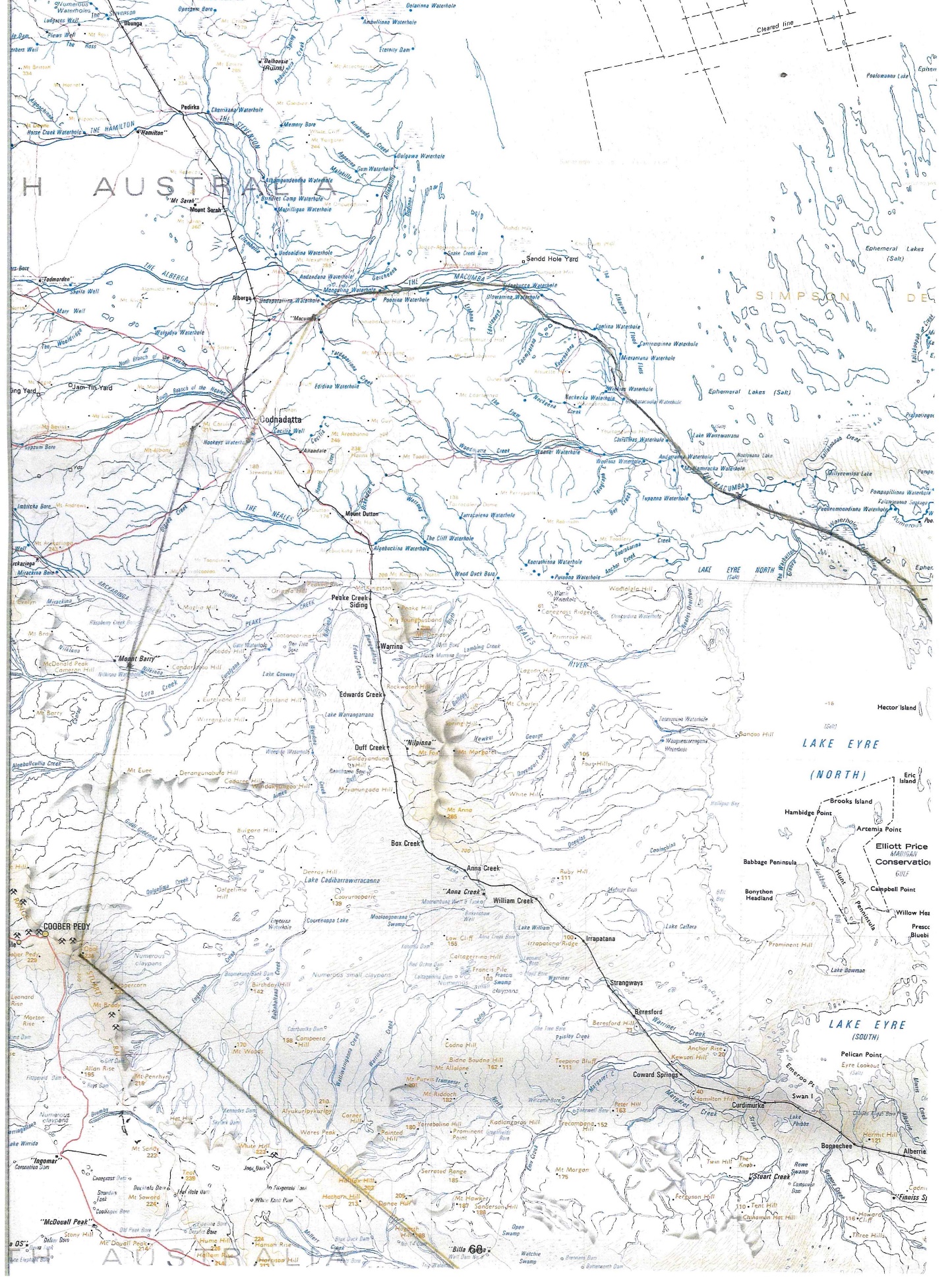
Map 30: Extract from the 1996 Map containing the signatures and marks placed by the senior men
Findings as to the marking of the 1996 Map
701 The findings which I now make concerning the 1996 meeting and the drawing of the lines on the 1996 Map draw heavily on the evidence of Mr Strangways which, as indicated, I regarded as generally reliable. Unless otherwise indicated, I accept his evidence about the meeting and about the marking of the 1996 Map which I summarise below.
702 The meeting in Marree occurred the day after a mediation had taken place between the Arabana and the Dieri Mitha Peoples. The mediation had concerned the foreshadowed native title claims of those two Peoples. Mr Fred Chaney from the National Native Title Tribunal was the mediator, but Mr Chaney was not involved at all in the meeting on the following day in which the 1996 Map was marked.
703 Mr Strangways said that Reg Dodd (he referred to him initially as Ray Dodd but that was plainly a slip) had sought to access the knowledge of the senior men of the various Peoples to assist in defining the country of the Arabana People for the purposes of their intended native title claim; that Reg Dodd gathered as many old people as he could into a room in Arabana House in Marree; and that he explained to them that the Arabana wished to use the map in their native title claim. Mr Strangways gave descriptions of the men who participated in the marking of the 1996 Map.
704 On the basis of Mr Strangways’ evidence and the other evidence concerning the men to which I refer, I make the following findings concerning the senior men. I mention that several other witnesses gave evidence concerning these men, their status and their English literacy but it is not necessary to refer to them all. I am satisfied that the following findings are appropriate:
Norm Wood: A very senior Arabana man who had “great knowledge” of Arabana country by reason that he was taught by, and associated with, senior Arabana men. Mr Dodd and Dean Ah Chee gave evidence to similar effect;
Laurie Stuart: An Arabana man who was senior to Mr Strangways but who could barely read and write. He was the grandfather of Aaron Stuart. Mr Dodd described Laurie Stuart’s knowledge of Arabana country as “very good”;
Brownie Doolan: A very senior LSA man whom Mr Strangways knew well. He was the father of Jeffrey Doolan (a Walka Wani applicant and witness). Mr Ah Chee said that at the time of his death (which other evidence indicated was in 2009), Brownie Doolan had been the most senior LSA man. Dr Cane described him in similar terms;
Whiskey Tjukanku: Mr Strangways knew of him but had not previously met him. He understood him to be a very senior Yankunytjatjara man. This was confirmed by Jeffrey Doolan and Dean Ah Chee. Dr Cane, who had met Whiskey Tjukanku but did not know him well, described him as knowing the Yankunytjatjara law and said that he had accompanied him on field trips when he was preparing his 2006 report;
Ronnie Russell: Mr Strangways did not know Ronnie Russell but it was accepted that he was a senior Yankunytjatjara/LSA man. Mr Strangways described him as middled aged;
Ted Edwards: Mr Strangways did not know Ted Edwards but it was accepted that he was a senior Arrernte/Pitjantjatjara/Yankunytjatjara man;
Old Pannikan: Mr Strangways did not know Old Pannikan but understood him to be Yankunytjatjara man and described him as “very old”. Other evidence indicated that he was a senior Yankunytjatjara/Antakarinja/LSA man;
Bingey Lowe: Mr Strangways knew him very well and described him as having the reputation in the community around Finke as being a senior initiated LSA man. This was confirmed by Jeffrey Doolan and Dean Ah Chee;
Charlie Yundu Spider: Mr Strangways knew him well and described him as a senior initiated Yankunytjatjara man;
Edward Johnson: A senior LSA man and Mr Strangways’ maternal uncle; and
Stanley Warren: A knowledgeable senior Arabana man, more senior than Mr Strangways, and the father of Joanne, Greg and Leonie Warren.
705 None of these men is still alive.
706 At the time, Mr Strangways thought that these were men who had the knowledge to talk about Arabana boundaries and the boundaries of the neighbouring peoples. Each had also been present at the mediation the previous day with the Dieri Mitha. I note that Graham who had worked with Brownie Doolan in 1985 described him as a senior man reputed to have great knowledge of sites and associated narratives. Graham also said that while Bingey Lowe and Brownie Doolan were good with geography, they were not good working with maps.
707 The meeting commenced with Norm Wood putting the large printed but unmarked map on a table; the senior men then gathered around; while talking to, and consulting with them, Norm Wood drew the boundary of Arabana country on the map; in doing so he followed the suggestions of the senior men, adjusting the boundary inwards and outwards as they suggested; all the while, the senior men talked amongst themselves and to Mr Wood (sometimes in English and sometimes in language) and he talked to them; the lines on the Map were identified by the discussion and by reference to the Ularaka and other important sites; the senior men had stood very close around the table so that they could observe what was being done; and Edward Johnson, who was half blind, was right up against the edge of the table with his elbow on it. For the whole of the time while the Map was being marked, Mr Strangways had stood behind Norm Wood, looking over his back.
708 Mr Strangways elaborated what had occurred by saying that, as the boundary was being drawn, there had been a lot of interaction:
A lot of them old people were saying no, it doesn’t go there or it goes further, not there, not there, and they were sort of talking in a fashion.
…
Well, the discussion was, your Honour, where the line should go. Norm would draw a [section] and he just – just talking between himself, “Is that right? Is that right or is that wrong?” And he – and the men present would say “no” or “yes” or “it should be further out”, “you should bring the line back” or – just all discussion they [were] having as Norman put the proposed line up … All – all the men in that room, and the men whose signatures appear on that map, they all put their, well for better word for input, put their two bob in.
709 Mr Strangways said that Norm Wood had followed all the suggestions made to him as to where the line should go, whether “further in” or “further out”.
710 Mr Strangways described the dark coloured line on Exhibit A23 as being the line which he had seen Norm Wood draw in the process just described. His attention was drawn to the lighter coloured line drawn between Mt Barry and Macumba which passed through Oodnadatta itself. He said that that line was not drawn at the meeting and that he was “very surprised much later to see that line”. He agreed that there had been a ruler on the table and that it was possible that the ruler had been used in the drawing of the lines on the map. Mr Strangways agreed that Aboriginal people do not have straight line boundaries and that the use in the 1996 Map of straight line boundaries “can’t be right”.
711 Mr Strangways could not recall how long it had taken for the drawing of the boundaries to be completed “but it was a fair amount – fair amount of time”.
712 When the marking of the boundary and the discussion was completed, each of the old men signed the Map. Mr Strangways said that they did so because Mr Kenny (the lawyer for the Arabana who was present but who had not taken any part in the discussion) asked the men, in the event that they were satisfied with the Map, to sign it. No one refused to sign. Old Pannikin and Edward Johnson signed the 1996 Map by placing their marks on it.
713 Mr Strangways gave the following explanation for not having signed the 1996 Map himself:
There were so many senior men in the room that I deferred to them, and I waited my opportunity, and also Edward Johnson was sitting right near the map. Edward Johnson, he’s my uncle on my mother’s side, and traditionally an Arabana, traditionally a nephew could not make physical contact with an uncle. It is forbidden, so I waited for my opportunity to get my chance to sign that map but unfortunately, as events happened, I did not sign it … after the signing, the men kept talking and still surrounding the map – the table – so I did not get access to the map.
714 Mr Dodd’s evidence was generally corroborative of that of Mr Strangways. Although he was in the room in which the meeting was held, he was not part of the group discussing the Map at the table and could not hear the discussion. He thought that the senior men were “the right people” to make decisions about the boundaries of Arabana country. Mr Dodd described the men as leaning over the Map as they talked about it. While he remembered that Mr Strangways had been present, he did not remember him standing at the table.
715 The whole of the Overlap Area is within the boundaries of the Arabana marked by the senior men on the 1996 Map. It shows the Macumba River as the northern boundary of the Arabana.
716 There were some differences in the evidence of the Arabana witnesses concerning the meeting. Mr Dodd said that he had not been the one who asked the men to come to the meeting. He thought it was Norm Wood and Stan Warren who had done that. Nothing turns on this difference.
717 Jodie Stuart said that she had been present in the room for part of the time. Mr Strangways, on the other hand, said that there had been only men in the room. However, this may be explicable as Joanne Warren said that the men discussing the Map had been “separate from everybody” and that she had been in and out of the meeting room.
718 Counsel for the Walka Wani elicited from Mr Strangways that the Map included areas which either the Arabana did not claim ultimately or in respect of which they withdrew their claim on the basis that particular portions were Kokatha or Yankunytjatjara.
719 Much of the challenge to the Arabana evidence concerning the 1996 Map concerned the facility in the English language of the senior men. Again, where there are differences, I prefer the evidence of Mr Strangways. Mr Strangways said that Norm Wood had spoken in English and that the men around the table had responded to the matters which he raised.
720 Mr Ah Chee, one of the Walka Wani applicants and a Walka Wani witness, said that Brownie Doolan, who was his mother’s brother, could not read or write. He also said that when Brownie Doolan had given preservation evidence in 2004, he had done so with the assistance of an interpreter. Earlier, however, Mr Ah Chee agreed that Brownie Doolan spoke LSA, Yankunytjatjara and English and that he himself had spoken to Mr Doolan mainly in English, understanding each other well. He also agreed that Brownie Doolan was a man who, if he did not agree with something, would tell you. Mr Dodd said that he conversed with Brownie Doolan in English.
721 Mr Strangways accepted that Whiskey Tjukanku did not speak English well but said that he had understood what everyone was saying. Mr Dodd described Whiskey as speaking in English but Mr Ah Chee thought that Whiskey could not read or write. It is reasonable to infer that Whiskey Tjukanku had limited written literacy.
722 Mr Strangways said expressly that Charlie Yundu Spider spoke English. I note that, although someone has written “this is the mark of Charlie”, Yundu Spider’s name has been written in the manner which one would expect had he written his own name, which may confirm that he did have limited facility with written English. Mr Dodd said that he had also spoken in English with Yundu Spider. Mr Ah Chee accepted that Yundu Spider spoke English well and could probably read a map.
723 One can infer that Old Pannikin had limited, if any, written literacy (he having placed his mark on the map). However, Mr Dodd said that he had had many discussions with Old Pannikan about Arabana boundaries and that those discussions had been in English. Dean Ah Chee said that he had conversed with Old Pannikan in English.
724 I think it likely that Ronnie Russell had limited written literacy.
725 Mr Ah Chee said that Bingey Lowe could speak English well but thought he could not read maps. Joanne Warren also thought that Bingey Lowe could not read or write at the time and that he had the help of someone who was caring for him.
726 Mr Dodd said that Ted Edwards could not read or write. Dean Ah Chee said, however, that he had conversed with Ted Edwards in English.
727 I am satisfied that the senior men had, for the most part, a sufficient grasp of English to understand what was being discussed. Of the few who did not, there was discussion in language by which they would have been acquainted with, and involved in the discussions. One cannot exclude altogether, however, the possibility that there had been some misunderstanding or incomplete understanding.
728 It is to be expected that the extent of the knowledge held by each of the senior men as to the boundary of Arabana country varied, according to their own experience and interest. Nevertheless, their very seniority and their senior membership of peoples who lived in close proximity to the Arabana suggest that it was likely that they had, at the least, general knowledge of the bounds of Arabana country. It is also appropriate to take into account that each was informed of the purpose of making the markings on the Map and (I find) were aware that it was intended for use in an application for native title.
729 The State contended that the 1996 Map does not assist the Court in resolving which, if any group, “was present in or held” the Overlap Area at effective sovereignty. It contended that the evidence was insufficient to allow the Court to find that the line drawn on the Map had been agreed on as a demarcation of Arabana country at effective sovereignty or at any other time. The State submitted that the evidence did not indicate:
(a) whether the 1996 Map was intended to show the limits of Arabana traditional country, the boundary of Arabana land as it was understood in 1996, or a boundary which had formerly pertained but which had since changed;
(b) the Arabana witnesses who had been present at the meeting had provided little evidence as to the creation and purpose of the 1996 Map; and
(c) there were unanswered questions as to the drawing of the lines on the Map, including:
(i) who had drawn the lighter coloured line between Mt Barrie and Macumba passing through Oodnadatta itself, when that line had been drawn, and whether it represented some disagreement as to the location of the Arabana boundary?
(ii) whether an attempt had been made to erase the lighter coloured line and, if so, whether that had occurred before or after the signatures were placed on the Map? and
(iii) the significance of the added crosses and numbers at various points of the boundary drawn on the northern and eastern side of Lake Eyre.
730 The State submitted that in the light of these unanswered question, a Jones v Dunkel [1959] HCA 8; (1959) 101 CLR 298 inference ought to be drawn against the Arabana by reason of their omission to adduce evidence from Mr Kenny.
731 The Walka Wani adopted the submissions of the State.
732 Mr Kenny is the principal solicitor acting for the Arabana in the Overlap proceedings. He was present throughout much of the trial so that there can be no question about his availability to give evidence. Counsel for the State submitted that it was likely that Mr Kenny had a more sophisticated understanding of the purpose and provenance of the 1996 Map than did Mr Dodd and Ms Warren and could have provided further (and not merely cumulative) evidence concerning the content of the discussions between the senior men and what the lines on the Map represented.
733 The principles concerning the drawing of a Jones v Dunkel inference are settled: see Jones v Dunkel at 308, 312, 320-1; Kuhl v Zurich Financial Services Australia Ltd [2011] HCA 11, (2011) 243 CLR 361 at [63]-[64]; Australian Securities and Investments Commission v Hellicar [2012] HCA 17, (2012) 247 CLR 345 at [165]-[167]. The Court would not be entitled to infer that any evidence which Mr Kenny may have given would have been adverse to the Arabana case, only that inferences which are otherwise available on the evidence may be drawn more confidently or that Mr Kenny’s evidence would not have assisted the Arabana case.
734 In my view, the drawing of the Jones v Dunkel inference for which the State contended would not be appropriate. Instead, I consider that several of the State’s criticisms of the evidence concerning the 1996 Map are unjustified.
735 The most obvious matter making a Jones v Dunkel inference inappropriate with respect to the marking of the lines on the Map is that the evidence indicates that Mr Kenny took no part in that process, that he was still further away from the table than was Mr Dodd while the Map was marked, and that he had not sought to be a participant in, or observer of, its preparation. Mr Strangways said that he was not near the table at all.
736 It is true that there is a difference between Mr Strangways and Mr Dodd as to who it was who gathered the senior men into the room at Arabana House and who gave them the explanation for the purpose. However, the inference that the senior men had gathered for the purpose of agreeing on the boundaries for the Arabana Native Title Claim, and that they knew that was the purpose, is strong. The very reason that the senior men had gathered in Marree in 1996 was to assist the Arabana in the mediation of the boundary between their country and that of the Dieri. The senior men would have understood that this was a serious matter, especially given the involvement of Mr Chaney from the NNTT. The inference that senior men understood that, in the meeting on the following day, they were engaged in the exercise of identifying the boundaries for Arabana country is confirmed by the very nature of the activity in which they engaged: gathering around a large map and, by a process of active interaction and discussion and by reference to the Ularaka and other sites of importance, identifying boundaries. The suggestion by the State that the senior men may have thought that they were engaged in the exercise of identifying historic boundaries of no continuing relevance is implausible. What would be the purpose of such an exercise? It is much more plausible that they engaged, and understood that they were engaging in, the process of identifying the land which was, in accordance with the traditional laws and customs observed by each group, Arabana land.
737 It is the case that the lighter coloured line drawn between Mt Barry and Macumba has not been explained. Nor is the fact that the dark blue line appears to have been drawn over the lighter coloured line in other places on the Map. This raises the possibility that there has been some alteration of the Map since the senior men placed their signatures on it. However, that is improbable given Mr Strangways’ evidence that it is the dark coloured line on the 1996 Map which he saw drawn by Norm Woods. Further, it was Mr Kenny who asked the men to place their signatures on the Map to indicate their agreement with the boundary drawn by Norm Woods. It is not seriously to be supposed that Mr Kenny, as a responsible solicitor, would be party to the Court being misled by an alteration of the Map so as to enlarge the boundary of Arabana country beyond that on which the senior men had agreed.
Discussion of the 1996 Map at Oodnadatta in March 1997
738 The 1996 Map was discussed at a meeting in Oodnadatta on 24 March 1997 attended by “practically all of Oodnadatta” as well as other “mobs”.
739 Regina McKenzie, who gave evidence about this meeting, said that it “totally rejected” the 1996 Map. She said that her sister Fanny and Douglas Walker had been critical at the meeting of the Arabana for claiming Oodnadatta as their country. Regina McKenzie said that Laurie Stuart did “the flip” on the Arabana and that she had felt sorry for Stan Warren as he looked “so deflated”.
740 The Minutes of the meeting confirm that there was unhappiness with aspects of the 1996 Map but do not confirm Ms McKenzie’s evidence of total rejection of it. I accept, however, that dissatisfaction with the accuracy of the Map was expressed by some of those attendees. I infer that the younger members of the Walka Wani (i.e, those who were younger than the senior men involved in the preparation of the 1996 Map) were alert to its implications with respect to a claim for native title over Oodnadatta and that that appreciation may have led to some of the unhappiness expressed at the meeting concerning the 1996 Map.
Conclusion regarding the 1996 Map
741 I conclude that the 1996 Map, and the agreement of the knowledgeable senior men as to Arabana boundaries which it reflects, does provide an item of evidence on which the Arabana can rely in support of their claim. It is an indication of what the senior and knowledgeable men of the Peoples in the surrounding areas may, in 1996, have regarded as being recognised Arabana country. However, some of the matters to which I have already referred bear on the weight which can be given to the Map:
(a) it is the fact that the lighter coloured line has not been explained. What was it thought to represent when it was first drawn?
(b) a number of the boundaries are drawn as straight lines when it seemed to be common ground that that was not the way in which the Aboriginal people understood the boundaries of their land;
(c) it is to be expected that a number of the senior men would have been more comfortable identifying boundaries by reference to features of the landscape rather than by depiction on a map;
(d) while agreeing on Arabana boundaries, the senior men may not necessarily have been agreeing that the adjacent Peoples had no rights at all, in accordance with their own laws and customs, in the Arabana country;
(e) cultural attitudes may have impacted on their willingness to express contrary views; and
(f) not all had the same fluency in spoken English.
742 All these matters suggest to me that, while the 1996 Map may be regarded as an agreement by the senior men of the Arabana boundaries, it would not be appropriate to regard it as an expression of binding agreement to all the boundaries depicted, in particular, the boundary in the region of the Overlap Area. It is the fact that the boundaries in the 2012 Arabana Determination do depart from the boundaries marked on the 1996 Map in some respects.
743 I also consider that it would not be appropriate to regard the 1996 Map as indicating agreement that the Antakarinja/LSA had no rights at all in the area marked as Arabana country.
744 It is appropriate to conclude this section of the reasons by stating my rejection of the suggestion of two Walka Wani witnesses (Richard Aitken and Rex Tjami) that the senior men had been paid by the Arabana to agree to the boundaries shown on the 1996 Map. There is no evidence at all to support that claim and I observe that the suggestion was not even put to Mr Strangways or Mr Dodd in their respective cross-examinations. Nor did counsel for the Walka Wani make a submission to this effect in the closing submissions. It was obvious that the Walka Wani regarded the 1996 Map as inconvenient evidence but it cannot be dismissed on the basis that it was obtained by nefarious means. With due respect to them, these suggestions by Richard Aitken and Rex Tjami seemed disrespectful of the senior men involved in the preparation of the 1996 Map.
Matters of agreement and difference
745 All of the anthropologists agreed that the Aboriginal people who occupied and possessed rights and interests in the claim area at effective sovereignty were the members of a society united in and by their acknowledgement and observance of a body of laws and customs under which they possessed those rights and interests in, and had a connection with, the land and waters of the claim area. They disagreed, however, as to the number of societies whose members did possess such rights and interests.
746 Cane, Graham and Liebelt considered that there were three societies in the Overlap Area at effective sovereignty, these being Lakes culture, Western Desert and Arandic. Each of those groups had rights and interests in the Overlap Area according to their traditional laws and customs.
747 Lucas, Sackett and Gara agreed that there were three societies in the wider region but did not accept that there had been a Western Desert society in the Overlap Area at the time of effective sovereignty. Each considered that the Overlap Area was Arabana country at effective sovereignty. They reached these conclusions after consideration of the ethnographic-historical evidence reviewed earlier in these reasons, genealogies (in the case of Lucas), the materials concerning movements of the Aboriginal peoples, and of the other sources to which reference has already been made.
748 All the anthropologists and Gara agreed that, at the edges of the regional societies (Lakes Culture, Western Desert and Arandic) the people had interacted by way of ceremony, marriage and trade. They also agreed that the ethnographic-historical evidence suggested stronger interactions between the Lakes and Arandic systems, and between the Arandic and Western Desert systems, than between all three. The anthropologists and Gara accepted that these interactions gave rise to use rights in the Overlap Area with respect to ceremony. They disagreed as to whether these rights were in the nature of “ownership” rights. This is a matter to which I will return.
749 The anthropologists agreed that each system had different ways of attributing or defining rights to country, but Cane, Graham and Liebelt thought that they were similar and compatible. Lucas and Sackett disagreed with that view (Sackett at least with respect to compatibility).
750 Each of Lucas, Sackett and Gara said that the system of law and custom of the claim area at effective sovereignty was the Lakes Culture (Arabana) system, whereas Cane, Graham and Liebet thought that the three systems converged with an “accommodation of beliefs and rights sharing”.
751 At the conference of experts, all the anthropologists and Gara expressed agreement with the proposition that members of the claim groups at effective sovereignty held rights and interests in the Overlap Area under the traditional laws and customs of the society or societies of which that person was a member. Some disagreement emerged at trial, however, as to the nature of the rights and interests so held.
The Cane/Liebelt report of 22 March 2019
752 The Cane and Liebelt report was prepared in response to a request by SANTS to Cane that he prepare a report based on his previous anthropological work with the Yankunytjatjara people in the Western Desert. The way in which the report of 22 March 2019 came to be co-authored by Liebelt, an employee of SANTS, was not explained in the evidence. My impression is that Liebelt acted in the manner of an amanuensis for Cane. Liebelt confirmed at trial that the opinions in the report are those of Cane.
753 SANTS had asked Cane to address three questions of which the first two are relevant presently:
(i) Do some of the Yankunytjatjara people with whom you worked on the above mentioned claim have rights and interests in, and a connection with, the claim area under that same or a similar body of traditional laws and customs to those acknowledged and observed in relation to the Yankunytjatjara/Antikirinja claim area? And
(ii) Please make specific reference to the travels of any Tjukurrpa of which you are aware of within the claim area and to any sites associated with that Tjukurrpa or Tjukunpas …
754 The Cane and Liebelt report consisted of two parts derived from the report prepared by Cane (the 2006 Report) based on his field work and research for the native title claim which culminated in the 2006 Yankunytjatjara/Antakarinja Determination. For the purposes of that report, Cane had undertaken three field trips between September 2005 and June 2006.
755 For the most part, Part One of the Cane and Liebelt report, containing 95 paragraphs, was a simple replication of paragraphs contained in the Cane 2006 report, grouped under four topics:
Community: Yankunytjatjara families with association to Oodnadatta;
Social Context: the Yankunytjatjara-Arrernte connection;
Law and Custom: Tjukurrpa in association with Oodnadatta and Macumba:
- Warru;
Connection: Social and territorial movement in eastern Western Desert.
756 By far the biggest portion of the report (49 paragraphs) was directed to the Yankunytjatjara-Arrernte connection. Given the recognition of the relationship between the Yankunytjatjara/Antakarinja and the LSA in the Eringa No 1 Determination, that is not an issue in these proceedings.
757 Twenty seven of the paragraphs addressed the third topic, i.e, the Tjukurrpa associated with Oodnadatta and Macumba. In relation to the first topic, Cane and Liebelt identified in seven paragraphs five families whose genealogies had some connection with Oodnadatta.
758 In Part Two of their report, Cane and Liebelt expressed two conclusions (it is not necessary to set out the third):
Do some of the Yankunytjaljara people with whom you worked on the above mentioned claim have rights and interests in, and a connection with, the claim area under that same or a similar body of traditional laws and customs to those acknowledged and observed in relation to the Yankunytjatjara/Antakirinja claim area?
[96] It is apparent from the evidence collected during the Y-A fieldwork and presented in Cane (2006) that Yankunytjatjara people have rights and interest in parts of the claim area according to their traditional laws and customs. It is also apparent from the evidence that these rights and interests are shared with other nguraritja identified according to shared laws and customs (relating to residence/knowledge, birth, descent, ritual status and religious knowledge) in that same area. The complexity of social and territorial relationships between Yankunytjatjara and Lower Southern Arrernte is explored above in section 1.2, and the ritual expression of these relationships is evident in shared aspects of the Tjukurrpa (as explored above in section 1.3).
Please make specific reference to the travels of any Tjukurrpa of which you are aware of within the claim area and to any sites associated with that Tjukurrpa or Tjukurrpas;
[97] It is apparent from the evidence presented above in Cane (2006) that an extremely important mythological narrative is associated with the heartland of the Walka Wani Oodnadatta claim area for which, in our opinion, senior Yankunytjatjara men and women hold primary authority and responsibility. Additionally, the April 2006 supplementary notes included in Appendix D below identifies a number of registered cultural heritage sites of importance to both Yankunytjatjara and Lower Southern Arrernte people associated with the Oodnadatta region which are discussed in the document replicated below.
(Emphasis in the original)
759 As counsel for the Arabana noted, these conclusions, in particular the conclusion in the first sentence of [96], are very generally stated. They are not linked to particular Yankunytjatjara/Antakarinja people; they do not indicate the particular rights and interests to which reference is made; and they do not indicate particular claimants for whom those rights are said to exist. Even the Tjukurrpa to which reference is made in [97] is not identified.
760 Cane provided an Addendum report dated 10 April 2006 addressing the concern of the Crown Solicitor’s Office that the 2006 Report had not addressed the issue of “Arabana influences in the eastern part of the claim area”.
761 In the Addendum, Cane accepted as reliable Hercus’ account of the Wati Wilyaru Tjukurrpa and its geographic extent but said that he had no other firm evidence regarding Arabana influence in the area claimed by the Yankunytjatjara/Antakarinja, at [2]. He said that he had endeavoured to describe the interests in country “in terms of social relationships” and that attempts to define boundaries between the Aranda and Antakarinja were misleading. He preferred an understanding of regional social and ritual relationships, at [4].
762 Cane maintained this position in the oral evidence, saying that maps showing boundaries are an attempt to define something which does not exist. Instead, there are sites with ritual significance and it is the identification of such sites which indicates the extent of country. It is when the language of the ritual changes that it can be said that the ritual ceases to be held by a group which previously held it. Cane said that a number of myths of the Arabana had points of amalgamation or conversion with myths of the Western Desert or Arrernte. These included Wati Wilyaru, the red ochre myth, and the fire mythology.
763 Cane went on to say that while he regarded the term “ownership” as clumsy in this context:
[I]f those men are born on the mythology, they own the mythology. The mythology designates the country; therefore they own everything … that is associated with that mythology, including its sites, including the country associated with it … [I]t’s not so much they own it; they have absolute authority for it.
764 This opinion seemed to be an over reach. It is well recognised that some myths commence, travel through, or conclude at locations outside a people’s country without these peoples “owning” or having any authority over, or rights in, the sites associated with the myth. Graham and Liebelt made this point in [222] of their first report when they said that having “a point of origin for … mythological characters outside of one’s own area … is not uncommon”. They gave the “old rain-man” narrative recorded by Spencer and Gillen as an example. The Western Desert red ochre narrative which extends into Western Australia is another.
765 Returning to the Addendum to the 2006 Report, Cane expressed the view that information, which he described as “background information”, suggested “a minimal Arabana link with the claim area through mythology” and that that “ritual link appears to have been stronger amongst Lower Southern Aranda and Yankunytjatjara (Antakarinja) people”.
766 Cane then referred to conversations which he had had with Huey Cullinan, Peter Mungkari and Ronnie Lennon and continued:
[28] These conversations suggest Arabana influence in the region is minimal (if extant). The conversations also suggest that the people with associations in this area are essentially 'one group' regardless of the dialect particular individuals speak. It also indicates that Arabana interest lay to the south of the claim area, although interest in the Oodnadatta area may have been asserted more strongly in the more recent historic period. Others spoken to during fieldwork at Oodnadatta - particularly old Nellie Stewart and Audrey Stewart raised this concern with some emotion. Both were particularly upset by increasing conflict with Arabana people, leaving me with the impression that they felt Arabana people were 'pushing in' and that the Oodnadatta area was outside significant traditional Arabana influence. The thrust of the evidence thus leads me to suspect that traditional Arabana influence in the eastern side of the claim area was slight. I suspect that the ritual relationship between Arabana and Lower Southern Aranda derived from their common knowledge of the rain history linked those groups, but that the influence generated by that myth was significantly Lower Southern Aranda in relation to the claim area, and is greatly diminished in the present context.
(Emphasis added)
767 The antipathy to which Cane alluded in this passage was also apparent in the evidence of many of the Walka Wani witnesses in the trial, in particular in the evidence of Audrey Stewart. There is little doubt that the Walka Wani have come in recent times (within the last 20-25 years) to feel that it is the Arabana who are pushing into their traditional country.
768 The 2006 Report was not directed to the Overlap Area. Understandably therefore, Cane did not undertake any detailed ethnographic-historical research or anthropological assessment in relation to the Overlap Area. These circumstances and its manner of expression suggest that the conclusion expressed in [28] in the Addendum does not rise above “impression”. As the evidence already reviewed in this judgment indicates, there is much more evidence concerning the Overlap Area than that to which it was necessary for Cane to refer.
769 The circumstances in which Cane came to be involved in the present proceedings probably explain the sense of non-engagement which he displayed from time to time. Cane seemed to regard himself more as an observer of the proceedings rather than engaged closely with them. I have already referred to his evidence that he regarded himself as a “visitor” to the proceedings. Another example was his concurrence in the Joint Conference of Experts with the proposition that the earlier maps were more definitive than the later maps, when he had not even looked at the maps. I did not regard that as carelessness on Cane’s part: only that he had not thought that it was within his retainer to engage with the utility of the maps in the way the other anthropologists and Gara had.
770 One effect of the way Cane came to be involved in the proceedings was that he participated in the joint conference of experts and in the concurrent evidence without having provided an expert anthropological assessment directed specifically to the Overlap Area.
771 In all these circumstances, while the Cane and Liebelt Report and the 2006 Report are helpful, I do not regard them as outweighing the assistance to be derived from the reports and evidence of Graham, Liebelt, Lucas, Sackett and Gara.
772 Lucas concluded that the Overlap Area was in Arabana country at effective sovereignty. He based this conclusion on:
(a) the ethnographic and historical evidence;
(b) other sources including the statements of senior Arabana men recorded in the pre-native title era by Bruce Shaw in the late 1980;
(c) his understanding of the different ways by which Lakes, Arandic and Western Desert peoples obtained interests in land;
(d) the absence of any record of Hookey’s Hole having been shared between LSA, Arabana and Western Desert people;
(e) the evidence that the claimant group are the descendants of those who had interests by traditional law and custom in the Overlap Area at effective sovereignty; and
(f) his understanding of the way in which responsibility for Arabana land has changed with the “depopulation” of Arabana people.
773 With respect to the last of these points, Lucas considered that the depopulation of the Arabana had made it “demographically and practically impossible” for them to continue the exercise of traditional rights and interests in the Overlap Area in their full traditional scope. He continued:
[251] In my opinion it is likely that the surviving Lakes Aboriginal population (including Arabana, Wangkangurru and Dieri groups) was progressively insufficient to ensure the persistence of ularaka and marduka relations (both as structures of everyday social life and as the basis of ritual groupings that were their expression). Traditionally, the presence of each was necessary for telling the stories, singing the songs, using the objects and doing ceremony for land (which ultimately sustained the relationship amongst all these integral elements). The extinction or non-viability of either ularaka or marduka groups likely threatened the particular ‘proximate title’ relationship of each to particular estates of land defined in terms of their ularaka identity (see Sutton 2005:116). Rituals requiring the complementarity of ularaka and marduka roles (and therefore the expression of each in terms of rights and responsibilities) ceased with depopulation and the increasing presence of non-Aboriginal people (pastoral workers, fettlers, etc.) throughout the region.
[252] With smaller numbers of people coming together at limited sites (Oodnadatta, Anna Creek, Finniss Springs, Gudnumpanha, Marree, etc.) and the separation of small local groups from their ritual centres, it seems probable that landed interests devolved into a broader ‘underlying’ title held by those survivors who continued to identify as descendants of Arabana people (see Sutton 2003: 116-18). What these subsequent generation people emphasise is the collective right of Arabana people to Arabana land, on the basis of filial connections (through men or through women) to known ancestors who they also believe to be Arabana people who had rights in Arabana land. Arabana people with specific kin-based identities connect with what they understand to be Arabana ‘country’ as a whole. This, in my opinion, is the contemporary expression of underlying title.
(Footnote omitted)
774 With respect to the inter-relationship between the Arandic, Lakes and Western Desert systems, Lucas expressed the following opinion:
[84] In my opinion, the Oodnadatta Common lies in an area where three Aboriginal cultural systems converge; for convenience I have labelled these ‘Arandic’, ‘Lakes’ and ‘Western Desert’ …
[85] I am of the opinion that these represent different systems of traditional law and custom that, nevertheless, had or have developed methods of articulation.
[86] It is the differences, as well as the historical convergence, of these systems that, in my opinion, is at play in the overlap dispute. The laws and customs of different systems are being evoked to claim rights and interest in the subject area. In my view, some of these rights and interests have developed and evolved through a history of connections, but have not erased the rights and interests of Arabana that can be inferred back to sovereignty.
(Footnotes omitted and emphasis in the original)
775 Sackett agreed with this conclusion. He accepted that long term residents of an area may be accorded levels of knowledge of the area and invited to join in the performance of various rites. Sackett referred to this, using the term of Professor Sutton, as “contingent rights”, distinguishing those from “core” rights. Contingent right holders may have a right to use country but without becoming an “owner” of the country. Graham seemed to agree that an analysis of this kind can be appropriate. Sackett said that, while a Yankunytjatjara-Antakarinja individual might, in accordance with Yankunytjatjara-Antakarinja law and custom, assert rights through their birth place, this would “run up against” Arabana law and custom which does not, by itself, recognise place of birth as leading to rights and interests in Arabana land and waters. The different way in which rights to country are obtained in Lakes’ culture compared with Western Desert and Arandic culture, tends to confirm the appropriateness of this understanding.
776 Sackett also referred to the implications of the Arabana having derived their rules from the Mura-mura, the Creative Beings in the distant past. He then said:
[379] In my experience and opinion, if the Arabana and their fellow Lakes Group culture bloc/society members did hold that their laws and customs relating to rights and interests in lands and waters came from the Mura-mura, they would have regarded them as unchanging and unchangeable. Put another way, just as Native Title requires traditional laws and customs be acknowledged and observed, it is in my view more likely than not that Lakes Group culture bloc/society law and custom demanded/demands that traditional laws and customs relating to acquiring rights and interests in lands and waters be acknowledged and observed.
777 This led him to conclude that it is not possible for the non-Arabana to claim Arabana lands through non-Arabana (or Lakes Group) laws and customs, at [380].
778 Sackett supported Lucas’ conclusion that the development he described in [252] of his report was “but an adaption to changed circumstances”.
779 Lucas also concluded that members of the Arabana have continued their connection to the Overlap Area by their ongoing visits, the utilisation of resources as of right, and the teaching of cultural significance to younger generations.
780 Lucas accepted that both the Walka Wani and the Arabana had different versions of the same mythologies. However, he considered that the Arabana versions of the shared mythologies were more likely to be the original and to pre-date sovereignty than did the Walka Wani versions. The conclusion of Shaw and Gibson in 1987 that the stories of the Antakarinja and Southern Arrernte were “second hand having once been the religious repertoire of Arabana and other Lake Eyre peoples” is supportive of this view.
781 Lucas accepted that the LSA did have some rights and interests in the claim area at effective sovereignty but said that those rights related only to ceremony and rights which came from marriage to Arabana people.
782 Graham and Liebelt expressed a contrary view to that of Lucas regarding the differences between the three cultural systems, saying “these three groupings could be said to have as many similarities with one and another as with their own respective ‘categories’”. They said that this was “the nature of neighbouring Aboriginal group relationships throughout Australia, where notions that separate or divide them are often, for the large part, anthropologically constructed phenomena”.
783 Graham and Liebelt concluded, substantially on the basis of the ethnographic-historical records, that the LSA and the Antakarinja had, at effective sovereignty, acknowledged and observed a body of laws and customs under which they possessed rights and interests in, and had a connection with, the Overlap Area and that they have continued, substantially uninterrupted, to acknowledge and observe those laws and customs by which they have a connection with the Overlap Area. They concluded that the Walka Wani have a full range of NTRI in the Overlap Area, namely, rights to travel, camp, hunt and forage, use resources, conduct ceremonies, visit and maintain sites and to provide or withhold access to others without the need for them to obtain outside permission. They said expressly that the normative systems under which the Walka Wani possess their rights and interests have had a continuous existence and vitality since sovereignty.
784 Graham and Liebelt also concluded that the Arabana had not, at effective sovereignty, acknowledged and observed the body of laws and customs under which they possessed rights and interests in, and had a connection with, the Overlap Area.
785 Graham and Liebelt reached these conclusions having regard to:
(a) their assessment of the ethnographic-historical material;
(b) the 2006 Yankunytjatjara/Antakarinja Determination and the Eringa No 1 and No 2 Determinations;
(c) the evidence of the Walka Wani connection to the claim area;
(d) the laws and customs of social organisations;
(e) their assessment of the mythological sites and narratives:
the red ochre ceremony group;
the frog (Ararrkern) narrative, including two sub-mythologies (the Yaldja Ularaga and the Rainbow Brothers);
rain (Anintjola);
snake (Apma);
fire (Ura/Waru);
native cat (Urumbulla); and
woman’s head (Arrkwty-akapert).
786 I mention that Graham and Liebelt also referred to the report of Paul Reader, mentioned earlier in these reasons and seemed to rely on information recorded by Reader which was said to have been provided by Sydney Stewart, Nelly Stewart, Yundu Spider, Tom Parrot, Tom Brady, Paddy Jones and Tommy O’Donaghue. However, as previously noted, the report of Reader did not form part of the tendered documentary evidence and the Graham and Liebelt report did not contain transcriptions of Reader’s discussions with them, or even summaries of what he had been told. In the circumstances, I am disinclined to attach any weight to these aspects of the Graham and Liebelt reports.
The Graham male gender restricted evidence
787 As mentioned earlier, Graham provided a separate male gender restricted report in respect of which the Court had an order under s 37AG of the Federal Court of Australia Act 1976 (Cth). I do not wish to say anything in these reasons which would compromise the confidentiality of that report. Nor do I wish to say anything in these reasons which would compromise the confidentiality of the information in the extracts from two works concerning Aboriginal mythology which were received as male gender restricted evidence, even though they do appear to be published works. I indicate, however, that I have had regard to this material.
788 I think it fair to say that the content of the male gender restricted report concerning initiation and other ceremonies conducted at or near the Overlap Area itself was brief. The references tended to be about ceremonies conducted at Macumba. I can refer to the Berndts’ “Ooldea Monograph” (1945) (which I took to be the “A Preliminary Report of Field Work in the Ooldea Region, Western SA”) and “From Black to White in South Australia” (1950). These were not the subject of any restriction in the trial and Graham referred to them in the open reports. In the Ooldea Monograph, the Berndts stated under the heading “An Initiation Ceremony at Macumba”:
While recently (between May and June, 1944) carrying out field work in acculturation in the northern region of South Australia … we were invited to attend an initiation ceremony involving both circumcision and subincision. The natives participating in the series of rites lived or worked in Oodnadatta and on surrounding cattle stations, mainly Macumba. They belong principally to the ‘Antinari,’Pidjandja and southern ‘Aranda peoples retaining their cultural affinities and language. The initiation was said, by many informants, to be of ‘Antinari pattern …
There then followed some discussion of the relationship between the Antinjari and the Aranda and the Berndts continued:
After being granted by his employer a period of leave from his work at Macumba station, the intended novice (an ‘Antinari) was caught and “tossed” in the Oodnadatta camp on June 11th; he was then taken by his “protector and guardian,” his mother’s brother, and old ‘Aranda man, to Macumba where a camp near the Gercheena creek was chosen.
There then followed a description of the ceremonies which ensued over the following days.
789 It was later in the same work, at 268, that the Berndts noted that the:
’Antinjari seem to have belonged to the country adjacent to and south of the Alberga Creek; their territory did not include Oodnadatta. Those 'Ant‘njari who were the predominant group in the Oodandatta native camp duty our recent visit to that region pronounced their tribal name as “Antinari or ‘Antinarinja.
(Emphasis added)
790 In “From Black to White in South Australia”, the Berndts mentioned some corroborees and ceremonies held in the camps around Oodnadatta but later gave a more detailed description of a particular ceremony:
A number of these men came up to the native camp on the Sunday evening, when the aborigines held a semi-sacred ceremony. This was arranged for their own entertainment, unlike the rather “staged” dances that they sometimes perform for white visitors.
…
This particular ceremony was divided into two sections, and contained mixed Aranda and Antingari elements from these two tribal groups.
There then followed a description of the ceremony and the Berndts continued:
Although this ceremony could not really be termed sacred, it was not held merely for recreation. It belonged to a series of preliminary rituals, leading up to an initiation ceremony that was to take place in a few weeks’ time. An interesting feature of it was the tall headdress worn by the first dancer. This was a wanigi or waniga, which among the Antingari, Southern Aranda and Pidjandjara people is usually shown only in the sacred or totemic rituals that initiated men perform for the benefit of their groups.
The Berndts also referred to “play-about” ceremonies which they described as being for the purpose of providing “amusement and diversion”.
791 In the male gender restricted report, Graham referred to other ceremonies which he considered indicated a “religious basis” for the LSA and Antikarinja “possessing a joint Law relating to the Claim Area”. However, the particular literature to which Graham referred was not in evidence (whether as open or restricted evidence) and it is not possible to assess the quality of that connection. I note, however, that Graham recorded having been told of initiations performed “near Oodnadatta” in the 1960s and 1970s.
792 As I have indicated, I do not wish to compromise the confidentiality of the gender restricted material but I think that I do not do so by indicating that it included photographs of a ceremony conducted near the Ankerr-Nyent site and of locations near Hookey’s Hole.
793 I accept Graham’s evidence of a shared initiation regime between the Antakarinja and the LSA. That accords with the other evidence received in the trial.
Assessment of the anthropological evidence
794 In my view, the opinions of Lucas and Sackett were generally soundly based and reasoned. They are supported by the historical evidence of Gara, the linguistic evidence, the 1996 Map and the other matters reviewed above. I accept their opinions in preference to those of Graham and Liebelt, and to the extent necessary, those of Cane. I was concerned about the objectivity of the evidence of Graham and Liebelt. As previously noted, some lack of objectivity or defensiveness of a position by an expert is probably inevitable but I thought it was much more evident in the evidence of Graham and Liebelt.
795 However, as will be seen, my general preference for the anthropological evidence other than that of Cane, Graham and Liebelt is not conclusive of either the Arabana claim or the Walka Wani claims.
Matters recorded by Shaw and Gibson in the Oodnadatta Aboriginal Heritage Survey Final Report (1987)
796 Shaw and Gibson interviewed many people in and around Oodnadatta in their field work in the 1980s. The information they were given repeatedly indicated that Oodnadatta was Arabana country:
Douglas Walker (born 1953 in Alice Springs)
This is supposed to be Arabana country but I think the Antakarinya people have been custodians. Because you have a lot of Arabana come up here who still do claim this is Arabana country and they still do claim sites as Arabana … [L]ast time they did [drilling sites] a couple of these old elders worked with the Arabana mob to show the drilling mob where the sacred sites were and that sort of thing.
Ruth McKenzie (Lower Southern Arrernte)
Ruth McKenzie was the maternal grandmother of Aaron Stuart and Regina McKenzie. When asked what Oodnadatta means, Ruth responded:
That’s Arabana country early day. [Some say on the border with Aluritji]. No Arabana boundary came to Oodnadatta int (sic) it Clancy? To Oodnadatta, Arabana name. [Clancy] Oodnadatta, not my country. My brother country, Yundu, my brother he born there. He born there, Yundu but I never born there. My country up here Mount Sarah [Ruth]. But you know, years back, before white man well that was Arabana boundary see, Oodnadatta.
As I understand it, the first section in square brackets was an interposition by Gibson. The segment commencing with “Clancy” in square brackets was from Clancy Clamp. The last sentence following “Ruth” in square brackets was from Ruth McKenzie.
Different Aborigines used to be there, in Adelaide, Marree, Oodnadatta. (the people here used to be Arabana). Yes, (now they’re more south to Marree), that’s where they are now. (and the Antakarinja and Arrernte mob are up here).
Tommy O’Donaghue (Yankunytjatjara)
That was Arragana, that big frog. He’s there sitting down alongside Hookey’s Hole waterhole. He was from Oodnadatta. This is Arabana country. That’s Arabana language.
Brian Marks (a senior Arabana man)
I bin (sic) round Macumba and all them places. It was [Arabana country] right back to the Lake. Arabana country used to run right up to what you call Hamilton. [And] Wangkangurru there all mixed up, y’know.
[Arabana country] goes right up past Oodnadatta, takes in all Macumba station … Arabana country goes right up the other side of Oodna, somewhere up around Mount Sarah there. Westward it runs up on the fall of those table top hills there. Well we are this side of the hills … It runs right back through Coober Pedy. All Arabana country is all this side of that.
Macumba station, well that’s our Dream there, see, my mother’s Dream. Macumba, they call it makka … It’s Fire, Fire Dream see.
(Emphasis in the original)
797 Regina McKenzie agreed that Gibson had asked Ruth McKenzie whether she had any idea what Oodnadatta means but did not agree that Ruth had responded in the way recorded by Gibson. Regina was an argumentative witness and I had the strong impression that her evidence was influenced by her appreciation of the potential significance of this evidence for the interests of the Walka Wani. Accordingly, I do not accept that Gibson recorded inaccurately the response of Ruth McKenzie. However, this may not matter much as, whatever was Ruth McKenzie’s view in 1988 when talking to Gibson, she was at some pains, only a year later, to have Oodnadatta shown in the country of the LSA. I will refer to the evidence of this shortly.
798 Shaw interviewed Brian Marks again at the Davenport community (near Port Augusta) in 1998. The transcript includes the following (separated out into questions and answers):
Q: What about Southern Aranda? Were they on your border?
A: Aranda?
Q: Yeah Southern Aranda.
A: Oh yeah, half of it yeah.
Q: On your border?
A: Yeah yeah.
Q: Where would that come to?
A: They come around Macumba country, all that.
Q: Macumba. So that’s ahh, Oodnadatta too yeah?
A: Yeah yeah.
Q: This side of Oodnadatta or other side?
A: No this side.
Q: This side?
A: Further back yeah.
Q: So their border must have met up with the Arabana?
A: Yeah yeah. Yeah that’s right. Yeah that’s true too, yeah, right through.
Q: So right out Oodnadatta itself or … ?
A: Right round. Yeah that’s Oodnadatta back this way. One older place.
Q: Mm? So the Aranda they came down there too?
A: Yeah. Right down. That Peake country.
799 In their second report, Graham and Liebelt made a detailed critique of Shaw’s summary of the statements of Tommy O’Donaghue, suggesting that he had pieced together in composite form separated fragments of what Tommy O’Donaghue had said. They said that Mr O’Donaghue had not actually used the words “this is Arabana country”, had used the Arrernte and not Arabana word for frog, and may have been indicating only that the frog Arragana was from Arabana country. They also pointed to a passage in which Mr O’Donaghue appeared to say that Wangkangurru, Aranda and Arabana people had been present around Oodnadatta before the establishment of the town. It is not possible for the Court presently to resolve these issues but I note that Mr O’Donaghue does seem to have told Shaw expressly that the frog was from Hookey’s Hole (“e bin born there”). However, in the light of the Graham and Liebelt critique, I accept that it would be inappropriate to place very much weight on the statement attributed to Mr O’Donghue that “this is Arabana country”. I note, however, that Graham and Liebelt did not make a corresponding critique of the other statements recorded by Shaw.
800 As Lucas noted, all these statements quoted above were made before the native title era. They were certainly not coloured by perceived interests in proceedings of that kind, and to my mind, attract greater weight than do the statements attributed to the same persons by some of the Walka Wani witnesses, e.g, Maria Stewart in respect of Paddy Jones and Tommy O’Donaghue and Regina McKenzie in respect of Ruth McKenzie.
801 I interpolate here another instance of contemporary statements being inconsistent with previous statements. Audrey Stewart was dismissive of claims to an Arabana presence in Oodnadatta, saying that she had never heard of the Arabana when she was growing up in Oodnadatta and that it had only been in the 1980s that they had started hearing about the Arabana. However, Shaw recorded Audrey Stewart telling him her story on 17 March 1986. On that occasion, Audrey Stewart described her mother as “Arrernte and half Arabana” and of her having been present when her husband CW seemingly acknowledged that he was Arabana. Audrey Stewart’s explanation that she had probably made the first statement so that she “could get out of there” was not credible.
Dr Stephen Davis: January 1993
802 Dr Davis was a geographer who in 1993 published a work entitled “Current Aboriginal Traditional Interests in the Lake Eyre South Region of South Australia”. With respect to the Arabana, Dr Davis recorded:
There are no Wilyuru (lawmen) for the Arabana. Without Wilyuru no one feels confident to talk definitively about country. Tom O’Donaghue is considered the most knowledgeable man for the northern section of the Arabana. He, like Tom Parrot who is also considered knowledgeable, belongs to the Antakarinja group. Angas Warren is the last senior man who knows Arabana traditions in the Lake Eyre south area. Tom O’Donaghue is considered the “top man” by Oodnadatta-based people. However, Tom’s specific knowledge of most of the Arabana boundaries is vague. What is clear is that Arranda territory comes in very close to Oodnadatta on the north side of the town … to a hill known as Arrakutjakaputa … woman’s head … which can be clearly seen from Oodnadatta township. The Arranda extends south to Todmorden and Macumba Stations (Map 7). The Arabana/Antakarinja boundary is unclear, not surprisingly in view of the fact that the Arabana boundary is given by Antakarinja men.
…
The Antakarinja living in Oodnadatta acknowledge that they are living on Arabana territory but, as they have charge of Arabana country for all practical reasons, their authority extends over the combined Antakarinja and Arabana country.
(Emphasis added)
803 I have not set out the map of the Davis because, as noted by Sackett, it has been the subject of a great deal of criticism.
804 There is a good deal of evidence (which I accept) indicating that Yumpy Jack (born in 1900) was the first Yankunytjatjara/Antakarinja person born near Oodnadatta. He was born near Hookey’s Hole. Mr Strangways was told that by Yumpy Jack himself. At the time Yumpy said this, he also said that, because he had been born at Hookey’s Hole, he had traditional rights there. Mr Strangways had corrected him, pointing out that merely being born at a place did not, under Arabana law, give a person rights at that place.
805 The Walka Wani referred to preservation evidence given by Brownie Doolan, as a senior southern Arrernte man, before Mansfield J in November 2004 in relation to the Eringa Native Title Claim. In his statement of evidence, Brownie Doolan said:
[26] South of my country on Macumba is still Arrernte land. Arabana country is other side of Oodnadatta. Arrernte land goes down to Oodnadatta and Mt Dutton. Macumba is not my country.
806 I agree that this evidence supports the Walka Wani case as to the location of country.
807 Brownie Doolan also described there being a “lot of Arrernte people at Macumba when I was a kid” (which, given his age, was probably in the 1930s).
808 In the preservation evidence which Brownie Doolan gave orally, he said that it was “Arrernte right through to Oodnadatta” in apparent reference to the extent of Arrernte country. Later, when asked more specifically how far his country goes, Brownie Doolan had replied that it was “this side Macumba. This side – this side and other side Macumba”.
809 Later again, Brownie Doolan gave the following evidence as to the extent of his country:
Mr Collett: And just so, to try and finish that off, when we were at Irrenhe on Wednesday, that was the first place, you told us that was about how far south your country went; do you remember saying that?
Interpreter: [Discussion in language] Yes.
Mr Collett: Is that nearly to the south of your country?
Brownie Doolan: Yes.
…
Mr Collett: I’ve been looking for places on the map that are further south than that to ask you about. There’s the ruins of old Dalhousie Station, just south of Irrenhe; is that part of your country?
Interpreter: [Discussion in language] Yes.
Mr Collett: The next place south I could find from there on the map called Woodgate Swamp; is that part of your country?
Interpreter: [Discussion in language] Yes.
Mr Collett: And does your country go any further south than that?
Interpreter: [Discussion in language] No.
810 It is not entirely clear, however, whether Brownie Doolan was giving this evidence in relation to the area for which he personally is responsible or as to the extent of Arrernte country more generally. My impression is that it was the former only.
811 In 1989, Jen Gibson authored a book entitled “Molly Lennon’s Story – That’s How It Was”. The book contained information that Molly Lennon (also known as Ruth McKenzie) (born in 1919 and LSA) had given Jen Gibson. The book does not contain any description of Arabana/Arrernte boundaries but does include a map. That map is essentially Tindale’s 1974 map (Map 22 above). However, the boundaries are adjusted so as to locate Oodnadatta just north of the Arabana/Arrernte boundary and therefore in the country of the LSA. The Walka Wani witness, Regina McKenzie, who is a daughter of Ruth McKenzie, said that her mother had insisted that Tindale’s map be adjusted so as to show Oodnadatta in the country of the LSA. This book pre-dated the native title era. Regina McKenzie also described Ruth McKenzie as having lived at Eringa/Bloods Creek from 1919 to 1926, in Oodnadatta in 1926, at the Colebrook Home in Quorn between 1926 and 1933, and thereafter in the Flinders Ranges for a long period (until after 1965). The evidence did not disclose when Ruth McKenzie resumed residence in Oodnadatta.
812 Sackett said that, during the course of his work on the native title claim over the area around Coober Pedy, Yundu Spider (a Western Desert man) had told him that the country around Oodnadatta north to the Macumba was Arabana country.
813 In their closing submissions, the Walka Wani submitted that the opening statement of Gavin Breen’s Lower Southern Arrernte Dictionary, i.e, “This is a dictionary of the language that was formerly spoken in an area between the present towns of Finke and Oodnadatta” was an indication that he had concluded that LSA was spoken south of Oodnadatta.
814 Black, quite fairly and in my view appropriately, said that he did not regard this as “a very strong proposition”. I do not place any weight on this statement of Breen.
815 The Arabana led evidence of seven Ularaka relating to the Overlap Area. Each of these had been recorded in some detail by Hercus. In the view I take of the matter, it is not necessary to record the Uraraka in detail.
816 This Ularaka has two dimensions: a Big Frog and Hookey’s Hole and some smaller Frogs (said to be young men) who had been sought to be recruited to go to battle. Both Mr Strangways and Aaron Stuart gave evidence concerning this Ularaka.
817 Mr Strangways said that he had been told that his grandfather was the traditional owner of this Ularaka. The Owl was said to have originated from Hookey’s Hole and concerned a Wilyaru story. Hercus confirmed that the main centre for the Owl was at Hookey’s Hole. This Ularaka concerns a group of young owl men who go on short journeys from around this site singing and dancing. They finally go on a journey via the wind site at Aminha and on up to the Alberga River and to Ross’s Hole (Watyalpa). They hunt about for mice and for other small creatures and then travel north to via Charlotte Waters.
The Anintoyla (rain maker) Ularaka
818 Mr Strangways gave evidence of this Ularaka and it is recorded in detail by Hercus. This myth and song cycle belongs to the northern part of the Lake Eyre Basin and links Arabana and LSA country. A Rain man “Anintyola” comes from his home “Earhole” (a waterfall) in the desert. He covets this rainstone and runs off with the precious stone. When he gets north of Oodnadatta he cannot resist the temptation of trying the stone again and he floods out and kills all the “Swallow people” at the Swallows rock.
819 Both Mr Strangways and Aaron Stuart gave evidence concerning this Ularaka, as did Mr Dodd. This Kangaroo Ularaka is connected to the formation of Lake Eyre. In this Ularaka at a place called “Thuntinha” by Arabana and Tooninda Springs by Europeans, the main character in the Kangaroo Ularaka has an altercation with an aunt. During this violent altercation, the aunt is hit so hard with his boomerang that her head flies off into the air and lands just north of present day Oodnadatta.
820 Aaron Stuart gave evidence of this Ularaka saying that it had been taught to him by his grandfather, father and other Arabana people. According to Aaron Stuart, this Ularaka concerned two snakes. He said that the “kingfisher” was flying and “dropping and burning the country”. One of the snakes was seriously burnt so both snakes then went underground.
821 Aaron Stuart gave evidence of this Ularaka and claimed that the Turkey story is sacred.
822 Aaron Stuart gave evidence of these Ularakas. Aaron Stuart explained that there are different Emu stories. He detailed the Emu story around Oodnadatta which concerned the Emus’ journey “up through Hookey’s Hole” to Oodnadatta to cut across a little creek in “moon country” to get to water.
Some general matters relating to the Arabana mythology evidence
823 In their first report, Graham and Liebelt were dismissive of the significance of Hookey’s Hole to the Arabana Frog mythology. They said:
Apart from Hookey’s Hole, the narrative of associated sites of this mythology all lie to the south and east of the Claim Area within country that is Arabana and/or Wangkangurru land, which is not in contention here. As the narrative’s ‘old [small frog] man’ is from the Simpson Desert he is exotic to the emplaced mythology of Hookey’s Hole. Further, Hookey’s Hole is largely irrelevant to the mythology save for it being from where he turned to return to his area of origin.
(Emphasis added)
824 However, as Lucas pointed out, this critique involved a misunderstanding of the myth recorded by Hercus. Sackett agreed with Lucas and said that Hookey’s Hole is central to the Large Frog mythology. The record of Hercus of the myth in “Mythological & Ceremonial Sites North-Eastern SA and Adjacent Areas” (1996) supports Lucas and Sackett:
The main Frog History belongs to Arabana people and starts from Uthapuka, Hookey's waterhole near Oodnadatta. A tree-frog arrived there to try and persuade a large party of Waterhole Frogs to go to war with some other frogs far away to the east. They all set off and travelled down the Neales. When they were camped near Algebuckina some local people began teasing them 'what have you come for, you with the big wide mouths?' In the end the Frogs got angry and turned all those people into stone and they are still there as jumbled rocks, and the Frogs are there as larger boulders. They continued down the Neales and then turned north and walked right up to the top of Mt Robinson 'the Frog-path'. They went along the Kancharana Creek to the Macumba, they are still there as rows of trees by the narrow channel as it goes into the Macumba. Ultimately they sank into the ground at a large swamp near the Macumba.
(Emphasis added)
825 It is evident that Hercus had obtained this narrative from Arthur McLean (assisted by Mick McLean) in January 1971 – see “Yaldja Ularaga: The Frog History” (1987) at page 4.
826 In “The Story of Kumpira Piri-Piri or ‘The Dead One’” published with Potenzy in 2000, Hercus said:
Hookey’s waterhole on the Neales was the main ancestral home of the Frogs, and they travelled from there on their long journey down the Neales, to Mount Robinson and then ultimately to a swamp near Lower Macumba.
(Emphasis added)
827 Thus, on the basis of Hercus’ record, Graham and Liebelt were wrong to describe the Frog mythology as “exotic” to Hookey’s Hole and to characterise Hookey’s Hole as “largely irrelevant” to the mythology. I did not understand Graham and Liebelt to maintain the claim of irrelevance in the light of the critique of Lucas and Sackett. Instead, in the second report, they opined that Hookey’s Hole had a “conjoined cultural geography”, at [46].
828 It is also convenient at this point to note an error by Graham and Liebelt in their discussion of the Arabana snake myth. They said that, with the exception of the reference in the narrative to Wampityi, all of the remaining places in the myth were south-east of the Overlap Area. However, as Lucas pointed out, in addition to Wampityi (which is south-west of Macumba), another site (Midlargunna) is north-east of Oodnadatta. In fairness to Graham and Liebelt, that position may in fact be shown in the path of the Rainbow Brothers Dreaming drawn by them.
829 Graham and Liebelt reported on a number of myths relating to the Walka Wani claim. The Walka Wani witnesses also gave evidence about these myths, although in some cases in a form constrained by their law.
830 This myth is similar to the Arabana Yaltya Frog Ularaka, but involves an additional site, i.e, the Ararrkern site in the town of Oodnadatta itself. The Court heard evidence from Audrey Stewart at that site.
831 This myth is similar to the Arabana myth. As Graham and Liebelt noted, while the rain maker in the myth passes close to, and just west of, Oodnadatta, none of the sites claimed by the Walka Wani in the Overlap Area to be significant contain references to him.
832 This myth is associated with, but not confined to, Ankerre-Nyent, the old “soakage” and place of the town camp of the LSA and Antakarinja.
833 This myth has a location outside the Overlap Area (to its north-east).
834 This myth has a wide ranging location extending from coastal South Australia north past Alice Springs.
Woman’s head (Arrkwety-Akapert)
835 Arrkwety-Akapert is said to be the head of a woman decapitated by her husband’s (or nephew’s) boomerang.
Goanna (Wati Milpati/Tinka) and Red Ochre ceremony party
836 There are two Red Ochre narratives, both of which have Western Desert origins. The first is a highly secret and sacred initiation ceremony conducted at different locations on a cyclical basis. It was last held near Hookey’s Hole in about 1958. The second, held more frequently, is also associated with initiations. It has been held at or near Hookey’s Hole at sites regarded by the Walka Wani as sacred and restricted.
837 During the hearing in Oodnadatta, the Court was taken to a site on the Western site of the Neales at which Aaron Stuart commenced to give evidence. This was not one of the previously arranged stopping points. Walka Wani men interrupted, drawing to the Court’s attention the particular sacred, and secret, significance of that site to them. The Arabana then sensibly agreed to relocate to another position. Later, Hughie Cullinan, Allan Wilson and Peter Mungkari explained that they were upset that the Court party, including females, had been taken to a secret place associated with the highest Red Ochre Law. I accept as honest and accurate what these three witnesses said, and the sincerity of the distress which they reported.
838 In his Report written in 2006 prepared in relation to the Yankunytjatjara/Antakarinja claim, Cane identified a number of Western Desert myths relevant to that claim. These included:
(a) the Marlu, Kanyala and Tjurki Tjukurrpa. Cane described the 2006 Yankunytjatjara/Antakarinja claim area as being at the east of this Tjukurrpa;
(b) the red ochre (Wati Milpali – sand goanna) myth. This is extremely sacred and has both male and female components which extend to Hookey’s Hole. The Tjukurrpa travels over a very wide area (Cane said 1,500 kms to the west of the 2006 Yankunytjatjara/Antakarinja claim area). The ceremony of expression of this Tjukurrpa moves cyclically and very slowly (Cane suggested taking 20-30 years but the Walka Wani witnesses in the trial suggested a shorter cycle). I note, however, that Hughie Cullinan appeared to suggest that the last expression of the ceremony at Hookey’s Hole had been in 1958;
(c) the Wati Wilyaru Tjukurrpa. This Tjukurrpa extends north from Lake Torrens to the north-west corner of 2006 Yankunytjatjara/Antakarinja claim area and returns through the claim area to Lake Eyre; and
(d) the Warru (Fire) Tjukurrpa. The myth extends from the Nullarbor Plains and the central south of the Great Victorian Desert to the 2006 Yankunytjatjara/Antakarinja claim area.
839 Graham and Liebelt accepted that there is evidence that Arabana people held mythological associations to, and partook in, ceremonial activities (relating to frogs and other mythic creatures) at sites around Hookey’s Hole in the pre-sovereignty period. They said, however, that they would have expected that these activities included some rituals with neighbouring groups including the LSA and the Antakarinja.
840 Graham and Liebelt also said that they expected that the highly significant red ochre religious mythology and ceremonial activities as well as the frog narratives at Hookey’s Hole in the pre-sovereignty period had given rise to co-existing rights and interests in the vicinity of Hookey’s Hole for both claimant groups. They accepted, however, that in the post-sovereignty period, most likely in the 1920s (given Mick McLean’s comments and the timing of Yumpy Jack’s birth in 1900) that the Antakarinja/Arrernte had assumed the major ritual responsibility for any Arabana portions of the religious content relating to the Frog mythology at Hookey’s Hole.
841 Graham and Liebelt referred to multiple factors which appear to have contributed to a break down in Arabana initiation practice with subsequent attenuation in their knowledge of the law, as well as knowledge of and participation in the shared mythology of Hookey’s Hole.
Assessment of the Arabana claim
842 It was common ground in the final submissions that the Arabana had had NTRI at effective sovereignty in the Overlap Area in accordance with the traditional laws acknowledged and traditional customs observed by them. Having regard to the combined effect of the ethnographic-historical evidence, the linguistic evidence, the evidence of Sydney Strangways, the evidence of migration, the evidence of custodianship, the other sources and the anthropological evidence reviewed and assessed above, that is a correct understanding of the position and the conclusion inevitable.
843 This means that, for the purposes of assessing the Arabana claim, the principal issue is whether they have established that they have continued to possess the rights and interests in the Overlap Area under the traditional laws acknowledged and traditional customs observed by them and have thereby maintained connection with the Overlap Area. In the trial, the parties referred to this in shorthand as being whether the Arabana have established continued connection with the Overlap Area.
Have the Arabana maintained connection with the Overlap Area in accordance with the traditional laws acknowledged and traditional customs observed by them?
844 Earlier in these reasons, I set out the traditional laws and customs of the Arabana by which rights and interests in land are possessed and it is unnecessary to repeat them.
845 In his reasons provided in connection with the 2012 Arabana Determination, Finn J noted the following matters concerning continuing connection by the Arabana with the claim area then under consideration:
[40] The evidence suggests that the classical system of landholding by localised groups based on patrafilial Ularaka (ie traditional stories) is no longer observed. Contemporary Arabana people consider that all of Arabana country belongs to Arabana people generally. Nevertheless, the evidence demonstrates that some individuals or families are recognised as having special knowledge of and responsibility for particular areas and their Ularaka, including related songs.
[41] In the context of negotiations for a consent determination, the State could properly accept that the changes in traditional rules of succession to country that accommodate both patrifilial and matrifilial descent, and succession to the country as a whole (as distinct from particular parts of the country) have their basis in traditional law and custom. For these purposes, the State accepts that the pre-sovereignty normative society has continued to exist throughout the period since sovereignty, notwithstanding an inevitable adaptation and evolution of the laws and customs of that society.
…
[46] It was the opinion of the experts, amply supported by the evidence, that contemporary connection to country by Arabana people continues to be governed by laws and customs, including those which go to authority, gender and knowledge of the physical and cultural geography of the claim area, including Ularaka.
846 Finn J then went on to describe a number of matters bearing on the continued connection of the Arabana with the 2012 Determination area. These included the continued observance of normative rules relating to authority, the transition of Arabana traditional law and custom to younger members of the group, continued use of Arabana names and kinship terms, maintenance of knowledge of the traditional Ularaka and the normative rules related to those Ularaka, the continued residence of Arabana people in the claim area, the knowledge of the claimants of the area and their continued engagement in traditional activities including hunting and gathering for food.
847 The principles recognised in the authorities relating to the assessment of continued connection include:
(a) connection involves the continuing internal and external assertion by the claimant group of its traditional relationship to the country defined by its laws and customs: Sampi at [1079]; Bodney v Bennell at [173];
(b) connection may be established by evidence of physical presence, but its absence is not fatal to the continuing connection: Bodney v Bennell at [171]-[174];
(c) non-physical forms of connection may include spiritual, cultural, social and utilisation connections: Yanner at [37]-[38]; Ward FC at [323]; Akiba FC at [172], [655];
(d) the assessment of connection requires, first, an identification of the content of the traditional laws and customs and, secondly, the characterisation of the effect of those laws and customs as constituting a “connection” of the peoples with the land or waters in question: WA v Ward at [64];
(e) the connection need not be maintained in the same manner as it was at effective sovereignty. Account may be taken, amongst other things, of displacement and depopulation.
848 It is appropriate to commence by indicating my acceptance of the State’s submission that it is connection with the Overlap Area which must be established and not just connection with the wider region. However, that does not mean that one ignores the effect of the 2012 Arabana Determination. The Arabana obtained that Determination by satisfying the Court that, in contemporary Arabana law and custom, all Arabana country belongs to all Arabana generally. It is accordingly pertinent that the possession of NTRI under the traditional laws acknowledged and customs observed by the Arabana generally has been recognised.
849 Moreover, the Overlap Area is immediately adjacent to the area of the 2012 Arabana Determination and comprises a very small fraction of the overall area claimed by the Arabana as Arabana land. Its existence as a separate area is an artefact of colonial decisions (the proclamation of the town of Oodnadatta and the gazettal of the Common) which had no relationship with the bounds of Aboriginal country. This would make it natural for the Court to have regard to matters bearing on the Arabana connection in the larger area.
850 However, the same reasoning would apply, in substance, in relation to the claim of the Walka Wani, given the determinations over adjacent areas which they, or elements of them, have obtained.
851 There was debate in the submissions of the Arabana and the State as to whether s 223 involved, in addition to qualitative aspects, quantitative aspects of connection. In my view, attempts to characterise particular matters as being either qualitative or quantitative in character is a distraction. There is no strict dichotomy between the two as they are inter-related.
The matters relied upon by the Arabana
852 The Arabana submitted that 10 matters indicated the continuity of their connection with the Overlap Area in accordance with their traditional laws and customs. It is convenient to address these in turn.
(i) The matters established for the 2012 Arabana Determination;
853 The Arabana relied on the matters established by the 2012 Arabana Determination in relation to the immediately adjacent land, including the finding that rights to Arabana country are held, under the Arabana system of law and custom, by Arabana society as a whole, with Arabana People and families having localised attachments, and that under Arabana rules, rights in land are based on filiation from known Arabana Persons.
854 I have accepted these matters but the requisite continuity of connection of the Arabana in the Overlap Area in accordance with traditional law and custom must be established by the evidence in these proceedings.
(ii) The continuity of Arabana people living in Oodnadatta
855 The Arabana relied on the continuity of Arabana People living in Oodnadatta itself.
856 The evidence of Arabana People continuing to live in Oodnadatta is limited and gave rise to its own discrete issues.
857 Only two of the six Arabana witnesses (Aaron Stuart and Leonie Warren) have ever resided in Oodnadatta, other than as a short term visitor.
858 Aaron Stuart has lived most of his 52 years away from Oodnadatta. As a child he camped with Laurie Stuart in the Overlap Area on three occasions; on leaving school he worked intermittently in Oodnadatta and on stations in its vicinity; and he lived in Oodnadatta as a Community Police Officer for approximately two years between August 1998 and June 2000. Aaron Stuart also said that he had also lived with Pauline Coombes in Oodnadatta for approximately two years before his period as a Community Police Officer, but this was disputed by Pauline Coombes. She said that they had lived for the whole of their time together in Port Augusta. I think Pauline Coombes is more likely to be correct about this but consider it unnecessary to express a firm conclusion. Even if Aaron Stuart be correct, he has still not resided in Oodnadatta for approximately 20 years since June 2000.
859 Leonie Warren lived in Oodnadatta between 1991 and 1997 but has not done so again since leaving following the kangaroo/freezer incident.
860 Greg Warren has lived in Oodnadatta for many years but did not give evidence.
861 The Arabana witnesses and Lucas gave evidence of other persons said to be Arabana who have lived in Oodnadatta. This was supported to an extent by the genealogies of Lucas.
862 As already noted, there was a substantial dispute on the evidence as to the Arabana identity of many of the persons claimed by the Arabana as Arabana. I repeat my view that elements of the Walka Wani contention that there were no Arabana people at all in Oodnadatta is implausible, but, given the length of these reasons, it is not possible or practical for the Court to make an assessment of the precise extent of Arabana presence. For the purposes of resolution of the matter, I will proceed on the basis that people who have resided in Oodnadatta and who were named as Arabana by Arabana witnesses and by Lucas are, or were, Arabana.
863 There is no evidence those Arabana who continue to live in Oodnadatta do so because they are Arabana, or that they continue to observe Arabana law and custom, or that their manner of living derives from, or is influenced by, or reflects an acknowledgement or observance of, Arabana traditional law and custom. For all the evidence indicates, their residence in Oodnadatta may be attributable to the availability there of housing, including publicly provided housing, or of employment opportunities. That is especially so in the case of more recent times, say, the last 20-30 years. The older Arabana, now deceased, may have lived in Oodnadatta because of, and in accordance with, Arabana traditional law and custom connecting them, and the rights and interests to which they gave rise, but there is relatively little evidence of that being so in more contemporary times. The younger cohort of Arabana witnesses did not indicate any familiarity with the principles in Arabana law and culture by which persons acquire rights and interests in Arabana land or with the secondary rights passed down from mothers.
864 I take into account the evidence that some Arabana have felt uncomfortable in continuing to live in Oodnadatta. For example, Leonie Warren who left after the kangaroo/freezer incident and Stan Warren who moved from Oodnadatta after the 1997 Meeting in which there was the rejection of the 1996 Map to which he was a signatory (and, it can be inferred, some public humiliation of him). This may account for an absence of physical presence in their cases. I accept that this connection is not lost simply because a person feels precluded from remaining on their country.
(iii) Continued use of the natural resources in the Overlap Area
865 There was some evidence of the use of the natural resources of the Overlap Area in contemporary times but it was not extensive. Joanne Warren and Leonie Warren gave evidence of camping in the Overlap Area and making use of some of the bush resources. Leonie Warren “loves camping” and does so regularly at various places in the area of the 2012 Arabana Determination, and near Hookey’s Hole and on the claypans. She has continued, since leaving Oodnadatta to do so. She visits Oodnadatta 3-4 times per year for funerals, to visit Greg Warren or to attend the bronco branding gymkhanas. On some of these occasions, she camps and hunts or makes use of natural resources. Leonie Warren’s brothers have taught her children how to hunt and about bush foods. So has her husband who is a Kokatha man.
866 Joanne Warren gave evidence to similar effect, although it does not seem that she is an enthusiastic camper like Leonie. It did not seem that she is engaging in these activities very frequently now.
867 Aaron Stuart gave evidence (supported by photographs) of his camping and food gathering activities in the Overlap Area, but it was not clear that that has continued since he ceased residing in Oodnadatta approximately 20 years ago.
868 Dr Arbon also gave evidence of some camping in and around Oodnadatta and of eating bush tucker “if we knew what the plant was”. On one occasion, a kangaroo was caught and cooked. She has been trying to have her children and grandchildren learn about Arabana country.
869 The Arabana also referred to the Fergie and Lucas report prepared in connection with the 2012 Arabana Determination.
870 The Arabana submissions accepted that the evidence of use of natural resources in the Overlap Area is likely “only a fragment” of the evidence which would have been available in former times.
871 Hunting and gathering of food is a recognised NTRI but the evidence that this was done in traditional ways or for traditional purposes was limited. In some respects, the evidence of Leonie and Joanne Warren and of Aaron Stuart was the strongest evidence of continuing physical connection by Arabana people.
(iv) Continuity of learning, respecting and teaching the Ularaka
872 The evidence on this topic was limited. Aaron Stuart said that, in respect of his own children, he had taught them the Ularaka “a little bit, now and then”. He also said that it is the role of an uncle or grandfather to teach the Ularaka, but did not say whether that had occurred in his family. He accepted that he himself had a responsibility to teach and said, with respect to his grandchildren, that he was “starting with just language”.
873 Dr Arbon said that she engages in some education of the children in her extended family but it is evident that she herself has only limited knowledge of the Ularaka. She has been engaged in the promotion of the learning of the Aboriginal language and it is reasonable to infer that some teaching of the Ularaka may be an incident of that, but my impression was that her knowledge of the Arabana Ularaka is limited. When asked about her teaching of her children and grandchildren of the frog story associated with Hookey’s Hole, she said only “I mention to them that it was a place to look after because it was a place where there was a story that belonged to Arabana”. She did not disclose knowledge of the details of the story or convey the content of which she was teaching her children. Dr Arbon did not give evidence of teaching her children the other Ularaka. A related matter is that she acknowledged that her knowledge of the Arabana two moiety system was “limited” and she did not give any evidence indicating awareness of the Arabana moiety subleases or totems, or kinship system more generally.
874 Sydney Strangways gave evidence that he is involved in a lot of teaching but did not claim that any of that teaching related to Ularaka concerning the Overlap Area or that it was to persons who have connection with the Overlap Area.
875 Leonie Warren said that she had not been taught about Ularaka from around the Oodnadatta area. Nor had she been taught the Arabana moiety system. She did not give any evidence of learning, respecting or teaching the Ularaka.
876 Likewise, Joanne Warren did not claim to have been taught about the Ularaka or that she was herself teaching them. With respect to Arabana traditional law concerning kinship, she said only that she had been taught that “we can’t go and marry our own family, not a close family”. Her parents had not taught her about the moiety system, had not spoken about mathari and karraru, and she had not heard other Arabana people speaking about them. Joanne Warren did not give any evidence indicating awareness of the Arabana kinship totems.
(v) Protection of Ularaka sites
877 The Arabana referred to a number of matters in support of their claim that they had continued, and were continuing, to protect the Ularaka sites in the Overlap Area.
878 I made findings earlier about the Arabana appointment of custodians. Their conduct in doing so can be regarded as an action in protection of Arabana sites. However, the appointment of custodians appears to have occurred in the 1950s (i.e., putting to one side the probable earlier appointment of Yumpy Jack), more than 60 years ago. The custodians then appointed are long deceased. There was no evidence of the appointment of successor or replacement custodians or, apart from the conversation which Reg Dodd had with Tom Brady, evidence of continuing communications with custodians. There was no evidence that the Arabana are ensuring that current LSA or Antakarinja men are, in some de facto way, undertaking the roles of custodians. The evidence in the proceedings would make fanciful any suggestion that the present Walka Wani would understand themselves to be acting as custodians of the Arabana or acting on their behalf in the protection of sites in the Overlap Area.
879 The Arabana sacred objects are not retained in or about the Overlap Area. Reg Dodd said that he had been told that the sacred objects entrusted to the custodians (which he likened to “the Crown Jewels”) had been taken by senior men (presumably Yankunytjatjara men) to Mimili for safe keeping. There was no evidence of that having occurred with the consent or authority of the Arabana as Sydney Strangways said that they had been left in an unidentified location north of Oodnadatta.
880 Counsel for the Arabana accepted that no custodians had been appointed after the 1990s (I consider that the relevant time is much earlier) but said that the Arabana had now adopted a different regime, evidenced by the work area clearance system. That seemed, with respect to counsel, a rationalisation of the evidence to overcome a difficulty in the Arabana case. There was evidence in the trial of two work clearances but detail of only one which took place in 2004. There is no evidence as to what was done with respect to care or replacement custodians in the long period between the late 1950s and 2004. There is no evidence from a Arabana witness, in particular from Mr Strangways, who may be expected to know if that was the case of this change in the practice concerning custodianship.
881 While the conduct of the Arabana in appointing custodians would have assisted the Arabana in establishing continued connection in former times, I do not consider that it assists in establishing continuing connection to contemporary times.
Holding ceremonies at the Ularaka sites
882 Conduct of this kind does not assist the Arabana as their counsel conceded, appropriately, that there is an absence of evidence of ceremonies in the Overlap Area. There have been no initiation ceremonies at all since at least 1958. There is evidence that funerals and Sorry Business are conducted but the evidence did not go beyond that.
Site inspections and monitoring
883 It is the fact that Aaron Stuart and others engaged in the site clearance for a mining company in 2004 at a site on the Overlap Area and that can be regarded as an activity directed to the protection of the Ularaka. Joanne Warren thought that she had been on one site inspection with, she thought, Veronica Milera and Mr Strangways but could not remember the details.
884 The evidence of other activities by way of protection is sparse.
885 Aaron Stuart also gave evidence that, when he was a young man, he had assisted his uncle Douglas in objecting to the cattle of Allendale Station “mucking up [the] sites” at Hookey’s Hole. However, this seemed to be a general complaint about the activities of the cattle as his uncle had not pointed out the sites. He also said that he had kept people away from sites but had done so by not telling anyone about them. It did not seem that he had given even his own children or grandchildren details about sites so that they could engage in protection of them.
886 In about 1976, Reg Dodd was involved in a consultation with the local community by the ALT which resulted in a decision to put up a fence around Hookey’s Hole to protect it from damage caused by the stock on Allendale Station. Also, while he was employed by the Department of Aboriginal Heritage as an Inspector, he had a role in the protection of Aboriginal sites. It was, however, unclear whether Reg Dodd was doing so as a duty of his employment, or by reason of his observance of traditional Arabana law and custom, or perhaps, a combination of both.
887 None of Mr Strangways, Leonie Warren or Dr Arbon gave evidence of action by way of protection of Ularaka sites.
Dissemination and teaching of appropriate site information and keeping other site information confidential
888 The evidence to which the Arabana pointed to support activities of this kind does not, with respect, have that effect. On my understanding, the evidence did not extend beyond Aaron Stuart’s statement that he refrained from telling others about sites because keeping them secret was a means of protection and Mr Dodd’s evidence that he participates in the education of school groups (which seemed to include children other than the Arabana) about Aboriginal places and practices in the Oodnadatta area. He also engages in cultural education of tourists, but this, by definition, is not education of the Arabana.
Fencing and signage at Hookey’s Hole
889 The Arabana did not point to any additional evidence concerning this form of activity, i.e, additional to that which has been reviewed above.
Arabana claimant involvement in site clearance work
890 The Arabana submissions did not point to any evidence additional to that referred to above.
Arabana claimant involvement in negotiations over protection of the Common
891 The Arabana submissions did not make clear what action they relied upon for this sub-topic.
892 The evidence of the most recent exclusion of persons from Arabana country was that given by Sydney Strangways concerning the removal of the Yankunytjatjara men who had engaged in some unidentified form of offensive conduct at Anna Creek in the late 1950s.
(vi) Continued acknowledgement and observance of other traditional laws and customs in the Overlap Area
893 The Arabana relied on three forms of activities under this heading. These were the continuation of initiation ceremonies until the late 1950s; the observance of Arabana funerals and Sorry Business in Oodnadatta in recent times; and the giving of permission by Arabana people to go to Hookey’s Hole and the Oodnadatta Common.
894 However, the evidence about Arabana funerals in Oodnadatta was almost non-existent. When Sydney Strangways was asked, he said that it was hard to answer because, living in Alice Springs, it was hard for him to get back to Oodnadatta for funerals but he did give evidence of his participation in Sorry Business as a younger man. Mr Strangways does wish to be buried in the Aboriginal way but that evidence was not linked to the Overlap Area.
895 None of Aaron Stuart, Reg Dodd or Joanne Warren gave evidence of returning to Oodnadatta for funerals or Sorry Business. Leonie Warren spoke of returning for the funeral of Yundu Spider and said that funerals were one of the reasons she returns to Oodnadatta from time to time. She did not give evidence that these funerals were conducted in a particular way so as to accord with Arabana traditional law and custom.
896 As to the giving of permission, none of the Walka Wani witnesses or Arabana witnesses said that they felt they had to seek permission to go to places in the Overlap Area. Sydney Strangways did say that there were Arabana sites to which non-Arabana persons could not go even with permission. In particular, he said that non-Arabana people do need permission to go to the Oodnadatta Common and Hookey’s Hole but the evidence in the trial indicated that either such a requirement is not known or that it is not enforced. To an extent, Sydney Strangways’ evidence concerning the topic of permission tended to underline the absence of continued Arabana connection. Even if it was the case previously that permission was required, it is plain that no one now regards that as a requirement and that the Arabana do not seek to impose that as a condition. Mr Strangways accepted that that was so and explained that it was because “we live under the European system”. Naturally, account must be taken of the practical circumstances encompassed by this statement of Mr Strangways, but the evidence does not disclose any attempt to enforce requirements for permission to the extent that it is still practical.
(vii) Continuing internal and external assertion of traditional relationships to the Overlap Area
897 The Arabana submitted that the forms of continuing connection already mentioned (living on the claim area, respecting, teaching and protecting the Ularaka for the Overlap Area and involvement in Arabana ceremonial and social life) involved an implicit assertion by the Arabana of their traditional relationship to the Overlap Area.
898 One may accept that activities of this kind have this character, but for the reasons already given, the actual evidence of these activities is limited.
899 The Arabana asserted in addition that they have made and continue to make explicit assertions of traditional ownership to the Overlap Area. The submissions referred to the following activities in particular:
The teaching of Arabana children that that Oodnadatta is part of Arabana country
900 There is evidence of activities to this effect from Mr Dodd, Dr Arbon, Leonie and Joanne Warren, and from Aaron Stuart. Moreover, these witnesses, and in addition Mr Strangways, were told by their parents that the Oodnadatta region is Arabana country.
Public self-identification by Arabana People as Arabana
901 There is evidence in the past that people in Oodnadatta have identified as Arabana but the evidence of that occurring in more recent times is sparse.
902 Mr Dodd did say that he goes to Hookey’s Hole from time to time to check it from a cultural and environmental point of view. However, it is evident that many of Mr Dodd’s visits are in connection with his activities in education in Aboriginal law and culture generally rather than with specific reference to the Arabana. By way of example, he assists in educating school children but these will come from many areas, including the Dieri and other non-Arabana locations. Otherwise, the evidence of actual assertion of the traditional relationship with the Overlap Area was sparse.
(viii) Knowledge of the boundaries of Arabana country
903 The Arabana submitted that they have a clear knowledge of the boundaries of their country and have regularly articulated and taught their children that Oodnadatta is Arabana country. The evidence concerning the making of the 1996 Map is some evidence supporting this proposition as does the evidence of Aaron Stuart, Reginal Dodds, and Joanne Warren that they were told by their elders and others that Oodnadatta is Arabana country. On the other hand, there is very little evidence concerning the witnesses’ knowledge of the extent to which Arabana country extends to the west of Oodnadatta, i.e, to the western extent of the Overlap Area.
(ix) Continuity of involvement in ceremonial life
904 The evidence does not support this claim of the Arabana. As Sydney Strangways said, initiation ceremonial activity was suspended or put into abeyance in the late 1950s and there was no evidence of other ceremonial activity in or in proximity to the Overlap Area since then.
(x) Continuity of Arabana Peoples’ social connections with Oodnadatta
905 I accept that there is some evidence of Arabana People maintaining connections with Oodnadatta. For example, to visit relatives and to engage in social activities such as race meetings, bronco brandings and gymkhanas. However, the evidence that this occurs as a manifestation of Arabana traditional law and custom is sparse. Counsel for the Arabana referred to passages in the report of Fergie and Lucas in 2011 (and repeated by Lucas in his first report):
[255] Races, gymkhanas, bronco brandings, cattle drives, reunions, anniversaries and especially funerals are the key communal events of contemporary Arabana society in which continued commitment to a system of custom and law is expressed. The significance of these is expressed in Opinion 8 in the Table of Expert Opinions …:
Arabunna [sic] people attending communal events are subject to Arabunna custom and law. Communal events are contexts in which proper Arabunna behaviour (that is the Arabunna normative system) is practised, monitored and transmitted between generations. Improper behaviour is censured. Communal events are also contexts in which membership of Arabunna society is activated, maintained, and policed and relations to others, living and dead, are remembered and memorialised.
[256] We noted in the Table of Expert Opinions … that,
The fact of undifferentiated underlying title does not negate the strength of some people’s associations to particular areas of Arabunna country. Some individuals or families have, in our view, particularly close associations with particular parts of Arabunna country. This association is usually based on their knowledge and experience of that area. We have evidence that some people feel strongly connected to certain places because they have inherited or been given knowledge for a particular ularaka and associated sites, because they grew up, live(d) or work(ed) on certain stations, or because of other biographic circumstances. People may choose to visit, camp, hunt, or collect bush medicine mainly in the areas to which they have a particularly close biographical connection. This, however, does not mean that they have no rights to access other parts of the claim area or that they own the areas they frequent to the exclusion of other Arabunna people.
906 However, as the evidence of the Arabana witnesses in the trial reviewed above indicates, the evidence of the continuity of these connections in relation to the Overlap Area is relatively limited.
907 Looked at more generally, a number of matters were absent from the Arabana evidence concerning connection. There is relatively little evidence of ritual associations with sites, or of “singing of country”, and no evidence of the storage of sacred objects on the Overlap Area. In the case of the Arabana witness with the most knowledge of original traditional law and custom (Mr Strangways), there is no evidence of him coming back to the Overlap Area to reconnect with it. His physical presence on the Overlap Area is confined to passage through it. He does not visit sites and it seems has not spent a night in Oodnadatta since the late 1950s or early 1960s. His acknowledgement of Arabana traditional law and observance of Arabana traditional custom in relation to the Overlap Area is now of a spiritual rather than practical kind.
908 The Court was not asked to hear gender restricted evidence from the Arabana and, even though Aaron Stuart had concerns about some of his evidence being heard by women, he did give evidence at one site without any objection to the presence of females and there was no evidence that gender specific division of knowledge is being taught within the Arabana People.
909 The Ularaka relating to the Overlap Area are not being taught to the younger generations. I note again that Aaron Stuart said that he had taught “a little bit, now and then” to his own children. Leonie Warren acknowledged that she had not been taught any of the Ularaka relating to the Overlap Area and Joanne Warren was unsure about the details of several.
910 Much of this is explicable given the movement of the Arabana away from Oodnadatta to which I have referred earlier.
911 Section 223 requires not just that the traditional laws and customs be known but that rights in land in this case the Overlap Area, be possessed by the acknowledgement and observance respectively of those laws and customs. It is by that acknowledgement and observance that the connection with the Overlap Area must be shown. Knowledge of what used to be the case is insufficient. Mr Strangways plainly has knowledge of Arabana traditional law and custom, and he would acknowledge and observe Arabana law and custom in the Overlap Area. Aaron Stuart’s evidence showed some knowledge of Arabana traditional law and customs but relatively little by way of actual acknowledgement and observance of them giving rise to a connection with the Overlap Area.
912 Evidence of the matters to which Finn J referred in 2012 is lacking. There is a relative absence of knowledge of the Arabana normative rules relating to authority (several witnesses did not even claim familiarly with them); the evidence of the transition of Aboriginal law and custom to the younger members of the Arabana is limited (often, it seems, because they are not known); while Arabana place names are used, the Arabana moiety, kinship and totemic names are not; some of the Ularaka are not known, let alone passed on; and the continued engagement in traditional activities on the Overlap Area is not extensive.
913 There is of course a connection with the Overlap Area which arises from having been taught that it is Arabana country or from having been taught that one is Arabana and that Oodnadatta is Arabana country. It was connections of this kind which in the main were asserted by the Arabana witnesses. However, as indicated, the connection required by s 223 is a connection arising from the continuing acknowledgement of traditional laws and traditional customs observed by the claimant group.
914 It is the relative absence of acknowledgement of traditional law and observance of customs by which a connection by the Arabana to the Overlap Area is maintained which is, in my opinion, fatal to the Arabana claim.
915 I am conscious that a conclusion that the Arabana have not maintained connection with the Overlap Area is inconsistent with the opinion of Lucas, who I thought generally was a sound witness. However, the Court heard much more detailed evidence concerning the issue of Arabana connection then he obtained, and it is appropriate to act on the basis of that evidence, rather than his opinion.
916 For these reasons, I am not satisfied that the Arabana have established the maintenance of their connection with the Overlap Area in accordance with the traditional laws acknowledged and traditional customs observed by them. Their claim must be dismissed.
Assessment of the claim of the Walka Wani
917 The critical issue bearing on the claim of the Walka Wani is whether they possessed, at effective sovereignty, rights and interests in the Overlap Area under the traditional laws acknowledged, and the traditional customs observed, by them and whether they were connected to the Overlap Area by the traditional laws and customs so acknowledged and observed.
918 As noted at the commencement of these reasons, the NT Act is not concerned with “ownership” per se but with the possession of rights and interests of a particular kind (Yorta Yorta at [40]). One consequence of this is that there may be more than one group of Aboriginal people who have native title rights and interests in the one area: Drury at [36] and [165]. Accordingly, the enquiry as to the NTRI claimed by the Walka Wani is not resolved only by an assessment of who it was who “owned” the Overlap Area at effective sovereignty. The finding that a particular people were the “owner” does not have the consequence that no other people could have had rights and interests in the Area. As I have noted, 19th and 20th Century ethnographers and anthropologists, whose writings were received in evidence and subjected to extensive analysis by the expert witnesses and in the parties’ submissions, may not have been alert to the distinction between “ownership” in the common law sense, on the one hand, and the possession of rights and interests in the native title sense, on the other. It is also likely that some of the attempts at tribal mapping were influenced by common law notions of ownership.
919 Counsel for the Walka Wani submitted, as a starting proposition, that it stood to reason that the small Overlap Area, being surrounded by Determinations of native title, would at effective sovereignty have been an area in which all three groups had rights and interests. On that basis, he contended that the issue for the Court was whether each of the three societies could establish continuing connection.
920 I do not accept counsel’s starting position. The Overlap Area is an artefact of the arrangements made with respect to infrastructure and administration in the 1890s. Its existence, area, and boundaries were not established by reference to matters such as traditional Aboriginal law and culture, or even by matters such as topography. It would be unrealistic to suppose that those responsible for the creation of the Overlap Area in the 1890s had, by happenstance, selected an area of shared Aboriginal “ownership”.
921 There is likely to have been some diffusion in the boundary between the Arabana and the LSA, wherever it was. This gives rise to the prospect that there was some area in which both had rights and interests of some character. However, the ethnographic-historical evidence is just as consistent with such a “shared” area having been to the north and north-east of the Overlap Area, that is, closer to the Macumba which many of the early ethnographers thought was the boundary, with the consequence that the Overlap Area to its south was wholly Arabana. Thus, it is equally possible that the former “shared” area is now the subject of the Yankunytjatjara/Antakarinja Determination and the Eringa No 1 Determination because the Arabana have since ceased to have the requisite connection with it. On such an understanding, it would not follow that the LSA or the Antakarinja had rights and interests in the area which is now the Overlap Area.
922 For that reason, I do not accept that the real issue for the Walka Wani is whether they too have established continuing connection. It is instead necessary to address the Walka Wani claim that they had NTRI in the Overlap Area at effective sovereignty, whether shared or otherwise.
The rights and interests claimed by the Walka Wani
923 There is a good deal of evidence (which I accept) indicating that the Walka Wani did not have “ownership” of the Overlap Area at effective sovereignty. The evidence indicating that that is so includes:
(a) the 19th Century ethnographic-historical evidence;
(b) the 20th Century ethnographic-historical evidence;
(c) the linguistic evidence;
(d) the evidence of post-colonisation migration;
(e) the evidence concerning the Yankunytjatjara/LSA coming into custodianship of Arabana sacred objects, sites and myths; and
(f) the anthropological evidence of Lucas and Sackett and the historical evidence of Gara.
924 In addition, there is the evidence concerning the agreement of the senior men to the boundaries of Arabana land shown in the 1996 Map.
925 However, as indicated, that is not the end of the matter as the requisite enquiry is not simply about “ownership”. A closer examination of the anthropological evidence is required.
926 Cane, Graham and Liebelt contend that the Overlap Area was a shared zone for ownership, usage rights, ritual and ceremonies. They said that there were linkages between the Arandic, Western Desert and Arabana which were facilitated by ceremony, trade and marriage and that those linkages required the accommodation of different types of rights in land. They also noted that rights will co-exist when they are different but are shared when they are similar.
927 None of Lucas, Sackett and Gara regarded the Overlap Area as an area of shared “ownership”. Lucas accepted that there were linkages between the three peoples facilitated by ceremony, trade and marriage which required the accommodation of different types of rights but said these did not extend to “ownership”. He considered that there was a shared zone with the Arrernte with respect only to “use rights” and ceremony. Sackett and Gara’s views were similar but Sackett referred to the distinction between “core rights” and “contingent rights” and between “ownership” and “user rights”.
928 The Walka Wani submitted that the “use rights and ceremony” acknowledged by Lucas, Sackett and Gara are native title rights recognised by s 223(1) of the NT Act. Both the Arabana and State disputed that that was so.
929 Before addressing this issue, it is appropriate to consider the position of the Western Desert people.
Rights of Western Deseert people at sovereignty
930 With the possible exception of Helms, the ethnographic-historical evidence of a Yankunytjatjara/Antakarinja/Luritja presence in the Overlap Area is almost non-existent. Nor does the linguistic evidence support such a presence.
931 Lucas considered that the absence of a Western Desert presence in the Overlap Area was confirmed by his analysis of Cane’s 2006 Report (this being the report on which the joint report of Cane and Liebelt made 19 March 2019 was based). In particular, he reviewed the data concerning the places at which Cane’s Western Desert informants said that they had been born, died or had otherwise lived. Lucas said, and it was not contested, that Cane’s 2006 Report did not contain any details of any Yankunytjatjara/Antakarinja or Western Desert person having been born in the Overlap Area before 1900. The details of births, deaths and other occurrences in the Oodndadatta area in the Cane 2006 Report post-dated 1900. Gara, independently, carried out a similar analysis and reached the same conclusion. The conclusion that Western Desert people had not been present at effective sovereignty is supported by Hercus’ report of being told by Yumpy Jack, and the evidence from other sources to the same effect, that Yumpy Jack was the first Antakarinja child born at Hookey’s Hole. Stockigt’s linguistic evidence is also indicative of the same position.
932 Cane accepted that this was so but made the point that the focus of 2006 Report had been on the station country at Bulla, Mt Dare and Todmorden and not on the Overlap Area. He also thought that there would be relatively few pieces of data pre-1900 in the Western Desert area he had reviewed more generally.
933 Graham said that, given the dry nature of the country and the presence of water at Hookey’s Hole, it would be “astonishing” if many people had not been born there. He thereby cast doubt on Yumpy Jack’s statement that he had been the first, but there is no reason to doubt it. These are the kind of things often known and accepted in family and community “folklore”. I accept the common sense in regarding the permanent supply of water at Hookey’s Hole as having been a significant attraction in the region, but consider that that tends to underline the significance of the evidence about Yumpy Jack. It is the circumstance that Antakarinja had not previously been born at Hookey’s Hole which points, in the circumstances mentioned by Graham, against them having been present in other than a transient way in the Overlap Area.
934 I conclude that Western Desert people, whether Yankunytjatjara, Luritja or Antakarinja were not present in the Overlap Area at effective sovereignty in other than in a transient way and did not have NTRI in the Area other than, possibly, with respect to red ochre ceremony.
Relevant principles
935 A starting point for consideration of the Walka Wani claim is to note again that not all rights which may be exercised on an area of land or waters are rights “in relation to land or waters … possessed under the traditional laws acknowledged, and the traditional customs observed, by” the particular people. It is for this reason that some rights asserted by Aboriginal peoples have not been recognised as encompassed by s 223.
936 In WA v Ward, the plurality (Gleeson CJ, Gaudron, Gummow and Hayne JJ) said that a “right to maintain, protect and prevent the misuse of cultural knowledge” was not a right in relation to land of the kind which could be the subject of a determination of native title, at [59]. Of relevance for present purposes, however, their Honours noted:
To some degree, for example, respecting access to sites where artworks on rock are located, or ceremonies are performed, the traditional laws and customs which are manifested at these sites answer the requirement of connection with the land found in par (b) of the definition of s 223(1) of the NTA.
(Emphasis added)
937 At the commencement of these reasons, I set out [547] from the judgment of Bennett J in Ngarla. I now add some additional paragraphs from Ngarla on which the Arabana and the State relied before repeating the recitation of [547]: Bennett J said:
[526] The State and the Ngarla both say that, although there may be an expectation that permission will be given, any licence or permission that was given to the Warrarn and others for participation in ceremonies on the Overlap Area did not give the Warrarn or those others any rights or interests in the land under the traditional laws and customs that applied in the Overlap Area. The evidence of the Aboriginal witnesses supports this contention. I accept the Ngarla and the State submission.
…
[529] Participation in induction ceremonies similarly does not give the participant any rights or interests in relation to Ngarla land. Dr Smith says that in ‘anthropological terms it appears that what the migrants acquire through ritual induction does not constitute a right in land per se; by my reading it is possibly more a form of permission that is being acquired’.
(Emphasis in the original)
938 The Arabana and the State referred to the discussion by Bennett J in Ngarla of “reciprocity-based rights”. Bennett J said:
[538] Both the State and the Ngarla say that any licences or permissions granted by the Ngarla are personal rights or privileges, or reciprocity-based rights. Both the State and the Ngarla submit that the Court should draw an analogy with Akiba (No 3) where Finn J considered “reciprocity based rights”, which were based on reciprocal personal relationships with persons who have native title rights in their own land. Justice Finn held that, to the extent that the recipient of a reciprocity based right has a “right”, it is a ‘right in relation to persons’ at [508]) in that the ‘“real relationship, or connection” is between the right and a person’ (at [509]). Accordingly, Finn J found at [509] that reciprocity based rights as such are not native title rights for the purposes of s 223(1) of the NTA, although ‘[t]his conclusion does not deny such rights their character under the Islanders’ traditional laws and customs’.
[539] The State and the Ngarla contend that the purported licences and permissions given to the Warrarn are in the nature of ‘reciprocity based rights’ identified by Finn J in Akiba (No 3). The State says that the permissions rely on a particular relationship between a Ngarla and a non-Ngarla person and, accordingly, are more correctly characterised as rights in relation to persons, rather than rights in relation to land. The Ngarla acknowledge that the fact situation in this case is not identical to Akiba (No 3), but say that the reasoning in that case compels the same conclusion here, that is, that the custom of granting a permission or licence to non-Ngarla persons does not give those persons a right in relation to the Overlap Area. To the extent that a person has a “right” it is a right in relation to persons.
…
[541] Personal rights, or reciprocity-based rights, arose in Akiba (No 3) out of particular relationships between people who share common principles of ‘respect, generosity and sharing, social and economic obligations and the personal nature of relationships’ (at [505]). The State says that what a particular person can expect of the other depends upon the particular situation and the closeness of the relationship and points out that a partner in reciprocity can be denied, revoked or withdrawn
[542] The State and the Ngarla contrast reciprocity-based rights with descent-based rights, which cannot be withdrawn or varied and the class of holders is not open-ended and indiscriminate. In contrast to the right from descent that cannot be withdrawn, the Ngarla say that the permission “right” remains only as long as the permission remains. They say that any permission given in the past cannot constitute a current right in relation to land and that if the relationship sours, the right disappears. The Ngarla point to Mr Brown’s evidence regarding a “visa” and his assertion that once it expires, the person has to leave. Mr Robinson gives evidence, by analogy, about Yindjibarndi people travelling to the sea in Marduthunera country; he imagines that their rights of access may be revoked if sites or resources were misused. However, Mr Robinson acknowledges he has no direct experience of such revocation.
[543] The Ngarla also say that the granting of permission in relation to the conduct of participation in Law ceremonies is based in reciprocal relationships between communities. Participation in Law ceremonies is also based on a person having passed through the appropriate stages of the Law, which is personal to the individual and is not transmissible or assignable. Dr Smith refers to the communal nature of ceremonial activity in the Pilbara.
(Emphasis in the original)
939 Having then referred to a passage in the judgment of Keane CJ and Dowsett J in Akiba, Bennett J continued:
[546] The Ngarla say that there is a distinction between the right to participate in the ceremonies themselves (which may not be a right in relation to land) and the right to make decisions as to where and when the ceremonies take place on particular land (which is a right in relation to land).
[547] I agree. A right to say what can occur on land is a right in relation to land. The right to participate in ceremonies is a personal right, a status-based right in the Akiba (No 3) sense, and is not a right in relation to land. Permission to attend Law ceremonies, generally given to all who wish to attend, does not amount to a grant of rights over the land. In the same way, the permission-based rights claimed by the Warrarn, such as the right to conduct rituals, to hunt and fish and to take materials from the land for the purposes of Law ceremonies, are dependent upon the core rights of the Ngarla as traditional owners of that land. They are personal or status-based rights. The giving of permission to be “free” in the country is a personal right that does not convey any interest in Ngarla land.
(Emphasis added)
940 Akiba and Ngarla indicate that there may be personal rights arising from reciprocal arrangements between individuals, the grants of permission or some other form of personal arrangement which are not NTRI. Ngarla also suggests that the right to participate in ceremony may not be a NTRI. It is necessary to keep in mind, however, in applying Ngarla that there is likely a distinction between an individual group member’s right to participate in a ceremony, on the one hand, and the right of the group as a whole to determine that a ceremony will be conducted at a particular place and at a particular time or the circumstances in which it will be held, on the other. Bennett J recognised that this was so at [546].
941 Another example of a right not being recognised as an NTRI is seen in Manado in which the Full Court upheld a finding that a ritual leader, who did not have descent or succession rights giving rise to NTRI, did not hold NTRI in relation to the place or places for which he had some responsibility, at [88]-[103]. That is to say, the ritual responsibilities by themselves did not give rise to NTRI.
“Use rights” and “core rights”
942 The anthropologists agreed that there is a general distinction between “core” rights and “use” rights in relation to land.
943 Sackett explained the distinction as follows:
Q: When you talked about people having the right to use country, the use of country, does that amount to having traditional rights and interests in the …?
A: Well they would be of traditional kind but they wouldn’t be ownership rights. Professor Sutton draws a distinction between core and contingent rights and interests. Core rights would be the small group of landholders and the contingent rights would apply to them and to others, so that they could use the country, use the waters and resources of the country but there would be others, the contingent right holders that would come in and use the country. For instance, if you had a situation of patrifiliation. The woman coming from elsewhere [who] marry the men of the group would have contingent rights and interests. They would be exploiting the resources of the country. They would not be considered to be owners of the country.
Q: When you say contingent rights and interest you mean contingent upon the marriage?
A: In that case, yes.
(Emphasis added)
944 Lucas gave evidence to similar effect:
I think Dr Sackett’s characterisation was both very clear and very concise. We can get much more complicated but I find that that working definition of a distinction between ownership and use in particular very useful. Ownership I would agree included things like control of access, the right to give permission for entry or access or use of an area, that that is entailed in traditional rights of ownership, and that this is distinct from the right that people have to use and access the country either for subsistence purposes or for ritual ceremonial purposes. I think it is a workable and fair distinction.
(Emphasis added)
945 As is apparent, “core” rights are likened to “ownership”, whereas “use” rights are limited to rights of use for particular purposes or particular occasions and may exist subject to some form of contingency.
946 Sackett agreed that use rights in the Overlap Area were shared between more than one group. Although he referred to these as “rights”, Sackett seemed to suggest that their exercise was subject to request, or subject to a grant of permission, or acquired by some close relationship such as marriage, or subject to the person coming to know the country, or being taught by the core right holders, i.e, the contingency. Persons from outside their country can exercise use rights freely once they learn the protocols regarding the country and have permission, sometimes a standing permission, to use it. Sackett also said that it is only the core right holders who may make decisions about the country, or speak on behalf of the country. He added that neighbours “might well be able” to access the country “quite freely”.
947 Graham, as I understood him, accepted that there may be a distinction between core and use rights but emphasised that, in the application of that dichotomy, persons who are complete strangers to country stand in a different position than do a country’s neighbours:
[I]t would be inconceivable - I haven’t found it to be the case that neighbours aren’t allowed to go onto country as they feel they need to. Spouses – people that you’ve related to in the past, so where your grandfather came from, things like that. Where your grandmother came from. People assume … they have the right to go on there. They don’t need to ask, they can go, do things. As I said, they’ve been raised with this so it’s not a case of, in most cases, needing to be introduced to the country they already know the country. They know their neighbours, they’re the people that they related to. They’ve been on each other’s country all their lives.
(Emphasis added)
948 Cane preferred an approach which accepted that there were different classes of rights in the country which may entitle the holders of those rights to different levels of control and exploitation. On my understanding, this seemed to be an acceptance of the underlying approach of Sackett and Lucas but without using their terminology and it allowed for the possibility that the country in which particular rights may exist may be diffuse.
Nguraritjas and traditional owners
949 Acceptance in a practical way of the distinction between “core” and “use” rights was also seen in the evidence of some of the senior Walka Wani witnesses. Huey Cullinan accepted that he was not an “Nguraritja” for the area around Hookey’s Hole, saying that he was Nguraritja for country much further to the west. Using English terminology, he said that he was not a “traditional owner” for Hookey’s Hole. He also explained that his interest was in protecting the Tjukurrpa. Allan Wilson gave evidence to similar effect saying that he was Nguraritja for an area still further west, i.e, around Pipilitjarra.
950 Rex Tjami confirmed that the word “Nguraritja” is a Yankunytjatjara-Pitjantjatjara word meaning “country owner”, so that to say that someone is an Nguraritja for some country is to say that they own that country. Dean Ah Chee gave evidence to similar effect. Rex Tjami also agreed that, for the Yankunytjatjara, the term “Nguraritja” is a way of conveying that a person has rights in country. He said that his interest in Hookey’s Hole was not as Nguraritja, but to “protect the Dreaming”.
951 Mr Aitken accepted that, even though Huey Cullinan was a senior law man, he is not Nguraritja for the area around Hookey’s Hole but is helping to protect the sites through which the Western Desert Tjukurrpa goes, and in particular, helping to protect the red ochre ceremony.
952 On my understanding, this evidence was, in effect, an acknowledgement that participation in ceremony does not, by itself, make the participant a traditional owner of the country or Nguraritja of the site on which the ceremony is carried out. That leaves open, however, the question of whether a responsibility to protect the ceremony or the Dreaming gives rise to a right or interest in the particular area recognised by the NT Act.
953 It is necessary to divert at this point to address an issue which arose during the trial concerning the concept of being Nguraritja.
954 Cane gave a more general meaning for the term “Nguraritja”, saying that anyone associated with country by being born in it, or descended from it, can be called Nguraritja. Cae also said there were different levels of Nguraritja and that it was only “four star” Nguraritja who can control access to country. I understood him to mean that it is only senior Nguraritja who are the ultimate decision makers with respect to country. It was not altogether clear that Cane’s explanation that the term Nguraritja had a more general meaning was consistent with the explanation of the term given by the Walka Wani witnesses recorded above. I observe that in De Rose v State of South Australia [2002] FCA 1342 at [30], O’Loughlin J described the term “Nguaraitja” as referring to the traditional owners of the claim area according to the traditional laws and customs acknowledged and observed by the people of the region.
955 It is unclear whether the responses of Huey Cullinan and Allan Wilson were given on the same understandings of the word Nguraritja as given by Cane. I think it likely that that they were accepting that they were not themselves traditional “owners” of the area around Hookey’s Hole, although not necessarily conceding that they did not have any rights or interests in the area.
956 Cane, who had listened to Huey Cullinan and Allan Wilson give evidence, said that what they had said on this topic was not right. He said that he understood Huey Cullinan to have been:
[A]cknowledging that his core living country [was] to the west … so in that sense he was saying [of Hookey’s Hole] “it’s not my country” … so when he’s saying he’s not [Nguraritja], he’s talking about the fact that his own country is some distance away. If the question had been, “have you the right to speak for this country?”, his answer would have been, “yes”. “Are you a boss for this country?”, his answer would have been, “Yes”. So I just think that the phrasing of the term “Nguraritja” in the context of the enquiry led to … an answer which didn’t actually encapsulate the truth of the right giving tradition.
957 This evidence of Cane came as a surprise. Although he said that he had thought, as soon as he had heard Huey Cullinan’s answers to the questions of the Arabana counsel, that they were not correct, and had thought that a different question would have elicited a different answer, he had not raised this with the solicitors or counsel for the Walka Wani. This was so despite there having been plenty of opportunity for him to do so before Huey Cullinan completed his evidence. Cane’s explanation for not doing so (“I’m seeing myself as a bit of a visitor to the proceedings”) was curious.
958 Graham said that Cane had mentioned his concerns about the evidence of Huey Cullinan and Allan Wilson to him, shortly after it was given, but acknowledged that he too had not raised it with the solicitors for the Walka Wani. This was even more curious given that Graham is employed by SANTS, i.e, the Walka Wani solicitors, and there were aspects of his evidence which, with due respect to him, reflected partisanship for the Walka Wani cause. Graham’s explanation for not having raised it with the solicitors was that:
[H]e and Cane had “decided that we’d probably talk – that we could bring it out in a discussion like this [i.e, the concurrent evidence] is what you said. You said, “don’t [talk] about it, we’ll bring it out in the discussion …”.
959 Cane seemed surprised to have that statement attributed to him and said that he had no memory of having raised it with Graham.
960 Again, with due respect to Graham, I have considerable reservations about this evidence. As I have said, it does not sit comfortably with Graham’s manifest pursuit of the interests of the Walka Wani in the litigation. To my mind it is not plausible that either he or Cane would have thought that the matter would be raised only in the event that a question was asked on the topic in the concurrent evidence of the experts.
961 The effect is that I do not accept the evidence of Cane or Graham with respect to, and arising out of, the evidence of Huey Cullinan and Allan Wilson that they were not Nguraritja for the area around Hookey’s Hole.
962 Cane offered another explanation of Huey Cullinan’s acceptance that he was not Nguraritja for the area around Hookey’s Hole. This was to the effect that Huey Cullinan and Allan Wilson, being men of senior ritual status, had felt “belittled by interrogation”, i.e, the questioning in the examination by the Arabana counsel. I understood Cane to be saying that in some sense Mr Cullinan and Mr Wilson may have felt that it was disrespectful of them to have to explain their connection with the area around Hookey’s Hole. Cane also said “I know what really is meant and I know what Huey is really thinking when he says that”.
963 While I acknowledge and respect Cane’s expertise with respect to Western Desert law, culture and custom, I do not accept his evidence about Huey Cullinan and Allan Wilson feeling “belittled”. It seemed to me to be in the nature of an attempt by Cane to explain away evidence which he perceived to be inconsistent with the Walka Wani case. Neither Huey Cullinan nor Allan Wilson gave any appearance of feeling “belittled” by the process. To the contrary, Huey Cullinan appeared relaxed when giving evidence and showed an easy relationship with the Arabana counsel (Mr Collett) with whom he was familiar by reason of previous associations. Further, I consider that a statement which Cane attributed to Peter Mungkari in the 2006 Report at [349] and repeated in the Cane and Liebelt Report at [68], was to much the same effect as the evidence given by Huey Cullinan and Allan Wilson. As counsel for the Arabana submitted, it could hardly be suggested that Mr Mungkari had felt that it was belittling, or disrespectful of him, to explain these matters when giving the information to Cane.
964 I add, with due respect to Cane, that I also regarded his evidence that he knew what Huey Cullinan really meant to be unpersuasive. It is noteworthy that, despite Cane’s presence throughout large parts of the trial, there was no re-examination of Huey Cullinan or Allan Wilson with a view to eliciting evidence that they had been misunderstood or had not conveyed their true position.
965 It is necessary to return again to the nature of the “use rights” which Lucas, Sackett and Gara acknowledged the LSA to have in the Overlap Area at effective sovereignty. There was no suggestion that these were personal reciprocal rights of the kind discussed in Akiba and in Ngarla. Nor was it suggested that these use rights were limited to particular purposes or particular occasions or encompassed only some of the NTRI claimed by the Walka Wani in their two applications. It seemed to be accepted that these were use rights without limitation.
966 In the final submissions, counsel for the State submitted that the use rights of the Walka Wani were not a right in relation to land for the following reasons:
[I]t is not a right which arises from the connection in any real sense to the land. It’s a right that’s more generally and indirectly or indirectly related to the land which arises from the ceremony itself in the case of ceremonies, and in the case, for example, [of] Dreaming, the right to go to a site arises from that Dreaming story, but not from a relationship to the land, and in the case of hunting, it’s a contingent right, contingent on the permission of the land holders to come onto the land … [T]hat’s why we say they’re not core rights … because it’s only ownership rights in relation to land which are core … We get to the point on contingent right-holders, be it by marriage or otherwise, ie, people who have permission to come onto the claim area because they’re married don’t have rights in relation to the land … [people who have] use rights, are not right-holders who claim the country as their own because their rights are contingent upon the permission of others.
(Emphasis added)
967 The idea that the rights and interests which the LSA had in the Overlap Area at effective sovereignty were contingent because their exercise was subject to the permission of the Arabana faces the difficulty that there is relative absence of evidence that that was so. There was certainly no express evidence to that effect. There are, however, three matters from which it could possibly be inferred that the exercise of LSA of use rights was subject to permission, or at least control, by the Arabana.
968 The first is the report by a correspondent on Mt Margaret Station (which became part of the Peake and in turn part of Anna Creek Station) in September 1870 of a conflict between Aboriginal “tribes”:
Our peaceful territory has been the scene of a horrible war between two tribes of Aborigines, the Maccumba natives having invaded the territory of the Peat [sic – Peake] blacks. It is supposed that there was great injury sustained on both sides; but eventually the Maccumba tribe succumbed, leaving numbers of their wounded on the field. The whites were alarmed, and were fully prepared with all descriptions of fire arms, but the belligerent parties did not molest them.
969 The circumstances of the confrontation described by the correspondent are not otherwise disclosed. However, the account does suggest that, at least at Mt Margaret, the local people (presumably the Arabana) considered that they were entitled to repel the intrusion of the “Maccumba natives” (presumably the LSA).
970 The second item of evidence was given by Mr Strangways in his account of the circumstances leading to the cessation of Arabana initiations. The relevant extracts of evidence are as follows:
A: There was a group of old Ankeri men if you like, they came over, they sought permission to have ceremony at Anna Creek.
Q: Which men did you say, Pitjantjatjara?
A: Ankeri.
Q: Sorry, you said they sought permission –
A: Or Yankunytjatjara.
Q: Or Yankunytjatjara. You say they sought permission?
A: Yes, from our men. Anna Creek was a special place.
…
971 Mr Strangways said that something really serious had then happened and that “the response of the Arabana men [had been] to remove the Antakarinja men from Anna Creek”.
972 That evidence (which, with the other evidence of Mr Strangways I accept) indicates that, at least with respect to Anna Creek, permission was recognised as being required, was granted by the Arabana, and was then revoked by them.
973 However, both Mt Margaret and Anna Creek are well south of Oodnadatta and, other than by a process of inference, it cannot be assumed that the same position applied in respect of the Overlap Area.
974 The third matter which could suggest that the Antakarinja/LSA exercise of use rights was subject to the permission of the Arabana requires one to start with the proposition that the Arabana were “owners” of the Overlap Area at effective sovereignty. From that starting point, one could then infer that an incident of the ownership was that they could give permission for others to enter onto and engage in activities in the Overlap Area, and that others could do so only in accordance with an express, tacit, or standing permission to do so.
975 However, the commencing premise for this inference has its own difficulties. It is not consistent with the NT Act itself as it does not speak of “ownership” but instead of the possession of rights and interest. To say that some group had ownership is to express a conclusion which begs questions about the nature of the rights and interests encompassed by the “ownership”. One would therefore still have to ascertain whether the “ownership” entailed the ability to exclude people who entered without permission or had the consequence that others “were not entitled to exercise some usufructuary right with respect to it”: R v Toohey; Ex parte Meneling Station Pty Ltd [2981] HCA 69; (1982) 158 CLR 327 at 358.
976 As I have said, the evidence did not support a view that non-Arabana were entering the Overlap Area only with some form of permission. To the contrary, the ethnographic-historical evidence suggests relatively free and easy movement onto, and about, the Overlap Area. As noted earlier in these reasons, Hercus noted the acceptance by the Arabana that in the areas where the “cutting out” of territory began or ceased, “the neighbouring people may ‘have a right’ in the area, that is, they may come there freely for ceremonies without this being considered an act of aggression”.
977 It is perhaps pertinent that the notion that the exercise of rights and interests by the Walka Wani had been subject to the grant of permission by the Arabana did not emerge clearly until the anthropologists were giving concurrent evidence. They, other than Sackett, had agreed that the Arabana and, at the least, the LSA, did possess rights and interests in, and had a connection with, the land and waters of the Overlap Area. That agreement was not expressed to be the subject of a qualification about permission. Moreover, all the anthropologists and Gara had agreed that members of the claim groups had held rights and interests in the Overlap Area under the traditional laws and customs of the society or societies of which that person was a member. Again, this agreement had been given without qualification. On my findings, the agreement is incorrect insofar as it included the Yankunytjatjara/Antakarinja but otherwise a “right” possessed under the traditional laws acknowledged and customs observed of one people, but which can be exercised only with the permission of another People in accordance with their traditional laws and customs is a curious species of right.
978 The position may have been different if the proposition had been that entry onto, or use of the country, could be made by the Antakarinja/LSA only with the permission of the Arabana. In that event, one could say that the right to enter or use arose, and was possessed, by virtue of the permission, and not by the acknowledgement of the traditional laws and the observance of the traditional customs of the Antakarinja/LSA. But that is not the position on which the anthropologists agreed.
979 Sackett said that he regarded some of the elements of connection referred to in the evidence (ritual activity, hunting and gathering and so forth) as “[falling] under an umbrella of rights and interest and laws and customs, but it’s not in relationship to the possession of land … I make that distinction”. This seemed to be reflected in the submission of the State set out above. I note that s 223 of the NT Act is not concerned with the possession of land, but with the possession of rights and interests in relation to land. Moreover, with due respect to Sackett, his evidence did not make clear why the possession of a right to engage in ritual activity on land, or to hunt and gather on land, under traditional law and custom, is not a right in relation to land. Rights of these kinds are well recognised forms of NTRI – see s 223(2) of the NT Act.
The manner in which the Walka Wani claims were made
980 As noted at the commencement of these reasons, the Walka Wani did not lodge a claim for a determination of native title over the Overlap Area until April 2013, and then only over part of the area. No explanation was given for the lodgement of the application at that time or for part only of the Overlap Area being claimed. Counsel for the Arabana also noted that there had been no claim by the Walka Wani in respect of the Overlap Area when the Eringa No 1 and No 2 claims had been lodged in 1996. Even when the Eringa No 1 claim was amended in January 2011, the Overlap Area had not been claimed. Counsel submitted that it should be inferred that the Walka Wani had not, until 2013, regarded the Overlap Area as part of their country and, even when they did make a claim, had not regarded the greater portion of the Overlap Area as part of their country.
981 In addition, counsel noted that the Yankunytjatjara/Antakarinja had not claimed the Overlap Area in the native title claim leading to the 2006 Determination. They noted in particular that the Yankunytjatjara/Antakarinja Native Title Claim SC97/9 (SG6022/98) had been amended in 2006 so as “to align with the extent of the claim group’s interests” and that no claim had been made at that time in respect of Oodnadatta. The Arabana submitted that it could be inferred that, had senior Yankunytjatjara/Antakarinja men considered in 2006 that Oodnadatta was part of their country, it would have been included in that claim. This is especially so given that Oodnadatta is a well-known landmark in the region.
982 Counsel contrasted that with the Arabana having claimed Oodnadatta, commencing with the common law claim lodged by Mr Dodd in the High Court in 1993.
983 There is some force in these submissions. The matters to which counsel referred are cause to scrutinise the Walka Wani claims closely, as occurred in these proceedings. It is, however, pertinent that, even despite their views about the ethnographic-historical evidence, the anthropologists recognised that the ancestors of the Walka Wani had use “rights” in the Overlap Area at effective sovereignty, possessed under their traditional laws and customs.
984 Rejection of the Walka Waki claim would involve rejection of these aspects of the anthropologists’ evidence. While there is much in the Walka Wani case which may be questioned (as the reasons above indicate), I consider that there is sufficient to warrant acceptance of the anthropologists’ opinions to the effect that the Walka Wani did have use rights, by virtue of their acknowledgement and observance of traditional law and custom over the Overlap Area at effective sovereignty.
985 In my view, these use rights were well recognised forms of NTRI for the purposes of the NT Act. I note again, that it was not suggested that the use rights did not encompass all the NTRI claimed by the Walka Wani in their applications.
986 It follows that, subject to the issue of tenure, the Walka Wani applications succeed.
Introduction
987 The Overlap Area comprises 156 allotments. The way in which the evidence and submissions were presented with respect to the tenure of these 156 allotments was in some respects less than clear and the task of resolving the outstanding issues concerning tenure made difficult. My conclusions follow.
988 The State and the Walka Wani agreed that, if the Walka Wani were otherwise successful, native title existed, subject to the existing rights and interests, in the 25 allotments set out in Tenure Table 1:
Tenure Table 1
Lot No | CT reference | Lot No | CT reference | Lot No | CT reference |
S1041 | CR5770/157 | S1193 | CR5435/451 | A105 | CR5410/429 |
S1184 | CR5435/454 | A39 | CR5759/759 | A110 | CR5759/761 |
S1186 | CR5607/263 | A40 | CR5759/760 | A111 | CR5759/762 |
S1187 | CR5435/454 | A60 | CR5442/528 | A112 | CR5770/208 |
S1188 | CR5435/454 | A61 | CR5442/525 | A113 | CR5770/209 |
S1189 | CR5435/454 | A62 | CR5442/524 | A114 | CR5749/12 |
S1190 | CR5435/454 | A63 | CR5442/523 | A116 | CR5408/547 |
S1191 | CR5758/583 | A64 | CR5442/522 | ||
S1192 | CR5752/791 | A65 | CR5442/521 |
989 The State and the Walka Wani also agreed that, with the exception of OL19480, native title was established, on the same basis, over the area of allotment D4917A305 (CR5574/732).
990 The State and the Walka Wani agreed that, subject to two qualifications, native title had been extinguished on 72 allotments. These are listed in Tenure Table 2.
Tenure Table 2
Lot No | CT reference | Lot No | CT reference | Lot No | CT reference |
D24283A1 | CT5350/164 | F17270A2 | CR5502/311 | T831302A29 | CT5298/270 |
D24283A2 | CT6149/687 | F199217A323 | CT5818/297 | T831302A30 | CT5815/111 |
D3437A2018 | CR5502/312 | F199218A324 | CT5788/677 | T831302A32 | CT5797/633 |
D4310A41 | CT6119/935 | F199221A327 | CT5774/195 | T831302A33 | CT5816/59 |
D4310A42 | CT6119/936 | F199222A328 | CT5684/190 | T831302A34 | CT5513/488 |
D4310A43 | CT5376/111 | F217750A6 | CT5725/955 | T831302A35 | CT5530/699 |
D4310A44 | CT5376/111 | F217750A7 | CT5725/955 | T831302A36 | CT5766/577 |
D4310A45 | CT5375/906 | H831300S1185 | CR5759/711 | T831302A37 | CT5522/643 |
D4310A46 | CT5375/906 | H831300S1295 | CT5463/443 | T831302A41 | CR5770/207 |
D4310A47 | CT5688/159 | T831302A1 | CT5355/691 | T831302A45 | CT5797/658 |
D4310A48 | CT5688/159 | T831302A2 | CT5355/691 | T831302A46 | CT5313/487 |
D4310A49 | CT5700/596 | T831302A3 | CT5822/11 | T831302A84 | CT5231/611 |
D4310A50 | CT5478/211 | T831302A4 | CT5822/11 | T831302A85 | CT5411/593 |
D4310A51 | CT5725/120 | T831302A5 | CT5698/520 | T831302A86 | CT5403/981 |
D4310A52 | CT5725/121 | T831302A6 | CT5608/28 | T831302A87 | CT5403/981 |
D4310A53 | CT5704/362 | T831302A9 | CT5833/827 | T831302A91 | CT5861/984 |
D4310A55 | CT5719/541 | T831302A10 | CT5822/920 | T831302A92 | CT5861/983 |
D4310A56 | CT5704/953 | T831302A19 | CT5355/691 | T831302A94 | CR5759/674 |
D49171A302 | CT5574/730 | T831302A20 | CTR5643/51 | T831302A95 | CR5758/133 |
D49171A303 | CT5574/731 | T831302A21 | CT5146/453 | T831302A96 | CR5758/133 |
D88021A17 | CT6102/64 | T831302A22 | CT5476/272 | T831302A99 | CT5865/526 |
D88021A18 | CT6107/496 | T831302A24 | CT5814/954 | T831302A101 | CR5406/255 |
F199219A325 | CT5827/57 | T831302A25 | CT5513/488 | T831302A102 | CT6136/722 |
F199220A326 | CT5788/678 | T831302A28 | CT5298/270 | T831302A104 | CR5759/872 |
991 The first qualification relates to Lot H831300S1185 (Lot S1185), the Cemetery Reserve gazetted on 12 August 1982, for which the agreement was that portion only had been extinguished. However, the Walka Wani did not make any closing submissions concerning the balance of Lot S1185 and I have taken any claim in respect of the balance of the portion of that allotment not to be pursued.
992 The second qualification relates to Lot T831302A41 (Lot A41) which the State and the Walka Wani had agreed could possibly be subject to the operation of s 47B of the NT Act. However, in the final submissions, the Walka Wani said only:
[Lot A41] was a vacant block with a pond where children swam in 2013. A water course running through the block was blocked off because it was flooding the street. Walka Wani people walked through there to get to the place next to the women’s shared recreation area.
993 The Walka Wani did not make any submission as to the application of s 47B in respect of Lot A41 and, accordingly, I have taken that claim also to have been abandoned.
994 The effect is that the State and the Walka Wani agreed, or are to be taken to have agreed, that native title had been totally extinguished in the 72 blocks and I will proceed on that basis.
995 The Walka Wani’s written submissions were that s 47A applied to have extinguishment disregarded in respect of 58 allotments, as indicated in the Tenure Table 3:
Tenure Table 3
Lot No | CT reference | Lot No | CT reference | Lot No | CT reference |
A1 (including five cottages and DUN242) | CT5477/121 | A52 | CT5536/235 | A78 | CT5654/621 |
A7 | CT5521/101 | A53 | CT5480/220 | A79 | CT5672/214 |
A8 | CT5832/958 | A54 | CT5480/220 | A81 | CT5441/67 |
A11 | CT5401/840 | A55 | CT5636/182 | A82 | CT5717/92 |
A12 | CT5732/875 | A56 | CT5480/220 | A83 | CT5717/92 |
A13 | CT5832/959 | A57 | CT5480/220 | A88 | CT5490/781 |
A14 | CT5823/964 | A58 | CT5441/161 | A89 | CT5536/237 |
A15 | CT5795/344 | A59 | CT5441/160 | A90 | CT5536/234 |
A16 | CT5698/521 | A66 | CT5833/159 | A93 | CT5424/727 |
A17 | CT5525/140 | A67 | CT5833/159 | A97 | CT5424/727 |
A18 | CT5573/601 | A68 | CT5833/158 | A98 | CT5424/727 |
A26 | CT5480/351 | A69 | CT5833/158 | A103 | CR5758/703 |
A27 | CT5573/302 | A70 | CT5441/170 | A329 | CT5744/279 |
A38 | CT5621/140 | A71 | CT5499/290 | A330 | CT5744/280 |
A42 | CT5480/220 | A72 | CT5480/220 | F17270A1 | CT5477/121 |
A43 | CT5512/240 | A73 | CT5636/181 | S275 | CT5834/645 |
A44 | CT5480/220 | A74 | CT5635/180 | S372 | CT5834/645 |
A47 | CT5814/18 | A75 | CT5512/239 | S623 | CT5477/121 |
A50 | CT5536/235 | A76 | CT5512/239 | ||
A51 | CT5536/236 | A77 | CT5652/366 |
996 I note the repetition of the first allotment in Table 3 with the later allotment F17270A1, with both having the same certificate of title reference.
997 Section 47A provides (relevantly):
47A Reserves etc. covered by claimant applications
When section applies
(1) This section applies if:
(a) a claimant application is made in relation to an area; and
(b) when the application is made:
(i) a freehold estate exists, or a lease is in force, over the area or the area is vested in any person, if the grant of the freehold estate or lease or the vesting took place under legislation that makes provision for the grant or vesting of such things only to, in or for the benefit of, Aboriginal peoples or Torres Strait Islanders; or
(ii) the area is held expressly for the benefit of, or is held on trust, or reserved, expressly for the benefit of, Aboriginal peoples or Torres Strait Islanders; and
(c) when the application is made, one or more members of the native title claim group occupy the area.
Prior extinguishment to be disregarded
(2) For all purposes under this Act in relation to the application, any extinguishment, of the native title rights and interests in relation to the area that are claimed in the application, by any of the following acts must be disregarded:
(a) the grant or vesting mentioned in subparagraph (1)(b)(i) or the doing of the thing that resulted in the holding or reservation mentioned in subparagraph (1)(b)(ii);
(b) the creation of any other prior interest in relation to the area, other than, in the case of an area held as mentioned in subparagraph (1)(b)(ii), the grant of a freehold estate for the provision of services (such as health and welfare services).
Note: The applicant will still need to show the existence of any connection with the land or waters concerned that may be required by the common law concept of native title.
…
998 Looked at generally, the effect of s 47A is to provide that particular acts which might otherwise have operated to extinguish native title are to be disregarded. The submissions of the State and the Walka Wani assumed that the conditions stated in subs (1) for the application of s 47A, other than occupation, were satisfied.
999 An essential element for the application of s 47A(1) is that, at the time the application for the determination of native title is made, one or more members of the native title group occupy the area.
1000 The relevant dates at which occupation is to be assessed are 12 April 2013 and 14 September 2018, these being the dates on which the Walka Wani filed their applications for the determination of native title. In respect of the allotments in the Oodnadatta township, the relevant date is 12 April 2013, as it was the first Walka Wani application which encompassed the township area.
1001 The Court heard considerable evidence from Maria Stewart, a Walka Wani witness, directed in particular to the issue of occupation under s 47A(1)(c). However, in the way the final submissions progressed, the issues with respect to tenure became confined, in effect, to two issues: first, whether s 47A(2) could have any application to particular allotments; and, secondly, issues concerning the group identity of the occupier for the purposes of s 47A(1)(c) in respect of some of the allotments.
1002 Lot F17270A1 (Lot A1) ( with the CT 5477/121) comprises the corridor of the former Railway, the Railway Station, some Railway residences and the Railway dam. As noted, Lot A1 appears twice in Tenure Table 3.
1003 The State asserts that Lot A1 contains or contained infrastructure associated with the old Ghan Railway line. It was formerly owned by the Commonwealth of Australia. The State contends that the construction of the Railway line, the Railway Station, the Railway residences and the Railway dam constituted the “construction or establishment of [a] public work that commenced to be constructed or established on or before 23 December 1996” within the meaning of s 23B(7)(b) of the NT Act. This meant that the construction was a “previous exclusive possession act” within the meaning of s 23B(7) and therefore had had the effect, pursuant to Div 2B of Pt 2 of the NT Act, of extinguishing native title.
1004 It seemed to be common ground, or least the Walka Wani did not contest, that the establishment of the Railway infrastructure on Lot A1 had been a previous exclusive possession act. In any event, work of this kind is within the definition of “public work” in s 253 of the NT Act:
public work means:
(a) any of the following that is constructed or established by or on behalf of the Crown, or a local government body or other statutory authority of the Crown, in any of its capacities:
(i) a building, or other structure (including a memorial), that is a fixture; or
(ii) a road, railway or bridge; or
(iia) where the expression is used in or for the purposes of Division 2 or 2A of Part 2—a stock-route; or
(iii) a well, or bore, for obtaining water; or
(iv) any major earthworks; or
(b) a building that is constructed with the authority of the Crown, other than on a lease.
Note: In addition, section 251D deals with land or waters relating to public works.
1005 The State also referred to s 251D:
251D Land or waters on which a public work is constructed, established or situated
In this Act, a reference to land or waters on which a public work is constructed, established or situated includes a reference to any adjacent land or waters the use of which is or was necessary for, or incidental to, the construction, establishment or operation of the work.
1006 The State contended that s 251D is applicable because the “vast majority” of the parcels in Lot A1 were either subject to public works (railway tracks and associated infrastructure) or constituted adjacent land which was necessary for, or incidental to, the construction or operation of those public works. However, this submission seemed to involve a misunderstanding of the effect of s 251D. On its own terms, it applies with respect to references in the NT Act to “land or waters on which a public work is constructed”. Section 23B(7) does not contain that term. It operates with respect to an “act”, not with respect to a “place”.
1007 However, s 47A(2)(a) does not require the extinguishing acts of the kind to which s 23B(7) refers to be disregarded: Erubam Le v State of Queensland [2003] FCAFC 227; (2003) 134 FCR 155. Likewise, the construction and establishment of the infrastructure cannot be regarded as “the creation of any other prior interest” for the purposes of s 47A(2)(b): Erubam Le [89]-[90]; Rrumburriya Borroloola v Northern Territory [2016] FCA 776 at [421]; Narrier at [1180]-[1192].
1008 The Walka Wani did not dispute these characterisations and consequences but submitted that it would be “contrary to the interests of justice” for the Court to entertain the State’s submission that s 47A is inapplicable to Lot A1 on this basis. They also submitted that the State was resiling from an admission it had made in the Statement of Agreed Facts Regarding Tenure, Exhibit 2A40. They submitted (correctly) that the State had not raised the public works exception in its SFIC or in its opening submissions, and instead had raised the issue for the first time in its closing submissions.
1009 I reject the Walka Wani submission that the State is seeking to resile from an admission. In relation to Lot A1, the parties had agreed that native title had been extinguished prior to the commencement of the Racial Discrimination Act 1975 (Cth) but that it was in the category of “possible s 47A subject to provision of evidence”. There was no indication, to which the Walka Wani pointed, that the contemplated evidence should relate only to the issue of occupation.
1010 It is true that the evidence in the trial concerning tenure was directed to the issue of occupation. In particular, the Walka Wani led substantial evidence from Maria Stewart directed to that topic. It seems that the Walka Wani had proceeded on the basis that, subject to the Court being satisfied as to connection, proof of occupation of the relevant allotments would result in the prior extinguishment of native title being disregarded.
1011 However, the Walka Wani did not contend that they had been denied procedural fairness on this topic in the trial. Nor did they contend that there was further evidence which could have been led had they been aware that the qualification with respect to the construction and establishment of public works was in issue. Indeed, the uses to which Lot A1 had been put seemed to have been common ground in the proceedings.
1012 Accordingly, the Walka Wani did not indicate a principled basis on which the Court could find that it was “contrary to the interests of justice” for the State to be permitted to maintain this submission and their submission to this effect must be rejected.
1013 I uphold the submission of the State. There was some suggestion that the State submission could be upheld only with respect to portions of Lot A1. But neither the evidence nor the submission identified any separate portions to which the submission was not applicable, and I have taken any claim with respect to residual portions of Lot A1 to be abandoned. The effect is that s 47A is not available for any of Lot A1.
1014 The State submitted that the qualification concerning the grant of freehold estate for the provision of services such as health and welfare services operates with respect to 29 allotments. This submission was made in the following circumstances.
1015 The Dunjiba Community Council Inc, a body corporate under the Associations Incorporation Act 1985 (SA) and formerly known as the “Oodnadatta Aboriginal Housing Society”), holds 49 parcels of land with freehold title in Oodnadatta. On 28 March 2012, Dunjiba entered into a Memorandum of Lease with the Minister for Social Housing in South Australia, pursuant to which it leased to the Minister 47 properties.
1016 Housing SA then entered into subleases of several of the properties to Aboriginal residents in Oodnadatta. The State provided the subleases for all of the sub-tenancies into which Housing SA had entered which were in effect (relevantly) on 12 April 2013. There are 29 subleases in all. They are listed in Tenure Table 4.
Tenure Table 4
Sublease reference | Lot No | Sublease reference | Lot No | Sublease reference | Lot No |
DUN118A | A77 | DUN130A | A51 | DUN232B | No Lot No given |
DUN119A | A78 | DUN131A | A50 | DUN241A | No Lot No given |
DUN120A | A79 | DUN145A | A44 | DUN242A | No Lot No given |
DUN121A | A81 | DUN145B | A44 | DUN247A | No Lot No given |
DUN122A | A82-A83 | DUN147A | A42 | DUN312A | No Lot No given |
DUN123A | A58-A59 | DUN153A | A89 | DUN313A | A13 |
DUN124A | A57 | DUN227B | No Lot No given | DUN315A | A15 |
DUN126A | A84 | DUN228B | No Lot No given | DUN318A | A18 |
DUN127A | A54 | DUN229A | No Lot No given | DUN323A | A93 |
DUN128B | A53 | DUN231B | No Lot No given |
1017 The elements of the State’s submission that the qualification in s 47A(2)(b) with respect to grants of freehold for the provision of services such as health and welfare services is applicable seemed to be these:
(a) the objects of Dunjiba as set out in cl 2 of its Constitution include:
To establish, promote, operate and coordinate services and facilities for the advancement and well-being of the Oodnadatta Aboriginal Community.
with the implication, as I understood it, that it was engaged in the provision of health and welfare services;
(b) the subleases were entered into by Housing SA pursuant to the Public Housing Program of the South Australian Housing Trust; and
(c) the weekly rents of $20 in the subleases indicated that the properties were supplied as “welfare housing”.
1018 On this basis, the State submitted that, irrespective of evidence about occupation, s 47A(2) did not have the effect of causing the original freehold grant over the properties to Dunjiba, or its predecessor, of any of the properties sublet by Housing SA to be disregarded.
1019 There are a number of reasons why this submission should be rejected.
1020 In the first place, the State did not provide any evidence concerning the original grant of freehold estate to Dunjiba or its predecessor. There is no evidence as to the circumstances in which that freehold was granted or the purpose for which it was granted.
1021 Secondly, the State’s reliance on cl 2.1 in the objects of the Dunjiba Constitution has some elements of selectivity. The full content of cl 2 is as follows:
2. OBJECTS
The Objects of the Association shall be:-
2.1 To establish promote, operate and co-ordinate services and facilities for the advancement and well being of the Oodnadatta Aboriginal Community.
2.2 To acquire land and property and to build, establish, develop, maintain, renovate and deal with and such buildings, land and property.
2.3 To encourage, promote and provide social educations, cultural and sporting activities.
2.4 To preserve and propagate the traditional culture and law of the Antikiringa, Southern Aranda and other tribal groupings who make up the Aboriginal population of Oodnadatta and the surrounding areas.
2.5 To promote the legitimate claims and interests of the members of the community their traditional lands and to assist them in legal and political action in respect of such claims.
2.6 To create and maintain a community who recognise that the value of the community interest is greater than the interest of one or a few members.
2.7 To do all such other things as may be incidental to the attainment of such objects.
1022 These objects are diverse. They do not suggest that the principal function of Dunjiba is the provision of health and welfare services, let alone that it is in fact engaged in the provision of such services. The operation of services and facilities for the advancement and well-being of the Oodnadatta Aboriginal Community seems much more broadly based. It is a community organisation, not just a health and welfare organisation.
1023 Thirdly, the State did not indicate why the provision of public housing to individual residents should be characterised as the provision of “health and welfare services” within the meaning of s 47A(2)(b). This proposition was left to inference. It is to be noted that the expression in s 47A(2)(b) is the “provision of services (including health and welfare services)”. There is an obvious issue as to whether the renting of a house, even by a public housing authority, is the provision of “service”. Further, in the context of s 47A(2)(b), the provision of a health or welfare services seems to have the connotation of a service of the kind available to a community generally. The provision of accommodation to an individual is not such a service.
1024 Fourthly, as a matter of general experience, the amount of a rental is usually influenced by a number of factors, including supply and demand. But the State did not adduce any evidence concerning the factors taken into account in the fixing of the rentals to support its submission that a rent of $20 per week indicated the provision of “welfare housing”. It can be inferred that the State was in a position to do so if it wished. Oodnadatta is a very remote community and its very remoteness may contribute to rentals being modest. The term “welfare housing” used by the State in its submission is in any event imprecise. It is not entirely clear what the State meant by the term. It did not lead any evidence concerning the program pursuant to which the housing was provided by which the Court could determine that the housing is “welfare housing” of some form. It is not even clear that it is a term which the State itself uses with respect to the subleases.
1025 This particular submission of the State had the air of an afterthought, having been raised for the first time in the closing submissions. Whether or not that be so, the State has not led evidence necessary to support it. Instead the State seeks to have the Court engage in speculation. It is not appropriate to do so. The result is that I am not satisfied that the qualification in s 47A(2)(b) concerning the provision of services such as health and welfare services has any application to the houses sublet by Housing SA.
1026 The requirements for occupation in the context of s 47A(1)(c) and its counterpart in s 47B(1)(c) have now been discussed in a number of authorities. These include Northern Territory of Australia v Alyawarr [2005] FCAFC 135, (2005) 145 FCR 442 at [179]-[196]; Moses v Western Australia [2007] FCAFC 78, (2007) 160 FCR 148 at [206]-[218]; Banjima People Full Court at [121]-[129]; and Fortescue Metals Group v Warrie on behalf of the Yindjbarndi People [2019] FCAFC 177, (2019) 273 FCR 350 at [417]-[422], [465]-[470].
1027 It is sufficient for present purposes to set out the principles stated by the Full Court in Moses at [215], noting however, that these were given in relation to broad expanses of arid country, rather than in relation to residential or township allotments:
…
(1) to “occupy” an area for the purposes of ss 47A and 47B of the NTA involves the exercise of some physical activity or activities in relation to the area;
(2) to “occupy” an area does not require the performance of an activity or activities on every part of the land;
(3) to “occupy” an area does not necessarily involve consistently or repeatedly performing the activity or activities over part of the area;
(4) to “occupy” an area does not require constant performance of the activity or activities over parts of the area; it is possible to conclude that an area is occupied where there are spasmodic or occasional physical activities carried on over the area;
(5) to occupy an area at a particular time does not necessarily require contemporaneous activity on that area at the particular time; it is possible to conclude that an area of land is occupied in circumstances where at the time the application is made there is no immediately contemporaneous activity being carried on in the area;
(6) the fact of occupation does not necessarily entail a frequent physical presence in the area; for example, the storage of sacred objects on the area or the holding, from time to time, of traditional ceremonies on the area may constitute occupation for the purposes of the NTA: see, e.g. Rubibi Community v Western Australia (2001) 112 FCR 409 at [182];
(7) evidence to establish occupation need not necessarily be confined to evidence of activities occurring on the particular area; it may be possible to establish that a particular area is occupied by reference to occupation of a wider area which includes the particular area: Risk [2006] FCA 404 at 890;
(8) occupation need not be “traditional”: Rubibi (No 7) [2006] FCA 459 at [84];
(9) whether occupation has been made out in a particular case is always a question of fact and degree.
1028 Three allotments (Lots A329 and A330 and A47) are owned by the United Aborigines Mission (now the Uniting Church). With the exception of some evidence concerning apparent intermittent camping and cooking of food, the Walka Wani did not adduce evidence with respect to the occupation of Lots A329 and A330 in April 2013.
1029 The only evidence of occupation of Lot A47 is that, in 2013, Maria Stewart’s cousin (Julia), had conducted open air church services on it. However, it seems that Julia was conducting these services on behalf of the Uniting Church. That did not constitute occupation by a member of the Walka Wani claim group. Accordingly, the Walka Wani have not shown that s 47A can be invoked in respect of these three allotments.
1030 The State and the Walka Wani agreed that the Walka Wani have provided “acceptable occupation evidence” for 19 complete allotments and part of Allotment F17270A1 (Lot A1) as set out in Tenure Table 5:
Tenure Table 5
H831300S372 | T831302A68 | T831302A73 | T831302A78 |
F17270A1 | T831302A69 | T831302A74 | T831302A82 |
T831302A57 | T831302A70 | T831302A75 | T831302A83 |
T831302A66 | T831302A71 | T831302A76 | H831300S275 |
T831302A67 | T831302A72 | T831302A77 | H831300S623 |
1031 Lots A57, A77, A78, A82 and A83 were included in those which the State had submitted were the subject of grants of a freehold estate for the provision of services such as health and welfare services.
1032 The State also agreed that the Walka Wani had provided “acceptable occupation evidence” over portion of Lot F17270A1 but, as I have found that was within the public works exception, a determination of native title cannot be made in respect of that allotment.
1033 The balance of the State’s submissions concerning the application of s 47A concerned the factual issue of occupation. However, the State’s position concerning this issue really distilled to one concerning the group identity of the persons on whom the Walka Wani relied as having been in occupation. Apart from this, it did not question Maria Stewart’s evidence of physical occupation in April 2013.
1034 The State referred to the contradictory evidence of the Arabana and to Walka Wani as the group identity of several of the Oodnadatta residents. It submitted that in this circumstance the Court could not be satisfied that the persons who had occupied the houses in Oodnadatta were members of the Walka Wani claim group as required by s 47A(1)(c).
1035 The State made this submission by reference to the aide memoire forming part of Exhibit S83 which contained a summary of the evidence relating to 55 allotments or parts of allotments. It submitted that this aide memoire revealed 11 allotments which associated individuals with both the Arabana and the Walka Wani. The State also submitted that, while the evidence identified persons as belonging to one of the “general” constituent groups (Yankunytjatjara, Antakarinja, Luritja and Arrernte) making up the Walka Wani, it did not indicate whether the persons were actually members of the Walka Wani claim group.
1036 In neither instance, did the State indicate the particular persons to whom it was referring. It also made its submission without reference to the claim group descriptions in the Arabana and Walka Wani applications and without seeking to apply those descriptions in the light of the genealogies (which it had itself usefully provided). Nor, with some exceptions, did the Walka Wani. The consequence is that it is not easy to grapple with the submissions in detail.
1037 Earlier in these reasons, in relation to the issue of continued connection of the Arabana, I rejected the approach of the Walka Wani which seemed to have been based on a rather narrow understanding of the circumstances in which a person could be Arabana. For much the same reasons, I reject the approach of the State with respect to those who are members of the Walka Wani insofar as it too assumes that the circumstances in which a person might be regarded as Walka Wani are narrowly confined.
1038 The result of the frequent inter-marriages between persons in each group, especially in the earlier generations, and the application by the Arabana and the Walka Wani of the criteria for group membership in a practical rather than a legalistic way, has meant that there is considerable flexibility in the way in which persons may identify themselves, or by which they may be identified by others, as the member of one or other or both groups. I also had the strong impression that, by reason of increasing forcefulness by the Walka Wani in the assertion of their claims over Oodnadatta and the diminishing presence of the Arabana, there have been some changes in affiliations and loyalties over time which has added to the complexity of the situation.
1039 There is some evidence supporting the Walka Wani submissions concerning the identity of the persons in occupation of the various allotment in April 2013. As previously indicated, I regarded Maria Stewart’s extensive evidence about the persons in occupation of the individual allotments as generally reliable. Her evidence about the group identities of some of the residents is also supported in some instances by the Walka Wani genealogies.
1040 I also consider that there is some force in the Walka Wani submission that, if the person in occupation of a property at the relevant date is within the description of the Walka Wani claim group, that person is a descendant of at least one apical ancestor, and there is evidence from members of the claim group that they are regarded as Walka Wani, that should be sufficient to establish membership of the native title claim group for the purposes of s 47A(1)(c).
1041 However, there is also no reason to doubt the sincerity or reliability of the Arabana witnesses concerning the group identity of persons in Oodnadatta.
1042 In most of the instances in which there was a dispute about the identity of the People with whom the residents of Oodnadatta associate, I have taken the view that a determination would require much more detailed evidence and examination than that which was essayed in the trial. In particular, it would be desirable to hear evidence from the residents themselves or from persons close to them. Hearsay evidence on topics such as this is undesirable. I also consider that it would be inappropriate to proceed on the basis of the evidence of those Walka Wani witnesses, such as Audrey Stewart, whose evidence was obviously influenced by their antipathy to the Arabana.
1043 In these circumstances, I consider that there are several allotments in respect of which the Walka Wani have not discharged their onus of proof under s 47A(1)(c). In particular, I consider that the Walka Wani have not established that the residents listed in Tenure Table 6 were members of their claim group in occupation of the identified allotments in April 2013.
Tenure Table 6
Lot No | CT reference | Resident |
A11 | CT5401/840 | Amos family |
A18 | CT5573/601 | Julia Lennon |
A27 | CT5573/302 | Tanya Bailes and Ally Warren |
A38 | CT5621/140 | Talitha Warren (Bailes) |
A50 | CT5536/235 | Lyle Warren |
A79 | CT5672/214 | Maxine Marks and Bobby Bailes |
1044 There were three further allotments in respect of which, with the possible exception of DUN241A, it was not clear that the Walka Wani were claiming the application of s 47A. However, for similar reasons, I am not satisfied that the Walka Wani have established occupation by a member of their claim group in respect of these allotments:
DUN241A – Peter and Dennis Amos;
DUN247A – Serena, Kiara and Kerarmiah Amos; and
DUN312A – Kahlia and Trevahn Amos.
1045 There are six allotment which were shown in Exhibit 2A40 as possibly subject to s 47A. These are listed in Tenure Table 7.
Tenure Table 7
Lot No | CT reference |
A14 | CT5823/964 |
A50 | CT5536/235 |
A51 | CT5536/236 |
A52 | CT5536/236 |
A81 | CT5441/67 |
A88 | CT5490/781 |
1046 The Walka Wani did not make any final submissions concerning these allotments and I did not understand them to have been subject to any relevant concession by the State. The Walka Wani and the State left the position with respect to these allotments unclear, so that it cannot be determined that s 47A applies to them.
1047 Otherwise, given the State did not dispute the balance of the occupations asserted by the Walka Wani, I accept their submissions concerning the sufficiency of the evidence of occupation concerning the remainder of the allotments in Oodnadatta.
1048 The end result is that, in respect of the allotments to which the Walka Wani claimed s 47A was applicable, I do not accept that submission in respect of the whole of Lot F17270A1, nor in respect of the allotments listed in Tenure Table 6, nor in respect of DUN241A, DUN247A and DUN312A and nor in respect of the allotments in Tenure Table 7. I accept the Walka Wani submissions in relation to the other allotments to which they claimed s 47A is applicable.
1049 The State and the Walka Wani agreed that, subject to the application of s 47A of the NT Act, the grants of tenure and gazettals over the remaining allotments in the Overlap Area have extinguished rights to control access and, accordingly, that the NTRI which may be determined by the Court will be non-exclusive.
1050 In summary, native title has been wholly extinguished on the 72 allotments listed in Tenure Table 2, in Lot F172701A1, in the UAM Lots A47, A329 and A330, in the Lots listed in Tenure Table 6, in allotments DUN241A, DUN247A and DUN312A, and in the six allotment listed in Tenure Table 7.
1051 The Walka Wani have non-exclusive native title, subject to the existing rights and interests over the remaining allotments, including those listed in Tenure Table 1 and Tenure Table 3 (other than those excluded by these reasons).
1052 The application by Aaron Stuart and others in Action SAD38/2013 be dismissed.
1053 The parties in Action Nos SAD78/2013 and SAD220/2018 are to confer with a view to providing the Court with minutes of the orders to be made to give effect to these reasons. The matter is adjourned to a date and time to be fixed for the making of orders.
I certify that the preceding (1053) numbered paragraphs are a true copy of the Reasons for Judgment of the Honourable Justice White. |
Associate:
SAD 38 of 2013 | |
First Applicant | |
Arabana No 2 Native Title Claim (Part 2) (SAD38/2013) | |
Applicant: | JOANNE WARREN |
Applicant: | PETER WATTS |
Applicant: | GREG WARREN (SNR) |
Applicant: | DESMOND DODD |
Applicant: | WALKA WANI NO 2 NATIVE TITLE CLAIM |
Applicant: | WALKA WANI NO 1 NATIVE TITLE CLAIM |
Applicant: | HUEY TJAMI |
Applicant: | AUDREY STEWART |
Applicant: | DEAN AH CHEE |
Applicant: | CHRISTINE LENNON |
Second Applicant | |
Walka Wani Oodnadatta Native Title Claim (SAD78/2013) | |
HUEY TJAMI | |
Applicant: | CHRISTINE LENNON |
DEAN AH CHEE | |
Respondent: | AIRSERVICES AUSTRALIA |
Respondent: | DOULGAS GORDON LILLECRAPP |

