
Federal Court of Australia
Karlka Nyiyaparli Aboriginal Corporation RNTBC v State of Western Australia [2021] FCA 9
ORDERS
KARLKA NYIYAPARLI ABORIGINAL CORPORATION RNTBC Applicant | ||
AND: | Respondent (and others named in the Schedule) | |
THE COURT NOTES THAT:
A Proceeding WAD 90 of 2020 (Nyiyaparli Variation Application) is made pursuant to s 13(1)(b) and s 61(1) of the Native Title Act 1993 (Cth). It seeks a variation to the approved determination of native title made by Barker J in proceedings WAD 6280 of 1998 and WAD 196 of 2013 on 26 September 2018 (the Nyiyaparli determination): see Stock on behalf of the Nyiyaparli People v State of Western Australia (No 5) [2018] FCA 1453.
B. The Nyiyaparli determination was made in accordance with a Minute of Proposed Consent Orders filed on 19 September 2018 (the Minute). The Minute included an agreement by the parties in WAD 6280 of 1998 and WAD 196 of 2013 that the registered native title body corporate may seek a variation of the Nyiyaparli determination as it related to the application of s 47B of the Native Title Act in the event that the decision of the Full Court of the Federal Court in BHP Billiton Nickel West Pty Ltd v KN (Deceased) [2018] FCAFC 8 (BHP v KN) was subsequently overturned by the High Court. By reason of the Full Court's decision, s 47B(2) of the Native Title Act could not apply to certain areas (as listed in Recital F of the Nyiyaparli determination) that were covered by exploration or prospecting licences at the relevant time.
C. The parties to the Nyiyaparli determination also agreed that one or more members of the native title claim group 'occupied' (within the meaning of s 47B(1)(c) of the Native Title Act) the areas listed in Recital F at the relevant time and that, but for prior extinguishment and the effect of BHP v KN, the native title rights in those areas would be those exclusive native title rights listed in paragraph 4 of the Nyiyaparli determination: see Recital D of the Nyiyaparli determination.
D. On 17 April 2019 the High Court of Australia delivered judgment in Tjungarrayi v Western Australia [2019] HCA 12, unanimously allowing two appeals from decisions of the Full Court of the Federal Court of Australia in BHP v KN and Attorney-General v Helicopter-Tjungarrayi [2018] FCAFC 35. In doing so the High Court held that the presence of exploration or prospecting licences or permits did not prevent the disregarding of extinguishment under s 47B(2) of the Native Title Act in respect of land or waters covered by such licences or permits.
E. Accordingly, the Nyiyaparli Variation Application seeks to vary the Nyiyaparli determination by recognising the application of s 47B (and a right of exclusive possession) over those land and waters identified in Recital F of the Nyiyaparli determination.
F. The Applicant in the Nyiyaparli Variation Application, the State of Western Australia and the other respondent party (the parties) have reached an agreement as to the terms of the orders, and including a varied determination of native title, to be made in relation to the Nyiyaparli Variation Application.
G. The parties have filed with the Court this Minute of Proposed Orders and Varied Determination of Native Title setting out the terms of the agreement reached by the parties in relation to the Nyiyaparli Variation Application.
BEING SATISFIED that orders in the terms sought by the parties are within the power of the Court and, it appearing to the Court appropriate to do so pursuant to s 13(5) of the Native Title Act, and by the consent of the parties:
THE COURT ORDERS THAT:
1. The determination of native title at Attachment A to the orders made by Justice Barker in Stock on behalf of the Nyiyaparli People v State of Western Australia (No 5) [2018] FCA 1453 on 26 September 2018 be varied as follows:
(a) delete the maps in Schedule Two and replace them with the maps contained in Schedule Two of the Varied Determination of Native Title provided for in Attachment A;
(b) in clause 2(a) of Schedule Three, delete all the words from and including 'Excluding' to the end of clause 2(a);
(c) in clause 2(b) of Schedule Three, delete all the words from and including 'Excluding' to the end of clause 2(b);
(d) in clause 2(c) of Schedule Three, delete all the words from and including 'Excluding' to the end of clause 2(c);
(e) in clause 2(d) of Schedule Three, delete all the words in sub-paragraph (i) and renumber sub-paragraph (ii) to sub-paragraph (i); and
(f) in clause 2(e) of Schedule Three, delete all the words from and including 'Excluding' to the end of clause 2(e); and
(g) in the last sentence of the chapeau to Schedule Six replace the words 'the date of the determination' with the words '26 September 2018'.
2. The determination of native title as varied by order 1 above is in the form of the Varied Determination of Native Title provided for in Attachment A.
3. There be no order as to costs.
Note: Entry of orders is dealt with in Rule 39.32 of the Federal Court Rules 2011.
ATTACHMENT A
DETERMINATION
THE COURT ORDERS, DECLARES AND DETERMINES THAT:
Existence of native title (s 225 Native Title Act)
1. Subject to paragraph 2, native title exists in the Determination Area in the manner set out in paragraphs 4 and 5 of this Determination.
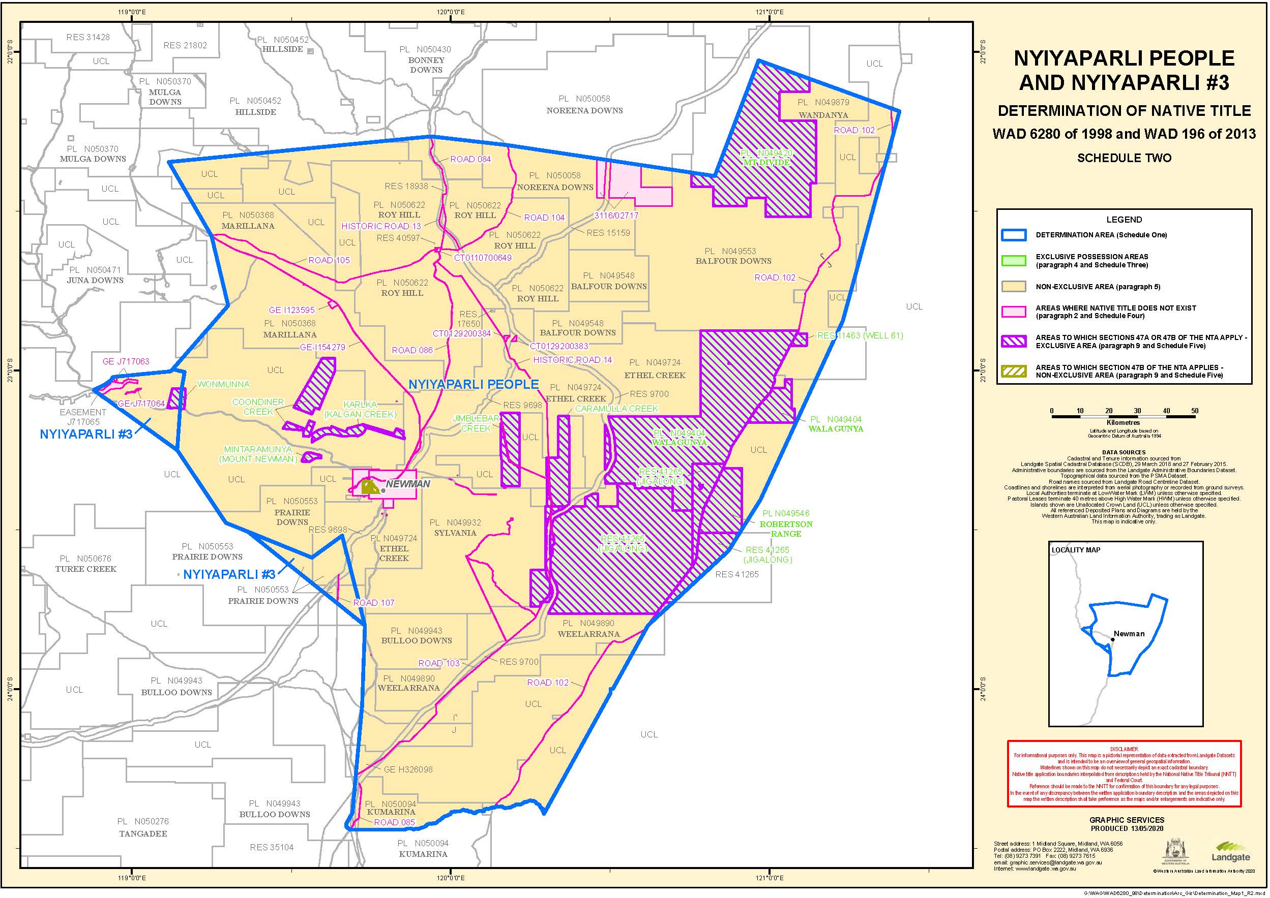
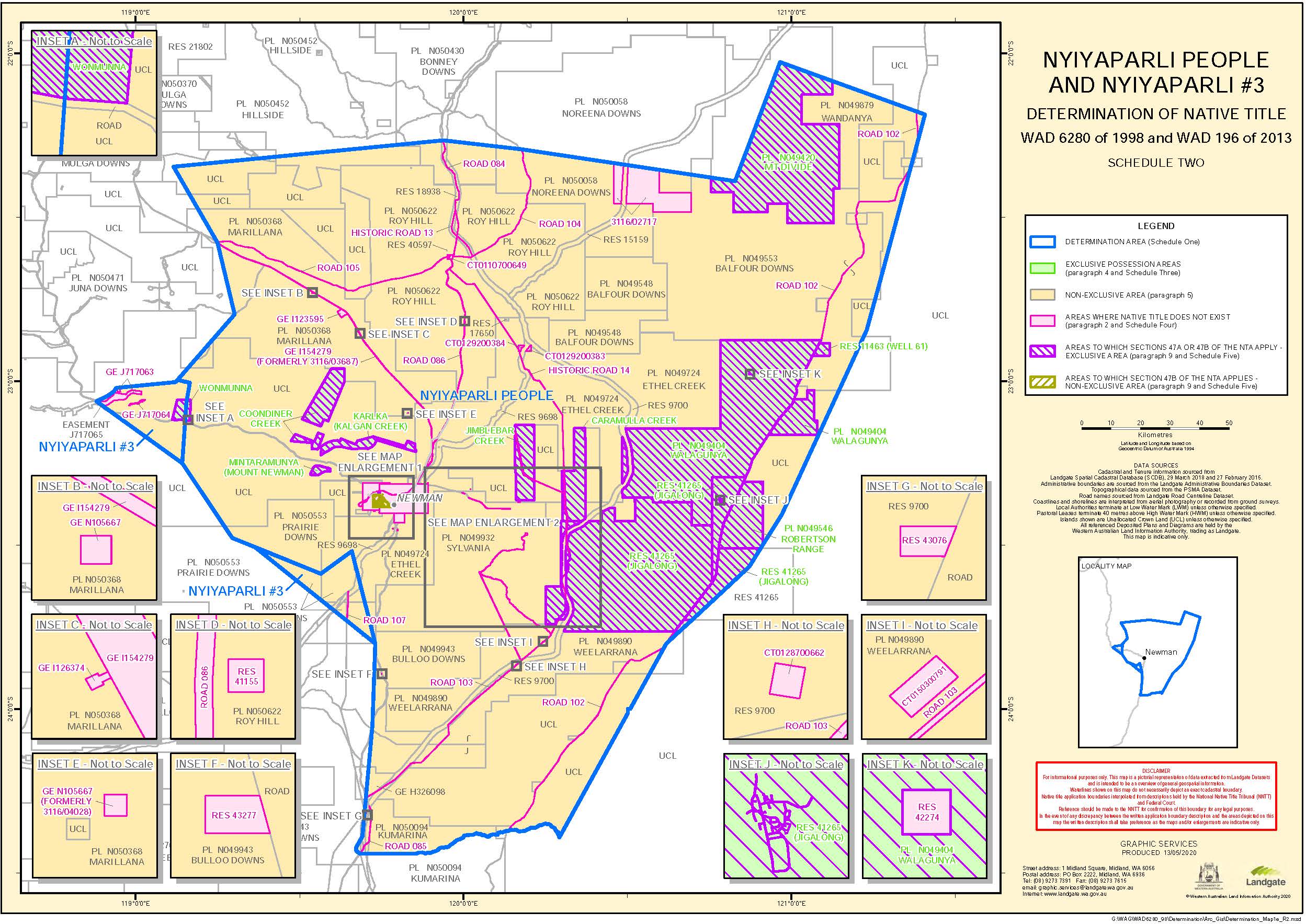
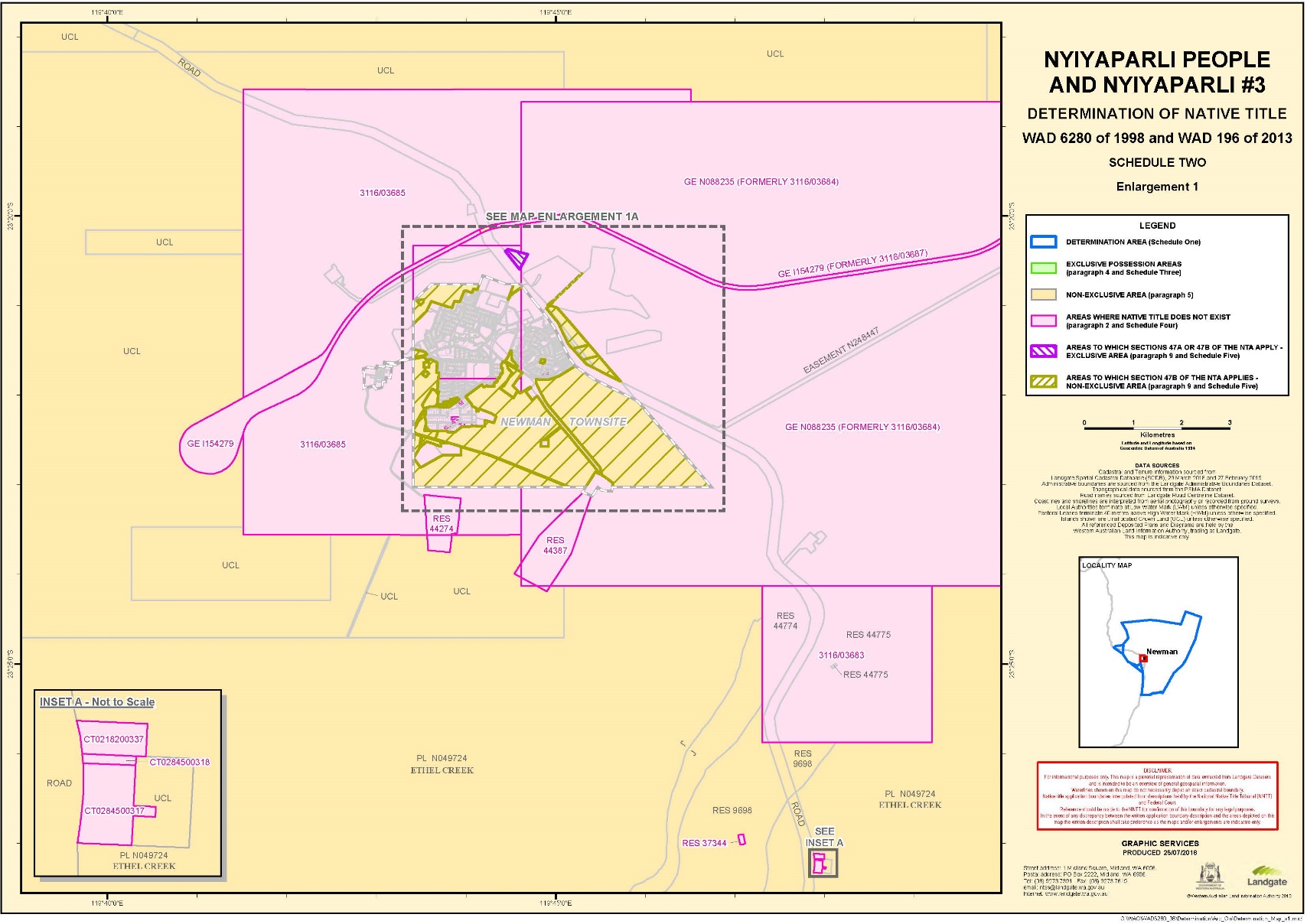
2. Native title does not exist in those parts of the Determination Area the subject of the interests identified in Schedule Four, which are shown as generally shaded pink on the maps in Schedule Two.
Native title holders (s 225(a) Native Title Act)
3. The native title in the Determination Area is held by the Nyiyaparli People. The Nyiyaparli People are the people described in Schedule Seven.
The nature and extent of native title rights and interests and exclusiveness of native title (s 225(b) and (e) Native Title Act)
Exclusive rights and interests
4. Subject to paragraphs 6, 7, 8, and 11, the nature and extent of the native title rights and interests in relation to the Exclusive Area is:
(a) except in relation to flowing and underground water, the right to possession, occupation, use and enjoyment to the exclusion of all others; and
(b) in relation to flowing and underground water, the right to use and enjoy the flowing and underground water, including:
(i) the right to hunt on, fish from, take and use the traditional resources of the flowing and underground water; and
(ii) the right to take and use the flowing and underground water.
Non-exclusive rights and interests
5. Subject to paragraphs 6, 7, 8, and 11, the nature and extent of the native title rights and interests in relation to the Non-Exclusive Area are that they confer the following non-exclusive rights on the Nyiyaparli People, including the right to conduct activities necessary to give effect to them:
(a) the right to live, being to enter and remain on the land, to camp and erect shelters and other structures for that purpose, and travel over and visit any part of the land and waters of the Non-Exclusive Area;
(b) the right to hunt, fish, gather, take and use the traditional resources of the Non-Exclusive Area;
(c) the right to take and use water in the Non-Exclusive Area;
(d) the right to engage in cultural activities and the transmission of cultural knowledge on the Non-Exclusive Area, including:
(i) visiting places of cultural or spiritual importance and maintaining, caring for, and protecting those places by carrying out activities to preserve their physical or spiritual integrity; and
(ii) conducting ceremony and ritual, including burial and burial rites; and
(e) the right to be accompanied on the Non-Exclusive Area by those people who, though not native title holders and who (for the avoidance of doubt) cannot themselves exercise any native title right in the Determination Area, are:
(i) spouses, parents or children of the native title holders; or
(ii) people required by or entering in connection with traditional law and custom for the performance of ceremonies or cultural activities on the Non-Exclusive Area.
Qualifications on the native title rights and interests
6. The native title rights and interests are subject to and exercisable in accordance with:
(a) the laws of the State and the Commonwealth, including the common law; and
(b) the traditional laws and customs of the Nyiyaparli People for personal, domestic and communal purposes (including social, cultural, religious, spiritual and ceremonial purposes).
7. Notwithstanding anything in this Determination, there are no native title rights and interests in the Determination Area in relation to:
(a) minerals as defined in the Mining Act 1904 (WA) (repealed) and in the Mining Act 1978 (WA), except to the extent that ochre is not a mineral pursuant to the Mining Act 1904 (WA); or
(b) petroleum as defined in the Petroleum Act 1936 (WA) (repealed) and in the Petroleum and Geothermal Energy Resources Act 1967 (WA);
(c) geothermal energy resources and geothermal energy as defined in the Petroleum and Geothermal Energy Resources Act 1967 (WA); or
(d) water captured by the holders of the Other Interests pursuant to those Other Interests.
8. The native title rights and interests set out in paragraphs 4(b) and 5 do not confer:
(a) possession, occupation, use and enjoyment on the Nyiyaparli People to the exclusion of all others; or
(b) a right to control the access to, or use of, the land and waters of the Determination Area or its resources.
Areas to which s 47, s 47A or s 47B of the Native Title Act apply
9. Section 47A and s 47B of the Native Title Act apply to disregard prior extinguishment in relation to the areas described in clauses 1 and 2, respectively, of Schedule Five.
The nature and extent of any other interests (s 225(c) Native Title Act)
10. The nature and extent of the Other Interests are described in Schedule Six.
Relationship between native title rights and other interests (s 225(d) Native Title Act)
11. Except as otherwise provided for by law, the relationship between the native title rights and interests described in paragraphs 4 and 5 and the Other Interests is that:
(a) to the extent that any of the Other Interests are inconsistent with the continued existence, enjoyment or exercise of the native title rights and interests, the native title rights and interests continue to exist in their entirety, but the native title rights and interests have no effect in relation to the Other Interests to the extent of the inconsistency during the currency of the Other Interests; and otherwise,
(b) the existence and exercise of the native title rights and interests do not prevent the doing of any activity required or permitted to be done by or under the Other Interests, and the Other Interests, and the doing of any activity required or permitted to be done by or under the Other Interests, prevail over the native title rights and interests and any exercise of the native title rights and interests but do not extinguish them.
Liberty to Apply
12. The parties have liberty to apply to establish the precise location and boundaries of the public works and adjacent land and waters identified in relation to any part or parts of the Determination Area referred to in clause 5 of Schedule Four of this Determination.
Definitions and Interpretation
13. In this Determination, unless the contrary intention appears:
Commonwealth means Commonwealth of Australia;
Determination Area means the land and waters described in Schedule One and depicted on the maps in Schedule Two;
Exclusive Area means those lands and waters of the Determination Area described in Schedule Three (which areas are generally shown as shaded green on the maps in Schedule Two);
Flowing water means the following water within the Determination Area:
(a) water which flows, whether permanently, intermittently or occasionally, within any river, creek, stream or brook; and
(b) any natural collection of water into, through, or out of which a river, creek, stream or brook flows;
land has the same meaning as in the Native Title Act and, for the avoidance of doubt, includes any natural collection of water found on the land which does not fall within the definition of 'waters';
Native Title Act means the Native Title Act 1993 (Cth);
native title holders means the Nyiyaparli People as described in Schedule Seven and referred to in paragraph 3;
Non-Exclusive Area means those lands and waters of the Determination Area which are not Exclusive Areas or described in paragraph 2 as an area where native title does not exist. These lands and waters are generally shown as shaded yellow on the maps at Schedule Two;
Other Interests means the legal or equitable estates or interests and other rights in relation to the Determination Area described in Schedule Six and referred to in paragraph 10;
resources means flora, fauna, and other natural resources such as charcoal, stone, soil, wood, resin and ochre (except, for the avoidance of doubt, ochres for use in the manufacture of porcelain, fine pottery or pigments which are minerals pursuant to the Mining Act 1904 (WA) (repealed));
State means State of Western Australia;
underground water means water from and including an underground water source, including water that percolates from the ground;
use includes by way of share and exchange; and
waters has the same meaning as in the Native Title Act.
14. In the event of any inconsistency between the written description of an area in Schedule One, Schedule Three, Schedule Four, Schedule Five, or Schedule Six and the area as depicted on the maps in Schedule Two, the written description prevails.
SCHEDULE ONE
DETERMINATION AREA
The Determination Area, generally shown as bordered in blue on the maps in Schedule Two, comprises all land and waters in the following descriptions:
WAD 6280 of 1998
All those lands and waters commencing at Latitude 22.025709 South and Longitude 120.965618 East and extending southeasterly to a western boundary of Reserve 12297 at Latitude 22.176991; Then southeasterly to Latitude 22.185703 South, Longitude 121.407723 East; Then southwesterly to a western boundary of Reserve 12297 at Latitude 22.267179 South; Then southwesterly to a western boundary of Reserve 12297 at Latitude 22.349350 South; Then southwesterly to an eastern boundary of the eastern severance of Pastoral Lease N049553 (Balfour Downs) at Latitude 22.690004 South; Then southwesterly to a southern boundary of the eastern severance of Pastoral Lease N049553 (Balfour Downs) at Longitude 121.255422 East being a point on the present boundary of Native Title Determination WAD6110/1998 Martu (Area A) (WCD2002/002); Then generally southwesterly along the boundary of that native title determination to an northern boundary of the eastern severance of Pastoral Lease N049553 (Balfour Downs) at Longitude 121.221018 East; Then southwesterly to a southern boundary of the eastern severance of Pastoral Lease N049553 (Balfour Downs) at Longitude 121.145159 East being a point on the present boundary of Native Title Determination WAD6110/1998 Martu (Area A) (WCD2002/002); Then generally southwesterly along the boundary of that native title determination to an eastern boundary of Pastoral Lease N049546 (Robertson Range) at Latitude 23.497899 South; Then southwesterly to Latitude 23.565459 South, Longitude 120.871261 East; Then southwesterly to a southern boundary of the eastern severance of Reserve 41265 at Longitude 120.696113 East being a point on the present boundary of Native Title Determination WAD6110/1998 Martu (Area A) (WCD2002/002); Then southwesterly along the boundary of that native title determination to an eastern boundary of the eastern severance of Pastoral Lease N049890 (Weelarrana) at Latitude 23.751355 South; Then southwesterly to Latitude 23.799908 South, Longitude 120.618550 East; Then southwesterly to a southern boundary of the eastern severance of Pastoral Lease N049890 (Weelarrana) at Longitude 120.568181 East being a point on the present boundary of Native Title Determination WAD6110/1998 Martu (Area A) (WCD2002/002); Then southwesterly along the boundary of that native title determination to Latitude 23.998656 South, Longitude 120.508828 East being a point on the present boundary of Native Title Determination WAD6284/1998 Birriliburu People (Part A) (WCD2008/002); Then westerly and southerly along the boundaries of that native title determination to Latitude 24.012185 South, being a point on the present boundary of Native Title Determination WAD6002/2003 Gingirana (WCD2017/011); Then southwesterly, generally westerly and generally northwesterly along the boundaries of the native title determination to the intersection of the centreline of an unnamed intermittent creek with Latitude 24.424384° South also being a point on the present boundary of Native Title Determination WAD78/2005 Ngarlawangga People (WCD2016/007); Then generally northerly along the boundaries of that native title determination to Latitude 23.800165 South, Longitude 119.730429 East; Then northerly, northwesterly and southwesterly through the following coordinate positions.
Latitude (South) | Longitude (East) |
23.799776 | 119.730443 |
23.517542 | 119.659365 |
23.586534 | 119.564249 |
Then northwesterly to Latitude 23.505056 South, Longitude 119.363043 East being a point on the present boundary of Native Title Determination WAD78/2005 Ngarlawangga People (WCD2016/007); Then generally northwesterly along the boundary of that native title determination to Latitude 23.249178 South, Longitude 119.141883 East; Then generally northerly and generally westerly through the following coordinate positions.
Latitude (South) | Longitude (East) |
23.063501 | 119.155112 |
23.003843 | 119.165211 |
23.003396 | 119.163741 |
23.001105 | 119.153405 |
23.000125 | 119.146432 |
22.999049 | 119.143061 |
22.997148 | 119.136689 |
22.995623 | 119.130872 |
Then westerly to Latitude 22.995316 South, Longitude 119.127503 East, being a point on the present boundary of Native Title Determination WAD6096/1998 Banjima People (WCD2014/001); Then northeasterly and generally northwesterly along the boundaries of that native title determination to Latitude 22.345315 South, Longitude 119.115406 East; Then generally easterly through the following coordinate positions.
Latitude (South) | Longitude (East) |
22.332946 | 119.241060 |
22.264352 | 119.938288 |
22.291786 | 120.176544 |
22.389190 | 120.828284 |
Then northeasterly back to the commencement point.
Note: Geographic Coordinates provided in Decimal Degrees.
Cadastral boundaries sourced from Landgate's Spatial Cadastral Database dated 29 March 2018.
For the avoidance of doubt the application excludes any land and waters already claimed by:
Native Title Determination WAD6110/1998 Martu (Area A) (WCD2002/002) as Determined in the Federal Court on 27 September 2002.
Native Title Determination WAD6284/1998 Birriliburu People (Part A) (WCD2008/002) as Determined in the Federal Court on 20 June 2008.
Native Title Determination WAD6002/2003 Gingirana (WCD2017/011) as Determined in the Federal Court on 7 December 2017.
Native Title Determination WAD78/2005 Ngarlawangga People (WCD2016/007) as Determined in the Federal Court on 7 December 2016.
Native Title Determination WAD6096/1998 Banjima People (WCD2014/001) as Determined in the Federal Court on 11 March 2014.
Native Title Determination Application WAD196/2013 Nyiyaparli #3 (WC2013/003) as Registered in the Federal Court on 27 August 2013.
Native Title Determination Application WAD6287/1998 Palyku (WC1999/016) as Registered in the Federal Court on 2 August 1999.
Native Title Determination Application WAD6028/1998 Nyamal (WC1999/008) as Registered in the Federal Court on 28 September 2007.
Native Title Determination Application WAD289/2018 Nyamal Overlap Claim (WC2018/011) as Filed in the Federal Court on 28 June 2018.
Datum: Geocentric Datum of Australia 1994 (GDA94)
Prepared By: Graphic Services (Landgate) 3 August 2018
Use of Coordinates:
Where coordinates are used within the description to represent cadastral or topographical boundaries or the intersection with such, they are intended as a guide only. As an outcome to the custodians of cadastral and topographic data continuously recalculating the geographic position of their data based on improved survey and data maintenance procedures, it is not possible to accurately define such a position other than by detailed ground survey.
WAD 196 of 2013
AREA 1
All those lands and waters commencing at Latitude 23.063501 South, Longitude 119.155112 East and extending northerly and generally westerly through the following coordinate positions.
Latitude (South) | Longitude (East) |
23.003843 | 119.165211 |
23.003396 | 119.163741 |
23.001105 | 119.153405 |
23.000125 | 119.146432 |
22.999049 | 119.143061 |
22.997148 | 119.136689 |
22.995623 | 119.130872 |
Then westerly to Latitude 22.995316 South, Longitude 119.127503 East, being a point on the present boundary of Native Title Determination WAD6096/1998 Banjima People (WCD2014/001); Then generally southwesterly along the boundaries of that native title determination to Latitude 23.035240 South, Longitude 118.926692 East, being a point on the present boundary of Native Title Determination WAD340/2010 Yinhawangka Part A (WCD2017/003); Then generally southwesterly along the boundaries of that native title determination to Longitude 118.879717 South, being a point on the present boundary of Native Title Determination WAD78/2005 Ngarlawangga People (WCD2016/007); Then southeasterly along the boundary of that native title determination to Latitude 23.249178 South, Longitude 119.141883 East; Then northerly back to the commencement point.
AREA 2
All those lands and waters commencing at Latitude 23.505056 South, Longitude 119.363043 East being a point on the present boundary of Native Title Determination WAD78/2005 Ngarlawangga People (WCD2016/007); Then southeasterly along the boundary of that native title determination to the intersection with a western boundary of Native Title Application WAD6280/1998 Nyiyaparli People (WC2005/006) at Latitude 23.800165 South; Then northerly, northwesterly and southwesterly along the boundaries of that native title application through the following coordinate positions.
Latitude (South) | Longitude (East) |
23.799776 | 119.730443 |
23.517542 | 119.659365 |
23.586534 | 119.564249 |
Then northwesterly back to the commencement point.
Note: Geographic Coordinates provided in Decimal Degrees.
Cadastral boundaries sourced from Landgate's Spatial Cadastral Database dated 29 March 2018.
For the avoidance of doubt the application excludes any land and waters already claimed by:
Native Title Determination WAD340/2010 Yinhawangka Part A (WCD2017/003) as Determined in the Federal Court on 18 July 2017.
Native Title Determination WAD78/2005 Ngarlawangga People (WCD2016/007) as Determined in the Federal Court on 7 December 2016.
Native Title Determination WAD6096/1998 Banjima People (WCD2014/001) as Determined in the Federal Court on 11 March 2014.
Native Title Determination Application WAD6280/1998 Nyiyaparli People (WC2005/006) as Registered in the Federal Court on 11 August 2010.
Datum: Geocentric Datum of Australia 1994 (GDA94)
Prepared By: Graphic Services (Landgate) 3 August 2018
Use of Coordinates:
Where coordinates are used within the description to represent cadastral or topographical boundaries or the intersection with such, they are intended as a guide only. As an outcome to the custodians of cadastral and topographic data continuously recalculating the geographic position of their data based on improved survey and data maintenance procedures, it is not possible to accurately define such a position other than by detailed ground survey.
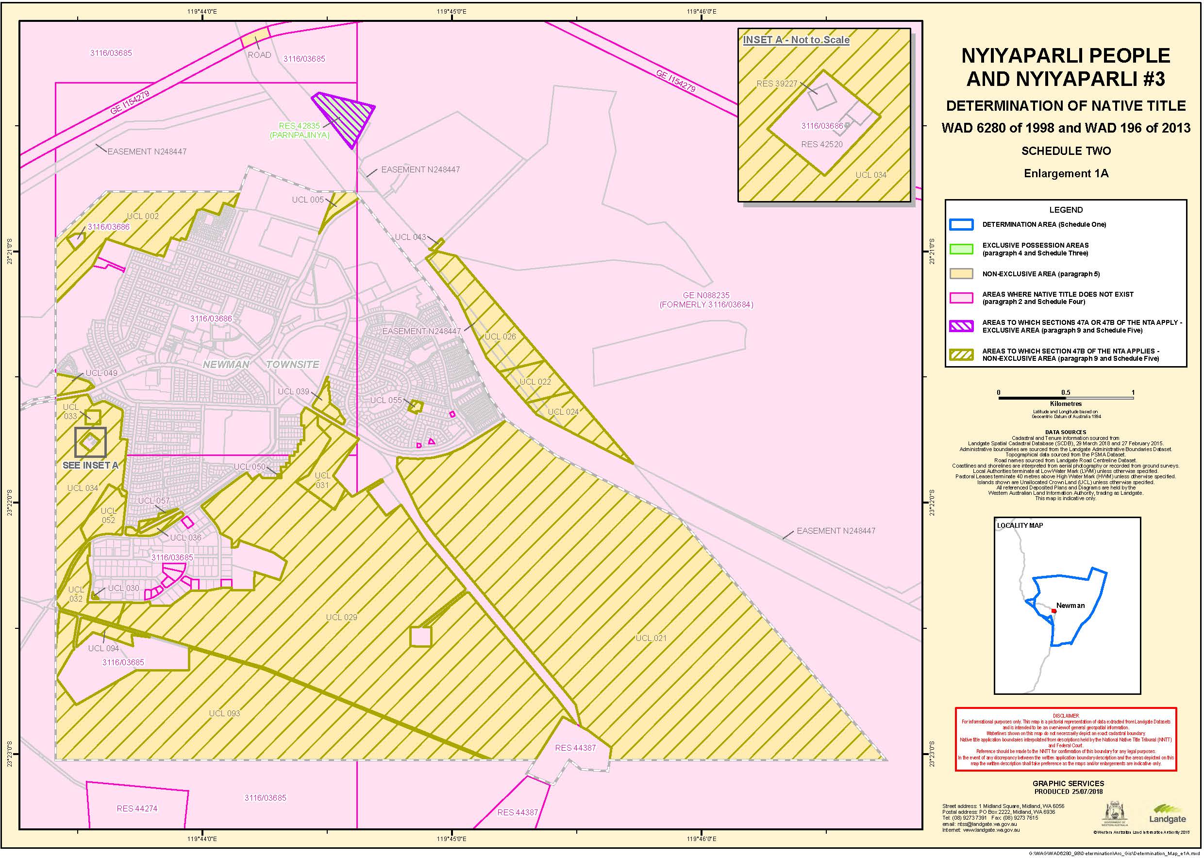
SCHEDULE TWO
MAPS OF THE DETERMINATION AREA

SCHEDULE THREE
EXCLUSIVE AREA (PARAGRAPH 4)
Native title comprises the rights and interests set out in paragraph 4 of the Determination in relation to the following land and waters (which areas are generally shown as shaded in green on the maps in Schedule Two):
1. Areas where s 47A applies
(a) The following reserves for the purpose of 'use and benefit of Aborigines', subject to clause 1(b) below in relation to Reserve 41265:
Reserve No. | Name |
Reserve 11463 | Well 61 |
Reserve 41265 | Jigalong |
Reserve 42835 | Parnpajinya |
(b) For the avoidance of doubt, the area of Reserve 41265 does not include:
(i) Road 103, being the Jigalong Mission Road as described in Schedule Four, clause 4; or
(ii) Road 14 (Historical), being the Weelarrana-Ethel Creek Road as described in Schedule Four, clause 4
for the purposes of this Schedule Three and paragraph 4 of the Determination.
(c) The following pastoral leases, being leases which were held or on trust expressly for the benefit of Aboriginal peoples within the meaning of s 47A(1)(b)(ii) of the Native Title Act:
Lease No. | Name |
PL N049404 | Walagunya Station |
PL N049420 | Mount Divide Station |
PL N049546 | Robertson Range Station |
2. Areas where s 47B applies
(a) Wonmunna
All those lands and waters commencing at Latitude 23.055742 South, Longitude 119.126278 East and extending easterly and southerly through the following coordinate positions:
Latitude (South) | Longitude (East) |
23.055741 | 119.167059 |
23.077529 | 119.167926 |
Then southerly to the intersection with a northern boundary of Lot 183 as shown on Deposited Plan 219300 being a point on the present northern side of the Great Northern Highway at Longitude 119.164336 East; Then generally westerly along the northern boundaries of that highway to Longitude 119.111522 East; Then northeasterly back to the commencement point.
(b) Coondiner Creek
PORTION 1
All those lands and waters commencing at Latitude 23.156819 South, Longitude 119.556852 East and extending southeasterly, southwesterly, westerly, northerly, again westerly, northeasterly and again southeasterly through the following coordinate positions:
Latitude (South) | Longitude (East) |
23.162897 | 119.572377 |
23.207231 | 119.555638 |
23.205734 | 119.537131 |
23.187337 | 119.538872 |
23.181974 | 119.472865 |
23.160947 | 119.486818 |
23.183385 | 119.544832 |
Then northeasterly back to the commencement point.
PORTION 2
All those lands and waters commencing at the intersection of a southern boundary of the southwestern severance of Pastoral Lease N050368 (Marillana) with Longitude 119.596290 East; Then easterly and southerly along the boundaries of that pastoral lease to a southwestern corner of the southwestern severance at approximate Latitude 23.000043 South, Longitude 119.636977 East; Then generally southwesterly, northwesterly, southwesterly and again northwesterly through the following coordinate positions:
Latitude (South) | Longitude (East) |
23.070603 | 119.608190 |
23.082976 | 119.602235 |
23.121108 | 119.586613 |
23.116114 | 119.573910 |
23.137363 | 119.564155 |
23.115128 | 119.507541 |
Then northeasterly back to the commencement point.
(c) Karlka (Kalgan Creek)
All those lands and waters commencing at the intersection of a western boundary of the westernmost northwestern severance of Pastoral Lease N049724 (Ethel Creek) with Latitude 23.190922 South; Then southerly, easterly and again southerly along the boundaries of that pastoral lease to Latitude 23.215004 South; Then northwesterly, generally southwesterly, generally easterly, generally northerly, generally northeasterly, generally easterly, southeasterly and northeasterly through the following coordinate positions:
Latitude (South) | Longitude (East) |
23.178920 | 119.734410 |
23.192118 | 119.728054 |
23.199739 | 119.720011 |
23.205435 | 119.708752 |
23.204508 | 119.688881 |
23.205303 | 119.676429 |
23.205832 | 119.662123 |
23.204508 | 119.651525 |
23.201593 | 119.636424 |
23.199077 | 119.624634 |
23.199209 | 119.611122 |
23.202653 | 119.600922 |
23.210734 | 119.589265 |
23.217225 | 119.575886 |
23.225113 | 119.564712 |
23.208095 | 119.566323 |
23.198679 | 119.564626 |
23.186095 | 119.585688 |
23.180796 | 119.604367 |
23.179520 | 119.614859 |
23.182685 | 119.622950 |
23.174655 | 119.626638 |
23.192299 | 119.671590 |
23.181494 | 119.676552 |
23.168045 | 119.724675 |
23.197239 | 119.821864 |
23.181489 | 119.829449 |
Then southeasterly back to the commencement point.
(d) Caramulla Creek
All those lands and waters commencing at the intersection of a northern boundary of the western severance of Reserve 41265 with Longitude 120.301861 East; Then northerly to the intersection with a southern boundary of the southern severance of Pastoral Lease N049724 (Ethel Creek) at Longitude 120.300623 East; Then easterly, northerly and again easterly along the boundaries of that pastoral lease to Longitude 120.371035 East; Then southerly to the intersection with a northwestern boundary of Reserve 9700 at Latitude 23.415873 South; Then southwesterly along the northwestern boundaries of that reserve to the intersection with a northern boundary of the western severance of Reserve 41265; Then westerly along the northern boundary of the western severance of that reserve back to the commencement point.
Excluding:
(i) For the avoidance of doubt:
(A) Road 01 (Historical), being part of the old alignment of the Great Northern Highway as described in Schedule Four, clause 4;
(B) Road 14 (Historical), being the Weelarrana-Ethel Creek Road as described in Schedule Four, clause 4.
(e) Mintaramunya (Mount Newman)
All those lands and waters commencing at Latitude 23.273889 South, Longitude 119.594217 East and extending generally westerly, generally southwesterly, again generally westerly, generally northeasterly, generally southeasterly and westerly through the following coordinate positions:
Latitude (South) | Longitude (East) |
23.274091 | 119.593396 |
23.274170 | 119.593068 |
23.274241 | 119.592777 |
23.274410 | 119.592110 |
23.274484 | 119.591799 |
23.274525 | 119.591614 |
23.274560 | 119.591441 |
23.274590 | 119.591276 |
23.274615 | 119.591118 |
23.274632 | 119.590997 |
23.274647 | 119.590874 |
23.274673 | 119.590619 |
23.274693 | 119.590350 |
23.274708 | 119.590061 |
23.274717 | 119.589787 |
23.274722 | 119.589480 |
23.274727 | 119.588353 |
23.274727 | 119.588043 |
23.274721 | 119.587718 |
23.274709 | 119.587376 |
23.274690 | 119.587009 |
23.274670 | 119.586693 |
23.274645 | 119.586339 |
23.274556 | 119.585205 |
23.274526 | 119.584807 |
23.274501 | 119.584433 |
23.274482 | 119.584094 |
23.274469 | 119.583786 |
23.274460 | 119.583493 |
23.274456 | 119.583213 |
23.274457 | 119.582944 |
23.274460 | 119.582788 |
23.274465 | 119.582625 |
23.274472 | 119.582453 |
23.274482 | 119.582270 |
23.274504 | 119.581926 |
23.274566 | 119.581084 |
23.274581 | 119.580851 |
23.274592 | 119.580641 |
23.274600 | 119.580414 |
23.274605 | 119.580201 |
23.274605 | 119.579999 |
23.274602 | 119.579805 |
23.274597 | 119.579707 |
23.274590 | 119.579604 |
23.274579 | 119.579496 |
23.274566 | 119.579381 |
23.274534 | 119.579156 |
23.274466 | 119.578734 |
23.274440 | 119.578563 |
23.274417 | 119.578388 |
23.274401 | 119.578231 |
23.274394 | 119.578140 |
23.274390 | 119.578053 |
23.274387 | 119.577969 |
23.274388 | 119.577887 |
23.274390 | 119.577808 |
23.274395 | 119.577731 |
23.274402 | 119.577656 |
23.274412 | 119.577583 |
23.274431 | 119.577470 |
23.274456 | 119.577352 |
23.274487 | 119.577229 |
23.274524 | 119.577098 |
23.274559 | 119.576983 |
23.274601 | 119.576856 |
23.274751 | 119.576427 |
23.274806 | 119.576264 |
23.274987 | 119.575711 |
23.275091 | 119.575399 |
23.275192 | 119.575107 |
23.275288 | 119.574846 |
23.275389 | 119.574590 |
23.275490 | 119.574352 |
23.275541 | 119.574238 |
23.275592 | 119.574129 |
23.275644 | 119.574022 |
23.275697 | 119.573918 |
23.275765 | 119.573792 |
23.275840 | 119.573662 |
23.275922 | 119.573528 |
23.276014 | 119.573387 |
23.276101 | 119.573260 |
23.276199 | 119.573119 |
23.276558 | 119.572622 |
23.276701 | 119.572419 |
23.276844 | 119.572207 |
23.276907 | 119.572107 |
23.276966 | 119.572012 |
23.277055 | 119.571861 |
23.277146 | 119.571701 |
23.277240 | 119.571532 |
23.277339 | 119.571350 |
23.277517 | 119.571009 |
23.277940 | 119.570188 |
23.278055 | 119.569968 |
23.278161 | 119.569772 |
23.278343 | 119.569444 |
23.278536 | 119.569104 |
23.278743 | 119.568747 |
23.278967 | 119.568367 |
23.279164 | 119.568037 |
23.279386 | 119.567671 |
23.280382 | 119.566037 |
23.280638 | 119.565611 |
23.280866 | 119.565224 |
23.281094 | 119.564832 |
23.281304 | 119.564460 |
23.281502 | 119.564104 |
23.281687 | 119.563759 |
23.281886 | 119.563380 |
23.282089 | 119.562983 |
23.282301 | 119.562564 |
23.282524 | 119.562113 |
23.282724 | 119.561704 |
23.282945 | 119.561248 |
23.283877 | 119.559304 |
23.284527 | 119.557972 |
23.284770 | 119.557471 |
23.284903 | 119.557189 |
23.285026 | 119.556926 |
23.285141 | 119.556675 |
23.285248 | 119.556434 |
23.285400 | 119.556099 |
23.285697 | 119.555465 |
23.285816 | 119.555208 |
23.285935 | 119.554939 |
23.286038 | 119.554697 |
23.286094 | 119.554556 |
23.286147 | 119.554419 |
23.286195 | 119.554286 |
23.286240 | 119.554156 |
23.286281 | 119.554029 |
23.286319 | 119.553904 |
23.286354 | 119.553781 |
23.286385 | 119.553660 |
23.286438 | 119.553432 |
23.286487 | 119.553202 |
23.286530 | 119.552969 |
23.286569 | 119.552734 |
23.286602 | 119.552498 |
23.286629 | 119.552262 |
23.286652 | 119.552026 |
23.286669 | 119.551792 |
23.286676 | 119.551645 |
23.286679 | 119.551495 |
23.286680 | 119.551341 |
23.286677 | 119.551184 |
23.286670 | 119.551023 |
23.286661 | 119.550856 |
23.286647 | 119.550685 |
23.286631 | 119.550506 |
23.286613 | 119.550346 |
23.286593 | 119.550178 |
23.286543 | 119.549812 |
23.286490 | 119.549466 |
23.286370 | 119.548714 |
23.286324 | 119.548413 |
23.286256 | 119.547961 |
23.286183 | 119.547514 |
23.286107 | 119.547074 |
23.286026 | 119.546639 |
23.285941 | 119.546210 |
23.285852 | 119.545786 |
23.285759 | 119.545368 |
23.285661 | 119.544956 |
23.285611 | 119.544758 |
23.285549 | 119.544539 |
23.285485 | 119.544324 |
23.285316 | 119.543778 |
23.285269 | 119.543620 |
23.285229 | 119.543477 |
23.285187 | 119.543317 |
23.285150 | 119.543166 |
23.285119 | 119.543023 |
23.285092 | 119.542884 |
23.285057 | 119.542673 |
23.285025 | 119.542458 |
23.284997 | 119.542239 |
23.284972 | 119.542017 |
23.284952 | 119.541790 |
23.284935 | 119.541561 |
23.284921 | 119.541329 |
23.284912 | 119.541093 |
23.284900 | 119.540659 |
23.284898 | 119.540498 |
23.284899 | 119.540352 |
23.284903 | 119.540209 |
23.284910 | 119.540075 |
23.284920 | 119.539948 |
23.284933 | 119.539826 |
23.284942 | 119.539754 |
23.284955 | 119.539680 |
23.284971 | 119.539604 |
23.284989 | 119.539523 |
23.285011 | 119.539435 |
23.285038 | 119.539339 |
23.285155 | 119.538950 |
23.285202 | 119.538779 |
23.285225 | 119.538686 |
23.285244 | 119.538598 |
23.285259 | 119.538515 |
23.285271 | 119.538434 |
23.285285 | 119.538296 |
23.285295 | 119.538150 |
23.285301 | 119.537996 |
23.285302 | 119.537830 |
23.285300 | 119.537691 |
23.285295 | 119.537537 |
23.285267 | 119.536960 |
23.285258 | 119.536719 |
23.285244 | 119.535850 |
23.285239 | 119.535641 |
23.285232 | 119.535453 |
23.285221 | 119.535247 |
23.285208 | 119.535055 |
23.285191 | 119.534873 |
23.285171 | 119.534700 |
23.285156 | 119.534559 |
23.285121 | 119.534182 |
23.285108 | 119.534071 |
23.285092 | 119.533973 |
23.285070 | 119.533863 |
23.285044 | 119.533763 |
23.285012 | 119.533671 |
23.284995 | 119.533628 |
23.284976 | 119.533586 |
23.284939 | 119.533512 |
23.284899 | 119.533440 |
23.284859 | 119.533371 |
23.284816 | 119.533306 |
23.284773 | 119.533245 |
23.284729 | 119.533189 |
23.284684 | 119.533137 |
23.284638 | 119.533090 |
23.284600 | 119.533055 |
23.284560 | 119.533020 |
23.284516 | 119.532986 |
23.284469 | 119.532952 |
23.284420 | 119.532919 |
23.284368 | 119.532886 |
23.284256 | 119.532824 |
23.284192 | 119.532792 |
23.284124 | 119.532766 |
23.284053 | 119.532743 |
23.283979 | 119.532725 |
23.283902 | 119.532710 |
23.283821 | 119.532700 |
23.283736 | 119.532694 |
23.283647 | 119.532692 |
23.283562 | 119.532693 |
23.283473 | 119.532698 |
23.283378 | 119.532706 |
23.283276 | 119.532718 |
23.283091 | 119.532744 |
23.282750 | 119.532801 |
23.282619 | 119.532821 |
23.282478 | 119.532839 |
23.282149 | 119.532869 |
23.282001 | 119.532885 |
23.281922 | 119.532897 |
23.281850 | 119.532910 |
23.281782 | 119.532924 |
23.281719 | 119.532939 |
23.281649 | 119.532960 |
23.281585 | 119.532984 |
23.281524 | 119.533010 |
23.281468 | 119.533039 |
23.281416 | 119.533071 |
23.281367 | 119.533106 |
23.281323 | 119.533144 |
23.281282 | 119.533185 |
23.281249 | 119.533225 |
23.281215 | 119.533272 |
23.281182 | 119.533324 |
23.281093 | 119.533473 |
23.281064 | 119.533518 |
23.281036 | 119.533555 |
23.280949 | 119.533668 |
23.280901 | 119.533725 |
23.280852 | 119.533774 |
23.280829 | 119.533793 |
23.280806 | 119.533810 |
23.280772 | 119.533829 |
23.280734 | 119.533843 |
23.280692 | 119.533852 |
23.280645 | 119.533857 |
23.280600 | 119.533857 |
23.280550 | 119.533855 |
23.280360 | 119.533832 |
23.280283 | 119.533826 |
23.280242 | 119.533826 |
23.280205 | 119.533828 |
23.280171 | 119.533833 |
23.280140 | 119.533841 |
23.280091 | 119.533857 |
23.280042 | 119.533877 |
23.279991 | 119.533902 |
23.279937 | 119.533932 |
23.279839 | 119.533995 |
23.279605 | 119.534158 |
23.279540 | 119.534198 |
23.279481 | 119.534232 |
23.279388 | 119.534278 |
23.279174 | 119.534379 |
23.279078 | 119.534426 |
23.279006 | 119.534465 |
23.278932 | 119.534510 |
23.278856 | 119.534560 |
23.278775 | 119.534617 |
23.278703 | 119.534672 |
23.278623 | 119.534734 |
23.278347 | 119.534960 |
23.278237 | 119.535047 |
23.278123 | 119.535132 |
23.278019 | 119.535203 |
23.277958 | 119.535241 |
23.277898 | 119.535275 |
23.277840 | 119.535305 |
23.277783 | 119.535332 |
23.277726 | 119.535355 |
23.277670 | 119.535376 |
23.277614 | 119.535393 |
23.277558 | 119.535406 |
23.277483 | 119.535420 |
23.277404 | 119.535432 |
23.277321 | 119.535441 |
23.277234 | 119.535448 |
23.277143 | 119.535452 |
23.277045 | 119.535453 |
23.276941 | 119.535453 |
23.276825 | 119.535450 |
23.276760 | 119.535446 |
23.276689 | 119.535439 |
23.276367 | 119.535394 |
23.276290 | 119.535385 |
23.276221 | 119.535381 |
23.276010 | 119.535369 |
23.275897 | 119.535367 |
23.275843 | 119.535368 |
23.275793 | 119.535372 |
23.275745 | 119.535377 |
23.275701 | 119.535385 |
23.275656 | 119.535396 |
23.275611 | 119.535411 |
23.275566 | 119.535430 |
23.275521 | 119.535452 |
23.275476 | 119.535478 |
23.275431 | 119.535508 |
23.275385 | 119.535542 |
23.275338 | 119.535580 |
23.275261 | 119.535651 |
23.275176 | 119.535736 |
23.275098 | 119.535821 |
23.274918 | 119.536023 |
23.274830 | 119.536116 |
23.274750 | 119.536194 |
23.274675 | 119.536259 |
23.274259 | 119.536600 |
23.273998 | 119.536809 |
23.273754 | 119.536996 |
23.273640 | 119.537081 |
23.273529 | 119.537160 |
23.273402 | 119.537251 |
23.273108 | 119.537468 |
23.272974 | 119.537564 |
23.272832 | 119.537662 |
23.272703 | 119.537745 |
23.272632 | 119.537788 |
23.272562 | 119.537828 |
23.272494 | 119.537864 |
23.272428 | 119.537897 |
23.272362 | 119.537927 |
23.272298 | 119.537954 |
23.272234 | 119.537977 |
23.272171 | 119.537999 |
23.272103 | 119.538018 |
23.272031 | 119.538033 |
23.271955 | 119.538045 |
23.271873 | 119.538055 |
23.271791 | 119.538061 |
23.271699 | 119.538065 |
23.271338 | 119.538069 |
23.271184 | 119.538076 |
23.271101 | 119.538082 |
23.271025 | 119.538091 |
23.270953 | 119.538104 |
23.270884 | 119.538118 |
23.270669 | 119.538171 |
23.270540 | 119.538207 |
23.270479 | 119.538227 |
23.270423 | 119.538248 |
23.270371 | 119.538271 |
23.270322 | 119.538295 |
23.270267 | 119.538328 |
23.270208 | 119.538371 |
23.270142 | 119.538426 |
23.270008 | 119.538551 |
23.269948 | 119.538602 |
23.269884 | 119.538652 |
23.269853 | 119.538671 |
23.269823 | 119.538689 |
23.269789 | 119.538706 |
23.269753 | 119.538722 |
23.269716 | 119.538736 |
23.269677 | 119.538748 |
23.269636 | 119.538759 |
23.269594 | 119.538767 |
23.269504 | 119.538779 |
23.269413 | 119.538785 |
23.269311 | 119.538786 |
23.269205 | 119.538782 |
23.268913 | 119.538766 |
23.268826 | 119.538765 |
23.268748 | 119.538766 |
23.268660 | 119.538772 |
23.268580 | 119.538783 |
23.268506 | 119.538800 |
23.268437 | 119.538821 |
23.268369 | 119.538850 |
23.268299 | 119.538886 |
23.268228 | 119.538931 |
23.268154 | 119.538984 |
23.268090 | 119.539034 |
23.268020 | 119.539094 |
23.267795 | 119.539298 |
23.267712 | 119.539371 |
23.267630 | 119.539437 |
23.267555 | 119.539493 |
23.267476 | 119.539542 |
23.267401 | 119.539582 |
23.267363 | 119.539599 |
23.267326 | 119.539613 |
23.267289 | 119.539625 |
23.267252 | 119.539634 |
23.267201 | 119.539644 |
23.267144 | 119.539651 |
23.267077 | 119.539656 |
23.266869 | 119.539665 |
23.266803 | 119.539672 |
23.266745 | 119.539683 |
23.266663 | 119.539703 |
23.266579 | 119.539729 |
23.266492 | 119.539761 |
23.266402 | 119.539799 |
23.266309 | 119.539842 |
23.266212 | 119.539891 |
23.266108 | 119.539948 |
23.265995 | 119.540014 |
23.265922 | 119.540060 |
23.265849 | 119.540111 |
23.265773 | 119.540168 |
23.265694 | 119.540233 |
23.265627 | 119.540292 |
23.265553 | 119.540358 |
23.265240 | 119.540650 |
23.265166 | 119.540717 |
23.265097 | 119.540775 |
23.264944 | 119.540899 |
23.264776 | 119.541034 |
23.263993 | 119.541646 |
23.263806 | 119.541794 |
23.263640 | 119.541929 |
23.263406 | 119.542126 |
23.263147 | 119.542349 |
23.262904 | 119.542564 |
23.262338 | 119.543068 |
23.262061 | 119.543311 |
23.261808 | 119.543527 |
23.261575 | 119.543720 |
23.261406 | 119.543851 |
23.261216 | 119.543992 |
23.261021 | 119.544129 |
23.260498 | 119.544492 |
23.260344 | 119.544602 |
23.260207 | 119.544704 |
23.260054 | 119.544823 |
23.259915 | 119.544939 |
23.259786 | 119.545053 |
23.259667 | 119.545168 |
23.259557 | 119.545280 |
23.259448 | 119.545397 |
23.259339 | 119.545517 |
23.259231 | 119.545641 |
23.259124 | 119.545770 |
23.259018 | 119.545902 |
23.258912 | 119.546038 |
23.258807 | 119.546178 |
23.258704 | 119.546321 |
23.258601 | 119.546469 |
23.258499 | 119.546620 |
23.258398 | 119.546774 |
23.258298 | 119.546933 |
23.258200 | 119.547094 |
23.258102 | 119.547259 |
23.258006 | 119.547427 |
23.257927 | 119.547572 |
23.257848 | 119.547719 |
23.257771 | 119.547869 |
23.257696 | 119.548023 |
23.257622 | 119.548179 |
23.257550 | 119.548338 |
23.257479 | 119.548500 |
23.257409 | 119.548665 |
23.257341 | 119.548832 |
23.257275 | 119.549002 |
23.257210 | 119.549175 |
23.257147 | 119.549350 |
23.257085 | 119.549527 |
23.257026 | 119.549706 |
23.256968 | 119.549888 |
23.256912 | 119.550072 |
23.256855 | 119.550265 |
23.256802 | 119.550452 |
23.256752 | 119.550633 |
23.256707 | 119.550809 |
23.256664 | 119.550981 |
23.256624 | 119.551150 |
23.256587 | 119.551314 |
23.256554 | 119.551476 |
23.256523 | 119.551635 |
23.256495 | 119.551791 |
23.256471 | 119.551944 |
23.256449 | 119.552094 |
23.256430 | 119.552242 |
23.256414 | 119.552387 |
23.256401 | 119.552530 |
23.256390 | 119.552670 |
23.256383 | 119.552843 |
23.256381 | 119.553019 |
23.256386 | 119.553200 |
23.256398 | 119.553384 |
23.256416 | 119.553573 |
23.256440 | 119.553768 |
23.256472 | 119.553970 |
23.256509 | 119.554180 |
23.256545 | 119.554354 |
23.256585 | 119.554537 |
23.256631 | 119.554728 |
23.256682 | 119.554934 |
23.256784 | 119.555314 |
23.257039 | 119.556230 |
23.257104 | 119.556476 |
23.257160 | 119.556698 |
23.257215 | 119.556931 |
23.257262 | 119.557149 |
23.257302 | 119.557358 |
23.257336 | 119.557558 |
23.257387 | 119.557902 |
23.257441 | 119.558286 |
23.257613 | 119.559589 |
23.257681 | 119.560086 |
23.257751 | 119.560571 |
23.257917 | 119.561685 |
23.257992 | 119.562210 |
23.258172 | 119.563468 |
23.258250 | 119.564042 |
23.258287 | 119.564341 |
23.258319 | 119.564621 |
23.258347 | 119.564887 |
23.258370 | 119.565142 |
23.258377 | 119.565242 |
23.258381 | 119.565354 |
23.258383 | 119.565474 |
23.258384 | 119.565823 |
23.258387 | 119.565932 |
23.258392 | 119.566029 |
23.258402 | 119.566139 |
23.258415 | 119.566241 |
23.258433 | 119.566336 |
23.258456 | 119.566426 |
23.258489 | 119.566536 |
23.258528 | 119.566646 |
23.258572 | 119.566757 |
23.258621 | 119.566867 |
23.258674 | 119.566975 |
23.258731 | 119.567081 |
23.258791 | 119.567184 |
23.258854 | 119.567284 |
23.258886 | 119.567329 |
23.258921 | 119.567375 |
23.258961 | 119.567421 |
23.259004 | 119.567468 |
23.259099 | 119.567563 |
23.259300 | 119.567750 |
23.259384 | 119.567830 |
23.259427 | 119.567875 |
23.259467 | 119.567919 |
23.259502 | 119.567961 |
23.259535 | 119.568003 |
23.259577 | 119.568061 |
23.259617 | 119.568122 |
23.259657 | 119.568185 |
23.259696 | 119.568252 |
23.259734 | 119.568321 |
23.259772 | 119.568394 |
23.259809 | 119.568471 |
23.259846 | 119.568553 |
23.259905 | 119.568693 |
23.259967 | 119.568852 |
23.260024 | 119.569005 |
23.260154 | 119.569365 |
23.260220 | 119.569539 |
23.260283 | 119.569695 |
23.260344 | 119.569834 |
23.260383 | 119.569915 |
23.260428 | 119.570003 |
23.260482 | 119.570103 |
23.260647 | 119.570398 |
23.260697 | 119.570493 |
23.260739 | 119.570579 |
23.260784 | 119.570679 |
23.260820 | 119.570773 |
23.260849 | 119.570865 |
23.260871 | 119.570953 |
23.260883 | 119.571024 |
23.260891 | 119.571098 |
23.260894 | 119.571177 |
23.260893 | 119.571261 |
23.260888 | 119.571348 |
23.260879 | 119.571444 |
23.260831 | 119.571823 |
23.260822 | 119.571908 |
23.260815 | 119.571983 |
23.260811 | 119.572069 |
23.260811 | 119.572148 |
23.260815 | 119.572223 |
23.260822 | 119.572293 |
23.260835 | 119.572362 |
23.260851 | 119.572432 |
23.260872 | 119.572502 |
23.260898 | 119.572573 |
23.260928 | 119.572644 |
23.260963 | 119.572717 |
23.261002 | 119.572791 |
23.261047 | 119.572867 |
23.261087 | 119.572930 |
23.261130 | 119.572994 |
23.261230 | 119.573133 |
23.261332 | 119.573265 |
23.261579 | 119.573575 |
23.261697 | 119.573733 |
23.261752 | 119.573810 |
23.261801 | 119.573884 |
23.261846 | 119.573955 |
23.261885 | 119.574024 |
23.261920 | 119.574090 |
23.261952 | 119.574156 |
23.261979 | 119.574220 |
23.262003 | 119.574284 |
23.262024 | 119.574347 |
23.262041 | 119.574410 |
23.262054 | 119.574473 |
23.262064 | 119.574535 |
23.262073 | 119.574619 |
23.262080 | 119.574707 |
23.262085 | 119.574799 |
23.262088 | 119.574896 |
23.262089 | 119.574998 |
23.262087 | 119.575107 |
23.262077 | 119.575357 |
23.262068 | 119.575469 |
23.262051 | 119.575593 |
23.262032 | 119.575711 |
23.261982 | 119.575986 |
23.261961 | 119.576119 |
23.261947 | 119.576239 |
23.261941 | 119.576348 |
23.261940 | 119.576501 |
23.261945 | 119.576658 |
23.261956 | 119.576820 |
23.261973 | 119.576986 |
23.261997 | 119.577158 |
23.262026 | 119.577334 |
23.262062 | 119.577517 |
23.262105 | 119.577706 |
23.262157 | 119.577920 |
23.262201 | 119.578079 |
23.262223 | 119.578151 |
23.262246 | 119.578219 |
23.262270 | 119.578283 |
23.262294 | 119.578343 |
23.262323 | 119.578406 |
23.262360 | 119.578474 |
23.262398 | 119.578537 |
23.262489 | 119.578682 |
23.262531 | 119.578754 |
23.262565 | 119.578820 |
23.262591 | 119.578882 |
23.262614 | 119.578948 |
23.262633 | 119.579018 |
23.262649 | 119.579094 |
23.262663 | 119.579176 |
23.262672 | 119.579248 |
23.262680 | 119.579331 |
23.262700 | 119.579605 |
23.262709 | 119.579707 |
23.262720 | 119.579806 |
23.262735 | 119.579894 |
23.262813 | 119.580333 |
23.262836 | 119.580452 |
23.262860 | 119.580557 |
23.262887 | 119.580667 |
23.262917 | 119.580768 |
23.262949 | 119.580862 |
23.262983 | 119.580951 |
23.263006 | 119.581000 |
23.263031 | 119.581051 |
23.263060 | 119.581102 |
23.263092 | 119.581157 |
23.263164 | 119.581266 |
23.263316 | 119.581483 |
23.263379 | 119.581575 |
23.263440 | 119.581675 |
23.263489 | 119.581767 |
23.263545 | 119.581885 |
23.263598 | 119.582010 |
23.263649 | 119.582141 |
23.263698 | 119.582278 |
23.263746 | 119.582423 |
23.263792 | 119.582576 |
23.263838 | 119.582738 |
23.263883 | 119.582913 |
23.263908 | 119.583027 |
23.263931 | 119.583155 |
23.263949 | 119.583279 |
23.263986 | 119.583572 |
23.264009 | 119.583716 |
23.264035 | 119.583850 |
23.264050 | 119.583910 |
23.264065 | 119.583968 |
23.264079 | 119.584012 |
23.264095 | 119.584057 |
23.264136 | 119.584155 |
23.264180 | 119.584247 |
23.264295 | 119.584476 |
23.264324 | 119.584540 |
23.264349 | 119.584598 |
23.264373 | 119.584662 |
23.264393 | 119.584724 |
23.264407 | 119.584782 |
23.264417 | 119.584840 |
23.264425 | 119.584916 |
23.264429 | 119.584997 |
23.264429 | 119.585083 |
23.264425 | 119.585174 |
23.264417 | 119.585269 |
23.264404 | 119.585372 |
23.264388 | 119.585487 |
23.264364 | 119.585631 |
23.264353 | 119.585687 |
23.264338 | 119.585746 |
23.264320 | 119.585807 |
23.264298 | 119.585872 |
23.264252 | 119.585992 |
23.264133 | 119.586273 |
23.264105 | 119.586347 |
23.264081 | 119.586414 |
23.264061 | 119.586484 |
23.264045 | 119.586551 |
23.264034 | 119.586615 |
23.264027 | 119.586676 |
23.264024 | 119.586766 |
23.264027 | 119.586860 |
23.264036 | 119.586960 |
23.264051 | 119.587067 |
23.264069 | 119.587166 |
23.264093 | 119.587277 |
23.264197 | 119.587717 |
23.264234 | 119.587874 |
23.264280 | 119.588048 |
23.264328 | 119.588212 |
23.264444 | 119.588598 |
23.264498 | 119.588789 |
23.264542 | 119.588961 |
23.264628 | 119.589346 |
23.264669 | 119.589516 |
23.264694 | 119.589607 |
23.264720 | 119.589692 |
23.264746 | 119.589772 |
23.264774 | 119.589846 |
23.264824 | 119.589973 |
23.264866 | 119.590075 |
23.264907 | 119.590167 |
23.264946 | 119.590250 |
23.264986 | 119.590329 |
23.265026 | 119.590401 |
23.265067 | 119.590468 |
23.265109 | 119.590530 |
23.265141 | 119.590573 |
23.265178 | 119.590616 |
23.265219 | 119.590659 |
23.265265 | 119.590701 |
23.265315 | 119.590744 |
23.265371 | 119.590789 |
23.265603 | 119.590959 |
23.265699 | 119.591035 |
23.265749 | 119.591079 |
23.265794 | 119.591122 |
23.265834 | 119.591164 |
23.265870 | 119.591208 |
23.265932 | 119.591292 |
23.265992 | 119.591383 |
23.266052 | 119.591482 |
23.266111 | 119.591589 |
23.266169 | 119.591703 |
23.266228 | 119.591829 |
23.266289 | 119.591969 |
23.266360 | 119.592139 |
23.266380 | 119.592192 |
23.266400 | 119.592248 |
23.266418 | 119.592309 |
23.266435 | 119.592375 |
23.266464 | 119.592500 |
23.266529 | 119.592813 |
23.266549 | 119.592899 |
23.266570 | 119.592974 |
23.266596 | 119.593054 |
23.266624 | 119.593128 |
23.266654 | 119.593194 |
23.266688 | 119.593255 |
23.266724 | 119.593310 |
23.266765 | 119.593365 |
23.266812 | 119.593419 |
23.266866 | 119.593475 |
23.266918 | 119.593525 |
23.266978 | 119.593578 |
23.267201 | 119.593763 |
23.267289 | 119.593841 |
23.267335 | 119.593884 |
23.267376 | 119.593925 |
23.267413 | 119.593965 |
23.267448 | 119.594005 |
23.267486 | 119.594054 |
23.267524 | 119.594107 |
23.267563 | 119.594164 |
23.267603 | 119.594228 |
23.267673 | 119.594348 |
23.267694 | 119.594387 |
23.267694 | 119.594217 |
Then southerly back to the commencement point.
(f) Jimblebar Creek
All those lands and waters commencing at the intersection of a northern boundary of Pastoral Lease N049932 (Sylvania) with Longitude 120.216343 East; Then westerly along the northern boundary of that pastoral lease to Longitude 120.160604 East; Then northerly through the following coordinate positions:
Latitude (South) | Longitude (East) |
23.362113 | 120.160593 |
23.289470 | 120.160593 |
Then northwesterly to a southeastern corner of the southern severance of Pastoral Lease N049724 (Ethel Creek) at approximate Latitude 23.266514 South, Longitude 120.157687 East; Then northerly and easterly along the boundaries of that pastoral lease to Longitude 120.216406 East; Then southerly back to the commencement point.
Excluding:
(i) That part of the Nyiyaparli (WAD6280 of 1998) claim area which was covered by mining lease AM 7000266 (M266SA) as at the date the Nyiyaparli claim was filed on 29 September 1998.
(ii) For the avoidance of doubt, Road 01 (Historical), being part of the old alignment of the Great Northern Highway as described in Schedule Four, clause 4.
Note in respect of technical descriptions in Schedule Three, clause 2:
Geographic Coordinates provided in Decimal Degrees.
All referenced Deposited Plans and Diagrams are held by the Western Australian Land Information Authority, trading as Landgate.
Cadastral boundaries sourced from Landgate's Spatial Cadastral Database dated 29 March 2018.
Datum: Geocentric Datum of Australia 1994 (GDA94)
Prepared By: Graphic Services (Landgate) 7 August 2018
Use of Coordinates:
Where coordinates are used within the description to represent cadastral or topographical boundaries or the intersection with such, they are intended as a guide only. As an outcome to the custodians of cadastral and topographic data continuously recalculating the geographic position of their data based on improved survey and data maintenance procedures, it is not possible to accurately define such a position other than by detailed ground survey.
SCHEDULE FOUR
AREAS WHERE NATIVE TITLE DOES NOT EXIST (PARAGRAPH 2)
Native title does not exist in relation to land and waters the subject of the following interests within the Determination Area which, with the exception of public works (as described in clause 5 of this Schedule), are generally shown as shaded in pink on the maps in Schedule Two:
1. Freehold
Grants of estates in fee simple within the Determination Area including the following:
Freehold No. |
CT0110700649 |
CT0128700662 |
CT0129200383 |
CT0129200384 |
CT0150300791 |
CT0218200337 |
CT0284500317 |
CT0284500318 |
2. Reserves
Reserve No. | Current / Last Purpose |
17562 | Water |
17563 | Water Supply and Battery Site |
37344 | Quarry Purposes |
41155 | Repeater Station Site |
41702 | Repeater Station Site |
42274 | Repeater Station Site |
43076 | Regenerator Site |
43277 | Regenerator Site |
44274 | Rubbish Disposal Site |
44387 | Recreation (Gun Club and Rifle Club) |
3. Leases
(a) Grants of the following leases, subject to clause 3(b) below in respect of special leases GE N088235 (formerly 3116/03684), 3116/03685 and 3116/03686:
Lease No. | Current / Last Purpose |
GE I123595 | Quarry for the production of railway ballast a stockpile area for the storage of the said railway ballast and other materials and equipment and a site for maintenance and construction workers' accommodation workshops and ancillary facilities for the requirements of the Lessees in the operation and maintenance of the railway constructed pursuant to the Agreement |
GE I126374 | Laying out development construction and provision of a water supply and ancillary installations and facilities for drawing conserving reticulating and supplying water for the requirements of the Lessees in the operation and maintenance of the railway constructed pursuant to the Agreement |
GE I126948 | Railway spur |
GE I154279 (formerly 3116/03687) | Construction development maintenance use and operation of (i) a railway and a service road between the mine and the port (ii) all works facilities and services ancillary to the railway and service road referred to above |
GE I163682 | Construction development maintenance use and operation of radio communications and ancillary installations and facilities |
GE J717063 | The final design, construction, use, operation and maintenance of a rail spur line and associated access road from the Mining Lease to the West Angelas Spur Line together with associated infrastructure as detailed in the Approved Proposals and for ancillary and incidental purposes thereto including in accordance with the Approved Proposals the construction, use, operation and maintenance of borrow pits for the taking of soil and of water bores |
GE J717064 | The final design, construction, use and maintenance of a private access road from the Great Northern Highway to the Mining Lease to service the mining operations area and permanent accommodation village and for ancillary and incidental purposes thereto including in accordance with the Approved Proposals the construction, use, operation and maintenance of borrow pits and of water bores |
GE N088235 (formerly 3116/03684) | The construction development maintenance use and operation of - (i) a water supply for supplying water to the Mineral Lease and to the other areas demised to the Lessees in the vicinity of the Mineral Lease; and (ii) all installations and facilities for conserving drawing reticulating and supplying water to the Mineral Lease and to the other areas demised to the Lessees in the vicinity of the Mineral Lease ancillary to all or any of the improvements referred to in paragraph (i) |
GE N105667 (formerly 3116/04028) | Construction development maintenance use and operation of radio communications and ancillary installations and facilities |
3116/02717 | Grazing |
3116/03683 | Construction development maintenance use and operation of an aerodrome and ancillary installations and facilities |
3116/03685 | Construction development maintenance use and operation of - (i) the greenbelt roads and ancillary facilities and amenities for the mine townsite and the town common surrounding the mine townsite (ii) the control by the Lessees of any undesirable persons or elements who or which are or may be attracted to or in the vicinity of the said townsite or to any other operations in the vicinity thereof; (iii) all works facilities and improvements ancillary to all or any of the matters referred to in paragraphs (i) and (ii) of this sub-clause |
3116/03686 | Construction development maintenance use and operation of - (i) a townsite for the purpose of the Lessees' operations contemplated in the Agreement; (ii) without limiting the foregoing the townsite, housing, shopping facilities, health, educational, social, recreational and welfare services, amenities, benefits and facilities, communication facilities and other residential and community services, utilities and facilities for the mine townsite; (iii) the railway and service road constructed pursuant to the Agreement; (iv) all works facilities and services ancillary to all or any of the improvements and matters referred to in paragraphs (i), (ii) and (iii) |
(b) In respect of special leases GE N088235 (formerly 3116/03684), 3116/03685 and 3116/03686 listed above, the relevant area is the area originally granted (meaning, in the case of GE N088235 (formerly 3116/03684), the area originally granted under special lease 3116/03684 for the avoidance of doubt), but omitting:
(i) Reserve 42835 (Parnpajinya), being an area to which s 47A of the Native Title Act applies as set out in Schedule Five, clause 1; and
(ii) The following areas of unallocated Crown land, being areas to which s 47B of the Native Title Act applies as set out in Schedule Five, clause 2:
Area | Description / Location |
UCL 002 | Lot 401 on DP 71872 |
UCL 005 | Lot 402 on DP 71872 |
UCL 021 | Lot 370 on DP 71869 |
UCL 022 | Lot 349 on DP 74327 |
UCL 024 | Lot 352 on DP 74327 |
UCL 026 | Lot 353 on DP 74327 |
UCL 029 | Lot 369 on DP 71870 |
UCL 030 | Lot 510 on DP 73722 |
UCL 031 | Lot 300 on DP 65155 |
UCL 032 | Lot 510 on DP 73722 |
UCL 033 | Lot 301 on DP 47460 |
UCL 034 | Lot 348 on DP 71871 |
UCL 036 | Lot 552 on DP 71668 |
UCL 039 | Lot 1789 on DP 216374 |
UCL 043 | Lot 72 on DP 216352, except to the extent covered by mineral lease AML700244 as at 29 September 1998 |
UCL 049 | Lot 550 on DP 71666 |
UCL 050 | Lot 1500 on DP 215129 |
UCL 052 | Lot 300 on DP 64866 |
UCL 055 | Lot 1976 on DP 216852 |
UCL 057 | Lot 551 on DP 71667 |
UCL 093 | Area bounded by Road 010, UCL 023 (Lot 2354 on DP 218837), general lease GE K858923, special lease 3116/03684, general lease GE I150289 and reserves 38674 and 39117, being the area of unallocated Crown land generally south of UCL 029 (Lot 369 on DP 71870) and UCL 032 (Lot 510 on DP 73722) |
UCL 094 | Area bounded by Road 010 and reserves 38674 and 39117 |
4. Roads
Dedicated roads, roads set aside, taken or resumed, or roads which are to be considered public works (as that expression is defined in the Native Title Act and the Titles (Validation) and Native Title (Effect of Past Acts) Act 1995 (WA)), including the following:
MapInfo ID. | Description | Shown in |
ROAD 084 | Road No. 3857 (part of Marble Bar Road) | Roy Hill 1:250,000 cadastral map dated April 1968 Government Gazette dated 10 June 1910, 1 April 1977 and 14 September 1979 |
ROAD 085 | Road No. 14501 | Original plan 11376 Government Gazette dated 3 March 1972 |
ROAD 086 | Road No. 15053 (part of Marble Bar Road) | Roy Hill 1:250,000 (250) Public Plan prepared 4 October 1988 Government Gazette dated 19 July 1974 |
ROAD 102 | Road No. 4274 | Public Plan 503168 (99/300 No.3) cancelled on 8 February 1923 Public Plan 503101 (90/300 No.2) cancelled on 1 June 1916 Public Plan 506518 (80/300 No.2) cancelled on 31 October 1916 |
ROAD 103 | Jigalong Mission Road | Public Plan 503111 (99/300 No.8) cancelled on 20 January 1971 Public Plan 506520A (80/300 No.5) cancelled on 24 April 1946 Government Gazette dated 10 March 1944 |
ROAD 104 | Road No. 9170 (Noreena-Roy Hill Road) | Public Plan 503165 (98/300 No.8) cancelled on 16 July 1965 Government Gazette dated 3 and 10 March 1933 |
ROAD 105 | Road No. 9169 (Munjina-Roy Hill Road) | Public plan 503165 (98/300 No.8) cancelled on 16 July 1965 Government Gazette dated 3 and 10 March 1933 |
ROAD 106 | Road No. 8172 | Public plan 503111 (91/300 No.8) cancelled on 20 January 1971 Public Plan 506523 (80/300) cancelled on 20 January 1972 Government Gazette dated 6 and 13 September 1929, 14 December 1951 and 18 January 1952 |
ROAD 107 | Road No. 6588 | Public Plan 503111 (91/300 No.8) cancelled on 20 January 1971 Public Plan 506523 (80/300) cancelled on 20 January 1972 Government Gazette dated 24 February 1922 and 3 March 1922 |
ROAD 01 (Historical) | Part of old alignment of Great Northern Highway | Public Plan 503111 (91/300 No.8) cancelled on 20 January 1971 Robertson SF51-13 topographic map published 1965 Roberston (250) Public Plan dated 1991 |
ROAD 13 (Historical) | Road No. 3857 | Public Plan 503160 (98/300 No.4) cancelled on 6 May 1921 Government Gazette dated 10 June 1910, 1 April 1977 and 14 September 1979 |
ROAD 14 (Historical) | Weelarrana-Ethel Creek Road (part of old alignment of Great Northern Highway) | Public Plan 503111 (91/300 No.8) cancelled on 20 January 1971 Government Gazette dated 10 March 1944 and 27 November 1987 |
ROAD 15 (Historical) | Road No. 8172 | Public Plan 503109 (91/300 No.6) cancelled on 7 September 1937 Government Gazette dated 6 September 1929 |
5. Public Works
Any other public works, as that expression is defined in the Native Title Act and the Titles (Validation) and Native Title (Effect of Past Acts) Act 1995 (WA) (including the land and waters on which a public work is constructed, established or situated as described in s 251D of the Native Title Act), and to which s 12J of the Titles (Validation) and Native Title (Effect of Past Acts) Act 1995 (WA) or s 23C(2) of the Native Title Act applies.
SCHEDULE FIVE
AREAS TO WHICH SECTIONS 47A AND 47B OF THE NATIVE TITLE ACT APPLY (PARAGRAPH 9)
1. Section 47A Areas
Section 47A of the Native Title Act applies with the effect that any extinguishment by the creation of the following interests (and by the creation of any other prior interests in relation to the area of the following interests) is to be disregarded:
(a) The following reserves for the purpose of 'use and benefit of Aborigines', subject to clause 1(b) below in relation to Reserve 41265:
Reserve No. | Name |
Reserve 11463 | Well 61 |
Reserve 41265 | Jigalong |
Reserve 42835 | Parnpajinya |
(b) For the avoidance of doubt, the area of Reserve 41265 does not include:
(i) Road 103, being the Jigalong Mission Road as described in Schedule Four, clause 4; or
(ii) Road 14 (Historical), being the Weelarrana-Ethel Creek Road as described in Schedule Four, clause 4
for the purposes of this Schedule Five and paragraph 9 of the Determination.
(c) The following pastoral leases, being leases which were held or on trust expressly for the benefit of Aboriginal peoples within the meaning of s 47A(1)(b)(ii) of the Native Title Act:
Lease No. | Name |
PL N049404 | Walagunya Station |
PL N049420 | Mount Divide Station |
PL N049546 | Robertson Range Station |
2. Section 47B Areas
Section 47B of the Native Title Act applies with the effect that any extinguishment over the following areas by the creation of a prior interest (to the extent that the areas were not covered by an interest described in s 47B(1)(b)(i) or (ii) or subject to a resumption process as described in s 47B(1)(b)(iii) of the Native Title Act when the relevant native title determination application was made) is to be disregarded:
Area | Description / Location |
Wonmunna | As described in Schedule Three, clause 2(a) |
Coondiner Creek | As described in Schedule Three, clause 2(b) |
Karlka (Kalgan Creek) | As described in Schedule Three, clause 2(c) |
Caramulla Creek | As described in Schedule Three, clause 2(d) |
Mintaramunya (Mount Newman) | As described in Schedule Three, clause 2(e) |
Jimblebar Creek | As described in Schedule Three, clause 2(f) |
UCL 002 | Lot 401 on DP 71872 |
UCL 005 | Lot 402 on DP 71872 |
UCL 021 | Lot 370 on DP 71869 |
UCL 022 | Lot 349 on DP 74327 |
UCL 024 | Lot 352 on DP 74327 |
UCL 026 | Lot 353 on DP 74327 |
UCL 029 | Lot 369 on DP 71870 |
UCL 030 | Lot 510 on DP 73722 |
UCL 031 | Lot 300 on DP 65155 |
UCL 032 | Lot 510 on DP 73722 |
UCL 033 | Lot 301 on DP 47460 |
UCL 034 | Lot 348 on DP 71871 |
UCL 036 | Lot 552 on DP 71668 |
UCL 039 | Lot 1789 on DP 216374 |
UCL 043 | Lot 72 on DP 216352, except to the extent covered by mineral lease AML700244 as at 29 September 1998 |
UCL 049 | Lot 550 on DP 71666 |
UCL 050 | Lot 1500 on DP 215129 |
UCL 052 | Lot 300 on DP 64866 |
UCL 055 | Lot 1976 on DP 216852 |
UCL 057 | Lot 551 on DP 71667 |
UCL 093 | Area bounded by Road 010, UCL 023 (Lot 2354 on DP 218837), general lease GE K858923, special lease 3116/3684, general lease GE I150289 and reserves 38674 and 39117, being the area of unallocated Crown land generally south of UCL 029 (Lot 369 on DP 71870) and UCL 032 (Lot 510 on DP 73722) |
UCL 094 | Area bounded by Road 010 and reserves 38674 and 39117 |
SCHEDULE SIX
OTHER INTERESTS (PARAGRAPH 10)
The nature and extent of the Other Interests in relation to the Determination Area are as follows.
Land tenure interests registered with the Western Australian Land Information Authority are current as at 29 March 2018. Mining tenements and petroleum interests registered with the Department of Mines, Industry Regulation and Safety are current as at 15 June 2018. All other interests are current as at 26 September 2018.
1. Reserves
(a) The following reserves:
Reserve No. | Current Purpose |
RES 09698 | Fortescue-Cue Stock Route |
RES 09700 | De Grey-Peak Hill Stock Route |
RES 11463 (Well 61) | Use and Benefit of Aboriginal Inhabitants |
RES 12297 | Protection of the Rabbit-proof Fence No.1 |
RES 15159 | Stock Route |
RES 17650 | Racecourse |
RES 18938 | Stock Route (Deviation) |
RES 41265 (Jigalong) | Use and Benefit of Aboriginal Inhabitants |
RES 42835 (Parnpajinya) | Use and Benefit of Aboriginal Inhabitants |
(b) The rights and interests of persons who have the care, control and management of the reserves identified in clause 1(a) above;
(c) The rights and interests of persons entitled to access and use the reserves identified in clause 1(a) above for the respective purposes for which they are reserved, subject to any statutory limitations upon those rights; and
(d) The rights and interests of persons holding leases over areas of the reserves identified in clause 1(a) above, if any.
2. Pastoral Leases
(a) The following pastoral leases and the rights and interests of the holders from time to time of those leases:
Lease No. | Station Name |
PL N049546 | Robertson Range Station |
PL N049553 | Balfour Downs Station |
PL N049879 | Wandanya Station |
PL N050368 | Marillana Station |
PL N049724 | Ethel Creek Station |
PL N049404 | Walagunya Station |
PL N050553 | Prairie Downs Station |
PL N050094 | Kumarina Station |
PL N049943 | Bulloo Downs Station |
PL N050430 | Bonney Downs Station |
PL N049932 | Sylvania Station |
PL N049890 | Weelarrana Station |
PL N050452 | Hillside Station |
PL N049420 | Mount Divide Station |
PL N050058 | Noreena Downs Station |
PL N049548 | Balfour Downs Station |
PL N050622 | Roy Hill Station |
(b) Any rights and obligations of the pastoralists pursuant to the pastoral leases referred to in clause 2(a) above to adopt and exercise best practice management of the pasture and vegetation resources, livestock and soils within the boundaries of the pastoral leases in order to manage stock and for the management, conservation and regeneration of pasture for permitted uses.
3. Leases
(a) The following leases and the rights and interests of the holders from time to time of those leases:
Lease No. | Purpose |
GE H326098 | Cultivation and grazing |
4. Roads
(a) The following roads and the rights and interests of the persons having the care, control and management of those roads from time to time, to the extent the areas of these roads do not fall within Schedule Four as areas where native title does not exist:
MapInfo ID. | Description | Shown in |
ROAD 013 | Part of Great Northern Highway | DP 217097 |
ROAD 014 | Part of Great Northern Highway | DP 217098 |
ROAD 015 | Part of Great Northern Highway | DP 217099 |
ROAD 017 | Part of Great Northern Highway | DP 219293 |
ROAD 018 | Part of Great Northern Highway | DP 219294 |
ROAD 019 | Part of Great Northern Highway | DP 219295 |
ROAD 020 | Part of Great Northern Highway | DP 219296 |
ROAD 021 | Part of Great Northern Highway | DP 219297 |
ROAD 022 | Part of Great Northern Highway | DP 219298 |
ROAD 023 | Part of Great Northern Highway | DP 219299 |
ROAD 024 | Part of Great Northern Highway | DP 219300 |
ROAD 025 | Part of Great Northern Highway | DP 219301 |
ROAD 026 | Part of Great Northern Highway | DP 219302 |
ROAD 027 | Part of Great Northern Highway | DP 50856 and DP 50859 (formerly DP 219303) |
5. Easements
(a) The following easements and the rights and interests of the holders from time to time of those easements, to the extent the areas of these easements do not fall within Schedule Four as areas where native title does not exist:
Easement No. | Description |
J717065 E | Rail spur |
N248447 | Electricity transmission line and associated infrastructure |
6. Mining Tenements and Petroleum Interests
(a) The following mining tenements under the Mining Act 1904 (WA) (repealed) and the Mining Act 1978 (WA) and the rights and interests of the holders from time to time of those mining tenements:
(i) Mining Leases:
Tenure ID | Tenure ID | Tenure ID | Tenure ID |
M 4501102 | M 4600337 | M 4600412 | M 4600491 |
M 4501124 | M 4600338 | M 4600413 | M 4600518 |
M 4501125 | M 4600339 | M 4600414 | M 4600519 |
M 4600080 | M 4600340 | M 4600415 | M 4700514 |
M 4600081 | M 4600341 | M 4600416 | M 4700580 |
M 4600121 | M 4600342 | M 4600417 | M 4701233 |
M 4600249 | M 4600343 | M 4600418 | M 4701414 |
M 4600292 | M 4600344 | M 4600419 | M 4701423 |
M 4600293 | M 4600345 | M 4600420 | M 4701424 |
M 4600314 | M 4600346 | M 4600421 | M 4701439 |
M 4600315 | M 4600347 | M 4600422 | M 4701461 |
M 4600316 | M 4600348 | M 4600423 | M 5200007 |
M 4600317 | M 4600349 | M 4600424 | M 5200010 |
M 4600318 | M 4600350 | M 4600437 | M 5200059 |
M 4600319 | M 4600351 | M 4600438 | M 5200062 |
M 4600320 | M 4600352 | M 4600439 | M 5200211 |
M 4600321 | M 4600353 | M 4600440 | M 5200609 |
M 4600322 | M 4600354 | M 4600450 | M 5200661 |
M 4600323 | M 4600355 | M 4600451 | M 5200790 |
M 4600324 | M 4600356 | M 4600452 | M 5200791 |
M 4600325 | M 4600357 | M 4600453 | M 5200798 |
M 4600326 | M 4600401 | M 4600454 | M 5200803 |
M 4600327 | M 4600402 | M 4600481 | M 5200804 |
M 4600328 | M 4600403 | M 4600482 | M 5201034 |
M 4600329 | M 4600404 | M 4600483 | M 5201043 |
M 4600330 | M 4600405 | M 4600484 | M 5201052 |
M 4600331 | M 4600406 | M 4600485 | M 5201053 |
M 4600332 | M 4600407 | M 4600486 | M 5201063 |
M 4600333 | M 4600408 | M 4600487 | M 5201064 |
M 4600334 | M 4600409 | M 4600488 | M 5201070 |
M 4600335 | M 4600410 | M 4600489 | |
M 4600336 | M 4600411 | M 4600490 |
(ii) Exploration Licences:
Tenure ID | Tenure ID | Tenure ID | Tenure ID |
E 4502498 | E 4601080 | E 4702053 | E 5202372 |
E 4502652 | E 4601085 | E 4702054 | E 5202398 |
E 4600413 | E 4601087 | E 4702085 | E 5202409 |
E 4600467 | E 4601099 | E 4702119 | E 5202591 |
E 4600516 | E 4601116 | E 4702141 | E 5202876 |
E 4600518 | E 4601119 | E 4702172 | E 5202933 |
E 4600519 | E 4601128 | E 4702173 | E 5203097 |
E 4600535 | E 4601131 | E 4702177 | E 5203160 |
E 4600566 | E 4601132 | E 4702280 | E 5203184 |
E 4600567 | E 4601157 | E 4702291 | E 5203204 |
E 4600568 | E 4601158 | E 4702664 | E 5203217 |
E 4600569 | E 4601159 | E 4702665 | E 5203233 |
E 4600580 | E 4601160 | E 4702666 | E 5203261 |
E 4600586 | E 4601188 | E 4703170 | E 5203296 |
E 4600590 | E 4601189 | E 4703194 | E 5203306 |
E 4600595 | E 4700013 | E 4703218 | E 5203323 |
E 4600600 | E 4700280 | E 4703222 | E 5203348 |
E 4600601 | E 4700319 | E 4703225 | E 5203348 |
E 4600610 | E 4700539 | E 4703226 | E 5203357 |
E 4600611 | E 4700540 | E 4703315 | E 5203360 |
E 4600612 | E 4700541 | E 4703347 | E 5203361 |
E 4600616 | E 4700542 | E 4703349 | E 5203363 |
E 4600621 | E 4700622 | E 4703403 | E 5203364 |
E 4600623 | E 4700623 | E 4703405 | E 5203365 |
E 4600662 | E 4700624 | E 4703444 | E 5203366 |
E 4600664 | E 4701137 | E 4703454 | E 5203370 |
E 4600666 | E 4701140 | E 4703498 | E 5203371 |
E 4600675 | E 4701191 | E 4703499 | E 5203373 |
E 4600699 | E 4701192 | E 4703505 | E 5203390 |
E 4600706 | E 4701224 | E 4703512 | E 5203396 |
E 4600741 | E 4701225 | E 4703513 | E 5203411 |
E 4600743 | E 4701228 | E 4703549 | E 5203413 |
E 4600776 | E 4701235 | E 4703575 | E 5203416 |
E 4600787 | E 4701307 | E 4703581 | E 5203417 |
E 4600799 | E 4701308 | E 4703583 | E 5203422 |
E 4600835 | E 4701313 | E 4703585 | E 5203441 |
E 4600861 | E 4701320 | E 4703628 | E 5203444 |
E 4600862 | E 4701326 | E 5200023 | E 5203447 |
E 4600947 | E 4701327 | E 5201658 | E 5203448 |
E 4600965 | E 4701380 | E 5201711 | E 5203450 |
E 4601000 | E 4701385 | E 5201772 | E 5203456 |
E 4601001 | E 4701387 | E 5201776 | E 5203471 |
E 4601020 | E 4701388 | E 5201894 | E 5203474 |
E 4601036 | E 4701392 | E 5201905 | E 5203517 |
E 4601041 | E 4701393 | E 5201926 | E 5203524 |
E 4601042 | E 4701423 | E 5201937 | E 5203532 |
E 4601044 | E 4701491 | E 5202009 | E 5203536 |
E 4601045 | E 4701522 | E 5202160 | E 5203541 |
E 4601046 | E 4701540 | E 5202247 | E 5203543 |
E 4601055 | E 4701587 | E 5202300 | E 5203544 |
E 4601069 | E 4701598 | E 5202303 | E 5203559 |
E 4601076 | E 4701922 | E 5202311 | E 5203561 |
E 4601077 | E 4702052 | E 5202350 | E 5203562 |
(iii) General Purpose Leases:
Tenure ID | Tenure ID | Tenure ID | Tenure ID |
G 4600007 | G 5200083 | G 5200151 | G 5200219 |
G 5200008 | G 5200084 | G 5200152 | G 5200220 |
G 5200015 | G 5200085 | G 5200153 | G 5200221 |
G 5200018 | G 5200086 | G 5200154 | G 5200222 |
G 5200019 | G 5200087 | G 5200155 | G 5200223 |
G 5200020 | G 5200088 | G 5200156 | G 5200224 |
G 5200021 | G 5200089 | G 5200157 | G 5200225 |
G 5200022 | G 5200090 | G 5200158 | G 5200226 |
G 5200023 | G 5200091 | G 5200159 | G 5200227 |
G 5200024 | G 5200092 | G 5200160 | G 5200228 |
G 5200025 | G 5200093 | G 5200161 | G 5200229 |
G 5200026 | G 5200094 | G 5200162 | G 5200230 |
G 5200027 | G 5200095 | G 5200163 | G 5200231 |
G 5200028 | G 5200096 | G 5200164 | G 5200232 |
G 5200029 | G 5200097 | G 5200165 | G 5200233 |
G 5200030 | G 5200098 | G 5200166 | G 5200234 |
G 5200031 | G 5200099 | G 5200167 | G 5200235 |
G 5200032 | G 5200100 | G 5200168 | G 5200236 |
G 5200033 | G 5200101 | G 5200169 | G 5200237 |
G 5200034 | G 5200102 | G 5200170 | G 5200238 |
G 5200035 | G 5200103 | G 5200171 | G 5200239 |
G 5200036 | G 5200104 | G 5200172 | G 5200240 |
G 5200037 | G 5200105 | G 5200173 | G 5200241 |
G 5200038 | G 5200106 | G 5200174 | G 5200242 |
G 5200039 | G 5200107 | G 5200175 | G 5200243 |
G 5200040 | G 5200108 | G 5200176 | G 5200244 |
G 5200041 | G 5200109 | G 5200177 | G 5200245 |
G 5200042 | G 5200110 | G 5200178 | G 5200246 |
G 5200043 | G 5200111 | G 5200179 | G 5200247 |
G 5200044 | G 5200112 | G 5200180 | G 5200248 |
G 5200045 | G 5200113 | G 5200181 | G 5200249 |
G 5200046 | G 5200114 | G 5200182 | G 5200250 |
G 5200047 | G 5200115 | G 5200183 | G 5200251 |
G 5200048 | G 5200116 | G 5200184 | G 5200252 |
G 5200049 | G 5200117 | G 5200185 | G 5200253 |
G 5200050 | G 5200118 | G 5200186 | G 5200254 |
G 5200051 | G 5200119 | G 5200187 | G 5200255 |
G 5200052 | G 5200120 | G 5200188 | G 5200256 |
G 5200053 | G 5200121 | G 5200189 | G 5200258 |
G 5200054 | G 5200122 | G 5200190 | G 5200259 |
G 5200055 | G 5200123 | G 5200191 | G 5200260 |
G 5200056 | G 5200124 | G 5200192 | G 5200261 |
G 5200057 | G 5200125 | G 5200193 | G 5200262 |
G 5200058 | G 5200126 | G 5200194 | G 5200263 |
G 5200059 | G 5200127 | G 5200195 | G 5200264 |
G 5200060 | G 5200128 | G 5200196 | G 5200265 |
G 5200061 | G 5200129 | G 5200197 | G 5200266 |
G 5200062 | G 5200130 | G 5200198 | G 5200267 |
G 5200063 | G 5200131 | G 5200199 | G 5200268 |
G 5200064 | G 5200132 | G 5200200 | G 5200269 |
G 5200065 | G 5200133 | G 5200201 | G 5200270 |
G 5200066 | G 5200134 | G 5200202 | G 5200271 |
G 5200067 | G 5200135 | G 5200203 | G 5200272 |
G 5200068 | G 5200136 | G 5200204 | G 5200273 |
G 5200069 | G 5200137 | G 5200205 | G 5200274 |
G 5200070 | G 5200138 | G 5200206 | G 5200276 |
G 5200071 | G 5200139 | G 5200207 | G 5200277 |
G 5200072 | G 5200140 | G 5200208 | G 5200278 |
G 5200073 | G 5200141 | G 5200209 | G 5200279 |
G 5200074 | G 5200142 | G 5200210 | G 5200280 |
G 5200075 | G 5200143 | G 5200211 | G 5200281 |
G 5200076 | G 5200144 | G 5200212 | G 5200282 |
G 5200077 | G 5200145 | G 5200213 | G 5200283 |
G 5200078 | G 5200146 | G 5200214 | G 5200284 |
G 5200079 | G 5200147 | G 5200215 | G 5200285 |
G 5200080 | G 5200148 | G 5200216 | |
G 5200081 | G 5200149 | G 5200217 | |
G 5200082 | G 5200150 | G 5200218 |
(iv) Miscellaneous Licences:
Tenure ID | Tenure ID | Tenure ID | Tenure ID |
L 4600035 | L 4600112 | L 4700627 | L 5200087 |
L 4600036 | L 4600124 | L 4700642 | L 5200088 |
L 4600037 | L 4600130 | L 4700654 | L 5200099 |
L 4600040 | L 4600133 | L 4700655 | L 5200101 |
L 4600047 | L 4600134 | L 4700656 | L 5200103 |
L 4600048 | L 4600135 | L 4700658 | L 5200105 |
L 4600049 | L 4700092 | L 4700660 | L 5200108 |
L 4600051 | L 4700193 | L 4700693 | L 5200109 |
L 4600052 | L 4700197 | L 4700702 | L 5200115 |
L 4600053 | L 4700198 | L 4700726 | L 5200123 |
L 4600057 | L 4700346 | L 4700727 | L 5200131 |
L 4600064 | L 4700347 | L 4700735 | L 5200141 |
L 4600066 | L 4700378 | L 4700752 | L 5200157 |
L 4600080 | L 4700399 | L 4700757 | L 5200163 |
L 4600084 | L 4700400 | L 4700766 | L 5200174 |
L 4600085 | L 4700417 | L 4700770 | L 5200177 |
L 4600096 | L 4700420 | L 4700772 | L 5200178 |
L 4600099 | L 4700515 | L 4700809 | L 5200179 |
L 4600100 | L 4700555 | L 5200079 | L 5200181 |
L 4600104 | L 4700559 | L 5200083 | L 5200183 |
L 4600110 | L 4700569 | L 5200084 | |
L 4600111 | L 4700626 | L 5200086 |
(v) Prospecting Licences:
Tenure ID |
P 4601688 |
P 4701611 |
P 4701718 |
P 4701816 |
P 5201485 |
P 5201525 |
(vi) Retention Licences:
Tenure ID |
R 4600001 |
R 4600002 |
R 4700013 |
R 4700015 |
R 4700016 |
R 5200002 |
R 5200003 |
R 5200004 |
R 5200005 |
R 5200006 |
R 5200008 |
(vii) Temporary Reserves:
Tenure ID |
TR 7004192 |
TR 7004193 |
TR 7004266 |
TR 7004267 |
TR 7004737 |
TR 7004881 |
TR 7004882 |
TR 7004883 |
TR 7004884 |
TR 7007484 |
(b) The agreement as amended and ratified by the Goldfields Gas Pipeline Agreement Act 1994 (WA) and rights and interests comprised in, conferred under or in accordance with, or pursuant to that agreement, including the following interests:
Tenement ID | Tenement Type |
PL24 | Pipeline licence |
F924685 | Easement |
(c) The agreement as amended and ratified by the Iron Ore (Hope Downs) Agreement Act 1992 (WA) and rights and interests comprised in, conferred under or in accordance with, or pursuant to that agreement, including the following mining tenements:
Tenement ID | Tenement Type |
AM 7000282 (M 282SA) | Mining lease |
(d) The agreement as amended and ratified by the Iron Ore (Goldsworthy-Nimingarra) Agreement Act 1972 (WA) and rights and interests comprised in, conferred under or in accordance with, or pursuant to that agreement, including the following mining tenements:
Tenement ID | Tenement Type |
AM 7000263 (M 263SA) | Mining lease |
(e) The agreement as amended and ratified by the Iron Ore (Hamersley Range) Agreement Act 1963 (WA) and rights and interests comprised in, conferred under or in accordance with, or pursuant to that agreement, including the following mining tenements:
Tenement ID | Tenement Type |
AL 7000005 (L 5SA) | Miscellaneous licence |
(f) The agreement as amended and ratified by the Iron Ore (Marillana Creek) Agreement Act 1991 (WA) and rights and interests comprised in, conferred under or in accordance with, or pursuant to that agreement, including the following mining tenements:
Tenement ID | Tenement Type |
AM 7000270 (M 270SA) | Mining lease |
(g) The agreement as amended and ratified by the Iron Ore (Mount Goldsworthy) Agreement Act 1964 (WA) and rights and interests comprised in, conferred under or in accordance with, or pursuant to that agreement, including the following mining tenements:
Tenement ID | Tenement Type |
AML 7000249 (ML 249SA) | Mineral lease |
AML 7000281 (ML 281SA) | Mineral lease |
(h) The agreement as amended and ratified by the Iron Ore (Mount Newman) Agreement Act 1964 (WA) and rights and interests comprised in, conferred under or in accordance with, or pursuant to that agreement, including the following mining tenements:
Tenement ID | Tenement Type |
AML 7000244 (ML 244SA) | Mineral lease |
(i) The agreement as amended and ratified by the Iron Ore (McCamey's Monster) Agreement Authorisation Act 1972 (WA) and rights and interests comprised in, conferred under or in accordance with, or pursuant to that agreement, including the following mining tenements:
Tenement ID | Tenement Type |
AM 7000266 (M 266SA) | Mining lease |
(j) The agreement as amended and ratified by the Iron Ore (Yandicoogina) Agreement Act 1996 (WA) and rights and interests comprised in, conferred under or in accordance with, or pursuant to that agreement, including the following mining tenements:
Tenement ID | Tenement Type |
AM 7000274 (M 274SA) | Mining lease |
(k) The agreement as amended and ratified by the Railway and Port (The Pilbara Infrastructure Pty Ltd) Agreement Act 2004 (WA) and rights and interests comprised in, conferred under or in accordance with, or pursuant to that agreement, including the following mining tenements:
Tenement ID | Tenement Type |
AL 7000001 (L 1SA) | Miscellaneous licence |
(l) The agreement as amended and ratified by the Railway (Roy Hill Infrastructure Pty Ltd) Agreement Act 2010 (WA) and rights and interests comprised in, conferred under or in accordance with, or pursuant to that agreement, including the following mining tenements:
Tenement ID | Tenement Type |
AL 7000004 (L 4SA) | Miscellaneous licence |
7. Access to Mining and Petroleum Areas
(a) Without limiting the operation of any other clause in Schedule Six, but subject to clause 7(b) below, any rights of the holders from time to time of a mining tenement or petroleum title, including those referred to in clause 6 of Schedule Six, to use (including by servants, agents and contractors) such portions of existing roads and tracks in the Determination Area as necessary to have access to the area the subject of the mining tenement or petroleum title for the purposes of exercising the rights granted by that tenement or title.
(b) Nothing in clause 7(a) above allows any upgrade, extension, widening or other improvement to the road or track other than work done to maintain it in reasonable repair and in order to leave it in substantially the same condition as it was prior to its use pursuant to clause 7(a).
(c) Nothing in this Schedule Six will limit the rights of the holders from time to time of mining tenements or petroleum titles, including those referred to in clause 6 of Schedule Six, including, without limitation, any right to exclude members of the public from entering onto the land and waters the subject of any mining tenement or petroleum title.
8. Telstra Corporation Limited
The rights and interests of Telstra Corporation Limited (ACN 051 775 556):
(a) as the owner or operator of telecommunications facilities within the Determination Area;
(b) created pursuant to the Post and Telegraph Act 1901 (Cth), the Telecommunications Act 1975 (Cth), the Australian Telecommunications Corporation Act 1989 (Cth), the Telecommunications Act 1991 (Cth) and the Telecommunications Act 1997 (Cth), including rights:
(i) to inspect land;
(ii) to install, occupy and operate telecommunications facilities; and
(iii) to alter, remove, replace, maintain, repair and ensure the proper functioning of its telecommunications facilities;
(c) for its employees, agents or contractors to access its telecommunications facilities in and in the vicinity of the Determination Area in performance of their duties; and
(d) under any lease, licence, permit, access agreement or easement relating to its telecommunications facilities in the Determination Area.
9. Indigenous Land Use Agreements
The following Indigenous Land Use Agreements, including the rights and interests comprised in, conferred under, or in accordance with, or pursuant to, each agreement:
(a) The Nyiyaparli and BHP Billiton Comprehensive Agreement Initial Indigenous Land Use Agreement (Area Agreement) dated 26 June 2012, and registered on the Register of Indigenous Land Use Agreements on 13 March 2013 (Tribunal No. WI2012/005).
(b) The Nyiyaparli and BHP Billiton Comprehensive Agreement Further Indigenous Land Use Agreement (Area Agreement) (Nyiyaparli #3) dated 16 July 2015, and registered on the Register of Indigenous Land Use Agreements on 18 January 2016 (Tribunal No. WI2015/011).
(c) The RTIO and Nyiyaparli People Indigenous Land Use Agreement (Area Agreement) dated 12 July 2012, and registered on the Register of Indigenous Land Use Agreements on 13 March 2013 (Tribunal No. WI2012/007).
(d) The RTIO and Nyiyaparli People Additional ILUA (Area Agreement) for Nyiyaparli People's Native Title Claim #3 dated 9 October 2005, and registered on the Register of Indigenous Land Use Agreements on 10 March 2016 (Tribunal No. WI2015/013).
10. Other
The following rights and interests:
(a) rights and interests, including licences and permits, granted by the Crown in right of the State or of the Commonwealth pursuant to statute or otherwise in the exercise of its executive power and any regulations made pursuant to such legislation;
(b) rights and interests held by reason of the force and operation of the laws of the State or of the Commonwealth, including but not limited to, the force and operation of the Rights in Water and Irrigation Act 1914 (WA);
(c) rights and interests of members of the public arising under the common law, including but not limited to:
(i) the public right to fish;
(ii) the public right to navigate; and
(iii) the right of any person to use and enjoy any roads in the Determination Area (subject to the laws of the State) over which, as at the date of this Determination, members of the public have a right of access under the common law;
(d) the right to access the Determination Area by:
(i) an employee, agent or instrumentality of the State;
(ii) an employee, agent or instrumentality of the Commonwealth;
(iii) an employee, agent or instrumentality of any local government authority,
as required in the performance of his or her statutory or common law duty, including for the purpose of pest management control and fire hazard management on areas of unallocated Crown land;
(e) so far as confirmed pursuant to s 212(2) of the Native Title Act and s 14 of the Titles (Validation) and Native Title (Effect of Past Acts) Act 1995 (WA) as at the date of this Determination, any existing public access to, and enjoyment of, the following places in the Determination Area:
(i) waterways;
(ii) beds and banks or foreshores of waterways;
(iii) coastal waters;
(iv) beaches;
(v) stock routes; and
(vi) areas that were public places at the end of 31 December 1993;
(f) any other:
(i) legal or equitable estate or interest in the land or waters; or
(ii) right (including a right under an option and a right of redemption), charge, power or privilege over, or in connection with:
(A) the land or waters; or
(B) an estate or interest in the land or waters; or
(iii) restriction on the use of the land or waters, whether or not annexed to other land or waters.
SCHEDULE SEVEN
NATIVE TITLE HOLDERS (PARAGRAPH 3)
The Nyiyaparli People are those persons who:
(a) are descended from, in accordance with the traditional laws acknowledged and the traditional customs observed by the Nyiyaparli People, one or more of the following persons:
(i) Mintaramunya;
(ii) Pitjirrpangu;
(iii) Yirkanpangu (Jesse);
(iv) Kitjiempa (Molly);
(v) Mapa (Rosie);
(vi) Iringkulayi (Billy Martin Moses);
(vii) Parnkahanha (Toby Cadigan);
(viii) Wirlpangunha (Rabbity-Bung);
(ix) Wuruwurunha (Tommy Malana);
(x) Ijiyangu (Daisy);
(xi) Sibling set of Ivy, Solomon and Mildred; and
(xii) Sibling set of Maynha and Itika,
or, though not descended from those persons, have been incorporated into the Nyiyaparli group in accordance with Nyiyaparli traditional laws and customs,
and
(b) identify themselves as Nyiyaparli under traditional law and custom and are so identified by other Nyiyaparli People as Nyiyaparli;
and
(c) have a connection with the land and waters of the Determination Area, in accordance with the traditional laws acknowledged and the traditional customs observed by the Nyiyaparli People.
COLVIN J:
1 On 26 September 2018, the Court made a determination as to the existence of native title in respect of an area of almost 50,000 square kilometres in the eastern Pilbara region of Western Australia (Determination). The Nyiyaparli People were determined to be the holders of native title for the area. Karlka Nyiyaparli Aboriginal Corporation ICN 3649 (KNAC) was nominated as the registered native title body corporate to hold the determined native title in trust for the native title holders. At that time, an appeal was pending in the High Court in respect of the decision of the Full Court of this Court in BHP Billiton Nickel West Pty Ltd v KN (Deceased) (TJIWARL and TJIWARL #2) [2018] FCAFC 8; (2018) 258 FCR 521.
2 When the Determination was made, the parties to the relevant applications for native title agreed that in the event that the High Court was to decide thereafter that the presence of exploration or prospecting licences or permits as at the date that an application is made does not prevent extinguishment of native title from being disregarded under s 47B(2) of the Native Title Act 1993 (Cth) then the registered native title body corporate may apply for a variation of the Determination in certain respects and the parties would agree to that variation. This was a matter that was formally noted by the Court when the Determination was made by consent.
3 The High Court allowed the appeal (and an appeal in another matter): Tjungarrayi v Western Australia [2019] HCA 12. The High Court held that exploration or prospecting licences or permits were not 'leases' within the meaning of s 47B(1)(b)(i) of the Native Title Act with the result that they did not prevent the disregarding of extinguishment under s 47B(2).
4 KNAC now brings an application to vary the determination of native title. Notification of the application has been given by the Native Title Registrar. The parties who responded to that notice of application (save for one party who has been removed as a respondent by Court order) all consent to the application.
5 Section 13(1)(b) of the Native Title Act allows for an application to revoke or vary an approved determination of native title on certain grounds specified in s 13(5). They are:
(a) that events have taken place since the determination was made that have caused the determination no longer to be correct; or
(b) that the interests of justice require the variation or revocation of the determination.
6 An application to revoke or vary may be made by the registered native title body corporate: s 61(1). KNAC is that body in respect of the Determination.
7 Variations to an approved determination of native title have been made in circumstances where, after the making of a determination of native title, there has been a change in law that would have led to a different outcome had such law been applied at the time of making the determination: see, for example, Tarlka Matuwa Piarku (Aboriginal Corporation) RNTBC v State of Western Australia [2017] FCA 40; and Yindjibarndi Aboriginal Corporation RNTBC v State of Western Australia [2020] FCA 1416.
8 I am satisfied that the power to vary the determination has been enlivened and it is appropriate for that power to be exercised in this case, particularly in circumstances where the parties to the original determination contemplated that course at the time the determination was made by this Court.
9 Section 87(1) of the Native Title Act provides:
This section applies if, at any stage of proceedings after the end of the period specified in the notice given under section 66:
(a) agreement is reached between the parties on the terms of an order of the Federal Court in relation to:
(i) the proceedings; or
(ii) a part of the proceedings; or
(iii) a matter arising out of the proceedings; and
(b) the terms of the agreement, in writing signed by or on behalf of the parties, are filed with the Court; and
(c) the Court is satisfied that an order in, or consistent with, those terms would be within the power of the Court.
10 The reference to 'proceedings' is to 'proceedings in relation to applications filed in the Federal Court that relate to native title': s 80.
11 In Tarlka Matuwa Piarku (Aboriginal Corporation) RNTBC where the Court considered a similar application, Barker J concluded that if the grounds for variation are met pursuant to s 13(5)(b) of the Native Title Act it is unnecessary to review the grounds for the making of a determination pursuant to s 87. His Honour explained the reason for that view in the following terms (at [16]):
… the result of the variation is that the varied determination will replace the determination as the approved determination of native title with the only change to the determination being the inclusion of areas of pastoral improvements as areas where native title exists. Nothing further will be varied in the determination nor the agreement reached between the parties for the determination on 29 July 2013.
12 However, in my view, an application to vary a determination must be a proceeding in relation to an application filed in the Federal Court that relates to native title. Therefore, with due respect to his Honour, the requirements of s 87 (or the equivalent provision in s 87A) must be met in respect of the present application. I note that this was the course followed by Rares J in Yindjibarndi Aboriginal Corporation RNTBC (and see also the approach of Rangiah J in Finlay on behalf of the Kuruma Marthudunera Peoples v State of Western Australia [2018] FCA 548).
13 Nevertheless, the fact that the Court has already determined that native title exists when it made the Determination by consent and did so on the basis of an agreement which contemplated the possibility of future variation of the determination if the High Court appeal was successful are matters that are relevant in deciding whether it is appropriate for the proposed orders to be made on the present application. The Court has already determined that it is appropriate to declare native title and has thereby been satisfied as to the matters specified in s 87 as to the making of a determination of native title by consent. Necessarily implicit in that decision was an acceptance that but for the decision BHP Billiton Nickel West Pty Ltd (since overturned), it would have been appropriate to make a determination of native title in the terms now sought. The orders made at that time contemplated the present application. The present application does not seek to depart from the basis upon which the Determination was made or to point to some matter that was not in contemplation at that time.
14 Therefore, this is not an instance where the application seeks to justify the variation of a previous determination of native title in terms that were not demonstrated to the Court when making the previous determination. Were that not to be the case then, in my view, it would be necessary for the Court to be provided with material of a kind that would support the making of a determination by consent in the exercise of the power conferred by s 87. The fact that the determination is to be made by way of variation does not take it outside the terms of that requirement.
15 Section 87 is an important requirement. Recently, in Hobbs on behalf of the Ngurrara D2 Claim Group v State of Western Australia [2020] FCA 624 at [24]-[28], I summarised the authorities as to the nature of the matters that must be established on such an application. The communal nature of native title and its perpetual proprietary character mean that the Court must have an eye for the public interests and the future interests of those who may be affected by the terms of a determination of native title which, though made with the requisite consent, will have consequences for those who are not themselves before the Court on the application. However, in the circumstances of the present application, the Court can look to the earlier Determination as having addressed those matters and proceed on the basis that no party raises any issue as to the earlier consent or the appropriateness of the order. Rather, the Court is asked to take a step that was contemplated at that time.
16 The notice period has expired in respect of the variation application. The agreed terms are before the Court. The requirements of s 94A and s 225 of the Native Title Act are met by the terms of the proposed orders.
17 KNAC and the State of Western Australia have filed joint submissions through solicitors by which they confirm their joint view that the orders are appropriate.
18 In those circumstances, I am satisfied that the proposed orders should be made.
I certify that the preceding eighteen (18) numbered paragraphs are a true copy of the Reasons for Judgment of the Honourable Justice Colvin. |
WAD 90 of 2020 | |
ALINTA ENERGY (CHICHESTER) PTY LTD | |
TELSTRA CORPORATION LIMITED (ABN 33 051 775 556) | |
BHP BILLITON MINERALS PTY LTD | |
BHP IRON ORE (JIMBLEBAR) PTY LTD | |
ITOCHU MINERALS & ENERGY OF AUSTRALIA PTY LTD | |
MITSUI IRON ORE DEVELOPMENT PTY LTD | |
MITSUI-ITOCHU IRON PTY LTD | |
BHP BILLITON DIRECT REDUCED IRON PTY LTD | |
PILBARA PASTORAL COMPANY PTY LIMITED | |
HAMERSLEY EXPLORATION PTY LIMITED | |
HAMERSLEY IRON PTY LIMITED | |
HAMERSLEY IRON-YANDI PTY LIMITED | |
HAMERSLEY RESOURCES LIMITED | |
HAMERSLEY WA PTY LTD | |
HOPE DOWNS IRON ORE PTY LTD | |
NIPPON STEEL AUSTRALIA PTY LIMITED | |
NIPPON STEEL RAW MATERIALS AUSTRALIA PTY LTD | |
NORTH MINING LIMITED | |
ROBE RIVER MINING CO PTY LTD | |
JOHN ALBERT HINE | |
JONATHON BARRY HINE | |
HEATHER ROSEMARY FOOTE | |
HERBERT NICHOLAS FOOTE | |
KIMBERLEY QUARRY PTY LTD | |
MITSUI IRON ORE CORPORATION PTY LTD |

