
FEDERAL COURT OF AUSTRALIA
Anderson on behalf of the Mardigan People v State of Queensland [2019] FCA 2140
ORDERS
BEING SATISFIED that an order in the terms set out below is within the power of the Court, and it appearing appropriate to the Court to do so, pursuant to s 87 of the Native Title Act 1993 (Cth)
BY CONSENT THE COURT ORDERS THAT:
1. There be a determination of native title in the terms set out below (the determination).
2. Each party to the proceedings is to bear its own costs.
BY CONSENT THE COURT DETERMINES THAT:
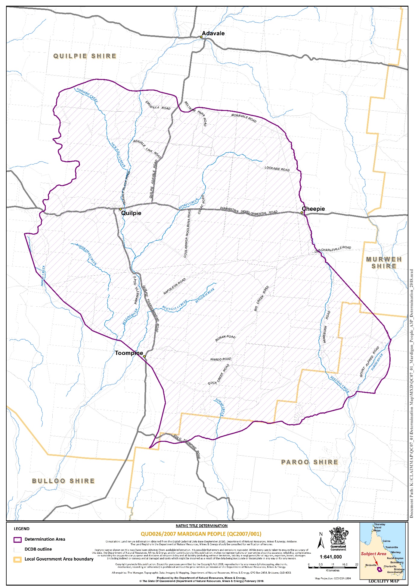
3. The Determination Area is the land and waters described in Schedule 1 and depicted in the map attached to Schedule 2. To the extent of any inconsistency between the written description and the map, the written description prevails.
4. Native title does not exist in the Determination Area.
DEFINITIONS AND INTERPRETATION
5. In this determination “land” and “waters”, respectively, have the same meanings as in the Native Title Act 1993 (Cth).
Other words and expressions used in this determination have the same meanings as they have in Part 15 of the Native Title Act 1993 (Cth).
SCHEDULE 1 – DESCRIPTION OF DETERMINATION AREA
The Determination Area comprises all of the land and waters within the external boundary described below:
External Boundary
Commencing at a point easterly of the town of Cheepie on the centreline of Beechal Creek at Latitude 26.629449° South, and extending generally southerly along the centreline of that creek to the centreline of Diamantina Developmental Road; then generally southerly passing through the following coordinate points:
Longitude East | Latitude South |
145.027948 | 26.642411 |
145.029013 | 26.644080 |
145.029512 | 26.645241 |
145.029874 | 26.645835 |
145.030789 | 26.646417 |
145.031589 | 26.646613 |
145.033568 | 26.646832 |
145.034721 | 26.647960 |
145.035243 | 26.649212 |
145.041117 | 26.673017 |
145.041160 | 26.673549 |
145.041249 | 26.675085 |
145.041364 | 26.676555 |
145.041826 | 26.678212 |
145.042746 | 26.679652 |
145.043713 | 26.681228 |
145.044004 | 26.682701 |
145.045229 | 26.686088 |
145.045959 | 26.688111 |
145.046755 | 26.690497 |
145.047992 | 26.691334 |
145.048617 | 26.693513 |
145.048733 | 26.695998 |
145.049221 | 26.696617 |
145.049674 | 26.697619 |
145.049649 | 26.698657 |
145.049994 | 26.699973 |
145.050731 | 26.701748 |
145.051422 | 26.703296 |
145.052328 | 26.704284 |
145.053455 | 26.705480 |
145.054133 | 26.706532 |
145.054329 | 26.707777 |
145.054075 | 26.708946 |
145.053966 | 26.710343 |
145.054089 | 26.711474 |
145.054243 | 26.712403 |
145.054872 | 26.713408 |
145.055246 | 26.714567 |
145.055612 | 26.716086 |
145.055680 | 26.717738 |
145.055354 | 26.718452 |
145.054486 | 26.718999 |
145.053889 | 26.719778 |
145.053969 | 26.721675 |
145.053927 | 26.723390 |
145.054121 | 26.724726 |
145.054547 | 26.725840 |
145.054920 | 26.727066 |
145.055119 | 26.728154 |
145.055188 | 26.729465 |
145.055056 | 26.730794 |
145.054904 | 26.731874 |
145.055056 | 26.732871 |
145.056263 | 26.734926 |
145.057137 | 26.736206 |
145.057633 | 26.737548 |
145.058034 | 26.739677 |
145.057884 | 26.741706 |
145.057577 | 26.742987 |
145.057343 | 26.744337 |
145.057314 | 26.745533 |
145.058129 | 26.747219 |
145.058501 | 26.748445 |
145.058594 | 26.749779 |
145.058556 | 26.750373 |
145.058539 | 26.750648 |
145.058473 | 26.751673 |
145.058236 | 26.753158 |
145.058104 | 26.754623 |
145.058177 | 26.755789 |
145.058585 | 26.757107 |
145.060539 | 26.759840 |
145.062034 | 26.760669 |
145.064676 | 26.761841 |
145.066738 | 26.763012 |
145.067485 | 26.763979 |
145.067985 | 26.765091 |
145.068142 | 26.765809 |
145.068079 | 26.766692 |
145.067666 | 26.768197 |
145.067597 | 26.769532 |
145.068098 | 26.771231 |
145.069027 | 26.772937 |
145.069962 | 26.774215 |
145.070847 | 26.775471 |
145.071802 | 26.777200 |
145.072589 | 26.778528 |
145.073736 | 26.780046 |
145.074981 | 26.781493 |
Then southerly to a point on the centreline of Beechal Creek at Longitude 145.076363° East; then generally south-easterly along the centreline of that creek to its intersection with the centreline of Gum Hole Creek; then generally south-easterly passing through the following coordinate points:
Longitude East | Latitude South |
145.120583 | 26.836559 |
145.254169 | 26.986120 |
Then south-easterly to the intersection with the centreline of an unnamed tributary and the centreline of Eugood Creek at Longitude 145.354970° East, Latitude 27.097990° South; then generally southerly along the centreline of that creek to Mount Alfred Road at Longitude 145.383120° East, Latitude 27.154562° South; then generally southerly and generally south-westerly passing through the following coordinate points:
Longitude East | Latitude South |
145.373242 | 27.180597 |
145.374968 | 27.198292 |
145.377989 | 27.212535 |
145.379284 | 27.230661 |
145.378852 | 27.248788 |
145.376263 | 27.264756 |
145.372379 | 27.276841 |
145.366337 | 27.294536 |
145.362021 | 27.301441 |
145.356842 | 27.309641 |
Then south-westerly to a point on the centreline of Yali Creek at Longitude 145.344326° East and south-westerly and southerly passing through Longitude 145.317722° East, Latitude 27.364181° South to the northern boundary of Lot 1295 on PH1617 (Humeburn Pastoral Holding) at Longitude 145.316794° East; then westerly along the boundary of that lot to Longitude 145.240771° East; then generally south-westerly passing through the following coordinate points:
Longitude East | Latitude South |
145.237795 | 27.374310 |
145.229239 | 27.382866 |
145.217334 | 27.388447 |
145.212870 | 27.389563 |
145.209522 | 27.388819 |
145.201400 | 27.395357 |
145.196798 | 27.402791 |
145.193613 | 27.407747 |
145.188303 | 27.419429 |
145.186533 | 27.422615 |
145.185826 | 27.427925 |
145.182285 | 27.433235 |
145.176268 | 27.437129 |
145.115735 | 27.452352 |
Then south-westerly to the intersection of the centreline of Twelve Mile Creek and the centreline of Hayes Creek and generally south-westerly along the centreline of Hayes Creek to its headwaters; then generally westerly passing through the following coordinate points:
Longitude East | Latitude South |
145.005288 | 27.500851 |
144.982279 | 27.504746 |
144.974492 | 27.502976 |
144.965996 | 27.504391 |
144.957146 | 27.502975 |
144.948650 | 27.499436 |
144.939801 | 27.494480 |
144.935553 | 27.490586 |
144.930243 | 27.489170 |
144.914313 | 27.492356 |
144.897675 | 27.495189 |
144.885285 | 27.498375 |
144.874665 | 27.498375 |
144.866877 | 27.494481 |
144.851301 | 27.490586 |
144.833956 | 27.489525 |
144.821920 | 27.489525 |
144.813424 | 27.492711 |
144.810593 | 27.495190 |
144.798556 | 27.507580 |
144.787937 | 27.517492 |
144.767406 | 27.528289 |
144.752183 | 27.533245 |
144.735191 | 27.538201 |
144.712890 | 27.544219 |
144.678553 | 27.554132 |
144.664039 | 27.560858 |
144.654835 | 27.564398 |
144.648109 | 27.565460 |
144.642446 | 27.565106 |
144.634304 | 27.562275 |
144.628994 | 27.560505 |
144.626162 | 27.560151 |
144.621560 | 27.560151 |
144.619436 | 27.559797 |
144.614834 | 27.557673 |
144.612356 | 27.556611 |
144.607046 | 27.556256 |
144.598550 | 27.552362 |
144.591116 | 27.549177 |
144.582266 | 27.550239 |
144.575540 | 27.551655 |
144.558903 | 27.564045 |
144.554262 | 27.566492 |
144.553662 | 27.565353 |
144.553661 | 27.565351 |
144.549109 | 27.568905 |
144.543638 | 27.571385 |
144.535462 | 27.574331 |
144.529405 | 27.574752 |
144.523479 | 27.575802 |
144.516135 | 27.576685 |
144.508533 | 27.578198 |
144.499707 | 27.579314 |
144.494941 | 27.580474 |
144.486561 | 27.580328 |
144.480950 | 27.579087 |
144.474047 | 27.577334 |
144.465919 | 27.575241 |
144.459724 | 27.573028 |
144.452438 | 27.572193 |
144.445670 | 27.572100 |
144.436581 | 27.572015 |
144.428593 | 27.573071 |
144.423314 | 27.574920 |
144.416493 | 27.578149 |
144.411026 | 27.582003 |
144.406592 | 27.585968 |
144.402222 | 27.590047 |
144.397080 | 27.594300 |
144.392576 | 27.596605 |
Then south-westerly to a point on the eastern external boundary of Native Title Determination QUD80/2009 – Kullilli People at Latitude 27.599205° South; then generally northerly and generally north-westerly along the external boundary of that determination, to the eastern external boundary of Native Title Determination QUD435/2006 – Boonthamurra People, further described as:
Generally northerly and generally north-westerly across Baalooroo Creek, Gorrie Gorrie Creek and Bulloo River passing through the following coordinate points:
Longitude East | Latitude South |
144.396596 | 27.586328 |
144.424181 | 27.529036 |
144.452827 | 27.413391 |
144.443278 | 27.359281 |
144.396596 | 27.268038 |
144.332938 | 27.209685 |
144.270340 | 27.158758 |
144.234268 | 27.150270 |
144.151512 | 27.116320 |
144.121805 | 27.090856 |
144.102708 | 27.048418 |
144.074061 | 27.027198 |
144.032684 | 26.996430 |
143.960001 | 26.917576 |
143.920221 | 26.874419 |
143.912575 | 26.849876 |
Then northerly to a point on the Grey Range and the watershed between Cooper Creek and Bulloo River at Longitude 143.871053° East, a point on the eastern external boundary of Native Title Determination QUD435/2006 Boonthamurra People.
Then generally north-easterly and generally northerly along the external boundary of Native Title Determination QUD435/2006 – Boonthamurra People to Latitude 26.137805° South, further described as:
Generally north-easterly and generally northerly along the ridgeline of the Grey Range being the watershed between Cooper Creek and Bulloo River to Latitude 26.137805° South.
Then generally north-easterly, generally easterly and generally south-easterly passing through the following coordinate points:
Longitude East | Latitude South |
144.016039 | 26.135189 |
144.023969 | 26.129783 |
144.038026 | 26.122934 |
144.049200 | 26.120411 |
144.061094 | 26.117528 |
144.072268 | 26.112842 |
144.081640 | 26.108877 |
144.090290 | 26.104912 |
144.102906 | 26.100587 |
144.121288 | 26.094459 |
144.132102 | 26.089774 |
144.146880 | 26.084727 |
144.154809 | 26.082925 |
144.167064 | 26.080763 |
144.180040 | 26.081844 |
144.192656 | 26.081844 |
144.208155 | 26.083286 |
144.220410 | 26.085448 |
144.233746 | 26.090134 |
144.244920 | 26.094820 |
144.254652 | 26.101308 |
144.268349 | 26.108877 |
144.278081 | 26.114284 |
144.291057 | 26.121493 |
144.297184 | 26.124737 |
144.304753 | 26.127260 |
144.317729 | 26.129062 |
144.334310 | 26.129783 |
144.358459 | 26.127260 |
144.384051 | 26.125818 |
144.403875 | 26.125457 |
144.419014 | 26.128701 |
144.429106 | 26.133387 |
144.452895 | 26.139154 |
144.474522 | 26.144200 |
144.486416 | 26.147805 |
144.495788 | 26.152491 |
144.499753 | 26.160060 |
144.501555 | 26.171234 |
144.504799 | 26.188174 |
144.508043 | 26.193941 |
144.514531 | 26.207638 |
144.519217 | 26.211964 |
144.527867 | 26.215208 |
144.537599 | 26.216289 |
144.548052 | 26.215928 |
144.560307 | 26.209440 |
144.571120 | 26.203673 |
144.578329 | 26.198988 |
144.590945 | 26.196825 |
144.612211 | 26.198627 |
144.637442 | 26.203673 |
144.648615 | 26.205476 |
144.662312 | 26.207638 |
144.689706 | 26.209440 |
144.707007 | 26.210161 |
144.728273 | 26.212684 |
144.740888 | 26.214847 |
144.764678 | 26.219172 |
144.780898 | 26.223498 |
144.798559 | 26.227463 |
144.826674 | 26.233230 |
144.850463 | 26.239718 |
144.865601 | 26.246566 |
144.879298 | 26.254856 |
144.898762 | 26.264949 |
144.917145 | 26.273960 |
Then south-easterly to the headwaters of an unnamed tributary of Beechal Creek at Longitude 144.926980° East, Latitude 26.282340° South; then generally south-easterly and generally southerly along the centreline of that unnamed tributary and the centreline of Beechal Creek back to the commencement point.
Note:
The Determination Area does not include any lands and waters subject to:
QUD80/2009 – Kullilli People as determined by the Federal Court of Australia 2 July 2014.
QUD435/2006 – Boonthamurra People as determined by the Federal Court of Australia 25 June 2015.
Reference Datum
Geographical coordinates are referenced to the Geocentric Datum of Australia (GDA94), in decimal degrees and are based on the spatial reference data acquired from the various custodians at the time.
Data Reference and Source
External boundary compiled by Queensland South Native Title Services based in part on data sourced from National Native Title Tribunal October 2018.
Mount Alfred Road referenced to cadastral data.
Native title determination external boundaries based on spatial data compiled by Queensland South Native Title Services.
Cadastre data sourced from State of Queensland, Department of Natural Resources Mines and Energy September 2018.
Watercourses where possible referenced to cadastral data otherwise 1:250k Topographic vector data © Commonwealth of Australia (Geoscience Australia) 2008.
Ridgeline of the Grey Range based on Drainage Basin Sub-Area Queensland Data as at (20/01/2009) sourced from Department of Environment and Resource Management (Qld) September 2011.
Use of Coordinates
Where coordinates are used within the description to represent cadastral or topographical boundaries or the intersection with such, they are intended as a guide only. As an outcome to the custodians of cadastral and topographic data continuously recalculating the geographic position of their data based on improved survey and data maintenance procedures, it is not possible to accurately define such a position other than by detailed ground survey.
Prepared by Queensland South Native Title Services (26/10/2018).
SCHEDULE 2 – MAP OF DETERMINATION AREA
Note: Entry of orders is dealt with in Rule 39.32 of the Federal Court Rules 2011.
REEVES J:
1 This is an application under s 87 of the Native Title Act 1993 (Cth) (the NTA). It seeks, what is commonly described as a consent determination of native title. In this case, however, it is directed to achieving a “non-native title outcome”, that is, a determination that native title does not exist in the claim area. This form of determination is commonly described as a negative determination of native title.
THE PROCEDURAL HISTORY
2 The native title determination application to which the current application relates was filed on 17 January 2007 by the authorised applicant of the Mardigan People. It covers a large area of land and waters in south-western Queensland, including the towns of Quilpie, Cheepie and Toompine.
3 The National Native Title Tribunal (the Tribunal) entered the application on the Register of Native Title Claims under Part 7 of the NTA on 6 June 2007. The notification period under s 66 of the NTA ended on 9 January 2008. There are presently 17 respondent parties to the proceeding. They are the State of Queensland (the State), the Paroo Shire Council, the Quilpie Shire Council, Ergon Energy Corporation Limited, Telstra Corporation Limited, Mr Adrian William Rach and 11 pastoral interests.
4 The proceeding has been listed for trial on three occasions. First, by orders made on 2 March 2010; secondly, by orders made on 8 November 2013; and finally, by orders made on 21 July 2016.
5 In August 2010, after the first set of trial programming orders mentioned above was vacated, the Court made orders giving effect to an alternative process that had been agreed between the parties. That process was case managed by Mansfield J and a Registrar of the Court. It included the identification and appointment of a Court-appointed expert, Professor David Trigger, who was tasked to prepare an expert report with respect to the anthropological issues raised by the application. During that process, reports were also commissioned from another anthropologist, Mr Kevin Murphy. Professor Trigger’s report was provided to the Court on or about 30 May 2013.
6 When that process failed to lead to a resolution of the matter, the second set of trial programming orders referred to above was made. That set of orders was also vacated. That occurred on 6 May 2014, before the hearing of lay evidence commenced. Those orders were made because the Mardigan applicant and the State informed the Court that they had entered into negotiations directed to achieving an “alternative settlement” of the application.
7 Negotiations to that end continued throughout 2015 and 2016. In the course of them, the Mardigan applicant provided further connection materials to the State, together with a set of submissions. Eventually, in July 2016, the Mardigan applicant and the State jointly proposed that the Court should conduct an on-country hearing in and around the town of Quilpie on 6 and 7 December 2016. Accordingly, on 21 July 2016, the third set of trial programming orders mentioned above was made. After being postponed to 3 April 2017 to 6 April 2017, that trial proceeded. As well as viewing a number of sites in the vicinity of the town of Quilpie, evidence was taken from lay witnesses and a number of anthropological reports were tendered.
8 Shortly after that on-country hearing, the Mardigan applicant and the State met to discuss a resolution of the application other than by way of a continuation of that contested hearing. This proposal was then discussed at a meeting of the Mardigan applicant held in May 2017 and at a meeting of the Mardigan claim group held in June 2017. Thereafter, between August and October 2017, the Mardigan applicant obtained legal advice about their prospects of success in the application.
9 On 12 December 2017, the State and the Mardigan applicant informed the Court, in a joint report, that they had agreed to enter into negotiations directed to achieving a negative determination of native title in the proceeding. This proposal was endorsed at a meeting of the Mardigan claim group held on 14 April 2018. A consent determination timetable was then developed and the proceeding was advanced in accordance with that timetable over the course of 2018 and 2019.
10 Concurrently with those steps, the parties negotiated on the terms of an Indigenous Land Use Agreement (ILUA) to cover the entirety of the application area (the Mardigan ILUA). The applicant’s submissions in support of the present application indicate that the Mardigan ILUA provides for certain benefits to the Mardigan people in consideration for the surrender of any native title rights and interests that they may hold in the application area.
11 On 9 March 2019, the last of three authorisation meetings was held in Cunnamulla. At that meeting, the Mardigan claim group authorised the Mardigan applicant to enter into the Mardigan ILUA. It also authorised and directed the Mardigan applicant to consent to the making of a negative consent determination of native title over all of the land and waters covered by the application. Those authorisation meetings were the subject of wide and extensive public notification and various other methods were employed to inform the members of the Mardigan claim group that they were being held. It is also apparent that the meetings that ensued were carefully conducted and minuted. Finally, it should be noted that both the Mardigan applicant and the Mardigan claim group received legal advice in the lead up to, and at, those authorisation meetings.
12 The Mardigan ILUA was executed by the Mardigan applicant immediately following the 9 March 2019 meeting. It was executed by the State on 24 April 2019, following which, on 1 May 2019, it was lodged with the Tribunal for registration.
13 That registration encountered some further delays. A certificate executed by the Chief Executive Officer of Queensland South Native Title Services Ltd certifying the application for registration of the Mardigan ILUA under s 203BE(5)(a) and (b) of the NTA had been provided to the Tribunal in support of the application for registration. However, following the decision of the Full Court of the Federal Court in Northern Land Council v Quall [2019] FCAFC 77, that certificate was withdrawn and replaced with a statement by the native title parties under s 24CG(3)(b) of the NTA. That allowed the process of public notification to occur and the Mardigan ILUA was finally entered on the Register of Indigenous Land Use Agreements under Part 8A of the NTA on 1 October 2019. One effect of that registration was, as already mentioned above, that any native title rights and interests which may have existed in the application area were surrendered to the State in exchange for certain benefits, including land.
THE SECTION 87 AGREEMENT
14 On 14 October 2019, the State filed with the Court an amended agreement made under s 87 of the NTA (the s 87 agreement), duly executed by the Mardigan applicant and all of the respondent parties. The s 87 agreement superseded an earlier agreement which was filed on 2 May 2019. That agreement was expressed to be conditional upon registration of the Mardigan ILUA and was therefore overtaken by the registration of that ILUA as mentioned above.
15 The Mardigan applicant has filed with the Court the following affidavits and submissions in support of the present application under s 87:
(a) affidavit of Jeffrey Graham Harris affirmed on 30 April 2019;
(b) affidavit of Jessica Marie Ling affirmed on 7 May 2019;
(c) a set of submissions filed on 7 May 2019 (the Mardigan applicant’s submissions);
(d) further affidavit of Jessica Marie Ling affirmed on 13 November 2019; and
(e) a further set of submissions filed on 13 November 2019 (the Mardigan applicant’s further submissions).
OVERLAPPING CLAIMS AND NEIGHBOURING DETERMINATIONS
16 In addition to drawing together the history of the application, the Mardigan applicant’s submissions and the supporting affidavit materials mentioned above address the complexity surrounding the historical claims made on behalf of people identifying as Mardigan in connection with the application area; the similar historical claims made to the application area on behalf of people not identifying as Mardigan; and the determinations of native title made with respect to areas in the vicinity of the application area. In respect of these issues, it is appropriate to record the following:
(a) prior to the filing of the present Mardigan application, there was a number of earlier applications made on behalf of people identifying as Mardigan;
(b) as well, there was a number of earlier native title determination applications made to parts of the present application area on behalf of people not identifying as Mardigan;
(c) with one exception, all of these applications were withdrawn, dismissed or discontinued prior to the filing of the present Mardigan application on 17 January 2007;
(d) the one exception was the Bidjara People #5 application, which was dismissed on 18 May 2007. It was the last application to overlap the claim area of the present Mardigan application;
(e) of the neighbouring groups who previously filed native title determination applications overlapping the present application area, the Bidjara People have no current claims on foot; the Budjiti People achieved a determination of native title over an area to the south of the application area and have not filed any additional applications since that determination; and the Kullilli People achieved a determination of native title over an area which abuts the south-west boundary of the application area and have not filed any additional applications since that determination;
(f) while they have never filed a native title determination application overlapping the application area, the Boonthamurra People achieved a determination of native title over an area which abuts the north-west boundary of the application area and have not filed any additional native title determination applications since that determination;
(g) none of the apical ancestors in the present Mardigan application has materially featured in any of the native title determination applications, or in any of the neighbouring native title determinations, mentioned above; and
(h) there have never been any Indigenous respondents to the present Mardigan application.
THE PROPOSED NEGATIVE DETERMINATION
17 The circumstances of the present application under s 87 and the negative determination of native title it propounds are analogous to another similar application that I determined relatively recently (see Hill on behalf of the Yirendali People v State of Queensland [2017] FCA 273 (Hill)). In Hill, I made a determination that native title did not exist in circumstances where, prior to making the s 87 agreement, the State had entered into an ILUA with the claim group providing for the surrender of native title in the whole of the application area in exchange for certain benefits, including land exchange and revenue sharing. In considering whether it was “appropriate” under s 87(1A) of the NTA to make orders under s 87(2) of the NTA in terms of that s 87 agreement, I applied the principles outlined in of Nelson v Northern Territory (2010) 190 FCR 344; [2010] FCA 1343 (Nelson), CG v Western Australia (2016) 240 FCR 466; [2016] FCAFC 67 (Badimia FC) and CG (Deceased) on behalf of the Badimia People v State of Western Australia (No 2) [2015] FCA 507 (Badimia SJ). In my view, these principles apply with equal force in this matter.
18 In Nelson (at [5]–[14]), I canvassed the authorities that identified the factors to which the Court will routinely have regard in determining the question of “appropriateness”. Those factors included (see Hill at [16]):
(a) the objects of the Act, one of the most important being the resolution of disputes by negotiation and agreement, rather than litigation [Nelson at [7]];
(b) whether there is an agreement, and whether it was freely entered into on an informed basis [Nelson at [8] and [9]];
(c) whether the parties have independent and competent legal representation [Nelson at [14]];
(d) whether the terms of the proposed order are unambiguous and clear [Nelson at [14]];
(e) whether the agreement has been preceded by a mediation process [Nelson at [14]].
19 Having regard to the history of the present s 87 application set out above, I consider factors (a) and (b) have been met. Noting that all of the parties to the application (with the exception of Mr Rach) have had independent and competent legal representation throughout, I consider factor (c) has also been met. From the terms of the s 87 agreement filed with the Court, it is apparent that the terms of the proposed orders are unambiguous and clear in their terms and, therefore, factor (d) has also been met. As to factor (e), while this proceeding has not, in recent times, been in mediation under s 86A of the NTA, its history as set out above indicates that there have been extensive bilateral negotiations between the Mardigan applicant and the State over a number of years resulting in the Mardigan ILUA and the s 87 agreement. I therefore consider that factor (e) has also been met.
20 However, as in Hill, the present matter gives rise to a further discretionary consideration that did not arise in Nelson. That is, whether it is appropriate, in the circumstances, to make a determination that native title does not exist in the application area. The discretionary power of the Court to make such a negative determination of native title was authoritatively affirmed by the Full Court in Badimia FC. The discretionary considerations that were taken into account by the primary judge in Badimia SJ and approved in Badimia FC were as follows:
(a) the serious consequences for the claimant group (Badimia SJ at [79]);
(b) the fact that a full and complete trial had been conducted which considered the relevant connection issues in the claim area (Badimia SJ at [79]);
(c) that following the lodgement of the native title determination application, no other Indigenous persons or groups had come forward to challenge the claimant’s alleged interests in the claim area (Badimia SJ at [80]);
(d) the fact that the claim had been formulated with the assistance of the relevant native title representative body, with the advice and representation of experienced solicitors and counsel and relying upon the evidence of an experienced anthropologist (Badimia SJ at [80]); and
(e) that it was artificial to suggest that a new claim group could exist comprising only the descendants of the claimants who had been identified by the Court (Badimia SJ at [81]–[82]).
21 While the circumstances of the negative determination in Badimia SJ were very different to those of the present application, I consider these considerations provide some assistance in identifying the factors I should take into account in this matter. In the circumstances of this matter, the serious consequences for the Mardigan claim group (consideration (a) above) overlap with the discussion about the factors identified in Nelson above, particularly (b) and (e) (see further at [24] below). Similarly, the consideration in (d) above overlaps factor (c) in Nelson above.
22 As for the consideration in (c) above, during the notification period of this application under s 66 of the NTA, no other Indigenous persons or groups came forward to challenge the Mardigan claim group’s claimed interests in the application area and none has come forward since. It is true that the Bidjara People #5 application overlapped the application until it was dismissed on 18 May 2007, more than 12 years ago, but, as discussed above at [16], it was the last native title determination application to overlap the application area. Consistent with this history, as also discussed above at [16], there has never been an Indigenous respondent in this proceeding. In my view, all of these matters reflect the considerations in (c) and (e) above, although the latter does not directly arise in this matter.
23 It is apparent that both the Mardigan applicant and the State have obtained the advice of appropriate experts and, in particular, experienced anthropologists, in putting forward this application under s 87. This reflects the consideration in (d) above.
24 Finally, as for the consideration in (b) above, unlike in Badimia FC where there was a contested hearing about the existence of native title in the claim area, in this matter, the Mardigan applicant and the State have agreed to, and had registered, the Mardigan ILUA, under which any native title which existed in the ILUA area (corresponding to the application area) was surrendered upon the registration taking effect. The existence of this registered ILUA is plainly a highly relevant factor in exercising my discretion to make a negative determination of native title in this matter. As I said in Hill, in this regard it is worth recording the observations of Branson J in Kelly on behalf of the Byron Bay Bundjalung People v NSW Aboriginal Land Council [2001] FCA 1479. That matter involved an application under s 87 of the NTA to make a determination that native title did not exist in circumstances similar to the present application. Specifically, the applicant had entered into an ILUA with the State of New South Wales to surrender to it any native title rights and interests that it may hold in the land in question. As to the significance of that ILUA, her Honour said (at [19]):
Section 24EA of the [NTA] gives contractual effect to an agreement entered on the Register of Indigenous Land Use Agreements. It also provides that all persons holding native title in relation to the land in the area covered by the agreement, who are not already parties to the agreement, are bound by the agreement in the same way as the registered native title bodies corporate or the native title group, as the case may be. In the circumstances I am satisfied that it is within the power of the Court now to order that native title does not exist in the land the subject of this proceeding. That is because the State Minister has, pursuant to a valid and binding agreement, accepted the surrender of any native title that may have previously existed in the land.
25 Having regard to all of these considerations, I am satisfied it is appropriate to make the orders that have been sought by the parties based on the s 87 agreement.
26 However, there remains a number of other requirements under s 87 of the NTA that must still be met before the determination sought may be made. The first three of those requirements, and the evidence that shows that the parties have met them, are as follows:
(a) under s 87(1), the notice period under s 66 of the NTA must have ended before the written agreement of the parties was filed with the Court. As I have already noted above, the notification period for the Mardigan application ceased on 9 January 2008, well before the s 87 agreement was filed with the Court on 14 October 2019;
(b) under s 87(1)(a), the agreement of the parties must relate to the whole of the proceeding, part of the proceeding, or a matter arising out of the proceeding. As the proposed orders in the s 87 agreement relate to the whole of this proceeding, this requirement, too, has been met; and
(c) s 87(1)(b) requires that the agreement must be reduced to writing, signed by the parties and filed with the Court. The s 87 agreement filed with the Court in this matter demonstrates that each of these requirements has also been met.
27 The next requirement is that the Court must be satisfied that the proposed orders, or orders consistent with them, would be within the power of the Court (s 87(1)(c)). An order will be within the power of the Court if it complies with the various provisions of the NTA including ss 94A and 225. Section 94A requires that:
An order in which the Federal Court makes a determination of native title must set out details of the matters mentioned in section 225 (which defines determination of native title).
28 This provision requires attention to the matters mentioned in s 225 of the NTA. That section provides:
A determination of native title is a determination whether or not native title exists in relation to a particular area (the determination area) of land or waters and, if it does exist, a determination of:
(a) who the persons, or each group of persons, holding the common or group rights comprising the native title are; and
(b) the nature and extent of the native title rights and interests in relation to the determination area; and
(c) the nature and extent of any other interests in relation to the determination area; and
(d) the relationship between the rights and interests in paragraphs (b) and (c) (taking into account the effect of this Act); and
(e) to the extent that the land or waters in the determination area are not covered by a non-exclusive agricultural lease or a non-exclusive pastoral lease—whether the native title rights and interests confer possession, occupation, use and enjoyment of that land or waters on the native title holders to the exclusion of all others.
(Note omitted)
29 It can be seen that a determination only needs to include the matters described in ss 225(a)–225(e) above if native title exists in the determination area. Those matters obviously cannot be included in a determination that native title does not exist. For similar reasons, the provisions of Part 2, Division 6 of the NTA relating to prescribed bodies corporate do not apply to the present determination (see s 55(b)).
30 Finally, none of the parties to this proceeding has elected to file an agreed statement of facts, so I do not need to concern myself with the provisions of ss 87(8)–87(11) inclusive.
31 For these reasons, I am satisfied that all of the requirements under s 87 of the NTA have been met and that it is appropriate to make a determination that native title does not exist in the whole of the claim area without holding a hearing.
I certify that the preceding thirty-one (31) numbered paragraphs are a true copy of the Reasons for Judgment herein of the Honourable Justice Reeves. |
Associate:
QUD 7 of 2019 | |
ERGON ENERGY CORPORATION LIMITED ACN 087 646 062 | |
Fifth Respondent: | TELSTRA CORPORATION LIMITED |
Sixth Respondent: | ADRIAN WILLIAM RACH |
Seventh Respondent: | LEIF DUE |
Eighth Respondent: | MARGARET ANN DUE |
Ninth Respondent: | THORA MERLE GREGORY |
Tenth Respondent: | PAMELA MARY LYONS |
Eleventh Respondent: | KATHRYN LOUISE PATRICK |
Twelfth Respondent: | ROBERT WILLIAM PATRICK |
Thirteenth Respondent: | ALAN CARL PULSFORD |
Fourteenth Respondent: | THERESE MARTHA PULSFORD |
Fifteenth Respondent: | SCOTT LESLIE TRAVERS |
Sixteenth Respondent: | DIANA ELEANOR WATTS |
Seventeenth Respondent: | DUNCAN COLIN WATTS |

