
FEDERAL COURT OF AUSTRALIA
Cronin on behalf of the Butchulla People (land & sea claim #2) v State of Queensland [2019] FCA 2082
ORDERS
GEMMA CRONIN & ORS ON BEHALF OF THE BUTCHULLA PEOPLE LAND & SEA CLAIM #2 Applicants | ||
AND: | Respondents | |
DATE OF ORDER: |
THE COURT NOTES THAT:
A. Pursuant to section 87(1) of the Native Title Act 1993 (Cth) the parties have filed with this Court a document recording an agreement reached between the parties on the terms of an order of the Court in relation to these proceedings. The parties have also filed an affidavit of Sarah Webster Svensson sworn 12 December 2019 recording the parties’ agreement to an amendment to the order, to insert a notation signifying that the non-extinguishment principle applies to Lot 182 on Plan MCH4365 (which had been inadvertently omitted).
B. The terms of the order involve the making of a determination of native title in relation to the area of land and waters the subject of these proceedings pursuant to section 87(2) and section 94A of the Native Title Act 1993 (Cth).
BEING SATISFIED that a determination of native title in the terms sought by the parties as set out below is within the power of the Court, and it appearing to the Court appropriate to do so, pursuant to section 87 of the Native Title Act 1993 (Cth) and by the consent of the parties:
THE COURT ORDERS THAT:
1. There be a determination of native title (the “Determination”) in the terms set out below for the Determination Area other than for Lot 2 on Plan AP6551 and Lot 3 on Plan AP6551.
2. Subject to paragraph 3 of this Order, on 11 December 2020, there be a determination of native title (also, the “Determination”) in the terms set out below for Lot 2 on Plan AP6551 and Lot 3 on Plan AP6551.
3. The Applicant and the State of Queensland have liberty to apply to the Court on or before 13 November 2020 in relation to paragraph 2 of this Order.
4. Each party to the proceeding is to bear its own costs.
THE COURT DETERMINES THAT:
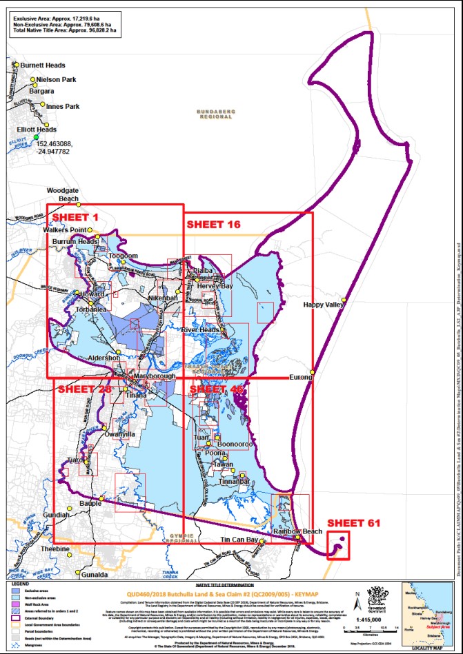
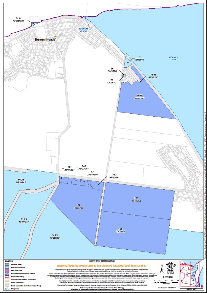
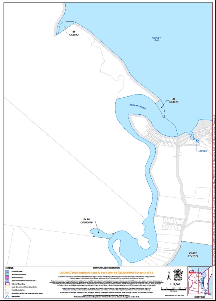
5. The determination area is the land and waters described in Schedule 4 and depicted in the maps attached to Schedule 6 to the extent those areas are within the External Boundary and not otherwise excluded by the terms of Schedule 5 (the “Determination Area”). To the extent of any inconsistency between the written description and the maps, the written description prevails.
6. Native title exists in the Determination Area.
7. The native title is held by the Butchulla People described in Schedule 1 (the “Native Title Holders”).
8. Subject to paragraphs 12, 13 and 14 of this Order the nature and extent of the native title rights and interests in relation to that part of the Determination Area described in Part 1 of Schedule 4 are:
(a) other than in relation to Water, the right to possession, occupation, use and enjoyment of the area to the exclusion of all others; and
(b) in relation to Water, the non-exclusive rights to:
(i) hunt, fish and gather from the Water of the area;
(ii) take and use the Natural Resources of the Water in the area; and
(iii) take and use the Water of the area,
for personal, domestic and non-commercial communal purposes.
9. Subject to paragraphs 12, 13 and 14 of this Order, the nature and extent of the native title rights and interests in relation to that part of the Determination Area described in Part 2 of Schedule 4 are the non-exclusive rights to:
(a) access, be present on, move about on and travel over the area;
(b) camp, and live temporarily on the area as part of camping, and for that purpose build temporary shelters;
(c) hunt, fish and gather on the land and waters of the area for personal, domestic and non-commercial communal purposes;
(d) take, use, share and exchange Natural Resources from the land and waters of the area for personal, domestic and non-commercial communal purposes;
(e) take and use the Water of the area for personal, domestic and non-commercial communal purposes;
(f) conduct, and participate in, rituals and ceremonies on the area, including those relating to initiation, birth and death;
(g) be buried on and bury Native Title Holders within the area;
(h) maintain places of importance and areas of significance to the Native Title Holders under their traditional laws and customs and protect those places and areas from physical harm;
(i) teach on the area the physical, cultural, and spiritual attributes of the area;
(j) hold meetings on the area; and
(k) light fires on the area for personal and domestic purposes including cooking, but not for the purpose of hunting or clearing vegetation.
10. Subject to paragraphs 12, 13 and 14 of this Order, the nature and extent of the native title rights and interests in relation to that part of the Determination Area described in Part 3 of Schedule 4 are the non-exclusive rights to:
(a) access, be present on, move about on and travel over the area;
(b) hunt, fish and gather on the land and waters of the area for personal, domestic and non-commercial communal purposes;
(c) take, use, share and exchange Natural Resources from the land and waters of the area for personal, domestic and non-commercial communal purposes;
(d) take and use the Water of the area for personal, domestic and non-commercial communal purposes;
(e) conduct, and participate in, rituals and ceremonies on the area, including those relating to initiation, birth and death;
(f) maintain places of importance and areas of significance to the Native Title Holders under their traditional laws and customs and protect those places and areas from physical harm; and
(g) teach on the area the physical, cultural, and spiritual attributes of the area.
11. Subject to paragraphs 12, 13 and 14 of this Order, the nature and extent of the native title rights and interests in relation to that part of the Determination Area described in Part 4 of Schedule 4 is the non-exclusive right to protect the area from physical harm.
12. The native title rights and interests are subject to and exercisable in accordance with:
(a) the Laws of the State and the Commonwealth; and
(b) the traditional laws acknowledged and traditional customs observed by the Native Title Holders.
13. The native title rights and interests referred to in paragraphs 8(b), 9, 10 and 11 of this Order do not confer possession, occupation, use or enjoyment to the exclusion of all others.
14. There are no native title rights in or in relation to minerals as defined by the Mineral Resources Act 1989 (Qld) and petroleum as defined by the Petroleum Act 1923 (Qld) and the Petroleum and Gas (Production and Safety) Act 2004 (Qld).
15. The nature and extent of any other interests in relation to the Determination Area (or respective parts thereof) as they exist at the date of this Determination are set out in Schedule 2 (the “Other Interests”).
16. The relationship between the native title rights and interests described in paragraphs 8, 9, 10 and 11 of this Order and the Other Interests is that:
(a) the Other Interests continue to have effect, and the rights conferred by or held under the Other Interests may be exercised notwithstanding the existence of the native title rights and interests;
(b) to the extent the Other Interests are inconsistent with the continued existence, enjoyment or exercise of the native title rights and interests in relation to the land and waters of the Determination Area, the native title continues to exist in its entirety but the native title rights and interests have no effect in relation to the Other Interests to the extent of the inconsistency for so long as the Other Interests exist; and
(c) the Other Interests and any activity that is required or permitted by or under, and done in accordance with, the Other Interests, or any activity that is associated with or incidental to such an activity, prevail over the native title rights and interests and any exercise of the native title rights and interests.
17. The native title is not held in trust.
18. The Butchulla Native Title Aboriginal Corporation ICN 9145, incorporated under the Corporations (Aboriginal and Torres Strait Islander) Act 2006 (Cth), is to:
(a) be the prescribed body corporate for the purpose of s 57(2) of the Native Title Act 1993 (Cth); and
(b) perform the functions mentioned in s 57(3) of the Native Title Act 1993 (Cth) after becoming a registered native title body corporate.
DEFINITIONS AND INTERPRETATION
19. In this Determination, unless the contrary intention appears:
"External Boundary" means the area described in Schedule 3; "High Water Mark" means the ordinary high-water mark at spring tides; |
"land" and "waters", respectively, have the same meanings as in the Native Title Act 1993 (Cth); |
"Laws of the State and the Commonwealth" means the common law and the laws of the State of Queensland and the Commonwealth of Australia, and includes legislation, regulations, statutory instruments, local planning instruments and local laws; |
“Local Government Area” has the meaning given in the Local Government Act 2009 (Qld); |
"Natural Resources" means: (a) any animal, plant, fish and bird life found on or in the lands and waters of the Determination Area; and (b) any clays, soil, sand, gravel or rock found on or below the surface of the Determination Area, that have traditionally been taken and used by the Native Title Holders, but does not include: (c) minerals as defined in the Mineral Resources Act 1989 (Qld); or (d) petroleum as defined in the Petroleum Act 1923 (Qld) and the Petroleum and Gas (Production and Safety) Act 2004 (Qld); |
"Water" means: (a) water which flows, whether permanently or intermittently, within a river, creek or stream; (b) any natural collection of water, whether permanent or intermittent; (c) water from an underground water source; and (d) tidal water; |
“Wolf Rock Area” means the area described in Part 4 of Schedule 4. |
Other words and expressions used in this Determination have the same meanings as they have in Part 15 of the Native Title Act 1993 (Cth).
Note: Entry of orders is dealt with in Rule 39.32 of the Federal Court Rules 2011.
Schedule 1 – Native Title Holders
1. The Native Title Holders for the Determination Area are the Butchulla People who are the biological descendants of the following people:
(a) Father / Mother of Gracie and Maudie Daramboi;
(b) Mother of Jessie Aldridge’s mother and Lappy;
(c) Mother of Charles Richards;
(d) Garry Owens;
(e) Annie Morris / Anna Gala nee Morris;
(f) Granny Polcus / Jenny Brown;
(g) Willy Brown / Mamboo / Namboo;
(h) George Gundy;
(i) Willy Wondunna;
(j) Jack Morris;
(k) Mary Ann (mother of Susan Rooney);
(l) Roger Bennett;
(m) Percy Coulson;
(n) Mother of John and Rosie Broome;
(o) Mother of Clara, Henry, Percy and Lucy Wheeler.
Schedule 2 – Other Interests in the Determination Area
The nature and extent of the Other Interests in relation to the Determination Area are the following as they exist as at the date of the Determination:
1. The rights and interests of Telstra Corporation Limited ACN 051 775 556:
(a) as the owner or operator of telecommunications facilities within the Determination Area;
(b) created pursuant to the Post and Telegraph Act 1901 (Cth), the Telecommunications Act 1975 (Cth), the Australian Telecommunications Corporation Act 1989 (Cth), the Telecommunications Act 1991 (Cth) and the Telecommunications Act 1997 (Cth), including rights:
(i) to inspect land;
(ii) to install, occupy and operate telecommunication facilities; and
(iii) to alter, remove, replace, maintain, repair and ensure the proper functioning of its telecommunications facilities;
(c) for its employees, agents or contractors to access its telecommunication facilities in and in the vicinity of the Determination Area in the performance of their duties; and
(d) under any lease, licence, access agreement, permit or easement relating to its telecommunications facilities in the Determination Area.
2. The rights and interests of Ergon Energy Corporation Limited ACN 087 646 062:
(a) as the owner and operator of any “Works” as that term is defined in the Electricity Act 1994 (Qld) within the Determination Area;
(b) as a distribution entity and the holder of a distribution authority under the Electricity Act 1994 (Qld);
(c) created under the Electricity Act 1994 (Qld) and the Government Owned Corporations Act 1993 (Qld) including:
(i) rights in relation to any agreement relating to the Determination Area existing or entered into before the date on which these orders are made;
(ii) rights to enter the Determination Area by its employees, agents or contractors to exercise any of the rights and interests referred to in this paragraph; and
(iii) to inspect, maintain and manage any Works in the Determination Area.
3. The rights and interests of the State of Queensland, Fraser Coast Regional Council and Gympie Regional Council to access, use, operate, maintain and control the dedicated roads in the Determination Area and the rights and interests of the public to use and access the roads.
4. The rights and interests of each of Fraser Coast Regional Council and Gympie Regional Council:
(a) under their local government jurisdiction and functions under the Local Government Act 2009 (Qld), under the Stock Route Management Act 2002 (Qld) and under any other legislation, for that part of the Determination Area within the area declared to be their respective Local Government Area;
(i) lessor under any leases which were validly entered into before the date on which these orders are made and whether separately particularised in these orders or not;
(ii) grantor of any licences or other rights and interests which were validly granted before the date on which these orders were made and whether separately particularised in these orders or not;
(iii) holder of any estate or other interest in land, including as trustee of any reserves, that exist in the Determination Area;
(c) as the owner and operator of infrastructure, other structures, earthworks, and any other facilities or improvements located in the Determination Area validly constructed or established on or before the date on which these orders are made, including but not limited to:
(i) undedicated but constructed roads except for those not operated by Council;
(ii) water pipelines and water supply infrastructure;
(iii) drainage facilities;
(iv) watering point facilities;
(v) recreational facilities;
(vi) transport facilities; and
(vii) community facilities;
(d) to enter the land for the purposes described in paragraphs 4(a), 4(b) or 4(c) above by their employees, agents or contractors to:
(i) exercise any of the rights and interests referred to in paragraphs 3 and 4;
(ii) use, operate, inspect, maintain, replace, restore and repair the infrastructure, facilities and other improvements referred to in paragraph 4(c) above;
(iii) undertake operational activities in their capacity as a local government such as feral animal control, weed control, erosion control, waste management and fire management.
5. The rights and interests of the Australian Maritime Safety Authority as the owner, manager, or operator of aids to navigation pursuant to s 190 of the Navigation Act 2012 (Cth), and in performing the functions of the Authority under section 6(1) of the Australian Maritime Safety Authority Act 1990 (Cth) including to be a national marine safety regulator, to combat pollution in the marine environment and to provide a search and rescue service.
6. The rights and interests granted by the State of Queensland pursuant to statute or otherwise in the exercise of its executive power including, but not limited to, the rights and interests of persons holding licences, permits or authority pursuant to the Fisheries Act 1994 (Qld) and regulations or declarations made under that Act.
7. The rights and interests of members of the public arising under the common law, including but not limited to the following:
(a) any subsisting public right to fish; and
(b) the public right to navigate.
8. Any other rights and interests:
(a) held by the State of Queensland or Commonwealth of Australia; or
(b) existing by reason of the force and operation of the Laws of the State and the Commonwealth.
Schedule 3 – External Boundary
Area One
The area of land and waters commencing at the peak of Mount Bauple and extending generally north-westerly passing through the following coordinate points:
Longitude (East) | Latitude (South) |
152.573377 | 25.805420 |
152.569500 | 25.804451 |
152.568795 | 25.803746 |
152.567913 | 25.803305 |
152.566063 | 25.801719 |
152.564389 | 25.799957 |
then north-westerly to the intersection of the western boundary of Hoffmans Road and the centreline of Sandy Creek; then generally north-westerly along the centreline of that creek and onwards to the centreline of Gutchy Creek; then generally northerly along the centreline of that creek to the Mary River; then north-easterly and generally northerly to and along the southern banks of that river to a bend west of Maryborough, at Longitude 152.648966° East; then generally north-westerly and generally northerly passing through the following coordinate points:
Longitude (East) | Latitude (South) |
152.648987 | 25.510692 |
152.647544 | 25.508500 |
152.641621 | 25.502985 |
152.637127 | 25.500126 |
152.627528 | 25.497471 |
152.597097 | 25.491957 |
152.556453 | 25.476231 |
152.547671 | 25.471329 |
152.537255 | 25.463568 |
152.521732 | 25.459688 |
152.511316 | 25.453969 |
152.503555 | 25.446412 |
152.498857 | 25.435588 |
152.496406 | 25.422108 |
152.492934 | 25.385754 |
then northerly along a line drawn to Longitude 152.493138° East, Latitude 25.377789° South to its intersection with the northernmost boundary of Lot 1 on SP159827; then easterly, generally north-easterly, generally south-easterly and again generally north-easterly along boundaries of that lot to a corner at Longitude 152.533414° East; then north-easterly to the western bank of Burrum River at Latitude 25.394363° South; then generally north-easterly and generally north-westerly along the banks of that river to the centreline of Cherwell River; then north-easterly to the eastern bank of Burrum River at Latitude 25.221740° South; then generally northerly and generally easterly along the southern banks of that river to Longitude 152.614826° East; then easterly to Longitude 152.616709° East, Latitude 25.183048° South and north-easterly along a line drawn to a point 5 Nautical Miles south-west of the High Water Mark of Rooney Point at Longitude 153.049705° East, Latitude 24.868460° South to its intersection with the 2 Metre Bathymetric Contour in Hervey Bay; then generally easterly, generally south-easterly, again generally easterly, generally northerly and again generally south-easterly along that Bathymetric Contour to the mouth of Great Sandy Strait; then north-easterly along a line defining Hervey Bay and Great Sandy Strait to a point 300 metres seaward of the High Water Mark of Fraser Island; then generally north-easterly and generally southerly along a line 300 metres seaward of that High Water Mark and the mainland coastline to a point east of Double Island Point at Latitude 25.931982° South; then west to the High Water Mark at Double Island Point; then generally north-westerly, generally south-westerly and again generally north-westerly along that High Water Mark to Latitude 25.918390° South and north-westerly back to the commencement point.
Area Two
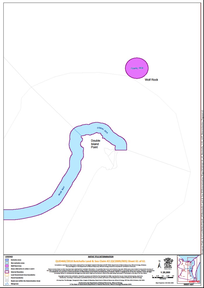
All the land and waters of Wolf Rock and the waters within a 300 metre buffer seaward of the High Water Mark of that rock.
Exclusions
The area excludes:
Lot 1 on AP23253;
Lot 1 on CP817467;
Lot 3 on RB96919;
all land and waters above the High Water Mark of Fraser Island;
all land and waters within the external boundaries subject to:
o native title determination QUD287/2009 – Butchulla People #2 as determined by the Federal Court on 24 October 2014; and
o native title determination application QUD20/2019 – Kabi Kabi First Nation as accepted for registration on 12 July 2019.
Note
Data reference and source
Application boundary compiled by Queensland South Native Title Services based in part on data sourced from the Commonwealth of Australia, NNTT (September 2019).
Cadastral data sourced from Department of Natural Resources, Mines and Energy, Qld (September 2019).
Location of Mount Bauple and Wolf Rock sourced from the Queensland Place Names Gazetteer (March 2019).
2 Metre Bathymetric Contour sourced from Maritime Safety, Department of Transport and Main Roads, Qld (June 2017).
Rivers, creeks and roads where possible based on cadastral data sourced from the Department of Natural Resources, Mines and Energy, Qld (September 2019).
Reference datum
Geographical coordinates are referenced to the Geocentric Datum of Australia 1994 (GDA94), in decimal degrees and are based on the spatial reference data acquired from the various custodians at the time.
Use of coordinates
Where coordinates are used within the description to represent cadastral or topographical boundaries or the intersection with such, they are intended as a guide only. As an outcome to the custodians of cadastral and topographic data continuously recalculating the geographic position of their data based on improved survey and data maintenance procedures, it is not possible to accurately define such a position other than by detailed ground survey.
Prepared by Queensland South Native Title Services (11 October 2019).
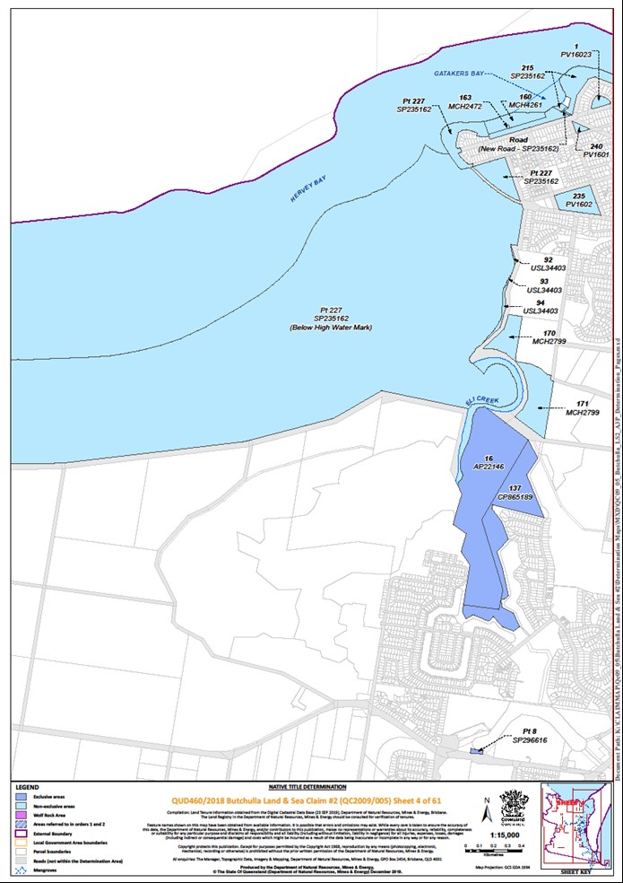
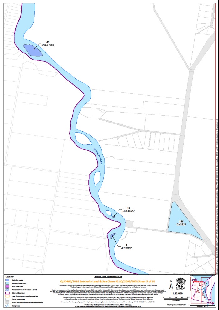
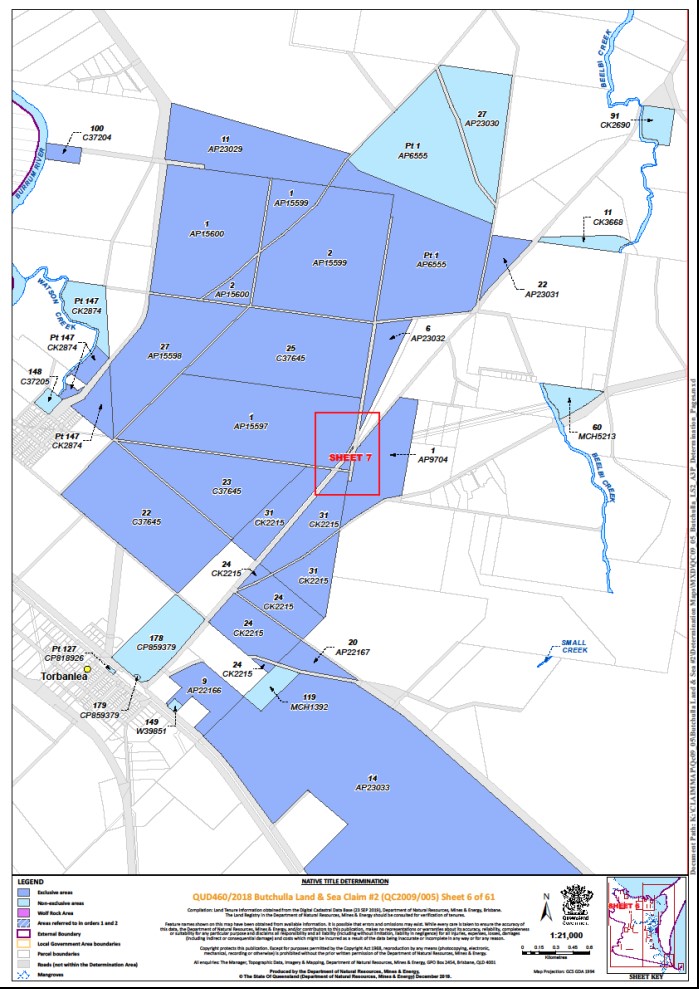
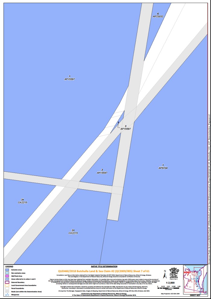
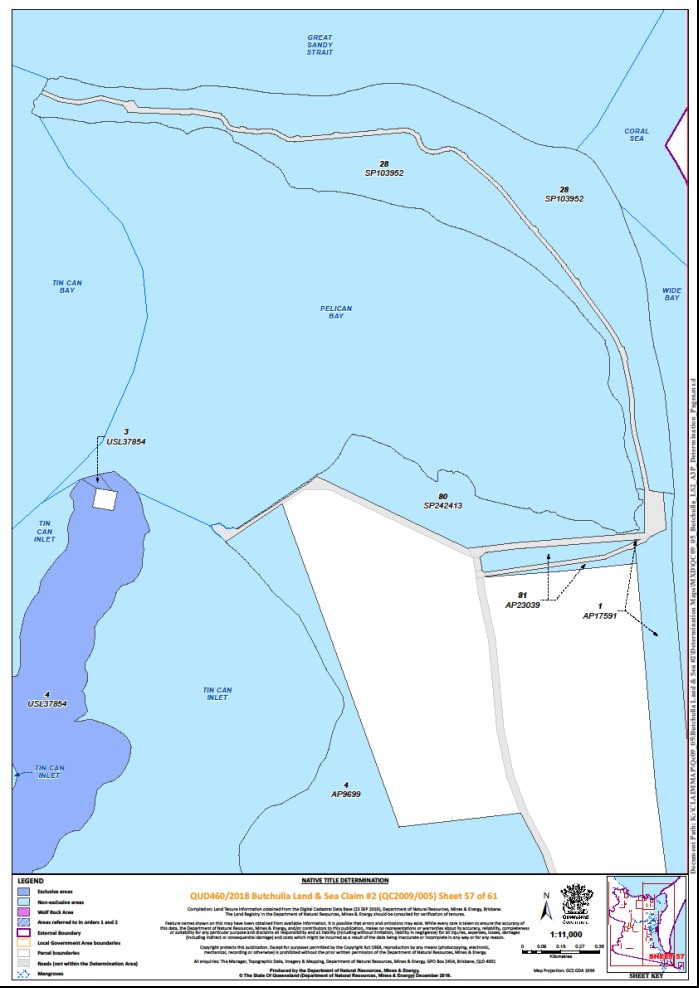
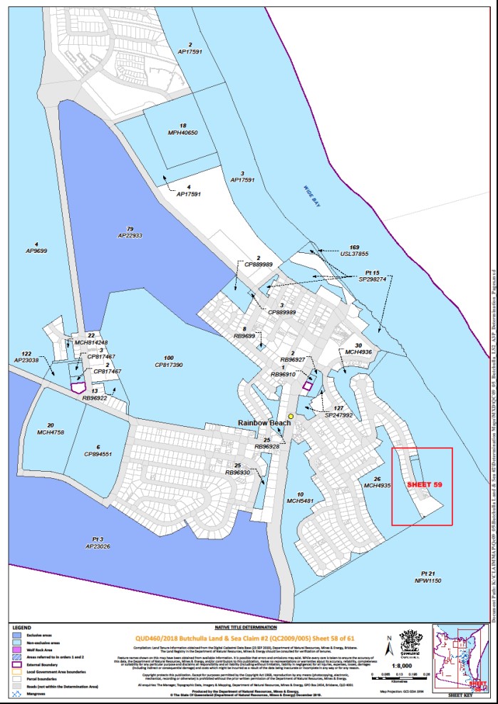
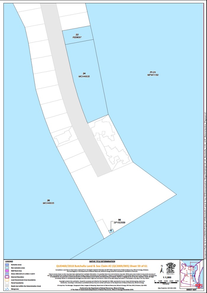
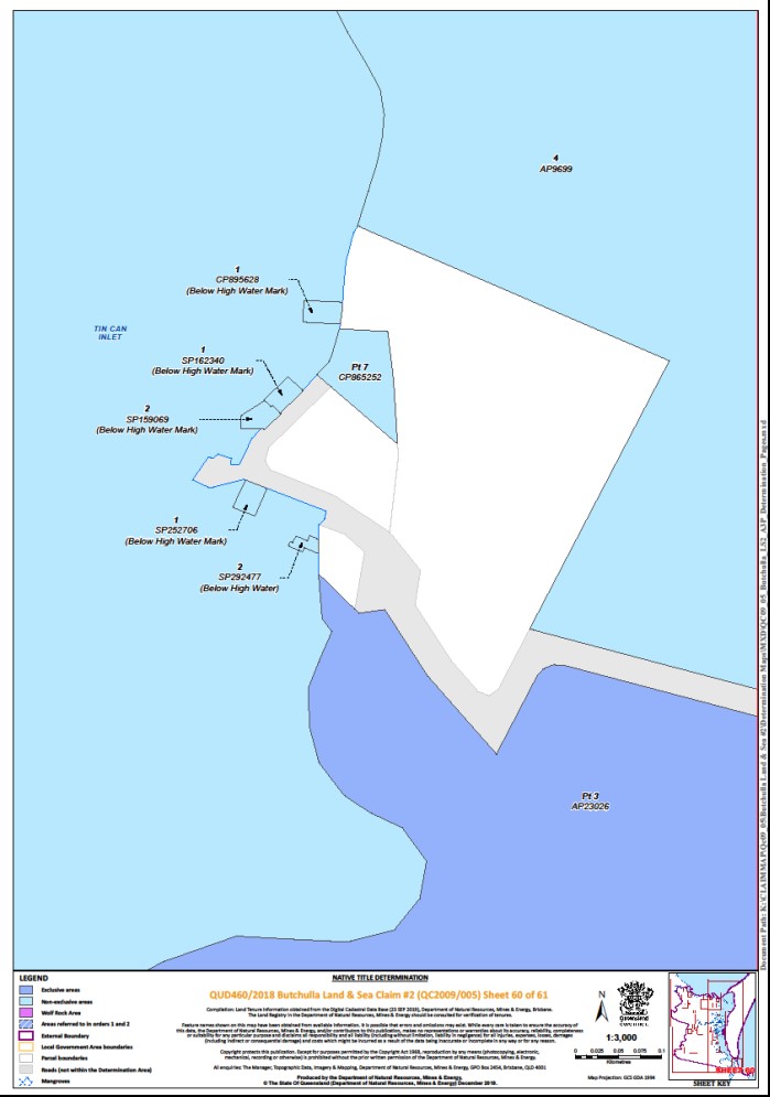
Schedule 4 – Description of Determination Area
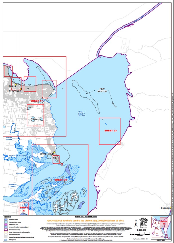
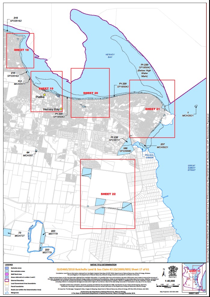
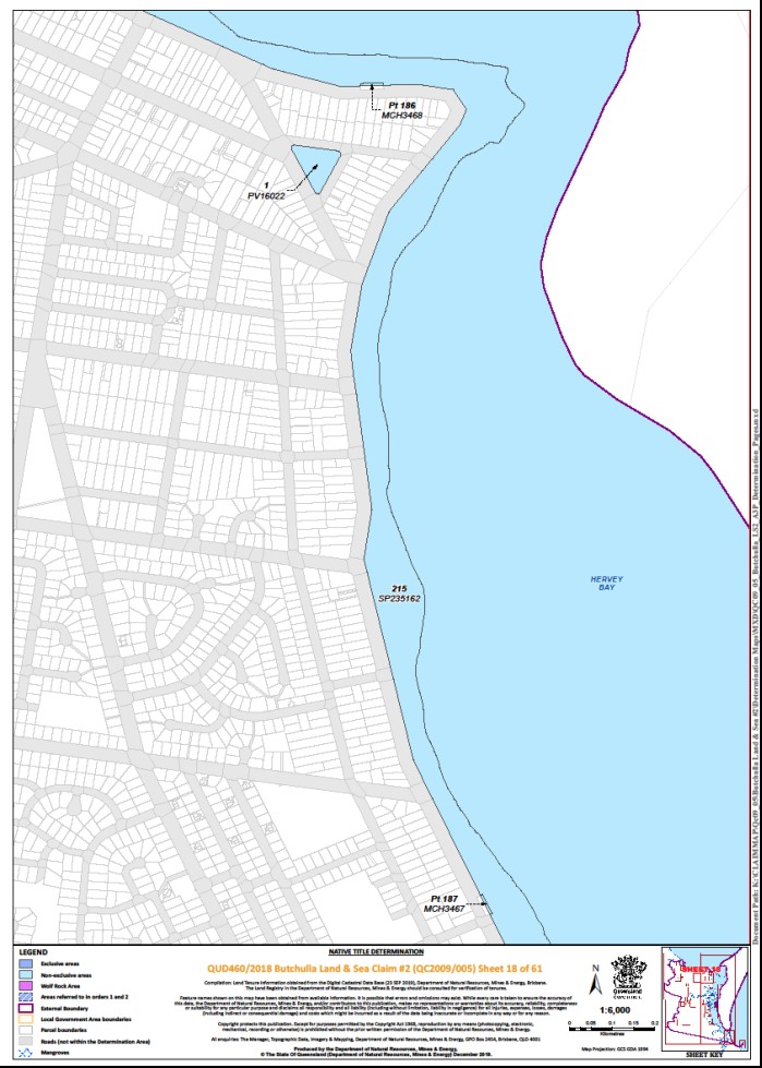
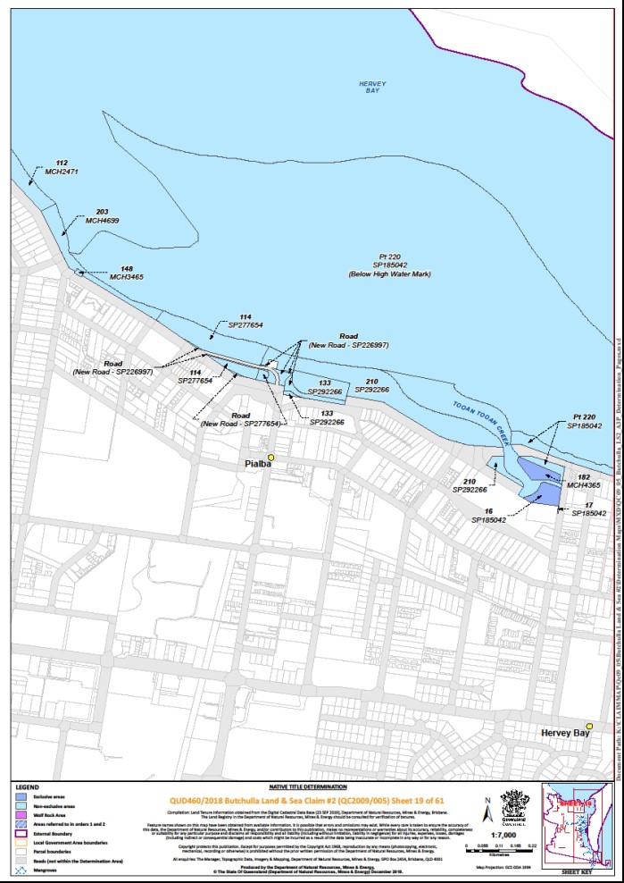
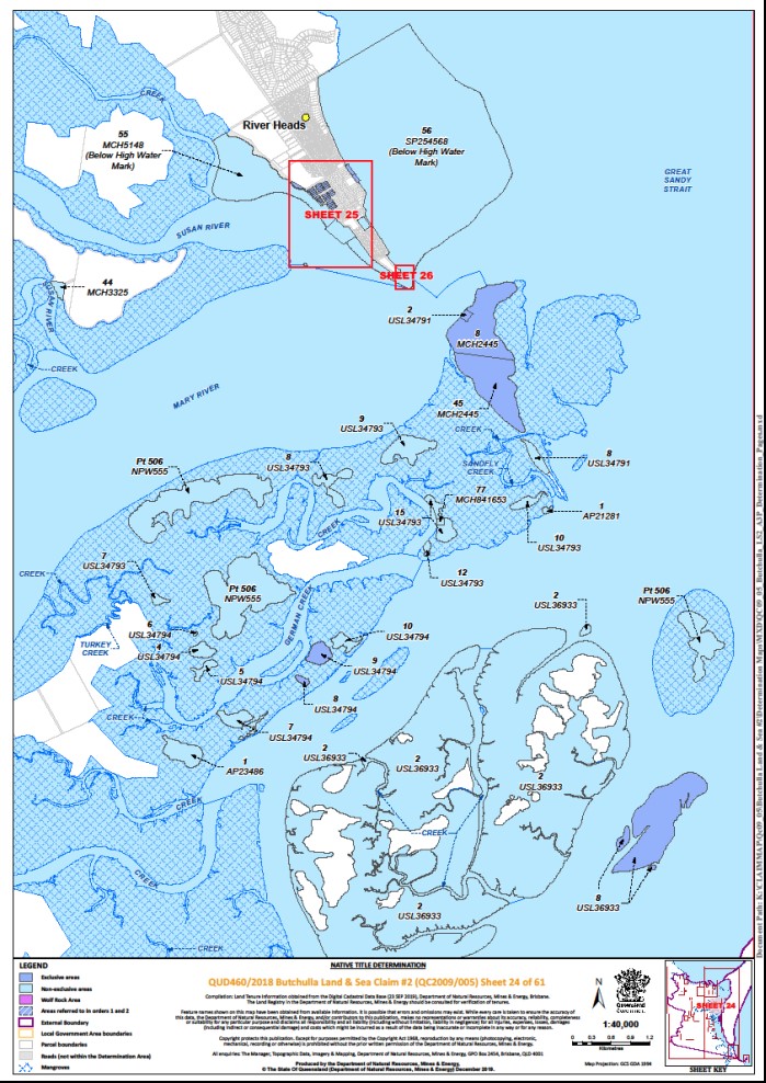
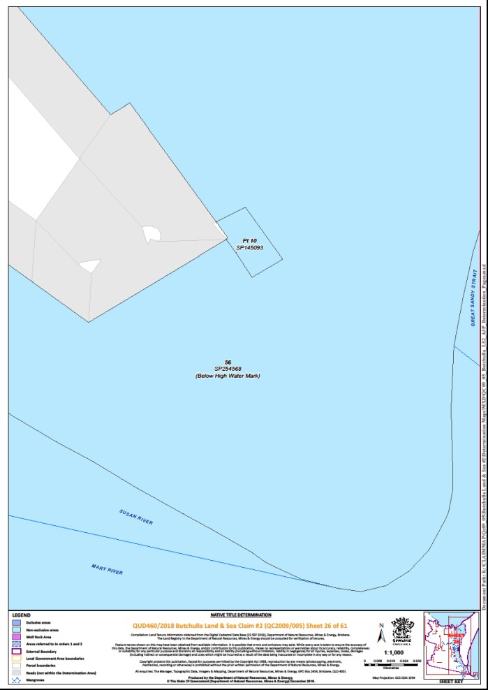
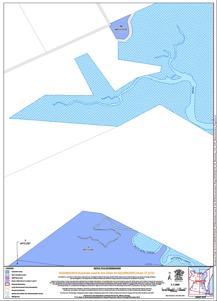
The Determination Area comprises all of the land and waters described in Parts 1, 2, 3 and 4 below, and depicted in the maps in Schedule 6, to the extent those areas are within the External Boundary and not otherwise excluded by the terms of Schedule 5.
Part 1 — Exclusive areas above the High Water Mark
All of the land and waters described in the following table and depicted in dark blue on the determination maps contained in Schedule 6:
Area description (at the time of the Determination) | Determination Maps Reference | Note | ||||||
Lot 1 on Plan AP15597 | Sheets 6, 7 | |||||||
Lot 1 on Plan AP15599 | Sheet 6 | |||||||
Lot 1 on Plan AP15600 | Sheet 6 | |||||||
Lot 1 on Plan AP15709 | Sheet 11 | |||||||
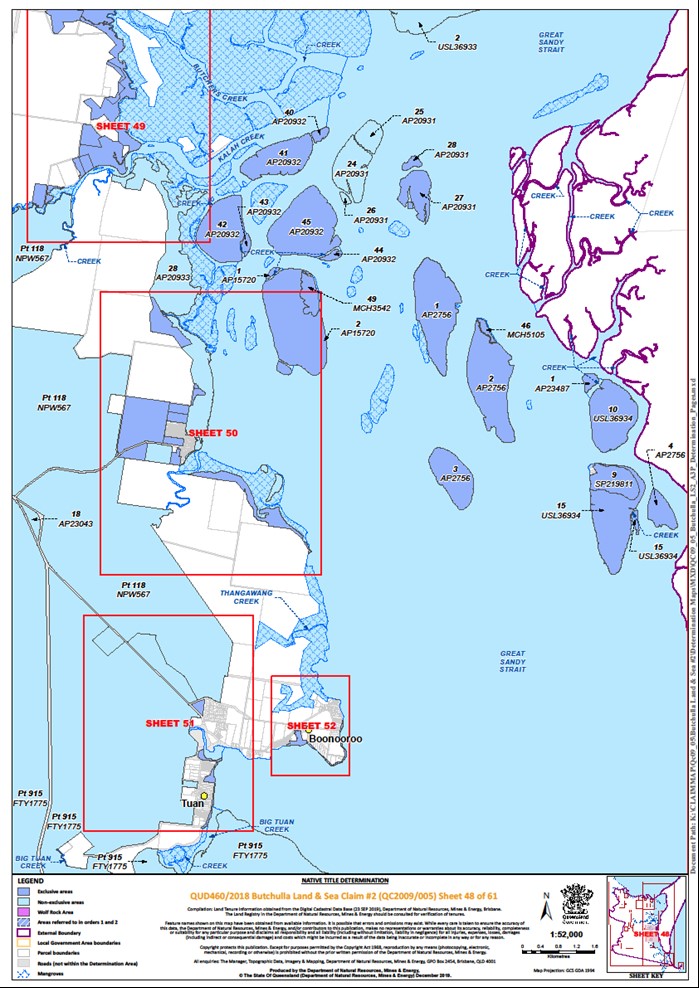
Lot 1 on Plan AP15720 | Sheet 48 | * | ||||||
Lot 1 on Plan AP20962 | Sheet 5 | |||||||
Lot 1 on Plan AP21283 (Ida Island) | Sheet 56 | |||||||
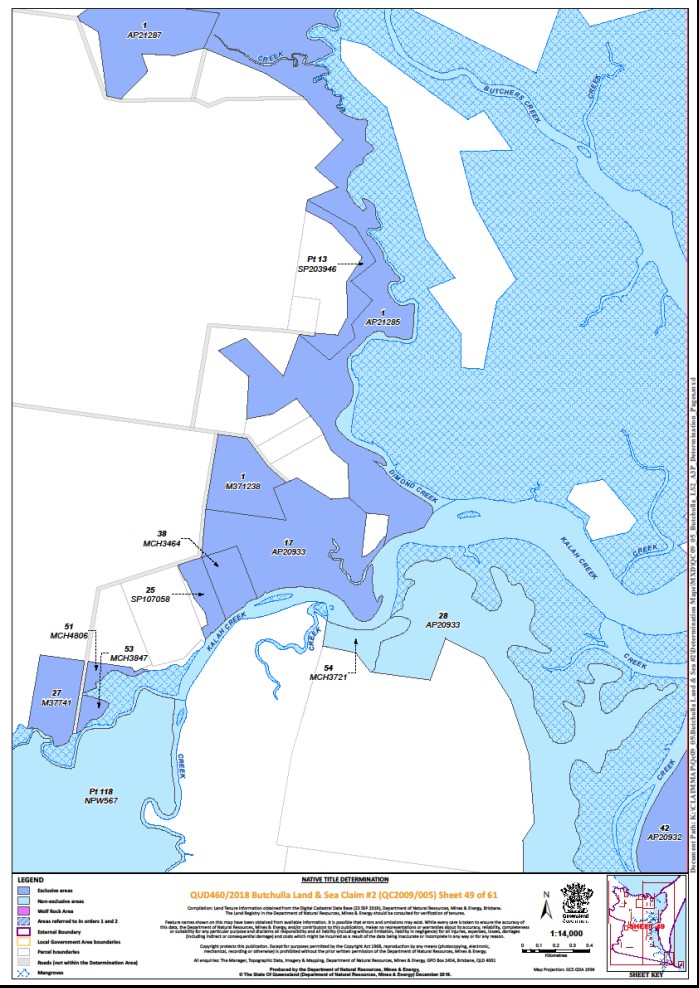
Lot 1 on Plan AP21285 | Sheets 27, 49 | |||||||
Lot 1 on Plan AP21287 | Sheets 27, 49 | |||||||
Lot 1 on Plan AP23033 | Sheets 1, 10 | |||||||
Lot 1 on Plan AP23487 | Sheet 48 | |||||||
Lot 1 on Plan AP2756 (on Moonboom Island) | Sheet 48 | |||||||
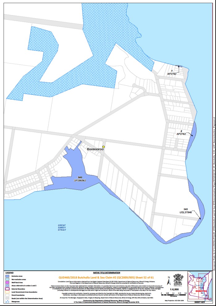
Lot 1 on Plan AP2762 | Sheet 52 | |||||||
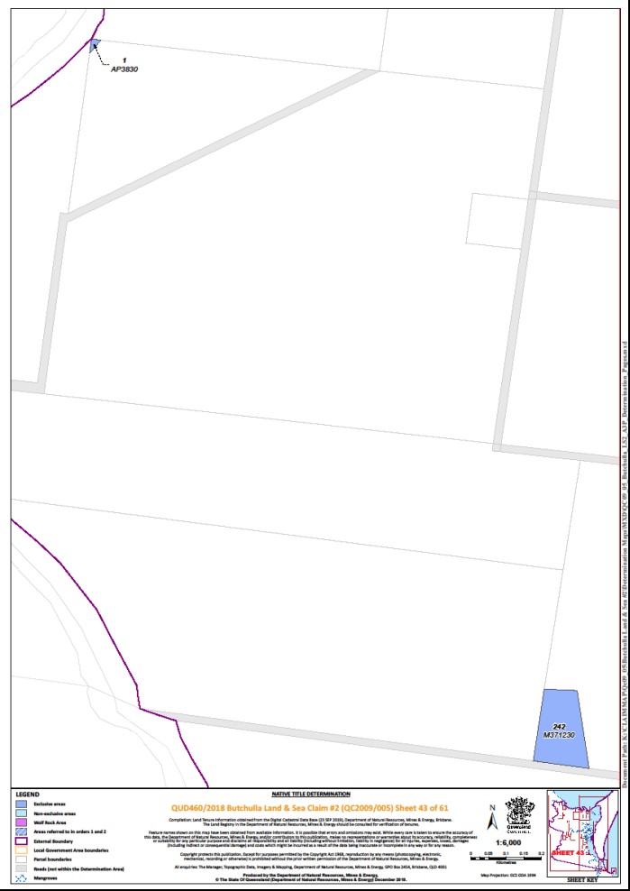
Lot 1 on Plan AP3830 | Sheet 43 | |||||||
Lot 1 on Plan AP6551 | Sheets 1, 10, 11 | |||||||
That part of Lot 1 on Plan AP6555 excluding former Lot 95 on Plan CK2047 | Sheet 6 | |||||||
Lot 1 on Plan AP9704 | Sheets 6, 7 | |||||||
Lot 1 on Plan CP884715 | Sheet 55 | + | ||||||
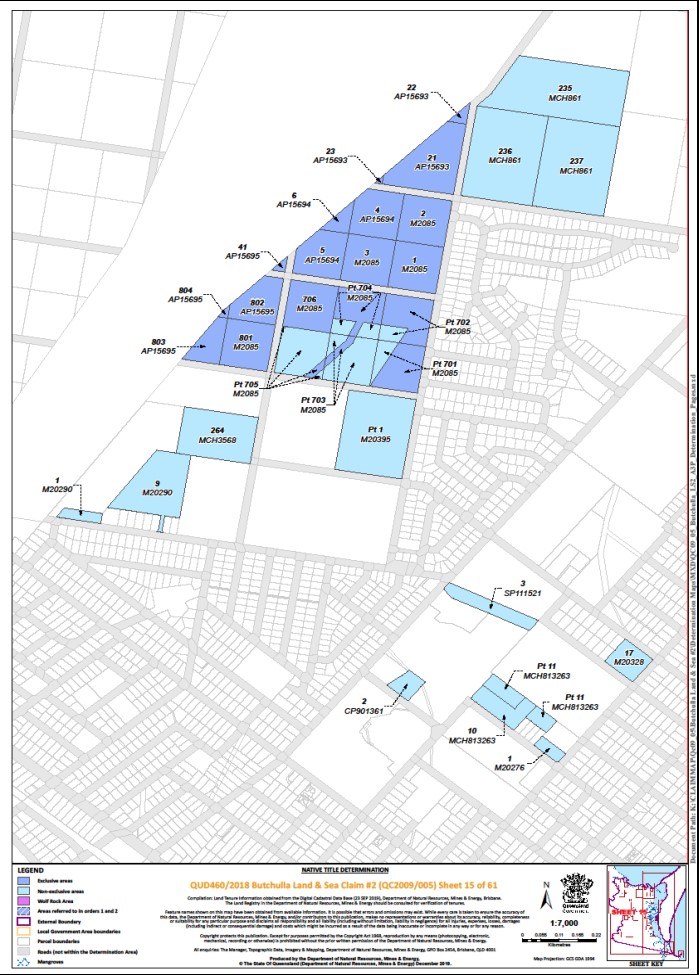
Lot 1 on Plan M2085 | Sheet 15 | |||||||
Lot 1 on Plan M371238 | Sheet 49 | * | ||||||
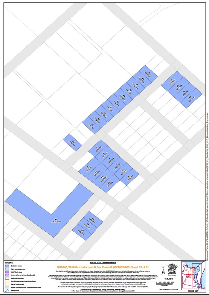
Lot 1 on Plan RP2264 | Sheet 33 | * | ||||||
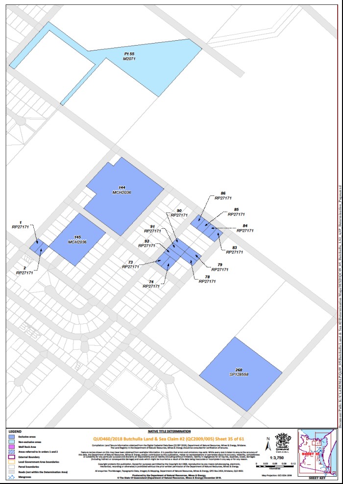
Lot 1 on Plan RP27171 | Sheet 35 | * | ||||||
Lot 2 on Plan AP15597 | Sheet 7 | |||||||
Lot 2 on Plan AP15599 | Sheet 6 | |||||||
Lot 2 on Plan AP15600 | Sheet 6 | |||||||
Lot 2 on Plan AP15709 | Sheet 11 | |||||||
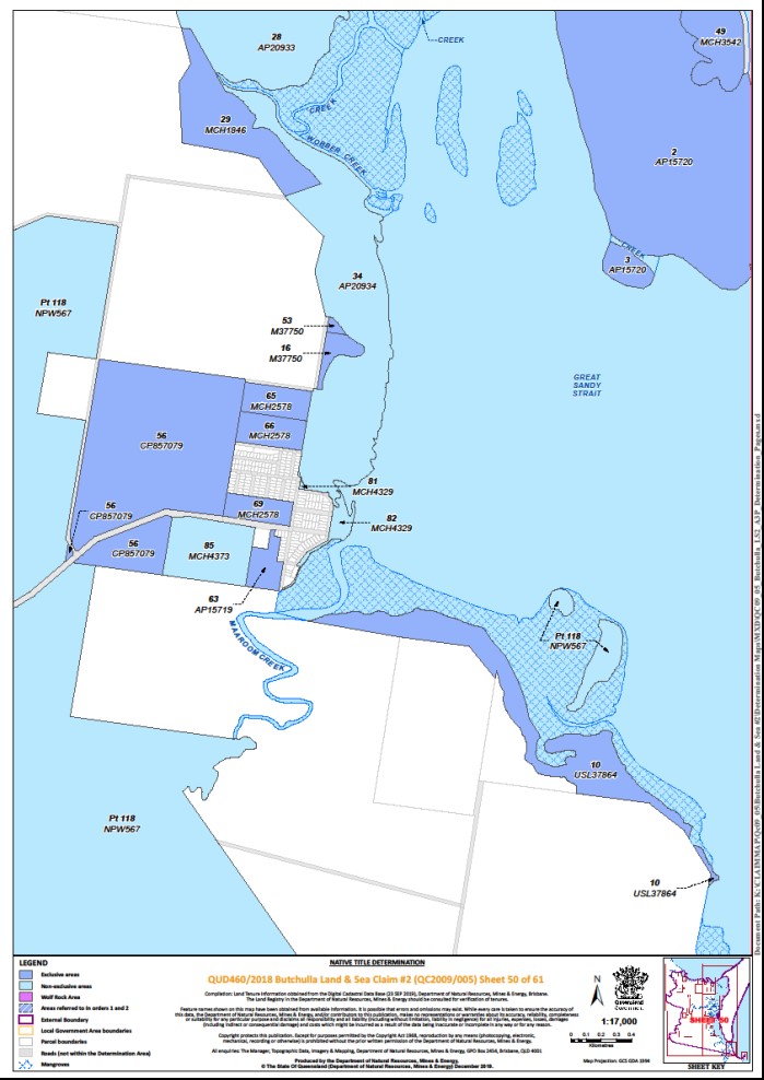
Lot 2 on Plan AP15720 (on Garden Island) | Sheets 48, 50 | * | ||||||
Lot 2 on Plan AP2756 (on Moonboom Island) | Sheet 48 | |||||||
Lot 2 on Plan AP2762 | Sheet 52 | |||||||
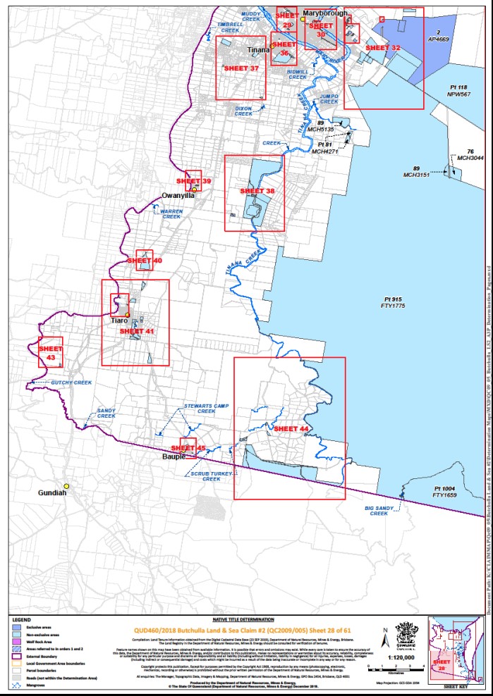
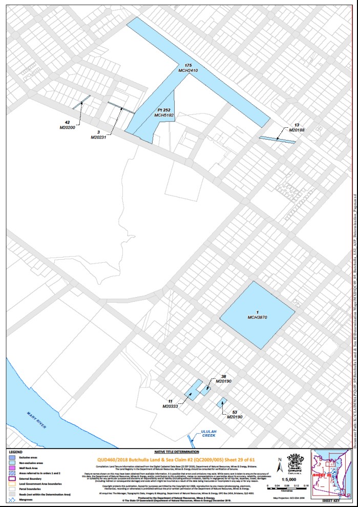
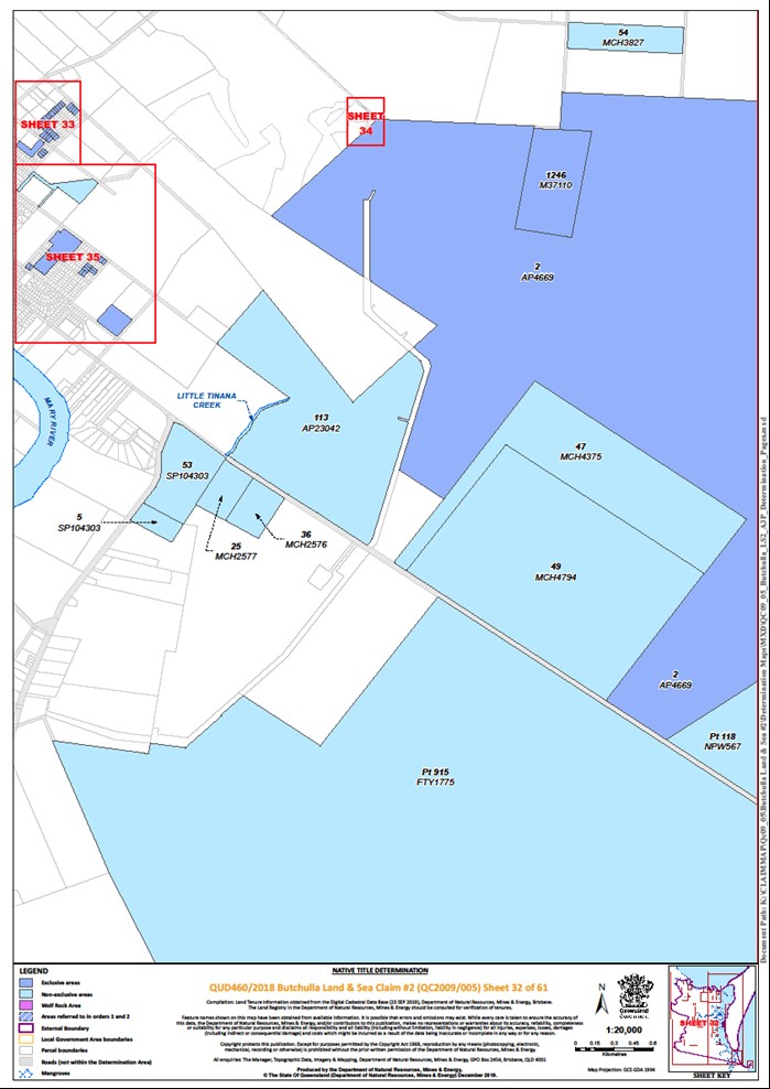
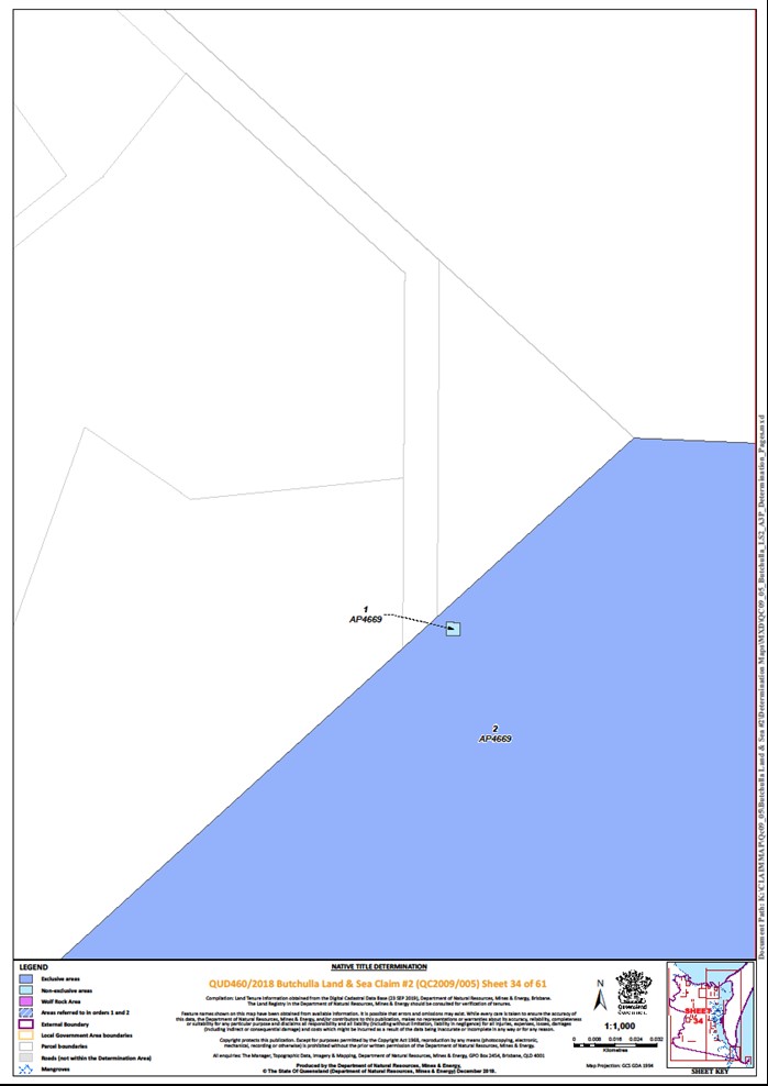
Lot 2 on Plan AP4669 | Sheets 28, 32, 34 | * | ||||||
Lot 2 on Plan AP6551 | Sheet 1 | ~ | ||||||
Lot 2 on Plan M2085 | Sheet 15 | |||||||
Lot 2 on Plan RP2264 | Sheet 33 | * | ||||||
Lot 2 on Plan RP27171 | Sheet 35 | * | ||||||
Lot 2 on Plan SP136268 | Sheet 41 | + | ||||||
Lot 2 on Plan USL34791 | Sheet 24 | * | ||||||
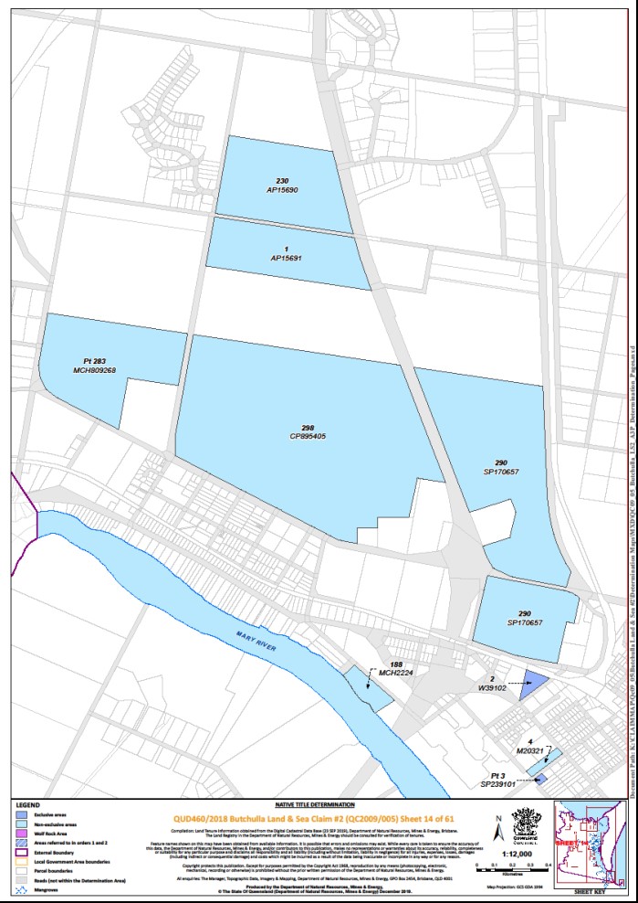
Lot 2 on Plan W39102 | Sheet 14 | |||||||
Lot 3 on Plan AP15597 | Sheet 7 | |||||||
Lot 3 on Plan AP15709 | Sheet 11 | |||||||
Lot 3 on Plan AP15720 | Sheet 50 | * | ||||||
Lot 3 on Plan AP23026 | Sheets 56, 58, 60 | * | ||||||
Lot 3 on Plan AP23037 | Sheet 11 | |||||||
Lot 3 on Plan AP2756 (on Moonboom Island) | Sheet 48 | |||||||
Lot 3 on Plan AP6551 | Sheet 1 | ~ | ||||||
Lot 3 on Plan M2085 | Sheet 15 | |||||||
Lot 3 on Plan RP2264 | Sheet 33 | * | ||||||
That part of Lot 3 on Plan SP239101 subject to former Allotment 1 of Section 9 on Plan M14096 | Sheet 14 | + | ||||||
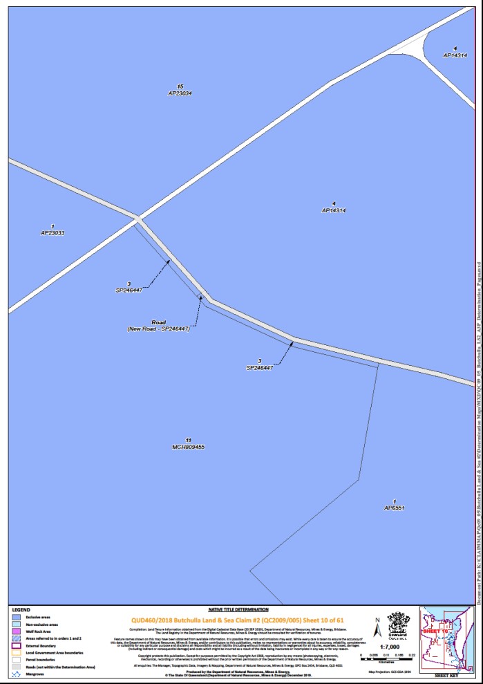
Lot 3 on Plan SP246447 | Sheet 10 | |||||||
Lot 3 on Plan USL37849 (Carlo Island) | Sheet 56 | |||||||
Lot 3 on Plan USL37854 (on Pannikin Island) | Sheet 57 | |||||||
Lot 4 on Plan AP14314 | Sheets 1, 10, 11 | |||||||
Lot 4 on Plan AP15694 | Sheet 15 | |||||||
Lot 4 on Plan AP2756 | Sheet 48 | |||||||
Lot 4 on Plan RP2264 | Sheet 33 | * | ||||||
Lot 4 on Plan USL37854 (on Pannikin Island) | Sheets 56, 57 | |||||||
Lot 5 on Plan AP15694 | Sheet 15 | |||||||
Lot 5 on Plan M20296 | Sheet 11 | |||||||
Lot 5 on Plan RP2264 | Sheet 33 | * | ||||||
Lot 5 on Plan USL37828 | Sheets 46, 55 | * | ||||||
Lot 6 on Plan AP15694 | Sheet 15 | |||||||
Lot 6 on Plan AP23032 | Sheets 6, 7 | |||||||
Lot 6 on Plan RP2264 | Sheet 33 | * | ||||||
Lot 7 on Plan AP22165 | Sheet 1 | |||||||
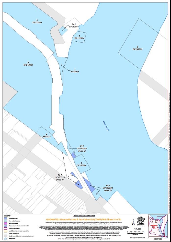
That part of Lot 7 on Plan SP185926 excluding: that part of Lot 7 on Plan SP185926 which is described in Part 2 of Schedule 4 of this Determination; • Lot 2 on Plan M20208; • Lot 3 on Plan M20330; • the former road shown as Road Opened on Plan RA1302; and • that part of former road (1877 New Street, access to Queen’s Wharf), described as:
| Sheet 31 | + | ||||||
Lot 8 on Plan MCH2445 | Sheet 24 | * | ||||||
That part of Lot 8 on Plan SP296616 excluding former Portion 10 on Plan M3751 | Sheet 4 | + | ||||||
Lot 8 on Plan USL34794 | Sheet 24 | |||||||
Lot 8 on Plan USL36933 (Bookar Island) | Sheet 24 | * | ||||||
Lot 9 on Plan AP22166 | Sheet 6 | |||||||
Lot 9 on Plan SP219811 (on Stuart Island) | Sheet 48 | * | ||||||
Lot 9 on Plan USL34794 | Sheet 24 | |||||||
Lot 10 on Plan RP2264 | Sheet 33 | * | ||||||
Lot 10 on Plan USL36934 (Dream Island) | Sheet 48 | |||||||
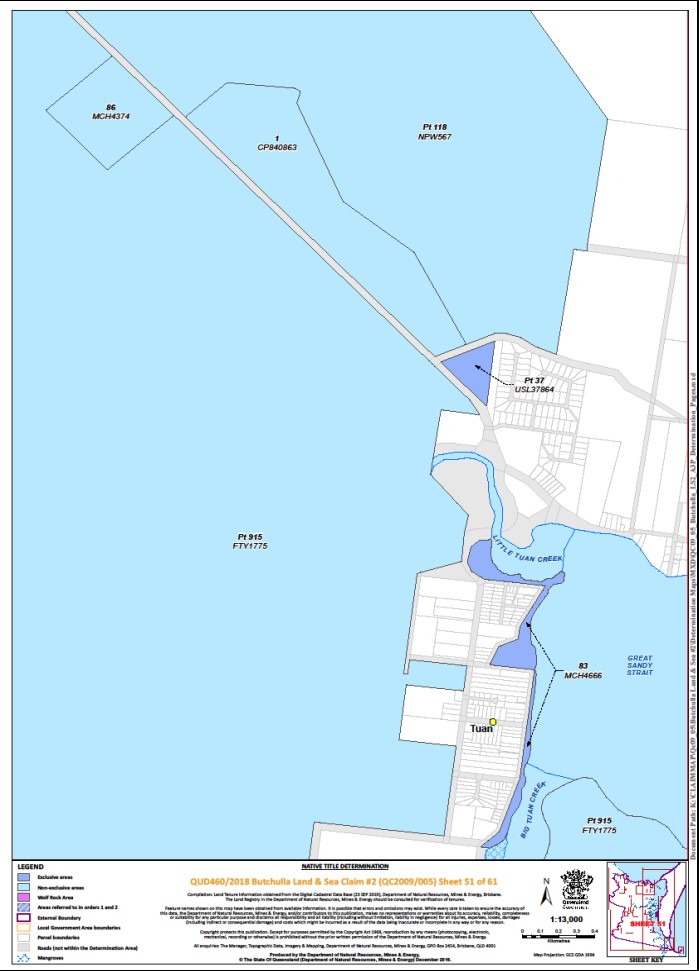
Lot 10 on Plan USL37864 | Sheet 50 | * | ||||||
Lot 11 on Plan AP23029 | Sheet 6 | |||||||
Lot 11 on Plan MCH809455 | Sheets 1, 10 | + | ||||||
Lot 11 on Plan RP2264 | Sheet 33 | * | ||||||
Lot 11 on Plan USL37828 | Sheets 46, 55 | * | ||||||
Lot 12 on Plan CK3709 | Sheet 2 | + | ||||||
Lot 12 on Plan RP2264 | Sheet 33 | * | ||||||
Lot 13 on Plan CK811107 | Sheet 2 | + | ||||||
Lot 13 on Plan RP2264 | Sheet 33 | * | ||||||
That part of Lot 13 on Plan SP203946 excluding former Lot A on Plan AP14510 | Sheet 49 | * | ||||||
Lot 14 on Plan AP23033 | Sheets 1, 6 | |||||||
Lot 15 on Plan AP23034 | Sheets 1, 10 | |||||||
Lot 15 on Plan AP23037 | Sheet 11 | |||||||
Lot 15 on Plan USL36934 | Sheet 48 | * | ||||||
Lot 16 on Plan AP22146 | Sheet 4 | |||||||
Lot 16 on Plan M37750 | Sheet 50 | * | ||||||
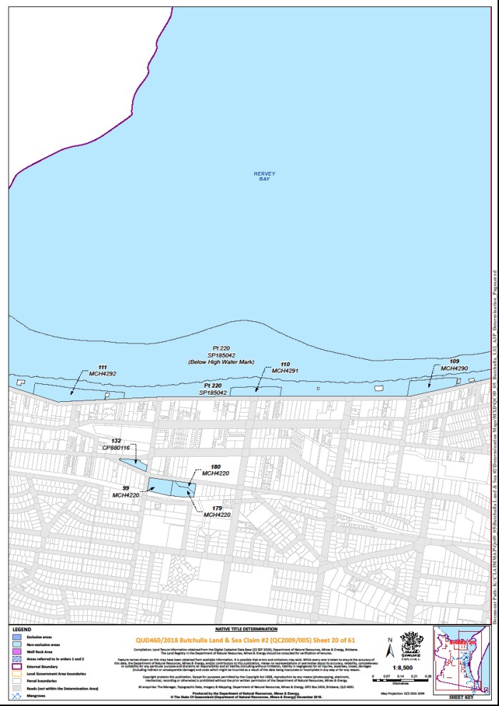
Lot 16 on Plan SP185042 | Sheet 19 | |||||||
Lot 16 on Plan USL34557 | Sheet 5 | |||||||
Lot 17 on Plan AP20933 | Sheet 49 | |||||||
Lot 17 on Plan SP185042 | Sheet 19 | |||||||
Lot 20 on Plan AP22167 | Sheet 6 | |||||||
Lot 21 on Plan AP15693 | Sheet 15 | |||||||
Lot 21 on Plan AP23035 | Sheet 1 | |||||||
Lot 21 on Plan B814 | Sheet 25 | * | ||||||
Lot 21 on Plan USL34857 | Sheet 11 | * | ||||||
Lot 22 on Plan AP15693 | Sheet 15 | |||||||
Lot 22 on Plan AP23031 | Sheet 6 | |||||||
Lot 22 on Plan B814 | Sheet 25 | * | ||||||
Lot 22 on Plan C37645 | Sheet 6 | |||||||
Lot 23 on Plan AP15693 | Sheet 15 | |||||||
Lot 23 on Plan AP23036 | Sheet 1 | |||||||
Lot 23 on Plan B814 | Sheet 25 | * | ||||||
Lot 23 on Plan C37645 | Sheet 6 | |||||||
Lot 24 on Plan B814 | Sheet 25 | * | ||||||
Lot 24 on Plan CK2215 | Sheet 6 | + | ||||||
Lot 25 on Plan B814 | Sheet 25 | * | ||||||
Lot 25 on Plan C37645 | Sheet 6 | |||||||
Lot 25 on Plan MCH4882 | Sheet 55 | + | ||||||
Lot 25 on Plan SP107058 | Sheet 49 | * | ||||||
Lot 26 on Plan B814 | Sheet 25 | * | ||||||
Lot 26 on Plan MCH5091 | Sheet 46 | * | ||||||
Lot 26 on Plan MCH5556 | Sheet 55 | + | ||||||
Lot 27 on Plan AP15598 | Sheet 6 | |||||||
Lot 27 on Plan AP20931 (on Tooth Island) | Sheet 48 | |||||||
Lot 27 on Plan B814 | Sheet 25 | * | ||||||
Lot 27 on Plan M37741 | Sheet 49 | * | ||||||
Lot 27 on Plan MCH5557 | Sheet 55 | + | ||||||
Lot 28 on Plan AP20931 (on Tooth Island) | Sheet 48 | |||||||
Lot 28 on Plan B814 | Sheet 25 | * | ||||||
Lot 29 on Plan B814 | Sheet 25 | * | ||||||
Lot 29 on Plan MCH1846 | Sheet 50 | * | ||||||
Lot 29 on Plan RP2264 | Sheet 33 | * | ||||||
Lot 30 on Plan B814 | Sheet 25 | * | ||||||
Lot 30 on Plan RP2264 | Sheet 33 | * | ||||||
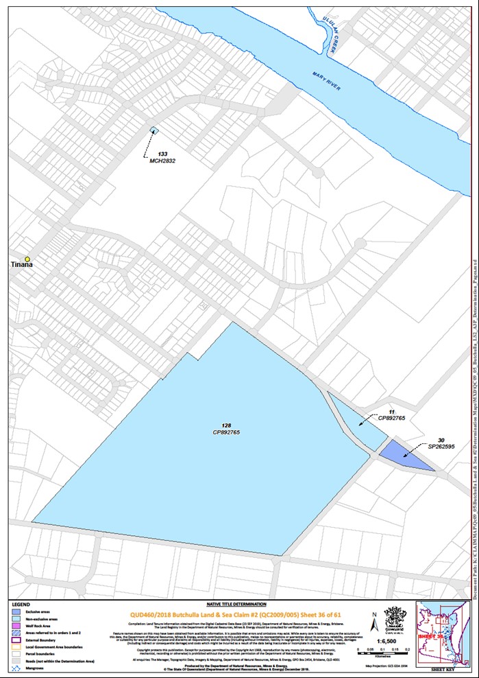
Lot 30 on Plan SP262595 | Sheet 36 | |||||||
Lot 31 on Plan CK2215 | Sheets 6, 7 | |||||||
Lot 31 on Plan RP2264 | Sheet 33 | * | ||||||
Lot 32 on Plan B814 | Sheet 25 | * | ||||||
Lot 32 on Plan RP2264 | Sheet 33 | * | ||||||
Lot 33 on Plan B814 | Sheet 25 | * | ||||||
Lot 34 on Plan B814 | Sheet 25 | * | ||||||
Lot 36 on Plan B814 | Sheet 25 | * | ||||||
Lot 37 on Plan B814 | Sheet 25 | * | ||||||
That part of Lot 37 on Plan USL37864 excluding former road adjoining the western boundary of Portion 15v as shown on Plan M371123 | Sheet 51 | * | ||||||
Lot 38 on Plan B814 | Sheet 25 | * | ||||||
Lot 38 on Plan MCH2447 | Sheet 25 | * | ||||||
Lot 38 on Plan MCH3464 | Sheet 49 | * | ||||||
Lot 39 on Plan B814 | Sheet 25 | * | ||||||
Lot 39 on MCH2447 | Sheet 25 | * | ||||||
Lot 39 on Plan MCH2534 | Sheet 27 | * | ||||||
Lot 40 on Plan AP20932 (on Thomas Island) | Sheet 48 | * | ||||||
Lot 40 on Plan MCH2600 | Sheet 25 | * | ||||||
Lot 41 on Plan AP15695 | Sheet 15 | |||||||
Lot 41 on Plan AP20932 (on Thomas Island) | Sheet 48 | * | ||||||
Lot 41 on Plan MCH3459 | Sheet 33 | * | ||||||
Lot 42 on Plan AP20932 (on New Island) | Sheets 48, 49 | * | ||||||
Lot 43 on Plan AP20932 (on New Island) | Sheet 48 | * | ||||||
Lot 44 on Plan AP20932 (on Round Bush Island) | Sheet 48 | * | ||||||
Lot 45 on Plan AP20932 (on Round Bush Island) | Sheet 48 | * | ||||||
Lot 45 on Plan MCH2445 | Sheet 24 | * | ||||||
Lot 45 on Plan RP2264 | Sheet 33 | * | ||||||
Lot 45 on Plan USL34559 (Mangrove Island) | Sheet 5 | |||||||
Lot 46 on Plan MCH5105 (on Moonboom Island) | Sheet 48 | * | ||||||
Lot 46 on Plan RP2264 | Sheet 33 | * | ||||||
Lot 47 on Plan RP2264 | Sheet 33 | * | ||||||
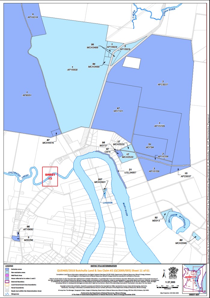
Lot 47 on Plan W37101 | Sheet 11 | |||||||
Lot 48 on Plan RP2264 | Sheet 33 | * | ||||||
That part of Lot 49 on Plan AP17243 excluding Lot A on Plan AP22202 | Sheet 2 | * | ||||||
Lot 49 on Plan MCH3542 (on Garden Island) | Sheets 48, 50 | * | ||||||
Lot 49 on Plan RP2264 | Sheet 33 | * | ||||||
Lot 50 on Plan RP2264 | Sheet 33 | * | ||||||
Lot 51 on Plan MCH4806 | Sheet 49 | * | ||||||
Lot 51 on Plan RP2264 | Sheet 33 | * | ||||||
Lot 51 on Plan W3784 | Sheet 11 | |||||||
Lot 52 on Plan RP2264 | Sheet 33 | * | ||||||
Lot 53 on Plan M37750 | Sheet 50 | * | ||||||
Lot 53 on Plan MCH3847 | Sheet 49 | * | ||||||
Lot 53 on Plan RP2264 | Sheet 33 | * | ||||||
Lot 54 on Plan RP2264 | Sheet 33 | * | ||||||
Lot 56 on Plan CP857079 | Sheet 50 | * | ||||||
Lot 57 on Plan CK970 | Sheet 1 | |||||||
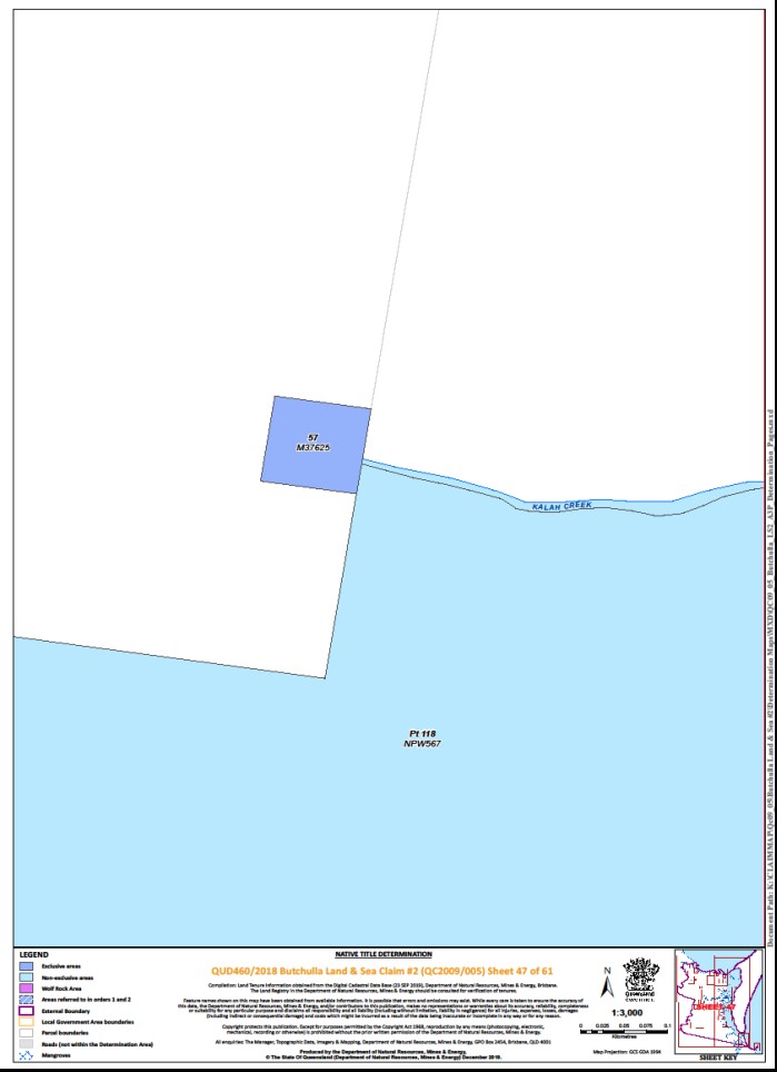
Lot 57 on Plan M37625 | Sheet 47 | |||||||
Lot 57 on Plan RP2264 | Sheet 33 | * | ||||||
Lot 63 on Plan AP15719 | Sheet 50 | * | ||||||
Lot 65 on Plan MCH2578 | Sheet 50 | * | ||||||
Lot 66 on Plan AP15692 | Sheet 11 | |||||||
Lot 66 on Plan MCH2578 | Sheet 50 | * | ||||||
Lot 69 on Plan MCH2578 | Sheet 50 | * | ||||||
Lot 72 on Plan B814 | Sheet 25 | * | ||||||
Lot 73 on Plan B814 | Sheet 25 | * | ||||||
Lot 73 on Plan RP27171 | Sheet 35 | * | ||||||
Lot 74 on Plan B814 | Sheet 25 | * | ||||||
Lot 74 on Plan RP27171 | Sheet 35 | * | ||||||
Lot 75 on Plan B814 | Sheet 25 | * | ||||||
Lot 76 on Plan B814 | Sheet 25 | * | ||||||
Lot 77 on Plan B814 | Sheet 25 | * | ||||||
Lot 78 on Plan B814 | Sheet 25 | * | ||||||
Lot 78 on Plan RP27171 | Sheet 35 | * | ||||||
Lot 79 on Plan AP22933 | Sheet 58 | * | ||||||
Lot 79 on Plan B814 | Sheet 25 | * | ||||||
Lot 79 on Plan RP27171 | Sheet 35 | * | ||||||
Lot 80 on Plan B814 | Sheet 25 | * | ||||||
Lot 81 on Plan B814 | Sheet 25 | * | ||||||
Lot 82 on Plan B814 | Sheet 25 | * | ||||||
That part of Lot 82 on Plan MCH4873 excluding an area defined as a reserve for ballast for railway purposes in Government Gazette of April 1897, here further described as:
| Sheet 1 | + | ||||||
Lot 83 on Plan B814 | Sheet 25 | * | ||||||
Lot 83 on Plan MCH4666 | Sheet 51 | + | ||||||
Lot 83 on Plan RP27171 | Sheet 35 | * | ||||||
Lot 84 on Plan B814 | Sheet 25 | * | ||||||
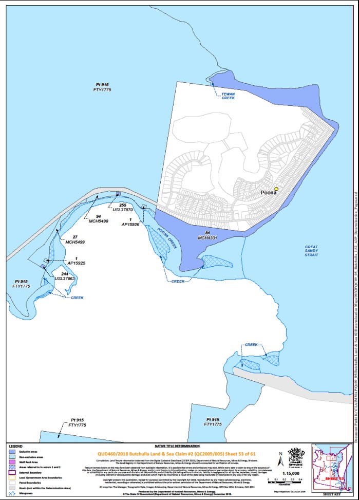
Lot 84 on Plan MCH4331 | Sheet 53 | + | ||||||
Lot 84 on Plan RP27171 | Sheet 35 | * | ||||||
Lot 85 on Plan B814 | Sheet 25 | * | ||||||
Lot 85 on Plan RP27171 | Sheet 35 | * | ||||||
Lot 86 on Plan RP27171 | Sheet 35 | * | ||||||
Lot 87 on Plan MCH4576 | Sheet 11 | * | ||||||
Lot 90 on Plan RP27171 | Sheet 35 | * | ||||||
Lot 91 on Plan RP27171 | Sheet 35 | * | ||||||
Lot 92 on Plan RP27171 | Sheet 35 | * | ||||||
Lot 95 on Plan RP2263 | Sheet 33 | * | ||||||
Lot 96 on Plan RP2263 | Sheet 33 | * | ||||||
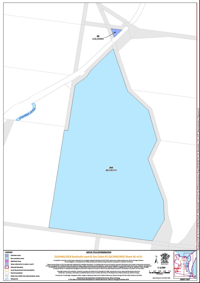
Lot 96 on Plan USL43444 | Sheet 40 | |||||||
Lot 97 on Plan C875 | Sheet 11 | * | ||||||
Lot 97 on Plan RP2263 | Sheet 33 | * | ||||||
Lot 98 on Plan W3727 | Sheet 11 | |||||||
Lot 100 on Plan C37204 | Sheet 6 | |||||||
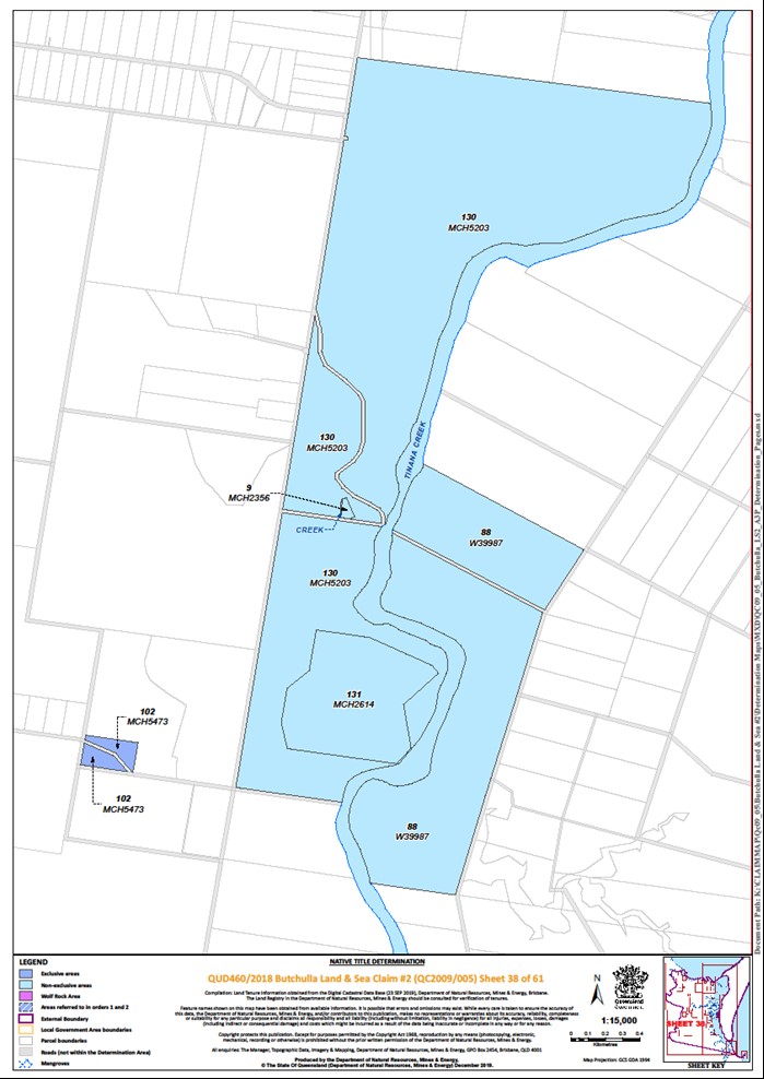
Lot 102 on Plan MCH5473 | Sheet 38 | + | ||||||
Lot 121 on Plan AP23041 | Sheet 2 | |||||||
Lot 122 on Plan AP23041 | Sheet 2 | |||||||
Lot 123 on Plan AP23041 | Sheet 2 | |||||||
Lot 129 on Plan CK3588 | Sheet 2 | + | ||||||
Lot 137 on Plan CK2769 | Sheet 1 | + | ||||||
Lot 137 on Plan CP865189 | Sheet 4 | * | ||||||
Lot 141 on Plan USL37846 | Sheet 52 | |||||||
Lot 144 on Plan MCH2036 | Sheet 35 | * | ||||||
Lot 145 on Plan MCH2036 | Sheet 35 | * | ||||||
That part of Lot 147 on Plan CK2874 excluding former Lot 87 on Plan CK1524 and OL 405, further described as:
| Sheet 6 | + | ||||||
Lot 155 on Plan CK3588 | Sheet 2 | + | ||||||
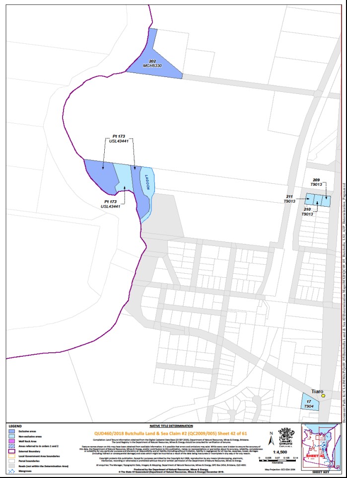
That part of Lot 173 on Plan USL43441 excluding an unnamed watercourse further described as:
| Sheet 42 | |||||||
Lot 182 on Plan MCH4365 | Sheet 19 | + | ||||||
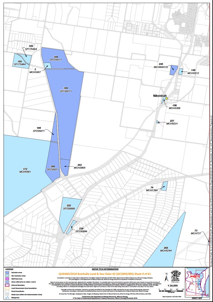
Lot 199 on Plan SP235071 | Sheet 9 | + | ||||||
Lot 202 on Plan MCH5330 | Sheet 42 | + | ||||||
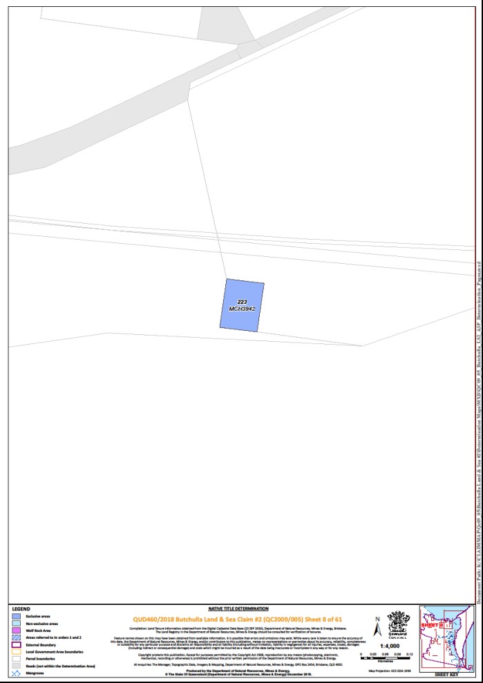
Lot 223 on Plan MCH3942 | Sheet 8 | + | ||||||
Lot 242 on Plan M371230 | Sheet 43 | |||||||
Lot 243 on Plan MCH3905 | Sheet 9 | + | ||||||
Lot 244 on Plan USL37863 | Sheet 53 | * | ||||||
Lot 245 on Plan MCH840122 | Sheet 9 | * | ||||||
Lot 255 on Plan USL37870 | Sheet 53 | * | ||||||
Lot 268 on Plan SP128558 | Sheet 35 | * | ||||||
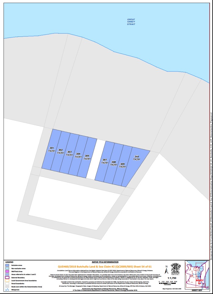
Lot 301 on Plan T4291 | Sheet 54 | * | ||||||
Lot 302 on Plan T4291 | Sheet 54 | * | ||||||
Lot 303 on Plan T4291 | Sheet 54 | * | ||||||
Lot 304 on Plan T4291 | Sheet 54 | * | ||||||
Lot 305 on Plan T4291 | Sheet 54 | * | ||||||
Lot 307 on Plan T4291 | Sheet 54 | * | ||||||
Lot 308 on Plan T4291 | Sheet 54 | * | ||||||
Lot 309 on Plan T4291 | Sheet 54 | * | ||||||
Lot 310 on Plan T4291 | Sheet 54 | * | ||||||
Lot 500 on Plan SP286562 | Sheet 52 | * | ||||||
That part of Lot 506 on Plan NPW555 excluding former: • Portions 30 and 31 on Plan M2209; • Lots 32 and 33 on Plan CP864837; • Portion 4 on Plan MCH2409; • Portion 24 on Plan MCH2949; • Portion 12 on MCH3155; and • Portion 6 on Plan MCH3129 | Sheets 46 | |||||||
That part of Lot 701 on Plan M2085 excluding Lot 1 on PER4843 | Sheet 15 | |||||||
That part of Lot 702 on Plan M2085 excluding Lot 1 on PER4843 | Sheet 15 | |||||||
That part of Lot 703 on Plan M2085 excluding: • Lot 1 on PER4843 and; • former Lot 1 on PER4671 | Sheet 15 | |||||||
That part of Lot 704 on Plan M2085 excluding: • Lot 1 on PER4843; and • former Lot 1 on PER4671 | Sheet 15 | |||||||
That part of Lot 705 on Plan M2085 excluding: • Lot 1 on PER4843; and • former Lot 1 on PER4671 | Sheet 15 | |||||||
Lot 706 on Plan M2085 | Sheet 15 | |||||||
Lot 801 on Plan M2085 | Sheet 15 | |||||||
Lot 802 on Plan AP15695 | Sheet 15 | |||||||
Lot 803 on Plan AP15695 | Sheet 15 | |||||||
Lot 804 on Plan AP15695 | Sheet 15 | |||||||
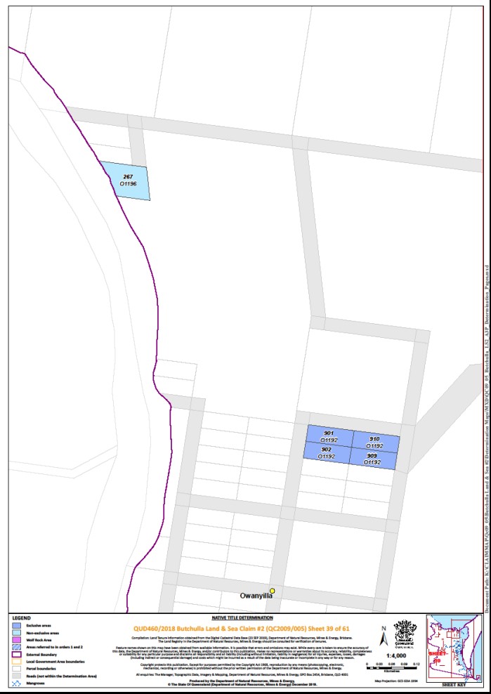
Lot 901 on Plan O1192 | Sheet 39 | |||||||
Lot 902 on Plan O1192 | Sheet 39 | |||||||
Lot 909 on Plan O1192 | Sheet 39 | |||||||
Lot 910 on Plan O1192 | Sheet 39 | |||||||
Lot 1246 on Plan M37110 | Sheet 32 | * | ||||||
An area of road identified as New Road on Plan SP246447 | Sheet 10 | + ^ |
* denotes areas to which s 47B of the Native Title Act 1993 (Cth) applies
^ denotes areas to which s 24KA of the Native Title Act 1993 (Cth) applies
+ denotes areas to which the non-extinguishment principle applies
~ denotes areas referred to in paragraphs 1 and 2
Part 2 — Non-exclusive areas above the High Water Mark, save the Wolf Rock Area
All of the land and waters described in the following table and depicted in light blue on the determination maps contained in Schedule 6:
Area description (at the time of the Determination) | Determination Maps Reference | Note | ||||||||||
Lot 1 on Plan AP14626 | Sheet 1 | |||||||||||
Lot 1 on Plan AP15691 | Sheet 14 | |||||||||||
Lot 1 on Plan AP15924 | Sheet 31 | |||||||||||
Lot 1 on Plan AP15925 | Sheet 53 | |||||||||||
Lot 1 on Plan AP15926 | Sheet 53 | |||||||||||
Lot 1 on Plan AP15928 | Sheet 11 | |||||||||||
Lot 1 on Plan AP15930 | Sheet 11 | |||||||||||
Lot 1 on Plan AP15938 | Sheet 56 | |||||||||||
Lot 1 on Plan AP17591 | Sheets 56, 57 | |||||||||||
Lot 1 on Plan AP21281 | Sheet 24 | |||||||||||
Lot 1 on Plan AP23486 | Sheet 24 | |||||||||||
Lot 1 on Plan AP4669 | Sheet 34 | |||||||||||
That part of Lot 1 on Plan AP6555 subject to former Lot 95 on Plan CK2047 | Sheet 6 | |||||||||||
Lot 1 on Plan BH9971 | Sheet 2 | |||||||||||
Lot 1 on Plan CP840863 | Sheet 51 | |||||||||||
Lot 1 on Plan M20276 | Sheet 15 | |||||||||||
Lot 1 on Plan M20290 | Sheet 15 | |||||||||||
That part of Lot 1 on Plan M20395 subject to Allotment 1 of Section 246 on Plan M20390 | Sheet 15 | |||||||||||
Lot 1 on Plan MCH2821 | Sheet 17 | |||||||||||
Lot 1 on Plan MCH3870 | Sheet 29 | |||||||||||
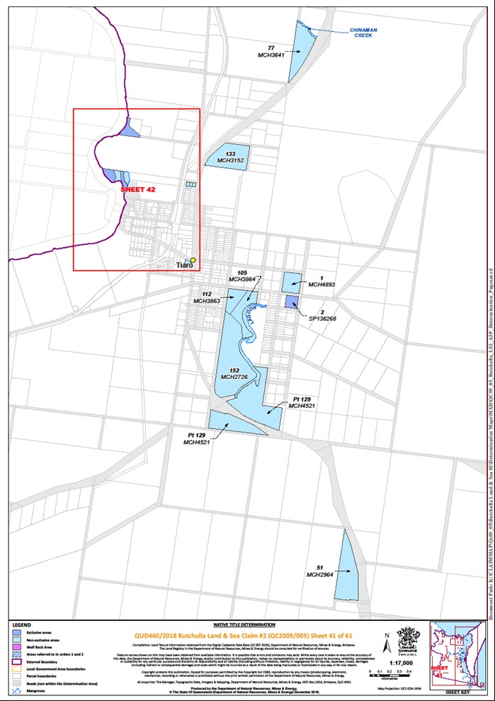
Lot 1 on Plan MCH4893 | Sheet 41 | |||||||||||
Lot 1 on Plan MCH802716 | Sheet 55 | |||||||||||
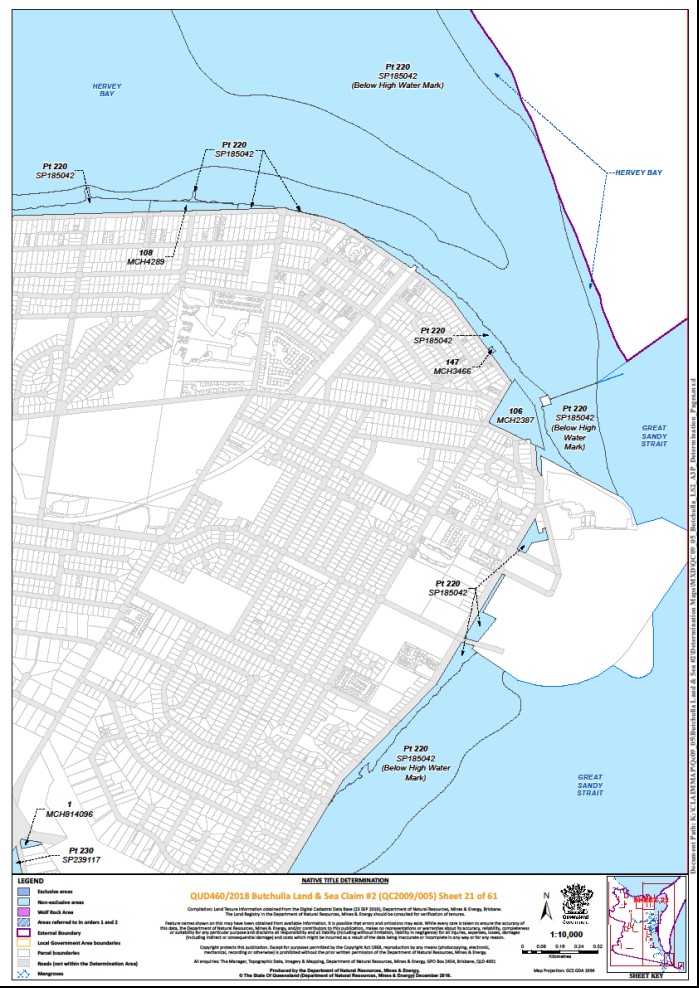
Lot 1 on Plan MCH814096 | Sheet 21 | |||||||||||
Lot 1 on Plan PV16022 | Sheet 18 | |||||||||||
Lot 1 on Plan PV16023 | Sheet 4 | |||||||||||
Lot 1 on Plan RB96910 | Sheet 58 | |||||||||||
Lot 1 on Plan SP132950 | Sheet 30 | |||||||||||
Lot 1 on Plan SP135765 | Sheet 56 | |||||||||||
Lot 1 on Plan SP211773 | Sheet 30 | |||||||||||
Lot 1 on Plan SP246783 | Sheet 30 | |||||||||||
That part of Lot 2 on Plan AP14626 excluding former Selection 982 on Plan L371477 | Sheet 1 | |||||||||||
Lot 2 on Plan AP15928 | Sheet 11 | |||||||||||
Lot 2 on Plan AP17591 | Sheets 56, 58 | |||||||||||
Lot 2 on Plan CP817467 | Sheet 58 | |||||||||||
Lot 2 on Plan CP889989 | Sheet 58 | |||||||||||
Lot 2 on Plan CP901361 | Sheet 15 | |||||||||||
Lot 2 on Plan M20285 | Sheet 30 | |||||||||||
Lot 2 on Plan MCH3457 | Sheet 9 | |||||||||||
Lot 2 on Plan RB96927 | Sheet 58 | |||||||||||
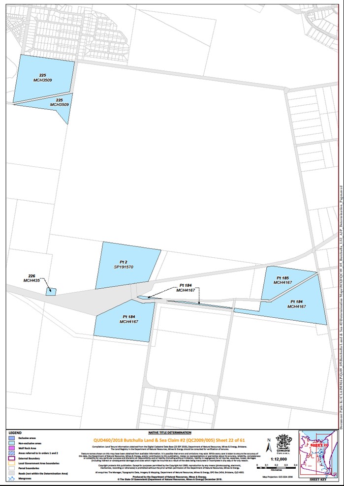
That part of Lot 2 on Plan SP191570 excluding former road delineated by stations 3-4-5-6-3 on Plan SP191570 | Sheet 22 | |||||||||||
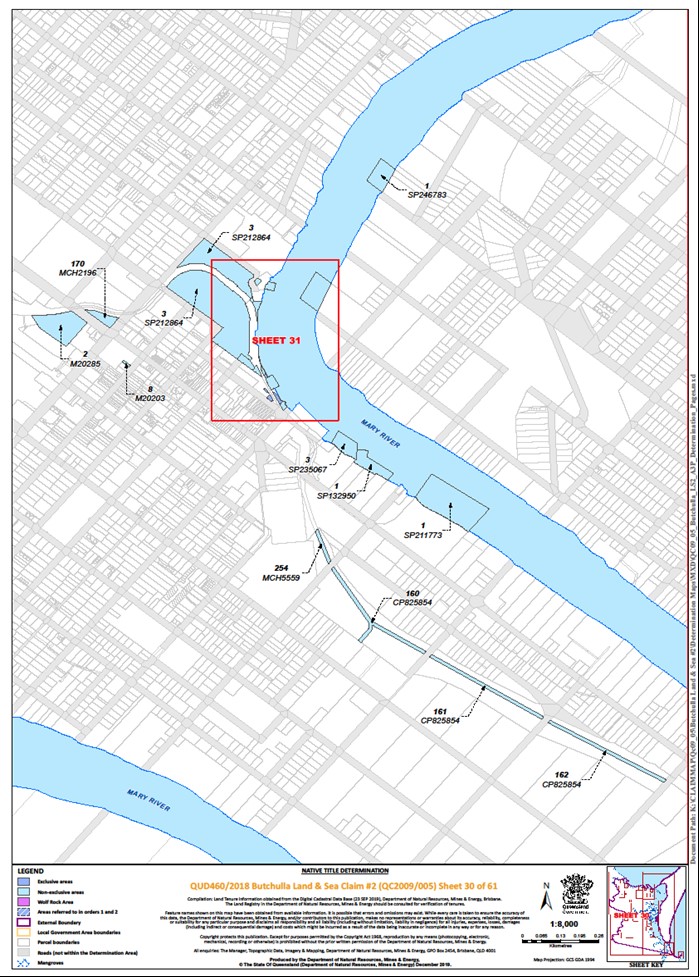
That part of Lot 2 on Plan SP212864 subject to the area delineated by stations A-C-10-4-A on Plan SP212864 | Sheet 31 | |||||||||||
Lot 2 on Plan SP246782 | Sheet 31 | |||||||||||
Lot 2 on Plan USL36933 (on Turkey Island) | Sheets 24, 48 | |||||||||||
Lot 3 on Plan AP14626 | Sheet 1 | |||||||||||
Lot 3 on Plan AP17591 | Sheet 58 | |||||||||||
Lot 3 on Plan CP817467 | Sheet 58 | |||||||||||
Lot 3 on Plan CP889989 | Sheet 58 | |||||||||||
Lot 3 on Plan M20231 | Sheet 29 | |||||||||||
Lot 3 on Plan SP111521 | Sheet 15 | |||||||||||
Lot 3 on Plan SP212864 | Sheets 30, 31 | |||||||||||
Lot 3 on Plan SP235067 | Sheet 30 | |||||||||||
Lot 4 on Plan AP17591 | Sheet 58 | |||||||||||
Lot 4 on Plan AP9699 | Sheets 56, 57, 58, 60 | |||||||||||
Lot 4 on Plan M20321 | Sheet 14 | |||||||||||
Lot 4 on Plan M20322 | Sheet 31 | |||||||||||
Lot 4 on Plan SP212864 | Sheet 31 | + | ||||||||||
Lot 4 on Plan USL34794 | Sheet 24 | |||||||||||
Lot 5 on Plan SP104303 | Sheet 32 | |||||||||||
Lot 5 on Plan USL34794 | Sheet 24 | |||||||||||
Lot 6 on Plan CP894551 | Sheet 58 | |||||||||||
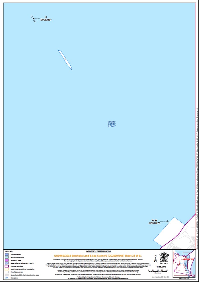
Lot 6 on Plan SP262584 (Picnic Island) | Sheet 23 | |||||||||||
Lot 6 on Plan USL34794 | Sheet 24 | |||||||||||
That part of Lot 7 on Plan CP865252 excluding the area south of a line drawn between Station 15 on Plan CP865252 and the eastern boundary of that lot at Latitude 25.897967° South | Sheet 60 | |||||||||||
Lot 7 on Plan MCH811112 | Sheet 1 | |||||||||||
That part of Lot 7 on Plan SP185926 subject to: Area 1: Segpar # 31726/185 That part of the westernmost severance of Lot 7 on Plan SP185926 (segpar # 31726/185), covered by R124 on M203 (1877 Reserve for Customs Boat Shed and Landing) and R125 on M203 (1877 Reserve for Wharf), further described as:
Area 2: Segpar # 31726/186 That part of the northernmost severance of Lot 7 on Plan SP185926 (segpar # 31726/186), covered by R124 on M203 (1877 Reserve for Customs Boat Shed and Landing), R125 on M203 (1877 Reserve for Wharf), and R112 on M2082 (1874 Reserve for Wharves), further described as:
Area 3: Segpar # 31726/187 That part of the easternmost severance of Lot 7 on Plan SP185926 (segpar # 31726/187), covered by Allotment 4 on M20254 (1952 Reserve for Wharf) and Allotment 5 of Section 103A on M20206 (1952 Reserve for Wharf), further described as:
| Sheet 31 | |||||||||||
Lot 7 on Plan USL34793 | Sheet 24 | |||||||||||
Lot 7 on Plan USL34794 | Sheet 24 | |||||||||||
Lot 8 on Plan M20203 | Sheet 30 | |||||||||||
Lot 8 on Plan RB9699 | Sheet 58 | |||||||||||
Lot 8 on Plan SP185926 | Sheet 31 | + | ||||||||||
Lot 8 on Plan USL34791 | Sheet 24 | |||||||||||
Lot 8 on Plan USL34793 | Sheet 24 | |||||||||||
Lot 9 on Plan M20290 | Sheet 15 | |||||||||||
Lot 9 on Plan MCH2356 | Sheet 38 | |||||||||||
Lot 9 on Plan USL34793 | Sheet 24 | |||||||||||
Lot 10 on Plan MCH5481 | Sheet 58 | |||||||||||
Lot 10 on Plan MCH813263 | Sheet 15 | |||||||||||
That part of Lot 10 on Plan SP145093 excluding former road delineated by stations 1-9-8-6-7-1 on Plan SP145093 | Sheet 26 | |||||||||||
Lot 10 on Plan USL34794 | Sheet 24 | |||||||||||
Lot 11 on Plan CK3668 | Sheet 6 | |||||||||||
Lot 11 on Plan CP892765 | Sheet 36 | |||||||||||
Lot 11 on Plan M20333 | Sheet 29 | |||||||||||
That part of Lot 11 on Plan MCH813263 excluding former: • Section 228 on Plan M20121; and • that part of Yaralla Street adjoining the north-western boundary of Section 228 on Plan M20121 | Sheet 15 | |||||||||||
That part of Lot 11 on Plan SP295518 excluding former Portion 5 on Plan C3748 | Sheet 2 | |||||||||||
That part of Lot 12 on Plan SP295035 excluding an area described as:
| Sheet 37 | |||||||||||
Lot 12 on Plan USL34793 | Sheet 24 | |||||||||||
Lot 13 on Plan M20188 | Sheet 29 | |||||||||||
Lot 13 on Plan RB96922 | Sheet 58 | |||||||||||
That part of Lot 15 on Plan SP298274 excluding:
| Sheet 58 | |||||||||||
Lot 15 on Plan USL34793 | Sheet 24 | |||||||||||
Lot 17 on Plan M20328 | Sheet 15 | |||||||||||
Lot 17 on Plan MCH3520 | Sheet 11 | |||||||||||
Lot 17 on Plan T904 | Sheet 42 | |||||||||||
Lot 18 on Plan AP23043 | Sheet 48 | |||||||||||
Lot 18 on Plan MPH40650 | Sheet 58 | |||||||||||
Lot 20 on Plan MCH4758 | Sheet 58 | |||||||||||
That part of Lot 21 on Plan NPW1150 excluding: • former Lot 7 on Plan MCH2664; and • areas subject to native title determination QUD287/2009 – Butchulla People #2 as determined by the Federal Court on 24 October 2014 | Sheets 16, 23, 48, 56, 58, 59 | |||||||||||
Lot 22 on Plan MCH814248 | Sheet 58 | |||||||||||
Lot 22 on Plan RB9697 | Sheet 59 | |||||||||||
Lot 24 on Plan AP20931 (on Slain Island) | Sheet 48 | |||||||||||
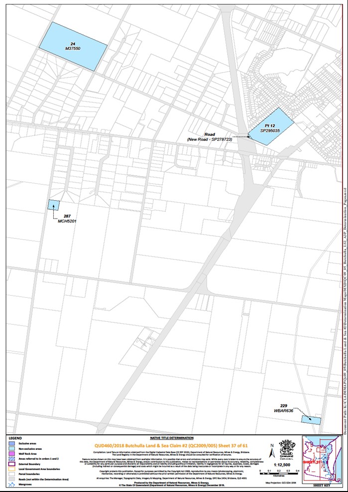
Lot 24 on Plan M37550 | Sheet 37 | |||||||||||
Lot 24 on Plan MCH4935 | Sheet 59 | |||||||||||
Lot 25 on Plan AP20931 (on Slain Island) | Sheet 48 | |||||||||||
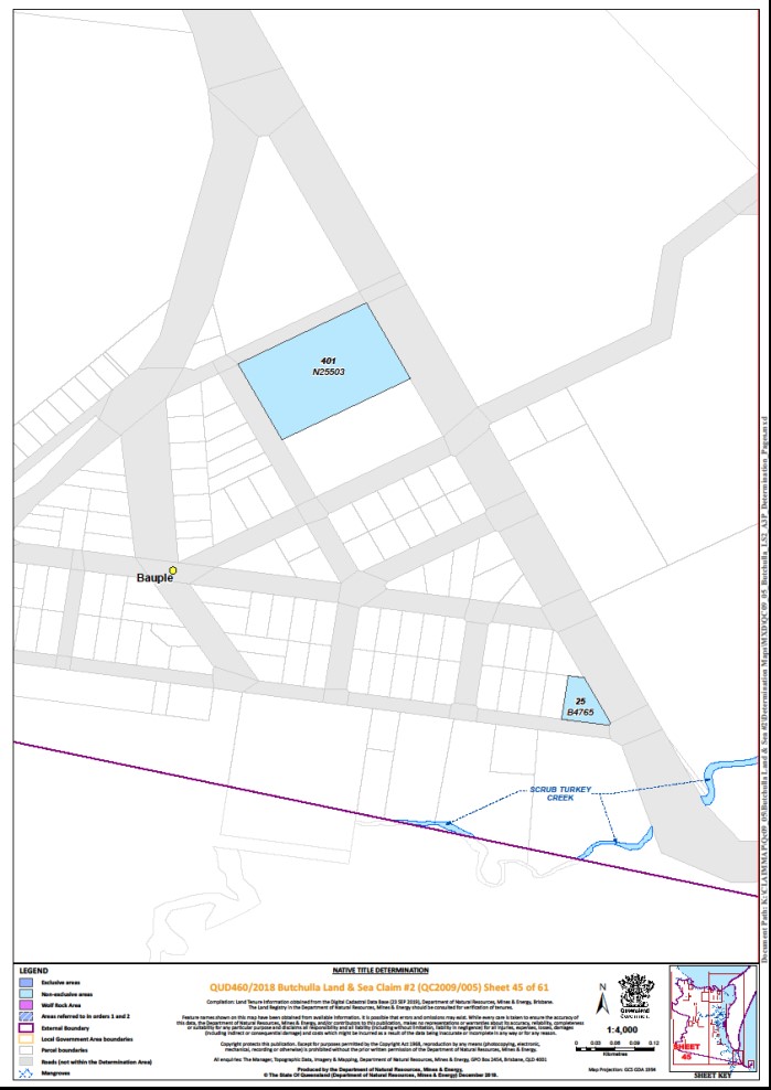
Lot 25 on Plan B4765 | Sheet 45 | |||||||||||
Lot 25 on Plan MCH2577 | Sheet 32 | |||||||||||
That part of Lot 25 on Plan NPW642 excluding former Lot 93 on Plan CK2898 | Sheets 1, 2, 3 | |||||||||||
Lot 25 on Plan RB96928 | Sheet 58 | |||||||||||
Lot 25 on Plan RB96930 | Sheet 58 | |||||||||||
Lot 26 on Plan AP20931 (on Slain Island) | Sheet 48 | |||||||||||
Lot 26 on Plan MCH4935 | Sheets 58, 59 | |||||||||||
Lot 27 on Plan AP23030 | Sheet 6 | |||||||||||
Lot 27 on Plan MCH5499 | Sheet 53 | |||||||||||
Lot 28 on Plan AP20933 | Sheets 48, 49, 50 | |||||||||||
Lot 28 on Plan SP103952 | Sheet 57 | |||||||||||
Lot 30 on Plan MCH4936 | Sheet 58 | |||||||||||
Lot 34 on Plan AP20934 | Sheet 50 | |||||||||||
That part of Lot 35 on Plan MCH4208 excluding former Portion 23 on Plan MCH1393 | Sheet 1 | |||||||||||
Lot 36 on Plan MCH2576 | Sheet 32 | |||||||||||
Lot 38 on Plan M20190 | Sheet 29 | |||||||||||
Lot 42 on Plan M20200 | Sheet 29 | |||||||||||
Lot 44 on Plan MCH3325 | Sheet 24 | |||||||||||
Lot 45 on Plan CK3670 | Sheet 2 | |||||||||||
Lot 47 on Plan MCH4375 | Sheet 32 | |||||||||||
Lot 48 on Plan MCH5086 (Susan Island) | Sheet 25 | |||||||||||
That part of Lot 49 on Plan AP17243 subject to Lot A on Plan AP22202 | Sheet 2 | |||||||||||
Lot 49 on Plan MCH4794 | Sheet 32 | |||||||||||
Lot 50 on Plan MCH4724 | Sheet 1 | |||||||||||
Lot 51 on Plan MCH2964 | Sheet 41 | |||||||||||
Lot 53 on Plan M20190 | Sheet 29 | |||||||||||
Lot 53 on Plan SP104303 | Sheet 32 | |||||||||||
Lot 54 on Plan MCH3721 | Sheet 49 | |||||||||||
Lot 54 on Plan MCH3827 | Sheet 32 | |||||||||||
That part of Lot 55 on Plan M2071 excluding:
| Sheet 35 | |||||||||||
Lot 56 on Plan CK3670 | Sheet 2 | |||||||||||
Lot 56 on Plan SP152559 | Sheet 59 | |||||||||||
That part of Lot 60 on Plan CP900876 excluding former: • Portion 59 on Plan CK1137; • Portion 112 on Plan CK2454; and • road delineated by stations 1-2-3-4-5-1 on Plan CP900876 | Sheet 3 | |||||||||||
Lot 60 on Plan MCH5213 | Sheet 6 | |||||||||||
Lot 64 on Plan MCH357 | Sheet 17 | |||||||||||
Lot 69 on Plan CK2477 | Sheet 1 | |||||||||||
Lot 73 on Plan MCH727 | Sheets 9, 17 | |||||||||||
Lot 74 on Plan MCH1394 | Sheet 9 | |||||||||||
Lot 76 on Plan MCH3044 | Sheet 28 | |||||||||||
Lot 77 on Plan MCH3641 | Sheet 41 | |||||||||||
Lot 77 on Plan MCH841653 | Sheet 24 | |||||||||||
Lot 80 on Plan MCH2046 | Sheet 11 | |||||||||||
Lot 80 on Plan SP242413 | Sheet 57 | |||||||||||
Lot 81 on Plan AP23039 | Sheet 57 | |||||||||||
That part of Lot 81 on Plan MCH4271 excluding former Portion 1433 on Plan M37736 | Sheet 28 | |||||||||||
Lot 81 on Plan MCH4329 | Sheet 50 | |||||||||||
Lot 82 on Plan MCH4329 | Sheet 50 | |||||||||||
That part of Lot 82 on Plan MCH4873 described as an area defined as a reserve for ballast for railway purposes in Government Gazette of April 1897, here further described as:
| Sheet 1 | |||||||||||
Lot 85 on Plan CK1513 | Sheet 3 | |||||||||||
Lot 85 on Plan MCH4373 | Sheet 50 | |||||||||||
Lot 86 on Plan CK1513 | Sheet 3 | |||||||||||
Lot 86 on Plan MCH4374 | Sheet 51 | |||||||||||
Lot 88 on Plan W39987 | Sheet 38 | |||||||||||
Lot 89 on Plan MCH3151 | Sheet 28 | |||||||||||
Lot 89 on Plan MCH5135 | Sheet 28 | |||||||||||
Lot 91 on Plan CK2690 | Sheet 6 | |||||||||||
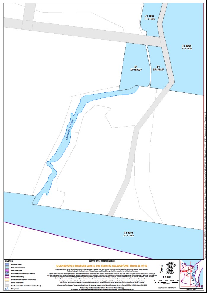
Lot 91 on Plan SP159827 | Sheet 13 | |||||||||||
Lot 92 on Plan LX2190 | Sheet 1 | |||||||||||
Lot 92 on Plan M2013 | Sheet 11 | |||||||||||
Lot 92 on Plan USL34403 | Sheet 4 | |||||||||||
Lot 93 on Plan LX2190 | Sheet 1 | |||||||||||
Lot 93 on Plan USL34403 | Sheet 4 | |||||||||||
Lot 94 on Plan B812 | Sheet 25 | |||||||||||
Lot 94 on Plan LX2191 | Sheet 1 | |||||||||||
Lot 94 on Plan MCH3488 | Sheet 11 | |||||||||||
Lot 94 on Plan MCH5498 | Sheet 53 | |||||||||||
Lot 94 on Plan USL34403 | Sheet 4 | |||||||||||
Lot 95 on Plan LX2191 | Sheet 1 | |||||||||||
Lot 95 on Plan MCH3488 | Sheet 11 | |||||||||||
Lot 99 on Plan MCH4220 | Sheet 20 | |||||||||||
Lot 100 on Plan CP817390 | Sheet 58 | |||||||||||
Lot 100 on Plan SP226980 | Sheet 17 | |||||||||||
Lot 105 on Plan MCH3864 | Sheet 41 | |||||||||||
Lot 106 on Plan MCH2387 | Sheet 21 | |||||||||||
Lot 108 on Plan MCH4289 | Sheet 21 | |||||||||||
Lot 109 on Plan MCH4290 | Sheet 20 | |||||||||||
Lot 110 on Plan MCH4291 | Sheet 20 | |||||||||||
Lot 111 on Plan MCH4292 | Sheet 20 | |||||||||||
Lot 112 on Plan MCH2471 | Sheets 17, 19 | |||||||||||
Lot 112 on Plan MCH3863 | Sheet 41 | |||||||||||
Lot 113 on Plan AP23042 | Sheet 32 | |||||||||||
Lot 113 on Plan LX2190 | Sheet 1 | |||||||||||
Lot 114 on Plan SP277654 | Sheet 19 | |||||||||||
That part of Lot 118 on Plan NPW567 excluding former: • Lot 42 on Plan MCH2759; • Portion 56 on Plan M37750; and • Portion 55 on Plan MCH2501 | Sheets 28, 32, 46, 47, 48, 49, 50, 51 | |||||||||||
Lot 119 on Plan MCH1392 | Sheet 6 | |||||||||||
Lot 122 on Plan AP23038 | Sheet 58 | |||||||||||
That part of Lot 127 on Plan CP818926 subject to former Lot 82 on Plan CK1381 | Sheet 6 | |||||||||||
Lot 127 on Plan SP247992 | Sheet 58 | |||||||||||
Lot 128 on Plan CK3323 | Sheet 5 | |||||||||||
Lot 128 on Plan CP892765 | Sheet 36 | |||||||||||
That part of Lot 129 on Plan MCH4521 excluding former Kelly Street and Broea Street shown on Plan MCH2965 | Sheet 41 | |||||||||||
Lot 130 on Plan MCH5203 | Sheet 38 | |||||||||||
Lot 131 on Plan MCH2614 | Sheet 38 | |||||||||||
Lot 132 on Plan CP880116 | Sheet 20 | |||||||||||
Lot 133 on Plan MCH2832 | Sheet 36 | |||||||||||
Lot 133 on Plan MCH3152 | Sheet 41 | |||||||||||
Lot 133 on Plan SP292266 | Sheet 19 | |||||||||||
Lot 135 on Plan SP273770 | Sheet 55 | |||||||||||
That part of Lot 147 on Plan CK2874 formerly subject to OL 405, further described as:
| Sheet 6 | |||||||||||
Lot 147 on Plan MCH3466 | Sheet 21 | |||||||||||
Lot 148 on Plan C37205 | Sheet 6 | |||||||||||
Lot 148 on Plan MCH3465 | Sheet 19 | |||||||||||
Lot 149 on Plan MCH3512 | Sheet 9 | |||||||||||
Lot 149 on Plan W39851 | Sheet 6 | |||||||||||
Lot 152 on Plan MCH2726 | Sheet 41 | |||||||||||
Lot 156 on Plan MCH3356 | Sheet 9 | |||||||||||
Lot 160 on Plan CP825854 | Sheet 30 | |||||||||||
Lot 160 on Plan MCH4261 | Sheet 4 | |||||||||||
Lot 161 on Plan CP825854 | Sheet 30 | |||||||||||
Lot 161 on Plan MCH2506 | Sheet 1 | |||||||||||
Lot 162 on Plan CP825854 | Sheet 30 | |||||||||||
Lot 163 on Plan MCH2472 | Sheet 4 | |||||||||||
Lot 169 on Plan USL37855 | Sheet 58 | |||||||||||
Lot 170 on Plan MCH2196 | Sheet 30 | |||||||||||
Lot 170 on Plan MCH2799 | Sheet 4 | |||||||||||
Lot 171 on Plan MCH2799 | Sheet 4 | |||||||||||
Lot 172 on Plan MCH5561 | Sheets 1, 9 | |||||||||||
That part of Lot 173 on Plan USL43441 being an unnamed watercourse further described as:
| Sheet 42 | |||||||||||
Lot 175 on Plan MCH2410 | Sheet 29 | |||||||||||
Lot 178 on Plan CP859379 | Sheet 6 | |||||||||||
Lot 179 on Plan CP859379 | Sheet 6 | |||||||||||
Lot 179 on Plan MCH4220 | Sheet 20 | |||||||||||
Lot 180 on Plan MCH4220 | Sheet 20 | |||||||||||
That part of Lot 184 on Plan MCH4167 excluding former Portion 51 on Plan M37250 | Sheet 22 | |||||||||||
That part of Lot 185 on Plan MCH4167 excluding former Portion 51 on Plan M37250 | Sheet 22 | |||||||||||
That part of Lot 186 on Plan MCH3468 excluding former road delineated by stations 6-10-11-8-6 on Plan MCH3468 | Sheet 18 | |||||||||||
That part of Lot 187 on Plan MCH3467 excluding former road delineated by stations 5-4-6-9-10-5 on Plan MCH3467 | Sheet 18 | |||||||||||
Lot 188 on Plan MCH2224 | Sheet 14 | |||||||||||
Lot 195 on Plan SP175464 | Sheet 9 | |||||||||||
That part of Lot 198 on Plan CP881182 excluding former road delineated by stations A-B-C-D-A on Plan CP881182 | Sheet 44 | |||||||||||
Lot 203 on Plan MCH4699 | Sheet 19 | |||||||||||
Lot 209 on Plan T9013 | Sheet 42 | |||||||||||
Lot 210 on Plan SP292266 | Sheet 19 | |||||||||||
Lot 210 on Plan T9013 | Sheet 42 | |||||||||||
Lot 211 on Plan T9013 | Sheet 42 | |||||||||||
Lot 215 on Plan SP235162 | Sheets 4, 17, 18 | |||||||||||
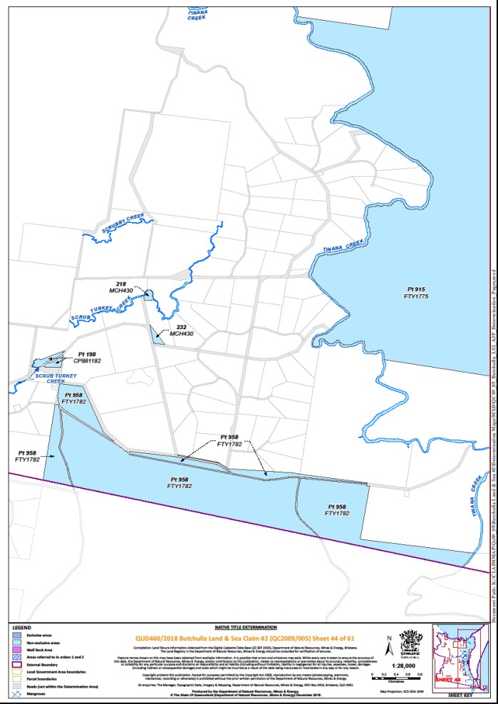
Lot 218 on Plan MCH430 | Sheet 44 | |||||||||||
That part of Lot 220 on Plan SP185042 that is above the High Water Mark | Sheets 17, 19, 20, 21 | |||||||||||
Lot 222 on Plan SP230898 | Sheet 9 | |||||||||||
Lot 223 on Plan M37779 | Sheet 17 | |||||||||||
Lot 225 on Plan MCH3509 | Sheet 22 | |||||||||||
Lot 226 on Plan MCH435 | Sheet 22 | |||||||||||
Lot 227 on Plan MCH5231 | Sheet 9 | |||||||||||
That part of Lot 227 on Plan SP235162 that is above the High Water Mark | Sheets 1, 4 | |||||||||||
Lot 228 on Plan MCH192 | Sheet 1 | |||||||||||
Lot 229 on Plan WBAR636 | Sheet 37 | |||||||||||
Lot 230 on Plan AP15690 | Sheet 14 | |||||||||||
That part of Lot 230 on Plan SP239117 excluding former road delineated by stations 1-2-4-5-1 on Plan SP239117 | Sheets 17, 21 | |||||||||||
Lot 232 on Plan MCH430 | Sheet 44 | |||||||||||
Lot 235 on Plan MCH861 | Sheet 15 | |||||||||||
Lot 235 on Plan PV1602 | Sheet 4 | |||||||||||
Lot 236 on Plan MCH861 | Sheet 15 | |||||||||||
Lot 237 on Plan MCH861 | Sheet 15 | |||||||||||
Lot 237 on Plan MCH5021 | Sheet 17 | |||||||||||
Lot 239 on Plan SP230894 | Sheet 9 | |||||||||||
Lot 240 on Plan PV1601 | Sheet 4 | |||||||||||
Lot 244 on Plan MCH1445 | Sheet 1 | |||||||||||
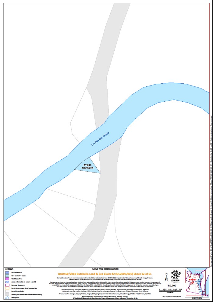
That part of Lot 246 on Plan MCH3825 subject to former Lot 246 on Plan MCH3012 | Sheet 12 | |||||||||||
Lot 247 on Plan MCH2601 | Sheet 11 | |||||||||||
That part of Lot 252 on Plan MCH5182 excluding former Portion 252 on Plan MCH2410 | Sheet 29 | |||||||||||
Lot 254 on Plan MCH5559 | Sheet 30 | |||||||||||
Lot 264 on Plan MCH3568 | Sheet 15 | |||||||||||
Lot 265 on Plan MCH5244 | Sheet 1, 9 | |||||||||||
Lot 265 on Plan MCH5310 | Sheet 40 | |||||||||||
Lot 267 on Plan O1196 | Sheet 39 | |||||||||||
That part of Lot 283 on Plan MCH809268 excluding: • former Allotment 1 of Section 175 on Plan M20114; and • an area of public work, further described as:
| Sheet 14 | |||||||||||
Lot 287 on Plan MCH5201 | Sheet 37 | |||||||||||
Lot 290 on Plan SP170657 | Sheet 14 | |||||||||||
Lot 298 on Plan CP895405 | Sheet 14 | |||||||||||
Lot 401 on Plan N25503 | Sheet 45 | |||||||||||
That part of Lot 506 on Plan NPW555 formerly subject to: • Portion 12 on Plan MCH3155; • Portion 6 on Plan MCH3129; and • Lot 33 on Plan CP864837 | Sheet 24 | |||||||||||
That part of Lot 682 on Plan FTY1579 excluding former: • Portion 54 on Plan MCH358; • Portion 4 on Plan M371310; • Portion 120 on Plan MCH1431; • Portion 117 on Plan MCH1315; and • Portions 175 and 176 on Plan MCH2982 | Sheets 1, 3 | |||||||||||
That part of Lot 701 on Plan M2085 subject to Lot 1 on PER4843 | Sheet 15 | |||||||||||
That part of Lot 702 on Plan M2085 subject to Lot 1 on PER4843 | Sheet 15 | |||||||||||
That part of Lot 703 on Plan M2085 subject to: • Lot 1 on PER4843; and • former Lot 1 on PER4671 | Sheet 15 | |||||||||||
That part of Lot 704 on Plan M2085 subject to: • Lot 1 on PER4843; and • former Lot 1 on PER4671 | Sheet 15 | |||||||||||
That part of Lot 705 on Plan M2085 subject to: • Lot 1 on PER4843; and • former Lot 1 on PER4671 | Sheet 15 | |||||||||||
That part of Lot 915 on Plan FTY1775 excluding former: • Portion 78 on Plan MCH3471; • Portion 74 on Plan MCH3793; • Portion 46v on Plan MCH65; • Portion 22 on Plan M371124; • Portion 5 Parish of Cowra Feb 1969; • Portion 12 on Plan MCH2352; • Portion 6 on Plan MCH2362; • Portion 2 on Plan M37531; • Portion 4 on Plan MCH2374; and • Portion 3 on Plan MCH1349 | Sheets 28, 32, 44, 46, 48 51, 53 | |||||||||||
That part of Lot 958 on Plan FTY1782 excluding former Portion 178 on Plan MCH1079 | Sheet 44 | |||||||||||
Lot 1004 on Plan FTY1659 | Sheets 28, 46 | |||||||||||
That part of Lot 1294 on Plan FTY1888 excluding former: • Portions 1v, 2v and 3v on Plan L371111; • Portion 76 on Plan LX1401; • Selection 982 on Plan L371477; • Portions 23v and 24v on Plan LX586; and • Portion 73 on Plan LX435 | Sheets 1, 13 | |||||||||||
That part of Bluebell Road East described as:
|
|
| ||||||||||
• 44-31-16-15-36-44; • 45-46-32-47-31-45; • 47-51-19-20-48-49-50-16-47; • 59-60-61-41-59; • 62-25-29-37-35-70-63-62; and • 64-66-67-23-65 | Sheet 19 | ^ | ||||||||||
Areas identified as New Road on Plan SP277654 and delineated by Stations: • 4-5-6-4; and • 8-9-14-11-12-8 | Sheet 1819 | ^ | ||||||||||
Areas identified as New Road on Plan SP235162 and delineated by Stations: • 4-3-17-16-15-14-13-12-10-9-8-7-6-4; and • 10-12-11-10 | Sheet 4 | ^ | ||||||||||
Save for any waters: • forming part of a lot on plan; or • within the area described in Part 3 of Schedule 4, all rivers, creeks, streams, lakes and lagoons within the External Boundary including but not limited to:
| ||||||||||||
^ denotes areas to which s 24KA of the Native Title Act 1993 (Cth) applies
+ denotes areas to which the non-extinguishment principle applies
Part 3 – Non-exclusive areas below the High Water Mark, save the Wolf Rock Area
All the land and waters described in the following table and depicted in light blue on the determination maps contained in Schedule 6:
Area description (at the time of the Determination) |
That area within the External Boundary that is below the High Water Mark, but not including the Wolf Rock Area. For the avoidance of doubt, the area includes: • Lot 1 on Plan CP895628; • Lot 1 on Plan SP162340; • Lot 1 on Plan SP252706; • Lot 2 on Plan SP159069; • Lot 2 on Plan SP292477; • Lot 54 on Plan MCH5147; • Lot 55 on Plan MCH5148; • Lot 56 on Plan SP254568; • that part of Lot 88 on Plan CP901875 excluding former Lot 88 on Plan FS87; • that part of Lot 220 on SP185042 that is below the High Water Mark; • that part of Lot 227 on Plan SP235162 that is below the High Water Mark; and • save for the Wolf Rock Area, all seas, bays, rivers, creeks and inlets within the External Boundary including but not limited to:
|
Part 4 – Wolf Rock Area
All the land and waters described in the following table and depicted in purple on the determination maps contained in Schedule 6:
Area description (at the time of the Determination) | Determination Maps Reference |
All the land and waters of Wolf Rock and the waters within a 300 metre buffer seaward of the High Water Mark of that rock | Sheet 61 |
Schedule 5 – Areas Not Forming Part of the Determination Area
The following areas of land and waters are excluded from the Determination Area as described in Part 1 of Schedule 4, Part 2 of Schedule 4, Part 3 of Schedule 4 and Part 4 of Schedule 4:
1. Those land and waters within the External Boundary which, at the time the native title determination application was made, were the subject of one or more Previous Exclusive Possession Acts, within the meaning of s 23B of the Native Title Act 1993 (Cth), as they could not be claimed in accordance with s 61A of the Native Title Act 1993 (Cth).
2. Specifically, and to avoid any doubt, the land and waters described in (1) above include:
(a) the Previous Exclusive Possession Acts described in ss 23B(2) and 23B(3) of the Native Title Act 1993 (Cth) to which s 20 of the Native Title (Queensland) Act 1993 (Qld) applies, and to which none of ss 47, 47A or 47B of the Native Title Act 1993 (Cth) applied; and
(b) the land and waters on which any public work, as defined in s 253 of the Native Title Act 1993 (Cth), is or was constructed, established or situated, and to which ss 23B(7) and 23C(2) of the Native Title Act 1993 (Cth) and to which s 21 of the Native Title (Queensland) Act 1993 (Qld) applies, together with any adjacent land or waters in accordance with s 251D of the Native Title Act 1993 (Cth), including, but not limited to, the whole of the land and waters described as:
(i) Lot 30 on Plan MCH5267;
(ii) Lot 55 on Plan SP152559;
(iii) that part of Lot 7 on Plan CP865252 that is south of a line drawn between Station 15 on Plan CP865252 and the eastern boundary of that lot at Latitude 25.897967° South; and
(iv) those parts of Lot 15 on Plan SP298274 described by the following coordinates:
A. an area bounded by Wide Bay Esplanade, Rainbow Beach Road, the southern boundaries of Lot 14 on Plan SP298274 to Longitude 153.093037° East, and a line drawn to Longitude 153.093509° East, Latitude 25.902505° South, and southerly to the northern boundary of Wide Bay Road at Longitude 153.093188° East;
B. an area bounded by Rainbow Beach Road, Kirchner Road to Longitude 153.091198° East and a line drawn to Longitude 153.091440° East, Latitude 25.900802° South, south-westerly to Longitude 153.092339° East, Latitude 25.901371° South and southerly to the north-western corner of Rainbow Beach Road; and
C. an area bounded by the northern boundary Rainbow Beach Road commencing at Longitude° 153.092546 East and extending northerly and generally north-westerly passing through the following coordinate points:
Longitude ° (East) | Latitude ° (South) |
153.092332 | 25.900914 |
153.091786 | 25.900756 |
153.091226 | 25.900144 |
153.090157 | 25.899806 |
then north-westerly to the eastern boundary of Lot 3 on Plan AP17591 at Latitude 25.899681° South; then north-easterly along that boundary to Latitude 25.899377° South; then easterly to Longitude 153.091300° East, Latitude 25.899482° South; then south-easterly to the western boundary of Lot 169 on Plan USL37855 at Latitude 25.899822° South; then south easterly along that boundary to the southernmost corner of that lot; then south-westerly to the northernmost corner of Lot 14 on Plan SP298274; then south-westerly along boundaries of that lot to the northern boundary Rainbow Beach Road.
3. Those land and waters within the External Boundary on which, at the time the native title determination application was made, public works were validly constructed, established or situated after 23 December 1996, where s 24JA of the Native Title Act 1993 (Cth) applies, and which wholly extinguished native title.
4. Those land and waters within the External Boundary which, at the time the native title determination application was made, were the subject of one or more Pre-existing Rights Based Acts, within the meaning of s 24IB of the Native Title Act 1993 (Cth), which wholly extinguished native title.
Schedule 6 – Maps of Determination Area

O’BRYAN J:
Introduction
1 This is an application under s 61 of the Native Title Act 1993 (Cth) (Act) for a determination of native title rights and interests on behalf of the Butchulla people. It is referred to as the Butchulla People Land & Sea Claim #2 and relates to areas of land and sea largely adjacent to the southern half of Fraser Island.
2 The application was filed in the Court on 27 November 2009 on the same day as an application in respect of the lands and waters of Fraser Island (hereinafter referred to by its name in the Butchulla language, K'Gari). On 24 October 2014, the Court recognised the Butchulla people as the native title holders in respect of the land and waters of K’Gari: De Satge on behalf of the Butchulla People #2 v State of Queensland [2014] FCA 1132 (K’Gari determination). Their native title rights and interests in relation to that determination have been managed by the Butchulla Aboriginal Corporation RNTBC (BAC) as an agent prescribed body corporate pursuant to s 57 of the Act.
3 The present application was accepted for registration and entered on the Register of Native Title Claims (Register) by the Native Title Registrar from 30 June 2010. The application was notified by the Native Title Registrar in accordance with s 66 of the Act, with the notification period ending on 5 January 2011. The application has been the subject of amendments on:
(a) 3 June 2010, before it was entered on the Register;
(b) 25 September 2014, following the orders of the Court on 11 September 2014 which changed the description and composition of the claim group, and replaced the then applicant. The amended application was accepted for registration on 11 February 2015; and
(c) 25 October 2019, which reduced the area of land and waters the subject of the application pursuant to s 64(1A) of the Act.
4 None of the amendments have triggered a requirement for the application to be re-notified. The application has remained on the Register since 30 June 2010.
5 The applicants are Gemma Cronin, Roderick Tobane, Belinda Barrowcliffe, Bronwyn De Satge, Sandra Page, Lurline Lillian Burke, Shirley Blake, Brett Nutley and Cepha Maria Roma. They are all members of the Butchulla people, on whose behalf the application is made. The Butchulla people are described in the application as the biological descendants of the following people:
(a) Father / Mother of Gracie and Maudie Daramboi;
(b) Mother of Jessie Aldridge’s mother and Lappy;
(c) Mother of Charles Richards;
(d) Garry Owens;
(e) Annie Morris / Anna Gala nee Morris;
(f) Granny Polcus / Jenny Brown;
(g) Willy Brown / Mamboo / Namboo;
(h) George Gundy;
(i) Willy Wondunna;
(j) Jack Morris;
(k) Mary Ann (mother of Susan Rooney);
(l) Roger Bennett;
(m) Percy Coulson;
(n) Mother of John and Rosie Broome;
(o) Mother of Clara, Henry, Percy and Lucy Wheeler.
6 The claim group description is in identical terms to the description of the native title holders in the K'Gari determination.
7 The names of the known descendants of the apical ancestors are listed in the genealogical charts prepared by Susan O'Brien and collated in two reports prepared in 2011, and filed in this proceeding on 23 October 2019.
8 The list of respondents to the application is relatively narrow and consists of the State of Queensland (State), the Commonwealth of Australia (Commonwealth), two regional councils (Fraser Coast and Gympie), two utilities companies (Telstra Corporation Ltd and Ergon Energy Corporation Limited) and seven individual respondents.
9 The parties to this proceeding have reached agreement on the terms of a native title determination for areas of the land and sea the subject of the application (the determination area) and a form of orders regarded as appropriate to provide recognition of the native title rights and interests held by the native title claimants, the Butchulla people, in the determination area. The agreement is recorded in a document filed with the Court which has been signed on behalf of each party, and annexes the terms of a draft consent determination of native title (proposed consent determination).
10 The parties have applied to the Court for an order in, or consistent with, the terms of the proposed consent determination pursuant to s 87(2) of the Act. The application is supported by an affidavit of Wati Taraivini Qalotaki, a solicitor employed by Queensland South Native Title Services Ltd in the position of Deputy Principal Legal Officer, affirmed 24 October 2019 and an affidavit of Lurline Lillian Burke, one of the applicants, affirmed 26 October 2019 (and amended in a minor respect on 28 October 2019) and two sets of submissions filed by the applicants (the first addressing the application for a consent determination under s 87(2) and the second addressing the appointment of a prescribed body corporate under s 57).
Relevant principles
11 The parties seek orders by consent from the Court pursuant to s 87(2) of the Act. Sections 87(1), (1A) and (2) of the Act provide as follows:
(1) This section applies if, at any stage of proceedings after the end of the period specified in the notice given under s 66:
a. agreement is reached between the parties on the terms of an order of the Federal Court in relation to:
i. the proceeding; or
ii. a part of the proceeding; or
iii. a matter arising out of the proceeding; and
b. the terms of the agreement, in writing signed by or on behalf of the parties, are filed with the Court; and
c. the Court is satisfied that an order in, or consistent with, those terms would be within the power of the Court.
(1A) The Court may, if it appears to the Court to be appropriate to do so, act in accordance with:
a. whichever of subsection (2) or (3) is relevant in the particular case; and
b. if subsection (5) applies in the particular case – that subsection.
(2) If the agreement is on the terms of an order of the Court in relation to the proceedings, the Court may make an order in, or consistent with, those terms without holding a hearing or, if a hearing has started, without completing the hearing.
12 Accordingly, for the Court to make an order under s 87(2) in, or consistent with, terms agreed between the parties, the Court must be satisfied of the four conditions specified in s 87(1), and must also be satisfied that it is appropriate to do so. The four conditions are: first, the notice period specified in s 66 must have ended; second, agreement must be reached between the parties on the terms of an order of the Court; third, the terms of the agreement, in writing signed by or on behalf of the parties, must be filed with the Court; and fourth, the Court must be satisfied that an order in, or consistent with, those terms would be within the power of the Court: see Munn v Queensland (2001) 115 FCR 109 (Munn) per Emmett J at [4]-[5].
13 Once those conditions are established, the Court retains a discretion whether or not to make the orders sought. Factors that may be relevant to the exercise of that discretion have been considered in many cases, including Munn at [28]-[33]; Kelly on behalf of the Byron Bay Bundjalung People v NSW Aboriginal Land Council [2001] FCA 1479 at [23]; and James v Western Australia [2002] FCA 1208 at [4]. Mortimer J recently gave comprehensive consideration to the issue of appropriateness in the context of s 87(1A) in Freddie v Northern Territory [2017] FCA 867 and in Agius v South Australia (No 6) [2018] FCA 358 (Agius). At [63] of Agius, her Honour observed:
The Court’s function where there is agreement as to a determination of native title, and its discretion, must also be understood in the context of the Native Title Act’s emphasis on negotiation and alternative dispute resolution, whereby one particular object of the Native Title Act is to resolve claims to native title without judicial determination in a contested proceeding: see Munn (for and on behalf of the Gunggari People) v Queensland [2001] FCA 1229; 115 FCR 109 at [28] (Emmett J). I note in this context that the Preamble to the Act envisages that:
A special procedure needs to be available for the just and proper ascertainment of native title rights and interests which will ensure that, if possible, this is done by conciliation and, if not, in a manner that has due regard to their unique character.
(Emphasis added)
14 Her Honour summarised the role of the Court as follows:
(a) The s 87(1A) role is quite different from the Court's role in contested hearings. The Court's focus is on the agreement between the parties: Lander v State of South Australia [2012] FCA 427 at [11]; Lovett on behalf of the Gunditjmara People v State of Victoria [2007] FCA 474 at [36] (Agius at [62]).
(b) Satisfaction as to appropriateness must take into account the nature of the rights sought to be recognised in the determination, having operation against the whole world, including rights in rem. The orders should be clear in their terms and the process one which observes procedural fairness and is supported by the State's agreement that a "credible and rational basis" for the determination has been made out (Agius at [64]).
(c) The discretion as to appropriateness is wide but the Court must focus on the individual circumstances of each determination: Hayes on behalf of the Thalanyji People v State of Western Australia [2008] FCA 1487 at [18] (Agius at [65]).
(d) The Court must also consider ss 37M and 37N of the Federal Court of Australia Act 1976 (Cth) and pursue the objectives of those provisions promoting the just resolution of disputes, according to law, and as quickly, inexpensively and efficiently as possible (e.g. Yaegl People #2 v Attorney General of New South Wales [2017] FCA 993 per Jagot J) (Agius at [66]).
(e) There must be some probative material to allow the Court to satisfy itself that the requirements of s 225 of the Act are met. However, there is no requirement to file all of the material as the determination is based on the agreement entered into on a free and informed basis: Hughes (on behalf of the Eastern Guruma People) v State of Western Australia [2007] FCA 365 at [9] (Agius at [68] to [69]).
(f) The Court is not required to conduct an enquiry on the merits, but must still be satisfied that the State made a reasonable and rational decision in entering the s 87 agreement: Brown v Northern Territory of Australia [2015] FCA 1268 at [23]; King on behalf of the Eringa Native Title Claim Group and the Eringa No 2 Native Title Claim Group v State of South Australia [2011] FCA 1387 at [21] (Agius at [70] to [71]).
(g) The Court should be satisfied that the State came to the agreement after discharging its public responsibilities to the community it represents, including the claimants: Yaegl People #2 v Attorney General of New South Wales [2017] FCA 993 at [16] (Agius at [72]).
(h) The public interest in a settled outcome as opposed to an exhaustive contested process is considerable: Prior on behalf of the Juru (Cape Upstart) People v State of Queensland (No 2) [2011] FCA 819 at [26] (Agius at [74]).
(i) The flexibility of a settled outcome allows the State to take into account a wide range of matters including, for instance, the history of dispossession (Agius at [75]).
Evidence relied on
15 In support of the proposed consent determination, the applicants have filed lay and expert evidence to show that the agreement of the parties to the proposed consent determination has a reasonable and rational basis. That evidence comprises:
(a) the following expert reports:
(i) Anthropological Report, Dr Lee Sackett, December 2011;
(ii) Supplementary Anthropological Report, Dr Lee Sackett, May 2015;
(iii) Historical Report, Dr Fiona Skyring, March 2011;
(iv) Supplementary Historical Report, Dr Fiona Skyring, July 2012;
(v) Consolidated Genealogies, Susan O’Brien, November 2011; and
(vi) Additional Genealogies: Wheeler Family, Susan O’Brien, November 2011;
(b) the following lay affidavits:
(i) Affidavit of Barbara May Trevaskis, affirmed 2 July 2014;
(ii) Affidavit of Clifford Peter Appo, affirmed 4 July 2014;
(iii) Affidavit of Conway Robert Burns, affirmed 19 June 2014;
(iv) Affidavit of Darren Gene Blake, 20 March 2013;
(v) Affidavit of Dustyn Ian Currie, 2 July 2014;
(vi) Affidavit of Edward Christian Claude Doolan, affirmed 20 March 2013;
(vii) Affidavit of Fiona-Lee Foley, affirmed 18 November 2011;
(viii) Affidavit of Garry Owen Smith, affirmed 21 March 2013;
(ix) Affidavit of Ian Wallace Wheeler, affirmed 21 March 2013;
(x) Affidavit of Malcolm John Frederick Burns, affirmed 18 November 2011;
(xi) Affidavit of Marie Jessie Wilkinson, affirmed 21 March 2013;
(xii) Affidavit of Mark Vincent Singho, affirmed 17 June 2014;
(xiii) Affidavit of Norman Ross Barney, affirmed 18 June 2014;
(xiv) Affidavit of Peter James Martin, affirmed 15 March 2013;
(xv) Affidavit of Jan Lorraine Williams, affirmed 18 June 2014; and
(xvi) Affidavit of Shawn Wondunna-Foley, affirmed 18 November 2011;
(c) the following outlines of evidence prepared for the On-Country Evidence Process (OCEP):
(i) Outline of evidence Dustyn Ian Currie, dated 23 September 2016;
(ii) Outline of evidence Gemma Marie Cronin, dated 23 September 2016;
(iii) Outline of evidence Glen Allan Miller, dated 23 September 2016;
(iv) Outline of evidence Norman Ross Barney, dated 23 September 2016;
(v) Outline of evidence Shawn Wondunna-Foley, dated 23 September 2016; and
(d) the consolidated transcript of the OCEP (12 to 15 December 2016) which records unsworn evidence from:
(i) Conway Burns;
(ii) Glen Miller;
(iii) Gemma Cronin;
(iv) Dustyn Currie; and
(v) Norman Barney.
16 The expert reports and the lay affidavits were all filed and relied upon in the K'Gari determination, other than the 2015 supplementary report of Dr Sackett which deals with connection to places the subject of the present application.
17 The OCEP material post-dates the K’Gari determination. The OCEP was an extra-curial process agreed to by the applicants, the State and the Commonwealth in which certain claimants gave testimony on the basis that they would be prepared to give the same testimony in court. Witnesses were not sworn in. However, their testimony was given in the usual format of evidence in chief followed by cross-examination by the respondents' representatives. The applicants, the State and the Commonwealth have agreed to the filing of the transcript of the OCEP in these proceedings.
18 In the K'Gari determination, Collier J referred to and summarised a significant part of the expert reports and lay affidavits referred to above and which were relied on in that determination. In considering the laws and customs of pre-sovereignty Butchulla society, her Honour observed (at [45]) that Dr Sackett had reported that:
• Butchulla People traditionally believed in a supreme being, namely a sky-god, although many claimants with whom Dr Sackett spoke were Christians.
• Butchulla People believed in totems. Anthropologist Norman Tindale wrote that in Butchulla society, totems were inherited through the mother, although the totem of the father was treated with respect. Totems were animals including dolphins, ducks, kites, honey bees and carpet snakes as well as plants including the cypress pine tree. There was some inconsistency in research as to whether totems could be eaten.
• Circumcision or knocking out of teeth of young men was not practised, although other initiation rites were practised in relation to young men including trial by fire.
• Young women on reaching puberty would be taken away into the bush, and ritually instructed in relation to marriage and mating.
• Children joined the land holding units of their fathers.
• A person is a Butchulla person because they are born as a Butchulla person. Many claimants referred to it as "bloodline".
• Permission was required from Butchulla People before persons from other countries accessed Butchulla land. Failure to seek permission was tantamount to trespass, and traditionally was punishable by, for example, spearing. Dr Sackett noted that the concept of requesting permission to enter Butchulla land was maintained by current members of the claim group.
• Kin relationships guided interpersonal behaviour such that, for example, certain relationships were within proscribed boundaries of consanguinity and that marriage within such relationships was forbidden.
19 Her Honour also summarised the opinion of Dr Sackett regarding the Butchulla people’s connection with K’Gari from sovereignty to the present (at [49]-[53]):
Continuity of connection from sovereignty to the present
49. This is clearly a critical aspect of the application before me. In considering this issue, Dr Sackett also took into account Dr Skyring’s report, factors which have affected the group, group members’ interaction with one another, and members’ interaction with country.
50. First, Dr Sackett’s evidence was that the claimants acknowledged and observed a body of law and custom as they relate to possession, occupation, use and enjoyment of lands and waters, having their roots in the normative system existing at sovereignty (at paragraph 992). While the group no longer practised “increase” ceremonies, nonetheless members interviewed by Dr Sackett averred that they shared Butchulla lands with the overseeing and protecting spirits of Butchulla dead (paragraph 993). Identification as Butchulla by descent from apical ancestors was a strong component of membership of the claim group. Dr Sackett gave evidence that the fundamentals of descent-based membership and country links continued, as did the concept of the necessity of permission to access and exploit Butchulla lands. Further, Dr Sackett gave evidence that elders continued to guide decisions regarding Butchulla country, and that this seemed in line with traditional practice (paragraph 993).
51. Second, Dr Sackett had earlier observed in his report that descendants of a number of apical ancestors had maintained little or no physical connection with the area of the claims, whereas descendants of other apicals had maintained relatively solid physical connection to the area of claims (in particular the descendants of Garry Owens and Willy Wondunna). The dislocation of some Butchulla people from their country resulted from a number of causes including:
• the settlement of non-Aborigines in the area beginning in the 1840s, accompanied by increasing competition for resources and violence between indigenous and non-indigenous people;
• the gradual incorporation of the local population into the pastoral and timber industries as unskilled labour;
• the establishment of a mission on Fraser Island in 1897;
• the removal of many local indigenous people to Yarrabah in 1904 as well as other removals (paragraph 996).
52. In light of this dislocation Dr Sackett opined that it was not surprising that relatively few members of the Butchulla People had been able to maintain ongoing physical connection with their country.
53. Overall, however, Dr Sackett was satisfied that fundamental laws and customs continued to be acknowledged by Butchulla claimants, which meant that crucial aspects of Butchulla society were transmitted from generation to generation.
20 Her Honour also referred to the lay evidence from members of the Butchulla people and concluded (at [55]):
The material in these documents attests to the basis of the witness’ identification as a member of the Butchella people and of their connection to the claim area under their traditional laws and customs. They are compelling reading. All witnesses deposed as to the aspects of Butchulla culture they had learned from elders, recounted traditional stories, and gave evidence of sacred places, totems and rules. Some of this evidence is relevant to areas outside the determination area, in particular on the mainland, but which the witnesses depose is also Butchulla country…
21 As noted above, after the K’Gari determination testimony was given during the OCEP at the Mary River, south of Tiaro, Tuan Creek, Eli Creek, Wongi Waterholes, the Burrum River and Toogoom. Primary amongst the laws and customs of the Butchulla people, and re-told during the OCEP, is the story of Yindingie and Princess K'Gari being sent to earth by Birral (or Beeral), and K'Gari laying down and becoming Fraser Island. Yindingie and K'Gari created the landscape and everything in and upon it. The travels of Yindingie across the landscape are recorded natural features, including for instance, Yindingie's footprints in the waters at Dayman Point. That story was retold by Conway Burns at the beginning of the OCEP:
CONWAY BURNS: My name is Conway Burns. I'm a Butchulla man, a Butchulla descendant. Yes, I'm–just like to talk to youse about what this place means to us here, especially with K'Gari, and at a high point here, the corroboree grounds.
Way back in the Dreamtime, the Stories, the First Creation Story is about K'Gari, and K'Gari is a female white spirit who was an apprentice who come down with Yindingie, Yindingie being the supreme Serpent, the left hand of God, which is Birril, which is a–a white spirits. So she's a female white spirit and a male white spirit come down. He created–helped to create the land. She sort of assisted along.
She was working so hard that Yindingie noticed. She said–he said to her, "Can you go over and lay on these rocks?"–there's rocks on the eastern side–and she said, "Yeah, okay". She laid down, had a sleep, and woke up and–with awe and look–looked out, and all she could see was a beautiful bay and a beautiful mountain over further and a beautiful river. And she said, "It's such a beautiful place. Can I stay?" And Yindingie said, "You can't. You can't stay here because you're a–you're a spirit".
So she begged and pleaded and–until she got her own way. And he said then, "You go back over and lay on those rocks". So she laid on the rocks like this, looking towards the land, and he said, "I'll change you into an island". He said, "You can't stay here as a spirit, so I'll change you into a island". So he changed her into an island and put clothes on her, which were the trees, and all the lakes on the island are her–are her eyes, that looks back up in the heavens where she come from, and all the streams and the creeks are her whispering voices, and Yindingie put on animals on her to–so she-and taught them the art of procreation so that she would never be lonely.
And then, once Yindingie finished creating all the lands and created her, that gave her the name K'Gari, which means beautiful place. So he then rested at place on the western–on the eastern side, called Yidni (sic) (see the correct spelling is ‘Yidney’) Rocks, hence the name Yindingie, which means Rainbow Serpent. And when he rested, he left–he then got up and left to Moon Point, which is–if you come over this way, you can see, directly in this line, the point there, the end of the island– edge of the island. Can you see?
He then left from there to a spot down here what Nanna Joyce was talking about, just there, you can see the building here, left from there. From there–to there to a place Tinnanbar, down the Coral Wing (sic) (see the correct spelling is ‘Korrawinga’) to Straits, and then left up onto a mountain that we call Bauple, and then turned around and said, "This is all your country", and then left up in the sky. And that's why we always gathered here, because–with our corroboree grounds, to speak about our beautiful country, and because of the special site.
MR McAVOY: Can you just say where "here" is?
CONWAY BURNS: Here is Urangan, Dayman Point, which is–"urangan", in our lingo, means dugong, place of dugongs, which they do live out here. And you spin that around back the front, nagnaru, which means "our country". And that's the Story about here that ties in with K'Gari to here to Bauple. I always refer to that Story, because that's how it all began for our people here. Okay?
MR McAVOY: Just a quick question for Conway. When you said Yindingie came here, did you mean to Dayman Point?
CONWAY BURNS: Yes.
MR McAVOY: And somewhere else?
CONWAY BURNS: Yes, Tinnanbar, which is down the Coral Window Straits, Great Sandy Straits, which is down further, you'll probably visit later on. It's a place called Tinnanbar but in our lingo means–it's properly pronounced as Gjinang-Djaa, which means footprint. So that's another area down further.
MR McAVOY: And did Yindingie leave something behind here?
CONWAY BURNS: He left–he left his footprint in the–in the Coffee Rock, down the bottom here, beside the aquarium. Every now and then it–it is exposed from the–from the movement of the sand.
22 Dayman Point and Tinnanbar are both within the claim area on the mainland adjacent to the Great Sandy Strait, while Yidney is located on K'Gari and within the K'Gari determination area.
23 Ms Gemma Cronin gave testimony at a site near the Mary River, in Maryborough, about the dreaming line involving the Crane Mundee and the Ibis Bunda:
GEMMA CRONIN: … This is a major Dreaming line and it runs from Bauple Mountain across to here and then to Urangan, and it’s–they’re our moiety and they’re totemic creatures. It’s a story of two totem Creation ancestors, and they–so, all–we don’t have any hard stone to make–to make artefacts with on the island or even–it’s a really sandy area and it’s not–it’s all sort of soft stone. It’s not the nice hard stone that you need. So, all of our stone that we built–we make tools with–made tools with came from Bauple Mountain. That’s where the hard stone is.
So, in the Dreaming that the crane Mundee, the crane was a really good toolmaker, and he was the one who was in charge of making tools. And he had a camp further south of here, and he–one day an Ibis came and visited him–and the crane is one of our moieties, and the Ibis is one of our moieties. So, the crane came and visited the–I mean the Ibis, the Bunda, came and visited Mundee and he had his wives with him. And he wanted to get some tools off Mundee but Mundee wouldn’t give him any. He only had so many. And he showed them to him and–but he said he’d have to make them for him, he couldn’t give them to him right now. He’d have to make some new ones for him.
So, they ate together and then Bunda, this Ibis told Mundee that he was going, he was leaving, so they left but they didn’t go very far. Then they hid in the bush and they watched Mundee, and when he went to sleep, Bunda’s wives crept back into the camp and they–they stole all of the artefacts and all of the stone tools. And they stole the stone tools and they took off and they started heading towards Urangan.
And Mundee woke up not long after they stole the tools. He woke up and went to do something and then he realised all his–everything was gone, you know, axe heads. So, then straight away he got guilty because he realised he’d been taking a lot of–a lot of stone from the mountain and he hadn’t really spoken to the–to the spirit up there, the guardian of that place in Melong. And he went back up and he realised he might have offended him and maybe that’s why his tools were gone.
So, he got some sugar bag honey and he went back and he fed it to the–he gave it to the Melong and he put it down in front of the cave, his little cave there, and he put it down in front of the cave and he called out and he was saying he was sorry if he offended him because he–he didn’t ask to take as much stone as he had taken. And–but the Melong came out and told him to come and sit at his fire with him, so he sat at his fire, and then in the smoke he saw the–he showed him the smoke the Bunda, the Ibis, and his wives had stolen his tomahawks, his stone heads, so–so then the Mundee jumped up and he grabbed his spear and his big killing boomerang and his burrakan, and he came running down and chasing–he’s chasing the Ibis and the Ibis is moving slow.
He’s got four wives and heavy stones to carry, so he caught him up and when he caught up with him it was here. And this was a shallow creek and the Ibis was on this side and the crane was on that side, and he yelled out and he was challenging the Ibis to a fight for stealing his stones. And he was waving his boomerang and getting ready to launch his spear at him. And the women got scared.
They were halfway across this creek and he–and the Bunda was on this side, but the women were only halfway across, and they got scared and they–they tipped out all the–all the stones they were carrying in their dilly bags. And they tipped them out into the creek, and when they tipped them out the stones transformed into the island, Baddow Island.
And the crane kept singing and calling out, and as he was singing and calling out, then the Melong made the rain come and the rain got deeper and the water got faster and faster and deeper. And the crane was trying to come back, but–I mean, the Bunda, the Ibis wanted to go back and fight but he couldn’t get back across. He was on this side. And that’s the formation of this. Then his wives came and joined him and then they went on and went to Urangan, and that’s it.
MS QALOTAKI: So, you’re pointing across from us towards the river and the island across. Could you show us where Baddow Island is?
GEMMA CRONIN: That’s Baddow Island there. It goes to there and some a bit here. That’s the island.
24 In addition to the oral stories connecting the Butchulla people to their country, there were many examples given during the OCEP of lived experience throughout the claim area in accordance with traditional laws and customs.
25 Dr Sackett’s 2015 supplementary report proceeded on the foundations laid in his 2011 report concerning K’Gari. In the executive summary to the 2015 report, Dr Sackett expressed the following opinions:
Society and Succession
10. In my Butchulla Native Title Claims: Anthropologist’s Report, I considered what some have called ‘the society question’. I…arrived at the conclusion that the Butchulla were part of the wider Kabi Kabi society. “Put another way, by law and custom, Butchulla people held certain areas and, by the same law and custom, others held neighbouring areas in the region” (Sackett 2011:¶444-445). By this same law and custom, they might succeed to one another’s areas.
11. Although there are no reports of succession in the Butchulla area, there most certainly are such reports from elsewhere in Aboriginal Australia. Succession has often been noted in the context of claims made in the Northern Territory under the Aboriginal Land Rights (NT) Act. Indeed, some 30% of the first 59 such claims treated and recognised aspects of succession. In reading the reports on these claims, it immediately becomes apparent that succession can proceed along different paths in different groups.
12. It should not be thought that succession was/is something exclusive to peoples and lands of the Northern Territory. Both Akerman (1995:99) and Kolig (1978:55-56) mention it in relation to different peoples and lands of the Kimberley. Sutton and Rigsby (1982:161-165) mention it in relation to peoples and lands of Cape York.
13. It seems to me that we see threads of Butchulla succession to portions of the mainland in (1) what claimants said about their country and (2) what they related, often at the same moment, about the founding of their country – particularly in the stories they tell about the acts and activities of the Creator Yindingie.
14. At one level, the Yindingie stories link specific places on the Island and the mainland. At another level, the Yindingie stories make the Island, parts of the mainland and the waters and islands between them literally one – one Butchulla country. At the ultimate level, the Yindingie stories deny succession ever occurred – by writing it out of the oral record.
15. It is my view that the specifics and processes of Butchulla succession to some mainland areas went unrecorded as such specifics and processes only become evident through close study. And while Butchulla people and Butchulla country have been mentioned in notes and reports from as early as 1842, they have not been the subject of close anthropological study until recent times.
The Butchulla and Mainland Areas
16. Evidence of Butchulla visiting, if not residing on, mainland areas dates from the earliest moments of effective sovereignty. The evidence continues across the intervening decades.
17. The evidence is by no means uniform across the mainland area being claimed by the Butchulla, however. It for the most part relates to country running from the Hervey Bay area in something of an arc around to the area of Maryborough.
18. As well, there is evidence of claimants’ ancestors and claimants engaging in various ways with mainland areas and places. In this, we see Butchulla Relating to the Spirits of the Country, Camping and Remembering Ancestral Camping Places on Country, Hunting and Gathering, Carrying the Knowledge of Special Places, Participating in Corroborees, Commemorating Ancestral Burial Places, and Caring for Country.
19. If the list of places/areas where Butchulla exercised/exercise rights, interests and responsibilities is held against the list of places for which there is evidence of Butchulla physical connections on the mainland, the one, with a few exceptions, replicates the other.
20. In my view, there is strong support for Butchulla connection to and ownership of mainland country extending from Dundowran Beach/Eli Creek/Point Vernon/Pialba around to Maryborough.
The Butchulla and Island and Bay Areas
21. As is the case with respect to Butchulla people engaging with mainland places and areas, much of the evidence regarding Butchulla activities in and on the waters and islands of the area comes from claimant recollections of their more immediate antecedents’ activities and statements about their own activities.
22. The evidence in relation to Butchulla engaging with inshore waters is strongest in relation to places running from Eli Creek, Gatakers Bay, Point Vernon, Pialba, Scarness, Hervey Bay, Urangan, Pulgul Creek, Booral, River Heads, the Mary River to Maryborough.
23. In Great Sandy Strait, there is good evidence regarding ongoing Butchulla connections to Round Island, Big Woody Island and Little Woody Island (and to a lesser extent to nearby Picnic Island). Claimants relate how their ancestors and they have visited and exploited these islands and surrounding water across the decades.
26 It can be seen that Dr Sackett considered that the Butchulla people were part of the wider Kabi Kabi society and, by the traditional law and custom observed by members of that society, Butchulla people held certain areas and others held neighbouring areas in the region and one might succeed to the other’s areas. Whilst Dr Sackett did not consider that the early ethnography demonstrated that Butchulla territory at sovereignty took in much of the mainland, he expressed the opinion that the evidence supports a finding that the Butchulla people acquired rights and interests in mainland territory through a process of succession under traditional law and custom. I return to that aspect of the evidence below.
Statutory conditions – s 87(1)
27 I am satisfied that the four conditions specified in s 87(1) have been met in this case.
28 First, the application was notified by the Native Title Registrar pursuant to s 66 of the Act. The notification period expired on 5 January 2011. Accordingly, this application is being made after the end of the period specified in the notice given under s 66.
29 Second, an agreement has been signed on behalf of all of the parties to the application recording the parties’ agreement on the terms of an order of the Court in relation to these proceedings, being the proposed consent determination.
30 Third, the agreement has been filed with the Court.
31 Fourth, I am satisfied that an order in, or consistent with, the terms of the proposed consent determination would be within the power of the Court. In that respect, I have given particular consideration to the following four matters:
(a) whether the applicants have been authorised to make the native title application, and seek the proposed consent determination, on behalf of persons who, according to their traditional laws and customs, hold the common or group rights and interests comprising the particular native title claimed, in accordance with s 61 of the Act;
(b) whether the proposed consent determination sets out the details of the matters mentioned in s 225, as required by s 94A of the Act;
(c) whether the proposed consent determination complies with the requirements of s 61A of the Act; and
(d) whether the proposed consent determination includes the matters required by s 56 (which deals with holding the native title on trust) and s 57 (which deals with the non-trust functions of prescribed bodies corporate), as required by s 55 of the Act.
Authorisation of the applicants
32 In relation to authorisation of the applicants, s 61(1) of the Act permits an application for a native title determination to be made by a “person or persons authorised by all the persons (the native title claim group) who, according to their traditional laws and customs, hold the common or group rights and interests comprising the particular native title claimed, provided the person or persons are also included in the native title claim group”. In the case of a claimant application, s 62A provides that authorisation has the consequence that the applicant may deal with all matters arising under the Act in relation to the application. Proper authorisation is therefore fundamental to the institution and maintenance of a native title claimant application under s 61: Strickland v Native Title Registrar [1999] FCA 1530; 168 ALR 242 at 259-260.
33 The evidence shows that the native title claim group specified in the application (the Butchulla people) has authorised the applicants to make the application and to apply for the consent determination, consistently with ss 61(1) and 62A of the Act. In her affidavit, Ms Qalotaki deposed that on 12 October 2019 an authorisation meeting was convened for the claim group and held at the Mantra Hervey Bay Resort, Buccaneer Drive, Urangan, Hervey Bay. The purposes of the authorisation meeting were for the claim group to:
(a) consider and authorise the applicants to make amendments to the application so as to ensure that the application is consistent with agreed positions on tenure and extinguishment and can be in proper, final form before the Court in readiness for the consent determination hearing; and
(b) consider and authorise the applicants to consent to the s 87 agreement that has been filed with the Court.
34 Ms Qalotaki deposed that she attended the authorisation meeting in her capacity as solicitor for the applicants and that the claim group authorised the applicants to amend the application and to consent to the s 87 agreement for filing in the proceedings.
Section 225 requirements
35 Section 94A requires the Court, in making a determination of native title, to set out the details of the matters mentioned in s 225. Section 225 defines a “determination of native title” as follows:
A determination of native title is a determination whether or not native title exists in relation to a particular area (the determination area) of land and waters and, if it does exist, a determination of:
(a) who the persons, or each group of persons, holding the common or group rights comprising the native title are; and
(b) the nature and extent of the native title rights and interests in relation to the determination area; and
(c) the nature and extent of any other interests in relation to the determination area; and
(d) the relationship between the rights and interests in paragraphs (b) and (c) (taking into account the effect of this Act); and
(e) to the extent that the land or waters in the determination area are not covered by a non-exclusive agricultural lease or a non-exclusive pastoral lease -whether the native title rights and interests confer possession, occupation, use and enjoyment of that land or waters on the native title holders to the exclusion of all others.
36 I have examined the proposed consent determination. I am satisfied that each of the matters referred to in s 225 is appropriately articulated in those orders and the rights and interests so described are recognisable by the common law of Australia. The proposed consent determination is largely in the same format as the K'Gari determination. I note the following matters in particular:
(a) The determination area is set out in paragraph 5, referencing the land and waters described in Schedule 4 and depicted in the maps attached to Schedule 6.
(b) A description of the proposed native title holders is set out in paragraph 7, referencing Schedule 1.
(c) A description of the nature and extent of the native title rights and interests in relation to the determination area is set out in paragraphs 8, 9, 10 and 11 of the proposed orders, referencing Parts 1, 2, 3 and 4 of Schedule 4 respectively. Those paragraphs, and paragraph 13, identify whether the native title rights and interests confer possession, occupation, use and enjoyment of that land or waters on the native title holders to the exclusion of all others. Paragraph 8(a), referencing the land in Part 1 of Schedule 4, confers exclusive rights. Paragraphs 8(b), 9, 10 and 11 do not confer exclusive rights.
(d) A description of the nature and extent of other interests in relation to the determination area is set out in paragraph 15, referencing Schedule 2.
(e) The relationship between the native title rights and interests and the other interests is set out in paragraph 16.
37 Paragraphs 1 to 3 of the proposed consent determination require some additional explanation. Those paragraphs are in the following form:
1. There be a determination of native title (the “Determination”) in the terms set out below for the Determination Area other than for Lot 2 on Plan AP6551 and Lot 3 on Plan AP6551.
2. Subject to paragraph 3 of this Order, on 11 December 2020, there be a determination of native title (also, the “Determination”) in the terms set out below for Lot 2 on Plan AP6551 and Lot 3 on Plan AP6551.
3. The Applicant and the State of Queensland have liberty to apply to the Court on or before 13 November 2020 in relation to paragraph 2 of this Order.
38 It is proposed that a determination will be made with respect to the whole of the determination area on 13 December 2019, except Lots 2 and 3 on AP6551. A further determination will be made in relation to Lots 2 and 3 on 11 December 2020, subject to any further application which may be made by the applicants or the State on or prior to 13 November 2020.
39 By way of background, at a late stage the State became aware that Lots 2 and 3, which had been identified as areas where exclusive native title was to be recognised, were the subject of a permit to occupy issued on 1 October 2002 in favour of the Fraser Coast Shooting Complex Association Inc. The activities of the Association are conducted on adjacent land and the permit in respect of Lots 2 and 3 provides a safety buffer. The State considers that the area comprising Lots 2 and 3 is necessary in order to accommodate requirements under the Weapons Act 1990 (Qld) for the safe operation of the activities conducted by the Association.
40 The applicants and the State consider that the permit to occupy is a low impact future act pursuant to s 24LA of the Act, to which the non-extinguishment principle applies. However, an immediate determination of native title conferring exclusive rights over the area would cause a public safety problem if the Association were to continue its activities. To resolve that difficulty (which was identified only recently), the parties have agreed that an immediate determination of native title in respect of the whole of the determination area except for Lots 2 and 3 will be made, and a further determination of native title will be made on 11 December 2020 without further order of the Court. The orders are designed to give the Butchulla people certainty that a determination of native title recognising their native title rights and interests in relation to Lots 2 and 3 will be made within 12 months, while allowing the Association to continue to operate by utilising the existing permit to occupy until the determination in respect of Lots 2 and 3 is made. This will give the relevant parties a period of 12 months to discuss and negotiate a suitable arrangement with respect to that land.
Section 61A requirements
41 Section 61A(1) provides that a native title determination application must not be made in relation to an area for which there is an approved determination of native title. Based on the records of the National Native Title Register kept under Part 8 of the Act, I am satisfied that there is no determination of native title in existence over the area the subject of this proposed consent determination.
42 Section 61A(2) provides that a claimant application must not be made in relation to an area in respect of which a previous exclusive possession act was done, save in respect of such acts which are to be disregarded under ss 47, 47A and 47B. Section 61A(3) provides that a claimant application must not be made in which any of the native title rights and interests claimed confer rights to the exclusion of all others in relation to an area in respect of which a previous non-exclusive possession act was done, save in respect of such acts which are to be disregarded under ss 47, 47A and 47B. I am satisfied as to these requirements by virtue of the parties’ consent to the determination to be made.
Prescribed body corporate
43 Section 56(1) provides that one of the determinations that the Court must make is whether the native title is to be held in trust and, if so, by whom. Section 56(2) provides that, in making that determination, the Court must take the following steps:
(a) first, it must request a representative of the persons it proposes to include in the determination as the native title holders (the common law holders) to indicate whether the common law holders intend to have the native title held in trust by:
(i) nominating, in writing given to the Court within a specified period, a prescribed body corporate to be trustee of the native title; and
(ii) including with the nomination the written consent of the body corporate; and
(b) second, if the common law holders give the nomination within the period, the Court must determine that the prescribed body corporate is to hold the rights and interests from time to time comprising the native title in trust for the common law holders; and
(c) third, if the common law holders do not give the nomination within the period, the Court must determine that the rights and interests are to be held by the common law holders.
44 Section 57(2) provides that if the determination is that the rights and interests are to be held by the common law holders, the Court must take the following steps in determining which prescribed body corporate is to perform the functions mentioned in subsection (3) (being functions given to the prescribed body corporate under the Act or regulations):
(a) first, it must request a representative of the common law holders to:
(i) nominate, in writing given to the Court within a specified period, a prescribed body corporate for the purpose; and
(ii) include with the nomination the written consent of the body corporate;
(b) second, if a prescribed body corporate is nominated in accordance with that request, the Court must determine that the body is to perform the functions;
(c) third, if no prescribed body corporate is nominated, the Court must (in accordance with the regulations) determine which body corporate is to perform the functions.
45 In this case, the applicants have proposed that the Court make orders in the form of paragraphs 17 and 18 of the proposed consent determination determining that native title is not to be held in trust and that the Butchulla Native Title Aboriginal Corporation ICN 9145 (BUNTAC) be the prescribed body corporate for the purposes of s 57(2) of the Act. I am satisfied that it is appropriate for the Court to make those orders for the following reasons.
46 First, by her affidavit affirmed 26 October 2019, Ms Lurline Lillian Burke has formally nominated BUNTAC to be determined under s 57(2) of the Act as the agent prescribed body corporate to perform the functions in ss 57(3) and 58 of the Act in relation to the proposed determination. The evidence shows that Ms Burke is one of the common law holders of the native title and is an initial member of BUNTAC. A meeting of the claim group held in Hervey Bay on 31 August 2019 resolved to nominate BUNTAC to the Court to be the agent prescribed body corporate in relation to the proposed determination, and authorised Ms Burke to make the nomination to the Court.
47 Second, Ms Burke’s affidavit exhibits a copy of the written consent of BUNTAC to its nomination under s 57(2) of the Act.
48 Third, BUNTAC is a prescribed body corporate. Section 59 of the Act provides that regulations may prescribe the kinds of body corporate that may be determined under s 57(2)(b). Regulation 4 of the Native Title (Prescribed Bodies Corporate) Regulations 1999 (Cth) sets out the requirements for a body corporate to be a prescribed body corporate for that purpose. Regulation 4 provides as follows:
4 Prescribed bodies corporate (Act s 59)
(1) An Aboriginal and Torres Strait Islander corporation is prescribed for section 59 of the Act if it is registered for the purpose of being the subject of a section 56 or 57 determination.
(2) An Aboriginal and Torres Strait Islander corporation is taken to be registered for the purpose of being the subject of a section 56 or 57 determination only if:
(a) the purpose of becoming a registered native title body corporate is set out in the objects of the corporation; and
(b) all members of the corporation are:
(i) persons who, at the time of making of the section 56 or 57 determination, are included, or are proposed to be included, in the native title determination as native title holders; or
(ii) persons to whom the persons mentioned in subparagraph (i) have consented; and
(c) at all times after the section 56 or 57 determination is made, all members of the corporation are:
(i) persons who have native title rights and interests in relation to the land or waters to which the native title determination relates; or
(ii) persons, or a class of persons, to whom the persons mentioned in subparagraph (i) have consented; and
(d) the corporation meets the Indigeneity requirement mentioned in section 29-5 of the Corporations (Aboriginal and Torres Strait Islander) Act 2006.
49 Regulation 3 stipulates that the expression “Aboriginal and Torres Strait Islander corporation” has the same meaning as in the Corporations (Aboriginal and Torres Strait Islander) Act 2006 (Cth) (CATSI Act), which is a corporation registered under that Act.
50 The evidence shows that BUNTAC meets those requirements. In that regard:
(a) Ms Burke’s affidavit exhibits a copy of the certificate of registration of BUNTAC issued by the Registrar of the Office of Indigenous Corporations which shows that the corporation was registered under the CATSI Act on 9 October 2019.
(b) The purpose of BUNTAC becoming a registered native title body corporate is set out in the objects of the corporation within its Rule Book.
(c) The current members of BUNTAC are included within the description of the Butchulla people in the proposed consent determination.
(d) The criteria for future membership of BUNTAC is that the person is a member of the Butchulla people as defined in the proposed consent determination.
(e) As a result of paragraphs (c) and (d), all members of BUNTAC can only be Butchulla people, which ensures that the indigeneity requirement under s 29-5 of the CATSI Act is met.
Exercise of discretion – s 87(2)
51 As noted earlier, once satisfied that the conditions in s 87(1) have been met, the Court has a discretion whether or not to make the orders that are sought by consent. In the present case, I am satisfied that it is appropriate to make the consent determination for the following reasons.
52 First, the agreement that has been reached between the parties is the culmination of a lengthy period of investigation and negotiation.
53 Second, all parties have been legally represented and there is no reason to doubt that the parties have made an informed decision to resolve the application by agreement.
54 Third, the State, in its role of protecting the interests of the community generally, has been an active participant in the investigation and negotiation of the proposed consent determination.
55 Fourth, the applicants have filed lay and expert evidence which together shows that the agreement of the parties to the proposed consent determination has a reasonable and rational basis. One aspect of that evidence should be noted. As stated earlier, Dr Sackett considered that the early ethnography did not demonstrate that Butchulla territory at sovereignty took in much of the mainland, but in his view the evidence supports a finding that the Butchulla people acquired rights and interests in mainland territory through a process of succession in accordance with traditional laws and customs. In Members of the Yorta Yorta Aboriginal Community v Victoria (2002) 214 CLR 422, the majority decided that native title rights and interests, as defined in s 223, must be founded upon traditional laws acknowledged and customs observed by a body of people, and that both laws and customs must have had a continuous existence and vitality since sovereignty (Gleeson CJ, Gummow and Hayne JJ at [47]). In Croft on behalf of Barngarla Native Title Claim Group v State of South Australia [2015] FCA 9; 325 ALR 213, Mansfield J observed at [717]:
A society for the purposes of native title jurisprudence is merely a “body of persons united in and by its observance and acknowledgment of a body of law and customs”: Yorta Yorta at [52] per Gleeson CJ, Gummow and Hayne JJ. If there are two groups that share a common or closely similar body of law and customs, then they are one “society” for the purposes of native title. It is certainly possible for one group within a single society, in respect of land formerly possessed by another group within that society, to have obtained rights and interests in that land which are rights and interests possessed under traditional laws and customs. There is no reason why a society’s traditional laws and customs could not provide for such “transmission” or “succession” between groups in particular circumstances.
56 By their agreement to the proposed consent determination, the parties can be taken to have accepted that the evidence establishes that, by the traditional laws acknowledged and customs observed by a society of which the Butchulla people formed part, the Butchulla people succeeded to the rights and interests over the land and waters the subject of the proposed consent determination. In that way, there has been the required continuous connection with the land and waters, and the rights and interests over the land and waters the subject of the proposed consent determination are possessed under the traditional laws acknowledged and customs observed by the Butchulla people. Having regard to the evidence that has been filed, I am satisfied that there is a proper basis for the parties’ agreement.
Conclusion
57 In conclusion, I am satisfied that the proposed consent determination should be made. The native title rights and interests of the Butchulla people in the areas of land and sea that are the subject of the application should be formally recognised in the proposed consent determination under the Act.
58 It is appropriate to record that this determination of native title does not create native title in the determination area. Rather, it marks the recognition, by the Australian legal system, of the Butchulla people’s long held native title in this land which has existed, according to the traditional laws and customs of the Butchulla people, since long before this determination today and before the time of British sovereignty.
59 I commend the parties and their representatives for bringing this matter to a conclusion by way of agreement.
I certify that the preceding fifty-nine (59) numbered paragraphs are a true copy of the Reasons for Judgment herein of the Honourable Justice O'Bryan. |
Associate:

