
FEDERAL COURT OF AUSTRALIA
Allen on behalf of the Nyamal People #1 v State of Western Australia [2019] FCA 1570
ORDERS
DATE OF ORDER: |
THE COURT NOTES THAT:
A. The Applicant in proceedings WAD 20 of 2019 has made a native title determination application (“Nyamal Application”).
B. The Applicant in the Nyamal Application, the State of Western Australia and the other Respondents to the proceedings (“the parties”) have reached an agreement as to the terms of the determination which is to be made in relation to part of the land and waters covered by the Nyamal Application (“the Determination Area”). The external boundaries of the Determination Area are described in Schedule One to the Determination.
C. The parties have agreed that, in respect of the balance of the land and waters of the Nyamal Application (namely those areas of the Nyamal Application which are overlapped by native title determination applications WAD 23 of 2019 (“Palyku Application”) and WAD 483 of 2018 (“Palyku Application #2”)), no determination be made at present. The overlap between the Nyamal Application and the Palyku and Palyku #2 Applications is currently the subject of a separate question and separate proceeding constituted by orders made by the Court on 31 August 2018.
D. Pursuant to subsections 87A(1) and (2) of the Native Title Act 1993 (Cth) (the Native Title Act) the parties have filed with this Court an agreement in writing setting out the terms of the agreement reached by the parties in relation to part of the Nyamal Application.
E. The terms of the agreement involve the making of consent orders for a determination pursuant to sections 87A and 94A of the Native Title Act that native title exists in relation to the land and waters of the Determination Area.
F. The parties acknowledge that the effect of the making of the Determination is that the members of the native title claim group, in accordance with the traditional laws acknowledged and the traditional customs observed by them, should be recognised as the native title holders for the Determination Area as set out in the Determination.
G. Pursuant to section 87A(4) of the Native Title Act, the parties have requested that the Court determine the proceedings that relate to the Determination Area without holding a hearing.
H. The Applicant in the Nyamal Application has nominated the Nyamal Aboriginal Corporation (ICN 8770) pursuant to section 56(2)(a) of the Native Title Act to hold the determined native title in trust for the native title holders.
BEING SATISFIED that a determination of native title in the terms set out in Attachment A would be within the power of the Court and, it appearing to the Court appropriate to do so, pursuant to sections 87A and 94A of the Native Title Act and by the consent of the parties:
THE COURT ORDERS THAT:
1. In relation to the Determination Area, there be a determination of native title in WAD 20 of 2019 in the terms provided for in Attachment A.
2. The Nyamal Aboriginal Corporation (ICN: 8770) shall hold the determined native title in trust for the native title holders pursuant to section 56(2)(b) of the Native Title Act 1993 (Cth).
3. There be no order as to costs.
ATTACHMENT A
DETERMINATION
THE COURT ORDERS, DECLARES AND DETERMINES THAT:
Existence of native title: section 225 Native Title Act
1. Subject to paragraph 2, native title exists in the Determination Area in the manner set out in paragraphs 4 and 5 of this Determination.
2. Native title does not exist in those parts of the Determination Area that are identified in Schedule Four and which are generally shown as shaded pink on the maps at Schedule Two.
Native title holders: section 225(a) Native Title Act
3. The native title in the Determination Area is held by the Nyamal People.
The nature and extent of native title rights and interests: sections 225(b) and 225(e) Native Title Act
Exclusive rights and interests
4. Subject to paragraphs 6, 7, 8 and 11 the nature and extent of the native title rights and interests in relation to the Exclusive Area is:
(a) except in relation to flowing and underground waters, the right to possession, occupation, use and enjoyment to the exclusion of all others; and
(b) in relation to flowing and underground waters, the right to use and enjoy the flowing and underground waters, including:
(i) the right to hunt on, fish from, take and use the traditional resources of the flowing and underground waters; and
(ii) the right to take and use the flowing and underground waters.
Non-exclusive rights and interests
5. Subject to paragraphs 6, 7, 8 and 11 the nature and extent of the native title rights and interests in relation to the Non-Exclusive Area is that they confer the following non-exclusive rights on the Nyamal People, including the right to conduct activities necessary to give effect to them:
(a) the right to live, being to enter and remain, camp and erect temporary shelters and other temporary structures for that purpose and to travel over and visit any part of the Non-Exclusive Area;
(b) the right to hunt, fish, gather and use the traditional resources of the Non-Exclusive Area;
(c) the right to take and use water on the Non-Exclusive Area; and
(d) the right to engage in cultural activities and the transmission of cultural knowledge on the Non-Exclusive Area, including:
(i) visiting places of cultural or spiritual importance and protecting those places by carrying out lawful activities to preserve their physical or spiritual integrity; and
(ii) conducting burials, ceremony and ritual.
(e) the right to be accompanied on to the Non-Exclusive Area by those people who, though not Nyamal People and who (for the avoidance of doubt) cannot themselves exercise any native title rights, are:
(i) the non-Nyamal spouses, parents or children of the Nyamal People; or
(ii) people required by traditional law and custom for the performance of ceremonies or cultural activities on the Non-Exclusive Area.
Qualifications on the native title rights and interests
6. The native title rights and interests are subject to and exercisable in accordance with:
(a) the laws of the State and the Commonwealth, including the common law; and
(b) the traditional laws and customs of the Nyamal People for personal, domestic, and communal purposes (including social, cultural, religious, spiritual and ceremonial purposes).
7. Notwithstanding anything in this Determination there are no native title rights and interests in the Determination Area in relation to:
(a) minerals as defined in the Mining Act 1904 (WA) (repealed) and in the Mining Act 1978 (WA), except to the extent that ochre is not a mineral pursuant to the Mining Act 1904 (WA) (repealed);
(b) petroleum as defined in the Petroleum Act 1936 (WA) (repealed) and in the Petroleum and Geothermal Energy Resources Act 1967 (WA);
(c) geothermal energy resources and geothermal energy as defined in the Petroleum and Geothermal Energy Resources Act 1967 (WA); or
(d) water lawfully captured by the holders of the Other Interests.
8. The native title rights and interests set out in paragraphs 4(b) and 5 do not confer:
(a) possession, occupation, use and enjoyment on the Nyamal People to the exclusion of all others; or
(b) a right to control the access to, or use of, those parts of the Determination Area or its resources.
Areas to which sections 47A or 47B of the Native Title Act apply
9. Sections 47A and 47B of the Native Title Act apply to disregard any prior extinguishment in relation to the land and waters described in Schedule Five.
The nature and extent of any Other Interests
10. The nature and extent of the Other Interests are described in Schedule Six.
Relationship between native title rights and Other Interests
11. Except as otherwise provided for by law, the relationship between the native title rights and interests described in paragraphs 4 and 5 and the Other Interests is that:
(a) to the extent that any of the Other Interests are inconsistent with the continued existence, enjoyment or exercise of the native title rights and interests, the native title rights and interests continue to exist in their entirety, but the native title rights and interests have no effect in relation to the Other Interests to the extent of the inconsistency during the currency of the Other Interests; and otherwise,
(b) the existence and exercise of the native title rights and interests do not prevent the doing of any activity required or permitted to be done by or under the Other Interests, and the Other Interests, and the doing of any activity required or permitted to be done by or under the Other Interests, prevail over the native title rights and interests and any exercise of the native title rights and interests but do not extinguish them.
Definitions and Interpretation
12. In this Determination, unless the contrary intention appears:
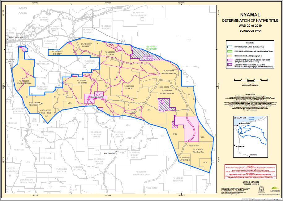
“Determination Area” means the land and waters described in Schedule One and depicted on the maps at Schedule Two;
“Exclusive Area” means those lands and waters of the Determination Area described in Schedule Three (which areas are generally shown as shaded green on the maps at Schedule Two);
“flowing water” means the following water within the Determination Area:
(a) water which flows, whether permanently, intermittently or occasionally, within any river, creek, stream or brook; and
(b) any natural collection of water into, through, or out of which a river, creek, stream or brook flows;
“land” has the same meaning as in the Native Title Act and, for the avoidance of doubt, includes any natural collection of water found on the land which does not fall within the definition of “waters”;
“Native Title Act” means the Native Title Act 1993 (Cth);
“Non-Exclusive Area” means those lands and waters of the Determination Area which are not Exclusive Areas or described in paragraph 2 as an area where native title does not exist (which areas are generally shown as shaded yellow on the maps at Schedule Two);
“Nyamal People” means the people referred to in Schedule Seven;
“Other Interests” means the legal or equitable estates or interests and other rights in relation to the Determination Area described in Schedule Six and referred to in paragraph 10;
“resources” means flora, fauna, and other natural resources such as charcoal, stone, soil, sand, clay, gravel, timber, resin and ochre (except, for the avoidance of doubt, ochres for use in the manufacture of porcelain, fine pottery or pigments which are minerals pursuant to the Mining Act 1904 (WA) (repealed));
“Titles Validation Act” means the Titles (Validation) and Native Title (Effect of Past Acts) Act 1995 (WA);
“use” does not include use by way of trade;
“underground water” means water from and including an underground water source, including water that percolates from the ground; and
“waters” has the same meaning as in the Native Title Act and includes flowing and underground water.
13. In the event of any inconsistency between the written description of an area in Schedule One, Three, Four, Five or Six and the area as depicted on the maps at Schedule Two the written description prevails.
SCHEDULE ONE
DETERMINATION AREA
The Determination Area, generally shown as bordered in blue on the maps at Schedule Two,
comprises all land and waters bounded by the following description:
All those lands and waters commencing at Latitude 20.455583 South and Longitude 118.782218 East being a point on the present boundary of Native Title Determination WAD6185/1998 Ngarla and Ngarla 2 (Area A) (WCD2007/003) and extending generally easterly along the boundaries of that native title determination to a point on the western boundary of Pastoral Lease N050091 (Strelley) at Latitude 20.448278 South; Then generally southerly, easterly and generally northerly along boundaries of that pastoral lease to the westernmost southwestern corner of Pastoral Lease N050454 (Panorama); Then northerly, easterly, generally northeasterly, generally northerly and again easterly along boundaries of that pastoral lease to the westernmost northwestern corner of Pastoral Lease N049987 (Eginbah); Then generally easterly along the boundaries of that pastoral lease to the intersection with a western boundary of Pastoral Lease N050507 (Muccan); Then northerly along the boundaries of that pastoral lease to the southernmost southeastern corner of Pastoral Lease N050027 (De Grey); Then generally westerly and northerly along the boundaries of that pastoral lease to Latitude 20.499104 South being a point on the present boundary of Native Title Determination WAD6185/1998 Ngarla and Ngarla 2 (Area A) (WCD2007/003); Then generally easterly and generally northeasterly along the boundaries of that native title determination to Latitude 20.340141 South, Longitude 119.642311 East; Then generally easterly through the following coordinate positions:
Latitude (South) | Longitude (East) |
20.339671 | 119.658516 |
20.344471 | 119.700816 |
20.355770 | 119.758716 |
20.368570 | 119.821916 |
20.377570 | 119.871216 |
20.383469 | 119.907716 |
20.394069 | 119.962316 |
20.408868 | 120.045616 |
20.410668 | 120.096817 |
20.418167 | 120.140517 |
20.422368 | 120.177316 |
20.436067 | 120.304016 |
Then southeasterly to a southwestern boundary of Reserve 12297 at Longitude 120.344825 East; Then generally southeasterly along the boundaries of that reserve to Longitude 120.767153 East; Then generally southeasterly through the following coordinate positions:
Latitude (South) | Longitude (East) |
20.639361 | 120.768315 |
20.641561 | 120.779115 |
20.644361 | 120.789915 |
20.647161 | 120.801415 |
20.650461 | 120.812115 |
20.654661 | 120.825915 |
20.658261 | 120.838415 |
20.661861 | 120.846115 |
20.667661 | 120.859015 |
20.670661 | 120.866115 |
20.677161 | 120.879015 |
20.684860 | 120.893615 |
20.694360 | 120.908615 |
20.698660 | 120.917415 |
20.702260 | 120.924415 |
20.705760 | 120.930815 |
20.708560 | 120.936115 |
20.711360 | 120.941315 |
20.713960 | 120.944815 |
20.717160 | 120.948115 |
20.720162 | 120.951753 |
20.783524 | 120.985634 |
Then easterly to a western boundary of Native Title Determination WAD6110/1998 Martu (Area A) (WCD2002/002) at Latitude 20.783613 South; Then southerly and easterly along the boundaries of that native title determination to the intersection with a western boundary of Reserve 12297 at Latitude 20.998625 South; Then generally southerly along the boundaries of that reserve to Latitude 21.118060 South; Then generally southerly and southeasterly through the following coordinate positions:
Latitude (South) | Longitude (East) |
21.124560 | 121.184017 |
21.132059 | 121.184518 |
21.138059 | 121.186317 |
21.145059 | 121.187418 |
21.152659 | 121.188517 |
21.160859 | 121.189517 |
21.169559 | 121.190418 |
21.169559 | 121.190418 |
21.178259 | 121.190718 |
21.185259 | 121.191218 |
21.190459 | 121.191918 |
21.195059 | 121.191418 |
21.201459 | 121.191318 |
21.208859 | 121.190518 |
21.219759 | 121.189418 |
21.239659 | 121.186018 |
21.251659 | 121.184718 |
21.268859 | 121.183519 |
21.296660 | 121.184919 |
21.309160 | 121.188519 |
21.312760 | 121.190019 |
21.316860 | 121.190819 |
21.322860 | 121.192619 |
21.330460 | 121.194319 |
21.335260 | 121.195719 |
21.339860 | 121.195819 |
21.348660 | 121.197319 |
21.351660 | 121.198319 |
21.357560 | 121.199519 |
21.365260 | 121.201819 |
21.372860 | 121.203419 |
21.376460 | 121.204319 |
21.381660 | 121.205019 |
21.384660 | 121.205919 |
21.387660 | 121.206820 |
21.391860 | 121.208320 |
21.401960 | 121.211520 |
21.404960 | 121.213120 |
21.408060 | 121.215220 |
21.412760 | 121.216620 |
21.419960 | 121.218920 |
21.426360 | 121.220120 |
21.433560 | 121.223120 |
21.438360 | 121.225020 |
21.442060 | 121.227120 |
21.445660 | 121.228620 |
21.449260 | 121.230120 |
21.452960 | 121.232220 |
21.457760 | 121.234820 |
21.462660 | 121.237420 |
21.468060 | 121.239920 |
21.472960 | 121.243120 |
21.478960 | 121.245620 |
21.483959 | 121.249420 |
21.487659 | 121.251520 |
21.490659 | 121.253720 |
21.494959 | 121.256320 |
21.499259 | 121.258320 |
21.508359 | 121.264221 |
21.512759 | 121.268121 |
21.517759 | 121.271921 |
21.521559 | 121.275221 |
21.525259 | 121.278021 |
21.528359 | 121.280121 |
21.531959 | 121.282221 |
21.535059 | 121.284421 |
21.538259 | 121.287121 |
21.542460 | 121.289221 |
21.546160 | 121.291921 |
21.549860 | 121.294621 |
21.554260 | 121.297921 |
21.557960 | 121.300621 |
21.561760 | 121.303921 |
21.566060 | 121.307221 |
21.570960 | 121.310420 |
21.575959 | 121.314220 |
21.580359 | 121.318120 |
21.584659 | 121.321420 |
21.589059 | 121.324720 |
21.593359 | 121.328020 |
21.597759 | 121.332520 |
21.602859 | 121.336920 |
21.609059 | 121.342520 |
21.614059 | 121.346320 |
21.618559 | 121.350820 |
21.623559 | 121.355320 |
21.627959 | 121.359820 |
21.632459 | 121.364320 |
21.637560 | 121.369320 |
21.642060 | 121.374520 |
21.647160 | 121.379520 |
21.651060 | 121.384720 |
21.655560 | 121.389220 |
21.663861 | 121.398920 |
21.674761 | 121.410220 |
21.683061 | 121.419320 |
21.686360 | 121.424020 |
21.689560 | 121.427320 |
21.691660 | 121.431520 |
21.693660 | 121.434420 |
21.696260 | 121.437220 |
Then southeasterly to a western boundary of Reserve 12297 at Latitude 21.697745 South; Then
generally southerly along the boundaries of that reserve to Latitude 22.176991 South, being a point on a northern boundary of Native Title Determination WAD6280/1998 Nyiyaparli People
(WCD2018/008); Then generally northwesterly along the boundary of that native title determination to the intersection with the easternmost northeastern point of Native Title Determination WAD23/2019 Palyku Part A (WCD2019/002); Then generally northerly, westerly, and southerly through the following coordinate positions:
Latitude (South) | Longitude (East) |
22.019390 | 120.965246 |
21.574907 | 120.788483 |
21.569416 | 120.767889 |
21.553970 | 120.715032 |
21.536123 | 120.650848 |
21.520677 | 120.596951 |
21.513813 | 120.572248 |
21.507978 | 120.557832 |
21.494935 | 120.539641 |
21.487041 | 120.523510 |
21.471939 | 120.500513 |
21.464388 | 120.486097 |
21.461299 | 120.478890 |
21.454091 | 120.449715 |
21.443107 | 120.414019 |
21.433840 | 120.379353 |
21.424230 | 120.344000 |
21.419425 | 120.324093 |
21.409814 | 120.281876 |
21.404322 | 120.255104 |
21.401577 | 120.240345 |
21.400890 | 120.227302 |
21.399517 | 120.205336 |
21.402263 | 120.174102 |
21.405695 | 120.155911 |
21.406725 | 120.093443 |
21.406039 | 120.047107 |
21.404666 | 120.031662 |
21.396771 | 120.016560 |
21.386131 | 120.002830 |
21.381326 | 119.990474 |
21.369999 | 119.971253 |
21.356614 | 119.951003 |
21.347346 | 119.936587 |
21.337049 | 119.915650 |
21.326409 | 119.897802 |
21.320918 | 119.884073 |
21.314396 | 119.870344 |
21.309591 | 119.862106 |
21.301354 | 119.856271 |
21.294146 | 119.852839 |
21.285908 | 119.851466 |
21.279044 | 119.846661 |
21.272522 | 119.840140 |
21.267031 | 119.834305 |
21.265658 | 119.826410 |
21.266344 | 119.806846 |
21.267031 | 119.790028 |
21.268747 | 119.770464 |
21.269090 | 119.736484 |
21.270463 | 119.709026 |
21.271836 | 119.681224 |
21.272522 | 119.659944 |
21.272866 | 119.646558 |
21.275611 | 119.629053 |
21.278357 | 119.610176 |
21.284535 | 119.582374 |
21.290027 | 119.548395 |
21.292086 | 119.530547 |
21.299637 | 119.505834 |
21.304786 | 119.487643 |
21.307875 | 119.468079 |
21.311650 | 119.444739 |
21.316112 | 119.420027 |
21.320231 | 119.395314 |
21.322291 | 119.385361 |
21.323320 | 119.376093 |
21.330871 | 119.364424 |
21.342541 | 119.344516 |
21.352152 | 119.326668 |
21.366224 | 119.305731 |
21.395055 | 119.277243 |
21.423543 | 119.247382 |
21.471252 | 119.205165 |
Then southwesterly along a line joining coordinate positions Latitude 21.471252 South, Longitude 119.205165 East and Latitude 21.511067 South, Longitude 119.174274 East to the intersection of a line joining coordinate positions Latitude 21.513187 South, Longitude 119.182725 East and Latitude 21.490587 South, Longitude 119.162025 East; Then generally northwesterly through the following coordinate positions:
Latitude (South) | Longitude (East) |
21.490587 | 119.162025 |
21.468087 | 119.143025 |
21.446087 | 119.124325 |
21.429687 | 119.111625 |
21.412887 | 119.102125 |
21.392387 | 119.090525 |
Then northwesterly to the northernmost northeastern corner of Reserve 22626; Then westerly along the northern boundary of that reserve to an intersection with the eastern boundary of Native Title Determination WAD47/2014 Kariyarra - Abydos (WCD2018/015); Then generally northwesterly along the boundary of that native title determination to the intersection with the eastern boundary of Native Title Determination WAD6169/1998 Kariyarra People (WCD2018/015); Then generally northwesterly along the boundary of that native title determination to the intersection with the eastern boundary of Native Title Determination WAD232/2009 Kariyarra - Pipingarra (WCD2018/015); Then generally northeasterly along the boundary of that native title determination back to the commencement point.
Note: Geographic Coordinates provided in Decimal Degrees.
Cadastral boundaries sourced from Landgate’s Spatial Cadastral Database dated 01 July 2019.
For the avoidance of doubt the application excludes any land and waters already claimed by:
Native Title Determination WAD77/2005 Ngarla Overlap Proceeding (WCD2013/001) as Determined in the Federal Court on 19/02/2013.
Native Title Determination WAD6185/1998 Ngarla and Ngarla 2 (Area A) (WCD2007/003) as Determined in the Federal Court on 30/05/2007.
Native Title Determination WAD6281/1998 Nyangumarta People (Part A) (WCD2009/001) as Determined in the Federal Court on 11/06/2009.
Native Title Determination WAD6110/1998 Martu (Area A) (WCD2002/002) as Determined in the Federal Court on 27/09/2002.
Native Title Determination WAD6280/1998 Nyiyaparli People (WCD2018/008) as Determined in the Federal Court on 26/09/2018
Native Title Determination WAD23/2019 Palyku Part A (WCD2019/002) as Determined in the Federal Court on 12/03/2019.
Native Title Determination WAD6169/1998 Kariyarra People (WCD2018/015) as Determined in the Federal Court on 13/12/2018.
Native Title Determination WAD232/2009 Kariyarra - Pipingarra (WCD2018/015) as Determined in the Federal Court on 13/12/2018.
Native Title Determination WAD47/2014 Kariyarra - Abydos (WCD2018/015) as Determined in the Federal Court on 13/12/2018.
Native Title Determination Application WAD26/2019 Njamal People #10 (WC2000/005).
Native Title Determination Application WAD23/2019 Palyku (WC1999/016).
Native Title Determination Application WAD483/2018 Palyku #2 (WC2018/022).
Datum: Geocentric Datum of Australia 1994 (GDA94)
Prepared By: Graphic Services (Landgate) 30 July 2019
Use of Coordinates:
Where coordinates are used within the description to represent cadastral or topographical boundaries or the intersection with such, they are intended as a guide only. As an outcome to the custodians of cadastral and topographic data continuously recalculating the geographic position of their data based on improved survey and data maintenance procedures, it is not possible to accurately define such a position other than by detailed ground survey.
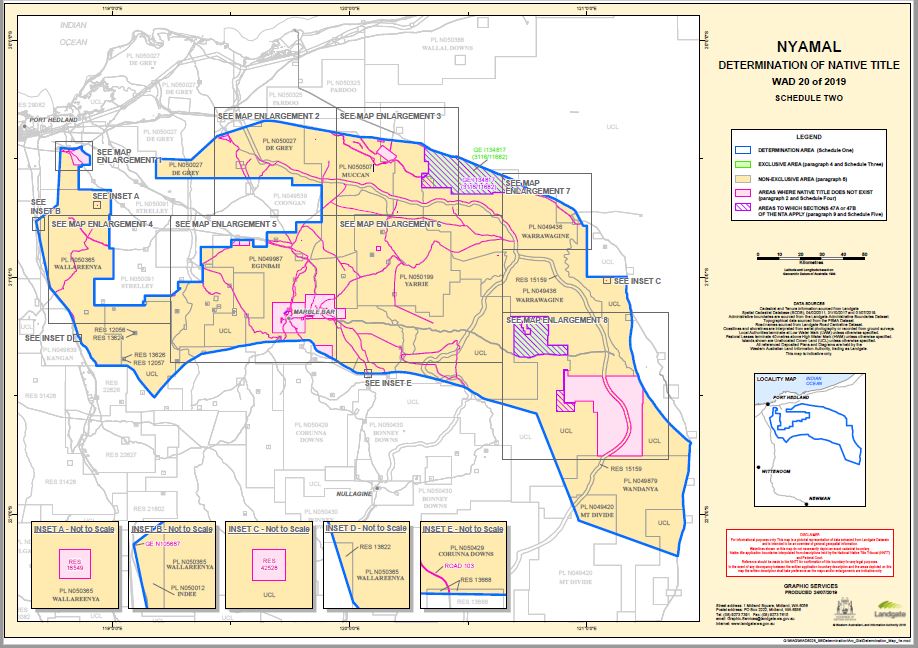
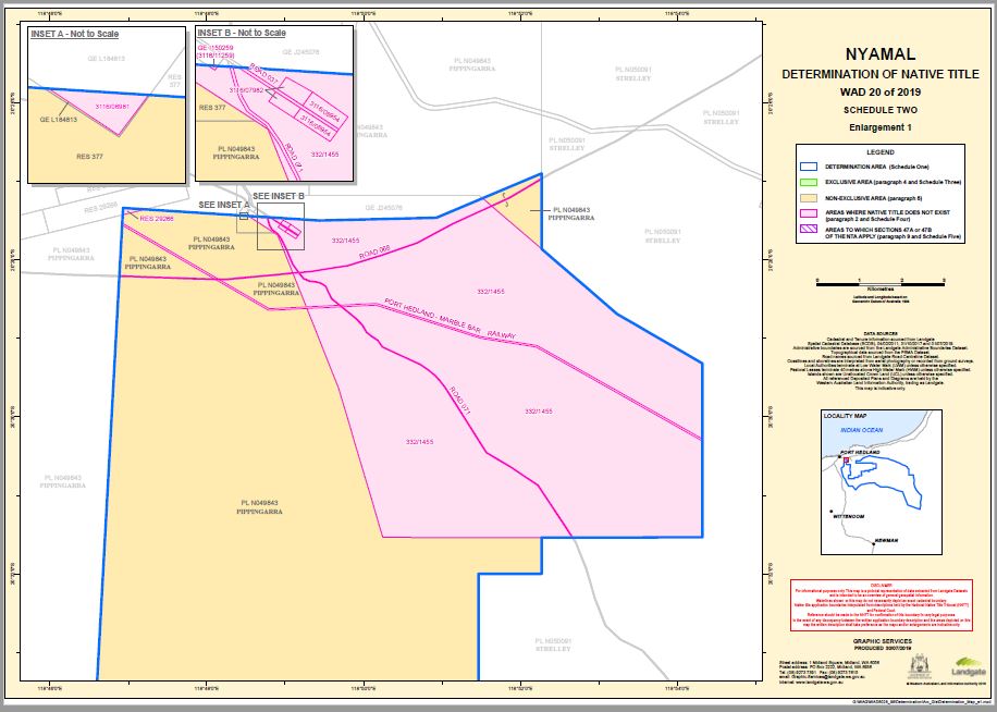
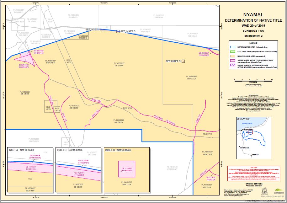
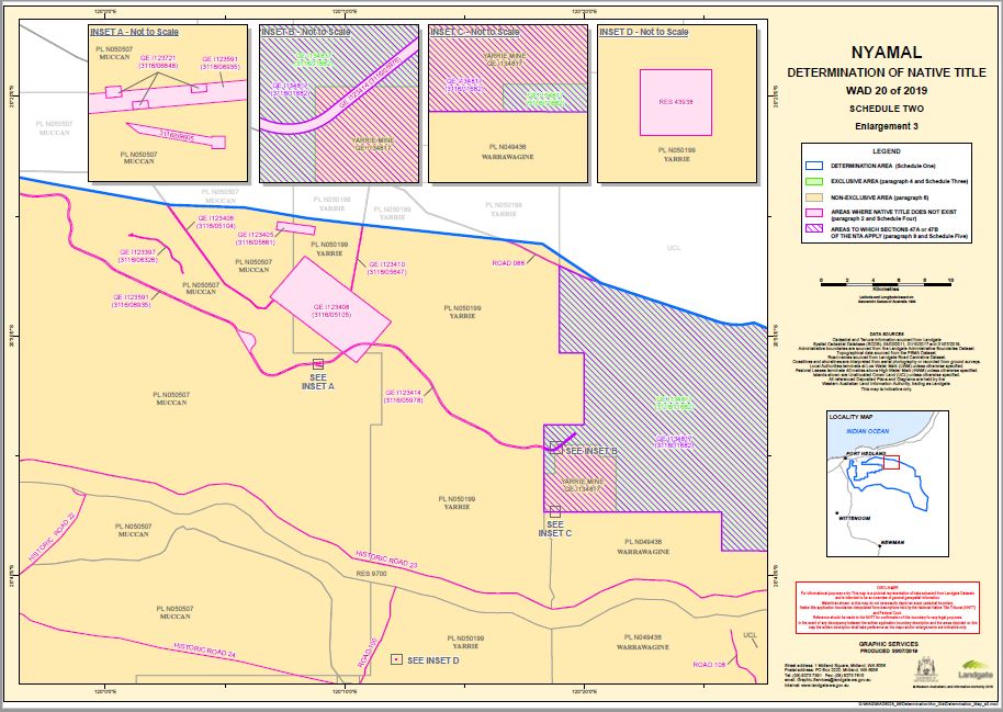
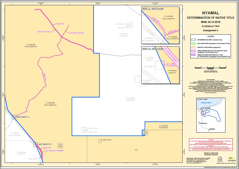
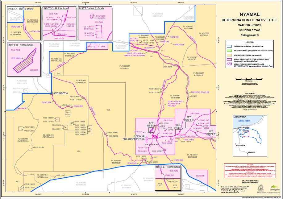
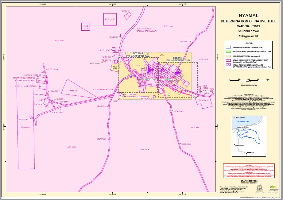
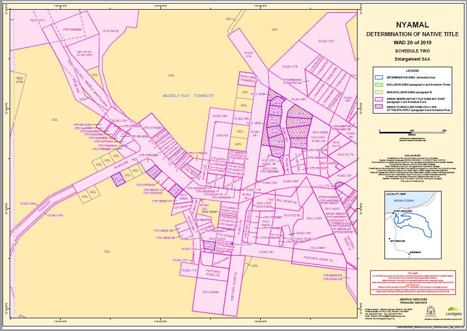
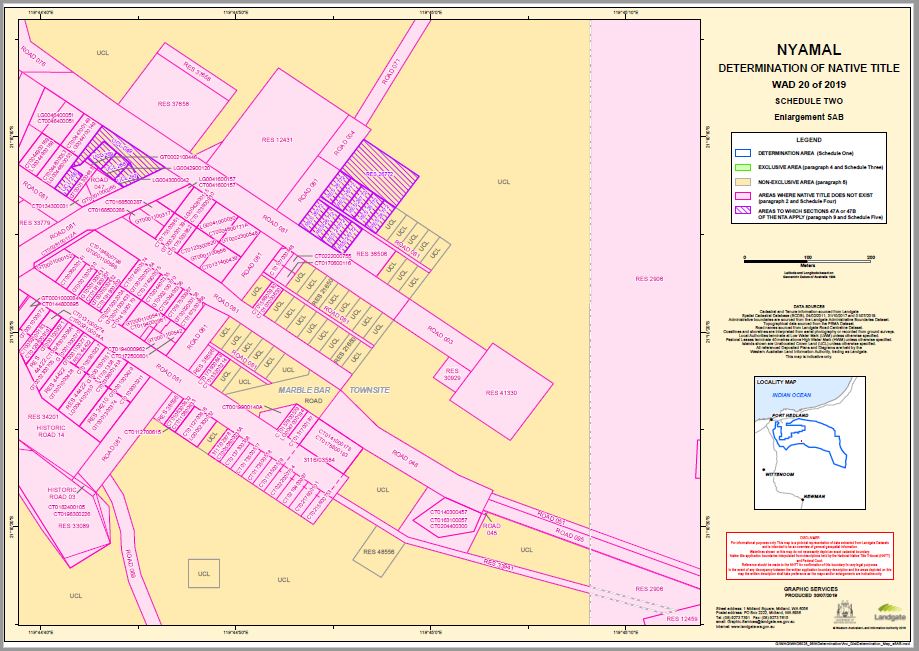
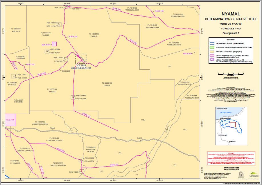
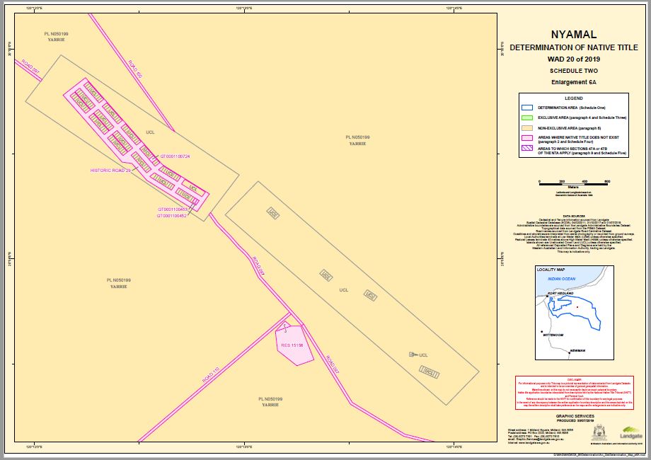
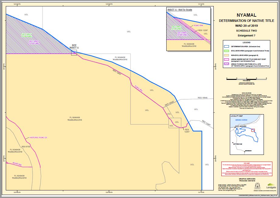
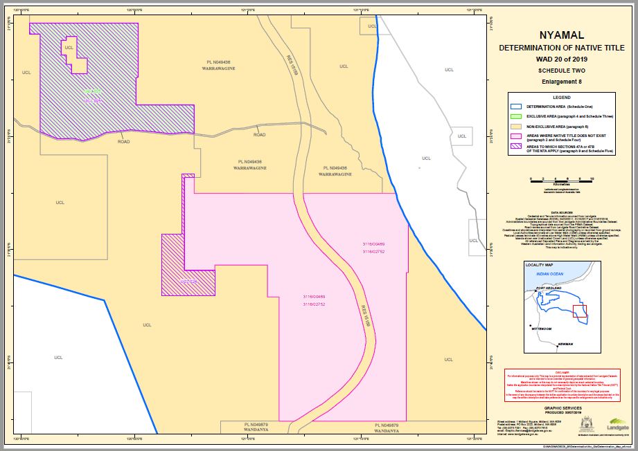
SCHEDULE TWO
MAPS OF THE DETERMINATION AREA
SCHEDULE THREE
EXCLUSIVE AREA
Areas where native title comprises the rights set out in paragraph 4 of the Determination.
Native title comprises the rights and interests set out in paragraph 4 of the Determination in relation to the land and waters the subject of the following interests (which areas are generally shown as shaded green on the maps at Schedule Two).
Tenure ID. | Description |
GE I134817 (SL 3116/11682) (part) | That part of Lease GE I134817 (being a lease for the purpose of Use and Benefit of Aboriginal Inhabitants (De Grey Location 102)) not subject to the Yarrie Mine |
UCL 025 (part) | That part of UCL 025 not subject to, or formerly subject to, mining leases M 4500434 and M 4500435 |
For the purpose of this Schedule Yarrie Mine comprises all those land and waters bounded by the following description:
All those lands and waters commencing at the intersection of a western boundary of General Lease I134817 with a northern boundary of Mining Lease M45/1018-I at approximately 219,108.663mE, 7,720,257.045mN and extending easterly along the boundary of that mining lease to the intersection with a western boundary of Mineral Lease S.A. ML 249SA at approximately 219,900.414mE, 7,720,268.823mN; Then northerly, easterly and southerly along boundaries of that mineral lease S.A. to the intersection with a northern boundary of Mining Lease S.A. M263SA at approximately 223,080.003mE, 7,721,622.474mN; Then easterly, southerly and westerly along boundaries of that mining lease S.A. to the intersection with a western boundary of Mining Lease M45/1016-I at approximately 219,966.333mE, 7,717,359.963mN; Then southerly along the boundary of that mining lease to the intersection with a southern boundary of General Lease I134817; Then westerly and northerly along the boundary of that general lease back to the commencement point.
EXCLUSIONS
All that land being the subject of General Lease I123414 which, to avoid doubt, is an area where native title does not exist.
Note: Cadastral boundaries sourced from Landgate’s Spatial Cadastral Database dated 31st October 2017.
Mining Tenements sourced from Department of Mines, Industry Regulation and Safety as at 25th October 2017.
Datum: MGA94, Grid Coordinates (Easting, Northing, Zone 51)
Prepared By: Graphic Services (Landgate) 7th March 2018
Use of Coordinates:
Where coordinates are used within the description to represent cadastral or topographical boundaries or the intersection with such, they are intended as a guide only. As an outcome to the custodians of cadastral and topographic data continuously recalculating the geographic position of their data based on improved survey and data maintenance procedures, it is not possible to accurately define such a position other than by detailed ground survey.
SCHEDULE FOUR
AREAS WHERE NATIVE TITLE DOES NOT EXIST (Paragraph 2)
Native title does not exist in relation to land and waters the subject of the following interests within the Determination Area which, with the exception of public works (as described in clause 6 of this Schedule), are generally shown as shaded in pink on the maps at Schedule Two:
1. Freehold
The following grants of estates in fee simple within the Determination Area:
Certificate of Title | Certificate of Title | Certificate of Title | ||
CT0004600171A | CT0044900169 | CT0131700923 | ||
CT0006000006 | CT0046400051 | CT0131700924 | ||
CT0006000141 | CT0046400089 | CT0133300038 | ||
CT0007500200A | CT0047700154 | CT0133700826 | ||
CT0008500172 | CT0050800035A | CT0133700827 | ||
CT0008500177 | CT0059100183 | CT0133700828 | ||
CT0017900106A | CT0103600930 | CT0134300031 | ||
CT0017900107A | CT0105900237 | CT0135000147 | ||
CT0017900108A | CT0106300632 | CT0135000148 | ||
CT0017900109A | CT0107000630 | CT0135000149 | ||
CT0019200097A | CT0107000848 | CT0135000150 | ||
CT0019200141A | CT0109000211 | CT0135200214 | ||
CT0019900140A | CT0110800633 | CT0136000155 | ||
CT0025800064 | CT0112700615 | CT0137300358 | ||
CT0028100112A | CT0112700616 | CT0140300457 | ||
CT0028300006A | CT0123300620 | CT0141000178 | ||
CT0030600141A | CT0125200962 | CT0141900170 | ||
CT0032100014A | CT0129600919 | CT0144800895 | ||
CT0035500077A | CT0131000273 | CT0144800896 | ||
CT0041600157 | CT0131000274 | CT0146500853 | ||
CT0042100119A | CT0131400439 | CT0146700526 | ||
CT0044700149 | CT0177500958 | CT0150100292 | ||
CT0044800053 | CT0131700187 | CT0277200137 | ||
CT0150100291 | CT0131700922 | CT0288300370 | ||
CT0156800930 | CT0177500960 | CT0222000755 | ||
CT0157800579 | CT0179700295 | GT0001000069 | ||
CT0163100057 | CT0179700296 | GT0001000070 | ||
CT0164400586 | CT0180000107 | GT0001000071 | ||
CT0164400587 | CT0180000108 | GT0001000072 | ||
CT0164400588 | CT0180000109 | GT0001000073 | ||
CT0164400589 | CT0180200838 | GT0001000084 | ||
CT0167500966 | CT0180200839 | GT0001000151 | ||
CT0167500967 | CT0181300156 | GT0001000152 | ||
CT0168500287 | CT0182100785 | GT0001000265 | ||
CT0168500288 | CT0182400105 | GT0001000427 | ||
CT0170600116 | CT0183700949 | GT0001000428 | ||
CT0170600277 | CT0183800930 | GT0001000429 | ||
CT0170600278 | CT0184800798 | GT0001000430 | ||
CT0170600279 | CT0186300113 | GT0001000431 | ||
CT0172500601 | CT0190100110 | GT0001000432 | ||
CT0173100714 | CT0190700326 | GT0001000433 | ||
CT0173200920 | CT0191900201 | GT0001100271 | ||
CT0173200921 | CT0191900202 | GT0001100317 | ||
CT0173500517 | CT0194000961 | GT0001100406 (part) 1 | ||
CT0173500518 | CT0194000962 | GT0001100407 | ||
CT0173500519 | CT0196000347 | GT0001100452 | ||
CT0173600849 | CT0197200664 | GT0001100453 | ||
CT0174800644 | CT0198300226 | GT0001100541 | ||
CT0174900574 | CT0199700479 | GT0001100542 | ||
CT0174900575 | CT0204400300 | GT0001100543 | ||
CT0175500861 | CT0204400335 | GT0001100598 | ||
CT0175500862 | CT0204400336 | GT0001100656 | ||
CT0175800183 | CT0215600753 | GT0001100724 | ||
CT0177500956 | CT0215600754 | GT0001300329 | ||
CT0177500957 | CT0219400997 | GT0001300374 | ||
GT0002000138 | CT0222000754 | GT0001300463 (part) 2 | ||
CT0177500959 | CT0217600101 | GT0002000139 | ||
GT0002000406 | CT0219400906 | GT0002000164 | ||
GT0002100446 (part) 3 | LG0041600157 | LG0044700149 | ||
GT0002100770 | LG0042600171 | LG0044800053 | ||
GT0002300210 | LG0042700199 | LG0044900169 | ||
GT0002300548 | LG0042800115 | LG0046400051 | ||
GT0002300705 | LG0042900120 (part) 4 | LG0047000194 | ||
LG0041000030 | LG0043000042 (part) 5 | LG0052300032 | ||
LG0044100150 |
1 To the extent not subject to the application of section 47B of the Native Title Act: see Schedule Five
2 To the extent not subject to the application of section 47B of the Native Title Act: see Schedule Five
3 To the extent not subject to the application of section 47B of the Native Title Act: see Schedule Five
4 To the extent not subject to the application of section 47B of the Native Title Act: see Schedule Five
5 To the extent not subject to the application of section 47B of the Native Title Act: see Schedule Five
2. Reserves
The following Reserves:
Reserve No. | Current / Last Purpose |
02338 | Park and Drainage |
02339 | Public Buildings |
02906 (part) 6 | Common |
07080 | Public Utility and Stopping Place for Travellers and Stock |
Former 10717 | Recreation |
12233 | Sanitary Site |
12431 | School Site |
12459 | Mineral Processing |
13157 | Explosives |
14700 | Water Supply |
15156 | State Battery Site |
16549 | Water |
17139 | Water |
18404 | Use and Benefit of Aboriginal Inhabitants |
24096 | Park and Recreation |
25354 | Recreation |
26960 | Park and Drainage |
27265 | Recreation |
28380 | Native Ceremonial Grounds |
29266 | Gravel |
29796 | Water Supply |
29882 | Public Recreation (Children’s Playground) |
30929 | Water Supply |
31047 | Preservation of Natural Formations |
Former 31655 | Use and Benefit of Aboriginal Inhabitants |
Former 32403 (part) 7 | Open Air Picture Theatre |
32622 | Water Supply |
Former 33089 | Use and Requirements of the Shire of East Pilbara |
33604 | Housing (Community Health Services) |
33778 | Power Station Site |
33779 | Power Station Site and Depot |
33941 | Pipeline |
34048 | Depot and Fire Station |
34201 | Recreation |
Former 34210 | Civic Purposes |
35814 | Water Supply |
36431 | Hospital Site |
Former 36506 | Radio and Television Station Site |
37658 | Water Storage |
38596 | Drainage |
38639 | Cemetery Site |
39032 | Water Supply |
39425 | Park and Drainage |
41179 | Mining |
41330 | Communications Aerial |
41518 | Repeater Station Site |
42413 | Repeater Station Site |
42528 | Repeater Station Site |
43938 | Repeater Station Site |
44422 | Tourism and Related Activities |
48556 | Automatic Weather Station |
6 Area as vested pursuant to section 33 of the Land Act 1933 (WA) on 16 November 1973, to the extent not subject to the application of section 47A of the Native Title Act (being Reserve 39860): see Schedule Five
7 To the extent not subject to the application of section 47B of the Native Title Act: see Schedule Five
3. Leases
The following leases:
Lease No. | Current / Last Purpose |
Special Leases | |
GE I123397 (SL 3116/06326) | Boring for conserving, reticulating and drawing water |
GE I123406 (SL 3116/05104) | Construction, erection, development, maintenance, use and operation of a power transmission line between Goldsworthy / Shay Gap / Kennedy Gap and all ancillary installations and facilities |
GE I123405 (SL 3116/05661) | Laying out, development, operation and use of an aerodrome |
GE I123408 (SL 3116/05105 ) | Laying out, development, operation and use of a townsite |
GE I123410 (SL 3116/05647) | Boring for conserving, reticulating and drawing water |
Former GE I123414 (SL 3116/05978) | Construction, upgrading, re-alignment, operation and use of a railway including all necessary bridges, culverts, crossing places, signalling switch and other gear and all proper or usual works therefore |
Former GE I123591 (SL 3116/06935) | Construction, upgrading, re-alignment, operation and use of a railway including all necessary bridges, culverts, crossing places, signalling switch and other gear and all proper or usual works therefore |
Former GE I123662 (SL 3116/08262) | Construction, erection, installation, operation, use and maintenance of a television and radio transmission mast for the transmission of television and radio signals from Mount Goldsworthy to Shay Gap |
GE I123721 (SL 3116/06648) | Boring for conserving, reticulating and drawing water |
Former GE I126953 (SL 3116/11323) | Residence and Grazing |
Former GE I127594 (SL 3116/11249) | Residence |
Former GE I131321 (SL 3116/11427) | Light Industry |
Former GE I134597 (SL 3116/11571) | Residence |
GE I150259 (SL 3116/11259) | Agriculture |
Former GE I150518 (SL 3116/11094) | Residence and Grazing |
GE I154279 (SL 3116/03687) | Construction, development, maintenance, use and operation of a railway and ancillary installations and facilities including a service road between the mine townsite and the port |
Former SL 3116/09892 (currently GE L546512) | Residence and Agriculture |
Former SL 3116/10118 (currently GE L557207) | Residence |
Former SL 3116/10151 (currently GE L594979) | Horticulture and Storage |
Former SL 1874/152 | Market Garden |
Former SL 3116/00469 (part) 8 | Grazing |
Former SL 3116/02752 (part) 9 | Grazing |
Former SL 3116/03462 | Boring for conserving, reticulation and drawing water |
Former SL 3116/03584 | Residence |
GE N105667 (SL 3116/04028) | Construction, development, maintenance, use and operation of radio communications and ancillary installations and facilities between the mine and the port |
Former SL 3116/04491 | Boring for conserving, reticulation and drawing water |
Former SL 3116/05870 | Boring for conserving, reticulation and drawing water |
Former SL 3116/06140 | Boring for conserving, reticulation and drawing water |
Former SL 3116/06981 | Market Gardening |
Former SL 3116/07982 | Market Garden |
Former SL 3116/08954 | Agriculture |
Former SL 3116/09170 | Residential Purposes |
Former SL 3116/09373 | Residence and Agriculture |
Former SL 3116/09605 | Construction, erection, installation, operation, use and maintenance of water supply facilities for the supply of water to the minesite at Shay Gap |
Former SL 3116/10206 | Residence and Agriculture |
Former SL 3117/01358 | Town or Suburban Lot |
Former SL 3117/02878 | Town or Suburban Lot |
Reserve Leases | |
Former RL 332/0568 | Grazing (granted over Reserve 07979) |
Former RL 332/1455 | Grazing (granted over Reserve 16473) |
Former RL 333/0720 | Rifle Range (granted over Reserve 38097) |
Former RL 409/41A | Pastoral Purposes (granted over Reserve 07969) |
Former RL 452/41A | Pastoral Purposes (granted over Reserve 10079) |
Former RL 472/41A | Pastoral Purposes (granted over Reserve 10079) |
8 To the extent not subject to the application of section 47B of the Native Title Act: see Schedule Five
9 To the extent not subject to the application of section 47B of the Native Title Act: see Schedule Five
4. Roads
The following dedicated roads, roads set aside, taken or resumed or roads which are to be considered public works (as that expression is defined in the Native Title Act and the Titles Validation Act):
MapInfo ID. | Description | Shown on |
Road 001 | Portion of McLeod Close | DP 168895 & CPP 504674 |
Road 002 | Portion of Lynas Road and General Street | DP 171725 & CPP 504674 |
Road 003 | Portion of Augusta Street | DP 174422 |
Road 004 | Portion of Contest Street | DP 175227 |
Road 005 | Portion of Station Street | DP 216242 |
Road 031 | Portion of Nichols Street | DP 181717 |
Road 032 | Portion of Nichols Street | DP 188859 |
Road 033 | Portion of Nichols Street | DP 192339 |
Road 034 | Portion of Nichols Street | DP 192340 |
Road 036 | Portions of Nichols Street, Comet Mine Road and General Street | DP 211568 |
Road 037 | Unnamed road | DP 213482 |
Road 039 | Portion of General Street | DP 216158 |
Road 041 | That road running between Garden Road and Lot 70 | DP 216831 |
Road 042 | Portion of General Street | DP 217447 |
Road 044 | Portion of Road No. 6443 (Comet Mine Road) | DP 215269 & Gaz 15/04/1983 |
Road 045 | Portion of Road No. 6443 (Halse Road) | DP 189122 & Gaz 17/05/1991 |
Road 046 | Portion of General Street | DP 172372, DP 171725 & CPP 504673 |
Road 047 | Green Street | DP 176130 |
Road 048 | Portion of Halse Road | DP 180945 |
Road 049 | Portion of McLeod Close | DP 217408 |
Road 051 | Portion of Road No. 06443 (Halse Road) | DP 184045 |
Road 052 | Road No. 14845 | Map SF 50-4 1:250,000 & Gaz 24/08/1973 |
Road 053 | Road No. 15203 | DP 212032 & Gaz 19/07/1974 |
Road 056 | Portion of Road No. 16872 (Marble Bar Pool Road) | DP 215269 & Gaz 07/01/1983 |
Road 057 | Road No. 16873 (Garden Road) | DP 215269 & Gaz 15/04/1983 |
Road 058 | Portion of Road No. 16872 (Marble Bar Pool Road) | DP 215269 & Gaz 07/01/1983 |
Road 063 | Portion of Road No. 17406 (North Pole Road) | DP 216311 |
Road 064 | Portion of Road No. 17406 (North Pole Road) | DP 216312 |
Road 065 | Portion of Road No. 17406 (North Pole Road) | DP 216313 |
Road 066 | Portion of General Street | DP 172372, DP 171725 & CPP 504673 |
Road 068 | Portion of Road No. 00432 | CPP 506015, DP 42630, Map SF 50-4 and part SE 50-16 1:250,000 & Gaz 22/06/1894 |
Road 069 | Road No. 00762 | CPP 503190, CPP 503163 & Gaz 02/12/1898 |
Road 071 | Road No. 02856 | Map 2657 1:100,000, Map SF 50-4 1:250,000, Map 28551:100,000 & Gaz 06/09/1907 |
Road 073 | Portion of Road No. 06443 | CPP 503187, DP 221153, DP 221152 & Map 2855 1:100,000 |
Road 076 | Portions of Bohemia, Ironclad and Augusta Streets | CPP 504674 & CPP 504675 |
Road 080 | Portions of Exhibition and Ironclad Streets | DP 222775 |
Road 081 | Portions of Bohemia, Augusta, Ironclad, Excelsior General, Francis, Hope and Contest Streets and portion of that road running between Bohemia Street and Davis Avenue | DP 222776 & CPP 504675 |
Road 085 | Portion of Exhibit Street and Lynas Road | CPP 504674 & CPP 504675 |
Road 087 | Road No. 04109 | CPP 503187 & Gaz 24/06/1932 |
Road 088 | Road No. 04274 | CPP 503194, CPP 503189 & CPP 503177 |
Road 089 | Road No. 06436 | CPP 503187 & Gaz 29/04/1921 |
Road 090 | Road No. 06438 | CPP 503176, CPP 503187, Map SF 50-4 1:250,000 & Gaz 29/04/1921 |
Road 091 | Road No. 06439 | CPP 503187 & Gaz 29/04/1921 |
Road 092 | Road No. 06440 | CPP 503178, CPP 503187 & Gaz 29/04/1921 |
Road 093 | Road No. 06441 | Map SF 50-4 1:250,000 & Gaz 29/04/1921 & 13/07/1979 |
Road 094 | Road No. 06442 | CPP 503187 & Gaz 29/04/1921 |
Road 095 | Road No. 06443 | Map SF 50-8 1:250,000, Map 2855 1:100,000, Map SF 51-5 1:250,000 & Gaz 29/04/1921 |
Road 096 | Road No. 06444 | Map SF 50-4 1:250,000, Map SF 50-8 1:250,000, Map 2855 1:100,000 & Gaz 29/04/1921 |
Road 097 | Road No. 06445 | CPP 503178, CPP 503187 & Gaz 29/04/1921 & 06/05/1921 |
Road 098 | Road No. 06446 | CPP 503189, Map SF 51-5 1:250,000 & Gaz 29/04/1921 & 11/10/1935 |
Road 100 | Road No. 06448 | CPP 503187 & Gaz 29/04/1921 |
Road 101 | Road No. 07047 | Map SF 50-4 1:250,000, Map SF 51-1 1:250,000 & Gaz 11/01/1924 |
Road 103 | Road No. 07346 | CPP 503164, CPP 503187, DP 238589, DP 238674 & Gaz 29/05/1925 & 05/06/1925 |
Road 104 | Road No. 07362 | CPP 503187, CPP 506008 & Gaz 26/06/1925 |
Road 105 | Road No. 07757 | Map 50-4 1:250,000 & Gaz 26/08/1927 |
Road 106 | Road No. 07761 | Map 50-4 1:250,000 & Gaz 26/08/1927 |
Road 107 | Road No. 08625 | CPP 503159, Map 50-4 1:250,000 & Gaz 23/01/1931 |
Road 108 | Road No. 08626 | CPP 503189, Map SF 51-1 1:250,000 & Gaz 23/01/1931 & 03/05/1946 |
Road 109 | Road No. 09178 | CPP 506006, Map SF 50-8 1:250,000 & Gaz 17/03/1933 |
Road 110 | Road No. 09179 | CPP 503189 & Gaz 31/03/1933 |
Road 113 | Road No. 10217 | Map SF 51-5 1:250,000 & Gaz 09/05/1958 |
Road 115 | Portion of South and Nichols Streets | CPP 504675 |
Road 116 | Portion of General and Bohemia Streets | DP 46857 |
Historical Road 02 | Portion of Bohemia Street | DP 183133 & DP 216242 |
Historical Road 03 | Portion of Contest Street | DP 190868 & DP 180580 |
Historical Road 04 | Portion of Davis Avenue | CPP 504674 & DP 168895 |
Historical Road 05 | Portion of General Street | DP 22775 & DP 222777 |
Historical Road 06 | Portion of McLeod Close | CPP 504674 & DP 168895 |
Historical Road 07 | Portion of Road No. 16873 (Garden Road) | DP 215269, DP 216831 & Gaz 15/04/1983 |
Historical Road 08 | Portion of Nichols and South Streets (now Lot 270 on DP 181717) | CPP 504674 & DP 172372 |
Historical Road 09 | Portion of Station Street (now Lots 276 and 288 on DP 216242) | DP 183133 |
Historical Road 14 | Portion of Davis Avenue (now Lot 290 on DP 91703) | CPP 504674, DP 180580 & DP 222776 |
Historical Road 15 | Portion of road running between Bohemia Street and Davis Avenue | CPP 504675 |
Historical Road 22 | Portion of Road No. 04109 | CPP 503187 & Gaz 24/06/1932 |
Historical Road 23 | Portion of Road No. 06438 | CPP 503176, CPP 503187, Map SF 50-4 1:250,000 & Gaz 29/04/1921 |
Historical Road 24 | Portion of Road No. 06440 | CPP 503187 & Gaz 18/12/1959 |
Historical Road 26 | Portion of Road No. 07362 | CPP 503187, CPP 506008 & Gaz 26/06/1925, 03/07/1925 & 20/11/1925 |
Historical Road 27 | Portion of Road No. 14845 | Map SF 50-4 1:250,000 & Gaz 24/08/1973 |
Historical Road 28 | Portion of Marble Bar Road | Map SF 50-4 1:250,000 & Map SF 50-8 1:250,000 |
Historical Road 29 | All those roads within the townsite of Bamboo | DP 222065 |
- | Portion of Marble Bar Road (being Lot 309 on DP 58954, formerly subject to portion of CT0262500353) | DP 58954 |
- | Portion of Marble Bar Road (being Lot 310 on DP 58956, formerly subject to portion of Reserve 17139) | DP 58956 |
5. Railways
The former Port Hedland to Marble Bar Railway constructed pursuant to the Port Hedland - Marble Bar Railway Act 1907 (WA) (repealed) and whose line is generally described in the Schedule to that Act.
6. Compulsory Acquisitions
The land and waters the subject of the following Taking Orders:
Taking Order | Description |
L653793 | Lot 555 on DP 61553 |
7. Public Works
Any other public works as that expression is defined in the Native Title Act and the Titles Validation Act (including the land and waters on which a public work is constructed, established or situated as described in section 251D of the Native Title Act) and to which section 12J of the Titles Validation Act or section 23C(2) of the Native Title Act applies.
SCHEDULE FIVE
AREAS TO WHICH SECTIONS 47A and 47B OF THE NATIVE TITLE ACT APPLY (Paragraph 9)
1. Section 47A
Section 47A of the Native Title Act applies with the effect that any extinguishment by the creation of the following interests (and by the creation of any other prior interests in relation to the area of the following interests) is to be disregarded:
Interest | Description / Purpose |
Reserve 03838 (part) | That part of Reserve 03838 (Use and Benefit of Aboriginal Inhabitants) not formerly subject to Historical Road 06 |
Reserve 26772 | Use and Requirements of the Local Aboriginal People |
Reserve 30888 | Housing (Native Welfare Department) |
Reserve 39860 | Use and Benefit of Aboriginal Inhabitants |
GE I134817 (SL 3116/11682) | Lease for the purpose of Use and Benefit of Aboriginal Inhabitants (De Grey Location 102) |
2. Section 47B
Section 47B of the Native Title Act applies with the effect that any extinguishment over the following areas by the creation of a prior interest (to the extent that the areas were not covered by an interest described in section 47B(1)(b)(i) or (ii) or subject to a resumption process as described in section 47B(1)(b)(iii) of the Native Title Act when the relevant native title determination application was made) is to be disregarded:
MapInfo ID. | Description |
UCL 024 (part) | That part of UCL 024 formerly subject to portion of special leases SL 3116/00469 and SL 3116/02752 |
UCL 025 (part) | That part of UCL 025 not subject to, or formerly subject to, mining leases M 4500434 and M 4500435 |
UCL 049 | Whole of UCL 049, formerly subject to portions of freehold titles GT0001300463, GT0002100446, LG0043000042 and LG0042900120 |
UCL 050 | Whole of UCL 050, formerly subject to portion of Reserve 32403 and portion of freehold title GT0001100406 |
UCL 263 | Whole of UCL 263 (being Lot 333 on DP 188859 [LR 3013/394]), formerly subject to freehold title CT0183700948 and portion of Reserve 32403 |
UCL 266 | Whole of UCL 266 (being Lot 258 on DP 180562 [LR 3013/407]), formerly subject to portion of freehold title GT0001300463 |
UCL 267 | Whole of UCL 267 (being Lot 259 on DP 176130 [LR 3013/408]), formerly subject to portions of freehold titles LG0042900120 and LG0043000042 |
UCL 268 | Whole of UCL 268 (being Lot 260 on DP 176130 [LR 3013/409]), formerly subject to portions of freehold titles LG0042900120 and LG0043000042 |
UCL 269 | Whole of UCL 269 (being Lot 261 on DP 176130 [LR 3013/410]), formerly subject to portions of freehold titles LG0042900120 and GT0002100446 |
UCL 272 | Whole of UCL 272 (being Lot 212 on DP 172283 [LR 3027/981]), formerly subject to Reserve 29191 |
SCHEDULE SIX
OTHER INTERESTS (Paragraph 10)
The nature and extent of the Other Interests in relation to the Determination Area are as follows:
Land tenure interests registered with the Western Australian Land Information Authority are current as at 6 May 2019. Mining tenements and petroleum interests registered with the Department of Mines, Industry Regulation and Safety are current as at 31 July 2019. All other interests are current as at the date of the determination.
1. Reserves
(a) The following reserves:
Reserve No. | Current / Last Purpose |
00377 | Water |
03838 | Use and Benefit of Aboriginal Inhabitants |
04783 | Cemetery |
04975 | Water |
04978 | Water |
08288 | Water |
08289 | Water |
09700 | De Grey - Peak Hill Stock Route |
11280 | Water |
11293 | Water |
12051 | Water |
12052 | Water |
12053 | Water |
12054 | Water |
12055 | Water |
12056 | Water |
12057 | Water |
12062 | Water |
12094 | Water |
12297 | Protection of the Rabbit Proof Fence No. 1 |
12745 | Water |
12750 | Water |
12751 | Water |
12752 | Water |
12755 | Water |
12756 | Water |
12757 | Water |
12758 | Water |
12759 | Water |
12760 | Water |
12761 | Water |
12762 | Water |
12769 | Water |
12772 | Water |
12773 | Water |
12804 | Water |
13619 | Timber |
13621 | Timber |
13622 | Timber |
13623 | Timber |
13624 | Timber |
13625 | Timber |
13626 | Timber |
13644 | Timber |
13646 | Timber |
13647 | Timber |
13648 | Timber |
13649 | Timber |
13650 | Timber |
13651 | Timber |
13652 | Timber |
13653 | Timber |
13654 | Timber |
13657 | Timber |
13658 | Timber |
13659 | Timber |
13660 | Timber |
13661 | Timber |
13662 | Timber |
13666 | Timber |
13668 | Timber |
13676 | Timber |
13677 | Timber |
13678 | Timber |
13679 | Timber |
13681 | Timber |
15159 | Warrawagine to Battle Hill Stock Route |
15540 | Protection of the Rabbit Proof Fence |
19795 | Water |
21650 | Excepted from Sale |
26772 | Use and Requirements of the Local Aboriginal People |
30888 | Housing (Native Welfare Department) |
39860 | Use and Benefit of Aboriginal Inhabitants |
40881 | Drainage and Parkland |
44710 | Management of Significant Geological Feature |
44711 | Management of Significant Geological Feature |
50149 | Preservation of Geological Features |
50150 | Preservation of Geological Features |
(b) The rights and interests of persons who, from time to time, have the care, control and management of the reserves identified in subclause (a) above;
(c) The rights and interests of persons entitled to access and use the reserves identified in subclause (a) above for the respective purposes for which they are reserved, subject to any statutory limitations upon those rights; and
(d) The rights and interests of persons holding leases over areas of the reserves identified in subclause (a) above.
2. Pastoral Leases
The following pastoral leases and the rights and interests of the holders from time to time of those pastoral leases:
Lease No. | Description |
PL N049420 (formerly 398/467) | Mt Divide Station |
PL N049436 (formerly 3114/1169) | Warrawagine Station |
PL N049839 (formerly 3114/1188) | Kangan Station |
PL N049843 (formerly 3114/0860) | Pippingarra Station |
PL N049879 (formerly 3114/0979) | Wandanya |
PL N049987 (formerly 3114/1244) | Eginbah Station |
PL N050012 (formerly 3114/1197) | Indee Station |
PL N050027 (formerly 3114/1142) | De Grey Station |
PL N050199 (formerly 3114/1215) | Yarrie Station |
PL N050324 (formerly 3114/0446) | Pardoo Station |
PL N050365 (formerly 3114/1266) | Wallareenya Station |
PL N050429 (formerly 3114/0745) | Corunna Downs |
PL N050453 (formerly 398/643) | Panorama Station |
PL N050454 (formerly 398/623) | Panorama Station |
PL N050507 (formerly 3114/1233) | Muccan Station |
3. Leases
The following lease and the rights and interests of the holders from time to time of that lease:
Lease No. | Purpose |
GE I134817 (SL 3116/11682) | Use and Benefit of Aboriginal Inhabitants |
4. Easements
The following easement and the rights and interests of the holders from time to time of that easement:
Easement No. | Purpose |
L428602 | Access to, and construction, repair, maintenance, replacement and use of a seismic monitoring station |
5. Roads
The following roads and the rights and interests of the persons having the care, control and management of those roads from time to time:
MapInfo ID. | Description | Shown on |
Road 007 | Portion of widening of Road No. 06443 (Marble Bar Road) (Lots 153 and 182) | DP 195179 |
Road 009 | Portion of widening of Road No. 06443 (Marble Bar Road) (Lots 152, 154, 155, 156 and 181) | DP 221151 |
Road 010 | Portion of widening of Road No. 06443 (Marble Bar Road) (Lots 157 and 158) | DP 221152 |
Road 011 | Portion of widening of Road No. 06443 (Marble Bar Road) (Lots 159, 160 and 161) and portion of Ripon Hills Road (Lots 160 and 180) | DP 221153 |
Road 012 | Portion of Ripon Hills Road (Lot 162) | DP 221154 |
Road 013 | Portion of Ripon Hills Road (Lot 163) | DP 221155 |
Road 014 | Portion of Ripon Hills Road (Lot 164) | DP 221156 |
Road 015 | Portion of Ripon Hills Road (Lot 165) | DP 221157 |
Road 016 | Portion of Ripon Hills Road (Lot 166) | DP 221158 |
Road 017 | Portion of Ripon Hills Road (Lot 167) | DP 221159 |
Road 018 | Portion of Ripon Hills Road (Lots 168 and 169) | DP 221160 |
Road 019 | Portion of Ripon Hills Road (Lot 170) | DP 221161 |
Road 020 | Portion of Ripon Hills Road (Lot 171) | DP 221162 |
Road 021 | Portion of Ripon Hills Road (Lots 172 and 173) | DP 221163 |
Road 022 | Portion of Ripon Hills Road (Lot 174) | DP 221164 |
Road 023 | Portion of Ripon Hills Road (Lots 175 and 176) | DP 221165 |
Road 024 | Portion of Ripon Hills Road (Lot 177) | DP 221166 |
Road 025 | Portion of Ripon Hills Road (Lots 178 and 179) | DP 221167 |
Road 118 | Portion of Road No. 04109 Map SF 51-1 1:250,000 & Map SF 50-4 1:250,000 | |
- | Portion of Marble Bar Road (Lot 306) | DP 58955 |
- | Portion of Marble Bar Road (Lot 307) | DP 58935 |
- | Portion of Marble Bar Road (Lot 308) | DP 58952 |
6. Mining Tenements
(a) The following mining tenements granted under the Mining Act 1904 (WA) (repealed) and / or the Mining Act 1978 (WA) and the rights and interests of the holders from time to time of those mining tenements:
(i) Mining Leases
Tenement ID | Tenement ID | Tenement ID | ||
M 4500014 | M 4500078 | M 4500258 | ||
M 4500016 | M 4500107 | M 4500284 | ||
M 4500057 | M 4500202 | M 4500296 | ||
M 4500076 | M 4500235 | M 4500297 | ||
M 4500302 | M 4500573 | M 4501022 | ||
M 4500328 | M 4500587 | M 4501023 | ||
M 4500329 | M 4500588 | M 4501095 | ||
M 4500333 | M 4500592 | M 4501096 | ||
M 4500354 | M 4500594 | M 4501115 | ||
M 4500368 | M 4500600 | M 4501134 | ||
M 4500375 | M 4500601 | M 4501160 | ||
M 4500376 | M 4500602 | M 4501161 | ||
M 4500377 | M 4500606 | M 4501162 | ||
M 4500385 | M 4500607 | M 4501163 | ||
M 4500395 | M 4500618 | M 4501164 | ||
M 4500407 | M 4500637 | M 4501179 | ||
M 4500411 | M 4500638 | M 4501189 | ||
M 4500429 | M 4500639 | M 4501218 | ||
M 4500430 | M 4500640 | M 4501226 | ||
M 4500431 | M 4500641 | M 4501230 | ||
M 4500432 | M 4500642 | M 4501231 | ||
M 4500433 | M 4500648 | M 4501241 | ||
M 4500434 | M 4500649 | M 4501244 | ||
M 4500435 | M 4500650 | M 4501254 | ||
M 4500435A | M 4500651 | M 4501255 | ||
M 4500438 | M 4500653 | M 4501256 | ||
M 4500453 | M 4500655 | M 4501260 | ||
M 4500459 | M 4500665 | M 4501266 | ||
M 4500478 | M 4500680 | M 4600092 | ||
M 4500480 | M 4500744 | M 4600093 | ||
M 4500481 | M 4500838 | M 4600094 | ||
M 4500490 | M 4500873 | M 4600108 | ||
M 4500494 | M 4500874 | M 4600137 | ||
M 4500511 | M 4501001 | M 4600150 | ||
M 4500514 | M 4501004 | M 4600161 | ||
M 4500515 | M 4501015 | M 4600162 | ||
M 4500517 | M 4501016 | M 4600383 | ||
M 4500538 | M 4501017 | M 4600384 | ||
M 4500554 | M 4501018 | |||
M 4500558 | M 4501019 |
(ii) Miscellaneous Licences
Tenement ID | Tenement ID | Tenement ID | ||
L 4500004 | L 4500188 | L 4500401 | ||
L 4500012 | L 4500189 | L 4500402 | ||
L 4500037 | L 4500204 | L 4500403 | ||
L 4500060 | L 4500207 | L 4500404 | ||
L 4500072 | L 4500257 | L 4500411 | ||
L 4500074 | L 4500284 | L 4500413 | ||
L 4500086 | L 4500285 | L 4500414 | ||
L 4500101 | L 4500286 | L 4500416 | ||
L 4500105 | L 4500287 | L 4500417 | ||
L 4500110 | L 4500292 | L 4500425 | ||
L 4500127 | L 4500294 | L 4500430 | ||
L 4500140 | L 4500310 | L 4500448 | ||
L 4500141 | L 4500320 | L 4500449 | ||
L 4500145 | L 4500322 | L 4500450 | ||
L 4500146 | L 4500323 | L 4500454 | ||
L 4500148 | L 4500325 | L 4500473 | ||
L 4500160 | L 4500329 | L 4500477 | ||
L 4500164 | L 4500331 | L 4500480 | ||
L 4500166 | L 4500351 | L 4500481 | ||
L 4500170 | L 4500361 | L 4500485 | ||
L 4500173 | L 4500364 | L 4500495 | ||
L 4500179 | L 4500396 | L 4600029 | ||
L 4500185 | L 4500397 | |||
L 4500186 | L 4500400 |
(iii) General Purpose Leases
Tenement ID | Tenement ID | Tenement ID | ||
G 4500021 | G 4500279 | G 4500333 | ||
G 4500025 | G 4500280 | G 4500334 | ||
G 4500037 | G 4500281 | G 4500335 | ||
G 4500038 | G 4500282 | G 4500336 | ||
G 4500039 | G 4500283 | G 4600004 | ||
G 4500040 | G 4500284 | G 4600005 | ||
G 4500276 | G 4500332 |
(iv) Exploration Licences
Tenement ID | Tenement ID | Tenement ID | ||
E 4501072 | E 4503619 | E 4504227 | ||
E 4502032 | E 4503641 | E 4504236 | ||
E 4502201 | E 4503648 | E 4504309 | ||
E 4502241 | E 4503655 | E 4504320 | ||
E 4502287 | E 4503662 | E 4504328 | ||
E 4502363 | E 4503674 | E 4504356 | ||
E 4502364 | E 4503675 | E 4504368 | ||
E 4502470 | E 4503679 | E 4504386 | ||
E 4502510 | E 4503705 | E 4504433 | ||
E 4502533 | E 4503717 | E 4504445 | ||
E 4502535 | E 4503724 | E 4504450 | ||
E 4502612 | E 4503725 | E 4504462 | ||
E 4502641 | E 4503728 | E 4504476 | ||
E 4502697 | E 4503856 | E 4504477 | ||
E 4502698 | E 4503857 | E 4504480 | ||
E 4502763 | E 4503858 | E 4504498 | ||
E 4502983 | E 4503940 | E 4504523 | ||
E 4502985 | E 4503952 | E 4504545 | ||
E 4502986 | E 4503956 | E 4504553 | ||
E 4502987 | E 4504024 | E 4504555 | ||
E 4503084 | E 4504025 | E 4504560 | ||
E 4503217 | E 4504060 | E 4504572 | ||
E 4503298 | E 4504065 | E 4504578 | ||
E 4503332 | E 4504069 | E 4504580 | ||
E 4503381 | E 4504070 | E 4504581 | ||
E 4503438 | E 4504116 | E 4504582 | ||
E 4503473 | E 4504118 | E 4504592 | ||
E 4503474 | E 4504137 | E 4504598 | ||
E 4503511 | E 4504169 | E 4504599 | ||
E 4503545 | E 4504174 | E 4504604 | ||
E 4503571 | E 4504175 | E 4504605 | ||
E 4503586 | E 4504178 | E 4504606 | ||
E 4503601 | E 4504194 | E 4504610 | ||
E 4503615 | E 4504198 | E 4504611 | ||
E 4504615 | E 4504766 | E 4504939 | ||
E 4504616 | E 4504772 | E 4504950 | ||
E 4504620 | E 4504774 | E 4504952 | ||
E 4504624 | E 4504778 | E 4504954 | ||
E 4504630 | E 4504779 | E 4504958 | ||
E 4504631 | E 4504780 | E 4504959 | ||
E 4504633 | E 4504781 | E 4504971 | ||
E 4504637 | E 4504787 | E 4504972 | ||
E 4504640 | E 4504788 | E 4504973 | ||
E 4504641 | E 4504790 | E 4504976 | ||
E 4504643 | E 4504796 | E 4504982 | ||
E 4504651 | E 4504800 | E 4504987 | ||
E 4504666 | E 4504801 | E 4504988 | ||
E 4504669 | E 4504803 | E 4504993 | ||
E 4504670 | E 4504806 | E 4504996 | ||
E 4504675 | E 4504811 | E 4504999 | ||
E 4504684 | E 4504814 | E 4505004 | ||
E 4504689 | E 4504843 | E 4505005 | ||
E 4504690 | E 4504850 | E 4505006 | ||
E 4504691 | E 4504853 | E 4505017 | ||
E 4504693 | E 4504854 | E 4505020 | ||
E 4504700 | E 4504858 | E 4505022 | ||
E 4504703 | E 4504873 | E 4505023 | ||
E 4504714 | E 4504874 | E 4505024 | ||
E 4504718 | E 4504875 | E 4505031 | ||
E 4504720 | E 4504877 | E 4505032 | ||
E 4504721 | E 4504879 | E 4505033 | ||
E 4504724 | E 4504880 | E 4505034 | ||
E 4504727 | E 4504888 | E 4505035 | ||
E 4504732 | E 4504900 | E 4505044 | ||
E 4504735 | E 4504909 | E 4505045 | ||
E 4504741 | E 4504914 | E 4505053 | ||
E 4504746 | E 4504915 | E 4505075 | ||
E 4504751 | E 4504920 | E 4505076 | ||
E 4504754 | E 4504921 | E 4505088 | ||
E 4504759 | E 4504922 | E 4505098 | ||
E 4504764 | E 4504923 | E 4505100 | ||
E 4505101 | E 4505350 | E 4601072 | ||
E 4505113 | E 4505354 | E 4601074 | ||
E 4505114 | E 4600513 | E 4601081 | ||
E 4505172 | E 4600525 | E 4601085 | ||
E 4505179 | E 4600535 | E 4601099 | ||
E 4505180 | E 4600571 | E 4601116 | ||
E 4505246 | E 4600649 | E 4601117 | ||
E 4505282 | E 4600739 | |||
E 4505298 | E 4600835 |
(v) Prospecting Licences
Tenement ID | Tenement ID | Tenement ID | ||
P 4502783 | P 4502951 | P 4502995 | ||
P 4502818 | P 4502952 | P 4502996 | ||
P 4502819 | P 4502954 | P 4502997 | ||
P 4502820 | P 4502955 | P 4502998 | ||
P 4502873 | P 4502956 | P 4503000 | ||
P 4502874 | P 4502957 | P 4503009 | ||
P 4502875 | P 4502958 | P 4503010 | ||
P 4502876 | P 4502961 | P 4503029 | ||
P 4502883 | P 4502962 | P 4503035 | ||
P 4502884 | P 4502963 | P 4503037 | ||
P 4502885 | P 4502969 | P 4503039 | ||
P 4502886 | P 4502970 | P 4503040 | ||
P 4502887 | P 4502978 | P 4503041 | ||
P 4502893 | P 4502985 | P 4503042 | ||
P 4502910 | P 4502987 | P 4503058 | ||
P 4502911 | P 4502989 | P 4503059 | ||
P 4502946 | P 4502990 | P 4503066 | ||
P 4502947 | P 4502991 | P 4503071 | ||
P 4502948 | P 4502992 | P 4503072 | ||
P 4502949 | P 4502993 | P 4601870 | ||
P 4502950 | P 4502994 | P 4601871 |
(vi) Retention Licences
Tenement ID |
R 4500005 |
R 4500006 |
(b) The agreement as amended and ratified by the Iron Ore (Mount Goldsworthy) Agreement Act 1964 (WA) and rights and interests comprised in, conferred under or in accordance with, or pursuant to that agreement, including the following mining tenements:
Tenement ID | Tenement Type |
AML7000249 | Mineral Lease |
(c) The agreement as amended and ratified by the Iron Ore (Goldsworthy - Nimingarra) Agreement Act 1972 (WA) and rights and interests comprised in, conferred under or in accordance with, or pursuant to that agreement, including the following mining tenements:
Tenement ID | Tenement Type |
AML7000251 | Mineral Lease |
AM 7000263 | Mineral Lease |
7. Petroleum interests
The following petroleum interests granted under the Petroleum and Geothermal Energy Resources Act 1967 (WA) and the Petroleum Pipelines Act 1969 (WA) and the rights and interests of the holders from time to time of those interests:
Tenement ID | Tenement Type |
PL 60 | Pipeline Licence (Telfer Pipeline) |
8. Access to Mining and Petroleum Areas
(a) Without limiting the operation of any other clause in Schedule Six, but subject to clause 8(b) below, the rights of the holders from time to time of the mining tenements or petroleum interests, including those listed in clauses 6 and 7 of this Schedule Six, to use (including by servants, agents and contractors) such portions of roads and tracks in the Determination Area (existing as at the date of this determination) as are necessary to have access to the area the subject of the mining tenement or petroleum interest for the purpose of exercising the rights granted by that tenement or interest.
(b) Nothing in clause 8(a) above allows any upgrade, extension, widening or other improvement to the road or track other than work done to maintain it in reasonable repair and in order to leave it in substantially the same condition as it was prior to its use pursuant to clause 8(a).
(c) Nothing in this Schedule Six will limit the rights of the holders from time to time of mining tenements or petroleum interests, including those referred to in clauses 6 and 7 of this Schedule Six, including, without limitation, any right to exclude members of the public from entering onto the land and waters the subject of any mining tenement or petroleum interest.
9. Telstra Corporation Limited
The rights and interests of Telstra Corporation Limited (ACN 051 775 556):
(a) as the owner or operator of telecommunications facilities within the Determination Area;
(b) created pursuant to the Post and Telegraph Act 1901 (Cth), the Telecommunications Act 1975 (Cth), the Australian Telecommunications Corporation Act 1989 (Cth), the Telecommunications Act 1991 (Cth) and the Telecommunications Act 1997 (Cth), including rights:
(i) to inspect land;
(ii) to install, occupy and operate telecommunications facilities; and
(iii) to alter, remove, replace, maintain, repair and ensure the proper functioning of its telecommunications facilities;
(c) for its employees, agents or contractors to access its telecommunications facilities in and in the vicinity of the Determination Area in the performance of their duties; and
(d) under any lease, licence, permit, access agreement or easement relating to its telecommunications facilities in the Determination Area.
10. Other
The following rights and interests in the Determination Area:
(a) Rights and interests, including licences and permits, granted by the Crown in right of the State or of the Commonwealth pursuant to statute or otherwise in the exercise of its executive power and any regulations made pursuant to such statutes;
(b) Rights and interests held by reason of the force and operation of the laws of the State or of the Commonwealth including but not limited to the Rights in Water and Irrigation Act 1914 (WA);
(c) Rights and interests of members of the public arising under the common law, including but not limited to:
(i) the public right to fish;
(ii) the public right to navigate; and
(iii) the right of any person to use and enjoy any roads in the Determination Area (subject to the laws of the State) over which, as at the date of this determination, members of the public have a right of access under the common law;
(d) The right to access the Determination Area by:
(i) an employee, agent or instrumentality of the State;
(ii) an employee, agent or instrumentality of the Commonwealth;
(iii) an employee, agent or instrumentality of any local government authority, as required in the performance of his or her statutory or common law duty where such access would be permitted to private land;
(e) So far as confirmed pursuant to section 212(2) of the Native Title Act and section 14 of the Titles Validation Act as at the date of this determination, any existing public access to and enjoyment of:
(i) waterways;
(ii) beds and banks or foreshores of waterways;
(iii) coastal waters;
(iv) beaches;
(v) stock routes; and
(vi) areas that were public places at the end of 31 December 1993; and
(f) Any other:
(i) legal or equitable estate or interest in the land or waters of the Determination Area; or
(ii) right (including a right under an option and a right of redemption), charge, power or privilege over, or in connection with:
(A) the land or waters of the Determination Area; or
(B) an estate or interest in the land or waters of the Determination Area; or
(iii) restriction on the use of the land or waters of the Determination Area, whether or not annexed to other land or waters.
SCHEDULE SEVEN
NYAMAL PEOPLE (Paragraph 3)
The Nyamal People are those persons who:
(a) are descended from Ngurrpangu @ Sally, Yirlkurani @ William Ball, Jarlapangu @ Billy Ball, Minparingu @ Daisy McColl, Wijiringu @ Joey, Ngamalykarinya @ Eginbah Murphy, Kutjikurtapa @ Fred Mitchell, Pularmu @ Albert, Martuwataranu @ Maryanne, Minjikarli @ Jimmy Woodman, Pularjiyi, Putangaja, Mikarnipirti, Mayinkapirti, Walykanpangu, Kujari @ Jenkins, Ngamalangu @ Nellie, Kalpimarra, Yirapinya, Warnangykuranya @ Tommy, Yatawaranu @ Yarriwawurru @ Dinah, Goondy @ Goondanee, Pilunjuji, Nyantipunu, Paddy Bung Bong, Amy Mirabung, Old Maybai, Mary (mother of Stella Ball), Minnie (mother of Allen Mitchell), Punkarli (mother of Alice Mitchell), Winturu, Susan Pontroy, Martin Pontroy or Jack Pontroy or are adopted by such biological descendants in accordance with the traditional laws acknowledged and the traditional customs observed by the Nyamal People; and
(b) identify themselves as Nyamal under traditional law and custom and are so identified by other Nyamal People as Nyamal.
Note: Entry of orders is dealt with in Rule 39.32 of the Federal Court Rules 2011.
REEVES J:
INTRODUCTION
1 In this proceeding, the Nyamal People have sought to have the Court make, what is commonly referred to as, a consent determination of native title under the apposite provisions of the Native Title Act 1993 (Cth) (the NTA). They seek to have that determination made on the terms of an agreement they have reached with the various parties to the proceedings, including the State of Western Australia. The area of land and waters with respect to which the determination is sought is in the central Pilbara region in the north of Western Australia.
2 For the reasons that follow, I propose to make the determination that they have sought.
PROCEDURAL HISTORY
3 The procedural history to this proceeding is lengthy and complex. The following is a brief summary.
4 The present Nyamal Application results from the combination of nine separate native title determination applications made by the Nyamal People. They were:
(a) Nyamal #1 (WC 1995/031, WAD 6028/1998) lodged on 7 August 1995;
(b) Nyamal #2 (WC 1996/056, WAD 6093/1998) lodged on 24 May 1996;
(c) Nyamal #3 (WC 1996/112, WAD 6137/1998) lodged on 9 December 1996;
(d) Nyamal #4 (WC 1996/115, WAD 6139/1998) lodged on 9 December 1996;
(e) Nyamal #5 (WC 1996/117, WAD 6141/1998) lodged on 30 December 1996;
(f) Nyamal #6 (WC 1997/008, WAD 6145/1998) lodged on 3 February 1997;
(g) Nyamal #7 (WC 1997/034, WAD 6165/1998) lodged on 21 May 1997;
(h) Nyamal #8 (WC 1997/042, WAD 6172/1998) lodged on 9 June 1997; and
(i) Nyamal #9 (WC 1997/045, WAD 6174/1998) lodged on 26 June 1997.
5 All of these applications were lodged with the National Native Title Tribunal (NNTT) pursuant to s 61 of the NTA as it stood (the old Act) prior to the commencement of the Native Title Amendment Act 1998 (Cth) (the Amendment Act). They were all subsequently notified by the Native Title Registrar (Registrar) pursuant to s 66 of the old Act. Under the transitional provisions of the Amendment Act, all nine applications were taken to have been made to the Federal Court and any notifications given by the Registrar pursuant to s 66 of the old Act were taken to be for that application and the same people were to be parties (see the table at Schedule 5, Part 3, Item 6 of the Amendment Act).
6 Nyamal applications #1 – #8 were, in effect, small polygon claims within (or in the case of the Nyamal #8 application, outside) of the boundary of the present Nyamal Application. The boundary of the Nyamal #9 application was larger than, but closely resembled, the boundary of the present Nyamal Application and was lodged over the entire area of land and waters that the Nyamal People claimed were their traditional lands.
7 Accordingly, by order made on 19 March 1999, the Nyamal #1 application was amended so that it included Nyamal applications #2 – #9. It was subsequently entered on the Register of Native Title Claims on 3 June 1999.
8 On 25 May 2006, leave was granted to amend the application to reduce the boundary of the claim area so that certain overlaps with the Ngarla (WAD 6185 of 1998), the Nyiyaparli (WAD 6280 of 1998), the Kariyarra (WAD 6196 of 1998), the Nyangumarta (WAD 6281 of 1998) and the Palyku Application (WAD 6287 of 1998) native title determination applications were either removed entirely or reduced.
9 Over the years since 2006, a number of further amendments have been made to the application, including changes to the constitution of the Nyamal Applicant and the claim group description.
10 By order of the Federal Court dated 15 January 2019, the Nyamal Application was given a new electronic court file proceeding number WAD 20 of 2019.
11 In respect of the balance of the land and waters the subject of the Nyamal Application, that is those areas not within the Nyamal Part A determination area or the Nyamal #10 determination area, no determination is to be made at present. This area comprises that portion of the Nyamal Application which is geographically overlapped by native title determination applications WAD 23 of 2019 (Palyku Application), WAD 289 of 2018 (Nyamal Overlap Application) and WAD 483 of 2018 (Palyku #2 Application). These overlaps are being progressed as part of the Nyamal Palyku Proceeding (WAD 392 of 2018).
12 Finally, as required by s 87A(3) of the NTA, on 4 September 2019, Judicial Registrar McGregor, acting on behalf of the Chief Executive Officer of the Court, gave notice to the other parties to the Nyamal #10 Application that the consent determination minute had been filed with the Court. On the same date, notice was formally given to the lawyers acting for the applicant in the Nyamal Application to the effect that, unless any objections to the Court making a determination in the terms of the consent determination minute were received by 13 September 2019, the Court may infer the Nyamal Applicant did not have any objections to that course. No such objections were received.
THE PARTIES REACH AGREEMENT
13 In early 2019, the parties in the Nyamal Application informed the Court that they had reached an agreement on the terms of a proposed determination of native title under s 87A of the NTA. To give effect to that agreement a minute of the terms of the proposed determination (the consent determination minute) and joint submissions of the Nyamal Applicant and the State were filed with the Court. The parties have now requested the Court make a determination of native title in accordance with the terms of that consent determination minute.
THE DETERMINATION AREA
14 The area the subject of the proposed consent determination comprises land and waters, which, as already mentioned above, is in the central Pilbara region in the north of Western Australia (the Determination Area). The majority of that area is covered by pastoral leases, mining tenements, roads and reserves.
THE SEVEN CONDITIONS IN SECTION 87A HAVE BEEN MET
15 The power of the Court to give effect to the agreement reflected in the consent determination minute is founded on s 87A of the NTA. That section sets out the conditions which must be met before the Court may make an agreed determination of native title, where that agreement relates to a part of the claim area covered by an application (s 87A(1)(b)). In this matter, s 87A sets seven such conditions, some of which contain multiple requirements.
16 The first condition is that the notice period under s 66 of the NTA must have ended (s 87A(1)(b)). As is already mentioned above (at [5]), the NNTT’s notification in the mid to late 1990s of the nine Nyamal applications which it incorporates was taken to have applied to this application. That condition has therefore been met.
17 The second condition has already been alluded to above. It is that the agreement of the parties must relate to an area which is included in the area covered by the application (s 87A(1)(b)). As has also already been mentioned above, in this instance, the Determination Area relates to part of the Nyamal Application claim area. Accordingly, this condition has also been met.
18 The third condition is that all of the parties described in s 87A(1)(c), who were parties to the proceeding at the time the agreement was made, must be parties to the agreement. In this matter, those parties are:
(a) the Nyamal Applicant;
(b) the State of Western Australia;
(c) the Attorney-General of the Commonwealth of Australia (as Intervener);
(d) the following pastoralists and other leaseholders:
(a) Balfour Downs Pastoral Coy Pty Ltd;
(b) Anthony B Bettini, David F Bettini, Ethel M Bettini, John J Bettini, Mark J Bettini, Mary E Bettini and Paul D Bettini;
(c) Bovidae Pty Ltd;
(d) Colin Brierly;
(e) Grant William Robert Brooks and Wendy Mcwhirter Brooks;
(f) Barkley Marshall Day, Joan Elizabeth Day, Richard Ernest Day and Zane Bradley Day;
(g) Greenleigh Pty Ltd;
(h) Hillside Station (WA) Pty Ltd;
(i) Keydrive Pty Ltd;
(j) Pardoo Beef Corporation Pty Ltd;
(k) Anne Catherine Paull;
(l) Startline Nominees Pty Ltd;
(m) Vanguard Enterprises Pty Ltd; and
(n) Pinga Pty Ltd.
(e) the following mining, exploration and related industry parties:
(a) BHP Direct Reduced Iron Pty Ltd;
(b) Mt Goldsworthy Joint Venturers; and
(c) Mt Newman Joint Venturers.
19 Having examined the consent determination minute, I am satisfied that each of the above parties is a party to the agreement. I am therefore satisfied that the third condition in s 87A has been met.
20 There is, however, one matter concerning this condition that should be recorded. Parkwood Enterprises Pty Ltd (Parkwood) is a respondent party to the Nyamal Application. As outlined in Ms Warren’s affidavit sworn on 19 August 2019, she confirmed with the Department of Mines, Industry Regulation and Safety that the mining lease held by Parkwood fell wholly within the portion of the Nyamal Application which is overlapped by the Palyku #2 Application, that being the portion which is not proceeding to consent determination at this stage. Accordingly, Parkwood did not sign the agreement.
21 The fourth condition is that “the terms of the proposed determination are in writing and signed by or on behalf of each of [the] parties” (s 87A(1)(d)). This condition has been met because, as is already mentioned above, the consent determination minute is in writing and it is apparent from the copy of that minute filed with the Court that each of the parties described above has signed that minute themselves, or someone has signed it on their behalf.
22 The fifth condition concerns the provisions of ss 87A(3) and (8). The former requires notice of the filing of a copy of the consent determination minute to be given to “the other parties to the proceeding”. That requirement is linked to the latter provision, which provides that “the Court must take into account any objections made by the other parties to the proceedings”. As is recorded in the procedural history of the Nyamal Application above (at [12]), the notice required by the former provision has been given. I infer from the lack of response to that notice that condition five has been met.
23 The sixth condition is that the Court must be satisfied that an order in the terms of the consent determination minute, or an order consistent with those terms, would be within the power of the Court (s 87A(4)(a)). For present purposes, and subject to the observations I have made about s 56 below (at [36]), it will be within the power of the Court to make a determination in the terms of the consent determination minute if that minute complies with s 94A of the NTA, if the rights and interests described in it are recognisable by the common law of Australia and if there is no other determination in existence over the Determination Area.
24 Addressing these matters in reverse order, first, I am satisfied on the evidence before me that there is no other determination of native title in existence over any part of the Determination Area. Secondly, having examined the native title rights and interests of the Nyamal People described in the consent determination minute, I am satisfied that they are recognisable by the common law of Australia. As for s 94A of the NTA, it requires the Court, when making a determination of native title, to set out the details of the matters mentioned in s 225. That section provides:
A determination of native title is a determination whether or not native title exists in relation to a particular area (the determination area) of land or waters and, if it does exist, a determination of:
(a) who the persons, or each group of persons, holding the common or group rights comprising the native title are; and
(b) the nature and extent of the native title rights and interests in relation to the determination area; and
(c) the nature and extent of any other interests in relation to the determination area; and
(d) the relationship between the rights and interests in paragraphs (b) and (c) (taking into account the effect of this Act); and
(e) to the extent that the land or waters in the determination area are not covered by a non‑exclusive agricultural lease or a non‑exclusive pastoral lease—whether the native title rights and interests confer possession, occupation, use and enjoyment of that land or waters on the native title holders to the exclusion of all others.
25 Section 225(a) above requires consideration of an issue raised in the joint submissions which concerns the way in which the Nyamal native title holders have been described in the consent determination minute.
26 Schedule A of the Form 1 in the Nyamal Application provides that the application is brought on behalf of: (a) the descendants of: Ngurrpangu / Sally; Yirlkurani / William Ball; Pularji and Minparingu / Daisy; Walykunpangu; Mujayakirrirri; Mikarnipirti; Kuijikurtapa / Fred Mitchell; Putangaja; Jarlapangu / Billy Ball; Wijiringu; Yirapinya; Ngamalykarinya; Wanarngykuranya / Tommy; and (b) the following incorporated members: Reggie Malana; and Colin Malana.
27 Despite the claim group description differences in the Nyamal Application and the Nyamal #10 Application, the Nyamal and Nyamal #10 Applicants and the State have been proceeding as though those applications were made on behalf of the same persons, being the Nyamal people described in the Nyamal Application.
28 The parties ultimately settled on the description of native title holders in Schedule Seven of the minute of proposed consent determination, having satisfied themselves that the description reflects the position as described in the connection materials and captures all of the known native title holders.
29 According to the affidavit of Mr John Edwards filed in support of this application and the joint submissions, the Nyamal Application consent determination was approved at a meeting of the Nyamal People held on 9 August 2019. That description of the Nyamal native title holders is included in the consent determination minute (Paragraph 3 and Schedule Seven).
30 While this description does not precisely correspond to the description of the native title claim group set out in the original combined Nyamal Application, the Nyamal Applicant and the State contended in the joint submissions that the Court may make a determination in that form provided that it is supported by the evidence before it, relying on Billy Patch and Others on behalf of the Birriliburu People v State of Western Australia [2008] FCA 944 at [18] and Sharpe v State of Western Australia [2013] FCA 599 at [18]. I agree and, having regard to the matters set out above, I am satisfied it is appropriate to use this description of the Nyamal native title holders in this determination.
31 As for ss 225(b) to (e) above, having perused Attachment A to the consent determination minute, particularly Paragraphs 4 to 11, I am satisfied that this determination sets out the matters mentioned in those subsections in compliance with s 94A.
32 Having regard to all these matters, I am therefore satisfied that this sixth condition has been met.
33 The seventh and final condition concerns the operation of s 87A(4)(b) of the NTA. That section requires the Court to be satisfied that it is appropriate to make a determination in terms of the consent determination minute. In Nelson v Northern Territory (2010) 190 FCR 344; [2010] FCA 1343 (Nelson) (at [5]–[13]), I canvassed the authorities that identified the factors that the Court will routinely have regard to in determining this question of “appropriateness” under s 87. For the reasons canvassed in Bigambul Part A (Doctor on behalf of the Bigambul People v State of Queensland [2016] FCA 1447) (at [14]), the same factors apply equally to s 87A. It is not necessary for me to repeat all those observations here. It will suffice to set out the concluding summary as follows (Nelson at [14]):
It follows from all these considerations that the central issue in an application for a consent determination under s 87 is whether there exists a free and informed agreement between the parties. In this respect, the process followed by the State party respondent, particularly how it goes about assessing the underlying evidence as to the existence of native title, is critical. Other critical factors, all directed to the processes that lead to the agreement and what was agreed, that have been previously identified by the Court include: whether the parties have independent and competent legal representation ...; whether the terms of the proposed order are unambiguous and clear …; and whether the agreement has been preceded by a mediation process …
34 In considering whether this condition has been met, I have been assisted by the joint submissions filed by the Nyamal Applicant and the State. Having regard to those submissions, I am satisfied that there exists a free and informed agreement between the parties. In reaching this conclusion, I have had particular regard to the fact that all parties have had the advantage of competent legal representation and that this proceeding has been supervised under intensive case management by a Registrar of the Court. Finally, I am satisfied that the terms of the consent determination minute are unambiguous and clear. I am therefore satisfied that this seventh condition has been met.
35 Notwithstanding this conclusion, and despite the lack of any necessity to do so (see Nelson at [12]–[13]), it is appropriate to set out the following excerpt from the joint submissions which summarises the Nyamal traditional laws and customs and their connection to their traditional country comprising the Determination Area. This summary goes some way to explaining why the parties came to the agreement that this determination of the Nyamal People’s native title should be made:
45. The Nyamal People are unique socio-territorial language group located in the Pilbara region of Western Australia. They comprise a single society who identify as Nyamal, who speak a common Nyamal language, and who acknowledge and observe the same body of traditional laws and customs relating to rights and interests in land and waters. While many of those laws and customs are similar to those of other Pilbara Aboriginal people, they constitute a distinct body of Nyamal laws and customs.
46. The ethnographic materials provide evidence for the existence of a distinct group of Aboriginal people called Nyamal who spoke a particular language and occupied the Nyamal Determination Area since the late the late 19th century, commencing with the reports of pioneer pastoralists and other amateur observers. These included: McKenzie Grant and C Harper, who held De Grey Station (1880 – 1886); E.M. Curr a pastoralist and writer who collated survey data from around the continent by correspondence with settlers, police officers and colonial officials (1886); John Withnell, one of the original pastoral settlers of the north-west who had an interest in Aboriginal customs (1901); Emile Clement, a self-described ‘explorer’ who undertook research with Aboriginal people (1903); John F Connelly, a prospector and explorer who upon retirement travelled around Australia writing articles of ethnographic interest (1932); and Daisy Bates, who was employed by the Western Australia government and collected ethnographic data on sites, languages and tribal distribution and who referred to the Nyamal on a number of occasions in her works (1904 – 1912).
47. The Nyamal were later recorded by ethnographers, anthropologists and linguists who conducted work in the region. The anthropologist AR Radcliffe-Brown who, whilst he did not visit the Nyamal, nevertheless located the group between the Shaw and De Grey Rivers (1911-1931). The anthropologist Norman Tindale recorded Nyamal country in a similar location (1940), as did anthropologist John Wilson (1961) and linguist Carol von Brandenstein (1972).
48. The Nyamal system of traditional laws and customs connects the Nyamal People to their country and the traditional spiritual beliefs of the Nyamal People are firmly embedded within the physical landscape. The Nyamal People believe that Nyamal language was mythologically inscribed on the country by ancestral beings during the Kapukarri (the dreamtime or dreaming). It was during the Kapukarri that the ancestral beings created the current physical features of the Nyamal Determination Areas, put the Nyamal People and language in the land and also laid down the laws to govern the Nyamal People and how they behave. It is these laws and customs that connect the Nyamal People to their country. The Nyamal People believe that dreaming spirits continue to inhabit the Nyamal Determination Area, respond to Nyamal language and have a particular relationship with the Nyamal People.
49. The Nyamal People’s contemporary land tenure system is traditionally based, albeit with some modifications due to the effects of settlement. It appears to be derived from an earlier estate based system which was typical of groups in the Pilbara at the time of sovereignty with the estates having expanded or merged over time and are now referred to as family areas or ‘runs’.
50. Contemporary rights in Nyamal country are held by subgroups of families of the Nyamal People who have the right to speak in relation to particular runs within the Nyamal Determination Area. Nyamal People describe the situation thus:
We all Nyamal, altogether, but got own areas inside which we own – this family here, that family there. We know where the families belong ...
Inside Nyamal country there are different special areas that different family groups speak for. These are usually around the yinta of those people
51. Inheritance of a family group area or run is reckoned by descent from Nyamal forebears associated with the area. Birthplace, knowledge or long-term residence in Nyamal country alone (without the requisite element of descent from Nyamal forebear) does not provide for rights and interest in land.
52. Family group areas or runs are centred around yinta, which are significant sites often associated with spirits inherent in the land and are most commonly, but not only, permanent pools in the rivers. Nyamal People describe yinta as follows:
Yinta pool, belong to that bloke, like where he come from. People belong to yinta from before, belong where water is.
A yinta is a special place, like a hill or a pool or a creek that belongs to a family. Yinta which are creeks or pools are associated with the snake katakatarra ...
Yinta is how Aboriginal people organised who belongs where. When you visit someone you ask ‘where the yinta here? It’s asking whose country this is. Where the Ngayarta [people] come from or which people belong here.
53. In most cases family group areas or runs, as well as their yinta, are associated with representative elders who are considered to have the right to speak for the area.
…
54. The Nyamal People have maintained their connection the Nyamal Determination Area since the assertion of sovereignty. It is evident from the archaeological and historical record that Aboriginal people have occupied and used the resources of the land in the Nyamal Determination Area since well before first contact.
55. Pastoral settlement in the region of the Nyamal Determination Area began around 1880. The towns of Nullagine, Marble Bar and various other mining centres were established in the area following the gold rushes of the 1880s. Whilst the Nyamal People suffered demographical losses as a result of conflict with settlers, depletion of the natural resources by the encroachment of the pastoral and mining industries and the introduction of new diseases, Nyamal People continued to occupy Nyamal country and progressively settled in mining areas or were incorporated into the pastoral industry as station workers or dependants of station workers living in and around the Nyamal Determination Area.
56. Through this work and residence on stations, townships or mining centres in or near the Determination Area, Nyamal People were able to continue to visit, hunt and gather on their country and transmit knowledge about the land to their children, thereby maintaining a continued connection to their land.
57. This relatively stable situation began to alter with the Aboriginal Pastoral Workers Strike in 1946. Many Nyamal and other Aboriginal people left pastoral station employment in this period and, instead, supported themselves collectively through small scale mining (much of which took place on Nyamal country). The success of this venture and numbers of people involved varied over the next 15 years. In 1959 – 1960 there was a significant split in the strike movement and many Nyamal People re-established a community at Yandeyarra.
58. Today, whilst some Nyamal People still live permanently in the Nyamal Determination Area at Marble Bar, a majority of Nyamal People now reside in Port Hedland whilst some remain at Yandeyarra. However, those Nyamal People who reside outside the Nyamal Determination Area continue to camp, fish, hunt and gather on their country on weekends and during holidays.
59. Accordingly, the Nyamal People continue to have a rich knowledge of the natural environment and particular sites in the Nyamal Determination Area (including mythological sites, dangerous, restricted, ceremonial, totemic and historical sites). Native game and plant foods continue to be important to Nyamal People and Nyamal People actively engage in hunting and gathering techniques and use traditional natural resources in accordance with a system of traditional laws and customs. The Nyamal People are also mindful of their responsibility to ensure that such knowledge is passed down to younger generations.
THE PRESCRIBED BODY CORPORATE
36 Pursuant to s 56(2) of the NTA, the Nyamal Applicant has nominated the Nyamal Aboriginal Corporation (ICN: 8770) (the Corporation) as the prescribed body corporate to hold the native title of the claim group in trust following the making of this determination. That nomination is in writing and the Corporation has given its consent to it. I am therefore satisfied that the relevant requirements of the NTA and the Native Title (Prescribed Bodies Corporate) Regulations 1999 (Cth) have been met in this respect.
CONCLUSIONS
37 For these reasons, I consider the seven conditions contained in s 87A of the NTA have been met and it is therefore appropriate to make a determination of native title in accordance with the terms of the consent determination minute.
38 One of the objects of the NTA is to resolve native title claims by negotiation and agreement. The negotiations and agreement that have led to this determination of native title clearly serve to advance that object.
39 The parties are to be congratulated for the years of effort and persistence that have been required to pursue the negotiations to their finality.
40 The legal representatives of all the parties are also to be congratulated for the support and assistance they have provided to their clients, over those years, to achieve this outcome.
41 In conclusion, it is worth making this observation: this determination of native title does not create native title in the Determination Area. Instead, it marks the recognition, by the Australian legal system, of the Nyamal People’s long held, and pre-existing, native title in this land. That is to say, that native title has existed in this land, according to the traditional laws and customs of the Nyamal People, since long before this determination today.
I certify that the preceding forty-one (41) numbered paragraphs are a true copy of the Reasons for Judgment herein of the Honourable Justice Reeves. |
Associate:
WAD 20 of 2019 | |
BHP DIRECT REDUCED IRON PTY LTD | |
Fifth Respondent: | BALFOUR DOWNS PASTORAL COY PTY LTD |
Sixth Respondent: | BOVIDAE PTY LTD |
Seventh Respondent: | HILLSIDE STATION (WA) PTY LTD |
Eighth Respondent: | PARDOO BEEF CORPORATION PTY LTD |
Ninth Respondent: | VANGUARD ENTERPRISES PTY LTD |
Tenth Respondent: | STARTLINE NOMINEES PTY LTD |
Eleventh Respondent: | ANNE CATHERINE PAULL |
Twelfth Respondent: | GREENLEIGH PTY LTD |
Thirteenth Respondent: | KEYDRIVE PTY LTD |
Fourteenth Respondent: | BARKLEY MARSHALL DAY |
Fifteenth Respondent: | JOAN ELIZABETH DAY |
Sixteenth Respondent: | RICHARD ERNEST DAY |
Seventeenth Respondent: | ZANE BRADLEY DAY |
Eighteenth Respondent: | PAUL D BETTINI |
Nineteenth Respondent: | JOHN J BETTINI |
Twentieth Respondent: | ETHEL M BETTINI |
Twenty-First Respondent: | ANTHONY B BETTINI |
Twenty-Second Respondent: | MARY E BETTINI |
Twenty-Third Respondent: | MARK J BETTINI |
Twenty-Fourth Respondent: | DAVID F BETTINI |
Twenty-Fifth Respondent: | GRANT WILLIAM ROBERT BROOKS |
Twenty-Sixth Respondent: | WENDY MCWHIRTER BROOKS |
Twenty-Seventh Respondent: | COLIN BRIERLY |
Twenty-Eighth Respondent: | PINGA PTY LTD |

