
FEDERAL COURT OF AUSTRALIA
Manado (on behalf of the Bindunbur Native Title Claim Group) v State of Western Australia [2018] FCA 854
File number: | WAD 359 of 2013 WAD 357 of 2013 WAD 374 of 2013 |
Judge: | NORTH J |
Date of judgment: | |
Registry: | Western Australia |
Division: | General Division |
National Practice Area: | Native Title |
Category: | No Catchwords |
Number of paragraphs: | |
Solicitor for the First Applicant: | Kimberley Land Council |
Counsel for the Third Applicant: | Mr S Blackshield |
Solicitor for the Third Applicant: | Blackshield Lawyers |
Counsel for the Fourth Applicant: | Mr J Walkley |
Solicitor for the Third Applicant: | Chalk & Fitzgerald |
Counsel for the State of Western Australia: | Mr P Quinlan SC with Ms C Taggart |
Solicitor for the State of Western Australia: | State Solicitor’s Office |
Counsel for the Commonwealth of Australia: | Mr R Levy |
Solicitor for the Commonwealth of Australia: | Australian Government Solicitor |
ORDERS
ERNEST MANADO ON BEHALF OF THE BINDUNBUR NATIVE TITLE CLAIM GROUP (and others named in the Schedule) First Applicant | ||
AND: | STATE OF WESTERN AUSTRALIA (and others named in the Schedule) Respondent | |
DATE OF ORDER: |
THE COURT ORDERS THAT:
1. There be a determination of native title in the form attached as Attachment A to these orders.
2. Within 12 months of the date on which these orders are made, a representative of the common law holders of native title shall:
(a) indicate whether the common law holders intend to have the native title held in trust; and
(b) nominate, in writing given to the Federal Court, a prescribed body corporate or prescribed bodies corporate:
(i) to be trustee of the native title rights and interests; or
(ii) otherwise perform the functions set out in section 57(3) of the Native Title Act,
including within the nomination the written consent of the bodies corporate.
3. In the event that there is no nomination within 12 months of the date on which these orders are made, or such later time as the Court may order, the matter is to be listed for further directions.
4. The following areas are not included in the determination area and the proceeding be adjourned in relation to it:
(a) all that land comprising that portion of Lot 259 as shown on Deposited Plan 220696 that is wholly within the external boundary of Petroleum Exploration Permit EP 436 R1 (as defined by The Department of Mines, Industry Regulation and Safety as at 11th November 2014); and
(b) all that land comprising that portion of Lot 851 as shown on Deposited Plan 66631 that is wholly within the external boundary of Mining Exploration Licence E04/2084 (as defined by The Department of Mines, Industry Regulation and Safety as at 17th July 2014).
ATTACHMENT A TO THE ORDERS – BINDUNBUR DETERMINATION
Federal Court of Australia
District Registry: Western Australia
Division: General
WAD 359 of 2013 | ||
| ||
BETWEEN: | ERNEST DAMIEN MANADO ON BEHALF OF THE BINDUNBUR NATIVE TITLE CLAIM GROUP (and others named in the Schedule) Applicant | |
AND: | STATE OF WESTERN AUSTRALIA (and others named in the Schedule) Respondents | |
JUDGE: | NORTH J | |
DATE OF ORDER: | 2 MAY 2018 | |
WHERE MADE: | BEAGLE BAY, WESTERN AUSTRALIA | |
THE COURT DETERMINES THAT:
Existence of native title [s 225]
1. Native title rights and interests exist in those parts of the Determination Area described in Schedule 2 Part 1 (native title areas).
2. Native title rights and interests do not exist in those parts of the Determination area described in Schedule 2 Part 2.
Native title holders [s 225(a)]
3. The rights and interests comprising the native title are held in the way described in Schedule 4 by Jabirr Jabirr/Ngumbarl, Nyul Nyul and Nimanburr people, being the people described in Schedule 3 (native title holders).
Nature and extent of native title [s 225(b) and (e)]
4. Subject to paragraphs 7 and 8, the nature and extent of the native title rights and interests in relation to each part of the Determination Area referred to in Schedule 5 (being areas where any extinguishment must be disregarded) is the right of possession, occupation, use and enjoyment of that part as against the whole world.
5. Subject to paragraphs 6, 7 and 8, the nature and extent of the native title rights and interests in relation to each part of the Determination Area referred to in Schedule 6 (being land and waters where there can only be partial recognition; or where there has been partial extinguishment other than where such extinguishment must be disregarded) are the following rights:
(a) the right to have access to, remain in and use that part;
(b) the right to access and take for any purpose the resources in that part; and
(c) the right to protect places, areas and things of traditional significance in that part.
6. The native title rights and interests referred to in paragraph 5 do not confer:
(a) possession, occupation, use and enjoyment of those parts of the Determination Area on the native title holders to the exclusion of all others; or
(b) a right to control the access of others to the land or waters of those parts of the Determination Area.
7. The native title rights and interests are exercisable in accordance with and subject to the:
(a) traditional laws and customs of the native title holders; and
(b) laws of the State and the Commonwealth, including the common law.
8. Notwithstanding anything in this determination, there are no native title rights and interests in the native title areas in or in relation to:
(a) pursuant to the Mining Act 1904 (WA), gold, silver, other precious metals, precious stones and all other minerals; or
(b) petroleum as defined in the Petroleum Act 1936 (WA) (repealed) and in the Petroleum and Geothermal Energy Resources Act 1967 (WA).
Other interests [s 225(c) and 225(d)]
9. The nature and extent of other rights and interests in relation to the Determination Area are those set out in Schedule 7 (other interests).
10. The relationship between the native title rights and interests and the other interests is as follows:
(a) the other interests co-exist with the native title rights and interests;
(b) the determination does not affect the validity of those other interests; and
(c) to the extent of any inconsistency, the native title rights and interests yield to the other interests.
Areas where extinguishment is disregarded [ss 47A and 47B]
11. Sections 47A and 47B of the Native Title Act respectively apply to disregard any prior extinguishment in relation to the parts of the determination area described in Schedule 5.
Definitions and interpretation
12. In this determination, unless the contrary intention appears:
‘Determination Area’ means the land and waters described in Schedule 1 Part 1, but does not include the area described in Schedule 1 Part 2;
‘land’ and ‘waters’ respectively have the same meanings as in the Native Title Act;
‘high water mark’ means the mean high water mark at common law;
‘Native Title Act’ means the Native Title Act 1993 (Cth) as amended as at the date of this Determination; and
‘State’ means the State of Western Australia.
In the event of an inconsistency between the written description of an area in Schedules 1, 2, 5 or 6 and an area depicted on the maps in Schedule 8, the written description prevails.
Schedule 1 – Determination Area
[See paragraphs 1 and 12 of the Determination]
Part 1 – External perimeter of the Determination Area
All those lands and waters commencing at the southeastern corner of Pastoral Lease N050224 (Kilto), being a point on the present boundary of Native Title Determination WAD6006/1998 Rubibi Community (WCD2006/001) and extending westerly along the boundary of that native title determination to Longitude 122.510750 East; Then northerly to the southernmost southwestern corner of Pastoral Lease N050014 (Country downs); Then northerly along the western boundary of that pastoral lease to the southernmost southwestern corner of Lot 301 as shown on Deposited Plan 66643, being Broome Cape Leveque Road; Then northerly along the western boundary of that lot to its southernmost northwestern corner; Then northerly to the southernmost southwestern corner of Lot 300 as shown on Deposited Plan 66643; Then northerly along the western boundary of that lot to the southernmost southwestern corner of Lot 851 as shown on Deposited Plan 66631; Then northerly along the western boundary of that lot to the intersection with the prolongation easterly of the southern boundary of the westernmost severance of Reserve 22615; Then westerly along that prolongation to the southernmost southeastern corner of that severance; Then westerly along the southern boundary of the westernmost severance of reserve 22615 to its southernmost southwestern corner; Then westerly to Latitude 17.239080 South, Longitude 122.145895 East; Then west to the intersection with the 3 nautical mile limit; Then north to the intersection with the 3 nautical mile limit, being south of the Lacepede Islands; Then generally northwesterly along that 3 nautical mile limit to its westernmost point; Then north to the intersection with the prolongation westerly of the westernmost southern boundary of Native Title Determination WAD49/1998 Bardi and Jawi (WCD2005/003); Then easterly along that prolongation to the westernmost southwestern corner of Native Title Determination WAD49/1998 Bardi and Jawi (WCD2005/003); Then easterly, southerly and generally easterly along boundaries of the native title determination to its easternmost southeastern corner at Latitude 16.794801 South, Longitude 123.417959 East; Then easterly to Latitude 16.794801 South, Longitude 123.501280, being a point on the present boundary of Native Title Determination WAD6061/1998 Dambimangari (WCD2011/002); Then southerly along a western boundary of that native title determination to the intersection with Latitude 16.917519 South; Then westerly, southwesterly and generally southesterly through the following coordinate positions;
LATITUDE (SOUTH) | LONGITUDE (EAST) |
16.917519 | 123.487198 |
17.000000 | 123.433585 |
17.145141 | 123.478429 |
17.215355 | 123.584445 |
17.234082 | 123.584619 |
Then westerly to the northernmost northeastern corner of the northwestern severance of Pastoral Lease N050691 (Yeeda), being a point on the present boundary of Native Title determination WAD6099/1998 Nyikina Mangala (WCD2014/003); Then generally westerly and southerly along boundaries of that native title determination to the intersection with the centreline of the Fraser River; Then generally westerly along the centreline of that river to the intersection with an eastern boundary of Pastoral Lease N050014 (Country downs); Then southerly along the eastern boundary of that pastoral lease to its southernmost southeastern corner; Then southerly along the prolongation of that eastern boundary of Pastoral Lease N050014 (Country downs) to the intersection with the northernmost northern boundary of Pastoral Lease N049900 (Roebuck Plains), being a point on a present boundary of Native Title Determination WAD6006/1998 Rubibi Community (WCD2006/001) and then westerly along the boundary of that native title determination back to the commencement point.
Note: Geographic Coordinates provided in Decimal Degrees.
All referenced Deposited Plans and Diagrams are held by the Western Australian Land Information Authority, trading as Landgate.
Fraser River sourced from 250K Series 3 vector data © Commonwealth of Australia (Geoscience Australia) 2006.
Australian Maritime Boundaries data sourced from © Commonwealth of Australia (Geoscience Australia) 2006.
Cadastral boundaries sourced from Landgate’s Spatial Cadastral Database dated 2nd January 2018.
Petroleum Tenements sourced from The Department of Mines, Industry Regulation and Safety as at 11th November 2014.
Mining Tenements sourced from The Department of Mines, Industry Regulation and Safety as at 17th July 2014.
For the avoidance of doubt the determination excludes any land and waters already claimed by:
Native Title Determination Application WAD6099/1998 Nyikina Mangala (WCD2014/003) as Determined in the Federal Court on the 29th May 2014.
Native Title Determination Application WAD49/1998 Bardi and Jawi (WCD2005/003) as Determined in the Federal Court on the 30th November 2005.
Native Title Determination Application WAD6006/1998 Rubibi Community (WCD2006/001) as Determined in the Federal Court on the 28th April 2006.
Native Title Determination Application WAD6061/1998 Dambimangari (WCD2011/002) as Determined in the Federal Court on the 26th May 2011.
Native Title Determination Application WAD598/2016 Boorroola Moorrool Moorrool (WC2016/005) as Registered by the Native Title Registrar on the 9th May 2017.
Native Title Determination Application WAD258/2012 Warrwa Combined (WC2014/004) as Registered by the Native Title Registrar on the 26th November 2014.
Native Title Determination Application WAD104/2011 Mawadjala Gadjidgar (WC2011/003) as Registered by the Native Title Registrar on the 23rd June 2011.
Native Title Determination Application WAD357/2013 Jabirr Jabirr (WC2013/007) as Registered by the Native Title Registrar on the 14th November 2013.
Native Title Determination Application WAD374/2013 Goolarabooloo People (WC2013/008) as Registered by the Native Title Registrar on the 12th December 2013.
Native Title Determination Application WAD6255/1998 Mayala (WC1998/039) as Registered by the Native Title Registrar on the 28th July 2005.
Datum: Geocentric Datum of Australia 1994 (GDA94)
Prepared By: Graphic Services (Landgate) 4th April 2018
Use of Coordinates:
Where coordinates are used within the description to represent cadastral or topographical boundaries or the intersection with such, they are intended as a guide only. As an outcome to the custodians of cadastral and topographic data continuously recalculating the geographic position of their data based on improved survey and data maintenance procedures, it is not possible to accurately define such a position other than by detailed ground survey.
Part 2 – Areas excluded from the determination
The following areas are excluded from the determination:
a) all that land comprising that portion of Lot 259 as shown on Deposited Plan 220696 that is wholly within the external boundary of Petroleum Exploration Permit EP 436 R1 (as defined by The Department of Mines, Industry Regulation and Safety as at 11th November 2014); and
b) all that land comprising that portion of Lot 851 as shown on Deposited Plan 66631 that is wholly within the external boundary of Mining Exploration Licence E04/2084 (as defined by The Department of Mines, Industry Regulation and Safety as at 17th July 2014).
Schedule 2 – The areas where native title does and does not exist
[See paragraphs 1 and 2 of the Determination]
Part 1 – Areas where native title exists
Native title exists in all parts of the Determination Area other than those described in Part 2.
Part 2 – Areas where native title does not exist
Native title does not exist in the following parts of the Determination Area:
Public Works
Roads
Note: The "road numbers" identified at the beginning of each sub-paragraph below is a reference to the number of a road which was set out by the affidavit of Paul Terrence Godden filed on 16 December 2015 (marked as exhibit WA10 in WAD 359/2013) and which area is otherwise marked and labelled on the maps in Schedule 8.
(1) The land and waters of the following roads:
(a) Road 03, BEING that area which is marked as road and bounded by a green border on diagram 56586;
(b) Road 04, BEING that area which is marked as road and within an area bounded by a green border on diagram 12362;
(c) Road 05, BEING the area designated as Road 15967 and described by publication in the Western Australian Government Gazette on 2 June 1978 as follows:
A strip of land 40 metres wide, commencing at the northwestern side of Great Northern Highway at a southeastern corner of Dampier Location 70 and extending as shown coloured red on Miscellaneous Plans 470 (1) and (2) generally northeastward through Reserve No. 25716 and Pastoral Lease 3114/810 thence northward and again northeastward through Lease 398/461 to terminate at a Northern boundary of the last mentioned lease;
(d) Road 09, BEING the area designated as Road 6241 and described, by publication in the Western Australian Government Gazette on 5 September 1919, as follows:
A strip of land, 10 chains wide, commencing at the North boundary of the Broome Townsite Reserve about one mile from the sea-coast, and extending in a North-Easterly direction through Pastoral Leases 1126/98 (Passing near Bones Well), 1111/98, 1087/98, 981/98 (passing near Wanganup Well), 849/98, 243/98, and 328/98 to the Waterbanks Spring in the latter; thence North Westerly through Leases 328/98 and 827/98 for a distance of about 700 chains; thence North-Easterly through Lease 827/98 and Reserves Nos. 1012 and 1834 to the North-Western corner of Dampier Location 6; thence North- Easterly through Reserve No 1834 and Lease 375/98 for a distance of about 155 chains; thence Northerly through Lease 375 and 871/98 to about four miles East and three miles North of the latter’s South-West corner; thence in a North-Easterly direction through Leases 871/98 and 1922/98 to Cape Levique (Plans 136/300 and 138/300);
(e) Road 10, BEING the area designated as Road 6863 and described by publication in the Western Australian Government Gazette on 9 February 1923, as follows:
A strip of land, two chains wide, leaving the Northern boundary of Reserve No. 631 at a point about 60 chains East of Duncan’s Well, and extending in a North-North-Easterly direction through Pastoral Leases 1126/98, 1111/98, 1087/98, 981/98, 849/98, 243/98, 416/98, and 328/98 to Waterbanks Rock in the latter lease; thence North-Easterly through said Lease 328/98 and Leases 988/98 and 827/98 to a surveyed road at the South East corner of Dampier Location 5 (Plans 135 and 136/300);
(f) Constructed Portion of the Broome Cape Leveque Road, BEING that portion of the Broome to Cape Leveque Road which is depicted on Deposited Plan 49462 and which is an area 80 metres wide which commences from the north boundary of Road 01 and Road 05 and extends through portions of Reserve 1834 and Reserve 22615 before joining Road 15970 at a point outside the Determination Area.
East Island Lighthouse and adjacent areas
(2) The land and waters upon which the aid to navigation named the East Island Lighthouse is situated and the adjacent areas within the meaning of s 251D of the Native Title Act, being the land and waters within the following description:
(a) Starting at coordinates 16° 57.256' Latitude South and 122° 9.631' Longitude East; and
(b) Moving north easterly through the coordinates 16° 56.419' Latitude South and 122° 9.932' Longitude East;
(c) Moving north easterly to the coordinates 16° 53.403' Latitude South and 122° 11.331' Longitude East;
(d) Moving north easterly to the coordinates 16° 51.139' Latitude South and 122° 12.588' Longitude East;
(e) Moving south easterly to the coordinates 16° 51.686' Latitude South and 122° 13.487' Longitude East;
(f) Moving south westerly to the coordinates 16° 53.712' Latitude South and 122° 12.399' Longitude East;
(g) Moving south easterly to the coordinates 16° 54.494' Latitude South and 122° 15.079' Longitude East;
(h) Moving south westerly to the coordinates 16° 55.332' Latitude South and 122° 14.769' Longitude East;
(i) Moving north westerly to the coordinates 16° 54.416' Latitude South and 122° 12.000' Longitude East;
(j) Moving south westerly to the coordinates 16° 57.251' Latitude South and 122° 10.601' Longitude East; and
(k) Moving westerly back to the coordinates 16° 57.256' Latitude South and 122° 9.631' Longitude East.
Reserves
(3) The land and waters of the following reserves:
(a) Reserve 7279, BEING a reserve set aside for the purpose of "conservation of flora and fauna" located on Lots 304, 305, 306 and 307 on Plan 240352;
(b) Reserve 29983 (Coloumb Point Nature Reserve), BEING a reserve set aside for the purpose of "conservation of flora and fauna" located on Dampier Location 77;
(c) Reserve 37168 (over part of which lease H612291 exists, which lease is identified in the list of leases in this Schedule), BEING a reserve set aside for the purpose of "conservation, navigation, communication, meteorology and survey" located on Lot 303 on Plan 92004;
(d) Reserve 38436, BEING a reserve set aside for the purpose of "health clinic and associated staff housing" and which is located on Lot 212 on Plan 12362;
(e) Reserve 44298, BEING a reserve set aside for the purpose of "navigation, communication, meteorology and survey" and which is located on Lot 240 on Plan 189239; and
(f) Reserve 51146 BEING a reserve set aside for the purpose of "harbour purposes" and which is located on Lot 450 on Plan 69951.
Freehold
(4) The area of the following freehold:
(a) CT 2210/074 BEING an estate in fee simple over land described as Lot 403 on Deposited Plan 195035 with the registered proprietor being the Roman Catholic Bishop of Broome.
Leases
(5) The areas of the following leases:
(a) General Lease M199002 for the permitted use of "Land base in support of pearling", covering Lot 224 on Deposited Plan 216717;
(b) Reserve Lease H612291 (which lease exists over Reserve 37168, identified in the list of Reserves in this Schedule) to the Australian Maritime Safety Authority and covering Dampier Location 303 on Reserve Diagram 1010; and
(c) General Lease H583526 for the purpose of "Horticulture" and covering Lot 398 on Deposited Plan 194609.
Area of unallocated Crown land
(6) UCL 67 BEING an area of unallocated Crown land generally located in King Sound and proximate to the eastern-most south-eastern corner of the Determination Area.
Schedule 3 – Native Title Holders
[See paragraph 3 of the Determination]
Jabirr Jabirr/Ngumbarl people
Jabirr Jabirr/Ngumbarl people are the living persons who are the descendants of one or more of the following ancestors, including by adoption in accordance with the traditional laws and customs of the native title holders:
Gadalargan; Murrjal; Dorothy Kelly; Liddy Kenagai; Liddy Skinner; Bornal; Wallai William & Mary Nelagumia; Senanus; Frank Walmandu; Sophie McKenzie; Frank Dixon (aka Frank Dinghi); Nabi; Appolonia; Dorothy (sister of Senanus); Agnes Imbarr; Deborah & Jacky; Ethyl Jacky; Alice Darada; Milare & Kelergado; Matilda; Louisa; Flora; Madeline; Fred/Friday Walmadang; and Walamandjin.
Nyul Nyul people
Nyul Nyul people are the living persons who are the descendants of one or more of the following ancestors, including by adoption in accordance with the traditional laws and customs of the native title holders:
Malambor (Tjanganbor); Ringarr Augustine; Alice Kotonel Wright; Bismarck; Kokanbor and Felix Nortingbor and Victor; Abraham Kongudu; Narcis Yumit, Peter Biyarr, Anselem and Patrick (brothers); Patrick Mouda; and Kandy.
Nimanburr people
Nimanburr people are the living persons who are the descendants of one or more of the following ancestors, including by adoption in accordance with the traditional laws and customs of the native title holders:
Mary and Din Din (sisters); Jidnyambala; and Bobby Ah Choo.
Schedule 4 – How the native title is held
[See paragraph 3 of the Determination]
The native title is held by the native title holders as follows:
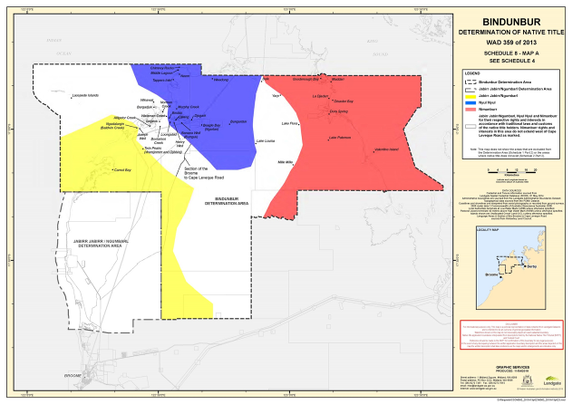
(1) Jabirr Jabirr/Ngumbarl people hold native title in that part of the Determination Area coloured yellow in Map A of Schedule 8 (in this schedule, the map) which part includes the areas Carnot Bay, Ngadalargin (Baldwin Creek), and Twin Peaks (Warnjinmirr and Djibbinj) as labelled on the map and the waters adjoining those areas;
(2) Nyul Nyul people hold native title in that part of the Determination Area coloured blue in the map, which part includes the areas Beagle Bay (Ngarlan), Middle Lagoon, Chimney Rocks, Binduk, Loongabid, Weedong, Henry Well, Djilang, Djugark, Murphy Creek, Tappers Inlet, Neem, Banana Well (Burrguk) and Bungarduk as labelled on the map and the waters adjoining those areas;
(3) Nimanburr people hold native title in that part of the Determination Area coloured red on the map, which part includes the areas Goodenough Bay, Fraser River, Dora Spring, Valentine Island, Madarr, La Djadarr, Lake Paterson and Disaster Bay as labelled on map and the waters adjoining those areas;
(4) Jabirr Jabirr/Ngumbarl people, Nyul Nyul people and Nimanburr people hold native title in that part of the Determination Area coloured white on the map, for their respective rights and interests in accordance with traditional laws and customs; but the rights and interests of Nimanburr people do not extend west of the section of the Broome to Cape Leveque Road shown on Map A in Schedule 8.
Note 1: for the avoidance of doubt, the areas coloured yellow, blue and red on the map are areas uncontroversially identified by reference to language identity and it is to be understood that Jabirr Jabirr/Ngumbarl, Nyul Nyul and Nimanburr areas respectively may extend beyond the edging of the coloured areas.
Schedule 5 – Where Native Title is Exclusive Possession
[See paragraph 4 of the Determination]
Note: A reference in any part of this Determination to a parcel of unallocated Crown land in the form“UCL #” is a reference to the number of a given parcel of UCL which was set out by the affidavit of Paul Terence Godden filed on 16 December 2015 (marked as Exhibit WA10 in WAD 359/2013).
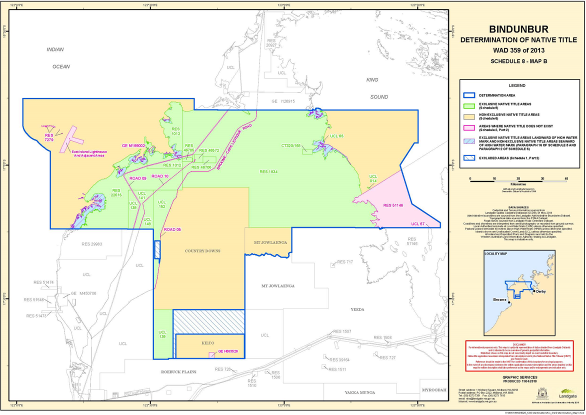
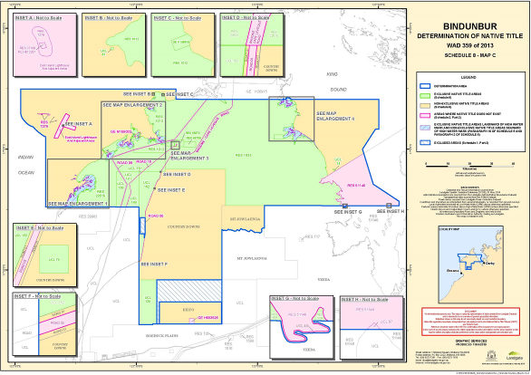
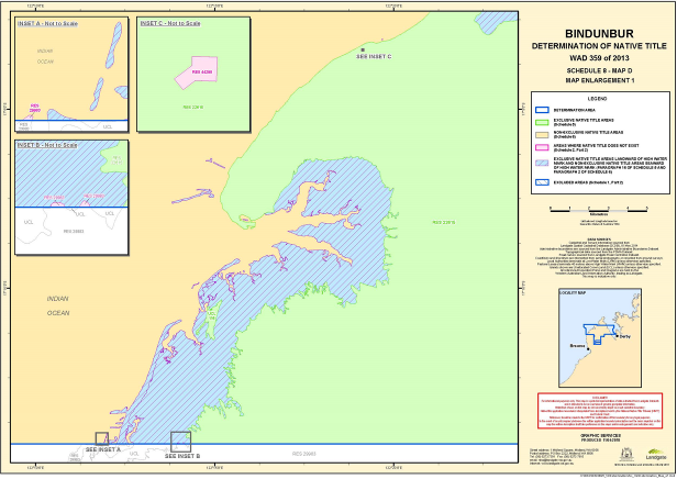
The parts of the Determination Area where native title comprises the rights and interests set out in paragraph 4 of the Determination are the following parts, being the parts of the Determination Area to which sections 47A and 47B of the Native Title Act respectively apply, as generally shown on the Maps in Schedule 8.
Areas to which s 47A applies
(1) Reserve 1012, BEING a reserve set aside for the purpose of "use and benefit of Aboriginal inhabitants" being located on Lots 348 and 361 on Plan 91101.
(2) Reserve 1834, BEING a reserve set aside for the purpose of "use and benefit of Aborigines" being located on Lot 246 on Plan 91725.
(3) Reserve 22615, BEING a reserve set aside for the purpose of "use and benefit of Aborigines" being located on Lot 26 on Plan 221072.
(4) Reserve 46572, BEING a reserve set aside for the purpose of "use and benefit of Aboriginal inhabitants" being located on Lot 375 on Plan 219679.
(5) Reserve 46705, BEING a reserve set aside for the purpose of "use and benefit of Aboriginal inhabitants" being located on Lot 429 on Plan 106140.
(6) Reserve 46706, BEING a reserve set aside for the purpose of "use and benefit of Aboriginal inhabitants" being located on Lot 430 on Plan 106142.
(7) CT 320/168, BEING an estate in fee simple over land described as Lot 8 on Deposited Plan 106143, with the registered proprietor being the Roman Catholic Vicar Apostolic of the Kimberleys of Broome.
(8) CT 1635/760, BEING an estate in fee simple over land described as Lot 4 on Diagram 56586, with the registered proprietor being the Aboriginal Lands Trust of 256 Adelaide Terrace, Perth.
(9) CT 2221/075, BEING an estate in fee simple over land described as Lot 402 on Deposited Plan 219679, with the registered proprietor being the Aboriginal Lands Trust of 197 Saint Georges Terrace, Perth.
(10) CT 2891/194, BEING an estate in fee simple over land described as Lot 33 on Deposited Plan 73719, with the registered proprietor being the Aboriginal Lands Trust of 151 Royal Street, East Perth.
(11) CT 2891/195, BEING an estate in fee simple over land described as Lot 9000 on Deposited Plan 73719, with the registered proprietor being the Aboriginal Lands Trust of 151 Royal Street, East Perth.
(12) Makalaba Lane, BEING a road which is shown on Deposited Plan 73719 and which generally joins Felix Avenue and Beagle Bay Road.
(13) Felix Avenue, BEING a road which is shown on Deposited Plan 73719 and which generally joins Makalaba Lane on the northern boundary of Felix Avenue.
(14) General Lease K145618, BEING a lease over Lot 223 on Deposited Plan 187725, granted to Goojar Goonyool Aboriginal Corporation for the permitted use of "whale research and use and benefit of Aboriginal people".
Areas to which s 47B applies
(15) Each of the following areas of unallocated Crown land: UCL 14; UCL 61; UCL 65, UCL 78, UCL 116, UCL 138; that part of UCL 139 which is not in the area described in paragraph (a) of Schedule 1 Part 2; UCL 141; UCL 148; UCL 151; that part of UCL 152 which is not in the area described in paragraph (b) of Schedule 1 Part 2.
(16) Each other area of unallocated Crown land within the Determination Area, excluding UCL 48, to the extent (if any) that it extends landward of the high water mark.
Schedule 6 – Where Native Title is not Exclusive Possession
[See paragraph 5 of the Determination]
The parts of the Determination Area where native title comprises the rights and interests set out in paragraph 5 of the Determination are all parts where native title exists other than those referred to in Schedule 5, as generally shown on the Maps in Schedule 8. For the avoidance of doubt, those parts are the following areas:
Areas of unallocated Crown land
(1) UCL 48.
Areas seaward of the high water mark
(2) Each area of unallocated Crown land to the extent (if any) that such area is not included in paragraph 16 of Schedule 5. (For the avoidance of doubt, for the purposes of this paragraph, UCL 48 is not to be taken as included in paragraph 16 of Schedule 5).
Lease areas
(3) The areas of the following leases:
(a) Pastoral Lease N050014 covering Lot 850 on DP 66632, known as Country Downs pastoral lease;
(b) Pastoral Lease N050224 covering Lot 263 on DP 194605, known as Kilto pastoral lease; and
(c) Pastoral Lease N050161 covering Dampier Location 265 on DP 29347, known as Mt Jowlaenga pastoral lease.
Road
(4) Road 01, BEING Lots 300 and 301 on Deposited Plan 66643.
Other areas
(5) Any other area not identified in Schedule 2 Part 2 or Schedule 5.
Schedule 7 – Other Interests
[See paragraph 9 of the Determination]
The nature and extent of other interests in relation to the Determination Area are the following as they exist as at the date of this determination:
Reserves
(1) The interests of persons who have the care, control and management of the following reserves, and the interests of persons entitled to access and use these reserves for the respective purposes for which they are reserved, subject to any statutory limitations upon those rights:
(a) Reserve 1012, BEING a reserve set aside for the purpose of "use and benefit of Aboriginal inhabitants" located on Lots 348 and 361 on Plan 91101;
(b) Reserve 1834, BEING a reserve set aside for the purpose of "use and benefit of Aborigines" located on Lot 246 on Plan 91725;
(c) Reserve 22615, BEING a reserve set aside for the purpose of "use and benefit of Aborigines" located on Lot 26 on Plan 221072;
(d) Reserve 46572, BEING a reserve set aside for the purpose of "use and benefit of Aboriginal inhabitants" located on Lot 375 on Plan 219679;
(e) Reserve 46705, BEING a reserve set aside for the purpose of "use and benefit of Aboriginal inhabitants" located on Lot 429 on Plan 106140; and
(f) Reserve 46706, BEING a reserve set aside for the purpose of "use and benefit of Aboriginal inhabitants" located on Lot 430 on Plan 106142.
Leases
(2) The rights and interests of the holders of:
(a) Pastoral Lease N050014 covering Lot 850 on DP 66632, known as Country Downs pastoral lease;
(b) Pastoral Lease N050224 covering Lot 263 on DP 194605, known as Kilto pastoral lease;
(c) Pastoral Lease N050161 covering Dampier Location 265 on DP 29347, known as Mt Jowlaenga pastoral lease; and
(d) General Lease K145618, BEING a lease over Lot 223 on Deposited Plan 187725, granted to Goojar Goonyool Aboriginal Corporation for the permitted use of "whale research and use and benefit of Aboriginal people".
(3) The interests of persons holding valid or validated leases over areas of the reserves identified in this Schedule.
Freeholds
(4) The rights and interests of the holders of:
(a) CT 320/168, BEING an estate in fee simple over land described as Lot 8 on Deposited Plan 106143, with the registered proprietor being the Roman Catholic Vicar Apostolic of the Kimberleys of Broome;
(b) CT 1635/760, BEING an estate in fee simple over land described as Lot 4 on Diagram 56586, with the registered proprietor being the Aboriginal Lands Trust of 256 Adelaide Terrace, Perth;
(c) CT 2221/075, BEING an estate in fee simple over land described as Lot 402 on Deposited Plan 219679, with the registered proprietor being the Aboriginal Lands Trust of 197 Saint Georges Terrace, Perth;
(d) CT 2891/194, BEING an estate in fee simple over land described as Lot 33 on Deposited Plan 73719, with the registered proprietor being the Aboriginal Lands Trust of 151 Royal Street, East Perth; and
(e) CT 2891/195, BEING an estate in fee simple over land described as Lot 9000 on Deposited Plan 73719, with the registered proprietor being the Aboriginal Lands Trust of 151 Royal Street, East Perth.
Telstra
(5) The following interests of Telstra Corporation Limited:
(a) rights and interests as the owner and operator of telecommunications facilities installed within the Determination Area, including customer radio terminals and telecommunications cabling;
(b) rights and interests created pursuant to the Post and Telegraph Act 1901 (Cth), the Telecommunications Act 1975 (Cth), the Australian Telecommunications Corporation Act 1989 (Cth), the Telecommunications Act 1991 (Cth) and the Telecommunications Act 1997 (Cth); and
(c) rights of access by employees, agents or contractors of Telstra Corporation Limited to its telecommunications facilities in, and in the vicinity of, the Determination Area, in the performance of their duties.
Road
(6) Rights or interests of members of the public, the State, Commonwealth or any local government arising in, on or in relation to Road 01, BEING Lots 300 and 301 on Deposited Plan 66643.
Petroleum Interests
(7) The rights and interests of the holders of the following exploration permits under the Petroleum and Geothermal Energy Resources Act 1967 (WA):
(a) EP 104;
(b) EP 436; and
(c) EP 487.
Mining Interests
(8) The rights and interests of the holders of the following exploration licences under the Mining Act 1978 (WA):
(a) EL 04/2083;
(b) EL 04/2084;
(c) EL 04/2159;
(d) EL 04/2192;
(e) EL 04/2193;
(f) EL 04/2194; and
(g) EL 04/2348.
Fishing and Pearling interests
(9) The interests of the holders of statutory interests and exemptions granted under the Fish Resources Management Act 1994 (WA), the Pearling Act 1990 (WA), the Fisheries Management Act 1991 (Cth) or any other legislative scheme for the control, management and exploitation of the living resources within the determination area.
Kimberley Marine Reserve
(10) The rights and interests of the Commonwealth of Australia:
(a) In the Kimberley Commonwealth Marine Reserve, as defined by Part 11 of Schedule 2 of the Environment Protection and Biodiversity Conversation (Commonwealth Marine Reserves) Proclamation 2013 (Cth);
(b) In the management of the Kimberley Commonwealth Marine Reserve, as set out in the Environment Protection and Biodiversity Conversation (Commonwealth Marine Reserves) Proclamation 2013 (Cth), including the rights and interests of the Director of National Parks;
(c) Under s 514B and s 514C of the Environment Protection and Biodiversity Conservation Act 1999 (Cth) in relation to the Kimberley Commonwealth Marine Reserve, including the rights and interests of the Director of National Parks; and
(d) As defined in such other legislation as exists from time to time as it applies to the Kimberley Commonwealth Marine Reserve.
Horizon Power
(11) The rights and interests of Horizon Power under the following:
(a) Lease J966228 being that part of Lot 246 on Deposited Plan 91725 marked as "A" and shown hatched in black on Deposited Plan 52361;
(b) Sub lease K60598 being that part of Lot 246 on Deposited Plan 91725 marked as "A" and shown hatched in black on Deposited Plan 52361; and
(c) as owner of infrastructure and related assets relating to the delivery of electricity to homes and other buildings within the Beagle Bay and Bobieding Aboriginal Communities and being generally items of the following kinds:
(i) mini pillars;
(ii) unmetered supply pits;
(iii) universal pillars;
(iv) pole mounted substations;
(v) distribution substations;
(vi) A-Frame rails;
(vii) falcon metal rounds;
(viii) streetlighting, including lamps and poles;
(ix) box rails;
(x) double box rails;
(xi) mercury vapour lamps;
(xii) mains;
(xiii) above ground powerlines; and
(xiv) underground powerlines.
Other
(12) The following rights and interests:
(a) rights and interests held under valid and validated grants from the Crown pursuant to statute or in the exercise of its executive power or otherwise validly conferred by legislation (whether an Act or a Regulation);
(b) rights or interests held by reason of the force and operation of the laws of the State or of the Commonwealth including the force and operation of the:
(i) Rights in Water and Irrigation Act 1914 (WA); and
(ii) Aboriginal Communities Act 1979 (WA);
(c) the rights and interests of the Australian Maritime Safety Authority:
(i) as the owner, manager or operator of aids to navigation (including the East Island Lighthouse) pursuant to s 190 of the Navigation Act 2012 (Cth);
(ii) under, and as the lessee of, Reserve Lease H612291 on East Island;
(d) the rights and interests of the Australian Fisheries Management Authority in relation to plans of management made under the Fisheries Management Act 1991 (Cth), including for the Western Tuna and Billfish Fishery and for the Western Skipjack Fishery;
(e) the right to access the Determination Area by:
(i) an employee or agent or instrumentality of the State;
(ii) an employee or agent or instrumentality of the Commonwealth; or
(iii) an employee or agent or instrumentality of any local government authority;
(iv) as required in the performance of his or her statutory or common law duty where such access would be permitted to private land;
(f) (Pursuant to section 14 of the Titles (Validation) and Native Title (Effect of Past Acts) Act 1995 (WA) public access to and enjoyment of all of those areas which are seaward of:
(i) Reserve 1012;
(ii) Reserve 1834, excluding:
A. that part of Reserve 1834 which abuts CT 320/168;
B. any area which is within Reserve 51146; and
C. UCL 67 (which is entirely abutted by Reserve 51146);
(iii) CT 320/168;
(iv) Reserve 7279;
(v) Reserve 22615, excluding:
A. that part of Reserve 22615 which abuts lease K 145618; and
B. Reserve 7279; and
(vi) Lease K 145618;
being areas which are:
(i) waterways;
(ii) beds and banks or foreshores of waterways;
(iii) coastal waters; or
(iv) beaches.
Note: For the avoidance of doubt, paragraph 12(f) of this Schedule does not confer, create or entitle public access to or enjoyment of any area which is not identified in paragraph 12(f) above.
(g) rights and interests of members of the public under the following:
(i) the public right to fish; and
(ii) the public right to navigate;
(h) the international right of innocent passage through the territorial sea; and
(i) rights or interests comprised in or conferred under or in accordance with the Canning-Kimberley Groundwater Area, proclaimed by proclamation published in the Western Australian Government Gazette on 2 May 1997.
Schedule 8 – The Maps
[See paragraph 12 of the Determination]
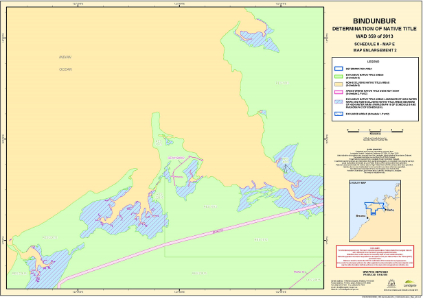
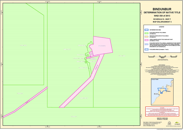
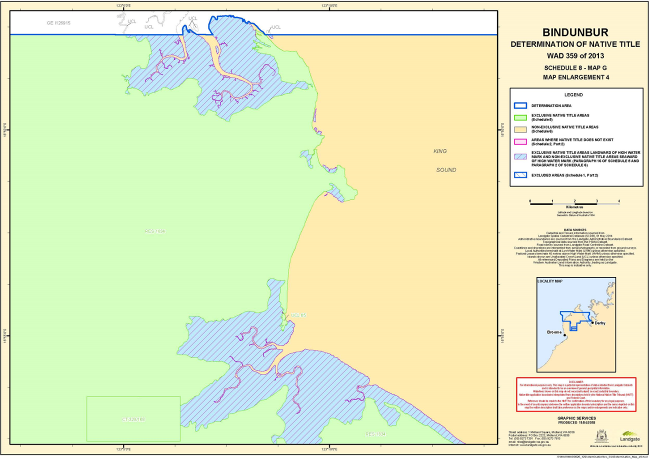
Note: Entry of orders is dealt with in Rule 39.32 of the Federal Court Rules 2011.
ORDERS
WAD 357 of 2013
BETWEEN: | RITA AUGUSTINE ON BEHALF OF THE JABIRR JABIRR NATIVE TITLE CLAIM GROUP (and others named in the Schedule) Third Applicant |
AND: | STATE OF WESTERN AUSTRALIA (and others named in the Schedule) Respondent |
WAD 374 of 2013
BETWEEN: | JR (DECEASED) ON BEHALF OF THE GOOLARABOOLOO NATIVE TITLE CLAIM GROUP (and others named in the Schedule) Fourth Applicant |
AND: | STATE OF WESTERN AUSTRALIA (and others named in the Schedule) Respondent |
JUDGE: | NORTH J |
DATE OF ORDER: | 2 MAY 2018 |
THE COURT ORDERS THAT:
1. Proceeding WAD374/2013 (the Goolarabooloo proceeding) be dismissed.
2. There be a determination of native title in the form attached as Attachment A to these orders.
3. Within 12 months of the date on which these orders are made, a representative of the common law holders of native title shall:
(a) indicate whether the common law holders intend to have the native title held in trust; and
(b) nominate, in writing given to the Federal Court, a prescribed body corporate:
(i) to be trustee of the native title rights and interests; or
(ii) otherwise perform the functions set out in section 57(3) of the Native Title Act, including within the nomination the written consent of the body corporate.
4. In the event that there is no nomination within 12 months of the date on which these orders are made, or such later time as the Court may order, the matter is to be listed for further directions.
The following area is not included in the determination area and the proceeding be adjourned in relation to it: All that land comprising that portion of Lot 259 as shown on Deposited Plan 220696 that is wholly within the external boundary of Exploration Licence E04/1624 (as defined by The Department of Mines, Industry Regulation and Safety as at 23rd September 2013).
ATTACHMENT A TO THE ORDERS – JABIRR JABIRR/NGUMBARL
DETERMINATION
IN THE FEDERAL COURT OF AUSTRALIA
DISTRICT REGISTRY: WESTERN AUSTRALIA
DIVISION: GENERAL
WAD 357 of 2013 | |
| |
BETWEEN: | RITA AUGUSTINE ON BEHALF OF THE JABIRR JABIRR NATIVE TITLE CLAIM GROUP (and others named in the Schedule) Applicant |
AND: | STATE OF WESTERN AUSTRALIA (and others named in the Schedule) Respondents |
WAD 374 of 2013 | |
BETWEEN: | JR (DECEASED) ON BEHALF OF THE GOOLARABOOLOO NATIVE TITLE CLAIM GROUP (and others named in the Schedule) Applicant |
AND: | STATE OF WESTERN AUSTRALIA (and others named in the Schedule) Respondents |
JUDGE: | NORTH J |
DATE OF ORDER: | 2 May 2018 |
WHERE MADE: | bEAGLE BAY, WESTERN AUSTRALIA |
THE COURT DETERMINES THAT:
Existence of native title [s 225]
1. Native title rights and interests exist in those parts of the Determination Area described in Schedule 2 Part 1 (native title areas).
2. Native title rights and interests do not exist in those parts of the Determination Area described in Schedule 2 Part 2.
Native title holders [s 225(a)]
3. The rights and interests comprising the native title are held by Jabirr Jabirr/Ngumbarl people, being the people described in Schedule 3 (native title holders).
Nature and extent of native title [s 225(b) and (e)]
4. Subject to paragraphs 7 and 8, the nature and extent of the native title rights and interests in relation to each part of the Determination Area referred to in Schedule 4 (being areas where any extinguishment must be disregarded) is the right of possession, occupation, use and enjoyment of that part as against the whole world.
5. Subject to paragraphs 6, 7 and 8, the nature and extent of the native title rights and interests in relation to each part of the Determination Area referred to in Schedule 5 (being land and waters where there can only be partial recognition; or where there has been partial extinguishment other than where such extinguishment must be disregarded) are the following rights:
(a) the right to have access to, remain in and use that part;
(b) the right to access and take for any purpose the resources in that part; and
(c) the right to protect places, areas and things of traditional significance in that part.
6. The native title rights and interests referred to in paragraph 5 do not confer:
(a) possession, occupation, use and enjoyment of those parts of the Determination Area on the native title holders to the exclusion of all others; or
(b) a right to control the access of others to the land or waters of those parts of the Determination Area.
7. The native title rights and interests are exercisable in accordance with and subject to the:
(a) traditional laws and customs of the native title holders; and
(b) laws of the State and the Commonwealth, including the common law.
8. Notwithstanding anything in this determination, there are no native title rights and interests in the native title areas in or in relation to:
(a) pursuant to the Mining Act 1904 (WA), gold, silver, other precious metals, precious stones and all other minerals; or
(b) petroleum as defined in the Petroleum Act 1936 (WA) (repealed) and in the Petroleum and Geothermal Energy Resources Act 1967 (WA).
Other interests [s 225(c) and 225(d)]
9. The nature and extent of other rights and interests in relation to the Determination Area are those set out in Schedule 6 (other interests).
10. The relationship between the native title rights and interests and the other interests is as follows:
(a) the other interests co-exist with the native title rights and interests;
(b) the determination does not affect the validity of those other interests; and
to the extent of any inconsistency, the native title rights and interests yield to the other interests.
Areas where extinguishment is disregarded [s 47B]
11. Section 47B of the Native Title Act applies to disregard any prior extinguishment in relation to the parts of the determination area described in Schedule 4.
Definitions and interpretation
12. In this determination, unless the contrary intention appears:
‘Determination Area’ means the land and waters described in Schedule 1 Part 1, but does not include the area described in Schedule 1 Part 2;
‘high water mark’ means the mean high water mark at common law;
‘land’ and ‘waters’ respectively have the same meanings as in the Native Title Act;
‘Native Title Act’ means the Native Title Act 1993 (Cth) as amended as at the date of this Determination; and
‘State’ means the State of Western Australia.
In the event of an inconsistency between the written description of an area in Schedules 1, 2, 4 or 5 and an area depicted on the maps in Schedule 7, the written description prevails.
Schedule 1 – Determination Area
[See paragraphs 1 and 12 of the Determination]
Part 1 – External perimeter of the Determination Area
The determination area, generally shown as bordered in blue on the maps at Schedule 7, comprises all that land and waters bounded by the following description, except the area described in Part 2 of this Schedule:
All those lands and waters commencing at the westernmost northwestern corner of the northern severance of Pastoral Lease N049900 (Roebuck Plains), being a point on a present boundary of Native Title Determination WAD6006/1998 Rubibi Community (WCD2006/001) and extending generally northwesterly and westerly along boundaries of that native title determination to its northwestern most corner, then westerly and generally northerly through the following coordinate positions;
LATITUDE (SOUTH) | LONGITUDE (EAST) |
17.763901 | 122.156415 |
17.762228 | 122.156629 |
17.761566 | 122.156820 |
17.760545 | 122.157198 |
17.758740 | 122.157676 |
17.756813 | 122.158061 |
17.755308 | 122.158351 |
17.753985 | 122.158732 |
17.752659 | 122.158743 |
17.752178 | 122.158932 |
17.751214 | 122.158940 |
17.750371 | 122.159132 |
17.749226 | 122.159142 |
17.747900 | 122.159245 |
17.746937 | 122.159438 |
17.745430 | 122.159451 |
17.743804 | 122.159649 |
17.742960 | 122.159656 |
17.740188 | 122.159680 |
17.739344 | 122.159687 |
17.738380 | 122.159695 |
17.737053 | 122.159706 |
17.735426 | 122.159719 |
17.733919 | 122.159732 |
17.732412 | 122.159744 |
17.730785 | 122.159758 |
17.728312 | 122.159595 |
17.727467 | 122.159417 |
17.726199 | 122.159150 |
17.725174 | 122.159158 |
17.724208 | 122.158982 |
17.723182 | 122.158805 |
17.721555 | 122.158819 |
17.719926 | 122.158648 |
17.719443 | 122.158467 |
17.717935 | 122.158387 |
17.716790 | 122.158396 |
17.715462 | 122.158222 |
17.714979 | 122.158042 |
17.713833 | 122.158051 |
17.712688 | 122.158061 |
17.711540 | 122.157700 |
17.710033 | 122.157712 |
17.708041 | 122.157266 |
17.705930 | 122.157099 |
17.705085 | 122.156921 |
17.704420 | 122.156742 |
17.703456 | 122.156750 |
17.701768 | 122.156671 |
17.700321 | 122.156683 |
17.698995 | 122.156694 |
17.697367 | 122.156708 |
17.696041 | 122.156719 |
17.694414 | 122.156732 |
17.692726 | 122.156747 |
17.691099 | 122.156760 |
17.689953 | 122.156770 |
17.688805 | 122.156409 |
17.687962 | 122.156417 |
17.686153 | 122.156432 |
17.684042 | 122.156264 |
17.682715 | 122.156091 |
17.681387 | 122.155824 |
17.680542 | 122.155646 |
17.679757 | 122.155468 |
17.678247 | 122.155111 |
17.677281 | 122.154841 |
17.675771 | 122.154484 |
17.674804 | 122.154122 |
17.674140 | 122.154035 |
17.673111 | 122.153489 |
17.672144 | 122.153035 |
17.666548 | 122.151476 |
17.658922 | 122.150278 |
17.647272 | 122.148155 |
17.642987 | 122.147359 |
17.638156 | 122.146197 |
17.632898 | 122.144391 |
17.617533 | 122.136937 |
17.611718 | 122.133009 |
17.610567 | 122.132186 |
17.609294 | 122.131272 |
17.608751 | 122.131185 |
17.608264 | 122.130449 |
17.607292 | 122.129440 |
17.600812 | 122.125333 |
17.599358 | 122.124328 |
17.598027 | 122.123691 |
17.596695 | 122.122870 |
17.594697 | 122.121685 |
17.570787 | 122.116151 |
17.566686 | 122.116000 |
17.561257 | 122.115398 |
17.560413 | 122.115405 |
17.557640 | 122.115428 |
17.554687 | 122.115453 |
17.550528 | 122.115488 |
17.547276 | 122.115977 |
17.545287 | 122.115994 |
17.542515 | 122.116202 |
17.539381 | 122.116228 |
17.517780 | 122.113357 |
17.515303 | 122.112545 |
17.513672 | 122.112096 |
17.509381 | 122.110559 |
17.505091 | 122.109116 |
17.487421 | 122.108061 |
17.483804 | 122.108091 |
17.482177 | 122.108105 |
17.479045 | 122.108500 |
17.471158 | 122.109769 |
17.469712 | 122.109873 |
17.465561 | 122.111110 |
17.461651 | 122.112160 |
17.449493 | 122.114758 |
17.447805 | 122.114772 |
17.446000 | 122.115157 |
17.444073 | 122.115543 |
17.433834 | 122.116646 |
17.431724 | 122.116663 |
17.419187 | 122.116768 |
17.416414 | 122.116791 |
17.411772 | 122.116829 |
17.405864 | 122.116694 |
17.404237 | 122.116707 |
17.400620 | 122.116738 |
17.397667 | 122.116762 |
17.392844 | 122.116802 |
17.387421 | 122.117033 |
17.385793 | 122.117046 |
17.383804 | 122.117063 |
17.379040 | 122.116733 |
17.369816 | 122.116625 |
17.368972 | 122.116632 |
17.364874 | 122.116666 |
17.353195 | 122.118982 |
17.351571 | 122.119458 |
17.349584 | 122.119844 |
17.346156 | 122.120890 |
17.333992 | 122.122656 |
17.332308 | 122.123225 |
17.331044 | 122.123513 |
17.327072 | 122.124378 |
17.317019 | 122.126311 |
17.314551 | 122.126702 |
17.312445 | 122.127182 |
17.311301 | 122.127376 |
17.299143 | 122.130067 |
17.298300 | 122.130166 |
17.295833 | 122.130742 |
17.284999 | 122.133051 |
17.278561 | 122.134770 |
17.277597 | 122.134778 |
17.274469 | 122.135636 |
17.271217 | 122.136126 |
17.268751 | 122.136886 |
17.265443 | 122.137838 |
17.263938 | 122.138220 |
17.262493 | 122.138417 |
17.261835 | 122.139070 |
Then northerly to Latitude 17.239080 South, Longitude 122.145895 East; Then easterly to the southernmost southwestern corner of the westernmost severance of Reserve 22615; Then easterly along the southern boundary of that severance to its southernmost southeastern corner; Then easterly to the intersection of the prolongation easterly of the southern boundary of the westernmost severance of Reserve 22615 with a western boundary of Lot 851 as shown on Deposited Plan 66631; Then southerly along the western boundary of that lot to the southernmost northwestern corner of Lot 300 as shown on Deposited Plan 66643, being Broome Cape Leveque Road; Then southerly along the western boundary of that lot to its southernmost southwestern corner; Then southerly to the southernmost northwestern corner of Lot 301 as shown on Deposited Plan 66643; Then southerly along the western boundary of that lot to the westernmost northwestern corner of Pastoral Lease N050014 (Country downs); Then southerly along the western boundary of that pastoral lease to its westernmost southwestern corner; Then southerly to the intersection of the northern boundary of the northern severance of Pastoral Lease N049900 (Roebuck Plains) with longitude 122.510750 East, being a point on a present boundary of Native Title Determination WAD6006/1998 Rubibi Community (WCD2006/001) and then westerly, southerly and again generally westerly along boundaries of the native title determination back to the commencement point.
Part 2 – Area excluded from the Determination Area
All that land comprising that portion of Lot 259 as shown on Deposited Plan 220696 that is wholly within the external boundary of Exploration Licence E04/1624 (as defined by The Department of Mines, Industry Regulation and Safety as at 23rd September 2013).
Note: Geographic Coordinates provided in Decimal Degrees.
All referenced Deposited Plans and Diagrams are held by the Western Australian Land Information Authority, trading as Landgate.
Cadastral boundaries sourced from Landgate’s Spatial Cadastral Database dated 2nd January 2018.
Mining Tenements sourced from The Department of Mines, Industry Regulation and Safety as at 23rd September 2013.
For the avoidance of doubt the determination excludes any land and waters already claimed by:
Native Title Determination Application WAD6006/1998 Rubibi Community (WCD2006/001) as Determined in the Federal Court on the 28th April 2006.
Native Title Determination Application WAD359/2013 Bindunbur (WC2015/007) as Registered by the Native Title Registrar on the 24th March 2016.
Datum: Geocentric Datum of Australia 1994 (GDA94) Prepared By: Graphic Services (Landgate) 4th April 2018
Use of Coordinates:
Where coordinates are used within the description to represent cadastral or topographical boundaries or the intersection with such, they are intended as a guide only. As an outcome to the custodians of cadastral and topographic data continuously recalculating the geographic position of their data based on improved survey and data maintenance procedures, it is not possible to accurately define such a position other than by detailed ground survey.
Schedule 2 – The areas where native title does and does not exist
[See paragraphs 1 and 2 of the Determination]
Part 1 – Areas where native title exists
Native title exists in all parts of the Determination Area other than those described in Part 2.
Part 2 – Areas where native title does not exist
Native title does not exist in the following parts of the Determination Area:
1. Leases:
J638664 | M450706 | M450708 |
J638665 | M450707 |
2. Reserves:
Reserve No | Description |
Reserve 21709 | A reserve set aside for the purpose of "camping site" located on Lot 51 on Deposited Plan 92369. |
Reserve 29983 (Coloumb Point Nature Reserve) | A reserve set aside for the purpose of "conservation of flora and fauna" located on Dampier Location 77. |
Reserve 51448 | A reserve set aside for the purpose of "service corridors associated with the Browse LNG Precinct" located on Lots 305, 307 and 308 on Deposited Plan 75838. |
Part Reserve 51473 | That part of reserve 51473 (being a reserve set aside for the purpose of "pipeline corridor associated with the Browse LNG Precinct") which is located on Lot 313 on Deposited Plan 75838. |
Part Reserve 51474 | That part of reserve 51474 (being a reserve set aside for the purpose of "pipeline corridor associated with the Browse LNG Precinct") which is located on Lot 311 on Deposited Plan 75838. |
Part Reserve 51546 | That part of reserve 51546 (being a reserve set aside for the purpose of "port purposes") which was formerly described as Lot 312 on Deposited Plan 75838 and is now a portion of Lot 331 on Deposited Plan 75851. |
3. Freehold areas:
Tenure ID | Description |
CT 2040/398 | An estate in fee simple over land described as Lot 238 on Deposited Plan 188313, with the registered proprietor being James Craig Kennedy of Post Office Box 399, Broome. |
4. Public Works
4.1 Roads:
Note: The "road numbers" identified in the first column of the table immediately below is a reference to the number of a road which was set out in the affidavit of Paul Terence Godden filed on 16 December 2015 (marked as Exhibit WA10 in WAD 359/2013) and which area is otherwise marked and labelled on the maps in Schedule 7.
Road Number | Description |
Road 02 | Lots 302, 303 and 304 on Deposited Plan 75838. |
Road 05 | The area designated as Road 15967 and described, by publication in the Western Australian Government Gazette on 2 June 1978, as follows: A strip of land 40 metres wide, commencing at the northwestern side of Great Northern Highway at a southeastern corner of Dampier Location 70 and extending as shown coloured red on Miscellaneous Plans 470 (1) and (2) generally northeastward through Reserve No. 25716 and Pastoral Lease 3114/810 thence northward and again northeastward through Lease 398/461 to terminate at a Northern boundary of the last mentioned lease. |
Road 06 | The area designated as Road 15968 and described, by publication in the Western Australian Government Gazette on 2 June 1978, as follows: A strip of land, 40 metres wide, commencing at the western side of Road No. 15967 within Pastoral Lease 3114/810 and extending as shown coloured red on Miscellaneous Plan 470(1) generally northwestward throughout that lease to terminate at the southern most boundary of Location 77 (A Class Reserve No. 29983) as shown on the said Plan. |
Road 07 | The area designated as Road 15969 and described, by publication in the Western Australian Government Gazette on 2 June 1978, as follows: A strip of land 40 metres wide, commencing at the southwestern side of Road No. 15968 within Pastoral Lease 3114/810 and extending as shown coloured red on Miscellaneous Plan 470 (1) generally westward and southward through that Lease to terminate at the northwestern boundary of Lease 3116/5366. |
Road 08 | The area designated as Road 16702 (Barred Creek Road) and described, by publication in the Western Australian Government Gazette on 25 September 1981, as follows: A strip of land, 40 metres wide commencing at the southwestern side of Road No. 15968 (Manari Road) within Pastoral Lease 3114/810 and extending as shown coloured brown on Lands and Surveys Miscellaneous Diagram 53 generally westward and southward through that lease to terminate within the said lease as shown on that Diagram. |
Road 09 | The area designated as Road 6241 and described, by publication in the Western Australian Government Gazette on 5 September 1919, as follows: A strip of land, 10 chains wide, commencing at the North boundary of the Broome Townsite Reserve about one mile from the sea-coast, and extending in a North-Easterly direction through Pastoral Leases 1126/98 (passing near Bones Well), 1111/98, 1087/98, 981/98 (passing near Wanganup Well), 849/98, 243/98, and 328/98 to the Waterbanks Spring in the latter; thence North-Westerly through Leases 328/98 and 827/98 for a distance of about 700 chains; thence North-Easterly through Lease 827/98 and Reserves Nos. 1012 and 1834 to the North-Western corner of Dampier Location 6; thence North-Easterly through Reserve No. 1834 and Lease 375/98 for a distance of about 155 chains; thence Northerly through Lease 375 and 871/98 to about four miles East and three miles North of the latter's South-West corner; thence in a North-Easterly direction through Leases 871/98 and 1922/98 to Cape Leveque (Plans 136/300 and 138/300). |
Road 10 | The area designated as Road 6863 and described by publication in the Western Australian Government Gazette on 9 February 1923, as follows: A strip of land, two chains wide, leaving the Northern boundary of Reserve No. 631 at a point about 60 chains East of Duncan's Well, and extending in a North-North-Easterly direction through Pastoral Leases 1126/98, 1111/98, 1087/98, 981/98, 849/98, 243/98, 416/98 and 328/98 to Waterbanks Rock in the latter lease; thence North-Easterly through said Lease 328/98 and Leases 988/98 and 827/98 to a surveyed road at the South East corner of Dampier Location 5. |
Schedule 3 – Native Title Holders
[See paragraph 3 of the Determination]
Jabirr Jabirr/Ngumbarl people
Jabirr Jabirr/Ngumbarl people are the living persons who are the descendants of one or more of the following ancestors, including by adoption in accordance with the traditional laws and customs of the native title holders:
Gadalargan; Murrjal; Dorothy Kelly; Liddy Kenagai; Liddy Skinner; Bornal; Wallai William & Mary Nelagumia; Senanus; Frank Walmandu; Sophie McKenzie; Frank Dixon (aka Frank Dinghi); Nabi; Appolonia; Dorothy (sister of Senanus); Agnes Imbarr; Deborah & Jacky; Ethyl Jacky; Alice Darada; Milare & Kelergado; Matilda; Louisa; Flora; Madeline; Fred/Friday Walmadang; and Walamandjin.
Schedule 4 – Where Native Title is Exclusive Possession
[See paragraph 4 of the Determination]
Note: A reference in any part of this Determination to a parcel of unallocated Crown land in the form “UCL #” is a reference to the number of a given parcel of UCL which was set out in the affidavit of Paul Terence Godden filed on 16 December 2015 (marked as Exhibit WA10 in WAD 359/2013).
The parts of the Determination Area where native title comprises the rights and interests set out in paragraph 4 of the Determination are the following parts, being the parts of the Determination Area to which section 47B of the Native Title Act applies, as generally shown on the Maps in Schedule 7.
(a) Those areas of unallocated Crown land described in the table immediately below
UCL Number | Description |
UCL 01 | A 40 metre wide strip of unallocated Crown land located immediately to the east of Road 10 and generally on the southern boundary of the Determination Area. |
UCL 03 | A small parcel of unallocated Crown land bounded between Road 8 to the east and UCL 84 to the west and generally north of UCL 80. |
UCL 21 | A 40 metre wide strip of unallocated Crown land located generally along the coastline within the eastern portion of the Determination Area commencing at around Willie Creek and then progressing generally north, north-east and concluding at the southern boundary of Reserve 21709. |
UCL 22 | A 40 metre wide strip of unallocated Crown land located generally along the coastline within the eastern portion of the Determination Area commencing at a point on the southern boundary of the Determination Area and then progressing generally north-west and concluding at the commencement of UCL 21 at around Willie Creek. |
UCL 32 | A thin sliver of unallocated Crown land located on the southern boundary of the Determination Area and surrounded by Water 1. |
UCL 68 | A 40 metre wide strip of unallocated Crown land located generally along the coastline within the eastern portion of the Determination Area commencing at Road 8 and then progressing generally south, then generally north and concluding at the southern boundary of Reserve 51473 (Coloumb Point Nature Reserve). |
UCL 80 | A small parcel of unallocated Crown land bounded between Road 8 to the east and UCL 84 to the west and generally south of UCL 3. |
UCL 81 | A small parcel of unallocated Crown land bounded between Road 8 to the north and UCL 84 to the south and generally north-east of UCL 3 and UCL 80. |
UCL 82 | A small parcel of unallocated Crown land bounded between UCL 84 to the east and UCL 137 to the west. |
UCL 84 | A 40 metre wide strip of unallocated Crown land located generally along the coastline within the eastern portion of the Determination Area commencing at Road 8 and then progressing generally north, north-east, south, south-east and concluding at the northern boundary of Reserve 21709. |
UCL 111 | A 40 metre wide strip of unallocated Crown land located generally along the coastline within the eastern portion of the Determination Area commencing at the northern boundary of Reserve 51474 and then progressing generally north and concluding at the southern boundary of Reserve 51473 (Coloumb Point Nature Reserve). |
UCL 115 | A 40 metre wide strip of unallocated Crown land located generally along the coastline within the south-eastern portion of the Determination Area commencing generally commencing at the southern boundary of the Determination Area and Road 10 and then progressing in a loop and concluding at a point further north on Road 10. |
UCL 120 | A 40 metre wide strip of unallocated Crown land located generally along the south eastern portion of the Determination Area generally commencing at a point along the western side of Road 10 and then progressing in a loop to the north, north-east, south and south-west and concluding at a point along the southern boundary of the Determination Area which is to the immediate east of UCL 22. |
UCL 127 | An area of unallocated Crown land being Lot 413 on Deposited Plan 26913 on Certificate of Crown Land Title 3003/322. |
UCL 128 | An area of unallocated Crown land being a portion of the land described as Lot 259 on Deposited Plan 220696 on Qualified Certificate of Crown Land Title 3015/565 and which is also within the Buffer Zone (M450705). |
UCL 129 | An area of unallocated Crown land being a portion of the land described as Lot 259 on Deposited Plan 220696 on Qualified Certificate of Crown Land Title 3015/565. |
Part UCL 130 | An area of unallocated Crown land being a portion of the land described as Lot 259 on Deposited Plan 220696 on Qualified Certificate of Crown Land Title 3015/565. A portion of UCL 130 is also within the Buffer Zone (M450705). The part of UCL 130 described in this Schedule does not include that part of UCL 130 which was overlapped by exploration licence E 04/1624 at the date of lodgement of the Jabirr Jabirr/Ngumbarl proceeding. |
UCL 131 | An area of unallocated Crown land being a portion of the land described as Lot 259 on Deposited Plan 220696 on Qualified Certificate of Crown Land Title 3015/565. |
UCL 132 | An area of unallocated Crown land being a portion of the land described as Lot 259 on Deposited Plan 220696 on Qualified Certificate of Crown Land Title 3015/565. |
UCL 133 | An area of unallocated Crown land being a portion of the land described as Lot 259 on Deposited Plan 220696 on Qualified Certificate of Crown Land Title 3015/565 and which is also within the Buffer Zone (M450705). |
UCL 134 | An area of unallocated Crown land being a portion of the land described as Lot 259 on Deposited Plan 220696 on Qualified Certificate of Crown Land Title 3015/565. A portion of UCL 134 is also within the Buffer Zone (M450705). |
UCL 135 | An area of unallocated Crown land being a portion of the land described as Lot 259 on Deposited Plan 220696 on Qualified Certificate of Crown Land Title 3015/565 and which is also within the Buffer Zone (M450705). |
UCL 136 | An area of unallocated Crown land being a portion of the land described as Lot 259 on Deposited Plan 220696 on Qualified Certificate of Crown Land Title 3015/565. |
UCL 137 | An area of unallocated Crown land being a portion of the land described as Lot 259 on Deposited Plan 220696 on Qualified Certificate of Crown Land Title 3015/565. |
Part UCL 138 | An area of unallocated Crown land being a portion of the land described as Lot 259 on Deposited Plan 220696 on Qualified Certificate of Crown Land Title 3015/565. A portion of UCL 138 is also within the Buffer Zone (M450705). The part of UCL 138 described in this Schedule does not include that part of UCL 138 which was overlapped by exploration licence E 04/1624 at the date of lodgement of the Jabirr Jabirr/Ngumbarl proceeding. |
UCL 139 | An area of unallocated Crown land being a portion of the land described as Lot 259 on Deposited Plan 220696 on Qualified Certificate of Crown Land Title 3015/565. |
Part UCL 140 | An area of unallocated Crown land being a portion of the land described as Lot 259 on Deposited Plan 220696 on Qualified Certificate of Crown Land Title 3015/565. The part of UCL 140 described in this Schedule does not include that part of UCL 140 which was overlapped by exploration licence E 04/1624 at the date of lodgement of the Jabirr Jabirr/Ngumbarl proceeding. |
UCL 141 | An area of unallocated Crown land being a portion of the land described as Lot 259 on Deposited Plan 220696 on Qualified Certificate of Crown Land Title 3015/565. |
UCL 142 | An area of unallocated Crown land being a portion of the land described as Lot 259 on Deposited Plan 220696 on Qualified Certificate of Crown Land Title 3015/565. A portion of UCL 142 is also within the Buffer Zone (M450705). |
UCL 144 | An area of unallocated Crown land being a portion of the land described as Lot 259 on Deposited Plan 220696 on Qualified Certificate of Crown Land Title 3015/565. |
UCL 145 | An area of unallocated Crown land being a portion of the land described as Lot 259 on Deposited Plan 220696 on Qualified Certificate of Crown Land Title 3015/565 and which is also within the Buffer Zone (M450705). |
UCL 146 | An area of unallocated Crown land being a portion of the land described as Lot 259 on Deposited Plan 220696 on Qualified Certificate of Crown Land Title 3015/565. |
UCL 147 | An area of unallocated Crown land being a portion of the land described as Lot 259 on Deposited Plan 220696 on Qualified Certificate of Crown Land Title 3015/565. |
UCL 148 | An area of unallocated Crown land being a portion of the land described as Lot 259 on Deposited Plan 220696 on Qualified Certificate of Crown Land Title 3015/565. |
UCL 149 | An area of unallocated Crown land being a portion of the land described as Lot 259 on Deposited Plan 220696 on Qualified Certificate of Crown Land Title 3015/565 and which is also within the Buffer Zone (M450705). |
UCL 150 | An area of unallocated Crown land being Lot 365 on Deposited Plan 92336 and covered by Qualified Certificate of Crown Land Title 3106/485. |
UCL 153 | An area of unallocated Crown land being Lot 550 on Deposited Plan 71401 on Certificate of Crown Land Title 3161/733. |
UCL 154 | An area of unallocated Crown land being Lot 551 on Deposited Plan 71401 on Certificate of Crown Land Title 3161/734. |
(b) each other area of unallocated Crown land within the Determination Area, excluding UCL 002, to the extent (if any) that it extends landward of the high water mark.
Schedule 5 – Where Native Title is not Exclusive Possession
[See paragraph 5 of the Determination]
The parts of the Determination Area where native title comprises the rights and interests set out in paragraph 5 of the Determination are all parts where native title exists other than those referred to in Schedule 4, as generally shown on the Maps in Schedule 7. For the avoidance of doubt, those parts are the following areas:
Reserves
Tenure ID | Description |
Reserve 50683 | A reserve set aside for the purpose of "boat ramp" located on Lot 300 on Deposited Plan 68241. |
Part Reserve 51473 | That part of reserve 51473 (being a reserve set aside for the purpose of "pipeline corridor associated with the Browse LNG Precinct") which is located on Lot 3006 on Deposited Plan 68252. |
Part Reserve 51474 | That part of reserve 51474 (being a reserve set aside for the purpose of "pipeline corridor associated with the Browse LNG Precinct") which is located on Lot 3003 on Deposited Plan 68251. |
Part Reserve 51546 | That part of reserve 51546 (being a reserve set aside for the purpose of "port purposes") which was formerly described as Lot 3000 on Deposited Plan 68245 and is now a portion of Lot 331 on Deposited Plan 75851. |
Areas of Unallocated Crown Land
(a) The area of unallocated Crown land described in the table immediately below
UCL Number | General Area Description |
UCL 002 | An area of unallocated Crown land generally located not less than1 km from the coastline in the eastern portion of the Determination Area where Reserve 29983 (Coloumb Point Nature Reserve) is located. |
(b) Each area of unallocated Crown land to the extent (if any) that such area is not included in numbered paragraph "b" in Schedule 4. (For the avoidance of doubt, for the purposes of this paragraph, UCL 002 is not to be taken as included in paragraph "b" of Schedule 4.)
(c) Any other area not identified in Schedule 2 Part 2 or Schedule 4.
Schedule 6 – Other Interests
[See paragraph 9 of the Determination]
The nature and extent of other interests in relation to the Determination Area are the following as they exist as at the date of this determination:
1. Reserves
(a) The interests of persons who have the care, control and management of the following reserves, and the interests of persons entitled to access and use these reserves for the respective purposes for which they are reserved, subject to any statutory limitations upon those rights:
Tenure ID | Description |
Reserve 50683 | A reserve set aside for the purpose of "boat ramp" located on Lot 300 on Plan 68241. |
Part Reserve 51473 | That part of reserve 51473 (being a reserve set aside for the purpose of "pipeline corridor associated with the Browse LNG Precinct") which is located on Lot 3006 on Deposited Plan 68252. |
Part Reserve 51474 | That part of reserve 51474 (being a reserve set aside for the purpose of "pipeline corridor associated with the Browse LNG Precinct") which is located on Lot 3003 on Deposited Plan 68251. |
Part Reserve 51546 | That part of reserve 51546 (being a reserve set aside for the purpose of "port purposes") which was formerly described as Lot 3000 on Deposited Plan 68245 and is now a portion of Lot 331 on Deposited Plan 75851. |
(b) The interests of persons holding valid or validated leases over areas of the reserves identified in this Schedule.
2. Telstra
The following interests of Telstra Corporation Limited:
(a) rights and interests as the owner and operator of telecommunications facilities installed within the Determination Area, including customer
radio terminals and telecommunications cabling;
(b) rights and interests created pursuant to the Post and Telegraph Act 1901 (Cth), the Telecommunications Act 1975 (Cth), the Australian Telecommunications Corporation Act 1989 (Cth), the Telecommunications Act 1991 (Cth) and the Telecommunications Act 1997 (Cth); and
rights of access by employees, agents or contractors of Telstra Corporation Limited to its telecommunications facilities in, and in the vicinity of, the Determination Area, in the performance of their duties.
3. Mining Interests
The rights and interests of the holders of the following exploration licences under the Mining Act 1978 (WA):
(a) EL 04/1624; and
(b) EL 04/2276.
4. Fishing and Pearling interests
The interests of the holders of statutory interests and exemptions granted under the Fish Resources Management Act 1994 (WA), the Pearling Act 1990 (WA), the Fisheries Management Act 1991 (Cth) or any other legislative scheme for the control, management and exploitation of the living resources within the determination area.
5. Groundwater areas
Rights or interests comprised in or conferred under or in accordance with:
(a) the Canning-Kimberley Groundwater Area, proclaimed by proclamation published in the Western Australian Government Gazette on 2 May 1997; and
(b) the Broome Groundwater Area which was first proclaimed by proclamation published in the Western Australian Government Gazette on 20 December 1974 and amended by proclamation made on 30 May 1986.
6. Water Reserves
(a) The Broome Water Reserve, the location of which is set out in the order published in the Western Australian Government Gazette on 23 October 2015 at pages 4357 and 4358.
7. Buffer Zone (M450705)
Being that area described on M450705 which is a registered dealing that identifies a Buffer Zone, as that term is defined by the Browse LNG Precinct Project Agreement.
8. Other Rights and Interests
The following rights and interests:
(a) rights and interests held under valid and validated grants from the Crown pursuant to statute or in the exercise of its executive power or otherwise validly conferred by legislation (whether an Act or a Regulation);
(b) rights or interests held by reason of the force and operation of the laws of the State or of the Commonwealth including the force and operation of the Rights in Water and Irrigation Act 1914 (WA);
(c) the rights and interests of the Australian Maritime Safety Authority as the owner, manager or operator of aids to navigation pursuant to s 190 of the Navigation Act 2012 (Cth);
(d) rights and interests of the Australian Fisheries Management Authority in relation to plans of management made under the Fisheries Management Act 1991 (Cth) including for the Western Tuna and Billfish Fishery and for the Western Skipjack Fishery;
(e) rights and interests of members of the public under the following:
(i) the public right to fish; and
(ii) the public right to navigate;
(f) the international right of innocent passage through the territorial sea;
(g) the right to access the Determination Area by:
(i) an employee or agent or instrumentality of the State;
(ii) an employee or agent or instrumentality of the Commonwealth; or
(iii) an employee or agent or instrumentality of any local government authority;
as required in the performance of his or her statutory or common law duty where such access would be permitted to private land;
(h) Pursuant to section 14 of the Titles (Validation) and Native Title (Effect of Past Acts) Act 1995 (WA) public access to and enjoyment of the following areas:
(i) The following areas of unallocated Crown land
UCL 02; UCL 06; UCL 15 – UCL 19 (inclusive); UCL 23 – UCL 31(inclusive); UCL 34; UCL 35; UCL 39; part UCL 49; UCL 50; UCL 57; UCL 58; UCL 69; UCL 73; UCL 75; UCL 83; UCL 87; UCL 98; UCL 99; part UCL 110; UCL 112; UCL 113; part UCL 155; part UCL 156; part UCL 157 and Water 1.
(ii) areas which are generally seaward of the following areas:
1. UCL 02; UCL 06; UCL 15 – UCL 19 (inclusive); UCL 21; UCL 22; UCL 23 – UCL 31 (inclusive); UCL 34; UCL 35; UCL 39; UCL 49; UCL 50; UCL 57; UCL 58; UCL 68; UCL 69; UCL 73; UCL 75; UCL 83; UCL 87; UCL 98; UCL 99; UCL 110; UCL 111; UCL 112; UCL 113; UCL 115; UCL 120; UCL 155; UCL 156; UCL 157 and Water 1;
2. Reserve 21709;
3. Reserve 29983 (Coloumb Point Nature Reserve);
4. Reserve 50683;
5. CT 2040/398;
6. General Lease J638664;
(iii) Those parts of the following areas of unallocated Crown land:
UCL 69; UCL 112; UCL 120; UCL 128; UCL 129; UCL 134; UCL 137; UCL 142; UCL 145.
being those parts where there are
A. waterways;
B. beds and banks or foreshores of waterways; or
C. beaches.
being areas which are:
1. waterways;
2. beds and banks or foreshores of waterways;
3. coastal waters; or
4. beaches.
Note: For the avoidance of doubt, paragraph (h) of this Schedule does not confer, create or entitle public access to or enjoyment of any area which is not identified in paragraph (h) above
Schedule 7 – Maps
[See paragraph 12 of the Determination]
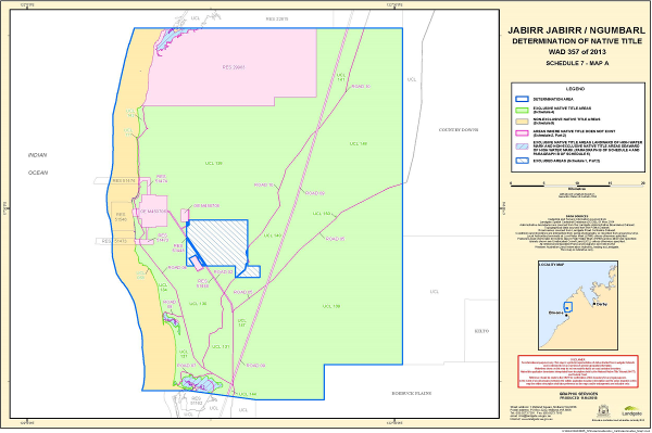
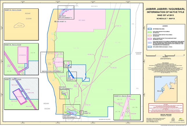
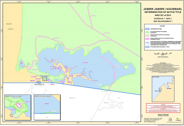

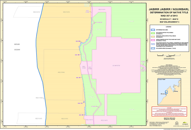
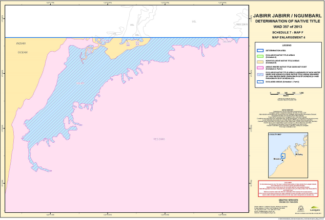
Note: Entry of orders is dealt with in Rule 39.32 of the Federal Court Rules 2011.
NORTH J:
1 Today, in Beagle Bay, at this sitting of the Federal Court of Australia, we witness a step in the long history of the Bindunbur, Jabirr Jabirr, Ngumbarl, Nyul Nyul and Nimanbur people.
2 The purpose of the Court convening here is to make final orders in the applications for determinations of native title brought by the Bindunbur people, the Jabirr Jabirr people and the Goolarabooloo people.
3 It is useful to set this event in its historical context. The Jabirr Jabirr, Ngumbarl, Nyul Nyul and Nimanbur people have been here in the Mid Dampier Peninsula for thousands of years. In times past the land provided all their needs, both spiritual and physical.
4 No doubt the people at times endured hardship as the result of cyclones, fire, drought and the like and also, most likely, from disputes with other Aboriginal people around the area.
5 But the most damaging intrusion in more recent times came from the arrival of European settlement in about the 1860s by pastoralist.
6 At that time there was a widespread social attitude of superiority of the settlers over the local Aboriginal people. Inequality was built into the relationship. Severe government policies including removal of children and statutory control of the lives of Aboriginal people was the result. The settlers brought diseases which ravaged and decimated the Aboriginal people here.
7 A significant turning point in the relationship with Aboriginal people came in June 1992 when the High Court accepted the challenge brought by Eddie Mabo and decided that prior to European settlement Australia was not terra nullius and that Aboriginal people had rights to land under the common law.
8 A statutory response was needed to reconcile the rights of the Aboriginal people then recognised and the interests of the settlers which had been acquired without consideration of those rights. The Native Title Act 1993 (Cth) was the result.
9 The Native Title Act provides for Aboriginal people to apply to the Court for a determination of native title. To establish native title requires applicants to establish that they have rights to land under traditional laws and customs and have had those rights continuously since the arrival of European settlement. The central concept of the Native Title Act is that once the Aboriginal people have established that rights existed under traditional laws and customs, the rights are recognised under Australian law, unless they have been extinguished.
10 It was under that system that the Jabirr Jabirr, Ngumbarl, Nyul Nyul and Nimanbur and Goolarabooloo people filed applications in 2013 in the Federal Court for determinations of native title to areas in the Mid Dampier Peninsula.
11 The hearing of the applications took place on 45 days over 21 months commencing in September 2015. The Court travelled throughout the Mid Dampier Peninsula and heard evidence from many of you present today. The old people, senior law men and women, and young people, told of their connection with the land and shared stories of culture showing the Court the deep connection you have with the land.
12 You made a powerful case of a proud people with a deep cultural attachment to this area. I considered your evidence and wrote a very long judgment explaining what you had told the Court and how it justified the application for determinations of native title. In that judgment I quoted words from your evidence extensively. They now stand as part of the history of your people.
13 The evidence of the Goolarabooloo people demonstrated their involvement in the community and relationship with the land over the last nearly 90 years. I have, however, found that their history did not give rise to rights to land in the application area which are recognised as native title rights under the Native Title Act.
14 Some of the things you told the Court about were further explained by experts engaged by the parties. I want to acknowledge the outstanding expertise of all the anthropologists who gave evidence, namely, Professor Peter Sutton, Mr Geoffrey Bagshaw, Dr James Weiner, Dr Janelle White and Professor Scott Cane. Their long experience provided great assistance to the Court.
15 I also want to acknowledge the high level of professional attention provided by all the lawyers involved in the proceeding. In particular I pay tribute to the meticulous preparation of the Bindunbur legal team and especially to their instructing solicitor Mr Dante Mavec, for whom no request was impossible, and to Mr Robert Blowes SC, Mr Tom Keely SC and Ms Megan Brayne.
16 The State of Western Australia had the carriage of the extinguishment claims and otherwise generally supported the applicants’ connection case. In the early days of native title litigation in Western Australia the approach of the State was at times unduly obstructionist. In the present proceeding, in contrast, the approach of Mr Peter Quinlan SC, who was appointed Solicitor General for Western Australia in the course of the case, and Ms Coby Taggart, could not be faulted. They were at all times constructive and cooperative whilst properly protective of the rights and interests of the State. Their conduct was a model of State participation in native title proceedings.
17 Registrar Ann Daniel has been integral to the efficient management of the case acting as the liaison between the Court and the parties and shepherding all through the complexities of the organisation of on-country hearings. Mr David Oldland and the staff of Transcript Australia have provided an impeccable transcript service often under trying conditions. Mr Nick Lonick as the Court Officer has been an indispensable presence for much of the hearing. My thanks and the gratitude of the parties is due to them all.
18 As I wrote in the judgment delivered on 23 November 2017, the Jabirr Jabirr and Bindunbur people have established that they are entitled to determinations of native title.
19 In closing I would like to draw attention to part of the preamble to the Native Title Act. It states that “the people of Australia intend: … to ensure that Aboriginal peoples and Torres Strait Islanders receive the full recognition and status within the Australian nation to which history, their prior rights and interests, and their rich and diverse culture, fully entitle them to aspire.”
20 The native title system is far from perfect. Today is not the occasion to dwell on its imperfections. Rather, today is the occasion to celebrate with the Bindunbur and Jabirr Jabirr people that they have achieved, though much hard work and preparation over a long period, through the native title system as the preamble states, the recognition to which their prior rights and interests full entitle them to aspire.
21 On this day the intention of the Australian people to right the wrongs of the past can be seen to have a practical meaning. The recognition of the rights of the Bindunbur and Jabirr Jabirr people to their land represents another step on the path to reconciliation.
22 I am proud to now make the orders which recognise the rights of the Bindunbur and Jabirr people to this land. In accordance with the practice which I started in the Karijarri native title application nearly 20 years ago, I will hand copies of the orders to Betty Dixon, Damien Manado, Cecelia Churnside, Phillip McCarthy, Alec Dann and Walter Koster on behalf of the Bindunbur named applicants and to Betty Dixon, Rita Augustine, Iga Paddy, Cecelia Djiagween and Anthony Watson on behalf of the Jabirr Jabirr / Ngumbarl named applicants, as representatives of the native title holders as a symbol of the recognition by the Australian people of the rights of the Bindunbur and Jabirr Jabirr people to this land.
I certify that the preceding twenty-two (22) numbered paragraphs are a true copy of the Reasons for Judgment herein of the Honourable Justice North. |
Associate:
SCHEDULE
WAD 359 of 2013
First Applicants CECILIA CHURNSIDE
ALEC DANN
BETTY DIXON
WALTER KOSTER
PHILLIP MCCARTHY
Respondents COMMONWEALTH OF AUSTRALIA
SHIRE OF BROOME
SHEFFIELD RESOURCES LIMITED
JAMIE PETER BURTON
VICTORIA JANE BURTON
KURT ELEZOVICH
YEEDA STATION PTY LTD
JD ARROW
SJ ARROW
WAD 357 of 2013
Third Applicants ELIZABETH DIXON
CECILIA DJIAGWEEN
PADDY IGNATIUS
ANTHONY WATSON
Respondents COMMONWEALTH OF AUSTRALIA
SHIRE OF BROOME
KIMBERLEY LAND COUNCIL ABORIGINAL CORPORATION
CLIPPER PEARLS PTY LTD
THE AUSTRALIAN SOUTH SEA PEARL COMPANY PTY LTD
WAD 374 of 2013
Fourth Applicants BRIAN JOHN COUNCILLOR
TERRENCE HUNTER
JASON DAVID ROE
RONALD LESLIE ROE
Respondents COMMONWEALTH OF AUSTRALIA
SHIRE OF BROOME
KIMBERLEY LAND COUNCIL ABORIGINAL CORPORATION
CLIPPER PEARLS PTY LTD
THE AUSTRALIAN SOUTH SEA PEARL COMPANY PTY LTD

