
FEDERAL COURT OF AUSTRALIA
Jones on behalf of the Yinhawangka People v State of Western Australia [2017] FCA 801
ORDERS
WAD 216 of 2010 | ||
| ||
BETWEEN: | CHURCHILL JONES, LY (DECEASED), NICHOLAS COOK, DAVID COX, ADRIAN CONDON, JI (DECEASED), STUART INJIE, AF (DECEASED) and ROY TOMMY Applicant | |
AND: | STATE OF WESTERN AUSTRALIA, BARKLEY MARSHALL DAY, ZANE BRADLEY DAY, JOAN ELIZABETH DAY, RICHARD ERNEST DAY, ANDREW NICHOLAS GLENN, WENDY RUTH HARVEY, ROCKLEA STATION PTY LTD, TUREE PASTORAL COMPANY PTY LTD, BM MAGUIRE, CHANNAR MINING PTY LTD, FMG PILBARA PTY LTD, HAMERSLEY EXPLORATION PTY LTD, HAMSERSLEY IRON PTY LTD, MT BRUCE MINING PTY LTD, ROBE RIVER MINING CO PTY LTD, SINOSTEEL CHANNAR PTY LTD and YAMATJI MARLPA ABORIGINAL CORPORATION Respondents | |
AND: | ATTORNEY-GENERAL OF THE COMMONWEALTH OF AUSTRALIA Intervener | |
DATE OF ORDER: |
THE COURT NOTES THAT:
A. The Applicant in proceedings WAD216 of 2010 and WAD340 of 2010 (collectively, “Yinhawangka Applications”) has made native title determination applications that relate to the area of land and waters the subject of the attached Consent Determination of Native Title (“Determination”).
B. The Applicant in the Yinhawangka Applications, the State of Western Australia and the other Respondents to the proceedings (“the parties”) have reached an agreement as to the terms of the Determination which is to be made in relation to the land and waters covered by the Yinhawangka Applications (“Determination Area”). The external boundaries of the Determination Area are described in Schedule One to the Determination.
C. Each of:
(a) Cheela Plains Pastoral Co Pty Ltd (ACN 096 951 094) of Cheela Plains Station;
(b) Barkley Marshall Day, Zane Bradley Day, Joan Elizabeth Day and Richard Ernest Day of Mt Vernon Station;
(c) Wendy Ruth Harvey of Mininer Station;
(d) Bruce Michael Maguire and Turee Pastoral Co Pty Ltd (ACN 008 691 718) of Turee Creek Station; and
(e) Andrew Nicholas Glenn of Ashburton Downs Station,
has agreed to the terms of the Determination on the basis of having reached agreement with the Applicant in relation to those portions of their respective pastoral leases that are situated within the Determination Area. Following the making of the Determination, those agreements will be executed and an application will be made for the agreements to be registered as Indigenous Land Use Agreements on the Register of Indigenous Land Use Agreements as body corporate agreements pursuant to s 24BG of the Native Title Act 1993 (Cth).
D. Pursuant to s 87(1) of the Native Title Act 1993 (Cth) the parties have filed with this Court an agreement in writing setting out the terms of the agreement reached by the parties in relation to the Yinhawangka Applications.
E. The terms of the agreement involve the making of consent orders for a determination pursuant to ss 87 and 94A of the Native Title Act 1993 (Cth) that native title exists in relation to the land and waters of the Determination Area.
F. The parties acknowledge that the effect of the making of the Determination is that the members of the native title claim group, in accordance with the traditional laws acknowledged and the traditional customs observed by them, should be recognised as the native title holders for the Determination Area as set out in the Determination.
G. Pursuant to s 87(2) of the Native Title Act 1993 (Cth), the parties have requested that the Court determine the Yinhawangka Applications together without holding a hearing.
H. The Applicant in the Yinhawangka Applications has nominated the Yinhawangka Aboriginal Corporation (ICN 7837) pursuant to s 56(2)(a) of the Native Title Act 1993 (Cth) to hold the determined native title in trust for the native title holders.
BEING SATISFIED that a determination in the terms set out at Attachment A would be within the power of the Court, and it appearing to the Court appropriate to do so, pursuant to ss 87 and 94A of the Native Title Act 1993 (Cth) and by the consent of the parties:
THE COURT ORDERS THAT:
1. In relation to the Determination Area, there be a determination of native title in WAD340 of 2010 and WAD216 of 2010 in terms of the Determination as provided for in Attachment A.
2. The Yinhawangka Aboriginal Corporation (ICN 7837) shall hold the determined native title in trust for the native title holders pursuant to s 56(2)(b) of the Native Title Act 1993 (Cth).
3. There be no order as to costs.
Note: Entry of orders is dealt with in Rule 39.32 of the Federal Court Rules 2011.
DETERMINATION
THE COURT ORDERS, DECLARES AND DETERMINES THAT:
Existence of native title (s 225 Native Title Act)
1. Subject to paragraph 2, native title exists in the Determination Area in the manner set out in paragraphs 4 and 5 of this Determination.
2. Native title does not exist in those parts of the Determination Area the subject of the interests identified in Schedule Four which are shown as generally shaded pink on the maps at Schedule Two.
Native title holders (s 225(a) Native Title Act)
3. The native title in the Determination Area is held by the Yinhawangka People. The Yinhawangka People are the people referred to in Schedule Seven.
The nature and extent of native title rights and interests and exclusiveness of native title (ss 225(b) and 225(e) Native Title Act)
Exclusive rights and interests
4. Subject to paragraphs 6, 7, 8 and 11, the nature and extent of the native title rights and interests in relation to the Exclusive Area is:
(a) except in relation to flowing and underground waters, the right to possession, occupation, use and enjoyment to the exclusion of all others; and
(b) in relation to flowing and underground waters, the right to use and enjoy the flowing and underground waters, including:
(i) the right to hunt on, fish from, take and use the traditional resources of the flowing and underground waters; and
(ii) the right to take and use the flowing and underground waters.
Non-exclusive rights and interests
5. Subject to paragraphs 6, 7, 8 and 11, the nature and extent of the native title rights and interests in relation to the Non-Exclusive Area is that they confer the following non-exclusive rights on the Yinhawangka People, including the right to conduct activities necessary to give effect to them:
(a) the right to live, being to enter and remain on the land, to camp and erect shelters and other structures for that purpose, and travel over and visit any part of the land and waters of the Non-Exclusive Area;
(b) the right to hunt, fish, gather, take and use the traditional resources of the Non-Exclusive Area;
(c) the right to take and use water;
(d) the right to engage in cultural activities and the transmission of cultural knowledge on the Non-Exclusive Area, including:
(i) visiting places of cultural or spiritual importance and maintaining, caring for, and protecting those places by carrying out activities to preserve their physical or spiritual integrity; and
(ii) conducting ceremony and ritual, including burial and burial rites; and
(e) the right to be accompanied on to the Non-Exclusive Area by those people who, though not native title holders and who (for the avoidance of doubt) cannot themselves exercise any native title right in the Determination Area, are:
(i) spouses, parents or children of the native title holders; or
(ii) people required by or entering in connection with traditional law and custom for the performance of ceremonies or cultural activities on the Non-Exclusive Area.
Qualifications on the native title rights and interests
6. The native title rights and interests are subject to and exercisable in accordance with:
(a) the laws of the State and the Commonwealth, including the common law; and
(b) the traditional laws and customs of the Yinhawangka People for personal, domestic and communal purposes (including social, cultural, religious, spiritual and ceremonial purposes).
7. Notwithstanding anything in this Determination, there are no native title rights and interests in the Determination Area in relation to:
(a) minerals as defined in the Mining Act 1904 (WA) (repealed) and in the Mining Act 1978 (WA), except to the extent that ochre is not a mineral pursuant to the Mining Act 1904 (WA); or
(b) petroleum as defined in the Petroleum Act 1936 (WA) (repealed) and in the Petroleum and Geothermal Energy Resources Act 1967 (WA);
(c) geothermal energy resources and geothermal energy as defined in the Petroleum and Geothermal Energy Resources Act 1967 (WA); or
(d) water captured by the holders of the Other Interests pursuant to those Other Interests.
8. The native title rights and interests set out in paragraphs 4(b) and 5 do not confer:
(a) possession, occupation, use and enjoyment on the Yinhawangka People to the exclusion of all others; or
(b) a right to control the access to, or use of, the land and waters of the Determination Area or its resources.
Areas to which ss 47, 47A or 47B of the Native Title Act apply
9. Sections 47A and 47B of the Native Title Act apply to disregard any prior extinguishment in relation to the areas described in Schedule Five.
The nature and extent of any other interests (s 225(c) Native Title Act)
10. The nature and extent of the Other Interests are described in Schedule Six.
Relationship between native title rights and other interests (s 225(d) Native Title Act)
11. Except as otherwise provided for by law, the relationship between the native title rights and interests described in paragraphs 4 and 5 and the Other Interests is that:
(a) to the extent that any of the Other Interests are inconsistent with the continued existence, enjoyment or exercise of the native title rights and interests, the native title rights and interests continue to exist in their entirety, but the native title rights and interests have no effect in relation to the Other Interests to the extent of the inconsistency during the currency of the Other Interests; and otherwise,
(b) the existence and exercise of the native title rights and interests do not prevent the doing of any activity required or permitted to be done by or under the Other Interests, and the Other Interests, and the doing of any activity required or permitted to be done by or under the Other Interests, prevail over the native title rights and interests and any exercise of the native title rights and interests but do not extinguish them.
Liberty to Apply
12. The parties have liberty to apply to establish the precise location and boundaries of the public works and adjacent land and waters identified in relation to any part or parts of the Determination Area referred to in clause 5 of Schedule Four of this Determination.
Definitions and interpretation
13. In this Determination, unless the contrary intention appears:
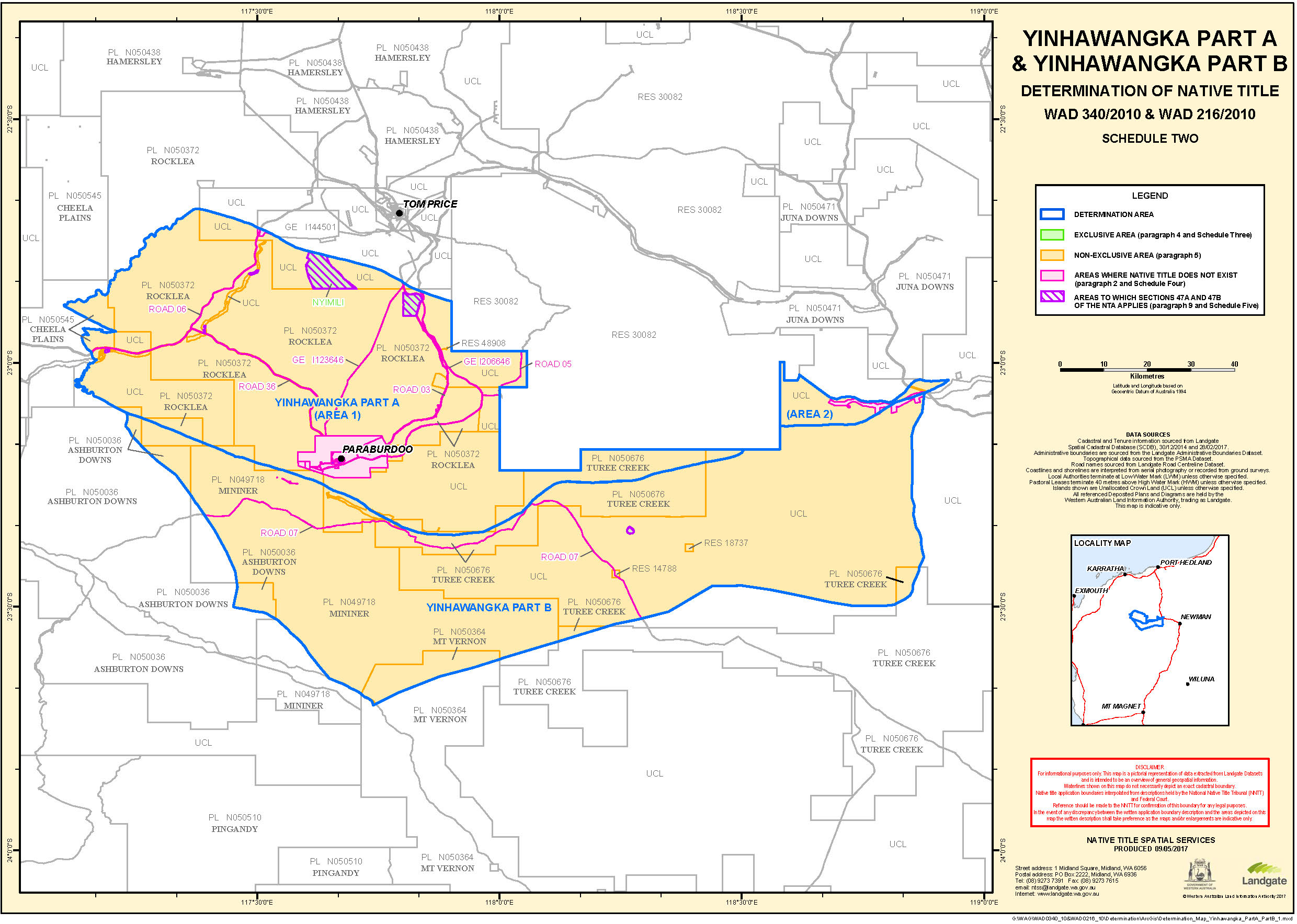
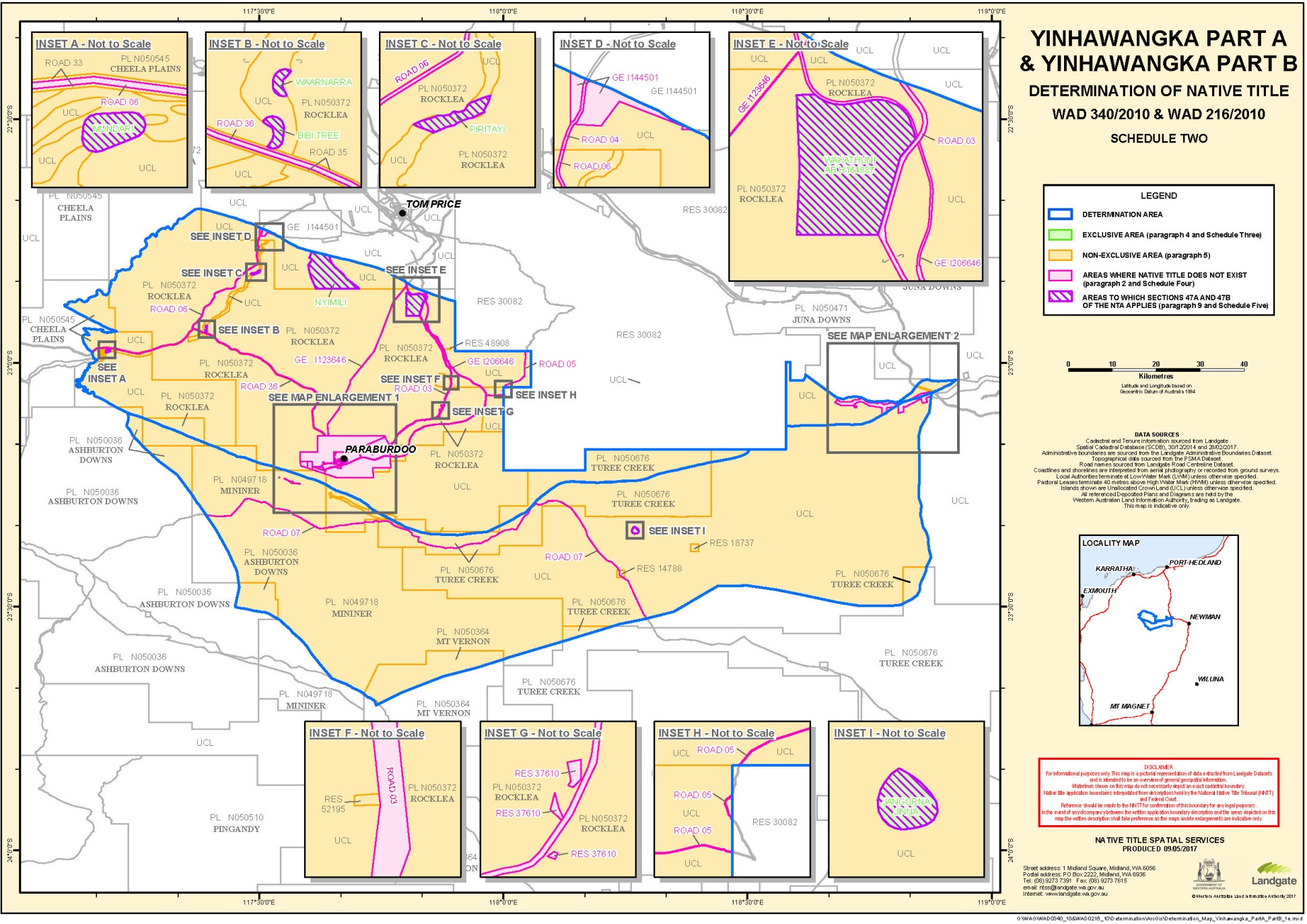
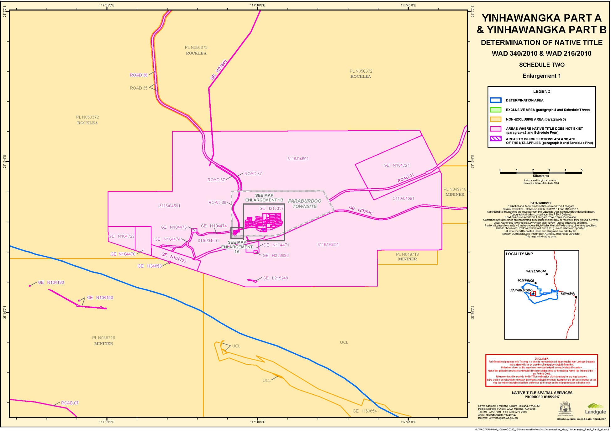
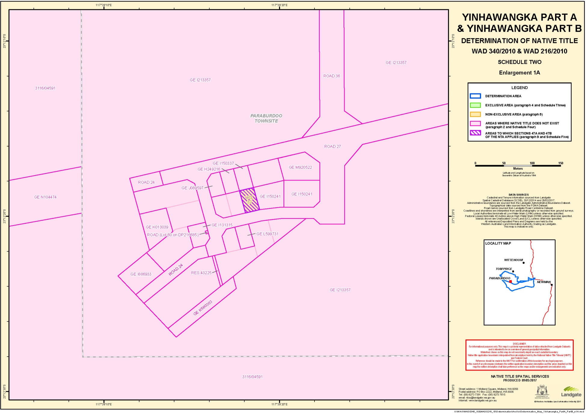
"Determination Area" means the land and waters described in Schedule One and depicted on the maps at Schedule Two;
"Exclusive Area" means those lands and waters of the Determination Area described in Schedule Three (which areas are generally shown as shaded green on the maps at Schedule Two);
"flowing water" means the following water within the Determination Area:
(a) water which flows, whether permanently, intermittently or occasionally, within any river, creek, stream or brook; and
(b) any natural collection of water into, through, or out of which a river, creek, stream or brook flows;
"land" has the same meaning as in the Native Title Act and, for the avoidance of doubt, includes any natural collection of water found on the land which does not fall within the definition of “waters”;
"Native Title Act" means the Native Title Act 1993 (Cth);
"native title holders" means the Yinhawangka People as described in Schedule Seven and referred to in paragraph 3;
"Non-Exclusive Area" means those lands and waters of the Determination Area which are not Exclusive Areas or described in paragraph 2 as an area where native title does not exist (which areas are generally shaded as yellow on the maps at Schedule Two);
"Other Interests" means the legal or equitable estates or interests and other rights in relation to the Determination Area described in Schedule Six and referred to in paragraph 10;
"resources" means flora, fauna, and other natural resources such as charcoal, stone, soil, wood, resin, and ochre (except, for the avoidance of doubt, ochres for use in the manufacture of porcelain, fine pottery or pigments which are minerals pursuant to the Mining Act 1904 (WA) (repealed));
"use" includes by way of share and exchange;
"underground water" means water from and including an underground water source, including water that percolates from the ground; and
"waters" has the same meaning as in the Native Title Act and includes flowing and underground water.
14. In the event of any inconsistency between the written description of an area in Schedule One, Three, Four, Five or Six and the area as depicted on the maps at Schedule Two the written description prevails.
SCHEDULE ONE
DETERMINATION AREA
The Determination Area, generally shown as bordered in blue on the maps at Schedule Two, comprises all land and waters bounded by the following descriptions:
WAD340/2010 Yinhawangka Part A
Area 1
All those lands and waters commencing at Latitude 22.705647 South, Longitude 117.334829 East being a point on the present boundary of Native Title Determination WAD6208/1998 Eastern Guruma (WCD2007/001); Then generally northeasterly and generally southeasterly along the boundaries of that native title determination to the intersection with a western boundary of Reserve 30082 (Karijini National Park) at Latitude 22.874031 South; Then generally southerly and generally easterly along the boundaries of that reserve to Longitude 118.504822 East being a point on the present boundary of Native Title Application WAD216/2010 Yinhawangka Part B (WC2010/011); Then generally southwesterly and generally northwesterly along the boundaries of that native title application through the following coordinate positions:
LATITUDE (SOUTH) | LONGITUDE (EAST) |
23.178931 | 118.503365 |
23.181459 | 118.501568 |
23.184576 | 118.499749 |
23.184886 | 118.498601 |
23.186338 | 118.496464 |
23.189640 | 118.490281 |
23.191755 | 118.483952 |
23.193451 | 118.478964 |
23.194873 | 118.473039 |
23.196443 | 118.464835 |
23.198036 | 118.457199 |
23.199702 | 118.448423 |
23.200785 | 118.442889 |
23.201818 | 118.436032 |
23.203079 | 118.428976 |
23.204450 | 118.421728 |
23.206890 | 118.411598 |
23.208630 | 118.404715 |
23.209021 | 118.399586 |
23.210193 | 118.396323 |
23.211616 | 118.390398 |
23.212899 | 118.383909 |
23.214646 | 118.377214 |
23.216054 | 118.370911 |
23.217344 | 118.364611 |
23.219593 | 118.355624 |
23.220993 | 118.349131 |
23.222062 | 118.343219 |
23.223131 | 118.337307 |
23.225557 | 118.326799 |
23.228144 | 118.317421 |
23.230702 | 118.310319 |
23.232744 | 118.305129 |
23.236931 | 118.294367 |
23.238965 | 118.288989 |
23.239113 | 118.286710 |
23.240049 | 118.283455 |
23.240823 | 118.279069 |
23.241200 | 118.273562 |
23.241731 | 118.268996 |
23.241709 | 118.262366 |
23.241864 | 118.257245 |
23.242358 | 118.251733 |
23.242603 | 118.242820 |
23.243274 | 118.235786 |
23.244041 | 118.228180 |
23.244418 | 118.222672 |
23.244713 | 118.215083 |
23.244722 | 118.206178 |
23.245445 | 118.200469 |
23.245954 | 118.195335 |
23.245711 | 118.189092 |
23.245483 | 118.183228 |
23.245071 | 118.172634 |
23.244858 | 118.167147 |
23.244534 | 118.158824 |
23.243967 | 118.153350 |
23.243739 | 118.147486 |
23.243474 | 118.140675 |
23.243651 | 118.136122 |
23.244042 | 118.130993 |
23.245067 | 118.123946 |
23.245922 | 118.121641 |
23.247684 | 118.115325 |
23.248244 | 118.114546 |
23.248561 | 118.113588 |
23.249777 | 118.111459 |
23.253123 | 118.106412 |
23.254708 | 118.104649 |
23.257022 | 118.100396 |
23.262844 | 118.092228 |
23.267244 | 118.086952 |
23.270841 | 118.082274 |
23.271497 | 118.080924 |
23.273973 | 118.077803 |
23.278845 | 118.072510 |
23.279169 | 118.071740 |
23.281984 | 118.068227 |
23.283488 | 118.067415 |
23.285073 | 118.065652 |
23.291595 | 118.060298 |
23.296268 | 118.055960 |
23.296946 | 118.055177 |
23.300926 | 118.051243 |
23.303071 | 118.048702 |
23.305039 | 118.047683 |
23.307707 | 118.043417 |
23.310058 | 118.037080 |
23.313714 | 118.030884 |
23.317046 | 118.025458 |
23.320724 | 118.019829 |
23.323141 | 118.015194 |
23.326112 | 118.009592 |
23.329399 | 118.003031 |
23.332665 | 117.995902 |
23.335076 | 117.991078 |
23.338673 | 117.983369 |
23.342167 | 117.976043 |
23.343081 | 117.975252 |
23.344032 | 117.972375 |
23.345418 | 117.968536 |
23.347260 | 117.964301 |
23.347430 | 117.962589 |
23.347806 | 117.954051 |
23.347947 | 117.948551 |
23.348987 | 117.941883 |
23.349119 | 117.939226 |
23.350144 | 117.932179 |
23.350573 | 117.924964 |
23.351324 | 117.920011 |
23.352659 | 117.911816 |
23.352991 | 117.905173 |
23.352726 | 117.898363 |
23.352484 | 117.892120 |
23.352109 | 117.882472 |
23.351829 | 117.875283 |
23.351601 | 117.869418 |
23.351373 | 117.863553 |
23.351130 | 117.857310 |
23.350851 | 117.850121 |
23.349613 | 117.842589 |
23.347543 | 117.831866 |
23.344331 | 117.822132 |
23.342017 | 117.814259 |
23.339888 | 117.808085 |
23.338024 | 117.802659 |
23.336196 | 117.798179 |
23.333168 | 117.793175 |
23.330729 | 117.788149 |
23.327892 | 117.782000 |
23.323721 | 117.774954 |
23.322026 | 117.770848 |
23.317826 | 117.763044 |
23.315041 | 117.758220 |
23.312970 | 117.753559 |
23.310435 | 117.749105 |
23.306353 | 117.741298 |
23.302521 | 117.733860 |
23.294732 | 117.724861 |
23.291283 | 117.721198 |
23.286538 | 117.714551 |
23.283752 | 117.709727 |
23.281107 | 117.705466 |
23.278520 | 117.699688 |
23.275838 | 117.694481 |
23.275042 | 117.692237 |
23.271926 | 117.684962 |
23.268684 | 117.677503 |
23.265729 | 117.668328 |
23.263194 | 117.660842 |
23.261751 | 117.657106 |
23.259326 | 117.652458 |
23.255900 | 117.646332 |
23.253513 | 117.642630 |
23.248959 | 117.634839 |
23.246881 | 117.629989 |
23.245835 | 117.627375 |
23.245061 | 117.625698 |
23.243263 | 117.621975 |
23.240515 | 117.615065 |
23.237797 | 117.605882 |
23.236390 | 117.600060 |
23.234157 | 117.594269 |
23.231652 | 117.587540 |
23.228763 | 117.580067 |
23.227629 | 117.575183 |
23.225764 | 117.569757 |
23.223635 | 117.563583 |
23.221800 | 117.558914 |
23.220024 | 117.552727 |
23.218042 | 117.544274 |
23.216583 | 117.540159 |
23.216149 | 117.538091 |
23.214004 | 117.531538 |
23.211904 | 117.526121 |
23.210408 | 117.521060 |
23.207948 | 117.509404 |
23.205737 | 117.501149 |
23.201722 | 117.488981 |
23.198848 | 117.481887 |
23.196734 | 117.476091 |
23.194508 | 117.470488 |
23.193381 | 117.465793 |
23.192623 | 117.455400 |
23.189830 | 117.450387 |
23.186735 | 117.443679 |
23.184503 | 117.437888 |
23.179617 | 117.427646 |
23.177149 | 117.421863 |
23.173634 | 117.413465 |
23.170731 | 117.405614 |
23.167828 | 117.397763 |
23.163532 | 117.387499 |
23.160393 | 117.379657 |
23.158529 | 117.374231 |
23.156429 | 117.368813 |
23.153165 | 117.360786 |
23.151426 | 117.355544 |
23.148199 | 117.348463 |
23.144013 | 117.341038 |
23.141095 | 117.332809 |
23.137956 | 117.324966 |
23.134648 | 117.315804 |
23.131738 | 117.307764 |
23.130013 | 117.302901 |
23.127862 | 117.299191 |
23.127176 | 117.296753 |
23.125393 | 117.293408 |
23.121864 | 117.284633 |
23.118555 | 117.275471 |
23.115372 | 117.266493 |
23.113184 | 117.261837 |
23.111459 | 117.256974 |
23.109949 | 117.251535 |
23.108114 | 117.246866 |
23.105145 | 117.237312 |
Then continuing northwesterly along the boundary of that native title application to Latitude 23.102006 South, Longitude 117.229470 East being a point on the present boundary of Native Title Application WAD490/2016 Yinhawangka Gobawarrah (WC2016/004); Then generally northwesterly along the boundaries of that native title application through the following coordinate positions:
LATITUDE (SOUTH) | LONGITUDE (EAST) |
23.097754 | 117.220342 |
23.094298 | 117.213459 |
23.089693 | 117.204344 |
23.087269 | 117.199696 |
23.083090 | 117.192459 |
23.081727 | 117.190804 |
23.080076 | 117.187833 |
23.076517 | 117.181332 |
23.072685 | 117.173894 |
23.069155 | 117.165119 |
Then continuing northwesterly along the boundary of that native title application to Latitude 23.067401 South, Longitude 117.161884 East being a point on the present boundary of Native Title Determination WAD126/2005 Puutu Kunti Kurrama and Pinikura #2 (WCD2015/003); Then generally northwesterly, generally northerly, generally easterly, again generally northwesterly and generally northeasterly along the boundaries of that native title determination back to the commencement point.
Area 2
All those lands and waters commencing at the intersection of an eastern boundary of Reserve 30082 (Karijini National Park) with Latitude 23.129889 South being a point on the present boundary of Native Title Application WAD216/2010 Yinhawangka Part B (WC2010/011); Then generally easterly and generally northeasterly along the boundaries of that native title application through the following coordinate positions:
LATITUDE (SOUTH) | LONGITUDE (EAST) |
23.129923 | 118.579226 |
23.129798 | 118.585104 |
23.130026 | 118.590968 |
23.130136 | 118.593806 |
23.129664 | 118.596854 |
23.129383 | 118.604821 |
23.128521 | 118.609967 |
23.128203 | 118.616989 |
23.128468 | 118.623799 |
23.128371 | 118.630433 |
23.128695 | 118.638757 |
23.128583 | 118.651076 |
23.128074 | 118.656209 |
23.127993 | 118.663221 |
23.127292 | 118.669499 |
23.126968 | 118.676331 |
23.126525 | 118.683167 |
23.126598 | 118.691121 |
23.126199 | 118.699093 |
23.126523 | 118.707417 |
23.126736 | 118.712903 |
23.126617 | 118.725032 |
23.126491 | 118.730909 |
23.126005 | 118.733579 |
23.124214 | 118.739139 |
23.122813 | 118.742600 |
23.121722 | 118.747944 |
23.119341 | 118.753525 |
23.118494 | 118.756019 |
23.115155 | 118.761256 |
23.112037 | 118.766106 |
23.111713 | 118.766875 |
23.108388 | 118.772491 |
23.106951 | 118.775006 |
23.104217 | 118.780599 |
23.101209 | 118.785256 |
23.097517 | 118.790506 |
23.094178 | 118.795742 |
23.090515 | 118.801749 |
23.086291 | 118.808534 |
23.081751 | 118.816277 |
23.079694 | 118.821088 |
23.077712 | 118.827791 |
23.075714 | 118.834116 |
23.074262 | 118.839284 |
23.073480 | 118.843481 |
23.070620 | 118.851921 |
23.068261 | 118.858069 |
23.065608 | 118.865744 |
23.062409 | 118.874575 |
Then continuing northeasterly along the boundary of that native title application to Latitude 23.061676 South, Longitude 118.876551 East being a point on the present boundary of Native Title Determination WAD78/2005 Ngarlawangga People (WCD2016/007); Then northeasterly along the boundary of that native title determination to Latitude 23.059844 South, Longitude 118.881488 East being a point on the present boundary of Native Title Application WAD196/2013 Nyiyaparli #3 (WC2013/003); Then generally northeasterly along the boundaries of that native title application through the following coordinate positions:
LATITUDE (SOUTH) | LONGITUDE (EAST) |
23.057979 | 118.885156 |
23.057153 | 118.888217 |
23.055369 | 118.890935 |
23.053320 | 118.895935 |
23.051139 | 118.900561 |
23.048168 | 118.906164 |
23.043694 | 118.915610 |
23.042228 | 118.917369 |
23.037650 | 118.924166 |
Then continuing northeasterly along the boundary of that native title application to Latitude 23.035240 South, Longitude 118.926692 East being a point on the present boundary Native Title Determination WAD6096/1998 Banjima People (WCD2014/001); Then generally westerly, generally southwesterly, again generally westerly and generally northwesterly along the boundaries of that native title determination to the intersection with an easternmost boundary of the southern severance of Reserve 30082 (Karijini National Park) at Latitude 23.024322 South; Then generally southwesterly, westerly, northerly, again westerly and southerly along the boundaries of that reserve back to the commencement point.
Note:
• Geographic Coordinates provided in Decimal Degrees.
• All referenced Deposited Plans and Diagrams are held by the Western Australian Land Information Authority, trading as Landgate.
• Cadastral boundaries sourced from Landgate’s Spatial Cadastral Database dated 28 February 2017.
• For the avoidance of doubt the application excludes any land and waters already claimed by:
• Native Title Determination Application WAD6096/1998 Banjima People (WCD2014/001) as determined in the Federal Court on 11 March 2014
• Native Title Determination Application WAD78/2005 Ngarlawangga People (WCD2016/007) as determined in the Federal Court on 7 December 2016
• Native Title Determination Application WAD6208/1998 Eastern Guruma (WCD2007/001) as determined in the Federal Court on 1 March 2007
• Native Title Determination Application WAD6007/2001 Puutu Kunti Kurrama and Pinikura People (WCD2015/003) as determined in the Federal Court on 2 September 2015
• Native Title Determination Application WAD126/2005 Puutu Kunti Kurrama and Pinikura #2 (WCD2015/003) as determined in the Federal Court on 2 September 2015
• Native Title Determination Application WAD490/2016 Yinhawangka Gobawarrah (WC2016/004) as filed in the Federal Court on 17 October 2016
• Native Title Determination Application WAD196/2013 Nyiyaparli #3 (WC2013/003) as registered in the Federal Court on 27 August 2013
• Native Title Determination Application WAD216/2010 Yinhawangka Part B (WC2010/011) as registered in the Federal Court on 17 September 2010
Datum: Geocentric Datum of Australia 1994 (GDA94)
Prepared By: Graphic Services (Landgate) 19 June 2017
Use of Coordinates:
Where coordinates are used within the description to represent cadastral or topographical boundaries or the intersection with such, they are intended as a guide only. As an outcome to the custodians of cadastral and topographic data continuously recalculating the geographic position of their data based on improved survey and data maintenance procedures, it is not possible to accurately define such a position other than by detailed ground survey.
WAD216/2010 Yinhawangka Part B
All those lands and waters commencing at Latitude 23.102006 South, Longitude 117.229470 East being a point on the present boundary of Native Title Application WAD490/2016 Yinhawangka Gobawarrah (WC2016/004); Then generally southeasterly along the boundaries of that native title application through the following coordinate positions:
LATITUDE (SOUTH) | LONGITUDE (EAST) |
23.106455 | 117.231014 |
23.112366 | 117.231590 |
23.118310 | 117.231126 |
23.124225 | 117.229425 |
23.127875 | 117.227890 |
23.127988 | 117.227843 |
23.130283 | 117.228704 |
23.138193 | 117.235751 |
23.148405 | 117.240354 |
23.174007 | 117.263942 |
23.200902 | 117.293571 |
23.230099 | 117.332405 |
23.273679 | 117.364335 |
23.285473 | 117.371526 |
23.291658 | 117.376992 |
23.343292 | 117.411943 |
23.387736 | 117.436538 |
23.427001 | 117.454085 |
23.460186 | 117.459257 |
23.499850 | 117.450437 |
23.500493 | 117.451958 |
23.501417 | 117.454963 |
23.502728 | 117.460295 |
23.503685 | 117.465963 |
23.504288 | 117.471367 |
23.505599 | 117.476967 |
23.507027 | 117.482431 |
23.508162 | 117.488164 |
23.509416 | 117.494364 |
23.510373 | 117.500033 |
23.510741 | 117.505506 |
23.511462 | 117.510709 |
23.512950 | 117.516374 |
23.515378 | 117.521095 |
23.518160 | 117.525880 |
23.521237 | 117.530663 |
23.523666 | 117.535517 |
23.526389 | 117.540435 |
23.529700 | 117.544616 |
23.533421 | 117.548191 |
23.536908 | 117.552035 |
23.540219 | 117.556215 |
23.543529 | 117.560128 |
23.547192 | 117.563770 |
23.551619 | 117.566872 |
23.555282 | 117.570314 |
23.558534 | 117.574561 |
23.561903 | 117.578673 |
23.565390 | 117.582718 |
23.568994 | 117.586294 |
23.572598 | 117.589869 |
23.576791 | 117.593641 |
23.580926 | 117.597279 |
23.585708 | 117.600712 |
23.590663 | 117.603008 |
23.595681 | 117.606438 |
23.600523 | 117.610271 |
23.604951 | 117.613640 |
23.609202 | 117.616944 |
23.614162 | 117.620709 |
23.618472 | 117.624079 |
23.620303 | 117.625667 |
23.623315 | 117.628313 |
23.628040 | 117.632347 |
23.632292 | 117.636251 |
23.636544 | 117.639822 |
23.641387 | 117.644055 |
23.646171 | 117.647955 |
23.646644 | 117.648619 |
23.647886 | 117.650612 |
23.650257 | 117.655935 |
23.652392 | 117.660859 |
23.654527 | 117.666452 |
23.656310 | 117.672046 |
23.658681 | 117.677503 |
23.661229 | 117.683024 |
23.664307 | 117.687873 |
23.667442 | 117.692656 |
23.669637 | 117.698247 |
23.671889 | 117.703036 |
23.674612 | 117.707889 |
23.677394 | 117.712740 |
23.681471 | 117.716980 |
23.685018 | 117.721358 |
23.687036 | 117.726751 |
23.689316 | 117.731350 |
23.692117 | 117.734787 |
23.696147 | 117.737635 |
Then continuing southeasterly along the boundary of that native title application to Latitude 23.701683 South, Longitude 117.739177 East being a point on the present boundary of Native Title Determination WAD72/1998 Nharnuwangga Wajarri and Ngarlawangga (WCD2000/001); Then generally northeasterly along the boundaries of that native title determination to the intersection with a western boundary of Pastoral Lease N049718 (Mininer) at Latitude 23.607725 South; Then generally northeasterly through the following coordinate positions:
LATITUDE (SOUTH) | LONGITUDE (EAST) |
23.604419 | 118.010175 |
23.582108 | 118.084615 |
23.581678 | 118.086525 |
Then northwesterly to the intersection with an eastern boundary of Pastoral Lease N049718 (Mininer) at Latitude 23.571113 South being a point on the present boundary of Native Title Determination WAD72/1998 Nharnuwangga Wajarri and Ngarlawangga (WCD2000/001); Then generally northeasterly and generally southeasterly along the boundaries of that native title determination to Longitude 118.797685 East being a point on the present boundary of Native Title Determination WAD78/2005 Ngarlawangga People (WCD2000/001); Then generally northeasterly and generally northerly along the boundaries of that native title determination to Latitude 23.061676 South, Longitude 118.876551 East being a point on the present boundary of Native Title Application WAD340/2010 Yinhawangka Part A (WC2010/016); Then generally southwesterly and generally westerly along the boundaries of that native title application through the following coordinate positions:
LATITUDE (SOUTH) | LONGITUDE (EAST) |
23.062409 | 118.874575 |
23.065608 | 118.865744 |
23.068261 | 118.858069 |
23.070620 | 118.851921 |
23.073480 | 118.843481 |
23.074262 | 118.839284 |
23.075714 | 118.834116 |
23.077712 | 118.827791 |
23.079694 | 118.821088 |
23.081751 | 118.816277 |
23.086291 | 118.808534 |
23.090515 | 118.801749 |
23.094178 | 118.795742 |
23.097517 | 118.790506 |
23.101209 | 118.785256 |
23.104217 | 118.780599 |
23.106951 | 118.775006 |
23.108388 | 118.772491 |
23.111713 | 118.766875 |
23.112037 | 118.766106 |
23.115155 | 118.761256 |
23.118494 | 118.756019 |
23.119341 | 118.753525 |
23.121722 | 118.747944 |
23.122813 | 118.742600 |
23.124214 | 118.739139 |
23.126005 | 118.733579 |
23.126491 | 118.730909 |
23.126617 | 118.725032 |
23.126736 | 118.712903 |
23.126523 | 118.707417 |
23.126199 | 118.699093 |
23.126598 | 118.691121 |
23.126525 | 118.683167 |
23.126968 | 118.676331 |
23.127292 | 118.669499 |
23.127993 | 118.663221 |
23.128074 | 118.656209 |
23.128583 | 118.651076 |
23.128695 | 118.638757 |
23.128371 | 118.630433 |
23.128468 | 118.623799 |
23.128203 | 118.616989 |
23.128521 | 118.609967 |
23.129383 | 118.604821 |
23.129664 | 118.596854 |
23.130136 | 118.593806 |
23.130026 | 118.590968 |
23.129798 | 118.585104 |
23.129923 | 118.579226 |
Then continuing westerly along the boundary of that native title application to the intersection with an eastern boundary of Reserve 30082 (Karijini National Park) at Latitude 23.129889 South; Then southerly and westerly along the boundaries of that reserve to Longitude 118.504822 East being a point on the present boundary of Native Title Application WAD340/2010 Yinhawangka Part A (WC2010/016); Then generally southwesterly and generally northwesterly along the boundaries of that native title application through the following coordinate positions:
LATITUDE (SOUTH) | LONGITUDE (EAST) |
23.178931 | 118.503365 |
23.181459 | 118.501568 |
23.184576 | 118.499749 |
23.184886 | 118.498601 |
23.186338 | 118.496464 |
23.189640 | 118.490281 |
23.191755 | 118.483952 |
23.193451 | 118.478964 |
23.194873 | 118.473039 |
23.196443 | 118.464835 |
23.198036 | 118.457199 |
23.199702 | 118.448423 |
23.200785 | 118.442889 |
23.201818 | 118.436032 |
23.203079 | 118.428976 |
23.204450 | 118.421728 |
23.206890 | 118.411598 |
23.208630 | 118.404715 |
23.209021 | 118.399586 |
23.210193 | 118.396323 |
23.211616 | 118.390398 |
23.212899 | 118.383909 |
23.214646 | 118.377214 |
23.216054 | 118.370911 |
23.217344 | 118.364611 |
23.219593 | 118.355624 |
23.220993 | 118.349131 |
23.222062 | 118.343219 |
23.223131 | 118.337307 |
23.225557 | 118.326799 |
23.228144 | 118.317421 |
23.230702 | 118.310319 |
23.232744 | 118.305129 |
23.236931 | 118.294367 |
23.238965 | 118.288989 |
23.239113 | 118.286710 |
23.240049 | 118.283455 |
23.240823 | 118.279069 |
23.241200 | 118.273562 |
23.241731 | 118.268996 |
23.241709 | 118.262366 |
23.241864 | 118.257245 |
23.242358 | 118.251733 |
23.242603 | 118.242820 |
23.243274 | 118.235786 |
23.244041 | 118.228180 |
23.244418 | 118.222672 |
23.244713 | 118.215083 |
23.244722 | 118.206178 |
23.245445 | 118.200469 |
23.245954 | 118.195335 |
23.245711 | 118.189092 |
23.245483 | 118.183228 |
23.245071 | 118.172634 |
23.244858 | 118.167147 |
23.244534 | 118.158824 |
23.243967 | 118.153350 |
23.243739 | 118.147486 |
23.243474 | 118.140675 |
23.243651 | 118.136122 |
23.244042 | 118.130993 |
23.245067 | 118.123946 |
23.245922 | 118.121641 |
23.247684 | 118.115325 |
23.248244 | 118.114546 |
23.248561 | 118.113588 |
23.249777 | 118.111459 |
23.253123 | 118.106412 |
23.254708 | 118.104649 |
23.257022 | 118.100396 |
23.262844 | 118.092228 |
23.267244 | 118.086952 |
23.270841 | 118.082274 |
23.271497 | 118.080924 |
23.273973 | 118.077803 |
23.278845 | 118.072510 |
23.279169 | 118.071740 |
23.281984 | 118.068227 |
23.283488 | 118.067415 |
23.285073 | 118.065652 |
23.291595 | 118.060298 |
23.296268 | 118.055960 |
23.296946 | 118.055177 |
23.300926 | 118.051243 |
23.303071 | 118.048702 |
23.305039 | 118.047683 |
23.307707 | 118.043417 |
23.310058 | 118.037080 |
23.313714 | 118.030884 |
23.317046 | 118.025458 |
23.320724 | 118.019829 |
23.323141 | 118.015194 |
23.326112 | 118.009592 |
23.329399 | 118.003031 |
23.332665 | 117.995902 |
23.335076 | 117.991078 |
23.338673 | 117.983369 |
23.342167 | 117.976043 |
23.343081 | 117.975252 |
23.344032 | 117.972375 |
23.345418 | 117.968536 |
23.347260 | 117.964301 |
23.347430 | 117.962589 |
23.347806 | 117.954051 |
23.347947 | 117.948551 |
23.348987 | 117.941883 |
23.349119 | 117.939226 |
23.350144 | 117.932179 |
23.350573 | 117.924964 |
23.351324 | 117.920011 |
23.352659 | 117.911816 |
23.352991 | 117.905173 |
23.352726 | 117.898363 |
23.352484 | 117.892120 |
23.352109 | 117.882472 |
23.351829 | 117.875283 |
23.351601 | 117.869418 |
23.351373 | 117.863553 |
23.351130 | 117.857310 |
23.350851 | 117.850121 |
23.349613 | 117.842589 |
23.347543 | 117.831866 |
23.344331 | 117.822132 |
23.342017 | 117.814259 |
23.339888 | 117.808085 |
23.338024 | 117.802659 |
23.336196 | 117.798179 |
23.333168 | 117.793175 |
23.330729 | 117.788149 |
23.327892 | 117.782000 |
23.323721 | 117.774954 |
23.322026 | 117.770848 |
23.317826 | 117.763044 |
23.315041 | 117.758220 |
23.312970 | 117.753559 |
23.310435 | 117.749105 |
23.306353 | 117.741298 |
23.302521 | 117.733860 |
23.294732 | 117.724861 |
23.291283 | 117.721198 |
23.286538 | 117.714551 |
23.283752 | 117.709727 |
23.281107 | 117.705466 |
23.278520 | 117.699688 |
23.275838 | 117.694481 |
23.275042 | 117.692237 |
23.271926 | 117.684962 |
23.268684 | 117.677503 |
23.265729 | 117.668328 |
23.263194 | 117.660842 |
23.261751 | 117.657106 |
23.259326 | 117.652458 |
23.255900 | 117.646332 |
23.253513 | 117.642630 |
23.248959 | 117.634839 |
23.246881 | 117.629989 |
23.245835 | 117.627375 |
23.245061 | 117.625698 |
23.243263 | 117.621975 |
23.240515 | 117.615065 |
23.237797 | 117.605882 |
23.236390 | 117.600060 |
23.234157 | 117.594269 |
23.231652 | 117.587540 |
23.228763 | 117.580067 |
23.227629 | 117.575183 |
23.225764 | 117.569757 |
23.223635 | 117.563583 |
23.221800 | 117.558914 |
23.220024 | 117.552727 |
23.218042 | 117.544274 |
23.216583 | 117.540159 |
23.216149 | 117.538091 |
23.214004 | 117.531538 |
23.211904 | 117.526121 |
23.210408 | 117.521060 |
23.207948 | 117.509404 |
23.205737 | 117.501149 |
23.201722 | 117.488981 |
23.198848 | 117.481887 |
23.196734 | 117.476091 |
23.194508 | 117.470488 |
23.193381 | 117.465793 |
23.192623 | 117.455400 |
23.189830 | 117.450387 |
23.186735 | 117.443679 |
23.184503 | 117.437888 |
23.179617 | 117.427646 |
23.177149 | 117.421863 |
23.173634 | 117.413465 |
23.170731 | 117.405614 |
23.167828 | 117.397763 |
23.163532 | 117.387499 |
23.160393 | 117.379657 |
23.158529 | 117.374231 |
23.156429 | 117.368813 |
23.153165 | 117.360786 |
23.151426 | 117.355544 |
23.148199 | 117.348463 |
23.144013 | 117.341038 |
23.141095 | 117.332809 |
23.137956 | 117.324966 |
23.134648 | 117.315804 |
23.131738 | 117.307764 |
23.130013 | 117.302901 |
23.127862 | 117.299191 |
23.127176 | 117.296753 |
23.125393 | 117.293408 |
23.121864 | 117.284633 |
23.118555 | 117.275471 |
23.115372 | 117.266493 |
23.113184 | 117.261837 |
23.111459 | 117.256974 |
23.109949 | 117.251535 |
23.108114 | 117.246866 |
23.105145 | 117.237312 |
Then continuing northwesterly along the boundary of that native title application back to the commencement point.
Note:
• Geographic Coordinates provided in Decimal Degrees.
• All referenced Deposited Plans and Diagrams are held by the Western Australian Land Information Authority, trading as Landgate.
• Cadastral boundaries sourced from Landgate’s Spatial Cadastral Database dated 28 February 2017.
• For the avoidance of doubt the application excludes any land and waters already claimed by:
• Native Title Determination Application WAD72/1998 Nharnuwangga Wajarri and Ngarlawangga (WCD2000/001) as determined in the Federal Court on 29 August 2000
• Native Title Determination Application WAD78/2005 Ngarlawangga People (WCD2016/007) as determined in the Federal Court on 7 December 2016
• Native Title Determination Application WAD490/2016 Yinhawangka Gobawarrah (WC2016/004) as filed in the Federal Court on 17 October 2016
• Native Title Determination Application WAD327/2012 Jurruru #2 (WC2012/012) as filed in the Federal Court on 22 November 2012
• Native Title Determination Application WAD340/2010 Yinhawangka Part A (WC2010/016) as registered in the Federal Court on 10 December 2010
Datum: Geocentric Datum of Australia 1994 (GDA94)
Prepared By: Graphic Services (Landgate) 29 May 2017
Use of Coordinates:
Where coordinates are used within the description to represent cadastral or topographical boundaries or the intersection with such, they are intended as a guide only. As an outcome to the custodians of cadastral and topographic data continuously recalculating the geographic position of their data based on improved survey and data maintenance procedures, it is not possible to accurately define such a position other than by detailed ground survey.
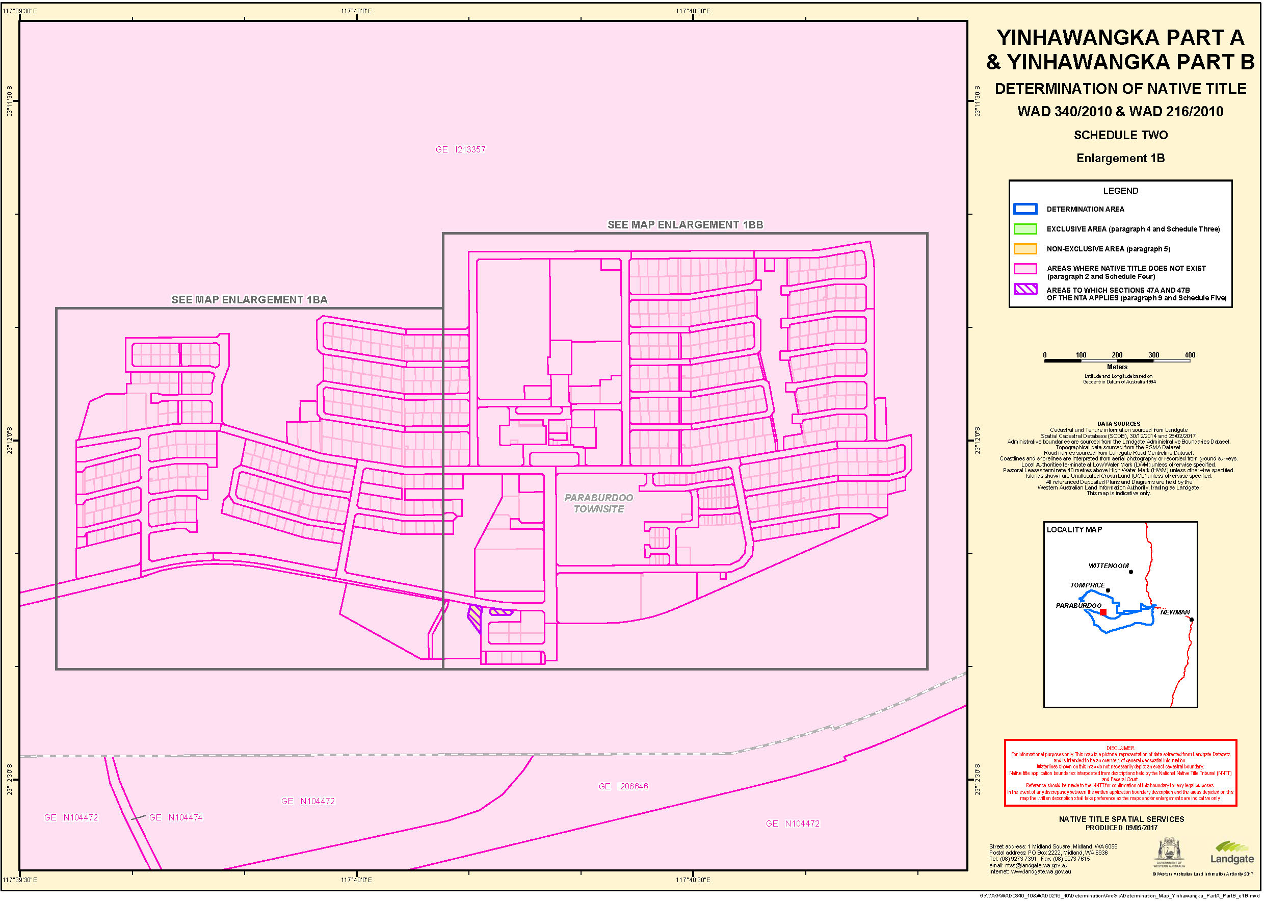
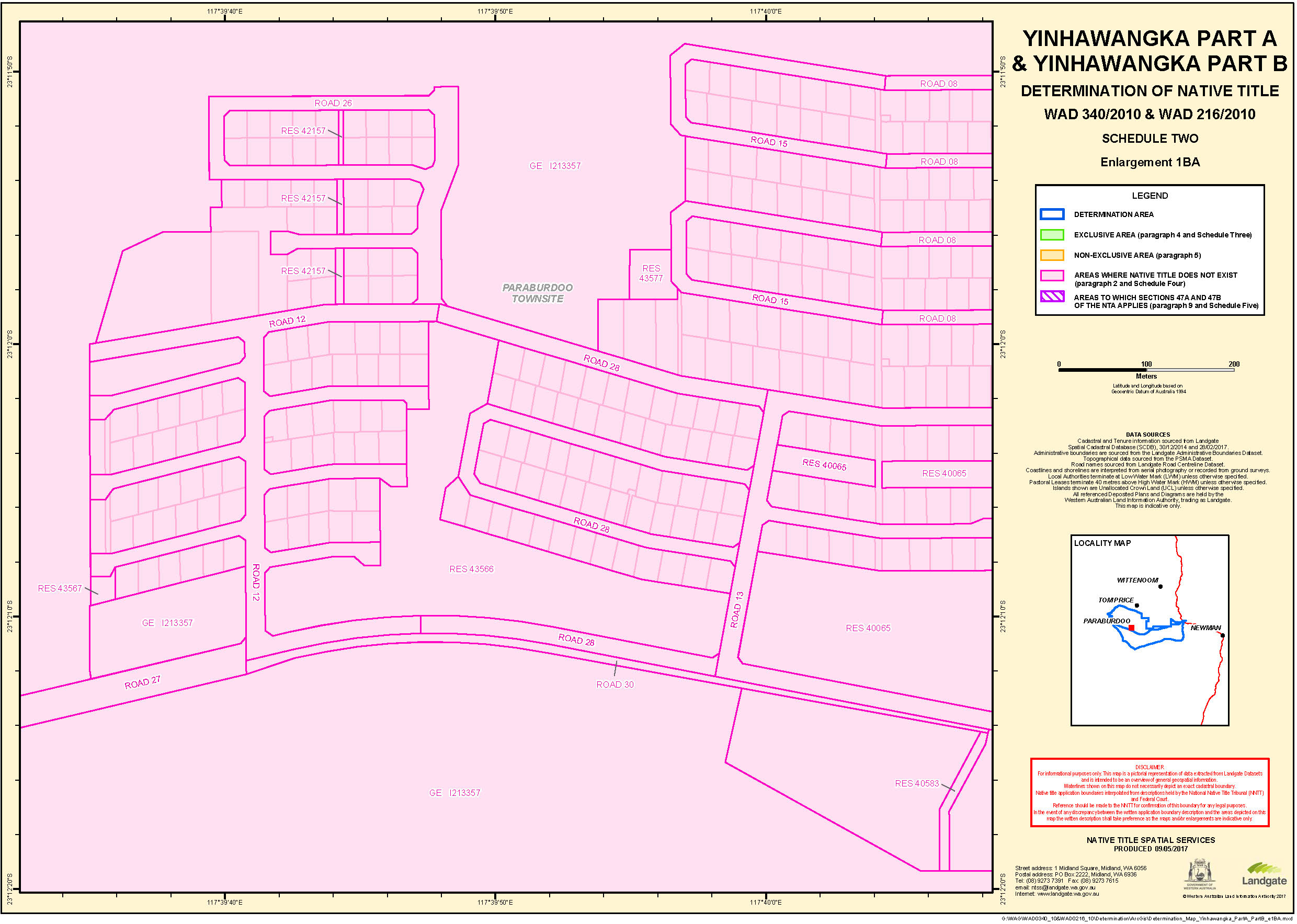
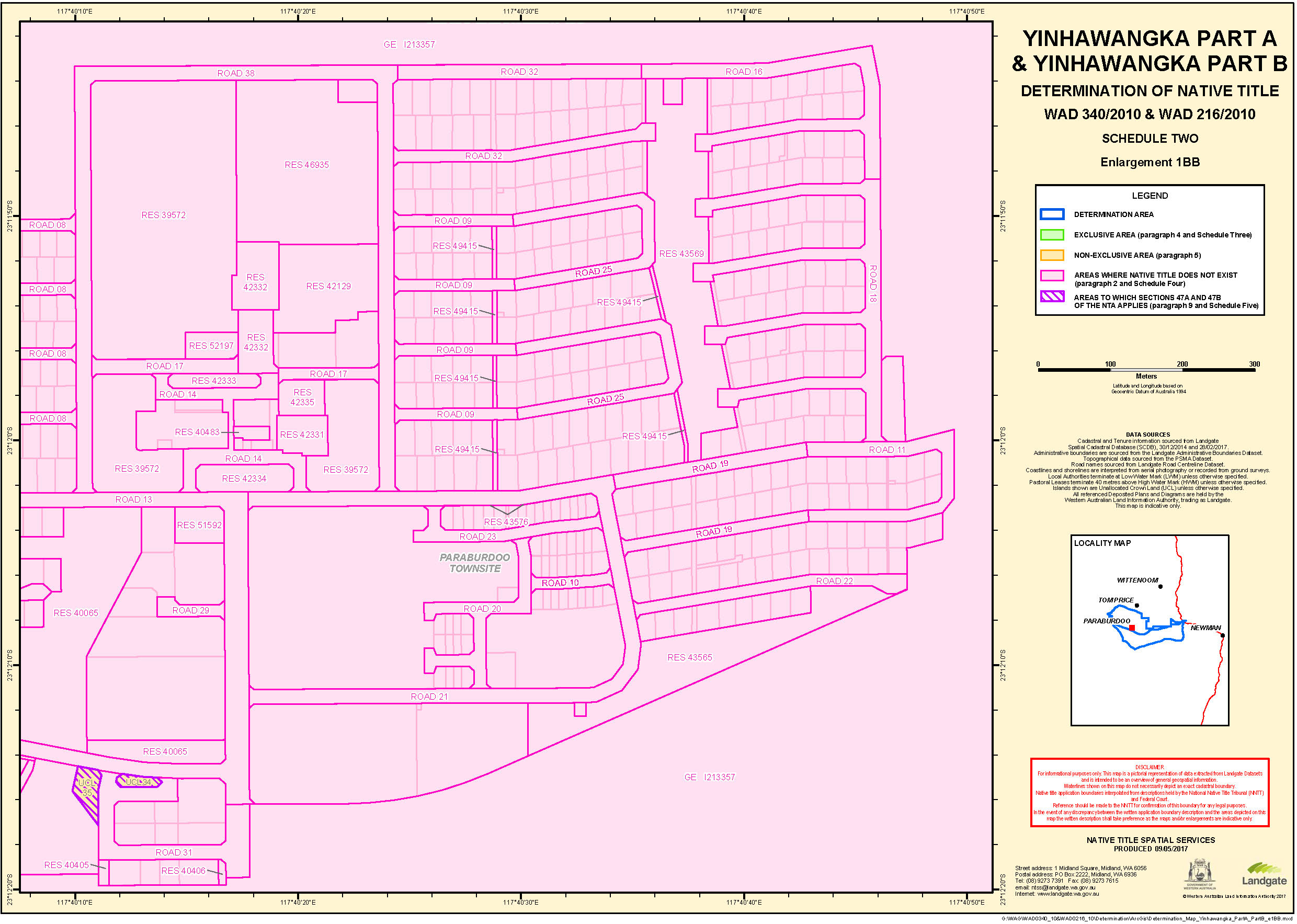
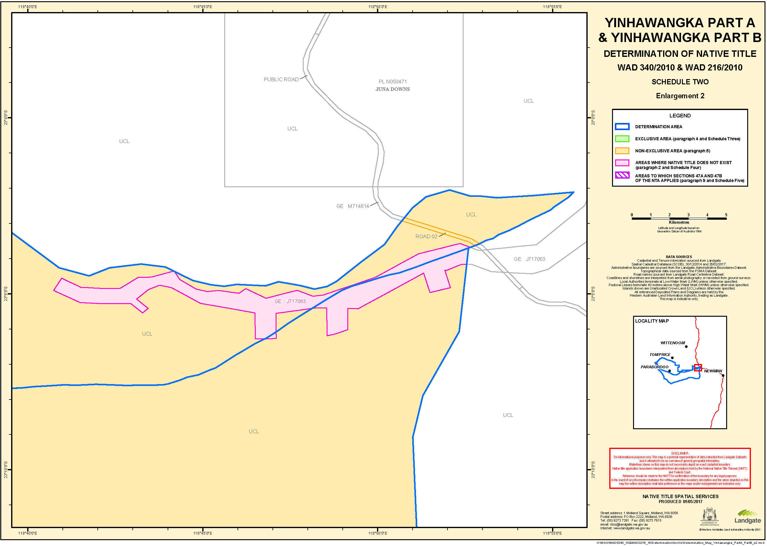
 SCHEDULE TWO
MAPS OF THE DETERMINATION AREA
Schedule THREE
EXCLUSIVE AREA
Areas where native title comprises the rights set out in paragraph 4 of the Determination
Native Title comprises the rights and interests set out in paragraph 4 of the Determination in relation to the following land and waters (which areas are generally shown as shaded in green on the maps at Schedule Two):
1. Wakathuni
All that land comprising Lot 105 as shown on Deposited Plan 219084 being subject to Aboriginal Lease H164887.
2. Mundari
All those land and waters commencing at Latitude 22.976921 South, Longitude 117.185721 East and extending generally northerly, generally easterly, generally southeasterly, generally southwesterly, and generally northwesterly through the following coordinate positions:
LATITUDE (SOUTH) | LONGITUDE (EAST) |
22.975171 | 117.185914 |
22.974453 | 117.186164 |
22.973791 | 117.186877 |
22.973551 | 117.187738 |
22.973281 | 117.192591 |
22.973278 | 117.192705 |
22.973518 | 117.193681 |
22.974179 | 117.194396 |
22.975082 | 117.194659 |
22.975986 | 117.194399 |
22.976648 | 117.193685 |
22.976743 | 117.193482 |
22.978762 | 117.188437 |
22.978911 | 117.187665 |
22.978670 | 117.186689 |
22.978009 | 117.185974 |
22.977106 | 117.185711 |
Then northerly back to the commencement point.
3. Bibi Tree
All those land and waters commencing at Latitude 22.934047 South, Longitude 117.388053 East and extending generally northeasterly, generally southeasterly, generally southerly, generally southwesterly, generally northwesterly and generally northerly through the following coordinate positions:
LATITUDE (SOUTH) | LONGITUDE (EAST) |
22.933143 | 117.388312 |
22.932480 | 117.389024 |
22.932235 | 117.389999 |
22.932475 | 117.390975 |
22.933073 | 117.391650 |
22.933425 | 117.391892 |
22.933487 | 117.391932 |
22.934389 | 117.392196 |
22.935056 | 117.392061 |
22.935098 | 117.392043 |
22.936492 | 117.391971 |
22.937305 | 117.391715 |
22.937968 | 117.391003 |
22.938212 | 117.390028 |
22.937973 | 117.389052 |
22.937313 | 117.388336 |
22.936411 | 117.388072 |
22.936320 | 117.388074 |
22.934628 | 117.388161 |
22.934526 | 117.388193 |
Then northwesterly back to the commencement point.
EXCLUSIONS:
• All that land comprising Pastoral Lease N050372 (Rocklea).
• Paraburdoo Road being Road No. 16245 as shown on Deposited Plan 41995.
4. Waarnarra
All those land and waters commencing at Latitude 22.926466 South, Longitude 117.393966 East and extending generally southeasterly, generally southwesterly, generally northwesterly, generally northeasterly, again generally southeasterly and again generally southwesterly through the following coordinate positions:
LATITUDE (SOUTH) | LONGITUDE (EAST) |
22.926644 | 117.393983 |
22.926801 | 117.393991 |
22.927705 | 117.393732 |
22.928368 | 117.393020 |
22.928612 | 117.392045 |
22.928373 | 117.391070 |
22.927713 | 117.390354 |
22.926967 | 117.390098 |
22.926679 | 117.390070 |
22.926522 | 117.390062 |
22.926457 | 117.390063 |
22.925973 | 117.390080 |
22.925950 | 117.390087 |
22.925725 | 117.390108 |
22.925393 | 117.390170 |
22.924802 | 117.390400 |
22.924567 | 117.390573 |
22.924259 | 117.390841 |
22.923831 | 117.391380 |
22.923586 | 117.392354 |
22.923826 | 117.393330 |
22.924486 | 117.394046 |
22.925388 | 117.394310 |
22.926292 | 117.394051 |
22.926405 | 117.393968 |
Then southerly back to the commencement point.
EXCLUSIONS:
• All that land comprising Pastoral Lease N050372 (Rocklea).
5. Piritayi
All those land and waters commencing at Latitude 22.817668 South, Longitude 117.482145 East and extending generally northeasterly, generally southeasterly, generally southwesterly and generally northwesterly through the following coordinate positions:
LATITUDE (SOUTH) | LONGITUDE (EAST) |
22.816757 | 117.484162 |
22.816326 | 117.485703 |
22.815690 | 117.487683 |
22.814812 | 117.489809 |
22.813903 | 117.491960 |
22.813062 | 117.494123 |
22.812407 | 117.495893 |
22.811376 | 117.498621 |
22.810812 | 117.500151 |
22.810220 | 117.501881 |
22.809884 | 117.503291 |
22.809871 | 117.504599 |
22.810691 | 117.505901 |
22.811552 | 117.506052 |
22.812504 | 117.505282 |
22.812816 | 117.504156 |
22.813167 | 117.503202 |
22.813626 | 117.502273 |
22.814283 | 117.501011 |
22.814756 | 117.500054 |
22.815073 | 117.499339 |
22.815468 | 117.498442 |
22.815937 | 117.497508 |
22.816590 | 117.496042 |
22.817077 | 117.494954 |
22.817714 | 117.493706 |
22.818245 | 117.492630 |
22.818867 | 117.491262 |
22.819460 | 117.489819 |
22.819830 | 117.488615 |
22.819843 | 117.487477 |
22.819349 | 117.486361 |
22.818782 | 117.484900 |
22.818395 | 117.483645 |
Then northwesterly back to the commencement point.
EXCLUSIONS:
• All that land comprising Pastoral Lease N050372 (Rocklea).
6. Nyimili
All those land and waters wholly within the external boundary of Native Title Application WAD340/2010 Yinhawangka Part A (WC2010/016) commencing at Latitude 22.765367 South, Longitude 117.620913 East and extending generally southeasterly, generally southwesterly, generally northwesterly, generally northerly and generally northwesterly through the following coordinate positions:
LATITUDE (SOUTH) | LONGITUDE (EAST) |
22.766148 | 117.624451 |
22.767648 | 117.627732 |
22.769948 | 117.631818 |
22.771807 | 117.634949 |
22.774406 | 117.638748 |
22.777273 | 117.641466 |
22.779884 | 117.642799 |
22.784615 | 117.644144 |
22.787476 | 117.644855 |
22.790782 | 117.645988 |
22.793554 | 117.647203 |
22.796648 | 117.648899 |
22.800336 | 117.651519 |
22.802892 | 117.653904 |
22.805952 | 117.657211 |
22.810167 | 117.662118 |
22.813376 | 117.665842 |
22.817312 | 117.670294 |
22.819789 | 117.672705 |
22.822124 | 117.674558 |
22.825007 | 117.676451 |
22.827216 | 117.678411 |
22.829488 | 117.680884 |
22.832158 | 117.684336 |
22.834690 | 117.687886 |
22.836873 | 117.690971 |
22.839695 | 117.694158 |
22.844578 | 117.700672 |
22.847970 | 117.704184 |
22.851199 | 117.706963 |
22.855157 | 117.709570 |
22.858679 | 117.711081 |
22.861927 | 117.711975 |
22.866826 | 117.712473 |
22.870849 | 117.712283 |
22.874851 | 117.711629 |
22.879544 | 117.712220 |
22.880379 | 117.712614 |
22.881931 | 117.712868 |
22.883273 | 117.712204 |
22.883850 | 117.711171 |
22.884045 | 117.709609 |
22.884059 | 117.708426 |
22.887720 | 117.706270 |
22.890809 | 117.707147 |
22.892698 | 117.707281 |
22.894284 | 117.706145 |
22.894676 | 117.705056 |
22.894385 | 117.701383 |
22.896817 | 117.698939 |
22.899437 | 117.695723 |
22.901594 | 117.692851 |
22.904339 | 117.688360 |
22.906356 | 117.684180 |
22.908051 | 117.679792 |
22.909313 | 117.675886 |
22.910310 | 117.671310 |
22.910614 | 117.663652 |
22.910205 | 117.659527 |
22.909302 | 117.654928 |
22.908261 | 117.650481 |
22.907054 | 117.644948 |
22.906163 | 117.641121 |
22.904559 | 117.636285 |
22.902769 | 117.631965 |
22.901265 | 117.628740 |
22.899040 | 117.624536 |
22.894806 | 117.619541 |
22.890725 | 117.617061 |
22.886228 | 117.616013 |
22.883925 | 117.616232 |
22.880607 | 117.617313 |
22.875868 | 117.619454 |
22.872090 | 117.620741 |
22.869334 | 117.621109 |
22.864394 | 117.620589 |
22.861148 | 117.619979 |
22.857366 | 117.619094 |
22.853565 | 117.617989 |
22.849793 | 117.616675 |
22.846038 | 117.615255 |
22.841271 | 117.613266 |
22.836028 | 117.610911 |
22.832413 | 117.609262 |
22.829333 | 117.607928 |
22.826245 | 117.606648 |
22.824173 | 117.605853 |
22.819453 | 117.604305 |
22.815770 | 117.603268 |
22.812058 | 117.602379 |
22.807808 | 117.601521 |
22.803657 | 117.600725 |
22.800133 | 117.600047 |
22.796603 | 117.599702 |
22.793559 | 117.599844 |
22.790041 | 117.600596 |
22.786048 | 117.601798 |
22.783109 | 117.602913 |
22.779180 | 117.604524 |
22.775703 | 117.605999 |
22.772774 | 117.607359 |
22.768453 | 117.610427 |
22.766683 | 117.613099 |
22.765576 | 117.616678 |
Then easterly back to the commencement point.
EXCLUSIONS:
All that land comprising Pastoral Lease N050372 (Rocklea).
Those parts of State Agreement Mineral Lease AML7000004 (as defined by Department of Mines and Petroleum as at 11th November 2010) overlapping the lands and waters described above.
7. Jangurna Jinna
All those land and waters commencing at Latitude 23.336087 South, Longitude 118.268197 East and extending generally southeasterly, generally southwesterly, generally northwesterly and generally northeasterly through the following coordinate positions:
LATITUDE (SOUTH) | LONGITUDE (EAST) |
23.336875 | 118.269660 |
23.337962 | 118.271442 |
23.339271 | 118.273062 |
23.340462 | 118.274313 |
23.342000 | 118.275652 |
23.343953 | 118.276850 |
23.346077 | 118.277170 |
23.348019 | 118.276208 |
23.349141 | 118.274596 |
23.349812 | 118.272297 |
23.350118 | 118.270312 |
23.350215 | 118.268999 |
23.350024 | 118.267434 |
23.349181 | 118.265799 |
23.347873 | 118.264487 |
23.345980 | 118.263469 |
23.343491 | 118.263268 |
23.341040 | 118.263956 |
23.339304 | 118.264937 |
23.337394 | 118.266461 |
Then northeasterly back to the commencement point.
Note:
• Geographic coordinates provided in decimal degrees.
• All referenced deposited plans and diagrams are held by the Western Australian Land Information Authority, trading as Landgate.
• Cadastral boundaries sourced from Landgate’s Spatial Cadastral Database dated 28 February 2017.
• Mining tenements sourced from Department of Mines and Petroleum as at 11 November 2010.
• Native Title Determination Application WAD340/2010 Yinhawangka Part A (WC2010/016) as registered in the Federal Court on 10 December 2010.
Datum: Geocentric Datum of Australia 1994 (GDA94)
Prepared By: Graphic Services (Landgate) 24 May 2017
Use of Coordinates:
Where coordinates are used within the description to represent cadastral or topographical boundaries or the intersection with such, they are intended as a guide only. As an outcome to the custodians of cadastral and topographic data continuously recalculating the geographic position of their data based on improved survey and data maintenance procedures, it is not possible to accurately define such a position other than by detailed ground survey.
SCHEDULE FOUR
AREAS WHERE NATIVE TITLE DOES NOT EXIST (PARAGRAPH 2)
Native Title does not exist in relation to land and waters the subject of the following interests within the Determination Area which, with the exception of public works (as described in clause 5 of this Schedule), are generally shown as shaded in pink on the maps at Schedule Two:
1. Freehold
Grants of estates in fee simple within the Determination Area including the following:
Freehold No. |
CT0170200692 |
CT0170300204 |
CT0170300205 |
CT0170300207 |
CT0170300208 |
CT0170300210 |
CT0170300211 |
CT0170300212 |
CT0170300215 |
CT0170300217 |
CT0170300218 |
CT0170300219 |
CT0170300220 |
CT0170300222 |
CT0170300224 |
CT0170300225 |
CT0170300226 |
CT0170300227 |
CT0170300228 |
CT0170300229 |
CT0170300230 |
CT0170300231 |
CT0170300232 |
CT0170300233 |
CT0170300234 |
CT0170300235 |
CT0170300236 |
CT0170300237 |
CT0170300238 |
CT0170300239 |
CT0170300240 |
CT0170300241 |
CT0170300242 |
CT0170300243 |
CT0170300244 |
CT0170300245 |
CT0170300246 |
CT0170300247 |
CT0170300248 |
CT0170300249 |
CT0170300250 |
CT0170300251 |
CT0170300252 |
CT0170300253 |
CT0170300255 |
CT0170300257 |
CT0170300258 |
CT0170300259 |
CT0170300260 |
CT0170300261 |
CT0170300262 |
CT0170300263 |
CT0170300264 |
CT0170300265 |
CT0170300266 |
CT0170300267 |
CT0170300268 |
CT0170300269 |
CT0170300270 |
CT0170300271 |
CT0170300272 |
CT0170300273 |
CT0170300274 |
CT0170300275 |
CT0170300276 |
CT0170300277 |
CT0170300278 |
CT0170300279 |
CT0170300280 |
CT0170300281 |
CT0170300282 |
CT0170300283 |
CT0170300284 |
CT0170300285 |
CT0170300286 |
CT0170300287 |
CT0170300288 |
CT0170300289 |
CT0170300290 |
CT0170300291 |
CT0170300292 |
CT0170300293 |
CT0170300294 |
CT0170300295 |
CT0170300296 |
CT0170300297 |
CT0170300298 |
CT0170300299 |
CT0170300300 |
CT0170300301 |
CT0170300302 |
CT0170300303 |
CT0170300304 |
CT0170300305 |
CT0170300306 |
CT0170300307 |
CT0170300308 |
CT0170300309 |
CT0170300310 |
CT0170300311 |
CT0170300312 |
CT0170300313 |
CT0170300314 |
CT0170300315 |
CT0170300316 |
CT0170300318 |
CT0170300319 |
CT0170300320 |
CT0170300321 |
CT0170300322 |
CT0170300323 |
CT0170300324 |
CT0170300325 |
CT0170300326 |
CT0170300327 |
CT0170300329 |
CT0170300331 |
CT0170300332 |
CT0170300333 |
CT0170300334 |
CT0170300335 |
CT0170300336 |
CT0170300337 |
CT0170300338 |
CT0170300339 |
CT0170300340 |
CT0170300341 |
CT0170300342 |
CT0170300343 |
CT0170300344 |
CT0170300345 |
CT0170300346 |
CT0170300347 |
CT0170300348 |
CT0170300349 |
CT0170300350 |
CT0170300351 |
CT0170300352 |
CT0170300353 |
CT0170300354 |
CT0170300355 |
CT0170300356 |
CT0170300357 |
CT0170300358 |
CT0170300359 |
CT0170300360 |
CT0170300361 |
CT0170300362 |
CT0170300363 |
CT0170300364 |
CT0170300365 |
CT0170300366 |
CT0170300367 |
CT0170300368 |
CT0170300369 |
CT0170300370 |
CT0170300372 |
CT0170300373 |
CT0170300374 |
CT0170300375 |
CT0170300376 |
CT0170300377 |
CT0170300378 |
CT0170300379 |
CT0170300380 |
CT0170300381 |
CT0170300382 |
CT0170300383 |
CT0170300384 |
CT0170300385 |
CT0170300386 |
CT0170300387 |
CT0170300388 |
CT0170300389 |
CT0170300390 |
CT0170300391 |
CT0170300392 |
CT0170300393 |
CT0170300394 |
CT0170300395 |
CT0170300396 |
CT0170300397 |
CT0170300398 |
CT0170300399 |
CT0170300401 |
CT0170300402 |
CT0170300403 |
CT0170300404 |
CT0170300405 |
CT0170300406 |
CT0170300407 |
CT0170300408 |
CT0170300409 |
CT0170300410 |
CT0170300411 |
CT0170300412 |
CT0170300413 |
CT0170300414 |
CT0170300415 |
CT0170300416 |
CT0170300417 |
CT0170300418 |
CT0170300419 |
CT0170300420 |
CT0170300421 |
CT0170300422 |
CT0170300423 |
CT0170300424 |
CT0170300425 |
CT0170300426 |
CT0170300427 |
CT0170300428 |
CT0170300429 |
CT0170300430 |
CT0170300431 |
CT0170300432 |
CT0170300433 |
CT0170300434 |
CT0170300435 |
CT0170300436 |
CT0170300437 |
CT0170300438 |
CT0170300439 |
CT0170300440 |
CT0170300441 |
CT0170300442 |
CT0170300443 |
CT0170300444 |
CT0170300445 |
CT0170300446 |
CT0170300447 |
CT0170300448 |
CT0170300449 |
CT0170300450 |
CT0170300451 |
CT0170300452 |
CT0170300453 |
CT0170300454 |
CT0170300455 |
CT0170300456 |
CT0170300457 |
CT0170300458 |
CT0170300459 |
CT0170300460 |
CT0170300461 |
CT0170300462 |
CT0170300464 |
CT0170300465 |
CT0170300466 |
CT0170300467 |
CT0170300468 |
CT0170300469 |
CT0170300470 |
CT0170300471 |
CT0170300472 |
CT0170300473 |
CT0170300474 |
CT0170300475 |
CT0170300476 |
CT0170300477 |
CT0170300478 |
CT0170300479 |
CT0170300480 |
CT0170300481 |
CT0170300482 |
CT0170300483 |
CT0170300484 |
CT0170300485 |
CT0170300486 |
CT0170300487 |
CT0170300488 |
CT0170300489 |
CT0170300490 |
CT0170300491 |
CT0170300492 |
CT0170300493 |
CT0170300494 |
CT0170300495 |
CT0170300496 |
CT0170300497 |
CT0170300498 |
CT0170300499 |
CT0170300500 |
CT0170300501 |
CT0170300502 |
CT0170300503 |
CT0170300504 |
CT0170300505 |
CT0170300506 |
CT0170300507 |
CT0170300508 |
CT0170300509 |
CT0170300510 |
CT0170300511 |
CT0170300512 |
CT0170300513 |
CT0170300514 |
CT0170300515 |
CT0170300516 |
CT0170300517 |
CT0170300518 |
CT0170300519 |
CT0170300520 |
CT0170300521 |
CT0170300523 |
CT0170300524 |
CT0170300525 |
CT0170300526 |
CT0170300527 |
CT0170300528 |
CT0170300529 |
CT0170300530 |
CT0170300531 |
CT0170300532 |
CT0170300533 |
CT0170300534 |
CT0170300535 |
CT0170300536 |
CT0170300537 |
CT0170300538 |
CT0170300539 |
CT0170300540 |
CT0170300541 |
CT0170300542 |
CT0170300543 |
CT0170300544 |
CT0170300545 |
CT0170300546 |
CT0170300547 |
CT0170300548 |
CT0170300549 |
CT0170300550 |
CT0170300551 |
CT0170300552 |
CT0170300553 |
CT0170300554 |
CT0170300555 |
CT0170300556 |
CT0170300557 |
CT0170300558 |
CT0170300559 |
CT0170300560 |
CT0170300561 |
CT0170300562 |
CT0170300563 |
CT0170300564 |
CT0170300565 |
CT0170300566 |
CT0170300567 |
CT0170300568 |
CT0170300569 |
CT0170300570 |
CT0170300571 |
CT0170300572 |
CT0170300573 |
CT0170300574 |
CT0170300575 |
CT0170300576 |
CT0170300577 |
CT0170300578 |
CT0170300579 |
CT0170300580 |
CT0170300581 |
CT0170300582 |
CT0170300583 |
CT0170300584 |
CT0170300585 |
CT0170300586 |
CT0170300587 |
CT0170300588 |
CT0170300589 |
CT0170300591 |
CT0170300592 |
CT0170300593 |
CT0170300594 |
CT0170300595 |
CT0170300596 |
CT0170300597 |
CT0170300598 |
CT0170300599 |
CT0170300600 |
CT0170300601 |
CT0170300602 |
CT0170300603 |
CT0170300604 |
CT0170300605 |
CT0170300606 |
CT0170300607 |
CT0170300608 |
CT0170300609 |
CT0170300610 |
CT0170300611 |
CT0170300612 |
CT0170300613 |
CT0170300614 |
CT0170300615 |
CT0170300616 |
CT0170300617 |
CT0170300618 |
CT0170300619 |
CT0170300620 |
CT0170300621 |
CT0170300623 |
CT0170300628 |
CT0170300630 |
CT0170300633 |
CT0170300634 |
CT0170300635 |
CT0170300636 |
CT0170300637 |
CT0170300638 |
CT0170300639 |
CT0170300640 |
CT0170300641 |
CT0170300642 |
CT0170300643 |
CT0170300644 |
CT0170300645 |
CT0170300646 |
CT0170300647 |
CT0170300648 |
CT0170300649 |
CT0170300650 |
CT0170300651 |
CT0170300652 |
CT0170300653 |
CT0170300654 |
CT0170300655 |
CT0170300656 |
CT0170300657 |
CT0170300658 |
CT0170300659 |
CT0170300660 |
CT0170300661 |
CT0170300662 |
CT0170300663 |
CT0170300664 |
CT0170300665 |
CT0170300666 |
CT0170300667 |
CT0170300668 |
CT0170300669 |
CT0170300670 |
CT0170300671 |
CT0170300672 |
CT0170300673 |
CT0170300674 |
CT0170300675 |
CT0170300676 |
CT0170300677 |
CT0170300678 |
CT0170300679 |
CT0170300680 |
CT0170300681 |
CT0170300682 |
CT0170300685 |
CT0170300686 |
CT0170300687 |
CT0170300688 |
CT0170300689 |
CT0170300690 |
CT0170300691 |
CT0170300692 |
CT0170300693 |
CT0170300694 |
CT0170300695 |
CT0170300696 |
CT0170300697 |
CT0170300698 |
CT0170300699 |
CT0170300700 |
CT0170300701 |
CT0170300702 |
CT0170300703 |
CT0170300704 |
CT0170300705 |
CT0170300706 |
CT0170300707 |
CT0170300708 |
CT0170300709 |
CT0170300710 |
CT0170300711 |
CT0170300712 |
CT0170300713 |
CT0170300714 |
CT0170300715 |
CT0170300716 |
CT0170300717 |
CT0170300718 |
CT0170300719 |
CT0170300720 |
CT0170300721 |
CT0170300722 |
CT0170300723 |
CT0170300724 |
CT0170300725 |
CT0170300726 |
CT0170300727 |
CT0170300728 |
CT0170300729 |
CT0170300730 |
CT0170300731 |
CT0170300732 |
CT0170300733 |
CT0170300734 |
CT0170300735 |
CT0170300736 |
CT0170300737 |
CT0170300738 |
CT0170300739 |
CT0170300740 |
CT0170300741 |
CT0170300742 |
CT0170300743 |
CT0170300744 |
CT0170300745 |
CT0170300746 |
CT0170300747 |
CT0170300750 |
CT0170300751 |
CT0170300752 |
CT0170300753 |
CT0170300754 |
CT0170300755 |
CT0170300756 |
CT0170300757 |
CT0170300758 |
CT0170300759 |
CT0170300760 |
CT0170300761 |
CT0170300762 |
CT0170300763 |
CT0170300764 |
CT0170300765 |
CT0170300766 |
CT0170300767 |
CT0170300768 |
CT0170300769 |
CT0170300770 |
CT0170300771 |
CT0170300772 |
CT0170300773 |
CT0170300774 |
CT0170300775 |
CT0170300776 |
CT0170300777 |
CT0170300778 |
CT0170300779 |
CT0170300780 |
CT0170300781 |
CT0170300782 |
CT0170300783 |
CT0170300784 |
CT0170300785 |
CT0170300786 |
CT0170300787 |
CT0170300788 |
CT0170300789 |
CT0170300790 |
CT0170300791 |
CT0170300792 |
CT0170300793 |
CT0170300794 |
CT0170300795 |
CT0170300796 |
CT0170300797 |
CT0170300798 |
CT0170300799 |
CT0170300800 |
CT0170300801 |
CT0170300802 |
CT0170300804 |
CT0170300806 |
CT0170300807 |
CT0170300808 |
CT0170300809 |
CT0170300810 |
CT0170300811 |
CT0170300812 |
CT0170300813 |
CT0170300814 |
CT0170300815 |
CT0170300816 |
CT0170300817 |
CT0170300818 |
CT0170300819 |
CT0170300820 |
CT0170300821 |
CT0170300822 |
CT0170300823 |
CT0170300824 |
CT0170300825 |
CT0170300826 |
CT0170300827 |
CT0170300828 |
CT0170300829 |
CT0170300830 |
CT0170300831 |
CT0170300832 |
CT0170300833 |
CT0170300834 |
CT0170300835 |
CT0170300836 |
CT0170300837 |
CT0170300838 |
CT0170300839 |
CT0170300840 |
CT0170300841 |
CT0170300842 |
CT0170300843 |
CT0170300844 |
CT0170300845 |
CT0170300846 |
CT0170300847 |
CT0170300848 |
CT0170300849 |
CT0170300850 |
CT0170300851 |
CT0170300852 |
CT0170300853 |
CT0170300854 |
CT0170300855 |
CT0170300856 |
CT0170300857 |
CT0170300858 |
CT0170300859 |
CT0170300860 |
CT0170300861 |
CT0170300862 |
CT0170300863 |
CT0170300864 |
CT0170300865 |
CT0170300866 |
CT0170300867 |
CT0170300868 |
CT0170300869 |
CT0170300870 |
CT0170300871 |
CT0170300872 |
CT0170300874 |
CT0170500851 |
CT0170500852 |
CT0172100559 |
CT0178600661 |
CT0178600662 |
CT0178600663 |
CT0178600664 |
CT0178600665 |
CT0178600666 |
CT0178600668 |
CT0178600670 |
CT0178900866 |
CT0178900867 |
CT0180100787 |
CT0180100790 |
CT0180100791 |
CT0182100093 |
CT0183600717 |
CT0184800101 |
CT0185600028 |
CT0185600039 |
CT0185600040 |
CT0186300073 |
CT0186900678 |
CT0190200965 |
CT0190200966 |
CT0190200967 |
CT0190200968 |
CT0190200969 |
CT0190200970 |
CT0190200971 |
CT0190200972 |
CT0190200973 |
CT0190200974 |
CT0190200975 |
CT0190200976 |
CT0190200978 |
CT0190300501 |
CT0190300502 |
CT0190300503 |
CT0190300504 |
CT0190300505 |
CT0190300506 |
CT0190300507 |
CT0190300508 |
CT0190300509 |
CT0190300510 |
CT0190300511 |
CT0190300512 |
CT0190300513 |
CT0190300514 |
CT0190300515 |
CT0190300516 |
CT0190300517 |
CT0190300518 |
CT0190300519 |
CT0190300520 |
CT0190300521 |
CT0190300522 |
CT0190300523 |
CT0190300524 |
CT0190300525 |
CT0190300526 |
CT0190300527 |
CT0190300528 |
CT0190300529 |
CT0190300530 |
CT0190300531 |
CT0190300532 |
CT0190300533 |
CT0192100206 |
CT0192400238 |
CT0192400240 |
CT0193600342 |
CT0193600343 |
CT0193600344 |
CT0193600345 |
CT0193600346 |
CT0193600347 |
CT0193600348 |
CT0193600349 |
CT0193600350 |
CT0193600351 |
CT0193600352 |
CT0193600353 |
CT0193600354 |
CT0193600355 |
CT0193600356 |
CT0193600357 |
CT0193600358 |
CT0193600359 |
CT0193600360 |
CT0193600361 |
CT0193600362 |
CT0193600363 |
CT0193600364 |
CT0193600365 |
CT0193600366 |
CT0193600367 |
CT0193600368 |
CT0193600369 |
CT0193600370 |
CT0193600371 |
CT0193600372 |
CT0193600373 |
CT0193600374 |
CT0193600375 |
CT0193600376 |
CT0193600377 |
CT0193600378 |
CT0193600379 |
CT0193600380 |
CT0193600381 |
CT0193600382 |
CT0193600383 |
CT0196300977 |
CT0196700750 |
CT0196700751 |
CT0196900419 |
CT0196900420 |
CT0196900421 |
CT0196900422 |
CT0196900423 |
CT0196900424 |
CT0196900425 |
CT0196900426 |
CT0196900427 |
CT0205700329 |
CT0212300200 |
CT0222600084 |
CT0264900584 |
CT0266000890 |
CT0268700691 |
CT0275100100 |
CT0286200051 |
CT0286200052 |
CT0286200053 |
CT0286200054 |
CT0286200055 |
S021762 |
2. Reserves
Reserve No. | Current / Last Purpose |
RES 37610 | Quarry |
RES 39572 | Public Recreation |
RES 40065 | Public Recreation |
RES 40405 | Park and Drainage |
RES 40406 | Park and Drainage |
RES 40483 | Public Recreation |
RES 40583 | Drainage |
RES 42129 | Sports Centre |
RES 42157 | Drain |
RES 42331 | Recreation |
RES 42332 | Recreation |
RES 42333 | Parking |
RES 42334 | Parking |
RES 42335 | Parking |
RES 43225 | Drainage |
RES 43565 | Public Recreation |
RES 43566 | Public Recreation |
RES 43567 | Public Recreation |
RES 43569 | Public Recreation |
RES 43576 | Public Recreation |
RES 43577 | Public Recreation |
RES 46935 | School Site |
RES 49415 | Pedestrian Accessway |
RES 51592 | Police Complex |
RES 52197 | Childcare Centre |
3. Leases
Lease No. | Current / Last Purpose |
GE H249216 | Light industry |
GE H326886 | Radio, television and telecommunications |
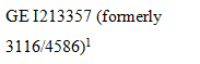
GE I123646 (formerly 3116/7842) | Construction and operation of power transmission line, control equipment, access track and other ancillary works, facilities and installations |
GE I131315 (formerly 3116/11402) | Light industrial |
GE I134853 (formerly 3116/11818) | Bulk fuel depot |
GE I144501 (formerly 3116/3467) | Boring for, conserving, reticulating and drawing water |
GE I150241 (formerly 3116/11350) | Light industry |
GE I150337 (formerly 3116/11367) | Light industrial |
GE I206646 (formerly 3116/4592) | Construction, upgrading, realignment, operation and use of a railway |
| Laying out, development, construction, provision and operation of and use as a townsite |
GE I886933 | Light industry |
GE J089597 | Light industry |
GE M920522 (formerly GE J412198; 3116/10834) | Light industry |
GE J717063 | Construction, use, operation and maintenance of a rail spur line and associated access road and infrastructure |
GE K013039 | Light industry |
GE K560303 | Industry |
GE L215248 | Communication site |
GE L599731 | Light industry |
GE N104721 (formerly 3116/04585) | Laying out, development, construction, provision and operation of and use as an aerodrome |
GE N104722 (formerly 3116/04587) | Allotting portions of the land to contractors and manufacturers for their respective uses whilst engaged on work associated with the construction and operation of the mine in and plant on the mineral lease, the town of Paraburdoo, the railway and facilities associated with all or any of the foregoing |
GE N104723 (formerly 3116/04588) | Laying out, construction, provision and operation of and use as a miscellaneous plant, equipment and machinery workshops and service facilities associated therewith |
GE N104470 (formerly 3116/04589) | Laying out, development, construction, provision and operation of and use as a construction camp for the housing of the construction force engaged in the present and future development works of the Company and in the construction of the mine and plan during its normal operations and of the town of Paraburdoo and of the facilities associated therewith |
GE N104471 (formerly 3116/04590) | Laying out, development, construction, provision and operation of and use as a sewerage treatment plant and radio and TV transmission tower to serve the town of Paraburdoo |
3116/04591 | (1) Establishment and maintenance of a greenbelt or rural zone for the townsite of Paraburdoo; (2) The use of that land in respect of or in connection with the control by the Company of any undesirable elements who are or may be attracted or would otherwise be attracted to that townsite or to the other operations of the Company in the vicinity; (3) Construction and use of roads; and (4) Construction, laying out and use of power transmission line, communications system and associated and other facilities and services for the townsite of Paraburdoo |
GE N104473 (formerly 3116/04593) | Laying out, development, construction, provision and operation of and use as a site for water storage tanks for the supply of water to Paraburdoo, the mine and mine plant, and the industrial area and construction camp |
GE N104474 (formerly 3116/04594) | Laying out, development, construction, provision and operation of and use for main water supply lines to Paraburdoo, the mine and mine plant, the industrial area and construction camp |
GE N104193 (formerly 3116/08933) | Development, construction, provision, operation and use of water bore holes, a water pipeline and a power transmission line and installations and facilities ancillary thereto |
| |

4. Roads
Dedicated roads, roads set aside, taken or resumed or roads which are to be considered public works (as that expression is defined in the Native Title Act and the Titles (Validation) and Native Title (Effect of Past Acts) Act 1995 (WA)), including the following:
MapInfo ID | Description | Shown in |
ROAD 01 | Tom Price-Paraburdoo Road | Deposited Plan 217031 |
ROAD 03 | Tom Price-Paraburdoo Road | Deposited Plan 242851 |
ROAD 04 | Road No. 14619 | Government Gazette 11 July 1975 |
ROAD 05 | Road No. 1718 | Government Gazette 18 December 1903 |
ROAD 06 | Road No. 14619 | Government Gazette 3 March 1972 |
ROAD 07 | Road No. 5424 | Public Plan 503114 cancelled on 6 July 1925 |
ROAD 08 | Portions of Channar Avenue, Pilbara Avenue, Whaleback Avenue and Joffre Avenue | Deposited Plan 14862 |
ROAD 09 | Portions of Bruce Avenue, Dale Avenue, Yampire Avenue and Samson Avenue | Deposited Plan 14949 |
ROAD 10 | Bennett Avenue | Deposited Plan 17647 |
ROAD 11 | Portions of Ashburton Avenue and Robe Avenue | Deposited Plan 14865 |
ROAD 12 | Murchinson Avenue, Exmouth Avnenue, Roebourne Avenue, Chichester Avenue, Barrow Avenue, Wittenoom Avenue, Turner Road and portions of Ashburton Avenue and Camp Road | Deposited Plan 14725 |
ROAD 13 | Wyloo Road, Gascoyne Avenue and portions of Ashburton Avenue, Rocklea Road and Camp Road | Deposited Plan 14723 |
ROAD 14 | Anzac Court, Mininer Lane and Ashburton Court | Deposited Plan 15743 |
ROAD 15 | Portions of Channar Avenue, Whaleback Avenue, Pilbara Avenue and Joffre Avenue | Deposited Plan 14951 |
ROAD 16 | King Avenue and portions of Nickol Avenue and Meharry Road | Deposited Plan 14947 |
ROAD 17 | Anzac Place and portion of Fortescue Road | Deposited Plan 15365 |
ROAD 18 | Brockman Avenue, Margaret Avenue, Monte Bello Avenue, Lockyer Avenue and portion of Meharry Road | Deposited Plan 14861 |
ROAD 19 | Portions of Ashburton Avenue and Robe Avenue | Deposited Plan 14864 |
ROAD 20 | Bellary Avenue, Jope Court and Maguire Avenue | Deposited Plan 17646 |
ROAD 21 | McRae Avenue and portion of Ashburton Avenue | Deposited Plan 14726 |
ROAD 22 | Meeka Avenue | Deposited Plan 14968 |
ROAD 23 | Coppin Court | Deposited Plan 16693 |
ROAD 24 | Mettawandy Place and portion of Camp Road | Deposited Plan 188713 |
ROAD 25 | Portions of Bruce Avenue, Dale Avenue, Yampire Avenue and Samson Avenue | Deposited Plan 14950 |
ROAD 26 | Weano Crescent, Muchamary street and Howies Close | Deposited Plan 217706 |
ROAD 27 | Turee Way and portion of Camp Road | Deposited Plan 216685 |
ROAD 28 | Capricorn Avenue, Hardy Avenue and portions of Ashburton Avenue and Camp Road | Deposited Plan 14724 |
ROAD 29 | You Yi Lane | Deposited Plan 80075 |
ROAD 30 | Portion of Camp Road | Deposited Plan 216547 |
ROAD 31 | Gregory Way, Yathala Way and portion of Rocklea Road | Deposited Plan 216817 |
ROAD 32 | De Coursey Avenue and portion of Nickol Avenue | Deposited Plan 14948 |
ROAD 36 | Road No. 16245 (Beasley Road / Paraburdoo Road) | Government Gazette 24 April 1980 and 29 May 1981 |
ROAD 37 | Widening of portion of Paraburdoo Road | Deposited Plan 41996 |
ROAD 38 | Fortescue Road, De Grey Road and portion of Nickol Avenue | Deposited Plan 14840 |
ROAD | Lot 60 | Deposited Plan 216685 |
5. Public Works
Any other public works as that expression is defined in the Native Title Act and the Titles (Validation) and Native Title (Effect of Past Acts) Act 1995 (WA) (including the land and waters on which a public work is constructed, established or situated as described in section 251D of the Native Title Act) and to which section 12J of the Titles (Validation) and Native Title (Effect of Past Acts) Act 1995 (WA) or section 23C(2) of the Native Title Act applies
SCHEDULE FIVE
AREAS TO WHICH SECTION 47A AND SECTION 47B OF THE NATIVE TITLE ACT APPLIES (PARAGRAPH 9)
Section 47A of the Native Title Act applies with the effect that any extinguishment by the creation of the following interests (and by the creation of any other prior interests in relation to the area of the following interests) is to be disregarded:
Interest | Description / Purpose |
Lease AB H164887 | Use and benefit of Aboriginal inhabitants |
Section 47B of the Native Title Act applies with the effect that any extinguishment over the following areas by the creation of a prior interest (to the extent that the areas were not covered by an interest described in s 47B(1)(b)(i) or (ii) or subject to a resumption process as described in s 47B(1)(b)(iii) of the Native Title Act when the relevant native title determination application was made) is to be disregarded:
Area | Description / Location |
Mundari | As described in Schedule Three |
Bibi Tree | As described in Schedule Three |
Waarnarra | As described in Schedule Three |
Piritayi | As described in Schedule Three |
Nyimili | As described in Schedule Three |
Jangurna Jinna | As described in Schedule Three |
Whole of UCL 32 | Lot 17 Turee Way, Paraburdoo (formerly subject to a portion of special lease 3116/4586) |
Whole of UCL 34 | Lot 39 Camp Road, Paraburdoo (formerly subject to a portion of special lease 3116/4586) |
Whole of UCL 35 | Lot 49 Camp Road, Paraburdoo (formerly subject to a portion of special lease 3116/4586) |
SCHEDULE SIX
OTHER INTERESTS (PARAGRAPH 10)
The nature and extent of the Other Interests in relation to the Determination Area as at the date of this Determination are:
1. Reserves
(a) The following reserves:
Reserve No. | Current Purpose |
RES 14788 | Water |
RES 18737 | Water |
RES 48908 | Microwave Radio Repeater Station |
RES 52195 | Bore Site |
(b) The rights and interests of persons who have the care, control and management of the reserves identified in subclause (a) above;
(c) The rights and interests of persons entitled to access and use the reserves identified in subclause (a) above for the respective purposes for which they are reserved, subject to any statutory limitations upon those rights; and
(d) The rights and interests of persons holding leases over areas of the reserves identified in subclause (a) above.
2. Leases
The following leases and the rights and interests of the holders from time to time of those leases:
Lease No. | Current / Last Purpose |
GE I163654 (formerly 3116/11553) | Mining purposes |
AB H164887 (Wakathuni) | Use and benefit of Aboriginal inhabitants |
3. Pastoral Leases
(a) The following pastoral leases and the rights and interests of the holders from time to time of those pastoral leases:
Pastoral Lease | Station Name |
PL N050364 (formerly 3114/0888) | Mt Vernon |
PL N050676 (formerly 3114/0937) | Turee Creek |
PL N050372 (formerly 3114/1166) | Rocklea |
PL N049718 (formerly 3114/1193) | Mininer |
PL N050036 (formerly 3114/1218) | Ashburton Downs |
PL N050545 (formerly 398/782) | Cheela Plains |
(b) Any rights and obligations of the pastoralists pursuant to the pastoral leases referred to in clause 3(a) above to adopt and exercise best practice management of the pasture and vegetation resources, livestock and soils within the boundaries of the pastoral leases in order to manage stock and for the management, conservation and regeneration of pasture for permitted uses.
4. Easements
The following easements and the rights and interests of the holders from time to time of those easements:
Easement No. | Description |
F931458 | Created pursuant to the Goldfields Gas Pipeline Agreement Act 1994 and the Public Works Act 1902 as published in the Government Gazette on 4 July 1995 and 14 June 1996 |
K664347 | Access, power and communication |
L478326 | Operating a borefield and associated infrastructure |
5. Roads
The following roads and the rights and interests of the persons having the care, control and management of those roads from time to time:
MapInfo ID | Description | Shown in |
ROAD 02 | Great Northern Highway | Deposited Plan 219303 |
ROAD 33 | Widening of portion of Nanutarra -Wittenoom Road | Deposited Plan 41993 |
ROAD 34 | Widening of portion of Nanutarra -Wittenoom Road | Deposited Plan 41994 |
ROAD 35 | Widening of Paraburdoo Road | Deposited Plan 41995 |
ROAD 39 | Widening of portion of Nanutarra -Wittenoom Road | Deposited Plan 41995 |
6. Mining Tenements
(a) The following mining tenements under the Mining Act 1904 (WA) (repealed) and the Mining Act 1978 (WA) and the rights and interests of the holders from time to time of those mining tenements:
(i) Mining Leases
Tenement ID |
M 4700030 |
M 4700031 |
M 4700032 |
M 4700033 |
M 4700034 |
M 4700035 |
M 4700036 |
M 4700037 |
M 4700038 |
M 4700039 |
M 4700040 |
M 4700041 |
M 4700217 |
M 4700244 |
M 4700246 |
M 4700282 |
M 4700321 |
M 4700322 |
M 4700332 |
M 4700358 |
M 4700683 |
M 4700684 |
M 4700685 |
M 4700686 |
M 4700687 |
M 4700688 |
M 4700689 |
M 4700690 |
M 4700691 |
M 4701135 |
M 5200032 |
M 5200553 |
M 5200639 |
M 5200640 |
M 5200734 |
M 5200735 |
(ii) Exploration Licences
Tenement ID |
E 0802115 |
E 0802210 |
E 0802211 |
E 0802248 |
E 0802307 |
E 0802757 |
E 4700013 |
E 4700014 |
E 4700015 |
E 4700016 |
E 4700017 |
E 4700030 |
E 4700709 |
E 4700754 |
E 4700797 |
E 4700798 |
E 4700952 |
E 4700986 |
E 4701050 |
E 4701355 |
E 4701370 |
E 4701396 |
E 4701413 |
E 4701420 |
E 4701446 |
E 4701461 |
E 4701478 |
E 4701540 |
E 4701623 |
E 4701681 |
E 4701741 |
E 4701772 |
E 4701795 |
E 4702086 |
E 4702236 |
E 4702239 |
E 4702240 |
E 4702417 |
E 4702427 |
E 4702496 |
E 4702538 |
E 4702936 |
E 4702948 |
E 4702951 |
E 4702952 |
E 4702953 |
E 4702963 |
E 4702985 |
E 4703001 |
E 4703004 |
E 4703014 |
E 4703153 |
E 4703169 |
E 4703185 |
E 4703227 |
E 4703245 |
E 4703270 |
E 4703312 |
E 4703313 |
E 4703331 |
E 4703345 |
E 4703369 |
E 4703406 |
E 4703481 |
E 5201459 |
E 5201667 |
E 5201763 |
E 5201788 |
E 5201789 |
E 5201790 |
E 5201941 |
E 5202034 |
E 5202043 |
E 5202044 |
E 5202521 |
E 5202522 |
E 5202594 |
E 5202624 |
E 5202625 |
E 5202667 |
E 5202724 |
E 5202745 |
E 5202748 |
E 5202786 |
E 5203024 |
E 5203025 |
E 5203026 |
E 5203036 |
E 5203065 |
E 5203134 |
E 5203135 |
E 5203137 |
E 5203208 |
E 5203209 |
E 5203210 |
E 5203211 |
E 5203213 |
E 5203247 |
E 5203304 |
E 5203305 |
E 5203311 |
E 5203369 |
E 5203372 |
E 5203398 |
(iii) General Purpose Leases
Tenement ID |
G 4700041 |
G 4701235 |
G 4701236 |
G 4701244 |
G 4701254 |
(iv) Miscellaneous Licences
Tenement ID |
L 4700041 |
L 4700050 |
L 4700052 |
L 4700053 |
L 4700054 |
L 4700060 |
L 4700061 |
L 4700062 |
L 4700063 |
L 4700099 |
L 4700130 |
L 4700266 |
L 4700268 |
L 4700269 |
L 4700270 |
L 4700271 |
L 4700272 |
L 4700326 |
L 4700409 |
L 4700421 |
L 4700552 |
L 5200072 |
L 5200075 |
L 5200153 |
(v) Prospecting Licences
Tenement ID |
P 4701429 |
P 4701687 |
P 5201366 |
P 5201367 |
P 5201368 |
P 5201369 |
P 5201372 |
P 5201373 |
P 5201374 |
P 5201375 |
P 5201376 |
P 5201377 |
P 5201378 |
P 5201379 |
P 5201380 |
P 5201381 |
P 5201523 |
P 5201524 |
(vi) Retention Licences
Tenement ID |
R 4700008 |
(b) The agreement as amended and ratified by the Iron Ore (Hamersley Range) Agreement Act 1963 (WA) and rights and interests comprised in, conferred under or in accordance with, or pursuant to that agreement, including the following mining tenements:
Tenement ID | Tenement Type |
AG 7000004 | General Purpose Lease |
AG 7000005 | General Purpose Lease |
AG 7000014 | General Purpose Lease |
AML 7000004 | Mineral Lease |
AML 7000246 | Mineral Lease |
(c) The agreement as amended and ratified by the Iron Ore (Mount Newman) Agreement Act 1964 (WA) and rights and interests comprised in, conferred under or in accordance with, or pursuant to that agreement, including the following mining tenements:
Tenement ID | Tenement Type |
AML7000244 | Mineral Lease |
(d) The agreement as amended and ratified by the Iron Ore (Robe River) Agreement Act 1964 (WA) and rights and interests comprised in, conferred under or in accordance with, or pursuant to that agreement, including the following mining tenements:
Tenement ID | Tenement Type |
AML 7000248 | Mineral Lease |
(e) The agreement as amended and ratified by the Iron Ore (Mount Bruce) Agreement Act 1972 (WA) and rights and interests comprised in, conferred under or in accordance with, or pursuant to that agreement, including the following mining tenements:
Tenement ID | Tenement Type |
AML 7000252 | Mineral Lease |
(f) The agreement as amended and ratified by the Iron Ore (Mount Goldsworthy) Agreement Act 1964 (WA) and rights and interests comprised in, conferred under or in accordance with, or pursuant to that agreement, including the following mining tenements:
Tenement ID | Tenement Type |
AML 7000281 | Mineral Lease |
(g) The agreement as amended and ratified by the Iron Ore (Channar Joint Venture) Agreement Act 1987 (WA) and rights and interests comprised in, conferred under or in accordance with, or pursuant to that agreement, including the following mining tenements:
Tenement ID | Tenement Type |
AM 7000265 | Mining Lease |
7. Petroleum Titles
The following petroleum titles under the Petroleum Pipelines Act 1969 (WA) and the rights and interests of the holders from time to time of those petroleum titles:
Tenement ID | Tenement Type |
PL 24 | Pipeline Licence |
PL 67 | Pipeline Licence |
PL 97 | Pipeline Licence |
8. Access to Mining and Petroleum Area
(a) Without limiting the operation of any other clause in Schedule Six, but subject to clause 8(b) below, any rights of the holders from time to time of a mining tenement or petroleum title, including those referred to in clauses 6 and 7 of Schedule Six, to use (including by servants, agents and contractors) such portions of existing roads and tracks in the Determination Area as necessary to have access to the area the subject of the mining tenement or petroleum title for the purposes of exercising the rights granted by that tenement or title.
(b) Nothing in clause 8(a) above allows any upgrade, extension, widening or other improvement to the road or track other than work done to maintain it in reasonable repair and in order to leave it in substantially the same condition as it was prior to its use pursuant to clause 8(a).
(c) Nothing in Schedule Six will limit the rights of the holders from time to time of mining tenements or petroleum titles, including those referred to in clauses 6 and 7 of Schedule Six, including, without limitation, any right to exclude members of the public from entering onto the land and waters the subject of any mining tenement or petroleum title.
9. Indigenous Land Use Agreements
(a) The RTIO and Yinhawangka People Indigenous Land Use Agreement (Area Agreement) dated 31 January 2013, and registered on the Register of Indigenous Land Use Agreements on 5 July 2013 (Tribunal No. WI2013/001), and the rights and interests comprised in, conferred under, or in accordance with, or pursuant to, that ILUA.
(b) The Yinhawangka and BHP Billiton Project Agreement Initial ILUA (Area Agreement) dated 10 February 2016, and registered on the Register of Indigenous Land Use Agreements on 29 July 2016 (Tribunal No. WI2016/001), and the rights and interests comprised in, conferred under, or in accordance with, or pursuant to, that ILUA.
10. Other
The following rights and interests:
(a) Rights and interests, including licences and permits, granted by the Crown in right of the State or of the Commonwealth pursuant to statute or otherwise in the exercise of its executive power and any regulations made pursuant to such legislation;
(b) Rights and interests held by reason of the force and operation of the laws of the State or of the Commonwealth, including but not limited to, the force and operation of the Rights in Water and Irrigation Act 1914 (WA);
(c) Rights and interests of members of the public arising under the common law, including but not limited to:
(i) the public right to fish;
(ii) the public right to navigate; and
(iii) the right of any person to use and enjoy any roads in the Determination Area (subject to the laws of the State) over which, as at the date of this Determination, members of the public have a right of access under the common law;
(d) The right to access the Determination Area by:
(i) an employee, agent or instrumentality of the State;
(ii) an employee, agent or instrumentality of the Commonwealth; and
(iii) an employee, agent or instrumentality of any local government authority,
as required in the performance of his or her statutory or common law duty;
(e) So far as confirmed pursuant to section 212(2) of the Native Title Act and section 14 of the Titles (Validation) and Native Title (Effect of Past Acts) Act 1995 (WA) as at the date of this Determination, any existing public access to, and enjoyment of, the following places in the Determination Area:
(i) waterways;
(ii) beds and banks or foreshores of waterways;
(iii) coastal waters;
(iv) beaches;
(v) stock routes; and
(vi) areas that were public places at the end of 31 December 1993;
(f) Any other:
(i) legal or equitable estate or interest in the land or waters; or
(ii) right (including a right under an option and a right of redemption), charge, power or privilege over, or in connection with:
(A) the land or waters; or
(B) an estate or interest in the land or waters; or
(iii) restriction on the use of the land or waters, whether or not annexed to other land or waters.
SCHEDULE SEVEN
NATIVE TITLE HOLDERS (PARAGRAPH 3)
The Yinhawangka People are those persons who:
(a) are descended from, in accordance with the traditional laws acknowledged and the traditional customs observed by the Yinhawangka People:
(i) Minatangunha;
(ii) Jarndunha; or
(iii) the couple Thurantajinha and Wilga; and
(b) identify themselves as Yinhawangka under traditional law and custom and are so identified by other Yinhawangka People as Yinhawangka; and
(c) have a connection with the land and waters of the Determination Area, in accordance with the traditional laws acknowledged and the traditional customs observed by the Yinhawangka People.
REASONS FOR JUDGMENT
BROMBERG J:
INTRODUCTION
1 Two native title applications, WAD340/2010 (“Yinhawangka Part A”) and WAD216/2010 (“Yinhawangka Part B”), have been made by the applicant in each proceeding (“Applicants”) and are before the Court for determination pursuant to s 225 of the Native Title Act 1993 (Cth) (“NT Act”). The Yinhawangka Part A application and the Yinhawangka Part B application (“Yinhawangka Applications”) together comprise approximately 10,113 square kilometres, straddling two distinct but proximate areas in the eastern Pilbara region of Western Australia.
2 The land and waters covered by the Yinhawangka Applications (“Determination Area”) extend from Hardey River and the upper waters of Seven Mile Creek in the west, to the upper waters of Angelo River in the east; and from the Aboriginal community Wakathuni, the junction of Milli and Turee Creeks, and the Mount Robinson area in the north, to the boundary of the Nharnuwangga Wajarri and Ngarlawangga (WAD72/1998) determination in the south. The Determination Area encompasses the town of Paraburdoo, as well as a number of pastoral leases, Crown reserves, mining tenements and unallocated Crown land.
PROCEDURAL HISTORY
3 The Yinhawangka Applications are the result of the combination, amendment and withdrawal of the following adjacent and overlapping native title determination applications:
(a) WAD6285/1998 (“Innawonga Application”) lodged with the National Native Title Tribunal (“Tribunal”) on 29 September 1998;
(b) WAD6173/1998 (“Gobawarrah Minduarra Yinhawanga Application”) lodged with the Tribunal on 25 June 1997; and
(c) WAD6096/1998 (“Innawonga Banjima Application”) lodged with the Tribunal on 4 June 1996.
4 The Yinhawangka members of the Innawonga Banjima Application were largely the same people who were members of the Innawonga Application. Further, members of the native title claim groups for the Innawonga and Gobawarrah Minduarra Yinhawanga Applications, and Yinhawangka members of the Innawonga Banjima Application, are all descended from one or more of the same forebears; that is, Minatangunha, Jarndunha and the married couple Thurantajinha and Wilga, each of whom are said to have been Yinhawangka people.
5 In 2010, members of the claim groups for the Innawonga and Gobawarrah Minduarra Yinhawanga Applications agreed to proceed with claims over areas which became the Yinhawangka Part A and Yinhawangka Part B Applications.
6 The whole of the Yinhawangka Part A Application area was previously covered by the Innawonga Banjima Application. On 11 November 2010, the boundary of the latter application was amended, withdrawing from the area that would subsequently be covered by the Yinhawangka Part A Application.
7 Also on 11 November 2010, the Yinhawangka Part A Application was filed with the Court pursuant to s 61 of the NT Act. On 12 November 2010, the Court gave a copy of the Yinhawangka Part A Application to the Native Title Registrar of the Tribunal pursuant to s 63 of the NT Act. The Yinhawangka Part A Application was then considered by the Native Title Registrar pursuant to s 190A of the NT Act (“the registration test”). The Native Title Registrar was satisfied that the Yinhawangka Part A Application addressed the criteria of the registration test and the application was entered onto the Register of Native Title Claims on 10 December 2010.
8 The Yinhawangka Part A Application was subsequently notified by the Native Title Registrar pursuant to s 66 of the NT Act. The period of three months after the notification day referred to in ss 66(8) and 66(10)(c) of the NT Act ended on 23 May 2011.
9 The parties to the Yinhawangka Part A Application are:
(a) the Applicant;
(b) the State of Western Australia;
(c) the Attorney-General of the Commonwealth of Australia;
(d) the Shire of Ashburton;
(e) Yamatji Marlpa Aboriginal Corporation (“YMAC”);
(f) the following mining interests:
(i) BHP Billiton Minerals Pty Ltd, Itochu Minerals & Energy of Australia Pty Ltd, Mitsui Iron Ore Corporation Pty Ltd and United Iron Pty Ltd (BHP Billiton interests);
(ii) Channar Mining Pty Ltd, Hamersley Exploration Pty Ltd, Hamersley Iron Pty Ltd, Hamersley WA Pty Ltd, Mitsui Iron Ore Development Pty Ltd, Mt Bruce Mining Pty Ltd, North Mining Ltd, Robe River Ltd and Robe River Mining Co Pty Ltd (Rio Tinto interests);
(iii) FMG Pilbara Pty Ltd;
(iv) Hope Downs Iron Ore Pty Ltd; and
(v) Sinosteel Channar Pty Ltd; and
(g) the following pastoral interests:
(i) Cheela Plains Pastoral Co Pty Ltd;
(ii) Andrew Nicholas Glenn (Ashburton Downs Station);
(iii) Wendy Ruth Harvey (Mininer Station); and
(iv) Bruce Michael Maguire and Turee Pastoral Co Pty Ltd (Turee Creek Station).
10 On 12 August 2010, the Yinhawangka Part B Application was filed with the Court pursuant to s 61 of the NT Act over an area of land previously subject to the Gobawarrah Minduarra Yinhawanga Application and the Innawonga Application. By an order of the Court dated 12 August 2010, the Gobawarrah Minduarra Yinhawanga Application was amended to make way for that part of the Yinhawangka Part B Application not covered by the Innawonga Application. By an order of the Court dated 3 September 2010, the Innawonga Application was amended and combined with the Yinhawangka Part B Application, with the latter application becoming the lead application.
11 On 7 September 2010, the Court gave a copy of the Yinhawangka Part B Application to the Native Title Registrar pursuant to s 64(4) of the NT Act, who then applied the registration test. The Native Title Registrar was satisfied that the Yinhawangka Part B Application addressed the criteria of the registration test and the application was entered onto the Register of Native Title Claims on 17 September 2010.
12 The Yinhawangka Part B Application was subsequently notified by the Native Title Registrar pursuant to s 66 of the NT Act. The period of three months after the notification day referred to in ss 66(8) and 66(10)(c) of the NT Act ended on 2 February 2011.
13 The parties to the Yinhwangka Part B Application are:
(a) the Applicant;
(b) the State of Western Australia;
(c) the Attorney-General of the Commonwealth of Australia;
(d) YMAC;
(e) the following mining interests:
(i) Channar Mining Pty Ltd, Hamersley Exploration Pty Ltd, Hamersley Iron Pty Ltd, Mt Bruce Mining Pty Ltd and Robe River Mining Co Ltd (Rio Tinto interests);
(ii) FMG Pilbara Pty Ltd; and
(iii) Sinosteel Channar Pty Ltd; and
(f) the following pastoral interests:
(i) Barkley Marshall Day, Zane Bradley Day, Joan Elizabeth Day and Richard Ernest Day (Mt Vernon Station);
(ii) Andrew Nicholas Glenn (Ashburton Downs Station);
(iii) Wendy Ruth Harvey (Mininer Station);
(iv) Rocklea Station Pty Ltd; and
(v) Turee Pastoral Co Pty Ltd and Bruce Michael Maguire (Turee Creek Station).
14 On 21 November 2016, the Attorney-General of the Commonwealth of Australia intervened pursuant to s 84A of the NT Act in both of the Yinhawangka Applications.
15 The Court has actively monitored the progress of the proceedings, and negotiations in relation to the proceedings, through case management.
AGREEMENT TO DETERMINATION OF NATIVE TITLE
16 The parties to the proceedings have reached agreement as to the terms of the determination of native title in relation to the Determination Area (“Determination”) and the form orders of to be made by the Court pursuant to ss 87 and 94A of the NT Act. The parties are agreed that it is appropriate to provide recognition of the native title rights and interests held by members of the Yinhawangka People in relation to the Determination Area.
17 In support of the agreement reached, the following documents have been filed:
(a) a Minute of Consent Determination of native title signed by each party and the Commonwealth, and filed on 4 July 2017 (“Minute”);
(b) joint submissions of the Applicants and the First Respondent (“State”) in support of the Minute, filed on 4 July 2017 (“joint submissions”); and
(c) an affidavit of Ms Katherine Anne Holloman (“Ms Holloman”) affirmed 3 July 2017 and filed by the Applicants on 4 July 2017 deposing to the process undertaken by the Applicants to authorise the agreement reached. The affidavit annexes:
(i) the notice of nomination of Yinhawangka Aboriginal Corporation (ICN 7837) (“YAC”) to be the prescribed body corporate for the Determination pursuant to s 56(2)(a) of the NT Act;
(ii) the written consent of YAC to be the prescribed body corporate for the Determination pursuant to s 56(2)(a)(ii) of the NT Act; and
(iii) the certificate of registration of YAC as a corporation registered under the Corporations (Aboriginal and Torres Strait Islander) Act 2006 as issued by the Registrar of Aboriginal and Torres Strait Islander Corporations.
18 Schedule One of the Determination provides a written description of the Determination Area which is also depicted on the maps at Schedule Two of the Determination. The parties agree that native title should be recognised in relation to the Determination Area, except in those parts identified in Schedule Four which are shown on the maps in Schedule Two and generally shaded pink. The areas where native title is agreed to exist includes those areas described in Schedule Five of the Determination, to which ss 47A and 47B of the NT Act apply to disregard any prior extinguishment. Paragraph 10 of the Determination outlines the relationship between the native title rights and interests to be determined and the other interests as set out in Schedule Six of the Determination.
19 It is agreed that native title is held by the Yinhawangka People, who are identified in Schedule Seven to the Determination as those persons who:
(a) are descended from, in accordance with the traditional laws acknowledged and the traditional customs observed by the Yinhawangka People:
(i) Minatangunha;
(ii) Jardunha; and
(iii) the couple Thurantajinha and Wilga; and
(b) identify themselves as Yinhawangka under traditional law and custom and are so identified by other Yinhawangka People as Yinhawangka; and
(c) have a connection with the land and waters of the Determination Area, in accordance with the traditional laws acknowledged and the traditional customs observed by the Yinhawangka People.
ASSESSMENT OF CONNECTION
20 Various materials were provided by the Applicants to the State between November 2011 and July 2013 in support of the claimants’ connection to the determination area (“Connection Material”). The Connection Material included:
(a) an anthropological report by Dr Lee Sackett, titled Yinhawangka Native Title Claim: Connection Report; relating to the former Innawonga, Gobawarrah Minduarra Yinhawanga and Innawonga Bunjima native title claims, dated October 2010;
(b) Genealogies for the descendants of Jardunha, Minatangu-nha and Thurantaji-nha authored by Dr Lee Sackett and Olivia Norris dated November 2011;
(c) Yinhawangka Connection DVD, prepared by Carolyn McDonald; and
(d) legal submissions in relation to various connection materials.
21 The joint submissions detail that the Connection Material was assessed by the State in accordance with its Guidelines for the Provision of Connection Material, with the State’s response being informed by independent expert anthropological advice from Professor Peter Sutton and legal advice from the State Solicitor’s Office.
22 On 6 May 2014, a Registrar of the Court convened a confidential settlement conference at various on-country locations in the Determination Area. The conference was attended by 12 members of the Yinhawangka claim group and their representatives, as well as representatives of the State, for the purpose of resolving a number of outstanding connection issues. This conference led to negotiations towards a consent determination of native title commencing in September 2014.
23 During these negotiations, the Applicants provided the State with additional material in support of the existence of exclusive native title rights in relation to areas of significance to Yinhawangka People, as well as the application of ss 47A and 47B of the NT Act. This material included:
(a) a report dated 1 June 2016 by YMAC’s in-house anthropologist, Jack O’Connor-Veth, titled Yinhawangka Occupation and Exclusive Possession;
(b) Witness statements of Roma Butcher dated 7 September 2016 and 22 November 2016;
(c) Witness statements of Marlon Cooke dated 7 September 2016 and 7 November 2016;
(d) Witness statement of Brendon Cook dated 2 September 2016;
(e) Witness statement of June Injie dated 2 September 2016;
(f) Witness statement of David Cox dated 13 September 2016;
(g) Witness statement of Darren Wade Injie dated 18 November 2016; and
(h) Witness statement of Lorraine Injie dated 21 November 2016.
24 The joint submissions outline that the State considers that the Connection Material, together with information obtained from members of the Yinhawangka claim group at the confidential settlement conference, is sufficient to evidence the Yinhawangka People’s maintenance of connection according to traditional laws and customs in the Determination Area.
CONNECTION TO COUNTRY
25 Yinhawangka People believe that the ancestral beings created the features of the landscape and laid down the laws and customs when the world was soft. As the joint submissions explain, these laws and customs connect the Yinhawangka people to their country.
26 The joint submissions further detail that, under Yinhawangka traditional laws and customs, the Determination Area is, and has been since prior to sovereignty, the traditional country of the Yinhawangka People. The Yinhawangka People today can trace their lineage to a Yinhawangka ancestor who had a traditional connection to the Determination Area. Membership of the Yinhawangka People requires what traditional laws and customs recognise as descent from such a Yinhawangka ancestor, and self-identification as a Yinhawangka person and acceptance of that identity by other members of the Yinhawangka People in accordance with traditional laws and customs. It also requires connection with Yinhawangka country in accordance with traditional Yinhawangka laws and customs.
AUTHORISATION OF each APPLICANT
27 Section 61(1) of the NT Act permits the making of a native title determination application by those persons who are authorised “by all of the persons (the native title claim group) who, according to their traditional laws and customs, hold the common or group rights and interests comprising the particular native title claimed”. Section 251B of the NT Act defines the term “authorise” for the purpose of making a native title determination application.
28 The NT Act vests in the persons comprising the applicant the carriage of a native title determination application. Section 62A of the NT Act relevantly provides that in the case of a claimant application, “the applicant may deal with all matters arising under this Act in relation to the application”. This includes consenting to a determination of native title rights and interests pursuant to s 87 of the NT Act.
29 An affidavit of Ms Holloman affirmed on 3 July 2017 (“Holloman Affidavit”) deposes to the process by which the claimants considered and authorised the Determination. The affidavit deposes that notices advising of the authorisation meeting to be held on 8 November 2016 were sent by post to all Yinhawangka people whose current postal addresses were recorded in a YMAC database of contact details for the members of the Yinhawangka claim group. Electronic copies of the notice were also provided to YMAC offices in Tom Price and South Hedland for display, and to the YAC in Paraburdoo for distribution and display.
30 Ms Holloman also deposes that attendance at the 8 November 2016 authorisation meeting was consistent with attendance at previous meetings of the Yinhawangka claimants, and that those Yinhawangka people who attended were broadly representative of the Yinhawangka claim group, including elders and descendants of each of the apical ancestors described in Schedule A to the Yinhawangka Applications and Schedule Seven to the Determination.
31 Ms Holloman also deposes that at the 8 November 2016 authorisation meeting, the Yinhawangka claimants agreed to and adopted a decision-making process for entering into the Determination, which incorporated traditional decision-making principles, including by making decisions by consensus (which does not necessarily require that decisions are made unanimously) at a properly notified meeting, taking into consideration any recommendations of the Yinhawangka Working Group (an advisory committee to the Yinhawangka Applicants and the claimants), and after consulting with elders. At the authorisation meeting, the Yinhawangka claimants resolved, in accordance with the agreed and adopted decision-making process, to authorise the terms of the Determination, and to authorise, direct and instruct YMAC to do all things reasonable and necessary to finalise the Determination.
32 The joint submissions outline that, on the basis of the evidence provided in the Holloman Affidavit, the Applicants assert that they are authorised to consent to the Determination.
DESCRIPTION OF THE PROPOSED NATIVE TITLE HOLDERS
33 An issue identified in the Holloman Affidavit is that the description of the native title holders in Schedule Seven of the Determination differs from the description of the native title claim group in Schedule A to both of the Yinhawangka Applications.
34 Schedule A to both of the Yinhawangka Applications states that the persons who comprise the Yinhawangka People’s native title claim group are those persons who are the descendants of the listed Yinhawangka apical ancestors, being:
(a) Minatangunha;
(b) Jardhunha; and
(c) Thurantajinha and Wilga.
35 Ms Holloman deposes that during the course of negotiations, the Applicant and the State agreed that the description of the native title holders set out in Schedule Seven to the Determination more accurately reflects the position as described in the Connection Materials and captures all of the native title holders.
36 Ms Holloman deposes that the identified apical ancestors in both of the Yinhawangka Applications and the Determination are the same. The description differs in that the Determination adds additional qualifiers, requiring a person to “identify” him or herself as a Yinhawangka person under traditional law and custom and to be so identified by Yinhawangka people, and also to have a connection with the land and waters of the Determination Area in accordance with the traditional laws acknowledged and the traditional customs observed by the Yinhawangka people. In the affidavit, Ms Holloman states that these additional qualifiers provide a “more accurate” way of describing the proposed native title holders, are consistent with the traditional laws and customs of the Yinhawangka People, and are consistent with the anthropological evidence outlined in the Connection Material.
37 The Holloman Affidavit also attests to the process by which the Determination was authorised by the Yinhawangka People, as outlined above.
38 The Court is not limited to making a determination in the form sought in the Yinhawangka Applications. Provided the application is valid and in accordance with the law, the Court can proceed to make a determination in such a form as it sees fit based upon the evidence before it: Patch v Western Australia [2008] FCA 944 at [18] (French J); Sharpe v Western Australia [2013] FCA 599 at [19] (Gilmour J).
39 Having considered the material, for the following reasons I consider it appropriate for the Court to make the determination in the form sought in the Minute:
(a) the description accurately reflects the position as described in the Connection Material;
(b) the description captures all proposed native title holders;
(c) the claimant groups are aware of the proposed Determination and have authorised the terms of the Minute at an authorisation meeting which was sufficiently notified and representative of the Yinhawangka People; and
(d) the parties have agreed that the proposed native title holders are the persons described in Schedule Seven to the Determination.
SECTION 87 OF THE NATIVE TITLE ACT
40 The joint submissions seek that a determination of native title should be made pursuant to s 87 of the NT Act. Section 87 of the NT Act provides, in effect, that the Court may make a determination of native title by consent over an area covered by a native title application without holding a hearing where:
(a) the period specified in the notice given under s 66 of the NT Act has ended and an agreement has been reached regarding the proceeding or part of the proceeding (s 87(1)(a));
(b) the terms of an agreement, in writing signed by or on behalf of the parties, are filed with the Court (s 87(1)(b));
(c) the Court is satisfied that an order in, or consistent with, those terms would be within the power of the Court (s 87(1)(c)); and
(d) it appears appropriate to the Court to make the orders sought (s 87(1A) and s 87(2)).
41 Pursuant to s 87(1) of the NT Act, for each of the Yinhawangka Applications, the notification period referred to in ss 66(8) and 66(10)(c) of the NT Act has ended. The notification period for the Yinhawangka Part A Application ended on 23 May 2011 and the notification period for the Yinhawangka Part B Application ended on 2 February 2011.
42 The requirements of s 87(1)(a) and (b) are established. There is an agreement in writing for a proposed determination of native title which has been filed with the Court. The agreement is reflected in the Minute which has been signed by (or on behalf of) all parties to both proceedings.
43 In accordance with s 87(1)(c) of the NT Act, the orders sought in the Minute are consistent with the terms of the agreement and are within the power of the Court to make for the following reasons:
(a) the Yinhawangka Applications are validly made, having been authorised by the native title claim groups according to a decision-making process agreed to and adopted by the claim group members that authorised the Applicant for each of the Yinhawangka Applications to bring the application;
(b) the Yinhawangka Applications are each for a determination of native title in relation to areas of land and waters for which there is no approved determination of native title (s 13(1)(a) NT Act) and there remains no approved determination in relation to the area the subject of the proposed determination (ss 61A(1) and s 68 of the NT Act);
(c) there are no other proceedings before the Court relating to native title determination applications that cover any part of the area the subject of the proposed determination which would otherwise require orders to be made under s 67(1) of the NT Act;
(d) the form of the Determination proposed, as outlined in the Minute, complies with ss 94A and 225 of the NT Act; and
(e) the requirements of s 87 of the NT Act are otherwise satisfied.
44 Section 87(1A) of the NT Act requires the Court to be satisfied that it is appropriate to make the determination sought by the parties. This is a discretion that must be exercised judicially and within the broad boundaries ascertained by reference to the subject matter, scope and purpose of the NT Act: Brown v Western Australia [2007] FCA 1025 at [22] (Bennett J).
45 As the terms of s 87(2) of the NT Act suggest, this does not necessarily require the Court to receive evidence, make findings, or embark on its own inquiry on the merits of the claim made in the application. Rather, the focus of the Court is upon determining whether there is an agreement between the parties and whether that agreement was freely entered into on an informed basis: Hughes v Western Australia [2007] FCA 365 at [9] (Bennett J). As observed by North J in Ward v Western Australia [2006] FCA 1848 at [8]:
The Act makes mediation the primary means of resolution of native title cases. It is designed to encourage parties to take responsibility for resolution of proceedings without the need for litigation. Section 87 must be construed in this context. The section provides a power which is exercisable only when an agreement has been made. The power must be exercised flexibly and with regard to the purpose for which the section is designed. The section should not be construed to require parties in agreement to produce evidence as if in a trial …
46 The requirements of s 87(2) of the NT Act will likely be met where the Court is satisfied that a relevant government respondent – such as the State – has, through competent legal representation, satisfied itself as to the cogency of the evidence upon which an applicant relies. Generally this will not involve the Court making findings on the evidence on which the government respondent relies, but it might consider that evidence for the limited purpose of being satisfied that the government respondent is acting in good faith and rationally: Lovett v Victoria [2007] FCA 474 at [37] (North J); Munn v Queensland (2001) 115 FCR 109 at [29]–[30] (Emmett J).
47 The joint submissions outline that the State has played an active role in the negotiation of the proposed consent determination contained in the Minute and it is apparent that the State has taken a real interest in the proceeding in the interests of the community generally: Watson v Western Australia (No 3) [2014] FCA 127 at [54] (Gilmour J); Munn at [29]. In so doing, the State has, acting on behalf of the community generally, had regard to the requirements of the NT Act. Through a rigorous and detailed assessment process, and after a period of negotiations, the State, acting in its capacity as parens patriae to look after the interests of the community generally, has satisfied itself that the Determination is justified in all the circumstances.
48 The Connection Material, together with information obtained from the Yinhawangka people at the May 2014 confidential settlement conference is, in the view of the State, sufficient to demonstrate that the Yinhawangka Applications have a credible basis. The State is satisfied that the material presented by the Applicants was sufficient to evidence the maintenance of connection according to traditional laws and customs in the Determination Area.
49 The State has also conducted searches of land tenure, mining and petroleum registries to determine the extent of “other interests” within the Determination Area, and the Determination includes those other interests at Schedule Six such that the Determination complies with s 225 of the NT Act.
50 By signing the Minute, the parties to the proceeding have indicated their agreement. The Applicants and the State have been legally represented throughout the negotiation process. All other respondent parties have also had the benefit of legal representation.
51 In all the circumstances, I am satisfied that it would be appropriate and within the Court’s power to make orders under ss 87 and 94A of the NT Act. The effect of the orders I will make is that the native title claim group for both Yinhawangka Applications, being the Yinhawangka People, in accordance with the traditional laws acknowledged and the traditional custom observed by them, are to be recognised as the native title holders for the Determination Area.
NOMINATION OF PRESCRIBED BODY CORPORATE
52 The Determination provides that the Applicant in each of the Yinhawangka Applications has nominated YAC pursuant to s 56(2)(b) of the NT Act. That nomination is in writing and YAC has given its consent to the nomination. I am satisfied the requirements of the NT Act and the Native Title (Prescribed Bodies Corporate) Regulations 1999 (Cth) have been met.
53 I will also order that YAC is to hold the rights and interests from time to time comprising the native title in trust for the native title holders pursuant to s 56(2) of the NT Act.
CONCLUDING REMARKS
54 The Court congratulates the Yinhawangka claimants, the State and the non-State respondent parties for negotiating and agreeing to the making of consent orders.
55 In the circumstances, the Court considers it appropriate to make the Determination of native title in the terms proposed, understanding that the Determination is recognition by Australian law of enduring traditional laws and customs over the Determination Area. It is important to note that, in making a determination of native title, the Court is recognising what has always existed but, since the European settlement of the Australian continent, has (regretfully) never before been acknowledged by Australian law.
56 I will make orders in the terms proposed by the parties.
I certify that the preceding fifty-six (56) numbered paragraphs are a true copy of the Reasons for Judgment herein of the Honourable Justice Bromberg. |
Associate:

