FEDERAL COURT OF AUSTRALIA
Lake Torrens Overlap Proceedings (No 3) [2016] FCA 899
ORDERS
DATE OF ORDER: |
THE COURT ORDERS THAT:
1. The application by Andrew Starkey and Joylene Thomas on behalf of the Kokatha People is dismissed.
2. The application by Michael Anderson, Anthony Clark, Mark McKenzie Snr, Deidre McKenzie, Beverly Patterson and Angelina Stuart on behalf of the Adnyamathanha People is dismissed.
3. The application by Eric Paige, Lorraine Briscoe, Harry Dare, Jeanne Miller and Linda Dare on behalf of the Barngarla People is dismissed.
Note: Entry of orders is dealt with in Rule 39.32 of the Federal Court Rules 2011.
[1] | |
[17] | |
The Barngarla-Kokatha-Kuyani Overlap and the Arabana Overlap | [22] |
[28] | |
[32] | |
[48] | |
[85] | |
[131] | |
[131] | |
[138] | |
[144] | |
[148] | |
[161] | |
[167] | |
[169] | |
[175] | |
[203] | |
[214] | |
[276] | |
[346] | |
[367] | |
[387] | |
[387] | |
[401] | |
[457] | |
[526] | |
[603] | |
[605] | |
[623] | |
[653] | |
[676] | |
[698] | |
[705] | |
[705] | |
[712] | |
[727] | |
[755] | |
[770] | |
[777] | |
[820] |
MANSFIELD J:
1 The Court has before it three overlapping applications for a determination of native title rights and interests pursuant to ss 13 and 61 of the Native Title Act 1993 (Cth) (the NTA), over the lands and waters of Lake Torrens in the mid-north of South Australia. The area claimed by each claim group in its application is identical. Hence, the overlap is complete.
2 The claim area is distinct. It concerns Australia’s second largest salt lake – Lake Torrens – and an island in that lake – Andamooka Island – which protrudes into the western side of the lake accessible by a causeway from the west. Lake Torrens does not routinely fill but on occasions (e.g. in 1931) it holds substantial fresh water for months which attracts an abundance of wildfowl and other fauna. That is the last recorded occasion when it held substantial water. Otherwise, and for the present hearings, it is a flat white salt lake with some flat areas running into adjacent lands and some rocky outcrops as the entry into the adjacent lands.
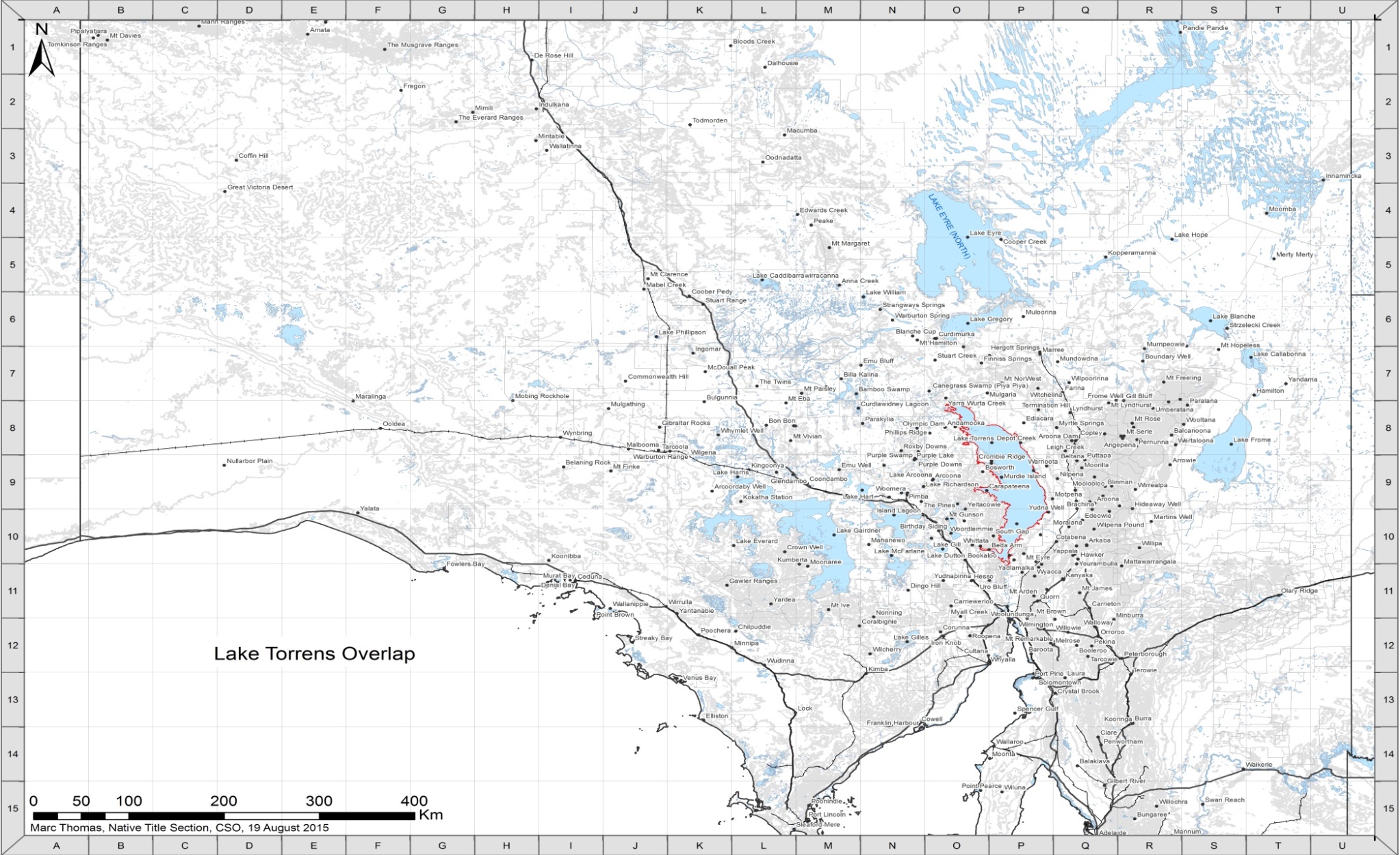
3 The surface of the claim area is accepted by all parties to be unsuited to long-term occupation, save for Andamooka Island. During the hearing a map of Lake Torrens entitled “Lake Torrens Overlap trial locations to be mentioned in evidence” was produced by the State (Exhibit S1). It is annexure A to these reasons. Another map, provided by the State by consent as an aide to the hearing and entitled “Lake Torrens Overlap Proceeding, Marc Thomas, Native Title Section, CSO, 19 August 2015” which depicts most of South Australia, including the claim area and the names of various places in the area surrounding Lake Torrens and referred to in the ethnography is annexure B.
4 The claim area is bounded by lands and waters in respect of which native title rights and interests have been determined or found to exist. To the west and contiguous with the western shore of Lake Torrens, the claim area abuts the area recognised as the native title lands of the Kokatha Uwankara People: Starkey v State of South Australia [2014] FCA 924 (Kokatha Part A). To the east and contiguous with the eastern shore of Lake Torrens, the claim area abuts the area recognised as the native title lands of the Adnyamathanha People: Adnyamathanha No 1 Native Title Claim Group v South Australia (No 2) [2009] FCA 359 (Adnyamathanha No 1). Separating the Kokatha Part A determination area from the Adnyamathanha No 1 determination area at the northern tip of Lake Torrens is a narrow strip of land (approximately 200 m wide at the shoreline) determined to be the southern part of the native title lands of the Arabana people: Doss v State of South Australia [2012] FCA 519. Separating the Kokatha Part A determination area from the Adnyamathanha No 1 determination area at the south-eastern part of Lake Torrens is approximately 6 km of shoreline which forms the northern part of lands determined to be the native title lands of the Barngarla People: Croft v State of South Australia (2016) 325 ALR 213; [2015] FCA 9 (Barngarla); Croft on behalf of the Barngarla Native Title Claim Group v State of South Australia (No 2) [2016] FCA 724 (Barngarla No 2).
5 The present applications for a determination of native title are:
(1) Kokatha Native Title Claim (Part B), SAD 90 of 2009 (the Kokatha Application, made by the First Applicant); this claim is the remaining area of the application which supported the Kokatha Part A determination. The Part A area was heard and determined separately because it did not give rise to the confronting overlapping claims now being considered;
(2) Adnyamathanha No. 5 Native Title Claim, SAD 277 of 2012 (the Adnyamathanha Application, made by the Second Applicant); and
(3) Barngarla (Lake Torrens) Native Title Claim, SAD 175 of 2015 (the Barngarla Application, made by the Third Applicant).
6 As the parties did in the course of the hearing, the claim group in the Kokatha Application will be referred to as the Kokatha People; the claim group in the Adnyamathanha Application will be called the Adnyamathanha People (in part used interchangeably with the description of the Kuyani People, as the earlier ethnography refers to them in that way as the Adnyamathanha People whose “local” area was more to the western part of the other Adnyamathanha Lands); and the claim group in the Barngarla Application will be called the Barngarla People.
7 One consequence of the determinations made on areas surrounding Lake Torrens is that there are significant challenges to the relevance to certain of the anthropological evidence which was adduced, as it was said in part to be premised upon parts inconsistent with one or other of those determinations, in particular in Kokatha Part A. It is appropriate, therefore, to record in a little more detail the nature of those determinations.
8 The determination in Kokatha Part A recognised the Kokatha People as the holders of native title over that claim area, running extensively west from the western borders of Lake Torrens, subject to those parts of the claim area where other acts have extinguished native title, either wholly or in part (including, by agreement the areas the subject of the ODA agreement registered as an ILUA under the NTA, and as explained in [32]-[37] later in these reasons). The recognised and extensive native title rights recognised are non-exclusive, because of the other interests in the claim area as recorded. The other interests do not include interests of any Adnyamathanha or Barngarla People except as recognised in the ODA agreement and as noted the area of the ODA agreement is excluded from the claim area. It is well to the west of Lake Torrens. The prescribed body corporate under s 57(2) of the NTA is the Kokatha Aboriginal Corporation.
9 The determination in Adnyamathanha No 1 recognised the Adnyamathanha People as the holders of native title over three claim areas, including relevantly the areas immediately to the east of Lake Torrens. Again, the rights recognised are extensive, and subject to the areas where other acts have extinguished native title either wholly or partially. The rights are non-exclusive other than four areas where, by operation of s 47A of the NTA, the extinguishment is to be disregarded. These areas of exclusive native title rights are not directly relevant to the present issues. There are no other terms of that determination which are said to inform the resolution of the present issues.
10 The determination in Barngarla No 2 recognised the Barngarla People as the holders of native title over that claim area, including relevantly the areas immediately to the south of Lake Torrens. Again, the rights are extensive but by reason of other acts those rights have been extinguished either wholly or partially, so the rights are relevantly to the present issues non-exclusive. There are no other terms of that determination which would inform the resolution of the present issues.
11 Obviously, at sovereignty, the native title rights and interests so recognised would not have been extinguished either in whole or in part by the acts which have occurred subsequent to sovereignty.
12 While the named applicants who comprise each of the claimant groups are no longer identical to the applicants who were authorised by the claimant groups and in whose favour the determinations were made in Kokatha Part A, Adnyamathanha No 1 and Barngarla No 2, they identify as being part of the same societies as those recognised as the holders of native title rights and interests under the NTA in Kokatha Part A, Adnyamathanha No 1 and Barngarla, respectively. Nothing presently turns on those differences. However, for reasons which are addressed below, the precise composition of the three competing claim groups provokes certain observations about the extent of certain common ancestry.
13 It is also accepted that the Kokatha People (in Kokatha Part A referred to as the Kokatha Uwankara People) are an eastern group as part of the wider Western Desert society and that the Adnyamathanha People and the Barngarla People are part of the wider Lakes Group society.
14 Each of the First, Second and Third Applicants relies on findings made in Kokatha Part A, Adnyamathanha No 1 and Barngarla, respectively, and seeks the Court to adopt certain findings in those proceedings pursuant to s 86(1)(c) of the NTA. The Second Applicant also seeks to rely on findings in a related proceeding: Coulthard v State of South Australia [2014] FCA 124 (Coulthard). Those findings, and the extent to which they are relevant to the present claims, are outlined and addressed in further detail below.
15 On 10 December 2014 (as reviewed on 2 February 2015), orders were made for the Kokatha Application and the Adnyamathanha Application to be heard together, and programming orders were also made. On 8 July 2015, that order was extended to include the Barngarla Application after that belated application. It is observed that the Barngarla Application was made many years after the other two applications, and of course therefore was not made by any response to the notification of either of those claims under s 66 of the NTA. Those orders meant that all three claimant applications over Lake Torrens would be heard together, as appropriate having regard to s 67(1) of the NTA.
16 The only other active parties in these claims were the State of South Australia (the State) and two related mining companies, Kelaray Pty Ltd (Kelaray) and Straits Exploration (Australia) Pty Ltd (Straits), although as discussed below, on 22 March 2016 Straits notified the Court that it wished to cease to be a party to the proceedings and Kelaray made only limited written closing submissions on 29 February 2016, after participating in the evidentiary hearing.
HISTORY OF CLAIMS OVER LAKE TORRENS
17 Like many native title determination applications, the claims which have been made over Lake Torrens, and including Andamooka Island, have a protracted history.
18 In 1998, the three applicant groups (somewhat differently constituted, and described in one case as the Kuyani, whose descendants now call themselves Adnyamathanha), each made applications for a determination of native title which was geographically more extensive but included Lake Torrens in the lands and waters claimed:
(1) Kokatha Native Title Claim – SAD 6013 of 1998 (the prior Kokatha claim);
(2) Barngarla Native Title Claim – SAD 6011 of 1998 (the prior Barngarla claim); and
(3) Kuyani People Native Title Claim – SAD 6004 of 1998 (the prior Kuyani claim).
19 The background and resolution of those original claims is described in some detail in Barngarla at [10] – [31]. That history, as recorded in Barngarla, is set out below to the extent that it affects the Lake Torrens area.
20 On 8 December 2003, the Court referred the prior Barngarla claim to the National Native Title Tribunal (NNTT) for mediation. Two broad main areas of overlap were the focus of its attention. The first area centred around the Lake Torrens area and concerned (at least initially) the prior Kokatha claim and the prior Kuyani claim. The second area centred around the Flinders Ranges National Park to the east of Lake Torrens and concerned two claims of the Adnyamathanha People (Adnyamathanha No 1 and Adnyamathanha No 2), as well as a native title claim made by the Nukunu People.
21 The NNTT sought to facilitate the State and the Aboriginal Legal Rights Movement (ALRM) (now South Australian Native Title Services or ‘SANTS’), as the relevant native title representative body for South Australia under the NTA, in attempting to resolve native title claims through a process known as the “State-Wide ILUA Process” (ILUA refers to the concept in the NTA of an Indigenous Land Use Agreement). The prior Kokatha claim, the prior Kuyani claim and the prior Barngarla claim (as well as the Adnyamathanha claims referred to) became a part of that process, and specifically a part of a strategy for resolution of overlapping native title claims called the “Central Western South Australia Mediation Strategy”. That Strategy, as far as those claims were concerned, was aimed at resolving the two Barngarla-Kokatha-Kuyani-Adnyamathanha overlaps referred to. It was conducted principally at Spear Creek, and is frequently referred to eponymously as the Spear Creek Mediation. The Spear Creek Mediation sought to address a number of other overlapping claims under the NTA at the same time.
1. The Barngarla-Kokatha-Kuyani Overlap and the Arabana Overlap
22 On 30 June 2004, the NNTT recommended that its mediation cease to the extent that it concerned the overlap of the Barngarla-Kokatha-Kuyani claims (the first area of overlap referred to at [20]), and that that part of the claim be listed for hearing. The Spear Creek Mediation, and follow-up meetings, had been unsuccessful in resolving the groups’ differences. The State opposed that recommendation, saying that the more appropriate course was to persevere with the “State-Wide ILUA process”. On 22 July 2004, the Court adopted the NNTT recommendation and ordered that that overlap be removed from mediation.
23 However, on 13 October 2004, the Court ordered that the Kokatha-Barngarla overlap be referred back to mediation by the NNTT. That order was made because it had emerged that an in-principle agreement to share the area of the overlap might be able to be finalised.
24 On 27 January 2005, the prior Kuyani claim was struck out by Finn J: McKenzie v South Australia (2005) 214 ALR 214. A second Kuyani Native Title Claim briefly emerged in early 2006, only to be discontinued several months later: Kokatha People v State of South Australia [2007] FCA 1057 at [9] per Finn J.
25 By this time, the Kokatha-Barngarla overlap had been affected by a third claim by the Arabana People (SAD 6025 of 1998). On 15 April 2005, the Court referred the Arabana People Native Title Claim to mediation by the NNTT, limited to that part of the claim which overlapped with the prior Kokatha and prior Barngarla claims. The consequent negotiations were not successful.
26 On 8 September 2005, the Court ordered that that part of the prior Barngarla claim that overlapped with the prior Kokatha and Arabana People claim was to be dealt with in a separate “overlap proceeding”. At about that time, the NNTT reported that there was a clear willingness on the part of the Barngarla, Kokatha and Arabana claimants to resolve the overlaps.
27 On 1 July 2007, a resolution of the overlaps between the prior Barngarla claim and Arabana People Native Title Claim was reached. The prior Barngarla claim would withdraw the claim over the overlapping land area, as it did. The prior Barngarla claim is the claim which is the subject of the Barngarla No 2 determination. The Arabana People were also to withdraw the claim over the overlapping area in the northern part of Lake Torrens, as it did. The Arabana People claim led to the determination referred to above in their favour, abutting Lake Torrens for a short distance at its northern extreme.
2. The Adnyamathanha-Barngarla Overlap
28 Meanwhile, the NNTT reported at the same time that progress was being made on the resolution of the Adnyamathanha-Barngarla overlap.
29 On 9 February 2006, the Court ordered that the ongoing NNTT mediation should focus on resolving overlaps between the prior Barngarla claim and the Adnyamathanha Peoples No 1 and No 2 Native Title Claims (SAD 6001 and 6002 of 1998 respectively). Negotiations between those groups had been on hold at the NNTT for several years, as the NNTT, ALRM and the State prioritised, inter alia, the Kokatha-Barngarla-Arabana Peoples overlap negotiations.
30 Through 2006 and 2007, the NNTT mediation of the prior Barngarla claim overlaps with the two Adnyamathanha Peoples Native Title Claims, now known collectively as the “Adnyamathanha Peoples Proceeding” continued. An agreement was reached in around December 2007, resulting in recognition of the Adnyamathanha over a substantial area in and around the Flinders Ranges and to the east of Lake Torrens: Adnyamathanha No 1.
31 In consequence of the above agreements with both the Adnyamathanha People and the Arabana Peoples, on 30 May 2008, a further amended application was filed by the Barngarla People reducing the prior Barngarla claim area to bring the claim area’s north-eastern boundary to the south-eastern border of Lake Torrens. Findings were made in favour of the Barngarla in respect of land and waters adjacent to the south-eastern part of Lake Torrens and further to the south in 2015 in Barngarla and effect was given to those findings, having regard to extinguishment in Barngarla No 2.
32 A further agreement was reached on 14 December 2008 at a meeting at the Standpipe Hotel, Port Augusta, between the Barngarla, Kokatha and Kuyani peoples to pursue jointly a claim over Lake Torrens and the area to its west. That claim, lodged as the Kokatha Uwankara Native Title Claim on 18 June 2009, is the original claimant application filed by the First Applicant in the present matter, that is the Kokatha Application but including both Parts A and B. It is convenient to call that application, including both Parts A and B, the Kokatha Uwankara Claim, to distinguish it from that claim as it later proceeded over those separate parts. On 5 April 2013, the Court made orders dividing the Kokatha claim into Part A and Part B. Part A consisted of the area west of Lake Torrens whilst Part B comprised the whole of Lake Torrens including Andamooka Island. As noted, Part A was resolved by the consent determination in Kokatha Part A. Part B was then renamed the Lake Torrens Overlap Proceedings, and in these reasons is referred to as to the Kokatha Application.
33 Those persons originally authorised to make the claim (then over Parts A and B) were Andrew Starkey, Lorraine Dare, Mark McKenzie and Joylene Thomas. Following the filing of the First Applicant’s amended claimant application the named applicants were Andrew Starkey and Joylene Thomas only, as reflected in Kokatha Part A. The First Applicant submits that Lorraine Dare is also a Barngarla person, that Mark McKenzie is also an Adnyamathanha Person and that Joylene Thomas and Andrew Starkey are Kokatha people. Further, it is said that Adnyamathanha claim group members Mick McKenzie, Mark McKenzie and Tony Clarke, and Barngarla claim group members Eric Paige, Beverly Patterson, Linda Dare and Patricia Dare were all present at the meeting to support the amended application and that Lee Brady (who was not present but who is an Adnyamathanha person) also wrote to Mr Linde at SANTS confirming his agreement to be part of the Kokatha Uwankara claim. Then, as now, the description of the claim group included Mark McKenzie, Tony Clark and Lee Brady who identify as Kuyani or Adnyamathanha people because of their “spiritual connection to and responsibility for specific sites in the determination area”, although it does not include their descendants.
34 On 8 November 2012, Mark McKenzie Senior, Anthony Clark, Angeline Stuart, Michael Anderson, Deidre McKenzie and Beverly Patterson on behalf of the Adnyamathanha People filed the present Adnyamathanha Application by the Second Applicant over Lake Torrens and Andamooka Island. They were also joined as respondents on behalf of the Adnyamathanha People to the Kokatha Uwankara claim. That was notwithstanding that the Kokatha Uwankara claim group formulation included Mark McKenzie, Tony Clark and Lee Brady, three individuals who identified as, or also identified as, Adnyamathanha and/or Kuyani: see affidavit of N Llewellyn-Jones of 25 August 2014.
35 In 2014, the State was exploring the resolution of Part A of the Kokatha Uwankara claim by consent. It was not then proposed that Mark McKenzie, Lee Brady, or Tony Clark should form part of the claimant group despite being included in the description of claim group in the Kokatha Uwankara claim. Ultimately, the named Adnyamathanha withdrew as respondents to Part A of that claim enabling the consent determination by Kokatha Part A to proceed.
36 The circumstances in which that occurred are set out in the affidavit of N Llewelyn-Jones of 25 August 2014. It records that the Adnyamathanha People had indicated that they have “traditional rights and interests” in that consent determination area, that is the area to the west of Lake Torrens, that they had provided material to the Federal Court of Australia on 1 July 2013 in support of that assertion, and that the claim group formulation for the Kokatha Uwankara claim included three Adnyamathanha/Kuyani individuals who were included into the Kokatha claim to represent those interests.
37 That affidavit further records that, the Kuyani Yartah Association, which comprises Adnyamathanha Persons, and one of the Kokatha associations, are party to a commercial agreement with BHP Billiton Pty Ltd regarding Olympic Dam (the ODA). The ODA was negotiated through 2004 to 2008; the signing ceremony was on 18 February 2008; and it became fully operational on 16 December 2009. The ODA Trust became operational in early 2010. Accordingly, the affidavit records that a commercial agreement, binding on members and/or associations of both parties, already existed subject to certain “implementation” phases. The last of the implementation phases was to be the completion of an ILUA which, it was said, needed to be finalised, in order properly to protect the Adnyamathanha/Kuyani interests under the ODA. Accordingly, it records that the Adnyamathanha and Kokatha had finalised an agreement which had the effect of guaranteeing the Kuyani interests under the ODA. In consideration of this, the Adnyamathanha had agreed to facilitate the Kokatha consent determination in the Part A area to the west of Lake Torrens.
38 As indicated, the named Adnyamathanha persons then withdrew as respondents, and Part A of the Kokatha Uwankara claim was resolved by the consent determination in Kokatha Part A.
39 Orders were then made on 10 December 2014 (as reviewed 2 February 2015) for Part B of the Kokatha Uwankara Application, as now described in these reasons the Kokatha Application, which had yet to be resolved and the Adnyamathanha Application to be heard together.
40 On 11 June 2015, a new claimant application was filed by the Barngarla (Lake Torrens) Native Title Claim, now described as the Barngarla Application. Three of the apical ancestors in the Barngarla Application, Andrew Davis, Percy Davis and Stanley Davis, are also named as apical ancestors in the Kokatha Application. A further order was made on 8 July 2015 that the applicant in the Barngarla Application be the Third Applicant in these proceedings. Those orders meant that all three claimant applications over Lake Torrens would be heard together pursuant to s 67(1) of the NTA.
41 The purpose of setting out this detailed history is not simply to describe the detailed history of the overlapping native title claims which are presently being considered in this matter. It is to record the numerous negotiation and mediation processes which each of the Applicants and the State have engaged in, and the attempts made by each of the parties, to resolve their overlapping claims through an ILUA process, a consent determination, or the formulation of a single claim over Lake Torrens.
42 The consequence is that the Court presently has before it three claimant applications which entirely overlap geographically.
43 Historically, in terms of the description of the native title holders in the three claimant applications (see also “Interrelated applicant groups” below) and, at least in some contemporary cases, that overlap is also in part cultural or genealogical. At this stage, it is also appropriate to record that, due to the description of the native title holders in each of the three claimant applications and the genealogical overlap between the claimant groups, if a finding were to be made in favour one of the applicant groups, that might not preclude the allocation intra-mural of particular responsibility for, or interest in, a particular area or areas of the determination area to a member of the claim group, even though that person is also a member of one or other or both of the other claim groups.
44 The three claimant applications, each as formulated, presents a claim for a determination being made in favour of one or other of the three Applicants to the exclusion of the others. That was the case presented by each of the Applicants in opening, and subject to certain admissions on the evidence and joint submissions made by the Second and Third Applicants in their oral, and supplementary, closing submissions.
45 At the outset the Court observed that the further the individual cases of the Applicants were advanced, the more there would be evidence directed also to showing that another Applicant, or Applicant group, did not have the native title rights which were asserted. There cannot be three sets of exclusive native title rights held by different groups. It also pointed out that it could not be assumed that the Court could find that there are joint or co-existing rights held by some differently defined group or society or community over Lake Torrens. That is not to suggest that the three claimant applications, or the manner in which the evidence evolved from the Applicants, was anything other than appropriate in the circumstances. It was to note the tension between the cases as presented, and the difficulty with respect to a future “joint proposal” such as the alternative proposition now made by the Second and Third Applicants (and at least in theory by the First Applicant) that the Court might exercise its power to find in favour of more than one Applicant, or some differently defined applicant, in respect of the same area. There is no reason why, depending on the evidence, the Court could not find in favour of one or more of the Applicants over a part or parts of Lake Torrens, but it is not evident that it could create a fourth group, not one of the Applicant groups, and determine that that different group held native title over Lake Torrens or parts of it.
46 The significance of the various alternative outcomes raised by the parties in final submissions is addressed further in the section of those reasons under the heading “The Law”.
47 As one counsel figuratively observed, three-handed poker got the name cut-throat poker.
48 Certain aspects of the lay and expert evidence concerned knowledge of secret men’s matters including of particular ceremonies and stories. It is described as secret because (as the parties accept) certain evidence about the ceremonies and stories of initiated Aboriginal men are not to be disclosed to women. Orders were made in respect of gender restricted evidence led by the First and Second Applicants on various occasions during the hearing, varied as appropriate, under s 17(4) and s 37AF(1)(b)(i) of the Federal Court of Australia Act 1976 (Cth) and s 82(2) of the NTA, restricting those persons who may hear, or view the transcript of, that evidence.
49 I note that the cultural concerns which led to the orders restricting those persons who may hear or view the transcript evidence were generally agreed to be appropriate, and were accommodated by counsel without opposition. That is despite the substantial restricted evidence which was proposed to be, and was, led, and the associated and corresponding complexity of the hearing, including the decision by parties to brief additional counsel to accommodate those cultural concerns. The parties are to be commended for the sensible and sensitive way in which those concerns were recognised.
50 Orders were also made in respect of the extent to which senior counsel for the Third Applicant should be entitled to hear and to cross-examine gender restricted evidence given by one witness for the First Applicant, because that counsel is himself an Aboriginal man and is not of the Kokatha claim group or of the wider Western Desert cultural group: Lake Torrens Overlap Proceedings (No 2) [2015] FCA 1195. That, too, was accommodated by the engagement of other senior counsel for parts of the hearing.
51 Evidence was led and argument heard over 21 hearing days on the existence of native title in the claim area and on extinguishment between October 2015 and March 2016.
52 It was common ground as between the parties, that no expert proposed to give evidence directly to attack any finding of fact which is fundamental to or underlies any existing determination and that the focus of the experts’ reports was on who, if anyone, occupies or is entitled to native title rights over Lake Torrens. That is, as the Court expressed it in the course of the hearing, the parties accepted the primary findings of fact necessary to support the three determinations on the areas of land surrounding Lake Torrens (as outlined in Kokatha Part A, Adnyamathanha No 1 and Barngarla) and, of course, the three determinations in Kokatha Part A, Adnyamathanha No 1, and Barngarla No 2 handed down on 23 June 2016.
53 Nonetheless, as briefly noted above, there were a number of objections to, and submissions which were made in respect of, both the oral and written evidence given by the experts.
54 Firstly, in respect of the expert evidence and despite the common ground about what was proposed, it was said that certain parts of the evidence were in fact an attack on findings in existing determinations. The evidence the subject of these objections was admitted into evidence to inform the extent to which there are native title rights in any one of the Applicants over Lake Torrens, and for any other legitimate purpose. This was done on the basis that the evidence would not be used to undermine an existing determination and that, in the event that it had no other relevant use, there would be no weight accorded to it. That ruling specified that it was for the party seeking to rely on that evidence to make appropriate submissions on its legitimate use, with the objecting party to have a right of reply. Those matters were then addressed further in the final submissions.
55 It was also said that certain parts of the expert reports are argumentative, hard to understand or not based on a proper foundation. In those circumstances, the evidence was received simply as a contention, again on the basis that final submissions would be made on its appropriate use, and with the objecting party accorded the right to respond. That is not an uncommon course to adopt, as it avoids a very extensive and time consuming analysis of, and rulings on, very long experts reports and then the steering of refined and complex courses in the evidence progress (as experience has shown) with great waste of time and little or no real benefit. The parties sensibly accepted that it was not necessary to go down that path.
56 Those issues are considered in more detail under the heading ‘Expert evidence’ below.
57 Similar submissions were also made in respect of certain lay evidence, to the extent that it was said to contradict the findings of the Court in Kokatha No 1, Adnyamathanha No 1 and Barngarla. That evidence was also received on the basis that no weight would be given to evidence that was inconsistent with those determinations.
58 There were 25 lay witnesses called by the Applicants over the hearing days from 26 October 2015 to 17 December 2015. A number of witnesses gave evidence “on country” on sites on Andamooka Island, or around the eastern border of Lake Torrens. Most witnesses gave evidence in Port Augusta or, in some cases, in Adelaide.
59 There were 11 lay witnesses called by the First Applicant. They were: Andrew Starkey, Robert Starkey, Michael Starkey, Glen Wingfield, Paul Strangways, Janice Wingfield, Sonya Gaston, Rebecca Bear Wingfield, Peter Mungkari, Kevin Dingaman and Professor Jon Willis. Professor Willis, the expert anthropologist engaged by the First Applicant, gave “lay” evidence separately from, and prior to, his evidence as an expert witness in accordance with orders made on 9 November 2015: Lake Torrens Overlap Proceedings (No 2) [2015] FCA 1195. That is because Willis, although not of indigenous extraction, is a person who has had a very long association with the Kokatha claim group and more generally people from the Western Desert country and is an initiated Pitjantjatjara Yankunytjatjara man. He was called as a “lay” witness in respect of both his actual experience of, and knowledge of, Western Desert cultural practices, along with other members of the Kokatha claim group, and as an expert anthropologist. It is not any disrespect that I shall recognise the professional status of each of the expert witnesses by using their respective professional titles when they are first referred to, but thereafter I will simply use the surname without repetition of the qualification.
60 During the course of evidence-in-chief, the First Applicant also tendered and relied on a series of restricted, and non-restricted photo plates, as well as a DVD entitled “Lake Torrens Overlap Proceeding 1st Applicant’s Footage Eucolo Creek”. It also tendered two extracts from a book by Dr D Tunbridge, “Artuni the Seven Sisters” and ‘The Woman who Murdered her Daughter’ extracted at page 16 and pages 128-129, respectively.
61 On country evidence, gender restricted in its entirety, was given by Andrew Starkey, Robert Starkey, Michael Starkey, Glen Wingfield, Paul Strangways, Peter Mungkari and Kevin Dingaman at Andamooka Island. The First Applicant also sought to rely on transcript of evidence given by Michael Starkey in proceedings in the Environmental Resources and Development Court of South Australia (the ERD Court) on 25 November 2010 in Straits Exploration (Australia) Pty Ltd v Kokatha Uwankara Native Title Claimants (ERD 231 of 2010). In addition the First Applicant relied on a letter signed by Lee Brady, a lay witness called by the Second Applicant, to SANTS dated 28 November 2008 and a copy of exhibit S1, as marked by Lee Brady. Genealogies prepared by SANTS for the then named Kokatha Uwankara Native Title Claim (that is, to cover Parts A and B of the claim) dated February 2009 were also tendered.
62 There were 7 lay witnesses called by the Second Applicant. They were Lee Brady, Regina McKenzie, Michael McKenzie, Heather Stuart, Ken McKenzie, Jacqueline McKenzie and Beverly Patterson. On country evidence was given by Lee Brady, Regina McKenzie and Michael McKenzie at Andamooka Island; Regina McKenzie and Heather Stuart at Hookina Creek and Ken McKenzie, Jacqueline McKenzie and Beverly Patterson at Nilpena. Gender restricted evidence was given by Michael McKenzie, Lee Brady and briefly by Ken McKenzie. Genealogies for the Second Applicant dated 1985 and 2008 were also tendered.
63 During the course of evidence-in-chief, the Second Applicant also tendered and relied on a series of restricted, and non-restricted photos of parts of the claim area as identified by the lay witnesses.
64 There were 7 lay witnesses called by the Third Applicant. They were Eric Paige, Graham Richards, Amanda Richards, Rosalie Richards, Patricia Dare, Linda Dare and Harry Dare. Only one witness gave evidence as a non-Aboriginal person: Rosalie Richards. On country evidence was given by Eric Page at Andamooka Island. During the course of evidence-in-chief, the Third Applicant also tendered and relied on a series of restricted photos, those photographs marked as ‘restricted to men only’ were tendered on an unrestricted basis. There was no other gender restricted evidence led by the Third Applicant.
65 Apart from the oral evidence of the lay witnesses at the hearing, the Third Applicant also relied on transcripts of evidence given by Eric Paige on 4 December 2012, Rosalie Richards on 7 December 2012, Amanda Richards on 4 December 2012, Linda Dare on 28 November 2012 and 10 December 2012 together with the DVD of Linda Dare performing the seven sisters dance at Roxby Downs (received during the giving of evidence as recorded in that transcript) and Harold Charles (Harry) Dare on 3 December 2012, adduced in the Barngarla matter. The Third Applicant also relied on the affidavit of Linda Dare of 5 May 1999 and Leroy Richards (deceased) of 26 May 1999, as well as a witness statement of Eileen Wingfield, mother of Janice Wingfield, Sonya Gaston and Rebecca Bear Wingfield, of 4 November 2010 tendered in Straits Exploration (Australia) Pty Ltd v Kokatha Uwankara Native Title Claimants in the ERD Court. In addition, the Third Applicant relied on a copy of exhibit S1 as marked by Graham Richards during his evidence-in-chief.
66 No lay witnesses were called by any party other than the Applicants.
67 The Court received the report of the conference of experts of 7 July 2015, and the report of the conference of experts of 10 and 11 September 2015. It received expert anthropological reports into evidence and heard oral evidence from the anthropologists Willis (called by the First Applicant), Mr Bob Ellis (called by the Second Applicant), Dr Deane Fergie, Dr Rod Lucas, Dr Paul Monaghan (called by the Third Applicant), Professor Peter Sutton (called by the State) and Dr Sullivan (called by Kelaray and Straits). Those reports were the report of Willis of 7 October 2015 (Willis Report), the report of Ellis of 27 September 2015, as revised on 15 December 2015 (Ellis Report) and the further report of Ellis of 15 December 2015 (Ellis Supplementary Report), the report of Fergie Lucas and Monaghan of 6 October 2015 (Fergie Lucas & Monaghan Report), in addition to a copy of exhibit S1, as marked by Fergie during the concurrent expert evidence, the report of Professor Sutton of 20 October 2015 (Sutton Report) and the supplementary report of Sutton of 15 December 2015 (Sutton Supplementary Report) and the report of Sullivan dated 16 October 2015 (Sullivan Report).
68 The Third Applicant accepted that it would not be appropriate for evidence on the same matter to be repeated by each of Fergie Lucas and Monaghan to bolster its case, and the oral evidence proceeded on the basis that those witnesses would each give specific and complementary oral evidence with respect to the various issues to be addressed, informed by which of those three experts was the more appropriate to address the particular issue.
69 The Sullivan Report was received on 17 December 2015. However, on 22 March 2016 the Court was notified that Sullivan would be unavailable to complete the concurrent anthropological oral evidence. That was related to the notification that Kelaray had terminated its retainer for legal representation for commercial reasons, and the application of counsel for Straits and Kelaray for leave not to appear further in the hearing. That application was granted and as noted above, Straits subsequently ceased to be a party. Mr Owler, a director of Kelaray was given leave to appear for Kelaray. Consequently on 29 February 2016 when the hearing of the concurrent anthropological evidence resumed, in the absence of Sullivan and in circumstances where no other party sought to compel his attendance but each wished to test his evidence by questions to be directed to him, the Court ruled that no weight would be placed on his report of 16 October 2015, or his previous evidence-in-chief, except to understand the purposes of the particular cross-examination which might otherwise be admissible. Kelaray accepted that that ruling was appropriate, also because there were often objections to the evidence of Sullivan which could no longer be usefully explored in his absence. It is not necessary to address that further in the circumstances.
70 The Court also received expert reports into evidence and heard oral evidence from the expert archaeologists Professor Neale Draper and Dr Greg Carver. Draper was called by the First Applicant and Carver was called by the Second Applicant. The First Applicant relied upon the expert archaeological reports of Draper of 7 September 2015 (Draper Report). The Second Applicant relied on the report of Carver of 5 October 2015 (Carver Report), in addition to a three page document with copied images of petroglyphs marked Plates X, Y and I prepared by Carver. The Court also received the Agreed Statement of Expert Issues: Archaeologists of 17 December 2015.
71 The Court also received the expert historical report of Mr Tom Gara of 19 October 2015 (Gara Report), tendered by the State. The report was received without any request for cross-examination.
72 The parties also tendered a number of expert historical, anthropological and archaeological reports which form the underlying ethnographic literature of the claim area. The earlier of these reports were first published in the late 1800s and then progressively through to the 1980s, 1990s and 2000s when a number of reports were prepared in relation to mining projects, or potential mining projects, and other work clearances and surveys.
73 The First Applicant tendered and relied on:
(1) Kingsmill and Gason 1886, ‘No. 60. Beltana’, p 118 – 119,
(2) Helms 1896, “Anthropology by Richard Helms 1896” pp 277-278 (pp 21-22 of the pdf document)
(3) Tindale 1938-39, “Harvard and Adelaide Universities Anthropological Expedition Australia 1938 – 1939 Journal and notes by Norman B. Tindale”, P 36 Sketch map
(4) Tindale 1940, “Results of the Harvard and Adelaide Universities of Anthropological Expedition Australia 1938 – 1939 Distribution of the Australian Aboriginal Tribes: A Field Survey”
(5) Elkin, A.P. 1879-1939, “Aboriginal Men of High Degree,” Australian Publishing Co. [1945], Map, “Aboriginal Tribes of Australia”
(6) Tindale 1974, “Aboriginal Tribes of Australia” p 213 (p 3 of the pdf document)
(7) Austin Ellis and Hercus 1976, “‘Fruit of the Eyes’ Semantic Diffusion in the Lakes Languages of South Australia”, Map on p 67
(8) Elkin 1976, Oceania 46(3) “R.H. Mathews: His Contribution to Aboriginal Studies” pp 217-219
(9) Hagen and Martin 1983, “Report on Kokatha Interests in Sites and Land in Vicinity of the Olympic Dam Mining Project” Appendices 1, 4, 5, 6 and 7, Appendix 1 Women’s survey (p 114 of the pdf document
(10) Mythological Tracks in the vicinity of the Olympic Dam Mining Venture – August 1983, Rod Hagen
(11) Aboriginal Land Rights in Port Augusta – October 1983, J.M Jacobs (H51) pp 261, 262 (A3 map), 357, and 358 (reproduced into two A3 maps)
(12) Report on Kokatha Interests in Sites and Land in the Vicinity of the Olympic Dam Mining Project – September 1983, R. Hagen and S. Martin. (E41) (pp 37 -39)
(13) Fitzpatrick and Gara 1984, “Anthropological Survey of Extractive Mineral Leases on Birthday, Four Mile and Nantilla Creeks Near Port Augusta – A Report for the Kokatha People’s Committee” p 5 of the report (p 7 of the pdf document)
(14) Fitzpatrick & Gara, “Anthropological Survey of extractive mineral leases on Birthday, Four Mile and Nantilla Creeks near Port Augusta – a report for the Kokatha People’s Committee” – October 1984
(15) Berndt 1985, “Natural History of Eyre Peninsula” Chapter 10: Traditional Aborigines
(16) Jacobs 1986, “Understanding the Limitations and Cultural Implications of Aboriginal Tribal Boundary Maps”, p 3, p 12 Map 3 (Field work 1981)
(17) A. P. Elkin 1977, 1994, “Aboriginal Men of High Degree Initiation and Sorcery in the World’s Oldest Tradition”, Foreword page xv
(18) Aziz Willis 1996, “Lake Torrens South: Work Area Clearance”
(19) Connection Report – Myrtle Springs Station, Northern Flinders Ranges, South Australia – September 2000, B. Ellis. (E33) pp 2-3
(20) Hugo 2003, “National Native Title Tribunal research report, North Lakes Region, South Australia” by Dr David Hugo October 2003
(21) “Proposal for the Conduct of a Survey within EL 94/03 (now EL 3195) by Representatives of the Kuyani (SC 00/3) Native Title Claimant Group” dated 5 May 2004
(22) Fitzpatrick and Wood 2005, “Work Area Clearance Andamooka Island Lake Torrens EL 3195 A Report to Straits Exploration (Australia) Pty Ltd and the Barngarla Native Title Claimants”
(23) Fitzpatrick and Wood 2006, “Work Area Clearance Andamooka Island Lake Torrens EL 3195 A Report to Straits Exploration (Australia) Pty Ltd and the Barngarla Native Title Claimants”
(24) De Gand October 2006, “Report on an Ethnographic Desktop Assessment and Consultation with Members of the Andamooka Land Council Aboriginal Corporation Regarding a Proposed Drilling Project at Lake Torrens in South Australia for Straits Exploration (Australia) Pty Ltd”, p 9
(25) Draper, Morley and Damhuis December 2007 (ACHM), “Aboriginal Cultural heritage Survey of Potential Drill Sites and Access Tracks within the Straits Exploration (Australia) Pty Ltd Exploration Licence Area (EL3195), Andamooka Island, SA – Kokatha Report”
(26) Draper, Sutherland and Williams May 2007 (ACHM), “Kokatha Native Title Claim (SAD 6013/1998) Expert Anthropology Report 2nd Draft, May 2007” (Vol 2 pdf p 25)
(27) Document entitled “A report to Straits Exploration (Australia) Pty Ltd and the Barngarla Native Title Claimants” dated November 2007
(28) Adnyamathanha Native Title Report Volume 2 – January 2008, Bob Ellis p 89
(29) Letter signed by Mr L Brady to SA Native Title Services dated 28 November 2008
(30) Kokatha Uwankara Authorisation Meeting, Attendance Record, 14 December 2008
(31) Draper 2010 (ACHM), “Aboriginal Cultural heritage Significance of Lake Torrens, South Australia. Anthropological Report prepared for the Kokatha Uwankara Native Title Claim Group (SAD 90/2009)”
74 The Second Applicant tendered and relied on:
(1) Kokatha People’s Committee Field Report #1 concerning a field survey undertake 8-10 October 1981 by D A Vachon
(2) Southern Land Council Field Report – Roxby Downs Olympic Dam Site – November 12-13 1981 by D A Vachon
(3) Hagen (1983) Aboriginal Sites of Significance - Interim Report to the Kokatha People’s Committee
(4) Gara, T (1989) The Kokatha Heritage Survey
(5) Fax letter from Andamooka Land Council to Straits Exploration (Australia) Pty Ltd dated 14 Sep 2007 and unsigned digital original of same
(6) Pring, A & McLean, G (2014) Aboriginal People’s Points of View about Mining (draft) pp 1-3 only
(7) BHP Billiton – draft EIS for Olympic Dam expansion – Appendix N8 “Ecological assessment of groundwater dependent ecosystems”
75 In relation to the history of the claims over Lake Torrens, the First Applicant also tendered two mediation progress reports by the NNTT dated 2 November 2007 and 12 December 2007, as well as two supplementary mediation progress reports, dated 9 December 2008 and 15 December 2008. An affidavit of Philip Teitzel, affirmed 13 July 2009, was also tendered. To an extent that material has been addressed in the ‘History of Claims over Lake Torrens’ section of these reasons.
76 Finally, the First Applicant tendered a Statement of Agreed Facts filed on 15 April 2015 (as between the First and Second Applicants and the State).
77 The Third Applicant tendered and relied on:
(1) Research performed on 1850s historical sources identified in Gara (2015) comprising a 7 page table, and a map to which that document relates.
78 The State tendered and relied on:
(1) Gara (1988) Report on fieldwork with the Kokatha People’s Committee at Coorlay Lagoon and Whisky Swamp; and
(2) Attachment 8 of the report of 8 October 1985 authored by the Roxby Management Services, containing a map on p 5 depicting Kokatha country.
79 It also tendered an affidavit of William Watt sworn on 30 October 2015 and filed on 16 November 2016, including the attached exhibits. That affidavit related to the issues of extinguishment. Its contents were uncontentious.
80 Finally, oral submissions were made by each of the Applicants and the State over two days, 30 and 31 March 2016. The oral submissions were supplemented by written submissions by each of those parties, as well as by Kelaray, BHP Billiton Olympic Dam Corporation Pty Ltd (BHP) and Mr D Greenfield, the holder of two Pastoral Leases over the area of Andamooka Island.
81 Kelaray made written submissions which were largely confined to dealing with aspects of the claim of the First Applicant. They address the proper use and weight to be accorded to the determination in Kokatha Part A, the Statement of Agreed Facts (as agreed between the First and Second Applicant and the State) and the anthropological evidence (specifically the evidence either relied on and otherwise considered by the First Applicant in its submissions). Kelaray also made brief submissions in respect of the possibility of shared country.
82 The only other persons to make written submissions were BHP and Greenfield. Both Greenfield and BHP made separate, brief written submissions in respect of extinguishment, outlining that their respective interests were validly granted and are, themselves, valid. Otherwise, they adopted the submissions of the State of South Australia, in the case of BHP in relation to the effect of the grant of exploration tenements on native title, and in the case of Greenfield, in relation to the effect of the grant of the pastoral leases over Andamooka Island.
83 For completeness, I also record that OZ Minerals, OZM Carrapateena Pty Ltd and OZ Exploration Pty Ltd filed a notice submitting to any order of the Court in this proceeding on 18 March 2016.
84 All that material has been considered in the course of, and for the purposes of, this judgment although there may be no specific references to it where the issue raised has been addressed in much the same manner by one of the active parties during the hearing.
85 As has been observed in a number of decisions, the starting point for consideration of an application for a native title determination is the NTA: Western Australia v Ward (2002) 213 CLR 1 at [16] and [25] per Gleeson CJ, Gaudron, Gummow and Hayne JJ (Ward HC); Yorta Yorta v Victoria (2002) 214 CLR 422 at [32] per Gleeson CJ, Gummow and Hayne JJ (Yorta Yorta); and Commonwealth v Yarmirr (2001) 208 CLR 1 at [7] per Gleeson CJ, Gaudron, Gummow and Hayne JJ. Although ss 223(1)(a) and (b) of the NTA are in large part based on Brennan J’s judgment in Mabo v Queensland (No 2) (1992) 175 CLR 1, it is the provisions of the NTA which establish the criteria for determining an application for a native title determination.
86 Section 225 of the NTA defines what is determined in an application for a native title determination.
A determination of native title is a determination whether or not native title exists in relation to a particular area (the determination area) of land or waters and, if it does exist, a determination of:
(1) who the persons, or each group of persons, holding the common or group rights comprising the native title are; and
(2) the nature and extent of the native title rights and interests in relation to the determination area; and
(3) the nature and extent of any other interests in relation to the determination area; and
(4) the relationship between the rights and interests in paragraphs (b) and (c) (taking into account the effect of this Act); and
(5) to the extent that the land or waters in the determination area are not covered by a non-exclusive agricultural lease or a non-exclusive pastoral lease—whether the native title rights and interests confer possession, occupation, use and enjoyment of that land or waters on the native title holders to the exclusion of all others.
Note: The determination may deal with the matters in paragraphs (c) and (d) by referring to a particular kind or particular kinds of non-native title interests.
87 Section 223 of the NTA defines the expressions “native title” and “native title rights and interests”. Relevantly, s 223(1) provides:
The expression native title or native title rights and interests means the communal, group or individual rights and interests of Aboriginal peoples or Torres Strait Islanders in relation to land or waters, where:
(a) the rights and interests are possessed under the traditional laws acknowledged, and the traditional customs observed, by the Aboriginal peoples or Torres Strait Islanders; and
(b) the Aboriginal peoples or Torres Strait Islanders, by those laws and customs, have a connection with the land or waters; and
(c) the rights and interests are recognised by the common law of Australia.
88 For a determination of native title to succeed, all the elements in s 223(1) of the NTA must be “given effect”: Yorta Yorta at [33].
89 With respect to s 223(1), in Ward HC, Gleeson CJ, Gaudron, Gummow and Hayne JJ observed at [17]:
…Several points should be made here. First, the rights and interests may be communal, group or individual rights and interests. Secondly the rights and interests consist “in relation to land or waters”. Thirdly, the rights and interests must have three characteristics: (a) they are rights and interests which are “possessed under the traditional laws acknowledged, and the traditional customs observed”, by the relevant peoples; (b) by those traditional laws and customs, the peoples “have a connection with” the land or waters in question; and (c) the rights and interests must be “recognised by the common law of Australia”.
90 In Barngarla, I sought to give effect to those requirements, expressed at [640] in the following terms.
The task of this Court is to ascertain under which (if any) laws acknowledged and customs observed by the present-day [Aboriginal] society do the claimants have rights and interests in the claimed land. Once ascertained, the Court must ask whether those laws and customs can be said to be “traditional laws” or “traditional customs”. The question of whether a particular aspect of [Aboriginal] society as it existed at sovereignty has been lost or retained is relevant only if that question helps determine whether the laws and customs of the present-day [Aboriginal] society can be said to be “traditional”. And the concept of traditional is one which should accommodate adaptation of those laws and customs with the evolution of the traditional [Aboriginal] society, if that is found to have occurred.
91 In making a determination of native title, the plurality in the High Court in Yorta Yorta recognised the importance of traditional rights and interests being established at or before sovereignty at [43]-[44]:
…It is important to recognise that the rights and interests concerned originate in a normative system, and to recognise some consequences that follow from the Crown's assertion of sovereignty. Upon the Crown acquiring sovereignty, the normative or law-making system which then existed could not thereafter validly create new rights, duties or interests. Rights or interests in land created after sovereignty and which owed their origin and continued existence only to a normative system other than that of the new sovereign power, would not and will not be given effect by the legal order of the new sovereign.
That is not to deny that the new legal order recognised then existing rights and interests in land. Nor is it to deny the efficacy of rules of transmission of rights and interests under traditional laws and traditional customs which existed at sovereignty, where those native title rights continue to be recognised by the legal order of the new sovereign. The rights and interests in land which the new sovereign order recognised included the rules of traditional law and custom which dealt with the transmission of those interests. Nor is it to say that account could never be taken of any alteration to, or development of, that traditional law and custom that occurred after sovereignty. Account may have to be taken of developments at least of a kind contemplated by that traditional law and custom. Indeed, in this matter, both the claimants and respondents accepted that there could be "significant adaptations". But what the assertion of sovereignty by the British Crown necessarily entailed was that there could thereafter be no parallel law-making system in the territory over which it asserted sovereignty. To hold otherwise would be to deny the acquisition of sovereignty and as has been pointed out earlier, that is not permissible. Because there could be no parallel law-making system after the assertion of sovereignty it also follows that the only rights or interests in relation to land or waters, originating otherwise than in the new sovereign order, which will be recognised after the assertion of that new sovereignty are those that find their origin in pre-sovereignty law and custom.
92 The native title claimants have both an evidentiary and an ultimate onus of proof, subject to the issue of extinguishment: Western Australia v Ward (2000) 99 FCR 316; Daniel v Western Australia (2004) 208 ALR 51 (Daniel); Harrington-Smith on behalf of the Wongatha People v Western Australia (No 9) [2007] FCA 31 at [339].
93 As discussed in Yorta Yorta by the plurality at [80]:
It may be accepted that demonstrating the content of that traditional law and custom may very well present difficult problems of proof. But the difficulty of the forensic task which may confront claimants does not alter the requirements of the statutory provision. In many cases, perhaps most, claimants will invite the Court to infer, from evidence led at trial, the content of traditional law and custom at times earlier than those described in the evidence. Much will, therefore, turn on what evidence is led to found the drawing of such an inference and that is affected by the provisions of the Native Title Act.
94 Nonetheless, where there are gaps in the historical timeline to the date of the application for a determination of native title, the Court may draw inferences in favour of the claimants in respect of substantial maintenance of connection from sovereignty where there is a proper foundation to do so. That requires the Court to be satisfied that the claimants currently have a connection with the claim area through traditional laws and customs observed and acknowledged, and the evidence available provides some support for the inference of the presence of that connection in the past (traceable by various means such as observations at and after the time of first contact, ancestors, marriage, migration and incorporation and even tribal disputes and wars): De Rose v South Australia [2002] FCA 1342 at [570]. As O’Loughlin J there observed:
To place any higher burden of proof on the claimants, who have a wholly oral tradition that reaches back reliably no further than three or (in a few cases) four generations, would be manifestly oppressive.
95 Where evidence of Aboriginal presence at sovereignty is unavailable (as is commonly the case), such an inference is more readily drawn where there is a preponderance and weight of available evidence and in the absence of contradictory evidence: see e.g. Yarmirr v Northern Territory (1998) 82 FCR 533. Where it is appropriate to do so, weight should be accorded not only to physical use of the claim area but also to evidence of spiritual connection: e.g. see Griffiths v Northern Territory (2007) 165 FCR 391; [2007] FCAFC 178 (French, Branson and Sundberg JJ) at [127] where spiritual sanctions visited upon unauthorised entry supported a finding of exclusive possession.
96 On occasions, it is appropriate that the Court is assisted in by s 86(1)(c) of the NTA, which provides the Court with a discretionary power to adopt “any recommendation, finding, decision or judgment” from other proceedings as there specified, subject to s 82(1), that is subject to the rules of evidence, except to the extent that the Court otherwise orders. That is an aspect referred to in more detail later in these reasons.
97 Nonetheless, the Court must be satisfied that, the traditional rights and interests (once established) relate to the particular area under consideration. In Bennell v Western Australia (2006) 153 FCR 120, the trial judge considered and found in favour of the Noongar People, on the hearing of the separate question of whether native title existed in relation to land and waters in a portion of the claim area, that is the Perth metropolitan area. On appeal, the Full Court in Bodney v Bennell (2008) 167 FCR 84 held that it was not open to the trial judge to find the necessary connection in relation to the Perth metropolitan area from evidence concerning the much wider claim area and where there was no real evidence of connection in relation to the Perth metropolitan area. Relevantly, the Full Court found at [178]-[179] and [187].
It is not uncommon for the traditional laws and customs of a community to connect that community to a claim area by connecting groups within the community both to each other (often in complex ways) and, respectively and immediately, to their own particular portions of the claim area (in the latter case by granting rights to, and imposing responsibilities on, each such group in respect of its portion). In such cases, it is entirely appropriate that the connection inquiry consider not merely evidence of the general connection of the claimant community to the claim area, but also the evidence of the particular connection of the particular groups and their members to their respective portions of the claim area: see Neowarra v State of Western [2003] FCA 1402 at [353]-[356]. The latter evidence, we would suggest, will ordinarily be necessary in some degree if the claimants’ assertion of connection is to be sufficiently manifest over the claim area as a whole – the more so, in communal claims, if rights and interests are held differentially across the community – though there can be cases where, because of long-standing occupancy of the claim area, the s 223(1)(b) inquiry (as distinct from that under s 223(1)(a)) will not loom large: cf Griffiths v Northern Territory (2006) 165 FCR 300 at [561]-[562].
What, in our view, is indispensable where a matter put in issue in a proceeding is whether connection has been maintained to a particular part of a claim area, are the needs:
(i) to examine the traditional laws and customs for s 223(1)(b) purposes as they relate to that area; and
(ii) to demonstrate that connection to that area has, in reality, been substantially maintained since the time of sovereignty.
…
If his Honour was to find that native title existed in relation to land and waters of the Perth Metropolitan Area, it had to be proved that the laws and customs that related to that area had continued to be acknowledged and observed without substantial interruption and that connection likewise had been substantially maintained. Those inquiries necessitated a consideration and evaluation of the evidence (historical and contemporary) as it related to that area from sovereignty to the present: cf the approach to these questions by Mansfield J in Risk TJ 240 ALR 74 in relation to the Darwin Area.
98 That decision has particular resonance for the present issues. The necessary connection must be shown in relation to Lake Torrens, or parts of it, notwithstanding its harsh physical features. And, moreover, it will not readily be inferred on any of these three Applications from the existence of adjoining native title rights at sovereignty that such connection, and therefore such rights, extended naturally into Lake Torrens because that inference (without more) would apply equally to the Kokatha People from the west and to the Adnyamathanha (or Kuyani) People from the east, although perhaps not so strongly to the Barngarla People from the south, except to a limited extent into the southern part of Lake Torrens.
99 There is some authority for the proposition that, while the Court may only make one determination of native title per area, where different groups are found to hold native title, subsidiary determinations within the principal determination can be made: Daniel v Western Australia (2004) 208 ALR 51 (Daniel) at [4]-[7]. I shall shortly further consider that decision.
100 There are further provisions of the NTA which also have a particular significance to the present issues.
101 Where there are overlapping claims of native title, the NTA provides for applications over the same area to be dealt with in the same proceedings with only one determination of native title per area. Relevantly, ss 67 and 68 provide:
67 Overlapping native title determination applications
(1) If 3 or more proceedings before the Federal Court relate to native title determination applications that cover (in whole or in part) the same area, the Court must make such order as it considers appropriate to ensure that, to the extent that the applications over the same area, they are dealt with in the same proceedings.
Splitting of application area
(2) Without limiting subsection (1), the order of the Court may provide that different parts of the area covered by an application are to be dealt with in separate proceedings.
68 Only one determination of native title per area
(1) If there is an approved determination of native title (the first determination) in relation to a particular area, the Federal Court must not:
(2) conduct any proceeding relating to an application for another determination of native title; or
(3) make any other determination of native title;
(4) in relation to that area or to an area wholly within that area, except in the case of:
(5) an application as mentioned in subsection 13(1) to revoke or vary the first determination; or
(6) a review or appeal of the first determination.
Note: Paragraph 13(1)(a) providers that no native title determination application can be made in relation to an area for which there is already an approved determination of native title.
102 The identification of potentially competing claimants is facilitated by s 66 which requires the Native Title Registrar to give notice containing details of the application to persons or bodies specified in s 66(3)(a), including any person which may be affected by a determination in relation to the application: see CG (Deceased) on behalf of the Badimia People v State of Western Australia [2016] FCAFC 67 (Badimia) at [61]. As noted earlier, despite that notification of the Kokatha Application and the Adnyamathanha Application, the Barngarla Application was only made belatedly. There are no doubt good reasons for that.
103 It is clear enough that, consistently with those provisions, the Court on the present hearing could conclude that one or other of the Applicants has established native title over some part or parts of Lake Torrens. Indeed, as later noted the Third Applicant has acknowledged that the claim by the Barngarla People in relation to the northern part of Lake Torrens is not made out, so the primary determination sought is only to an area over the southern part of Lake Torrens. It is then accepted that the Second Applicant should be recognised as holding native title over the northern part of Lake Torrens. Although I have not mentioned there the First Applicant, one available conclusion would be that the Kokatha People hold native title over only part of Lake Torrens.
104 However, the Second and Third Applicants in final submissions put a further contention that, in respect of what might be described loosely as the middle third of Lake Torrens, that there should be a determination that each of the Adnyamathanha People and the Barngarla People together as one native title claim group have shared common rights. The proposed determination then describes the native title holders together as the Adnyamathanha People (as described on the Adnyamathanha Application) and the Barngarla People (as described on the Barngarla Application) with the same specified rights in the “Shared Area” to be exercised in accordance with the traditional laws and customs of the (collective) native title holders.
105 I have significant reservations that, on the three Applications before the Court, it would be either within power or alternatively appropriate, to make such a determination, having regard to s 67 and 68 of the NTA as well as other provisions in the NTA.
106 As noted there is some foundation for such an approach in Daniel.
107 Nicholson J earlier in Daniel v Western Australia [2003] FCA 666 had found that two groups of persons (Ngarluma and Yindjibarndi Peoples) held native title in the claim area. Their joint application had apparently been authorised by each group, as separate persons were nominated on behalf of each group to constitute the composite applicant: see at [41].
108 To put the conclusions into context, that primary decision concerned the hearing of three competing claims. The second and third applicants’ claims were unsuccessful: see at [501, [527] and [528]. The first applicant’s claim on behalf of the Ngarluma People and the Yindjibarndi People jointly succeeded to a limited degree: see at [510] and [525]-[526].
109 In the case of the applicants, said to comprise a composite group of Ngarluma and Yindjibarndi People, the primary judge at [338]-[339] concluded that it was not necessary to make a specific finding as the areas over which group, or subgroup, claimed native title were different. There was a consistent focus on the Ngarluma People’s claim area and the Yindjibarndi People’s claim area separately, concerning the native title rights and interests claimed: see at [93] and [118]-[129] and variously elsewhere in the reasons. It appears the areas or sub-areas were physically separated by a significant ridge of hills. After the reasons were published, the parties were given an opportunity to address the appropriate form of the determination.
110 The primary judge then, in Daniel, decided that, in the circumstances, there could be one determination which in effect comprised two subsidiary determinations separately for each of those groups of people: at [4]-[23]. Although there is reference to “separate and overlapping determinations”, it appears from the determination that that there was slight overlapping of the separate areas of the Ngarluma and Yindjibarndi claim areas in the area of the ridge of hills. There was one determination that the Ngarluma People held native title over part of the claim area, and the Yindjibarndi People held native title over a different part of the claim area: Daniel v State of Western Australia [2005] FCA 536. A reference to the attached map does show some overlap of the separately coloured hatched areas to depict the two areas of determination along the ridge of hills.
111 It does not appear to have been considered whether s 68 precluded the “subsidiary determinations” which, to some extent, overlapped. However, it is apparent in any event from the reasoning in Daniel that the critical step in the reasoning was addressing the determination area in the application, in two separate steps, namely by asking over what part of the claim area had native title been shown to exist so that there should be a determination; and separately addressing s 225(a)-(e).
112 In Daniel, Nicholson J said at [4]-[9]
[4] In the draft determination attached to the July reasons it was proposed, as being consistent with the reasons, that the determination should provide as follows:
“8. Non-exclusive native title rights and interests exist in relation to the Determination Area and are held by the Ngarluma and Yindjibarndi peoples as the common law holders of the native title rights and interests as follows:
• Native title held by Ngarluma peoples is held in relation to the Ngarluma claim area (excluding the area of the sea beyond low water mark) or such lesser portion as may be referred to below in respect of any particular right and interest;
• Native title held by Yindjibarndi peoples is held in relation to the Yindjibarndi claim area or such lesser portion as may be referred to below in respect of any particular right and interest.”
The first respondents submit that, in respect of the overlap area, the preferable conclusion on the Court’s reasoning is that two distinct native titles are held severally by the two groups rather than one native title held collectively by the two groups.
[5] To consider this aspect it is necessary first to turn to the relevant provisions in the NTA. Section 94A of the NTA requires a determination to set out the details of the matters mentioned in s 225. Section 225 provides that a determination of native title ‘is a determination whether or not native title exists in relation to a particular area (the determination area) of land or waters’. It further provides that if it does exist there has to be a determination of, among other things, ‘who the persons, or each group of persons, holding the common or group rights comprising the native title are’. This supports the view that there should be a determination in relation to the determination area, which will include within it a determination of who holds common or group rights. There are thus two levels of determination: the principal determination being a determination of whether native title exists in relation to the particular area, and the subsidiary determinations being a determination of the matters set out in pars (a) – (e) of s 225. Where different groups are found to hold different native titles, necessarily there is a requirement for more than one subsidiary determination. Those paragraphs require determination of who holds native title and the nature and extent of the native title rights and interests. This statutory language accommodates variations in entitlement to rights between applicants and groups of applicants.
[6] This is supported by reference to s 61 which provides that persons who may make application for native title are authorised persons (the native title claim group) who, according to their traditional laws and customs, hold the common or group rights and interests comprising the particular native title claimed. Therefore, the application is directed to ‘the particular native title claimed’ even though not all the claimants claim the same rights. As the July reasons state at [60], the first applicants initially brought a claim that there was a single composite community known as the Ngarluma and Yindjibarndi peoples but subsequently abandoned that claim in favour of one that there were two groups, namely, the Ngarluma peoples and Yindjibarndi peoples holding rights comprising native title rights. The findings in the July reasons accepted that position subject to exclusions and issues of extinguishment and any other qualifications set out in the text of each finding.
[7] A plain reading of ss 61, 223 and 225 supports the view that the determination should be approached on the basis that the Court should make a single principal determination in which subsidiary determinations are made on the issues raised in pars (a) – (e) of s 225. That approach may, in appropriate evidentiary circumstances, lead to a finding that different persons or groups of persons hold common or group rights comprising the native title. The statute requires the subsidiary determinations to be made in relation to each group: the focus is to be on the holder group rather than a geographical area (such as an overlap area). Importantly s 225 directs attention, in respect of a particular determination area, to who holds native title and to the nature and extent of the rights and interests so held. Looked at from the perspective of each group, the fact of overlap in a geographical area is relevant only to the extent of rights of each group and does not support the making of a determination in respect of a so-called overlap area of a determination of one native title held by two groups.
[8] As has been already stated, that, however, does not mean that there should be two principal determinations. What the Court is required by s 225 is to make ‘a determination of native title’. That determination is required in subsidiary determinations to identify the persons or group of persons holding common or group rights comprising the native title. Each subsidiary determination may vary as to its terms depending on the findings of fact concerning the native title rights and interests held by each claimant group. Nevertheless, there will still be one principal determination in respect of the determination area.
[9] This view is supported by the use of the description ‘the determination area’ as it appears in s 225(b) and s 225(c). That description is a reference to the particular area of land and waters in relation to which the claim was made and a determination is required; it does not require a focus only on the area where any native title is found to exist. Furthermore, the underlying rationale of ss 13, 67 and 68 of the NTA is that the issue of whether native title exists in any particular area is to be determined once only in respect of a determination area (i.e. in the one proceedings; subject to any revision application or appeal). For that reason the principal determination must relate to the determination area. Variations in native title holding by groups within the area are matters to be addressed in subsidiary determinations.
113 I do not, with respect, consider that that separation of the two steps is appropriate. Where there are, as here, competing applications over the same area, it is proper that – depending on the findings – there may be a determination of one application in favour of the applicant over part of the claim area, and a determination on another application in favour of the second applicant over a different part of the claim area, and each claim may be unsuccessful over part or all of the claim area, whether or not a separate claim, heard together, itself succeeds in part. But the step taken in reliance on s 61, in [6] of those reasons, is predicated upon a particular native title claim group making the claim by an applicant authorised by s 251B of the NTA. And that, in turn, enlivens the considerations in s 225(a)-(e). I consider the steps are an integrated process of the one inquiry.
114 It may be that the particular way in which that claim was made, as noted, diverted attention from the requirement of authorisation in the terms specified. It may be that there was no focus on the significance of the finding that “the native title claim group” was not found to be the group who brought the claim. It may be that s 225(a) does accommodate the recognition of more than one group of persons holding the common or group rights comprising the native title in certain circumstances.
115 The decision in Banjima People v State of Western Australia (2015) 231 FCA 456 (Banjima FC) appears to have proceeded on the basis that there can be only one native title group which holds the native title rights and interests over a particular section of country. The Full Court (Mansfield, Kenny, Rares, Jagot and Mortimer JJ) said at [54]:
Assume that the primary judge, as the State contended, had found shared rights in respect of a part of the Banjima claim area. On the basis of his other conclusions discussed in the context of grounds 1(a) and 1(c) above, it would necessarily be the case that Banjima rights and interests, at sovereignty, would be exclusive of all persons other than those who had the benefit of the shared rights and interests. The point the primary judge was making at [308], [312] and [691] was what the evidence did disclose was that the people who may have had the benefit of those shared rights did not continue to assert them. Accordingly, insofar as those shared rights are concerned, there had been no continuity of connection with the part of the land over which the (presumed) shared rights had been enjoyed at sovereignty. The primary judge was saying no more than that, in such a case, the remaining native title rights and interests, those of Banjima People, would be exclusive. There is no error in this reasoning. If there is no person who can presently assert the existence of continued shared rights in any part of Banjima country, then the Banjima People’s otherwise exclusive rights and interests in the whole of their country remain and can be asserted against the world. The State’s contention to the contrary wrongly assumes that if his Honour had found shared rights at sovereignty (which he did not) then the rights and interests of the Banjima People were not now exclusive as against any person. This is not the logical concomitant of the primary judge’s reasoning. Banjima rights and interests, on that assumption, would be subject only to the shared rights of the particular persons who held them. As the primary judge correctly said at [317]:
Whether or not other language groups — such as the Palyku or the Yindjibarndi — also had interests at sovereignty becomes irrelevant for present purposes. If there is no other group that presently asserts any such interests, either exclusively or on a shared basis, and the evidence shows that on the balance of probabilities the Banjima traditionally had rights and interests in that area, then there is no adequate basis to deny the claimants’ claim that the traditional boundaries of the Banjima extend to where they currently assert that they extend, for native title purposes.
116 That decision also informs the nature of the rulings now to be made on the contentious sections of the expert reports and other evidence. That is because it recognises that a favourable finding in an application for the recognition of native title does not necessarily mean that at an earlier point in time there may not have been other Indigenous people with some form of rights over that country but who no longer assert them. It also accommodates the recognition of different groups over different areas within a claim area if the circumstances (including the procedural circumstances) warrant that.
117 The procedural requirements are important.
118 In Commonwealth of Australia v Clifton [2007] FCAFC 190, the Full Court (Branson, Sundberg and Dowsett JJ) considered the question of whether the Federal Court may make a determination of native title in favour of a person who has not made a native title determination application under s 61 in relation to the area in question, but who is a respondent to such an application brought on behalf of a claimant group which does not include him. The Full Court affirmed that the Court did not have the power to do so. Relevantly, at [57] their Honours said:
Section 213(1) of the Act discloses a legislative intent that a determination of native title should only be made by the Court in accordance with the procedures set out in the Act. In our view, since the coming into force of the Native Title Amendment Act, those procedures require, as a minimum, that before any determination may be made that native title is held by a particular group, an application as mentioned in s 13(1) must be made under Part 3 of the Act by a person or persons authorised by that group in the manner required by s 61(1).
119 As noted, that judgment was further considered by the Full Court Badimia. The primary judge had made a determination that native title did not exist in response to a claimant application made on behalf of the Badimia People. The primary issue before the Full Court was whether the NTA, properly construed, authorised the making of a determination that native title does not exist in response to a claimant application. The Full Court concluded that it did. Importantly for present purposes, one of the reasons for doing so was the reliance on the decision in Clifton and the need for compliance with the particular procedures required by s 213(1). The plurality (North, Mansfield, Jagot and Mortimer JJ) at [41] said that Clifton recognised that, where there is more than one native title claim group seeking a determination over a particular claim area, each group must follow the procedures prescribed in the NTA, and referred specifically to authorisation, the making of an application, and the provision of the information specified by s 62.
120 In this matter, the proposed joint determination is not within the scope of either the Adnyamathanha Application nor the Barngarla Application. Although the two Applicants in those matters no doubt instructed their solicitors to present that proposal, there is no evidence – indeed no suggestion – that a combined claim group as asserted has authorised the making of such a claim. I do not know whether or not they would. If they were minded to do so, they might have been expected to have brought first such a claim rather than the competing claims presented. The history of claims concerning Lake Torrens provides no basis for being confident that such a claim has been, or would be, authorised by such a combined claim group. Unlike the circumstances in Daniel, there is no joint application.
121 In those circumstances, I do not consider it proper to proceed to consider making such a determination. It is therefore not necessary to fully explore the significance of the approach in Daniel or to consider whether, in the circumstances, the other procedural requirements for a claimant application under s 61 to result in a determination of that character have been, or should have been, complied with by the two separate applications.
122 There is, of course, much to be said for the alternative conclusion. That is a contention developed, in particular by the First Applicant, albeit to recognise common, rather than joint, rights, of more than one group in the same area of land or waters.
123 The steps in that contention are first, that s 225 of the NTA defines a "determination of native title" as a determination of whether or not native title exists in relation to a particular area of land or waters and, if it does exist, a determination of, inter alia:
(1) who the persons, or each group of persons, holding the common or group rights comprising the native title are.
124 In its terms, the NTA contemplates that the relevant native title may be held as either “common” or “group” rights by more than one group of persons.
125 By way of factual background, supporting the contention, it is then said that there have been a number of cases that have recognised that “Aboriginal society does not mark out boundaries to land in western style”: De Rose v South Australia [2002] FCA 1342 at [908] per O'Loughlin J. So much is almost self-evident. I remarked in Barngarla at [778] that Aboriginal cultural groupings are not and were never, political entities and so there was never any need for them to be geographically demarcated with the precision one expects of nation states. In Banjima People v State of Western Australia (No 2) [2013] FCA 868 at [182], Barker J made the observation that, in some circumstances, particularly where the country of one group begins to run out and the country of another starts, there may well be a basis for concluding that both groups have rights and interests and in that sense “share” that area of country.
126 At a more interpretative level, it is pointed out that the NTA has as one of its main objects in s 3(a) “to provide for the recognition and protection of native title”: Yorta Yorta HC at [76] per Gleeson, Gummow and Hayne JJ.
127 However, even accepting that the NTA is clearly remedial and beneficial legislation and must be construed accordingly: Yarmirr at [124] per McHugh J, I do not consider that those submissions properly have regard to the particular procedural prescriptions in the NTA, and the authorities addressing them.
128 I have separately, and later, in these reasons explained why, on the evidence, I have not been able to conclude, as an alternative to the competing claims of the three Applicants, that Lake Torrens, excluding Andamooka Island, was a transitional zone where the rights and interests of Western Desert and Lakes Groups people co-existed at sovereignty, and that those rights and interests remain in existence today, so that there should be a determination that identifies the rights and interests of each of the groups involved over Lake Torrens or parts of it.
129 However, I should record at this point, that I am firmly of the view that no such accommodation would be consistent with the evidence of the Kokatha witnesses, in the practical sense of there being an acceptable and accommodating sharing of country in the manner suggested, and secondly (and perhaps even more firmly) in the procedural sense that any joint resolution of the three (or two: Barngarla and Adnyamathanha) Claim Groups to support such a claim of shared rights and interests would be supported.
130 During the course of the hearing following the lay evidence and the expert evidence, there was some refinement by the Applicants of their respective claims, and by the State in response. The position of the parties as presented during closing submissions, to the extent necessary, is outlined below.
(a) The First Applicants claim
131 The description of the Kokatha People as the claim group contained in the Kokatha Application consists of those Aboriginal people who:
(1) are the following named individuals (where living) and their biological descendants:
(a) Alma Allen;
(b) Arthur Baker;
(c) Hilda Captain;
(d) Susie Captain;
(e) Andrew Davis;
(f) Percy Davis;
(g) Stanley Davis;
(h) Ted Egan;
(i) Micky Fatt;
(j) Gladys Kite;
(k) Ted Larkins;
(l) Mick Reid;
(m) George Reid;
(n) William Smith;
(o) Dick Thomas;
(p) Edie Thomas;
(q) George Turner;
(r) Wild Mary;
(s) Eileen Wingfield; and
(2) are included as native title claimants because of their spiritual connection to and responsibility for specific sites in the determination area, being:
(a) Lee Brady;
(b) Tony Clark; and
(c) Mark McKenzie.
132 The First Applicant claims that over areas where a claim to exclusive possession can be recognised (such as areas where there has been no prior extinguishment of native title or where s 238 and/or ss 47, 47A and 47B apply), members of the Kokatha People claim the right to possess, occupy, use and enjoy the lands and waters of the application area as against the whole world, pursuant to their traditional laws and customs.
133 The First Applicant claims that over areas where a claim to exclusive possession cannot be recognised, the nature and extent of the native title rights and interests claimed in relation to the application area are the non-exclusive rights to use and enjoy the land and waters in accordance with traditional laws and customs being:
(1) the right to access and move about the application area;
(2) the right to hunt on the application area;
(3) the right to fish on the application area
(4) the right to gather and use the natural resources of the application area such as food, medicinal plants, wild tobacco, timber, stone and resin;
(5) the right to use the natural water resources on the application area;
(6) the right to live, to camp and to erect shelters on the application area;
(7) the right to cook on the application area and to light fires for all purposes other than the clearances of vegetation;
(8) the right to share or exchange subsistence or other traditional resources obtained from the application area;
(9) the right to engage and participate in cultural activities on the application area including those relating to births and deaths;
(10) the right to conduct ceremonies and to hold meetings on the applications area;
(11) the right to teach on the application area the physical and spiritual attributes of locations and sites within the application area;
(12) the right to maintain and protect sites and places of significance under traditional laws and customs on the application area;
(13) the right to maintain, conserve and/or protect significant ceremonies, artworks, song cycles, narratives, beliefs or practices by preventing (by all reasonable lawful means) any activity occurring on the application area which may desecrate, damage, disturb or interfere with any such ceremony, artwork, song cycle, narrative, belief or practice;
(14) the right to prevent (by all reasonable lawful means) any use or activity within the area which under traditional laws and customs is unauthorised or inappropriate in relation to significant locations, sites or objects within the area or ceremonies, artworks, song cycles, narratives, beliefs or practices carried out within the area;
(15) the right to be accompanies on to the application area by those people who, though not members of the native title claim group, are:
(a) spouses of members of the native title claim group,
(b) people required by traditional law and custom for the performance of ceremonies or cultural activities on the application area; or
(c) people required by members of the native title claim group to assist in, observe, or record traditional activities on the application area.
134 The rights sought in (2)-(6) and (10) above, are traditional rights exercised in order to satisfy personal, domestic, or communal needs.
135 The Kokatha People say that they have demonstrated continued connection since sovereignty to the whole of the claim area. They claim exclusive rights to possession of the claim area.
136 They say that there is no evidence of any present day Adnyamathanha occupation or use of Andamooka Island, and the only evidence of any present day use of the surface of Lake Torrens by Adnyamathanha People relates to non-traditional uses only a short distance in from the Lake’s eastern shoreline and that the Adnyamathanha People have failed to establish the existence of any traditional Adnyamathanha People’s rights and interests in, or in the continuity of any relevant connection with, any part of the claim area.
137 Similarly, the Kokatha say that the Barngarla People have failed to establish the existence of any traditional Barngarla rights and interests in, or in the continuity of any relevant connection with, any part of the claim area.
(b) The Second Applicants claim
138 The description of the claim group contained in the Adnyamathanha Application consists of those Aboriginal people who:
(1) are the descendants (whether biologically or by adoption) of the apical ancestors:
(a) Mt Serle Bob;
(b) Polly, wife of Mt Serle Bob;
(c) Quartpot Tommy;
(d) Mt Serle Bob’s sister, wife of Quartpot Tommy;
(e) Willy Austin Snr;
(f) Nicholas Demell;
(g) Emily McKenzie, wife of Nicholas Demell;
(h) Sydney Ryan;
(i) Mary, wife of Sydney Ryan;
(j) the siblings of Angepena Billy or Mary;
(k) Fanny, wife of Angepena Billy;
(l) the siblings Sara Johnson, Matilda Johnson, Fred Johnson, Natalie Johnson, Jessie Johnson or Sydney Jackson;
(2) who identify as Adnyamathanha; and
(3) are recognised by other Adnyamathanha People under the relevant Adnyamathanha traditional laws and customs as having maintained an affiliation with, and continuing to hold native title rights and interests in, the claim area.
139 The Second Applicant claims that the nature and extent of the native title rights and interests held by all members of the native title claim group in relation to the claim area are rights to use, stay on and enjoy the land and waters of the claim area being:
(1) the right to access and move about the claim area;
(2) the right to hunt on the claim area where appropriate, and together and use the natural resources of the claim area such as food, plants, timber, resin, ochre and soil, where appropriate;
(3) the right to cook and to light fires for cooking or as part of traversing the claim area;
(4) the right to distribute, trade or exchange the natural resources of the claim area;
(5) the right to conduct ceremonies and hold meetings on the claim area;
(6) the right to teach on the claim area the physical and spiritual attributes of Lake Torrens and of locations and sites within the claim area;
(7) the right to visit, maintain and preserve sites and places of cultural or spiritual significance to the Adnyamathanha People within the claim area including the lake surface, islands and mound springs;
(8) the right to speak for and make decisions in relation to the claim area about the use and enjoyment of the claim area by Aboriginal people who recognise themselves to be governed by the traditional laws and customs acknowledged by the Adnyamathanha People;
(9) the right to be accompanied on to the claim area by those people who, though not Adnyamathanha People, are:
(a) spouses of an Adnyamathanha Person;
(b) or people required by traditional law and custom for the performances of ceremonies or cultural activities involving Lake Torrens or on the claim area;
(c) or people who have rights in relation to Lake Torrens or the claim area according to the traditional laws and customs acknowledged by the Adnyamathanha People;
(d) or people invited by the Adnyamathanha People to assist in, observe or record traditional activities on the claim area.
140 The rights and interests claimed in (1)-(9) above are for personal domestic and non-commercial communal use.
141 The Second Applicant says that they have demonstrated continued connection since effective settlement (and by inference, since sovereignty) to the whole of the claim area, or alternatively, substantially the whole of the claim area. They claim non-exclusive rights to access and move about; hunt; gather and use resources; cook and light fires; use water resources; distribution, exchange, etc, natural resources; conduct ceremonies and meetings engage in cultural activities; teach the attributes of the claim area; visit and maintain significant sites; speak for country; and be accompanied by certain people on the claim area.
142 The Second Applicant says that the Barngarla People are members of the same Lakes Society as the Adnyamathanha People and governed by the same laws. Families who identify as Adnya-Barngarla are amongst the Adnyamathanha people who are the traditional owners of the land the subject of Adnyamathanha No 1. They are encompassed in the description of the Adnyamathanha People claim group. Those persons also have interests in the claim area as Adnyamathanha people. To the extent that there is any distinct Barngarla People’s interest in the claim area, it is limited to a line south of Willochra Creek.
143 The Second Applicant submits that the Kokatha People’s claim should be dismissed. The evidence does not demonstrate traditional rights and interests in relation to the claim area, nor continuing connection, from sovereignty.
(c) The Third Applicants claim
144 The description of the claim group contained in the Barngarla Application consists of the group of persons described as:
(1) people who are related by means of the principle of descent to the following Barngarla (Lake Torrens) apical ancestors:
(a) the siblings Percy Richards and Susie Richards;
(b) Maudie Blade who is the mother of Phyllis Croft;
(c) Georgie Glennie and Mary Glennie;
(d) The siblings Bob Eyles and Harry Croft;
(e) Arthur Davis (also known as King Arthur) and his sons Andrew Davis, Jack Davis, Stanley Davis and Percy Davis; and
(2) who have a connection with the claim area in accordance with the traditional laws and customs of the Barngarla People native title claim group; and
(3) who identify as a Barngarla (Lake Torrens) person and who are accepted by the Barngarla (Lake Torrens) People as a Barngarla (Lake Torrens) person.
145 In the Barngarla Application, the Third Applicant claims in its in relation to the whole of Lake Torrens, the non-exclusive right to use the land and waters in accordance with their traditional laws and customs being:
(1) the right to use and enjoy the area;
(2) the right to make decisions about the use and enjoyment of the area;
(3) the right of access to the area;
(4) the right to control the access of others to the area;
(5) the right to use and enjoy resources of the area;
(6) the right to control the use and enjoyment by others of the area; and
(7) the right to maintain and protect places of importance under traditional laws, customs and practices in the area.
146 The Barngarla People submit that the traditional laws and customs of the Barngarla People and the Adnyamathanha People demonstrably relate to Lake Torrens and the traditional laws and customs of the Kokatha People do not. However, even if the Court finds that the Kokatha People possess or appear to possess rights and interests founded upon traditional laws and customs that relate to the claim area, the rights and interests asserted to be possessed by the Kokatha People at sovereignty cannot be made out on the evidence. More specifically, the Kokatha People’s assertion of possession of rights to possess the claim area to the exclusion of all others cannot be established.
147 The Third Applicant says that, the Barngarla People with the Adnyamathanha (Kuyani) People and other groups made up a cultural grouping which is referred to as the “Lakes Group”; that at sovereignty, the Barngarla People and the Kuyani People relevantly possessed tenurial rights in the claim area pursuant to their respective laws and customs; and the geographical extent of the Barngarla People’s rights and interests in relation to Lake Torrens is that identified in the “two brothers” story by Fergie and Lucas during expert evidence.
(d) Joint submissions of the Second and Third Applicants
148 During the course of closing submissions, the Second Applicant and the Third Applicant filed and served a document entitled ‘Joint written submissions of the second and third applicants as to appropriate determinations’ (Joint Submissions) which concern the final position of the Second and Third Applicants including certain concessions which were made in respect of parts of Lake Torrens, in light of the evidence during the hearing. It presented broadly the terms of an alternative determination which, they said, was available to the Court on the facts.
149 Neither the Second nor the Third Applicant sought leave to amend their application to reflect the alternative determination which they said the Court could make. Indeed, as noted, it is not clear that the Second Applicant, who said its submission was on instructions from the management of the claim group, was duly authorised to do so and there was no proposal nor application made under s 84D(4) of the NTA for the Court to hear and determine either or both of the Adnyamathanha or Barngarla Applications to reach that alternative determination despite the apparent lack of authorisation, or to amend the Adnyamathanha Application under s 66C despite what may be a defect in authorisation if the claim is to be significantly revised.
150 It may be said that the Second and Third Applicants primarily seek the determination of native title rights and interests as outlined in each of their respective claimant applications, and that the Joint Submissions indicate concessions made by each of the Second and Third Applicants that the evidence is insufficient to demonstrate that a finding of non-exclusive native title rights and interests should be made in favour of either the Second or Third Applicant in respect of all of Lake Torrens.
151 The Joint Submissions contain three maps annexed to them which would require refinement if a determination of native title were to be made in the proposed terms. The three annexures are based on copies of exhibit S1, a map depicting Lake Torrens, which depict lines which divide Lake Torrens into two or three portions.
152 Annexure A depicts a line bisecting Lake Torrens into a northern and a southern portion. The line joins the outflow of Willochra Creek (on the east) and the outflow of the creek identified as South Gap – Barngarla gateway to Lake Torrens (on the west). The line is named the “McKenzie Line” in reference to the evidence given by Mick McKenzie, Regina McKenzie and Heather Stuart, each of whom are named as part of the Second Applicant.
153 Annexure B also depicts a line bisecting Lake Torrens into a northern and a southern portion. It runs slightly north of Nilpena (on the east) across the Lake to south of Andamooka township (on the west), so that Andamooka Island is placed within the southern portion of Lake Torrens. This line is named the “Fergie Line” in the evidence, in reference to the expert anthropological evidence of Fergie who described what is, in her opinion, the geographical extent of the Barngarla rights and interests in relation to Lake Torrens as identified in the “two brothers” story (the description the “Fergie Line” was not created by or endorsed by Fergie).
154 Annexure C depicts both the McKenzie Line and the Fergie Line on the same map, so that the Lake is divided into three parts: south of the McKenzie Line, between the McKenzie Line and the Fergie Line, and north of the Fergie Line.
155 The Second Applicant in any event acknowledges that the area south of the McKenzie Line was Barngarla country at sovereignty. It is accepted by the Adnyamathanha People that the Barngarla People have non-exclusive rights over that area. The corollary is that the Adnyamathanha People accept that their claim to native title rights over Lake Torrens south of the McKenzie Line will not succeed.
156 The Third Applicant acknowledges that the portion of the claim area north of the Fergie Line was and remains Adnyamathanha country – and submits that the present Adnyamathanha claim should succeed in relation to this portion of the claim area. The corollary is that the Barngarla People accept that their claim to native title rights over Lake Torrens north of the Fergie Line will not succeed.
157 The Second and Third Applicant jointly submit that, if either of their individual claims does not succeed in respect of the area between the McKenzie Line and the Fergie Line, they had over that area common rights at sovereignty as members of a larger cultural bloc (the Lakes Society) which was based on and followed like traditions and customs and accommodated each other. The appropriate determination then, would involve a description of both the Adnyamathanha People and the Barngarla People who together are the native title claim group and that the native title rights and interests to be recognised are:
(1) the right to access and move about the Determination Area [that is, the middle part of Lake Torrens];
(2) the right to live, to camp and to erect shelters there;
(3) the right to hunt and fish there;
(4) the right to gather and use the natural resources of the area such as food, plants, timber, resin, ochre and soil;
(5) the right to right to cook and to light fires for cooking and camping purposes there;
(6) the right to use the natural water resources of the area;
(7) the right to distribute, trade or exchange the natural resources of the area;
(8) the right to conduct ceremonies and hold meetings there;
(9) the right to engage and participates in cultural activities on the area including those relating to births and deaths;
(10) the right to carry out and maintain burials of deceased native title holders and of their ancestors within the area;
(11) the right to visit, maintain and preserve sites and places of cultural or spiritual significance to Native Title Holders within the area;
(12) the right to speak for and make decisions in relation to the area about its use and enjoyment by Aboriginal people who recognise themselves to be governed by the traditional laws and customs acknowledged by the Native Title Holders; and
(13) the right to be accompanied on to the area by those people who, though not Native Title Holders, are
(a) spouses of Native Title Holders; or
(b) people required by traditional law and custom for the performances of ceremonies or cultural activities on the area; or
(c) people who have rights in relation to the area according to the traditional laws and customs acknowledged by the Native Title Holders; or
(d) people invited by Native Title Holders to assist in, observe, or record traditional activities on the area.
158 They say that the native title rights and interests listed in (1)-(13) above do not confer possession, occupation, use and enjoyment of Lake Torrens on the native title holders to the exclusion of others. The native title rights and interests are for personal, domestic and non-commercial communal use. The native title rights and interests are subject to and exercisable in accordance with the traditional laws and customs of the Native Title Holders.
159 For the reasons already given, I am not satisfied that such a proposal is a claim authorised by the larger claim group it is based on, so I do not propose to accede to it. I do not need to address the other potential procedural obstacles to such a claim succeeding having regard to s 213(1) of the NTA, or the evidence in the context of such a claim.
160 If only the Second Applicant’s claim or the Third Applicant’s claim is successful, each says the Court should make a determination in favour of one or other of them in respect of the area between the McKenzie Line and the Fergie Line.
(e) The State of South Australia
161 The State of South Australia submits that:
(1) no Applicant has established both the existence of native title rights at sovereignty and continued connection in the exercise of those rights for the purposes of s 223(1)(b) of the NTA, so that the three applications must be dismissed; and
(2) on the alternative claims put by the Adnyamathanha People and the Barngarla People, the evidence is too uncertain and thus insufficient to enable the Court to make factual findings to the requisite degree of certainty to draw lines on Lake Torrens and within those lines and the external boundaries of Lake Torrens, so the result should be the dismissal of the applications in any event.
162 The grounds for the State’s submission in respect of each of the applications are different.
163 The State’s case with respect to the Kokatha People is that they were not connected to the claim area at sovereignty. In addition the spiritual connection evidence of contemporary witnesses does not emanate from sovereignty and thus is not “traditional” in the relevant sense.
164 The State’s case with respect to the Adnyamathanha People is that the connection they appear to have had at sovereignty over the northern portion of the claim area has not continued. In addition, the evidence of contemporary witnesses did not demonstrate contemporary connection to the claim area. In its submissions, the State also made submissions indicating that the genealogical and biographical links to Lake Torrens provided little evidence of either the apical or intermediate ancestors’ connection to the claim area prior to about 1920, and that only apical ancestor Nicholas Demell has any potential relationship to the claim area.
165 The State’s case with respect to the Barngarla People is similar to that regarding the Adnyamathanha People, in that any historical association with the southern portion of the claim area is not supported by the contemporary evidence.
166 The State says that, unsurprisingly given the nature of the claim area, the evidence of the lay witnesses indicated minimal physical use of Lake Torrens by all of the groups so that, on its own, it is not capable of satisfying the statutory requirements of the NTA. The primary evidence of each of the Applicants consists of mythological stories that are in some way related to the Lake supplemented with statements of minimal use (or deliberate non-use) of Lake Torrens.
167 It is not disputed that each of these native title claim groups satisfy the statutory test laid down in s 223(1) of the NTA. That is, each group acknowledges and observes a body of traditional laws and customs under which that group possesses rights and interests in and had a connection with, an area of land and waters. That has been the subject of the three determinations referred to earlier in these reasons.
168 The issue in this proceeding is whether all of, or any part of, the rights and interests possessed by any of the three groups, extend to and include all of, or any part of, Lake Torrens, including Andamooka Island, at sovereignty and have since been maintained and exercised by the successors to the relevant group or groups to the present time, albeit appropriately adapted, so as to satisfy s 223(1)(b) requiring the present connection to Lake Torrens (or a part or parts of it) under those traditional laws and customs. There is no issue concerning s 223(1)(c).
169 On 15 April 2015, before the Third Applicant’s claim was filed, the First and Second Applicants and the State (but not Kelaray or Straits), signed and filed a brief one page Statement of Agreed Facts (SAF), which was tendered as part of the proceedings. The agreed facts are:
Adnyamathanha
1. The Adnyamathanha people, and its society, are as identified in the determinations of native title made by Federal Court of Australia in March 2009 and February 2014, and are a relevant society for the purposes of s 223 of the Native Title Act 1993.
2. The Adnyamathanha comprise various traditionally closely related groups, including the Kuyani, Pirlatapa, Wailpi and Yadliyawara.
3. The Adnyamathanha people acknowledge and observe traditional laws and customs in the Adnyamathanha people, which are rooted in those normative rules which existed prior to the assertion of sovereignty by the British Crown. Those traditional laws and customs have a continuous and unbroken existence from sovereignty until the present day, and satisfy the requirement for such traditional laws and customs in s 223 of the Native Title Act 1993.
4. Key features of the Adnyamathanha society are the division of the Adnyamathanha people into two traditional matrilineal moieties, Matheri and Arraru; and belief in the Mura (in relation to areas covered by the determinations of native title made by the Federal Court of Australia in March 2009 and February 2014), for which the Adnyamathanha have responsibility.
Kokatha
5. The Kokatha people are a recognisable group forming part of the wider Western Desert society.
6. The Western Desert society has continued to exist from sovereignty through to the present day as a body united in and by its acknowledgement and observance of a body of traditional laws and customs under which the member of that society possess rights and interests in and have a connection with land and waters.
7. The Kokatha people possess rights and interests in and have a connection with, the land and waters immediately to the west of the claim area under the traditional laws and customs of the Western Desert society which the Kokatha people continue to acknowledge and observe.
8. The non-exclusive rights and interests possessed by the Kokatha people in relation to the land and waters immediately to the west of the claim area are as set out in paragraph 8 of the determination made by Allsop CJ in Starkey v State of South Australia [2014] FCA 924.
9. The Kokatha people include the descendants of the named ancestors listed in paragraph 7(a) of the determination in Starkey v State of South Australia [2014] FCA 924.
170 In effect, the SAF is an acknowledgement of key findings which were made in the Kokatha Part A and Adnyamathanha No 1 determinations by each of the signatories. It was not said that the SAF should be treated other than as admissions by and as against those parties who signed the SAF. I have considered the SAF on that basis. In any event, I proceed generally on the basis that those “findings” are correct. They are, or flow from, the determinations referred to.
171 The use which may be made of the SAF was raised as an issue by the First Applicant and Kelaray. The First Applicant says that the anthropological evidence which the Second Applicant and the State have each chosen to call contain numerous assertions of fact or opinion, inconsistent with the SAF and with the determination and findings in Kokatha Part A. Those submissions are considered in respect of the expert anthropological evidence below. To the extent that evidence is sought to be led which is directly inconsistent with the necessary findings in Kokatha Part A, I have not accorded it any weight.
172 Kelaray submits that the First Applicant extrapolates from, and relies on the SAF as precluding any consideration of the unspecified but extensive range of matters that would necessarily have been the subject of findings if the determination made in Kokatha Part A had been the outcome of contested proceedings. In particular, Kelaray says that the SAF does not extend to assumptions concerning specific affiliations with specific places or cover the details that might be inferred for the making of a determination of native title.
173 A native title consent determination can only be made where the Court is satisfied that it would be appropriate to make a determination of native title rights and interest in the terms agreed by the parties: s 87 of the NTA. Allsop CJ reached that satisfaction in the terms expressed in Kokotha Part A.
174 I have carefully considered the reasons for judgment in Kokatha Part A, conscious that it is said by Kelaray that the First Applicant seeks to extend or to infer findings based upon, but not evident from, his Honour’s reasons. I will only need to further address Kelaray’s concern where it generates a real factual issue.
OBJECTIONS TO THE ANTHROPOLOGICAL EVIDENCE
175 As indicated, concurrent anthropological evidence was heard over a number of days during the hearing. Objections were raised in respect of all or part of the expert reports and evidence of each of the anthropologists and the above ruling was made in relation to the receipt of that evidence. During closing submissions, submissions were pressed by the respective parties to accord little, or no, weight to the evidence given by certain of the expert anthropologists.
176 It is now appropriate to consider those objections.
177 The First Applicant pressed its submissions in relation to the use which could be made of the expert anthropological evidence given by Sutton, and the other anthropologists except for Willis. Those objections are set out in some detail in the “First Applicant’s submissions on the potential for an abuse of process in the proposed expert and ethno-historical evidence” filed on 16 November 2016 and the “First Applicant’s objections to expert evidence” as filed on 24 November 2015.
178 In respect of Sutton, it was submitted that the factual premises that he had used to draw ultimate inferences or conclusions about Aboriginal interests in Lake Torrens and Andamooka Island, were wholly inconsistent with the determination in Kokatha Part A and with the factual findings that necessarily underpin that determination – that is, that the Kokatha have traditional rights and interests in the land to the west of Lake Torrens. Relevantly, the Sutton Report states:
My general position is that work-related family history has led to a Kukarta [sic] overlay on the pastoral leases [west of the Lake] over the top of what was and still remains Kuyani and Barngarla country. Their extension of these recently-based claims to the Lake itself, in a push that is totally exclusive of the native title rights and interests of any other group is a case of attempted annexation.
…
I have concluded from the evidence I have studied that the western limits of Kukarta [sic] country circa 1850 were in the vicinity of Mount Eba, Bon Bon, Kingoonya, Tarcoola and Coondambo. The country to the east of there, as far as about Parachilna on the eastern side of Lake Torrens, was Kuyani country.
…
[T]hat area [the area west of Lake Torrens] belonged to the Lakes society people at sovereignty, that they had retained their connection to the area until the present, and that the Kukarta [sic] established some kind of presence in the area west of the Lake after colonisation.
179 As such, the First Applicant submits that no weight can be given to any of the inferences, conclusions or opinions contained in either of Sutton’s reports.
180 The First Applicant makes similar objections to the expert evidence given by Ellis. It is said that Ellis concludes that, at sovereignty, Lake Torrens was within the territory of Lakes Group affiliated language groups, principally the Kuyani and that only post-European settlement did Kokatha People move eastwards from their traditional country, which lay well to the west, into Kuyani country on the western side of Lake Torrens. On this basis, the First Applicant says that the Ellis opinions in the Ellis Report and the Ellis Supplementary Report cannot be given any weight.
181 Similarly it is said that the Fergie Lucas & Monaghan Report, like the reports of Sutton and Ellis, proceed on the impermissible premise that the authors are not bound to accept the Kokatha Part A determination or the factual findings upon which that determination is based. On that basis, the First Applicant objects to all evidence contained in that report where that evidence contradicts the Kokatha Part A determination and the factual premises which underpin it.
182 In response, the State relied on and reproduced submissions made on 1 November 2015. It said that the parties may rely on ethno-historical evidence to establish a factual basis to ground the broader or ultimate assertion of connection to the Lake, provided that the evidence was limited to that confined purpose and could not, in any event, give rise to an ultimate finding of fact that controverts the ultimate findings of fact made in Kokatha Part A, Adnyamathanha No 1 or Barngarla (emphasis added).
183 The State submitted that the effect of a determination in rem precludes a party in another proceeding putting in issue the ultimate findings or ultimate facts determined in the in rem determination. It submitted that any evidence adduced for the purposes of identifying indigenous groups with a particular interest in an area at sovereignty can only be used for the purposes of identifying indigenous groups with native title in Lake Torrens at sovereignty, that is only for that confined or different purpose, but not so as to challenge any fact underlying an existing in rem determination.
184 That position was broadly supported by the Third Applicant in respect of the evidence of Fergie Lucas and Monaghan.
185 Consequently, the State said that it is permissible to adduce evidence in this proceeding which identified the Kuyani People as having been located on the north western area of land adjacent to Lake Torrens for the limited basis of establishing the Kuyani’s potential connection to the Lake. However, it is impermissible to adduce that same evidence for the purpose of contending, or otherwise controverting the finding in Kokatha Part A, that the Kokatha People were not in exclusive possession of the Kokatha Part A area. It is noted that, even if the Court found that there were shared rights in country at sovereignty, if the persons said to have the benefit of those “shared rights” no longer asserted those rights, then those with the remaining rights must be held to have held them exclusively from sovereignty: see Banjima FC at [48]-[55].
186 In my view, having regard to the approach of the Court in Banjima FC, a finding that at sovereignty more than one group, and particularly more than one of the Applicant groups, might have held some rights and interests in the land which has now been determined to be the land of the Kokatha, Adnyamathanha or Barngarla People respectively would not necessarily be inconsistent with the determinations in Kokatha Part A, Adnyamathanha No 1 or Barngarla. To the extent that the ethno-historical record supports a finding that at sovereignty any applicant group or groups were located on both the eastern and western side of Lake Torrens (or a portion of the eastern and western sides of Lake Torrens), that is said to identify the claim area (or a portion of it) as lying within the territory of that group.
187 Indeed, in their closing submissions, the First Applicant accepted that the Kuyani and Barngarla People, along with the Kokatha People, may have been present in some parts of the area west of the western shoreline of Lake Torrens prior to European settlement but that subsequently the Barngarla and Kuyani left those lands and ceased to have any continuing connection with that area. They accepted that such a factual scenario would be consistent with the determination and the findings in Kokatha Part A that only the Kokatha People now possess native title rights and interests in the land that is contiguous with the western shoreline of the Lake.
188 That acknowledgment is consistent with the evidence given by Willis. Willis accepted that, at effective sovereignty, in addition to the Kokatha, the Kuyani were clearly on the western side of the Lake. As noted above, he said that progressively through to the end of the 19th Century and the beginning of the 20th Century the Kokatha presence was growing at the same time that the Kuyani and the Barngarla presence was retreating and that by 1940 there were almost no Aboriginal people other than the Kokatha on the western side of the Lake.
189 However, I accept the contention of the First Applicant that certain aspects of the expert anthropological evidence referred to does not merely assert that there were shared rights as between the Kokatha and the Kuyani at sovereignty, but rather it asserts that native title rights and interests in the area immediately to the west of Lake Torrens at the time of sovereignty were held by only the Kuyani or the Barngarla, and it also says that at sovereignty most, if not all, Kokatha People resided or were widely thought to be associated in some way with country further to the west, and not with areas immediately to the west of Lake Torrens. From that premise, it is said that it is unlikely that the eastern border of Kokatha country extended west into Lake Torrens at the time of sovereignty, because the Kokatha People were not at sovereignty in the western side of Lake Torrens. In my view, such a premise is not consistent with the decision in Kokatha Part A.
190 The premises upon which expert opinion evidence is based are fundamental, as expert evidence “is only as helpful as the evidence and assumptions on which it is based”: Anikin v Sierrai (2004) 79 ALJR 452 at [28]. Consequently, to the extent that the expert anthropological views are premised upon the Kokatha People not having native title rights and interests in the area immediately to the west of Lake Torrens at sovereignty, I do not place weight on it. That is not to question the scholarship and integrity of any of the expert anthropologists. But, as a matter of record, the premise referred to is fundamental to the Kokatha Part A determination, and the Court must proceed on the basis of it. Nor is it to be critical in any way of those who supported the determination in Kokatha Part A. There was clearly an appropriate body of information, including expert anthropological information, which enabled the State with its responsibilities on behalf of the community to support that determination. Clearly, too, that information was sufficient to satisfy those other Aboriginal persons or groups who had become respondents to the then Kokatha Uwankara Claim to withdraw any objections they had to the determination in Kokatha Part A, that is to give recognition to the Kokatha People as the holders of the native title rights and interests over the area immediately to the west of Lake Torrens.
191 There was substantial accord between the expert anthropologists on a range of related facts. They all broadly accepted that:
(1) at some time at or before sovereignty there was a large population of Kuyani or Barngarla People on the western side of Lake Torrens (and, I add, also Kokatha People – although not all the experts accepted that);
(2) the historical record demonstrates a “migration” of Western Desert Peoples in the period up to the 1880s, coming from the north-west, into Mount Eba and other nearby locations and subsequently, more intensely into the area west of Lake Torrens; and that
(3) by the 1940s Western Desert people had come to numerically predominate in the area west of Lake Torrens.
There is no reason not to place any weight on the collective position of the anthropologists on those matters.
192 Hence, the key differences between the experts in relation to the area to the west of Lake Torrens are principally twofold. The first is the times when the presence of the Kuyani or Barngarla People decreased in that area, and the times when the Kokatha People’s presence in that area increased. I have ruled that it is a determined fact that the Kokatha People occupied, and held native title rights in, the area immediately to the west of Lake Torrens at sovereignty. The second is the difference between the experts as to what the increased presence of the Kokatha People to the west of the Lake signified, that is was it representative of increased usage by the Kokatha People of lands and waters that were, and had always been, Kokatha country, or did it signify a case of migration by the Kokatha People into an area post sovereignty which had previously been Lakes Group country.
193 As any evidence or submissions in relation to migration must be considered in accordance with the determination in Kokatha Part A, that at least by sovereignty, the Kokatha People had rights and interests in that country, to the extent that the dates adopted by an expert or experts indicate that the Kokatha People annexed the land to the west of Lake Torrens only post-sovereignty, or are otherwise inconsistent with the findings in Kokatha Part A, no weight has been placed on that evidence. I have also considered the expert opinion evidence which relies in part on those dates, with particular caution. If the necessary premise for an expert opinion is not consistent with the determination in Kokatha Part A, the opinion itself cannot be given weight.
194 As the reasons below disclose, I have placed significant weight on the underlying ethnographic material, where that material is available either in its original form, or in the relevant expert reports where the contents of that material is described in detail by the anthropologists. I have had regard also to the other material tendered by the parties as well as the expert evidence given by the archaeologists and the evidence of the lay witnesses. That is in part because, in my view and understandably, the anthropologists tended to refer to or emphasise particular features of the ethnographic material relevant to their views (as the cross-examinations respectively sought to expose), and in part because the ethnographic material in relation to the Aboriginal relationships with Lake Torrens itself, as distinct from the adjacent land, was relatively sparse and/or quite general in nature. Where the interpretive analysis of the anthropologists did not lead them to a common view, I thought it would be useful to go back to the sources. I have of course taken into account what each of the anthropologists said about the weight which might be attached to each of the ethnographic materials in evidence (either directly or by its extensive content in one or other of the anthropological reports) and the reasons for that view.
195 I do not consider that particular sections of the expert reports should expressly be struck out. To do so would remove from any consideration the extent to which, if at all, any particular remaining section of that report might have been based in part on a premise which, for the reasons given, cannot be accepted. I have carefully considered whether, leaving the various reports as they stand, might have worked injustice to any particular party, either because it could not properly be understood or tested or in some other way. I have had the benefit, in the light of the general ruling made at an early part of the hearing, of the cross-examination and the submissions of each of the parties. In that light, I am confident that no party has been materially disadvantaged by adopting that ruling at the time. I am satisfied that the course of the hearing gave each party the opportunity to test potentially relevant opinion evidence, and to make submissions about the quality of that evidence or about the parts of the reports which might fall more accurately into the status of argument.
196 Before turning to that review of the material, I note the further specific objections in the evidence of Willis.
197 The Third Applicant submitted that the evidence of Willis should not be accorded any weight because of a combination of all, or some of, the following: that he (it is asserted) has very little direct knowledge of the claim area or the Kokatha People; that he acknowledged that his Report was deficient because he had not had the opportunity to devote such time to its preparation to “satisfactory absorb” (as he put it) the other expert reports and historical material; that he lacked the requisite independence, particularly because of his long relationship with the Western Desert People and culture; that the Willis Report lacks objectivity and is more akin to “assertion, submission and argument” of the type referred to by Allsop J in Evans Deakin Pty Ltd v Sebel Furniture Ltd [2003] FCA 171 at [676]-[677]; and that the Willis Report does not outline the basis/foundation for most of the opinions expressed therein.
198 Willis, as noted above, gave evidence in two capacities. As a person initiated into Western Desert society, it is inevitable that he would have a more intimate knowledge of the laws and customs of that society than others. I did not form the impression that, in describing him as a “Western Desert man” with the relevant culture and practices, he was other than completely honest. Of course, having that status, his evidence as an expert should be viewed with some caution because it is almost inevitable that his expert views would be disposed to reflect that personal foundation. That does not make his views inadmissible. I have taken them into account, but have borne in mind the need to be a little cautious about them for the reason given. It should be said that I did not discern that his evidence was other than provided to the Court to assist it in reaching the proper findings of fact. Nor did I think that his evidence generally about Western Desert society, or its traditional laws and customs, was inappropriately transposed to the Kokatha People (who, it is acknowledged, are part of the Western Desert Cultural Bloc). He accepted the possibility of nuanced variations from one group to another within that bloc, and did not assert his knowledge to be Kokatha specific. Those matters were capable of being, and were, explored in his cross-examination.
199 It may also be observed that Ellis has himself had a very long exposure to the Adnyamathanha traditional laws and customs. Like Willis, I also considered that his evidence was nevertheless careful, considered and objective.
200 I have referred earlier in these reasons to the potential overlap between evidence and submissions, in relation to the expert evidence. To a greater or lesser degree that was apparent in the course of the evidence and in the submissions themselves. I consider that, ultimately, the capacity of the parties through their counsel to “manage” those reports and the oral evidence, recognising and addressing appropriately the evidentiary components, and on the other hand recognising and addressing the argument components, meant that no party was disadvantaged by the line which was drawn by the approach adopted. Indeed, as all counsel acknowledged, sometimes the line between opinion and argument is hard to discern.
201 I do not consider that Willis’ evidence presented such different challenges, or was structured so unhelpfully, that counsel for the Third Applicant was unable to address it in a proper way as evidence (to the extent it clearly was) and to the extent that he said was more in the category of submissions to confront them.
202 I have also borne in mind the reservations which Willis himself made that he had not done as much work as ideally he would have liked in relation to the other experts reports and other extrinsic material, and including his reliance largely upon Draper’s analysis of the early historical and ethnographic material, especially in the light of my assessment of Draper’s own evidence. Where Willis has asserted that historical and ethnographic material, and geographical material, supports his own views, I have not assumed the validity of his assertions and so have not placed weight on those assertions as supporting his views. Where Willis has explained features of the Western Desert Society, on the other hand, I am satisfied that his own knowledge and experience amply qualifies him to have done so.
THE CLAIM AREA AT SOVEREIGNTY AND SUBSEQUENTLY
203 Much of the ethnographic evidence goes to the areas surrounding Lake Torrens and the early attempts made to record and map the areas of different Aboriginal groups. As indicated, Lake Torrens, with the exception of Andamooka Island, is not suitable for long term occupation and most, if not all, of the ethno-historic records concern research undertaken outside of the claim area.
204 In an important respect, moreover those must be viewed with caution in the present case. That is because it has been established in Kokatha Part A, Adnyamathanha No 1 and Barngarla that in the areas surrounding Lake Torrens the Kokatha People, the Adnyamathanha People and the Barngarla People, and in respect of a small stretch of land the Arabana People, held native title rights and interests at sovereignty and continue to do so. In any event, the early ethnography provides only indirect evidence from which the use of Lake Torrens may be inferred, as opposed to direct evidence of rights and interests being held and/or exercised in respect of the claim area itself.
205 The challenge which confronts the Court, in the light of those findings, is how the ethnography is capable of properly informing the “at sovereignty” position in the areas surrounding the Lake beyond the findings in Kokatha Part A, Adnyamathanha No 1 and Barngarla (and there is some dispute about what it does, in fact, demonstrate), especially where it may in part not be consistent with those findings. And then the further step must be addressed as to how that evidence may be properly used to inform findings in respect of Lake Torrens itself.
206 That issue is also directly related to the objections made to the opinion evidence given by the expert anthropologists, who analysed and relied on the historical and ethnographic record of the broader Lake Torrens region, to inform their opinions about the groups which occupied and/or held native title rights in the area surrounding Lake Torrens at sovereignty, and the group or groups which held native title rights in Lake Torrens itself at that time.
207 Each of the anthropologists accepted that it was most likely that Lake Torrens would have been subject to traditional rights and interests by an Aboriginal society, or societies, at sovereignty and that it is likely that members of country groups closest to Lake Torrens would likely have had stronger rights and interests in the nearby portions of the Lake, its islands and springs, than others. In that respect the anthropologists disagree with the views of Norman Tindale, who regarded salt lakes as unoccupied areas, as demonstrated by his 1974 mapping and explanatory statement.
208 The First Applicant, in reliance on Willis said that, while the historical and ethnographic record provides few insights about the Aboriginal presence in the area of Lake Torrens prior to the 1880s, and is sparse and often contradictory in detail prior to 1900, in general terms it consistently identifies the Kokatha as occupying the territory from Lake Torrens west towards Ooldea and north-west towards the Everard Ranges. That is, the record indicates the people who range from Lake Torrens west and north-west into the Western Desert region proper, and who are culturally and socially distinct from the non-Western Desert Aboriginal people of the Spencer Gulf and Flinders Ranges regions.
209 The Kokatha People submitted that the Kuyani People and the Barngarla People, along with the Kokatha People, may have been present in some parts of the area west of the western shoreline of Lake Torrens prior to European settlement, but subsequently the Barngarla People and the Kuyani People left those lands and ceased to have any continuing connection with that area. They said, correctly, that such a factual scenario would be consistent with the determination and the findings in Kokatha Part A that only the Kokatha People possess native title rights and interests in the land that is contiguous with the western shoreline of the Lake.
210 That is supported by the evidence given by Willis. He accepted that, at effective sovereignty, in addition to the Kokatha, the Kuyani were definitely on the western side of the Lake. He said that progressively through to the end of the 19th Century and the beginning of the 20th Century the Kokatha presence was growing at the same time that the Kuyani and the Barngarla presence was retreating and that by 1940 there were almost no Aboriginal people other than the Kokatha People on the western side of the Lake.
211 The Second Applicant said that the ethno-historic record strongly identifies the claim area as lying within the territory of Lakes groups (including Kuyani, Adnyamathanha, Walypi, Adna-Vangalla, and Barngarla Groups). Equally strongly, it is said not to identify the claim area as Kokatha country.
212 Similar propositions were advanced by the Third Applicant which submitted that the ethnography indicated that in former times the land around Lake Torrens (that is, on the eastern and western sides of the Lake) was owned by Lakes peoples – principally the Kuyani and Barngarla – and that Kokatha and other Western Desert peoples occupied country far to the west and northwest of Lake Torrens. Such findings are consistent with the expert evidence given by Sutton and the State’s submissions that the Adnyamathanha were associated with the northern half of Lake Torrens at effective sovereignty (that is, at the time of first European observations), but the Barngarla were associated with the southern portion of Lake Torrens at effective sovereignty and that the Kokatha were not connected to the claim area at effective sovereignty.
213 As indicated, due to the significant dispute in relation to the proper weight to be accorded to the expert anthropological evidence in assessing the claim area at sovereignty, the underlying ethnographic and linguistic material, the expert historical and archaeological evidence and, where appropriate, the lay evidence, have been considered extensively. That has been informed by the submissions of counsel on the weight to be accorded to those materials and the possible explanations given by the experts as to their quality or interpretation.
Historical and early ethnographic evidence
214 Although the claim area falls within the area of the original proclamation of the colony of New South Wales in 1788, it is agreed as between the parties that first contact in the area of Lake Torrens occurred, as suggested by the anthropologists in the Report of the First Conference of Experts, in about 1845 on the eastern side and about 1850 on the western side.
215 The Gara Report provides a general history of the claim area and its surrounds and of certain individuals known to be associated with it. It was received without cross-examination or demur. As its contents are broadly not contentious, it is not necessary to refer to it in detail except to provide a historical context for the anthropological evidence and the ethnography.
216 Lake Torrens was the subject of European discovery in 1840 when Edward Eyre reached its eastern shore. On the assumption it was part of a vast horseshoe-shaped salt lake blocking travel to the north, exploration of the area to the west of the Lake did not occur seriously until the mid-1850s when several explorers looked for grazing land. Two explorers, Oakden and Hulkes, explored about 70 miles north/north-west from Mount Arden (in the southern Flinders Ranges south of Lake Torrens but north-east of Port Augusta), to the vicinity of Oakden Hills (west of Lake Torrens below the Carrapateena Arm of the Lake and immediately to the west of what is now the Stuart Highway). They discovered good grazing country and met some local Aboriginal people who showed them two lakes, both containing “abundant and deep fresh water”. They also recorded many Aboriginal place names.
217 Pastoral stations started operating east of the Lake from the 1840s and west of the Lake from about 1859. In about 1860-1, John Bosworth established a station north of Pernatty Lagoon (west of Lake Torrens below the Carrapateena Arm of the Lake and immediately east of the Stuart Highway and the Oakden Hills vicinity). He recorded a difficult, two day crossing of the Lake with his sheep to his brother’s station on the western side. Another, unsuccessful, crossing may have been attempted by a pastoralist, Kingsmill, from east to west in about 1887 but there is some contradictory evidence on that. What is clear is the tendency of livestock to get bogged in the Lake’s surface. In March 1913, another pastoralist, Greenfield of South Gap, described how 20 tons of feed was delivered to him in 1882 in several trips over the Lake at a spot only about 4 miles across, to the north-west of Kallioota Station on the south-eastern side of the Lake. The teamsters involved believed that the bogginess was affected by the moon.
218 As indicated above, it is agreed between the experts that the historical record demonstrates a significant migration of Western Desert People in the period to the 1880s, coming from the northwest, into Mt Eba and other nearby locations and subsequently, into the area west of Lake Torrens. As Willis observes, considering the typically extensive areas within the range of Western Desert people, that does not demonstrate that the area to the west of Lake Torrens was other than Kokatha country at the time of settlement.
219 The following has predominantly been taken from summaries of the ethnography in the expert anthropological reports, and extracts of the sources provided in those reports and as tendered by the parties.
220 It is appropriate at this stage to record that in the case of much of the underlying historical and ethnographic evidence, and particularly where the ethnographic material relied on is described in detail by the anthropologists but has not itself been tendered by the parties, there are numerous references to pastoral stations and geographic locations in the areas surrounding the claim area, the locations of which in respect of Lake Torrens, are not routinely apparent on the face of those materials. Where possible, I have endeavoured to cross reference those locations with maps, including Annexures A and B to these reasons, a large and detailed 3x3m map of the claim area handed up as an aide by the Third Applicant which includes the northern Spencer Gulf to the south, Lake Gairdner to the west, Lake Eyre (South) to the north and the Flinders Ranges and Gammon Ranges National Parks to the east, and the maps of historical tenure documents annexed to the affidavit of William Watt of 30 October 2015.
221 In 1844, Reverend Shurmann, a Moravian missionary was based for a time at Port Lincoln. He published a vocabulary of the Parnkalla [Barngarla] language, in which appeared the following entry:
Kukata, national name of a north western tribe of natives, said to be very numerous and ferocious’.
222 Shurmann also contributed a chapter on the Port Lincoln Tribe to JD Woods’ compendium “The Native Tribes of South Australia”, in which he wrote:
The Aborigines inhabiting the Peninsula of Port Lincoln [Eyre Peninsula] are divided into several tribes, with two of whom the European settlers are in daily contact, namely, the Nauo and Parnkalla tribes. Besides these, three other tribes are mentioned by the natives as known to them:- the Nukunnus in the north-east, the Kukatas in the north-west, and the Ngannityiddis in the north, between the two last mentioned of whom a few have now and then visited the settlement.
223 There is a dispute as to what was intended by Shurmann by his description of the “Ngannityiddis”, which he placed in an undefined area “in the north” of the Eyre Peninsula (to the west to Lake Torrens). Willis, in reliance on a 1928 publication by Tindale, says that “Ngannityiddi” was another name for the Kokatha to the north as this is the Wirangu name given to the Kokatha Kadaitchi men (the “featherfoot” nocturnal killer). Sutton, in reliance on a 1974 publication by Tindale suggests that it was not simply a synonym for Kokatha and that if it were, Shurmann would not have distinguished them geographically. He says that the term used to refer to enemies as ‘featherfoot men’ or ‘those who sneak and kill by night’ and that variations of the term were cited by Tindale 1974 as referring to the “Kokata”, “Kujani” or “Kokata and Kujani”.
224 It is not necessary to decide what was intended by Shurmann in that passage. Whether the inhabitants “in the north” of the Eyre Peninsula referred to the “Kokata”, “Kujani” or “Kokata” and “Kujani”, that account does not specify that any group had rights and interests in Lake Torrens. It is also not inconsistent with the decision in Kokatha Part A that the area to the west of Lake Torrens is, and was at sovereignty, Kokatha country or the agreement by the expert anthropologists that the inhabitants to the west of Lake Torrens at sovereignty may have included Adnyamathanha People.
Oakden and Hulkes – 1851, 1857
225 In 1851, Oakden and Hulkes went on an expedition in the vicinity of the Oakden Hills, near Pernatty Lagoon on the south-west side of Lake Torrens. Hulkes reported to the Commissioner of Crown Lands in 1857 on this expedition. According to Hulkes, the Aboriginal people said that there were ten other lakes to the northwest of those he found near the Oakden Hills, and that ‘Ko-kat-tah is the designation which the aborigines apply to the district’.
226 Sutton observed that there are lakes north-west of Old Oakden Hills intermittently for a distance of 360 km and that the informants may have been speaking of people in the very far distance. The precise location which Hulkes and his informants sought to describe does not need to be determined. The report does not place the Kokatha People any further east than the western side of Lake Torrens, already determined to be Kokatha country in Kokatha Part A.
227 In 1879, Reverend George Taplin produced a book on South Australian Aborigines. C Provis, a police corporal stationed at Streaky Bay, west of the Eyre Peninsula, was one of the sources for this book, with respect to the “Ku-ka-tha” clan. He placed their territory (from his perspective at Streaky Bay) as between Venus Bay, which is approximately 350 km south-west of the southern tip of Lake Torrens, and Point Brown further along the coast to the west, and inland to the Gawler Ranges, but with frequent movements further afield to Fowlers Bay in the west and Port Lincoln to the south-east.
228 The area considered in that account is a significant distance from the claim area. It does not support a claim for rights and interests in Lake Torrens at sovereignty or thereafter.
229 Commencing in 1858, Babbage and Stuart were involved in an expedition which travelled north from Port Augusta, past Pernatty Lagoon, as far north as the Turret Ranges to the north-west of Lake Torrens to its northern end, and west as far as Lake Younghusband (a little north of Lake Gairdner). On a subsequent journey northwards along the western side of Lake Torrens, Stuart recorded the native name “Wilaroo” for a salt lagoon and “Andamoka” for a “fine waterhole”. Babbage also made a further expedition north in October, on the western side of Lake Torrens via Emu Springs, Lake Campbell, Maerty, Curdlawidry and Winnamulla.
230 There was no evidence to suggest that Babbage and Stuart recorded the identity of the local people.
231 In April 1875, the explorer Ernest Giles travelled from Fowlers Bay, (approximately 550 km south-west of Lake Torrens on the coast), north-west to Ifould Lake and then to “Youldeh” [Ooldea], and then on a long journey eastwards, and around the northern end of Lake Torrens, to arrive on the eastern side of Lake Torrens in Beltana in the Flinders Ranges in April 1875. His party included “one old black fellow and two young ones” who described the area around Ifould Lake, as “Cockata” [Kokatha] country. One of his informants, Jimmy from Fowler’s Bay, described the chain of waters running east from Ooldea to Wynbring (approximately halfway between Ooldea and Kingoonya along the Trans Australia Railway and some 400 km to the west of Lake Torrens). However, the account does not suggest that any of the guides had knowledge of the country east of Wynbring, or the area surrounding Lake Torrens.
232 While Giles’s expedition did meet some “blackfellows and their lubras or wives” closer to Lake Torrens, including around Stuart Creek Station (between the northern tip of Lake Torrens and the southern part of Lake Eyre (South)), there is no information regarding their identities or country. In May 1875, Giles’ return expedition set out south to Port Augusta, and then northwards immediately to the west of Lake Torrens, before retracing the former route. There is no mention in the account regarding local Aboriginal people.
233 In 1886-7, EM Curr published a four volume study, “The Australian Race”, including a map of “Continental Australia” depicting Lake Torrens marked with numbers which referred to the tribes which were cross-referenced under such numbers in the body of the work. The western side of Lake Torrens is not attributed to any group. To the east of Lake Torrens is group ‘60’. This corresponds to a discussion by Curr under the heading “No. 60 Beltana” of his findings following correspondence with JW Kingsmill and S Gason who reported on the “Kooyiannie” and “Undyamootha”, respectively. Kingsmill reported that (see Curr, 1886:118):
“Koocatho” [i.e., Kokatha] were located “on the west of the “Kooyiannie” [i.e., Kuyani] of the Beltana area [Flinders Ranges]. The extent of country inhabited by the Kooyiannie Blacks is about 100 miles long by 50 wide, Beltana being situated in the south-eastern portion of it. The names of the neighbouring tribes are Koonarie on the north, a much more numerous tribe than this; the Burngala [Barngarla], on the south, now nearly extinct; the Keidnamutha [Adnyamathanha] on the east, a fierce and warlike tribe; and the Koocatho [Kokatha] on the west, of which very little is known. The Kooyiannie, or Beltana Blacks, number now about 50
234 While the correspondents did provide some of the earliest, direct local knowledge of the identities and locations of local Aboriginal people in the area, there has been some criticism about the reliability of this work, including by Willis who notes that Curr’s information is second-hand and its utility is limited in some respects by the quality and consistency of information provided by his correspondents. Allowing for those limitations, it does not provide any particular light on the occupation or use of Lake Torrens by any particular Aboriginal group.
235 In 1889, East published material on the Aboriginal tribes in South Australia. The Kokit-ta (Kokatha) are only briefly referred to. Their country is described as being west and north of the Gawler Ranges. The reliability of his information and sources is questioned by Willis in his Report. It does not advance my consideration as I start from the premise that the Kokatha People occupied the area immediately to the west of Lake Torrens at least by sovereignty.
236 Helms produced a paper in 1896, following the Elder Scientific Exploration in 1891 for which he was the naturalist. The paper was produced in part from his notes from the expedition, including groups which he had encountered which did not include the Kokatha, and with information from Billy Weaver, “an intelligent half-caste living at Warrina, but who was born at Port Lincoln”. He says that the “Kukatha joins the Adgjirigna [Antakirinja]”, and extends from Port Augusta in the north to Pooindie, near Port Lincoln, in the south-west.
237 The value of that paper is questioned by the anthropologists. Willis says that the Kokatha appear to have been conflated with the Barngarla and attributed to their territory. In 1981, Sutton suggested that it may have been intended to refer to “normal limits of visitation, not ‘country’ of primary right”, although it is not clear that that is the case.
238 In the circumstances, there is nothing in the paper of particular significance to the present issues.
Howitt and Siebert – 1891, 1898, 1904
239 In the late 1800s and early 1900s, AW Howitt entered into correspondence with Siebert, a Lutheran missionary who collected ethnographic and linguistic data from Aboriginal people and which led to the publication of tribal maps of South Australia. Those publications are considered and summarised in the Willis Report and the Fergie Lucas & Monaghan Report.
240 In 1891, AW Howitt published a tribal boundary map of the area to the east of Lake Eyre, based on his previous field experience with an inland exploration expedition with Tolmer in 1859, and the rescue of King from the Burke and Wills expedition in the north-east in 1861. This map shows the Kuyani eastern boundary as a line between Lake Eyre and Lake Torrens, the “Yandiarunga Tribe” west of Lake Eyre and just to its south, and a separate, bounded but unnamed area in the south-west corner of the map in the vicinity of the claim area.
241 Howitt subsequently received a map showing the tribes of South Australia from Siebert in 1898 and the boundaries between them. Relevantly, that map depicts the Wirangu on the western side of Lake Torrens, the “Kujani” on the northeast side of Lake Torrens north to Lake Eyre South, and the “Parnkalla” on the eastern side of the Eyre Peninsula, northeast past Port Augusta to the south eastern side of Lake Torrens and abutting the “Kujani” on the north. The “Kukata” are shown in the northern half of Lake Gairdner northeast of the Stuart Range and ranging to the west as far as Fowler’s Bay.
242 In due course Howitt published an updated tribal map in 1904 in “The Native Tribes of South-east Australia: Victoria”, with the Wirangu on the western side of Lake Torrens and the Kokatha further west although Willis observed that in placing the Wirangu to the west of Lake Torrens, Howitt may have been confused in respect of the area between the Wirangu and the Kokatha.
243 The same year, Howitt and Siebert also jointly published a paper containing a map of Aboriginal regional legends, without boundary lines indicated. The map shows the Kuyani, Parnkalla and Kukata in approximately the same positions, with the Kukata placed to the north-west of a conjoined version of Lakes Gairdner, Everard and Hart, and south of the Stuart Range. However, there is no Wirangu or other group shown between Lake Gairdner and Lake Torrens.
244 While this may indicate some uncertainty as between the authors about the group immediately to the west of Lake Torrens, it does not clearly place any applicant group in that area and is not strong evidence of any applicant group having rights and interests in Lake Torrens by virtue of their proximity to the western shore of the Lake.
245 In 1900, RH Mathews, a surveyor by profession, produced a map and paper with the aim of determining the boundaries of the country occupied by certain aggregates of tribes which he called ‘nations’ possessing the same divisional names and practicing similar initiatory rights. He relied on his own observations and inquiries in the field (particularly his travels as a licenced surveyor, said to be limited to south-eastern South Australia (Elkin, 1975)), an analysis of available literature, and correspondence with local, non-Aboriginal, informants including pastoralists, police and missionaries.
246 Relevantly, Mathews describes the ‘Parnkalla Nation’ as the largest nation in South Australia, which he divided into ten communities, three of which are ascribed to the areas around Lake Torrens and which are reflected in his map. The principal tribes for the community on the south of Lake Torrens and apparently stretching up towards the Lake and along its south-eastern shore include the Parnkalla; the principal tribes around the northern tip and north-eastern shore of Lake Torrens are the Kooyeeunna [an alternative name for Tindale’s Kujani or Kuyani]; and the western shores of Lake Torrens are ascribed to a community described as the “Hillary, Kakarru and Yallingarra”. The “Kookatha Nation” is to the west of the “Hillary, Kakarru and Yallingarra” community of the Parnkalla Nation. It encompasses all of Lake Gairdner and stretches west to the Ooldea Ranges, south-west to encompass Streaky Bay and Fowlers Bay, and north-west to the Stuart Ranges.
247 In respect of the western side of Lake Torrens, Mathews said:
Touching the Kooyeeunna about Red Lake, and extending thence southerly down the western side of Lake Torrens is occupied by the remnants of the Hillary, Kakkarurra, Yallingarra and other friendly tribes, meeting the northern limit of the Parnkalla [Barngarla] and Nauo
…
Lying to the west of the Parnkalla [Barngarla], Hillary, and Arrabuna Nations, the country is occupied by several tribes, including the Kookatha [Kokatha]…The Kookatha [Kokatha] tribe extends from the Stuart Range, taking in Lake Phillipson, Mr Eba Station, Wilgena Station, Mount Finke and Lake Bring.
248 Matthews’ work is acknowledged by Fergie Lucas and Monaghan to have inherent limitations in terms of the correspondents’ variable knowledge, interest, linguistic capacities and attitudes towards Aboriginal people. Nonetheless, it is described by them as ‘the first and best window we have onto Aboriginal territoriality in these parts of South Australia for the late nineteenth century’.
249 There was some debate about what was meant by the “Hillary, Kakkarurra and Yallingarra” tribes, and whether the peoples in this area were influenced by Lakes Society or Western Desert Society cultures. By way of example, Fergie Lucas and Monaghan suggested that, based on advice from TE Hogarth (one of Mathew’s informants), the male initiation sequence of groups in that area suggests a Lakes Society system. In contrast, Willis, in reliance on Howitt’s 1904 map and Tindale 1928, suggests that “Hillary” was intended to refer to the Wirangu People, and observes the contemporary association of Wirranga [Wirangu] and Kokatha People: see e.g. Draper notes of interviews with the Starkeys/Wright of 10 December 2006.
250 It is not necessary to consider those issues in any detail. I do not regard the map and paper as probative in any material way of any one of the applicant groups holding native title rights in the area immediately to the western side of Lake Torrens, or on Lake Torrens itself. Given the decision in Kokatha Part A, I am unable to ascribe any real significance to the reference to “the Hillary Kakkarurra, Yallingara … tribes” to the west of Lake Torrens if it excludes the Kokatha People.
251 Sir James George Frazer was a Professor of Social Anthropology at the University of Liverpool and a Fellow of Trinity College, Cambridge. His 1910 publication, “Totemism and exogamy: A Treatise on certain early forms of superstition and society” included a map on the distribution of the Native Tribes of South Australia which appears to be based on Howitt’s 1904 map and which places the “Kukata”, “Kuyani”, “Wirangu” and “Parnkalla” in the same locations.
252 Similarly, it is not strong evidence of any applicant group having rights and interests in Lake Torrens by virtue of their proximity to the western shore of the Lake, or indeed to any of the shores of the Lake.
253 In 1936, Fenner produced a paper following his participation in the Adelaide University’s tenth Anthropological Expedition to Central Australia during May 1934, including a map of tribal boundaries in northern South Australia and the route of the 1934 trip along the eastern side of Lake Torrens and further north to the east of Lake Eyre. The map places the Kujani to the north-east of Lake Torrens and the Kukata to the north-west. Lake Torrens is not clearly placed within the territory of any group.
254 In 1938 DS Davidson, an Assistant Professor of Anthropology at the University of Pennsylvania, published “A Preliminary register of Australian tribes and hordes” and “An Ethnic map of Australia”. He listed the Kuyani and their location as follows:
KUYANI T KOONARIE, KOOTEEUNNA,
KUYANNI KOOYIANNIE, KUJANI.
KWIANI N. and E. of L. Torrens.
A. AJNYA-KUYANI H Foothills near Leigh’s Cr. S. to Beltana
B. WARTA-KUYANI H Borders of L. Torrens (1938a, page 77)
WARTA, PLAINS
255 I do not consider his material as advancing the present inquiry.
256 Elkin collected field data concerning the locality of Aboriginal groups from senior Aboriginal informants in 1930. The notes which were extracted and summarised by Fergie Lucas and Monaghan in their Report support a Kuyani connection with the north-eastern side of Lake Torrens, south to around Nilpena Station, a Barngarla connection with the south-eastern side of Lake Torrens, and the Kokatha with areas to the west of the south-western side of Lake Torrens about Lake Phillipson, Lake Everard and Nilpena. That is broadly consistent with the findings of the Court in the three determinations referred to.
257 The First Applicant also relied on subsequent publications by Elkin. Over three years in the journal, Oceania, Elkin addressed the social organization of South Australian Aboriginal groups including the “Kwiani” (Kuyani). In 1938, Elkin noted the location of the Kwiani as:
The Wailpi (or Adnya-matana) of the Flinders Range, the Kwiani on their west, the Yadliaura on their east, and the Pankala (Bangala) on the south and west of Lake Torrens and the northern part of Eyre’s Peninsula
258 That description is reflected in Elkin’s 1938 map, which further designates a larger area which includes all of Lake Torrens and the area north of Lake Torrens to Lake Eyre, the Flinders Ranges, the Spencer Gulf and Lake Gairdner as sharing the same kinship system. There is no group specifically placed between Lake Torrens and Lake Gairdner. The “Kokata” are located south of the Stuart Ranges and west of Lake Gairdner in an area which is designated as having a different kinship system.
259 Elkin subsequently published a book in 1944 or 1945 entitled “Aboriginal men of high degree” including a map of Australia delineated to indicate circumcision and subincision practices. While it does not include any borders between the different groups, it broadly locates the Kokata to the west of Lake Torrens between Lake Torrens and Lake Gairdner, the Pankala to the south west of Lake Torrens and the Wailpi to the north-east of Lake Torrens.
260 It is not necessary to consider the varying descriptions of the areas around Lake Torrens in detail. They may be a reflection of the particular matters being considered by Elkin in those reports or they may also reflect the relative and agreed increase in the population of Kokatha People living in the area to the west of Lake Torrens by the 1940s. They do not indicate that the Kokatha presence extended eastwards into Lake Torrens.
261 CP Mountford was a prolific recorder or Adnyamathanha culture, especially in the late 1930s and 1940s and certain of his journal writings are summarised and extracted by Fergie Lucas and Monaghan in their Report in respect of the Barngarla People. Relevantly, part of Mountford’s Nepabunna Journal, May 1939 at 79 provides support for Bangala [sic] tribal area including around Nilpena, Parachilna, Hookina, Callioota, Quorn, Willockra, Carrington and Port Augusta, to the south-east of Lake Torrens. They also refer to records made in September 1944 by Mountford during a trip to the Flinders Ranges which said:
The two Richards belonged to the Bangala [Barngarla] tribe, whose country extended northward to the Kweini [Kuyani] boundary, westward to Lake Torrens, eastwood to the foothills of the Flinders Range, and southward to Yadlamulka, although they said another Bangala people joined them and extended southward to Pt Augusta and Whyalla.
262 Following the Harvard-Adelaide Universities expedition of 1938-39 Tindale produced a 1940 map and paper entitled “Distribution of Australian Aboriginal tribes: a field survey” in which he attempted “...to give a list of all established tribes, and, where possible, a concise account of the known boundaries and precis of natural tribal displacements that have occurred.”
263 Tindale worked with a number of people of Barngarla descent during the expedition. His journals, as extracted and summarised in the Fergie Lucas & Monaghan Report, include a description of the location of Aboriginal groups around Lake Torrens. One of his sketches, which depicts sub-groups of the Barngarla shows the area around Lake Torrens. “Kokata” country is shown joining the western edge of Lake Torrens just north of the Carrapateena Arm. A boundary between “Bangala” [Barngarla] and “Kokata” is indicated as bisecting Lake Gairdner and Island Lagoon before reaching Lake Torrens. “Bangala” are shown on the south-west side of Lake Torrens abutting a “Kokata” boundary north of Oakden Hills and Yeltacowie. The “Warta Bangala” are located on the south east side of Lake Torrens, seemingly abutting the “Kujani” [Kuyani]. “Kujani” country is shown surrounding northern Lake Torrens on both the east and west.
264 On June 1939, Tindale recorded an account of “Kokata” territory from Emma, a Kokata woman by her own description, whom Tindale estimated to be approximately 58 years of age, and sketched a map based on that description. This places the western boarder of Kokatha country as running along the western shore of Lake Torrens from just south of the northern tip of Lake Torrens south to the Carrapateena Arm, before heading west to bisect Lake Gairdner.
265 The published map following the Harvard-Adelaide Universities expedition shows Lake Torrens bisected just north of the Carrapateena Arm, with the areas surrounding the northern half of the Lake entirely within Kujani country and the areas surrounding the southern part of the Lake entirely within Pankala country. The portion of Tindale’s 1940 “tribal map” shows a third area attributed to the Kokata which borders Lake Torrens at the Carrapateena Arm only.
266 Tindale published the results of the Harvard-Adelaide Universities anthropological expedition in 1940, including the following descriptions:
Kokata, ‘Kukata
Loc.: At Tarcoola, Pimba and McDou[g]all Peak; west to Ooldea, north to Stuart Range and Lake Phillipson (southward migratory movements were in progress before 1850. Earliest historic boundaries are indicated on map).
Alt.: Kukatha, Kukata, Kokatga, Koogatho, Kugarda, Koogurda, Koocatho, Kokit-ta, Kukataja, Maduwonga (Arabana term), Madutara, (Antakirinja term).
…
‘Kujani
Loc.: From Parachilna north to Maree on west side of Flinders Range; around north end of Lake Torrens, west to Turret Range, north-east to Murnpeowie.
Ref.: Kuyanni, Kwiani, Kwiana, Kooyiannie, Cooyiannie, Kooyeeunna, Kooteeunna, Koonarie.
267 The First Applicant observes that Tindale specifically excluded Lake Torrens from his description of Kuyani country, although it is not said that he assigned it to the Kokatha People or to any other group. In his consideration of Tindale, Sutton said that he was unable to locate any source for this particular opinion, and that Tindale was the only person ever to assert this view categorically. He said that it was completely unlikely that a feature such as Lake Torrens would be lacking in traditional owners under classical conditions. At least in respect of Lake Torrens, that was a view which was held by all of the expert anthropologists.
268 Tindale’s descriptions were supported by A Capell, a pioneer of Australian linguistics in his 1963 publication on the state of knowledge of Aboriginal languages. In his published Introduction, Capell noted that he relied heavily on Tindale’s 1940 map for the most accurate locations possible for the various languages’ and in describing the location of the “Gugada” and “Gujani” he relied on the exact description of Tindale’s “Kokata” and “Kujani”.
269 Tindale’s description, as relied on by Capell, does not support any particular applicant group having rights and interests in Lake Torrens itself.
270 The review of that material to this point does not point in any significant way to supporting any of the three Applicants’ claims.
271 If one starts with the premises of the three claim groups at settlement occupying the areas as determined (and so virtually all the areas around Lake Torrens), until the work of Mountford and Tindale in the late 1930s and early 1940s, the material does not focus on the “occupation” or the exercise of traditional laws and customs with respect to the area of Lake Torrens, including Andamooka Island, by any particular group of Aboriginal people.
272 Although, as noted, the terrain of Lake Torrens is a very harsh and confronting one, Sutton said (uncontroversially, according to the other expert anthropologists), that it was very unlikely that such a geographical feature would not attract or have Indigenous traditional owners under classical conditions. Nevertheless, the ethnographic observations to that time do not record any instance or observations indicating in any persuasive way who those traditional owners might have been.
273 If there is any relevant focus to be gained from that material, it is that the movement of the Kokatha People eastwards towards Lake Torrens (accepting that by settlement they were the traditional owners of the area immediately to the west of Lake Torrens) was an ongoing one.
274 There is some ethnographic material from the next decades which places the Barngarla People on the western side of Lake Torrens up to about the Carrapateena Arm, and the Kuyani People on the western side of Lake Torrens north of the Carrapateena Arm, including those adjacent parts of the Lake itself (Pratt 1967, Elkin 1976), although Elkin’s later work also places the Kokatha in that vicinity. To the extent that such material would exclude the Kokatha People as the traditional owners of the area to the west of Lake Torrens, both north and south of the Carrapateena Arm, it must be given no weight for the reasons already given.
275 The later ethnographic and related material, not surprisingly, has a focus on the mining exploration project then being developed and undertaken at Roxby Downs and in Olympic Dam, some distance to the west of Lake Torrens.
More Recent Ethnographic and Historical Material
276 J Platt, a linguist, completed field work in 1966 at Davenport, Port Augusta and Koonibba, followed by further field work at Andamooka, Port Lincoln and Port Augusta. In 1966 he worked with ten informants whom he subsequently described as being in their sixties, their seventies or as “elderly” (1977 publication). He is described by Sutton as an important authority in this case.
277 He describes Kokatha country as the same area as that shown on Tindale’s map, noting in his 1967 publication that:
Every Kukata who was questioned was well aware of the area in which his people had lived- Mt. Eba, Bon Bon, Pimba, Coober Pedy being mentioned.
278 Subsequently, in 1972 he added:
It would seem that the area occupied by the Gugada people, when first they came into contact with Europeans, centred on Mount Eba, and extended to Kingoonya, Tarcoola, Coober Pedy … and possibly as far as Ooldea.
279 He also refers to a 1966 map by Wurm, Hale and O’Grady. That map clearly places the northern half of Lake Torrens and its shores, including that Carrapateena Arm, within the borders of Kuyani country, and the southern part of the Lake and its shores within Pangkala country.
280 In 1976, Elkin published a paper following careful study of Mathew’s informant correspondence, criticising certain of his findings in respect of intermarrying matrilineal moiety systems and in some cases the assumptions of the Lakes Society practices in the underlying research which (he says) led to mistakes regarding the Kokatha. It is not necessary to refer to that analysis in detail except in so far as it touches on the location of Indigenous groups.
281 Elkin observes that Robert Bruce of Coondambo pastoral station, on the north of Lake Gairdner, one of Mathew’s informants, called the tribe around Coondambo the “Geebera”. He says with reference to further correspondence to Mathew from AW Cocks of Wilgena Station 80 miles west of Coondambo and his own field notes made in 1930, that this was in error, as the term “Geebera, Gibera or Giberie was not a tribal name. It was the term for the cicatrice pattern on the backs of fully initiated men. The tribe was the Kukata (Kookata), which extended to Ooldea in the west and north almost to the Everard Range.”
282 In respect of the location of the Kokatha and the Wirangu, Elkin also cites an earlier paper he authored, AP Elkin “Kinship in South Australia” Oceania, Vol. X, 1939, No. 2 at 203, in which he said:
These two tribes were respectively north and south of a “line” from Ooldea to Lake Gairdner. The former extended north to the Stuart Range and somewhat indefinitely to the west (the Great Victoria Desert) and to the north-west (the Everard Range and beyond). Frequent migration in a southerly direction for decades made the tribal boundaries indefinite
283 Elkin also found that the correspondence from Mathew’s informants provided information in relation to the “drifting and migrating” of indigenous groups in the region.
The correspondence shows clearly that the Aboriginal groups in the districts occupied by the white man had already died out or were dying out and that their places were being taken by groups from the north and north-west. According to one of Robert Bruce’s Station Aborigines, the so-called Geeberas who drifted into Coondambo in 1880 and later, were part of a numerous tribe “running well back towards Western Australia”. JL Higgins with 40 years’ experience among the “coast” Black referred (September, 1899) to a small tribe “who came from southwest of the Musgrave Range, forced on to the coast for want of water during dry summers
…
Such migratory reaction to severe drought was obvious to me when in the Musgrave and Ooldea regions in 1930. Likewise. R. T. Maurice, writing (July 5, 1900) from Yalata, Fowler’s Bay, said that nearly all the “original” coast blacks had died out, and that the “present day (1900) ones” had come in from “the sand hill country hundreds of miles back”, from Boundary Dam and “say 100 miles” north and then east to Lake Phillipson. They could all speak the same language, but “the real original coast blacks” could not (July 7, 1900). On the other hand, the immigrant Aborigines used the coastal (Wirangu) talk, but if any of them visited their own country… they changed to their own language on entering that country, and appeared to be very proud of it.
…
Clearly, movement of Aboriginal groups from the Great Victoria Desert region and the ranges further north was in process since European settlement began, and indeed before that if the impression I received in 1930 be correct. Severe droughts and the hard nature of the whole region would have been the causal factors. Two main lines of movement are indicated: one from the Oodnadatta-Everard Range districts south via the Stuart Range and the west of Lakes Torrens and Gairdner to the Gawler Range and thence to the coast – the Wirangu migration followed by the Kukata.
284 While I accept that Elkin’s observation that in some cases the Kokatha appeared to fill any void created by the decline of other Aboriginal groups under pressure from colonial expansion, there is some suggestion that Elkin’s description of migratory movements is mistaken. Willis says that the influx of Kokatha into Coondambo commencing in 1880 was indicative of seasonal movement following traditional travel routes but that contemporary non-Aboriginal observers were relatively new to the region and had no comparative observations on which to interpret the nomadic, drought and wet season responsive movements of desert hunter-gatherers in patterns that might only repeat once a decade or even a generation (referencing Tindale 1940 and Cane’s 2006 review of Elkin’s 1930 data).
285 It is also appropriate to note that Elkin also referred to his experience in the Musgrave Ranges in 1930 when asking about a man’s djugur, Dreaming or his “big” ritual, Elkin said the men performing a groups’ cult totem:
… had migrated from the north and north-west and in performing their Djugur ritual, were sanctifying the land, the country to which they had come, and were lengthening the mythological path. They were “singing their song” in a strange land, and thereby making it “their” land
286 The process of “sanctifying the land” through ceremonies, was also described by Willis in his Report as being a component of the Western Desert cultural system that allowed for individual and family movements as required over time to adjust for demographic pressures in one of the most arid regions of the continent, and to lawfully extend the spatial application of custodianship of sites, country, and resources.
287 While that may provide context for the formation of borders of Kokatha country, the NTA only provides for the recognition of native title rights and interests that are found to have existed in a specific area at sovereignty. It does not recognise traditional post-sovereignty territorial expansion.
Kokatha People’s Committee - 1981
288 In July 1981 the Kokatha People’s Committee (KPC) authored a report which indicated that it was intended to be “an objective statement of the affairs of the Kokatha Committee up to the 2nd of July, 1981”. It describes the reason for the formation of the KPC as being to address then present mining operations and the risk of future mining operations in traditional land. It particularly records the KPCs concerns in relation to the mining exploration project being conducted around Roxby Downs – Olympic Dam. That area is said to have “always been regarded as being a place of particular religious significance to the Kokatha. We don’t talk about it very much. It is a place where our old people conducted very advanced initiations and ceremonies. It is a wilyaru ground.” Attached to that report, is a map showing in general terms the traditional area of the Kokatha People running along the western shore of Lake Torrens and stretching north west, including Andamooka township, Kingoonya, and Coober Pedy. It excludes all of Lake Torrens from Kokatha country.
289 In October 1981, Dr D Vachon produced a report for the KPC in response to the KPCs concerns that the activities of Roxby Mining Services on its mining lease on Roxby Downs Station would result in the destruction of sites of cultural significance to the Kokatha people. Dr Vachon conducted a field survey with information from Max Thomas, Jeffery Brown and Richard Reid.
290 He recorded from them the extent of Kokatha country as being to the western shore of Lake Torrens.
291 He recorded several archaeological sites and 14 ethnographic sites in the Olympic Dam Area as having possible significance, none which were within the present claim area. He noted that none of these sites had been visited for cultural purposes for at least 20-25 years, and in summary under the heading “Assessment” he said:
The men who made up the field party were selected by the men themselves as being most knowledgable of the study area. In my opinion, unless other people can accompany us on a second trip, we will be forced to indicate to RMS archaeological only – places the KPC would want no mining on the basis of protecting a forgotten heritage.
Mythological knowledge is worse than thin, it is non-existent among these informants. The men themselves know that others will need to be involved if the myths are to be re-learned.
Unlike these people who still retain their religious traditions, these men…
(1) Sang no songs during the trip – a constant practice in the North-West, for instance. They admit they do not know them.
(2) Know no Aboriginal place names.
(3) …
(4) identify wilyaru as the only “dreaming”. The term seems to be used in a generic fashion for any site.
Since the songs and place names are not known, there are no “ethnographic sites” to protect. Without the place names, it becomes almost impossible (but not entirely) to elicit information on the area from others.
That is not to say that no-one knows the country. But unless a process of re-learning begins immediately, whatever knowledge of the area remains will be lost within the next few years.
These men know that the situation is desperate, but have little confidence that the younger people share their enthusiasm. In truth, only Richard Ried (sic, Reid) and, maybe, Max Thomas are serious in re-learning their heritage. Both are willing to consider having white people who know anything teach them the country.
292 In or around February 1983, Tregenza and Hagan produced a report for the KPC entitled “Sites of Importance to Aboriginal People within the Olympic Dam EIS Area” based on fieldwork they had conducted in January 1983, and informants who identified as Kokatha, Pitjantjatjara, Yankuntjatjara and Antakirinya.
293 That report concerns the land on the north-western side of Lake Torrens but does not directly concern the claim area.
294 Hagen recorded a number of sites associated with the mythology of the EIS area, which were said to be based on two major groups of mythic beings passing through the area. Firstly, the Wati Kalta (sleepy lizard) and Wati Angata (frill necked lizard) (Wilyaru), and secondly the Kunkarankara or “Seven Sisters”.
295 Under the heading “Kokatha or Kuyani” concerning the affiliation of Aboriginal groups with the Olympic Dam Area, Hagen writes:
The limited time available to me has made it impossible to arrive at an unchallengeable conclusion on the matter. It is however worth nothing that all Aboriginal people approached on the question agreed that Kokatha territory encompassed the entire EIS area. The eastern boundary of Kokatha territory was invariably given as the entire western shore of Lake Torrens.
296 In the early 1980s, Jacobs carried out field work in Port Augusta for a master’s degree in geography on the subject of the land rights movement in that town and region which led to her 1983 publication “Aboriginal Land Rights in Port Augusta”. Three of the maps in that publication were tendered by the First Applicant, they are:
(1) Map 7:1 “Varying Individual Territory Concepts held by Adnjamathanha people”;
(2) Map 8:1 “Territory Concepts held by a number of Kokatha individuals”; and
(3) Map 8:2 “Kokatha Territory according to Collective Statements issued by the KPC”.
They represent the personal views of country of Adnyamathanha and Kokatha People by depicting a series of borders drawn over maps of South Australia which include Lake Torrens. A subsequent map of South Australia produced by Jacobs in 1986 apparently transposes those borders onto the same map as is discussed in the Sutton Report.
297 The individuals who gave their personal views of country in each of the maps are not listed by name, but are described broadly in terms of their occupation, the place or city in which they or their kin reside and approximate age.
298 There are five, broadly concentric, borders of country on map 7:1. Each of them is drawn to include Nepabunna and the Flinders Ranges, or part of it, as Adnyamathanha country. From the smallest area of land to the largest area of land which is designated as Adnyamathanha country, those borders are attributed to:
(1) “Initiated man. Living in outstation camp, near Nepabunna”;
(2) “Middle-aged female. Lived most of life away from Flinders in Children’s Home. Politically active. Kin at Nepabunna”;
(3) “Chairman of Adnjamathanha Land Rights Group. Initiated man. Lives Port Augusta. Kin at Nepabunna”;
(4) “Heritage Unit Ranger. Boundary follows course of populat/public mythology. Living Port Augusta. Kin at Nepabunna”; and
(5) “Young man. Living Port Augusta. Kin at Nepabunna”.
299 There are also five borders on map 8:1. They are attributed to:
(1) “Aged Pangala woman. Lives Whyalla. Participates in Kokatha Land Rights Action”;
(2) “Initiated man. Chairman KPC [Kokatha Peoples Committee]. Prime KPC informant”;
(3) “Aged Kokatha woman. Mother of KPC Chairman. Prime KPC informant”;
(4) “Middle aged man. Born Gawler Ranges. Vice-Chairman KPC. Lived Koonibba”; and
(5) “Young woman. Born Gawler Ranges. Taken away from parents, reared in Adelaide. Recently returned to Port Augusta”.
300 Map 8:2 depicts two borders drawn to encompass land on the west of Lake Torrens. It does not include a key, but I infer from the title of that map that the borders were drawn based on statements made by the KPC.
301 The First Applicant submits that the maps, which are based on information from Kokatha and Adnyamathanha informants, shows Kokatha country going along or into the western side of the Lake and Adnyamathanha country ending on the eastern side of the Lake. While each of the borders of country are drawn broadly and do not attempt to follow geographical features in detail, I accept that the borders drawn by Adnyamathanha people all encircle an area to the east of, or to the eastern border of, Lake Torrens and all of the borders drawn by Kokatha people encircle an area broadly to the west of Lake Torrens but in some cases include small parts of the side of Lake Torrens.
302 I have not placed substantial weight on this to determine the “at sovereignty” borders for a number of reasons. Firstly, this map was produced in the 1980s from contemporary, but not individually identifiable, sources and did not seek to establish tribal boundaries at sovereignty. Secondly, Sutton noted in his consideration of the joint map that the informants gave Jacobs place names and that it was Jacobs who drew the lines to enclose the places they described; and, as outlined in the Sutton Report, none of the twelve (or so) individuals included Lake Torrens per se in their countries in their interviews with Jacobs (Jane Jacobs personal communication May 2015). That was not contested during the hearing.
303 Thirdly, there are also substantial differences between the borders, and land, which are said to be Adnyamathanha country by different Adnyamathanha informants. That is illustrated by the differences in map 7:1 between border 1), which depicts a limited area within the Flinders Ranges some distance on the east from Lake Torrens stretching approximately 150 km from north to south, and border 3) which shows Adnyamathanha country extending east to the eastern shoreline of Lake Torrens, north to the northern most point of Lake Torrens, north-east to the south eastern part of Lake Eyre and south-east to include Lake Frome and the edge of the map, and south along the shoreline of Lake Torrens, continuing south to Whyalla, Port Pirie and the Spencer Gulf, and from there sloping north-east to the border with New South Wales and the edge of the map.
304 A similar observation may be made in respect of what is said to be Kokatha country. On map 8:1, border 3 encircles an area to the north of Lake Gairdner west to the northern half of Lake Torrens, border 4 does not place Kokatha country next to Lake Torrens but instead encompasses only the Gawler Ranges to the south-east of the Lake, and border 2 includes almost the entirety of both of these areas, indicating that Kokatha country is close to 500 km from east to west with the eastern side being the western shoreline of the Lake, the northern border being approximately 200 km north of Coober Pedy and the southern border encompassing northern parts of the Eyre Peninsula. All of the lines on the maps are in broad lines rather than apparently responsive to particular geographical features. I do not think they can be used other than for giving a general picture. In my view, that general picture so far as presently relevant is consistent with the determinations in Kokatha Part A and Adnyamathanha No 1, but does not advance the critical issues.
305 The First Applicant also relied on the 1983 report by Hagen & Martin (1983), “Report on Kokatha interests in sites and land in the vicinity of the Olympic Dam Mining Project”. The cover page says the document is confidential, but it was not marked as confidential when received. It contains extracts from a transcript of an interview, apparently taken as part of a women’s survey. The date is recorded as 14 June 1983 and the names of 7 participants, including Max Thomas, whom I have taken to have been referred to as “M” in the transcript. He is interviewed by “J” whom I have taken to be Jean Aitken, although nothing turns on that.
306 The interview appears to have occurred at Phillips Ridge/Pine Ridge, which is south-west of Lake Torrens. During the interview, in response to the question “where does the Kokatha country finish – on the other side of Andamooka?”, Max Thomas replies “On the lake…Lake Torrens”.
307 Relevantly,
J - And where does the Kokatha country finish – on the other side of Andamooka?
M - On the lake
J - Lake Torrens?
M - Lake Torrens
J - Around the boundary edge of it?
M - That’s the boundary of the Kokatha people
308 The use of the word “on” does not designate a clear boundary. The First Applicant did not maintain that the boundary between Kokatha country and Adnyamathanha or Barngarla country bisected Lake Torrens. Indeed, such an interpretation would not be consistent with evidence given by the Kokatha witnesses. Nor do I understand that the “boundary edge” is referring to the eastern boundary. That is so different from what Hagen recorded in the Tregenza and Hagan report of the same year to the KPC that, if that were the suggestion, it would have prompted some follow up.
309 This is a restricted exhibit, so reference to it is oblique. It is entitled “Mythological Tracks in the Vicinity of the Olympic Dam Mining Venture”. It reports on Dreaming travels through a triangle “bounded loosely” by Lake Torrens in the east, and then to the west. I considered each of the myths referred to. There is no clear indication, with one exception, that the tracks concern an area to the east of the western boundaries of Lake Torrens. One myth concerns the creation of Lake Torrens, including “where the Kokatha and Kuyani meet”. It therefore records a mythological track which has Kokatha associations and concerns Lake Torrens itself.
310 This is also a restricted exhibit (although it is not clear why), being three pages of a Report by Hagen headed “Kokatha, Kuyani and Arabana Interests in the Olympic Dam Area: Results of the Current Field Survey”.
311 As with other material, it records that “invariably” the direct response to questions about the interests in land was that the western shore of Lake Torrens belonged to the Kokatha and the eastern shore was Kuyani. The focus of questions, in the context of the inquiry, was the Olympic Dam area. The range of informants included Adnyamathanha men, senior Yankuntjatjara men, and Aranda men. Reference is made in responses to the activities of Jack Davis, Dicky Thomas and Max Thomas. The informants included Richard Reid, John Stewart and Max Thomas.
312 There is nothing in that document to suggest that the Kokatha country extended eastwards into Lake Torrens from its western shores.
313 In 1964, Berndt published two maps in “The World of the First Australians” on the distribution of Aboriginal social organisation and kinship systems. They were reproduced unaltered in subsequent editions in 1977, 1981, 1985, and 1988, and were said to be based on the work of Radcliffe-Brown (1930-1) and Elkin (1938/54); etc. as well as, in some circumstances, their own data.
314 A dividing line is shown on the map to the west of Lake Torrens running through Kingoonya, Bon Bon and Mount Eba. To the west, it shows people with generation moieties, including the ‘Gogoda’ people, and to the east including all of Lake Torrens are matrilineal moiety societies, described by Sutton as Lakes societies.
315 Whilst that material cannot be useful to demonstrate a state of affairs inconsistent with the Kokatha Part A determination, it provides no support for the Kokatha claim extending over Lake Torrens itself.
316 Tunbridge, a linguistics graduate from the Australian National University who worked with the Nepabunna community in the Flinders Ranges recording Adnyamathanha language wrote a book of stories entitled “Flinders Ranges Dreaming” concerning Adnyamathanha mythology and containing a section entitled “Boundaries” in 1988. She included the following description, as summarised in the 2003 report by the National Native Title Tribunal on the North Lake Torrens Region:
Kuyani country lay between the western edge of the Ranges and Lake Torrens, and north to Stuart Creek [No southern boundary is mentioned here, but on the basis of some comments, it can be put not far south of Parachilna, as on Tindale’s map.] (1988, page 147)
317 In 1989, T Gara was involved in the Kokatha Heritage Survey which was undertaken in association with the KPC. The results of that report are carefully outlined in the 2003 report by the National Native Title Tribunal on the North Lake Torrens Region which discusses Gara’s findings in relation to geographic areas described as “traditional Kokatha territory” by reference to historical sources as well as providing analysis of more contemporary sources. The original report was also tendered by the Second Applicant as Exhibit A12. It possibly contains material which is gender restricted. The following is taken from the NNTT report, which is an unrestricted exhibit, so that the non-public sections of Gara are not accidentally exposed. They accord with the Gara – 1989 “The Kokatha Heritage Survey”.
318 In respect of traditional and/or historical Kokatha country, Gara said at 1 and 4 (quoted at 24 and 25):
Kokatha traditionally occupied the vast expanse of sand dune country stretching westwards from Lake Torrens to the edge of the Nullabor Plain. The Kokatha People’s Committee today includes people from throughout the Kokatha lands, including the west coast, Gawler Ranges, Tarcoola, Kingoonya and Andamooka. However, being based in Port Augusta, the KPC’s principal focus of interest is the eastern portion of Kokatha territory, the country northwards from Port Augusta to Andamooka and westwards to the Gawler Ranges and Tarcoola.
…
Ooldea appears to have marked the western limit of the Kokatha; this important permanent soak traditionally belonged to the Kokatha but was shared with the Wirangu, Ngalea and other neighbouring tribes. (Bates 1921:76; Tindale 1974; 215). Kokatha territory extended eastwards to the Gawler Ranges, Lake Gairdner and the western side of Lake Torrens. (Provis 1879; Kingsmill 1886; Howitt 1904; Black 1920) and northwards to the Stuart Range, Lake Phillipson, Mt Eba and Mt Finke (Mathews 1900; Wood Jones 1925).
319 Gara noted that:
Historical and ethnographic accounts provide a general description of Kokatha territory but it is likely that tribal boundaries were never clearly delineated. As Berndt (1959) pointed out, boundaries were somewhat fluid throughout the Western Desert, a reflection both of the erratic nature of food and water resources in the region and the close kinship, ceremonial and religious links between neighbouring groups.
320 Gara, citing Tindale, stated that the “northern end of Lake Torrens and the western side of the lake as far south as Andamooka belonged to the Kyani”. And that the Hercus “1974 and 1975 maps show the area between Lake Gairdner and Lake Torrens as being Kuyani,” however, the Austin, Ellis and Hercus 1976 map was similar to Tindale’s 1974 map showing “the north-western side of Lake Torrens belonging to the Kuyani and the south-western side to the Desert people i.e the Kokatha” (as noted in the NNTT Report at 25).
321 Gara reported that the debate about Kokatha territory had intensified in the 1980s in the context of mining developments in the region. He referred to Sutton’s research and 1981 report that “questioned the applicability of the concept of tribal boundaries to the desert situation” and concluded only that the
[l]iterature suggests that four linguistic groups are associated with the wider region … These are the Kwiyani in the east, Kukata in the west, Arabana in the north and Parnkalla in the south.
322 Further references on location cited by Gara were Hagan and Martin (1983), as stating that the “…Roxby Downs area belonged exclusively to the Kokatha”, and Berndt (1983) Olympic Dam Project report as:
Tribal boundaries in the region were flexible, a reflection of the interaction between the Kokatha, Kuyani and Arabana in prehistoric times. He concluded that although areas to the north and north-east of Olympic Dam may have been areas of shared responsibility for the three groups, the Olympic Dam area itself traditionally belonged to the Kokatha.
323 In the Gara report (as summarised by the NNTT), Gara noted that “disputes” between Kokatha and some neighbours over territorial boundaries and the threat to Aboriginal sites by mining and other developments influenced the report’s focus on the country northwards from Port Augusta to Andamooka to establish the eastern boundary. He also mentioned that his instructions from the KPC and the committee’s contemporary interests led him to focus his research on particular geographic areas of “traditional Kokatha territory”.
324 I have separately considered the Gara survey. Its aims included the identification of sites of significance to the Kokatha people in traditional Kokatha territory. Its focus, through the KPC, was the eastern portion of Kokatha country. There was a focus on identifying the eastern boundary, prompted in part by disputes about its extent. It involved fieldwork with Kokatha elders and other Kokatha people between 1984 and 1988.
325 Section 5.2 entitled “Kokatha boundaries” reviews ethnographic material (much of which is referred to above) as well as the Kokatha informants who (it is said) “regard their eastern boundary as being the western side of Lake Torrens”. Those Kokatha informants included those who had worked in the Lake Torrens – Lake Gairdner area (at p 13). There is no reference to any significant site in or immediately adjacent to the western edge of Lake Torrens, including there being no reference to any significant site on Andamooka Island, although reference is made to sites somewhat west of there on Arcoona Plateau, and at or near Coorlay Swamps and Pernatty Lagoon and near Andamooka Homestead. It is noteworthy that those sites are recorded, because their relative proximity to the western side of Lake Torrens suggests that, if there were significant sites on or immediately adjacent to Lake Torrens, there is no reason why they would not have been identified.
326 Reference is also made (at p 12-13) of important Dreaming tracks and numerous “minor” tracks passing north-south “through the country west of Lake Torrens” with the observation that the Kokatha use these tracks “to define the eastern border of their land”. That section of the report notes that the KPC are reluctant to divulge information about ceremonial sites on the Arcoona Plateau unless they are threatened by mining activities, but that the KPC had a high priority to document mythological sites in the Lake Torrens – Andamooka area.
327 What of the more recent material?
328 The First Applicant also relies on a map in the “Encyclopaedia of Aboriginal Australia” edited by Horton in 1994, based on all published resources available at the time. It identifies Kokatha country abutting the western shoreline of Lake Torrens north form the Carrapateena arm, Kuyani country abutting most of the eastern shoreline of the Lake and Barngarla having country on both sides of the Lake south of the Carrapateena arm. The Encyclopaedia contains an entry for Kokatha as:
People of the Desert region west of Lake Torrens, neighbours of Antakarinja, Arabana, Kuyani, Banggarla, Wirangu, Ngalea, Nakakao and Yankuntjatjara.
329 The entry for the Kuyani is:
People of the Spencer region east of Lake Torrens, neighbours of the Dhirari, Dieri, Adnyamathanha, Banggarla, Kokatha and Arabana peoples.
330 The map also includes the disclaimers that the map is “not suitable for use in native title and other land claims” and “Boundaries are not intended to be exact”.
331 That material is consistent with the Kokatha Part A determination, but does not usefully inform the First Applicant’s claim over Lake Torrens.
332 Willis and Abdel-Azziz were engaged to conduct a Work Area Clearance on a proposed exploration at Lake Torrens south, to determine if there are any sites of significance to Kokatha traditional owners in the vicinity of the proposed exploration. As the first access was on Lake Torrens Station (on the south eastern edge of the Lake), where it is suggested the proposed exploration drilling was to take place, I do not think that the presence of Kokatha people there, or their interest in that site, is of particular significance. The access appears to have been through land now recognised as held under either the Barngarla No 2 determination or the Adnyamathanha No 1 determination.
333 The second day of field work focused on areas on the western side of Lake Torrens. It is noted (at p 4) that a particular dreaming defined “the Kokatha country immediately to the west of Lake Torrens”.
334 That report identifies two important Tjukurpatjina (Dreaming) tracks that pass through Lake Torrens south: the Wati Wilyaru and the Seven Sisters. It records that the Lake is restricted men’s area (as also recognised by the women present). I have not here recorded the details of those two Dreaming tracks, and of a further Dreaming of the Wati Nyiru, as the details may be restricted.
335 In its open sections, the report says the Seven Sisters and the Wati Nyiru define the Kokatha country immediately to the west of Lake Torrens, but it is clear that the Dreamings of Wati Wilyaru and Wati Nyiru also relate to parts of the Lake itself.
336 For completeness, I record that the Fergie Lucas & Monaghan Report also considers and extracts various descriptions of Aboriginal areas on the eastern side of Lake Torrens in relation to this matter and in various other Adnyamathanha cases. That material has also been considered in the Ellis Report and the Ellis Supplementary Report.
337 The material since about 1980 also does not provide any sound basis, absent the interpretive “insights” (or contentions) of the experts about the traditional owners of Lake Torrens itself.
338 It is significant, in my view, that the KPC in 1981 depicted the Kokatha People’s traditional area as extending to the western side of Lake Torrens but not east into Lake Torrens itself, and the Kokatha informants to Vachon in 1981, and to Tregenza and Hagen in 1983, and to Gara between 1984 and 1988 presented the same picture.
339 Equally significant is Vachon’s assessment of the level of mythological knowledge of the Kokatha People in the area to the west of Lake Torrens at that time. I note that Tregenza and Hagen were given more detail of the Wati Kalta and Wati Angata mythic beings and the Kunkarankara dreaming stories passing through that region. He was given no suggestion that their passage or those stories was related to Lake Torrens.
340 Given the character of the Kokotha informants to Jacobs in 1983, at the same time as Tregenza and Hagen record that “[t]he eastern boundary of Kokatha territory was invariably given as the entire western shore of Lake Torrens”, I do not think much can be made by the Kokatha People of the loose maps drawn which show some extension of their country into some western areas of Lake Torrens for the reasons given.
341 On that material, in my view, there is little to support the claims of the Kokatha People to be the sole traditional owners of Lake Torrens either at sovereignty or at any later time, at least up to the late 1980s, in the ethnographic material. I have considered that material both as it appears on its face, and with the insight which certain of the anthropological experts sought to attribute to it. Indeed, given the nature of the informants to certain of those ethnographers and to Gara as an historian it must be said that the material tends to show that, at least until the late 1980s, the Kokatha People themselves did not assert to those sources that their native title rights extended into Lake Torrens itself.
342 If the Kokatha People’s claim is to be made out, it must find its proof directly in the lay evidence, or the expert evidence itself (relevantly that of Willis) or from other evidence. It is certainly the case that the picture presented by the Willis-Azziz report in 1996 is a somewhat different one.
343 The same conclusion is indicated with respect to the Adnyamathanha People’s claim and the Barngarla People’s claim from that material. There is no cogent ethnographic material up to the late 1980s which attributes to either of them the occupation of Lake Torrens at all, or at least in any sense reflecting occupation or use of Lake Torrens in accordance with their traditional laws and customs. In each of their cases, there is some suggestion of such a relationship with Lake Torrens, partly by direct but minor references which – for the reasons given – I do not find at all persuasive. I do not think that material combined with the fact of their occupation of the eastern side of Lake Torrens, or parts of it, points to Lake Torrens being within their traditional country during the time of the observations recorded.
344 As I have said, I am unable to place any real weight upon the fact of adjacent occupation. The Kokatha Part A determination means that, at and from settlement, the Adnyamathanha and Barngarla Peoples were not the traditional owners of the land immediately to the west of Lake Torrens. That was and is the country of the Kokatha People. The fact that Adnyamathanha and Barngarla People, in the period from settlement may have been and been recorded on the western side of Lake Torrens over that period does not demonstrate or tend to demonstrate that they had at settlement, and have continued to have, any particular traditional relationship with Lake Torrens. In the light of the Kokatha Part A determination, their presence on that country (as clearly occurred from time to time) does not support the step of saying that their traditional country surrounded Lake Torrens and therefore Lake Torrens is and has been within their traditional country from settlement and since.
345 The ethnographic material then, if assessed on the basis of movement south and west from the northern and eastern boundaries of Lake Torrens for the Adnyamathanha People and if assessed on the basis of movement north and west from the southern boundary of Lake Torrens, does not provide evidence of their occupation and use of Lake Torrens so as to contribute towards a state of satisfaction that they, or either of them, were and are the traditional owners of Lake Torrens or particular parts of it at sovereignty or continuously since sovereignty
Place names and linguistic identity
346 During the hearing expert anthropological and/or linguistic evidence analysing historical records of Aboriginal place names was introduced. That analysis was primarily undertaken by Professor Sutton, described in detail in Appendix 1 to the Sutton Report and by Monaghan as outlined in the Fergie Lucas & Monaghan Report and in a subsequent report by Monaghan in relation to research performed on 1850s historical sources identified in Gara (2015). All of that material was primarily relied upon by the Third Applicant.
347 Sutton refers to 17 early place names in and around the area surrounding Lake Torrens on the west, north and south-east, many of which were recorded as early as 1858, two of them from 1851. They are:
(1) Lake Pidleeomina (just north of L Torrens);
(2) Curdlawidny Lagoon (100 km west of the northern end of L Torrens) (also Curdlawidry, Babbage 21 November 1858 to Commissioner of Crown Lands);
(3) Collabidnya (E of Curdlawidny, Babbage 21 November 1858 to Commissioner of Crown Lands) (Gara 2015:12 has Cottabidnya);
(4) Babnee Adnee (about 15 km SW of Yarra Wurta, west of N end of L Torrens; Babbage 3 December 1858 to Commissioner of Crown Lands);
(5) Beradli (named by Aboriginal Jonah to Swinden and Sleep 1857; Register 12/10/1857 p 2);
(6) Bumbeyadna (in Yarra Wurta area, NW area of L Torrens; Babbage 3 December 1858 to Commissioner of Crown Lands);
(7) Boodnemunna (in Yarra Wurta area, NW area of L Torrens; Babbage 3 December 1858 to Commissioner of Crown Lands);
(8) Kool-tah-bid-nah (obtained by Oakden & Hulkes in 1851; published Observer 27/3/1858, p 7);
(9) Moodlampnie Hill (125 km WNW of the northern end of L Torrens);
(10) Moondiepitchnie Water (125 km W of the northern part of L Torrens);
(11) Nedlebutanyie (island in Island Lagoon W of Pernatty Lagoon);
(12) Pid-lee-wir-rah [= Pidlee Wirra] (obtained by Oakden & Hulkes in 1851; published Observer 27/3/1858, p. 7);
(13) Pidlee Wirra (west of L Torrens) (record dates from 1858, R.H. Babbage in the South Australian register 16/04/1858 p3) (Gara 2015:12 has Pidlawirra (Lake Campbell);
(14) Woordlemmie (on W side of Pernatty Lagoon);
(15) Wangamoodla Creek (west of southern part of L Torrens);
(16) Yudnapinna Hill (SW of L Torrens);
(17) Yadlamalka (just east of south L Torrens); and
(18) Yudna Well (just east of middle L Torrens).
348 He says that the linguistic origins of each of those names are Kuyani, Barngarla or both, but not Kokatha and that it is likely that these place names were provided to explorers and colonists in the language of those who lived there at the time. In the northern part he says that the language would have been Kuyani and in the southern part, Barngarla.
349 The Fergie Lucas & Monaghan Report place name analysis involved consideration by them of approximately 800 placenames recorded on 1:250,000 series maps of areas contiguous to Lake Torrens, combined into a single map, and a series of diagnostic tests to indicate the likely source language of a particular name. Of these, only approximately 200 are identified as providing indicia that one or more of the applicant groups lived in the area around Lake Torrens at sovereignty.
350 The conclusion of that analysis was that, in the west the placename evidence indicates that there was no Kokatha connection to Lake Torrens before the area was explored or settled from the 1850s (practical sovereignty); and Kokatha placenames extended no further east than Mt Eba before the 1880s. In respect of the eastern side of Lake Torrens, they say that the evidence supports a view that Barngarla is the most likely source language in the south east of Lake Torrens and at least 40kms inland; Kuyani is the most likely source language for placenames at the top of the Lake, that there was a Barngarla Kuyani presence on the western part of the Lake and that this supports a deeper time depth of association with the Lake Torrens region by Lakes Societies.
351 Fergie Lucas and Monaghan concurred with Sutton (2014) that the placenames Carrapateena and Murdie Island, which were recorded in the 1850s, embed the earliest known and identifiable cultural associations to Lake Torrens. They say that these placenames are most likely Barngarla and possibly Kuyani. On similar grounds, Fergie Lucas and Monaghan attributed the place names Pernatty and Nilpena to the Barngarla and possibly to the Kuyani.
352 The Third Applicant also relied on the 1999 work by Hercus & Potezny and the 2006 publication by Mark Clendon. Hercus & Potezny listed the following placenames as having likely Barngarla derivations:
(1) Manucowie Wells: composed of Barngarla manu, “back” (Schürmann 1844: 27) and kawi, “water”, hence ManuLkawi, “Back Water”, southeast of Bookaloo.[west of southernmost point of Lake Torrens];
(2) Marachowie Spring: marrity’awi, “Cat Water”, from marrityi, “cat”, near Yadlamulka. [south east of Lake Torrens];
(3) Yeltacowie: Barngarla yalta, “crack, fissure” (Schürmann 1844: 78) and kawi, “water”: hence YaltaLkawi, Crack (in rocks) Water, near the northernmost edge of Pernatty Lagoon. [west of southern Lake Torrens];
(4) Willowie: may contain Barngarla wilu, “eagle” (Schürmann 1844: 72), hence Eagle Water’m Kuyani and Adnyamathanha have wildu “eagle”. [south east of Lake Torrens, east of northern Spencer Gulf];
(5) Belcherowie Well: Paltyarr’awi, “Rat Water” from paltyarra, rat, near the Moalana Creek and close to the eastern edge of Lake Torrens south of the Carrapateena arm; and
(6) Etowie Creek: Irt’awi, “Bird Water”, near the eastern side of Lake Torrens and Belcherowie Well.
353 Mark Clendon (2006) discuses two possible etymologies for the name Andamooka, including a Barngarla one suggesting that “Andamooka” as a Barngarla Yarnda-malka word, composed of yarnda “back” and malka “marks”, meaning “marks on the back”, referring to the Wilyaru initiation ritual in which parallel scars were carved on the backs of initiands.
354 There was very limited linguistic evidence relied upon which was said to be indicative of Kokatha place names in and around Lake Torrens. One of the only place names said to be derived from a Kokatha word, was the place name Pimba derived from “pinba”, native pine. However, there was evidence to suggest that that word was common to each of the Kokatha, Barngarla and Kuyani languages.
355 The First Applicant submitted that Kokatha place names may not have been recorded for cultural reasons. That is because there may be some sites that are so secret and dangerous that the name of the site will never be uttered outside of a ceremonial context by Western Desert men. That was supported by the lay evidence given by Kokatha People as to the laws and customs that follow from openly discussing culturally restricted evidence, one of which is that people are liable to physical assault and homicide. While that may explain the absence of recorded Kokatha place names in certain areas, it is not capable of positively supporting a Kokatha presence on the claim area. I have considered that explanation in the weight to be accorded to the historical place name evidence.
356 There was a significant dispute during the hearing about the weight which should be accorded to the linguistic evidence. That was in part because the First Applicant disputed that it was appropriate to characterise country as necessarily having a linguistic or language identity, and, even if it were appropriate to do so, it was said that the early linguistic reports were not recorded in such a way as to enable them to be relied on to accurately reflect the group, or groups, which held native title rights and interests in Lake Torrens at sovereignty.
357 The First Applicant’s submissions are supported by the evidence given by Willis. He says that the so-called principle that land has a linguistic identity is not one that he has heard expressed by Western Desert people in more than 30 years of field studies. However, Willis acknowledged that describing country as having a linguistic identity may be a general principle used by linguists specialising in Aboriginal culture. He says that, in Western Desert terms, places may have multiple names. Some places have no names at all. The Rock that we call Uluru is not called that by its traditional owners; Uluru is the name of one of the waterholes at the Rock and local people are just as likely to call the Rock Mutitjulu, after one of the other water holes there. They often refer to it in descriptive terms as Puli Wiru - Bald Rock – or simply as Puli, the Rock.
358 The importance of language to Aboriginal groups is outlined in the Fergie Lucas & Monaghan Report and the Sutton Report. The existence of that importance is also supported by Ellis. As a general principle, it is said in Aboriginal culture that the land itself has a linguistic identity based on the actions, talk or song of its originating Beings (Fergie Lucas & Monaghan Report) and that linguistic identity is a widespread principle held by Aboriginal people themselves, manifest in massive amounts of anthropological and linguistic reportage from across a large proportion of Australia (see e.g. Sutton Report, Sutton and Palmer (1980), Sutton (1991), Sutton (1997), Sutton (2003), Rumsey (1993), and Toohey J’s 1982 report as the Aboriginal Land Commissioner concerning the Malak Malak People).
359 Citing his 1978 publication, Sutton says:
In Aboriginal Australia, as far as I am aware, there is a universal distinction between the language one ‘owns’ by way of patrilineal descent, and other languages. Language is ritual property. People can use each others’ languages, as indeed they commonly do and on occasions must. A theory of linguistic communities which simply separates language knowers from language users will overlook in the Australian case a whole ideology – of great pragmatic importance – about language owners.
360 Sutton also cited numerous examples in Aboriginal myths of the foundations of language either by accounts of Dreamings who institute culture and allot languages to different groups of people or Dreamings which switch from one pre-existing language to another in their creative travel across a wide landscape, including Professor WEH Stanner (1953) and (1979), Yankunytjatjara elder Reggie Uluru in evidence before the Court in Jango, Spencer & Gillen (1899), Strehlow (1947), Strehlow (1965), Berndt (1951) and (1952), Berndt & Berndt (1970), (1988) and (1989), Davis & Prescott (1992), Robinson (1965), Crowley (1978), Williams (1986), Keen (1978) and (1978), Morphy (1989), Wilkins (1989), Reuther (1981), Stirling & Waite (1919), Hercus (1994), Merlan (1981), Merlan & Rumsey (1982), Rumsey (1993), Holmes (1992), Warner (1958), Piddington (1932), Trigger (1982) and (1987), Weiner (2015), Bowern (2012).
361 Sutton acknowledged that he was not aware of any source that reports a systematic mythology of language territory creation in the Western Desert. That would fit with the Western Desert being anomalous, as it is said to be in many other respects. However, he said that there is mythology relating to linguistic territories on the edges of the Western Desert.
362 His evidence on this topic was questioned by Willis. Willis says that a lot remains unclear in the data relied on by Fergie Lucas and Monaghan. From whom, and under what circumstances were these place names recorded (were the informants more likely to be Lakes Group language speakers than Western Desert language speakers)? Does their analysis take into account the orthographic capabilities of those recording the names – colonial world maps for more than a century recorded Peking and Bombay as legitimate renderings of their native names? Were the names recorded in situ, or at a remote location – that is, were the informants talking about distant or proximate places and country? Consequently, he says that the Fergie Lucas & Monaghan Report findings in relation to the language identity of country provide more of a commentary on colonial mapmaking practices than describing the linguistic identity of the country being mapped.
363 I do not accept that the comments of Willis reduce the significance of the linguistic evidence to little or nothing. Monaghan said that its significance depends on the pattern it discloses, and (as Sutton said apparently in more technically correct terms) a strong pattern increases the probability that the picture presented by the pattern is a correct one. Indeed, Willis did not dispute that.
364 The difficulty, in my view, with taking the linguistic evidence too far is the extent to which the pattern it is said to disclose is related more or less consistently to the western side of Lake Torrens (as well as to the areas to the south and north) in terms which point to a conclusion inconsistent with Kokatha Part A. To the extent that that picture therefore shows significant use of Barngarla words or word derivations, on the western side of Lake Torrens and appears to exclude any Kokatha presence, the evidence cannot be received to support the proposition that the presence of Barngarla People in those areas shows or tends to show that, at settlement, they were the traditional owners of all that land. If the pattern or patterns were confined to areas to the south, east or north of Lake Torrens, they may have some probative significance. But their significance must be taken from the pattern. The pattern can, and does, show significant Barngarla presence and probably significant Kuyani presence in the areas around Lake Torrens. That that was the state of affairs accepted by Willis in any event, and was the general effect of the evidence. Having regard to the decision in Kokatha Part A the pattern cannot show that that presence demonstrated that the Barngarla (or Kuyani) People had at, and therefore since, sovereignty native title rights and interests under their traditional laws and customs in the area west of the western boundary of Lake Torrens. Once that step is taken, it is hard to draw any inference from the linguistic analysis which informs the identification of the Aboriginal People who, by their traditional laws and customs, held native title rights and interests over Lake Torrens or part of it.
365 Indeed, given that evidentiary pattern of word use and word derivation in the area to the west of Lake Torrens, and the Kokatha Part A determination in respect of that area, the suggested explanation for the absence of Kokatha word usage and word derivation in place names in the area, namely that in Western Desert societies such word usage or word derivation is kept confidential, appears the more likely. If that step is taken, the pattern demonstrated by the linguistic evidence does not really advance the case of the Barngarla People (or the Adnyamathanha People) in any event.
366 Accordingly, for the reasons given, I did not find that evidence persuasive in support of any one or other of the competing claims over Lake Torrens itself.
367 As indicated, Professor Draper and Mr Carver gave concurrent evidence on 17 December 2015, which focused on field work undertaken by Draper in the preparation of the Draper Report, and the weight which should be attributed to his findings.
368 The First Applicant tendered 4 reports of Draper. They are;
(1) Draper Report: “Archaeological Report: Lake Torrens Overlap Proceedings SAD 90/2009: Kokatha Native Title Claimants” dated 7 September 2015;
(2) “Kokatha Native Title Claim (SAD 6013/1998) Expert Anthropology Report 2nd Draft, May 2007” (Draper 2007 Draft Report);
(3) Aboriginal Cultural Heritage Survey of Potential Dill Sites and Access Tracks within the Straits Exploration (Australia) Pty Ltd Exploration Licence Are (EL315), Andamooka Island, SA Kokatha Report” Draper, Morley and Damhuis December 2007 (ACH Draper 2007 Report); and
(4) “Aboriginal Cultural Heritage Significance of Lake Torrens, South Australia”. Anthropological Report prepared for the Kokatha Uwankara Native Title Claim group (SAD90/2009) (ACH Draper 2010 Report).
369 The Draper 2007 Draft Report and the ACH Draper 2010 Report were relied upon only on the basis that they were referred to extensively by Draper in the Draper Report and were referred to in the reports of the anthropologists generally.
370 The ACH Draper 2007 Report and the ACH Draper 2010 Report were not admitted as evidence of archaeological opinion, but on the basis that they were relied upon by Draper in the Draper Report, and the reports of other witnesses referred to or relied upon those documents. Hence, they are only material to better understand and use those other reports.
371 The Second Applicant tendered the Carver Report, and a series of photographs and images to which Carver referred in the course of his evidence (given concurrently with Draper). Certain of those photographs contained restricted evidence.
372 It was agreed as between the archaeologists that there was archaeological evidence of Aboriginal people’s presence at the following sites:
(1) Karlupunta (edge of Lake Torrens, southern side of the tip of the Carrapateena arm);
(2) Bosworth Creek (edge of Lake Torrens, northern side of the tip of the Carrapateena arm);
(3) Archie Bevis Dam Ochre Quarry (edge of Lake Torrens, western side of the tip of the Carrapateena arm);
(4) Yeltacowie Stone Arrangement Site (south-west of Carrapateena arm of Lake Torrens, north-east of Pernatty Lagoon);
(5) Yeltacowie waterhole and engraving site (south-west of Carrapateena arm of Lake Torrens, north-east of Pernatty Lagoon);
(6) Andamooka Island;
(7) No 5 Tank Campsite (Andamooka Island);
(8) Crombie Ridge (Andamooka Island); and
(9) Island Soak Campsites (Andamooka Island).
373 The issues to be addressed in relation to that material are principally:
(1) whether there is any archaeological evidence of Aboriginal presence, occupation or use of Lake Torrens prior to 1788, and, or prior to about 1850;
(2) if so, the nature, location and estimated date of that presence, occupation or use; and
(3) whether the archaeological evidence permits inferences to be drawn or conclusions to be made about the identity of any Aboriginal persons, or groups who left or created that archaeological evidence, and so, whether the archaeological evidence permits inferences about the identity of Aboriginal persons or groups who occupied and used Lake Torrens (or parts of), before the commencement of European settlement and from sovereignty.
374 There was very limited common ground between the two experts on any of these issues. That was largely because it was Draper’s opinion that the fieldwork which he had undertaken and the artefacts collected could be used as an effective diagnostic tool to answer question (3) above whereas Carver said that it was not capable of being used for that purpose. There was a fundamentally different view about the use to which the material could properly be put.
375 Draper gave evidence that at almost all of the archaeological sites he inspected, there was at least one artefact which had clear evidence of antiquity, taking into account the amount of re-weathering and re-patination which is found on the working edges and flaked surfaces of artefacts. He conservatively estimated that those artefacts were several hundred years old, and that they were probably several thousands of years old.
376 He further said that the specific sites visited for this work indicate a pattern of men-only camping, workshop, quarrying and ceremonial sites clustered around the Carrapateena Arm of Lake Torrens and on Andamooka Island itself, and that the archaeological pattern is consistent with the broader Kokatha and Western Desert archaeological record. It was his opinion that the archaeological record supports the pre-sovereignty occupation and use of the western side of Lake Torrens and of Andamooka Island by Western Desert People.
377 While Carver accepted that the artefacts may have been there for that long, he disputed that a visual inspection of the artefacts was capable of definitively indicating the age of the artefacts, having regard to how protected they may have been from weathering, and the material composition of the artefact. He said that, even if the artefacts had been weathered on the surface (and had not been protected, that is covered by sand), it was still likely that they had been there for ‘a fairly long time’. However, he was not prepared to provide an estimate of the time, or to say that it had been there for more than 100 years or, by inference, since sovereignty or effective sovereignty.
378 Carver’s evidence further was that he had seen exactly the same sorts of archaeological arrangements on the eastern shores of Lake Torrens as the assemblages found on Andamooka Island and the same use of ochre palettes. He also described seeing exactly the same site tool assemblages in NSW, South Australia and the Kimberley, and the same artefacts, morphology and material throughout the Flinders Ranges. He described finding Pirri Points on the eastern side of the Lake, and in south-west Queensland, a significant distance from the claim area. He disputed that the artefacts necessarily indicated a men-only presence in the area.
379 The Second Applicant submitted therefore, relying on Carver’s evidence, that the archaeology was of no assistance, as the assemblages etc. observed on Andamooka Island could equally have been created by Kokatha People or Lakes Society People.
380 I have considered the evidence of both Draper and Carver carefully.
381 In my view, the evidence does show Aboriginal activity and use on and around the western shore of Lake Torrens and on Andamooka Island of considerable antiquity. I find that the artefacts observed, or very many of them, were present well before sovereignty.
382 I accept that, as Carver said, those artefacts or many of them may have been protected from weathering in various ways so that it is possible that they, or some of them – albeit “old” – are of relatively recent derivation of 100 years or more. However, I think it is unlikely that that is so consistently and with so many artefacts over a number of sites. Their relatively significant appearance is more probably of a much longer duration, notwithstanding the agnostic view of Carver. That that is more probably the case is confirmed by the generally agreed anthropological view that Lake Torrens, given its particular feature, is very likely to have attracted Aboriginal presence and use and to have been sourced to a Dreaming story by a classical Aboriginal society. Its age is also to a degree, more likely to have considerable antiquity because the ethnographic and historical observations from about the mid-1850s have not led to reports of any significant Aboriginal activity on, or use of, those areas. Of course, that may be the consequence simply of the absence of any consistent process of observation of those areas, at least until the 1930s or thereabouts. But, on balance, I infer that the extent of those observations would be likely to have led to some material sightings of, or reports of, such activities after the mid 1850s.
383 However, I do not take the second step in Draper’s process of reasoning, supporting the conclusion that the artefacts represent activities of, and use by, Western Desert people (by inference the Kokatha People) and quite likely including men-only ceremonial activities.
384 In my view, Draper’s evidence, albeit persuasively expressed, rises no higher than saying that the archaeological material, including that found on Andamooka Island, is consistent with Western Desert ceremonial practices. He did not say that it is inconsistent with any other Aboriginal society having generated those archaeological remnants, and in particular that they are not consistent with Lake Society occupation. Draper accepted that he had not undertaken a comparative study, and that his brief was specifically in relation to the Kokatha People and not the Adnyamathanha People.
385 So, in my view, the archaeological evidence shows that, at least on Andamooka Island (as well as on areas abutting the Western side of Lake Torrens and further to the west), there was probably an Aboriginal presence for a long time before settlement, and certainly prior to about the 1840s and 1850s. That material is consistent with it having been left by Aboriginal people from the Western Desert society. If it was people from the Western Desert society it was probably the Kokatha People. However, it is also consistent with having been left by other Aboriginal people, including people from the Lakes Society. Indeed, although Draper was not asked to, and did not, make any comparative study of the archaeological assemblages elsewhere, including on the eastern side of Lake Torrens, Carver was able to make that comparison. His evidence is that the assemblages observed are typical of deposits of Aboriginal people elsewhere in Australia, including those of the Adnyamathanha People. I was impressed by that evidence, having regard to his extensive experience.
386 That evidence confirms the anthropological evidence that it would be very surprising, given the remarkable features of Lake Torrens, if there were no pre-sovereignty Aboriginal society or societies which had firm cultural connections to Lake Torrens under traditional laws and customs. However, for the reasons given, I do not regard it as tending to add to the proof, more probably than not, that the archaeological materials show that the Kokatha engaged in the activities which they reveal and used the sites where they were carried out, rather than the Adnyamathanha (Kuyani) People or the Barngarla People.
387 One issue which arose during the hearing was the extent to which some of the lay witnesses identified with, or could trace their ancestry back to, more than one applicant group. That is in part because, as indicated, three of the apical ancestors in the Barngarla Application, Andrew Davis, Percy Davis and Stanley Davis, are also apical ancestors for the Kokatha Application.
388 Two of the key families which gave evidence for the First Applicant were the Starkey and Wingfield families, both of which trace their ancestry to Mary Bubada known as “Wild Mary”.
389 Wild Mary’s sister (or possibly half-sister), Annie Davis, had children with Arthur Davis known as “King Arthur” who is an apical ancestor for the Third Applicant. Their children, Andrew Davis, Percy Davis and Stanley Davis, are apical ancestors claimed by both the First and the Third Applicants.
390 Eric Page, who gave evidence on behalf of the Barngarla People, is the grandson of Andrew Davis. Members of the Dare family who also gave evidence on behalf of the Barngarla People, including Patricia Dare, Harry Dare and Linda Dare, are descendants of both Percy Davis, through his daughter Edna Davis, and Wild Mary, through her grandson Robert or Harry Dare. Each of them are listed in the genealogy tendered by the First Applicant.
391 The Richards family, including Amanda Richards and Graham Richards, who gave evidence for the Third Applicant, trace their ancestry to Andrew Richards and Grace Coulthard, daughter of Jack Coulthard and Alice McKenzie. Andrew Richards is the son of Barngarla apical ancestor Percy Richards. Grace Coulthard traces her ancestry to Adnyamathanha apical ancestors Mt Serle Bob, Polly, wife of Mt Serle Bob, and Fanny, wife of Angepena Billy. Amanda Richards and Leroy Richards both also identify or identified as Adnyamathanha. Graham Richards identifies as Adnya-Barngarla.
392 In respect of the Kokatha People, that was explained to some extent by Willis in his report as being part of that adaptability of Western Desert people to desert life. He said:
Part of that adaptation includes the traditional – and extreme – permeability of both marriage and ceremonial systems such that Western Desert people can legitimately acquire rights to land through participating in ceremony for that land, by marrying people who have existing rights to land, and even by producing children who by virtue of their conception and birth on that land have rights in it. Because man-making ceremonies and the marriage system (and thereby the possibilities for parenthood) are closely linked in Western Desert law and custom, early records of shared men’s ceremonies between the Kokatha and their Barngala or Kuyani neighbours are strong indicators that the Kokatha were engaged in strategic intermarriage with these groups at least from sovereignty, and likely for centuries before. Western Desert law and custom, geared as it is around arid zone survival at individual and group level, rewards cultural bower-birds, who collect exotic ceremonial experiences, as well as cultural cuckoos, who leave their eggs in the nests of other birds.
393 The overlapping geographical history and the relationships between the witnesses informs the lay evidence which was given, including the similarities and variations between the evidence given by different applicant groups and different families within those groups.
394 That was a particular feature of the evidence of traditional stories, where some witnesses were said to be have been told their stories by elders who knew those stories but who identified with another group, either in addition to their own group, or in some cases senior men and/or women who only identified with another group.
395 In addition some witnesses gave evidence that they had been initiated into the law in more than one group. Mick McKenzie and Lee Brady, who both gave evidence on behalf of the Adnyamathanha People, also described going through Western Desert law. Mick McKenzie is also a Western Desert-initiated wati who gave evidence of going through Western Desert law ceremonies. Lee Brady is also recognised as being a very senior Adnyamathanha person and a very senior Western Desert tjilpi with extensive knowledge of both Adnyamathanha and Western Desert law, including dealings with senior Kokatha men Robert Starkey and Mick Starkey.
396 Similarly, some witnesses gave evidence of needing to pass on knowledge of, or being taught about, stories or sites or particular importance to men or women, from senior people who were not of that gender.
397 There was some evidence to suggest that this was a result of a renewed interest in preserving and teaching traditional laws and customs as well as evidence which suggested that, in some cases, the teaching of individuals in another group may have been a necessity because senior men or women for that group either were not consistently available to teach, or did not know, those stories in detail and would have been unable to pass them on. By way of example, in his evidence, Lee Brady explained the loss of knowledge as a result of missionaries at Port Augusta discouraging ceremonies and said that his father gave him the women’s dreaming song about the Artunyi; and that he wanted to give that back [to the women], but that there was “no time for ceremony to give back them songs that was – and that story”.
398 The general reasons for these practices were not expanded upon in submissions and are speculative to some extent. In respect of Lee Brady’s evidence of certain women’s knowledge, the State submitted that an inference should be drawn that Lee Brady is himself the custodian of the women’s dreaming, that no women currently know the dreaming song, and that this is positive evidence of loss of women’s knowledge.
399 In a general sense, I do not consider that these matters, in and of themselves, demonstrate an absence of continuity of connection or that they preclude reliance being placed on that knowledge of stories and customs. However, I have carefully considered the weight to be attributed to the lay evidence having regard to the context in which it was given, and the senior men and women who the witnesses identified as teaching them about country.
400 However, that degree of inter-relationship and clearly shared knowledge to a significant degree because of the shared sources of it means that the Court should be cautious above using evidence of such knowledge as supporting the claim of one of the three competing claim groups over the other. Secondly, it attracts the same comments as made earlier: the positive evidence given by one claim group may well have a negative significance to the interests of another claim group. That situation is confirmed by the closing written submissions of the other Applicants. It is not just the State or Kelaray which positively asserted in submissions that a particular application should fail; it is also each of the competing Applicants.
The First Applicants witnesses
401 The lay witnesses called by the First Applicant in support of their application were the three Starkey brothers, Andrew Starkey, Robert Starkey and Michael Starkey, and also Glen Wingfield, Paul Strangways, Peter Mungkari and Willis. Group evidence was given by Janice Wingfield, Sonya Gaston, and Rebecca Bear Wingfield.
402 It is fair to say the principal witnesses were Andrew Starkey, Robert Starkey and Michael Starkey. They were born in Port Augusta in 1962, 1966 and 1967 respectively. They each spent long periods living at Mutitjulu and were each initiated in the Western Desert law in the early 1990s. They claim their Kokatha affiliation through their father (Stan Starkey), his mother (Winnie Watson) and maternal grandmother (Wild Mary Buburda). Stan Starkey had two brothers, John Starkey and Max Thomas. The latter was a particularly important Kokatha source for most of the knowledge of Lake Torrens (including Andamooka Island) that has been obtained by the three brothers.
403 The reliability of the evidence given by the Starkey brothers in respect of Andamooka Island was questioned by the Third Applicant on the basis that:
(1) The Vachon report records that the Kokatha men that were his informants in relation to the proposed Olympic Dam mine site in the 1980s had no knowledge of any mythological stories pertaining to Lake Torrens. Amongst those men were Ningel Reid (acknowledged senior knowledge holder for the Kokatha), Max Thomas (from whom the Starkey brothers said they have been taught certain stories given in evidence), and Alex Baker (who was present while evidence was given at Andamooka Island but did not give evidence himself).
(2) The most significant story in relation to the claim area was that relating to Wati Nyiru. Although Wati Nyiru stories are known in the Western Desert, the particular part of the story relating to Lake Torrens had not been recorded anywhere, and it was not previously known by Lee Brady, a senior law man in Western Desert law, or by Willis who is also a senior wati. Nor had it been heard of previously by Sutton, who has written a number of reports in relation to the Roxby Downs/Olympic dam area at various points.
(3) The possibility that a site with the significance attached to it by the Kokatha witnesses would not have been known or recorded in some form must be regarded as slim, especially given the extensive ethnographic activity about the area.
404 Before turning to the particular evidence, it is desirable to make two observations.
405 The first is prompted by the submission of the Third Applicant concerning the reliability of the evidence of the three Starkey Brothers. I did not discern in the extensive course of the evidence any reason to doubt the honesty of any of the lay witnesses, including each of the Starkey brothers. Obviously different witnesses have different personalities. They express themselves more or less forcefully, and more or less positively. That does not mean that the more forceful ones are more or less truthful or persuasive than the less forceful ones. The overall picture I formed was that each of the witnesses was honest and genuine.
406 There are a range of reasons why evidence honestly given, and forcefully given, may not ultimately be found to prove all the critical fact or facts to which the evidence was directed. There will necessarily be findings to be made, as the three Applications cannot all succeed. That is recognised in the three Applicants’ submissions. I stress that, to the extent I have not acted on particular evidence of a particular witness or witnesses, it is not a consequence of a finding that the witness was untruthful.
407 The second observation is that, to a significant degree, the evidence given by some of the lay witnesses was given in a restricted setting, mainly confined to initiated men (or particular categories of initiated men). That was the case with almost all of the evidence of the Starkey brothers. The confidential transcript was also redacted to ensure that, so far as appropriate, the evidence of the particular witnesses could be a matter of public record.
408 As it is desirable that the reasons for judgment of the Court should, so far as possible, be publicly available, these reasons touch only generally on the detailed elements of confidential evidence. That should not be taken to indicate that its detailed content has not been carefully and fully considered. There is, however, little point in appending a confidential and restricted summary of that evidence where a redacted version is available, and those who may have access to the confidential transcript may do so in any event. That will explain why, in these reasons, the description of the evidence (for instance) of the three Starkey brothers is relatively brief and does not go into detail of particular stories or sites.
409 Andrew Starkey gave evidence on Andamooka Island on 26 October 2015 and in Port Augusta on 3 and 4 November 2015. His evidence on Andamooka Island was all restricted and at Port Augusta partly so. He was born in 1962 and went through law around 1990 or 1991 and continues to participate in ceremonies. His Aboriginal names are Mungawata (in the Anangu Pitjantjatjara Lands or in Western Desert, meaning “long hair”) and Mirru Budu (at Woomera, meaning “spear thrower man”). He is a senior Kokatha law man.
410 On Andamooka Island, he explained the significance of Andamooka Island generally, including particular physical features and during a view he showed certain stone tools and certain other very significant objects (not permanently there).
411 He later described that he had been told from a young age that Lake Torrens was Kokatha country, because it is “the land of our ancestors” and the land of Wati Nyiru. He described how his family camped along its “length and breadth”. The family hunted in the area, including Andamooka Island, but as he said there was no reason to go into the Lake itself for hunting. He had never walked on Lake Torrens itself, and he did not know of any water sources on the Lake. He learned stories from Uncle Max (Thomas) and Tony Tjaniwa and (after him) Dicky Baker. Tony Tjaniwa (Jinawa) was a Western Desert man he met in about 1986. He agreed Lake Torrens was not the country of Tony Tjaniwa. He described his role as protecting and looking after Kokatha country, including Lake Torrens. It is, he said, a place on which women are not permitted at all. The Kokatha have the right to say who may and may not go to the Lake. He was involved in the proceeding in the ERD Court hearing briefly referred to above, which was to prevent certain exploration activities on Andamooka Island by Straits.
412 He gave evidence concerning Kokatha country generally, and about Lake Torrens his evidence touched on:
Kokatha tjukurpa, including Wati Nyiru and Wati Willaroo (Wilyaru) – the details were given in a closed session;
access to Lake Torrens and the fact that women cannot go there;
ceremony and ritual practice including certain songs and dances;
knowledge about Lake Torrens and how it is passed on, including access to and use of an ochre pit in the vicinity of, but not on, Lake Torrens;
continued connection, including physical visits and actions taken to protect the area and hunting on Andamooka Island;
other groups and the claim area; and
the Spear Creek meeting.
413 There is an “open” level of the Wati Nyiru story, and he said the Wati Nyiru is in Lake Torrens and (as he learned from Max Thomas in about 1981) it creates the eastern side of the Lake.
414 He attributed a number of adverse events to past exploratory drilling on Lake Torrens, involving illnesses to Kokatha families.
415 He described himself as the senior tjilpi for Kokatha country.
416 He described Uncle Max as the boss for Kokatha country. Thus, it follows (he said) that if Max Thomas had been consulted by the researchers in the 1980s, the Kokatha boundary would not have been designated only to the western side of Lake Torrens.
417 Robert Starkey gave evidence on Andamooka Island on 26 October 2015 at Port Augusta on 2 November 2015. His Aboriginal name is “Muti Mick” (after a waterfall at Uluru “Mitijulu”) or “Mickey”.
418 He was present during the Kokatha evidence on Andamooka Island, and contributed to the viewing of the sites and objects there. He became wati in 1993 at Amata, and continues to take part in ceremonies.
419 He confirmed the importance to him of Lake Torrens, including by reference to the Wati Nyiru Dreaming and the Seven Sisters Dreaming. The details are restricted, although there are “open” parts of those stories, and open parts of the associated dances.
420 He said he learned of the significance of Lake Torrens from Max Thomas.
421 His evidence generally was about:
Kokatha stories, including Wati Nyiru, Wati Willaroo (Wilyaru) – again, the details were given in closed session;
access to Lake Torrens and the fact that women cannot go there;
ceremony and ritual practice;
knowledge about Lake Torrens and how it is passed on;
continued connection, including physical visits and actions taken to protect the area;
other groups and the claim area; and
the Spear Creek meeting.
422 The open evidence was that Max Thomas, his father’s brother, and therefore his father, had taken Robert Starkey “underneath his wing” when he was a young man, and that Max Thomas was then the boss/custodian of the Andamooka area. He was taken to Lake Torrens, and shown its significant features. Max Thomas was his primary, but not his only, instructor about the stories and ceremonies in relation to Kokatha country generally.
423 He had no knowledge of any east-west or west-east travel across Lake Torrens either as Dreaming stories or as significant historical events.
424 He, like his brothers, has responsibility to look after Lake Torrens, including Andamooka Island, and he will over time educate his children and wider family into its stories and significance.
425 He described in some detail his Wati Nyiru and Seven Sisters stories in closed session. There are “open” versions of those stories, including a Seven Sisters dance ceremony which he had seen his Uncle Max perform and sing the song for that ceremony. He also said the Wati Nyiru man cannot be split, so as it is a Kokatha Dreaming the Kokatha People have exclusive rights over Lake Torrens. He also described in some detail in closed session other features of significance along the western edge of Lake Torrens and further to the west and north.
426 He, too, attributed certain adverse events to the exploratory drilling which took place on Lake Torrens, and adjacent areas. He acknowledged, however, that at least two senior wati of the Kokatha were not opposed to that activity.
427 Michael Starkey also gave evidence at Port Augusta on 3 November 2015.
428 He was born in 1967. His Aboriginal name is “Muti Mick” after a waterfall at Uluru, and he is also called Mickey. He lived in the Uluru area for some 23 years. He, too, is a senior Kokatha wati or lawman and continues to participate in ceremonies. His is Kokatha from his father and mother, and he said his great grandmother was a Kokatha woman called Bubadu or Wild Mary.
429 He said his father was born in Andamooka itself, near where his uncle Max Thomas is now buried. He said Max Thomas was the “boss” for all Kokatha stories and totems.
430 He spoke of both the Wati Wilyaru and Wati Nyiru stories, and described them briefly (and in considerably more detail in closed session). In open session he said Wati Nyiru creates the eastern boundary of Lake Torrens. He was taught that by Max Thomas in about 1981. He also referred to Kalta, Angkarta, Urumbulla and Wanambi stories associated with Lake Torrens. He said the Western Desert tjukurpa that travel near Lake Torrens include the (Kalta) sleepy lizard, dragon lizard and native cat stories.
431 He too attributed certain adverse events to the Kokatha People, including the death of Max Thomas, to exploration drilling on Lake Torrens, and as evidence of the Kokatha responsibility to maintain Lake Torrens. He was entitled to go there, as a senior Kokatha man but had never actually walked on Lake Torrens itself. He did not know of any water sources on the Lake, although he identified some just to its west.
432 In short, his evidence related to:
Kokatha stories, including Wati Nyiru, Wati Willaroo (Wilyaru), kalta ;
access to Lake Torrens and that women cannot go there;
ceremony and ritual practice;
knowledge about Lake Torrens and how it is passed on;
continued connection, including physical visits and actions taken to protect the area;
other groups and the claim area; and
the Spear Creek meeting.
433 Glen Wingfield gave evidence at Port Augusta on 4 November 2015. He was born in 1972. He identifies as a Kokatha man and went through law in about 2006. He gave evidence he was taught about Lake Torrens from his elders and parents, including that its eastern side is the eastern boundary of Kokatha country.
434 He learned that Lake Torrens can only be visited by senior wati. He had been told of the Seven Sisters story and of the Wati Nyiru story (“it is the Lake”), but he said it was for more senior Kokatha men to relate it. He had been to the vicinity a number of times, but once only on the Lake itself for a short distance to inspect damage caused by a drilling contractor. Much of what he had learned about Lake Torrens had been from the three Starkey brothers.
435 Paul Strangways also gave evidence at Port Augusta on 4 November 2015.
436 He was born in 1975 and went through the law in 1995. He is a Kokatha man through his father and his paternal grandparents.
437 His evidence was quite brief. He was told by his grandmother Nancy (his father’s mother) that Lake Torrens is a man only place of the Kokatha. He understood that decisions about it could only be made by Kokatha watis. That had been confirmed by others, such as the Starkey brothers.
438 Peter Mungkari gave evidence on Andamooka Island on 26 October 2015.
439 He is a senior law man from Indulkana.
440 His evidence was brief, and in closed session, from a point overlooking the causeway to the mainland from Andamooka Island. He had not previously been to Lake Torrens. He was somewhat diffident about speaking of the area, and its stories.
441 He identified the principal people for that place (Andamooka Island) as Uncle Max and his family, and the Starkey brothers. He referred to the Wati Nyiru and Wati Willaroo (Wilyaru) stories only in very general terms, and was not clear about the few details he gave. He also spoke in very general terms about the Kalta (sleepy lizard) story.
442 I did not think his evidence really advanced the case of the First Applicant in any real way.
443 I have referred earlier in these reasons to the “lay” evidence of Willis.
444 These three women gave evidence together at Port Augusta on 5 November 2015. They variously responded to particular questions. The First Applicant’s summary of evidence helpfully separated their answers.
445 Janice Wingfield was born in 1962. She identifies as a Kokatha woman through her mother, Eileen Wingfield, now deceased. She was taught about Kokatha culture and country by her mother.
446 Rebecca Bear Wingfield was born in 1961. She too identifies as a Kokatha woman through her mother Eileen Wingfield, and her father Billy Wingfield. She was brought up by a white family (the Bear family) including for a time in England. In 1984 she returned to Australia, and then re-connected with her Aboriginal family. From then she has slowly been told about Kokatha cultural matters.
447 Sonia Gaston was born in 1972. She too identifies as a Kokatha woman through her grandmother Eileen Wingfield and her mother Marlene.
448 I note that each of those witnesses is in the process of assuming greater status and responsibility in relation to Kokatha country. It was apparent that they were each somewhat diffident about giving evidence on the matters of the tjukurpa.
449 It is not necessary to refer to their detailed evidence except insofar as it may inform the First Applicant’s claim in relation to Lake Torrens.
450 In that context they each gave concurrent evidence about the tjukurpa of Wati Nyiru and the Seven Sisters.
451 Their evidence of the Seven Sisters tjukurpa was somewhat fragmented. The Seven Sisters songline, in the Kokatha country, runs from Port Augusta north at least to Stuarts Creek with “that lover boy chasing the sisters across country” up the west side of the Lake (that is to the west of the Lake): Rebecca Bear Wingfield. Sonya Gaston identified Wati Nyiru as the chaser. None of them related any part of the Seven Sisters story to Lake Torrens or Andamooka Island specifically. Nor did they say what the Lake is or what it represents, save that women may not go there. There is some expectation that senior women from the APY Lands will be able to teach them more of that story, and about Kokatha country.
452 None of these witnesses knew of any other story concerning Lake Torrens or, in particular, Andamooka Island.
453 In their visits to country to the west and north of Lake Torrens as part of a clearance party, it was not uncommon for both men and women to do that work together, although women would not go to special men’s areas and vice versa. It was also not uncommon for Barngarla People and Adnyamathanha People also to be part of those working groups.
454 More generally each understood that Lake Torrens was Kokatha country, and that they should stay away from it as it was a men’s only area. Sonia Gaston had learnt that from about the 1990s (that is from when she was a young woman). Janice Wingfield placed her learning of that during the period of land clearances, and so somewhat more recently. In the course of their evidence, a statement of Eileen Wingfield of 4 November 2010 was verified as signed by her, and tendered by the Third Applicant. It included reference to a special place for women called Crombie Ridge (which is marked on Exhibit S1 as being on Andamooka Island, but was said by the Starkey brothers as being to the west of Lake Torrens). None of them had been told of that place or the significance of it. They did not recognise its name.
455 Eileen Wingfield was a foundation member of the KPC, with Ningel Reid (a senior Kokatha wati).
456 As that review of that evidence indicates, it shows an awareness of the fact that Lake Torrens is, in Kokatha culture, a men’s only place. It does not go further than that to advance the First Applicant’s claim, as it is otherwise evidence confirmatory of the facts which underlie the Kokatha Part A determination.
The Second Applicants witnesses
457 The lay witnesses called by the Second Applicant in support of their application were Lee Brady, Michael McKenzie, Ken McKenzie, Regina McKenzie, Heather Stuart, Jaqueline McKenzie and Beverly Patterson.
458 The Second Applicant primarily relied on the lay evidence in support of its claim that the Second Applicant continues to enjoy a connection, by its laws and customs, to the claim area. In particular, the lay evidence was said to demonstrate:
Adnyamathanha People being told the Lake (including Andamooka Island) was Adnyamathanha country by ancestors;
Adnyamathanha People being told by their ancestors of sites on the Lake shore and on Andamooka Island;
crossing of the Lake within living memory;
walking and hunting on the Lake;
use of the Lake for secret/sacred business;
use of the Lake for recreational purposes;
use of the Lake for resources (salt and gypsum or similar);
459 Evidence was given, it was submitted, demonstrating continued knowledge and teaching of stories, consistent with expert evidence suggesting that it was pre-sovereignty in origin, and which:
account for the creation of the Lake, including Andamooka Island (Artunyi and Arkaru);
account for landscape features in and adjacent to the Lake (Irti Vardnappa and Kadni, and Pungka Pudanha);
link the Lake to significant places elsewhere in Adnyamathanha country (Wilka and Warratyi and Irti Vardnappa and Kadni);
cross over (Kalta and frill-neck lizard, and Wilka and Warratyi) and under the Lake (Idhi); and
involve the ancestral hero Bivu and the Lake.
460 To some extent, it was also said that the expert evidence and the ethno-historic record of the at-sovereignty position around Lake Torrens, and particularly the evidence given by Lee Brady about stories for traditional Adnyamathanha country (including its deeper levels) mostly in song from senior Adlya-Wirri men who would have been alive in the 19th century was also relevant.
461 Lee Brady is a senior Adnyamathanha person, and also recognised as a senior Western Desert tjilpi by Kokatha people. He gave evidence at Andamooka Island on 28 October 2015 and on 10 and 11 November 2015 at Port Augusta. Part of his evidence on 11 November 2015 was given in restricted session. It is therefore referred to in these reasons to a limited degree for the reasons given.
462 He referred to his family background, including his mother Jacqui Stubbs, from whom he takes his Adnyamathanha (Kuyani) identity.
463 She learned of the Adnyamathanha cultural rules partly through his material grandfather Bill Stubbs, his “Pop”, whose father was a Wilyaru man, and other elderly men including Archie, Alande Demethe, the three Johnson men and Rufus, as well as the other Wilyaru main men Andy Coulthard and Mark and Malcolm McKenzie. He later explained those related to Bill Stubbs were also his “pops”.
464 He lived in the Leigh Creek area until 1971, when he was about 15, and his father a Pitjintjatjara-Yankatjatjara man took the family to Amata to live. Up to then, his Pop had walked with him along the eastern side of Lake Torrens (he said, to check out something sacred). Shortly after the move, he came to the western side of Lake Torrens where he underwent ceremony, as he has done several times since. He was given songs and stories by his Pop about Lake Torrens. He did not sing or tell those stories in open evidence. He said his Pop told him that Lake Torrens, including Andamooka Island was his family “Yalla” or country. He was aware from his Pop that Andamooka Island was a place for both men’s and women’s Dreaming stories; the men’s stories he learned in ceremony. In open evidence he identified the Seven Sisters story. He gave much more information about that in closed session. He sang one song, which he said should be passed back to the Adnyamathanha women in an appropriate ceremony. He also described in more detail certain sacred objects which (he said) were identified with certain areas accurately described, to the east and south of the Lake itself. He also spoke more of his crossing of Lake Torrens, referred to above when he was told what he should see. His open evidence described how, as a youth, he had seen others going to the west at that time and that he would be told about that after he had gone through ceremony (as told to him by Willie Stubbs). He also referred in open evidence to the story of two dogs chasing a kangaroo (expanded upon in closed session). He also said the main story was the Wati Wyna mura.
465 He also referred in open evidence to learning of, and hearing, songs about Artunyi on Lake Torrens.
466 Much of his knowledge, he agreed, had come from Western Desert law men, including his father’s siblings, because his father had been taken from his own parents at a young age.
467 In the late 1990s he visited Andamooka Island with his family. He had learned to smoke those visiting the Island to keep the bad spirits away (as he did at the completion of his on-country evidence on the Island).
468 He said he had made one trip across Lake Torrens when he was told about sacred objects to look after. They are to be checked out every three to four years (as he does). That was in the southern section of Lake Torrens, near Willochra Creek, and did not involve a significant distance into the Lake rather than around its southern banks.
469 He said that each of the three Claim Groups use Lake Torrens, including Andamooka Island, but strictly speaking he (as an Adnyamathanha man) could tell them not to do so without permission. He agreed in cross-examination that, in that sense, Lake Torrens is “neutral”.
470 He accepted having signed a letter to SANTS of 28 November 2008 to authorise the Kokatha-Uwankara Application (of which the present Kokatha Part B Application is part) on behalf of the Kokatha Claim Group, but including himself, Tony Clarke and Mark McKenzie (three Adnyamathanha men) and others, as well as 18 Kokatha members of the Kokatha Claim Group and their descendants.
471 Despite that, I accept that his evidence is truthful when he says that Lake Torrens (including Andamooka Island) is Kuyani or Adnyamathanha country.
472 As a Western Desert lawman, he said the present claim area so far as he knows, is not an important Western Desert place or a place for Western Desert ceremonies. Nor did he know of Western Desert stories (including those to which the Starkey brothers referred in their evidence) concerning Lake Torrens or Andamooka Island.
473 The Second Applicant in submissions stressed Lee Brady’s evidence that he, as a senior Western Desert man, had never heard the versions of the stories or mythologies told by the Starkeys, except possibly from the Starkeys. This was corroborated by Mick McKenzie. Lee Brady was also definitive that Lake Torrens is not an important men’s place under Western Desert law; that it did not belong to the Kokatha; and that he had never heard old people talking about that. Relevantly, he said:
MR EVANS: Mr Brady, are you aware that under Western Desert law that Lake Torrens and Andamooka Island is an important men’s place?
LEE BRADY: Not – not – not the lake. I understand that they had a part to do with that Roxby Downs area. That’s – that part of the ceremony part there, not – not – not to the – to the lake.
MR EVANS: You said not to the lake. What about Andamooka Island?
LEE BRADY: What do you mean there? They – no, not that I know of anyway. I never hear the old people talking about that. They didn't even know what a lake is. I mean, I talk to the old people. Maybe they extended their stories.
474 Lee Brady did not suggest that Andamooka Island was a men’s only place, contrary to the evidence given by other senior Adnyamathanha men, including Mick McKenzie. Instead, he gave evidence that Andamooka Island was a part of a women’s Dreaming and that when he told this to “family” they “got upset with it because all their life they know that it was men’s, you know”.
475 Michael McKenzie gave evidence at Andamooka Island on 28 October 2015 and at Port Augusta on 10 November 2015. Part of his evidence at Port Augusta was in closed session.
476 Michael (or Mick) McKenzie was born in 1967. His father is Mark McKenzie, an Adnyamathanha man and his mother is of Kokatha country through the Thomas family. Her mother was Lorna Thomas. Like Lee Brady therefore, he has extensive genealogical tracks back to both the Adnyamathanha People and the Kokatha People. As I have remarked elsewhere, such shared genealogies make it somewhat hard to understand the vehemence of the competing Claim Groups. He grew up in Andamooka in part. He spent time at school and as a young man after leaving school away from Adnyamathanha country, but would return from time to time including to his family then at Port Augusta. He there spent some time with Max Thomas, his uncle.
477 He is an initiated Adnyamathanha man, originally in the Warburton Ranges in 1994, but has been at a number of subsequent ceremonies. Prior to, and subsequent to his initiation he learned stories about Adnyamathanha country. He was told at an early age (including by his father and later by Lee Brady) that Lake Torrens, including Andamooka Island, was Adnyamathanha country, but he was not then allowed to know its precise boundaries.
478 He spoke of a number of stories (murra) he had learned about Adnyamathanha country generally, and about their laws and customs, including the proper way to kill and cook kangaroo.
479 To an extent, it is necessary to be cautious about giving weight to his evidence where it relates to the area to the west of Lake Torrens and is or may be inconsistent with the findings underlying, or the orders made, in Kokatha Part A. Those informants included Max Thomas. The fact that his evidence about Lake Torrens itself, and including Adnamooka Island, is in part sourced or learned from those who gave him history or stories not consistent with Kokatha Part A also causes me to pause before placing much weight on his evidence directly concerning the claim area.
480 He described his activities hunting and spot lighting adjacent to Lake Torrens, as a young man, to the east and south-east of the Lake. He described two trips to Andamooka Island, where he started to learn the stories for that place (including from Lee Brady).
481 He said that Lake Torrens (munda) is shared between the Adnyamathanha People and the Barngarla People, but that sharing is over the Lake as a whole as there was no line dividing their country. That evidence was later qualified, as noted below. He said it is not Kokatha country, a matter he should know (he said) as he is also Kokatha through his mother, and so he knows Kokatha country, even though the family was “kicked out” of the Kokatha People in the 1990s.
482 He did not know any songs for Lake Torrens or of any ceremonies related to it. He agreed that, as Max Thomas passed away in 1994, the same year he went through to ceremony, his Uncle Max had not taught him any men’s stories or men’s law relating to Lake Torrens.
483 However, he referred to a number of stories related to the Lake, somewhat briefly in part in his open evidence. I will refer to that evidence later in these reasons. He said that in “the olden days” control of access to, and care for, Lake Torrens was the responsibility of the old Wilyaru men. He had learned that over Lake Torrens, including Andamooka Island, there were areas men could not go, but the area as a whole was not an entirely men’s area only. He had been to Andamooka Island once only, but only since the current applications had been made. He knew of Ernie “Donkey Man” Demell, an Adnyamathanha man, crossing the Lake in around the 1930s (as did Lee Brady).
484 He said that, at the sites of murra or stories, it is necessary to show respect for the ancestral being and to speak to them, and to make smoke when you leave so that they do not follow you back, and that you should not leave their areas as or after the sun is setting.
485 Although he said Lake Torrens was shared with the Barngarla People, he resisted the suggestions that particular Barngarla men have responsibility for particular named sites around Lake Torrens, and he asserted that the Barngarla interests are only at the southern end of the Lake at about South Gap, and possibly over Andamooka Island (as he had heard the evidence of Eric Paige on Andamooka Island).
486 It is convenient at this point to refer to evidence given by a number of the witnesses about the Spear Creek meeting. Michael McKenzie was asked about it at length, as were a number of other witnesses. I have not much referred to it, partly because a lot of that evidence was given in closed session. The questions about it were intended to expose conduct on the part of various witnesses in attendance, and what they said, to show that more probably one or other of the claims is the correct one, and particularly the Kokatha Claim. Although during the course of the hearing that evidence was clearly relevant, and appeared capable of supporting one or other of the claims, upon reflection I have not placed weight upon it to any significant degree. That is the second reason why I have not referred to it in detail. I have carefully considered it. I have not placed much weight on it having regard to the nature of the occasion (the extensive mediation of overlapping claims), the fact that particular conduct or comments may have been directed to the objective of compromise, the strongly expressed and competing evidence about the status and significance of certain objects presented (about which all witnesses appeared to me to be truthful) and the undesirability (as acknowledged by the nature of the examination and cross-examination) of diverting too far into the resolution of those views (except as they directly correspond with factual issues arising directly in relation to the three Applications), and of course the reluctance of certain witnesses to explore certain events at Spear Creek in detail in their evidence.
487 Ken McKenzie gave evidence briefly near Hookina Creek on 28 October 2015 and on Nilpena Station on the eastern shore of Lake Torrens on 29 October 2015. The evidence nearby to Hookina Creek was to present a men’s only song about a particular ceremony. At the eastern side of Lake Torrens, he also presented a song about Lake Torrens as he was standing on its eastern shore and looking to the west, describing the rain coming and the thunder talking. He gave the name Nganda mukunha for the Lake (although that was not identified by any other witnesses).
488 He had learned the songs in the stages of initiation, as well as stories about Lake Torrens, including the Artunyi (Seven Sisters) story, and the story of the three wallabies walking from the Flinders Rangers.
489 On the same occasion, his daughter Jacqueline (Jacqui) McKenzie, at the commencement of on-country evidence at that site, also performed a dance and sang certain songs. I will refer to that when discussing her evidence generally.
490 Regina McKenzie gave evidence at Andamooka Island on 27 October 2015 and at Hookina Creek the following day. She also gave evidence at Port Augusta on 5 and 9 November 2015.
491 A brief synopsis of her evidence is that it concerned:
Adnyamathanha place names on and around Lake Torrens, including
○ Carrapateena, meaning sloping hill in Adnyamathanha;
○ Ngamiawi, a bitter mound spring within Lake Torrens; and
○ Daraji, Andamooka Island and the name of the eldest of the Artunyi;
Arpiuppis, spiritual beings who live in certain parts of Lake Torrens, including an island in Lake Torrens which is a men’s site and a place of arpiuppis (although there was no mens’ evidence given in relation to this);
Adnyamathanha stories, including Irti Vardnappa and Artunyi and Arkaru and Pungka Pudunha;
taking resources from the Lake; and
recreational use of the Lake.
492 Regina McKenzie is 50 years of age. She was taught a lot by her father. As a young girl, she waited while he did mulpera or ceremonies, and generally learnt of the Adnyamathanha cultural laws and traditions. Her bedtime stories were part of her learning process.
493 She went to school at Port Augusta, and in 1959 her family was removed to the Davenport Mission. Despite constraints on speaking Adnyamathanha language, she continued learning the culture. That included trips up to Lake Torrens on both the eastern and western sides; learning of “cultural minefields”, that is places she could not go; hunting, including around Carrapateena and to the shores of the Lake there on its western side, and around the southern tip of the Lake on the Yadlamalka Pastoral Lease area. After her father died, she and her family including her sister Heather Stewart continued those practices. They collect salt and a white powder “from Artunyi for cooking, medicine and curing hides. They also collect a white powder from the side or top of mounds left by springs for sandpainting and for other purposes she would not describe, which she had learned from her elders (mainly Mavis Coulthard).
494 Relevantly, she was told her father had gone to Andamooka Island many times, and she went there on one occasion. She was shown the Seven Sisters ground (Artunyi Vidna), a women’s only site, as she was told by her Aunties Mavis and Mabel, where the Artunyi went up.
495 She also learned of the Arpiuppis spirits who live in certain parts of Lake Torrens, including a particular one on the Lake Torrens Pastoral Lease (abutting the south eastern shore of the Lake), and who can make you sick. Her father and grandfather told her a story of a woman thrown into the Lake to get water; the detail she said was an “upstairs story”.
496 She was always told that Lake Torrens, including Andamooka Island, was Adnyamathanha country. The murra stories and laws are integral to understanding that, with different levels of knowledge and layers of stories, and with stories that intervene between men’s and women’s versions.
497 Her evidence included considerable detail about the Irti Vardnappa (blue lizard) story both on Andamooka Island and at Hookina Creek. She had been taught that and other murra or stories by her father, Malcolm McKenzie and recently she and her sister Heather Stewart had recognised the Adnyamathanha Kadni in that story from an internet image (as now pictured in Exhibits A3 and A4). They had not previously been to that place as the Kadni (bearded dragon) was deceased so they had not been permitted to go there.
498 She also spoke about the Yurlu story on the eastern side of Lake Torrens.
499 She spoke about the Marukurli story, which she had been told on Andamooka Island and which is the focus of her 2002 painting. They depict the crossing of Lake Torrens, to go from east to west, the Kadni dying on the crossing. The Vardnappa remains in Lake Torrens.
500 She also spoke in some detail of the Pungka Pudanha story, again by reference to her artistic depictions of that story.
501 The Seven Sisters story in the region is largely focused on particular physical features which she pointed out in the view (as depicted in part in Exhibit A5 and A6), which are not features on the Lake itself, but Artunyi (she said) is then represented by Andamooka Island itself. She also spoke about that story in some detail. She emphasised that it was a story her father separately insisted she remember: she was “born into it”.
502 The cross-examination elicited that those stories, as related by her, had limits of knowledge or different details from the versions related by others, including the place on the west of Lake Torrens where Kadni had died.
503 During her evidence, she in effect acknowledged that the Barngarla People had a traditional interest in the southern section of Lake Torrens, south of Willochra Creek. Her father had told her Adnyamathanha country was to the north of that area of the Lake. She was always accompanied by Barngarla People, generally Lorraine Dare, when visiting that area so she had implicit consent to do so.
504 The cross-examination explored the reasons why the present Adnyamathanha Application was over Lake Torrens when the application upon which Adnyamathanha No 1 was based extended only to the eastern side of Lake Torrens. It also brought out that the research carried out by Vachon in the early 1980s, referred to above, which involved extensive inquiry of Adnyamathanha People including Regina McKenzie, did not procure the information that Lake Torrens was Adnyamathanha country. That material is, of course, of some significance to what is made of this and other evidence adduced by the Second Applicant. It is further considered later in these reasons.
505 Heather Stuart gave evidence at Hookina Creek on 28 October 2015 and at Port Augusta on 5 November 2015. She is the sister of Regina McKenzie and Beverly Patterson, and Ken McKenzie is her eldest brother. Her father is of course Malcolm McKenzie.
506 Her evidence concerned:
Andamooka Island being a birthing place for Kuyani women;
Arpiuppis, spiritual beings who live in certain parts of Lake Torrens;
Adnyamathanha stories, including Irti Vardnappa and Artunyi and Arkaru;
knowledge of Ernie “Donkey Man” Demell crossing the Lake in or around the 1930s and [possibly] her father crossing the Lake;
hunting on and around the Lake; and
recreational use of the Lake.
507 Heather Stuart was born in Hawker and then lived in the Flinders Ranges area and then Port Augusta. She was exposed to Adnyamathanha stories from her father and the “old ladies”. She clearly has a sound knowledge of Adnyamathanha country, as do her sisters, and of the traditional laws and customs, as well as some knowledge of areas to the west of Lake Torrens.
508 She explained in quite graphic and expressive terms the impact of the policies of the mid 20th century for some decades upon the sharing of language and of stories for country, and the processes by which there was progressively a change or reduction of ceremonies in the latter part of that century. It would not be specific to the Adnyamathanha People, although they were clearly subject to it. It was a salutary warning against the expectation that traditional laws and customs have been readily passed on, and barely adapted, over the passage of decades. In turn, that should (and does) inform the approach to the significance of particular evidence and, on the other hand, the not surprising differences there are in individual Indigenous persons’ memories of, or knowledge of stories, events and other matters of cultural significance.
509 Her evidence at Hookina Creek, in particular about the Seven Sisters – Artunyi and the Irti Vardnappa stories – was consistent with that of Regina McKenzie. She too described the recent experience of seeing the Irti Vardnappa rock from an internet image, and based on what her father had told her, the unhesitating recognition as being the rock related to the story her father had told her.
510 Her evidence about the Seven Sisters, and relevantly the place on Andamooka Island where the Seven Sisters went up to the heavens, was also impressive. She too gave evidence of being told, and believing, that Adnyamathanha country extends west to the western boundary of Lake Torrens. She addressed the unsatisfactory history of past claims by the Adnyamathanha People, with evident uncertainty about how or why those claims had been presented in that manner. She firmly rejected the suggestion that Andamooka Island was a men’s only place with Kokatha exclusive rights over it, and pointed to her father, to Tim Strangways, Ted Egan and Andrew Davis (an old Barngarla man) as asserting rights to the country.
511 She also gave evidence about the Arpiuppus; about the Pungka Pudunha story; about regular but not frequent use of the shoreline of Lake Torrens for cooking (but not on Lake Torrens itself as there is nothing on it); and about the constraints on telling too much of particular stories openly.
512 She accepted that Vachon, who (she said) mainly spoke to her mother, had not apparently been told that Lake Torrens was Adnyamathanha country. She suggested Vachon had been too busy, and did not set aside enough time to accurately and fully record what he had been told or about the time of his report; and she was dismissive of Tunbridge “The Woman Who Murdered her Daughter” (extract): Exhibit K8, because no-one agrees with it and it is written for children.
513 Heather Stuart, as Regina McKenzie, acknowledged that the area of Lake Torrens south of South Gap and on a line to Willochra Creek on the east is Barngarla country, and not Adnyamathanha country.
514 Jaqueline McKenzie gave evidence at Nilpena Station on the eastern shore of Lake Torrens on 28 October 2015, and she performed a dance there with two other young women. She did so because her mother was unwell but would otherwise have done that.
515 She is the daughter of Ken and Margaret McKenzie. She performed the dance, duly attired with feather and ochre painting, and with clapsticks. It was a graphic and well presented set of two dances.
516 She was taught those dances when aged about 15, and explained why the dances were performed to tell their stories. She said the words of the songs (with the dances) do not refer to Lake Torrens, but the story ends back at Lake Torrens. They are in the Kuyani language. The dances belong to Adnyamathanha country, and not only to Lake Torrens. However, she did say that the snake (part of the story) exploded or blew up in Adnyamathanha country. She had not done those dances at the particular place before, and indeed had not been to that particular place before. She has presented the dances publicly elsewhere.
517 She said that Lake Torrens is part of her area, and that the fact that there is a story line running through Lake Torrens makes it “my area”.
518 Beverly Patterson gave evidence at Nilpena Station on the eastern shore of Lake Torrens on 29 October 2015 and subsequently briefly at Port Augusta on 9 and 10 November 2011.
519 Broadly, her evidence concerned:
knowledge of Ernie “Donkey Man” Demell crossing the Lake in or around the 1930s;
taking resources from the Lake;
recreational use of the Lake.
520 She is a sister to Heather Stuart and Regina McKenzie. She traced her family on her mother’s side back to her great grandfather Nicholas Demell, whose son Ernie Demell was a brother of Beverly Patterson’s maternal grandmother. She was born on Mulgaria Station.
521 Since she was a young girl, she has intermittently been on, or on the shores of, the eastern side of Lake Torrens, collecting small stones (peptites and australites) or “emu eyes”, which are also collected by her grandchild. More recently, she takes salt from Lake Torrens. She and her family still go to the Lake side for relaxation. She knows of several tracks to the Lake, mainly through Mulgaria Station in the upper north eastern section of the Lake.
522 She was told by her grandmother of a crossing of the Lake by Ernie Demell, pulling an old cart pulled by a donkey. She said she had seen that cart and had ridden in it. She thought the crossing was from Beltana Station, just north of Nilpena Station.
523 She has always believed Lake Torrens is part of her Adnyamathanha country. She learned that from her grandparents and her parents. Her father had once referred to a big fight regarding ownership of the Lake. That topic was only a vague theme through some of the evidence. She did not know much about Dreaming stories concerning the Lake, and what knowledge she has may have come from more recent research she has undertaken. She did, however, have a general understanding of Adnyamathanha laws and customs.
524 As with the witnesses for the First Applicant, I found the witnesses for the Second Applicant to be impressive, genuine and truthful. The reliability of what each said, on the whole, was not contentious. There are nevertheless several respects on which their evidence must be assessed in the context of the evidence as a whole.
525 The evidence about the Adnyamathanha’s spiritual or cultural or social connections with Lake Torrens under their traditional laws and customs was largely confined to the eastern borders of Lake Torrens. It was in part quite contemporary, and did not have great historical depth. Certain evidence was more geographically extensive, or concerned stories of spiritual significance, which will be further considered later in these reasons.
The Third Applicants witnesses
526 The lay witnesses called by the Third Applicant in support of their application were Eric Paige, Graham Richards, Amanda Richards, Rosalie Richards, Patricia Dare, Linda Dare, and Harry Dare. The Third Applicant also relied on evidence given by Adnyamathanha witnesses including Michael McKenzie and Lee Brady (referred to above) in respect of shared Barngarla/Adnyamathanha country.
527 The Third Applicant relied heavily on the lay evidence in support of its claim of continued connection with the claim area. It said that the Barngarla lay evidence (and the evidence from the Adnyamathanha witnesses to the effect that the Adnyamathanha People’s asserted rights and interest accommodate co-existing rights and interests held by the Barngarla People) supports:
the existence of stories relating to and consistent with a mythological and spiritual relationship with Lake Torrens by the Barngarla People over and near the claim area;
their use of Lake Torrens for hunting and fishing;
their obligation in relation to the maintenance and protection of sites of significance within Lake Torrens;
the non-exclusive nature of their connection to Lake Torrens;
the acknowledgement of coexisting rights and interests of the Adnyamathanha People; and
the denial of any coexisting or other rights and interests in Lake Torrens held by the Kokatha People.
528 The only other evidence relied upon by the Third Applicant in support of their claim of continued connection was the expert opinion evidence given by Fergie Lucas and Monaghan to the effect that the Barngarla People are connected to Lake Torrens by their traditional laws and customs, which have been substantially maintained since sovereignty, and that at sovereignty neither the Kokatha People nor their tenurial interests extended into the claim area.
529 As in the case of those witnesses called by the First and Second Applicants, each of the Barngarla witnesses apparently gave evidence to the best of their ability and I am satisfied were witnesses of truth. The significance of their evidence must, of course, be assessed in the context of the whole of the evidence. That is a matter addressed later in these reasons.
530 Eric Paige is about 65 years of age. He gave evidence at Andamooka Island on 27 October 2015 and at Port Augusta on 11 November 2015. In addition, transcripts of evidence in chief and cross-examination adduced in Barngarla were admitted into evidence without objection.
531 Mr Paige was born in 1950. He grew up around Marree. He is a man initiated under Western Desert Law in 2002 or 2004 as that is his father’s country. It was only after that time that he learnt of his Barngarla identity when he found out about his relationship to Lorraine Dare. The relevant aspects of Mr Paige’s evidence fall into three categories:
his ongoing proximity to the claim area, including that he was born at Wichelina Outstation some 50 to 70 kilometres east of the north eastern portion of the claim area;
his knowledge of Barngarla stories in relation to the claim area; and
his visits to Andamooka Island for cultural heritage work.
532 Eric Paige introduced his on-country evidence (all of which was open evidence) with the assertion that Lake Torrens was shared Barngarla/Adnyamathanha country.
533 He has been to Andamooka Island twice. Once he came with an older man Bill Lennon (who he described as “my teacher”), and a group of others, to stop mining exploration on the Lake, about 2009 or 2010 and a second occasion about a year later for the same purpose.
534 He asserted cultural knowledge of two particular sites on Andamooka Island: Crombie Ridge (as marked on Exhibit S1) related to a Kalta-Widjeru story, and Crombie Sandhills (not marked on that map). I note that the Kokatha evidence referred to above also identified a site called Crombie Ridge, but placed it off Andamooka Island to the west. The former was told to him by Bill Lennon on one of his visits. The latter was told to him by an old lady Mrs Crombie; she said it was a women’s place only so men should not go there. He also said this had come from senior APY women. But for its content, having regard to the evidence of the Starkey brothers, that could support the Kokatha claim, but it is not consistent with their evidence if the site is on the Island, as the Kokatha evidence is that Andamooka Island is a men only area.
535 He also told a story about the northern end of the Lake of a Wilyaru man, who travelled extensively with two dogs across the Nullabor, around the region between Iron Knob and Coober Pedy including through Roxby Downs (where the name the Uranium man was given – potentially illustrating contemporary adaptation of the story) and to Lake Eyre. At Lake Eyre he laid out the skin of a kangaroo he had been chasing and it became Lake Eyre. He then stepped across to Lake Torrens, creating the Lake by his footprints. He then returned to the Iron Knob area, went into the sea and emerged near Andamooka Island and went to Roxby Downs where he dug himself in. Where he dug himself in is now the material coming from the Olympic Dam mine.
536 He also related a version of the Seven Sisters story, which he said was a Barngarla version, travelling from Elcho Island in Northern Australia to Port Lincoln chased by a man, and then having been impregnated and pregnant, the women went underwater to return. One came across Andamooka Island and one went around Lake Torrens on the return journey to Elcho Island. He said he learned that story from Bill Lennon.
537 He agreed that, when he met Lorraine Dare, she invited him to become associated with the Barngarla People, and support their claim in Barngarla (as he did). He only knew the Barngarla stories he related through the people he had met since about 2005. He accepted that his principal teacher, Bill Lennon, is also a Yankunytjatjara man.
538 He also agreed that it was Lorraine Dare who had told him that Lake Torrens was Barngarla country, but he was not familiar with the reasons why the earlier extensive claim (including over Lake Torrens) had been withdrawn.
539 The evidence of Eric Paige in Port Augusta was largely confirmatory of that evidence.
540 He explained that his first visit in 2005 was a site clearance visit. He agreed that the women present (including both some Western Desert women and Lorraine Dare and Eileen Crombie) would not fly over Andamooka Island by helicopter for fear of seeing certain men only sites. Eileen Crombie had gone on to the Island by vehicle and had spoken about the Crombie Sandhills. He agreed that on the second visit, specified in the questions as November 2007, the women present (including Linda, Lorraine and Patricia Dare) had simply refused to go on to the Island at all. The reason for their change of attitude is not explored (and of course is probably not a matter Eric Paige could give evidence about).
541 He accepted that the transport of Barngarla stories about Lake Torrens from Bill Lennon was a potentially inaccurate process because of the use of English and Yankunytjatjara. He was adamant that Bill Lennon had never referred to a Kokatha Wilyaru story for Lake Torrens or said that the story he passed on was the same as a Kokatha story for Lake Torrens.
542 He also accepted that Lake Torrens, including Andamooka Island, is also Adnyamathanha country.
543 Graham Richards was born in 1970. He gave evidence at Port Augusta on 11 November, 2015. Mr Richards is the son of Lorraine Briscoe (nee Richards) and the grandson of Andrew Richards (deceased) and the great grandson of Percy Richards (deceased).
544 He grew up around Leigh Creek, Copley and Nepabunna, all areas well to the east and north of Lake Torrens. He identifies, as he is entitled to do so, as AdnyaBarngarla as he has ancestral lines to both Adnyamathanha and Barngarla country. He has spent a lot of his working life away from that country.
545 In broad terms, he is familiar with the Dreaming stories of the Adnyamathanha. He has travelled quite substantially down the eastern side into the Lake. He did not recall with any apparent confidence stories specifically about Lake Torrens itself. He had on occasion been on Lake Torrens to hunt and fish, after rainfall caused some water to flow into the Lake.
546 He was told by his grandfather and grandmothers and uncles that Barngarla country was the area south of a line drawn across the Claim Area from Parachilna, Blinman, Beltana to Arcoona. He had not heard any suggestion that any part of Lake Torrens is Kokatha country, even though his great grandmother Minnie Conway was a Kokatha woman. He did say the southern part of the Lake was Barngarla country.
547 He said that he has some memory difficulties which explained the generality of his evidence. Whilst his evidence was generally consistent with some other evidence, I do not think it advanced the case of the Third Applicant to any material degree.
548 Rosalie Richards gave evidence on 13 November 2015 by audio link from the Pipalyatjara Anangu School in far north-west South Australia where she is working as the literacy co-ordinator and acting Principal. Rosalie Richards is the widow of Leroy Richards and the mother of Amanda Richards and Rebecca Richards. She is a non-Aboriginal person.
549 Rosalie Richards gave detailed evidence of what she had been told by her husband Leroy throughout the course of their marriage, and what she had observed. In addition, a transcript of evidence she gave in the Barngarla claim was admitted into evidence without objection. Relevantly, she gave evidence regarding:
the Kadnu and Kalyanarra story (two lizards);
Marakurli;
the Snake story (akura minna – snake eyes);
the two women story; and
the “two brothers” map.
550 Leroy Richards had an Adnyamathanha mother and a Barngarla father, Andrew Richards and his grandfather Percy Richards. She explained that, therefore, he had asserted a traditional interest over Lake Torrens in the northern part through his mother and in the southern part through his father.
551 Rosalie Richards had married when a young woman in 1986. Unfortunately, her husband died in 2003. During the period they were together, they travelled extensively around Adnyamathanha country. She heard her husband teaching their children about the murra (stories) and she said certain Dreaming stories crossed Lake Torrens. I interpose to note that the Kokatha evidence was that there were no Dreaming stories crossing the Lake from east to west, or the reverse.
552 One part of her evidence concerned the two women story, crossing Lake Torrens from just south of Wilpena. They started together near Hawker, but moving north they had an argument near Parachilna, and the younger woman crossed the Lake to the west. She became an ancestor of the mythical beings on that side.
553 Another story concerned the Marrakurli Dreaming story, concerning two men (who became the Adnu-sleepy and Alyanarra-knob tailed lizards) from Commodore Swamp east of Lake Torrens who killed the Marrakurli, and then started to cross the Lake to the west, but were sinking in the salt water/sandy areas. The Alyanarra (gecko man) told Kadnu/Adnu (sleepy lizard man) to get on his shoulders, and helped him cross, and then returned to the eastern side of the Lake. That knob-tailed gecko is found only on the eastern side of the Lake, but there are now Kadni on both sides. There is, she said, a Barngarla song about that story.
554 She also referred to the Mulga Snake story but did not recall its details. She did recall that it travelled up the western side of the Lake.
555 She recalled her husband’s concern about stopping near Willochra Creek, as it runs into Lake Torrens, because of the bad spirits there.
556 Rosalie Richards had obviously learned of the Barngarla traditional laws and customs from her husband. She said he would not take her on to Lake Torrens or to Andamooka Island, but he did not say why. That attitude may reflect more contemporary views of the Barngarla people, having regard to some of the other evidence. She was aware that the Kokatha People had cultural connections with the western side of Lake Torrens, particularly to the north-west, but she did not know how far that extended.
557 As to the relationship between the Barngarla and the Adnyamathanha, Rosalie Richards said that her husband Leroy saw the Barngarla as two groups or subgroups: Eastern Barngarla (to which he and his family belonged) and the Western Barngarla. The extent of the Western Barngarla country was not then explored, but it cannot be taken as meaning the area of the Kokatha Part A determination. That leaves the awkward possibility of the Western Barngarla country being Lake Torrens itself, an area then distinct from the Eastern Barngarla country. But that was not the effect of her evidence, as she said that her husband’s country “from here” extended to the western side of Lake Torrens, and up to Andamooka, itself part of the Kokatha Part A area.
558 I am therefore troubled about accepting her evidence on the issue of the western boundary of Barngarla country.
559 Rosalie Richards also added another proposition: that the Kuyani (Adnyamathanha) and the Barngarla groups come together over Lake Torrens. She was not sure how far north that merger extended in the Lake, but attributed the Dreaming stories referred to across the Lake to Barngarla shared country: the Marrakurli story, and the two lizards story. She said, on the east of Lake Torrens, Barngarla country extended north of Parachilna and Commodore Swamp and up to Wilpena siding. That is also into the Adnyamathanha No 1 determination area. Certain of her evidence in Barngarla also concerned that area, including about Ango Tom and the Pukatu ochre mine.
560 I have confidence in her evidence, so far as it is appropriate to accept it having regard to those two reservations. I accept she is a reliable reporter of what she learned from Leroy Richards. In that, I note the particular purpose of Leroy Richards and his brother arranging a trip in October 2000, to research and record for posterity the stories and sites of significance in the area.
561 Amanda Richards is 27 years of age. She gave evidence in the Port Augusta on 13 November 2015. Amanda is the daughter of Leroy Richards (deceased) and Rosalie Richards. The transcript of Ms Richards evidence in the Barngarla hearing was also admitted into evidence.
562 Amanda Richards’ evidence covered the following matters:
her knowledge of stories relating to Lake Torrens;
the Kadnu and Kalyanarra (two lizards) story;
the two women story; and
the “two brothers” story, and in particular that her father told her that the boundary all the way across the lake.
563 She clearly has knowledge of Barngarla traditional laws and customs. It is necessary to note, in particular, only those matters of direct relevance to these three Applications over Lake Torrens.
564 She said the Barngarla and Adnyamathanha countries are different (without a specific focus on Lake Torrens); her father and his brother Randolph Richards were “very adamant” about that as their father Andrew Richards through Percy Richards was Barngarla and their mother Grace Coulthard was Adnyamathanha. She knew those two groups shared Wilyaru law, and could be involved in each other’s ceremonies.
565 As with her mother’s evidence, it must be viewed in the light that it asserts the range of Barngarla country well to the north of the present Barngala determination area into the Adnyamathanha No 1 determination area (almost as far as Leigh Creek). She said the Kuyani area is “just near Lake Torrens”, and with some cautious doubt that the Kokatha area was to the north-west “[n]ear Lake Torrens”.
566 She has never been to Lake Torrens or to the area to its west, but on trips with her father and others to the eastern side of the Lake she was told by him and her brother that Barngarla country extended across Lake Torrens and to the west at least to Andamooka. She has never been told to avoid any part of the Lake, or Andamooka Island.
567 She knew of the Marrakurli story, including the section where the Kadnu Adynarra (Kadynarra) crossed the Lake. She had heard a song of that story. She said the crossing was somewhat south of Parachilna. She knew of the Seven Sisters Dreaming, but did not directly relate it to the Lake. She knew of a Wilyaru story where two women argued in the hills near Parachilna and the younger one crossed Lake Torrens to the west. She knew of the Brown Snake Story, in particular that it is her father’s “yakka” or totem so it cannot be killed.
568 Patricia Dare also gave evidence in Port Augusta on 12 November 2015. Patricia Dare is now 70 years old. She is the sister of Harry Dare and Lorraine Dare (deceased). She is a Barngarla woman, through her mother Edna Davis. Her father is a Kokatha man born at South Gap, and earlier she identified as a Kokatha woman until the family was shunned by that group.
569 Patricia Dare’s evidence was chiefly directed to having lived at Andamooka in the 1970’s, and her conversations with Max Thomas to the effect that she should tell her brothers to come up and see him because he had some stories to tell them and to tell them this mundha (land) belongs to them.
570 She was not sure of the boundaries of Barngarla country, and did not know whether it extended into any part of Lake Torrens until told that it was Barngarla country by her brother Simon Dare only a few years ago. She has lived widely around the State, including for a time in the 1970s at Andamooka, and at Port Augusta.
571 She said she did not learn anything particularly about Lake Torrens from her father. She had been on a site clearance to the western side of the Lake, but was unsure whether that included Andamooka Island. She also said that Max Thomas, who she understood was a Kokatha man, had not told her that Lake Torrens was Barngarla country or that it was the country of a particular group.
572 Linda Dare also gave evidence in Port Augusta on 12 November 2015. She is 37 years of age. She is the daughter of Lorraine Dare (deceased) and niece of Harry Dare and Simon Dare (deceased). She is a Barngarla woman through her mother and in turn through her mother’s mother Edna Davis. In addition to her oral evidence, a transcript of her evidence in Barngarla was admitted into evidence without objection.
573 The relevant aspects of Linda Dare’s evidence focused on:
being told by her mother that Lake Torrens was Barngarla country;
knowing of a birthing site at the swamp at South Gap; and
camping near Lake Torrens with her family on numerous occasions.
574 Again, although she clearly had knowledge of Barngarla traditional laws and customs, it is necessary only to focus on her evidence about Lake Torrens and its surrounds.
575 She believes the whole of Lake Torrens is Barngarla country as she has been told that by her mother, her uncles and other old ladies. In 2000, a large cultural heritage trip north of Port Lincoln stopped at the place her grandfather Robert Dare was born in the swampy area at South Gap. That tour went also to Roxby Downs and to Andamooka Island (including the women present).
576 On a later survey in 2007, the women stopped at Andamooka Station homestead and did not go on to Andamooka Island as it was said to be men’s business. It is not clear from her evidence whether that was a consequence of the different group asserting that position, or the evolution of the story about Andamooka Island. However, I incline to the view that it was imposed by the cultural sensitivity of the men present. She adhered to the view that there is also a women’s only area also on the Island including where the lizards are.
577 She and her family travelled from time to time to the north, on both sides of Lake Torrens, and accessed bush medicines and the natural resources of those areas, including up to Roxby Downs. Not surprisingly, her evidence in Barngarla did not focus on Lake Torrens itself. She recognised the effect of the Adnyamathanha No 1 determination as fixing a northern boundary for Barngarla country on the south-eastern section of Lake Torrens, and that the Kokatha country was north and north-west of Barngarla country (without being very precise).
578 She says Andamooka Island is sacred because the two lizards are there. She recognises there are men’s only places there, but it is not clear whether she now accepts that covers the whole of the Island.
579 She is, of course, familiar with the Seven Sisters story, and that the Seven Sisters were chased by the wati, and stopped on Lake Torrens where they drank and washed. One of her teachers was Eileen Wingfield. She offered no further detail of that aspect of the story. She learned much of that story on a site clearance in 2000.
580 She also knew of the story of the two lizards Kalta and the other she referred to as the bearded dragon crossing the Lake. She had been told that story by her mother, and by Regina McKenzie and Heather Patterson from about 2000. She said she had seen their rocks on the Lake.
581 She knew of, but would not speak about, the men’s story of Wati Nyiru.
582 It is convenient to repeat that the processes or procedures and consultations by which the history of claims over Lake Torrens occurred, as explored with the various witnesses including Linda Dare, did not ultimately cause me to doubt the honesty of any of those witnesses. In respect of each of the witnesses asked about that, it was apparent that advice, pragmatism, and the prospects of securing a consent determination with compromise over claim areas, negotiated at different levels of responsibility, means that those discussions do not provide any foundation for doubting the integrity of any one or other of the witnesses.
583 Harold Charles (Harry) Dare gave evidence in Port Augusta on 13 November 2015. Harry Dare is the brother of Lorraine Dare (deceased) and Simon Dare (deceased). His evidence was supplemented by a transcript of evidence given in the Barngarla matter.
584 His evidence concerned, among other things, the men’s initiation process, including that he was looked after by Barry Amos, an Adnyamathanha man after the ceremony. He worked as an archaeological assistant for BHP in relation to the Olympic Dam mine site north of Roxby Downs for many years. During that time he had located and logged an extraordinary number of items of physical cultural heritage (artefacts). He said that there was no way of determining which group of people had created those artefacts. On that topic, his evidence partly covered the archaeological material about which Carver gave evidence. I have made findings as to its significance based on the expert evidence. As it happens, those findings coincide with the opinion of Harry Dare about what they may show for the purposes of these Applications.
585 Harry Dare was removed from his parents at a very young age. His father Robert Dare was a Kokatha man, and his mother Edna Davis was a Barngarla woman, whose parents were Percy Davis and Dolly. He is a member of an extensive family. He returned to the Port Augusta area for the latter part of his schooling, and then worked in that area and to the north for his working life. He gradually re-established close cultural relationships with his family, and is an initiated man.
586 As his family was “kicked out” of the Kokatha group in about 2000, he more firmly adopted the Barngarla identity through his mother.
587 In his work, he has done extensive site surveys through Barngarla and Kokatha country (as it is recognised by Kokatha Part A) (although he indicated on a map that it is largely Barngarla country, including to the west of Lake Torrens), including Roxy Downs. His Barngarla seniors, named as Eric Paige and his brother Simon Dare, have instructed him to a degree about the special places in the areas he has worked or done site surveys. He defers to them, and others, on matters of cultural knowledge.
588 In his evidence, he adhered to the claim that Barngarla country extended north to the eastern slopes of the Flinders Ranges up to Parachilna. Despite the Kokatha Part A determination, he did not accept that the area to the west of Lake Torrens was Kokatha country exclusively.
589 He has been to Andamooka Island three or four times, including on one occasion with some women, but they were required to stay behind at the homestead. His description of that occasion identifies it as the second visit by Eric Paige (and the second visit by Rosalie Richards). What he said about that suggests that the women did not go on to the Island because the purpose of the visit included some men only areas, rather than that no women could go on to the Island at all. In fact, he said expressly that women were not prohibited from going on to Andamooka Island. He referred to another occasion (which by the description of those present included Eileen Crombie) was the first visit by Eric Paige when women did go on to Andamooka Island.
590 He had not heard of the Wati Nyiru story about Lake Torrens, nor of the Wilyaru law as it applied to Lake Torrens. Indeed, he agreed he did not know any Dreaming stories particularly about Lake Torrens.
591 The Barngarla Applicant also tendered certain witness statements, where the witness was either deceased or not available for, or required for cross-examination.
592 Eileen Wingfield’s statement of 4 November 2010 (for use in the ERD Court proceeding) records that she was a Kokatha person, born in 1935. She said the Kokatha Uwankara Application (including Lake Torrens) was over Kokatha country, and because she was born on that country she is nguraritja for that area.
593 She agrees women are not allowed on Andamooka Island at all, and only wati can do so. She refers to the Seven Sisters tjukurpa or dreaming, including that the women were chased to Lake Torrens, where they sat and talked on the shore. That site is, by inference, identified as Crombie Ridge which is a restricted women’s site and with restricted women’s stories. As noted, there is an apparent dispute about the location of Crombie Ridge. She says the whole of Lake Torrens is significant to the Seven Sisters story, including a “big site” at a place around the Lake.
594 It is not clear to me how that statement advances the claim of the Barngarla Applicant.
595 The statement of Lorraine Dare of 25 May 1999 was prepared for the hearing for Barngarla.
596 After a period when, as a young girl, she was taken from her family, she returned to Port Augusta in 1964 (when aged 14). She gradually absorbed and learned Barngarla cultural traditions.
597 She describes Barngarla country as extending to the north to Andamooka, Coober Pedy and Roxby Downs.
598 Having regard to Kokatha Part A, it is hard to see how her evidence can advance the Third Applicant’s claim.
599 Leroy Richards’ statement of 26 May 1999 was also prepared for the hearing in Barngarla.
600 He describes Barngarla country to the east of Lake Torrens as extending up to Wilpena siding and Parachilna. Putting aside that his statement therefore includes areas which are the subject of the Adnyamathanha No 1 determination, his statement does not specifically address the status of Lake Torrens itself.
601 The above is not intended to be exhaustive. These reasons for judgment select what appears to be some of the principal matters derived from the evidence called.
602 It is appropriate now to move to the consideration of the wider issues to be addressed by the Court.
Summary of Dreaming stories and beliefs and activities
603 To make my conclusions more readily accessible, but not too lengthy, I think it is helpful to now refer briefly but thematically to the main Dreaming stories and beliefs and activities which the lay evidence exposed on behalf of the three Claim Groups.
604 Each of the Applicants relied heavily on evidence of Dreaming stories and beliefs to demonstrate connection between the societies established in Kokatha Part A, Adnyamathanha No. 1 and Barngarla, and Lake Torrens. As the State observed, that was in part due to the nature of the claim area being unsuited to long term occupation. The Dreaming stories and beliefs of the Kokatha People were generally referred to as Tjukurpa, and those of the Adnyamathanha People were referred to as mura. In general, the Barngarla witnesses used the English term story.
605 In his explanation of Tjukurpa, Andrew Starkey said that “there’s a whole range of different layers when you start looking at country” and explained that not everyone knows the stories associated with Kokatha country as there are rules about higher level types of stories and cultural sensitivities where there are versions for everybody and others just for men and others just for women.
606 That explanation was of particular significance as the Tjukurpa told by the Kokatha witnesses primarily related to the Wati Nyiru and Willaroo (Wilyaru) stories which were said to be highly sacred and dangerous men’s stories which should only be told to men, and in respect of certain levels of those stories, to senior initiated men.
607 That was consistent with the evidence given by Glen Wingfield, Paul Strangways, Janice Wingfield, Sonya Gaston, and Rebecca Bear Wingfield that they either did not know, or were not able to tell the Court the Wati Nyiru and Willaroo (Wilyaru) stories, or versions of those stories because of it would not be culturally appropriate to do so and because of potential repercussions. The details of those repercussions were described by Andrew Starkey, and were also gender restricted. Consequently, much of the First Applicant’s evidence on this topic was provided to the Court as restricted evidence by the Starkey brothers.
608 Other stories to a degree associated with Lake Torrens were the Seven Sisters Tjukurpa, told by Kokatha women, and references which were made to the Kalta, Angkarta, Urumbulla and Wanambi.
609 The existence of the Angkarta, Urumbulla and Wanambi stories were mentioned only in passing by Michael Starkey and there was no evidence given describing how those stories related to the claim area.
610 Much of the evidence given about the Tjukurpa was given in closed session, so brief “open” descriptions only are given.
611 This story was told in detail by Andrew Starkey, Michael Starkey, Robert Starkey and Glen Wingfield, and is said to be an important Kokatha creation story. The importance of this Tjukurpa to the Kokatha People is described by Andrew Starkey, who says that Lake Torrens is Kokatha country because:
It’s a creation place. It’s the land of our ancestors. It’s the land of – it’s Wati Nyiru. It’s – it’s – it is who Kokatha are. It’s our – who we are culturally. It’s our cultural identity. This is why the symbol’s very important is to represent Kokatha people.
612 This Tjukurpa was also consistently identified by the witnesses as being a dangerous and highly restricted men’s story. It was told only during the closed hearing of male gender restricted evidence, and only in detail by the Starkey brothers, who were consistently identified by the Kokatha witnesses as senior men.
613 Glen Wingfield identified that Wati Nyiru is Lake Torrens, but did not provide further detail of the story. This Tjukurpa was not described by any of the women called as witnesses by the Kokatha People, although those witnesses did refer to men’s stories which they did not know or share with the Court for cultural reasons. The female Kokatha witnesses knew that Lake Torrens was a men’s place, associated with men’s stories, and that women should stay away.
614 Due to the restricted nature of this evidence, it is not possible to summarise it in further detail. It is appropriate to record that Michael Starkey also described how in Western Desert law ceremonies he would perform Wati Nyiru and identify himself as such using ochre collected from Andamooka Island.
615 This is a deeper story, with a relationship to the Wati Nyiru story, although they do not touch. It involves a description of what Lake Torrens represents and of a particular ceremony performed at Crombie Ridge.
616 Sonya Gaston, Janice Wingfield and Rebecca Bear Wingfield described each described the Seven Sisters story as travelling north along the western side of Lake Torrens.
617 Sonya Gaston in her evidence talked about the Seven Sisters Tjukurpa, which is a particularly important Tjukurpa for women. She tells the story of the women being chased by Wati Nyiru north from Port Augusta up the western side of Lake Torrens, ending up at Stuart Creek where the women went up into the sky. Sonya Gaston mentioned the significance of Bottle Hill, which was said to represent the eldest sister’s breast, and the sandhills to the west of Lake Torrens where the sisters stop and do their dance before moving on.
618 None of the witnesses would say whether Lake Torrens had anything to do with this story.
619 While I accept Janice Wingfield’s explanation that it was “only for men”, in my view this story as related by the three witnesses who spoke of it in open hearing does not support a finding of Kokatha rights and interests in Lake Torrens itself. I have considered it as providing context for the men’s evidence. I have addressed this aspect also when discussing the evidence of the three Kokatha women.
620 Glen Wingfield said that there was a Kalta Tjukurpa connected with Lake Torrens, but said that he was uncomfortable talking about it as this was a matter to be talked about by the senior men, including Andrew Starkey, Robert Starkey, Michael Starkey, Peter Mungkari and Mr Baker.
621 This story was not told by any of the other Kokatha witnesses, including the witnesses identified by Glen Wingfield as being in a position to tell these stories. However, Mick Starkey indicated that there is a “particular feature that represents the kalta” at Andamooka, and that Uncle Max Thomas is buried in the vicinity of that feature.
622 Peter Mungkari gave restricted evidence of another Tjukurpa. No evidence of any Tjukurpa crossing Lake Torrens from east to west from the Flinders Rangers was given.
623 The Second Applicant primarily relied on the Irti Vardnappa story, the Artunyi and the Arkaru story, the Pungka Pudunha story, the Wilka and Warratyi story, the Kadni and Kalyanarra story, the Bivu story, the Idahi story, the Alda (Kalta) story and the Vidni Mununha story, as pre-sovereignty stories retold by the witnesses which are relevant to the claim area.
624 There were also some other stories mentioned by the witnesses, including the “Two creatures and the emu” story, the “Urumbulla (native cat)” story and the “Seven sisters” story. They were not specifically relied upon by the Second Applicant in closing submissions and it is not necessary to describe them in detail at this point.
625 The Second Applicant says that this accounts for a number of Lake-adjacent and on-Lake natural features, including Brachina Creek and Commodore Swamp, and the mound springs and water resources, and it also relates to physical features on Andamooka Island. It explains how the Lake could be crossed. There can be no doubting the powerful emotional connection that Regina McKenzie and Heather Stuart have to the history, nor the substantial importance it held to their father Fred McKenzie (himself acknowledged as a senior Wilyaru “boss man”). A version of the history was recorded by Tindale in 1937.
626 The State says that the weight to be given to the evidence regarding the rocks said to represent Irti Vardnappa and Kadni on or near Andamooka Island must be tempered by the way these rocks came to be known by the witnesses. Heather Stuart said she came across images of the rocks on the internet recently when doing a search for “Andamooka Island”. She says she instantly knew what they were, as her father had described them to her. She then sent an email to her sister Regina McKenzie who said she too instantly recognised them. Heather admitted that the only time she had ever been to Andamooka Island was for this hearing. While she denied that she recognised Irti Vardnappa in the photos of the rocks by using “a fair bit of imagination” her explanation – that she remembered what her father had told her and what she knew the lizards looked like, required a large step for its acceptance. That is, of course, not because I think it is fabricated. But there is a risk that it is not really reliable.
627 Regina McKenzie had been to Andamooka Island only once before, other than in preparation for this case, when she was about seven years old when her father took her to show her these rocks.
628 The State suggested that the location of where Regina was taken on the west of the lake is unreliable as it is based on a childhood memory of one instance from 43 years ago. It was submitted by the State that Regina McKenzie and Heather Stuart assumed that the Andamooka Island rock formations shown to the Court are those spoken of by Malcolm McKenzie only because of the discovery of the photos on the internet by Heather Stuart.
629 Regina McKenzie and Heather Stuart both gave evidence about the Artunyi story. Regina McKenzie said that she had been told this story by Aunty Mavis and Mabel. Heather Stuart said that she had heard this story from her father and from “the older ladies” and that she had known it all her life.
630 The Second Applicant says that this directly relates to Lake Torrens and Andamooka Island. It was learned by Regina McKenzie and Heather Stuart when they were young from elderly Adnyamathanha women, well before the native title era. It accounts for the saltiness of the Lake. It is linked to the area surrounding Lake Torrens by various geographic features pointed out by Regina McKenzie. It is also linked to the evidence of Heather Stuart concerning historic Kuyani women’s camps and use of Andamooka Island. The State submitted that this story provided limited support for the claim that Andamooka Island was, and continues to be, a place of special significant to women, and particularly observed that there was no gender restricted evidence given by Regina McKenzie or Heather Stuart to support a finding of special significance. The Second Applicant submitted that it is consistent with, although not identical to, the evidence of Jacqui McKenzie, who gave evidence that the storyline goes through Lake Torrens, but she did not describe any particular events of this dreaming happening at Lake Torrens.
631 I have adverted to this evidence above, and will of course consider further its significance.
632 Lee Brady gave evidence that he knew some songs about Lake Torrens and Andamooka Island, and heard the Artunyi from his father, and that he wanted to give back but that “there’s no time for – no time for ceremony to give back them songs that was – and that story”. He explained the loss of knowledge as a result of missionaries at Port Augusta discouraging ceremonies.
633 It is clear from Jacqui McKenzie’s evidence that the importance of Lake Torrens in relation to the Artunyi story is well known to her mother Margaret who has danced the Artunyi dance on the Lake surface.
634 The Second Applicant says that this history accounts for Hookina waterhole on Hookina Creek which is adjacent to Lake Torrens on its eastern side, and for the “bitter” spring on Lake Torrens. The location of the mound spring is said to be in the middle of the southern portion of Lake Torrens, although the precise location was not given. This was clearly an important story to Regina McKenzie, who spent six years recording the storyline for registration, a period commencing prior to the present Adnyamathanha Application. It was taught to all of the McKenzie children by their Adlya-Wirri father. It is also known to Margaret McKenzie.
The Wilka and Warratyi (dog and emu)
635 This Second Applicant says that this history and the Kadni and Kalyanarra link significant events on Lake Torrens with a very important regional site within the Adnyamathanha country to the east of Lake Torrens, the Vukartu ochre mine. Again, it is said that both stories substantially pre-date native title with versions of each being recorded by Horne and Aiston in 1924: see Ellis Report at [204].
636 The Bivu story was retold by Mick McKenzie. It is male gender restricted and it is not possible to summarise it in detail. It involves the travel of Bivu and his companion animals from the eastern side of Lake Torrens southwards, northwards on the western side of Lake Torrens and finally south again. Bivu does not go into Lake Torrens itself.
637 Mick McKenzie said that Bivu’s journey started before any history at a particular place east of Lake Torrens where he gave instructions to someone. The name of that place was given, but it is not culturally appropriate to repeat it here. Bivu then travelled to Lake Torrens looking for something, but when he reached the edge of the Lake something happened which was related to the instruction he had given earlier, and he travelled away from Lake Torrens. He then returned to the first place and travelled southwards, taking a number of steps to reach a third place. At the third place something happened which created another feature and he found another person. He then travelled slightly south-west to a fourth place where he had one or two interactions with others. At about this time, a creature was coming from the west. It found the feature that had been created at the third place and carried it around. Eventually it realised that the feature could be used to produce a particular outcome, although that was different to the outcome that would usually happen when using the feature.
638 The creature used the feature to produce the outcome, and this attracted Bivu’s attention. Bivu directed his two companion animals (whose names were given, but are culturally restricted) to follow the creature. They travelled northward, west of Lake Torrens towards Andamooka and to a fifth place, the creature using the feature and attracting attention, and the companion animals following. There is a feature in the landscape at the fifth place near Andamooka Island which represents Bivu’s two companion animals and Andamooka Island is a place for the companion animals to do something. Mick McKenzie also provided Adnyamathanha etymology for Andamooka based on this story, although whether this is in fact the origin of the place Andamooka is not agreed as between the expert anthropologists.
639 At a sixth place, north-west of the hills adjacent to the causeway which links Andamooka Island to the area to the west of Lake Torrens, the companion animals interacted with the creature causing a particular geological substance to be formed. Mick McKenzie gave detailed evidence about the interaction and the nature of the ground there. After that, the creature headed west and Bivu caught up to his two companion animals.
640 Bivu and his companion animals followed the creature. Bivu can be found in the landscape at a seventh place. His companion animals went ahead some distance to the north-west to an eighth place, where had a further interaction with the creature and produced more of the geological substance. The response of the creature produced a further feature in the landscape. Bivu arrived at the eighth place and he and his companion animals can be seen in the landscape. From that place onwards, Bivu changes name and language. He is not called Bivu anymore, and Mick McKenzie refers to him as “old man”.
641 The creature then headed further north toward Mintabie (a word which Mick McKenzie describes as having Adnyamathana etymology). The old man followed and then obtained a part of the creature at Mintabie. When the old man picked up part of the creature, the people said, “take it away take it away!” From there the old man went north and did something with the part of the creature but the other little creatures there persuaded the old man to leave, taking the creature part with him, but what the old man had done had created a landscape feature. That process was then repeated a number of times as the old man travelled southward. Finally, the old man created a very large landscape feature whose name is derived from the name of the creature and the part of it taken by the old man. Close by there is another landscape feature which is the old man himself.
642 Mick McKenzie said that the Barngarla People also have interests in the Bivu and the creature story. Significantly however, it was not referred to by any of the lay witnesses called by the Third Applicant.
643 The presence of Bivu on Lake Torrens is also established by the evidence of Lee Brady. He said that the Bivu came and drank water at Lake Torrens at a particular time, that when the companion animals are waiting for Bivu, they wait at the shore of Lake Torrens at a particular point. He also says that at one point the creature travels “across the lake”.
644 Ken McKenzie’s evidence included singing one verse of an Adnyamathanha song for Lake Torrens and explaining the importance of the song which involved Bivu watching the Artunyi dance on the surface of Lake Torrens. Mr Ellis provided a literal translation of this song in the Ellis Supplementary Report.
645 On another occasion, Mick McKenzie said that Bivu was at a particular place to the east, and near the south, of Lake Torrens and then north along the western side passing near to Andamooka Island.
646 Mick McKenzie recounted the story of Idhi, the zebra finches, in restricted session. The following is the redacted and publicly available version.
647 He said that there was a creature from the northwest that used to interact with little idhis birds, and that at that time all the little birds had particular physical features. But all the little birds wished to get away from the creature and they found a way to do this at a particular location with physical features which Mick McKenzie described. The birds escaped from the creature via the way they had found which took them along a particular rough passing underneath Lake Torrens before emerging, but when they emerged from underground, some physical aspect of them had altered. Mick McKenzie claimed that the place where they emerged had the name which is derived from the language name of the little bird.
648 Mick McKenzie also provided the Adnyamathanha name “Ediacra” for places adjacent to the claim area.
649 The Alda story was told by Mick McKenzie in restricted session in which Alda was described as having a particular relationship with the Wilyaru man and is important in Wilyaru law. Again, the following is the redacted public version.
650 The story involved the travels of Alda who came from a particular location [to the east of the claim area] and crossed Lake Torrens heading west. Some people on the west of the Lake heard that Alda was coming and reacted to the news by sending a messenger. The messenger reached Alda at a particular point on the western edge of the claim area and following some interaction, Alda then turned around. There are certain landscape features which represent Alda and the messenger there.
651 The Second Applicant also relied on the Vidni Murunhai story which has been known to Mr Ellis since the 1970s. As none of the lay witnesses for the Adnyamathanha told this story in their evidence I have not placed much weight it as establishing contemporary connection.
Seven Sisters
652 Heather Stuart and Regina McKenzie (and in a short piece of evidence Tom McKenzie) gave evidence of this story, focusing upon its elements that touch upon Lake Torrens and its surrounds.
653 Rosalie Richards related the Murrukurli story in some detail and particularly in relation to the Lake Torrens area.
654 Right at the beginning of the story the two men (Kalyanarra and Kadnu), as they then were, were traveling up from the west, either from across Lake Torrens or from the edge of Lake Torrens, and down along Commodore Swamp towards a family campsite around what is now an ochre mine (described at the “Bookatoo” ochre mine by the Richards and the “Vukartu” ochre mine by the Second Applicant).
655 Two men could hear the Marrukurli sucking the marrow from the bones of the people they killed, even the little children’s bones. The Kalyanarra man was the bigger man in terms of law, and in terms of his powers, which is why he could make himself invisible to the Marrukurli. He called out to the Kadnu man, who was up a pine tree, to call out louder. The Kadnu would call out quietly at first because he was scared, but he gradually called out louder and the Marrukurli started coming and they started coming and more came. She described how her husband, now deceased, would quote from a song and tell Rosalie Richards and his daughters this part of the story in English and in Barngarla language. She described how he would always tell that part of the story in the same way each time because it was a direct quote. She also described how her husband had sung that song in Barngarla language.
656 Many people died in the camps at the hands of the Marrukurli and in turn the two men killed all of them. After the last of the Marrukurli had died, the two men were very lonely and so they crossed back over the Lake. And as they were crossing the Lake they started to sink into the water. It was getting too deep and they were sinking into the water and the sand of the Lake and at first the Kalyanarra, the knob tail gecko man, told the Kadnu fellow to get onto his shoulders and the Kadnu climbed onto his shoulders. He was crossing further, then that was getting too deep again. The Kalyanarra man was the bigger man in terms of law and in terms of his powers. As it was getting deep, he said “jump across to the other side” and so the Kadnu man launched himself across to the other side, his skin turning to reptile skin as he became a lizard, and he became the forefather of the Barngarla on the western side. But the Kalyanarra had to turn back because he couldn’t cross the Lake because it was too deep. And so he turned back, and became the forefather of the eastern side Barngarla. Rosalie Richards described how her husband would say “we’re turning into snakes, we’re getting snakeskin or lizard skin” in Barngarla language.
657 Amanda Richards also described the successful crossing of Lake Torrens by Kadnu and the attempt to cross Lake Torrens by Kalyanarra in similar terms. She added that the two men left because they no longer had any family to visit [at the camp on the east of Lake Torrens] now, so they left to visit family on the western side of the Lake. She explained that Kalyanarra turning back was the reason why Kadnu, the bearded dragon is on both the eastern and western sides of Lake Torrens, while the knob tail gecko is only on the eastern side.
658 Linda Dare referred to being told a story by Adnyamathanha women of the two lizards, Kalta and the bearded dragon, who tried to cross Lake Torrens, but the small one was sinking so the other would help him by putting him on his shoulders, but it was too much and they both ended up dying. She described how they could be seen on the western side of the Lake in stone and how she he had visited the stone lizards, including with her family.
659 This story was also relied on by the Second Applicant as linking significant events on Lake Torrens with a very important regional site within the Adnyamathanha No 1 determination area, the Vukartu ochre mine.
660 In cross-examination concerning crossing the Lake, Rosalie Richards did not know of any family groups including women and children that crossed the Lake because it was easier not to. However she was unsure whether men crossed the lake. Relevantly, she said:
ROSALIE RICHARDS: He certainly talked the story of the men going onto the lake to get the akurras out to help make rain, and he would talk about it so that the men would go into the lake on those occasions and the (punghi) men, the doctor men, would go and the arkurras out to make rain when there were periods of drought by cutting their kidney fat and lay it out in the sun to dry, etcetera
And later in XXN:
ROSALIE RICHARDS: It was also through Akurru Dreamings, like he would show us the (akurru minna ngurana) – ngurana on – just north of Hawker, and then the ones at Lake Kotapena, etcetera, and say that’s come up – underground and the comes out at these spots, etcetera. So, it was partly – and that he would tell the story about the akurra and the – the doctors going and getting the akurra out and persuading them – riding them out of the lake and onto the plains, and then getting their kidney fat
…
MR HUGHSTON: And all those stories are related to what you describe as the southern part of the lake do they?
ROSALIE RICHARDS: Yes, yes.
MR HUGHSTON: Which part of the lake do the snakes cross at?
ROSALIE RICHARDS: The snakes lived in the lake. I don’t know, they didn’t – they weren’t crossing the lake.
MR HUGHSTON: They weren’t crossing the lake. Okay.
ROSALIE RICHARDS: The akurra, they live within the lake, and would come out from the lake, the specific sites of that I’m not sure. I know they lived in a cave - - -
MR HUGHSTON: Yes.
ROSALIE RICHARDS: - - - so I would suggest there was a ridge or a – some sort of way, you know, there being a cave and they lived within under the lake. You know, there had been water – you had to go through the water to get to them, but then they were in the dry when - -
661 In opening her evidence she said:
ROSALIE RICHARDS: There were women’s and men’s stories that crossed the lake… He did talk about other stories as well that were involved with the lake, and akurra stories and some of the (akurra minna) which are the eyes of the snake where the snake actually – a Dreaming snake would come out of the water and that would travel underground and up the creeks from Lake Torrens, and then out of those akurra minna… And also the brown snakes, the king brown stories etcetera… Each of those stories has associations with the lake.
She also explained that there was a story related to the King Brown mulga snake and the southern part of Lake Torrens, but she was unable to recall the detail during the hearing.
662 In cross-examination she also referred to the “Bookatoo Ochre Mine Dreaming”.
663 Rosalie Richards recounted the Two Women from Parachilna story. Some of that story is women’s restricted evidence and it was described to and recounted by Fergie in more detail in the restricted women’s only part of the Fergie Lucas & Monaghan Report. This story is said to explain the two branches of the Barngarla on the east and the west of the Lake. It is not possible to fully summarise the evidence about this story for that reason. The public version of that story is that there were two women who were traveling together up to Parachilna. When they reached Parachilna in the gorge, marked by two hills they had an argument and separated. The younger woman went west over Lake Torrens and became the ancestor of the Barngarla Andamooka (or Ngarnda Murta) people, while the older woman stayed in this area and became the ancestor of this group of Wilpena/Blinman/Parachilna People. It is said that in the landscape, the two hills (in front of Mount Falkner, to the east of Lake Torrens) are the ancestors of the Northern Barngarla People.
664 Rosalie Richards also described how the two hills were Barngarla women’s sites and how men should not go there because the “women will cause the spirits will cause you to fall and break your legs and they’ll throw hurl stones and cause a landscape”. She also explained that she had told her daughters the restricted women’s part of that story when they were old enough to hear it.
665 This story was also recounted by Amanda Richards. In addition, Eric Page described a story where two women argued on the eastern side of the Lake and parted company, with one of them coming across the Lake to Andamooka Island.
666 Linda Dare was told the Two Sisters story by her mother and an Adnyamathanha woman, Aunty Margret McKenzie, and was told it was a Barngarla story. The story involved an argument at Brachina Gorge, to the east of Lake Torrens, one sister crossing the Lake to the west, then the two them meeting up on the other side of Lake Torrens and going north.
667 Eric Paige also related a story where two women argued on the east of the Lake and parted company, with one of them coming across the Lake to Andamooka Island and the other went around the Lake before meeting again and going north. However the details of the stories told by Eric Paige and Linda Dare are different in some respects.
668 Linda Dare recounted part of the Seven Sisters story where their travels involved Lake Torrens and the area around Lake Torrens. She described how the wati went to the Lake to drink and the sisters washed themselves in the Lake, and how later they ascended to the sky at Bookatoo near the Lake on the eastern side, although she was unsure precisely where Bookatoo was.
669 Eric Paige told the story of the Wilyaru man and his travels. He said that the Lake Torrens was the footprint of the Wilyaru man.
670 The travels of the Wilyaru man and his dogs are described in some detail. Eric Paige refers to the travels of the Wilyaru man and his dogs chasing, maiming and, eventually, killing a kangaroo, the blood of which formed opal fields. He also refers to the Wilyaru man taking the kangaroo skin after the kangaroo is eaten and being told to leave a number of sites by the animals that live there because it is poison. He had become Uranium Man. Eventually, he left the skin at or around Lake Eyre, before traveling south through Lake Torrens, which is his footprint, to Whyalla. However, he became unwell and then went north to Roxby Downs where he dug himself in and passed away around the Olympic Dam uranium mining site.
671 The travels of the Wilyaru man are largely to the west of Lake Torrens; in some cases a significant distance to the west as he is said to have travelled to the Nullabor Plains. There are also a number of place names and descriptions of the landscape where he, or his dogs, can be seen. It is not necessary to consider those places in detail. I have addressed earlier in these reasons the weight that can (or cannot) be given to this story, showing a Barngarla connection from Iron Knob to Roxby Downs in the light of Kokatha Part A.
672 While that story involves travels across Lake Torrens, it does not closely relate the Barngarla People to the Lake.
The Man and the Women (South Gap)
673 Eric Paige described how one of the stories for the Lake Torrens is South Gap, a place near the south western edge of Lake Torrens. He described a place the other side of South Gap where it goes into the Lake.
ERIC PAGE: There’s the mens are on the top of the ridge, they walk along hunting and that, and the womans are going down along the valley, okay. Now, they – they stopped there once a year, this – the story go – and it’s a ceremony time for – for young fellas and young womans, you know.
When they go take the young fellas through ceremony, they teach them how to hunt, how – how to drink, you know, where the waters are, where the food is and that, and when they reckon they man to take in the womans, they take them down to that place now and there’s – there’s a lot of womans who used to be there and they want to give their daughters away.
They give them to the right people, though, not just anyone, you know. And they used to give their daughters out there. And then it – you do the same thing next year again, you know. They go back out again and hunt again, and when it’s ready for the girls are old enough, the boys have gone through and that and learnt the ways and that, they take them back then. They shout him into marriage then.
674 Graham Richards told a story about the wilkonis killing the old tribal people to the east of Lake Torrens and the yuras chasing them with spears south towards Hawker and towards Lake Torrens. He described how this could be seen in the sandhills along the ranges around Hawker, which represent the blood from the wilka ungie, the spirit dogs, and the black oak trees representing the spears which were being thrown.
675 He acknowledged that that story did not go across the Lake. Its significance, having regard to Kokatha Part A, has been adverted to above.
676 It is also useful at this point to note some related matters of fact which, it was contended, would inform the decision to be made.
677 The Second Applicant submitted that ongoing physical occupation of the Lake is not required to be shown to demonstrate physical presence, and physical presence on the Lake surface itself may have been intermittent. Given the physical features of the Lake, I accept that.
678 There is some evidence of use of the claim area in at least 4 ways: crossing and walking on the claim area; use of the claim area for storage of sacred objects; taking of resources from the claim area; and recreational use of the claim area.
679 The Kokatha evidence on this topic; apart from men’s use of Andamooka Island itself, was quite sparse. The Starkey brothers had been on, or in the vicinity of, its margins to protect it from mining exploration activities and for site and cultural inspections. Andrew Starkey in closed evidence also referred to one other occasion.
680 None of the female Kokatha witnesses had been on Andamooka Island or on Lake Torrens itself.
681 There was more evidence of usage by the Adnyamathanha People.
682 Lee Brady said he had crossed the Lake twice. First in the company of senior old Adnyamathanha men who sang about the country, and spoke in the old Kuyani language. By the time of the second crossing he had knowledge that few other people had. The purpose of both trips was to deal with sacred objects or materials. That was described in detail during the hearing, but it is not possible to summarise that here as that evidence was restricted to men only for cultural reasons.
683 More generally, a number of witnesses referred to Ernie “Donkey Man” Demell crossing the Lake in or around the 1930s. That was supported by references collected by Mr Ellis from the historic record and his own knowledge which suggest that Ernie’s father, Nicholas Demell, also crossed the Lake in prior times. The Second Applicant submits that the sheer distance of such travels would have necessitated traditional knowledge of safe routes and water sources (such as mound springs). Heather Stuart also believed that her father had walked across the Lake.
684 Glen Wingfield says that he has gone onto the surface of the Lake (with Andrew Starkey, Bob Starkey, Mick Starkey, Paul Strangways and Tim Strangways) although he has not gone very far, in order to inspect damage on the Lake. That is not, obviously, an exclusive Adnyamathanha activity.
685 Michael Starkey said he had only heard of one story of people crossing Lake Torrens from his Uncle, John Starkey, where he was told that “early 1800s some mob [their neighbours, the Adnyamathanha] tried to cross it [Lake Torrens] and they got slaughtered.” That is generally consistent with the evidence of another one or two witnesses.
686 There was no significant Barngarla evidence of physical use of the Lake, although as noted some Barngarla People from time to time have been present on Andamooka Island and on the margins of the Lake, especially at its southern end.
687 That brief recitation included some references to protecting Lake Torrens from damage through drilling on its surface and as part of the Ramsar Wetlands Protection, and including more generally protecting sites in around country called “Mantaku Mayatja”.
Ceremony, ritual practice and sacred objects
688 Andrew Starkey gave evidence of the importance of Andamooka Island and in particular the area marked as Crombie Ridge where he provided an explanation as to why the place is only visited by senior men and is significant. As noted, the Court was taken on a walk and shown some objects, the significance of which was explained in the restricted evidence of Andrew Starkey. They were not specific to either the Lake generally or to Andamooka Island. He also provided detail of ceremonies at Crombie Ridge in his restricted evidence. He also discussed the importance of secrecy and privacy in relation to undertaking ceremonies. The objects viewed included objects which were the law that gives the Kokatha the authority to talk for Kokatha country generally. He provided an example of the use of a certain object in ceremony and ritual practice. There was some detail of ceremonies (in his restricted evidence) at or on, or in the vicinity of, Lake Torrens itself.
689 Lee Brady explained that his trips across the Lake (east and west), were so that the senior old men (and later he) could check on sacred objects or sites on the margins of the Lake. The importance of those objects or sites as described was gender restricted evidence and is not described here in detail.
690 Again, there was no significant Barngarla evidence on this topic.
691 Evidence on this topic was mainly from Adnyamathanha witnesses.
692 Beverly Patterson gave evidence of use of salt gathered from the Lake, and Regina McKenzie gave evidence of gathering salt and “white powder” from the Lake, the latter having cultural significance. Michael McKenzie and Heather Stuart described hunting on and around the Lake. Ellis also described the collection of salt and gypsum is the Ellis Supplementary Report.
693 The Kokatha evidence included Andrew and Michael Starkey, who said that under their law they can hunt and gather, teach cultural protocols and how to respect the Tjurkurpa. They can also take people onto Kokatha country and take ochre. The evidence was that they do not hunt or walk on the surface of Lake Torrens, because there is nothing there, but that they do hunt at Andamooka Island. Michael Starkey was able to identify water sources along the western side of Lake Torrens.
694 The only other evidence of recreational use of the Lake related to its eastern and southern section, proximate to its margins.
695 Beverly Patterson gave evidence of frequent recreational use of the Lake surface by her family from the days of her grandparents to the present day, and she was aware of about 10 different access roads through to the shore, particularly in the north-eastern section. Mick McKenzie, Regina McKenzie and Heather Stuart gave evidence of walking or hunting on Lake Torrens, as an extension of their activities near the shores of Lake Torrens. Lee Brady and Regina McKenzie gave evidence of trips around and on the Lake as children with knowledgeable elders.
696 Beverly Patterson also explained how Adnyamathanha people gave permission for the use of Lake Torrens by the film crews making the film Rabbit Proof Fence, including insisting upon protective measures.
697 Certain Barngarla witnesses spoke of their recreational activities just off Lake Torrens, and in its southern and south-eastern reaches, and at least in one instance of an area in tha vicinity to be avoided.
698 The issue of the “extent” of country primarily arose in respect of the Third Applicant, but also to a lesser extent in respect of the Second Applicant. As indicated, in their claimant application the Kokatha People claimed interests in all of Lake Torrens. Those borders were supported by the lay evidence. There was no evidentiary foundation for any lesser area to be acknowledged.
699 The Adnyamathanha witnesses broadly claimed the whole of the Lake, but acknowledged (as do their final submissions) that a case has not been made out for the southernmost section of the Lake as an exclusive Adnyamathanha area at and from sovereignty.
700 The Third Applicant relied on evidence given by Adnyamathanha witnesses, Michael McKenzie and Lee Brady. Michael McKenzie, in his evidence at Andamooka Island agreed that Andamooka Island was both Barngarla and Kuyani/Adnyamathanha country. Lee Brady agreed that Barngarla People have the right to go to Andamooka Island and the country to the south down towards the bottom of the Lake as well as the Adnyamathanha People and that if people want to go to Andamooka Island they should also seek permission from Barngarla people as well as Adnyamathanha elders.
701 Barngarla witnesses had difficulty in consistently effectively describing the borders of country. Eric Paige said that the line was either Carrapateena or Yeltacowie on the west, going directly east. He identified South Gap and Andamooka Island as the two sites of Barngarla significance that he knew about, but said he wouldn’t draw the line from South Gap eastward because “that’s not givin’ us much then”. Graham Richards said the line was around Beltana, and Parachilna on the east, bending southwards to “below Arcoona Station” on the west. Linda Dare claimed the area south of a line from Beltana on the east, but her evidence was not specific about the western side of the Lake. Eventually she said that her mother told her, “the Lake was ours.. It was Barngarla country”. Rosalie Richards identified the Nilpena railway siding on the east to “probably a bit north of Andamooka” although she was not sure. And Amanda Richards said “around Beltana” on the east. She was not sure on the west, but said she thought it was north of Andamooka. Patricia Dare and Harry Dare said that the whole Lake was Barngarla country.
702 The Fergie Lucas & Monaghan Report referred to ethnohistorical documents relating to people and families, relevant material from the Barngarla hearing and their own recent fieldwork. The “Richards family” is described as having responsibilities on the south east of Lake Torrens and the “Dare-Davis” (Eric Paige and Brandon McNamara families) are described as having responsibilities for the south west of Lake Torrens.
703 The informants for that fieldwork were the “Richards family”: Rosalie Richards, Rebecca Richards (deceased), Amanda Richards, Lorraine Biscoe and Graham and Brett Richards; and for the “Dare-Davis family”: Maureen Atkinson, Stephen Atkinson, Patricia Dare, Jeanne Miller, Symon Dare, Linda Dare, Harry Dare, Eric Paige and Brandon McNamara.
704 Only Rosalie Richards, Amanda Richards, Graham Richards, Patricia Dare, Linda Dare, Harry Dare and Eric Paige were called as witnesses during the hearing. Comment was made upon that on behalf of the First Applicant.
705 It is now necessary to record my findings having regard to the whole of the evidence and the submissions.
706 As I have earlier noted, but perhaps not in so much detail, it is not uncommonly the case that what is clearly established by evidence may support an inference, either by physical or by temporal proximity, to fill the gap in evidence because there was, realistically, no meaningful way of securing direct evidence. The most obvious example is the conclusion as to whether a native title holding group held native title rights and interests in a particular geographical area at sovereignty, when commonly there is no direct evidence to support that conclusion. That is not always the case. In particular, archaeological evidence may identify elements of a relevant Aboriginal society at sovereignty by direct expert opinion. While the archaeological evidence in this matter supports Aboriginal activity and use on and around the western shore of Lake Torrens of considerable antiquity, I have not found the archaeological evidence in this matter persuasive of a particular conclusion directed in favour of one or other of the three Applicants.
707 In such cases, what has been observed in relation to an Aboriginal group at the time of the first recorded observations has very often been used to support an inference that what existed at that time more probably than not existed at the time of sovereignty. Commonly, there is no reason not to draw such a conclusion. There may also be areas where the proximity of a particular native title holding group under their traditional laws and customs enables it to be inferred that they are the holders of native title rights and interests in adjacent country, where there is no other competing claimant group. That is particularly so where there is a broader cultural bloc of traditional people holding the native title rights and interests in that adjacent country. It has been assumed often that, even in the most desolate and confronting physical areas of Australia, it is more probable than not that the country was occupied at sovereignty by a particular group of Aboriginal people, provided there is some evidence of its occupation and use by that group at the time of first European contact.
708 In the case of Lake Torrens, where there are quite remarkable physical features, and consistent with the evidence of all the anthropologists, it is probable that – despite the uninviting environment (other than on Andamooka Island) – there were people who constituted a particular group of Indigenous Australians who “occupied” in some sense, a part, parts, or the whole, of Lake Torrens including Andamooka Island at sovereignty according to their traditional laws and customs. It should not routinely be assumed, however, that that occupation was entirely by one group over the whole of Lake Torrens including Andamooka Island.
709 In this matter, such inferences are not routinely available. That is because there are three Determinations of native title (putting aside the Arabana determination abutting part of the northern section of Lake Torrens) surrounding entirely the present claim area. It is also common ground that the Kokatha Part A determination is a determination in favour of the Kokatha People, as members of the Western Desert Cultural Bloc and the Adnyamathanha No 1 and Barngarla No 2 determinations reflect groups who are members of a separate Lakes Cultural Group or Bloc. Those matters mean that, in relation to these three Applications, there is no ready inference to be drawn in favour of any one of the three Applicants in respect of their claims over the whole of Lake Torrens (modified in final submissions particularly by the Third Applicant).
710 Moreover, as I also remarked earlier in these reasons, much of the evidence led by each of the Applicants was inevitably inconsistent with, rather than complementary to, the claims of competing Applicants. By way of example, an obvious illustration derives from the First Applicant’s assertion that Andamooka Island is a men’s only place where women are not permitted, and the direct contradiction of that on the part of the Second Applicant and to some degree the Third Applicant. It is an area where the competing claims cannot co-exist. Without going into the detail of the evidence, it is also apparent that each of the Applicant’s evidence concerning stories about Lake Torrens and its creation or Dreaming relationships are not capable of being accommodated fully consistently with the way in which those Dreamings are recorded from the point of view of the separate Applicants. It is not necessary, or appropriate, to highlight those elements in these reasons because, in part, that picture emerged as a result of some of the closed evidence compared to some of the open evidence.
711 The starting point for the consideration of each Applicant’s claim, therefore, must necessarily be found in such evidence as there is, either from the lay witnesses, or from the recorded ethnographic and historical documentation, and as the First Applicant submitted, as informed by the expert anthropological evidence. I have explained why I do not regard the expert archaeological evidence as of particular significance in support of one or other of the three applications over Lake Torrens, and why I have some caution using certain of the linguistic evidence to inform my decision in relation to the competing claims.
712 The starting point is to accept, as the Kokatha Part A determination records, that at the time of sovereignty the Kokatha People occupied the western boundary of Lake Torrens according to their traditional laws and customs. It is consistent with the evidence of all the anthropologists that that occupation came about progressively as the Western Desert Cultural Bloc moved from the north and west towards Lake Torrens. I accept that that movement had progressed to the point of the western boundary of Lake Torrens by sovereignty, as determined by the Kokatha Part A determination.
713 In my view, it is not possible, on the evidence, to be satisfied that the Kokatha People had extended their country under their traditional laws and customs into the area east of that western boundary of that determination at the time of sovereignty.
714 There is no evidence of Kokatha occupation of any areas to the east of that western boundary of Lake Torrens at the time of first European contact, or indeed in my view in any of the ethnographic or historical material until well into the 20th century, probably about the 1980s. I do not regard any of the earlier ethnographic or historical material, including any roughly drawn maps, as progressing that physical occupation either actually or conceptually into Lake Torrens itself. I have not overlooked the Curr map, but having regard to the written observations and Willis’ appropriate observation to the effect that early mapping was not intended to be used for forensic purposes, I do not place any real weight on it.
715 There is, on the other hand, some evidence that the Kokatha occupation of the area immediately to the west of Lake Torrens was, if not relatively recent prior to sovereignty, at least at a point in time when the Kuyani People and to a significant degree also the Barngarla People lived in part on the area to the west of the western border of Lake Torrens. That is clear both from the ethnographic material and from the linguistic evidence. In short, whilst such evidence (to the extent that it necessarily asserts a conclusion inconsistent with the Kokatha Part A determination was disregarded, nevertheless it showed some relatively contemporary occupation by the Kuyani of areas to the west of Lake Torrens in the period leading up to the time of sovereignty. That state of affairs was not significantly contested, and indeed accepted by Willis. If anything, it tends to support the fact that the area to the west of Lake Torrens was, at the time of sovereignty, comparatively recently the exclusive country of the Kokatha People.
716 As I have said, I have no doubt about the truthfulness of the witnesses called on behalf of each of the Applicants, and relevantly for present purposes each of the three Starkey brothers as the principal Kokatha witnesses.
717 In the 1980s, they were each relatively young men. Each of them relied on Max Thomas as the source of much of their current knowledge. Each of them gave coherent, and persuasive evidence as to their current state of knowledge and their current beliefs, particularly in relation to the Dreaming stories relating to Lake Torrens, and to the claim that the Kokatha People at material times from sovereignty had observed a body of laws and customs under which they possessed rights and interests in, and had a connection with, Lake Torrens. They had also received some knowledge about Lake Torrens from other Western Desert men, and possibly also from Ningel Reid.
718 The difficulty I have with accepting that their knowledge represents the knowledge of the Kokatha People at, and subsequent to, settlement or sovereignty in relation to Lake Torrens derives not simply from the absence of any supporting material up to the 1980s, but also from the material which was gathered directly from Ningel Reid and Max Thomas in particular in the period of the 1980s, at the time of the investigations concerning the proposed Olympic Dam mine in the early to mid 1980s. It was during that time that the KPC came to be formed and surveys of the area surrounding Roxby Downs took place in 1980 and late 1981.
719 An initiated Western Desert anthropologist, Daniel Vachon, was requested to assist in the identification of relevant sacred sites and the recording of the stories relating to the area, including the area to the east of Roxby Downs and what became Olympic Dam. It is fair to say that his record of those investigations, including from his informants, did not expose any Kokatha or Western Desert stories relating to Lake Torrens itself. He remarked that “mythological knowledge is worse than thin, it is non-existent in these informants. The men themselves know that others will need to be involved if the myths are to be re-learned”. In November 1981, the second trip, reference is made to Wilyaru, but it was not recorded as relevant to Lake Torrens, as distinct from the area to the west of Lake Torrens. In 1983, Hagen went through the area with Kokatha men, including Max Thomas, but again the Dreaming stories relating to Lake Torrens and its occupation or possession by Kokatha People was not adverted to.
720 There is other extensive material, referred to above, which clearly draws the boundary of the Kokatha People’s country up to the time of the observations recorded as being at the western side of Lake Torrens, rather than extending onto it. I have referred to that material above. It includes Tindale in 1939 and his later observations.
721 As discussed, in relation to the three female Kokatha witnesses, I did not consider that their evidence advanced the Kokatha claim, in the sense of taking it into Lake Torrens area at all, except by reference to relatively recently acquired information. The source of that recently acquired information is, beyond one generation, speculative. Had that state of affairs existed prior to the 1980s, as a state of knowledge and belief, in my view it is highly likely that it would have been recorded at a much earlier point of time.
722 It is evident from his own evidence that Willis, as a lay witness, did not himself know or learn of claims of Kokatha People’s relationship to Lake Torrens, routinely as part of his exposure to Western Desert society. His exposure to particular Kokatha cultural knowledge runs largely from the mid 1990s, and his opportunity to review and analyse the ethnographic and historical material was (as I have noted above) somewhat restricted on his own evidence. Whilst he became aware of the Western Desert tjukurpa relating broadly to the region near Lake Torrens when working as an anthropologist at the Pitjantjatjara Council in the mid 1980s, his learning as a Western Desert man at that time was restricted. He said it was not until the early 1990s that he learned of the Wati Nyiru and Seven Sisters dreamings having some association with Lake Torrens, information which he described as the “first hint” of that association and which he learned from a Western Desert man but not a Kokatha person. His more precise knowledge came only from surveys conducted in 1996 and 1997. In my view, his knowledge of those matters as a lay witness is shown to be derivative only to informants in a material sense in the 1990s, and does not bridge any gap in knowledge or awareness beyond the period of the mid 1980s to which I have referred.
723 As an expert witness, the opinions he expressed were tentative and relatively unpersuasive (to the extent that they progressed the Kokatha claim area into Lake Torrens). He pointed out that the ethnographic record was capable of supporting Kokatha occupation of the Territory to the west of Lake Torrens (as determined in Kokatha Part A). He pointed out the inaccuracy or unreliability of early ethnographic recording of Aboriginal group country. That may be correct, but it does not advance the Kokatha People’s claim over Lake Torrens or provide a reason why, as an anthropologist, the step should be taken of interpreting the data in a way which attributes Kokatha country as extending over Lake Torrens. Secondly, he pointed out the fact of major Dreaming stories or tjukurpa traversing the Western Desert area both running north and south and to the south-west and north-east. Again, that did not in my view support any anthropological opinion attributing Lake Torrens itself to the Kokatha People at sovereignty, or indeed for a considerable time thereafter. He referred to the archaeological investigations, about which I have made separate findings.
724 In my view, the absence of any material at all which tends to associate Kokatha interests with Lake Torrens until the relatively recent past, particularly in circumstances where it may have been expected that such Kokatha Dreaming stories as relate to Lake Torrens (according to the contemporary evidence) would have emerged in the course of those investigations particularly in the 1980s, and having regard to the fact that the maps drawn by others, including Tindale, in the earlier decades of the 20th century draw the Kokatha boundary on the western shore of Lake Torrens lead to the conclusion that, at sovereignty, the Kokatha People by their traditional laws and customs did not possess or occupy any part of Lake Torrens east of the western shore of Lake Torrens (as determined in the Kokatha Part A determination).
725 I have referred above to the Kokatha stories relating in some way to Lake Torrens, including Andamooka Island. In essence, that evidence came from the three Starkey brothers, other than some evidence of the Seven Sisters tjukurpa which the three female witnesses spoke of.
726 On the whole of the evidence, I accept the submission of the State that those tjukurpas relied upon by the Kokatha claimant must be post-sovereignty in origin. As I have said, I have no doubt they are sincerely believed by the witnesses concerned, but their exposure to information came from those involved in the 1980s when the proposed Olympic Dam mine was being considered and those sources of information did not at that time present that material when it might otherwise have been expected to have been presented.
727 Although the State has made no submission that, at sovereignty, the Adnyamathanha People did not hold traditional rights and interests in Lake Torrens (including Andamooka Island) so as to have native title rights at sovereignty, that has not been acknowledged by the Kokatha People. They have put in issue, in any event that there are traditional Adnyamathanha rights and interests in, or any continuity of any relevant connection with, any part of Lake Torrens either at sovereignty or subsequently. Moreover, they say, there is no evidence of any present day Adnyamathanha occupation or use of Andamooka Island and the only evidence of any present day use of the surface of the land by Adnyamathanha People relates to non-traditional uses only a short distance from the State’s eastern shoreline.
728 It is not clear, in my view, that at sovereignty there was a community constituted of the present Adnyamathanha People or their ancestors, that is the present claim group and their ancestors, who acknowledged and observed a body of laws and customs under which its members possessed traditional rights and interests in, and had a relevant connection with, Lake Torrens including Andamooka Island at sovereignty.
729 It is certainly the case that, as elsewhere noted, some Kuyani People (and some Barngarla People) at around the time of first observations around the 1850s, and possibly considerably earlier, spent some time on land to the west of the western side of Lake Torrens. That is confirmed to some degree not simply by the anecdotal lay evidence, but by some of the ethnographic material referred to and in part by some of the linguistic evidence. It does not show that, at sovereignty, the Kokatha People did not have the traditional Aboriginal rights to the country immediately to the west of Lake Torrens. The fact of that generalised presence might, however, support an inference (once the Kokatha claim over Lake Torrens is not accepted as established at sovereignty) that it was the Kuyani People and/or the Barngarla People who may have enjoyed those rights and interests in Lake Torrens itself at sovereignty, having regard to the archaeological evidence of the use of Andamooka Island and the agreed anthropological evidence that it was most likely that Lake Torrens would have been subject to traditional rights and interests by an Aboriginal society, or societies, at sovereignty and that it is likely that members of country groups closes to Lake Torrens would likely have had stronger rights and interests in the nearby portions of the Lake, its islands and springs, than others.
730 I note however that in the extensive ethnographic and historic material referred to, apart from general references, there are also a number of instances of maps and observations indicating that the Kuyani People had country bordering to the eastern side of Lake Torrens, rather than on Lake Torrens itself, and there is virtually no specific reference (other than some generic and imprecise mapping as discussed in the analysis of the ethnographic material) that the Adnyamathanha People in fact enjoyed such rights and interests over Lake Torrens itself at the time of first European contact, or working backwards at sovereignty. The evidence does tend to show that at least from the early decades of the 20th Century, some Adnyamathanha People traversed Lake Torrens, but it is not very strong evidence.
731 In addition, as I have discussed, even if that state of affairs were shown to have existed at the time of first European contact, there is a further period of some 60 plus years to be addressed. It is known that, at sovereignty, the Kokatha People held the native title rights and interests in the area immediately to the west of Lake Torrens. It is known that, progressively, the Kuyani people who were at the time probably still in part on the western side of Lake Torrens were moving eastwards. Those two matters, or even the first, would operate to discourage any inference that, for all of the 60 years or so proceeding European contact, the Kuyani (Adnyamathanha) People held the native title rights and interests over the entirey of Lake Torrens to its western boundaries. The same observation applies in relation to the claims of the Third Applicant.
732 I do not need formally to resolve that question.
733 That is because, in any event, whatever relationship existed between the Adnyamathanha People and Lake Torrens at sovereignty, assuming it to have been according to the traditional laws and customs of the group then occupying that country (insofar as occupation or possession was realistic having regard to the topography) I am not persuaded that that relationship has been maintained to the present time.
734 It is the case that some Adnyamathanha witnesses continued to assert responsibility to look after Adnyamathanha country and its spirits and Dreaming stories, including in relation to Lake Torrens. However, the evidence has a more generic focus, principally in locations east of Lake Torrens and (in the case of the Barngarla People, south-east of Lake Torrens) along its borders. As the State put it, none of the evidence has such an appropriate topographic focus as to found proof, in my view, of the continued substantial maintenance of occupation or possession in accordance with traditional laws and customs from European settlement to the present time. For the reasons already explained, in my view, it is necessary to maintain that focus on Lake Torrens itself, because it is the Claim Area.
735 As a starting point, and having regard to the prospect (on the evidence) of a further movement to the east of the Kokatha People after sovereignty, the unaccountable period of 60 or so years to first European contact is a temporal space that I do not consider has been “filled” by any proper inference from those early observations. That is, the continuity over the western side of the Lake by the Kuyani People (if they held native title over that area at sovereignty) is not shown to have continued over the whole, or (for the reasons which follow) even over the eastern side of the Lake) since sovereignty.
736 From the earliest ethnographic observations, starting with Hulkes in 1857, and up to about 1980 (when the focus of investigations concerned the proposed development of the Olympic Dams mine), there is virtually no ethnographic or historic material identifying any particular activities or ceremonies of the Adnyamathanha People in relation to the Lake itself. Tindale in 1940, or in his 1938/39 records and reports, did not do so.
737 In the Ellis Supplementary Report, there is reference to some earlier published material of stories to which he refers which supports an Adnyamathanha connection to the Lake. I do not find evidence sufficient to establish the uninterrupted connection to all, or part of, Lake Torrens. As Ellis noted, there are a number of versions of the Irti Vardnappa story, including by Tindale, 1937, and the Alda / Kalta story by Mountford, 1937.
738 While I accept the heritage of the mura recounted by the Adnyamathanha witnesses, so far as I can discern, there are only two detailed stories (the Irti Vardnappa Kadni story and the Arkurru/Artunyi story) which specifically relate to the claim area. In relation to those two stories, I am cautious not to rely on post-sovereignty and contemporary evidence of Adnyamathana mura to the extent that it places contemporary Adnyamathanha rights and interests on the western side of Lake Torrens post-sovereignty. For the reasons I have given, I do not think they are persuasive evidence of the continued connection required by s 223 and 225 of the NTA as prescribed in Ward HC. Other stories, as noted in the earlier sections of these reasons, are more generic rather than related particularly to a part or parts of Lake Torrens. By way of example, the Alda / Kalta story was recorded by Mountford within the ranges.
739 I have taken into account that the Irti Vardnappa story was only related by Regina McKenzie and Heather Stuart and was not known by others, especially as Regina McKenzie said that it is “everything to us” and was widely discussed among Adnyamathanha People.
740 Similarly, the Arkurru/Artunyi story, as related by Regina McKenzie and Heather Stuart, was not tied by Jacquie McKenzie to the claim area, and in some of the ethnographic material is related to places remote from Lake Torrens. It is also significant that Mr Ellis was not informed of that related story in the creation of the Lake until March 2015. It was not related to earlier ethnographers, including Vachon, at least on the evidence.
741 The Pungka Pudunha story provided by Regina McKenzie is also, apparently, recorded in the book by Tunbridge “The Woman who Murdered her Daughter” but not at a location on the Lake. Again it is a story which Ellis learned only recently. Other stories, as noted in the record above, are not specific to Lake Torrens or are identified other than on Lake Torrens.
742 The evidence is that, whilst Kuyani People and Barngarla People, along with Kokatha People, may have been present in some parts of the area west of the western shoreline of Lake Torrens prior to European settlement, clearly the Barngarla and Kuyani People left those areas and ceased to have any continuing connection with that area. That is consistent with the Kokatha Part A determination. But by the progressive movement of those people from (it is assumed) the western side of the Lake, there is imposed a practical evidentiary obligation upon the Adnyamathanha People (that is the Kuyani People) to show, at the least, a continued occupation or possession of Lake Torrens substantially in accordance with their traditional laws and customs, albeit adapted, to the present time. I do not think that continuity is shown.
743 Of the named apical ancestors of the Adnyamathanha People in the evidentiary material, only one, Nicholas Demell, has any potential relationship with Lake Torrens, because (it is said) he was headman for Arcoona (a location west of Lake Torrens) and that he and later his son travelled across the Lake with donkeys. That information is unrelated to Andamooka Island or to the Lake except as an historical event. His status in relation to Arcoona is not of particular significance, relating as it does to land over which native title rights and interests have been recognised to have been held by the Kokatha People. The other named apical ancestors are not described in any way as having a particular connection with or exposure to the claim area.
744 From the second or third decade of the 20th century, there is evidence of the ancestors of the McKenzie witnesses, and their more intermediate ancestors, having lived and worked in areas to the west and to the east of the Lake up to about the 1970s. Again, their activities west of the Lake, in my view, do not inform the decision to be made in this matter, having regard to the determination in Kokatha Part A. Nor is there any evidence of Fred McKenzie, the father of Malcolm McKenzie, having any association with Lake Torrens or Andamooka Island. Indeed, both he, and his father Mt Serle Bob, are in some sections of the evidence described as non-Kuyani affiliated (as the Ellis Report observes).
745 My review of the evidence, therefore, does not indicate that either in the ethnographic or historical material, or in the evidence of the apical or ancestral material, is there any real connection to Lake Torrens shown prior to about 1920.
746 Such evidence of occupation of some parts of the claim area as was given does not demonstrate any connection to the Lake through traditional laws and customs.
747 The evidence of contemporary usage for camping, visiting together with children, and the like does not particularly assist. Lee Brady gave evidence of crossing the Lake at its southern-most area many years ago, but not since. There is evidence, anecdotally, of the Irti Vardnappa, to show where water may be found in the mound springs to facilitate Lake crossings, but no witness had done so. The context of Ernie Demell or earlier his father, Nicholas Demell crossing the Lake is not related to the exercise of any traditional laws or customs, or their observance. There is no evidence of ceremonial practices on or immediately adjacent to the Lake, save for the storage of some sacred objects in a location presently not identified (but described to some degree in closed evidence) and which occurred many years previously. There is scant evidence of occupation of Andamooka Island, save for one anecdotal reference to women’s ceremonies on Andamooka Island. The dancing performed on Nilpena Station at the eastern shore of Lake Torrens is accepted to have been performed elsewhere, and not previously on the Lake or adjacent to the Lake by Jacquie McKenzie, who performed that dance. It is not, on the evidence, particular to the Lake. There is some evidence of hunting and taking resources such as salt and white powder which is somewhat imprecise, and was not particularly tied to the exercise of traditional laws and customs or their observance of appropriate traditional practices.
748 In my view, assessed overall, the evidence did not lead to the conclusion that the Adnyamathanha People have maintained an ongoing spiritual connection with and over Lake Torrens, according to their traditional laws and customs, since sovereignty to the present time. Indeed, until quite recently, it is not clear that they have sought to do so. In particular, I note that the sites associated with the story of the Irti Vardnappa given in oral evidence, and apparently related by the father of Regina McKenzie and Heather Stuart, had effectively not been enlivened until the recent discovery of an image on the internet. There had been, for a period of many years, no attempt to identify, or to pay respects to, or to look after, those sites. The evidence did not convey that, until that recent discovery, the appropriate level of commitment to that story had continued unabated so as to demonstrate continued respect for, and practice of, traditional laws and customs in relation to Lake Torrens.
749 In my view, that is consistent with the expert evidence about the contraction of the Kuyani People from the west of the claim area from about at least the 1920s towards the Flinders Rangers, and why only vestiges or anecdotes of customs and stories relating to the Lake and Andamooka Island remain. It is not necessary to explore why that has occurred. There is some evidence in the Ellis Report to explain it, but the explanation does not inform or cause a change in the conclusion.
750 The most cogent evidence in support of the Adnyamathanha People’s claim concern the rocks said to represent Irti Vardnappa and Kadni on or near Andamooka Island. I have briefly referred above to the recent recognition of those rocks by Heather Stuart when she was doing a search for Andamooka Island on the internet. She sent an email to her sister, Regina McKenzie. They both instantly recognised those rocks as related to a story their father had told them. In the case of Regina McKenzie, she had been to Andamooka Island only once many many years ago when she was about seven years old when her father had shown her certain rocks. Heather Stuart had not been to Andamooka Island at all prior to this hearing. I do not think that evidence, whilst no doubt genuine, is persuasive to attribute to that story an ongoing traditional cultural commitment to that story over the intervening decades. It is difficult to understand why, if they had such cultural significance, some earlier attempts to locate them would not have been made. It is not a matter about which there is cogent evidence of that continuity.
751 I note also the submission that Andamooka Island is itself a place of significance to Adnyamathanha (Kuyani) women. I have looked carefully at that evidence. Despite the assertion that Andamooka Island was a birthing place for Kuyani women, upon testing the evidence, there was little foundation for that assertion. There was some evidence, both from Heather Stuart and Regina McKenzie, about the Artunyis who went up into the sky from Andamooka Island as part of the Seven Sisters story, but little detail was provided of that story. If it was of particular significance to women, it was inconsistent with the assertion by Lee Brady that he should himself assert the knowledge of that story, and songs and the dance about it, which he received from his father, but which had not been given back to the women. The knowledge of those two witnesses was not shared by Beverly Patterson or Jacquie McKenzie. As was said in the course of evidence in the Sutton Supplementary Report, the degree of contradiction between the versions of the story as told by Regina McKenzie and Jacquie McKenzie is consistent with a decline and fragmentation in recent generations of a tradition that pre-dated colonial impact. I do not consider that the remnant, and contradictory, knowledge is of much weight in assessing the issue of whether or not continued connection is made out.
752 I have not overlooked the evidence of Ken McKenzie who sang a verse of song about rain coming across Lake Torrens. It was not a piece of knowledge which was shared with other witnesses, and contrary to Ken McKenzie’s evidence, others did not know the name for the Lake which he attributed to it, even though many had visited the eastern side of the Lake for many, many years.
753 The lay evidence exposed that there is no clear Adnyamathanha/Kuyani word for Lake Torrens or of other physical features in Lake Torrens and Andamooka Island, again suggestive of partial or fragmentary remainders of traditional knowledge relating to the Lake. As the State submitted, based upon the evidence of Sutton and Monaghan, the absence of such consistent naming is counter-indicative of a culture in which the land itself has a linguistic identity based upon the actions or songs of its originating ancestral beings.
754 In my overall assessment of the Adnyamathanha evidence, I have also taken into account the apparently inconsistent evidence about whether Andamooka Island is men’s place of significance, as distinct from a women’s place of significance, about the fact that Mr Ken McKenzie’s evidence was not confirmed by Lee Brady, an initiated man or Michael McKenzie, also an initiated man; the evidence of Mr Ellis in the Ellis Report on the significance or otherwise of the song performed by Ken McKenzie; and the possible imprecision of the description of where the Artunyis were dancing to the north of the location where that song was sung, possibly off Lake Torrens. The end result is that, upon the whole of the evidence, as I have indicated, I accept the State’s submission that the Adnyamathanha claimants have not established that any occupation of Lake Torrens, which they had according to traditional laws and customs at the time of sovereignty or at the time of first European contact has been maintained substantially in accordance with their traditional laws and customs over Lake Torrens to the present time.
755 As noted above, during the course of final submissions the Barngarla Applicant reduced the claim area for which a determination of native title was sought to that below the “Fergie Line”, that is a line drawn from Parachilna across the Lake roughly to the south of the Andamooka Township.
756 As with the Adnyamathanha claim, there is little evidence to support the assertion that, at the time of sovereignty, the Barngarla held rights and interests in that part of Lake Torrens (or indeed to the lower section of Lake Torrens where the “fall back” line position was drawn) in accordance with their traditional laws and customs, although similarly I note the archaeological and agreed anthropological evidence as to the historical use and likelihood of traditional rights and interests being held in Lake Torrens by an Aboriginal society, or societies.
757 There was little evidence to support the drawing of the “fall back” line in the ethnographic evidence, nor indeed in the expert evidence. The line was drawn by Fergie at the invitation of counsel in the course of the evidence, rather than being initially outlined in any of the anthropological reports on the basis of early ethnography, history, or other observations at the time of first European contact. Such evidence as there was, was drawn from the “two brothers” story (that is, the Kadnu and Kalyanarra story) as interpreted by the Barngarla anthropologists and particularly Fergie with some reference to the topography and certain of the evidence about Barngarla place names on the western side of, and on, the Lake.
758 I do not accept that that line should be taken as indicating, in any way, support for a finding of Barngarla People’s traditional rights and interests in the area of the Lake at sovereignty. There was no real contemporary Aboriginal evidence to support the drawing of that line. I am reluctant to place any weight on the evidence as to Barngarla place names in the area to the west of the Lake, as it is unclear how that evidence could be coherently used consistently with the Kokatha Part A determination that, at the time of sovereignty, the area to the west of the Lake was the land of the Kokatha People. On the eastern side of the Lake, the starting point is significantly north of the lower section of the area abutting the Lake which is the subject of the Adnyamathanha No 1 determination. The suggestion that, for some reason, the Barngarla interests ballooned from a small point at the lower part of the Lake to occupy the whole of the lower half of the Lake at sovereignty, or indeed subsequent to sovereignty, is counter-intuitive in those circumstances. It is not supported by any lay evidence. It is not coherently supported by any ethnographic evidence.
759 I have outlined such lay evidence as there was above, under the heading “Borders of country”. It was not persuasive, as it appeared to be inconsistent, speculative and somewhat indecisive.
760 I therefore propose to consider the Barngarla claim confined to the area referred generally in the evidence as the “south gap” area with the line drawn across the Lake on Exhibit S1. Even in respect of that much smaller area to the south, and more realistically adjacent to the northern boundary of the Barngarla No 2 determination where it touches on the southern part of Lake Torrens, the evidence to support a finding that the Barngarla People enjoyed native title rights according to their traditional laws and customs at the time of sovereignty is relatively slight.
761 I do not need to dwell on it because, in any event, I am not satisfied that the Barngarla People have maintained any connection they had to that part of the Lake in accordance with their traditional laws and customs in a continuous way substantially in accordance with their traditional laws and customs since sovereignty.
762 Again, as with the Adnyamathanha People’s claim, even if such a state of affairs were found to exist at the time of first European contact, it is not a case where it can be inferred that that state of affairs existed for the preceding 60 years or so to sovereignty. That is primarily because of the Kokatha Part A determination, but is reinforced by the evidence about the eastwards tending movement of the Western Desert Cultural Bloc and the accepted western movement of the Barngarla (and Kuyani) People from the western side of Lake Torrens over that period and presumably subsequent decades. The observations I have made on this topic in relation to the Adnyamathanha claim apply equally to the issue of continuity concerning the Barngarla claim.
763 The Barngarla application rests heavily on the expert anthropological evidence. The Fergie Lucas & Monaghan Report comprehensively considers Barngarla continuity of connection over some 100 pages by reference to the ethnographic record, mythology, genealogies, and other material from the Barngarla trial and fieldwork completed in 2015. Nonetheless, Fergie agreed that it is uncontroversial that the Barngarla evidence with respect to Lake Torrens is “impoverished”. Both Sutton and Willis remarked upon the lack of substance in the contemporary lay evidence supporting that connection. It is for that reason, as identified in the Fergie Lucas & Monaghan Report, that the issues of connection considered in that report are canvassed from the areas around Lake Torrens. As I have indicated above, I have not placed any weight on material to the extent that the anthropological evidence is inconsistent with the Kokatha Part A and Adnyamathanha No 1 determinations.
764 In addition, the evidence relied upon in the Fergie Lucas & Monaghan Report refers to “eastern” and “western” Barngarla and the divergent responsibilities and histories of the Barngarla People who identify more south-eastern or south-western parts of the Lake. For the reasons above, I am unable to place significant weight on the areas around Lake Torrens as forming a foundation to infer that any one group has traditional rights and interests in the claim area.
765 There was little persuasive lay evidence of continuous ongoing and contemporary connection with Lake Torrens, according to Barngarla traditional laws and customs. No Barngarla name was offered for Lake Torrens. With the exception of Andamooka Island, whose possible etymology may be Barngarla but which in any event is in common usage, none of the places on the Lake referred to in the linguistic evidence as etymologically indicative of Barngarla or any Lakes Society were identified by the lay witnesses. Such evidence as there was about Andamooka Island was inconsistent as to whether it was a men’s only place, or a place where both men and women could go, or a place where there was a particularly significant women’s area.
766 The senior male Barngarla witness had learned much of the mythology relating to Lake Torrens from a Western Desert man, Bill Lennon. The story he related of the Wilyaru man was not regarded as a secret story, and it was not given in much detail. The evidence of the wilkonies story was said not to run across the Lake.
767 The only real focus upon the area known as south gap was given by Linda Dare and by Rosalie Richards. The other evidence given by Linda Dare was more general in its nature geographically, that is more broadly concerning the Lake and its surrounds, and the evidence they gave concerning the Two Women from Parachilna, about the Marrakurli, and about responsibility for the ochre site at Pukartu (in the area of the Adnyamathanha No 1 determination), and more generally, was not confined to that southern-most section. I am cautious not to rely on the Barngarla stories as post-sovereignty and contemporary evidence to the extent that it places contemporary Barngarla rights and interests on the eastern or western side of Lake Torrens post-sovereignty.
768 I also found the variations in the mythology known and described by different Barngarla witnesses, to be indicative of fractured and localised knowledge, that is knowledge held by those Barngarla who identified more south-eastern or south-western parts of the Lake. The evidence in any event was that the Barngarla People acknowledge that such rights as they may have had in the Lake area are largely shared by Adnyamathanha People.
769 The absence of any significant reference to Barngarla occupation of that section of the Lake in the ethnographic evidence until relevantly recently, and on my overall assessment of the witnesses, means that I am not satisfied that there is a proper foundation for the contemporary connection with that section of the Lake required for the determination of native title rights and interests in that section of the Lake in favour of the Barngarla People.
770 In summary, I am not persuaded that a determination of native title in favour of any of the three applicants should be made in respect of any part of the claim area.
771 In the case of the Kokatha claim, I am not satisfied that they occupied or possessed the claim area according to their traditional laws and customs at sovereignty. Clearly, the very strong evidence concerning their mythology in relation to the western part of the claim area, and indeed the Lake itself, is now of great significance to the contemporary claimants, but I am not satisfied that it is other than of relatively recent origin for the reasons given. Consequently, s 223(1)(b) of the NTA is not satisfied.
772 Although the ethno-historical records provide some support for the Adnyamathanha (Kuyani) People being associated at least with part of the claim area, mainly in its northern part at the time of first European contact, it is difficult inferentially to take that back to the time of sovereignty. In addition, I have not found the evidence of continuing and contemporary connection sufficiently persuasive to conclude that (assuming the existence of native title rights and interests at sovereignty in some part of Lake Torrens) there has been a continual connection to the present time substantially in accordance with their traditional laws and customs so as to satisfy that requirement. There is certainly a remnant knowledge of sites, ceremonies and songs but it is broken and not coherent.
773 Similarly, in respect of the Barngarla claimant, whilst the ethno-historical record might support a connection to the southern part of the claim area at effective sovereignty, that is at the time of first European contact, I would not draw the inference that that represented the state of affairs at sovereignty. In addition, I do not think that the evidence shows a continuing connection through and substantially in accordance with their traditional laws and customs, which provides that connection at sovereignty and to the present time. I have given reasons for that conclusion. As I have noted, the evidence did not provide a coherent and detailed picture as to where the area covered by Barngarla laws and customs existed, and there was little independent knowledge of laws and customs to serve the proof of a continuing traditional connection to Lake Torrens or to Andamooka Island.
774 The conclusion reached, having regard to the anthropological evidence referred to, is somewhat counter-intuitive of an appropriate starting point. Each of the claim groups now has contemporary significant and credible spiritual connection to parts of Lake Torrens, but it is not possible, in my view, presently to prioritise one set of spiritual beliefs over the other for the purposes of a finding in terms of ss 223 and 225 of the NTA. As Sutton said in the course of his cross-examination, it is the abutment between the Lakes Cultural Bloc and the Western Desert Cultural Bloc that the Court is being requested to determine, and to use his word which, on the evidence I think is appropriate, to “re-imagine” what existed in 1788. The competing or inconsistent spiritual beliefs, which clearly exist, tend to demonstrate also the lack of the continuance of a dominant particular set of spiritual beliefs of one of the three Claim Groups over that of the others for the purposes of s 223(1)(b) of the NTA from sovereignty to contemporary times.
775 I note that neither the Adnyamathanha nor the Kokatha Applicants, as an alternative position, put forward that their claims had been made out only in respect of a part or parts of Lake Torrens extending to the east from the western side in the case of the Kokatha, or extending west from the eastern side in the case of the Adnyamathanha. As noted earlier in these reasons, the drawing of particular boundaries in a precise way is a consequence of the NTA itself. As a matter of history, it is probably inevitable that such boundaries waxed and waned, and indeed at the areas of intersection may have been loose and in a practical sense shared. Given the features of Lake Torrens, it would not be surprising if that were the position in relation to it. It appears that the respective sets of contemporary spiritual beliefs in relation to the area or areas of Lake Torrens to which I have referred have to the present been able to be accommodated without significant interference or distress over the last decades, and there is no reason to suspect that that will not continue in the future notwithstanding the decision which I have made in this matter.
776 It is appropriate briefly to refer to the issue of extinguishment.
777 The State tendered, without objection, the affidavit of William Watt sworn on 30 October 2015, containing maps of the claim area with reference to the tenements. There was no other evidence led by any party in relation to the issue of extinguishment.
778 The tenure for Lake Torrens comprises :
(1) the area of the Lake Torrens National Park (being Crown Record 5773/872 Section 1532 Out of Hundreds (Andamooka, Copley, Parachilna and Torrens) (the National Park); and
(2) Andamooka Island being portions of:
(a) Crown Lease Volume 1629 Folio 3 Pastoral No. 2333A Block 1267 Out of Hundreds (Andamooka) (Andamooka Island Pastoral Lease); and
(b) Crown Lease Volume 1279 Folio 26 Pastoral No. 2211 Block 869 Out of Hundreds (Andamooka and Torrens) (Bosworth Pastoral Lease).
779 The effect of those two pastoral leases over Andamooka Island is not a matter of dispute. Each of the Andamooka Island Pastoral Lease and the Bosworth Pastoral Lease is said by the State to be valid and to constitute a previous non-exclusive possession act: s 23F of the NTA. Each of the Applicants either made submissions to that effect or did not dispute that. Douglas Greenfield, the pastoralist with interests in those leases adopted the State's submissions. They are valid because each pre-dated the Racial Discrimination Act 1975 (Cth) (RDA). It is not necessary to address those matters in further detail. In my view each of Andamooka Island Pastoral Lease and Bosworth Pastoral lease are valid non-exclusive possession acts under the NTA, and, if native title rights and interests were established over those areas, would partially extinguish those rights and interests to the extent of the inconsistency: see Ward HC at [191]-[194] and at [471]; De Rose v South Australia [2002] FCA 1342 at [541].
780 There are also a large number of mining, petroleum and geothermal exploration tenements (or applications) over parts of Lake Torrens. Such activities have previously been opposed by the Kokatha People, as noted above: see also Starkey v South Australia [2011] SASC 34.
781 Section 63F of the Mining Act 1971 (SA) states:
63F-Qualification of rights conferred by exploration authority
(1) An exploration authority confers no right to carry out mining operations on native title land unless-
(a) the mining operations do not affect native title (i.e. they are not wholly or partly inconsistent with the continued existence, enjoyment or exercise of rights deriving from native title); or
(b) a declaration is made under the law of the State or the Commonwealth to the effect that the land is not subject to native title or
(c) an indigenous land use agreement registered under the Native Title Act 1993 (Cwth) provides that statutory rights to negotiate are not intend to apply in relation to the mining operations.
(2) However, a person who holds an exploration authority that would, if land were not native title land, authorise mining operations on the land may acquire the right to carry out mining operations on the land (that affect native title) from an agreement or determination authorising the operations under this Part.
Section 49 of the Opal Mining Act 1995 (SA) is in relevantly similar terms.
782 I accept that the submissions of the parties that if native title were found to exist in Lake Torrens (or any part of it), that the Lake (or that part of it in which native title were found) would be native title land for the purposes of the Mining Act 1971 and the Opal Mining Act 1995.
783 The remaining issue to be addressed concerns the National Park. The relevant legislation and principles were largely not a matter of dispute.
784 There was some discrepancy as to whether pastoral leases were ever granted over parts of what became the National Park. That is because in his affidavit, Mr Watts refers to difficulties with early mapping processes which provide a visual impression that certain leases included the bed of the Lake. Nonetheless, it is his opinion that it “was not the intent as pastoral leases were issued over the land suitable for pastoral purposes… the issues with the representation of the leases on plans and documents has to be viewed on the basis that none of these boundaries were surveyed, nor indeed was the lake edge”. He further notes that it was not until after the adoption of the modern 1:250 000 map sheet base for pastoral lease maps that a degree of accuracy for the underlying topography was achieved. The State submitted that the Court may proceed on the basis that none of the area of the National Park was ever the subject of any pastoral lease prior to the constitution and vesting of the Park. In the absence of submissions to the contrary, I proceed on that basis.
785 The National Park was proclaimed on 19 December 1991 (the Proclamation) under ss 28(1) and 43(2) of the National Parks and Wildlife Act 1972 (SA) (NPW Act) as follows:
The land specified in the schedule [namely, Block 1532 (Lake Torrens), Out of Hundreds (Andamooka, Copley, Parachilna and Torrens)] is constituted as a national park and is assigned the name Lake Torrens National Park.
This area of land includes the entirety of Lake Torrens as claimed in these Applications with the exception of Andamooka Island, that is, it concerns the surface of the Lake.
786 As at 19 December 1991, s 5 of the NPW Act defined “national park” as “land constituted, and for the time being continuing, as a national park under Part III”. Section 28(1) of the NPW Act (which fell within Part III), provided:
The Governor may, by proclamation-
(1) constitute as a national park any specified Crown land the Governor considers to be of national significance by reason of the wildlife or natural features of that land; and
(2) assign a name to a national park so constituted.
787 Section 35 of the NPW Act stated:
(1) Subject to Part IIIA, the Minister has the control and administration of all reserves constituted under this Act.
(2) All such reserves are vested in the Crown.
(3) The Minister may grant on appropriate terms and conditions a lease or licence entitling a person to rights of entry, use or occupation in respect of a reserve.
(4) Any lease or license granted in respect of land constituted as a reserve under this Act, and in force immediately before the land is so constituted continues, subject to its terms and conditions, in force for the remainder of the term for which it was granted as if it had been granted by the Minister under this section.
788 Section 5 of the NPW Act defined a “reserve” as “any national park, conservation park, game reserve, recreation park or regional reserve constituted under this Act”.
789 Therefore, following the constitution of the National Park by the Proclamation, the land the subject of the Proclamation vested in the Crown under s 35(2) of the NPW Act.
790 The National Park was proclaimed as what is described by the State as a dual proclamation park under s 43(2) of the NPW Act. Section 43 provides:
(1) Subject to subjection 2, rights of entry, prospecting, exploration or mining cannot be acquired or exercised pursuant to the Mining Act 1971, the Petroleum Act 1940 or the Petroleum (Submerged Lands) Act 1982, in respect of land constituting a reserve.
(2) The Governor may, by proclamation, declare that subject to any conditions specified in the proclamation rights of entry, prospecting, exploration or mining may be acquired and exercised in respect of land constituting a reserve or portion of a reserve, to which subsection (1) applies.
…
(5) A proclamation under this section in respect of land constituting a national park … must not be made unless:
a. is made for the purpose of continuing rights of entry, prospecting, exploration or mining vested in any person immediately before the commencement of this Act in respect of that land;
b. the proclamation is made simultaneously with the proclamation constituting that land a national park or a conservation park;
791 Clauses 2 to 4 of the Proclamation preserved existing and future rights of entry for prospecting, exploration or mining under the Mining Act 1971 or the Petroleum Act 1940 but required the holders of such rights to comply with the conditions set out in the proclamation when exercising the rights.
792 The constitution and vesting of the National Park was not a previous exclusive possession act or a previous non-exclusive possession act for the purposes of the NTA or the Native Title (South Australia) Act 1994 (SA) (NT(SA) Act) ss 23B and 23F.
793 The State submitted that the validity and effect of the Proclamation and vesting are determined under the past act provisions of the NTA, the Racial Discrimination Act 1975 (Cth) and the NT(SA) Act.
794 An act is a past act under the NTA in relation to the land or waters if (subject to subsection (10)):
(a) Either:
(i) at any particular time before 1 July 1993 when native title existed in relation to particular land or waters, an act consisting of the making, amendment or repeal of legislation took place; or
(ii) at any time before January 1994 when native title existed in relation to particular land or waters, any other act took place; and
(b) Apart from this Act, the act was invalid to any extent, but it would have been valid to that extent if the native title did not exist
[emphasis added]
795 The proclamation and vesting took place in 1991 concerning the bed of Lake Torrens. Section 28 of the NPW Act only allowed the constitution of a reserve on Crown land but the Act contemplated and made provision for holders of existing leases and licences over that land. Section 35(4) provided that any lease or license in force before the constitution of a reserve, continued subject to its terms and conditions for the remainder of the term for which it had been granted, as if it had been granted by the Minister under s 35 of the NPW Act. Accordingly, the only rights in land that were extinguished by the constitution of the National Park under s 28(1) of the NPW Act and its consequential vesting under s 35(2) were native title rights and interests.
796 As such, I am satisfied that invalidity arises under s 10(1) of the RDA as any native title holders would not enjoy their rights and interests, to the same extent as holders of other forms of title, and the proclamation and vesting was a valid past act: s 32 NT(SA) Act. That was not a matter of dispute between the parties.
797 The NTA and the NT(SA) provide for the validation of past acts and set out their extinguishing effects. Past acts attributable to the State are valid, and are taken always to have been valid: s 32 of the NT(SA) Act. Sections 33 to 36 of the NT(SA) Act set out the extinguishing effects of Category A, B, C and D past acts.
798 It was further agreed by each of the State, the First Applicant, the Second Applicant and to some extent the Third Applicant (adopting the submissions of the First Applicant on extinguishment) that this was a Category D past act, as defined in ss 228(2) and 232 of the NTA. To the extent that the Third Applicant submitted that the vesting of that portion of Lake Torrens comprising the National Park was not a Category D past act, the contention was not expanded on. I conclude that the proclamation and vesting was a Category D past act, validated by s 32 of the NT(SA) Act.
799 Section 35 of the NT(SA) Act provides that the non-extinguishment principle applies to Category D past acts done by the State.
800 The dispute between the parties concerns the application of the non-extinguishment principle in 238 of the NTA in the present circumstances. Relevantly, s 238 infers that native title is not extinguished, either wholly or partly, but:
Rights and interests wholly ineffective
(3) In such a case, if the act is wholly inconsistent with the continued existence, enjoyment or exercise of the native title rights and interests, the native title continues to exist in its entirety but the rights and interests have no effect in relation to the act.
Rights and interests partly ineffective
(4) If the act is partly inconsistent with the continued existence, enjoyment or exercise of the native title rights and interests, the native title continues to exist in its entirety, but the rights and interests have no effect in relation to the act to the extent of the inconsistency.
801 Where the act or its effects are later removed, either wholly or to an extent, the native title rights then again have effect in full or to that extent.
802 The State submitted that the vesting of the land of the National Park in the Crown under s 35 of the NPW Act vested the legal estate in fee simple in the Crown. Consequently, it said that the effect of the constitution of the National Park by the Proclamation and vesting, being wholly inconsistent with native title in the entire area of the Lake, was that any native title found to exist continues to exist in its entirety, but the native title rights and interests have no effect whilst the Proclamation and vesting remain in force.
803 The Applicants disputed that the vesting under the NPW Act constituted a vesting of an estate in fee simple or of exclusive possession.
804 The effect of a reservation was discussed by the High Court in Ward HC. The majority held that the relevant inquiry is (at [215]) :
…whether rights have been created in others that are rights inconsistent with native title rights and interests, and whether the Crown has asserted rights over the land that are inconsistent with native title rights and interests. Use of the land may suggest, it may even demonstrate, that such rights have been created or asserted, but the basic inquiry is about inconsistency of rights, not inconsistency of use. Further, as has already been pointed out, it is often necessary to examine inconsistency by reference to the particular native title right and interest concerned.
805 In Western Australia v Brown 253 CLR 507 (Brown HC) (per French CJ, Hayne, Kiefel, Gageler and Keane JJ), the Court considered when rights will be inconsistent under the heading “Determining inconsistency” at [37] - [38]:
The determination of whether two or more rights are inconsistent is also an objective inquiry. The question of inconsistency of rights can always be decided at the time of the grant of the allegedly inconsistent rights. And it must be decided by reference to the nature and content of the rights as they stood at the time of the grant. At that time, were the rights as granted inconsistent with the relevant native title rights and interests? As these reasons will later demonstrate, to the extent to which the decision in De Rose [No 2] countenances a notion of contingent extinguishment (contingent on the later performance of some act in exercise of the "potentially inconsistent" rights granted), it is wrong and should not be followed. In the present case, then, the question of inconsistency is to be determined at the time of the grant of the relevant mineral leases. What the joint venturers did or did not do in exercise of the rights granted under the mineral leases is important (60) only to the extent to which it directs attention to the nature and content of the rights which were granted.
There cannot be "degrees of inconsistency of rights". "Two rights are inconsistent or they are not. If they are inconsistent, there will be extinguishment to the extent of the inconsistency; if they are not, there will not be extinguishment" (61). As counsel for the native title holders put the point in argument in this Court, inconsistency is that state of affairs where "the existence of one right necessarily implies the non-existence of the other". And one right necessarily implies the non-existence of the other when there is logical antinomy between them: that is, when a statement asserting the existence of one right cannot, without logical contradiction, stand at the same time as a statement asserting the existence of the other right.
806 In Ward HC, the Court considered s 33 of the Land Act 1933 (WA) which empowered the Governor to direct that a reserve “shall vest in and be held by” a named body or person “in trust for the like or other public purposes, to be specified”.
807 In Ward HC the majority said at [219]-[220]:
…by designating land as a reserve for a public purpose, even a purpose as broadly described as "public utility", the executive, acting pursuant to legislative authority, decided the use or uses to which the land could be put. The executive thus exercised the power that was asserted at settlement by saying how the land could be used. The exercise of that power was inconsistent with any continued exercise of power by native title holders to decide how the land could or could not be used. The executive had taken to itself and asserted (pursuant to the authority conferred in that regard by statute) the right to say how the land could be used. This step was not, however, necessarily inconsistent with the native title holders continuing to use the land in whatever way they had, according to traditional laws and customs, been entitled to use it before its reservation.
808 The reason that the right to use the land may have survived reservation is the same reason that the grant of a pastoral lease extinguished the right to control access to the land, but not necessarily all the rights of native title holders to use it in accordance with the rights held under traditional laws or customs.
809 The Court found that vesting under s 33 vests the legal estate in fee simple to the land in that body or person and obliges the body or person to hold the land on trust for the stated purposes. Where the reservation of land pursuant to the Land Acts, occurred after the RDA had come into force and where the area was not and had not previously been the subject of a pastoral lease, that was inconsistent with the RDA and “would, in effect, suspend the native title right to speak for country for so long as the land remained reserved”: at [249], [468].
810 In Brown HC the Court considered two mineral leases granted by the State of Western Australia, “for the purposes but upon and subject to the terms, covenants and conditions in the Agreement”. The Agreement provided expressly that the joint venturers must allow not only the State but also third parties to have access over the land the subject of the mineral lease, provided that the access did not “unduly prejudice or interfere with” the joint venturers’ operations: see [44]-[45]. The Court found at [46] that the unqualified mineral leases did not give the joint venturers:
a right of the kind identified (67) in Fejo: the unqualified right to exclude any and everyone from access to the land, for any reason or no reason. The joint venturers could prevent anyone else from using the land for mining purposes and could use any part of the land for the extraction of iron ore or for any of the associated purposes described in the State Agreement (such as building a town, roads and railway). It may be accepted that the grant of these rights would be inconsistent with a native title right of the kind which was at issue in Ward: a native title right to control access to land (for any purpose or no purpose). But no right of that kind was in issue in this case. Neither instrument gave the joint venturers the right to exclusive possession of the land.
811 By way of example, the Court said at [222]:
…reservation, being inconsistent with the continued existence of a native title right to control the use of or access to the land, would extinguish that right and, by hypothesis, it would affect only that native title right.
812 When assessing the content of the rights created, the relevant starting point is the legislation. It is not what has been held about other statutes, even by courts of high authority: Ward HC [228].
813 It is necessary to consider the Proclamation and the consequential vesting in its context. The long title of the NPW Act is:
An Act to provide for the establishment and management of reserves for public benefit and enjoyment; to provide for the conservation of wildlife in a natural environment; and for other purposes.
814 Section 35 of the NPW Act provides for the control of reserves. Sections 36-38 provide for the management of reserves in accordance with specified public interest and environmental objectives, and the preparation of management plans. If the Minister is satisfied for the purpose of protecting human life or conserving native plants or animals, the Minister may restrict access to any portion of the reserve by declaring it to be a prohibited area: s 42. Section 43 enables the Governor to declare that rights of entry, prospecting, exploration or mining may be acquired and exercised.
815 The First Applicant submits that a reservation under the NPW Act does no more than affect the native title holder’s right to decide how the land could or could not be used. It says that the reservation was not necessarily inconsistent with native title holders continuing to use the land in whatever way previously they had done so, according to traditional laws and customs.
816 As was observed during the hearing, s 33 of the Land Act 1933 (WA) is different from the expression in s 35 of the NPW Act. The Land Act 1933 vests rights in different persons in any person or body, whereas by the NPW Act rights are vested in the Crown. The majority found in Ward HC “the term ‘vest’ is of elastic import” and “vesting lands in a public body for public purposes ‘may pass only such powers of control and management and such proprietary interests as may be necessary to enable that body to discharge its public functions effectively’” at [225].
817 In my view, the Proclamation and the consequential vesting of Lake Torrens in the State was not wholly inconsistent with some native title rights and interests continuing to exist and to be enjoyed in the entire area of the Lake (putting aside Andamooka Island for reasons already given. It would not have operated to exclude Aboriginal persons holding native title from entering on to the Lake in accordance with their traditional laws and customs, or from “harvesting” (albeit a meagre harvest) the resources of the Lake surface. The control and administration, vested in the State, under s 35 of the NPW Act would not necessarily have had that consequence. I do not read s 35(3) as meaning that entry of such Indigenous persons on to the Lake became forbidden. The consequences of the exercise of other Ministerial powers under ss 35, 42 or 53 are dependent on the exercise of those particular powers.
818 Obviously, any native title right to control access to the Lake surface, and to decide how and where the Lake surface could or could not be used, were displaced, and to the extent that existing other interests were thereby recognised, native title rights were also to that extent displaced.
819 In view of the conclusions I have otherwise reached, those views are somewhat academic. It is sufficient to say that, in any event, any native title rights and interests in the Lake surface which were inconsistent with the Proclamation and its consequential vesting are subject to, but not extinguished by, the Proclamation and the consequential vesting of the Lake in the State. They are suspended for the period that the Lake remains as a national park.
CONCLUSION
820 For the reasons given, in my view, each of the Applications does not succeed. Each is therefore dismissed.
I certify that the preceding eight hundred and twenty (820) numbered paragraphs are a true copy of the Reasons for Judgment herein of the Honourable Justice Mansfield. |
Associate:
ANNEXURE A
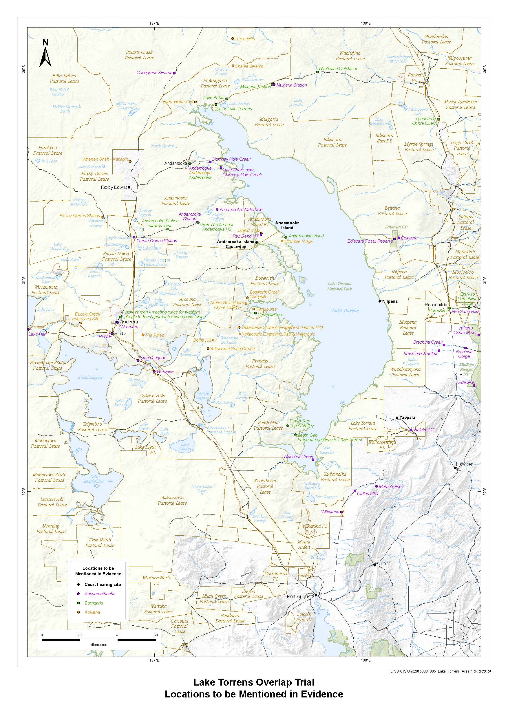
ANNEXURE B