
FEDERAL COURT OF AUSTRALIA
Taylor on behalf of the Gangalidda and Garawa Peoples #2 v State of Queensland [2015] FCA 730
IN THE FEDERAL COURT OF AUSTRALIA | |
DATE OF ORDER: | |
WHERE MADE: |
A. The Applicant in these proceedings has made an application for a determination of native title in relation to land and waters in the Determination Area.
B. The Native Title Determination Application filed in these proceedings covers all land and waters in the Determination Area.
C. Each party to the proceedings has reached agreement with the Applicant as to the terms of a determination of native title to be made in the Determination Area.
D. The parties have agreed that the areas referred to in Schedule 9 are subject to:
(a) previous exclusive possession acts of the kind referred to in s 23B of the Native Title Act 1993 (Cth); or
(b) pre-existing rights based acts of the kind referred to in s 24IB of the Native Title Act 1993 (Cth),
and in accordance with s 61A of the Native Title Act 1993 (Cth) cannot be claimed and are therefore not in the Determination Area.
E. The parties have agreed that native title has been extinguished over the land and waters referred to in Schedule 10.
Being satisfied that a determination in the terms sought by the parties would be within the power of the Court pursuant to s 87 of the Native Title Act 1993 (Cth), and it appearing to the Court appropriate to do so, and with the consent of those parties,
BY CONSENT THE COURT ORDERS THAT:
1. There be a determination of native title in the terms set out below ("the Determination").
2. The Determination will take effect upon the agreements referred to in paragraph 2 of Schedule 8 being registered on the Register of Indigenous Land Use Agreements.
3. In the event that the agreements referred to in paragraph 2 are not registered on the Register of Indigenous Land Use Agreements within six (6) months of the date of this order or such later time as this Court may order, the matter is to be listed for further directions.
4. Each party to the proceedings is to bear its own costs.
BY CONSENT THE COURT DETERMINES THAT:
5. Native title exists in relation to the area described in Schedule 1, being areas that are also described in:
(a) Schedule 2 - which describes that part of the Determination Area in which there are exclusive native title rights and interests; or
(b) Schedule 3 - which describes that part of the Determination Area in which there are non-exclusive native title rights and interests,
and shown on the Determination Map at Schedule 11.
6. Section 47A of the Native Title Act 1993 (Cth) applies to the areas denoted with a * described in Schedule 2.
7. Section 47B of the Native Title Act 1993 (Cth) applies to the areas denoted with a + described in Schedule 2.
8. Native title is held by the Gangalidda People in that part of the Determination Area described in Schedule 4.
9. Native title is held by the Garawa People in that part of the Determination Area described in Schedule 5.
10. The Gangalidda People are those people described in Schedule 6.
11. The Garawa People are those people described in Schedule 7.
12. Subject to orders 16, 17 and 20, the nature and extent of the native title rights and interests in relation to that part of the Determination Area described in Schedule 2 and shown in Schedule 11, other than in relation to the use and enjoyment of Water (which is dealt with in order 14), is the right to possession, occupation, use and enjoyment of the Determination Area to the exclusion of all others.
13. Subject to orders 16, 17, 18 and 20, the nature and extent of the native title rights and interests in relation to that part of the Determination Area described in Schedule 3 and shown in Schedule 11, other than in relation to the use and enjoyment of Water (which is dealt with in order 14) and land and waters on the seaward side of the High Water Mark (which is dealt with in order 15), are non-exclusive rights:
(a) to access, to be present on and to traverse the area;
(b) to hunt, fish and gather Natural Resources on the area for personal, domestic, and non-commercial communal purposes;
(c) to take, use, share and exchange Natural Resources from the area for personal, domestic, and non-commercial communal purposes;
(d) to camp on the area but not to reside permanently or to erect permanent structures or fixtures;
(e) to light fires on the area for domestic purposes including cooking but not for the purposes of hunting or clearing vegetation;
(f) to conduct religious and spiritual activities and ceremonies on the area;
(g) to be buried on, and bury Native Title Holders on the area; and
(h) to maintain places and areas of importance or significance to the Native Title Holders under their traditional laws and customs and protect those places and areas from physical harm.
14. Subject to orders 16, 17, 18 and 20, the nature and extent of the native title rights and interests in relation to the use and enjoyment of Water within the Determination Area, other than in relation to waters on the seaward side of the High Water Mark (which is dealt with in order 15), are non-exclusive rights:
(a) to hunt and fish in and on and gather Natural Resources from the Water;
(b) to take, use, share and exchange Natural Resources from the Water; and
(c) to take, use and enjoy the Water,
for personal, domestic, and non-commercial communal purposes.
15. Subject to orders 16, 17, 18 and 20, the nature and extent of the native title rights and interests in relation to the use and enjoyment of land and waters on the seaward side of the High Water Mark within that part of the Determination Area described in Schedule 3 and shown in Schedule 11 are non-exclusive rights:
(a) to access, to be present on and to traverse the area;
(b) to fish, hunt and gather Natural Resources on the area for personal, domestic or non-commercial communal purposes;
(c) to take, use, share and exchange Natural Resources from the area for personal, domestic, and non-commercial communal purposes;
(d) to take and consume fresh drinking water from fresh water springs in the inter-tidal zone for domestic or non-commercial purposes;
(e) to conduct religious and spiritual activities or ceremonies on the area; and
(f) to visit places or areas of importance or significance to the Native Title Holders under their traditional laws and customs and protect those places and areas from physical harm.
16. There are no native title rights or interests in or in relation to minerals as defined by the Mineral Resources Act 1989 (Qld) and petroleum as defined by the Petroleum Act 1923 (Qld) and the Petroleum and Gas (Production and Safety) Act 2004 (Qld).
17. The native title rights and interests are subject to and exercisable in accordance with:
(a) the Laws of the State and the Commonwealth; and
(b) the traditional laws acknowledged and traditional customs observed by the Native Title Holders.
18. The native title rights and interests in relation to that part of the Determination Area described in Schedule 3 do not confer possession, occupation, use and enjoyment of the area on the Native Title Holders to the exclusion of all others.
19. The nature and extent of other interests in relation to the Determination Area are the rights and interests described in Schedule 8 (the “Other Interests") that are current at the date of this determination.
20. The relationship between the native title rights and interests and the Other Interests is that:
(a) the Other Interests continue to have effect;
(b) in areas where s 47A of the Native Title Act 1993 (Cth) applies, and prior extinguishment is disregarded in accordance with s 47A(2) of the Native Title Act 1993 (Cth), the non-extinguishment principle in s 238 of the Native Title Act 1993 (Cth) applies to any prior interest in relation to the area in accordance with s 47A(3)(b) of the Native Title Act 1993 (Cth);
(c) in areas where s 47B of the Native Title Act 1993 (Cth) applies, and prior extinguishment is disregarded in accordance with s 47B(2) of the Native Title Act 1993 (Cth), the non-extinguishment principle in s 238 of the Native Title Act 1993 (Cth) applies to any prior interest in relation to the area in accordance with s 47B(3)(b) of the Native Title Act 1993 (Cth); and
(d) the Other Interests, and any activity that is required or permitted by or under and done in accordance with the Other Interests, prevail over the native title rights and interests and any exercise of the native title rights and interests, but do not extinguish them except in accordance with law.
21. Pursuant to s 56 of the Native Title Act 1993 (Cth), the Court determines that native title is not held in trust.
22. Gangalidda and Garawa Native Title Aboriginal Corporation RNTBC ICN 7365, incorporated under the Corporations (Aboriginal and Torres Strait Islander) Act 2006 (Cth), is to:
(a) be the prescribed body corporate for the purposes of ss 57(2) and 57(3) of the Native Title Act 1993 (Cth);
(b) not hold the native title in trust;
(c) act as agent for the Gangalidda People and the Garawa People who are the common law holders of the native title rights and interests; and
(d) perform the functions set out in the Native Title Act 1993 (Cth) and the Native Title (Prescribed Bodies Corporate) Regulations 1999 (Cth).
Definitions and Interpretations
23. The words and expressions used in the Determination, including the words "land" and "waters", have the same meanings as they have in Part 15 of the Native Title Act 1993 (Cth) except for the following defined words and expressions:
"Determination Area" means the land and waters within the area described in Schedule 1 and shown on the Determination Map at Schedule 11, and to the extent of any inconsistency between the Schedules, Schedule 1 prevails.
"Finucane Island ILUA Area" means that part of Lot 442 on NPW906 described in Schedule 1 and shown on the Determination Map in Schedule 11, and to the extent of any inconsistency between the Schedules, Schedule 1 prevails.
"High Water Mark" means the ordinary high water mark at spring tides.
"Laws of the State and the Commonwealth" means the common law and the laws of the State of Queensland and the Commonwealth of Australia, and includes regulations, statutory instruments, local planning instruments and local laws.
"Native Title Holders" means:
(a) in relation to the land and waters described in Schedule 4, the Gangalidda People described in Schedule 6; and
(b) in relation to the land and waters described in Schedule 5, the Garawa People described in Schedule 7.
"Natural Resources" means:
(a) "animals" as defined in the Nature Conservation Act 1992 (Qld) and, for certainty, includes honey, but not including animals or honey that are the private personal property of another;
(b) "plants" as defined in the Nature Conservation Act 1992 (Qld) and, for certainty, includes charcoal, sap, wax and resin, but not including crops grown on a Crown lease by a lessee; and
(c) any clay, soil, sand, gravel, or rock on or below the surface of the Determination Area but does not include minerals (except ochre taken in accordance with the traditional laws and customs of the Native Title Holders) as defined in the Mineral Resources Act 1989 (Qld) or petroleum as defined in the Petroleum Act 1923 (Qld) and the Petroleum and Gas (Production and Safety) Act 2004 (Qld).
"Other Interests" has the meaning given in order 19.
"seaward side" has the meaning that it has in the Land Act 1994 (Qld).
"Water" means all or any of the following:
(a) water that permanently or intermittently is in, or flows in, a watercourse, lake or spring, regardless of the frequency;
(b) any natural collection of water, whether permanent or intermittent;
(c) water from an underground water source; or
(d) tidal water.
"watercourse" has the meaning that it has in the Water Act 2000 (Qld).
Note: Entry of orders is dealt with in Rule 39.32 of the Federal Court Rules 2011.
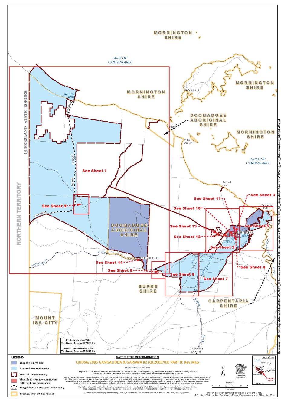
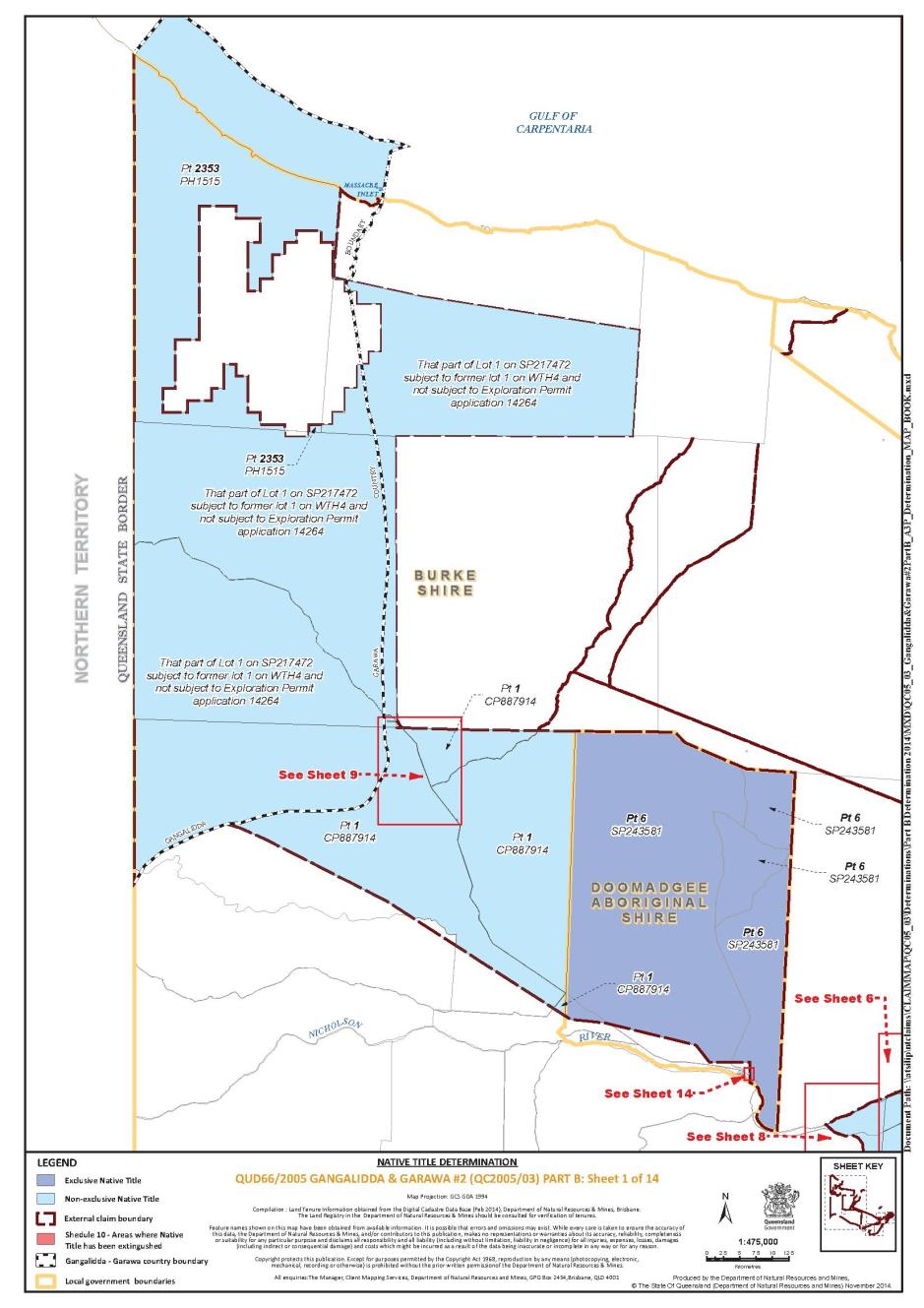
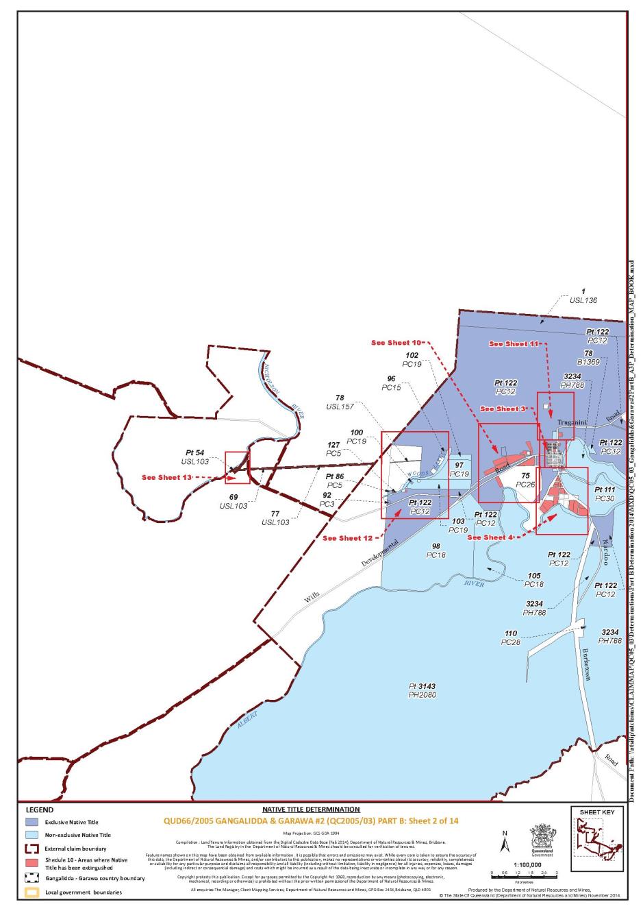
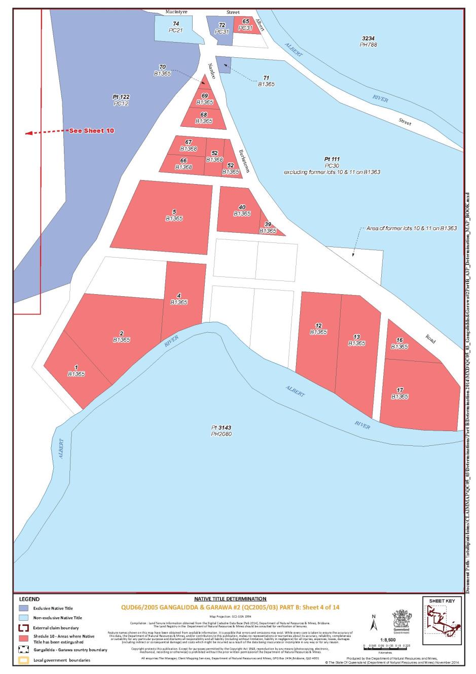
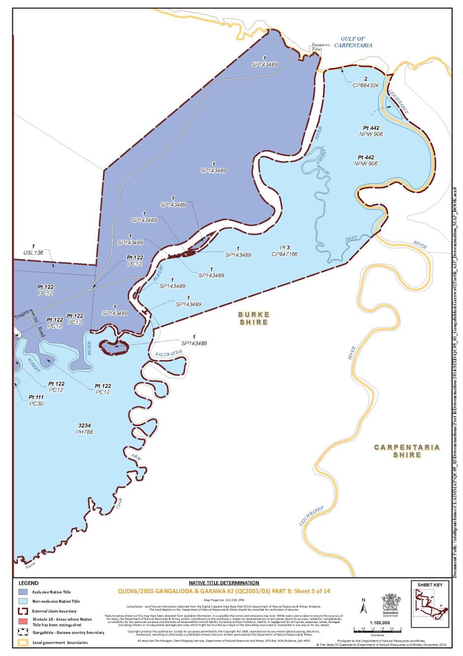
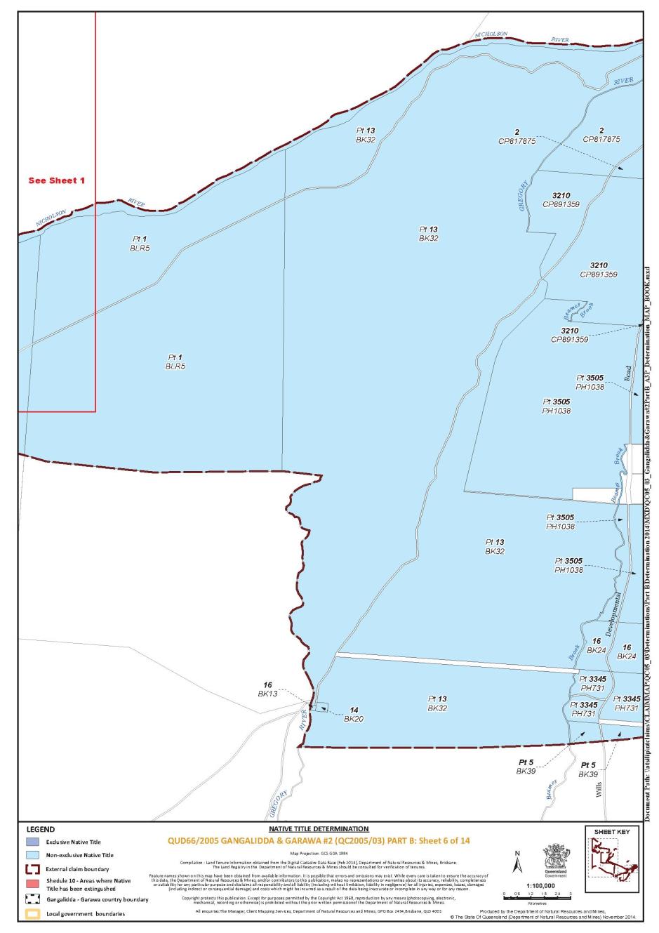
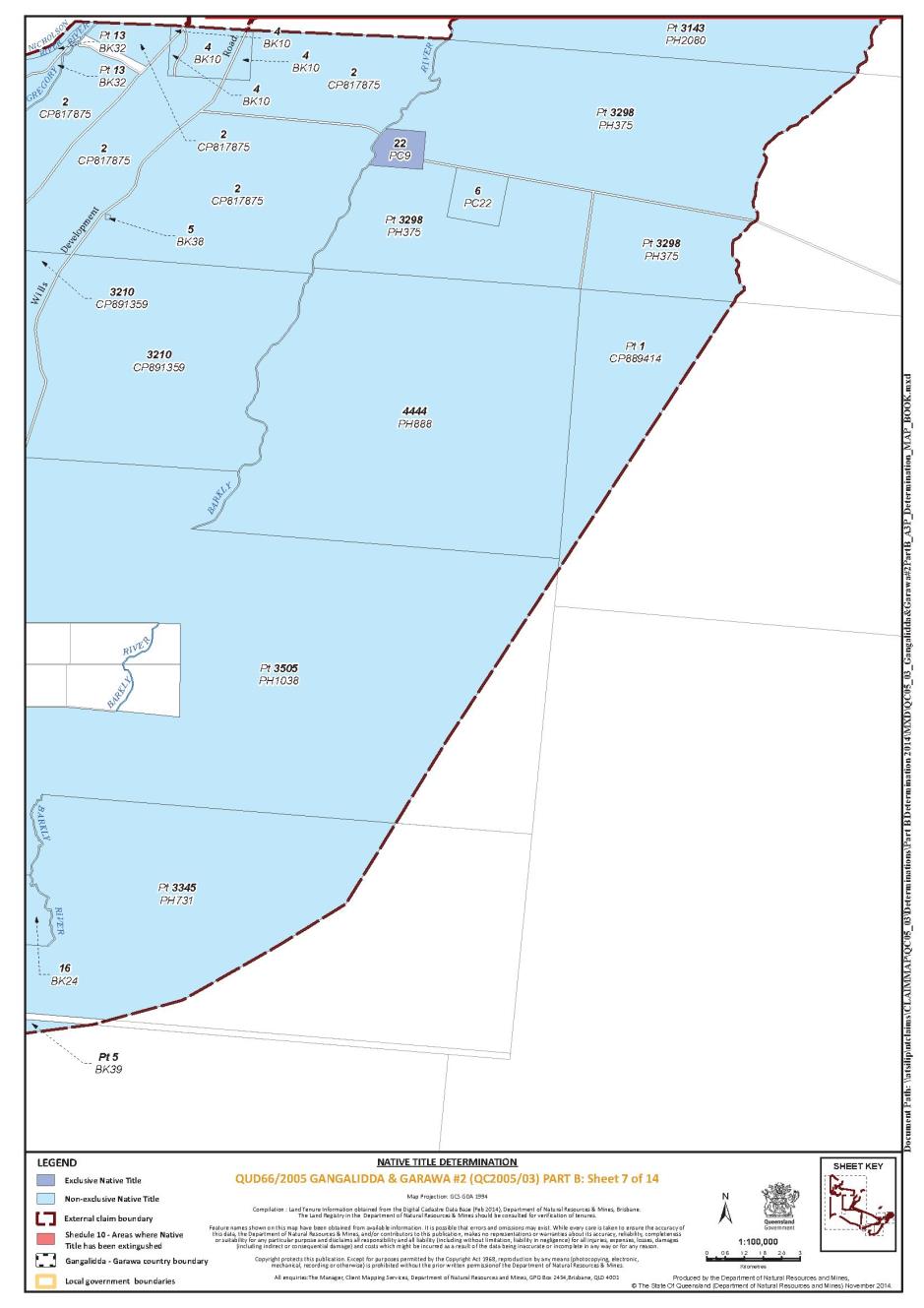
SCHEDULE 1
Description of Determination Area
The Determination Area comprises all of the following land and waters described in Part 1(a), (b) and (c) of this schedule to the extent that they fall within the External Boundary Description at Schedule 1 Part 2, and depicted in the Determination Map in Schedule 11, excluding the areas described in Schedule 9 and Schedule 10.
Part 1 - Determination Area
(a) The land and waters comprised of the lots and part lots listed below:
Area Description | |||
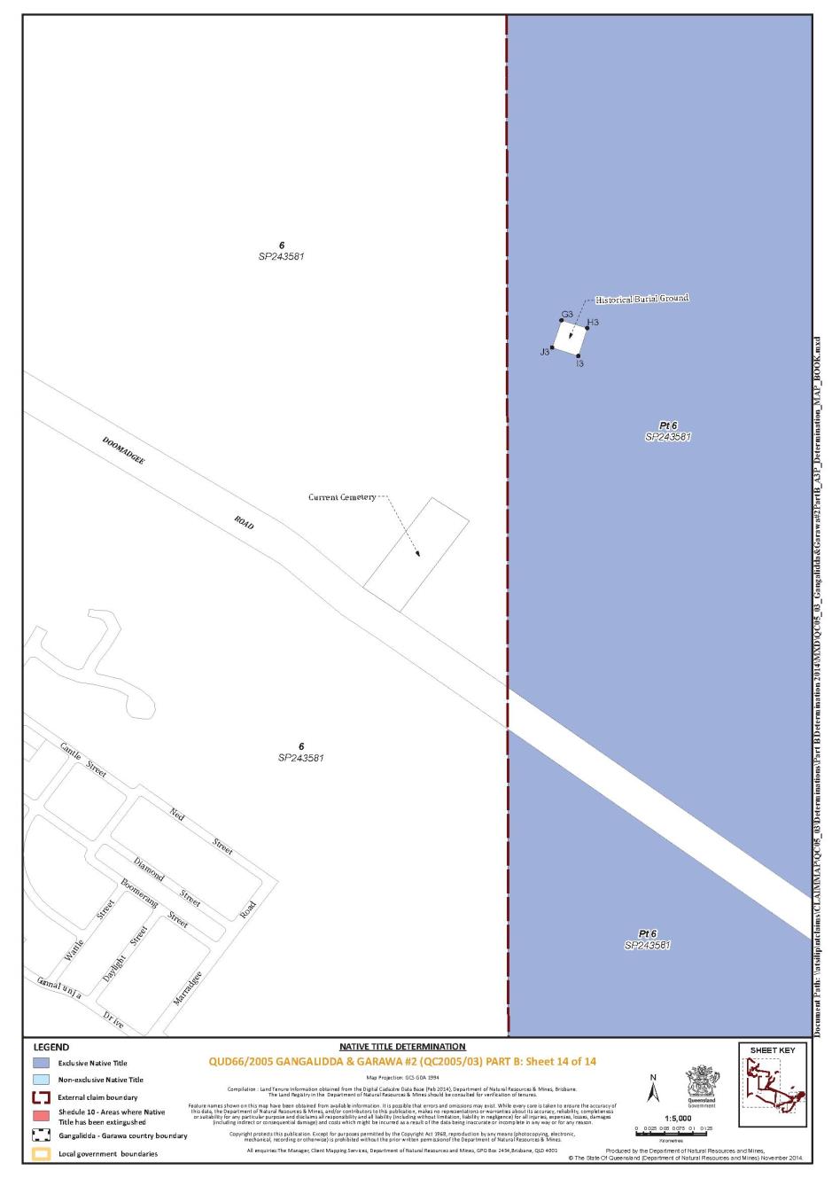
That part of Lot 6 on SP243581 that falls within the External Boundary Description excluding an area known as the Historical Burial Ground which is bounded by the following coordinates and depicted in the Determination Map in Schedule 11 | |||
Longitude East | Latitude South | ||
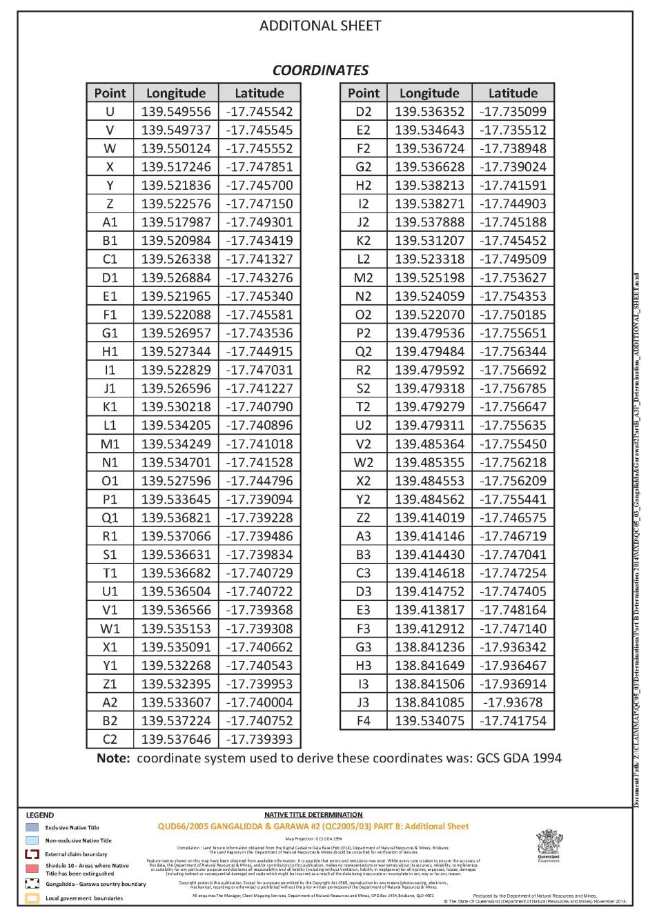
138.841236 138.841649 138.841506 138.841085 | -17.936342 -17.936467 -17.936914 -17.93678 | ||
Lot 16 on BK13 | |||
Lot 98 on PC18 | |||
Lot 105 on PC18 | |||
That part of Lot 442 on NPW906 that falls within the External Boundary Description | |||
Lot 78 on B1369 | |||
Lot 4 on BK10 | |||
Lot 14 on BK20 | |||
Lot 16 on BK24 | |||
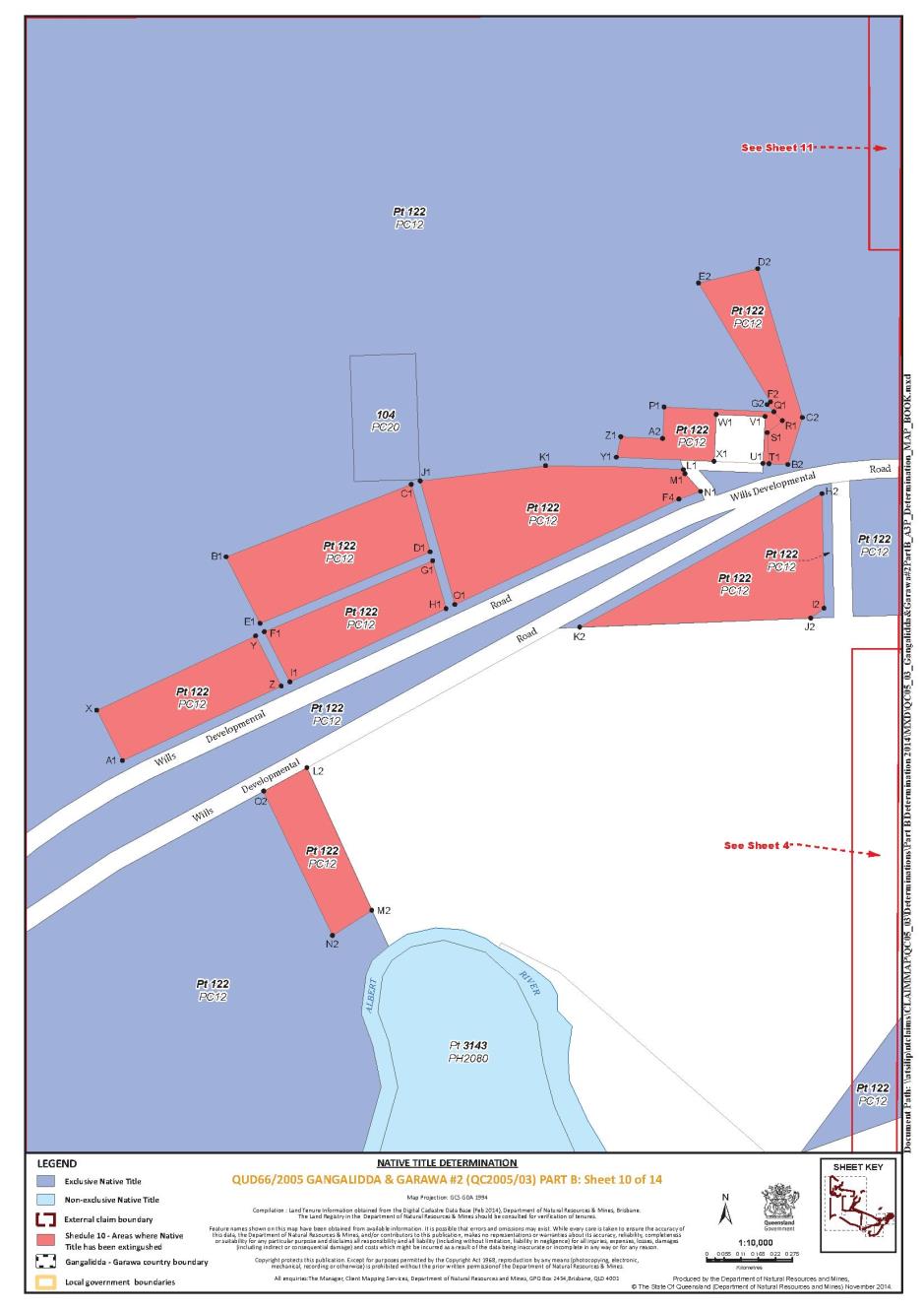
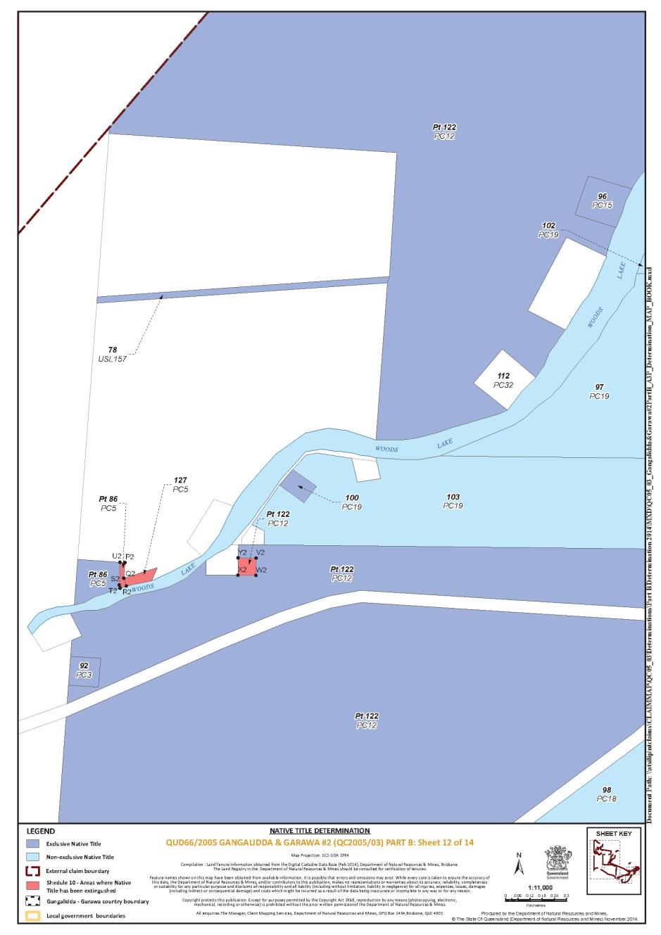
That part of Lot 122 on PC12 excluding those areas outlined in Schedule 10 | |||
Lot 97 on PC19 | |||
Lot 102 on PC19 | |||
Lot 103 on PC19 | |||
Lot 74 on PC21 | |||
Lot 6 on PC22 | |||
That part of Lot 111 on PC30 excluding former Lots 10 and 11 on B1363 | |||
Lot 115 on PC38 | |||
That part of Lot 13 on BK32 that falls within the External Boundary Description | |||
That part of Lot 5 on BK39 that falls within the External Boundary Description | |||
That part of Lot 1 on BLR5 that falls within the External Boundary Description | |||
Lot 2 on CP817875 | |||
That part of Lot 3 on CP847166 that falls within the External Boundary Description | |||
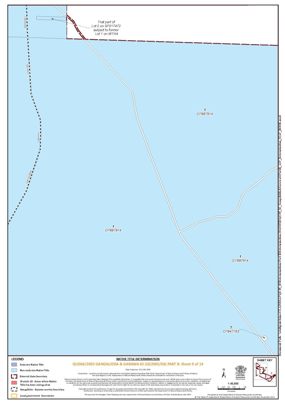
That part of Lot 1 on CP887914 that falls within the External Boundary Description | |||
That part of Lot 1 on CP889414 that falls within the External Boundary Description | |||
Lot 3210 on CP891359 | |||
That part of Lot 3505 on PH1038 that falls within the External Boundary Description | |||
That part of Lot 2353 on PH1515 not subject to Exploration Permit Applications 14264 and 14265 | |||
That part of Lot 3143 on PH2080 that falls within the External Boundary Description | |||
That part of Lot 3298 on PH375 that falls within the External Boundary Description | |||
That part of Lot 3345 on PH731 that falls within the External Boundary Description | |||
Lot 3234 on PH788 | |||
Lot 4444 on PH888 | |||
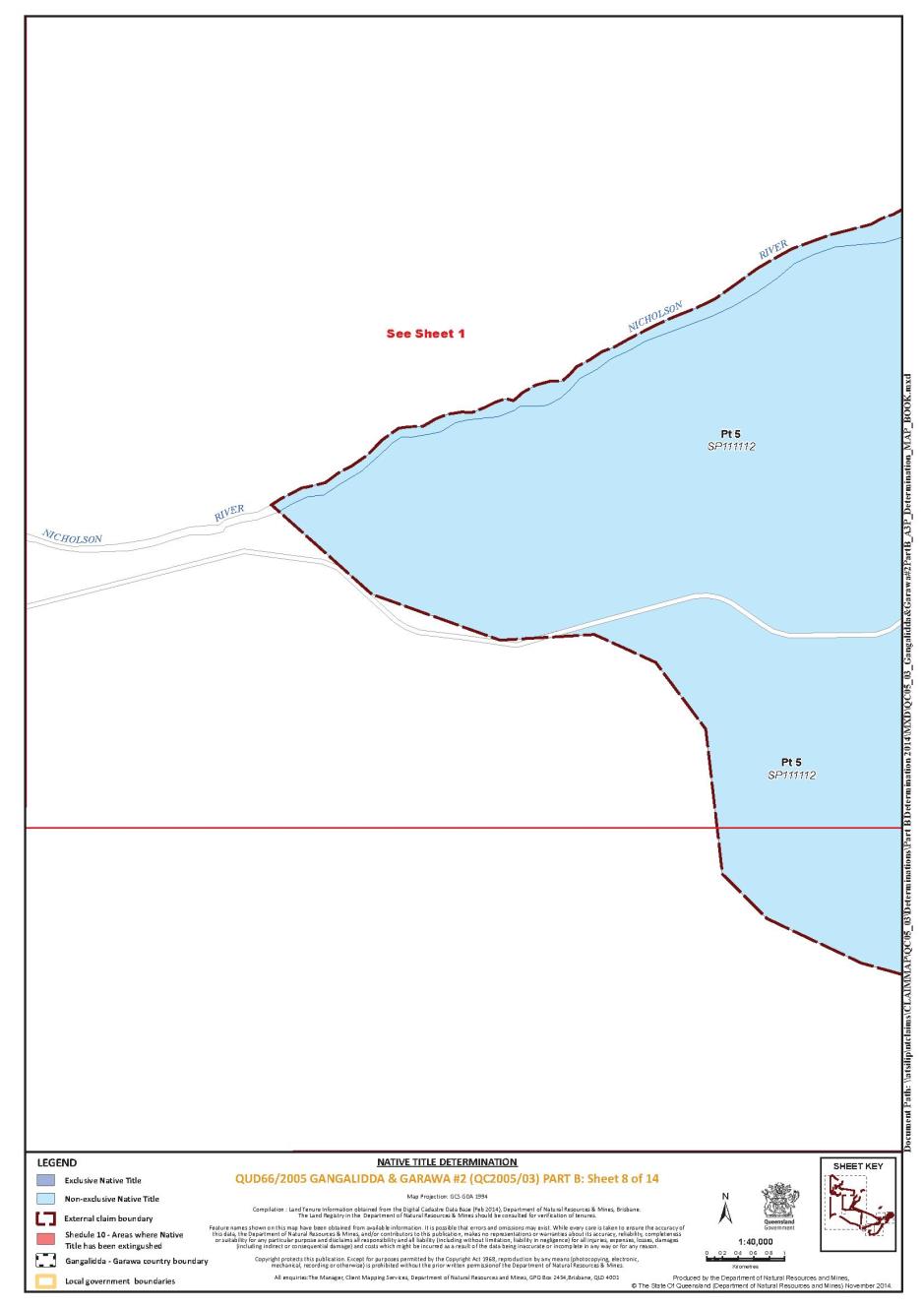
That part of Lot 5 on SP111112 that falls within the External Boundary Description | |||
That part of Lot 1 on SP217472 subject to former Lot 1 on WTH4 and not subject to Exploration Permit Application 14264 | |||
That part of Lot 2 on SP217472 subject to former Lot 1 on WTH4 | |||
Lot 5 on BK38 | |||
Lot 117 on PC43 | |||
That part of Lot 111 on B1361 excluding the area outlined in Schedule 10 | |||
Lot 112 on B1361 | |||
That part of Lot 113 on B1361 excluding the area outlined in Schedule 10 | |||
Lot 114 on B1361 | |||
Lot 121 on AP15578 | |||
Lot 123 on B1361 | |||
Lot 301 on B1361 | |||
Lot 41 on B1364 | |||
Lot 42 on B1364 | |||
Lot 49 on B1364 | |||
Lot 50 on B1364 | |||
Lot 51 on B1364 | |||
Lot 53 on B1364 | |||
Lot 106 on B1364 | |||
Lot 108 on B1364 | |||
Lot 71 on B1365 | |||
Lot 96 on PC15 | |||
Lot 100 on PC19 | |||
Lot 104 on PC20 | |||
Lot 110 on PC28 | |||
Lot 92 on PC3 | |||
Lot 72 on PC31 | |||
That part of Lot 86 on PC5 excluding the area outlined in Schedule 10 | |||
Lot 22 on PC9 | |||
Lot 1 on SP143489 | |||
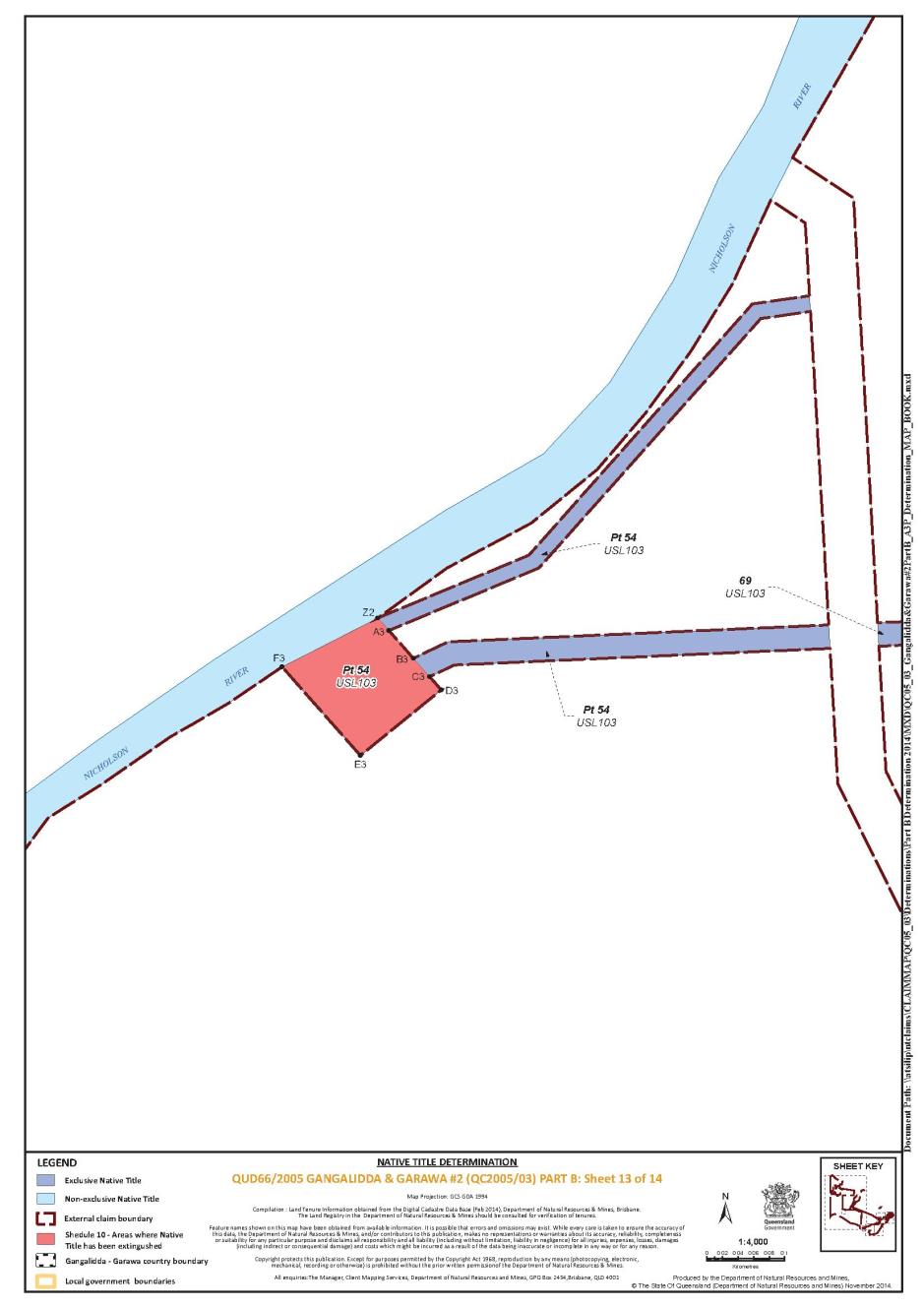
That part of Lot 54 on USL103 excluding the area outlined in Schedule 10 | |||
Lot 69 on USL103 | |||
Lot 77 on USL103 | |||
Lot 1 on USL136 | |||
Lot 78 on USL157 | |||
Lot 2 on CP884324 | |||
(b) The waters within the External Boundary Description including but not limited to:
(i) Albert River;
(ii) Nicholson River;
(iii) Woods Lake;
(iv) Beames Brook;
(v) Barkly River;
(vi) Landsborough Inlet;
(vii) Leichhardt River; and
(viii) Gregory River.
(c) That part of the land and waters below High Water Mark including the sea-bed and subsoil within the following boundary description:
Commencing at a point at the High Water Mark on the Queensland/Northern Territory State Border in the Gulf of Carpentaria; then north-easterly along the Queensland/Northern Territory adjacent area boundary as defined in Schedule 2 of the Petroleum (Submerged Land) Act 1967 (Cth) to a point 5 nautical miles seaward of the High Water Mark; then generally south-easterly along a boundary 5 nautical miles seaward of the High Water Mark to a western boundary of native title determination QG207/1997 The Lardil Peoples v State of Queensland; then generally south westerly along western boundaries of that determination to the High Water Mark of the Gulf of Carpentaria; then generally north-westerly along the High Water Mark of the Gulf of Carpentaria back to the point of commencement.
Part 2 - External Boundary Description
The External Boundary Description means the land and waters bounded by the following description:
Commencing at the intersection of the western bank of Leichhardt River and the southern bank of Landsborough Inlet and extending south-westerly passing through Longitude 139.769059° East, Latitude 17.688131° South to a western bank of Saltwater Arm at Latitude 17.726036° South; then generally south-westerly along the western banks of Saltwater Arm and Harris Creek to Latitude 17.968260° South; then again generally south-westerly passing through the western bank of Twelve Mile Creek at Latitude 18.093510° South to the western bank of Four Mile Creek at Latitude 18.140880° South; then south-westerly and westerly through the following coordinate points:
Longitude East | Latitude South |
139.344679 | 18.152815 |
139.316754 | 18.168737 |
139.291086 | 18.175717 |
139.264606 | 18.179197 |
139.236167 | 18.181510 |
139.202258 | 18.182652 |
139.148844 | 18.182613 |
Then westerly to the western boundary of Lot 13 on BK32 (Punjaub Pastoral Holding) at Latitude 18.182297° South, then generally northerly along that western boundary, the western boundary of Lot 16 on BK13 and again the western boundary of Lot 13 on BK32 (Punjaub Pastoral Holding) to Longitude 139.124747° East; then generally north-westerly through the following coordinate points:
Longitude East | Latitude South |
139.072883 | 18.071115 |
139.029097 | 18.066608 |
139.012999 | 18.062101 |
139.002052 | 18.056949 |
138.996901 | 18.051798 |
138.994969 | 18.035056 |
138.989174 | 18.027329 |
138.982091 | 18.024109 |
138.971144 | 18.024753 |
138.956319 | 18.019431 |
Then north-westerly to a point on the northern bank of the Nicholson River at Longitude 138.944745° East; then generally westerly and generally northerly along that bank to Longitude 138.840387° East (being south east of Doomadgee); then northerly and generally westerly through the following coordinate points:
Longitude East | Latitude South |
138.840340 | 17.923187 |
138.784619 | 17.923275 |
138.766427 | 17.900186 |
138.641622 | 17.869594 |
138.594116 | 17.864824 |
138.340969 | 17.702018 |
138.174418 | 17.617281 |
138.139445 | 17.601666 |
138.121771 | 17.596390 |
138.080543 | 17.611232 |
138.032331 | 17.634817 |
138.008674 | 17.654384 |
Then south-westerly to a point on the Queensland/Northern Territory State Border at Latitude 17.677553° South; then northerly along that border to the High Water Mark of the Gulf of Carpentaria; then north-easterly along the Queensland/Northern Territory adjacent area boundary as defined in Schedule 2 of the Petroleum (Submerged Land) Act 1967 (Cth) to a point 5 nautical miles seaward of the High Water Mark; then generally south-easterly along a boundary 5 nautical miles seaward of the High Water Mark to a western boundary of native title determination QG207/1997 The Lardil Peoples v State of Queensland; then generally south-westerly along western boundaries of that determination to the High Water Mark of the Gulf of Carpentaria; then generally south-easterly along that High Water Mark to the eastern bank of the Leichhardt River; then generally southerly along the eastern bank of that river to Latitude 17.669084° South; then south-westerly back to the commencement point.
Exclusions
The Determination Area specifically excludes all lands and waters covered by:
QG207/1997 The Lardil Peoples v State of Queensland native title determination, as determined in the Federal Court of Australia on 23 March 2004;
QUD66/2005 Gangalidda & Garawa People #2 v State of Queensland native title determination, as determined in the Federal Court of Australia on 23 June 2010;
QUD84/2004 Gangalidda and Garawa Peoples v State of Queensland native title determination, as determined in the Federal Court of Australia on 23 June 2010;
QUD6022/1999 Waanyi Peoples v State of Queensland native title determination, as determined in the Federal Court of Australia on 9 December 2010;
QUD84/2004 Gangalidda and Garawa Peoples native title determination application, as accepted for registration on 26 August 2011;
Lot 4597 on PH1605 (Pendine Pastoral Lease);
Lot 4536 on SP204559 (Konka Pastoral Lease); and
Lots 1 and 2 on SP204559 (within Konka Pastoral Lease).
Note:
Reference Datum
Geographical coordinates are referenced to the Geocentric Datum of Australia (GDA94), in decimal degrees and are based on the spatial reference data acquired from the various custodians at the time.
Data Reference and Source
External boundary data compiled by the National Native Title Tribunal.
Cadastre data sourced from Department of Natural Resources and Mines (Qld) October 2014.
Use of Coordinates
Where coordinates are used within the description to represent cadastral or topographical boundaries or the intersection with such, they are intended as a guide only. As an outcome to the custodians of cadastral and topographic data continuously recalculating the geographic position of their data based on improved survey and data maintenance procedures, it is not possible to accurately define such a position other than by detailed ground survey.
SCHEDULE 2
Description of that part of the Determination Area where exclusive native title rights and interests are recognised
The exclusive native title areas comprise all the land and waters listed below and shown on the Determination Map in Schedule 11, to the extent they are within the Determination Area:
AREA DESCRIPTION | |||
* That part of Lot 6 on SP243581 that falls within the External Boundary Description excluding an area known as the Historical Burial Ground which is bounded by the following coordinates and depicted in the Determination Map in Schedule 11 | |||
Longitude East | Latitude South | ||
138.841236 138.841649 138.841506 138.841085 | -17.936342 -17.936467 -17.936914 -17.93678 | ||
+ That part of Lot 122 on PC12 excluding those areas identified in Schedule 10 | |||
+ That part of Lot 111 on B1361 excluding the area identified in Schedule 10 | |||
+ Lot 112 on B1361 | |||
+ That part of Lot 113 on B1361 excluding the area identified in Schedule 10 | |||
+ Lot 114 on B1361 | |||
+ Lot 121 on AP15578 | |||
+ Lot 123 on B1361 | |||
+ Lot 301 on B1361 | |||
+ Lot 41 on B1364 | |||
+ Lot 42 on B1364 | |||
+ Lot 49 on B1364 | |||
+ Lot 50 on B1364 | |||
+ Lot 51 on B1364 | |||
+ Lot 53 on B1364 | |||
+ Lot 106 on B1364 | |||
+ Lot 108 on B1364 | |||
+ Lot 71 on B1365 | |||
+ Lot 96 on PC15 | |||
+ Lot 100 on PC19 | |||
+ Lot 104 on PC20 | |||
+ Lot 110 on PC28 | |||
+ Lot 92 on PC3 | |||
+ Lot 72 on PC31 | |||
+ That part of Lot 86 on PC5 excluding the area identified in Schedule 10 | |||
+ Lot 22 on PC9 | |||
+ Lot 1 on SP143489 | |||
+ That part of Lot 54 on USL103 excluding the area identified in Schedule 10 | |||
+ Lot 69 on USL103 | |||
+ Lot 77 on USL103 | |||
+ Lot 1 on USL136 | |||
+ Lot 78 on USL157 | |||
* Denotes areas to which s 47A of the Native Title Act 1993 (Cth) applies.
+ Denotes areas to which s 47B of the Native Title Act 1993 (Cth) applies.
SCHEDULE 3
Description of that part of the Determination Area where non-exclusive native title rights and interests are recognised
The non-exclusive native title areas comprise the land and waters described in parts (a), (b), and (c) of this schedule and shown on the Determination Map in Schedule 11, to the extent they are within the Determination Area:
Area Description | |
(a) | Lot 16 on BK13 |
Lot 98 on PC18 | |
Lot 105 on PC18 | |
That part of Lot 442 on NPW906 that falls within the External Boundary Description | |
Lot 78 on B1369 | |
Lot 4 on BK10 | |
Lot 14 on BK20 | |
Lot 16 on BK24 | |
Lot 97 on PC19 | |
Lot 102 on PC19 | |
Lot 103 on PC19 | |
Lot 74 on PC21 | |
Lot 6 on PC22 | |
That part of Lot 111 on PC30 excluding former Lots 10 and 11 on B1363 | |
Lot 115 on PC38 | |
That part of Lot 13 on BK32 that falls within the External Boundary Description | |
That part of Lot 5 on BK39 that falls within the External Boundary Description | |
That part of Lot 1 on BLR5 that falls within the External Boundary Description | |
Lot 2 on CP817875 | |
That part of Lot 3 on CP847166 that falls within the External Boundary Description | |
That part of Lot 1 on CP887914 that falls within the External Boundary Description | |
That part of Lot 1 on CP889414 that falls within the External Boundary Description | |
Lot 3210 on CP891359 | |
That part of Lot 3505 on PH1038 that falls within the External Boundary Description | |
That part of Lot 2353 on PH1515 not subject to Exploration Permit Applications 14264 and 14265 | |
That part of Lot 3143 on PH2080 that falls within External Boundary Description | |
That part of Lot 3298 on PH375 that falls within the External Boundary Description | |
That part of Lot 3345 on PH731 that falls within the External Boundary Description | |
Lot 3234 on PH788 | |
Lot 4444 on PH888 | |
That part of Lot 5 on SP111112 that falls within the External Boundary Description | |
That part of Lot 1 on SP217472 subject to former Lot 1 on WTH4 and not subject to Exploration Permit Application 14264 | |
That part of Lot 2 on SP217472 subject to former Lot 1 on WTH4 | |
Lot 5 on BK38 | |
Lot 117 on PC43 | |
Lot 2 on CP884324 |
(b) The waters within the External Boundary Description including but not limited to:
(i) Albert River;
(ii) Nicholson River;
(iii) Woods Lake;
(iv) Beames Brook;
(v) Barkly River;
(vi) Landsborough Inlet;
(vii) Leichhardt River; and
(viii) Gregory River.
(c) That part of the land and waters below the High Water Mark including the sea-bed and subsoil within the following boundary description:
Commencing at a point at the High Water Mark on the Queensland/Northern Territory State Border in the Gulf of Carpentaria; then north-easterly along the Queensland/Northern Territory adjacent area boundary as defined in Schedule 2 of the Petroleum (Submerged Land) Act 1967 (Cth) to a point 5 nautical miles seaward of the High Water Mark; then generally south-easterly along a boundary 5 nautical miles seaward of the High Water Mark to a western boundary of native title determination QG207/1997 The Lardil Peoples v State of Queensland; then generally south-westerly along western boundaries of that determination to the High Water Mark of the Gulf of Carpentaria; then generally north-westerly along the High Water Mark of the Gulf of Carpentaria back to the point of commencement.
SCHEDULE 4
Description of that part of the Determination Area where Gangalidda People hold native title
All the following land and waters described in (a) that comprise that part of the Determination Area that falls to the east and south of the Gangalidda Garawa Boundary Line defined at (b) and depicted in the Determination Map in Schedule 11.
Area Description | ||||
(a) | That part of Lot 6 on SP243581 that falls within the External Boundary Description excluding an area known as the Historical Burial Ground which is bounded by the following coordinates and depicted in the Determination Map in Schedule 11 | |||
Longitude East | Latitude South | |||
138.841236 138.841649 138.841506 138.841085 | -17.936342 -17.936467 -17.936914 -17.93678 | |||
Lot 16 on BK13 | ||||
Lot 98 on PC18 | ||||
Lot 105 on PC18 | ||||
That part of Lot 442 on NPW906 that falls within the External Boundary Description | ||||
Lot 78 on B1369 | ||||
Lot 4 on BK10 | ||||
Lot 14 on BK20 | ||||
Lot 16 on BK24 | ||||
That part of Lot 122 on PC12 excluding those areas identified in Schedule 10 | ||||
Lot 97 on PC19 | ||||
Lot 102 on PC19 | ||||
Lot 103 on PC19 | ||||
Lot 74 on PC21 | ||||
Lot 6 on PC22 | ||||
That part of Lot 111 on PC30 excluding former Lots 10 and 11 on B1363 | ||||
Lot 115 on PC38 | ||||
That part of Lot 13 on BK32 that falls within the External Boundary Description | ||||
That part of Lot 5 on BK39 that falls within the External Boundary Description | ||||
That part of Lot 1 on BLR5 that falls within the External Boundary Description | ||||
Lot 2 on CP817875 | ||||
That part of Lot 3 on CP847166 that falls within the External Boundary Description | ||||
That part of Lot 1 on CP887914 that falls within the External Boundary Description | ||||
That part of Lot 1 on CP889414 that falls within the External Boundary Description | ||||
Lot 3210 on CP891359 | ||||
That part of Lot 3505 on PH1038 that falls within the External Boundary Description | ||||
That part of Lot 3143 on PH2080 that falls within the External Boundary Description | ||||
That part of Lot 3298 on PH375 that falls within the External Boundary Description | ||||
That part of Lot 3345 on PH731 that falls within the External Boundary Description | ||||
Lot 3234 on PH788 | ||||
Lot 4444 on PH888 | ||||
That part of Lot 5 on SP111112 that falls within the External Boundary Description | ||||
That part of Lot 1 on SP217472 subject to former Lot 1 on WTH4 and not subject to Exploration Permit Application 14264 | ||||
That part of Lot 2 on SP217472 subject to former Lot 1 on WTH4 | ||||
Lot 5 on BK38 | ||||
Lot 117 on PC43 | ||||
That part of Lot 111 on B1361 excluding an area identified at Schedule 10 | ||||
Lot 112 on B1361 | ||||
That part of Lot 113 on B1361 excluding an area identified at Schedule 10 | ||||
Lot 114 on B1361 | ||||
Lot 121 on AP15578 | ||||
Lot 123 on B1361 | ||||
Lot 301 on B1361 | ||||
Lot 41 on B1364 | ||||
Lot 42 on B1364 | ||||
Lot 49 on B1364 | ||||
Lot 50 on B1364 | ||||
Lot 51 on B1364 | ||||
Lot 53 on B1364 | ||||
Lot 106 on B1364 | ||||
Lot 108 on B1364 | ||||
Lot 71 on B1365 | ||||
Lot 96 on PC15 | ||||
Lot 100 on PC19 | ||||
Lot 104 on PC20 | ||||
Lot 110 on PC28 | ||||
Lot 92 on PC3 | ||||
Lot 72 on PC31 | ||||
That part of Lot 86 on PC5 excluding an area identified at Schedule 10 | ||||
Lot 22 on PC9 | ||||
Lot 1 on SP143489 | ||||
That part of Lot 54 on USL103 excluding an area identified at Schedule 10 | ||||
Lot 69 on USL103 | ||||
Lot 77 on USL103 | ||||
Lot 1 on USL136 | ||||
Lot 78 on USL157 | ||||
Lot 2 on CP884324 | ||||
Waters
That part of the land and waters below High Water Mark including the sea-bed and subsoil outlined in paragraph (c) of Schedule 1.
(b) Description of Gangalidda Garawa Boundary Line
The Gangalidda Garawa Boundary Line is bounded by the following coordinates:
Longitude East | Latitude South |
137.994665 | -16.538711 |
138.048922 | -16.471921 |
138.052435 | -16.474542 |
138.057719 | -16.479205 |
138.062583 | -16.48427 |
138.065951 | -16.488331 |
138.067508 | -16.490334 |
138.072584 | -16.493883 |
138.079322 | -16.498966 |
138.084576 | -16.502632 |
138.089692 | -16.506479 |
138.093415 | -16.509501 |
138.095975 | -16.511663 |
138.096916 | -16.512502 |
138.105392 | -16.520173 |
138.111118 | -16.525872 |
138.115151 | -16.530631 |
138.117871 | -16.534294 |
138.12313 | -16.5418 |
138.128465 | -16.54548 |
138.133828 | -16.549495 |
138.137572 | -16.552714 |
138.139832 | -16.554849 |
138.152391 | -16.56716 |
138.170126 | -16.581684 |
138.198299 | -16.597289 |
138.205694 | -16.601879 |
138.211339 | -16.606137 |
138.216597 | -16.610826 |
138.220367 | -16.614329 |
138.228585 | -16.619048 |
138.259126 | -16.632456 |
138.271577 | -16.63533 |
138.274733 | -16.636119 |
138.277033 | -16.636772 |
138.278252 | -16.637145 |
138.294132 | -16.642124 |
138.301023 | -16.644598 |
138.306677 | -16.647128 |
138.310723 | -16.649243 |
138.316915 | -16.652686 |
138.324304 | -16.65729 |
138.325545 | -16.658004 |
138.332726 | -16.657825 |
138.339898 | -16.658214 |
138.347012 | -16.65917 |
138.354019 | -16.660686 |
138.360872 | -16.662751 |
138.363839 | -16.663835 |
138.365704 | -16.664554 |
138.369106 | -16.666054 |
138.366574 | -16.66663 |
138.35881 | -16.668893 |
138.351208 | -16.671613 |
138.347106 | -16.673367 |
138.33492 | -16.741832 |
138.333543 | -16.746632 |
138.331546 | -16.751722 |
138.32942 | -16.755974 |
138.327874 | -16.757134 |
138.325877 | -16.757843 |
138.323622 | -16.759067 |
138.322204 | -16.760291 |
138.321496 | -16.762159 |
138.320529 | -16.765831 |
138.3204 | -16.767442 |
138.320529 | -16.770406 |
138.320658 | -16.772338 |
138.3204 | -16.773305 |
138.319434 | -16.774658 |
138.316535 | -16.777042 |
138.316084 | -16.778072 |
138.31623 | -16.77944 |
138.31446 | -16.7801 |
138.31252 | -16.78058 |
138.3112 | -16.78134 |
138.31001 | -16.78317 |
138.30842 | -16.7885 |
138.3076 | -16.7899 |
138.30534 | -16.7923 |
138.30177 | -16.79503 |
138.30146 | -16.79526 |
138.30104 | -16.79647 |
138.30123 | -16.79745 |
138.30255 | -16.80043 |
138.30273 | -16.80218 |
138.30236 | -16.80349 |
138.30145 | -16.80674 |
138.2998 | -16.80963 |
138.29611 | -16.81357 |
138.29579 | -16.81483 |
138.29599 | -16.81519 |
138.29633 | -16.81581 |
138.29831 | -16.81677 |
138.29829 | -16.81746 |
138.2982 | -16.81817 |
138.29785 | -16.81866 |
138.29808 | -16.819 |
138.29937 | -16.81946 |
138.2996 | -16.81969 |
138.2996 | -16.82025 |
138.29866 | -16.82115 |
138.29889 | -16.82194 |
138.29865 | -16.82273 |
138.29876 | -16.82364 |
138.29808 | -16.82437 |
138.29805 | -16.82578 |
138.29769 | -16.82657 |
138.29604 | -16.82803 |
138.2952 | -16.8313 |
138.29461 | -16.83209 |
138.29309 | -16.83254 |
138.2925 | -16.83321 |
138.29249 | -16.83434 |
138.29307 | -16.83502 |
138.29647 | -16.8356 |
138.29717 | -16.83606 |
138.29728 | -16.8382 |
138.29617 | -16.84024 |
138.29592 | -16.84096 |
138.29524 | -16.84339 |
138.29423 | -16.8447 |
138.28979 | -16.84626 |
138.2884 | -16.84741 |
138.28716 | -16.84872 |
138.28683 | -16.85048 |
138.28639 | -16.85488 |
138.28575 | -16.85663 |
138.28581 | -16.85781 |
138.28652 | -16.85905 |
138.28753 | -16.86025 |
138.28949 | -16.8616 |
138.29016 | -16.86256 |
138.2903 | -16.86381 |
138.28997 | -16.86579 |
138.28994 | -16.86748 |
138.29069 | -16.86844 |
138.29163 | -16.86898 |
138.311929 | -16.997173 |
138.315113 | -17.024345 |
138.323208 | -17.052579 |
138.327947 | -17.075285 |
138.334463 | -17.120498 |
138.339202 | -17.165712 |
138.343941 | -17.237975 |
138.338216 | -17.304118 |
138.334925 | -17.361379 |
138.338287 | -17.4611 |
138.339853 | -17.487471 |
138.343889 | -17.498636 |
138.343825 | -17.510419 |
138.337848 | -17.528351 |
138.327886 | -17.546282 |
138.31892 | -17.56272 |
138.311448 | -17.569693 |
138.299992 | -17.575173 |
138.270263 | -17.578301 |
138.203069 | -17.579152 |
138.169986 | -17.585633 |
138.142591 | -17.594599 |
138.121771 | -17.59639 |
138.080543 | -17.611232 |
138.032331 | -17.634817 |
138.008674 | -17.654384 |
137.995262 | -17.677553 |
schedule 5
Description of that part of the Determination Area where Garawa People hold native title
All the following land and waters described in (a) that comprise that part of the Determination Area that falls to the west and north of the Gangalidda Garawa Boundary Line defined at paragraph (b) of Schedule 4 and depicted in the Determination Map in Schedule 11.
(a) | Area Description |
That part of Lot 2353 on PH1515 not subject to Exploration Permit Applications 14264 and 14265 | |
That part of Lot 1 on SP217472 subject to former Lot 1 on WTH4 and not subject to Exploration Permit Application 14264 | |
That part of Lot 1 on CP887914 that falls within the External Boundary Description |
Waters
That part of the land and waters below High Water Mark including the sea-bed and subsoil outlined in paragraph (c) of Schedule 1.
SCHEDULE 6
Description of the Gangalidda People
The Gangalidda People are all of the descendants of one or more of the following people:
Greg Thompson, Sophie Thompson, Ernest Thompson, Walter Thompson, Jimmy, Dawudawu Jimmy (King), Grant, George Nark Mirrabaliyajari, Bob Scoles Gunyarbadijarri, Lirrgagujarri, Bob Weber Milgalajarri, Maggie (or Minnie), Kitty, Kitty Wulnanda, Kitty Lirrgagujarri, Dolly, Old Nim, Stumpy Paddy, Mickey Charles, Barny Guldangara, Limilimilda, Johnny Balawayinda, Daisy Lirrgawanjinda, Sandy, Gunalumbu, Ngarilgudu, Malurgudu, Myrna Malalairunanda, Didmanja, Sandy, Garruwala and Charly (Gundirrirri/Ngarrguyumbu/Gulawi),
who identify, and are identified by other Gangalidda People, as belonging to the Gangalidda People according to Gangalidda traditional laws and customs.
"Descendants" for the purposes of this description includes those individuals who have been adopted by the Gangalidda People.
SCHEDULE 7
Description of the Garawa People
The Garawa People are all of the descendants of one or more of the following people:
Dixon Yiliwagu, Murdering Tommy Mayarwagu, Dick Gawardalagayi, Mardu, “Strike-a-light” Yalagu, Bindi Bindi, Illibarra (or Yilibarra), Charley Marrgarranyi, Violet Man.gali, Dildol Charley Lujunguynyi, Gandiyari, Jangurungurama, Wirrangala, Gurrunggumaji, Banjiramaji (Bob) Yellow Jack, Gabugabumanyi Jack, Wanjirrigama Sandy, Dirrdungga, Baramalinya Bandaguyi, Wambilangunu, Dunggula, Yalbindirri, Topsy Landurimara, Jack Boy Walbungga, Paul Gayjbalala, Tobacco Jack, Ned Bamalurri, Old Rory Mawulawula (Buraji), Bamy (Barney) Barrgudugudu, Jack Calvert, Masterton Jack, Wudungkamarra, Thalmarrurrkimara, Karringamaji (King Peter), Widalamara, Malarrkudu (Kabajuju) (Barramundi Billy), Dukala, Rukulamara, Albert Doomadgee, Ned Doomadgee, Kukurrinya (Yabiwayngka), Jack Nadinku, Nukuthu, Minnie Munjanagurru, Waguwiganda, Jangulamarra, Gilmajarri (or Landilimarra) and Willy Murrandoo,
who identify, and are identified by other Garawa People, as belonging to Garawa People in accordance with Garawa traditional laws and customs.
"Descendants" for the purposes of this description includes those individuals who have been adopted by the Garawa People.
SCHEDULE 8
Other Interests
The nature and extent of other interests in relation to the Determination Area are those rights and interests current at the date of the Determination which comprise the following:
1 The rights and interests of the State of Queensland and the interests of any permittees or licencees pursuant to the Nature Conservation Act 1992 (Qld) and subordinate legislation in relation to the Finucane Island ILUA Area.
2 The rights and interests of the parties under the following indigenous land use agreements ("ILUAs"):
(a) between Terrance Taylor and Jacky Green on behalf of the Gangalidda People and the Garawa People, Gangalidda and Garawa Native Title Aboriginal Corporation RNTBC and the State of Queensland, entitled Gangalidda People Finucane Island ILUA dated 16 December 2014;
(b) between Terrance Taylor and Jacky Green on behalf of the Gangalidda People and the Garawa People, Gangalidda and Garawa Native Title Aboriginal Corporation RNTBC, the State of Queensland and the Burke Shire Council entitled Burketown ILUA dated 16 December 2014;
(c) between Terrance Taylor and Jacky Green on behalf of the Gangalidda People and the Garawa People, Gangalidda and Garawa Native Title Aboriginal Corporation RNTBC and Westmoreland Pastoral Company Pty Ltd, entitled the Gangalidda and Garawa People Westmoreland Pastoral ILUA dated 5 March 2015;
(d) between Terrance Taylor and Jacky Green on behalf of the Gangalidda People and the Garawa People, Gangalidda and Garawa Native Title Aboriginal Corporation RNTBC and Panoy Pty Ltd, entitled the Garawa People Wentworth Pastoral ILUA dated 26 March 2015;
(e) between Terrance Taylor and Jacky Green on behalf of the Gangalidda People and the Garawa People, Gangalidda and Garawa Native Title Aboriginal Corporation RNTBC and Norman Leonard Clarke, entitled the Gangalidda People Almora Pastoral ILUA dated 11 March 2015;
(f) between Terrance Taylor and Jacky Green on behalf of the Gangalidda People and the Garawa People, Gangalidda and Garawa Native Title Aboriginal Corporation RNTBC and John Geoffrey Nelson and Janice Nelson, entitled the Gangalidda People Birkalla, Little Doab, Nierrina, Beamesbrook and Other Interests ILUA dated 18 December 2014;
(g) between Terrance Taylor and Jacky Green on behalf of the Gangalidda People and the Garawa People, Gangalidda and Garawa Native Title Aboriginal Corporation RNTBC and Paraway Pastoral Company Limited, entitled the Gangalidda People Armraynald, Part Doab, Yarrum and Iluka Pastoral ILUA dated 17 March 2015;
(h) between Terrance Taylor and Jacky Green on behalf of the Gangalidda People and the Garawa People, Gangalidda and Garawa Native Title Aboriginal Corporation RNTBC and Lorna Ann Elizabeth Smith, John Ross Smith, Judith Anne Goodall, Frederick James Edwards and Patricia Joy White, entitled the Gangalidda People Kotupna Pastoral ILUA dated 5 March 2015; and
(i) between Terrance Taylor and Jacky Green on behalf of the Gangalidda People and the Garawa People, Gangalidda and Garawa Native Title Aboriginal Corporation RNTBC and Venlock Pty Ltd, entitled the Gangalidda People Punjaub Pastoral ILUA dated 27 March 2015.
3 The rights and interests of the grantee and others under the Deed of Grant of Land (Reference 50875488) over that part of Lot 6 on SP243581 ("Doomadgee DOGIT").
4 The rights and interests of Westmoreland Pastoral Company Pty Ltd ACN 009 711 602 under PH08/1406, over Lot 1 on SP217472 (“Westmoreland Pastoral Holding”).
5 The rights and interests of Panoy Pty Ltd ACN 010 023 346 as lessee under PH08/2353, over Lot 2353 on PH1515 (“Wentworth Pastoral Holding”).
6 The rights and interests of Norman Leonard Clarke as lessee under PH8/4876, over Lot 5 on Crown Plan BK39 and Lot 1 on Crown Plan BLR5 (“Almora Pastoral Holding”).
7 The rights and interests of John Geoffrey Nelson and Janice Nelson as lessees under:
(a) PH08/3218, over Lot 2 on CP817875 (“Birkalla Pastoral Holding”);
(b) PH08/4444, over Lot 4444 on PH888 (“Little Doab Pastoral Holding”);
(c) PH08/3298, over Lot 3298 on PH375 (“Nierrina Pastoral Holding”);
(d) Beamesbrook Term Lease (Title Reference 40064761) over Lot 3210 on Crown Plan 891359 (“Beamesbrook Term Lease”); and
(e) Term Lease TL0/215966 over Lot 4 on Crown Plan BK10 (“TL 0/215966”).
8 The rights and interests of Paraway Pastoral Company Limited ABN 14 122 572 641 as lessee under:
(a) PH08/1907, over Lot 3 on CP847166 (“Armraynald Pastoral Holding”);
(b) PH08/4697, over Lot 1 on CP889414 (“Part Doab Pastoral Holding”);
(c) PH08/3143, over Lot 3143 on PH2080 (“Yarrum Pastoral Holding”); and
(d) PH08/3234, over Lot 3234 on PH788 (“Iluka Pastoral Holding”).
9 The rights and interests of Turn Off Lagoons Pastoral Holding Company Pty Ltd ACN 085 377 304 as lessee under PH8/5440, over Lot 1 on CP887914 (“Turn Off Lagoons Pastoral Holding”).
10 The rights and interests of Juanita Mary Clarke and Leslie Gordon Clarke as lessees under PH08/3345, over Lot 3345 on CP PH731 (“Brinawa Pastoral Holding”).
11 The rights and interests of Venlock Pty Ltd ACN 010 198 893 as lessee under PH8/5027, over Lot 13 on CP BK32 (“Punjaub Pastoral Holding”).
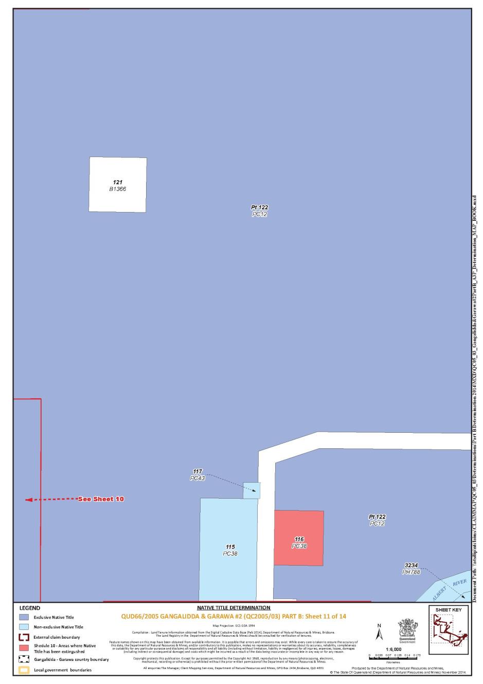
12 The rights and interests of Lawn Hill and Riversleigh Pastoral Holding Company Pty Ltd ACN 083 607 470 as lessee under TL0/221407 over Lot 5 on SP111112 (“Lawn Hill Pastoral Holding”).
13 The rights and interests of Lorna Ann Elizabeth Smith, John Ross Smith, Judith Anne Goodall, Frederick James Edwards and Patricia Joy White as lessees under PH8/3505 over Lot 3505 on CP PH1038 (“Kotupna”).
14 The rights and interests of William Archibald Olive and McRae Investments Pty Ltd ACN 008 696 731 as lessees under TL0/237237 over Lot 2 on SP217472 (“Cliffdale Term Lease”).
15 The rights and interests of Telstra Corporation Limited ACN 051 775 556:
(a) as the owner or operator of telecommunications facilities within the Determination Area;
(b) created pursuant to the Post and Telegraph Act 1901 (Cth), the Telecommunications Act 1975 (Cth), the Australian Telecommunications Corporation Act 1989 (Cth), the Telecommunications Act 1991 (Cth) and the Telecommunications Act 1997 (Cth), including rights:
(i) to inspect land;
(ii) to install and operate telecommunications facilities; and
(iii) to alter, remove, replace, maintain, repair and ensure the proper functioning of its telecommunications facilities;
(c) for its employees, agents or contractors to access its telecommunications facilities in, and in the vicinity of, the Determination Area in the performance of their duties; and
(d) under any lease, licence, access agreement or easement relating to its telecommunications facilities in the Determination Area including under:
(i) Term Lease 0/233251 over Lot 117 on Crown Plan PC43 (Title Reference 40058255);
(ii) Term Lease 0/221724 over Lot 5 on Crown Plan BK38 (Title Reference 40046528); and
(iii) a permissive occupancy issued by the Department of Community Services Queensland on 10 June 1986 providing for the use of an area measuring 150m by 150m on the Doomadgee DOGIT.
16 The rights and interests of Ergon Energy Corporation Limited ACN 087 646 062:
(a) as the owner and operator of "Works" as that term is defined in the Electricity Act 1994 (Qld) within the Determination Area;
(b) as a distribution entity and the holder of a distribution authority under the Electricity Act 1994 (Qld);
(c) created under the Electricity Act 1994 (Qld) and the Government Owned Corporations Act 1993 (Qld), including:
(i) rights in relation to any agreement entered into before the date on which these orders are made relating to the Determination Area and to which ss 113A or 113B of the Electricity Act 1994 (Qld) apply;
(ii) rights to enter the Determination Area by its employees, agents or contractors to exercise any of the rights and interests referred to in this paragraph; and
(iii) to inspect, maintain and manage any Works in the Determination Area.
17 The rights and interests of the State of Queensland and Burke Shire Council to access, use, operate, maintain and control the dedicated roads in the Determination Area and the rights and interests of the public to use and access those roads.
18 The rights and interests of Burke Shire Council as the local government to exercise its powers and responsibilities of a local government under the Local Government Act 2009 (Qld) and any other legislation within the Burke local government area under the Local Government Regulations 2012 (Qld).
19 The rights, interests or powers of the Doomadgee Aboriginal Shire Council:
(a) under the Local Government Act 2009 (Qld) and under any other legislation, for that part of the Determination Area within the Doomadgee local government area under the Local Government Regulations 2012 (Qld); and
(b) as the holder of any estate or interest in land that exists in the Determination Area, including as the trustee under the Doomadgee DOGIT,
including:
(c) as the owner, operator or holder of any interest in infrastructure, facilities, or other site improvements, including:
(i) roads as defined in the Local Government Act 2009 (Qld);
(ii) buildings or other structures, including fencing;
(iii) gravel pits; and
(iv) water bores, water point facilities and other infrastructure for the supply of water; and
(d) any rights of its employees, agents or contractors to enter land, including:
(i) to perform its local government operational activities such as feral animal and weed control, erosion control, waste management, and fire and land management; and
(ii) to operate, inspect, maintain and repair its infrastructure, facilities and other site improvements.
20 The rights and interests of the holders of any leases, licences, permits or authorities granted under the Forestry Act 1959 (Qld) as may be current at the date of this determination.
21 In relation to the land and waters comprising that part of the Determination Area on the seaward side of the High Water Mark:
(a) the rights and interests granted by the State of Queensland or the Commonwealth pursuant to statute including, but not limited to, the rights and interests of persons holding licences, certificates, permits, authorities and permissions pursuant to:
(i) the Transport Operations (Marine Safety) Act 1994 (Qld) and the Transport Operations (Marine Safety) Regulation 1995 (Qld); and
(ii) the Fisheries Act 1994 (Qld), the Fisheries Regulation 1995 (Qld) and the Fisheries Management Act 1991 (Cth); and
(b) the rights and interests of members of the public arising under:
(i) the common law public right to navigate; and
(ii) the common law public right to fish; and
(c) the rights under the international right of innocent passage.
22 So far as confirmed pursuant to s 212(2) of the Native Title Act 1993 (Cth) and s 18 of the Native Title (Queensland) Act 1993 (Qld) as at the date of this determination, any existing public access to, and enjoyment of, the following places in the Determination Area:
(a) waterways;
(b) beds and banks or foreshores of waterways;
(c) coastal waters;
(d) beaches;
(e) stock routes; and
(f) areas that were public places at the end of 31 December 1993.
23 Any other rights and interests:
(a) held by the State of Queensland or Commonwealth of Australia; or
(b) existing by reason of the force and operation of the Laws of the State and the Commonwealth.
SCHEDULE 9
Areas Not Forming Part of the Determination Area
Previous Exclusive Possession Acts
The following areas are wholly excluded from the Determination Area on the grounds that they have been the subject of a previous exclusive possession act (defined in s 23B of the Native Title Act 1993 (Cth)) and in accordance with s 61A of the Native Title Act 1993 (Cth) cannot be claimed:
(a) The land or waters on which any public work (defined in s 253 of the Native Title Act 1993 (Cth)) that is a previous exclusive possession act (defined in s 23B of the Native Title Act 1993 (Cth)) was, on or before 23 December 1996, constructed or established, including (in accordance with s 251D of the Native Title Act 1993 (Cth)) any adjacent land and waters the use of which is or was necessary for, or incidental to, the construction, establishment or operation of the work.
(b) The following land or waters the subject of previous exclusive possession acts (defined in s 23B of the Native Title Act 1993 (Cth)):
(i) Lot 75 on PC 26; and
(ii) Lot 1 on SP 194674.
Pre-Existing Rights Based Act
On the basis that native title has been extinguished and is not claimed pursuant to s 24IB of the Native Title Act 1993 (Cth), the parties have agreed that Lot 7 on CP847163 is wholly excluded from the Determination Area.
SCHEDULE 10
Areas where native title has been extinguished
The parties have agreed that native title has been extinguished over the land and waters described below pursuant to the Indigenous Land Use Agreement referred to in clause 2(b) of Schedule 8.
Area Description | |||
That part of Lot 122 on PC12 bounded by the following coordinates and depicted in the Determination Map in Schedule 11 | |||
Longitude East | Latitude South | ||
139.535091 139.532268 139.532395 139.533607 139.533545 139.536821 139.537066 139.536631 139.536682 139.536504 139.536566 139.535153 139.535091 | -17.740662 -17.740543 -17.739953 -17.740004 -17.739094 -17.739228 -17.739486 -17.739834 -17.740729 -17.740722 -17.739368 -17.739308 -17.740662 | ||
That part of Lot 122 on PC12 bounded by the following coordinates and depicted in the Determination Map in Schedule 11 | |||
Longitude East | Latitude South | ||
139.536682 139.536631 139.537066 139.536628 139.536724 139.534643 139.536352 139.537646 139.537224 139.536682 | -17.740729 -17.739834 -17.739486 -17.739024 -17.738948 -17.735512 -17.735099 -17.739393 -17.740752 -17.740729 | ||
That part of Lot 122 on PC12 bounded by the following coordinates and depicted in the Determination Map in Schedule 11 | |||
Longitude East | Latitude South | ||
139.523318 139.525198 139.524059 139.522070 139.523318 | -17.749509 -17.753627 -17.754353 -17.750185 -17.749509 | ||
That part of Lot 122 on PC12 bounded by the following coordinates and depicted in the Determination Map in Schedule 11 | |||
Longitude East | Latitude South | ||
139.538213 139.538271 139.537888 139.531207 139.538213 | -17.741591 -17.744903 -17.745188 -17.745452 -17.741591 | ||
That part of Lot 122 on PC12 bounded by the following coordinates and depicted in the Determination Map in Schedule 11 | |||
Longitude East | Latitude South | ||
139.521965 139.520984 139.526338 139.526884 139.521965 | -17.745340 -17.743419 -17.741327 -17.743276 -17.745340 | ||
That part of Lot 122 on PC12 bounded by the following coordinates and depicted in the Determination Map in Schedule 11 | |||
Longitude East | Latitude South | ||
139.522829 139.522088 139.526957 139.527344 139.522829 | -17.747031 -17.745581 -17.743536 -17.744915 -17.747031 | ||
That part of Lot 122 on PC12 bounded by the following coordinates and depicted in the Determination Map in Schedule 11 | |||
Longitude East | Latitude South | ||
139.517987 139.517246 139.521836 139.522576 139.517987 | -17.749301 -17.747851 -17.745700 -17.747150 -17.749301 | ||
That part of Lot 122 on PC12 bounded by the following coordinates and depicted in the Determination Map in Schedule 11 | |||
Longitude East | Latitude South | ||
139.484553 139.484562 139.485364 139.485355 139.484553 | -17.756209 -17.755441 -17.755450 -17.756218 -17.756209 | ||
That part of Lot 122 on PC12 bounded by the following coordinates and depicted in the Determination Map in Schedule 11 | |||
Longitude East | Latitude South | ||
139.526596 139.530218 139.534205 139.534249 139.534701 139.534075 139.527596 139.526596 | -17.741227 -17.740790 -17.740896 -17.741018 -17.741528 -17.741754 -17.744796 -17.741227 | ||
Lot 116 on PC38 | |||
Lot 13 on B13616 | |||
Lot 16 on B13618 | |||
Lot 5 on B13619 | |||
Lot 3 on B13623 | |||
Lot 2 on B13624 | |||
Lot 18 on B13625 | |||
Lot 97 on B1364 | |||
That part of Lot 111 on B1361 north of a line that passes through the following coordinates and depicted in the Determination Map in Schedule 11 | |||
Longitude East | Latitude South | ||
139.549737 139.550124 | -17.745545 -17.745552 | ||
That part of Lot 113 on B1361 north of a line that passes through the following coordinates and depicted in the Determination Map in Schedule 11 | |||
Longitude East | Latitude South | ||
139.549556 139.549737 | -17.745542 -17.745545 | ||
Lot 8 on B13610 | |||
Lot 9 on B13610 | |||
Lot 10 on B13610 | |||
Lot 11 on B13610 | |||
Lot 12 on B13610 | |||
Lot 13 on B13610 | |||
Lot 14 on B13610 | |||
Lot 15 on B13610 | |||
Lot 16 on B13610 | |||
Lot 18 on B13610 | |||
Lot 22 on B13610 | |||
Lot 23 on B13610 | |||
Lot 24 on B13610 | |||
Lot 25 on B13610 | |||
Lot 26 on B13610 | |||
Lot 27 on B13610 | |||
Lot 28 on B13610 | |||
Lot 29 on B13610 | |||
Lot 30 on B13610 | |||
Lot 31 on B13610 | |||
Lot 32 on B13610 | |||
Lot 33 on B13610 | |||
Lot 34 on B13610 | |||
Lot 35 on B13610 | |||
Lot 36 on B13610 | |||
Lot 37 on B13610 | |||
Lot 38 on B13610 | |||
Lot 39 on B13610 | |||
Lot 42 on B13610 | |||
Lot 43 on B13610 | |||
Lot 44 on B13610 | |||
Lot 45 on B13610 | |||
Lot 46 on B13610 | |||
Lot 47 on B13610 | |||
Lot 48 on B13610 | |||
Lot 49 on B13610 | |||
Lot 50 on B13610 | |||
Lot 51 on B13610 | |||
Lot 52 on B13610 | |||
Lot 53 on B13610 | |||
Lot 54 on B13610 | |||
Lot 55 on B13610 | |||
Lot 56 on B13610 | |||
Lot 57 on B13610 | |||
Lot 58 on B13610 | |||
Lot 59 on B13610 | |||
Lot 64 on B13610 | |||
Lot 65 on B13610 | |||
Lot 66 on B13610 | |||
Lot 67 on B13610 | |||
Lot 68 on B13610 | |||
Lot 69 on B13610 | |||
Lot 70 on B13610 | |||
Lot 71 on B13610 | |||
Lot 72 on B13610 | |||
Lot 73 on B13610 | |||
Lot 74 on B13610 | |||
Lot 75 on B13610 | |||
Lot 76 on B13610 | |||
Lot 87 on B13610 | |||
Lot 88 on B13610 | |||
Lot 89 on B13610 | |||
Lot 90 on B13610 | |||
Lot 91 on B13610 | |||
Lot 92 on B13610 | |||
Lot 93 on B13610 | |||
Lot 94 on B13610 | |||
Lot 95 on B13610 | |||
Lot 96 on B13610 | |||
Lot 97 on B13610 | |||
Lot 21 on B1364 | |||
Lot 1 on B1365 | |||
Lot 2 on B1365 | |||
Lot 4 on B1365 | |||
Lot 5 on B1365 | |||
Lot 12 on B1365 | |||
Lot 13 on B1365 | |||
Lot 16 on B1365 | |||
Lot 17 on B1365 | |||
Lot 39 on B1365 | |||
Lot 40 on B1365 | |||
Lot 52 on B1365 | |||
Lot 68 on B1365 | |||
Lot 69 on B1365 | |||
Lot 70 on B1365 | |||
Lot 52 on B1368 | |||
Lot 66 on B1368 | |||
Lot 67 on B1368 | |||
Lot 65 on PC31 | |||
Lot 114 on PC34 | |||
Lot 119 on PC35 | |||
Lot 2 on SP194674 | |||
That part of Lot 86 on PC5 east of a line that passes through the following coordinates and depicted in the Determination Map in Schedule 11 | |||
Longitude East | Latitude South | ||
139.479318 139.479279 139.479311 | -17.756785 -17.756647 -17.755635 | ||
Lot 127 on PC5 | |||
That part of Lot 54 on USL103 bounded by the following coordinates and depicted in the Determination Map in Schedule 11 | |||
Longitude East | Latitude South | ||
139.414019 139.414752 139.413817 139.412912 139.414019 | -17.746575 -17.747405 -17.748164 -17.747140 -17.746575 | ||
SCHEDULE 11 - Determination Map
QUEENSLAND DISTRICT REGISTRY | |
GENERAL DIVISION | QUD 66 of 2005 |
BETWEEN: | TERRANCE TAYLOR AND JACKY GREEN ON BEHALF OF THE GANGALIDDA AND GARAWA PEOPLES #2 Applicant |
AND: | STATE OF QUEENSLAND First Respondent COMMONWEALTH OF AUSTRALIA Second Respondent BURKE SHIRE COUNCIL Third Respondent DOOMADGEE ABORIGINAL SHIRE COUNCIL Fourth Respondent ERGON ENERGY CORPORATION LIMITED Fifth Respondent TELSTRA CORPORATION LIMITED Sixth Respondent JOHN LEONARD CLARKE, NORMAN LEONARD CLARKE, SUSAN MAREE CLARKE, JUDITH ANNE GOODALL, JANICE NELSON, JOHN GEOFFREY NELSON, PANOY PTY LTD, PARAWAY PASTORAL COMPANY LIMITED, JOHN ROSS SMITH, VENLOCK PTY LTD AND WESTMORELAND PASTORAL COMPANY PTY LTD Seventh Respondent |
JUDGE: | DOWSETT J |
DATE: | 1 APRIL 2015 |
PLACE: | BURKETOWN |
REASONS FOR JUDGMENT
1 Before the Court are two applications for native title determinations. In proceeding QUD 84 of 2004, Terrance Taylor and Jacky Green (the “Applicant”) claim on behalf of the Gangalidda People and the Garawa People. The Gangalidda People are all of the descendants of the following people:
Greg Thompson, Sophie Thompson, Ernest Thompson, Walter Thompson, Jimmy, Dawudawu Jimmy (King), Grant, George Nark Mirrabaliyajari, Bob Scoles Gunyarbadijarri, Lirrgagujarri, Bob Weber Milgalajarri, Maggie (or Minnie), Kitty, Kitty Wulnanda, Kitty Lirrgagujarri, Dolly, Old Nim, Stumpy Paddy, Mickey Charles, Barny Guldangara, Limilimilda, Johnny Balawayinda, Daisy Lirrgawanjinda, Sandy, Gunalumbu, Ngarilgudu, Malurgudu, Myrna Malalairunanda, Didmanja, Sandy, Garruwala and Charly (Gundirrirri/Ngarrguyumbu/Gulawi),
who identify, and are identified by other Gangalidda People, as belonging to the Gangalidda People according to Gangalidda traditional laws and customs.
The term “descendants” includes those individuals who have been adopted by the Gangalidda People.
The Garawa People are all of the descendants of the following people:
Dixon Yiliwagu, Murdering Tommy Mayarwagu, Dick Gawardalagayi, Mardu, “Strike-a-light” Yalagu, Bindi Bindi, Illibarra (or Yilibarra), Charley Marrgarranyi, Violet Man.gali, Dildol Charley Lujunguynyi, Gandiyari, Jangurungurama, Wirrangala, Gurrunggumaji, Banjiramaji (Bob) Yellow Jack, Gabugabumanyi Jack, Wanjirrigama Sandy, Dirrdungga, Baramalinya Bandaguyi, Wambilangunu, Dunggula, Yalbindirri, Topsy Landurimara, Jack Boy Walbungga, Paul Gayjbalala, Tobacco Jack, Ned Bamalurri, Old Rory Mawulawula (Buraji), Bamy (Barney) Barrgudugudu, Jack Calvert, Masterton Jack, Wudungkamarra, Thalmarrurrkimara, Karringamaji (King Peter), Widalamara, Malarrkudu (Kabajuju) (Barramundi Billy), Dukala, Rukulamara, Albert Doomadgee, Ned Doomadgee, Kukurrinya (Yabiwayngka), Jack Nadinku, Nukuthu, Minnie Munjanagurru, Waguwiganda, Jangulamarra, Gilmajarri (or Landilimarra) and Willy Murrandoo,
who identify, and are identified by other Garawa People, as belonging to the Garawa People in accordance with Garawa traditional laws and customs.
The term “descendants” includes those individuals who have been adopted by the Garawa People.
2 In proceeding QUD 66 of 2005, Terrance Taylor and Jacky Green (the “Applicant”), claim on behalf of the Gangalidda People and the Garawa People, who are described in the same way as in QUD 84 of 2004.
3 The claim areas are contiguous and are in the southern Gulf of Carpentaria region of north-west Queensland, close to the Queensland/Northern Territory border. QUD 84 of 2004 claims approximately 706 square kms of land and water, including parts of Wentworth Pastoral Holding, a small western portion of Troutbeck Pastoral Holding and part of Westmoreland Pastoral Holding. The north-eastern corner of the claim area extends to the High Water Mark, commencing west of Massacre Inlet.
4 QUD 66 of 2005 covers an area of approximately 8,643 square kms of land and water. The north-western corner of the claim area extends five nautical miles seaward of the High Water Mark. The eastern boundary of the claim area commences on the coast at the Leichhardt River. Part of the southern boundary includes the Nicholson River. Other major rivers that flow through the claim area are the Albert and Gregory Rivers. The claim area predominantly covers, either wholly or in part, 15 pastoral holdings namely:
Yarrum;
Turn Off Lagoons;
Lawn Hill;
Westmoreland;
Wentworth;
Almora;
Armraynald;
Beamesbrook;
Birkalla;
Nierrana;
Little Doab;
Doab;
Brinawa;
Kotupna; and
Punjaub.
QUD 66 of 2005 also claims:
(a) reserves and unallocated State land;
(b) part of the Doomadgee Deed of Grant in Trust;
(c) areas of unallocated State land;
(d) land and waters on the seaward side of the High Water Mark, predominantly between the Queensland/Northern Territory border and Massacre Inlet;
(e) estuarine areas, including the lower reaches of Johns Creek in the locality of Tarrant Point; and
(f) part of Finucane Island National Park.
The Gangalidda People have been recognized as traditional owners of other areas in the region. I need not complicate these reasons by detailed references to those determinations.
5 The present respondents to QUD 84 of 2004 are:
State of Queensland;
Burke Shire Council;
Carpentaria Land Council Aboriginal Corporation;
Telstra Corporation Limited;
Panoy Pty Ltd; and
Westmoreland Pastoral Company Pty Ltd.
6 The present respondents to QUD 66 of 2005 are:
State of Queensland;
Commonwealth of Australia;
Burke Shire Council;
Doomadgee Aboriginal Shire Council;
Ergon Energy Corporation Limited;
Telstra Corporation Limited;
John Leonard Clarke;
Norman Leonard Clarke;
Susan Maree Clarke;
Judith Anne Goodall;
Janice Nelson;
John Geoffrey Nelson;
Panoy Pty Ltd;
Paraway Pastoral Company Limited;
John Ross Smith;
Venlock Pty Ltd; and
Westmoreland Pastoral Company Pty Ltd.
7 The Gangalidda and Garawa Peoples are, according to the anthropological evidence, constituent parts of a single cultural bloc. Professor Trigger of the University of Queensland has spent much of his professional life in contact with that cultural bloc. He considers that it includes, apart from the Gangalidda and Garawa Peoples, the Waanyi and a number of other named language groups to the north and west. Professor Trigger says in his report dated 20 March 2012 at para 4, that:
…
The shared laws and customs across this regional society, that extends as far east as the vicinity of the Leichhardt River, include the following:
• The same subsection or ‘skin’ system of 8 categories (with the same set of 16 terms for male and female persons);
• The same system of spiritual (or totemic) entities inhering in the landscape;
• Adaptations and transformations of the structurally similar system of estate groups;
• The same form of kinship system (with both shared and some different actual terms of address and reference);
• A history of intermarriage and resulting multiple personal potential memberships in both Waanyi and Ganggalida groups, such that a significant number of individuals have a primary link to country of one group together with a secondary link to the country of the other group;
• Both Waanyi and Ganggalida groups have social, kinship and historical connections and relationships with the adjacent Garawa group to the west;
…
8 The Gangalidda and Garawa Peoples do not claim equal interests in the whole of each claim area. Professor Trigger has identified the eastern boundary of Garawa traditional land and waters as running more or less north-south, about 30 kms east of the Queensland/Northern Territory border. I should add that Garawa traditional land extends into the Northern Territory. Generally, Gangalidda land lies to the east of that line. Professor Trigger considers that there is a transitional zone extending up to 10 kms to the west of the line. Both Gangalidda and Garawa Peoples assert traditional rights over that area. Professor Trigger also describes Garawa country at para 7 of his report dated June 2010 as follows:
The Garawa system of estates, Dreamings and associated ‘skins’ extends eastwards into Queensland to Massacre Inlet on the coast. Inland from the coast, Garawa country extends southwards along Settlement Creek, then southwards to the vicinity of the junction of Lagoon Creek and Hann Creek (known as Percy Creek further upstream). The line indicating the eastward extent of Garawa country then extends southwards to cross Eight Mile Creek and continue to the vicinity of a site known as Balaganyi ( … an area surrounding a hill located around 35 km east of the N.T./Qld border). This location marks a topographic boundary of sorts with the beginning of hilly areas extending to the west. …
9 Concerning the Gangalidda People, Professor Trigger says in his report dated December 1998 at pp 5, 6 and 9:
Those who identify as members of the category of persons known as “Ganggalida people” are the descendants of the people who at the time of European arrival were in occupation of coastal areas of land and sea from the vicinity of Massacre Inlet in the west to at least the vicinity of Moonlight Creek in the east. It is difficult to reconstruct precisely the location of the eastern boundary of Ganggalida country with the territory of another language group known as Minggin or Mingginda … . However, Ganggalida people are the successors of the Mingginda People who were in occupation of the area from the Leichhardt River west to what was, during times beyond the living memory of all but a few contemporary older persons, the boundary with Ganggalida country.
The population of Ganggalida people is made up of interconnected extended families.
These are cognatic groups in that membership of them is traced through either parent, and then through either male or female lineal links, to earlier generations of one’s ancestry. The groups tend to have a patrifilial core in that successive earlier generations are often traced through a male line. However, it would seem there has been a shift to a broadly accepted cognatic principle in these groups, over the past few generations, such that it is now just as common for people to be members by matrifiliation as by patrifiliation … .
The primary rule for membership among Ganggalida people is that a person is socially acknowledged as belonging to one or more of what are referred to as Ganggalida “families”.
There are cases where adoption by a Ganggalida family is accepted as conferring on the adopted person the right to identify with Ganggalida people and assert interests in the group’s cultural property.
As these extracts demonstrate, the Gangalidda People claim some areas as successors to earlier owners in accordance with traditional laws and customs. This question has been dealt with in part, but at some length, in earlier proceedings.
10 Of the Garawa People, Mr Jeff Stead says in his report dated June 2010 at para 1.37:
A number of literature sources attempt to localise Garawa language territory. Tindale has Karawa (Garawa) extending east to Wollogorang Station and on to Westmoreland but excludes the coastal plain. Roth’s data (collected at the turn of the 20th Century) also locates traditional Karawa (Garawa) territory on or close to the claim area, locating it on the upper Settlement Creek, with a main residential focus being in the Northern Territory at Wollogorang Station. Matthews locates Karrawar (Garawa) in the general area between the Calvert and Nicholson Rivers which would include much of the claim area. Oates’ analysis locates Garawa territory as running north from the Nicholson River, west to the MacArthur River and east to eighty kilometres inside Queensland. Furby and Furby also locate the claim area within Garawa territory having it extending east into Queensland by approximately fifty miles … . Kumarage’s research confirms Garawa interests within the claim area, identifying Garawa estates in the north-western corner. In the author's opinion, this body of research clearly indicates that historically, and currently, the claim area was, and is, identified with the Garawa People and their law and custom. The author’s investigations over the last thirty years also confirm that the claim area is associated with the Garawa People and Garawa law and custom.
(References omitted.)
Professor Trigger in his report dated June 2010 concerning the Garawa People says at para 8:
The system of estates and related ‘skin’ groups (subsections and semi-moieties) upon which Garawa law and custom in regard to land is based continues into Queensland. There are processes of internal succession enabling people to circulate through relationships of various kinds to the different estates … . On this basis there is a continuing Garawa system for resolving those particular families who hold locality-specific rights and interests to the country in Queensland, as well as the broader Garawa group who hold generic rights and interests largely throughout Garawa country. I have discussed this distinction between locality-specific and generic rights in my reports in the Ganggalida sea claim and the Waanyi native title claim. …
11 Concerning the Gangalidda People’s first European contact following sovereignty, Spender J said in earlier proceedings in Gangalidda and Garawa People v State of Queensland [2010] FCA 646 at [22] – [25]:
22 I cite the following historical observations taken from paragraph 6 of the Applicant’s submissions filed in these proceedings, that give an understanding of the society that existed at first contact and the changes to that society as a consequence of European contact:
As early as November 1802, just [fourteen] years after the establishment of the colony of New South Wales, Matthew Flinders observed that the islands which he named the Wellesley Islands were inhabited by Indigenous people. In November 1802 Flinders stayed over a month in the vicinity of the Wellesley Islands, to undertake repairs to his vessel, the HMS Investigator, and to replenish supplies of water and wood. He observed “natives” on Bentinck Island, Sweers Island, Allen Island, Horseshoe Island and Mornington Island. He observed spiral shells used as water containers, and midden material comprising shells and turtle bones on Horseshoe Island. He observed sleeping hollows on Bentinck and Sweers Island, and wells, midden material and human remains on Sweers Island.
Later explorers confirmed the presence of Indigenous people on the islands and adjoining coastal mainland. In July 1841 John Lort Stokes in the HMS Beagle anchored in Investigator Road. Stokes reported “natives” on Sweers Island and on Allen Island. He travelled 40 miles upstream of the Albert River and continued on foot. He was so impressed with the soil and vegetation of the area that he called it ‘the plains of promise’. He observed ‘native skulls’ and long bones on Sweers Island, and a well at Bayley Point.
In 1844-1845 Ludwig Leichhardt’s expedition travelled along the southern part of the Gulf. They crossed the Albert River, travelled along the Nicholson River, and travelled to Port Essington. They found camps, tracks, and fish traps of Aboriginal people.
In 1865 pastoralist JG Macdonald established a settlement on the Albert River twelve miles inland from the Gulf. It was named Burketown. Severe fever inflicted the residents, and the fever victims were evacuated to Sweers Island. The majority of the population of Burketown was relocated in 1866 to Sweers Island in 1866 where a township called Carnarvon was established.
In 1880 Captain Pennefather in the HMS Pearl landed on Sweers Island and Allen Island and examined the fish traps, and in 1881 surveyed the waters between Point Parker and Allen Island. In 1880 he recorded that he ‘saw a large mob of natives, who did not allow us to approach them.’
On 6 January 1866 the pastoral district of Burke was proclaimed. A number of pastoral operations commenced: Lawn Hill in 1875, Gregory Downs in 1876, Lorraine in 1878, Punjaub in 1880, Augustus Downs in 1880, Westmoreland circa 1880s. In 1888 a school was opened in Burketown, and boiling down works were established in 1892. Aboriginal people from the region were attracted to the town. Camps were established on the fringes of the town. By the late 1890s the population of the camps had grown to more than 200.
In 1899 Inspector Lamond closed down the camps. He provided ‘rations for each tribe and sent them off to their old hunting grounds’. In November 1899 J. Ordish, officer in charge at Turn Off Lagoon, reported that 130 of the ‘Point Parker tribe’ were camping at Moonlight Creek – ‘they are improving now they are away from Burketown ... now they are settling down to their native food.’ The coastal country between the Northern Territory border and Point Parker was considered unsuitable for cattle. In 1896 Police Inspector Urquhart reported that this country was ‘wholly unoccupied except by the blacks’. Within several years fringe camps were re-established at Burketown and Normanton. By 1906 Burketown camp had 220 residents. Occasionally, rations and blankets were issued by the local Protector.
23 At paragraph 13 in my reasons in the Lardil, Yangkaal, Gangalidda and Kaiadilt People Land Claim, I referred to submissions specifically in respect to Gangalidda people where it was said that:
It should also be noted that during the first half of the 19th century Gangalidda people, though coming to live in camps on pastoral stations and at Burketown (as well as at the Dumaji Mission established in 1933), continued to move around the coastal country, at least into the 1920s and 1930s. Such occupation of the Gangalidda coastal lands entailed considerable movement among people and this included some travel via traditional watercraft between the mainland and the North Wellesley Islands. Waters relatively near to the beach were routinely used for obtaining foods and other resources.
24 This historical overview records that from the time of first European contact, the Determination Area was inhabited by Aboriginal people, and by inference from the date of sovereignty, and thereafter.
25 The Gangalidda people have maintained their connection to the claimed land and waters through their continuing enjoyment and use of them. That connection supports the rights and interests claimed in this application.
(Emphasis in original.)
Equally, I would add, that connection supports the rights and interests claimed in the applications today.
12 Concerning the Garawa People’s first European contact after sovereignty, I cite the following passage from Mr Stead’s report dated June 2010 at paras 1.18 – 1.31:
1.18 The following paragraphs analyses significant events of the claim region (including the claim area), with the aim of illustrating the degree of Aboriginal occupation of the claim region (and area) at contact and onwards. The analysis also attempts to obtain an understanding of traditional Aboriginal life in the claim region at first contact.
…
1.19 Marine explorers sailed within close proximity of the coastal portion of the claim region (and area). Flinders charted the southern coast of the Gulf of Carpentaria in 1802. He records Aboriginal occupation of the coastline from the Pellew Islands to the Wesley Islands [sic]. His party had very brief encounters with Aboriginal people. Flinders describes hunting and gathering techniques, Aboriginal dwellings and the use of rafts. In later years Stokes (early 1840’s), Chimmo (in 1850’s) and Pennefather (in 1880) all record the presence of Aboriginal people in the southern Gulf of Carpentaria.
1.20 Leichhardt in his expedition from Moreton Bay to Port Essington, encountered many Aboriginal people from the Albert River (in Queensland), west to the Robertson River in the (now) Northern Territory. He describes their artefacts, dwellings, food sources, methods of preparing and storing food, use of red ochre and the presence of fish and emu traps.
…
1.21 Wells who along with Carruthers (1880’s) surveyed the Queensland/Northern Territory border recorded the names of the three Aboriginal individuals ‘Jakkamarri, ‘Kumerange’ and ‘Bellarimi’ which generally equate to sub-sections term currently in use in the general region. In the author’s opinion, they are important elements of Aboriginal laws and customs as they related to the regulation of marriage and the establishment of socio-centric relationships between groups … .
1.22 Dymock provides information about Aboriginal occupation of Westmoreland and Wollogorang Stations in the 1880’s through his data on Aboriginal/European conflict e.g. at Damorli Lagoon (Westmoreland Homestead), Hell’s Gate, Massacre Inlet at the mouth of Lagoon Creek, Battle Creek approximately ten kilometres up Lagoon Creek from Westmoreland Homestead, and a number of upper tributaries of Branch Creek.
1.23 Dymock relying on Garawa oral history, relates the gatherings of Aboriginal people at Baladuna Waterhole on Settlement Creek, about eighteen kilometres up from Wollogorang Station (in 1897). His data indicates that one of the attendees was Illibarra (Healy Burra), also known as “King Hillyborough of Wollogorang”, who had traditional interests in the Settlement Creek area. … Dymock also records ceremonial activities involving Garawa people in north-west Queensland including at Westmoreland and Turn-off Lagoons.
1.24 Blake’s analysis also demonstrates Aboriginal occupation of the claim region (and claim area) in 1899. Relying on police correspondence, he indicates that: one hundred and thirty Carawa (Garawa) were camped at the head of the Nicholson River; one hundred people camped on Moonlight Creek; and fifty Aboriginal people (Euchlo) camping between Point Parker and the SA (Northern Territory) border. I agree with Blake’s opinion this demonstrates that despite contact with Europeans for many years, distinct groups and their territory were readily identifiable. Blake’s analysis of the historical data indicates that the coastal country between Borroloola and Point Parker (this includes the coastal portions of the claim area) was occupied by Aboriginal people.
1.25 Given this historical data the author is of the opinion that the claim region (and area) was occupied by Aboriginal people at first contact.
1.26 There is early ethnographic data which links the Garawa People to the claim region (and area) and demonstrates aspects of their laws and customs, which are still currently relevant.
1.27 Stretton who was a magistrate and collector of customs at Borroloola during the 1890’s, identifies a Leearrwa (Garawa) tribe of one hundred people centred on the Robinson River. He also provides generalised data on the laws and customs of a number of Aboriginal groups of the western Gulf of Carpentaria including the Garawa. Such laws and customs include, use of native flora as medicine, marriage laws, avoidance of certain relations, body scarification, performance of initiation rites, the practice of adoption, and burial rites. Stretton’s data also partially addresses the connection of individuals and groups to their land. His data suggests that each individual has a relationship with his birth place. It also demonstrates territoriality between groups and traditionally, sanctions for trespass that were enforced against Aboriginal and non-Aboriginal.
1.28 The pioneering anthropologists Gillen and Spencer contacted Aboriginal people of the Gulf of Carpentaria in their expedition through northern Australia. These contacts were recorded in Gillen’s daily diary and subsequent publications. Most of this data was collected at Borroloola in 1901. They locate Garawa territory close to the coast on the east of the Robinson River. Whilst they recorded little direct Garawa data, they did collect information from neighbouring groups with similar laws and customs … including, knowledge of myth, use of sub-sections and semi-moieties, marriage arrangements and ritual.
1.29 Roth collected data in the early 1900’s. He locates the Karawa (Garawa) tribe at the head of Settlement Creek (which runs through the western claim area) with their chief camp at Wollogorang Station. Constable Alford, based at the Turn-off Lagoon Police Post (during the 1890’s) identifies the Carawagh (Garawa) as frequenting the Queensland/Northern Territory border up to the Calvert River.
1.30 The evidence examined above, in the author’s view, clearly indicates that Aboriginal people were living within the claim region from at least the early Nineteenth Century. The historical and early ethnographic data also indicates there were Garawa people living within the claim region (and claim area) since the latter years of the Nineteenth and early years of the next Century. In the author’s opinion, it is similarly clear, that these people maintained a social system with regulating laws and customs such as, marriage rules, kinship avoidance, initiation rites, the practice of adoption, sanctions for trespass, and a system of social classification including the use of sub-section terms. The evidence, in the author’s opinion, also indicates that the Garawa (and neighbouring groups) were semi-nomadic people who had specialist techniques and artefacts to exploit the environment in which they lived (e.g. traps, canoes and flora processing techniques).
1.31 It is the author’s opinion that is it appropriate to infer that this way of life, and its accompanying system of rules and customs, were in existence prior to the 1890’s. Similarly it is the author's opinion, that had there been an earlier, different system, dating prior to first contact then it would have been reported in early historical and ethnographic data. Thus, a conclusion that the way of life and system of law and customs recorded in last half of the Nineteenth Century was present at sovereignty is reasonable.
(References omitted.)
13 Although we know the names of so many of the European explorers, settlers, anthropologists and officials from those early times, we know little about the indigenous people whom they encountered. That is regrettable, but perhaps inevitable. In any event, today we recall all indigenous people who have, for thousands of years, owned and occupied this part of our country. These histories leave little room for doubt that the Gangalidda and Garawa Peoples occupied the claim areas as at the time of first European contact and, by inference, as at the date of the first claim to sovereignty, and that they are the traditional owners of the claim area.
14 Concerning ongoing connection, a large number of Gangalidda People and Garawa People have provided affidavits in which they describe personal associations with the claim area and associations between the claim group and the claim area. Time constraints prevent me from giving even a general summary of that evidence, or even listing the names of the people who have sworn the affidavits. It is sufficient to say that that evidence identifies numerous well-known locations within the claim area to which the Gangalidda and Garawa Peoples relate and describes the nature of the ongoing connection between them and such areas. The evidence also provides detailed descriptions of traditional laws and customs as they relate to the Gangalidda and Garawa Peoples and the claim area.
15 I am grateful for the submissions prepared by counsel for the Applicants, Mr Athanasiou. They have helped greatly in the preparation of these reasons.
16 Section 87 of the Native Title Act 1993 (Cth) (the “Native Title Act”) authorizes the Court, in certain circumstances, to decide that native title exists without conducting a full hearing. Broadly speaking, the Court may proceed in that way where all of the parties agree, and the Court considers that it is appropriate so to do. On 19 December 2014 and 30 January 2015, agreements were filed in QUD 84 of 2004 and QUD 66 of 2005 respectively. Those agreements were the result of years of work and persistence on the part of the claim group and the other parties. QUD 66 of 2005 posed particular problems. Those problems have been resolved by way of mediation, in good faith, and with good will. The Court’s Native Title Registrar, Mr Ian Irving and the Queensland Native Title Registrar, Mrs Christine Fewings, have made particular contributions to that process. I should also mention the involvement in the mediation process of the Honourable SG Jones AO, formerly the Far Northern Judge of the Supreme Court of Queensland. Mr Jones has assisted in the resolution of many problems. Those involved in native title in Queensland are fortunate that he makes his skills available to us. I am pleased that he is with us today.
17 The proposed determination in QUD 84 of 2004 recognizes the existence of exclusive native title over the land and waters described in Schedule 2 to each of the orders and non-exclusive nature title rights and interests over that part of the claim area which is identified in Schedule 3. The Gangalidda People hold native title over that part of the claim area described in Schedule 4. The Garawa People hold native title over that part of the claim area described in Schedule 5. The Gangalidda People are described in Schedule 6, and the Garawa People, in Schedule 7.
18 Orders 11, 12 and 13 provide:
11. Subject to orders 14, 15 and 18, the nature and extent of the native title rights and interests in relation to that part of the Determination Area described in Schedule 2 and shown in Schedule 10, other than in relation to the use and enjoyment of Water (which is dealt with in order 13), is the right to possession, occupation, use and enjoyment of the Determination Area to the exclusion of all others.
12. Subject to orders 14, 15, 16 and 18, the nature and extent of the native title rights and interests in relation to that part of the Determination Area described in Schedule 3 and shown in Schedule 10, other than in relation to the use and enjoyment of Water (which is dealt with in order 13) are non-exclusive rights:
(a) to access, to be present on and to traverse the area;
(b) to hunt, fish and gather Natural Resources on the area for personal, domestic, and non-commercial communal purposes;
(c) to take, use, share and exchange Natural Resources from the area for personal, domestic, and non-commercial communal purposes;
(d) to camp on the area but not to reside permanently or to erect permanent structures or fixtures;
(e) to light fires on the area for domestic purposes including cooking but not for the purposes of hunting or clearing vegetation;
(f) to conduct religious and spiritual activities and ceremonies on the area;
(g) to be buried on, and bury Native Title Holders on the area; and
(h) to maintain places and areas of importance or significance to the Native Title Holders under their traditional laws and customs and protect those places and areas from physical harm.
13. Subject to orders 14, 15 and 18, the nature and extent of the native title rights and interests in relation to the use and enjoyment of Water within the Determination Area are non-exclusive rights:
(a) to hunt and fish in and on and gather Natural Resources from the Water;
(b) to take, use, share and exchange Natural Resources from the Water; and
(c) to take, use and enjoy the Water,
for personal, domestic and non-commercial communal purposes.
19 The proposed determination in QUD 66 of 2005 recognizes the existence of exclusive native title rights and interests over that part of the claim area as is described in Schedule 2, and non-exclusive native title rights and interests over that part of the claim area as is described in Schedule 3. The Gangalidda People hold native title rights and interest over the area identified in Schedule 4. The Garawa People hold native title rights and interests over the area described in Schedule 5. The Gangalidda People are again described in Schedule 6, and the Garawa People, in Schedule 7.
20 Orders 12, 13, 14 and 15 provide:
12. Subject to orders 16, 17 and 20, the nature and extent of the native title rights and interests in relation to that part of the Determination Area described in Schedule 2 and shown in Schedule 11, other than in relation to the use and enjoyment of Water (which is dealt with in order 14), is the right to possession, occupation, use and enjoyment of the Determination Area to the exclusion of all others.
13. Subject to orders 16, 17, 18 and 20, the nature and extent of the native title rights and interests in relation to that part of the Determination Area described in Schedule 3 and shown in Schedule 11, other than in relation to the use and enjoyment of Water (which is dealt with in order 14) and land and waters on the seaward side of the High Water Mark (which is dealt with in order 15), are non-exclusive rights:
(a) to access, to be present on and to traverse the area;
(b) to hunt, fish and gather Natural Resources on the area for personal, domestic, and non-commercial communal purposes;
(c) to take, use, share and exchange Natural Resources from the area for personal, domestic, and non-commercial communal purposes;
(d) to camp on the area but not to reside permanently or to erect permanent structures or fixtures;
(e) to light fires on the area for domestic purposes including cooking but not for the purposes of hunting or clearing vegetation;
(f) to conduct religious and spiritual activities and ceremonies on the area;
(g) to be buried on, and bury Native Title Holders on the area; and
(h) to maintain places and areas of importance or significance to the Native Title Holders under their traditional laws and customs and protect those places and areas from physical harm.
14. Subject to orders 16, 17, 18 and 20, the nature and extent of the native title rights and interests in relation to the use and enjoyment of Water within the Determination Area, other than in relation to waters on the seaward side of the High Water Mark (which is dealt with in order 15), are non-exclusive rights:
(a) to hunt and fish in and on and gather Natural Resources from the Water;
(b) to take, use, share and exchange Natural Resources from the Water; and
(c) to take, use and enjoy the Water,
for personal, domestic, and non-commercial communal purposes.
15. Subject to orders 16, 17, 18 and 20, the nature and extent of the native title rights and interests in relation to the use and enjoyment of land and waters on the seaward side of the High Water Mark within that part of the Determination Area described in Schedule 3 and shown in Schedule 11 are non-exclusive rights:
(a) to access, to be present on and to traverse the area;
(b) to fish, hunt and gather Natural Resources on the area for personal, domestic or non-commercial communal purposes;
(c) to take, use, share and exchange Natural Resources from the area for personal, domestic, and non-commercial communal purposes;
(d) to take and consume fresh drinking water from fresh water springs in the inter tidal zone for domestic or non-commercial purposes;
(e) to conduct religious and spiritual activities or ceremonies on the area; and
(f) to visit places or areas of importance or significance to the Native Title Holders under their traditional laws and customs and protect those places and areas from physical harm.
21 The native title is not to be held in trust. Gangalidda and Garawa Native Title Aboriginal Corporation (RNTBC ICN 7365) is to be the prescribed body corporate for the purposes of ss 57(2) and 57(3) of the Native Title Act. It is to act as agent for the common law holders of the native title rights and interests and to perform the functions set out in the Native Title (Prescribed Bodies Corporate) Regulations 1999 (Cth).
22 Section 94A of the Native Title Act requires that an order for a determination of native title must set out details of the matters mentioned in s 225 of the Native Title Act. That section must be read together with s 223 of the Native Title Act. I am satisfied that the proposed orders address each of the relevant matters. Finally, I am satisfied that the orders are appropriate and in accordance with s 87 of the Native Title Act. I therefore make orders in terms of the draft provided in each case, which drafts I initial and place with the papers.
23 The Gangalidda and Garawa Peoples have waited a very long time to achieve recognition of their traditional rights and interests. They have, since first European contact, suffered much. That they have survived as recognizable societies with ongoing connection to their traditional lands says much about their individual and collective strength and resilience.
24 Native title rights and interests are the product of traditional laws and customs which have been observed and practised over the generations. Those rights and interests are now recognized and protected under the Native Title Act.
25 I have not come here today to give anything to the Gangalidda and Garawa Peoples. Rather, I have come to recognize, on behalf of all Australians, that they are the traditional owners of this land pursuant to traditional laws and customs which have their roots in ancient times. I now recognize that traditional ownership. In so doing, I bind all people for all time, including the Commonwealth of Australia, the State of Queensland, the Doomadgee Aboriginal Shire Council and the Burke Shire Council. On behalf of all other Australians, and in particular on behalf of the Judges of this Court and our staff, I congratulate you, the Gangalidda and Garawa Peoples upon the recognition which you have achieved today. We wish you well for the future in which we will all share.
I certify that the preceding twenty-five (25) numbered paragraphs are a true copy of the Reasons for Judgment herein of the Honourable Justice Dowsett. |
Associate:

