
FEDERAL COURT OF AUSTRALIA
Lampton on behalf of the Juru People v State of Queensland [2015] FCA 609
Table of Corrections | |
2 July 2015 | In order 3, subparagraphs (a) and (b) and the words ‘be suspended for a period of 12 months from the date of the determination.’ have been added. |
2 July 2015 | In order 10, subparagraphs (a) – (k) have been added. |
2 July 2015 | The map on page 25 was a duplicate of page 24 and has been removed. |
IN THE FEDERAL COURT OF AUSTRALIA | |
RAYMOND LAMPTON AND OTHERS ON BEHALF OF THE JURU PEOPLE Applicant | |
AND: | STATE OF QUEENSLAND AND OTHERS (ACCORDING TO THE SCHEDULE) Respondent |
DATE OF ORDER: | |
WHERE MADE: |
THE COURT ORDERS THAT :
BEING SATISFIED that an order in the terms set out below is within the power of the Court, and it appearing appropriate to the Court to do so, pursuant to s 87 of the Native Title Act 1993 (Cth)
BY CONSENT THE COURT ORDERS THAT:
1. There be a determination of native title in the terms set out below (the “determination”).
2. The exercise of the native title rights and interests referred to in paragraph 8 of the determination in relation to the following areas:
(a) Lot 26 on Plan AP7702;
(b) Lot 27 on Plan AP7702;
(c) the eastern severance of Lot 80 on Plan K1242;
(d) Lot 1 on Plan AP5697; and
(e) Lot 4 on Plan AP9330,
be suspended for a period of 12 months from the date of the determination.
3. The exercise of the native title rights and interests referred to in paragraph 9 of the determination in relation to the following areas:
(a) Lot 404 on Plan SP224848; and
(b) that part of Lot 297 on Plan HR1866 described in Schedule 1,
be suspended for a period of 12 months from the date of the determination.
4. Each party to the proceedings is to bear its own costs
BY CONSENT THE COURT DETERMINES THAT:
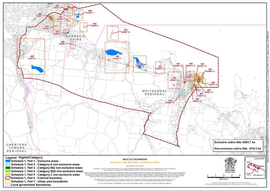
5. The Determination Area is the land and waters described in Schedule 1, and depicted in the map attached to Schedule 1. To the extent of any inconsistency between the written description and the map, the written description prevails.
6. Native title exists in relation to that part of the Determination Area described in Parts 1, 2, 3, 4 and 5 of Schedule 1.
7. The native title is held by the Juru People described in Schedule 3 (the “native title holders”).
8. Subject to paragraphs 13, 14 and 15 below the nature and extent of the native title rights and interests in relation to the land and waters described in Part 1 of Schedule 1 are:
(a) other than in relation to Water, the rights to possession, occupation, use and enjoyment of the area to the exclusion of all others; and
(b) in relation to Water, the non-exclusive rights to:
(i) hunt, fish and gather from the Water of the area;
(ii) take and use the Natural Resources of the Water in the area; and
(iii) take and use the Water of the area,
for personal, domestic and non-commercial communal purposes.
9. Subject to paragraphs 13, 14 and 15 below the nature and extent of the native title rights and interests in relation to the land and waters described in Part 2 of Schedule 1 are the non-exclusive rights to:
(a) access, be present on, move about on and travel over the area;
(b) camp, and live temporarily on the area as part of camping, and for that purpose build temporary shelters;
(c) hunt, fish and gather on the land and waters of the area for personal, domestic and non-commercial communal purposes;
(d) take, use, share and exchange Natural Resources from the land and waters of the area for personal, domestic and non-commercial communal purposes;
(e) take and use the Water of the area for personal, domestic and non-commercial communal purposes;
(f) conduct ceremonies on the area;
(g) be buried and bury native title holders within the area;
(h) maintain places of importance and areas of significance to the native title holders under their traditional laws and customs and protect those places and areas from physical harm;
(i) teach on the area the physical and spiritual attributes of the area;
(j) hold meetings on the area; and
(k) light fires on the area for domestic purposes including cooking, but not for the purpose of hunting or clearing vegetation.
10. Subject to paragraphs 13, 14 and 15 below the nature and extent of the native title rights and interests in relation to the land and waters described in Part 3 of Schedule 1 are the non-exclusive rights to:
(a) access, be present on, move about on and travel over the area;
(b) camp, and live temporarily on the area as part of camping, and for that purpose build temporary shelters;
(c) fish and gather on the land and waters of the area for personal, domestic and non-commercial communal purposes;
(d) take, use, share and exchange Natural Resources from the land and waters of the area for personal, domestic and non-commercial communal purposes;
(e) take and use the Water of the area for personal, domestic and non-commercial communal purposes;
(f) conduct ceremonies on the area;
(g) be buried and bury native title holders within the area;
(h) maintain places of importance and areas of significance to the native title holders under their traditional laws and customs and protect those places and areas from physical harm;
(i) teach on the area the physical and spiritual attributes of the area;
(j) hold meetings on the area; and
(k) light fires on the area for domestic purposes including cooking, but not for the purpose of hunting or clearing vegetation.
11. Subject to paragraphs 13, 14 and 15 below the nature and extent of the native title rights and interests in relation to the land and waters described in Part 4 of Schedule 1 are the non-exclusive rights to:
(a) access, be present on, move about on and travel over the area;
(b) fish and gather on the land and waters of the area for personal, domestic and non-commercial communal purposes;
(c) hunt on the land and waters of the area for personal, domestic and non-commercial communal purposes, but not using weapons as defined in the Weapons Act 1990 (Qld);
(d) take, use, share and exchange Natural Resources from the land and waters of the area for personal, domestic and non-commercial communal purposes;
(e) take and use the Water of the area for personal, domestic and non-commercial communal purposes;
(f) conduct ceremonies on the area;
(g) be buried and bury native title holders within the area;
(h) maintain places of importance and areas of significance to the native title holders under their traditional laws and customs and protect those places and areas from physical harm;
(i) teach on the area the physical and spiritual attributes of the area;
(j) hold meetings on the area; and
(k) light fires on the area for domestic purposes including cooking, but not for the purpose of hunting or clearing vegetation.
12. Subject to paragraphs 13, 14 and 15 below the nature and extent of the native title rights and interests in relation to the land and waters described in Part 5 of Schedule 1 are the non-exclusive rights to access, be present on, move about on and travel over the area.
13. The native title rights and interests are subject to and exercisable in accordance with:
(a) the Laws of the State and the Commonwealth;
(b) the traditional laws acknowledged and traditional customs observed by the native title holders; and
(c) the terms and conditions of the agreements referred to in paragraph 1 of Schedule 4.
14. The native title rights and interests referred to in paragraphs 8(b), 9, 10, 11 and 12 do not confer possession, occupation, use or enjoyment to the exclusion of all others.
15. There are no native title rights in or in relation to minerals as defined by the Mineral Resources Act 1989 (Qld) and petroleum as defined by the Petroleum Act 1923 (Qld) and the Petroleum and Gas (Production and Safety) Act 2004 (Qld).
16. The nature and extent of any other interests in relation to the Determination Area (or respective parts thereof) are set out in Schedule 4.
17. The relationship between the native title rights and interests described in paragraphs 8, 9, 10, 11 and 12 and the other interests described in Schedule 4 (the "other interests") is that:
(a) the other interests continue to have effect, and the rights conferred by or held under the other interests may be exercised notwithstanding the existence of the native title rights and interests;
(b) to the extent the other interests are inconsistent with the continued existence, enjoyment or exercise of the native title rights and interests in relation to the land and waters of the Determination Area, the native title continues to exist in its entirety but the native title rights and interests have no effect in relation to the other interests to the extent of the inconsistency for so long as the other interests exist; and
(c) the other interests and any activity that is required or permitted by or under, and done in accordance with, the other interests, or any activity that is associated with or incidental to such an activity, prevail over the native title rights and interests and any exercise of the native title rights and interests.
DEFINITIONS AND INTERPRETATION
18. In this determination, unless the contrary intention appears:
“High Water Mark” means the ordinary high-water mark at spring tides;
“land” and “waters”, respectively, have the same meanings as in the Native Title Act 1993 (Cth);
“Laws of the State and the Commonwealth” means the common law and the laws of the State of Queensland and the Commonwealth of Australia, and includes legislation, regulations, statutory instruments, local planning instruments and local laws;
“Natural Resources” means:
(a) any animal, plant, fish and bird life found on or in the lands and waters of the Determination Area; and
(b) any clays, soil, sand, gravel or rock found on or below the surface of the Determination Area,
that have traditionally been taken and used by the native title holders, but does not include:
(a) animals that are the private personal property of another;
(b) crops that are the private personal property of another; and
(c) minerals as defined in the Mineral Resources Act 1989 (Qld) or petroleum as defined in the Petroleum Act 1923 (Qld) and the Petroleum and Gas (Production and Safety) Act 2004 (Qld);
“Water” means:
(a) water which flows, whether permanently or intermittently, within a river, creek or stream;
(b) any natural collection of water, whether permanent or intermittent;
(c) water from an underground water source; and
(d) tidal water.
Other words and expressions used in this determination have the same meanings as they have in Part 15 of the Native Title Act 1993 (Cth).
THE COURT DETERMINES THAT:
19. The native title is held in trust.
20. The Kyburra Munda Yalga Aboriginal Corporation RNTBC ICN 7581, incorporated under the Corporations (Aboriginal and Torres Strait Islander) Act 2006 (Cth), is to:
(a) be the prescribed body corporate for the purpose of ss 56(2)(b) and 56(3) of the Native Title Act 1993 (Cth); and
(b) perform the functions mentioned in s 57(1) of the Native Title Act 1993 (Cth) after becoming a registered native title body corporate in relation to the determination.
LIST OF SCHEDULES
Schedule 1 – DETERMINATION AREA | |
Schedule 2 – AREAS NOT FORMING PART OF THE DETERMINATION AREA | |
Schedule 3 – NATIVE TITLE HOLDERS | |
Schedule 4 – OTHER INTERESTS IN THE DETERMINATION AREA |
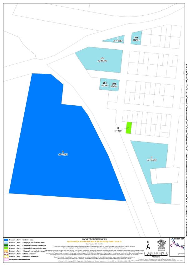
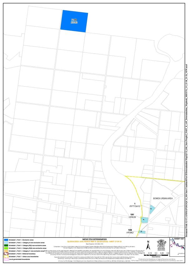
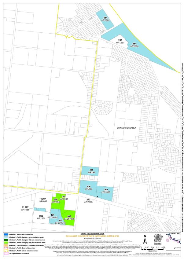
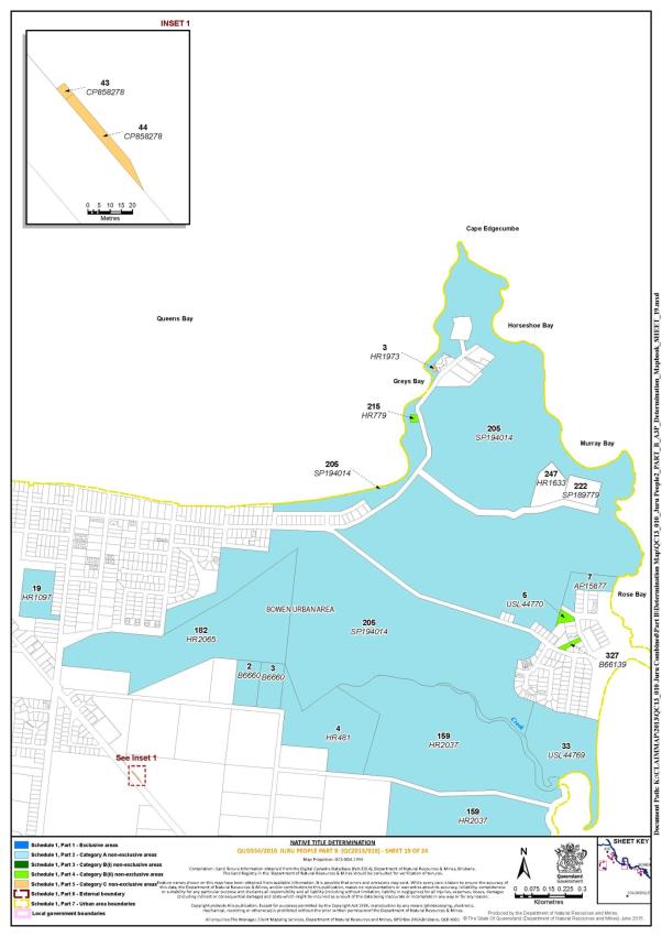
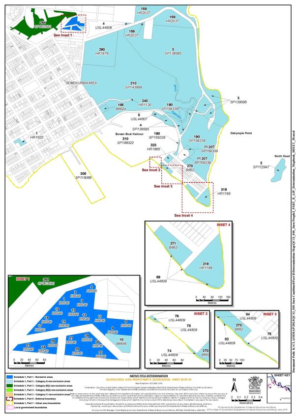
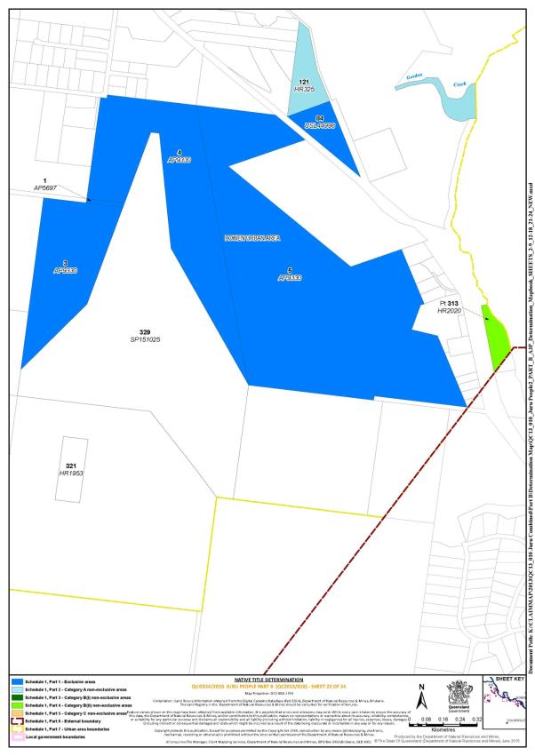
Schedule 1 – DETERMINATION AREA
A. Description of Determination Area
The Determination Area comprises all of the land and waters described in Parts 1, 2, 3, 4 and 5 below, to the extent that they are within the external boundary described in Part 6 below, and depicted on the determination map, but does not include the areas described in Schedule 2.
Part 1 – Exclusive areas
All of the land and waters described in the following table and depicted in dark blue on the determination map:
Area description (as at date of determination) | Determination map sheet reference |
Lot 2 on Plan AP15663 | 16 |
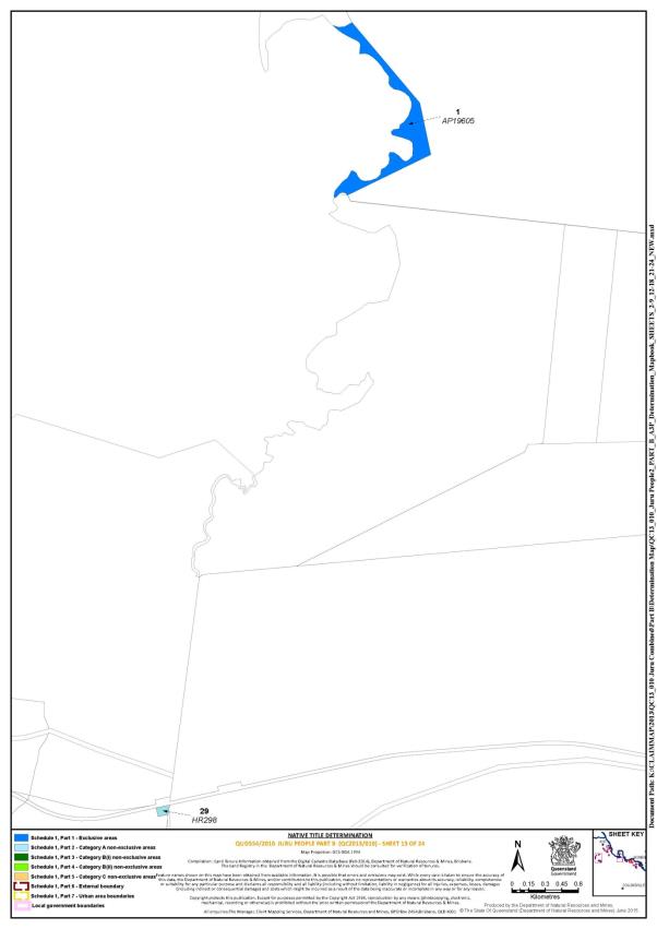
Lot 1 on Plan AP19605 | 13 |
Lot 2 on Plan AP2792 | 4 |
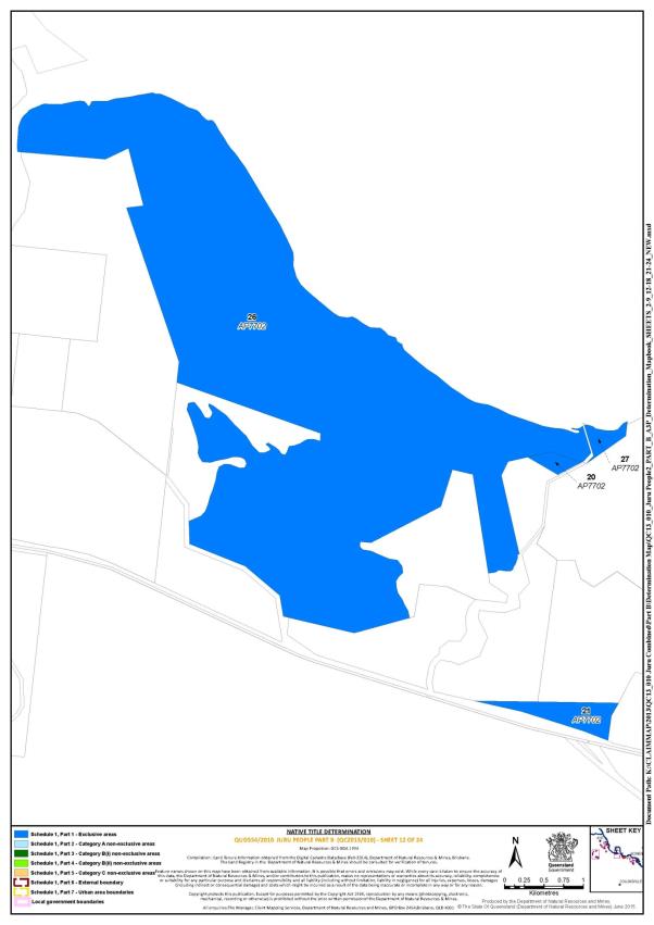
Lot 20 on Plan AP7702 | 12 |
Lot 21 on Plan AP7702 | 12 |
Lot 5 on Plan AP9330 | 22 |
Lot 1 on Plan B6646 | 20 |
Lot 2 on Plan B6646 | 20 |
Lot 3 on Plan B6646 | 20 |
Lot 4 on Plan B6646 | 20 |
Lot 8 on Plan B6646 | 20 |
Lot 9 on Plan B6646 | 20 |
Lot 11 on Plan B6646 | 20 |
Lot 12 on Plan B6646 | 20 |
Lot 13 on Plan B6646 | 20 |
Lot 14 on Plan B6646 | 20 |
Lot 15 on Plan B6646 | 20 |
Lot 16 on Plan B6646 | 20 |
Lot 17 on Plan B6646 | 20 |
Lot 23 on Plan B6646 | 20 |
Lot 24 on Plan B6646 | 20 |
Lot 25 on Plan B6646 | 20 |
Lot 27 on Plan B6646 | 20 |
Lot 28 on Plan B6646 | 20 |
Lot 29 on Plan B6646 | 20 |
Lot 30 on Plan B6646 | 20 |
Lot 31 on Plan B6646 | 20 |
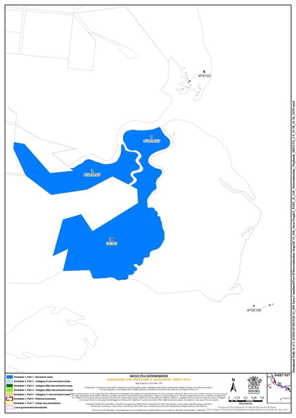
Lot 36 on Plan GS303 | 7 |
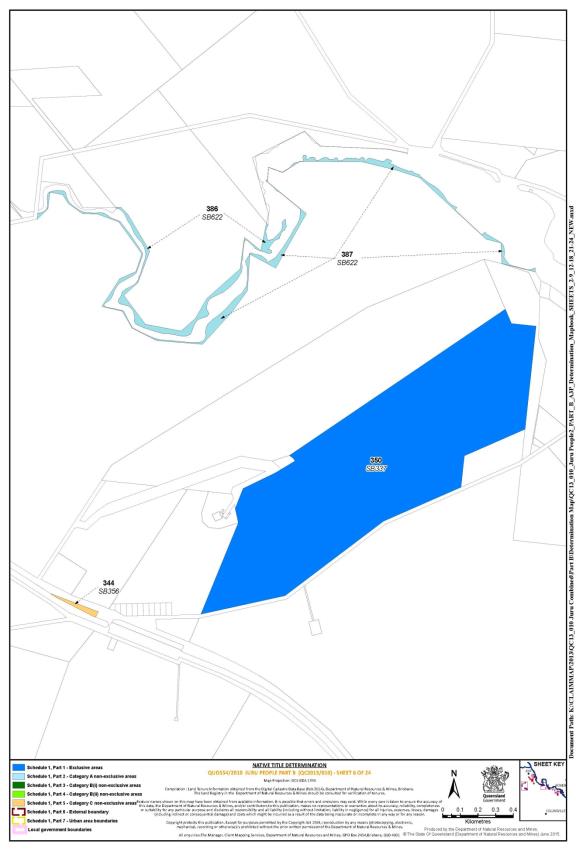
Lot 350 on Plan SB337 | 6 |
Lot 7 on Plan USL38553 | 7 |
Lot 2 on Plan USL38557 | 7 |
Lot 4 on Plan USL42095 | 1 |
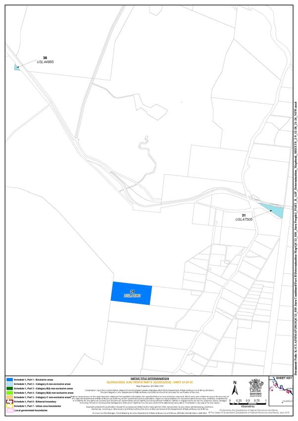
Lot 26 on Plan USL44981 | 14 |
Lot 84 on Plan USL44998 | 22 |
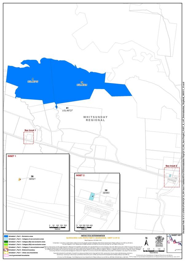
Lot 4 on Plan USL46715 | 11 |
Lot 14 on Plan USL46724 | 11 |
Lot 61 on Plan USL46727 | 11 |
Lot 1 on Plan AP5697 | 22 |
Lot 3 on Plan AP9330 | 22 |
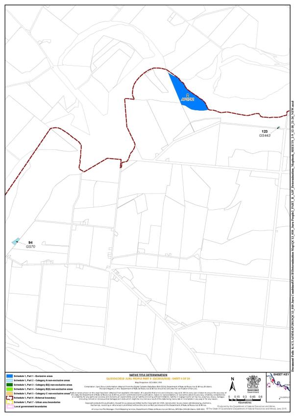
Lot 4 on Plan AP9330 | 22 |
Lot 26 on AP7702 | 12 |
Lot 27 on AP7702 | 12 |
Eastern severance of Lot 80 on Plan K1242 | 17 |
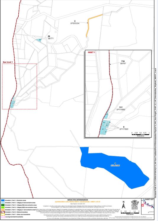
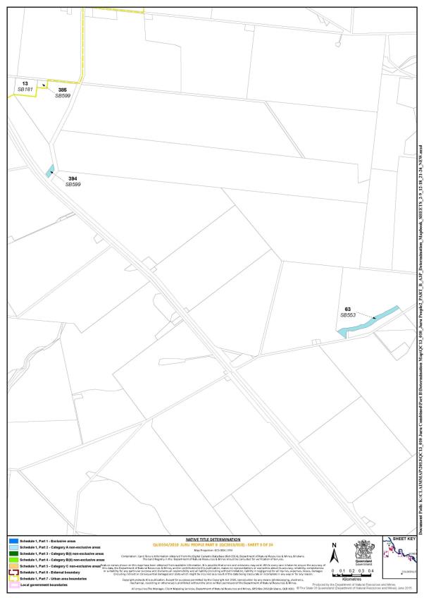
Part 2 – Category A non-exclusive areas
All of the land and waters described in the following table and depicted in light blue on the determination map:
Area description (as at date of determination) | Determination map sheet reference | ||||||||||||||||||||||
Lot 121 on Plan HR325 | 22 | ||||||||||||||||||||||
Lot 191 on Plan HR639 | 17 | ||||||||||||||||||||||
Lot 1 on Plan HR1822 | 20 | ||||||||||||||||||||||
Lot 111 on Plan HR296 | 18 | ||||||||||||||||||||||
Lot 301 on Plan M4881 | 16 | ||||||||||||||||||||||
Lot 210 on Plan SP143899 | 20 | ||||||||||||||||||||||
Lot 186 on Plan B6624 | 20 | ||||||||||||||||||||||
Lot 14 on Plan SP212227 | 21 | ||||||||||||||||||||||
Lot 290 on Plan HR1678 | 20 | ||||||||||||||||||||||
Lot 2 on Plan SP112947 | 20 | ||||||||||||||||||||||
Lot 323 on Plan HR1965 | 20 | ||||||||||||||||||||||
Lot 19 on Plan HR1097 | 19 | ||||||||||||||||||||||
Lot 213 on Plan HR1216 | 21 | ||||||||||||||||||||||
Lot 10 on Plan B6646 | 20 | ||||||||||||||||||||||
Lot 319 on Plan HR1189 | 20 | ||||||||||||||||||||||
Lot 254 on Plan HR1286 | 18 | ||||||||||||||||||||||
Lot 205 on Plan SP194014 | 19 | ||||||||||||||||||||||
Lot 110 on Plan HR1562 | 21 | ||||||||||||||||||||||
Lot 189 on Plan HR962 | 17 | ||||||||||||||||||||||
Lot 269 on Plan HR1585 | 18 | ||||||||||||||||||||||
Lot 3 on Plan AP15663 | 16 | ||||||||||||||||||||||
Lot 1 on Plan AP15663 | 16 | ||||||||||||||||||||||
Lot 154 on Plan AP15664 | 21 | ||||||||||||||||||||||
Lot 101 on Plan AP15710 | 16 | ||||||||||||||||||||||
Lot 7 on Plan AP15877 | 19 | ||||||||||||||||||||||
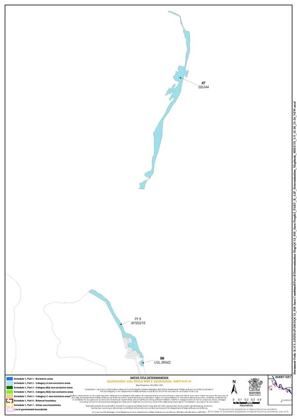
That part of Lot 1 on Plan AP20215 that does not include the areas formerly described as Lots 7 and 9 on Plan AP2858 | 8 | ||||||||||||||||||||||
Lot 6 on Plan AP2103 | 7 | ||||||||||||||||||||||
Lot 270 on Plan B662 | 20 | ||||||||||||||||||||||
Lot 271 on Plan B662 | 20 | ||||||||||||||||||||||
Lot 2 on Plan B6660 | 19 | ||||||||||||||||||||||
Lot 3 on Plan B6660 | 19 | ||||||||||||||||||||||
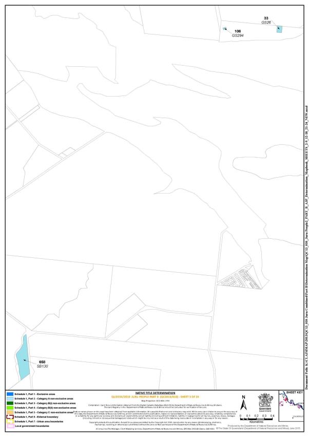
Lot 33 on Plan GS26 | 5 | ||||||||||||||||||||||
Lot 106 on Plan GS294 | 5 | ||||||||||||||||||||||
Lot 123 on Plan GS443 | 4 | ||||||||||||||||||||||
Lot 94 on Plan GS70 | 4 | ||||||||||||||||||||||
Lot 282 on Plan HR1467 | 21 | ||||||||||||||||||||||
Lot 283 on Plan HR1467 | 21 | ||||||||||||||||||||||
Lot 270 on Plan HR1585 | 18 | ||||||||||||||||||||||
Lot 159 on Plan HR2037 | 19; 20 | ||||||||||||||||||||||
Lot 182 on Plan HR2065 | 19 | ||||||||||||||||||||||
Lot 29 on Plan HR298 | 13 | ||||||||||||||||||||||
Lot 326 on Plan HR350 | 18 | ||||||||||||||||||||||
Lot 4 on Plan HR481 | 19 | ||||||||||||||||||||||
Lot 204 on Plan M4881 | 16 | ||||||||||||||||||||||
Lot 205 on Plan M4881 | 16 | ||||||||||||||||||||||
Lot 1 on Plan RP715410 | 17 | ||||||||||||||||||||||
Lot 658 on Plan SB130 | 5 | ||||||||||||||||||||||
Lot 47 on Plan SB344 | 8 | ||||||||||||||||||||||
Lot 63 on Plan SB553 | 3 | ||||||||||||||||||||||
Lot 36 on Plan SB560 | 11 | ||||||||||||||||||||||
Lot 394 on Plan SB599 | 3 | ||||||||||||||||||||||
Lot 386 on Plan SB622 | 6 | ||||||||||||||||||||||
Lot 387 on Plan SB622 | 6 | ||||||||||||||||||||||
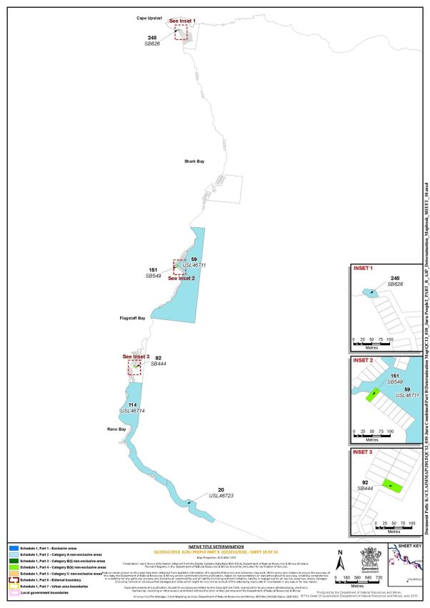
Lot 248 on Plan SB626 | 10 | ||||||||||||||||||||||
Lot 716 on Plan SB767 | 1 | ||||||||||||||||||||||
Lot 39 on Plan SB771 | 1 | ||||||||||||||||||||||
Lot 717 on Plan SP114952 | 1 | ||||||||||||||||||||||
Lot 8 on Plan SP117920 | 1 | ||||||||||||||||||||||
Lot 3 on Plan SP139595 | 20 | ||||||||||||||||||||||
Lot 4 on Plan SP139595 | 20 | ||||||||||||||||||||||
Lot 190 on Plan SP159339 | 20 | ||||||||||||||||||||||
Lot 59 on Plan USL38542 | 8 | ||||||||||||||||||||||
Lot 33 on Plan USL44769 | 19 | ||||||||||||||||||||||
Lot 36 on Plan USL44776 | 21 | ||||||||||||||||||||||
Lot 47 on Plan USL44776 | 21 | ||||||||||||||||||||||
Lot 4 on Plan USL44806 | 20 | ||||||||||||||||||||||
Lot 5 on Plan USL44807 | 20 | ||||||||||||||||||||||
Lot 69 on Plan USL44809 | 20 | ||||||||||||||||||||||
Lot 74 on Plan USL44809 | 20 | ||||||||||||||||||||||
Lot 75 on Plan USL44809 | 20 | ||||||||||||||||||||||
Lot 76 on Plan USL44809 | 20 | ||||||||||||||||||||||
Lot 78 on Plan USL44809 | 20 | ||||||||||||||||||||||
Lot 82 on Plan USL44809 | 20 | ||||||||||||||||||||||
Lot 84 on Plan USL44809 | 20 | ||||||||||||||||||||||
Lot 36 on Plan USL44985 | 14 | ||||||||||||||||||||||
Lot 59 on Plan USL46711 | 10 | ||||||||||||||||||||||
Lot 114 on Plan USL46714 | 10 | ||||||||||||||||||||||
Lot 20 on Plan USL46723 | 10 | ||||||||||||||||||||||
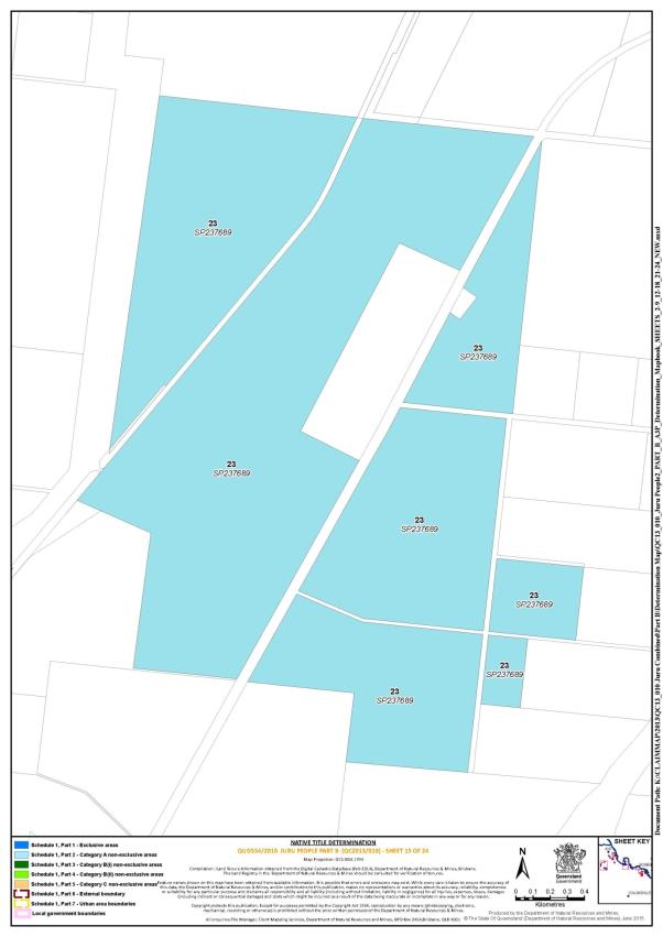
Lot 23 on Plan SP237689 | 15 | ||||||||||||||||||||||
Lot 1 on Plan AP20150 | 7 | ||||||||||||||||||||||
Lot 403 on Plan SP224848 | 18 | ||||||||||||||||||||||
Lot 404 on Plan SP224848 | 18 | ||||||||||||||||||||||
Lot 31 on Plan USL47505 | 14 | ||||||||||||||||||||||
That part of Lot 297 on Plan HR1866 commencing at the south-western corner of Lot 297 on Plan HR1866 being a point at approximately D East=627,889.33 North=7,788,003.87 and bounded thence on the east in a northerly direction by the western boundary of Lot 297 on Plan HR1866 to the intersection with North = 7,788,038.27 then bounded on the north in an easterly direction by a line passing through the following co-ordinate points: A East=627,893.56 North=7,788,038.27 B East=628,028.88 North=7,788,025.68 C East=628,037.99 North=7,787,985.00 to a point on the southern boundary of Lot 297 on Plan HR1866 and bounded thence on the south in a westerly direction by the southern boundary of Lot 297 on Plan HR1866 back to the point of commencement (Point Coordinate Datum is shown as East and North in WGS84 Zone 55) | 18 | ||||||||||||||||||||||
That part of Lot 207 on Plan SP159339 commencing at the intersection of the south west boundary of Lot 207 on Plan SP159339 and Northing 7785903.29m and extending generally north easterly and generally north westerly passing through the following coordinate points:
then north easterly, south easterly, south westerly and north westerly along the boundaries of Lot 207 on SP159339 back to the point of commencement. (Coordinates are Map Grid of Australia (MGA94), which is a projection in Zone 55 with Central Meridian 147° East based on the Geocentric Datum of Australia 1994 (GDA94)) | 20 | ||||||||||||||||||||||
Save for any waters forming part of a lot on plan, all waterways, natural lakes, creeks and rivers within the “Bowen urban area” described in Part 7 including but not limited to: Gordon Creek, Doughty Creek and Saltwater Creek | |||||||||||||||||||||||
Part 3 – Category B(i) non-exclusive areas
All of the land and waters described in the following table and depicted in dark green on the determination map:
Area description (as at date of determination) | Determination map sheet reference |
Lot 264 on Plan CP903592 | 20 |
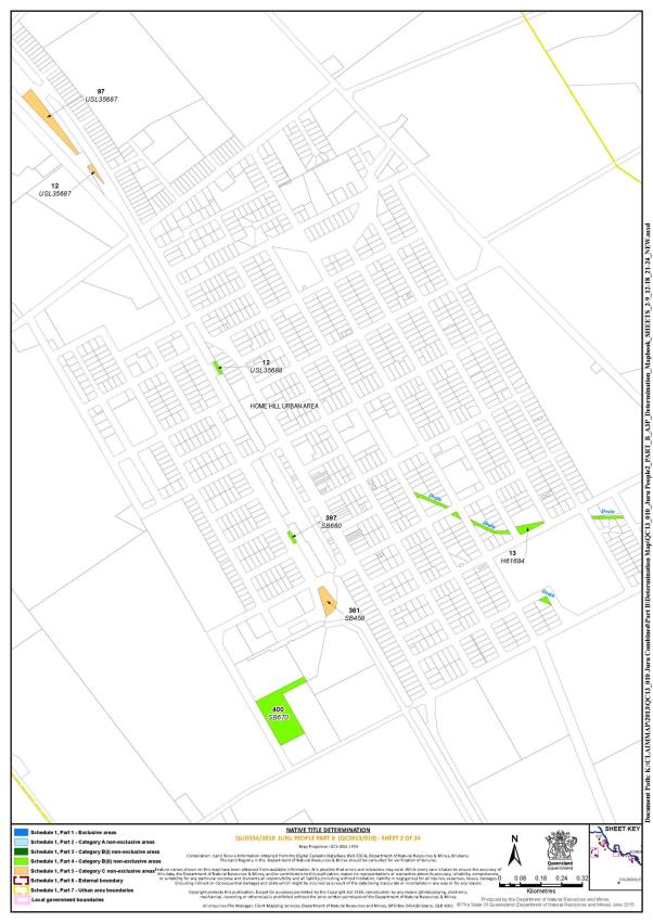
Part 4 – Category B(ii) non-exclusive areas
All of the land and waters described in the following table and depicted in light green on the determination map:
Area description (as at date of determination) | Determination map sheet reference |
Lot 13 on Plan SP212227 * | 21 |
That part of Lot 313 on Plan HR2020 that is within the external boundary described in Part 6 | 22 |
Lot 53 on Plan AP17193 | 21 |
Lot 16 on Plan B66103 | 21 |
Lot 327 on Plan B66139 | 19 |
Lot 13 on Plan H61684 | 2 |
Lot 215 on Plan HR779 | 19 |
Lot 19 on Plan M4889 | 16 |
Lot 1 on Plan RP700162 | 21 |
Lot 92 on Plan SB444 | 10 |
Lot 151 on Plan SB549 | 10 |
Lot 397 on Plan SB660 | 2 |
Lot 400 on Plan SB670 | 2 |
Lot 402 on Plan SP250548 | 18 |
Lot 12 on Plan USL35688 | 2 |
Lot 5 on Plan USL44770 | 19 |
Lot 305 on Plan AP7688 | 18 |
Lot 301 on Plan AP7688 | 18 |
Save for any waters forming part of a lot on plan, all waterways, natural lakes, creeks and rivers within the “Home Hill urban area” described in Part 7 | |
* denotes an area to which the non-extinguishment principle applies in accordance with s 24KA of the Native Title Act 1993 (Cth)
Part 5 – Category C non-exclusive areas
All of the land and waters described in the following table and depicted in tan on the determination map:
Area description (as at date of determination) | Determination map reference |
Lot 74 on Plan AP17156 | 21 |
Lot 43 on Plan CP858278 | 19 |
Lot 44 on Plan CP858278 | 19 |
Lot 3 on Plan HR1973 | 19 |
Lot 344 on Plan SB356 | 6 |
Lot 361 on Plan SB458 | 2 |
Lot 39 on Plan SB521 | 11 |
Lot 2 on Plan SP203334 | 1 |
Lot 12 on Plan USL35687 | 2 |
Lot 97 on Plan USL35687 | 2 |
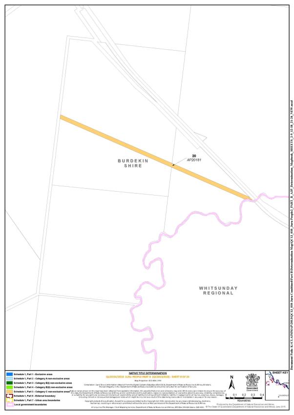
Lot 20 on Plan AP20181 | 9 |
Part 6 – External boundary
Commencing at the north eastern corner of native title determination application QUD544/2010 Juru People (QC2010/005), as accepted for registration on 27 May 2011, at Latitude 19.793130° South and Longitude 148.134685° East and extending south easterly, south, west and generally southerly passing though the following coordinate points:
Longitude (East) | Latitude (South) |
148.350000 | 19.880000 |
148.350000 | 20.046626 |
148.230513 | 20.046626 |
148.183443 | 20.108314 |
148.146910 | 20.186861 |
148.135954 | 20.215472 |
148.129272 | 20.245890 |
148.125391 | 20.272221 |
148.123187 | 20.287284 |
148.116492 | 20.296415 |
148.115274 | 20.311025 |
148.119535 | 20.326245 |
148.119522 | 20.337220 |
148.123795 | 20.349985 |
148.120143 | 20.364595 |
148.123187 | 20.370682 |
148.131099 | 20.377987 |
then north westerly to the eastern boundary of the northern severance of Lot 36 on Plan HR1868 at Latitude 20.305445° South; being a point on the eastern boundary of native title determination application QUD6244/1998 Birriah People (QC1998/012), as accepted for registration 14 August 2007; then generally northerly and again generally westerly along boundaries of that native title determination application to the centreline of the Burdekin River; further described as: then generally northerly along the eastern boundaries of the northern severance of Lot 36 on Plan HR1868 to its north eastern most corner; then northerly to the intersection of the eastern boundary of Lot 161 on Plan SP122361 and the northern boundary of an unnamed road reserve at Latitude 20.301993° South; then generally northerly along the eastern boundary of Lot 161 on SP122361 to the southern boundary of Lot 13 on Plan HR1842; then easterly along the southern boundary of that lot and the prolongation easterly of that southern boundary to its intersection with the eastern bank of Euri Creek; then generally northerly along eastern banks of that creek to the southern boundary of Mt Aberdeen Road reserve; then north easterly and generally westerly passing through the following coordinate points:
Longitude (East) | Latitude (South) |
147.973352 | 20.190211 |
147.953092 | 20.187919 |
147.929141 | 20.180326 |
147.904038 | 20.175614 |
147.874685 | 20.171545 |
147.850806 | 20.166802 |
147.821432 | 20.161576 |
147.798701 | 20.153365 |
147.772380 | 20.148076 |
147.746609 | 20.139907 |
147.713519 | 20.131280 |
147.681103 | 20.125499 |
147.646114 | 20.112874 |
147.612466 | 20.105950 |
147.584900 | 20.098352 |
147.555432 | 20.086765 |
147.534574 | 20.079055 |
147.510607 | 20.067950 |
147.493994 | 20.059026 |
147.477961 | 20.048372 |
147.461952 | 20.038863 |
147.443563 | 20.032250 |
147.422122 | 20.025104 |
147.397631 | 20.016852 |
147.373154 | 20.010315 |
147.351133 | 20.004312 |
147.327918 | 19.999467 |
147.302938 | 19.998079 |
147.284633 | 19.995453 |
147.270637 | 19.995634 |
then again westerly along the northern boundary of native determination application QUD6244/1998 Birriah People (QC1998/012); being a line extending to Longitude 147.252990° East and Latitude 19.995860° South to its intersection with the eastern bank of the Burdekin River; then generally northerly and generally easterly along the eastern banks of that river to the easternmost corner of Lot 21 on RP903179; then north easterly to a point on the southern bank of the north arm of the Burdekin River at Longitude 147.493574° East; then generally north easterly along the southern banks of that northern arm of that river to the Coral Sea at Longitude 147.572199° East; then north easterly and generally south easterly passing through the following coordinate points:
Longitude (East) | Latitude (South) |
147.690000 | 19.580000 |
147.820000 | 19.680000 |
then south easterly back to the commencement point.
Part 7 – Urban area boundaries
• The “Bowen urban area”:
Commencing at the western most corner of Lot 233 on RP705709 being a point on the right bank of Salt Creek, then generally north easterly along the right bank of that creek downstream to the intersection with the Coral Sea being a point on the High Water Mark, then generally north-easterly, south easterly, easterly, northerly, southerly, north westerly and south-westerly along the High Water Mark, crossing the mouths of any waterways between the seaward extremities of each of the opposite banks of each such waterways to the north easternmost corner of Lot 308 on SP118066, then generally south easterly, south westerly and north westerly along the boundaries of that lot and western boundary of Lot 309 on SP118066 to again intersect the High Water Mark, then generally south westerly and generally southerly to a point on the eastern boundary of Lot 313 on HR2020 intersected by a line passing through the following coordinate points:
Longitude (East) | Latitude (South) |
148.230513 | 20.046626 |
148.183443 | 20.108314 |
then south westerly along that line to a point on the southern boundary of Lot 73 on HR180 intersected by that aforementioned line, then westerly along the southern boundaries of that lot, Lot 58 on HR180 and Lot 329 on SP151025 to the eastern most corner of Lot 557 on SP240434; then southerly and westerly along the boundaries of that lot, the southern boundary of Woodhouse Road, then by a line to the south-eastern corner of Lot 1 on RP703857, then westerly along the southern boundary of that lot to its western most corner being the right bank of the Don River, then generally northerly along the right bank of that river downstream to the intersection with the prolongation westerly of the centreline of Richmond Road, then easterly along that prolongation to the centreline of Richmond Road, then generally easterly along that centreline to the intersection with the centreline of Mount Nutt Road, then generally northerly along that centreline to a prolongation easterly of the northern most boundary of Lot 3 on SP212250, then generally westerly along that prolongation and the northern boundary of that lot, the northern boundaries of Lot 12 on RP896364 and Lot 31 on RP896355 to the north western most corner of that lot, then generally northerly along the eastern and northern boundaries of Lot 85 on H826, Lot 157 on HR380, the centreline of Murray Avenue, the eastern boundary of Lot 6 on RP715422 and the western boundary of Lot 233 on RP705709 back to point of commencement.
• The “Home Hill urban area”:
Commencing at the northernmost corner of Lot 13 on RP702844 being the intersection with the right bank of the Burdekin River, then generally south-easterly along the north eastern boundary of that lot and Lots 26 on SP185660, 24 on SP100968, 2 on SP146703, 11 on SP164915, 4 on RP865845, 159 on SB104, 2 on RP733026 and 4 on SP123353, then generally south westerly along the eastern boundaries of that lot, Lot 2 on RP706463 and Lot 168 on SP151038 and onwards to the centreline of Darvenzia Road, then generally westerly, southerly and westerly along the centrelines of Darveniza Road, Woods Road and Bojack Road to the intersection with the northern prolongation of the eastern boundary of Lot 385 on SB599, then southerly along that prolongation and generally south westerly along the northern boundaries of Lot 405 on SB678 and Lot 384 on SB738 to its western most corner, then by a prolongation of that northern boundary to an eastern boundary of Lot 71 on SP116364, then generally north westerly along the eastern boundary of that lot to intersect with a prolongation north easterly of the southern boundary of Lot 2 on RP729208, then south westerly along that prolongation, the southern boundaries of Lot 2 on RP729208 and Lot 1 on RP729208, then generally north westerly along the eastern boundary of Lot 3 on RP723689 and southern boundary of Lot 2 on RP731926, then by a line to the intersection of the centreline of Iona Road, then generally north westerly along the centrelines of that road, Hurney Road and Marshall Road, to its intersection with Kirknie Road, then by a line to the easternmost corner of Lot 189 on SB100, then north westerly along its eastern boundary to the right bank of the Burdekin River, then generally north easterly by that right bank downstream to the point of commencement.
Reference datum
Geographical coordinates are in decimal degrees referenced to the Geocentric Datum of Australia (GDA94).
Data reference and source
• Land tenure information obtained from the Digital Cadastral Database, Department of Natural Resources and Mines (Queensland) (June 2014).
• Watercourse boundaries and road boundaries are based where possible on cadastral boundaries obtained from the Digital Cadastral Database, Department of Natural Resources and Mines (Queensland) (June 2014) otherwise digitised from 100K Topographic Map sheets © Commonwealth of Australia and supplied by Geoimage Pty Ltd under licence from Geoscience Australia.
• Native title determination application boundary data sourced from the Department of Natural Resources and Mines (Queensland) or sourced from the National Native Title Tribunal.
Use of coordinates
Where coordinates are used within the description to represent cadastral or topographical boundaries or the intersection with such, they are intended as a guide only. As an outcome of the custodians of cadastral and topographic data continuously recalculating the geographic position of their data based on improved survey and data maintenance procedures, it is not possible to accurately define such a position other than by detailed ground survey.
Prepared by Client Mapping Services, Spatial Data & Mapping, Land and Spatial Information, Department of Natural Resources and Mines (Queensland) (June 2014).
B. Map of Determination
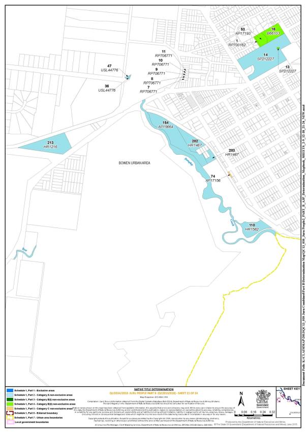
Schedule 2 — AREAS NOT FORMING PART OF THE DETERMINATION AREA
The areas described below do not form part of the Determination Area.
Part A
1. Those land and waters within the external boundary described in Part 6 of Schedule 1, which at the time the native title determination application was made:
(a) were the subject of one or more previous exclusive possession acts, as defined in s 23B of the Native Title Act 1993 (Cth) (despite the fact that the areas, or parts of them, may have been subject to earlier acts that extinguished native title); and
(b) to which none of ss 47, 47A or 47B of the Native Title Act 1993 (Cth) applied,
do not form part of the Determination Area on the basis that they could not be claimed, in accordance with s 61A of the Native Title Act 1993 (Cth).
2. Specifically, and to avoid any doubt, the land and waters referred to in paragraph 1 above include the acts described in ss 23B(2) and 23B(3) of the Native Title Act 1993 (Cth) to which s 20 of the Native Title (Queensland) Act 1993 (Qld) applies and include, but are not limited to, the whole of the land and waters described as:
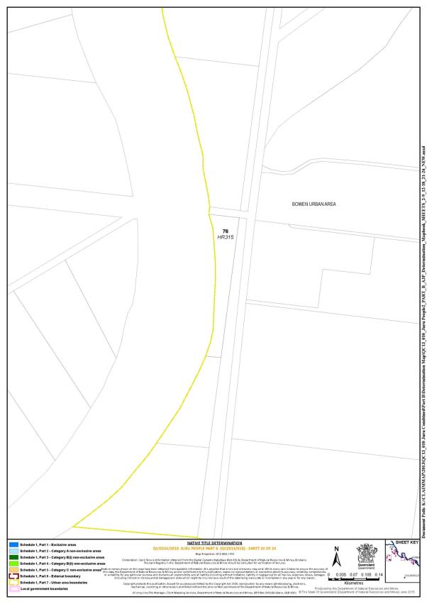
(a) Lot 76 on Plan HR315;
(b) Lot 7 on Plan RP706771;
(c) Lot 8 on Plan RP706771;
(d) Lot 9 on Plan RP706771;
(e) Lot 10 on Plan RP706771;
(f) Lot 11 on Plan RP706771;
(g) Lot 247 on Plan HR1633;
(h) Lot 222 on Plan SP189779;
(i) Lot 255 on HR1287;
(j) Lot 296 on Plan HR1866;
(k) Lot 321 on Plan HR1953; and
(l) Lot 329 on SP151025.
3. Specifically, and to avoid any doubt, the land and waters described in paragraph 1 above include the land or waters upon which any public work, as defined in s 253 of the Native Title Act 1993 (Cth), is or was constructed, established, or situated, and to which ss 23B(7) and 23C(2) of the Native Title Act 1993 (Cth) and / or s 21 of the Native Title (Queensland) Act 1993 (Qld) applies, together with any adjacent land or waters in accordance with s 251D of the Native Title Act 1993 (Cth), and include but are not limited to the whole of the land and waters described as:
(a) that part of Lot 297 on Plan HR1866 which does not include the area described in Part 2 of Schedule 1;
(b) that part of Lot 207 on Plan SP159339 which does not include the area described in Part 2 of Schedule 1;
(c) Lot 13 on SB181;
(d) Lot 385 on SB599;
(e) Lot 310 on SP198022;
(f) Lot 308 on SP118066;
(g) Lot 240 on HR1130; and
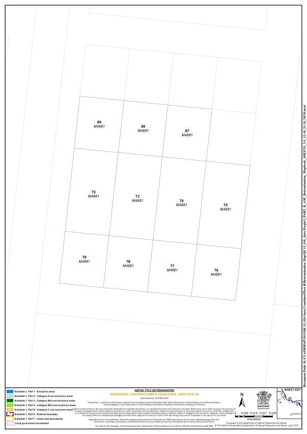
(h) Lots 72, 73, 74, 75, 76, 77, 78, 79, 87, 88, and 89 on Plan M4881.
Part B
Land and waters specifically excluded from QUD554/2010 Juru People native title determination application (QC2013/010) filed on 7 March 2014, being land and waters subject to:
• native title determination application QUD6244/1998 Birriah People (QC1998/012), as accepted for registration by the National Native Title Tribunal on 14 August 2007; and
• the determination made by the Federal Court of Australia on 26 July 2011 in QUD6249/1998 Juru (Cape Upstart) People.
Part C
Land and waters the subject of the determination made by the Federal Court of Australia on 11 July 2014 in QUD544/2010 Juru People (the “Part A” determination).
Schedule 3 – NATIVE TITLE HOLDERS
1. The native title holders are the Juru People. The Juru People are the descendants of one or more of the following people:
(a) Emily Pickard;
(b) Con Lymburner
(c) Nellie Steel / Stell;
(d) Lena Taylor;
(e) William Morrell and his wife Bessie Rook;
(f) Jinnie Ross;
(g) Eliza Lampton (mother of Arthur Lampton); or
(h) Rosie Wake (mother of William and Emma Nicol).
Schedule 4 — OTHER INTERESTS IN THE DETERMINATION AREA
The nature and extent of the other interests in relation to the Determination Area are the following as they exist as at the date of the determination:
1. The rights and interests of the parties under the following agreements:
(a) the Juru People and Ergon Energy indigenous land use agreement QI2014/010 registered on 28 July 2014;
(b) the Juru People and Local Government indigenous land use agreement QI2014/011 registered on 28 July 2014;
(c) the Hancock Alpha Coal Project (Port Area Native Title Group) indigenous land use agreement QI2011/019 registered on the Register of Indigenous Land Use Agreements on 23 March 2012; and
(d) the Port of Abbot Point and Abbot Point State Development Area indigenous land use agreement QI2011/063 registered on the Register of Indigenous Land Use Agreements on 10 May 2012.
2. The rights and interests of Telstra Corporation Limited ACN 051 775 556:
(a) as the owner or operator of telecommunications facilities within the Determination Area;
(b) created pursuant to the Post and Telegraph Act 1901 (Cth), the Telecommunications Act 1975 (Cth), the Australian Telecommunications Corporation Act 1989 (Cth), the Telecommunications Act 1991 (Cth) and the Telecommunications Act 1997 (Cth), including rights:
(i) to inspect land;
(ii) to install and operate its telecommunication facilities;
(iii) to alter, remove, replace, maintain, repair and ensure the proper functioning of its telecommunications facilities;
(c) for its employees, agents or contractors to access its telecommunication facilities in and in the vicinity of the Determination Area in performance of their duties; and
(d) under any lease, licence, access agreement or easement relating to its telecommunications facilities in the Determination Area .
3. The rights and interests of Ergon Energy Corporation ACN 087 646 062 in the Determination Area including Lot 350 on Plan SB337, Lot 84 on Plan USL4498 and Lot 4 on Plan AP9330:
(a) as the owner and operator of any “Works” as that term is defined in the Electricity Act 1994 (Qld) within the Determination Area;
(b) as a distribution entity and the holder of a distribution authority under the Electricity Act 1994 (Qld);
(c) created under the Electricity Act 1994 (Qld) and the Government Owned Corporations Act 1993 (Qld) including:
(i) rights in relation to any agreement relating to the Determination Area existing or entered into before the date on which these orders are made;
(ii) rights to enter the Determination Area by its employees, agents or contractors to exercise any of the rights and interests referred to in this paragraph; and
(iii) to inspect, maintain and manage any Works in the Determination Area.
4. The rights and interests of Aurizon Network Pty Ltd ACN 132 181 116 in relation to rail transport infrastructure under the Transport Infrastructure Act 1994 (Qld).
5. The rights and interests of Hancock Coal Infrastructure Pty Ltd ACN 132 394 122 as preferred developer of Terminal 3 at the Port of Abbot Point, under the T3 Project Framework Agreement dated 2012 between North Queensland Bulk Ports Corporation Limited ACN 136 880 218 and Hancock Coal Infrastructure Pty Ltd.
6. The rights, interests, functions and powers of North Queensland Bulk Ports Corporation Limited ACN 136 880 218 as a port authority under the Transport Infrastructure Act 1994 (Qld).
7. The rights and interests of Burdekin Shire Council and Whitsunday Regional Council:
(a) under their local government jurisdiction and functions under the Local Government Act 2009 (Qld), under the Land Protection (Pest and Stock Route Management Act 2002 (Qld) and under any other legislation, for that part of the Determination Area within the area declared to be their respective local government areas;
(b) as the:
(i) lessor under any leases which were validly entered into before the date on which these orders are made and whether separately particularised in these orders or not;
(ii) grantor of any licences or other rights and interests which were validly granted before the date on which these orders were made and whether separately particularised in these orders or not;
(iii) holder of any estate or interest in land, as trustee of any reserves, that exist in the Determination Area;
(c) as the owner and operator of infrastructure, and those facilities and other improvements located in the Determination Area validly constructed or established on or before the date on which these orders are made, including but not limited to:
(i) undedicated but constructed roads except for those not operated by Council;
(ii) water pipelines and water supply infrastructure;
(iii) drainage facilities;
(iv) watering point facilities;
(d) to enter the land for the purposes described in paragraphs (a), (b) and (c) above by their employees, agents or contractors to:
(i) exercise any of the rights and interests referred to in paragraph 6 above;
(ii) inspect, maintain and repair the infrastructure, facilities and other improvements referred to in paragraph (c) above;
(iii) undertake operational activities in its capacity as a local government such as feral animal control, weed control, erosion control, waste management and fire management.
8. The rights and interests of the State of Queensland or any other person existing by reason of the force and operation of the laws of the State of Queensland, including those existing by reason of the following legislation or any regulation, statutory instrument, declaration, plan, authority, permit, lease or licence made, granted, issued or entered into under that legislation:
(a) the Land Act 1994 (Qld); and
(b) the Fisheries Act 1994 (Qld).
9. The rights and interests of the State of Queensland, Burdekin Shire Council and Whitsunday Regional Council to access, use, operate, maintain and control the dedicated roads in the Determination Area and the rights and interests of the public to use and access the roads.
10. The rights and interests of members of the public arising under the common law, including but not limited to the following:
(a) any subsisting public right to fish; and
(b) the public right to navigate.
11. So far as confirmed pursuant to s 212(2) of the Native Title Act 1993 (Cth) and s 18 of the Native Title Act (Queensland) Act 1993 (Qld) as at the date of this determination, any existing public access to, and enjoyment of, the following places in the Determination Area:
(a) waterways;
(b) beds and banks or foreshores of waterways;
(c) coastal waters;
(d) beaches;
(e) stock routes; and
(f) areas that were public places at the end of 31 December 1993.
12. Any other rights and interests:
(a) held by the State of Queensland or Commonwealth of Australia; or
existing by reason of the force and operation of the Laws of the State and the Commonwealth.
Note: Entry of orders is dealt with in Rule 39.32 of the Federal Court Rules 2011.
QUEENSLAND DISTRICT REGISTRY | |
GENERAL DIVISION | QUD 554 of 2010 |
BETWEEN: | RAYMOND LAMPTON AND OTHERS ON BEHALF OF THE JURU PEOPLE Applicant |
AND: | STATE OF QUEENSLAND AND OTHERS (ACCORDING TO THE SCHEDULE) Respondent |
JUDGE: | RARES J |
DATE: | 22 JUNE 2015 |
PLACE: | BRISBANE |
REASONS FOR JUDGMENT
1 This is the third occasion on which the Court will make a consent determination of some of the Juru people’s native title rights over land and waters with which they have connection. Today’s determination concerns about 200 individual, scattered and relatively small lots in and around the townships of Bowen, Merinda and Home Hill and certain other parcels of rural land and waters within the large area over which I made the second of those consent determinations in Bowen, on 11 July 2014: Lampton on behalf of the Juru People v State of Queensland [2014] FCA 736.
2 Earlier, on 26 July 2011, I made the first of the consent determinations of native title in respect of the land and waters at Cape Upstart, which formed part of the traditional land and waters of the Juru people: Prior on behalf of the Juru (Cape Upstart) People v State of Queensland (No 2) [2011] FCA 819.
3 At the time of the 2014 determination, the parties had not been able to agree as to whether the Juru people’s native title rights and interests continued to exist in any of the land and waters included in today’s consent determination and, if they did, what those rights and interests were. I made orders on 27 June 2014 and 17 July 2014 so that those issues could be resolved in a separate trial, due to commence on 29 January 2015. One of those issues was whether the Juru people had maintained a sufficient connection with parcels of land and waters held by the State of Queensland to give them the benefit of a presumption of native title provided in s 47B(1)(b) of the Native Title Act 1993 (Cth).
4 The 2014 determination also did not include land and waters over which the Commonwealth had exercised its powers for the defence of Australia during World War II. On 13 May 2015, the High Court decided that the effect of the Commonwealth’s exercise of those powers did not extinguish native title: Queensland v Congoo [2015] HCA 17. This decision has now allowed the parties to resolve all outstanding issues in the Juru people’s application for a determination of native title.
5 The law provides that some events that have occurred since European settlement of Australia have extinguished all or some native title rights and interests in our many indigenous peoples’ traditional land and waters. However, the law also recognizes that traditional owners, such as the Juru people, are entitled to exercise all native title rights and interests that now exist over their land and waters. The parties’ agreement for a further and final consent determination to be made today has finally identified all of the land and waters over which the Juru people have native title rights and interests.
6 The scattered parcels of land and waters that are covered in the present consent determination can now be combined with the land and waters in the two earlier ones. The Juru people once again will be able to exercise their native title rights and interests over all of them with the full authority of the law of our nation through the orders of this Court.
Background
7 In preparation for the hearing set to commence on 29 January 2015, the applicant provided additional evidence to the State to support the Juru people’s case. That evidence comprised outlines of evidence that eight lay witnesses would give, an historical report by Dr Rosalind Kidd and a supplementary anthropology report by Dr Sandra Pannell. The State also provided the applicant with the results of some additional tenure research that it had undertaken.
8 Dr Kidd concluded from her review of historical records that, from and after first contact with Europeans in 1859, there was significant evidence of continuous Aboriginal presence in the Kennedy district. That district stretched over an area of about 51,000 square miles, or 132,000 square kilometres, from the coast and contains the towns of Bowen, Euri Creek/Merinda and Inkerman/Home Hill. She found that the Europeans quickly realised the pastoral potential of that district.
9 Dr Kidd located an article in the Sydney Morning Herald of 24 November 1859. That article reported the discovery of a new harbour in Edgecumbe Bay by Captain Sinclair, the master of the ship Santa Barbara. He named the harbour Port Denison. In 1861, Port Denison was renamed Bowen. The article reported Captain Sinclair had said that when the ship anchored near Gloucester Island in mid-October 1859:
The natives came off to us in canoes, and brought us two casks of water, for which we gave them two tomahawks and sundry articles of wearing apparel. They appeared very anxious for us to go ashore, which we declined.
10 Dr Kidd said that the article reported that several Aboriginal men again came aboard the ship the following morning, and again urged the crew to land. They offered to bring more fresh water, and returned with two filled buckets provided by the crew. When men from a second canoe also boarded, the crew discovered they had weapons hidden under the shirts given to them the previous day. They left hurriedly when challenged:
The natives here appeared to be very strong and daring, and more ingenious than any part of the coast we have visited. Their canoes are formed with three pieces of bark sewn together with grass-tree, and forming very pretty models. They are exceedingly light and buoyant, and are capable of carrying five men.
11 Over many years the Juru people have since shown similar qualities in seeking orders under the Native Title Act recognising their rights and interests in the three consent determinations that now cover a considerable area of the land and waters that were theirs in and before 1859.
12 Dr Pannell’s supplementary report specifically considered the anthropological issues relating to the Bowen, Merinda, Home Hill and rural areas. She opined that contemporary Juru people know about their laws and customs, because each earlier generation had passed these on orally to the next generation or because each generation had observed and been instructed about them through interacting with other Juru and Birri Gubba people. While Dr Pannell could not say unequivocally that the Juru people had acknowledged and observed those laws and customs continuously since European settlement, nonetheless, in her opinion, it was likely that they had done so. That was because, she said, there was considerable evidence that this had occurred for over a century. She observed that some adaptations had occurred to those laws and customs as a result of the Juru people’s interactions with the European settlers. However, Dr Pannell considered that the Juru people appeared to have continued substantially to acknowledge and observe their traditional laws and customs.
13 Dr Pannell identified ways in which Juru people expressed their physical, social and spiritual connection with the areas over which I will make the new consent determination today. She also opined that, under their traditional laws and customs, the Juru people held their native title rights and interests in their traditional lands and waters to the exclusion of all others.
14 Of course, the consent determinations of 2011, 2014 and today must take into account the impact of the Native Title Act and common law on the extent to which the Court can recognise those native title rights and interests in light of all that has happened since European settlement. Therefore, the consent determinations provide that in some areas the Juru people can exercise their rights and interests to the exclusion of everyone else while in other areas they can do so non-exclusively.
15 Geoffrey Renouf is the acting director of claim resolution within the Aboriginal and Torres Strait Islander Land Services of the State’s Department of Natural Resources and Mines. He said in his affidavit of 5 June 2015 that he had overall responsibility for the management of these proceedings.
16 Mr Renouf said that each of counsel for the State, solicitors from Crown Law, an expert anthropologist and an expert historian engaged by the State reviewed the new material provided by the applicant for the separate trial. Once he had considered those reviews, Mr Renouf then instructed Crown Law to negotiate the terms of a draft consent determination. Those settlement negotiations resulted in the parties’ application, that I granted on 17 December 2014, to vacate the 29 January 2015 hearing with a view to me making a consent determination today.
17 Mr Renouf explained that the parties wanted the operation of orders 2 and 3 in the consent determination to be suspended for 12 months to allow time for further negotiations to resolve two outstanding matters. He said that was because the parties had to deal with, first, some unauthorised structures that have been erected on the areas referred to in order 2 and, secondly, the safe operation of two gun clubs that affects the areas referred to in order 3. I am satisfied that, in those circumstances, it is appropriate to suspend the operation of orders 2 and 3, as the parties seek.
Jurisdictional findings
18 The parties affected by the orders sought in the proposed consent determination are the applicant, the State, the Commonwealth, Whitsunday Regional Council, Burdekin Shire Council, Ergon Energy Corporation Limited, Telstra Corporation Limited, Aurizon Network Pty Ltd, Aurizon Property Pty Ltd, Hancock Coal Infrastructure Pty Ltd and several persons operating commercial fishing businesses. Those parties signed an agreement under s 87(1) of the Native Title Act for the making of the proposed consent determination. That agreement was filed on 10 June 2015.
19 I have already made findings in my reasons for judgment in the two previous consent determinations as to why anthropological evidence in support of the current existence of native title rights and interests was, and having regard to the matters to which I have referred above, remains sufficient to enable the Court to exercise its special power to make the proposed consent a determination under s 87(2) of the Act without a fully contested trial of this question.
20 All of the land and waters over which the parties have agreed that I should make today’s consent determination are wholly within the wider geographical area that was the subject of the 2014 consent determination. In addition, I found that Kyburra Munda Yalga Aboriginal Corporation was a prescribed body corporate and was an appropriate person to hold native title on trust for the purposes of s 56 of the Act, as the present proposed consent determination also contemplates: Lampton [2014] FCA 736. That is still the position.
21 The Court may make an order in the terms of the proposed consent determination without holding a hearing, if it considers that an order in those terms is within its power and it is appropriate to do so, as s 87(2) provides.
22 I am satisfied that an order in those terms is within the power of the Court, for the purposes of s 87(2), because:
first, each of the original applications, and the current amended application, is valid and each was made in accordance with the Act (ss 61, 64, 81);
secondly, the amended application relates to an area in relation to which there is no approved determination of native title (ss 13(1)(a) and 61A(1)); and
thirdly, the proposed orders comply with the requirements of ss 94A and 225 because they set out, in relation to the land and waters specified, the group of persons holding the common or group rights comprising the native title, the nature and extent of each of the native title and other rights and interests, the relationship between those native title and other rights and interests and because they acknowledge where the Juru people’s native title rights and interests to possession, occupation, use and enjoyment of the land and waters will, or will not, be to the exclusion of others.
23 Accordingly, for the reasons that I gave for making the 2014 determination and having regard to the further material to which I have referred today, I am satisfied that it is appropriate to act on the basis of those earlier findings and the further material in respect of the identity of the apical ancestors of the Juru people, the continuing connection of the Juru people to the land and waters within the claim area and the appropriateness of Kyburra Munda Yalga Aboriginal Corporation to hold native title interests on trust for the Juru people.
Conclusion
24 The Court congratulates the parties in achieving this important milestone and in finalizing this whole claim. It will give the Juru people certainty about the entire area of land and waters over which they can exercise their traditional native title rights and interests, substantially with the protection both of their own laws and customs, as well as of the orders of this Court that I now make.
I certify that the preceding twenty-four (24) numbered paragraphs are a true copy of the Reasons for Judgment herein of the Honourable Justice Rares. |
Associate:
SCHEDULE
QUD 554 OF 2010
BETWEEN:
RAYMOND LAMPTON, RAYMOND GASTON, COLLEEN POWER, RAYLENE OUI, TANYA CHATFIELD, IRIS GLENBAR, LENORA ALDRIDGE AND VINCENT MUNDRABY
Applicant
AND:
STATE OF QUEENSLAND | First Respondent |
COMMONWEALTH OF AUSTRALIA | Second Respondent |
WHITSUNDAY REGIONAL COUNCIL | Third Respondent |
BURDEKIN SHIRE COUNCIL | Fourth Respondent |
ERGON ENERGY CORPORATION | Fifth Respondent |
PAUL CURTEIS, MELLASANNE GRAY, NOEL GRAY, KAREN QUADRELL, MATT QUADRELL, NATHAN RYNN, TRAVIS RYNN, GFB DEVELOPMENTS PTY LTD | Sixth Respondent |
AURIZON NETWORK PTY LTD, AURIZON PROPERTY PTY LTD | Seventh Respondent |
HANCOCK COAL INFRASTRUCTURE PTY LTD | Eighth Respondent |
TELSTRA CORPORATION LIMITED | Ninth Respondent |

