
FEDERAL COURT OF AUSTRALIA
McKellar on behalf of the Budjiti People v State of Queensland [2015] FCA 601
IN THE FEDERAL COURT OF AUSTRALIA | |
First Applicant MELISSA BRYAN Second Applicant PHILLIP EULO Third Applicant MARGARET HEARN Fourth Applicant CAROLYN HOOPER Fifth Applicant ELIZABETH MCNIVEN Sixth Applicant | |
AND: | First Respondent BULLOO SHIRE COUNCIL Second Respondent PAROO SHIRE COUNCIL Third Respondent ERGON ENERGY CORPORATION LIMITED Fourth Respondent TELSTRA CORPORATION LIMITED Fifth Respondent BRIDGEFIELD PTY LIMITED Sixth Respondent DELHI PETROLEUM PTY LTD Seventh Respondent MOONIE PIPELINE COMPANY PTY LTD Eighth Respondent ORIGIN ENERGY CSG LIMITED Ninth Respondent SANTOS LIMITED Tenth Respondent VAMGAS PTY LTD Eleventh Respondent GEOFF BARTON Twelfth Respondent BUNDOONA NOMINEES PTY LTD Thirteenth Respondent FAY MARY COONEY Fourteenth Respondent GRANT PATRICK COONEY Fifteenth Respondent EILEEN JEAN EASTON Sixteenth Respondent GORDON CHARLES EASTON Seventeenth Respondent RANDALL KENNETH NEWSHAM Eighteenth Respondent GREGORY NOEL VICARY SHERWIN Nineteenth Respondent |
DATE OF ORDER: | |
WHERE MADE: | CURRAWINYA WOOLSHED |
BEING SATISFIED that an order in the terms set out below is within the power of the Court, and it appearing appropriate to the Court to do so, pursuant to s 87 of the Native Title Act 1993 (Cth)
BY CONSENT THE COURT ORDERS THAT:
1. There be a determination of native title in the terms set out below (the Determination).
2. The Determination will take effect upon the agreements referred to in paragraph 1(a)-(q) of Schedule 4 being registered on the Register of Indigenous Land Use Agreements.
3. In the event that the agreements referred to in paragraph 2 are not registered on the Register of Indigenous Land Use Agreements within six (6) months of the date of this order or such later time as this Court may order, the matter is to be listed for further directions.
4. Each party to the proceedings is to bear its own costs.
BY CONSENT THE COURT DETERMINES THAT:
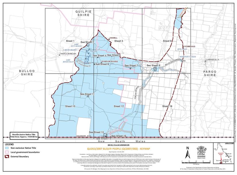
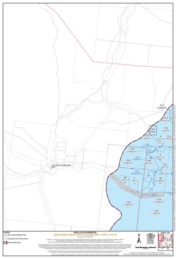
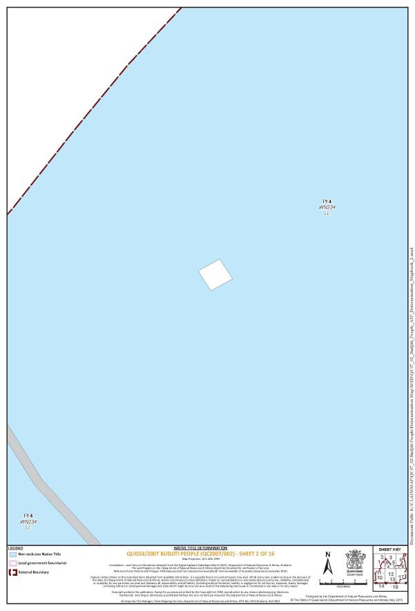
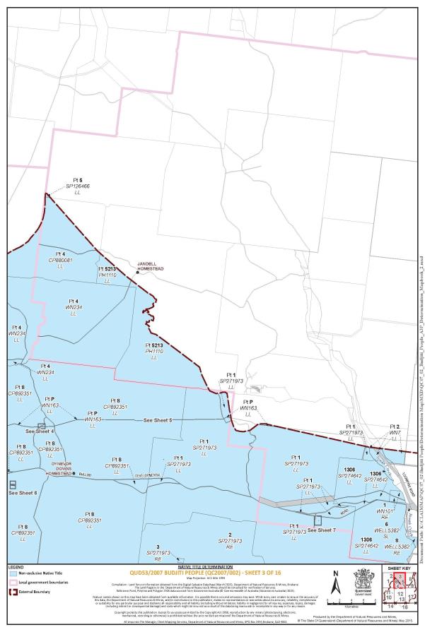
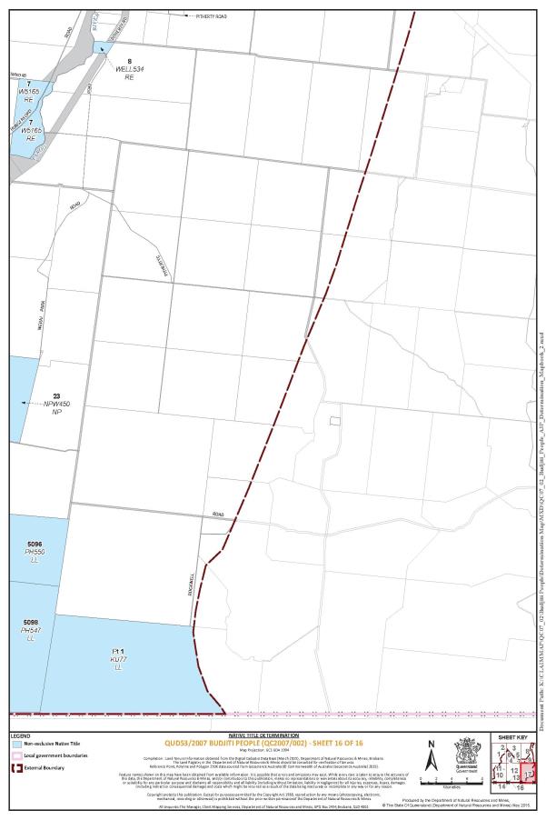
5. The Determination Area is the land and waters described in Schedule 1A and depicted on the map attached to Schedule 1B.
6. Native title exists in relation to the Determination Area described in Part 1 of Schedule 1.
7. The native title is held by the Budjiti People described in Schedule 3 (the native title holders).
8. Subject to paragraphs 9, 10 and 11 below, the nature and extent of the native title rights and interests in relation to the land and waters described in Part 1 of Schedule 1A are the non-exclusive rights to:
(a) access, be present on, move about on and travel over the area;
(b) camp, and live temporarily on the area as part of camping, and for that purpose build temporary shelters;
(c) hunt, fish and gather on the land and waters of the area for personal, domestic and non-commercial communal purposes;
(d) take, use, share and exchange Natural Resources from the land and waters of the area for personal, domestic and non-commercial communal purposes;
(e) take and use the Water of the area for personal, domestic and non-commercial communal purposes;
(f) conduct ceremonies and hold meetings on the area;
(g) be buried and bury native title holders within the area;
(h) maintain places of importance and areas of significance to the native title holders under their traditional laws and customs and protect those places and areas from physical harm;
(i) teach on the area the physical and spiritual attributes of the area;
(j) light fires on the area for domestic purposes including cooking, but not for the purpose of hunting or clearing vegetation; and
(k) be accompanied onto the area by certain non-native title holders, being:
(i) spouses and other immediate family members of native title holders, pursuant to the exercise of traditional laws and customs; and
(ii) people required under the traditional laws acknowledged and traditional customs observed by the native title holders for the performance of, or participation in ceremonies.
9. The native title rights and interests are subject to and exercisable in accordance with:
(a) the Laws of the State and the Commonwealth; and
(b) the traditional laws acknowledged and traditional customs observed by the native title holders.
10. The native title rights and interests referred to in paragraph 8 do not confer possession, occupation, use or enjoyment to the exclusion of all others.
11. There are no native title rights in or in relation to minerals as defined by the Mineral Resources Act 1989 (Qld) and petroleum as defined by the Petroleum Act 1923 (Qld) and the Petroleum and Gas (Production and Safety) Act 2004 (Qld).
12. The nature and extent of any other interests in relation to the Determination Area (or respective parts thereof) are set out in Schedule 4.
13. The relationship between the native title rights and interests described in paragraph 8 and the other interests described in Schedule 4 (the other interests) is that:
(a) the other interests continue to have effect, and the rights conferred by or held under the other interests may be exercised notwithstanding the existence of the native title rights and interests;
(b) to the extent the other interests are inconsistent with the continued existence, enjoyment or exercise of the native title rights and interests in relation to the land and waters of the Determination Area, the native title continues to exist in its entirety but the native title rights and interests have no effect in relation to the other interests to the extent of the inconsistency for so long as the other interests exist; and
(c) the other interests and any activity that is required or permitted by or under, and done in accordance with, the other interests, or any activity that is associated with or incidental to such an activity, prevail over the native title rights and interests and any exercise of the native title rights and interests.
14. The Applicant (through the Prescribed Body Corporate), the State of Queensland, or any other Respondent Party have liberty to apply to the Court on 14 days’ notice to establish the precise location and boundaries of any public works and adjacent land and waters referred to in Schedule 2.
DEFINITIONS AND INTERPRETATION
15. In this Determination, unless the contrary intention appears:
“land” and “waters”, respectively, have the same meanings as in the Native Title Act 1993 (Cth); |
“Laws of the State and the Commonwealth” means the common law and the laws of the State of Queensland and the Commonwealth of Australia, and includes legislation, regulations, statutory instruments, local planning instruments and local laws; |
“Local Government Act” has the same meaning as in the Local Government Act 2009 (Qld); |
“Local Government Area” has the same meaning as in the Local Government Act 2009 (Qld); |
“Natural Resources” means: (a) any animal, plant, fish and bird life found on or in the lands and waters of the Determination Area; and (b) any clays, soil, sand, gravel or rock found on or below the surface of the Determination Area that have traditionally been taken and used by the native title holders, but does not include: (a) animals that are the private personal property of another; (b) crops that are the private personal property of another; and (c) minerals as defined in the Mineral Resources Act 1989 (Qld) or petroleum as defined in the Petroleum Act 1923 (Qld) and the Petroleum and Gas (Production and Safety) Act 2004 (Qld); |
“Plant” has the same meeting as in the Nature Conservation Act 1992 (Qld); “Reserves” means reserves that are dedicated or taken to be reserves under the Land Act 1994 (Qld); |
“Water” means: (a) water which flows, whether permanently or intermittently, within a river, creek or stream; (b) water from an underground water source; and (c) any natural collection of water, whether permanent or intermittent. |
Other words and expressions used in this Determination have the same meanings as they have in Part 15 of the Native Title Act 1993 (Cth).
THE COURT DETERMINES THAT:
16. The native title is held in trust.
17. The Budjiti Aboriginal Corporation (ICN: 8210), incorporated under the Corporations (Aboriginal and Torres Strait Islander) Act 2006 (Cth), is to:
(a) be the prescribed body corporate for the purpose of ss 56(2)(b) and 56(3) of the Native Title Act 1993 (Cth); and
(b) perform the functions mentioned in s 57(1) of the Native Title Act 1993 (Cth) after becoming a registered native title body corporate.
Schedule 1 – DETERMINATION AREA
A. Description of Determination Area
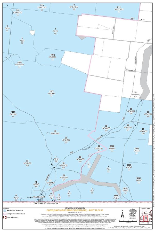
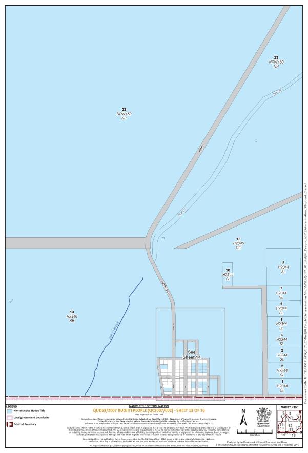
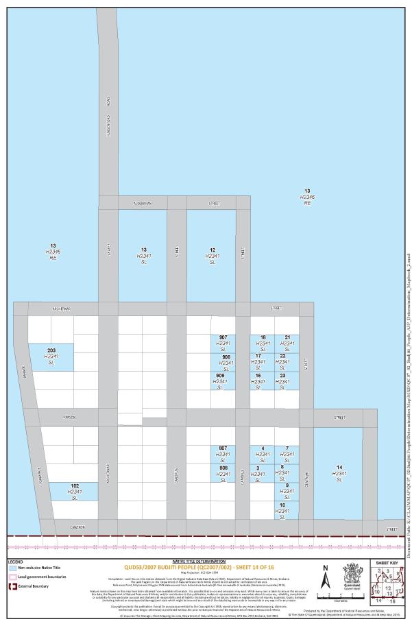
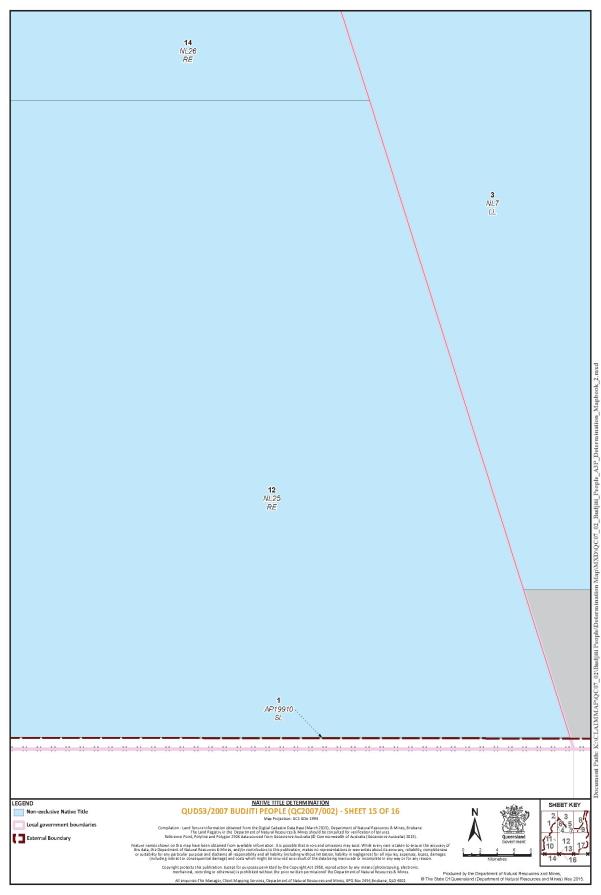
The Determination Area comprises all of the following land and waters described in Part 1 of Schedule 1A to the extent that they fall within the External Boundary described in Part 2 of Schedule 1A and depicted in the Map at Schedule 1B, excluding the areas described in Schedule 2.
Part 1 – Non-Exclusive Areas
(a) The land and waters comprised of the lots and part lots listed below:
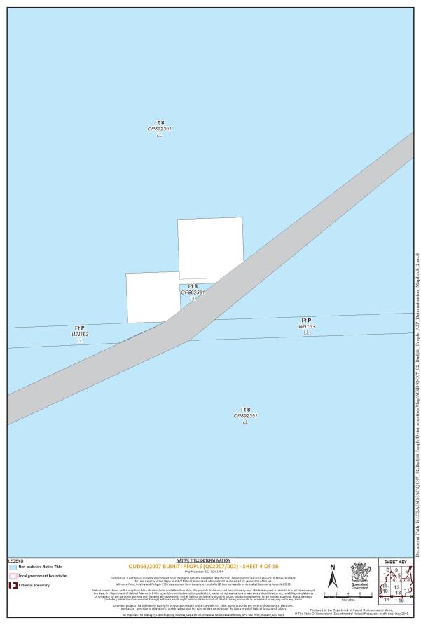
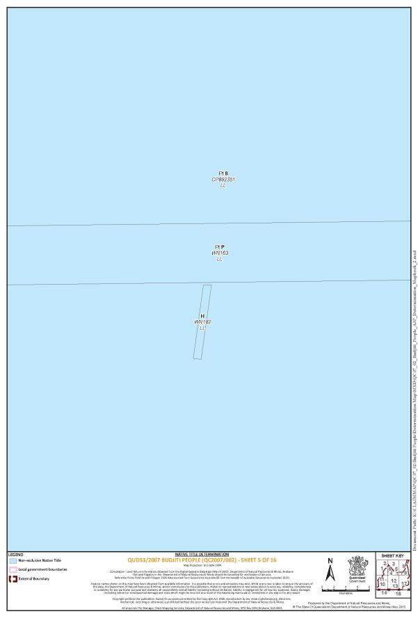
That part of Lot 8 on CP892351 that falls within the External Boundary |
Lot 10 on WN123 |
Lot 15 on NPW591 |
Lot 1 on WN125 |
Lot 2 on WN125 |
That part of Lot 4 on WN234 that falls within the External Boundary |
That part of Lot 4 on CP880081 that falls within the External Boundary |
Lot 1 on WN19 |
That part of Lot 5 on SP126466 that falls within the External Boundary |
That part of Lot 5213 on PH1110 that falls within the External Boundary |
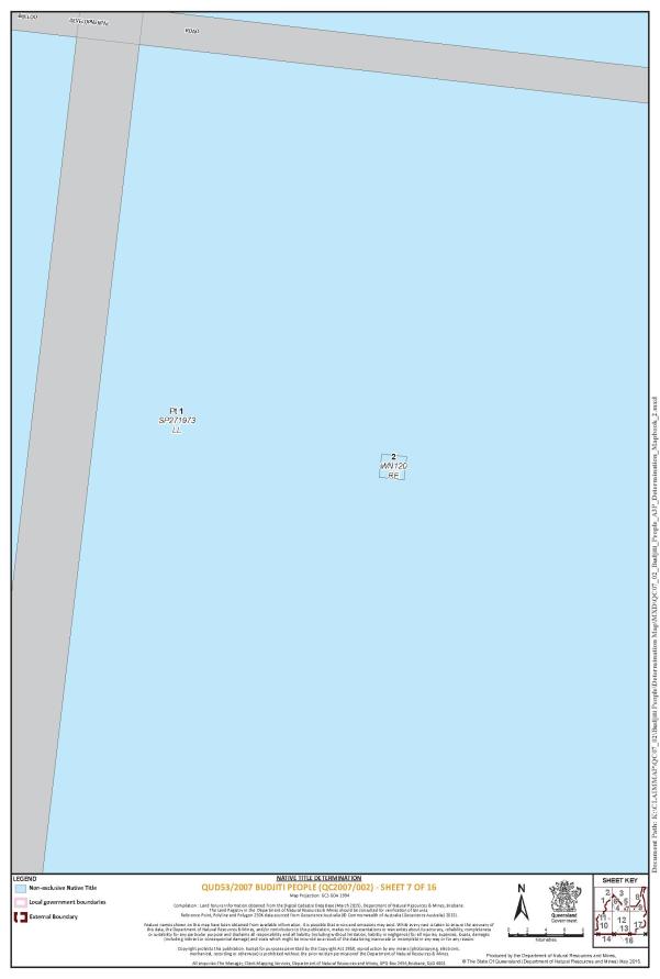
That part of Lot 1 on SP271973 that falls within the External Boundary |
Lot 1306 on SP274642 |
That part of Lot 2 on WN7 that falls within the External Boundary |
Lot 1 on WN101 |
Lot 6 on WELL5382 |
Lot 8 on WELL5382 |
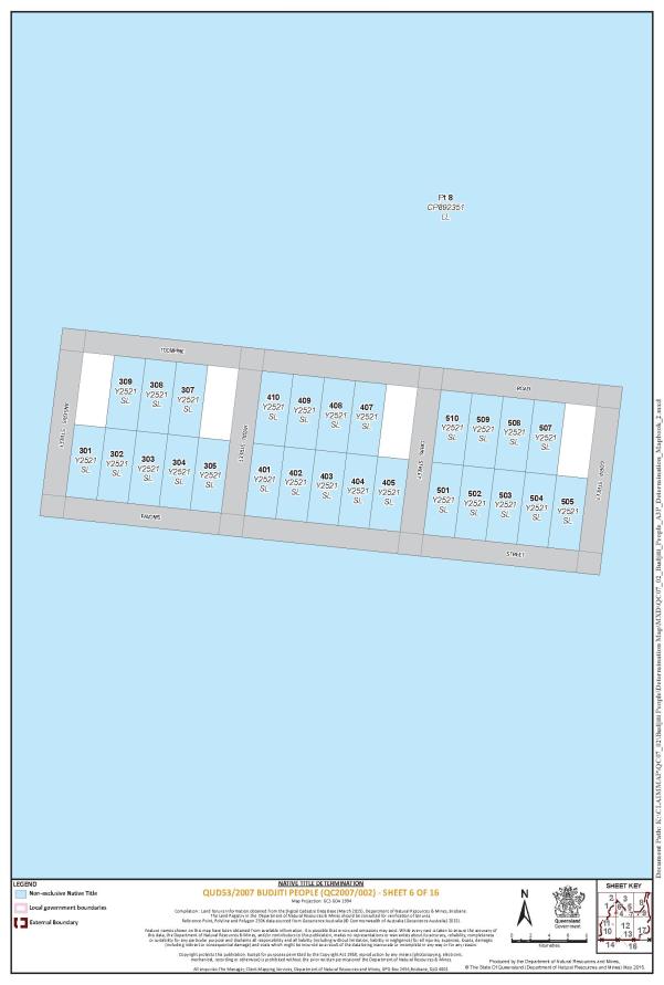
Lot 301 on Y2521 |
Lot 302 on Y2521 |
Lot 303 on Y2521 |
Lot 304 on Y2521 |
Lot 305 on Y2521 |
Lot 307 on Y2521 |
Lot 308 on Y2521 |
Lot 309 on Y2521 |
Lot 401 on Y2521 |
Lot 402 on Y2521 |
Lot 403 on Y2521 |
Lot 404 on Y2521 |
Lot 405 on Y2521 |
Lot 407 on Y2521 |
Lot 408 on Y2521 |
Lot 409 on Y2521 |
Lot 410 on Y2521 |
Lot 501 on Y2521 |
Lot 502 on Y2521 |
Lot 503 on Y2521 |
Lot 504 on Y2521 |
Lot 505 on Y2521 |
Lot 507 on Y2521 |
Lot 508 on Y2521 |
Lot 509 on Y2521 |
Lot 510 on Y2521 |
Lot 2 on WN120 |
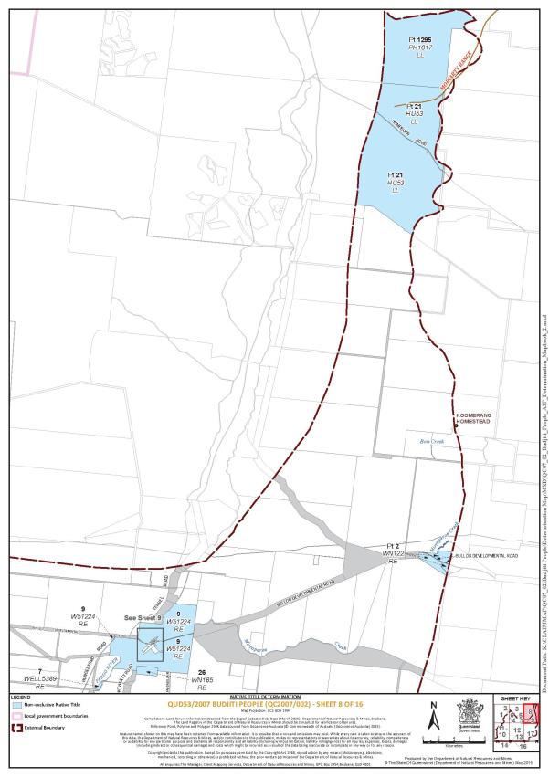
That part of Lot 1295 on PH1617 that falls within the External Boundary |
That part of Lot 21 on HU53 that falls within the External Boundary |
That part of Lot 2 on WN122 that falls within the External Boundary |
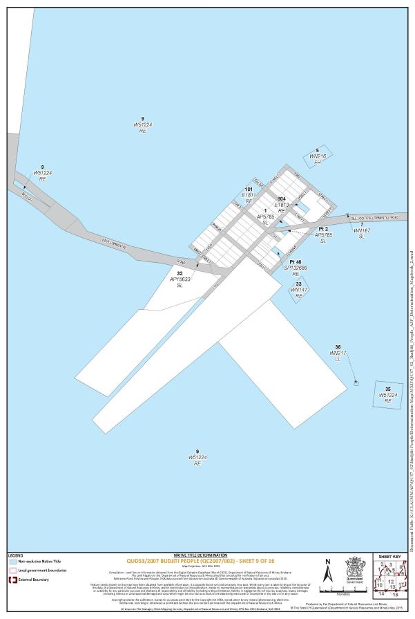
Lot 9 on W51224 |
Lot 26 on WN185 |
Lot 7 on WELL5389 |
Lot 35 on W51224 |
Lot 33 on WN147 |
Lot 5 on WN216 |
Lot 32 on AP15633 |
That part of Lot 46 on SP132689 excluding previous Allotments 6 & 7 of Section 9, Allotment 10 of Section 10 on plan E1813 and an area identified as road to be closed (part of Shea Street) and delineated by station numbers 5-16-14-8-5 on SP132689 . |
Lot 1 on AP5785 |
That part of Lot 2 on AP5785 excluding former Allotment 8 of Section 9 on plan E1813 |
Lot 101 on E1811 |
Lot 804 on E1813 |
Lot 7 on WN187 |
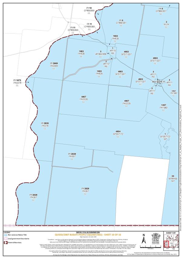
That part of Lot 1673 on PH2276 that falls within the External Boundary |
That part of Lot 2828 on PH276 that falls within the External Boundary |
That part of Lot 2829 on PH307 that falls within the External Boundary |
That part of Lot 23 on NPW450 excluding an area identified as Lot 15 on NL8025469 |
Lot 4904 on SP207172 |
Lot 1 on SP207172 |
Lot 4907 on PH2235 |
That part of Lot 2669 on PH2064 that falls within the External Boundary |
Lot 1803 on PH635 |
Lot 4903 on SP271327 |
Lot 3 on WY11 |
That part of Lot 11 on CP855300 that falls within the External Boundary |
That part of Lot 10 on CP855300 that falls within the External Boundary |
Lot 2 on NL24 |
Lot 1 on WY15 |
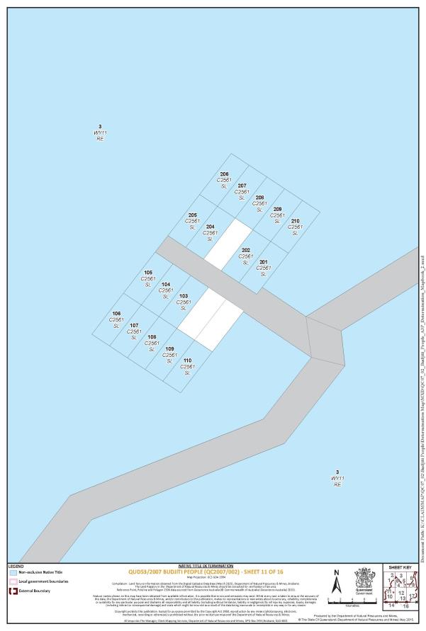
Lot 103 on C2561 |
Lot 104 on C2561 |
Lot 105 on C2561 |
Lot 106 on C2561 |
Lot 107 on C2561 |
Lot 108 on C2561 |
Lot 109 on C2561 |
Lot 110 on C2561 |
Lot 201 on C2561 |
Lot 202 on C2561 |
Lot 204 on C2561 |
Lot 205 on C2561 |
Lot 206 on C2561 |
Lot 207 on C2561 |
Lot 208 on C2561 |
Lot 209 on C2561 |
Lot 210 on C2561 |
Lot 1 on NL24 |
Lot 5096 on PH550 |
Lot 5098 on PH547 |
Lot 1 on NL13 |
Lot 12 on NL25 |
Lot 1 on AP19910 |
Lot 1 on NL7 |
Lot 2 on NL7 |
Lot 3 on NL7 |
Lot 13 on H2346 |
Lot 11 no NL12 |
Lot 1 on H2344 |
Lot 2 on H2344 |
Lot 3 on H2344 |
Lot 4 on H2344 |
Lot 5 on H2344 |
Lot 6 on H2344 |
Lot 7 on H2344 |
Lot 8 on H2344 |
Lot 10 on H2344 |
Lot 3 on H2341 |
Lot 4 on H2341 |
Lot 7 on H2341 |
Lot 8 on H2341 |
Lot 9 on H2341 |
Lot 10 on H2341 |
Lot 12 on H2341 |
Lot 13 on H2341 |
Lot 14 on H2341 |
Lot 16 on H2341 |
Lot 17 on H2341 |
Lot 18 on H2341 |
Lot 21 on H2341 |
Lot 22 on H2341 |
Lot 23 on H2341 |
Lot 203 on H2341 |
Lot 907 on H2341 |
Lot 908 on H2341 |
Lot 909 on H2341 |
Lot 807 on H2341 |
Lot 808 on H2341 |
Lot 14 on NL26 |
Lot 1 on AP19910 |
Lot 8 on WELL534 |
Lot 7 on W5165 |
That part of Lot 1 on KU77 that falls within the External Boundary |
Lot 2 on WY12 |
Lot 2 on SP271973 |
Lot 3 on SP271973 |
Lot 1257 on PH1992 |
Lot 4852 on PH1531 |
That part of Lot 36 on WN217 that is not subject to the Eulo Telecommunications Facility, which is a public work as defined in paragraph 2(b) of schedule 2 |
Lot 3 on WY802468 |
That part of Lot 102 on H2341 that is not subject to the Hungerford Telecommunications Facility, which is a public work as defined in paragraph 2(b) of schedule 2 |
(b) The waters within the External Boundary Description including but not limited to:
(i) Paroo River;
(ii) Bow Creek;
(iii) Bundilla Creek;
(iv) Mirraparoo Creek; and
(v) Yowah Creek.
Part 2 - External Boundary of the Determination Area
The External Boundary of the Determination Area commences at a point on the Queensland – New South Wales State Border at Longitude 143.684697° East, a point on the Kullilli People Native Title Determination external boundary, and extending generally northerly and generally north-easterly along that external boundary to Latitude 27.686700° South, further described as:
Generally northerly and generally north-easterly along a ridgeline to Longitude 144.067132° East, Latitude 28.175252° South, about 32 km south-easterly of Thargomindah and about 3 km easterly of Dynevor Downs No. 9 Bore passing through the following coordinate points.
Longitude East | Latitude South | |||
143.684528 | 28.997830 | |||
143.684328 | 28.996186 | |||
143.684424 | 28.992798 | |||
143.685031 | 28.988488 | |||
143.685773 | 28.984522 | |||
143.686906 | 28.980666 | |||
143.687782 | 28.977100 | |||
143.689501 | 28.973185 | |||
143.690183 | 28.969850 | |||
143.691130 | 28.966916 | |||
143.691476 | 28.962493 | |||
143.692596 | 28.957433 | |||
143.692932 | 28.951920 | |||
143.692811 | 28.946524 | |||
143.693144 | 28.940896 | |||
143.692972 | 28.936591 | |||
143.692976 | 28.930678 | |||
143.692847 | 28.924422 | |||
143.692798 | 28.919600 | |||
143.692286 | 28.914149 | |||
143.691318 | 28.908587 | |||
143.690095 | 28.903658 | |||
143.688352 | 28.898848 | |||
143.685427 | 28.893012 | |||
143.684660 | 28.888080 | |||
143.684282 | 28.882973 | |||
143.685335 | 28.877627 | |||
143.686198 | 28.872799 | |||
143.689203 | 28.867210 | |||
143.691114 | 28.862948 | |||
143.694719 | 28.858790 | |||
143.698459 | 28.855148 | |||
143.704422 | 28.852180 | |||
143.708772 | 28.850715 | |||
143.714753 | 28.849583 | |||
143.719763 | 28.848975 | |||
143.726019 | 28.849219 | |||
143.732736 | 28.849977 | |||
143.739245 | 28.849473 | |||
143.745550 | 28.848110 | |||
143.749368 | 28.845615 | |||
143.753442 | 28.842832 | |||
143.757112 | 28.838501 | |||
143.759038 | 28.835789 | |||
143.761405 | 28.831581 | |||
143.763446 | 28.827261 | |||
143.764444 | 28.822949 | |||
143.766487 | 28.812429 | |||
143.767145 | 28.806741 | |||
143.767622 | 28.802375 | |||
143.767629 | 28.796634 | |||
143.767186 | 28.791470 | |||
143.765968 | 28.787000 | |||
143.764231 | 28.782764 | |||
143.762374 | 28.779562 | |||
143.760045 | 28.774698 | |||
143.757978 | 28.770062 | |||
143.754799 | 28.764859 | |||
143.752077 | 28.759826 | |||
143.749542 | 28.754045 | |||
143.748446 | 28.748599 | |||
143.747397 | 28.741659 | |||
143.746894 | 28.737127 | |||
143.746384 | 28.731849 | |||
143.746671 | 28.728058 | |||
143.748055 | 28.723169 | |||
143.750031 | 28.718965 | |||
143.751690 | 28.715566 | |||
143.753734 | 28.711534 | |||
143.756108 | 28.708015 | |||
143.758355 | 28.704785 | |||
143.759305 | 28.702138 | |||
143.759926 | 28.699148 | |||
143.760929 | 28.695295 | |||
143.761014 | 28.690817 | |||
143.759996 | 28.686748 | |||
143.758664 | 28.683944 | |||
143.756356 | 28.681146 | |||
143.753005 | 28.678356 | |||
143.749057 | 28.674422 | |||
143.746812 | 28.671452 | |||
143.743392 | 28.668260 | |||
143.740426 | 28.664893 | |||
143.737578 | 28.660263 | |||
143.735972 | 28.656083 | |||
143.735741 | 28.652525 | |||
143.736942 | 28.648900 | |||
143.738474 | 28.645847 | |||
143.740714 | 28.641813 | |||
143.742317 | 28.639506 | |||
143.745393 | 28.634490 | |||
143.748414 | 28.630508 | |||
143.750591 | 28.626877 | |||
143.753222 | 28.622955 | |||
143.756172 | 28.618342 | |||
143.757688 | 28.613682 | |||
143.759075 | 28.609194 | |||
143.759942 | 28.604768 | |||
143.760357 | 28.600746 | |||
143.760443 | 28.596325 | |||
143.760917 | 28.591729 | |||
143.760552 | 28.587828 | |||
143.759476 | 28.584448 | |||
143.757490 | 28.581304 | |||
143.754200 | 28.578054 | |||
143.751568 | 28.575546 | |||
143.748540 | 28.572410 | |||
143.746229 | 28.569383 | |||
143.743980 | 28.565953 | |||
143.743931 | 28.561189 | |||
143.743833 | 28.557917 | |||
143.744054 | 28.554299 | |||
143.744210 | 28.550279 | |||
143.743455 | 28.546610 | |||
143.742306 | 28.542370 | |||
143.741227 | 28.538933 | |||
143.740461 | 28.534001 | |||
143.738717 | 28.529133 | |||
143.735025 | 28.524795 | |||
143.731928 | 28.521314 | |||
143.728439 | 28.517664 | |||
143.724758 | 28.514474 | |||
143.721406 | 28.511511 | |||
143.719619 | 28.508711 | |||
143.719328 | 28.505785 | |||
143.719367 | 28.503201 | |||
143.720049 | 28.499752 | |||
143.719566 | 28.497172 | |||
143.719473 | 28.494359 | |||
143.720100 | 28.491944 | |||
143.721571 | 28.489293 | |||
143.723622 | 28.486007 | |||
143.725483 | 28.483296 | |||
143.730376 | 28.477579 | |||
143.732763 | 28.475324 | |||
143.734897 | 28.473759 | |||
143.737292 | 28.472193 | |||
143.740598 | 28.470620 | |||
143.744032 | 28.468989 | |||
143.746820 | 28.467535 | |||
143.750827 | 28.464522 | |||
143.753337 | 28.461577 | |||
143.755325 | 28.458521 | |||
143.757638 | 28.455348 | |||
143.759882 | 28.451773 | |||
143.761610 | 28.448776 | |||
143.763724 | 28.445260 | |||
143.764999 | 28.442553 | |||
143.766526 | 28.438983 | |||
143.767800 | 28.436104 | |||
143.769330 | 28.432821 | |||
143.771764 | 28.428672 | |||
143.774341 | 28.425899 | |||
143.777120 | 28.423754 | |||
143.780037 | 28.422299 | |||
143.783213 | 28.420727 | |||
143.785997 | 28.419043 | |||
143.788581 | 28.417131 | |||
143.790699 | 28.414017 | |||
143.793009 | 28.410556 | |||
143.796342 | 28.405252 | |||
143.798128 | 28.401508 | |||
143.800035 | 28.396845 | |||
143.801748 | 28.392356 | |||
143.803064 | 28.387295 | |||
143.803286 | 28.383447 | |||
143.803252 | 28.380060 | |||
143.804643 | 28.375917 | |||
143.807336 | 28.371650 | |||
143.810357 | 28.367726 | |||
143.813637 | 28.363513 | |||
143.817821 | 28.358662 | |||
143.823189 | 28.355008 | |||
143.827399 | 28.352683 | |||
143.831996 | 28.349839 | |||
143.837056 | 28.347795 | |||
143.842106 | 28.344775 | |||
143.846842 | 28.342791 | |||
143.852358 | 28.340687 | |||
143.858596 | 28.339209 | |||
143.865286 | 28.337325 | |||
143.871844 | 28.335155 | |||
143.878076 | 28.333104 | |||
143.884966 | 28.331794 | |||
143.891924 | 28.330656 | |||
143.898632 | 28.330439 | |||
143.905270 | 28.329704 | |||
143.911524 | 28.329834 | |||
143.916752 | 28.331406 | |||
143.921970 | 28.332116 | |||
143.927380 | 28.332424 | |||
143.931859 | 28.330843 | |||
143.936729 | 28.329318 | |||
143.942183 | 28.327616 | |||
143.947441 | 28.326030 | |||
143.952121 | 28.324964 | |||
143.956728 | 28.323268 | |||
143.960489 | 28.321520 | |||
143.963401 | 28.319663 | |||
143.966185 | 28.317865 | |||
143.970071 | 28.315657 | |||
143.973632 | 28.313508 | |||
143.977189 | 28.310956 | |||
143.979246 | 28.308301 | |||
143.980069 | 28.305942 | |||
143.980179 | 28.303989 | |||
143.980287 | 28.301807 | |||
143.980123 | 28.298478 | |||
143.979836 | 28.295897 | |||
143.979226 | 28.293547 | |||
143.977765 | 28.290801 | |||
143.976170 | 28.287655 | |||
143.974317 | 28.284797 | |||
143.971024 | 28.281262 | |||
143.969035 | 28.277830 | |||
143.966845 | 28.273883 | |||
143.964654 | 28.269879 | |||
143.963704 | 28.266269 | |||
143.963140 | 28.261912 | |||
143.964877 | 28.253516 | |||
143.966530 | 28.249543 | |||
143.969369 | 28.246883 | |||
143.972218 | 28.245199 | |||
143.975982 | 28.243681 | |||
143.979959 | 28.244055 | |||
143.983926 | 28.243340 | |||
143.987238 | 28.242398 | |||
143.989898 | 28.241289 | |||
143.992419 | 28.239435 | |||
143.994219 | 28.237012 | |||
143.995632 | 28.235050 | |||
143.998284 | 28.233252 | |||
144.001953 | 28.232605 | |||
144.005348 | 28.232676 | |||
144.010200 | 28.232462 | |||
144.015049 | 28.230539 | |||
144.018990 | 28.227889 | |||
144.022418 | 28.224745 | |||
144.025653 | 28.221945 | |||
144.028630 | 28.218684 | |||
144.030572 | 28.215992 | |||
144.032385 | 28.212553 | |||
144.035556 | 28.208316 | |||
144.038534 | 28.203388 | |||
144.041963 | 28.199842 | |||
144.044164 | 28.196289 | |||
144.047076 | 28.193143 | |||
144.050247 | 28.189365 | |||
144.053612 | 28.185704 | |||
144.056718 | 28.182846 | |||
144.060467 | 28.180679 | |||
144.064480 | 28.178227 | |||
Then generally northerly to the Bulloo Developmental Road passing through the following coordinate points.
Longitude East | Latitude South | |
144.067132 | 28.175252 | |
144.069204 | 28.171584 | |
144.070758 | 28.168316 | |
144.071344 | 28.162744 | |
144.070377 | 28.158600 | |
144.069022 | 28.155490 | |
144.067536 | 28.153241 | |
144.063660 | 28.149140 | |
144.060558 | 28.146423 | |
144.056746 | 28.143243 | |
144.052287 | 28.140349 | |
144.047439 | 28.137853 | |
144.042010 | 28.134721 | |
144.036970 | 28.131075 | |
144.033222 | 28.127493 | |
144.029928 | 28.123050 | |
144.026959 | 28.116311 | |
144.024829 | 28.111529 | |
144.022763 | 28.106461 | |
144.021021 | 28.101682 | |
144.019345 | 28.095523 | |
144.017927 | 28.089424 | |
144.016120 | 28.084127 | |
144.015607 | 28.078262 | |
144.015355 | 28.069869 | |
144.015878 | 28.062285 | |
144.016206 | 28.055791 | |
144.017051 | 28.049991 | |
144.018283 | 28.045514 | |
144.018868 | 28.040344 | |
144.020422 | 28.035581 | |
144.022109 | 28.031279 | |
144.024049 | 28.027898 | |
144.027156 | 28.024752 | |
144.030390 | 28.022180 | |
144.033107 | 28.020010 | |
Then generally north-easterly passing to the west of Lake Bindegolly, Lake Toomaroo and Lake Hutchinson passing through the following coordinate points.
Longitude East | Latitude South |
144.037635 | 28.017619 |
144.041968 | 28.015169 |
144.046432 | 28.011916 |
144.051737 | 28.007976 |
144.055824 | 28.004647 |
144.059132 | 28.000576 |
144.061186 | 27.996242 |
144.062341 | 27.992080 |
144.063042 | 27.987213 |
144.063577 | 27.982574 |
144.065166 | 27.976100 |
144.067013 | 27.969109 |
144.070464 | 27.960166 |
144.072960 | 27.954662 |
144.073595 | 27.952926 |
144.075898 | 27.946637 |
144.078584 | 27.940159 |
144.083270 | 27.933666 |
144.083270 | 27.933666 |
144.086476 | 27.928798 |
144.091226 | 27.922828 |
144.097974 | 27.916909 |
144.104917 | 27.911391 |
144.111542 | 27.907648 |
144.123066 | 27.903487 |
144.132656 | 27.898820 |
144.140634 | 27.894672 |
144.146163 | 27.890131 |
144.152462 | 27.884729 |
144.157604 | 27.880591 |
144.162102 | 27.876511 |
144.166148 | 27.872033 |
144.169547 | 27.867098 |
144.173466 | 27.862791 |
144.177318 | 27.858084 |
144.180849 | 27.853951 |
144.185025 | 27.849643 |
144.189590 | 27.846308 |
144.196085 | 27.841650 |
144.202390 | 27.838366 |
144.210497 | 27.834046 |
144.215706 | 27.829907 |
144.219429 | 27.825601 |
144.222699 | 27.820552 |
144.226225 | 27.814814 |
144.230261 | 27.807244 |
144.234367 | 27.801219 |
144.238280 | 27.795481 |
144.242965 | 27.789455 |
144.247588 | 27.784002 |
144.253889 | 27.779001 |
144.259740 | 27.774745 |
144.265721 | 27.771176 |
144.270677 | 27.768927 |
144.279494 | 27.764834 |
144.285154 | 27.761209 |
144.291070 | 27.756839 |
144.294986 | 27.751674 |
144.299097 | 27.747366 |
144.303463 | 27.742314 |
144.306285 | 27.738469 |
144.308913 | 27.733823 |
144.311410 | 27.729063 |
144.313327 | 27.724019 |
144.315170 | 27.715940 |
144.315859 | 27.709926 |
144.316286 | 27.702425 |
144.316390 | 27.694982 |
144.317077 | 27.687880 |
144.317073 | 27.686700 |
Then generally south-easterly passing through Longitude 144.395150° East, Latitude 27.770780° South to a Longitude 144.438022° East, Latitude 27.806769° south, point about 1.98km westerly of the locality of Jandell; then south easterly along a line drawn to Longitude 144.472591°East, Latitude 27.832120° South for a distance of about 4.4 km to its intersection with a cliff face; then generally south-easterly, generally south-westerly and generally southerly along that cliff face to its southernmost point; then southerly to another cliff face at Longitude 144.479280° East, Latitude 27.871070; then generally westerly, generally south-westerly and easterly along that cliff to its southernmost point at Longitude 144.469760° East; then south-easterly to another cliff face at Longitude 144.472900° East, 27.878470° South; then generally southerly along that cliff to its southernmost point; then generally south-easterly, generally southerly and generally easterly to a point on the Paroo River passing through the following coordinate points.
Longitude East | Latitude South |
144.476048 | 27.888583 |
144.483538 | 27.890888 |
144.494465 | 27.898343 |
144.541671 | 27.932153 |
144.549326 | 27.937894 |
144.551240 | 27.944274 |
144.553154 | 27.950015 |
144.559533 | 27.962773 |
144.564637 | 27.971704 |
144.574205 | 27.975532 |
144.579947 | 27.974894 |
144.584412 | 27.973618 |
144.588240 | 27.973618 |
144.590792 | 27.975532 |
144.591429 | 27.979359 |
144.594619 | 28.000411 |
144.595895 | 28.005514 |
144.597171 | 28.013170 |
144.600998 | 28.024014 |
144.604188 | 28.028480 |
144.609929 | 28.029756 |
144.615033 | 28.030394 |
144.625240 | 28.028480 |
144.631619 | 28.024014 |
144.636722 | 28.020187 |
144.641188 | 28.018911 |
144.647567 | 28.018911 |
144.802583 | 28.052083 |
144.978013 | 28.073135 |
145.014375 | 28.075048 |
145.054564 | 28.075048 |
145.077205 | 28.071676 |
145.084547 | 28.070583 |
Then generally northerly and generally easterly to a point on the ridge of the Moriarty Range through the following coordinate points.
Longitude East | Latitude South |
145.107728 | 28.065531 |
145.117882 | 28.055269 |
145.140498 | 28.032016 |
145.142409 | 28.026357 |
145.146280 | 28.020110 |
145.149297 | 28.018035 |
145.150289 | 28.017347 |
145.151050 | 28.016450 |
145.151685 | 28.014640 |
145.152560 | 28.013509 |
145.188688 | 27.966813 |
145.229548 | 27.911742 |
145.252048 | 27.859635 |
145.272182 | 27.787984 |
145.273959 | 27.722850 |
145.279880 | 27.671924 |
145.285208 | 27.635803 |
145.286986 | 27.604420 |
145.290539 | 27.586656 |
145.296460 | 27.570076 |
145.305934 | 27.542245 |
145.312448 | 27.513230 |
145.316593 | 27.474149 |
145.316693 | 27.424651 |
145.320344 | 27.425977 |
145.323176 | 27.429517 |
145.328131 | 27.432702 |
145.330609 | 27.433410 |
145.334149 | 27.432702 |
145.349017 | 27.430225 |
145.370612 | 27.426685 |
145.379107 | 27.427039 |
145.400347 | 27.422083 |
145.404949 | 27.422083 |
145.408843 | 27.423145 |
145.412736 | 27.424915 |
145.415569 | 27.427039 |
145.420170 | 27.430933 |
145.422976 | 27.434386 |
Then generally southerly along that ridgeline to a point about 4 km south of Koomerang Station passing through the following coordinate points.
Longitude East | Latitude South | |
145.420285 | 27.435168 | |
145.416293 | 27.436097 | |
145.413202 | 27.437137 | |
145.411336 | 27.438116 | |
145.411325 | 27.438128 | |
145.410286 | 27.439368 | |
145.409988 | 27.439724 | |
145.409606 | 27.441214 | |
145.409806 | 27.443160 | |
145.409990 | 27.443431 | |
145.410011 | 27.443637 | |
145.411565 | 27.445922 | |
145.414859 | 27.447915 | |
145.419119 | 27.449848 | |
145.423641 | 27.452925 | |
145.425585 | 27.455953 | |
145.426878 | 27.458466 | |
145.428245 | 27.461197 | |
145.429816 | 27.464908 | |
145.430248 | 27.465938 | |
145.430455 | 27.470060 | |
145.429436 | 27.473613 | |
145.427131 | 27.478487 | |
145.424049 | 27.481932 | |
145.420771 | 27.484805 | |
145.416330 | 27.486766 | |
145.412088 | 27.490672 | |
145.407563 | 27.493260 | |
145.403851 | 27.494878 | |
145.400700 | 27.497179 | |
145.399161 | 27.499302 | |
145.397753 | 27.502283 | |
145.397634 | 27.505204 | |
145.397771 | 27.507722 | |
145.397715 | 27.510299 | |
145.396824 | 27.513794 | |
145.395415 | 27.516719 | |
145.393622 | 27.519759 | |
145.391633 | 27.522742 | |
145.388742 | 27.525557 | |
145.385203 | 27.527458 | |
145.382310 | 27.529757 | |
145.380643 | 27.532339 | |
145.379429 | 27.535721 | |
145.379373 | 27.538297 | |
145.379895 | 27.540242 | |
145.381258 | 27.543158 | |
145.381439 | 27.543488 | |
145.381546 | 27.543718 | |
145.383025 | 27.546421 | |
145.384118 | 27.550649 | |
145.384261 | 27.555114 | |
145.383951 | 27.558837 | |
145.383576 | 27.562445 | |
145.382171 | 27.566342 | |
145.380893 | 27.569724 | |
145.379423 | 27.573508 | |
145.377442 | 27.578438 | |
145.376619 | 27.582906 | |
145.376117 | 27.587030 | |
145.375809 | 27.591554 | |
145.376788 | 27.595330 | |
145.376986 | 27.595544 | |
145.377076 | 27.595890 | |
145.379406 | 27.598401 | |
145.382831 | 27.601253 | |
145.387155 | 27.603129 | |
145.390568 | 27.605455 | |
145.393356 | 27.607403 | |
145.395186 | 27.609825 | |
145.395796 | 27.612960 | |
145.394968 | 27.616283 | |
145.393946 | 27.618634 | |
145.391890 | 27.620874 | |
145.388676 | 27.623288 | |
145.385780 | 27.624729 | |
145.381537 | 27.627949 | |
145.377806 | 27.630365 | |
145.375753 | 27.633406 | |
145.374152 | 27.636618 | |
145.373197 | 27.640228 | |
145.373335 | 27.643090 | |
145.374312 | 27.646178 | |
145.374474 | 27.646339 | |
145.374600 | 27.646738 | |
145.376669 | 27.648793 | |
145.379252 | 27.650273 | |
145.382606 | 27.650778 | |
145.384885 | 27.651917 | |
145.385292 | 27.653071 | |
145.385105 | 27.654846 | |
145.382918 | 27.656456 | |
145.378029 | 27.659220 | |
145.373071 | 27.660954 | |
145.368756 | 27.661998 | |
145.364700 | 27.663328 | |
145.361160 | 27.664828 | |
145.358330 | 27.666784 | |
145.355889 | 27.669196 | |
145.353772 | 27.672063 | |
145.351465 | 27.676367 | |
145.350513 | 27.681007 | |
145.349045 | 27.685249 | |
145.348218 | 27.689086 | |
145.347331 | 27.693612 | |
145.347026 | 27.698765 | |
145.346851 | 27.704147 | |
145.347512 | 27.709355 | |
145.348109 | 27.714449 | |
145.349162 | 27.720629 | |
145.349947 | 27.724691 | |
145.350280 | 27.727896 | |
145.350100 | 27.731561 | |
145.349534 | 27.735857 | |
145.348577 | 27.739066 | |
145.347303 | 27.743708 | |
145.346283 | 27.746918 | |
145.345712 | 27.749955 | |
145.346044 | 27.752816 | |
145.347405 | 27.755158 | |
145.347488 | 27.755283 | |
145.347693 | 27.755635 | |
145.349637 | 27.758549 | |
145.352003 | 27.761092 | |
145.355191 | 27.764820 | |
145.356538 | 27.768641 | |
145.357323 | 27.772360 | |
145.358113 | 27.774381 | |
145.358753 | 27.776019 | |
145.358700 | 27.779397 | |
145.358325 | 27.783120 | |
145.358985 | 27.787813 | |
145.360676 | 27.792387 | |
145.360842 | 27.792646 | |
145.360923 | 27.792864 | |
145.366235 | 27.801092 | |
145.368959 | 27.806179 | |
145.371869 | 27.809032 | |
145.374136 | 27.812345 | |
145.384022 | 27.819928 | |
145.386700 | 27.823866 | |
145.387427 | 27.825342 | |
145.388141 | 27.826815 | |
145.390226 | 27.831381 | |
145.390378 | 27.831848 | |
145.391498 | 27.835572 | |
145.392607 | 27.839920 | |
145.392830 | 27.840305 | |
145.392854 | 27.840397 | |
145.396111 | 27.846196 | |
145.397472 | 27.849008 | |
145.398384 | 27.852096 | |
145.398468 | 27.857936 | |
145.398163 | 27.862803 | |
145.397272 | 27.866699 | |
145.396128 | 27.871455 | |
145.396149 | 27.875789 | |
145.396217 | 27.878955 | |
145.396234 | 27.883880 | |
145.396440 | 27.887886 | |
145.397037 | 27.892923 | |
145.397504 | 27.897903 | |
145.397776 | 27.902310 | |
145.398305 | 27.906431 | |
145.398509 | 27.909523 | |
145.398908 | 27.913186 | |
145.400599 | 27.918046 | |
145.402612 | 27.922505 | |
145.403593 | 27.926681 | |
145.404705 | 27.931774 | |
145.405947 | 27.937037 | |
145.407190 | 27.942759 | |
Then generally southerly to a point easterly of Moonjaree Waterhole passing through the following coordinate points.
Longitude East | Latitude South |
145.407592 | 27.947165 |
145.407419 | 27.953637 |
145.407952 | 27.958788 |
145.407129 | 27.963028 |
145.407725 | 27.967835 |
145.408385 | 27.972157 |
145.408396 | 27.976135 |
145.408345 | 27.980085 |
145.409453 | 27.983861 |
145.410495 | 27.987235 |
145.410711 | 27.987868 |
145.407908 | 28.004193 |
145.398034 | 28.045334 |
Then generally south westerly and generally southerly to the Queensland – New South Wales Border at Longitude 145.132100° East passing through the following coordinate points.
Longitude East | Latitude South |
145.398034 | 28.045334 |
145.379923 | 28.121724 |
145.373615 | 28.158371 |
145.346582 | 28.249686 |
145.303929 | 28.379450 |
145.288310 | 28.424206 |
145.263380 | 28.500202 |
145.250464 | 28.534145 |
145.224632 | 28.592418 |
145.189488 | 28.678928 |
145.159752 | 28.749517 |
145.128880 | 28.817442 |
145.109421 | 28.834853 |
145.102764 | 28.860457 |
145.097643 | 28.884525 |
145.094570 | 28.909106 |
145.100715 | 28.946488 |
145.111469 | 28.974141 |
145.127344 | 28.991552 |
Then westerly along that State Border back to the commencement point.
Note:
The Determination Area does not include any land and waters subject to:
QUD80/2009 Kullilli People as determined by the Federal Court 02 July 2014
Reference Datum
Geographical coordinates are referenced to the Geocentric Datum of Australia 1994 (GDA94), in decimal degrees and are based on the spatial reference data acquired from the various custodians at the time
Data Reference and source
Topographic features based on the 250K topographic vector data SG55-13 Toompine and SH55-01 Eulo © Commonwealth of Australia (Geoscience Australia) 2006.
Cadastral data sourced from the Department of Natural Resources and Mines (QLD) 2015
Application boundary compiled by Queensland south Native title Services based in part on data sourced from Commonwealth of Australia, NNTT (March 2015).
Kullilii determination external boundary sourced from Commonwealth of Australia, NNTT (March 2015).
Use of Coordinates
Where coordinates are used within the description to represent cadastral or topographical boundaries or the intersection with such, they are intended as a guide only. As an outcome to the custodians of cadastral and topographic data continuously recalculating the geographic position of their data based on improved survey and data maintenance procedures, it is not possible to accurately define such a position other than by detailed ground survey.
Note: Entry of orders is dealt with in Rule 39.32 of the Federal Court Rules 2011.
B. Map of Determination Area
Schedule 2 – AREAS NOT FORMING PART OF THE DETERMINATION AREA
The following areas of land and waters are excluded from the Determination Area.
1. Those land and waters within the External Boundary, which at the time the native title determination application was made:
(a) were the subject of one or more Previous Exclusive Possession Acts, within the meaning of s 23B of the Native Title Act 1993 (Cth); and
(b) to which none of ss 47, 47A or 47B of the Native Title Act 1993 (Cth) applied at the time of the native title determination application.
are excluded from the Determination Area as they could not be claimed in accordance with s 61A of the Native Title Act 1993 (Cth).
2. Specifically, and to avoid any doubt, the land and waters described in (1) above includes:
(a) the tenure based exclusions under ss 23B(2) and 23B(3) of the Native Title Act 1993 (Cth) to which s 20 of the Native Title (Queensland) Act 1993 (Qld) applies;
(b) the land or waters on which any public work, as defined in s 253 of the Native Title Act 1993 (Cth), is or was constructed, established or situated, and to which ss 23B(7) and 23C(2) of the Native Title Act 1993 (Cth) and to which s 21 of the Native Title (Queensland) Act 1993 (Qld), applies, together with any adjacent land or waters in accordance with s 251D of the Native Title Act 1993 (Cth); and
(c) but is not limited to, the whole of the land and waters described as:
(i) Lot 14 on E1813;
(ii) Lot 15 on E1813;
(iii) Lot 8 on WN108;
(iv) Lot 11 on SP256402;
(v) Lot 12 on SP256402;
(vi) Lot 1 on CP867479;
(vii) that part of Lot 23 on NPW450 identified as Lot 15 on NL8025469;
(viii) Lot 3 on WN226;
(ix) Lot 36 on WN217 that is subject to the Eulo Telecommunications Facility, which is a public work as defined in paragraph 2(b) of Schedule 2;
(x) Lot 20 on HU802463;
(xi) Lot 10 on CP867479;
(xii) Lot 14 on NL802466;
(xiii) Lot 44 on WN223;
(xiv) Lot 15 on NL802467; and
(xv) that part of Lot 102 on H2341 that is subject to the Hungerford Telecommunications Facility, which is a public work as defined in paragraph 2(b) of schedule 2.
Schedule 3 – NATIVE TITLE HOLDERS
1. The native title holders are the Budjiti People. The Budjiti People are the biological descendants of one or more of the following people:
(a) Jessie Brooks;
(b) Lizzie Brooks; or
(c) Gypsy Brooks.
Schedule 4 – OTHER INTERESTS IN THE DETERMINATION AREA
The nature and extent of the other interests in relation to the Determination Area are the following as they exist as at the date of the Determination:
1. The rights and interests of the parties under the following agreements:
(a) the agreement between Dinny McKellar on his own behalf and on behalf of the Budjiti People (QUD532007) and the State of Queensland, which was authorised by the native title claim group on 19 April 2015 and executed by Dinny McKellar on his own behalf and on behalf of the Budjiti People (QUD532007) (the Currawinya National Park, Lake Bindegolly National Park Protected Areas Indigenous Land Use Agreement), and that agreement once it becomes registered as a body corporate ILUA following execution of the agreement by the Registered Native Title Body Corporate;
(b) Indigenous Land Use Agreement between Bulloo Shire Council and Dinny McKellar, Phillip Eulo, Margaret Hearn, Carolyn Hooper and Melissa Bryan on behalf of the Budjiti People QUD53/200 which was authorised by the native title claim group on 19 April 2015;
(c) Indigenous Land Use Agreement between Ergon Energy Corporation Limited and Dinny McKellar, Phillip Eulo, Margaret Hearn, Carolyn Hooper and Melissa Bryan on behalf of the Budjiti People QUD53/200 which was authorised by the native title claim group on 19 April 2015;
(d) the Budjiti People/Yakara ILUA authorised on 19 April 2015;
(e) the Budjiti People/Boodgherree ILUA authorised on 19 April 2015;
(f) the Budjiti People/Bulloo Downs ILUA authorised on 19 April 2015;
(g) the Budjiti People/Bundoona ILUA authorised on 19 April 2015;
(h) the Budjiti People/Dynevor Downs ILUA authorised on 19 April 2015;
(i) the Budjiti People/Humeburn ILUA authorised on 19 April 2015;
(j) the Budjiti People/Jandell and Kyeenee ILUA authorised on 19 April 2015;
(k) the Budjiti People/Kilcowera and Zenoni ILUA authorised on 19 April 2015;
(l) the Budjiti People/Merimo ILUA authorised on 19 April 2015;
(m) the Budjiti People/Moombidary ILUA authorised on 19 April 2015;
(n) the Budjiti People/Thargo (aka Besm) ILUA authorised on 19 April 2015;
(o) the Budjiti People/Wathopa ILUA authorised on 19 April 2015;
(p) the Budjiti People/Wiralla ILUA authorised on 19 April 2015;
(q) the Budjiti People/Wombula and Yenloora ILUA authorised on 19 April 2015;
(r) the deed of agreement between Dinny McKellar on his own behalf and on behalf of the Budjiti People (QUD532007) and Michael Connolly, Stephen Hagan, Judy Conlon, Brenda Fisher, Elizabeth McAvoy and Kayleen Hopkins for themselves and as the Kullilli Bulloo River Aboriginal Corporation Directors dated 4 March 2015; and
(s) the deed of agreement between Dinny McKellar on his own behalf and on behalf of the Budjiti People (QUD532007) and Ronald Herbert McKellar and Maureen Alison McKellar on behalf of the Kunja People dated 5 March 2015.
2. The rights and interests of Santos Limited, Vamgas Pty Ltd, Bridgefield Pty Ltd, Moonie Pipeline Company Pty Ltd, Delhi Petroleum Pty Ltd, and Origin Energy Resources Limited as joint holders of Petroleum Pipeline Licence 6 granted under the Petroleum Act 1923 (Qld).
3. The rights and interests of the holders of any authority, permit, lease or licence made, granted, issued or entered into under the Land Act 1994 (Qld).
4. The rights and interests of Telstra Corporation Limited:
(a) as the owner or operator of telecommunications facilities installed within the Determination Area;
(b) created pursuant to the Post and Telegraph Act 1901 (Cth), the Telecommunications Act 1975 (Cth), the Australian Telecommunications Corporation Act 1989 (Cth), the Telecommunications Act 1991 (Cth) and the Telecommunications Act 1997 (Cth), including rights:
(i) to inspect land;
(ii) to install and operate existing and new telecommunication facilities, including cabling, customer terminal sites, customer radio sites and ancillary facilities;
(iii) to alter, remove, replace, maintain, repair and ensure the proper functioning of its existing and any new telecommunications facilities including cabling, customer terminal sites, customer radio sites, and ancillary facilities;
(c) for its employees, agents or contractors to access the Determination Area for the purposes of exercising the rights in (i), (ii)and (iii) above in respect of telecommunication facilities in and in the vicinity of the Determination Area;
(d) under any licences, leases, access agreements or easements relating to its telecommunications facilities in the Determination Area.
(e) The rights and interests in Term Lease 0/238257 over Lot 3 on WY802468.
5. The rights and interests of Ergon Energy Corporation ACN 087 646 062:
(a) as the owner and operator of any “Works” as that term is defined in the Electricity Act 1994 (Qld) within the Determination Area;
(b) as a distribution entity and the holder of a distribution authority under the Electricity Act 1994 (Qld);
(c) created under the Electricity Act 1994 (Qld) and the Government Owned Corporations Act 1993 (Qld) including:
(i) rights in relation to any agreement relating to the Determination Area existing or entered into before the date on which these orders are made;
(ii) rights to enter the Determination Area by its employees, agents or contractors to exercise any of the rights and interests referred to in this paragraph; and
(iii) to inspect, maintain and manage any Works in the Determination Area.
6. The rights and interests of the State of Queensland, the Bulloo Shire Council and the Paroo Shire Council to access, use, operate, maintain and control the dedicated roads in the Determination Area and the rights and interests of the public to use and access the roads.
7. The rights and interests respectively of the Bulloo Shire Council and Paroo Shire Council as the local government for that part of the determination area within their respective Local Government Area, including:
(a) its powers, functions, responsibilities and jurisdiction under a Local Government Act;
(b) its rights and interests under any interest in land or waters within the Determination Area including under any lease, license, access agreement, easement or reserve in the Determination Area;
(c) its rights to use, operate, maintain, replace, restore, remediate, repair and otherwise exercise all other rights as the owner and operator of infrastructure, structures, earthworks, access works, facilities and other improvements within the Determination Area;
(d) its rights under any agreements between the local government and third parties which relate to land or water in the Determination Area; and
(e) the rights of its employees, agents and contractors to enter upon the Determination Area for the purpose of performing their powers and responsibilities under paragraphs (a) to (d).
8. The rights and interests of the State of Queensland in Reserves, the rights and interests of the trustees of those Reserves and of the persons entitled to access and use those Reserves for the respective purpose for which they are reserved.
9. The rights and interests of members of the public arising under the common law, including but not limited to the following:
(a) any subsisting public right to fish; and
(b) the public right to navigate.
10. So far as confirmed pursuant to s 212(2) of the Native Title Act 1993 (Cth) and s 18 of the Native Title Act (Queensland) Act 1993 (Qld) as at the date of this Determination, any existing public access to, and enjoyment of, the following places in the Determination Area:
(a) waterways;
(b) beds and banks or foreshores of waterways;
(c) stock routes; and
(d) areas that were public places at the end of 31 December 1993.
11. Any other rights and interests:
(a) held by the State of Queensland or Commonwealth of Australia; or
(b) existing by reason of the force and operation of the Laws of the State and the Commonwealth.
QUEENSLAND DISTRICT REGISTRY | |
GENERAL DIVISION | QUD 53 of 2007 |
BETWEEN: | DINNY MCKELLAR First Applicant MELISSA BRYAN Second Applicant PHILLIP EULO Third Applicant MARGARET HEARN Fourth Applicant CAROLYN HOOPER Fifth Applicant ELIZABETH MCNIVEN Sixth Applicant |
AND: | STATE OF QUEENSLAND First Respondent BULLOO SHIRE COUNCIL Second Respondent PAROO SHIRE COUNCIL Third Respondent ERGON ENERGY CORPORATION LIMITED Fourth Respondent TELSTRA CORPORATION LIMITED Fifth Respondent BRIDGEFIELD PTY LIMITED Sixth Respondent DELHI PETROLEUM PTY LTD Seventh Respondent MOONIE PIPELINE COMPANY PTY LTD Eighth Respondent ORIGIN ENERGY CSG LIMITED Ninth Respondent SANTOS LIMITED Tenth Respondent VAMGAS PTY LTD Eleventh Respondent GEOFF BARTON Twelfth Respondent BUNDOONA NOMINEES PTY LTD Thirteenth Respondent FAY MARY COONEY Fourteenth Respondent GRANT PATRICK COONEY Fifteenth Respondent EILEEN JEAN EASTON Sixteenth Respondent GORDON CHARLES EASTON Seventeenth Respondent RANDALL KENNETH NEWSHAM Eighteenth Respondent GREGORY NOEL VICARY SHERWIN Nineteenth Respondent |
JUDGE: | MANSFIELD J |
DATE: | 23 JUNE 2015 |
PLACE: | CURRAWINYA WOOLSHED |
REASONS FOR JUDGMENT
1 This application was first made on 20 February 2007, and has since been amended to reflect the final decision of the Budjiti People about their claim. It is an application under s 61 of the Native Title Act 1993 (Cth) (the NT Act) for the recognition of the Budjiti People as the holders of native title rights and interests over their country.
2 The lands and waters of the Budjiti claim covers a total area within the external boundary of approximately 16730km² (the Claim Area). The Claim Area is situated in Southwest Queensland centred in the Paroo River extending roughly between the Queensland/New South Wales border in the south to Dynevor Lakes in the north, from Mt Bindegolly in the west to Moonjaree Waterhole in the east and includes the towns of Eulo and Hungerford.
3 That part of the Claim Area which is subject to the proposed determination i.e. where non-exclusive native title can be determined to exist, comprises a total area of approximately 11000km².
4 There are no overlapping or competing native title claims over any part of the Claim Area or any indigenous respondents opposing the Budjiti claim.
Claim Group
5 The native title claim group is the Budjiti People. They are the biological descendants of Jessie Brooks, Gypsy Brooks and Lizzie Brooks.
6 For the reasons which follow, I am well satisfied that the Court should make a determination over the whole of the area of the Budjiti claim, under s 87 of the NT Act. It provides that where the parties to proceedings that hold an interest in the proposed determination area agree on the terms of a consent order the Court may, if it appears to be appropriate to do so, make an order in those terms without conducting a hearing: Lovett on behalf of the Gunditjmara People v Victoria [2007] FCA 474 (Gunditjmara).
7 When making an order under s 87, it is not necessary to examine at length whether the agreement between the parties is grounded on a factual basis which would satisfy the Court at a hearing of the application: Gunditjmara. The primary consideration of the Court is to determine whether there is an agreement and whether it was freely entered into on an informed basis.
8 It is clear that the State of Queensland has taken steps to satisfy itself that there is a credible basis for the application. Nevertheless, s 87 of the NT Act requires the Court to be satisfied as to the appropriateness of the proposed orders. As native title rights are rights in rem, attaching to the land and having effect as against the whole world, the Court has an oversight function to ensure that there is a proper basis for recognition of the those rights: Munn for and on behalf of the Gunggari People v State of Queensland [2001] FCA 1229.
9 As I have indicated, the materials that have been filed and served on all respondent parties including the State to date in this matter are more than sufficient to demonstrate that their application has a credible basis. I am also satisfied that the procedural requirements of s 87(1) are met. In particular, the Determination to be made is consistent with s 94A of the NT Act and there has been no previous determination of native title in the claim area.
10 Section 94A requires the proposed orders to set out details of the matters mentioned in s 225 of the Act. Section 225 defines a determination of native title as:
a determination whether or not native title exists in relation to a particular area (the determination area) of land or waters and, if it does exist, a determination of:
(a) who the persons, or each group of persons, holding the common or group rights comprising the native title are; and
(b) the nature and extent of the native title rights and interests in relation to the determination area; and
(c) the nature and extent of any other interests in relation to the determination area; and
(d) the relationship between the rights and interests in paragraphs (b) and (c) (taking into account the effect of this Act); and
(e) to the extent that the land or waters in the determination area are not covered by a non-exclusive agricultural lease or a non-exclusive pastoral lease – whether the native title rights and interest confer possession, occupation, use and enjoyment of that land or waters on the native title holders to the exclusion of all others.
11 The terms “Native title” and “Native title rights and interests” are defined in s 223(1) of the Act as:
…the communal, group or individual rights and interests of Aboriginal peoples or Torres Strait Islanders in relation to land or waters, where:
(a) the rights and interests are possessed under the traditional laws acknowledged, and the traditional customs observed, by the Aboriginal peoples or Torres Strait Islanders; and
(b) the Aboriginal peoples or Torres Strait Islanders, by those laws and customs, have a connection with the land or waters; and
(c) the rights and interests are recognised by the common law of Australia.
12 There is an extensive list of the material before the Court to support the conclusions that I have reached. It is contained in the Annexure A to the written submissions on behalf of the Budjiti People. I shall not repeat it. It includes statements and affidavits of members of the Budjiti People, and a series of anthropological reports of Dr Kevin Murphy, and of Professor David Trigger and Dr Andrew Sneddon.
13 In addition, I have had the benefit of hearing directly from a number of the persons whose affidavits and statements are relied upon. Between 11 and 15 August 2014, the Court heard evidence both at Charleville, and at Eulo, and on various sites of special cultural or historical significance to the Budjiti People about their background, their genealogical lines, about their community, their upbringing and education into Budjiti cultural and social practices, and about the stories attaching to particular places on their country. Those witnesses included (in the order in which they gave evidence) Elizabeth (Liz) McNiven, Dinny McKellar, Philip Eulo, Millie Shillingsworth, Gordon Sullivan, Mick McNiven, LoranMcNiven, Nina Prasad, Ruby Eulo, Doreen McNiven, Ethel Hooper, Burt McKellar, Judy Shillingsworth, Beatrice Eulo, Grace Brown, Mareia Brown, Margie Hearn and Frank Kavenough.
14 It is not necessary to refer in detail to that evidence. It was consistently genuine and impressive. Obviously, some of those people had a greater knowledge or experience of Budjiti laws and customs and stories than others. Some had more opportunity to be exposed to and to learn them than others. There was clearly a structural social group of Budjiti People who were preserving and continuing to pass to younger generations their stories and their cultural and social practices as a communal group, and to preserve and maintain their country and knowledge of it.
15 It is appropriate to say a little more about the history of this claim and the evidence.
16 The explorer Thomas Mitchell travelled through the region from the Warrego River east to Cooper Creek in 1846. Settlement of the Budjiti lands through pastoralism followed in the 1860s. Pastoral stations established during this period within Budjiti country included Tinnenburra (1859), Eulo (1862), Currawinya (1862), Caiwarro (1862) and Dynevor Downs (1871).
17 At the time the Crown acquired legal sovereignty over the Claim Area, in the 1850s to 1870s there was a body of Aboriginal people who were associated with the land and waters of the Claim Area.
18 Those Aboriginal people were or have been variously described as:
Poidgerry named by Myles in Curr, 1886
Badjeri in Howitt, 1904
Byjerri in Mathews, 1898
Baddyeri in Mathews, 1905
Badjiri in Tindale, 1974
Badjidi and Badjedi in Tennant-Kelly, n.d.
19 Contemporary claimants refer to themselves as the Budjiti People. They also refer to themselves as the Paroo River People. They assert rights over traditional country that includes Eulo and areas to the north of the township. They are the traditional owners of country between Moonjaree Waterhole, located between Eulo and Cunnamulla, and Lake Bindegolly. Their country includes Hungerford, Lake Wyara, Lake Numalla, Lake Thorlinda and Cuttaburra Creek. Budjiti People consider their lands go south of the Claim Area to include Waanaring, Yantabulla and Enngonia.
20 The neighbours of the Budjiti People are the Kullilli to the west, Mardigan to the north and Kunja to the east. To the south of the Budjiti People are the Barkandji People and to the southeast are the Murrawarri.
21 The Budjiti People comprise the biological descendants of the three acknowledged apical ancestors referred to above.
22 Jessie Brooks, (born around 1878) is identified as a member of the Budjiti Aboriginal society of South-West Queensland, in the oral history of her descendants. This is supported by some documentary evidence. In the correspondence regarding the rejection of Charles Betters (a non-Aboriginal man) proposal of marriage to Jessie, Jessie is described as “a native of the Paroo about Caiwarro”. This area is in the claimed Budjiti country, which reinforces the idea of Jessie as Budjiti. Jessie and Charles were never married due to prevention by government authorities. Jessie's relationship with Charles went from 1902-1903, and they had one daughter named Rose. Rose Betters married Charles McNiven, a Murrawarri man, and had seven children: Charles, Thomas, Kathleen, Doreen, Lorna, Percy, and Nancy.
23 Jessie Brooks also had an Aboriginal spouse named Toogler. According to oral history of the family, he was a Parundji or Barkandji man, originally from NSW Paroo River country (south of the Budjiti Claim area). Toogler and Jessie Brooks had two children - Bob and Clara. Bob was known as “Bob Toogler”, “Bob Tuglar”, or “Bob Barrett”, among other variants. He is not known to have had any children. Bob Toogler and his sister Clara Hart (nee Toogler; Jessie’s daughter) were recorded speaking Budjiti language by linguist Gavan Breen in 1969, 1971, and 1972. Breen notes that Bob Toogler was the most fluent of all present-day “Badjiri” speakers. Clara Toogler had children with three different fathers - Bertie Reynolds, George Hart, and Jimmy Eulo. Jimmy Eulo’s father was also named Jimmy Eulo (Snr.); he was previously named as an apical ancestor on the Budjiti Claim. However, evidence from Ruby Eulo (Jimmy Eulo Jnr's daughter) and Ruby’s nephew Phillip Eulo, shows that Jimmy Eulo Snr was not a Budjiti man.
24 Jessie Brooks was clearly a Budjiti woman, who held rights and interests in the Budjiti Claim Area, and consequently her biological descendants also hold rights and interests in the Claim Area.
25 Lizzie Brooks is commonly regarded as Jessie Brooks’ sister. However, research has revealed no evidence that the two were biologically related. Nothing is known of their parents. Lizzie and Jessie could possibly have been classificatory sisters, and as such, Dr Murphy recommends they be treated “analytically as apical ancestors in their own rights”.
26 The identification of Lizzie Brooks as a Budjiti woman is supported by the oral history of her descendants. In terms of documentary evidence, McKeown refers to “one independent source … in support of the claim that these women [the Brooks sisters] were Budjiti” – a recording made by the linguist Gavan Breen on the 15 July 1972, where Mary McKellar is speaking Budjiti.
27 Lizzie had three daughters (to unknown fathers) - Jessie, May and Ethel. There is speculation that Lizzie may have had a fourth daughter, named Gypsy. It is unknown whether Lizzie and Gypsy were mother and daughter, or whether Gypsy was the daughter of an unnamed sister of Lizzie. Lizzie’s daughter Jessie (Jintu) is remembered by living Budjiti Claimants, including her grandson Danny or Dinny McKellar and Lorna McNiven (Jessie Brooks’ granddaughter). Jessie had a son named Jack Barrett, to a man also named Jack Barrett. She also had a daughter with Jack Gwydir named Mary. Mary used the surname Barrett, and was more commonly known as “Nin”. Mary (Nin) married and had eight children with Alf McKellar (a Kunja man).
28 Lizzie’s daughter May had five children with a man named Charlie Martin, and three children with a man named Norman Turner (according to genealogies compiled by Gorecki [2009]). One of Lizzie’s daughters, Doris Turner, refers to her mother by the name of “Nell Brooke” in a 2005 publication.
29 The existence of Lizzie’s third daughter Ethel Brooks is widely accepted by descendants of Lizzie’s other daughters, Jessie and May. The oral history of the family holds that Ethel moved to Sydney as a young woman. Her death certificate confirms this information, marrying Norman Coleman in Sydney.
30 The claim that Lizzie was a Budjiti woman is not known to be disputed by any Budjiti People, or by any others from neighbouring Aboriginal groups in South-West Queensland.
31 It is unknown whether Gypsy Brooks was the daughter of Lizzie Brooks, or the daughter of an unnamed sister (classificatory or otherwise) of Lizzie and Jessie Brooks. Gypsy Brooks is identified as a Budjiti woman through the oral history of her descendants. There is general acceptance of Gypsy as Budjiti among the Budjiti Claim group. Dr Murphy concludes that it is more likely than not that Gypsy Brooks was a Budjiti ancestor, "on the basis that the descendants of Lizzie and Jessie Brooks acknowledge that Gypsy was related to Lizzie and Jessie, although they are not sure how, and that [Gypsy’s] descendants identify as Budjiti on the basis of their oral family history”.
32 Budjiti native title claim group members acquire rights to land passed through their mothers and fathers linking back to one of the three apical ancestors; Jessie Brooks, Lizzie Brooks and Gypsy Brooks. These rights are contingent on the recognition by members of the Budjiti People.
33 There is evidence which shows that the Budjiti People have enjoyed and exercised their traditional rights over the claim area.
34 Aboriginal people were living around Currawinya Lakes and the Paroo River at least 14,000 years ago. There are occupation sites, camping places, ceremonial grounds and tool manufacture sites located within the application area. Camp sites were selected for their closeness to foods and resources. Bow Creek has stone artefact scatters. It is also a place where crayfish and yabbies are found in the creek and where pigweed, which is a source of vitamin C, is located. Reeds commonly found in the area would have been woven into baskets.
35 There are also places of cultural significance where the ancestral beings manifested themselves in the natural features of the landscape. The Stone Man, a rocky outcrop in Caiwarro Waterhole is one such place which is known to many Budjiti People and which Budjiti People frequently visit.
36 People travelled across the landscape following walking trails linked by springs and waterholes. The routes enabled people to utilise food resource places, to access sacred sites, to visit relatives at distant locations and to gather at ceremonial grounds. Claimants recall how their parents and grandparents would follow these routes. Judy Shillingsworth remembered how her mother Ruby and her grandmother, Clara Toogler, would travel up and down the Paroo River. One walking route went from Caiwarro to Yantabulla and Enngonia, all localities where Budjiti People resided. A trail went west from Turn Turn Station to Molesworth Waterhole on Kullilli country, enabling Budjiti People to visit their neighbours for trade and for ceremony.
37 Budjiti People remained on their lands providing an integral part in the pastoral industry. Several older claim group members grew up at Currawinya and Caiwarro Stations. They lived with their family who were the cooks, the drovers, the station hands and the maids. Trips were regularly taken onto country to impart knowledge, to hunt, fish and gather bush foods and to visit places of significance. For example Mick McNiven attended school in Cunnamulla but would return to country on weekends to join his mother at Caiwarro Station. As an adult he lived for many years with his partner at Yalata Station.
38 Today a small group of claimants live in the township of Eulo which is located inside the application area. Those claimants are Dinny McKellar, Lorna McNiven, Keith (Dulla) McKellar and Nina Prasad. Today, Budjiti People travel into the Claim Area to visit their family who live at Eulo.
39 The establishment of the townships of Eulo and Hungerford resulted in a group of Aboriginal people living at the edge of both townships in temporary structures. Budjiti People and other land holding groups were gathered together in these fringe camps. Several claimants remembered growing up in either Top Camp or Bottom Camp on the edge of the town. Several of the senior claimants appear in the School attendance handbook for Eulo.
40 Temporary shelters were utilised by claimants on camping trips onto the Claim Area. A bough shelter would be used by Judy Shillingsworth and her family when they camped at Caiwarro Waterhole. Claimant Dinny McKellar and his siblings would construct humpies laying cane grass onto a wooden frame. Dinny was shown how to make these waterproof dwellings by his grandmother Jintu (Jessie) and his grandfather Charlie Turner. Bruce Shillingsworth learnt how to build a gunyah from his mother, Ruby Eulo on camping trips. He recalled seeing the frames of abandoned gunyahs that had been erected by his mother during winter. Phillip Eulo also remembers as a child sleeping outside around the fire in a humpy and his grandfather teaching him how to make a windbreak out of hopbush. Philip still does this today.
41 Budjiti People who live in the Claim Area at Eulo and in the nearby towns of Enngonia and Cunnamulla frequently access the Claim Area to fish, camp and to harvest plants. Marcia Kay Brown, a resident of Cunnamulla, has said that she fishes on the Paroo at Eulo as, “It is a place where I feel entitled to go and where I feel at home”. People regularly return to favoured fishing places. Nina Prasad fishes at the same locations on the river that were once visited by her mother.
42 Traditionally food gathering and hunting occurred in gender groups. Millie Shillingsworth remembered how the men went hunting and fishing as a group. The women went out separately to forage for bush foods and to fish. Today trips on country occur in family groups. Marcia Kay Brown takes her family to Eulo to fish. Elizabeth (Liz) McNiven stops to collect bush medicine with her family when travelling on her Budjiti country. Judy Shillingsworth hunts with her grandchildren for any wild meat such as emu, kangaroo or goannas.
43 Children are taken onto country from a young age, learning how to gather a wide variety of bush foods and to fish. Dinny McKellar has described some of the bush skills he has imparted onto his grandchildren including the reading of animal tracks and knowing how to find the path back.
44 Food that is caught is often cooked and eaten on country. Dinny McKellar eats fish at his camp preparing it by rolling it in mud and cooking it on the coals. With larger catches food is taken back to the community and shared with family. Nina Prasad takes any excess fish that she catches back to town to be shared with the old people who no longer are able to fish.
45 Fires are used for such things as cooking, rituals and for ceremonies on the claim area.
46 Nina Prasad lights a small fire if she feels afraid when fishing. She wards off any malevolent spirits with the fire, as taught to her by her mother. Smoky fires will be lit when people visit sites in case bad spirits are lingering at the site or someone has inadvertently brought a bad spirit to the place.
47 Dinny McKellar recalls when his children were young and living at home he would smoke the house if they were getting bad dreams. Today, when his grandchildren visit he will also make a fire and smoke the house if they can’t sleep. He also does this at the campfire at night when camping - collecting a few dogwood branches and throwing them on the fire to smoke his camp.
48 Many Budjiti People light cooking fires when camping within the Claim Area. Phillip Eulo uses fire to cook fish, he learnt this from his grandmother and mother. Phillip recalls that one way of cooking fish in the fire was to “... roll it in mud and put them in the hot ashes. When the mud is hard and cracked the fish is cooked”. Bruce Shillingsworth cooks catfish and johnny cakes over a fire near the Caiwarro homestead. If Sam Eulo finds an echidna by the Paroo River, he will sometimes light a fire and cook it. Cooking fires are also lit by Dinny McKellar when he goes camping in Currawinya with his cousin Dulla McKellar.
49 A number of Budjiti People recall activities with their parents and grandparents on the waterways and lakes found within Budjiti country. Dinny McKellar was taken to Lake Wyara and Lake Numalla by his grandparents to collect swan eggs. The flowering of the gidgee trees was a signal that the swans were laying. Lorna McNiven remembered how she went on a rowboat with her parents to fish in Caiwarro Waterhole.
50 Fish from the lakes and the Paroo River has featured in the diet of generations of Budjiti People. Analysis of material at archaeological sites in the application area found evidence that people included in their diets both fish and shellfish. The practice of utilising the waterways and lakes continues to the present today. As stated by Lorna McNiven, “Budjiti People are always fishing on the Paroo”. Nina Prasad goes fishing two or three days a week when the fish are biting. Dinny McKellar goes fishing and sometimes takes his cousin Dulla McKellar with him. Favoured fishing locations would be revisited several times a year.
51 Seasonal events such as the flooding of the Paroo River are remembered by many witnesses as times of celebrations. People would walk upstream to meet the flood waters after rains as they signalled when fish stocks along the Paroo would be replenished and there would be food for everyone. Today people return to the river after heavy rains. Sam Eulo returns with his whole family, including his mother Ruby Eulo, to Caiwarro after a fresh flow of water passes down the Paroo.
52 These activities require care and respect as the landscape contains potential dangers. A story recounted to Philip Eulo was how Grandma Toogler had to swim back from an island on Lake Numulla after collecting swan eggs. The creature Muddan-gaddah had caused the lake to rise. Whilst fishing Nina Prasad and Rhonda Cavanough heard the slapping of the Muddan-gaddah in the river. They packed up and returned home as they were wary of the creature.
53 Smoking ceremonies involving burning leaves of the dogwood bush or sandalwood bush are used as protection by the Budjiti People. Millie Shillingsworth for example, smokes herself when near the Paroo River to ward off the Muddan-guddah. Smoking is a means of calling on the good spirits to offer protection to the performer of the ritual. Dinny McKellar conducted a smoking ceremony so that he would be safe when he swam amongst the reeds to collect swan eggs. The spirits would also bring good fortune. Dinny was taught to smoke his fishing line so that the ancestors would know who he was and assist with a catch.
54 Budjiti People perform other rituals when out on country. Judy Shillingsworth throws dirt into the water and calls out “Gouyoo Gouyoo” before throwing in her line. She learnt this from her mother Ruby as well as her grandmother. The same ritual is performed by Nina Prasad to attract the fish. Nina Prasad spits on her bait just as her mother once did.
55 Lorna McNiven remembers when Budjiti People used to meet with neighbouring groups. They used to have ceremonies at the lakes, it had to be when there was an abundance of food. There would be meetings or ceremonies or anything after there had been “a big wet” and the lakes would be full of fish and birds. Millie Shillingsworth also recalls being told about a big ceremonial ground up at Caiwarro. In her outline of evidence she says that she remembers her “Granny saying that all the tribes have different ceremonial sites and the different tribes would meet and exchange things. Aunty Kate told me about ceremonies on Caiwarro, the men would all get out there and have a big feed and dance and do a corroboree and exchange things. Granny used to say it was men’s business, it was a meeting place”.
56 Traditionally Aboriginal people would travel across the landscape, telling events and stories associated with the landscape. Dinny McKellar acquired many narratives from walking on Budjiti country with his grandparents. The story of the stone people at Caiwarro Waterhole was told to Dinny by his grandmother Jessie. At Lake Thorlinda, Jessie would call out in language asking permission to collect duck eggs. Dinny repeats this ritual when visiting the lakes with his grandchildren, speaking to the spirits. Dinny was told by his family not to approach some places as they were dangerous sites, such as the women’s area at the Granites.
57 When Sam Eulo returns to his country with his mother Ruby, she relays past events associated with the land. At a fish trap at Caiwarro, Ruby recalled how fish were caught off the rocks by hand. Sam learnt of the Muddan-gaddah and how it travels up and down the Paroo River, visiting different waterholes. Another story given to Sam is how swimming in the Paroo will cause your hair to go grey prematurely.
58 Gordon Sullivan returns to the fresh and salt water lakes in Currawinya National Park with his family. The younger children are introduced to country. Similarly Liz McNiven has taken her three children when they were young onto country and has told them stories that she learnt herself growing up. The trip in 1991 gave an opportunity for Ben, Akazia and Kaiwarra to learn from their Budjiti elders and experience some of their cultural heritage.
59 Claimants are given skills in interpreting the environment. A difference in colours of saps on eucalypt trees determines whether you had found a food or a medicine. Millie Shillingsworth’s mother Ruby Eulo told her not to eat the red sap on gum trees as it was a medicine, which plants were poisonous and which ones can be eaten. Quinine trees can be located in the scrub by looking for bright green leaves, a skill that Liz McNiven received from her cousin Mack John (Max) Sullivan.
60 Claimants were also taught how to read animal tracks found in the sandy regions of Budjiti country. Sam Eulo learnt to distinguish between the tracks of a goanna and an echidna from his mother. From a young age Dinny McKellar was taught how to track. He was taught that emus will avoid imprinting their toes into the ground when nesting. Dinny also learnt to look for the claw marks of an echidna to determine the direction it was taking.
61 Budjiti People fulfil responsibilities of caring for the land by visiting and maintaining sites. Dinny McKellar regularly rides his motorbike to Injamala Waterhole and other significant places close to Eulo to ensure no damage has occurred. He removes any rubbish left lying around. Similarly Liz McNiven will stop at an old camping place at Sheep Station Creek when travelling with her mother to ensure that everything is in order.
62 They engage with Councils and Government agencies to ensure that cultural sites are protected. Dinny McKellar and Keith (Dulla) McKellar participate in cultural heritage work to check that areas are clear of sites and artefacts before the Paroo Shire or Main Roads commence works within the Claim Area. Mick McNiven also works with a Ranger at Currawinya National Park to protect sites. Any dead animals discovered in any of the rockholes are removed. If Mick finds any dirt or muck accumulated in a rock well, he will use a pannikin to scoop out the material, thus ensuring the animals have clean drinking water.
63 Cultural site protection includes teaching the younger generation the significance of different places. Phillip Eulo has shown his grandchildren mud springs and waterholes on his country, sharing stories with them. The association of Caiwarro Waterhole as the residing place of the Muddan-gaddah is known to many Budjiti People who have been taken to the site. Dinny McKellar considers that the creature itself will no longer inhabit the waterway should the oral traditions be no longer passed down to younger people.
64 Jessie Brooks, a Budjiti apical ancestor, is buried on country on Gunamurra station. Two much older graves are located nearby. Smoking ceremonies have been performed at Jessie's grave by her descendants to assist in settling her spirit.
65 Several Budjiti People are buried at Eulo in the cemetery including Thomas (Tommy) McNiven. Thomas's remains were transferred from Canberra by his sister Lorna McNiven so that her brother could be buried on country.
66 There are a number of massacre sites within the Claim Area. Mick McNiven has described one such place where seventy Budjiti People perished near a spring between Currawinya Homestead and the lakes area. The ongoing care of these places are important to Budjiti People. They believe the spirits of their ancestors remain on country and it is important for their graves to be protected.
67 Decision makers for country are aware they carry a responsibility toward country. Lorna McNiven describes the pull to return to country being one of the last of her generation. Ruby Eulo has left a legacy for the group ensuring that her daughters Millie and Judy have received her knowledge over time. They are able to make decisions for country as they have received the required training.
68 Traditionally people would ask permission prior to going onto country. An example today of this custom, is when Kunja people call on Dinny McKellar prior to going hunting in the Budjiti Claim area. Today Budjiti younger members of the group ask their elders to identify which areas should be avoided on country and where the best hunting grounds and fishing locations are to be found.
69 Advice is also sought from Budjiti elders regarding objects found on country. When Phillip Eulo found a bluestone axe head at a site near Eulo, he called his aunt Ruby Eulo to ascertain what should be done with the object. Ruby advised him that it was best left on country.
70 Budjiti People harvest native flora for medicinal purposes. The tobacco bush is applied topically to treat ant bites. Claimants use the bark of the Quinine tree (Alstonia constricta) found in Eulo Common to treat rashes, and for cancer treatment. These trees have been harvested by Budjiti People over many generations, as evidenced by the scarring of the bark. The dogwood also carries medicinal properties. Liz McNiven collects fresh dogwood leaves at Moonjaree Waterhole when travelling to Cunnamulla to share with older family members suffering from coughs and chest complaints.
71 The process of acquiring the knowledge to use these medicinal plants has been described by Liz McNiven. Her aunt Katie Eulo, who was a senior elder of the group, instructed John Mack (Max) Sullivan to teach Liz about the plant. How to identify the trees, the method of removing the bark without killing the tree, and how to prepare the medicines were all imparted onto the novice.
72 Traditionally people from neighbouring language groups would be invited onto Budjiti country to participate in ceremony and to trade. Invitations would be sent using message sticks. The visitors would travel along walking routes. One route entered Budjiti country from the east through Moonjaree Waterhole. Another came from Tinnenburra to Injamala Waterhole following Six (6) Mile Creek, also known as Bow Creek. Dinny McKellar’s grandmother, Jintu (Jessie) participated in a ceremony at Injamala Waterhole in the 1940s.
73 A large ceremony ground is located on Caiwarro Station. Budjiti People would meet with other tribes to dance, sing and to exchange items.
74 When claimants bring non-Budjiti People onto country, a smoking ceremony is performed for those visitors. Dinny McKellar explained that this custom stemmed from the time when ceremonies were traditionally held on country. Dinny’s grandfather Charlie Turner told him that if a visitor wished to dance a new ceremony, the visitor remained respectfully silent until they had been smoked by their hosts.
75 A contemporary visit onto country by non-claim group members occurred in 1991 when Budjiti People accompanied photographers Wesley Stacey and Narelle Perroux and the archaeologist Robert Neale on an AITSIS funded trip. Places visited within the application area included Caiwarro Station, Currawinya Station, Eulo, Boorara Station and the Paroo River. The Budjiti People that participated in the trip included Charles McNiven, Tom McNiven, Lorna McNiven, Doreen Lord, Mick McNiven, Lorna McNiven and Liz McNiven. The photographs recorded Budjiti visiting sites and performing cultural activities. Stories were shared about the sites allowing younger people to learn from their elders and graves were visited and smoked. At Caiwarro, Robert Neale registered a grave and other cultural sites.
76 That recital of some of the available material shows clearly that:
(a) at the time of sovereignty, the ancestors of the Budjiti People comprised a society (the pre-sovereignty society) united in and by their acknowledgment and observance of a body of accepted laws and customs (traditional laws and customs);
(b) pursuant to the traditional laws and customs the pre-sovereignty society held rights and interests in the Claim Area;
(c) the pre-sovereignty society has substantially maintained its identity and existence from generation to generation by the acknowledgment and observance of the traditional laws and customs which have continued to be acknowledged and observed substantially uninterrupted by each successive generation to the present time;
(d) the Budjiti People possess rights and interests in the Claim Area under the traditional laws and customs acknowledged and observed by them; and
(e) by the traditional laws and customs still observed and acknowledged by the Budjiti People, they have a connection with the Claim Area.
77 In the light of that assessment, I am well satisfied that, in terms of s 87(1A) it is appropriate to make the Determination. The parties, with the benefit of that material, consent. It is an informed agreement between the parties. The process followed by the State, particularly how an assessment of the underlying evidence as to the existence of native title is carried out, has been thorough and professional. The parties have independent and competent legal representation.
78 The parties agree that native title exists in relation to the Claim Area and that the native title rights and interests are held non-exclusively by the Budjiti People.
79 The nature and extent of the native title rights and interests in relation to the Claim Area where native title is recognised are the rights to:
(a) access, be present on, move about on and travel over the application area;
(b) camp, and live temporarily on the application area as part of camping, and for that purpose build temporary shelters;
(c) hunt, fish and gather on the land and waters of the application area for personal, domestic and non-commercial communal purposes;
(d) take, use, share and exchange natural resources from the land and waters of the application area for personal, domestic and non-commercial communal purposes;
(e) take and use the water of the application area for personal, domestic and non-commercial communal purposes;
(f) light fires on the application area for domestic purposes including cooking, but not for the purpose of hunting or clearing vegetation;
(g) conduct ceremonies and hold meetings on the application area;
(h) teach on the area the physical and spiritual aspects of the application area;
(i) maintain places of importance and areas of significance to the native title holders under their traditional laws and customs, and protect those places and areas from physical harm;
(j) be buried and bury native title holders within the application area; and
(k) be accompanied onto the application area by certain non-native title holders, being:
(i) spouses and other immediate family members of the native title holders, pursuant to the exercise of traditional laws and customs; and
(ii) people required under the traditional laws acknowledged and traditional customs observed by the native title holders for the performance of, or participation in, ceremonies.
80 Those rights and interests are rights and interests that are capable of recognition by the common law of Australia.
81 The proposed consent determination contains determination maps that include all of the area that the parties agree is land and waters where native title exists within the Claim Area.
82 I note that the Budjiti People propose that the native title rights and interests be held by the Budjiti Aboriginal Corporation as trustee pursuant to s 56 of the NT Act, so the proposed determination contains orders pursuant to ss 56 and 57 of the NT Act.
83 I accordingly consider it appropriate to make the orders in paragraph 17 of the proposed determination that the Budjiti Aboriginal Corporation be determined to be the prescribed body corporate for the purposes of s 56(1) of the NT Act to perform the functions mentioned in s 57(1) of the NT Act after becoming a registered native title body corporate. I am satisfied that that body is a prescribed body corporate, in accordance with Regulation 4 of the Native Title (Prescribed Body Corporate) Regulations (1999) and that Melissa Bryan is a Budjiti person, and a member of the group of persons jointly comprising the applicant in these proceedings, so that the nomination made by her in her letter to the Court dated 19 April 2015 is a written nomination in accordance with s 56(2) of the NT Act.
84 In all the circumstances, I am well satisfied that it is appropriate to make a Determination that the Budjiti People hold the native title rights and interests over the claim area as its traditional owners, in accordance with the proposed determination.
I certify that the preceding eighty-four (84) numbered paragraphs are a true copy of the Reasons for Judgment herein of the Honourable Justice Mansfield. |
Associate:

