
FEDERAL COURT OF AUSTRALIA
Wallace on behalf of the Boonthamurra People v State of Queensland
[2015] FCA 600
IN THE FEDERAL COURT OF AUSTRALIA | |
First Applicant BARBARA OLSEN Second Applicant BARBARA BOND Third Applicant | |
AND: | First Respondent BARCOO SHIRE COUNCIL Second Respondent QUILPIE SHIRE COUNCIL Third Respondent ERGON ENERGY CORPORATION LIMITED Fourth Respondent TELSTRA CORPORATION LIMITED Fifth Respondent AUSTRALIAN GASFIELDS LIMITED Sixth Respondent BEACH PETROLEUM LIMITED Seventh Respondent DELHI PETROLEUM LIMITED Eighth Respondent DRILLSEARCH ENERGY LIMITED Ninth Respondent GIDGEALPA OIL PTY LTD Tenth Respondent ICON ENERGY LIMITED Eleventh Respondent INLAND OIL (PRODUCTION) PTY LTD Twelfth Respondent IOR ENERGY PTY LTD Thirteenth Respondent MAWSON PETROLEUM LIMITED Fourteenth Respondent ORIGIN ENERGY RESOURCES LIMITED Fifteenth Respondent SANTOS AUSTRALIAN HYDROCARBONS PTY LTD Sixteenth Respondent SANTOS LIMITED Seventeenth Respondent SANTOS PETROLEUM PTY LTD Eighteenth Respondent SANTOS QNT PTY LTD Nineteenth Respondent VAMGAS PTY LTD Twentieth Respondent AA COMPANY PTY LTD Twenty-First Respondent CONGIE PASTORAL CO PTY LTD Twenty-Second Respondent CONSOLIDATED PASTORAL COMPANY PTY LTD Twenty-Third Respondent DOCE PTY LTD Twenty-Fourth Respondent GAMBAMORA INDUSTRIES PTY LTD Twenty-Fifth Respondent GEORGINA PASTORAL COMPANY LIMITED Twenty-Sixth Respondent ALISON EMILY GROVES Twenty-Seventh Respondent JOHN WILLIAM GROVES Twenty-Eighth Respondent ROSS WILLIAM GROVES Twenty-Ninth Respondent WILLIAM BERTRAM GROVES Thirtieth Respondent PETER ROBERT JUKES Thirty-First Respondent NANETTE CAUSEY MACKENZIE Thirty-Second Respondent STUART ALEXANDER MACKENZIE Thirty-Third Respondent WILLIAM ALEXANDER JOHN MACKENZIE Thirty-Fourth Respondent DAVID MIDDLETON MCWATERS Thirty-Fifth Respondent SUSAN LYNNE MCWATERS Thirty-Sixth Respondent JILL A PEGLER Thirty-Seventh Respondent RAY MARGARET PEGLER Thirty-Eighth Respondent ROSS M PEGLER Thirty-Ninth Respondent GRAHAM LINDSAY PHILLOTT Fortieth Respondent BRUCE LESLIE SCOTT Forty-First Respondent MAUREEN FRANCES SCOTT Forty-Second Respondent PETER DONALD SHEEHAN Forty-Third Respondent WENDY ALISON SHEEHAN Forty-Fourth Respondent DAVID JOHN SMITH Forty-Fifth Respondent RAYMOND BRUCE STEELE Forty-Sixth Respondent BRIAN MARK TULLY Forty-Seventh Respondent ELIZABETH ANN TULLY Forty-Eighth Respondent MARINA GAY TULLY Forty-Ninth Respondent MARK DURACK TULLY Fiftieth Respondent GORDAN ALEXANDER WALKER Fifty-First Respondent HAZEL JANE WALKER Fifty-Second Respondent KENNETH ALLAN WALKER Fifty-Third Respondent |
DATE OF ORDER: | |
WHERE MADE: | EROMANGA |
BEING SATISFIED that an order in the terms set out below is within the power of the Court, and it appearing appropriate to the Court to do so, pursuant to s 87A of the Native Title Act 1993 (Cth)
BY CONSENT THE COURT ORDERS THAT:
1. There be a determination of native title in the terms set out below (the Determination).
2. The Determination will take effect upon the agreements referred to in paragraph 1 of Schedule 4 being registered on the Register of Indigenous Land Use Agreements.
3. In the event that the agreements referred to in paragraph 2 are not registered on the Register of Indigenous Land Use Agreements within six (6) months of the date of this order or such later time as this Court may order, the matter is to be listed for further directions.
4. Each party to the proceedings is to bear its own costs.
BY CONSENT THE COURT DETERMINES THAT:
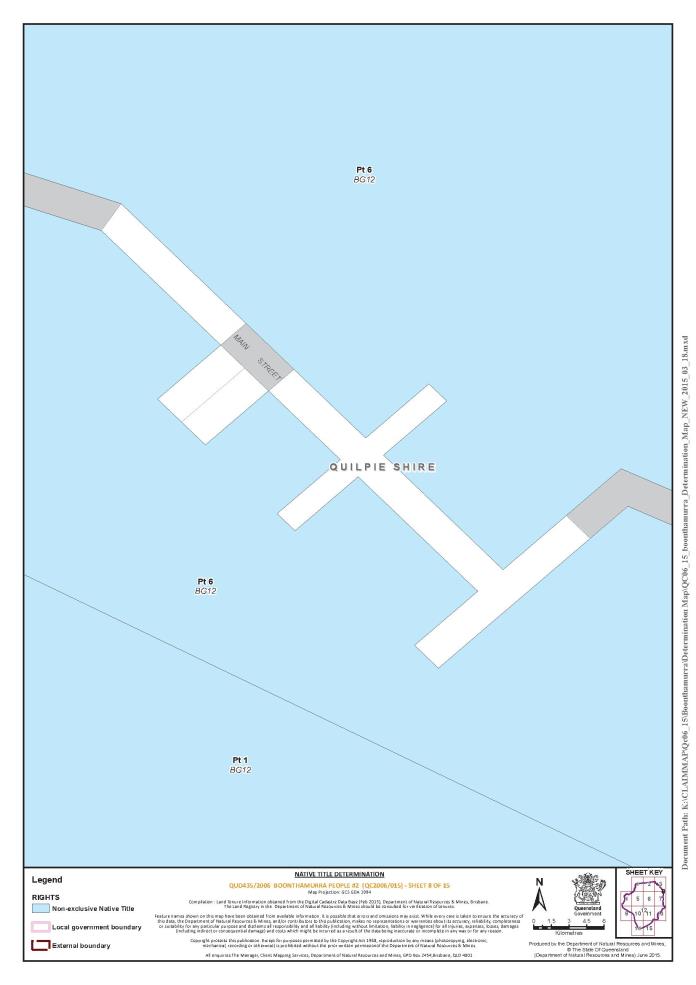
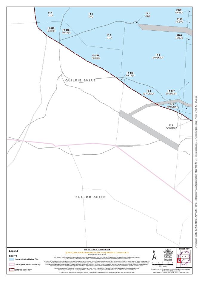
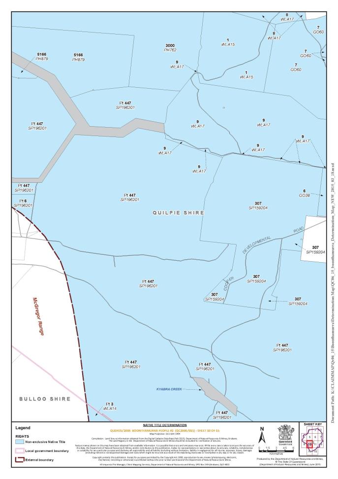
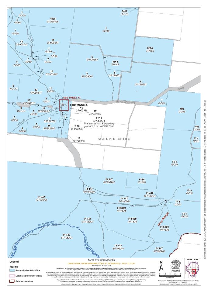
5. The Determination Area is the land and waters described in Schedule 1 and depicted in the map attached to Schedule 1.
6. Native title exists in relation to the Determination Area described in Schedule 1.
7. The native title is held by the Boonthamurra People described in Schedule 3 (the native title holders).
8. Subject to paragraphs 9, 10 and 11 below the nature and extent of the native title rights and interests in relation to the land and waters described in Schedule 1 are the non-exclusive rights to:
(a) access, be present on, move about on and travel over the area;
(b) camp, and live temporarily on the area as part of camping, and for that purpose build temporary shelters;
(c) hunt, fish and gather on the land and waters of the area for personal, domestic and non-commercial communal purposes;
(d) take, use, share and exchange Natural Resources from the land and waters of the area for personal, domestic and non-commercial communal purposes;
(e) take and use the Water of the area for personal, domestic and non-commercial communal purposes;
(f) conduct smoking ceremonies and dance on the area;
(g) hold meetings on the area;
(h) teach on the area the physical and spiritual attributes of the area;
(i) maintain places of importance and areas of significance to the native title holders under their traditional laws and customs and protect those places and areas from physical harm;
(j) light fires on the area for domestic purposes including cooking, but not for the purpose of hunting or clearing vegetation; and
(k) be accompanied onto the area by certain non-Boonthamurra people, being:
(i) immediate family of the native title holders, pursuant to the exercise of traditional laws acknowledged and customs observed by the native title holders; and
(ii) people required under the traditional laws acknowledged and customs observed by the native title holders for the performance of, or participation in, ceremonies and dance.
9. The native title rights and interests are subject to and exercisable in accordance with:
(a) the Laws of the State and the Commonwealth; and
(b) the traditional laws acknowledged and traditional customs observed by the native title holders.
10. The native title rights and interests referred to in paragraph 8 do not confer possession, occupation, use or enjoyment to the exclusion of all others.
11. There are no native title rights in or in relation to minerals as defined by the Mineral Resources Act 1989 (Qld) and petroleum as defined by the Petroleum Act 1923 (Qld) and the Petroleum and Gas (Production and Safety) Act 2004 (Qld).
12. The nature and extent of any other interests in relation to the Determination Area (or respective parts thereof) are set out in Schedule 4.
13. The relationship between the native title rights and interests described in paragraph 8 and the other interests described in Schedule 4 (the other interests) is that:
(a) the other interests continue to have effect, and the rights conferred by or held under the other interests may be exercised notwithstanding the existence of the native title rights and interests;
(b) to the extent the other interests are inconsistent with the continued existence, enjoyment or exercise of the native title rights and interests in relation to the land and waters of the Determination Area, the native title continues to exist in its entirety but the native title rights and interests have no effect in relation to the other interests to the extent of the inconsistency for so long as the other interests exist; and
(c) the other interests and any activity that is required or permitted by or under, and done in accordance with, the other interests, or any activity that is associated with or incidental to such an activity, prevail over the native title rights and interests and any exercise of the native title rights and interests.
DEFINITIONS AND INTERPRETATION
14. In this Determination, unless the contrary intention appears:
“land” and “waters”, respectively, have the same meanings as in the Native Title Act 1993 (Cth); |
“Laws of the State and the Commonwealth” means the common law and the laws of the State of Queensland and the Commonwealth of Australia, and includes legislation, regulations, statutory instruments, local planning instruments and local laws; |
“Local Government Act” has the same meaning as in the Local Government Act 2009 (Qld) |
“Local Government Area” has the same meaning as in the Local Government Act 2009 (Qld) |
“Natural Resources” means: (a) any animal, plant, fish and bird life found on or in the lands and waters of the Determination Area; and (b) any clays, soil, sand, gravel or rock found on or below the surface of the Determination Area. that have traditionally been taken and used by the native title holders, but does not include: (a) animals that are the private personal property of another; (b) crops that are the private personal property of another; and (c) minerals as defined in the Mineral Resources Act 1989 (Qld) or petroleum as defined in the Petroleum Act 1923 (Qld) and the Petroleum and Gas (Production and Safety Act) 2004 (Qld); Reserves” means reserves that are dedicated and taken to be reserves under the Land Act 1994 (Qld). “Water” means: (a) water which flows, whether permanently or intermittently, within a river, creek or stream; (b) water from an underground water source; and (c) any natural collection of water, whether permanent or intermittent. |
Other words and expressions used in this Determination have the same meanings as they have in Part 15 of the Native Title Act 1993 (Cth).
THE COURT DETERMINES THAT:
15. Upon the Determination taking effect:
(a) The native title is held in trust;
(b) The Boonthamurra Native Title Aboriginal Corporation (ICN: 8237), incorporated under the Corporations (Aboriginal and Torres Strait Islander) Act 2006 (Cth), is to:
(i) be the prescribed body corporate for the purpose of ss 56(2)(b) and 56(3) of the Native Title Act 1993 (Cth); and
(ii) perform the functions mentioned in s 57(1) of the Native Title Act 1993 (Cth) after becoming a registered native title body corporate.
Note: Entry of orders is dealt with in Rule 39.32 of the Federal Court Rules 2011.
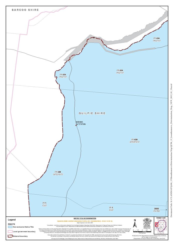
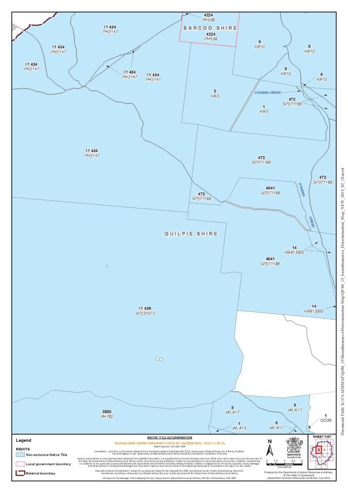
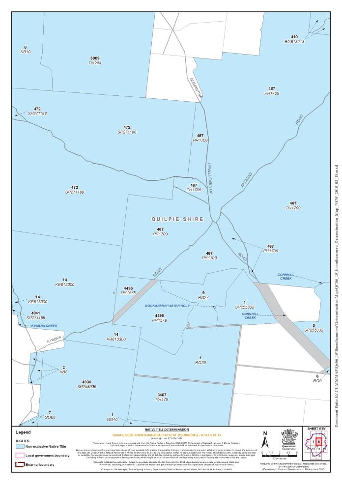
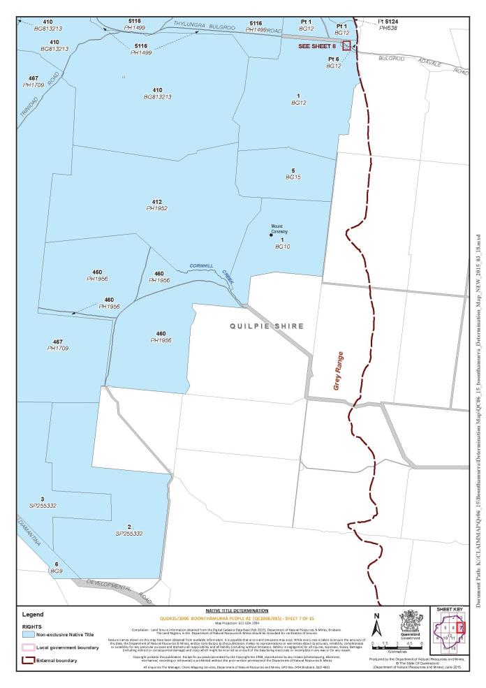
Schedule 1 – DETERMINATION AREA
A. Description of Determination Area
The Determination Area comprises all of the land and waters described in Part 1 of Schedule 1 A, to the extent that they are located within the External Boundary described in Part 2 of Schedule 1 A, and depicted in the map contained in Schedule 1 B, excluding the areas described in Schedule 2.
To the extent of any inconsistency, the written description set out in Part 1 and Part 2 of Schedule 1 A prevails over the map contained in Schedule 1 B.
Part 1 – Non-Exclusive Areas:
(a) The land and waters comprised of the lots and part lots listed below:
(b) The waters within the External Boundary including but not limited to:
(i) Bookaberri Waterhole;
(ii) Cornhill Creek;
(iii) Ginnapapa Creek; and
(iv) Kyabra Creek.
Part 2 – External Boundary of Determination Area:
The External Boundary of the Determination Area commences at a point south easterly of Quimmarroo Waterhole at Longitude 142.197707° East, Latitude 26.319248° South and extending generally north easterly and generally easterly, passing through the following coordinate points:
Longitude (East) | Latitude (South) |
142.206428 | 26.314791 |
142.221294 | 26.306265 |
142.233983 | 26.299283 |
142.238015 | 26.294444 |
142.240165 | 26.292168 |
142.244162 | 26.287068 |
142.252482 | 26.277084 |
142.263620 | 26.243837 |
142.269536 | 26.227076 |
142.274298 | 26.214375 |
142.279061 | 26.203262 |
142.285809 | 26.191752 |
142.290571 | 26.186592 |
142.298906 | 26.182226 |
142.300891 | 26.179051 |
142.303669 | 26.174288 |
142.304860 | 26.166350 |
142.304463 | 26.158015 |
142.302479 | 26.120309 |
142.302082 | 26.092526 |
142.303272 | 26.088557 |
142.306844 | 26.081413 |
142.308829 | 26.075459 |
142.310417 | 26.061568 |
142.310020 | 26.050455 |
142.306051 | 26.042913 |
142.302500 | 26.038380 |
142.300490 | 26.036350 |
142.299110 | 26.035000 |
142.298730 | 26.034330 |
142.298460 | 26.029480 |
142.298200 | 26.028470 |
142.295820 | 26.026330 |
142.294570 | 26.025650 |
142.293930 | 26.022500 |
142.293660 | 26.019120 |
142.294390 | 26.013580 |
142.293510 | 26.012010 |
142.293500 | 26.009980 |
142.290620 | 26.008970 |
142.288620 | 26.007850 |
142.288360 | 26.006270 |
142.287110 | 26.005600 |
142.286610 | 26.005260 |
142.285720 | 26.003690 |
142.284340 | 26.002450 |
142.284590 | 26.001090 |
142.283540 | 25.999460 |
142.282830 | 25.998500 |
142.285240 | 25.990620 |
142.286600 | 25.988100 |
142.285260 | 25.986680 |
142.283240 | 25.987540 |
142.280740 | 25.987640 |
142.279360 | 25.986130 |
142.279280 | 25.984690 |
142.280060 | 25.983410 |
142.280040 | 25.980910 |
142.280420 | 25.976630 |
142.280700 | 25.974180 |
142.282070 | 25.970390 |
142.283390 | 25.968170 |
142.291760 | 25.967450 |
142.292870 | 25.965750 |
142.293750 | 25.965520 |
142.294870 | 25.965630 |
142.296120 | 25.964830 |
142.299850 | 25.961650 |
142.301450 | 25.958490 |
142.302700 | 25.957690 |
142.303570 | 25.957690 |
142.304940 | 25.956100 |
142.305310 | 25.955310 |
142.307170 | 25.953150 |
142.310030 | 25.950430 |
142.310650 | 25.949190 |
142.310890 | 25.948290 |
142.311000 | 25.944790 |
142.311620 | 25.943650 |
142.312860 | 25.942520 |
142.315350 | 25.941380 |
142.316090 | 25.939690 |
142.316220 | 25.939460 |
142.317090 | 25.939000 |
142.317330 | 25.937420 |
142.318200 | 25.937080 |
142.319330 | 25.937520 |
142.319830 | 25.937410 |
142.320950 | 25.936500 |
142.322320 | 25.936040 |
142.323190 | 25.934690 |
142.324680 | 25.933770 |
142.324960 | 25.933520 |
142.325320 | 25.933200 |
142.326320 | 25.932970 |
142.326410 | 25.927210 |
142.326780 | 25.926530 |
142.329390 | 25.924030 |
142.333040 | 25.922400 |
142.335990 | 25.920110 |
142.340610 | 25.919920 |
142.343980 | 25.919570 |
142.345220 | 25.918890 |
142.351330 | 25.918070 |
142.352710 | 25.917720 |
142.353580 | 25.917260 |
142.355930 | 25.914660 |
142.356550 | 25.913530 |
142.357920 | 25.912850 |
142.359040 | 25.911490 |
142.361280 | 25.910230 |
142.361650 | 25.909550 |
142.362500 | 25.906390 |
142.365350 | 25.900840 |
142.366710 | 25.899030 |
142.367330 | 25.897900 |
142.368820 | 25.896420 |
142.369800 | 25.894160 |
142.371040 | 25.892800 |
142.372270 | 25.889860 |
142.373140 | 25.888610 |
142.377240 | 25.884870 |
142.377230 | 25.883840 |
142.378910 | 25.880350 |
142.378750 | 25.876390 |
142.379510 | 25.873410 |
142.385380 | 25.869870 |
142.390440 | 25.867360 |
142.393230 | 25.866380 |
142.398840 | 25.865690 |
142.403710 | 25.865990 |
142.404460 | 25.866550 |
142.408840 | 25.868800 |
142.409850 | 25.869570 |
142.411720 | 25.869350 |
142.415970 | 25.870220 |
142.419460 | 25.870440 |
142.421210 | 25.871320 |
142.422600 | 25.873010 |
142.423870 | 25.876170 |
142.425490 | 25.876960 |
142.426750 | 25.879100 |
142.427010 | 25.881000 |
142.428400 | 25.882800 |
142.429040 | 25.885060 |
142.429290 | 25.885400 |
142.429420 | 25.886300 |
142.431800 | 25.888100 |
142.433180 | 25.888430 |
142.434930 | 25.889200 |
142.437810 | 25.891450 |
142.438820 | 25.893140 |
142.439080 | 25.893920 |
142.440590 | 25.895720 |
142.443710 | 25.896840 |
142.447970 | 25.898850 |
142.449720 | 25.899290 |
142.453850 | 25.900850 |
142.457480 | 25.902980 |
142.459350 | 25.902740 |
142.460110 | 25.903070 |
142.461360 | 25.904650 |
142.462990 | 25.905320 |
142.474590 | 25.904130 |
142.475600 | 25.904910 |
142.477100 | 25.905580 |
142.481470 | 25.906340 |
142.482720 | 25.906340 |
142.484210 | 25.905650 |
142.484710 | 25.905200 |
142.489440 | 25.903030 |
142.490560 | 25.902800 |
142.492810 | 25.903570 |
142.499280 | 25.900720 |
142.500950 | 25.900360 |
142.502310 | 25.899810 |
142.503570 | 25.898810 |
142.504850 | 25.897470 |
142.507540 | 25.894290 |
142.510020 | 25.893340 |
142.515540 | 25.887480 |
142.519470 | 25.884750 |
142.523120 | 25.883540 |
142.527130 | 25.881550 |
142.530760 | 25.880800 |
142.532890 | 25.879810 |
142.537400 | 25.878720 |
142.539530 | 25.877840 |
142.541550 | 25.876170 |
142.543180 | 25.875510 |
142.543730 | 25.874740 |
142.545580 | 25.873500 |
142.546330 | 25.873280 |
142.548470 | 25.871380 |
142.549620 | 25.869700 |
142.549630 | 25.868800 |
142.550140 | 25.867790 |
142.550160 | 25.866180 |
142.551040 | 25.865540 |
142.552540 | 25.865330 |
142.553050 | 25.864880 |
142.553560 | 25.863650 |
142.555200 | 25.861970 |
142.556600 | 25.859950 |
142.557100 | 25.859510 |
142.558230 | 25.859360 |
142.559730 | 25.859080 |
142.561870 | 25.857970 |
142.563630 | 25.856520 |
142.564760 | 25.855970 |
142.567890 | 25.855100 |
142.568780 | 25.854090 |
142.572300 | 25.851750 |
142.575060 | 25.850650 |
142.576190 | 25.849760 |
142.578450 | 25.848880 |
142.580210 | 25.847880 |
142.581580 | 25.847670 |
142.583090 | 25.846330 |
142.584850 | 25.845440 |
142.586770 | 25.845190 |
142.587740 | 25.844230 |
142.591248 | 25.842491 |
142.599400 | 25.838930 |
142.600000 | 25.838110 |
142.601180 | 25.836460 |
142.603700 | 25.834000 |
142.606840 | 25.832680 |
142.607720 | 25.831780 |
142.607750 | 25.829070 |
142.609160 | 25.825930 |
142.610430 | 25.824580 |
142.611550 | 25.824480 |
142.612240 | 25.823920 |
142.612940 | 25.823140 |
142.613070 | 25.822240 |
142.614090 | 25.821010 |
142.614970 | 25.820230 |
142.617360 | 25.818780 |
142.619240 | 25.818010 |
142.620120 | 25.817340 |
142.622750 | 25.816240 |
142.623630 | 25.815570 |
142.624750 | 25.814070 |
142.626390 | 25.814580 |
142.627390 | 25.814250 |
142.629280 | 25.812460 |
142.632160 | 25.811470 |
142.633170 | 25.810580 |
142.635960 | 25.806320 |
142.637860 | 25.804190 |
142.639740 | 25.803640 |
142.642010 | 25.801410 |
142.643390 | 25.800630 |
142.644160 | 25.798940 |
142.645420 | 25.797710 |
142.647670 | 25.796950 |
142.648930 | 25.795720 |
142.650940 | 25.794940 |
142.652830 | 25.793040 |
142.654330 | 25.792270 |
142.655090 | 25.791370 |
142.654940 | 25.789300 |
142.656520 | 25.788580 |
142.657870 | 25.788240 |
142.658370 | 25.788350 |
142.659110 | 25.789150 |
142.660230 | 25.789390 |
142.661270 | 25.789070 |
142.662850 | 25.789410 |
142.666710 | 25.789450 |
142.672090 | 25.788480 |
142.673840 | 25.787710 |
142.676610 | 25.785930 |
142.684290 | 25.779450 |
142.685920 | 25.778450 |
142.689170 | 25.777240 |
142.690930 | 25.776240 |
142.692320 | 25.775010 |
142.694590 | 25.772320 |
142.695480 | 25.770860 |
142.696490 | 25.769970 |
142.698370 | 25.769080 |
142.699120 | 25.768410 |
142.700260 | 25.766620 |
142.701900 | 25.765160 |
142.703360 | 25.762670 |
142.714880 | 25.744930 |
142.716100 | 25.743850 |
142.717490 | 25.742170 |
142.719270 | 25.738690 |
142.720550 | 25.735310 |
142.720960 | 25.732490 |
142.720850 | 25.730910 |
142.720120 | 25.728980 |
142.719540 | 25.725590 |
142.719570 | 25.722430 |
142.719050 | 25.719970 |
142.719740 | 25.717920 |
142.721640 | 25.715570 |
142.722290 | 25.713090 |
142.724070 | 25.709490 |
142.725580 | 25.707930 |
142.726220 | 25.707030 |
142.727370 | 25.704330 |
142.727750 | 25.703770 |
142.728630 | 25.703210 |
142.730370 | 25.703000 |
142.732500 | 25.702460 |
142.733620 | 25.702020 |
142.734750 | 25.701120 |
142.735140 | 25.699880 |
142.737150 | 25.698210 |
142.738170 | 25.696560 |
142.738770 | 25.694790 |
142.740800 | 25.693150 |
142.742270 | 25.690830 |
142.743280 | 25.686790 |
142.744390 | 25.685360 |
142.744390 | 25.683050 |
142.745840 | 25.681420 |
142.746450 | 25.667820 |
142.745600 | 25.666350 |
142.743470 | 25.663930 |
142.740020 | 25.660870 |
142.738450 | 25.658150 |
142.736980 | 25.656330 |
142.735620 | 25.655190 |
142.733050 | 25.654050 |
142.728560 | 25.651180 |
142.727570 | 25.650270 |
142.727720 | 25.648130 |
142.726740 | 25.647220 |
142.726710 | 25.645650 |
142.728690 | 25.643220 |
142.734350 | 25.639320 |
142.735590 | 25.634770 |
142.737320 | 25.631770 |
142.737200 | 25.630040 |
142.736500 | 25.627870 |
142.736630 | 25.626350 |
142.738190 | 25.624290 |
142.738830 | 25.622940 |
142.738840 | 25.621810 |
142.739230 | 25.620690 |
142.740360 | 25.619570 |
142.741240 | 25.619130 |
142.743230 | 25.617060 |
142.744250 | 25.616440 |
142.745620 | 25.616340 |
142.747360 | 25.616920 |
142.747980 | 25.616930 |
142.748860 | 25.616600 |
142.752120 | 25.614480 |
142.754920 | 25.614340 |
142.758400 | 25.614100 |
142.759340 | 25.614320 |
142.761340 | 25.613880 |
142.764700 | 25.614030 |
142.765450 | 25.613810 |
142.768080 | 25.612140 |
142.769090 | 25.611240 |
142.769600 | 25.610010 |
142.770990 | 25.608100 |
142.772780 | 25.606650 |
142.776660 | 25.602050 |
142.778290 | 25.600490 |
142.779040 | 25.600040 |
142.779420 | 25.599260 |
142.780420 | 25.599040 |
142.783280 | 25.599630 |
142.785620 | 25.600600 |
142.786030 | 25.599200 |
142.786660 | 25.598300 |
142.787660 | 25.597520 |
142.788170 | 25.596730 |
142.788390 | 25.593350 |
142.789580 | 25.592340 |
142.789710 | 25.591780 |
142.788900 | 25.591130 |
142.788940 | 25.583110 |
142.788200 | 25.581720 |
142.786960 | 25.580700 |
142.786980 | 25.579460 |
142.786480 | 25.578430 |
142.787240 | 25.577540 |
142.787250 | 25.576520 |
142.788010 | 25.575510 |
142.787780 | 25.573930 |
142.788540 | 25.572470 |
142.788560 | 25.571120 |
142.788180 | 25.570000 |
142.786730 | 25.566700 |
142.785750 | 25.565900 |
142.784630 | 25.565780 |
142.782290 | 25.563160 |
142.781230 | 25.562010 |
142.779520 | 25.558830 |
142.778930 | 25.556520 |
142.779210 | 25.554420 |
142.779100 | 25.553410 |
142.778180 | 25.551280 |
142.778820 | 25.549590 |
142.777970 | 25.547550 |
142.778350 | 25.546540 |
142.778230 | 25.546090 |
142.777370 | 25.545120 |
142.778750 | 25.544060 |
142.778390 | 25.542930 |
142.778400 | 25.542140 |
142.779280 | 25.541580 |
142.780400 | 25.541360 |
142.781280 | 25.540690 |
142.781910 | 25.539230 |
142.782540 | 25.539240 |
142.782910 | 25.538900 |
142.782800 | 25.537550 |
142.782560 | 25.536980 |
142.781700 | 25.536070 |
142.781460 | 25.534710 |
142.781100 | 25.534150 |
142.779730 | 25.533800 |
142.778300 | 25.532460 |
142.777520 | 25.531290 |
142.777030 | 25.529710 |
142.774820 | 25.527430 |
142.774580 | 25.525960 |
142.774100 | 25.525170 |
142.773980 | 25.524270 |
142.773490 | 25.523360 |
142.770290 | 25.520280 |
142.769030 | 25.519750 |
142.768680 | 25.519030 |
142.767690 | 25.518910 |
142.767200 | 25.518450 |
142.765610 | 25.515960 |
142.766250 | 25.513820 |
142.767510 | 25.512470 |
142.767890 | 25.511690 |
142.767910 | 25.509650 |
142.768550 | 25.508190 |
142.768700 | 25.505940 |
142.769420 | 25.504230 |
142.768230 | 25.503220 |
142.767480 | 25.503330 |
142.767230 | 25.503100 |
142.767250 | 25.501180 |
142.768260 | 25.499730 |
142.768910 | 25.497930 |
142.770170 | 25.496240 |
142.770800 | 25.494890 |
142.770700 | 25.492520 |
142.771210 | 25.491740 |
142.773720 | 25.489840 |
142.773970 | 25.489170 |
142.775460 | 25.489000 |
142.776340 | 25.488960 |
142.777340 | 25.488070 |
142.777980 | 25.487060 |
142.778240 | 25.485930 |
142.780140 | 25.483250 |
142.780730 | 25.484380 |
142.782250 | 25.483030 |
142.782630 | 25.482240 |
142.783280 | 25.479540 |
142.783910 | 25.478980 |
142.785270 | 25.479330 |
142.786020 | 25.478660 |
142.786780 | 25.477650 |
142.787420 | 25.476300 |
142.787680 | 25.474840 |
142.787510 | 25.473780 |
142.788450 | 25.473150 |
142.788950 | 25.472250 |
142.789210 | 25.470900 |
142.789850 | 25.469550 |
142.790980 | 25.468210 |
142.791620 | 25.467080 |
142.792140 | 25.464490 |
142.793290 | 25.461340 |
142.794170 | 25.460330 |
142.794920 | 25.460340 |
142.795410 | 25.460680 |
142.795910 | 25.460690 |
142.796790 | 25.459790 |
142.797660 | 25.459690 |
142.798420 | 25.459130 |
142.799180 | 25.457550 |
142.800650 | 25.456100 |
142.799950 | 25.454850 |
142.799960 | 25.453610 |
142.800600 | 25.452260 |
142.800250 | 25.450340 |
142.801010 | 25.448990 |
142.800900 | 25.446960 |
142.802300 | 25.444370 |
142.802690 | 25.442120 |
142.804960 | 25.439660 |
142.806200 | 25.439220 |
142.807080 | 25.438430 |
142.807470 | 25.437310 |
142.809100 | 25.436080 |
142.809240 | 25.434610 |
142.811370 | 25.432830 |
142.812140 | 25.431480 |
142.812880 | 25.430580 |
142.815380 | 25.429470 |
142.816260 | 25.428690 |
142.932290 | 25.423196 |
142.935402 | 25.425687 |
142.943704 | 25.424441 |
142.973180 | 25.404930 |
142.978992 | 25.403269 |
142.986049 | 25.402024 |
142.996428 | 25.402024 |
143.005146 | 25.402854 |
143.013864 | 25.404099 |
143.032960 | 25.407421 |
143.041263 | 25.407421 |
143.057454 | 25.402854 |
143.066172 | 25.399118 |
143.071984 | 25.397042 |
143.079456 | 25.395381 |
143.087759 | 25.394551 |
143.103535 | 25.393721 |
143.121801 | 25.389985 |
143.133840 | 25.386248 |
143.145879 | 25.381267 |
143.150031 | 25.380436 |
143.157503 | 25.380436 |
143.163315 | 25.381682 |
143.167052 | 25.390400 |
143.170230 | 25.393320 |
143.184050 | 25.398970 |
143.187400 | 25.399440 |
143.189780 | 25.398220 |
143.193770 | 25.396900 |
143.205100 | 25.394730 |
143.219130 | 25.395400 |
143.225110 | 25.394650 |
143.228340 | 25.393890 |
143.241390 | 25.393870 |
143.249652 | 25.393413 |
143.267294 | 25.390758 |
143.279245 | 25.387153 |
143.294231 | 25.382032 |
143.306182 | 25.379376 |
143.316994 | 25.378996 |
143.325531 | 25.380135 |
143.333308 | 25.382601 |
143.340327 | 25.384118 |
143.348484 | 25.385067 |
143.355882 | 25.384877 |
143.366315 | 25.383929 |
143.380353 | 25.380893 |
143.390407 | 25.375202 |
143.396288 | 25.369512 |
143.402737 | 25.365907 |
143.409187 | 25.362303 |
143.414119 | 25.360406 |
143.416775 | 25.359837 |
143.421517 | 25.360596 |
143.426829 | 25.363631 |
143.432330 | 25.368563 |
143.436276 | 25.372812 |
143.438400 | 25.373495 |
143.442573 | 25.373875 |
143.454180 | 25.365630 |
143.468372 | 25.354146 |
143.485700 | 25.345340 |
143.491136 | 25.342954 |
143.495119 | 25.342195 |
143.499293 | 25.341816 |
143.504984 | 25.342006 |
143.509347 | 25.344092 |
143.513150 | 25.346680 |
143.519590 | 25.350542 |
143.524902 | 25.352818 |
143.535145 | 25.355853 |
143.548045 | 25.359268 |
143.552787 | 25.359458 |
143.556960 | 25.356612 |
143.560754 | 25.347696 |
143.568532 | 25.338022 |
Then north-easterly to a point on the Cheviot Range at Longitude 143.578552 East, Latitude 25.332230 South, being the watershed between Cooper Creek and Barcoo River then generally easterly, and generally south easterly along that watershed, and ridgeline of that range to its intersection with the watershed of Cooper Creek and Bulloo River, then generally southerly along that watershed and the Ridgeline of the Grey Range to Longitude 143.871053° East, a point on the external boundary of the Kullilli People determination; then generally south-westerly again along that watershed, ridgeline of that range and external boundary of that determination to Latitude 27.120427° South; then generally south westerly again along the boundary of that determination passing through the following coordinate points:
Longitude (East) | Latitude (South) |
143.504683 | 27.134139 |
143.480100 | 27.156729 |
143.448873 | 27.181311 |
143.418311 | 27.201244 |
143.397714 | 27.216525 |
143.376454 | 27.230477 |
143.359844 | 27.241108 |
143.341240 | 27.249745 |
143.318651 | 27.261704 |
143.292739 | 27.274992 |
143.276129 | 27.283629 |
143.245566 | 27.300239 |
143.214339 | 27.318178 |
143.181784 | 27.334124 |
143.163845 | 27.343426 |
143.137269 | 27.356049 |
143.114015 | 27.368008 |
143.087439 | 27.379303 |
143.061527 | 27.393256 |
143.039602 | 27.405215 |
143.014354 | 27.417174 |
143.002395 | 27.423154 |
142.985785 | 27.429133 |
142.965853 | 27.435778 |
142.949243 | 27.442422 |
142.941935 | 27.443086 |
142.924660 | 27.433120 |
Then north westerly to the centreline of Wilson River at Longitude 142.921272° East, then generally north westerly back to the commencement point through the following coordinate points:
Longitude (East) | Latitude (South) |
142.828467 | 27.220193 |
142.814070 | 27.201477 |
142.783118 | 27.140291 |
142.752885 | 27.083425 |
142.742807 | 27.007122 |
142.734169 | 26.937299 |
142.725531 | 26.886191 |
142.714014 | 26.834363 |
142.705376 | 26.810608 |
142.693858 | 26.792613 |
142.680901 | 26.771737 |
142.662186 | 26.751582 |
142.664190 | 26.735746 |
142.600280 | 26.706233 |
142.575086 | 26.694715 |
142.543414 | 26.684638 |
142.522538 | 26.673120 |
142.457034 | 26.632810 |
142.424641 | 26.607616 |
142.385770 | 26.582422 |
142.346180 | 26.562986 |
142.310908 | 26.540671 |
142.273477 | 26.515477 |
142.238925 | 26.495322 |
142.211756 | 26.471065 |
142.205777 | 26.439839 |
142.200696 | 26.378517 |
142.199133 | 26.358781 |
142.197804 | 26.337521 |
142.197709 | 26.319591 |
Reference Datum
Geographical coordinates have been provided by the NNTT Geospatial Unit and are referenced to the Geocentric Datum of Australia 1994 (GDA94), in decimal degrees and are based on the spatial reference data acquired from the various custodians at the time.
Data Reference and Source
External boundary based in part on data sourced from Commonwealth of Australia, NNTT (March 2015).
Wilson River sourced from 1:250,000 scale topographic vector data, © Commonwealth of Australia (2008).
Watershed boundaries and Ridgelines of the Grey and Cheviot Ranges based on Drainage Basin Sub-Area Data as at (January 2009) sourced from Department of Environment and Resource Management (Qld) September 2011.
Use of Coordinates
Where coordinates are used within the description to represent cadastral or topographical boundaries or the intersection with such, they are intended as a guide only. As an outcome to the custodians of cadastral and topographic data continuously recalculating the geographic position of their data based on improved survey and data maintenance procedures, it is not possible to accurately define such a position other than by detailed ground survey.
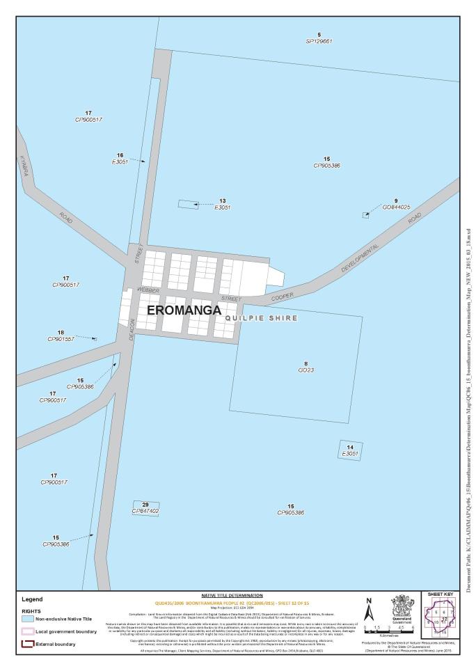
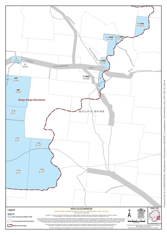
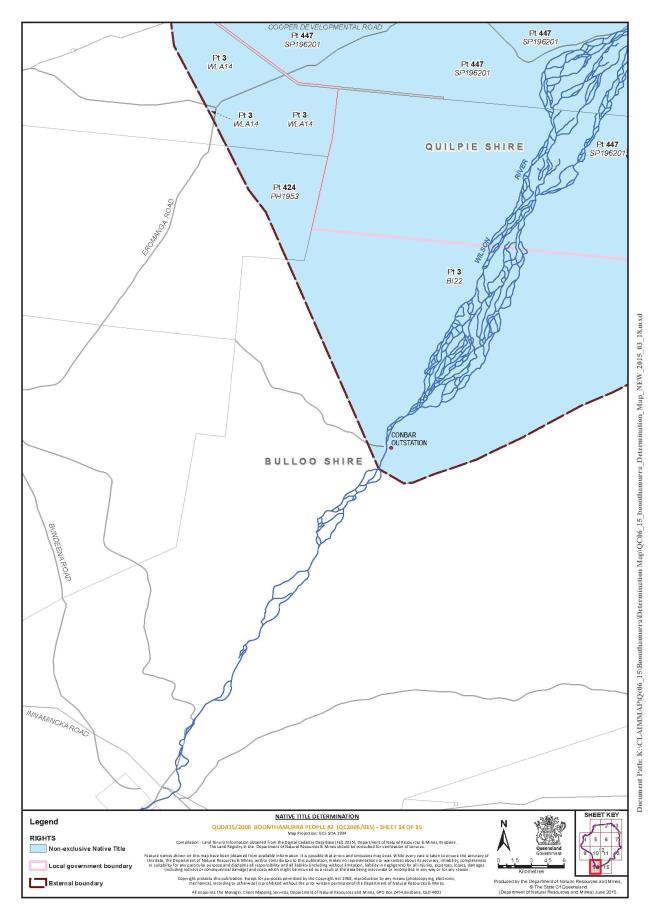
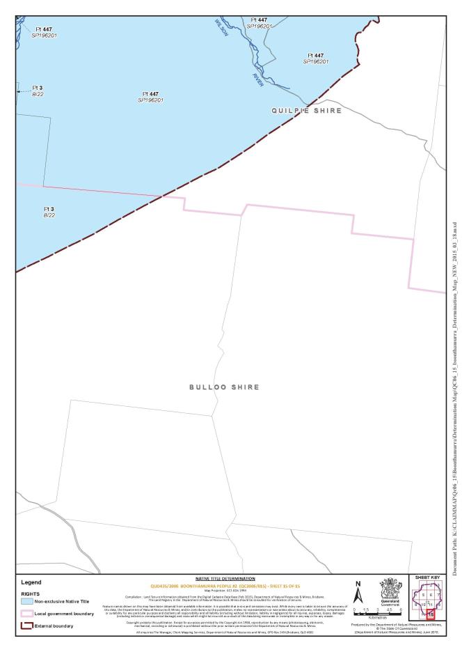
B. Map of Determination Area
Schedule 2 – AREAS NOT FORMING PART OF THE DETERMINATION AREA
The following areas of land and waters are excluded from the Determination Area.
1. Those land and waters within the External Boundary, which at the time the native title determination application was made;
(a) were the subject of one or more Previous Exclusive Possession Acts, within the meaning of s 23B of the Native Title Act 1993 (Cth); and
(b) to which none of ss 47, 47A or 47B of the Native Title Act 1993 (Cth) applied at the time of the native title determination application;
are excluded from the Determination Area as they could not be claimed in accordance with s 61A of the Native Title Act 1993 (Cth).
2. Specifically, and to avoid any doubt, the land and waters described in (1) above includes:
(a) the tenure based exclusions under ss 23B(2) and 23B(3) of the Native Title Act 1993 (Cth) to which s 20 of the Native Title (Queensland) Act 1993 (Qld) applies;
(b) the land or waters on which any public work, as defined in s 253 of the Native Title Act 1993 (Cth), is or was constructed, established or situated, and to which ss 23B(7) and 23C(2) of the Native Title Act 1993 (Cth) and to which s 21 of the Native Title (Queensland) Act 1993 (Qld), applies, together with any adjacent land or waters in accordance with s 251D of the Native Title Act 1993 (Cth); and
(c) includes, but is not limited to, the whole of the land and waters described as:
(i) Lot 7 on KB813309;
(ii) Lot 411 on BG813212;;
(iii) Lot 1 on KB813299;
(iv) Lot 10 on WLA813313;
(v) Lot 6 on GO813218;
(vi) Lot 2 on BG813297;
(vii) Lot 10 on GO813301; and
(viii) that part of Lot 4 on BLO10 that falls within the External Boundary described in Schedule 1A Part 2.
Schedule 3 – NATIVE TITLE HOLDERS
1. The native title holders are the Boonthamurra People. The Boonthamurra People are the descendants of one or more of the following people:
(a) Kangaroo; or
(b) Dick Ray
Who identify and are accepted as Boonthamurra People according to Boonthamurra traditional law and custom.
Schedule 4 – OTHER INTERESTS IN THE DETERMINATION AREA
The nature and extent of the other interests in relation to the Determination Area are the following as they exist as at the date of the determination:
1. The rights and interests of the parties under the following agreements:
(a) The agreement between Barbara Olsen and Mark Wallace on their own behalf and on behalf of the Boonthamurra People (QUD435/2006), the Barcoo Shire Council and the Quilpie Shire Council as parties to the Local Government ILUA authorised on 14 April 2015;
(b) The agreement between Barbara Olsen and Mark Wallace on their own behalf and on behalf of the Boonthamurra People (QUD435/2006), and Ergon Energy Corporation Limited as parties to the Indigenous Land Use Agreement authorised on 14 April 2015;
(c) The Boonthamurra People (QUD435/2006) and Araluen and Budgerygar pastoral Indigenous Land Use Agreement authorised on 14 April 2015;
(d) The Boonthamurra People (QUD435/2006) and Buckaroola and Monler pastoral Indigenous Land Use Agreement authorised on 14 April 2015;
(e) The Boonthamurra People (QUD435/2006) and Clifton pastoral Indigenous Land Use Agreement authorised on 14 April 2015;
(f) The Boonthamurra People (QUD435/2006) and Congie pastoral Indigenous Land Use Agreement authorised on 14 April 2015;
(g) The Boonthamurra People (QUD435/2006) and Coomo pastoral Indigenous Land Use Agreement authorised on 14 April 2015;
(h) The Boonthamurra People (QUD435/2006) and Hammond Downs pastoral Indigenous Land Use Agreement authorised on 14 April 2015;
(i) The Boonthamurra People (QUD435/2006) and Harkaway pastoral Indigenous Land Use Agreement authorised on 14 April 2015;
(j) The Boonthamurra People (QUD435/2006) and Kalabra pastoral Indigenous Land Use Agreement authorised on 14 April 2015;
(k) The Boonthamurra People (QUD435/2006) and Keeroongooloo pastoral Indigenous Land Use Agreement authorised on 14 April 2015;
(l) The Boonthamurra People (QUD435/2006) and Malagarga and Mt Howitt pastoral Indigenous Land Use Agreement authorised on 14 April 2015;
(m) The Boonthamurra People (QUD435/2006) and Maroo and Regleigh pastoral Indigenous Land Use Agreement authorised on 14 April 2015;
(n) The Boonthamurra People (QUD435/2006) and Moothandella pastoral Indigenous Land Use Agreement authorised on 14 April 2015;
(o) The Boonthamurra People (QUD435/2006) and Nerrigundah pastoral Indigenous Land Use Agreement authorised on 14 April 2015;
(p) The Boonthamurra People (QUD435/2006) and Nockatunga pastoral Indigenous Land Use Agreement authorised on 14 April 2015;
(q) The Boonthamurra People (QUD435/2006) and Panjee and Talgeberry pastoral Indigenous Land Use Agreement authorised on 14 April 2015;
(r) The Boonthamurra People (QUD435/2006) and Plevna Downs pastoral Indigenous Land Use Agreement authorised on 14 April 2015;
(s) The Boonthamurra People (QUD435/2006) and Quartpot pastoral Indigenous Land Use Agreement authorised on 14 April 2015;
(t) The Boonthamurra People (QUD435/2006) and Raymore and Wheeo pastoral Indigenous Land Use Agreement authorised on 14 April 2015;
(u) The Boonthamurra People (QUD435/2006) and South Galway pastoral Indigenous Land Use Agreement authorised on 14 April 2015;
(v) The Boonthamurra People (QUD435/2006) and Tenham pastoral Indigenous Land Use Agreement authorised on 14 April 2015;
(w) The Boonthamurra People (QUD435/2006) and Thylungra pastoral Indigenous Land Use Agreement authorised on 14 April 2015;
(x) The Boonthamurra People (QUD435/2006) and Trinidad pastoral Indigenous Land Use Agreement authorised on 14 April 2015; and
(y) The Boonthamurra People (QUD435/2006) and Whynot pastoral Indigenous Land Use Agreement authorised on 14 April 2015.
2. The rights and interests of Santos Limited and Delhi Petroleum Pty Ltd:
(a) as holders of Authority to Prospect No. 1189 granted under the Petroleum and Gas (Production and Safety Act) 2004 (Qld);
3. The rights and interests of Santos Limited, Vamgas Pty Ltd, Santos Australian Hydrocarbons Pty Ltd, Origin Energy Resources Limited, Delhi Petroleum Pty Ltd:
(a) as holders of Petroleum Lease No. 141 granted under the Petroleum Act 1923 (Qld); and
(b) as holders of Petroleum Lease No. 148 granted under the Petroleum Act 1923 (Qld).
4. The rights and interests of Vamgas Pty Ltd, Santos QNT Pty Ltd and Drillsearch Energy Limited;
(a) as holders of Authority to Prospect No. 299 granted under the Petroleum Act 1923 (Qld);
(b) as holders of Petroleum Lease No. 29 granted under the Petroleum Act 1923 (Qld);
(c) as holders of Petroleum Lease No. 38 granted under the Petroleum Act 1923 (Qld);
(d) as holders of Petroleum Lease No. 39 granted under the Petroleum Act 1923 (Qld);
(e) as holders of Petroleum Lease No. 52 granted under the Petroleum Act 1923 (Qld);
(f) as holders of Petroleum Lease No. 57 granted under the Petroleum Act 1923 (Qld);
(g) as holders of Petroleum Lease No. 95 granted under the Petroleum Act 1923 (Qld);
(h) as holders of Petroleum Lease No. 169 granted under the Petroleum Act 1923 (Qld);
(i) as holders of Petroleum Lease No. 170 granted under the Petroleum Act 1923 (Qld);
(j) as holders of Petroleum Lease No. 295 granted under the Petroleum Act 1923 (Qld);
(k) as holders of Petroleum Pipeline Licence No. 109 granted under the Petroleum and Gas (Production and Safety Act) 2004 (Qld);
(l) as holders of Petroleum Pipeline Licence No. 110 granted under the Petroleum and Gas (Production and Safety Act) 2004 (Qld);
(m) as holders of Petroleum Pipeline Licence No. 111 granted under the Petroleum and Gas (Production and Safety Act) 2004 (Qld); and
(n) as holders of Petroleum Pipeline Licence No. 112 granted under the Petroleum and Gas (Production and Safety Act) 2004 (Qld).
5. The rights and interests of Santos QNT Pty Ltd, Santos (299) Pty Ltd and Drillsearch Energy Limited:
(a) as holders of Petroleum Lease No. 293 granted under the Petroleum Act 1923 (Qld);
(b) as holders of Petroleum Lease No. 294 granted under the Petroleum Act 1923 (Qld); and
(c) as holders of Petroleum Lease No. 298 granted under the Petroleum Act 1923 (Qld).
6. The rights and interests of Santos QNT Pty Ltd:
(a) as holder of Authority to Prospect No. 636 granted under the Petroleum Act 1923 (Qld);
(b) as holder of Petroleum Lease No. 117 granted under the Petroleum Act 1923 (Qld); and
(c) as holder of Authority to Prospect No. 765 granted under the Petroleum and Gas Act 2004 (Qld)
7. The rights and interests of Doce Pty Ltd as holder of Rolling Term Lease TL 0/232564 over Lot 424 on PH1953.
8. The rights and interests of IOR Energy Pty Ltd as the holder of petroleum pipeline licence 9 granted under the Petroleum Act 1923 (Qld) and converted to a pipeline licence under the Petroleum and Gas (Production and Safety) Act 2004 (Qld), which includes the right of IOR Energy Pty Ltd, its employees, agents and contractors to enter the Determination Area and do all things necessary for or incidental to the exercise of those rights and interests in the Determination Area.
9. The rights and interests of Beach Energy Limited and Mawson Petroleum Pty Limited, as joint holders of:
(a) Petroleum Lease No. 31 granted under the Petroleum Act 1923 (Qld);
(b) Petroleum Lease No. 32 granted under the Petroleum Act 1923 (Qld);
(c) Petroleum Lease No. 47 granted under the Petroleum Act 1923 (Qld); and
(d) which includes the right of Beach Energy Limited and Mawson Petroleum Pty Limited’s employees, agents or contractors to enter the Determination Area and do all things necessary to perform their duties in the Determination Area.
10. The rights and interests of Beach Energy Limited, Gidgealpa Oil Pty Ltd and Mawson Petroleum Pty Limited as joint holders of:
(a) Authority to Prospect No. 269 granted under the Petroleum Act 1923 (Qld);
(b) Petroleum Lease No. 482 granted under the Petroleum Act 1923 (Qld);
(c) Petroleum Lease No. 483 granted under the Petroleum Act 1923 (Qld); and
(d) Petroleum Lease No. 484 granted under the Petroleum Act 1923 (Qld);
(e) which includes the right of Beach Energy Limited, Gidgealpa Oil Pty Ltd and Mawson Petroleum Pty Limited’s employees, agents or contractors to enter the Determination Area and do all things necessary to perform their duties in the Determination Area.
11. The rights and interests of Australian Gasfields Limited, Beach Energy Limited, and Mawson Petroleum Pty Limited, as joint holders of Petroleum Lease No. 184 granted under the Petroleum Act 1923 (Qld), which includes the right of Australian Gasfields Limited, Beach Energy Limited and Mawson Petroleum Pty Limited’s employees, agents or contractors to enter the Determination Area and do all things necessary to perform their duties in the Determination Area.
12. The rights and interests of Beach Energy Limited, Inland Oil (Production) Pty Ltd, and Mawson Petroleum Pty Limited, as joint holders of Petroleum Lease No. 256 granted under the Petroleum Act 1923 (Qld), which includes the right of Beach Energy Limited, Inland Oil (Production) Pty Ltd and Mawson Petroleum Pty Limited’s employees, agents or contractors to enter the Determination Area and do all things necessary to perform their duties in the Determination Area.
13. The rights and interests of Beach Energy Limited and Bengal Energy (Australia) Pty Ltd as joint holders of Authority to Prospect No.732 granted under the Petroleum and Gas (Production and Safety) Act 2004 (Qld) which includes the right of Beach Energy Limited and Bengal Energy (Australia) Pty Ltd’s employees, agents or contractors to enter the Determination Area and do all things necessary to perform their duties in the Determination Area.
14. The rights and interests of Telstra Corporation Limited (ACN 051 775 556):
(a) as the owner or operator of telecommunications facilities installed within the Determination Area;
(b) created pursuant to the Post and Telegraph Act 1901 (Cth), the Telecommunications Act 1975 (Cth), the Australian Telecommunications Corporation Act 1989 (Cth), the Telecommunications Act 1991 (Cth) and the Telecommunications Act 1997 (Cth), including rights:
(ii) to install and operate telecommunication facilities;
(iii) to alter, remove, replace, maintain, repair and ensure the proper functioning of telecommunications facilities;
(c) for its employees, agents or contractors to access its telecommunications facilities in and in the vicinity of the Determination Area in the performance of their duties; and
(d) under any lease, licence, access agreement or easement relating to its telecommunications facilities in the Determination Area.
14. The rights and interests of Ergon Energy Corporation Limited:
(a) as the owner and operator of any “Works” as that term is defined in the Electricity Act 1994 (Qld) within the Determination Area;
(b) as a distribution entity and the holder of a distribution authority under the Electricity Act 1994 (Qld)
(c) created under the Electricity Act 1994 (Qld) and the Government Owned Corporations Act 1993 (Qld) including:
(i) rights in relation to any agreement relating to the Determination Area existing or entered into before the date on which these orders are made;
(ii) rights to enter the Determination Area by its employees, agents or contractors to exercise any of the rights and interests referred to in this paragraph; and
(iii) to inspect, maintain and manage any Works in the Determination Area.
15. The rights and interests of the State of Queensland, the Barcoo Shire Council and the Quilpie Shire Council to access, use, operate, maintain and control the dedicated roads in the Determination Area and the rights and interests of the public to use and access the roads.
16. The rights and interests of the Barcoo Shire Council and Quilpie Shire Council as the local governments for that part of the Determination Area within their respective Local Government Areas, including:
(a) their powers, functions, responsibilities and jurisdiction under the Local Government Act 2009 (Qld);
(b) their rights and interests under any interest in land or waters within the Determination Area, including under any lease, licence, access agreement, easement or reserve in the Determination Area;
(c) the right to use, operate, maintain, replace, restore, remediate, repair and otherwise exercise all other rights as the owners and operators of infrastructure, structures, earth works, access works, facilities and other improvements within the Determination Area;
(d) the rights under any agreements between the Councils and any third party which relate to land or waters within the Determination Area; and
(e) the rights of their employees, agents and contractors to enter upon the Determination Area for the purpose of performing their powers and responsibilities under sub-paragraphs (a) – (d).
17. The rights and interests of the State of Queensland in Reserves, the rights and interests of the trustees of those Reserves and of the persons entitled to access and use those Reserves for the respective purpose for which they are reserved.
18. The rights and interests of the holders of any authority, permit, lease or licence made, granted, issued or entered into under the Land Act 1994 (Qld).
19. The rights and interests of members of the public arising under the common law, including but not limited to:
(a) any subsisting public right to fish; and
(b) the public right to navigate.
20. So far as confirmed pursuant to s 212(2) of the Native Title Act 1993 (Cth) and s 18 of the Native Title Act (Queensland) Act 1993 (Qld) as at the date of this Determination, any existing public access to, and enjoyment of, the following places in the Determination Area:
(a) waterways;
(b) beds and banks or foreshores of waterways;
(c) stock routes; and
(d) areas that were public places at the end of 31 December 1993.
21. Any other rights and interests:
(a) held by the State of Queensland or Commonwealth of Australia; or
(b) existing by reason of the force and operation of the Laws of the State and the Commonwealth.
QUEENSLAND DISTRICT REGISTRY | |
GENERAL DIVISION | QUD 435 of 2006 |
BETWEEN: | MARK WALLACE First Applicant BARBARA OLSEN Second Applicant BARBARA BOND Third Applicant |
AND: | STATE OF QUEENSLAND First Respondent BARCOO SHIRE COUNCIL Second Respondent QUILPIE SHIRE COUNCIL Third Respondent ERGON ENERGY CORPORATION LIMITED Fourth Respondent TELSTRA CORPORATION LIMITED Fifth Respondent AUSTRALIAN GASFIELDS LIMITED Sixth Respondent BEACH PETROLEUM LIMITED Seventh Respondent DELHI PETROLEUM LIMITED Eighth Respondent DRILLSEARCH ENERGY LIMITED Ninth Respondent GIDGEALPA OIL PTY LTD Tenth Respondent ICON ENERGY LIMITED Eleventh Respondent INLAND OIL (PRODUCTION) PTY LTD Twelfth Respondent IOR ENERGY PTY LTD Thirteenth Respondent MAWSON PETROLEUM LIMITED Fourteenth Respondent ORIGIN ENERGY RESOURCES LIMITED Fifteenth Respondent SANTOS AUSTRALIAN HYDROCARBONS PTY LTD Sixteenth Respondent SANTOS LIMITED Seventeenth Respondent SANTOS PETROLEUM PTY LTD Eighteenth Respondent SANTOS QNT PTY LTD Nineteenth Respondent VAMGAS PTY LTD Twentieth Respondent AA COMPANY PTY LTD Twenty-First Respondent CONGIE PASTORAL CO PTY LTD Twenty-Second Respondent CONSOLIDATED PASTORAL COMPANY PTY LTD Twenty-Third Respondent DOCE PTY LTD Twenty-Fourth Respondent GAMBAMORA INDUSTRIES PTY LTD Twenty-Fifth Respondent GEORGINA PASTORAL COMPANY LIMITED Twenty-Sixth Respondent ALISON EMILY GROVES Twenty-Seventh Respondent JOHN WILLIAM GROVES Twenty-Eighth Respondent ROSS WILLIAM GROVES Twenty-Ninth Respondent WILLIAM BERTRAM GROVES Thirtieth Respondent PETER ROBERT JUKES Thirty-First Respondent NANETTE CAUSEY MACKENZIE Thirty-Second Respondent STUART ALEXANDER MACKENZIE Thirty-Third Respondent WILLIAM ALEXANDER JOHN MACKENZIE Thirty-Fourth Respondent DAVID MIDDLETON MCWATERS Thirty-Fifth Respondent SUSAN LYNNE MCWATERS Thirty-Sixth Respondent JILL A PEGLER Thirty-Seventh Respondent RAY MARGARET PEGLER Thirty-Eighth Respondent ROSS M PEGLER Thirty-Ninth Respondent GRAHAM LINDSAY PHILLOTT Fortieth Respondent BRUCE LESLIE SCOTT Forty-First Respondent MAUREEN FRANCES SCOTT Forty-Second Respondent PETER DONALD SHEEHAN Forty-Third Respondent WENDY ALISON SHEEHAN Forty-Fourth Respondent DAVID JOHN SMITH Forty-Fifth Respondent RAYMOND BRUCE STEELE Forty-Sixth Respondent BRIAN MARK TULLY Forty-Seventh Respondent ELIZABETH ANN TULLY Forty-Eighth Respondent MARINA GAY TULLY Forty-Ninth Respondent MARK DURACK TULLY Fiftieth Respondent GORDAN ALEXANDER WALKER Fifty-First Respondent HAZEL JANE WALKER Fifty-Second Respondent KENNETH ALLAN WALKER Fifty-Third Respondent |
JUDGE: | MANSFIELD J |
DATE: | 25 JUNE 2015 |
PLACE: | EROMANGA |
REASONS FOR JUDGMENT
INTRODUCTION
1 This judgment concerns an application for the determination of native title under the Native Title Act 1993 (Cth) (the NT Act) in respect of a very substantial area of land in the south-western section of Queensland.
2 This judgment is now made with the consent and support of the State of Queensland, the Quilpie Shire Council and, in respect of the southernmost tip of the claim area, with the consent of the Barcoo Shire Council, and with those who hold pastoral and mining interests and other interests over any part of the claim area. As explained below, it is also made in respect of an area over which no other Aboriginal group claims to have, or to have had, traditional rights and interests. It is surrounded by other areas over which different Aboriginal groups claim to have, or are recognised to have, traditional rights and interests.
3 For the reasons set out below, I am satisfied that the requirements of the NT Act have been satisfied, and that the orders agreed between the parties should be made: see Munn (for and on behalf of the Gunggari People v Queensland (2001) 115 FCR 109 at [22].
4 Consequently, I will make a determination that:
(a) native title exists in relation to the determination area;
(b) the Boonthamurra People are the native title holders of the determination area;
(c) the native title does not confer possession, occupation, use and enjoyment of that land or waters on the native title holders to the exclusion of all others in relation to any of the determination area;
(d) the non-exclusive native title rights and interests exist in relation to all of the determination area;
(e) the Boonthamurra People hold native title in accordance with the laws of Australia and their own traditional laws and customs;
(f) there are other interests in relation to the determination area;
(g) the native title and other interests take their place within the general legal order so that the relationship between native title rights and other interests in the determination area is explained in the Determination.
5 The maps attached to the Determination show where respective native title rights exist in relation to the proposed determination area.
6 On the footing that the proposed determination is within the power of the Court, s 87A(4) of the Act then authorises the Court to make the proposed determination without holding a hearing “if it appears to the Court to be appropriate to do so”.
7 In making the Determination, I have taken into account that:
(a) the parties consent to the proposed determination and they have freely entered into the agreement under s 87A on the basis of consent informed by their involvement in the claim process, including negotiation and mediation in relation to the application and by having had the opportunity to consider and assess the evidence on which the applicant has relied;
(b) the parties have had the benefit of, and their consent is further informed by, independent legal advice in reaching the agreement under s 87A and the parties have engaged rationally and in good faith throughout the claim process;
(c) the State of Queensland (the State), in its capacity of parens patriae to look after the interests of the community generally, has taken a “real interest” or an active role in the proceeding on behalf of the broader community and has considered and assessed the evidence under its particular processes for dealing with native title claims; and
(d) the process by which the parties have reached agreement is consistent with the design of the Act which encourages parties to take responsibility for resolving proceedings without the need for litigation.
HISTORY OF THE CLAIM
8 Clearly, the requirements of s 87A of the NT Act are satisfied, including that it is appropriate under s 87A(4)(b) to make the determination. There is now no need to refer to the many authorities, consistently identifying factors which are or may be relevant to that required satisfaction. I have referred to some of them. The process reaching the agreed position, and the material on which it has been based, are addressed in more detail in the next section of these reasons.
9 This judgment explains why the Court makes a determination recognising that the Boonthamurra People are, and have been for many, many generations, the traditional owners of a very large section of the land in South West Queensland.
10 It is based upon the extensive material filed in the proceeding, including a range of anthropological reports and other anthropological and linguistic data, and on an extensive range of affidavit material (referred to in Attachment 2 to the Submissions of the Applicant filed on 10 June 2015).
11 The application was filed on 2 November 2006 and sought a determination of native title over particular areas of land and waters, including rivers, creeks and streams, within the outer boundaries identified in the application described generally as the land surrounding the town of Eromanga in the south western region of the state of Queensland and bordered on the west by Cooper Creek, on the north by the Cheviot Ranges, on the east by the Grey Range and to the south encompassing the headwaters of the Wilson River and north of Conbar Station.
12 There had been some overlapping claims over the claim area. They were resolved by Queensland South Native Title Services convening the Western Region Land Summit from 27 October to 30 October 2005 under ss 203BC and 203BF of the NT Act.
13 As a consequence, overlaps with the claimed interests of the Wangkumara, Kullilli and Mardigan peoples were addressed. Any overlapping claim areas were resolved by the amendment of the claims or by the withdrawal and making of new claims.
14 The current claim was filed pursuant to agreements and the Boonthamurra claim group has adhered to the resolution agreed to at the Land Summit. The adjacent Kullilli claim was determined by consent in favour of the Kullilli People on 2 July 2014.
15 By proposed amendments to the application, the claim area is to be further refined to accommodate a more accurate description of the claim group and the claimed rights and interests that have been agreed between the parties. Those proposed amendments were authorised at meetings of the claim group held on 14 April 2015.
16 The Determination to be made pursuant to s 87A of the NT Act excludes an area that is to be the subject of a post determination Indigenous Land Use Agreement between the State and the applicant. It is intended that the agreement will resolve any remaining native title claims in respect of the excluded area.
17 The remaining respondents are the State, Bulloo Shire Council, Quilpie Shire Council and Ergon Energy Corporation Ltd, Telstra Corporation Ltd, various mining entities and various pastoralists. They are all represented by experienced legal professionals.
FINDINGS
18 There is no doubt that there were Aboriginal people in this Determination Area and the surrounding areas for a very long time before Sir Thomas Mitchell first recorded his impressions of this general area in 1846.
19 A map of Mitchell's 1846 expedition read with his diary suggests that he travelled through the previously uncharted claim area from the Warrego River to the east through to Cooper Creek on the northwest boundary of the claim area. In areas just to the east, Mitchell recorded the existence of an Aboriginal camp on an area cleared by burning off. Further to the west, Mitchell recorded another encampment near a waterhole and noted “a large net, used for taking emus” hung on a bush nearby. Still further west, possibly on the northern border of the claim area, there was evidence that people lived there as that term is ordinarily understood. There were well-beaten paths and large permanent huts. That the people there were part of a broader society and traded or interacted with other groupings from explored areas of the interior may be inferred from the fact that “[e]ven there, in the heart of the interior on a river utterly unheard of by white men, an iron tomahawk glittered on high in the hand of a chief having a very long handle to it.”
20 The explorers Burke and Wills also passed through the country close to the claim area before meeting their deaths in 1861 at a place on Cooper Creek. From diaries of the expedition and the accounts of the search parties sent to find the members of that expedition, one of which led by Alfred Howitt found the survivor John King who had been cared for by local occupants, it is plain that Aboriginal people lived in the surrounds of the claim area.
21 Between 1861 and 1863, Vincent James Dowling, a squatter and Justice of the Peace who had established a cattle station at Bourke in the frontier-like western New South Wales, travelled north along the Paroo River and Bulloo River areas. His diaries showed that by 1863, other Europeans had established stations on creeks and waterholes between the Warrego and Cooper Rivers. He recorded the presence of Aboriginal people whom he used to obtain information about the country.
22 Settlement of areas which were most certainly within the present claim area occurred in the late 1860’s with the first forays into the claim area by the Durack, Tully, Skehan and Costello families. Their story is made famous by the book “Kings in Grass Castles” by Mary Durack. In their first foray into the region in 1867, Michael Costello and the Duracks established a base on Mobel or Mobile Creek on the eastern boundary of the claim area. Upon seeing great flocks of birds heading north-east, Patsy Durack assumed that they were heading towards sources of permanent water and asked Aboriginal man Cobby of the Mardigan people, who had accompanied them as guide, if he knew about the country to the north east. Cobby’s response, described by Mary Durack, shows that he knew the people there by the description “Buntamurra [Boonthamurra]” and that they were seemingly untouched by white incursion:
This [request] put the old man on his mettle. He knew about this country - everything. As ambassador of the Murrugon tribe he had often visited those carpet snake Boontamurra people who camped on the big Kyabra waterholes where there was fish and game all year round. He could take him all right. He has a mother-in-law and few other “little bit” relatives over there but they were wild people. You had to look out for them, keep your hand on your gun.
23 After travelling overland from Goulburn in NSW in 1868, Michael Costello and some of his sons and employees took up land at Kyabra, on Kyabra Creek, and Patrick Durack occupied land further upstream at Thylungra. Both places had permanent waterholes, and both were in the middle of Boonthamurra country.
24 The party then encountered, according to their Mardigan guide, Cobby, a “big mob Boontamurra close up” around “Thilling-gurra” (Thylungra) waterhole. It was then that the party met Kangaroo, one of the apical ancestors of the claim group. Some of the Boonthamurra there became the work force for Durack’s first station established shortly thereafter. Kangaroo’s son, Tippo Ray, appears in a photograph taken in 1945 with M P Durack and the relationship between the Duracks and the Boonthamurra continued into the third generation as the children and grandchildren of Kangaroo and others remained an integral part of the station workforce.
25 The Tully family, related to the Duracks by marriage, took up the lease on Ray Station in 1874. Durack descendant, Fleur Lehane, recalls the Boonthamurra travelling through Ray Station on their way to Thylungra, a tribal meeting place.
26 Boonthamurra people worked on the stations within the claim area until at least the late 1960s.
27 While the Durack’s and Costello’s recollections and memoirs lend themselves to a version of history that records the initial encounters with the Boonthamurra as essentially friendly, there are other accounts that demonstrate resistance by the Boonthamurra of encroachments into their territory. Like most of the frontier encounters, the truth lies somewhere in between. There can be no doubt that like much of the history of the settlement of Aboriginal Australia it was characterised by frontier violence.
28 In the result, the Boonthamurra negotiated with some autonomy a transition from the phase of frontier violence to employment and residence in the relatively safe havens of the stations. Underpinning this transition was the “central factor that it remained Boonthamurra country and people did not want to leave their country.”
29 The Boonthamurra’s resistance to European incursions and a form of negotiated presence on the stations within their traditional country suggests that the Boonthamurra were an organised group of people. Their continued presence in their traditional country made it possible to maintain important aspects of the normative system as it had existed before then. The Boonthamurra and other neighbouring groups travelled across and near the claim area to attend ceremonies and gatherings. Tully descendant, Fleur Lehane, recalled that people could go on “walkabout” when they wanted.
30 Although the Aboriginals Protection and Restriction of the Sale of Opium Act 1897 (Qld) led to a round up of many Aboriginal people around Queensland, the local station owners did not want their work force removed, so the Boonthamurra could remain on country in relatively significant numbers. However, history shows that drought and the consequences of over-grazing hit far western Queensland, so by 1901 opportunities for the use of Aboriginal labour declined, and the viability of camps of station Aborigines and their relatives and dependants was affected by available rations.
31 There is nevertheless satisfactory evidence of continued Boonthamurra occupation. In 1902, Meston visited Ray and Tenham Stations in the claim area and recorded 11 people living there. On Ray Station were Kangaroo’s wife and one of his sons. All were “full-blooded and look[ed] well fed”. A sample of employment records relating to the claim area shows that apical ancestor Dick Ray was employed at Congie station in 1937 and Bellalie in 1938; Mickey Ray was at Congie from 1952 to 1956; Tiger Ray was at Ray station in 1936, 1937 and 1938 and that Tiger Ray was still at Ray station in 1951 and 1952; Tippo Ray was at Ray station in 1936, 1937 and 1938; Rosie Dick was at Ray Station in 1937 and 1938; Pontius Pilot was at Congie station in 1937, 1938 and in 1951 and 1952; Jimmy Jones was at Yambutta station in 1939; Rosie Braddle was at Bellalie in 1938; and Witchery was employed at Bellalie station in 1940.
32 Indeed, the records in relation to apical ancestor Dick Ray show that:
(a) he was born in 1878 at Mt Margaret Station and died at Quilpie in 1948 and that he had a work history within the claim area;
(b) he was working at Bellalie Station - within the claim area - from 24 March 1940 to 31 December 1949;
(c) around 1926, he was employed at Ray Station by James Tully and went on “walkabout” for three months.
In short, he was born in the claim area only a decade after the Duracks first encountered the Boonthamurra and is recorded as having worked within the claim area in his forties, fifties and sixties.
33 As to possible references to his partner Millie, there is a report from Harold Meston dated 1902 regarding the reserve at Whitula but which also mentions the names and ages of the Aboriginal people then on Ray Station including a “Millie” aged 13 years and “Mommy” aged 90 years. The reference to both Millie and Mommy as being present on Ray Station together supports an inference that Millie was also Boonthamurra. Millie was then said to be aged 13 which would make 1889 her year of birth. Dick Ray was therefore only 10 years older than Millie and therefore he was a potential partner of Millie. The woman “Mommy” is quite conceivably “Mormy” one of the wives of Kangaroo. Kangaroo was one of the men who greeted the Duracks in 1868. If he held elder status, he may well have been in his 60s when he encountered the Duracks which would place his year of birth close to 1800. Mommy was said to be 90 in 1902 which would place her year of birth around 1812. Again, Mormy and Kangaroo were within an age range as potential partners. It is not unlikely that groups of Boonthamurra people would have lived or congregated together. It would have been natural for Boonthamurra people to remain together where it was possible for them to have done so.
34 In addition, no Aboriginal group lays claim to native title through either Dick Ray or Kangaroo, or to the claim area. As to the views of other Aboriginal groups, it is pertinent to observe at this point that the location of certain points on the southern boundaries of Boonthamurra country are recognised by knowledgeable senior Aboriginal men.
35 The book, “Heartbreak Corner” by Fleur Lehane, contains photographs of Rosie Braddle, the grandmother of applicants Mark Wallace and Barbara Olsen, and Pontius Pilot who is William Pilot’s father, during their time on Ray Station.
36 One of the applicant group, Mark Wallace, who is Kangaroo’s descendant, lived with and was taught by his father and mother, among other things, the boundaries of his country, hunting methods, and food sharing practices and prohibitions based on totemic identities.
37 It follows that the circumstances were apt to permit the transmission of laws and customs relating to land tenure, among other things, of the pre-contact period to the current generation of the Boonthamurra. It is to that aspect of the evidence which these reasons now turn.
The pre-sovereignty society
38 Obviously, historical evidence relating to the “pre-sovereignty” society is limited. Having regard to the existence of Boonthamurra sovereignty at the point of first European contact, I infer that the pre-sovereignty occupants of the claim area were the Boonthamurra, and that inference is supported by accounts of first contact with the Aboriginal people in that area as being identified as “Boonthamurra” by name as either a language name or identity term.
39 The anthropological research and reports of Dr Skyring and Mr Southon, and the careful analysis by Professor Trigger, also support that conclusion. Mr Southon notes in his first report the first references to Boonthamurra as a grouping were by the Duracks at first contact in 1868, and on other occasions from 1886 to 1904 by ethnographers Curr, Howitt and Cameron respectively.
40 On that material, I am satisfied that there was a normative system of Boonthamurra traditional society which existed at sovereignty, and at first European contact, with the following elements:
(a) a division of the society into two moieties, which were further divided into two sections in each moiety with moiety membership reckoned on the basis of matrilineal descent;
(b) section membership also reckoned on the basis of matrilineal descent: a child belonged to the alternate section to that of its mother;
(c) membership in local clans associated with specific tracts of country reckoned on the basis of patrilineal descent (sub-paragraphs (a)-(d) may be classed as normative rules of recruitment to the group);
(d) personal totems, being a particular species of animal which that person was prohibited from eating, and which were inherited together with section membership, the totems of a given moiety being collectively referred to by the name of that moiety;
(e) song-traditions or mura crisscrossed Boonthamurra country and unlike such traditions in groups to the wet, were open to both male and female members of the society;
(f) obligations to country encapsulated in the expression “looking after country” tied up with a belief that the country is embued with the spirits of deceased ancestors and other normative beings, which also requires other ritualised behaviour such as ceremonial obligation and site avoidance;
(g) normative prescriptions about trespass to country that is not one’s own;
(h) the dialect “Punthamara” that belongs to a language which the linguist Gavan Breen termed the “Wilson River language”, and which included Punthamara, Yaramara or Yarumara, Wangkumara, Thiraila, Karendala, Kungardutyi and Mambangura (of which only two variants are still spoken today: Wangkumara and Punthamara); and
41 I am satisfied that that system gave rise to rights and interests of use and occupation of the claim area by the Boonthamurra.
42 The evidence then shows that the system of moieties and sections did not fully survive the removals of people from the claim area or the rapid decline in population occasioned by contact with European settlers. However, the rules for recruitment to the group remain such that a Boonthamurra identity remains open on the basis of patrilineal descent but with a matrilineal bias currently, as some senior members of the claim group maintain. The matrilineal bias may well have been due to the fact that many were raised during their formative years by their mothers whose moiety affiliations were familiar. However, the patrilineal route to membership was always known. Alex Wallace explained in an interview with Mr Southon:
MS: Did he tell you which way you should go? Through him or your mum?
AW: No, he never told us, we stuck by mum
MS: Was there any particular reason for that?
AW: Yeah, well, all the people was here, here on Boonthamurra country, that's why I stuck with her
MS: But you could have gone Kallili way if you had wanted?
AW: If I had wanted, and I still can if I want to, but I chose Boonthamurra, like all of us here (interview with Alec Wallace, 25 October 2010.
43 The Boonthamurra have maintained knowledge and understanding of the families who are related and families who do not qualify for Boonthamurra membership. The smaller land-holding groups within Boonthamurra society have coalesced into what is now the current claim group. Language has not been retained with any fluency although some of the claimants speak a few words and sentences.
44 At first contact, the Boonthamurra were identified by the Durack’s guide, Cobby, as “those carpet snake Buntamurra people”. The carpet snake remains venerated by the Boonthamurra people as a totemic species and as a food prohibition.
Continuity and connection
45 The evidence, both expert and lay, shows that the Boonthamurra engage in all of the activities that constitute their native title rights and interests and retain a number of significant practices to discharge their obligations to country.
46 There is a substantial body of evidence of contemporary behaviour and beliefs that demonstrates connection of the kind referred to in s 223(1)(b) of the NT Act and also the continued acknowledgment and observance of laws and customs handed down from Boonthamurra forebears, in turn supporting inferences that the transmission of those laws and customs has continued since before contact. This includes evidence of physical presence on some or all of the claim area and adjacent areas by numerous claimants and their ancestors.
47 In that regard, aside from the fact that Boonthamurra ancestors have resided in and worked on the claim area during the station era until the late 1960s, the members of the claim group continue to access and camp on the claim area as a necessary part of engaging in those activities, and favoured spots are those that were used by their parents and grandparents. Naturally, this includes Kyabra Creek where Kangaroo and the other Boonthamurra were first encountered by the Duracks and the Wilson River. Visitation of the claim area occurs on average three to four times a year unless people are involved in cultural heritage protection work in which case it occurs more frequently.
48 One of the purposes of visiting the claim area is to instruct younger people about:
(a) “cultural connection” including things done today or in the lifetime of the claimants as they were at the time of contact, such as camping, fishing and not over-using a resource;
(b) hunting and gathering of various food resources. The Boonthamurra have all been instructed in living off country and they continue to pass those skills to their children and grand-children. Resources include emu, kangaroo, crayfish (known as booglies), mussels, echidna, wild fruits and vegetables of various kinds and bush medicines. When hunting, if a goanna is killed, the skin must be discarded immediately. Water was used to cook and boil medicines among other things;
(c) practices and beliefs taught by their elders consistent with practices observed by ancestors pre-sovereignty, including mourning practices;
(d) ceremonial obligations: the Boonthamurra acknowledge country when entering it again after a period of absence;
(e) fishing as an activity engaged in by all of the claim group which is one of their main sources of dietary supplementation, as it was for their ancestors. The main fishing areas used by the parents and grandparents are remembered and visited. Despite the conduct of what would be regarded by mainstream society as a recreational activity, fishing by the Boonthamurra in waterways and waterholes invariably requires the area to be smoked and that the fisher engage in communication with the ancestral spirits who inhabit the area;
(f) smoking ceremonies of different varieties continue to be practised. In addition to the smoking of fishing sites, such ceremonies are performed to rid houses or places of bad spirits or spirits that annoy children at night, to cleanse new houses, or cleanse houses after funerals or to bring a deceased person’s spirit home; and
(g) spiritual connection - including beliefs of elemental spirits dwelling in country which are capable of influencing one’s activities.
49 Nearly all interviewed claimants had strong beliefs in spirits of ancestors that reside in the claim area. They said that they address these spirits when they go on to Boonthamurra country to protect them while on country, to give them success in fishing, and to prevent the spirits from following them back home.
50 Spiritual beliefs also translate into practices of site avoidance. Mr Southon recorded that claimants mentioned sites of traditional significance in various parts of the claim area, including rock shelf sites with paintings on Trinidad station; a corroboree ground at Kyabra; a corroboree ground and camp site at Thylungera; a stone formation around a “mountain” at Plevna station that represents an ancestral snake (“that big snake”); rock art sites in the Cannaway Range; and men’s and women’s business sites at Yupundi, south of the Wilson River. However, claimant, Barbara Olsen, stressed that the whole claim area is of traditional significance to Boonthamurra people and warned of the danger of isolating certain places as being significant: “... so it’s not just one little part down here that we know and we leave all the rest of it, that doesn't seem right”.
51 Trespass to other’s country is conscientiously avoided and trespass on Boonthamurra country is considered a wrongful act. Important sites, especially those that are tangible evidence of ancestors’ presence, are carefully maintained. Mark Wallace’s affidavit gives, as a good example, his acknowledgment that he is required to obtain permission from the neighbouring traditional owners when engaged in activities on neighbouring country that directly affect traditional rights. For example, for the time that he worked for the Quilpie Shire Council he would refuse to perform any kind of cultural heritage clearance on behalf of the Council if the areas or items of cultural significance were in his neighbour's countries. He gives the Mithaka people as an example and said that he sought the permission of Dot Gorringe, a recognised Mithaka elder. Evidence of reciprocal respect for prohibition on trespass is also provided by his evidence of his encounter with Mithaka elder John Gorringe, who informed Mark Wallace of important sites, which John had inadvertently come across on Boonthamurra country while he was working. Wangkumara man, Malcolm Ebsworth has similarly recognised the requirements for permission to be present on Boonthamurra country in like situations. Thus, there is evidence of a mutual recognition by neighbouring groups. Indeed, it would not be possible to uphold local territorial and socio-cultural identities without the mutual recognition afforded by neighbouring groups, which are ultimately part of a set of regional laws and customs and are commensurate (if not identical in every respect) with the claimants’ own. Put differently, it is the regional society’s laws and customs which legitimate the claimant group’s title to Boonthamurra country.
52 Mark Wallace also deposed to the role that he played in protecting a site at Trinidad Station, which he learned about as a younger man and how younger Boonthamurra people are prohibited from going there alone:
53 In my view, there is ample evidence which demonstrates that knowledge of the boundaries of Boonthamurra country continue to be passed on. The affidavits of Mark Wallace and Barbara Olsen contain the indicia of a process of teaching that involves the accumulation of layers of knowledge over time as each of them matured. They were taught constantly, and in stages, learning more detailed information about people, places, sites and their obligations over time.
54 The evidence referred to continued use and occupation of areas in the vicinity of the claim area, and a significant number of biological links with previous generations and other evidence of continued connection between Boonthamurra people and their country shows the existence, acknowledgement and observance of a body of laws and customs over many generations extending beyond first contact, and by inference prior to sovereignty.
The native title holders
55 Mr Southon sets out the list of apicals in the claim group description as provided in the initial Form 1, filed 2 November 2006. He draws attention to the claim group description including intergenerational descendants of a common apical. Additional members of the claim group description have no descendants. The “Table 1 Claim Group Description” in the submissions sets out the intergenerational connection of the apicals Dick Ray and Kangaroo with persons named in the initial claim group description and those people with no descendants.
56 Mr Southon also drew attention to those members of the initial claim group description, who were not supported by evidence as being Boonthamurra People. Accordingly the apicals “Topsy” and her daughter “Beemore Barney” have also been removed from the claim group description.
57 Mr Southon (table 14 of May 2010 report) - raises possible additional lines of descent of Boonthamurra ancestry on three named persons who have been referred to in historical papers or 1970 linguists reports. Research by Mr Southon does not include any further information other than limited historical reference and no reference to descendants was located.
58 On that basis, the intergenerational family members have been removed from the claim group description as have those named persons who either had no descendants or alternatively, were not supported by evidence as being Boonthamurra people. Accordingly the claim group description, as authorised on the 14 April 2015, should be “The Boonthamurra People are the descendants of Dick Ray or Kangaroo, who identify and are accepted as Boonthamurra People according to Boonthamurra traditional law and custom”.
59 Although there are many people who regard themselves and are regarded by others as Boonthamurra people, it is only those with “bloodline” connection who are said to have rights to speak for and to make decisions about country. In order to have rights to country one must be a biological descendant of a person who is “from” the area, and also be identified with the area and the group.
60 There has been much debate about whether some people, who are regarded as Boonthamurra people, have that status as a result of their recruitment into neighbouring groups and their publicly declared identification as members of those groups. This often occurs as genealogical information, not previously available in traditional and early post-contact times, combines with cognatic recruitment models and results in individuals being able to reckon biological descent from an increasing number of ancestors. Thus, some descendants of Kangaroo and Dick Ray may continue to identify as Boonthamurra through a parent while others may choose to identify and be raised in the norms of a non-Boonthamurra parent who has married a descendant of either of those ancestors. After several (or many) generations, those persons and their descendants may become incorporated into other groups although they may nonetheless be able to trace back those many generations to establish descent from Kangaroo and Dick Ray (among many other ancestors by then). Accordingly, the Determination records that the Boonthamurra people are the “biological descendants of Dick Ray or Kangaroo who identify and are accepted as Boonthamurra people according to Boonthamurra traditional law and custom”.
61 That reflects a continued theme of evidence from Boonthamurra people that details the claimants being told as children that they “will follow my mother’s people”. Other claimants describe being “raised as a Boonthamurra person or” being “told I was a Boonthamurra”. The adopting and retention of the Boonthamurra identity occurs at birth and continues through the claimants lives. The identification of a person as a Boonthamurra person is accepted and acknowledged by both Boonthamurra people and by neighbouring group’s members.
62 All of the apical ancestors named in the proposed determinations were and are regarded as having been Boonthamurra people through “bloodline” although, over time some of their descendants have, through marriage into other groups of their more immediate ancestors, been recruited into those other groups.
CONCLUSION
63 For those reasons, I am satisfied of the following:
(a) Pre-sovereignty:
(i) There was a relevant society. That is, there was “a body of persons united in and by its acknowledgment and observance of a body of laws and customs” pursuant to which rights and interests were held in the claim area (both before and after contact, those people were known as Boonthamurra people);
(ii) the Boonthamurra were comprised of land holding units which have coalesced into the current claim group;
(iii) under that normative system, the laws and customs regarding land tenure allocated or distributed rights in relation to the proposed determination area are primarily in favour of the members of the Boonthamurra aggregate, which had particular associations with that area to the exclusion of other Aboriginal groups; and
(iv) principles of recruitment to the Boonthamurra were only “loosely patrifiliative”. However the underlying principle was filiation and descent, more commonly nowadays referred to as cognatic descent.
(b) Current society:
(i) there is currently a body of people, now known as the Boonthamurra people, who constitute a “society” in the sense that they are “a body of persons united in and by its acknowledgment and observance of a body of laws and customs”.
(ii) a number of those laws and customs relate to and define customary rights and interests in land; and
(iii) there has not been anything like the emphasis on patrilineal descent as a membership and land-owning principle as there was at the time of, and shortly after, contact. The present system is cognatic.
(c) Continuity:
(i) there is sufficient evidence to conclude that the current society is effectively the “same society” as the pre-sovereignty society;
(ii) rights and interests are held by the Boonthamurra pursuant to their traditional laws and customs;
(iii) the requirements of s 223(1)(a) of the Act are met;
(iv) connection – by their traditional laws and customs the Boonthamurra people have a connection with the claim area of the kind referred to in s 223(1)(b) of the Act.
64 There will be a determination of the existence of native title in the Boonthamurra People, in accordance with the detailed Determination made with these reasons.
I certify that the preceding sixty-four (64) numbered paragraphs are a true copy of the Reasons for Judgment herein of the Honourable Justice Mansfield. |
Associate:

