
FEDERAL COURT OF AUSTRALIA
Graham on behalf of the Ngadju People v State of Western Australia [2014] FCA 1247
IN THE FEDERAL COURT OF AUSTRALIA | |
DATE OF ORDER: | |
WHERE MADE: | NORSEMAN |
THE COURT ORDERS THAT:
1. There be a determination of native title in the terms set out in below.
2. Within 12 months of the date upon which these orders are made, a representative of the common law holders of the native title rights and interests shall:
(a) indicate whether or not the common law holders intend to have the native title held in trust;
(b) nominate in writing to the Federal Court a prescribed body corporate either to hold the native title in trust or to perform the functions mentioned in s 57(3) of the Native Title Act 1993 (Cth); and
(c) provide the nominated body corporate’s written consent to perform those functions.
3. On or before 5 October 2015 a party to this proceeding may file an interlocutory application seeking leave to extend the time for compliance with order 3.
4. Any interlocutory application filed in accordance with order 3, is to be heard on or before 30 October 2015.
5. In the event that there is no nomination within the time specified in order 2 above, or such later time as the Court may order, the Court will make a determination in accordance with section 56(2)(c) of the Native Title Act.
Note: Entry of orders is dealt with in Rule 39.32 of the Federal Court Rules 2011.
IN THE FEDERAL COURT OF AUSTRALIA | |
WESTERN AUSTRALIA DISTRICT REGISTRY | |
GENERAL DIVISION | WAD 6020 of 1998 |
BETWEEN: | JOHN WALTER GRAHAM, BETTY BULLEN, AD (DECEASED), OD (DECEASED), SONNY GRAHAM, KATIE RAY, GEORGINA SCHULTZ, JACK SCHULTZ, MABEL WILSON AND MAUREEN YOUNG ON BEHALF OF THE NGADJU PEOPLE Applicant |
AND: | STATE OF WESTERN AUSTRALIA First Respondent CITY OF KALGOORLIE – BOULDER SHIRE OF COOLGARDIE Second Respondents COMMONWEALTH OF AUSTRALIA Third Respondent GOLDFIELDS LAND & SEA COUNCIL ABORIGINAL CORPORATION Fourth Respondent ANGLOGOLD ASHANTI AUSTRALIA LIMITED Fifth Respondent BHP BILLITON NICKEL WEST PTY LTD ST IVES GOLD MINING COMPANY PTY LIMITED Respondents 5A LAKE JOHNSTON PTY LTD Respondent 5B ARUBIDDY PASTORAL CO PTY LTD (ARUBIDDY STATION), CHILDARA PTY LTD (PONDANA STATION), COMMONWEALTH HILL PTY LTD (RAWLINNA STATION), JARAC PTY LTD, JEMARKIM NOMINEES PTY LTD, MILEURA CATTLE CO PTY LTD, NORGATE NOMINEES PTY LTD, SYDNEY ERNEST POND, RED SUN NOMINEES PTY LTD, GAYNOR MAREE SHIELDS (MADOONIA DOWNS) VICTOR EDWARD SHIELDS (MADOONIA DOWNS), CHRISTOPHER RYAN SOUTH, MONICA MARGARET SOUTH AND VANESK PTY LTD (VANESK STATION) Sixth Respondents LESLIE HAMILTON PINNIGER Eighth Respondent CEDRIC ANDERSON Fourteenth Respondent |
JUDGE: | MARSHALL J |
DATE OF ORDER: | 21 NOVEMBER 2014 |
WHERE MADE: | NORSEMAN |
REASONS FOR JUDGMENT
1 On 9 December 2011, I ordered pursuant to s 67(2) of the Native Title Act 1993 (Cth) (“the Act”) that the part of the Ngadju claim area that did not overlap with the now dismissed WAD6216/1998 Kalamai Kabu(d)n Native Title Application be referred to as the “Ngadju Trial Area proceeding”. I also ordered (as amended on 24 September 2012, to correct a slip in wording) that there be a determination of a separate question, being:
But for any question of extinguishment of native title by acts carried out pursuant to the authority of the legislature to which Divisions 2, 2A, 2B or 3 of Part 2 of the Native Title Act 1993 (Cth) or the Titles Validation and Native Title (Effect of Past Acts) Act 1995 (WA) applies, and the determination of matters required by s 225(c), (d) and (e) of the Native Title Act 1993 (Cth);
(i) does native title exist in relation to land and waters in the area of the Ngadju Trial Area proceeding?;
(ii) if the answer to (i) above is in the affirmative, who are the persons or each group of persons holding the common or group rights comprising the native title?; and
(iii) what is the nature and extent of the native title rights and interests in relation to the area?
2 On 21 December 2012, I published reasons for judgment recognising that the Ngadju people hold native title in the “Ngadju Trial Area proceeding”; see Graham v Western Australia [2012] FCA 1455. The order made answering the separate question was as follows:
THE COURT ORDERS THAT:
The separate question is answered as follows:
But for any question of extinguishment of native title by acts carried out pursuant to the authority of the legislature to which Divisions 2, 2A, 2B or 3 of Part 2 of the Native Title Act 1993 (Cth) or the Titles Validation and Native Title (Effect of Past Acts) Act 1995 (WA) applies, and the determination of matters required by s. 225(c), (d) and (e) of the Native Title Act 1993 (Cth):
(i) Does native title exist in relation to land and waters in the area of the Ngadju Trial Area proceeding?
Answer to (i):
Yes. Native title exists in relation to the land and waters within the area of the Ngadju Trial Area proceeding.
(ii) If the answer to (i) above is in the affirmative, who are the persons or each group of persons holding the common or group rights comprising the native title?
Answer to (ii):
The Ngadju people are the persons holding the common or group rights comprising the native title.
(iii) What is the nature and extent of the native title rights and interests in relation to that area?
Answer to (iii):
(a) In relation to all of the land and waters above the high watermark of the foreshore of the coastline including rivers, streams and estuaries that are not affected by the ebb and flow of the tides, the native title rights and interests that are possessed under the traditional laws and customs are the right to possession, occupation, use and enjoyment to the exclusion of all others;
(b) In relation to the land and waters of the sea, including rivers, streams and estuaries that are affected by the ebb and flow of the tides, the native title rights and interests that are possessed under the traditional laws and customs are:
(i) the right to hunt and fish (excluding commercial fishing), to gather and use the natural resources of the area, such as food and medicinal plants and trees, timber and ochre and to have access to and use of potable water;
(ii) the right to live, to camp, to erect shelters and other structures and to travel over and visit;
(iii) the right to do the following activities:
• engage in cultural activities;
• conduct rituals or ceremonies;
• hold meetings; and
• teach the physical and spiritual attributes of places and areas of importance on or in the land and waters;
(iv) the right to have access to, maintain and protect, places and areas of importance on or in the land and waters, including Dreaming sites, waterholes and ceremony grounds;
(v) the right to share or exchange subsistence and other traditional resources obtained on or from the land and waters.
3 The First Respondent, pursuant to leave granted 26 April 2013, appealed against each of the answers to the separate questions. On appeal on 27 November 2013 the following orders were made (as varied on 18 November 2014, to correct a slip in spelling of Mary Kuuban (Kuubanj)) upholding the recognition of the Ngadju people’s native title in the “Ngadju Trial Area proceeding” with one amendment to the answer at paragraph (ii) of the orders made 21 December 2012: see State of Western Australia v Graham on behalf of the Ngadju People [2013] FCAFC 143.
THE COURT ORDERS THAT:
1. The answer at para (ii) of the order made 21 December 2012 be amended to read:
Native Title is held by the Ngadju people who are Aboriginal persons who are the biological descendants of Belang (Bilanj, @ Jinny) [f], Minnie [f] and Tuumi [m], Karitjabana [m] and Ngilinj [f], Kakaanj [f], Mary Kuuban (Kuubanj) [f], Djurdilj [m] and Djalbulj [f] Djaruptjal [m] and Tjupu [f], Diamond [m] and Lucy [f], Linesman Jacob [m], Wicker (Wika) [m], Peter Flynn [m], Maggie [f] and Jumbo [m] and Polly Raylinya [f].
2. The appeal be otherwise dismissed with no order as to costs.
4 On 21 May 2014, I published reasons for judgment relating to the remaining issue in the proceeding, the extent to which Ngadju native title rights and interests have been extinguished: see Graham v Western Australia [2014] FCA 516. Further reasons for judgment were published on 3 July 2014 to address certain issues inadvertently omitted from consideration in the 21 May 2014 judgment and various typographical errors and omissions: see Graham v Western Australia [2014] FCA 700. The orders made on 3 July 2014 were as follows:
THE COURT ORDERS THAT:
1. Subject to Order 2, the applicant bring forward a minute of proposed determination in accordance with the accompanying reasons for judgment read together with, and partially correcting, the reasons provided on 21 May 2014.
2. The applicant and the first respondent confer in a case management conference before Deputy Registrar Daniel to attempt to resolve the issues referred to at [30] and [38] of the accompanying reasons for judgment.
5 Following case management convened by the Registrar to resolve outstanding issues, orders were made on 20 August 2014 by consent for the listing of determination on country on 21 November 2014 of the “Ngadju Trial Area proceeding” and the parties to file the Minute of Determination and any related documents by 7 November 2014.
6 Due to two issues identified by the parties regarding the drafting of the Minute of Determination, the Minute was filed by the Applicant on 11 November 2014 identifying the issues requiring further consideration. Following written submissions provided by the parties and a hearing of the issues on 12 November 2014, the following orders were made:
THE COURT ORDERS THAT:
1. Clause 8A of the Minute of Determination should be in the following terms:
8A Relationship between Other Interests described at Schedule 5A and native title rights and interests
(a) To the extent that the Other Interests described at Schedule 5A cover areas of land and waters where the Ngadju People's native title rights and interests exist, those native title rights and interests are described in [3] above;
(b) The Other Interests described at Schedule 5A do not cover areas of land and waters where the native title rights and interests described at [4] above exist;
(c) The relationship between native title rights described in [3] above and the Other Interests identified in Schedule 5A is that to the extent that one or more of those Other Interests is inconsistent with the continued existence, enjoyment or exercise of those native title rights and interests, the Other Interest is invalid as against those native title rights and interests so that it does not affect the continued existence, enjoyment or exercise of those native title rights or interests.
2. Mining leases M63/279 and M15/710 be removed from Schedule 4.2 of the Minute of Determination.
3. The Applicant to file a further Minute of Determination to reflect Order 1 and Order 2 by 10 am Thursday 13 November 2014.
7 Following the orders, an Amended Minute of Determination was filed by the Applicant on 13 November 2014. On 14 November 2014 a Further Amended Minute of Determination was filed by the Applicant to address a drafting inconsistency that was identified by the Applicant and First Respondent regarding Order 1 and Order 2 made 12 November 2014.
8 Accordingly, I make a determination of native title, pursuant to the Native Title Act 1993 (Cth), in the terms proposed in the Further Amended Minute of Determination filed 14 November 2014 which has been agreed between the parties.
9 The determination of native title so made is attached to these reasons.
I certify that the preceding nine (9) numbered paragraphs are a true copy of the Reasons for Judgment herein of the Honourable Justice Marshall. |
Associate:
Dated: 21 November 2014
THE COURT ORDERS, DECLARES AND DETERMINES THAT:
Existence of native title (s 225Native Title Act)
1. Native title exists in the Determination Area in the manner set out in paragraphs 3 and 4 of this determination.
Native title holders (s 225(a) Native Title Act)
2. The native title in the Determination Area is held by the Ngadju People. The Ngadju People are the people referred to in Schedule 6.
The nature and extent of native title rights and interests and exclusiveness of native title (ss 225(b) and 225(e) Native Title Act)
3. Subject to paragraphs 4, 5 and 8 the nature and extent of the native title rights and interests in relation to the Determination Area (other than the Exclusive Area) are that they confer the following non-exclusive rights on the Ngadju People:
a. the right to hunt and fish (excluding commercial fishing), to gather and use the natural resources of the area, such as food and medicinal plants and trees, timber and ochre and to have access to and use of potable water;
b. the right to live, to camp, to erect shelters and other structures and to travel over and visit;
c. the right to do the following activities:
i. Engage in cultural activities;
ii. Conduct rituals or ceremonies;
iii. Hold meetings; and
iv. Teach the physical and spiritual attributes of places and areas of importance on or in the land and waters;
d. the right to have access to, maintain and protect, places and areas of importance on or in the land and waters, including Dreaming sites, waterholes and ceremony grounds; and
e. the right to share or exchange subsistence and other traditional resources obtained on or from the land and waters.
4. Subject to paragraphs 5 and 8 the nature and extent of the native title rights and interests in relation to the Exclusive Area are that they confer the right to possession, occupation, use and enjoyment on the Ngadju people to the exclusion of all others.
Qualifications on the native title rights and interests
5. The native title rights and interests set out in paragraphs 3 and 4:
a. are subject to and exercisable in accordance with:
i. the laws of the State and the Commonwealth, including the common law; and
ii. the traditional laws and customs of the Ngadju People;
b. do not confer exclusive rights in relation to water in any watercourse, wetland or underground water source as is defined in the Rights in Water and Irrigation Act 1914 (WA) as at the date of this Determination; and
c. do not confer any rights in relation to:
i. minerals as defined in the Mining Act 1904 (WA) (repealed) and in the Mining Act 1978 (WA);
ii. petroleum as defined in the Petroleum Act 1936 (WA) (repealed) and in the Petroleum and Geothermal Energy Resources Act 1967 (WA); or
iii. geothermal energy resources and geothermal energy as defined in the Petroleum and Geothermal Energy Resources Act 1967 (WA).
Areas to which s 47A or s 47B of the Native Title Act apply
6. Sections 47A and 47B of the Native Title Act apply to disregard any prior extinguishment in relation to the land and waters described in Schedule 4.
The nature and extent of any other interests
7. The nature and extent of the Other Interests are described in Schedule 5 and Schedule 5A.
Relationship between native title rights and other interests
8. Except as otherwise provided for by law, the relationship between the native title rights and interests described in paragraphs 3 and 4 and the Other Interests set out in Schedule 5 is that:
a. to the extent that any of the Other Interests are inconsistent with the continued existence, enjoyment or exercise of the native title rights and interests, the native title rights and interests continue to exist in their entirety, but the native title rights and interests have no effect in relation to the Other Interests to the extent of the inconsistency during the currency of the Other Interests; and otherwise,
b. the existence and exercise of the native title rights and interests do not prevent the doing of any activity required or permitted to be done by or under the Other Interests, and the Other Interests, and the doing of any activity required or permitted to be done by or under the Other Interests, prevail over the native title rights and interests and any exercise of the native title rights and interests but do not extinguish them.
8A. Relationship between Other Interests described at Schedule 5A and native title rights and interests
(a) To the extent that the Other Interests described at Schedule 5A cover areas of land and waters where the Ngadju People's native title rights and interests exist, those native title rights and interests are as described in [3] above.
(b) The Other Interests described at Schedule 5A do not cover areas of land and waters where the native title rights and interests described at [4] above exist.
(c) The relationship between the native title rights described in [3] above and the Other Interests identified in Schedule 5A is that to the extent that one or more of those Other Interests is inconsistent with the continued existence, enjoyment or exercise of those native title rights and interests, the Other Interest is invalid as against those native title rights or interests so that it does not affect the continued existence, enjoyment or exercise of those native title rights and interests.
8B. Relationship between Other Interests described at Schedule 5B and native title rights and interests
(a) To the extent that the Other Interests described at Schedule 5B cover areas of land and waters where the Ngadju People's native title rights and interests exist, those native title rights and interests are as described in [4] above.
(b) The Other Interests described at Schedule 5B do not cover areas of land and waters where the native title rights and interests described at [3] above exist.
(c) The relationship between the native title rights described in [4] above and the Other Interests identified in Schedule 5B is that to the extent that one or more of those Other Interests is inconsistent with the continued existence, enjoyment or exercise of those native title rights and interests, the Other Interest is invalid as against those native title rights or interests so that it does not affect the continued existence, enjoyment or exercise of those native title rights and interests.
Definitions and Interpretation
9. In this determination, unless the contrary intention appears:
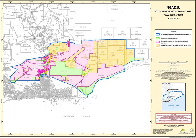
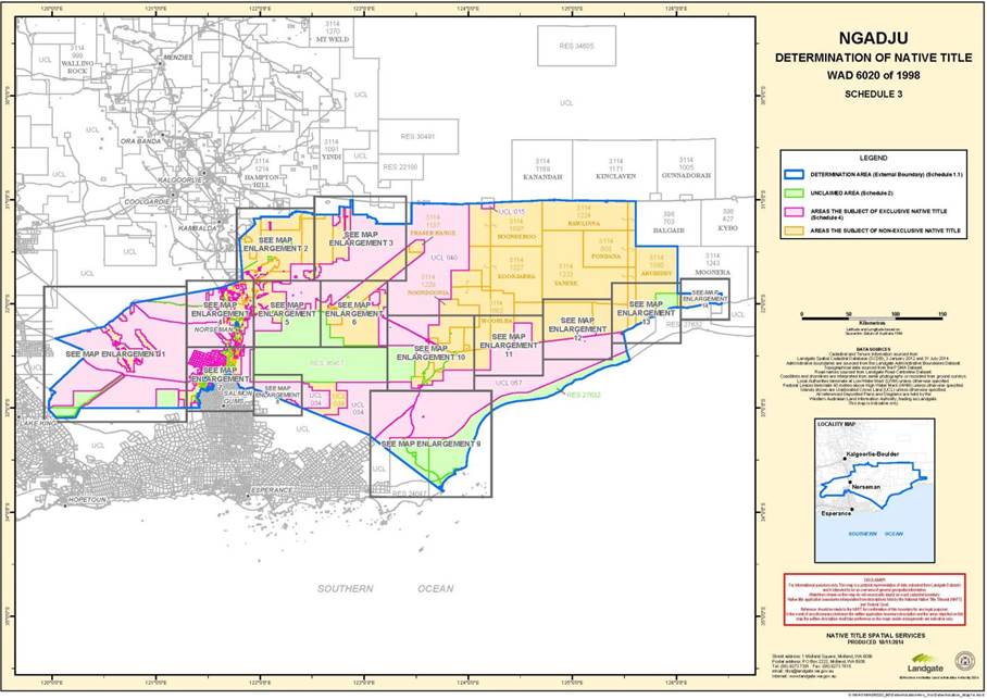
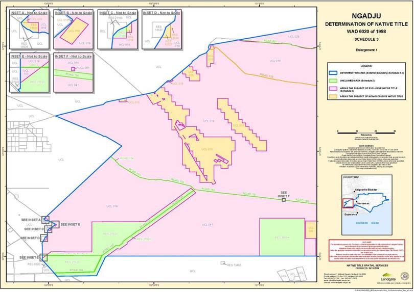
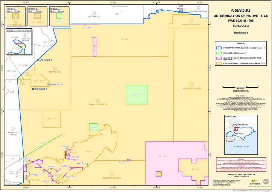
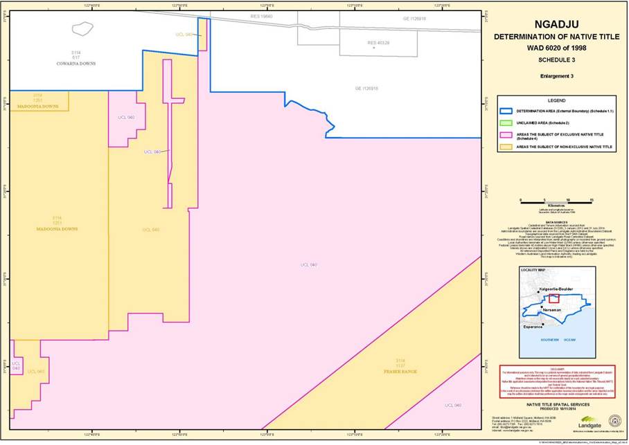
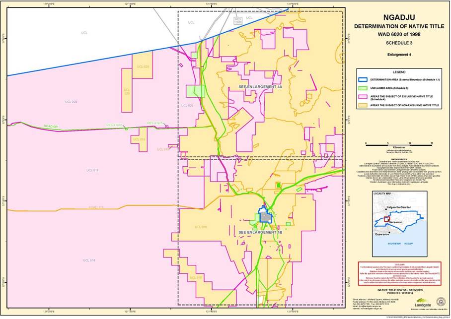
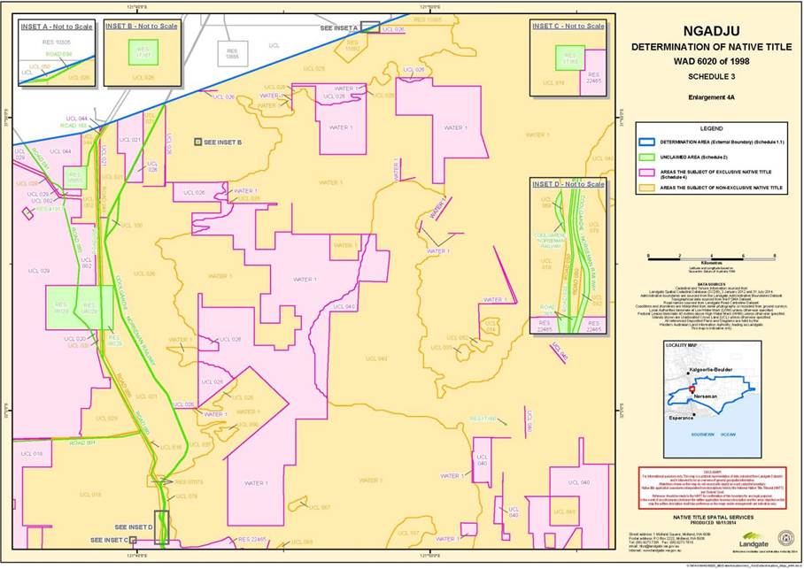
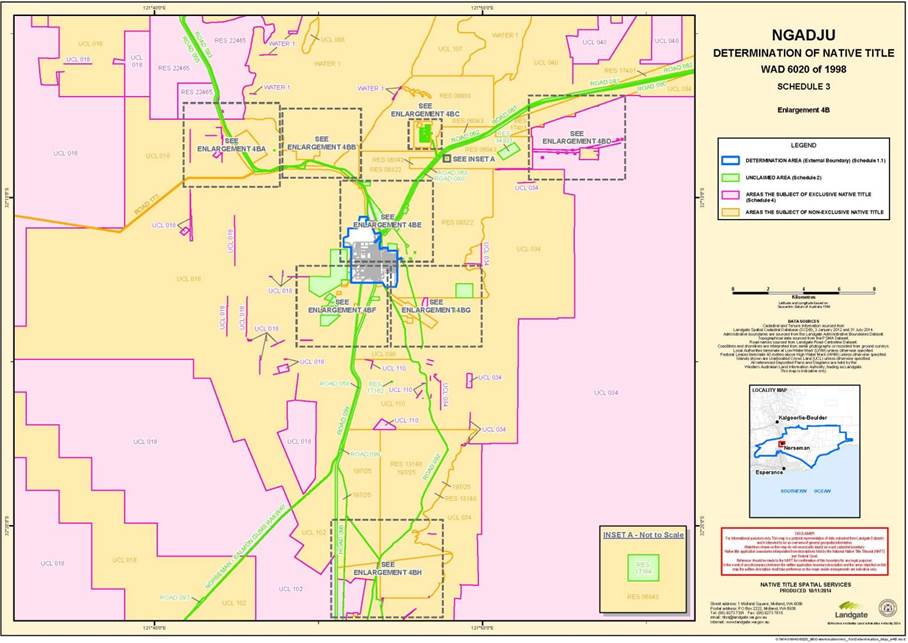
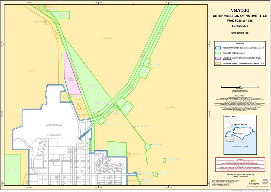
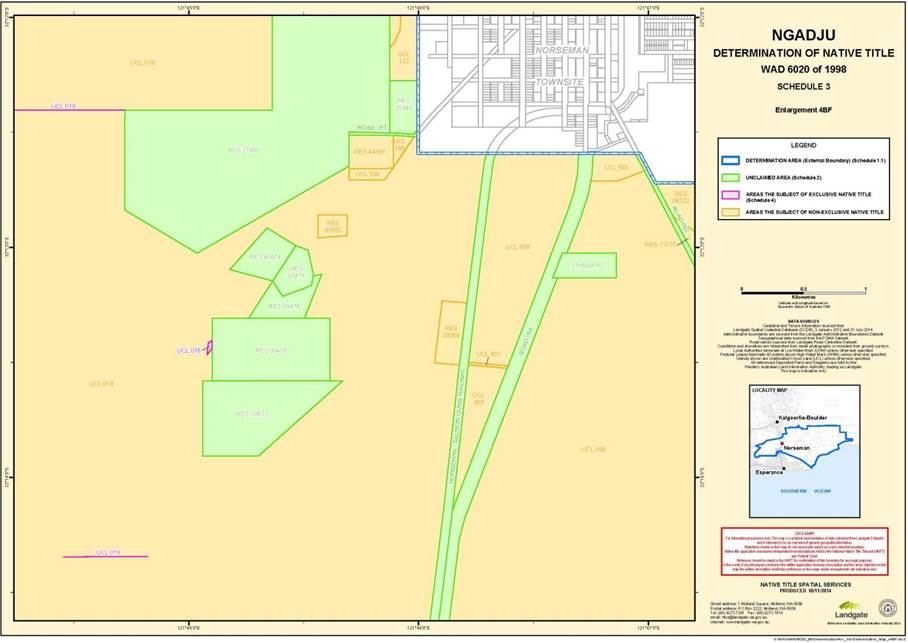
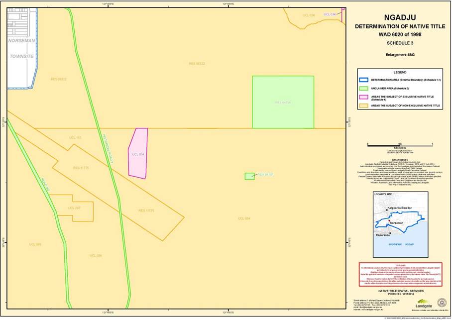
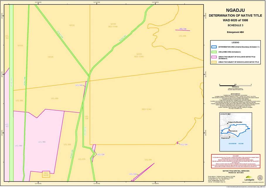
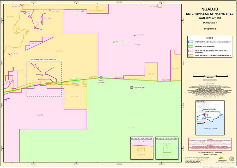
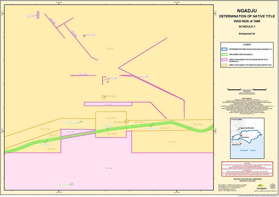
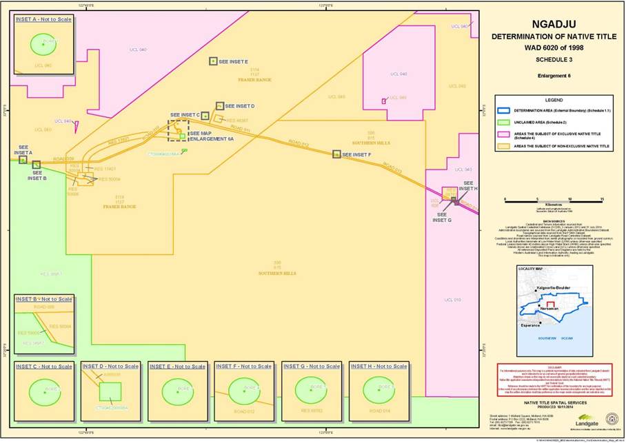
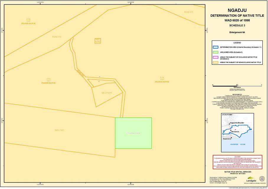
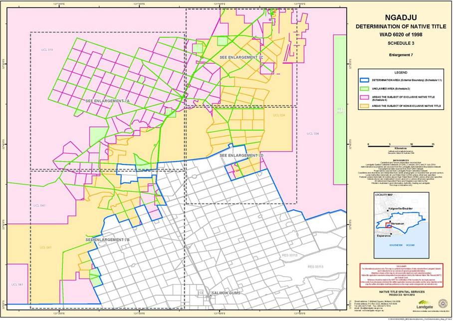
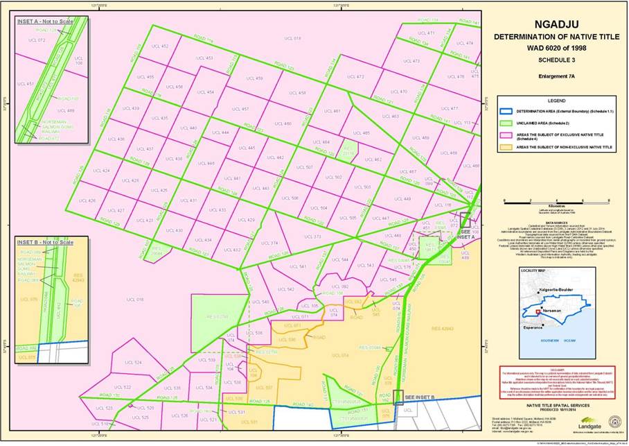
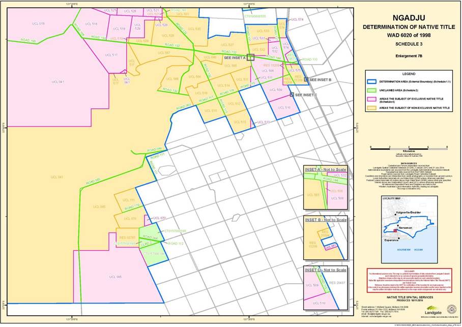
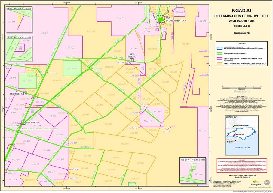
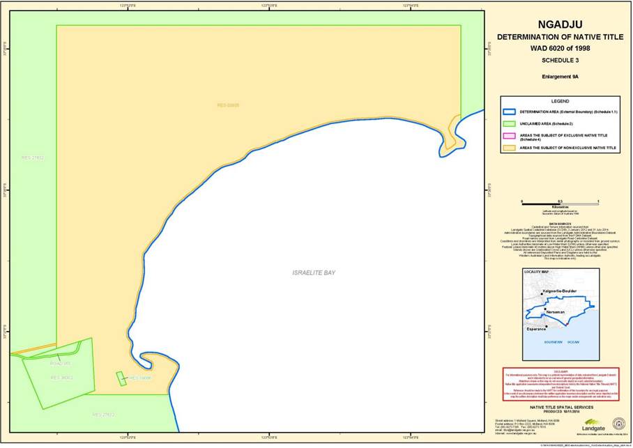
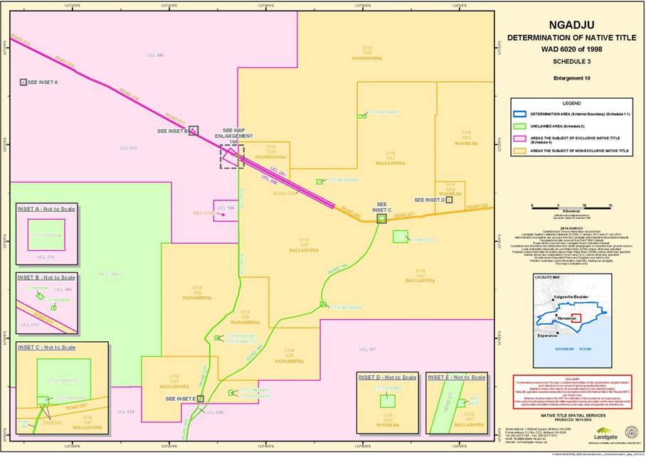
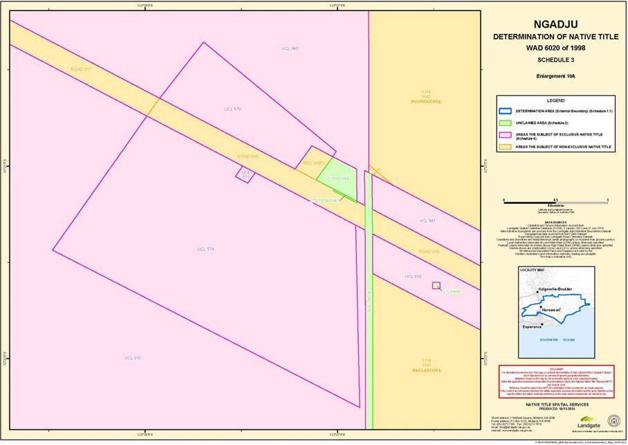
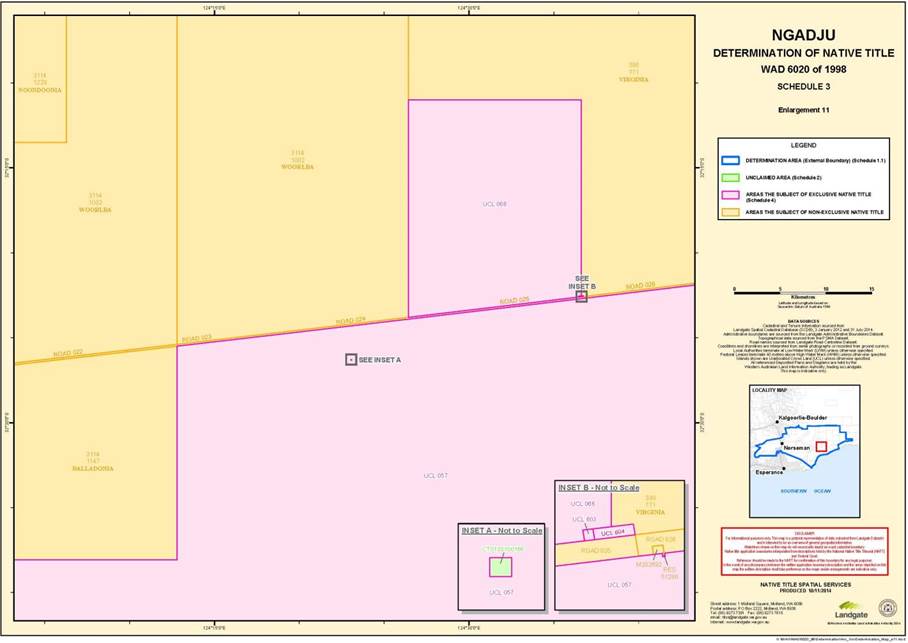
“Determination Area” means the land and waters within the external boundary described in item 1.1 of Schedule 1 but not including the Unclaimed Area. The external boundary is generally shown as a solid blue line on the maps in Schedule 3;
“Exclusive Area” means that part of the Determination Area described in item 1.2 of Schedule 1. This area is generally shaded pink on the maps in Schedule 3;
“land” has the same meaning as in the Native Title Act and, for the avoidance of doubt, includes any natural collection of water found on the land which does not fall within the definition of “waters”;
“Native Title Act” means the Native Title Act 1993 (Cth);
"Non-Exclusive Area" means those parts of the Determination Area which are not the Unclaimed Area or the Exclusive Area. This area is generally shaded orange on the maps in Schedule 3.
“ochre” does not include ochres for use in the manufacture of porcelain, fine pottery or pigments which are minerals pursuant the Mining Act 1904 (WA) (repealed);
“Other Interests” means the legal or equitable estates or interests and other rights in relation to the Determination Area described in Schedule 5 and Schedule 5A and referred to in paragraph 7, as at the date of this determination;
“Unclaimed Area” means the land and waters described in Schedule 2. This area is generally shaded green on the maps in Schedule 3;
“underground water” includes water that percolates from the ground; and
“waters” has the same meaning as in the Native Title Act.
10. In the event of any inconsistency between the written description of an area in Schedule 1, Schedule 2, Schedule 4 or Schedule 5, and the area as depicted on the maps at Schedule 3, the written description prevails.
11. In the event of any inconsistency as to the existence of native title rights and interests in an area of land and waters which is or was covered by interests that are listed in Schedule 2 and Schedule 4, Schedule 4 prevails.
Pre Racial Discrimination Act 1975 (Cth) mining tenements
12. Some historical mining tenements were granted "subject to survey". Such condition precedent to the grant of those tenements is recorded in the Gazette. There is no evidence with respect to such tenements that the condition precedent was never fulfilled. There is no evidence of the undertakings of a survey with respect to such mining tenements. In all such respects, those tenements are not valid and do not extinguish native title rights and interests.
Schedule 1: Determination area and exclusive area
S1.1 Determination Area
The external boundary of the Determination Area, generally shown as bordered in blue on the maps at Schedule 3, is as follows:
All those lands and waters commencing at the easternmost northeastern corner of Pastoral Lease 3114/617 (Cowarna Downs), being a point on a present southern boundary of Lot 5 as shown on Deposited Plan 203378 (Trans Australian Railway) and extending easterly along the southern boundary of that lot to the northwestern corner of the southern severance of Special Lease I126918; Then southerly, generally easterly and northerly along boundaries of that severance to the southern boundary of Lot 4 as shown on Deposited Plan 203373 (Trans Australian Railway); Then easterly along the southern boundary of that lot to the northwestern corner of the southern severance of Lot 3 as shown on Deposited Plan 144514; Then southerly, easterly and northerly along boundaries of that severance to the southern boundary of Lot 4 as shown on Deposited Plan 203373 (Trans Australian Railway); Then easterly along the southern boundary of that lot to the intersection of the prolongation northerly of the eastern boundary of Lot 10 as shown on Deposited Plan 163667; Then southerly to the northeastern corner of Lot 10 as shown on Deposited Plan 163667; Then southwesterly, southerly and southeasterly along boundaries of that lot to a western boundary of Lot 9 as shown on Deposited Plan 152699; Then southerly, easterly and northerly along boundaries of that lot and onwards to the southern boundary of Lot 4 as shown on Deposited Plan 203373 (Trans Australian Railway); Then generally easterly along southern boundaries of that lot to the westernmost southwestern corner of Lot 3 as shown on Deposited Plan 203369 (Trans Australian Railway); Then generally easterly along southern boundaries of that lot to the northwestern corner of pastoral lease 3114/1224 (Rawlinna); Then generally easterly along northern boundaries of that pastoral lease to the northwestern corner of Pastoral Lease 398/703 (Balgair); Then southerly along the western boundary of that pastoral lease to the northwestern corner of the northern severance of pastoral lease 3114/1080 (Arubuddy); Then easterly, southerly, again easterly and again southerly along boundaries of that severance to its easternmost southeastern corner; Then southerly to the easternmost northeastern corner of the southern severance of pastoral lease 3114/1080 (Arubuddy), being a point on the present southern side of the Eyre Highway; Then generally southwesterly along southern boundaries of that highway to the northeastern corner of Lot 3 as shown on Deposited Plan 168565; Then southerly along the eastern boundary of that lot to its southeastern corner; Then generally southerly passing through the following coordinate positions:
LATITUDE (SOUTH) | LONGITUDE (EAST) |
32.388449 | 125.513105 |
32.452926 | 125.521081 |
Then southerly to the intersection of the Low Water Mark with Longitude 125.551605º East; Then generally southwesterly along that water mark to the prolongation easterly of the northern boundary of the eastern severance of Lot 2 as shown on Deposited Plan 256429; Then westerly to and westerly along the northern boundary of that severance to its northwestern corner; Then westerly to the northeastern corner of the western severance of Lot 2 as shown on Deposited Plan 256429; Then westerly, southerly and easterly along boundaries of that severance to its southeastern corner; Then easterly to the southwestern corner of the eastern severance of Lot 2 as shown on Deposited Plan 256429; Then easterly along the southern boundary of that severance and onwards to the Low Water Mark; Then generally southerly, generally easterly and generally southwesterly along the Low Water Mark to the intersection with Longitude 123.754068° East, being a point southwest of Point Malcolm; Then northwesterly to the easternmost corner of Lot 491 as shown on Deposited Plan 215215, being a point on the present boundary of Native Title Determination WAD6097/1998 The Esperance Nyungars (WC1996/064); Then generally northwesterly, generally southwesterly and generally westerly along that determination boundary to the eastern side of Road Number 4274; Then generally northwesterly along sides of that road to the southern side of Road Number 9283; then generally northerly, generally northeasterly and generally northwesterly along sides of that road to the intersection with Latitude 32.821851° South; Then northwesterly to the eastern side of a road at approximately Latitude 32.525422° South, Longitude 120.294539° East; Then generally northeasterly and generally northwesterly along sides of that road to a southern side of the Hyden – Norseman Road; Then generally northeasterly along sides of that road to the intersection with Latitude 31.994916° South; Then generally northeasterly and generally northerly passing through the following coordinate positions:
LATITUDE (SOUTH) | LONGITUDE (EAST) |
31.842044 | 121.635623 |
31.773431 | 121.823677 |
31.684542 | 121.825622 |
31.373705 | 121.800341 |
31.234535 | 121.952282 |
Then northwesterly to the intersection of a southern boundary of Lot 227 as shown on Deposited Plan 238373, being portion of pastoral Lease 3114/1192 (Mt Monger) with Longitude 121.936611° East; Then generally easterly and northerly along boundaries of that lot to a southwestern corner of Pastoral Lease 3114/617 (Cowarna Downs) and then generally easterly, northerly, easterly and again northerly back to the commencement point.
Note:
Geographic Coordinates provided in Decimal Degrees.
All referenced Deposited Plans and Diagrams are held by the Western Australian Land Information Authority, trading as Landgate.
Cadastral boundaries sourced from Landgate Spatial Cadastral Database (SCDB) dated 31st July 2014.
Datum: Geocentric Datum of Australia 1994 (GDA94)
Prepared By: Native Title Spatial Services (Landgate) 13th October 2014
Use of Coordinates: Where coordinates are used within the description to represent cadastral or topographical boundaries or the intersection with such, they are intended as a guide only. As an outcome to the custodians of cadastral and topographic data continuously recalculating the geographic position of their data based on improved survey and data maintenance procedures, it is not possible to accurately define such a position other than by detailed ground survey.
For the avoidance of doubt, the Ngadju Trial Area does not include any area within the boundaries of Native Title Application WAD6216/1998 Kalamaia Kabu(d)n People (WC1997/100) Registered 26/11/1997.
Any part of the Determination Area which is not an area described in Schedules 2 or 4 is the Non-Exclusive Area. This area is generally shown as shaded orange on the maps at Schedule 3.
S1.2 Exclusive Area
The Exclusive Area, generally shown as shaded pink on the maps at Schedule 3, comprises all of the areas listed in Schedule 4 below, excluding all land and waters below the high watermark of the foreshore of the coastline including rivers, streams and estuaries that are affected by the ebb and flow of the tides.
Schedule 2: Unclaimed area
The following areas were excluded from the native title determination application and are excluded from the Determination Area:
(a) The Town of Norseman
The following areas, being land and waters where native title has been completely extinguished, were excluded from the native title determination application and are excluded from the Determination Area.
All of the following areas are shown generally as shaded green on the maps in Schedule 3.
S2.1 Freehold
CT0101900712 | GT0001100262 | GT0002300675 | CT0008500027 | CT0124200080 |
CT0101900818 | GT0001100312 | GT0002300707 | CT0008500028 | CT0125200851 |
GT0001000617 | GT0001100384 | GT0002300708 | CT0008500029 | CT0133100166 |
GT0001000618 | GT0001100385 | GT0002400069 | CT0008500030 | CT0133700834 |
GT0001000642 | GT0001100404 | LG0036100028 | CT0008500031 | CT0135200204 |
GT0001000659 | GT0001100420 | LG0036600103 | CT0008500032 | CT0135300440 |
GT0001100199 | GT0001100503 | LG0037300059 | CT0008500045 | CT0139000495 |
GT0001100200 | GT0001100504 | LG0038000195 | CT0008500096 | CT0157000198 |
GT0001100201 | GT0001100767 | LG0038300188 | CT0008800077 | CT0162100050 |
GT0001100202 | GT0001200089 | LG0038400026 | CT0008800078 | CT0165900047 |
GT0001100203 | GT0001200465 | LG0039200198 | CT0008800080 | CT0171000427 |
GT0001100204 | GT0001200466 | LG0039200199 | CT0008800153 | CT0173200958 |
GT0001100205 | GT0001200467 | LG0039200200 | CT0009900178 | CT0173200975 |
GT0001100206 | GT0001200468 | CT0006400163A | CT0010900023 | CT0173900288 |
GT0001100208 | GT0001200469 | CT0006400164A | CT0011200005 | CT0179800721 |
GT0001100209 | GT0001300287 | CT0007400161 | CT0011200008 | CT0190100387 |
GT0001100210 | GT0002200207 | CT0008100165 | CT0011200009 | CT0190100388 |
GT0001100211 | GT0002200698 | CT0008100166 | CT0011800114 | CT0190100389 |
GT0001100212 | GT0002200699 | CT0008100167 | CT0020000034 | CT0195800535 |
GT0001100213 | GT0002200700 | CT0008100168 | CT0028100051A | CT0196300389 |
GT0001100214 | GT0002200701 | CT0008100169 | CT0038800097 | CT0219400480 |
GT0001100215 | GT0002200718 | CT0008100170 | CT0044500086A | CT0221400164 |
GT0001100216 | GT0002300179 | CT0008100171 | CT0046200086A | |
GT0001100259 | GT0002300429 | CT0008500024 | CT0057500124 | |
GT0001100260 | GT0002300496 | CT0008500025 | CT0064400036 | |
GT0001100261 | GT0002300509 | CT0008500026 | CT0118200953 |
S2.2 Vested reserves or reserves covered by public works
Reserve No | Current/Last Purpose | Reserve No | Current/Last Purpose | ||
RES 02788 | Water | RES 19875 | Water Tank | ||
RES 03044 | Water | RES 20044 | Water | ||
RES 03045 | Water | RES 20114 | Water Tank | ||
RES 03046 | Water | RES 21168 | Water | ||
RES 03047 | Water | RES 21690 | Goldfields Water supply Administration | ||
RES 03098 | Church of England | RES 21930 | Aerial Landing Ground | ||
RES 03314 | Water | RES 22205 | Recreation and Swimming Pool | ||
RES 03476 | Refuse Disposal and Management Site | RES 24047 | National Park | ||
RES 03671 | Explosives Magazine | RES 25948 | Recreation | ||
RES 04797 | Water | RES 26155 | Water Supply | ||
RES 04798 | Water | RES 27023 | National Park | ||
RES 05655 | Water Supply | RES 27632 | Primitive area for preservation and study of flora and fauna geological and anthropological features | ||
RES 08029 including that area now comprising Road 049 | Conservation of flora and fauna | RES 29734 | Open Air Museum | ||
RES 10257 | Mineral Processing | RES 30316 | Aeronautical Navigational aids, satellite ground station and telecommunications | ||
RES 14234 | National park and water | RES 17162 | State Geodetic Infrastructure | ||
RES 31796 | Interstate stock checkpoint | RES 17163 | State Geodetic Infrastructure | ||
RES 17164 | State Geodetic Infrastructure | RES 34933 | Quarry | ||
RES 17165 | State Geodetic Infrastructure | RES 35860 | Stock paddock | ||
RES 17166 | State Geodetic Infrastructure | RES 36002 | Heritage place | ||
RES 17167 | State Geodetic Infrastructure | RES 36004 | National Park | ||
RES 17201 | Water | RES 36957 | Conservation of flora and fauna | ||
RES 38086 | Fishermen’s camp site | RES 40974 | Recreation motor racing | ||
RES 17630 | Water | RES 41127 | Maintenance depot | ||
RES 17631 | Water | RES 41448 | Arboretum | ||
RES 41915 | Gravel | RES 41916 | Gravel | ||
RES 19871 | Water | RES 41917 | Gravel | ||
RES 19874 | Water Tank | RES 41934 | Conservation of flora and fauna | ||
RES 43129 | Regenerator Site | RES 44121 | Regenerator Site | ||
RES 44117 | Regenerator Site | RES 44263 | Regenerator Site | ||
S2.3 Leases
Lease No | Summary/General description of the Current/Las purpose | Lease No | Summary/General description of the Current/Las purpose |
3116/1071 | Industrial and other purpose | 332/0966 | Grazing |
3116/02515 | Grazing | 332/2079 | Grazing |
3116/03044 | Motel and Service Station | 333/0689 | Aeronautical and satellite ground station |
3116/09553 | Grazing | 37L/0689 | Microwave tower |
3116/09690 | Water Supply |
S2.4 Dedicated roads and roads set aside, taken or resumed and associated features
(a) Dedicated roads, roads set aside, taken or resumed or roads which are to be considered public works (as that expression is defined in the Native Title Act and the Titles (Validation) and Native Title (Effect of Past Acts) Act 1995(WA)), being the following:
Road | General Location/Description |
Current Road 001 (as constructed) | The general description of the location of Current Road 001 (as constructed) is provided at Schedule 2A. |
Current Roads 003, 106, 107, 110 , 114, 115, 116 118, 119, 120, 121, 122, 123, 124, 125, 126, 127, 128, 129, 131, 132, 133, 134, 135, 136, 137, 138, 139, 140, 141, 142, 143, 144, 145,146, 147, 148, 149, 150, 151, 152, 153, 154, 155, 164, 165, 101, 128, and 130 | Roads described as One, Two and Three Chain Roads shown generally on: • Diagram No. 49828, 52015, 52569, 59295, 72656; • Deposited Plan No. 201879, 203640, 203643, 203644,203654, 203651, 203695; 203686, 203694; • Leake District Plan No. 4601, 4602, 4603, 4604, 4605, 4686, 4610, 4611, 4612; • Plan of Dundas No. 3637, 3638, 3639, 3641, 3642, 3652, 3655, 3691, 3692, 3696, 3703, 3706, 3707, 3714; • Plan of Fitzgerald No. 1880, 3715, 3724, 3675, , 3687, 3697; • Cancelled Public Plans 371-80-2, 371-80-3, 372-80-1; • 3232-IV Gilmore Cadastral Edition 1; and • Reserve Plan 72 (re Reserve 27023). |
Current Road 004 | Road marked Commonwealth Access shown generally on Diagram No. 80446. |
Current Road 162 | That portion of road shown on DP 226290 which commences at the north-western corner of "Townsite of Dundas" and then runs generally south and then generally south east until the boundary of current reserve 4508 and Road 139; and that portion of road generally shown on DP 92265 and labelled Old Coach Road. |
Current Roads 005, 057, 058, 059, 060, 065, 066, 067, 068, 069, 070, 071, 072, 073, 095, 103, 104, 105, 163 | Coolgardie-Esperance Highway (including a 200m road corridor) shown generally on: • Plan No. 10452, 14750, 14751, 14752, 14820, 14821, 14822, 14823, 14824, 17526, 17816 (generally being only that portion of road which is within the Determination Area); • Deposited Plan 217527, 217528, 217529; • Cancelled Public Plan 501115, 501116, 501805; • Gilmore Public Plan 3232-IV Gilmore 1:50 000 Cadastral Edition 1 LAWA; and • Lake Kirk Public Plan 3233-III Lake Kirk 1:50 000 Cadastral Edition 1 LAWA. |
Current Road 055 (as constructed) | The general description of the location of Current Road 055 (as constructed) is provided at Schedule 2B. |
Current Road 056 | Being Road 13847 and generally commencing at the northwestern corner of Nuyts Location 3 and extending eastward along the northern boundary of that location to its northeastern corner. Gazetted as a public road on 31 January 1969 and shown generally on Diagram No. 68565. |
Current Road 061 | Being Road 15202 (Railway Parade) as described in the Gazette dated 19 July 1974 on page 2727 and shown generally on Diagram No. 80110. |
Current Road 062, 063, 080, 081, 082, 083 | Eyre Highway shown as Road No. 2826 on Original Plan No. 11762, 11763 and shown generally on Department of Land Administration (‘DOLA’) Plan No. 19001, 19002, 19032 and 19033. |
Current Roads 064 and 112 | Being Road 7204 and shown generally on Original Plan 14551 including an extension of road No. 7204 shown on Diagram No. 52287. Road 64 was Gazetted as a public road on 9 November 1979 with the following description: (i) (Extension) A strip of land 20.12 metres wide, commencing at the southwestern terminus of the present road at the southern corner of Fitzgerald Location 310 and extending as surveyed to and along the southeastern boundaries of Locations 1403 and 1251 to terminate at the southern corner of the last mentioned location; and (ii) (Deviation of Part) A strip of land, 60 metres wide leaving the northwestern side of the present road at the southeastern boundary of Fitzgerald Location 1251 and extending as delineated and coloured dark brown on Original Plan 14551 northwestward through that location to terminate at the eastern boundary of Reserve No. 2787. |
(Current Roads 074, 075, 076, 077, 078, 079) | Being Road No 18487 and generally comprising all that portion of Parmango Road delineated and coloured mid brown on Crown Survey Plans 18069, 18070 and 18071. Gazetted as a public street on 3 May 1994. |
Current Road 157 | Those roads, road widenings and rights of way in the townsite of Dundas shown generally as streets on Deposited Plan No. 222401 and named Browne Street, Hicks Street , Keyser Street, Mason Street, Mawson Street, Moir Street, Scotia Street, Wittenoom Street and Woodward Street. |
Current Road 109, 160, 161 | The roads, road widenings and rights of way in the Princess Royal Townsite shown generally on Deposited Plan No. 223069, Deposited Plan No. 223070, Diagram No.6096 and named Bucknall Street, Chester Street , Cooper Street, Iona Street, Oak Street, Norma Street, Maybell Street, Pascoe Street, Princess Street and Royal Street. |
Current Road 100 | Road shown generally on CPP 501805 and 3232-IV Gilmore Edition 1, extending northerly from Fuller Road to Coolgardie-Esperance Highway. |
Current Road 108 | Road shown generally on CPP 501809, extending from Road 130 southerly to Road 133 along the western boundary of lot 918 and through a portion of lot 919. |
Current Road 166 | Road No 7532, being generally a strip of land, one chain wide, leaving Road No. 7484 near the South – West corner of Pastoral Lease 444/95, and extending North – Eastward via Wonberna through the said pastoral lease and Pastoral Lease 720/95 to Balladonia Telegraph Station. (Plan 12/300.) Gazetted as a public road on July 9 1926 and shown generally on Deposited Plan 52833. |
Current Road 170 | Road 7203, being generally a strip of land, one chain wide, commencing at the Western Corner of Fitzgerald Location 455 and extending North-Eastward, as surveyed, along the North-Western boundary of said location 455 and the North – Western boundaries of Locations of 456, 461, 462, 261, 463, 464, 504, and 503 to the North corner of the last – mentioned location. (Plans 392/80, A.B. 1, 11/300). Gazetted as a public road on 19 September 1924 and as shown generally on CPP 502835 and Geordie Rock Public Plan: 3132-II Geordie Rock 1:50 000 Cadastral Edition 1 LAWA. |
Current Road 171 | Road No 6368, being generally a strip of land, one chain wide, leaving a surveyed road at the South-East corner of Lot 56 in Higginsville Townsite, and extending North – Eastward through Reserve No. 10305 and the Widgiemooltha – Higginsville State Forest and continuing North – Eastward to “Corney’s Group” Gold Mining Leases (Plans 18 and 19/80). Gazetted as a public road on 24 December 1920 and shown generally on cancelled plan of Widgiemooltha ‘Australia Series SH 51-14 Zone 2’. |
Current Road 172 | Road No 7484, being generally a strip of land three chains wide, commencing at Israelite Bay and extending Northward through Reserve 3805 and Pastoral Leases 755/95, 672/95 and 444/95 to Nanambinia; thence through said pastoral lease 444/95 and Pastoral Leases 478/95, 447/95, 720/95, 753/95, 748/95, 1004/95, 2808/97, via Curalia Dam, Car Bob Well, Brooks Soak, Bull Oak Tank and Pioneer Tank to the District boundary. (Plans 3, 12 and 17/300). Gazetted as a public road on 26 February 1926 and shown generally on CPP 502838 and 502820. |
Current Road 084 | Road No 15890, being generally a strip of land, 200 metres wide, commencing at the northeastern side of Road No. 4274, at northwestern side of Road No. 4274, at the northwestern side of Reserve No. 8812 and extending as delineated and coloured dark brown on Miscellaneous Plan 865, eastward through the said Reserve and Vacant Crown Land and Reserve No. 27023 to terminate at the southern side of a surveyed road within the last mentioned Reserve. Gazetted as a public road on 25 November 1977 and shown generally on Reserve Plan No. 72 (re Reserve 27023) and Miscellaneous Plan No. 865. |
Current Road 085 | Road No 18336, being generally a strip of land commencing at a line in prolongation southwestwards of the northwestern boundary of Fitzgerald Location 1631 and extending southeastwards to terminate at a northwestern side of Wiltshires Road. (Extension). A strip of land, varying in width, as delineated and coloured mid – brown on DOLA Survey Plans 17910 to 17912, inclusive. Gazetted as a public road on 1 November 1991 and shown generally on Department of Land Administration Plan No. 17911, 17912. |
Current Road 86 | Road No 18337, being generally a strip of land commencing at a line in prolongation northwestwards of the southwestern boundary of the southernmost severance of Fitzgerald Location 1433 and extending through the said Location thence northeastwards to terminate at a southwestern side of Coolgardie Esperance Highway (Road No 16148). (Extension) A strip of land as delineated and coloured mid – brown on DOLA Survey Plan 17912. Public Plan: 391 and 392/80; 3131 – I (Roberts 1:50 000). Gazetted as a public road on 1 November 1991 and shown generally on DOLA Survey Plan 17912. |
Current Road 87 | Road No 18296, being generally the area described and dedicated as a public street by notice in the Government Gazette on 18 October 1991 as "whole of Airport Road plus extension – Road No. 18296 – Shire of Wongan – Ballidu; from the Northern side of Wandoo Crescent to Reserve 29590, and also the land as described in the abovementioned resumption notice" and shown generally on DOLA Survey Plan 18573. |
Current Road 88 | Road No 14854, being generally a strip of land varying in width, commencing on the western alignment of Road No. 2826 and extending as delineated and coloured dark brown on Lands and Surveys Diagram 76443 westward through Reserve 8322 and Railway Reserve and Dundas Location 195, to the eastern alignment of a surveyed road on the western boundary of Location 195. 7168 square metres being resumed from Dundas Location 195. Gazetted as a public road on 20 September 1974 and shown generally on Diagram No. 76443. |
Current Road 089 | Road No 1408, being generally a strip of Crown land, 1 chain 50 links wide, leaving the Northern end of Hicks Street, Dundas, and extending Northerly for a distance of about 250 chains, and thence North – Westerly to join Mr Surveyor Allan’s traverse at the 117 – Mile Post. (Plans 26M and Norseman Locality.). Gazetted as a public road on 1 August 1902 and shown generally on CPP 505 514, and 3233-II Woolyeenyer 1:50 000 Cadastral Edition 1 LAWA. |
Current Road 090 | Road No 2826, being generally a strip of land (Crown), two chains wide, leaving Road No. 941 at the Northern end of Prinsep Street (Norseman) and extending in a general North-Easterly direction (as surveyed , O.P. Dundas 3), passing through G.M.Ls. 383, 292, 586 (part of), and 647 to the North boundary of the latter (at Princess Royal). (Plan 18/300). Gazetted as a public road on 2 August 1907 and shown generally on DOLA Survey Plan Nos. 19032, 19033 and CPPs 502868, 501802. |
Current Road 167 | Road No 9372, being generally a strip of land, two chains wide (plus truncations) leaving Rumble street at the north – west corner of Norseman Town Lot 941 and extending east along north boundaries of Lots 941 to 948 inclusive, 973 to 980, and 1005 to 1012 to the easternmost boundary of the Townsite and continuing one chain wide through Reserve No. 8322 (Common) and Goldmining Lease 1451 Dundas (Mines Diagram 127/98) to an eastern boundary of latter. (Plans Norseman Townsite and 350/80). Gazetted as a public road on 5 March 1937 and shown generally on DOLA Reserve Plan No. 288 (re Reserve 8322) and Original Plan No. 5940. |
Current Road 091 | Road No 916, being generally a strip of land (Crown), one chain wide, extending in a general South – South – Easterly direction from Coolgardie to the South boundary of the district, via Burbanks, Londonderry, Toonarrie, Burra, Wonaway , and 50 – Mile Soak, as surveyed and shown on Original Plans T.G. 317, 331, 344 and 358. (plans 17 and 20M). Gazetted as a public road on 20 October 1899 and shown generally on CPP 505500. |
Current Road 092 | Road No 909, being generally a strip of land (Crown) one chain wide, extending from Dundas Townsite in a general Northerly direction to Norseman Townsite, as surveyed by Mr. Surveyor R. E. Lowe, Eastern Districts Plan 91. (Plans 26 M and Locality). Gazetted as a public road on 22 November 1899 and shown generally on Public Works Department Plan, Goldfields Water Supply Branch N91 No. 6488 Dundas Location No. 4 and CPP 502868. |
Current Road 093 | Road No 941, being generally a strip of land (Crown), one chain wide, as surveyed by Messrs. Surveyors R. S. Allen and H.L. Brown, and shown on Original Plan Coolgardie No. 6, extending from the North boundary of the district at Wilgarnie Roacks (50 Mile Soak) in a general Southerly direction to Norseman. (Plan 20 and 26M). Gazetted as a public road on 22 December 1899 and shown generally on CPPs 505500, 505514. |
Current Road 94 | A looped road from Higginsville to Eundynie as shown generally on CPP 50115. |
Current Road 96 | A road running in a north westerly direction from Point Malcolm and shown generally on CPP 502820. |
Current Road 97 | The portion of road proximate to the Goodia Siding of the Salmon Gums-Norseman Railway as shown generally on CPP 501801 and Lake Kirk Public Plan No 3233-III 1:50 000 Cadastral Edition 1 LAWA. |
Current Road 99 | Portion of road proximate to Lake-Kirk siding of the Salmon Gum-Norseman Railway as shown generally on CPP 501801 and on Woolyeenyer No. 3233-II 1:50 000 Cadastral Edition 1 LAWA. |
Current Road 98 | Road extending north from the vicinity of Dundas townsite running parallel and east to the Coolgardie-Esperance Highway marked on Woolyeenyer No. 3233-II 1:50 000 Cadastral Edition 1 LAWA. |
Current Road 141 | Roads marked ‘Railway Reserve’ and 'Three Chains Road" and shown generally on Dundas PlanNo. 3703. |
Current Road 102 | The portion of Fuller Road, shown generally on Gilmore Public Plan: 3232-IV 1:50 000 Cadastral Edition 1 LAWA that extends westerly from Coolgardie-Esperance Highway to Current Roads 100 and 131. |
Current Road 111 | An inverted “L” shaped road diverging from Magagnotti Road as shown generally on Geordie Rock Public Plan: 3132-II 1:50 000 Cadastral Edition 1 LAWA. |
Current Road 113 | Road widenings in Dundas District shown generally on Diagram No. 59294. |
Current Road 117 | Road shown generally on Deposited Plan No. 202841 intersecting Lots 560, 561, 578 and 579. |
Current Road 156 | Road commencing at 90̎47̎30 and ceasing at the intersection with Three Chain Road, shown generally on Original Plan No. 10892 in the vicinity of Fitzgerald Location 1552. |
Historical Road 003 | Road shown as Lot 266 on DP 40385. |
Historical Road 005 | Road shown as Lot 3000 on DP 46104. |
Historical Road 006 | Lake Grace – Norseman Road shown coloured blue on Miscellaneous Plan 865 (Public Plans 389/80 and 390/80), closure gazetted on 29 July 1977 at pp 2452-2454. |
Historical Road 008 | Road No. 11014 generally shown as the road from Norseman to Iron King Mines in the Dundas District and marked on Original Plan No. 5940. |
Closed Road 1 (Portion of Road 123) | Portion of Road No. 123 being the Lake Grace to Norseman Road shown generally on Miscellaneous Plan 865 |
Closed Road 2 (Portion of Road 7204) | Portion of Road 7204 shown generally on Deposited Plan 14551 |
(b) The following public works (as that expression is defined in the Native Title Act and the Titles (Validation) and Native Title (Effect of Past Acts) Act 1995 (WA)) associated with the roads identified in sub-item 2.4 above:
S2.5 Public works
Public Work | Location/Description | ||||
Water Bores (each of an area of 0.1 ha, the centre point of which is:) | Located near the Eyre Highway being: | ||||
Bore | Straight Linear Kilometre – distance in linear kilometres from the start of the road | Distance (m) from side of road (LHS: left hand side, RHS: right hand side) | Latitude | Longitude | |
1. | 80.45 | 250 – LHS | -32.06862 | 122.57874 | |
2. | 106.06 | 1450 – LHS | -32.00826 | 122.83255 | |
3. | 154.25 | 1400 – RHS | -32.19281 | 123.29621 | |
4. | 124.64 | 150 - LHS | -32.06140 | 123.01549 | |
5. | 141.47 | 300 - LHS | -32.12353 | 123.17777 | |
6. | 142.18 | 50 – LHS | -32.12839 | 123.18218 | |
7. | 103.31 | 10000 – LHS | -31.93122 | 122.84335 | |
Railway (the area on which the railway and any associated infrastructure is situated) | Coolgardie – Norseman Railway | ||||
Norseman – Salmon Gums Railway | |||||
The part of the reserve on which the railway or any associated infrastructure is situated | RES 32416 | ||||
Schedule 2A: General description of the location of Current Road 001 (as constructed)
All that land, being 20 metres wide and defined by the centerline commencing at the intersection of a northern boundary of the Ngadju Trial Area with Longitude 120.905541° East and extending generally southeasterly and generally easterly along that centerline through the following coordinate positions:
LATITUDE (SOUTH) | LONGITUDE (EAST) |
31.971782 | 120.924184 |
31.974257 | 120.947167 |
31.976494 | 120.967531 |
31.977561 | 120.977098 |
31.978469 | 120.986895 |
31.979754 | 121.001714 |
31.980850 | 121.003908 |
31.982745 | 121.031000 |
31.984189 | 121.051652 |
31.985878 | 121.074754 |
31.987463 | 121.096890 |
31.987949 | 121.104704 |
31.986591 | 121.109556 |
31.988352 | 121.129304 |
31.990280 | 121.150611 |
31.990737 | 121.151698 |
31.991306 | 121.152493 |
31.993466 | 121.154600 |
31.994084 | 121.155329 |
31.994535 | 121.156156 |
31.998561 | 121.173737 |
32.003011 | 121.194410 |
32.007808 | 121.217417 |
32.008022 | 121.218485 |
32.009949 | 121.240281 |
32.011401 | 121.258025 |
32.011543 | 121.260254 |
32.011234 | 121.261706 |
32.010567 | 121.262689 |
32.007927 | 121.266441 |
32.007733 | 121.266985 |
32.005688 | 121.277301 |
32.005762 | 121.278206 |
32.005976 | 121.279051 |
32.013628 | 121.299420 |
32.017268 | 121.319401 |
32.017887 | 121.322844 |
32.019053 | 121.337216 |
32.020723 | 121.357322 |
32.021699 | 121.361010 |
32.020652 | 121.380634 |
32.019819 | 121.400949 |
32.018725 | 121.432699 |
32.018221 | 121.450552 |
32.018019 | 121.457497 |
32.017297 | 121.477192 |
32.016607 | 121.498129 |
32.015941 | 121.517131 |
32.015155 | 121.538042 |
32.014798 | 121.547317 |
32.015227 | 121.548959 |
32.016250 | 121.550815 |
32.017630 | 121.552576 |
32.018534 | 121.553837 |
32.019081 | 121.555312 |
32.019177 | 121.556621 |
32.018296 | 121.578767 |
32.017273 | 121.602226 |
32.016226 | 121.626877 |
32.015369 | 121.647883 |
32.014989 | 121.657874 |
Then easterly to the intersection of a western side of the Coolgardie – Esperance Highway, being Lot 312 as shown on Deposited Plan 40384, with Latitude 32.012683° South.
Note:
Geographic Coordinates provided in Decimal Degrees.
All referenced Deposited Plan and Diagrams are held by the Western Australian Land Information Authority, trading as Landgate.
Road 1 Centreline digitised from interpreting the approximate position from aerial photography mosaics held by Landgate (DIAMOND_ROCK_3034_AUG_2010_MOSAIC, BRONZITE_RIDGE_3133_NOV_2012_MOSAIC and NORSEMAN_3233_FEB_2009_MOSAIC).
Cadastral boundaries sourced from Landgate Spatial Cadastral Database (SCDB) dated 31st July 2014.
Datum: Geocentric Datum of Australia 1994 (GDA94)
Prepared By: Native Title Spatial Services (Landgate) 7th November 2014
Use of Coordinates:
Where coordinates are used within the description to represent cadastral or topographical boundaries or the intersection with such, they are intended as a guide only. As an outcome to the custodians of cadastral and topographic data continuously recalculating the geographic position of their data based on improved survey and data maintenance procedures, it is not possible to accurately define such a position other than by detailed ground survey.
Schedule 2B: General description of the location of Current Road 055 (as constructed)
All that land, being 20 metres wide and defined by the centerline commencing at the intersection of a southwestern boundary of Native Title Application WAD6020/1998 Ngadju (WC1999/002) with Latitude 33.708086° South and extending generally northeasterly along that centerline through the following coordinate positions:
LATITUDE (SOUTH) | LONGITUDE (EAST) |
33.708016 | 123.632972 |
33.707272 | 123.633681 |
33.706113 | 123.639112 |
33.705785 | 123.640980 |
33.705162 | 123.646418 |
33.704349 | 123.650742 |
33.703380 | 123.655325 |
33.702343 | 123.660008 |
33.701530 | 123.664280 |
33.701339 | 123.667646 |
33.700717 | 123.673959 |
33.700371 | 123.676605 |
33.700181 | 123.681995 |
33.699091 | 123.688083 |
33.698814 | 123.689311 |
33.697718 | 123.692659 |
33.696801 | 123.695098 |
33.695694 | 123.697658 |
33.694950 | 123.699024 |
33.693982 | 123.700460 |
33.692338 | 123.702631 |
33.690799 | 123.704360 |
33.690436 | 123.704914 |
33.690176 | 123.705934 |
33.689502 | 123.709212 |
33.688689 | 123.712844 |
33.688256 | 123.713744 |
33.687997 | 123.714764 |
33.687703 | 123.715750 |
33.686388 | 123.719365 |
33.685039 | 123.722921 |
33.683535 | 123.726242 |
33.680688 | 123.732088 |
33.678975 | 123.735679 |
33.678197 | 123.738360 |
33.677574 | 123.739934 |
33.677384 | 123.741058 |
33.677384 | 123.742727 |
33.677038 | 123.744128 |
33.676865 | 123.745339 |
33.676433 | 123.746792 |
33.676381 | 123.747293 |
33.676121 | 123.748227 |
33.676018 | 123.751513 |
33.675890 | 123.752596 |
33.675042 | 123.754741 |
33.674195 | 123.756765 |
33.673243 | 123.757958 |
33.672534 | 123.758200 |
33.671566 | 123.758494 |
33.670839 | 123.759117 |
33.670476 | 123.759273 |
33.669922 | 123.759722 |
33.668418 | 123.760293 |
33.667708 | 123.760881 |
33.667138 | 123.761106 |
33.666446 | 123.761365 |
33.665782 | 123.762203 |
33.665470 | 123.762566 |
33.664882 | 123.762773 |
33.663118 | 123.763119 |
33.661337 | 123.763673 |
33.660870 | 123.764036 |
33.659572 | 123.766250 |
33.654626 | 123.775979 |
33.653674 | 123.777717 |
33.652533 | 123.780070 |
33.651132 | 123.782162 |
33.650734 | 123.782526 |
33.649783 | 123.782923 |
33.648797 | 123.783529 |
33.648330 | 123.784082 |
33.647534 | 123.784843 |
33.646925 | 123.785561 |
33.646268 | 123.786599 |
33.645438 | 123.788052 |
33.644763 | 123.789297 |
33.644469 | 123.790093 |
33.643501 | 123.792151 |
33.640975 | 123.797426 |
33.640800 | 123.797840 |
33.638740 | 123.801092 |
33.636910 | 123.804785 |
33.635474 | 123.806445 |
33.633964 | 123.807976 |
33.632579 | 123.809643 |
33.631503 | 123.811017 |
33.629624 | 123.813502 |
33.628177 | 123.815882 |
33.625691 | 123.819746 |
33.624304 | 123.821913 |
33.623477 | 123.823414 |
33.623340 | 123.823683 |
33.623123 | 123.823928 |
33.622691 | 123.824904 |
33.622484 | 123.825577 |
33.622286 | 123.826484 |
33.622394 | 123.827098 |
33.622531 | 123.827860 |
33.622556 | 123.828975 |
33.622413 | 123.831414 |
33.622416 | 123.833108 |
33.622284 | 123.834896 |
33.622289 | 123.835528 |
33.622498 | 123.837198 |
33.622476 | 123.837888 |
33.622303 | 123.838635 |
33.621893 | 123.839491 |
33.621135 | 123.840722 |
33.620271 | 123.843111 |
33.620192 | 123.845876 |
33.619773 | 123.848030 |
33.619421 | 123.849176 |
33.619383 | 123.851829 |
33.619314 | 123.852634 |
33.619471 | 123.853701 |
33.619820 | 123.854684 |
33.619787 | 123.855732 |
33.619550 | 123.857104 |
33.619561 | 123.857467 |
33.619377 | 123.858337 |
33.619289 | 123.859751 |
33.619154 | 123.860383 |
33.618844 | 123.860710 |
33.618142 | 123.860919 |
Then northeasterly to the intersection of the northern boundary of Reserve 36002 with Longitude 123.861056° East.
Note:
Geographic Coordinates provided in Decimal Degrees.
Road 55 Centreline digitised from interpreting the approximate position from aerial photography mosaics held by Landgate (MALCOLM_3630_JAN_2009_MOSAIC).
Cadastral boundaries sourced from Landgate Spatial Cadastral Database (SCDB) dated 31st July 2014.
Native Title Application WAD6020/1998 Ngadju (WC1999/002) Registered 28/09/2000.
Datum: Geocentric Datum of Australia 1994 (GDA94)
Prepared By: Native Title Spatial Services (Landgate) 7th November 2014
Use of Coordinates:
Where coordinates are used within the description to represent cadastral or topographical boundaries or the intersection with such, they are intended as a guide only. As an outcome to the custodians of cadastral and topographic data continuously recalculating the geographic position of their data based on improved survey and data maintenance procedures, it is not possible to accurately define such a position other than by detailed ground survey.
Schedule 3: Maps of the determination area
Schedule 4: Areas to which ss 47A and 47B apply
Sections 47A or 47B of the Native Title Act apply to the following land and waters within the Determination Area, which are generally shaded pink on the maps at Schedule 3:
S4.1 Section 47A
Section 47A of the Native Title Act applies with the effect that any extinguishment by the creation of prior interests, including those referred to below, in relation to those parts of the Determination Area the subject of the following interests is disregarded:
Areas where section 47A applies |
RES 22465 |
RES 26233 |
S4.2 Section 47B
Section 47B of the Native Title Act applies with the effect that any extinguishment by the creation of prior interests in relation to those parts of the Determination Area referred to below is disregarded:
Areas where section 47B applies | ||||||||||
The following areas or such portions of them that lie within the Determination Area: | ||||||||||
UCL001 | UCL068 | UCL 372 | UCL 503 | UCL 525 | UCL 577 | |||||
UCL009 | UCL072 | UCL 373 | UCL 504 | UCL 526 | UCL 578 | |||||
UCL010 | UCL077 | UCL 374 | UCL 505 | UCL 534 | UCL 579 | |||||
UCL015 | UCL081 | UCL 423 to 474 | UCL 506 | UCL 535 | UCL 584 | |||||
UCL016 | UCL091 | UCL 476 | UCL 507 | UCL 539 | UCL 586 | |||||
UCL017 | UCL097 | UCL 477 | UCL 509 | UCL 540 | UCL 592 | |||||
UCL053 | UCL099 | UCL 489 | UCL 510 | UCL 541 | UCL 594 | |||||
UCL056 | UCL 103 | UCL 490 | UCL 518 | UCL 542 | UCL 603 | |||||
UCL057 | UCL 105 | UCL 491 | UCL 520 | UCL 543 | UCL 604 | |||||
UCL065 | UCL 108 | UCL 493 | UCL 522 | UCL 544 | ||||||
UCL066 | UCL 112 | UCL 494 | UCL 523 | UCL 575 | ||||||
UCL067 | UCL 116 | UCL 502 | UCL 524 | UCL 576 | ||||||
The following areas or such portions of them that lie within the Determination Area, | excluding the portion overlapped by: | |||||||||
UCL002 | M15/708 | L15/192 | E63/303 | |||||||
UCL018 | E63/296-297 | E63/383-386 | M63/68 | M63/202 | P63/759 | P63/811-812 | ||||
E63/318 | E63/401 | M63/85 | M63/209 | P63/767 | P63/829-832 | |||||
E63/334-335 | E63/404 | M63/87 | M63/218-219 | P63/770-772 | P63/841-861 | |||||
E63/345 | E63/406 | M63/96 | M63/236-237 | P63/774-775 | P63/872-874 | |||||
E63/349 | E63/428-432 | M63/141 | M63/258-259 | P63/776-779 | P63/913-915 | |||||
E63/356 | M63/13 | M63/148-149 | M63/283-284 | P63/780-788 | P63/920-922 | |||||
E63/366 | M63/15 | M63/163 | M63/290 | P63/925 | ||||||
E63/368 | M63/26 | M63/165 | M63/302 | |||||||
E63/373 | M63/38-39 | M63/170 | P63/706 | |||||||
E63/378-379 | M63/44-46 | M63/184 | P63/734 | |||||||
UCL019 | E74/151 | L74/6-7 | M74/69 | P74/155-156 | ||||||
UCL020 | E63/303 | |||||||||
UCL021 | E15/208 | E63/345 | L15/192 | M63/277 | M15/708 | P15/3587 | ||||
E63/303 | E63/401 | M15/681 | M63/274 | P63/824 | M15/640 | |||||
E63/337 | M15/619 | M15/680 | M15/708 | |||||||
M63/277 | P15/3587 | |||||||||
UCL026 | E15/212 | E63/303 | E63/401 | M15/572 | M15/619-620 | M15/694 | ||||
E15/272 | E63/317 | GML15/6469 | M15/578 | M15/639-640 | M63/127-128 | |||||
E15/301 | E63/337 | M15/269 | M15/581 | M15/656 | M63/274 | |||||
E15/265 | E63/345 | M15/506-507 | M15/597-599 | M15/681 | M63/88 | |||||
M63/277 | M15/629 | |||||||||
UCL027 | E15/184 | |||||||||
UCL028 | E63/348 | |||||||||
UCL029 | E15/181 | E63/303-304 | E63/345 | L15/192 | M63/274 | M63/304-305 | ||||
M15/788 | ||||||||||
E63/318 | E63/334 | E63/345 | E63/368 | E63/383 | E63/384 | |||||
E63/428 | M63/283 | |||||||||
UCL034 | E63/346 | L63/012-014 | M63/110 | M63/178 | M63/268 | P63/822-823 | ||||
E63/348 | L63/035 | M63/112 | M63/204 | M63/270 | P63/876 | |||||
E63/364-365 | L63/041 | M63/119-120 | M63/216 | M63/275 | P63/879-901 | |||||
E63/381 | M63/009 | M63/122 | M63/224-226 | P63/692-694 | P63/902-911 | |||||
E63/403 | M63/015 | M63/126 | M63/229 | P63/712-715 | P63/926 | |||||
E63/417-419 | M63/035-036 | M63/133 | M63/231-232 | P63/724-725 | RES04508 | |||||
E63/422 | M63/041-043 | M63/135-138 | M63/238 | P63/749 | E63/47 | |||||
E63/452-454 | M63/068-069 | M63/140 | M63/247 | P63/752-754 | GML63/2181 | |||||
GML63/2182 | M63/105 | M63/144-145 | M63/260 | P63/764-766 | L63/17 | |||||
GML63/2910 | M63/108 | M63/172 | M63/262 | P63/798-801 | L63/36-40 | |||||
M63/7 | M63/94 | P63/705 | P63/742 | P63/810 | P63/813 | |||||
P63/826 | P63/833 | |||||||||
UCL040 | E15/265 | E15/336 | E15/371 | E15/394 | E28/360 | E28/472 | ||||
E28/480 | E28/520 | E28/536 | E28/540 | E28/555 | E28/562 | |||||
E28/578 | E63/328 | E63/336 | E63/347-348 | E63/355 | E63/364-365 | |||||
E63/380 | E63/382 | E63/396 | E63/434 | E63/440-441 | E69/979 | |||||
GML63/2319 | M15/590-592 | M15/605-607 | M63/059 | M63/061-066 | M63/099-100 | |||||
M63/116 | M63/129-130 | M63/139 | M63/160 | M63/180 | M63/180 | |||||
M63/207 | M63/230 | M63/242 | M63/250 | M63/265 | M63/272 | |||||
M63/295-298 | E63/250 | E63/306 | E63/381 | E63/414 | M15/651 | |||||
M63/115 | M63/125 | M63/134 | M63/164 | M63/177 | ||||||
M63/182 | M63/189-190 | M63/255 | M63/263 | M69/15 | P63/743 | |||||
P63/745 | P63/755 | P63/765-766 | P63/768 | P63/789-795 | P63/807 | |||||
P63/822 | P63/868 | P63/916 | P63/683-685 | |||||||
UCL041 | E63/343-344 | E74/165 | ||||||||
UCL044 | P15/3587 | E15/208 | M15/708 | |||||||
L15/144 | M15/45 | |||||||||
M15/680 | M15/681 | |||||||||
UCL064 | E28/481 | E15/304 | E15/390-392 | E15/329 | E28/481 | E25/96-97 | ||||
E25/88 | E28/460 | |||||||||
UCL069 | E63/406 | P63/692 | P63/694 | P63/838 | RES04508 | L63/19 | ||||
M63/260 | P63/693 | P63/705 | P63/837 | |||||||
UCL070 | E63/344 | |||||||||
UCL071 | E63/342 | |||||||||
UCL074 | E63/342 | E63/376 | ||||||||
UCL085 | E63/344 | |||||||||
UCL092 | E63/376 | M63/267 | ||||||||
UCL102 | M63/38-39 | E63/406 | ||||||||
UCL 104 | E63/342 | |||||||||
UCL 109 | E63/404 | |||||||||
UCL 110 | M63/26 | M63/39-40 | M63/96 | M63/126 | M63/118 | M63/211-212 | ||||
M63/172 | M63/225-226 | M63/238 | M63/247 | M63/232 | GML63/2248 | |||||
P63/719 | P63/911 | P63/801 | ||||||||
UCL 113 | E63/404 | |||||||||
UCL 121 | P63/693 | M63/260 | ||||||||
UCL 375 | E63/346 | |||||||||
UCL 379 | E63/404 | M63/108-109 | L63/19 | M63/36 | RES04508 | |||||
UCL 380 | E63/406 | E63/404 | M63/109 | |||||||
UCL 475 | E63/404 | |||||||||
UCL 478 | E63/403 | |||||||||
UCL 483 | E63/403 | E63/346 | ||||||||
UCL 484 | M63/109-110 | E63/94 | M63/105 | |||||||
UCL 485 | M63/109 | E63/404 | M63/94 | |||||||
UCL 486 | E63/403-404 | M63/109 | ||||||||
UCL 488 | E63/346 | |||||||||
UCL 492 | E63/346 | |||||||||
UCL 495 | E63/346 | |||||||||
UCL 496 | E63/346 | M63/268 | ||||||||
UCL 508 | E63/343 | |||||||||
UCL 511 | E63/343 | |||||||||
UCL 513 | E63/343 | |||||||||
UCL 517 | E63/343 | |||||||||
UCL 519 | E63/343 | |||||||||
UCL 521 | E63/342 | |||||||||
UCL 528 | E63/342-343 | |||||||||
UCL 529 | E63/343 | |||||||||
UCL 531 | E63/342 | |||||||||
UCL 532 | E63/343 | |||||||||
UCL 533 | E63/343 | |||||||||
UCL 536 | E63/342 | |||||||||
UCL 538 | E63/342 | |||||||||
UCL 545 | E63/376 | M63/267 | ||||||||
UCL 550 | E63/346 | |||||||||
UCL 568 | E63/437 | |||||||||
UCL 569 | P63/738-739 | P63/871 | ||||||||
UCL 570 | E63/437 | |||||||||
UCL 572 | P63/871 | P63/717 | ||||||||
UCL 573 | E63/437 | |||||||||
UCL 574 | E63/342-343 | |||||||||
UCL 595 | E63/403-404 | |||||||||
UCL 596 | E63/403 | E63/346 | ||||||||
UCL 597 | E63/346 | |||||||||
Water 1 | E15/102 | E15/336 | E63/355 | M15/651 | M63/134 | M63/269 | ||||
E15/184 | E15/368 | E15/212 | M15/670-671 | M63/152 | M63/272 | |||||
E15/190 | E15/371 | E63/401 | ||||||||
E15/265 | E15/394 | M15/496 | M63/011 | M63/160 | P63/684-685 | |||||
E15/272 | E63/306 | M15/588-589 | M63/046-054 | M63/214 | P63/743-747 | |||||
E15/285 | E63/317 | M15/598-599 | M63/057-067 | M63/230 | M15/615 | |||||
E15/300-301 | E63/321 | M15/617 | M63/088 | M63/258 | M63/55-56 | |||||
E15/310 | E63/337 | M15/625-626 | M63/127-128 | M63/265 | M63/100 | |||||
E63/382 | GML63/2319 | M15/497 | M15/572 | M15/578 | P15/3300 | |||||
M63/141 | M63/156 | M63/255 | M63/273 | M63/295 | P63/868 | |||||
P15/3604 | M15/597 | M15/615 | ||||||||
That portion of the area marked as "protected road" extending from Norseman to join 19/300 on CPP 502866 | E63/296-297 | E63/383-386 | M63/68 | M63/202 | P63/759 | P63/811-812 | ||||
E63/318 | E63/401 | M63/85 | M63/209 | P63/767 | P63/829-832 | |||||
E63/334-335 | E63/404 | M63/87 | M63/218-219 | P63/770-772 | P63/841-861 | |||||
E63/345 | E63/406 | M63/96 | M63/236-237 | P63/774-775 | P63/872-874 | |||||
E63/349 | E63/428-432 | M63/141 | M63/258-259 | P63/776-779 | P63/913-915 | |||||
E63/356 | M63/13 | M63/148-149 | M63/283-284 | P63/780-788 | P63/920-922 | |||||
E63/366 | M63/15 | M63/163 | M63/290 | P63/925 | ||||||
E63/368 | M63/26 | M63/165 | M63/302 | |||||||
E63/373 | M63/38-39 | M63/170 | P63/706 | |||||||
E63/378-379 | M63/44-46 | M63/184 | P63/734 | |||||||
E15/181 | E63/303-304 | E63/345 | L15/192 | M63/274 | M63/304-305 | |||||
M15/788 | ||||||||||
E63/318 | E63/334 | E63/345 | E63/368 | E63/383 | E63/384 | |||||
E63/428 | M63/283 | Road 001 (as constructed) | ||||||||
Schedule 5: Other Interests
The nature and extent of the Other Interests in relation to the Determination Area as at the date of this determination are:
S5.1 Reserves
(a) The following unvested reserves:
Reserve No | Current/last purpose | Reserve No | Current/last purpose | ||
RES 02782 | Resting place for travellers and stock | RES 13526 | Water supply mines | ||
RES 02787 | Resting place | RES 13527 | Water supply mines | ||
RES 02898 | Public utility | RES 14595 | Salvation Army | ||
RES 02899 | Public utility | RES 17171 | Trigonometrical station | ||
RES 3079 | Church Site Methodist | RES 3312 | Public Utility | ||
RES 3315 | Recreation | RES 03552 | Cemetery | ||
RES 17172 | Trigonometrical station | RES 03761 | Roman Catholic Church | ||
RES 17401 | Stock route | RES 03796 | Church site primitive Methodist | ||
RES 17402 | Water | RES 03805 | Recreation | ||
RES 17938 | Common | RES 04295 | Recreation | ||
RES 17941 | Common | RES 04296 | Cemetery | ||
RES 18234 | Water | RES 04297 | Rubbish depot | ||
RES 19587 | Gravel | RES 19588 | Gravel | ||
RES 04380 | Cemetery | RES 20394 | Hall site | ||
RES 04381 | Recreation | RES 23101 | Camping boy scouts | ||
RES 04508 | Water | RES 32830 | Trigonometrical station | ||
RES 06043 | Conservation of flora and fauna | RES 34803 | Maintenance depot | ||
RES 07073 | Water | RES 42943 | Conservation of flora and fauna | ||
RES 08322 | Common | RES 08762 | Water | ||
RES 44091 | Recreation | RES 08847 | Travellers and stock | ||
RES 09983 | Common | RES 10305 | Common | ||
RES 11692 | Water | RES 46367 | Quarry | ||
RES 11775 | Rifle range rifle club | RES 50004 | Use and benefit of Aboriginal people and cultural heritage protection | ||
RES 13140 | Common | RES 50006 | Access | ||
RES 13209 | Water | RES 50893 | Protection of Aboriginal graves | ||
Drain Res 1 | Drain Reserve | RES 39269 | Railway Purposes | ||
RES 51286 | Telecommunications Site | RES 51165 | Use and Benefit of Aboriginal People | ||
(b) The rights and interests of persons who have the care, control and management of the reserves identified in sub-item 5.1(a) above;
(c) The rights and interests of persons entitled to access and use the reserves identified in sub-item 5.1(a) above for the respective purposes for which they are reserved; and
(d) The rights and interests of persons holding leases over areas of the reserves identified in sub-item 5.1(a) above.
(e) The following timber reserve:
TR 197/25 |
S5.2 Pastoral Leases
The following pastoral leases and the rights and interests of the holders from time to time of those pastoral leases:
Pastoral Lease | Station Name |
3114/0429 | Nanambinia |
3114/0803 | Pondana |
3114/1002 | Woorlba |
3114/1080 | Arubiddy |
3114/1097 | Boonderoo |
3114/1137 | Fraser Range |
3114/1147 | Balladonia |
3114/1192 | Mt Monger |
3114/1223 | Vanesk |
3114/1224 | Rawlinna |
3114/1227 | Koonjarra |
3114/1229 | Noondoonia |
3114/1251 | Madoonia Downs |
398/771 | Virginia |
398/815 | Southern Hills |
S5.3 General Leases
The following general leases and the rights and interests of the holders from time to time of these general leases:
General Lease | Purpose |
GE J953192 | Residence and Grazing |
GE K114106 | Restoration of Historical Buildings |
GE L573215 | Caravan Park and Tourist Facilities |
M 282690 | Installation, maintenance and operation of telecommunications network facility or radio communications facility |
M 282692 | Installation, maintenance and operation of telecommunications network facility or radio communications facility |
M 386210 | Installation, maintenance and operation of telecommunications network facility or radio communications facility |
S5.4 Mining Tenements
(a) The rights and interests of the holders from time to time of the following mining tenements under the Mining Act 1904 (WA) (repealed) and the Mining Act 1978 (WA):
(i) Mining Leases
M 1500217 | M 1500367 | M 1500400 | M 1500457 | M 1500468 | M 1500471 | M 1500472 |
M 1500473 | M 1500474 | M 1500475 | M 1500476 | M 1500479 | M 1500480 | M 1500481 |
M 1500482 | M 1500496 | M 1500497 | M 1500498 | M 1500506 | M 1500507 | M 1500537 |
M 1500538 | M 1500581 | M 1500597 | M 1500620 | M 1500629 | M 1500639 | M 1500640 |
M 1500651 | M 1500681 | M 1500759 | M 1500815 | M 1500817 | M 1501132 | M 1501133 |
M 1501134 | M 1501135 | M 1501175 | M 1501305 | M 1501308 | M 1501383 | M 1501470 |
M 1501478 | M 2800171 | M 2800376 | M 6300009 | M 6300011 | M 6300013 | M 6300014 |
M 6300015 | M 6300026 | M 6300029 | M 6300035 | M 6300036 | M 6300040 | M 6300041 |
M 6300042 | M 6300043 | M 6300044 | M 6300045 | M 6300046 | M 6300047 | M 6300048 |
M 6300049 | M 6300050 | M 6300051 | M 6300052 | M 6300053 | M 6300054 | M 6300055 |
M 6300056 | M 6300057 | M 6300058 | M 6300059 | M 6300060 | M 6300061 | M 6300062 |
M 6300063 | M 6300064 | M 6300065 | M 6300066 | M 6300067 | M 6300068 | M 6300069 |
M 6300085 | M 6300087 | M 6300088 | M 6300096 | M 6300099 | M 6300100 | M 6300105 |
M 6300108 | M 6300110 | M 6300112 | M 6300114 | M 6300115 | M 6300116 | M 6300118 |
M 6300119 | M 6300120 | M 6300122 | M 6300125 | M 6300126 | M 6300127 | M 6300128 |
M 6300129 | M 6300130 | M 6300133 | M 6300134 | M 6300136 | M 6300137 | M 6300138 |
M 6300140 | M 6300141 | M 6300142 | M 6300145 | M 6300148 | M 6300152 | M 6300155 |
M 6300156 | M 6300160 | M 6300163 | M 6300164 | M 6300165 | M 6300170 | M 6300173 |
M 6300174 | M 6300177 | M 6300178 | M 6300180 | M 6300182 | M 6300184 | M 6300187 |
M 6300189 | M 6300190 | M 6300204 | M 6300207 | M 6300213 | M 6300214 | M 6300218 |
M 6300219 | M 6300220 | M 6300224 | M 6300225 | M 6300226 | M 6300229 | M 6300230 |
M 6300231 | M 6300232 | M 6300233 | M 6300234 | M 6300235 | M 6300236 | M 6300237 |
M 6300242 | M 6300247 | M 6300255 | M 6300257 | M 6300258 | M 6300259 | M 6300265 |
M 6300269 | M 6300272 | M 6300273 | M 6300274 | M 6300275 | M 6300276 | M 6300283 |
M 6300284 | M 6300293 | M 6300294 | M 6300302 | M 6300315 | M 6300316 | M 6300323 |
M 6300325 | M 6300326 | M 6300327 | M 6300329 | M 6300366 | M 6300368 | M 6300369 |
M 6300515 | M 6300516 | M 6300523 | M 6300524 | M 6300526 | M 6300528 | M 6300529 |
M 6300533 | M 6300549 | M 6300559 | M 6300647 | M 6900030 | M 6900080 |
(ii) Miscellaneous Licences
L 1500080 | L 1500085 | L 1500086 | L 1500117 | L 1500118 | L 1500137 |
L 1500144 | L 1500145 | L 1500178 | L 1500233 | L 1500239 | L 1500241 |
L 1500263 | L 1500264 | L 1500265 | L 1500266 | L 1500267 | L 1500268 |
L 1500269 | L 1500270 | L 1500298 | L 1500322 | L 1500346 | L 1500348 |
L 2800047 | L 6300012 | L 6300013 | L 6300014 | L 6300017 | L 6300019 |
L 6300032 | L 6300034 | L 6300035 | L 6300036 | L 6300037 | L 6300038 |
L 6300039 | L 6300040 | L 6300041 | L 6300051 | L 6300052 | L 6300055 |
L 6300056 | L 6300057 | L 6300058 | L 6300064 | L 6300066 | L 6300067 |
L 6900001 | L 6900020 | L 6900021 |
(iii) General Purpose Leases
G 6300005 |
(iv) Exploration Licences
E 1500810 | E 1500828 | E 1500846 | E 1500860 | E 1500869 | E 1500927 |
E 1500949 | E 1500951 | E 1500977 | E 1500981 | E 1500982 | E 1500986 |
E 1501005 | E 1501037 | E 1501038 | E 1501040 | E 1501043 | E 1501049 |
E 1501050 | E 1501058 | E 1501064 | E 1501066 | E 1501067 | E 1501094 |
E 1501097 | E 1501117 | E 1501125 | E 1501128 | E 1501161 | E 1501162 |
E 1501166 | E 1501179 | E 1501181 | E 1501183 | E 1501199 | E 1501200 |
E 1501203 | E 1501205 | E 1501212 | E 1501223 | E 1501223 | E 1501224 |
E 1501260 | E 1501286 | E 1501298 | E 1501336 | E 1501336 | E 1501337 |
E 1501353 | E 1501370 | E 1501376 | E 1501402 | E 1501414 | E 1501414 |
E 2500162 | E 2500402 | E 2500446 | E 2500473 | E 2500500 | E 2800469 |
E 2801228 | E 2801612 | E 2801630 | E 2801663 | E 2801664 | E 2801711 |
E 2801712 | E 2801713 | E 2801714 | E 2801715 | E 2801718 | E 2801724 |
E 2801727 | E 2801895 | E 2801904 | E 2801912 | E 2801913 | E 2801915 |
E 2801932 | E 2801935 | E 2801958 | E 2801959 | E 2801968 | E 2801987 |
E 2802017 | E 2802018 | E 2802064 | E 2802065 | E 2802071 | E 2802073 |
E 2802095 | E 2802113 | E 2802117 | E 2802118 | E 2802152 | E 2802158 |
E 2802162 | E 2802167 | E 2802177 | E 2802201 | E 2802209 | E 2802210 |
E 2802215 | E 2802222 | E 2802239 | E 2802247 | E 2802248 | E 2802257 |
E 2802258 | E 2802261 | E 2802263 | E 2802276 | E 2802277 | E 2802278 |
E 2802280 | E 2802281 | E 2802293 | E 2802297 | E 2802298 | E 2802319 |
E 2802325 | E 2802326 | E 2802336 | E 2802338 | E 2802339 | E 2802340 |
E 2802353 | E 2802363 | E 6300373 | E 6300585 | E 6300625 | E 6300811 |
E 6300837 | E 6300856 | E 6300872 | E 6300873 | E 6301001 | E 6301002 |
E 6301003 | E 6301004 | E 6301018 | E 6301041 | E 6301042 | E 6301051 |
E 6301064 | E 6301067 | E 6301068 | E 6301071 | E 6301085 | E 6301086 |
E 6301087 | E 6301102 | E 6301103 | E 6301117 | E 6301133 | E 6301134 |
E 6301138 | E 6301140 | E 6301142 | E 6301165 | E 6301172 | E 6301182 |
E 6301196 | E 6301198 | E 6301199 | E 6301240 | E 6301241 | E 6301244 |
E 6301264 | E 6301267 | E 6301281 | E 6301282 | E 6301283 | E 6301293 |
E 6301315 | E 6301319 | E 6301320 | E 6301321 | E 6301355 | E 6301362 |
E 6301365 | E 6301368 | E 6301371 | E 6301372 | E 6301375 | E 6301401 |
E 6301405 | E 6301406 | E 6301409 | E 6301410 | E 6301411 | E 6301415 |
E 6301419 | E 6301437 | E 6301448 | E 6301451 | E 6301463 | E 6301466 |
E 6301467 | E 6301469 | E 6301470 | E 6301489 | E 6301490 | E 6301491 |
E 6301496 | E 6301506 | E 6301508 | E 6301509 | E 6301510 | E 6301517 |
E 6301518 | E 6301521 | E 6301522 | E 6301523 | E 6301528 | E 6301539 |
E 6301570 | E 6301571 | E 6301572 | E 6301573 | E 6301574 | E 6301576 |
E 6301577 | E 6301582 | E 6301595 | E 6301605 | E 6301616 | E 6301623 |
E 6301624 | E 6301626 | E 6301640 | E 6301641 | E 6301642 | E 6301652 |
E 6301655 | E 6301660 | E 6301661 | E 6301662 | E 6902386 | E 6902388 |
E 6902436 | E 6902506 | E 6902663 | E 6902664 | E 6902755 | E 6902783 |
E 6902784 | E 6902788 | E 6902944 | E 6902945 | E 6902946 | E 6902947 |
E 6902948 | E 6902950 | E 6902953 | E 6902954 | E 6902955 | E 6902956 |
E 6902969 | E 6902970 | E 6902971 | E 6902989 | E 6902990 | E 6902993 |
E 6903010 | E 6903033 | E 6903041 | E 6903049 | E 6903052 | E 6903066 |
E 6903070 | E 6903074 | E 6903081 | E 6903082 | E 6903128 | E 6903194 |
E 6903211 | E 6903215 | E 7400305 | E 7400368 | E 7400428 | E 7400499 |
E 7400526 | E 7400544 |
(v) Prospecting Licences
P 1503752 | P 1504696 | P 1504697 | P 1504698 | P 1504699 |
P 1504700 | P 1504787 | P 1504788 | P 1504874 | P 1504875 |
P 1505072 | P 1505073 | P 1505074 | P 1505075 | P 1505076 |
P 1505077 | P 1505078 | P 1505079 | P 1505080 | P 1505167 |
P 1505168 | P 1505171 | P 1505375 | P 1505376 | P 1505440 |
P 1505441 | P 1505444 | P 1505445 | P 1505446 | P 1505465 |
P 1505466 | P 1505467 | P 1505568 | P 1505569 | P 1505634 |
P 1505638 | P 1505639 | P 1505640 | P 1505647 | P 1505688 |
P 1505767 | P 1505813 | P 2801168 | P 2801169 | P 6301330 |
P 6301331 | P 6301332 | P 6301333 | P 6301350 | P 6301353 |
P 6301354 | P 6301355 | P 6301356 | P 6301357 | P 6301358 |
P 6301361 | P 6301362 | P 6301363 | P 6301380 | P 6301381 |
P 6301382 | P 6301383 | P 6301384 | P 6301389 | P 6301391 |
P 6301392 | P 6301393 | P 6301394 | P 6301395 | P 6301396 |
P 6301397 | P 6301398 | P 6301399 | P 6301400 | P 6301401 |
P 6301402 | P 6301403 | P 6301404 | P 6301405 | P 6301406 |
P 6301407 | P 6301408 | P 6301409 | P 6301410 | P 6301411 |
P 6301412 | P 6301413 | P 6301414 | P 6301415 | P 6301416 |
P 6301417 | P 6301418 | P 6301419 | P 6301420 | P 6301421 |
P 6301422 | P 6301424 | P 6301425 | P 6301426 | P 6301427 |
P 6301428 | P 6301429 | P 6301454 | P 6301455 | P 6301456 |
P 6301457 | P 6301458 | P 6301461 | P 6301462 | P 6301463 |
P 6301464 | P 6301465 | P 6301466 | P 6301467 | P 6301468 |
P 6301469 | P 6301470 | P 6301471 | P 6301472 | P 6301503 |
P 6301504 | P 6301517 | P 6301519 | P 6301527 | P 6301528 |
P 6301529 | P 6301530 | P 6301531 | P 6301532 | P 6301533 |
P 6301543 | P 6301549 | P 6301560 | P 6301561 | P 6301562 |
P 6301563 | P 6301564 | P 6301565 | P 6301566 | P 6301567 |
P 6301568 | P 6301569 | P 6301571 | P 6301573 | P 6301575 |
P 6301576 | P 6301577 | P 6301578 | P 6301579 | P 6301580 |
P 6301581 | P 6301582 | P 6301583 | P 6301584 | P 6301585 |
P 6301587 | P 6301588 | P 6301589 | P 6301590 | P 6301591 |
P 6301592 | P 6301593 | P 6301594 | P 6301636 | P 6301637 |
P 6301639 | P 6301640 | P 6301642 | P 6301646 | P 6301672 |
P 6301686 | P 6301687 | P 6301688 | P 6301693 | P 6301694 |
P 6301695 | P 6301732 | P 6301733 | P 6301760 | P 6301761 |
P 6301762 | P 6301764 | P 6301775 | P 6301775 | P 6301779 |
P 6301785 | P 6301786 | P 6301787 | P 6301788 | P 6301802 |
P 6301803 | P 6301809 | P 6301810 | P 6301811 | P 6301812 |
P 6301813 | P 6301814 | P 6301815 | P 6301816 | P 6301817 |
P 6301818 | P 6301819 | P 6301824 | P 6301829 | P 6301830 |
P 6301831 | P 6301832 | P 6301833 | P 6301834 | P 6301835 |
P 6301836 | P 6301837 | P 6301851 | P 6301852 | P 6301853 |
P 6301855 | P 6301856 | P 6301857 | P 6301858 | P 6301859 |
P 6301861 | P 6301862 | P 6301863 | P 6301875 | P 6301876 |
P 6301877 | P 6301878 | P 6301882 | P 6301883 | P 6301884 |
P 6301885 | P 6301886 | P 6301887 | P 6301889 | P 6301890 |
P 6301891 | P 6301892 | P 6301893 | P 6301894 | P 6301895 |
P 6301896 | P 6301897 | P 6301898 | P 6301899 | P 6301900 |
P 6301901 | P 6301903 | P 6301904 | P 6301905 | P 6301906 |
P 6301907 | P 6301908 | P 6301909 | P 6301910 | P 6301912 |
P 6301913 | P 6301914 | P 6301917 | P 6301918 | P 6301921 |
P 6301922 | P 6301923 | P 6301924 | P 6301925 | P 6301926 |
P 6301927 | P 6301928 | P 6301929 | P 6301930 | P 6301931 |
P 6301932 | P 6301934 | P 6301935 | P 6301936 | P 6301937 |
P 6301938 | P 6301939 | P 6301940 | P 6301941 | P 6301942 |
P 6301943 | P 6301944 | P 6301945 | P 6301946 | P 6301947 |
P 6301954 | P 6301955 | P 6301956 | P 6301957 | P 6301961 |
P 6301964 | P 6301965 | P 6301966 | P 6301967 | P 7400348 |
(vi) Retention Licences
R 1500001 |
R 6300003 |
S5.5 Roads
The following roads and the right of a member of the public to use those roads:
Road Name | Location/Description |
Current Roads 006, 007, 008, 009, 010, 011, 012, 013, 014, 015, 016, 017, 018, 019, 020, 021, 022, 023, 024, 025, 026, 027, 028, 029, 030, 031, 032, 033, 034, 035, 036, 037, 038, 039, 040 | Eyre Highway shown as Lot 248 on DP 219693, Lot 11 on DP 219693, Lot 15 on DP 219693, Lot 16 on DP 219693, Lot 14 on DP 219694, Lot 13 on DP 219695, Lot 12 on DP 219695, Lot 47 on DP 219695, Lot 52 on DP 219696, Lot 51 on DP219697, Lot 24 on DP 219697, Lot 26 on DP 219698, Lot 25 on DP 219699, Lot 32 on DP 219699. |
Current Road 041 | Cave Hill Road shown as Lot 214 on DP 36250. |
Current Roads 048, 050, 051 | The Coolgardie-Esperance Highway shown as: portion of Lot 310 on DP 40382 as comprised in lots 248 and 265 on DP 40382; portion of Lot 312 on DP 40384 as comprised in Lots 261, 262 and 263 on DP 40384; and portion of Lot 313 on DP 40385 as comprised in Lots 260, 246 and 500 on DP 40385. |
Current Road 054 | Woods Road shown as Lot 502 on DP 66727. |
Current Road 173 | Road as shown as Lot 330 on DP 70763 |
Current Road 174 | Road as shown as Lot 14 on DP 41479 |
S5.6 Easements
The following easements and the rights and interests of the holders of the following easements:
Number | Purpose | Held by |
A365038 | Right of Carriageway | Commonwealth of Australia |
I 650265 | Memorial/Public Works | Heritage Council of WA |
K 340723 | Water Pipes/Water Mains | Water Corporation |
K 933414 | Access | Shire of Dundas |
S5.7 Petroleum Pipeline
The rights and interests of the holder from time to time of pipeline licence PL 59 under the Petroleum Pipelines Act 1969 (WA).
S5.8 Other
The following rights and interests:
(a) Valid or validated rights and interests, including licences and permits, granted by the Crown in right of the State or of the Commonwealth pursuant to statute or otherwise in the exercise of its executive power and any regulations made pursuant to such legislation.
(b) Valid or validated rights or interests held by reason of the force and operation of the laws of the State or of the Commonwealth, including but not limited to, the force and operation of the Rights in Water and Irrigation Act 1914 (WA) and the Land Administration Act 1997 (WA).
(c) The right to access the Determination Area by:
(i) an employee, agent or instrumentality of the State;
(ii) an employee, agent or instrumentality of the Commonwealth;
(iii) an employee, agent or instrumentality of any local government or other statutory authority;
as required and permitted by law in the performance of his or her statutory or common law duty.
(d) So far as confirmed pursuant to s. 212(2) of the Native Title Act and s. 14 of the Titles (Validation) and Native Title (Effect of Past Acts) Act 1995 (WA), any then existing public access to, and enjoyment of, the following places in the Determination Area:
(i) waterways;
(ii) beds and banks or foreshores of waterways;
(iii) coastal waters;
(iv) beaches;
(v) stock routes; and
(vi) areas that were public places at the end of 30 June 1995.
(e) Rights and interests of members of the public arising under the common law including but not limited to:
(i) the public right to fish in such areas and circumstances as that right exists at common law;
(ii) the public right to navigate in such areas and circumstances as that right exists at common law;
(iii) the right of any person to use any road in the Determination Area, subject to the laws of the State, over which, from time to time, members of the public have a right of access under common law.
Schedule 5A
(1) Mining Leases
M 1501637 | M 1501643 | M 1501649 | M 1501710 | M 1501716 | M 1501556 | |
M 1500748 | M 1501638 | M 1501644 | M 1501650 | M 1501711 | M 1501717 | M 1501557 |
M 1501592 | M 1501639 | M 1501645 | M 1501651 | M 1501712 | M 1501718 | M 1501559 |
M 1501595 | M 1501640 | M 1501646 | M 1501652 | M 1501713 | M 1501719 | M 1501561 |
M 1501596 | M 1501641 | M 1501647 | M 1501706 | M 1501714 | M 1501552 | M 1501594 |
M 1501636 | M 1501642 | M 1501648 | M 1501707 | M 1501715 | M 1501554 |
(2) Mineral Leases
ML 15/346 | ML 15/371 | ML 15/379 | ML 15/385 | ML 15/483 | ML 15/489 | ML 15/495 |
ML 15/347 | ML 15/372 | ML 15/380 | ML 15/386 | ML 15/484 | ML 15/490 | ML 15/498 |
ML 15/367 | ML 15/375 | ML 15/381 | ML 15/387 | ML 15/485 | ML 15/491 | ML 15/499 |
ML 15/368 | ML 15/376 | ML 15/382 | ML 15/388 | ML 15/486 | ML 15/492 | ML 15/500 |
ML 15/369 | ML 15/377 | ML 15/383 | ML 15/389 | ML 15/487 | ML 15/493 | ML 15/501 |
ML 15/370 | ML 15/378 | ML 15/384 | ML 15/482 | ML 15/488 | ML 15/494 | ML 15/502 |
ML 15/504 | ML 15/506 | ML 15/507 | ML 15/508 | ML 15/509 |
(3) General Leases
G 1500017 |
G 6300004 |
Schedule 5B
(1) Mining Leases
M 1500710 |
M 6300279 |
Schedule 6: Native Title Holders
The Ngadju People are those Aboriginal persons who are:
(1) the biological descendants of one or more of the following apical ancestors:
(a) Belang (Bilanj, @ Jinny);
(b) Minnie and Tuumi;
(c) Karitjabana and Ngilinj;
(d) Kakaanj;
(e) Mary Kuuban (Kuubanj);
(f) Djurdilj and Djalbulj;
(g) Djaruptjal and Tjupu;
(h) Diamond and Lucy;
(i) Linesman Jacob;
(j) Wicker (Wika);
(k) Peter Flynn;
(l) Maggie and Jumbo; and
(m) Polly Raylinya.
(2) those persons adopted by the biological descendants in accordance with Ngadju tradition and custom. (Adoption, under Ngadju tradition and custom, refers to the situation where a child is ‘grown up’ by a relative or someone without a biological relationship, either because they have been ‘gifted’ to them, or left in their care, as the biological parents are not in a position to care for them. This applies regardless of whether or not the child has been formally adopted under the non-Aboriginal legal system).

