
Smith on behalf of the Kullilli People v State of Queensland [2014] FCA 691
|
IN THE FEDERAL COURT OF AUSTRALIA |
|
|
DATE OF ORDER: |
|
|
WHERE MADE: |
BEING SATISFIED that an order in the terms set out below is within the power of the Court, and it appearing appropriate to the Court to do so, pursuant to s 87 of the Native Title Act 1993 (Cth)
BY CONSENT THE COURT ORDERS THAT:
1. There be a determination of native title in the terms set out below (“the determination”).
2. The determination will take effect upon the agreements referred to in paragraph 1 of Schedule 4 being registered on the Register of Indigenous Land Use Agreements.
3. In the event that the agreements referred to in paragraph 2 are not registered on the Register of Indigenous Land Use Agreements within six (6) months of the date of this order or such later time as this Court may order, the matter is to be listed for further directions.
4. Each party to the proceedings is to bear its own costs.
BY CONSENT THE COURT DETERMINES THAT:
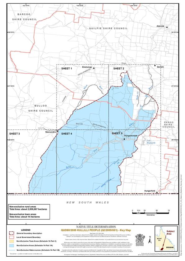
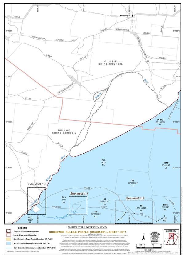
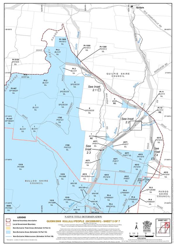
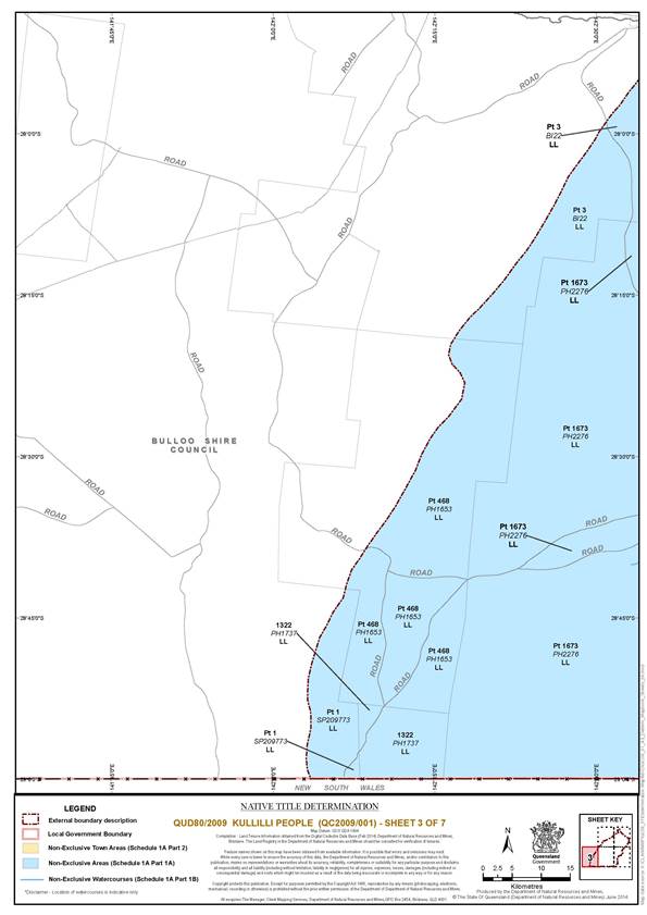
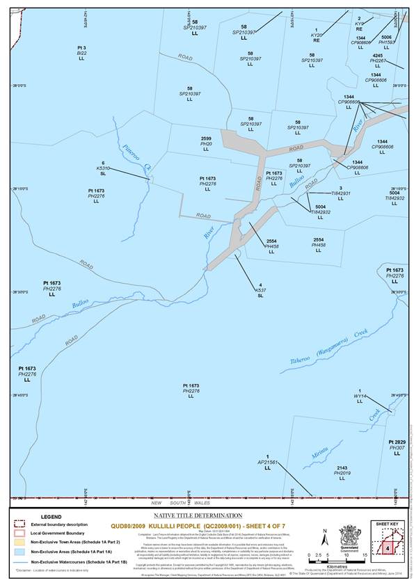
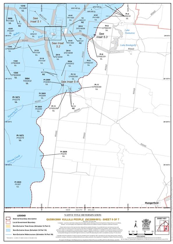
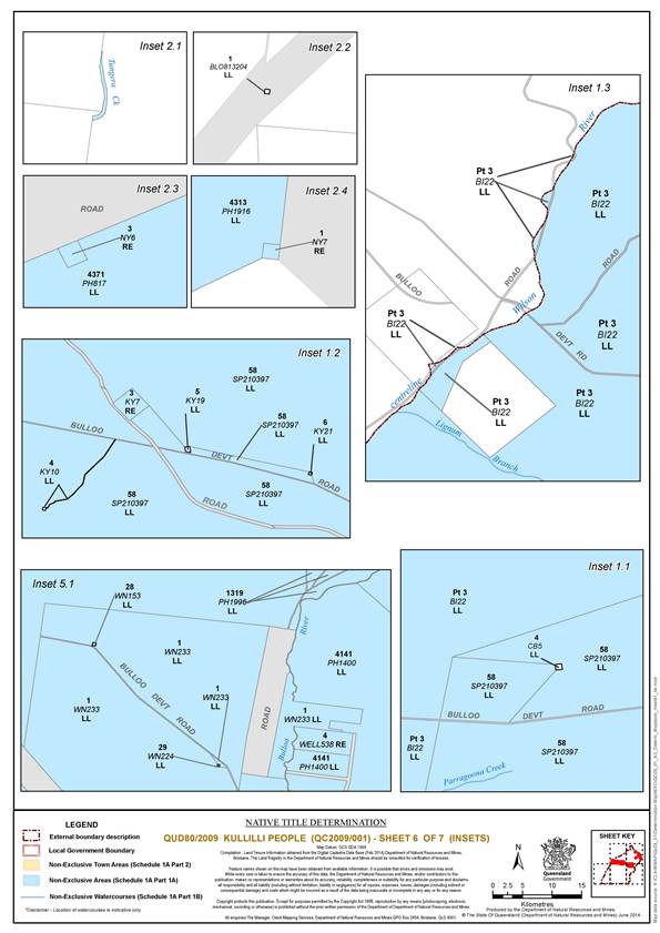
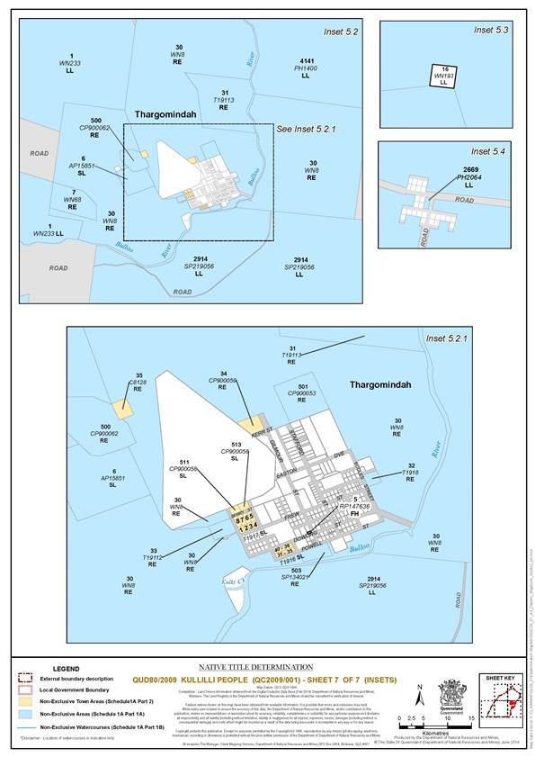
5. The Determination Area is the land and waters described in Schedule 1A, and depicted in the map attached to Schedule 1B.
6. Native title exists in relation to the Determination Area described in Part 1, 2 and 3 of Schedule 1A.
7. The native title is held by the Kullilli People described in Schedule 3 (“the native title holders”).
8. Subject to paragraphs 10, 11 and 12 below the nature and extent of the native title rights and interests in relation to the land and waters described in Part 1 of Schedule 1 are the non-exclusive rights to:
(a) access, be present on, move about on and travel over the area;
(b) camp and for that purpose build temporary shelters;
(c) hunt, fish and gather on the land and waters of the area for personal, domestic and non-commercial communal purposes;
(d) take, use, share and exchange Natural Resources from the land and waters of the area for personal, domestic and non-commercial communal purposes;
(e) take and use the Water of the area for personal, domestic and non-commercial communal purposes;
(f) conduct ceremonies on the area;
(g) be buried and bury native title holders within the area;
(h) maintain places of importance and areas of significance to the native title holders under their traditional laws and customs and protect those places and areas from physical harm; and
(i) teach on the area the physical and spiritual attributes of the area.
9. Subject to paragraphs 10, 11 and 12 below the nature and extent of the native title rights and interests in relation to the land and waters described in Part 2 of Schedule 1A are the non-exclusive rights to:
(a) access, be present on, move about on and travel over the area.
10. The native title rights and interests are subject to and exercisable in accordance with:
(a) the Laws of the State and the Commonwealth;
(b) the traditional laws acknowledged and traditional customs observed by the native title holders; and
(c) the terms and conditions of the agreements referred to in paragraph 1 of Schedule 4.
11. The native title rights and interests referred to in paragraphs 8 and 9 do not confer possession, occupation, use or enjoyment to the exclusion of all others.
12. There are no native title rights in or in relation to minerals as defined by the Mineral Resources Act 1989 (Qld) and petroleum as defined by the Petroleum Act 1923 (Qld) and the Petroleum and Gas (Production and Safety) Act 2004 (Qld).
13. The nature and extent of any other interests in relation to the Determination Area (or respective parts thereof) are set out in Schedule 4.
14. The relationship between the native title rights and interests described in paragraphs 8 and 9 and the other interests described in Schedule 4 (the “other interests”) is that:
(a) the other interests continue to have effect, and the rights conferred by or held under the other interests may be exercised notwithstanding the existence of the native title rights and interests;
(b) to the extent the other interests are inconsistent with the continued existence, enjoyment or exercise of the native title rights and interests in relation to the land and waters of the Determination Area, the native title continues to exist in its entirety but the native title rights and interests have no effect in relation to the other interests to the extent of the inconsistency for so long as the other interests exist; and
(c) the other interests and any activity that is required or permitted by or under, and done in accordance with, the other interests, or any activity that is associated with or incidental to such an activity, prevail over the native title rights and interests and any exercise of the native title rights and interests.
THE COURT DETERMINES THAT:
15. Upon the determination taking effect:
(a) The native title is held in trust;
(b) The Kullilli Bulloo River Aboriginal Corporation (ICN: 7224), incorporated under the Corporations (Aboriginal and Torres Strait Islander) Act 2006 (Cth), is to:
(i) be the prescribed body corporate for the purpose of ss 56(2)(b) and 56(3) of the Native Title Act 1993 (Cth); and
(ii) perform the functions mentioned in s 57(1) of the Native Title Act 1993 (Cth) after becoming a registered native title body corporate.
DEFINITIONS AND INTERPRETATION
16. In this determination, unless the contrary intention appears:
|
“Determination Area” is the land and waters described in Schedule 1A and depicted on the map in Schedule 1B and does not include areas described in Schedule 2. To the extent of any inconsistency between Schedule 1A and 1B, Schedule 1A prevails; “External Boundary” means the boundary described in Schedule 1A Part 3; |
|
“land” and “waters”, respectively, have the same meanings as in the Native Title Act 1993 (Cth); |
|
“Laws of the State and the Commonwealth” means the common law and the laws of the State of Queensland and the Commonwealth of Australia, and includes legislation, regulations, statutory instruments, local planning instruments and local laws; |
|
“Local Government Act” has the same meaning as in the Local Government Act 2009 (Qld); |
|
“Local Government Area” has the same meaning as in the Local Government Act 2009 (Qld); |
|
“Natural Resources” means: (a) any animal, plant, fish and bird life found on or in the lands and waters of the Determination Area; and (b) any clays, soil, sand, gravel or rock found on or below the surface of the Determination Area that have traditionally been taken and used by the native title holders, but does not include: (a) animals that are the private personal property of another; (b) crops that are the private personal property of another; and (c) minerals as defined in the Mineral Resources Act 1989 (Qld) or petroleum as defined in the Petroleum Act 1923 (Qld) and the Petroleum and Gas (Production and Safety) Act 2004 (Qld); |
|
“Reserves” means reserves that are dedicated and taken to be reserves under the Land Act 1994 (Qld); |
|
“Water” means: (a) water which flows, whether permanently or intermittently, within a river, creek or stream; and (b) any natural collection of water, whether permanent or intermittent. |
Other words and expressions used in this Determination have the same meanings as they have in Part 15 of the Native Title Act 1993 (Cth).
Schedule 1 — DETERMINATION AREA
A. Description of Determination Area
The Determination Area comprises all of the land and waters described in Parts 1 and 2 of Schedule 1A to the extent that they fall within the External Boundary description at Schedule 1A Part 3, and depicted in the determination map in Schedule 1B, excluding the areas described in Schedule 2.
Part 1 — Non-Exclusive Areas.
(a) The land and waters comprised of the lots and part lots listed below.
|
Area Description |
|
Lot 1 on KY20 |
|
Lot 1 on NY10 |
|
Lot 1 on NY7 |
|
Lot 1 on WY10 |
|
Lot 1 on WY14 |
|
Lot 1 on WY9 |
|
Lot 2 on KY3 |
|
Lot 2 on KY9 |
|
Lot 3 on KY7 |
|
Lot 3 on NY6 |
|
Lot 4 on B536 |
|
Lot 4 on WELL538 |
|
Lot 7 on WN68 |
|
That part of Lot 10 on BLO13 that falls within the External Boundary description |
|
That part of Lot 11 on BLO13 that falls within the External Boundary description |
|
Lot 14 on WN121 |
|
Lot 30 on WN8 |
|
Lot 31 on T19113 |
|
Lot 32 on T1918 |
|
Lot 33 on T19112 |
|
Lot 500 on CP900062 |
|
Lot 501 on CP900053 |
|
Lot 503 on SP134021 |
|
Lot 1 on BLO31 |
|
That part of Lot 1 on SP209773 that falls within the External Boundary description |
|
Lot 1 on WN148 |
|
Lot 1 on WN186 |
|
Lot 1 on WN233 |
|
That part of Lot 2 on BLO31 that falls within the External Boundary description |
|
That part of Lot 3 on BI22 that falls within the External Boundary description |
|
That part of Lot 4 on CP880081 that falls within the External Boundary description |
|
That part of Lot 4 on GO51 that falls within the External Boundary description |
|
That part of Lot 4 on WN234 that falls within the External Boundary description |
|
That part of Lot 5 on SP126466 that falls within the External Boundary description |
|
Lot 6 on SP238338 |
|
That part of Lot 8 on CP892351 that falls within the External Boundary description |
|
That part of Lot 10 on CP855300 that falls within the External Boundary description |
|
That part of Lot 11 on CP855300 that falls within the External Boundary description |
|
Lot 58 on SP210397 |
|
That part of Lot 447 on SP196201 that falls within the External Boundary description |
|
That part of Lot 468 on PH1653 that falls within the External Boundary description |
|
That part of Lot 1309 on PH1613 that falls within the External Boundary description |
|
Lot 1319 on PH1996 |
|
Lot 1322 on PH1737 |
|
Lot 1344 on CP908606 |
|
That part of Lot 1673 on PH2276 that falls within the External Boundary description |
|
Lot 1795 on PH2123 |
|
That part of Lot 2143 on PH2019 that falls within the External Boundary description |
|
Lot 2554 on PH458 |
|
Lot 2599 on PH20 |
|
That part of Lot 2669 on PH2064 that falls within the External Boundary description |
|
That part of Lot 2828 on PH276 that falls within the External Boundary description |
|
That part of Lot 2829 on PH307 that falls within the External Boundary description |
|
Lot 2914 on SP219056 |
|
Lot 3119 on PH1104 |
|
Lot 4141 on PH1400 |
|
Lot 4245 on PH2267 |
|
Lot 4312 on PH887 |
|
Lot 4313 on PH1916 |
|
Lot 4371 on PH817 |
|
Lot 5004 on TI842932 |
|
Lot 5006 on PH1593 |
|
That part of Lot 5159 on PH1835 that falls within the External Boundary description |
|
Lot 4 on K537 |
|
Lot 6 on AP15851 |
|
Lot 6 on K5310 |
|
Lot 3 on TI842931 |
|
Lot 1 on AP21561 |
(b) The waters within the External Boundaries including but not limited to:
(i) Bulloo River;
(ii) Kulki Creek;
(iii) Tungera Creek;
(iv) Titheroo (Wangamurra) Creek;
(v) Tooverra Creek;
(vi) Mirintu Creek;
(vii) Moble Creek
(viii) Pitteroo Creek;
(ix) Wilson River;
(x) Lignum Branch;
(xi) Parragoona Creek.
Part 2 – Non-Exclusive Town Areas.
The land and waters comprised of the lots and part lots listed below.
|
Area Description |
|
Lot 34 on CP900059 |
|
Lot 35 on C8128 |
|
Lot 1 on T1917 |
|
Lot 2 on T1917 |
|
Lot 3 on T1917 |
|
Lot 4 on T1917 |
|
Lot 5 on T1917 |
|
Lot 6 on T1917 |
|
Lot 7 on T1917 |
|
Lot 8 on T1917 |
|
Lot 31 on T1916 |
|
Lot 32 on T1916 |
|
Lot 33 on T1916 |
|
Lot 34 on T1916 |
|
Lot 35 on T1916 |
|
Lot 36 on T1916 |
|
Lot 37 on T1916 |
|
Lot 38 on T1916 |
|
Lot 39 on T1916 |
|
Lot 40 on T1916 |
|
Lot 511 on CP900058 |
|
Lot 513 on CP900058 |
Part 3 — External Boundary Description
The External Boundary means the land and waters bounded by the following line:
External Boundary
Commencing at a point on the Queensland – New South Wales state border, approximately 12.5km east of Warri Warri Gate at Longitude 142.058001° East and extending generally northerly and generally north-easterly passing through the following coordinate points:
|
Longitude East |
Latitude South | |
|
142.057699 |
28.998318 | |
|
142.052618 |
28.984621 | |
|
142.051022 |
28.967840 | |
|
142.052472 |
28.945953 | |
|
142.058298 |
28.920321 | |
|
142.057868 |
28.895466 | |
|
142.052839 |
28.876431 | |
|
142.053864 |
28.845110 | |
|
142.058223 |
28.825482 | |
|
142.064374 |
28.803987 | |
|
142.071786 |
28.780172 | |
|
142.082417 |
28.761605 | |
|
142.092487 |
28.740973 | |
|
142.108257 |
28.718645 | |
|
142.111636 |
28.704886 | |
|
142.113363 |
28.697852 | |
|
142.121299 |
28.675176 | |
|
142.133251 |
28.658657 | |
|
142.146170 |
28.638208 | |
|
142.160391 |
28.617969 | |
|
142.175392 |
28.597947 | |
|
142.189321 |
28.576558 | |
|
142.205453 |
28.547996 | |
|
142.220307 |
28.521062 | |
|
142.229985 |
28.496049 | |
|
142.242048 |
28.473530 | |
|
142.254961 |
28.454911 | |
|
142.271289 |
28.438309 | |
|
142.287692 |
28.416336 | |
|
142.291821 |
28.410818 | |
|
142.296528 |
28.385416 | |
|
142.289208 |
28.369874 | |
|
142.277269 |
28.357167 | |
|
142.271526 |
28.342290 | |
|
142.274598 |
28.326355 | |
|
142.287699 |
28.305195 | |
|
142.293441 |
28.297961 | |
|
142.304688 |
28.283973 | |
|
142.318459 |
28.271089 | |
|
142.341584 |
28.245618 | |
|
142.357811 |
28.226243 | |
|
142.375484 |
28.201546 | |
|
142.392700 |
28.180308 | |
|
142.406542 |
28.159353 | |
|
142.421832 |
28.133307 | |
|
142.434852 |
28.110751 | |
|
142.447560 |
28.085897 | |
|
142.456751 |
28.066627 | |
|
142.468840 |
28.049840 | |
|
142.484973 |
28.028377 | |
|
142.497787 |
28.009503 | |
|
142.503763 |
27.998115 | |
|
142.514559 |
27.982831 | |
|
142.524730 |
27.968915 | |
|
142.536210 |
27.956133 | |
|
142.551441 |
27.934105 | |
|
142.562898 |
27.920171 | |
|
142.573075 |
27.907402 | |
|
142.583232 |
27.893481 | |
|
142.586739 |
27.889416 | |
|
142.591279 |
27.879727 | |
Then northerly to the centreline of the Wilson River at Longitude 142.595276° East, about 560 metres north-easterly of Noccundra Waterhole; then generally north-easterly along the centreline of that river to Longitude 142.921272° East; then generally south-easterly and generally north-easterly passing through the following coordinate points:
|
Longitude East |
Latitude South | |
|
142.924660 |
27.433120 | |
|
142.941935 |
27.443086 | |
|
142.949243 |
27.442422 | |
|
142.965853 |
27.435778 | |
|
142.985785 |
27.429133 | |
| 143.002395 | 27.423154 | |
| 143.014354 | 27.417174 | |
| 143.039602 | 27.405215 | |
| 143.061527 | 27.393256 | |
| 143.087439 | 27.379303 | |
| 143.114015 | 27.368008 | |
| 143.137269 | 27.356049 | |
| 143.163845 | 27.343426 | |
| 143.181784 | 27.334124 | |
| 143.214339 | 27.318178 | |
| 143.245566 | 27.300239 | |
| 143.276129 | 27.283629 | |
| 143.292739 | 27.274992 | |
| 143.318651 | 27.261704 | |
| 143.341240 | 27.249745 | |
| 143.359844 | 27.241108 | |
| 143.376454 | 27.230477 | |
| 143.397714 | 27.216525 | |
| 143.418311 | 27.201244 | |
| 143.448873 | 27.181311 | |
| 143.480100 | 27.156729 | |
| 143.504683 | 27.134139 | |
Then north easterly to a point on the Grey Range at Latitude 27.120427° South, being the watershed between Cooper Creek and Bulloo River; then generally north-easterly along that watershed and ridgeline of that range to Longitude 143.871053 East; then generally south-easterly across the Bulloo River, Gorrie Gorrie Creek and Baalooroo Creek passing through the following coordinate points:
|
Longitude East |
Latitude South |
|
143.912575 |
26.849876 |
|
143.920221 |
26.874419 |
|
143.960001 |
26.917576 |
|
144.032684 |
26.996430 |
|
144.074061 |
27.027198 |
|
144.102708 |
27.048418 |
|
144.121805 |
27.090856 |
|
144.151512 |
27.116320 |
|
144.234268 |
27.150270 |
|
144.270340 |
27.158758 |
|
144.332938 |
27.209685 |
|
144.396596 |
27.268038 |
|
144.443278 |
27.359281 |
Then southerly and generally south-westerly passing through the following coordinate points:
|
Longitude East |
Latitude South |
|
144.452827 |
27.413391 |
|
144.424181 |
27.529036 |
|
144.396596 |
27.586328 |
|
144.386509 |
27.599205 |
Then generally south westerly passing to the west of Lake Hutchinson, Lake Toomaroo and Lake Bindegolly to the Bulloo Developmental Road passing through the following coordinate points:
|
Longitude East |
Latitude South |
|
144.317073 |
27.686700 |
|
144.317077 |
27.687880 |
|
144.316390 |
27.694982 |
|
144.316286 |
27.702425 |
|
144.315859 |
27.709926 |
|
144.315170 |
27.715940 |
|
144.313327 |
27.724019 |
|
144.311410 |
27.729063 |
|
144.308913 |
27.733823 |
|
144.306285 |
27.738469 |
|
144.303463 |
27.742314 |
|
144.299097 |
27.747366 |
|
144.294986 |
27.751674 |
|
144.291070 |
27.756839 |
|
144.285154 |
27.761209 |
|
144.279494 |
27.764834 |
|
144.270677 |
27.768927 |
|
144.265721 |
27.771176 |
|
144.259740 |
27.774745 |
|
144.253889 |
27.779001 |
|
144.247588 |
27.784002 |
|
144.242965 |
27.789455 |
|
144.238280 |
27.795481 |
|
144.234367 |
27.801219 |
|
144.230261 |
27.807244 |
|
144.226225 |
27.814814 |
|
144.222699 |
27.820552 |
|
144.219429 |
27.825601 |
|
144.215706 |
27.829907 |
|
144.210497 |
27.834046 |
|
144.202390 |
27.838366 |
|
144.196085 |
27.841650 |
|
144.189590 |
27.846308 |
|
144.185025 |
27.849643 |
|
144.180849 |
27.853951 |
|
144.177318 |
27.858084 |
|
144.173466 |
27.862791 |
|
144.169547 |
27.867098 |
|
144.166148 |
27.872033 |
|
144.162102 |
27.876511 |
|
144.157604 |
27.880591 |
|
144.152462 |
27.884729 |
|
144.146163 |
27.890131 |
|
144.140634 |
27.894672 |
|
144.132656 |
27.898820 |
|
144.123066 |
27.903487 |
|
144.111542 |
27.907648 |
|
144.104917 |
27.911391 |
|
144.097974 |
27.916909 |
|
144.091226 |
27.922828 |
|
144.086476 |
27.928798 |
|
144.083270 |
27.933666 |
|
144.078584 |
27.940159 |
|
144.075898 |
27.946637 |
|
144.073595 |
27.952926 |
|
144.072960 |
27.954662 |
|
144.070464 |
27.960166 |
|
144.067013 |
27.969109 |
|
144.065166 |
27.976100 |
|
144.063577 |
27.982574 |
|
144.063042 |
27.987213 |
|
144.062341 |
27.992080 |
|
144.061186 |
27.996242 |
|
144.059132 |
28.000576 |
|
144.055824 |
28.004647 |
|
144.051737 |
28.007976 |
|
144.046432 |
28.011916 |
|
144.041968 |
28.015169 |
|
144.037635 |
28.017619 |
|
144.033107 |
28.020010 |
Then generally southerly to a point on a low ridgeline at Longitude 144.067132° East, Latitude 28.175252° South about 32km south-easterly of Thargomindah and about 3 km easterly of Dynevor Downs No. 9 Bore passing through the following coordinate points:
|
Longitude East |
Latitude South |
|
144.030390 |
28.022180 |
|
144.027156 |
28.024752 |
|
144.024049 |
28.027898 |
|
144.022109 |
28.031279 |
|
144.020422 |
28.035581 |
|
144.018868 |
28.040344 |
|
144.018283 |
28.045514 |
|
144.017051 |
28.049991 |
|
144.016206 |
28.055791 |
|
144.015878 |
28.062285 |
|
144.015355 |
28.069869 |
|
144.015607 |
28.078262 |
|
144.016120 |
28.084127 |
|
144.017927 |
28.089424 |
|
144.019345 |
28.095523 |
|
144.021021 |
28.101682 |
|
144.022763 |
28.106461 |
|
144.024829 |
28.111529 |
|
144.026959 |
28.116311 |
|
144.029928 |
28.123050 |
|
144.033222 |
28.127493 |
|
144.036970 |
28.131075 |
|
144.042010 |
28.134721 |
|
144.047439 |
28.137853 |
|
144.052287 |
28.140349 |
|
144.056746 |
28.143243 |
|
144.060558 |
28.146423 |
|
144.063660 |
28.149140 |
|
144.067536 |
28.153241 |
|
144.069022 |
28.155490 |
|
144.070377 |
28.158600 |
|
144.071344 |
28.162744 |
|
144.070758 |
28.168316 |
|
144.069204 |
28.171584 |
Then generally south-westerly and generally southerly along a ridgeline to a point on the Queensland – New South Wales State Border at Longitude 143.684697° East passing through the following coordinate points:
|
Longitude East |
Latitude South |
|
144.064480 |
28.178227 |
|
144.060467 |
28.180679 |
|
144.056718 |
28.182846 |
|
144.053612 |
28.185704 |
|
144.050247 |
28.189365 |
|
144.047076 |
28.193143 |
|
144.044164 |
28.196289 |
|
144.041963 |
28.199842 |
|
144.038534 |
28.203388 |
|
144.035556 |
28.208316 |
|
144.032385 |
28.212553 |
|
144.030572 |
28.215992 |
|
144.028630 |
28.218684 |
|
144.025653 |
28.221945 |
|
144.022418 |
28.224745 |
|
144.018990 |
28.227889 |
|
144.015049 |
28.230539 |
|
144.010200 |
28.232462 |
|
144.005348 |
28.232676 |
|
144.001953 |
28.232605 |
|
143.998284 |
28.233252 |
|
143.995632 |
28.235050 |
|
143.994219 |
28.237012 |
|
143.992419 |
28.239435 |
|
143.989898 |
28.241289 |
|
143.987238 |
28.242398 |
|
143.983926 |
28.243340 |
|
143.979959 |
28.244055 |
|
143.975982 |
28.243681 |
|
143.972218 |
28.245199 |
|
143.969369 |
28.246883 |
|
143.966530 |
28.249543 |
|
143.964877 |
28.253516 |
|
143.963140 |
28.261912 |
|
143.963704 |
28.266269 |
|
143.964654 |
28.269879 |
|
143.966845 |
28.273883 |
|
143.969035 |
28.277830 |
|
143.971024 |
28.281262 |
|
143.974317 |
28.284797 |
|
143.976170 |
28.287655 |
|
143.977765 |
28.290801 |
|
143.979226 |
28.293547 |
|
143.979836 |
28.295897 |
|
143.980123 |
28.298478 |
|
143.980287 |
28.301807 |
|
143.980179 |
28.303989 |
|
143.980069 |
28.305942 |
|
143.979246 |
28.308301 |
|
143.977189 |
28.310956 |
|
143.973632 |
28.313508 |
|
143.970071 |
28.315657 |
|
143.966185 |
28.317865 |
|
143.963401 |
28.319663 |
|
143.960489 |
28.321520 |
|
143.956728 |
28.323268 |
|
143.952121 |
28.324964 |
|
143.947441 |
28.326030 |
|
143.942183 |
28.327616 |
|
143.936729 |
28.329318 |
|
143.931859 |
28.330843 |
|
143.927380 |
28.332424 |
|
143.921970 |
28.332116 |
|
143.916752 |
28.331406 |
|
143.911524 |
28.329834 |
|
143.905270 |
28.329704 |
|
143.898632 |
28.330439 |
|
143.891924 |
28.330656 |
|
143.884966 |
28.331794 |
|
143.878076 |
28.333104 |
|
143.871844 |
28.335155 |
|
143.865286 |
28.337325 |
|
143.858596 |
28.339209 |
|
143.852358 |
28.340687 |
|
143.846842 |
28.342791 |
|
143.842106 |
28.344775 |
|
143.837056 |
28.347795 |
|
143.831996 |
28.349839 |
|
143.827399 |
28.352683 |
|
143.823189 |
28.355008 |
|
143.817821 |
28.358662 |
|
143.813637 |
28.363513 |
|
143.810357 |
28.367726 |
|
143.807336 |
28.371650 |
|
143.804643 |
28.375917 |
|
143.803252 |
28.380060 |
|
143.803286 |
28.383447 |
|
143.803064 |
28.387295 |
|
143.801748 |
28.392356 |
|
143.800035 |
28.396845 |
|
143.798128 |
28.401508 |
|
143.796342 |
28.405252 |
|
143.793009 |
28.410556 |
|
143.790699 |
28.414017 |
|
143.788581 |
28.417131 |
|
143.785997 |
28.419043 |
|
143.783213 |
28.420727 |
|
143.780037 |
28.422299 |
|
143.777120 |
28.423754 |
|
143.774341 |
28.425899 |
|
143.771764 |
28.428672 |
|
143.769330 |
28.432821 |
|
143.767800 |
28.436104 |
|
143.766526 |
28.438983 |
|
143.764999 |
28.442553 |
|
143.763724 |
28.445260 |
|
143.761610 |
28.448776 |
|
143.759882 |
28.451773 |
|
143.757638 |
28.455348 |
|
143.755325 |
28.458521 |
|
143.753337 |
28.461577 |
|
143.750827 |
28.464522 |
|
143.746820 |
28.467535 |
|
143.744032 |
28.468989 |
|
143.740598 |
28.470620 |
|
143.737292 |
28.472193 |
|
143.734897 |
28.473759 |
|
143.732763 |
28.475324 |
|
143.730376 |
28.477579 |
|
143.725483 |
28.483296 |
|
143.723622 |
28.486007 |
|
143.721571 |
28.489293 |
|
143.720100 |
28.491944 |
|
143.719473 |
28.494359 |
|
143.719566 |
28.497172 |
|
143.720049 |
28.499752 |
|
143.719367 |
28.503201 |
|
143.719328 |
28.505785 |
|
143.719619 |
28.508711 |
|
143.721406 |
28.511511 |
|
143.724758 |
28.514474 |
|
143.728439 |
28.517664 |
|
143.731928 |
28.521314 |
|
143.735025 |
28.524795 |
|
143.738717 |
28.529133 |
|
143.740461 |
28.534001 |
|
143.741227 |
28.538933 |
|
143.742306 |
28.542370 |
|
143.743455 |
28.546610 |
|
143.744210 |
28.550279 |
|
143.744054 |
28.554299 |
|
143.743833 |
28.557917 |
|
143.743931 |
28.561189 |
|
143.743980 |
28.565953 |
|
143.746229 |
28.569383 |
|
143.748540 |
28.572410 |
|
143.751568 |
28.575546 |
|
143.754200 |
28.578054 |
|
143.757490 |
28.581304 |
|
143.759476 |
28.584448 |
|
143.760552 |
28.587828 |
|
143.760917 |
28.591729 |
|
143.760443 |
28.596325 |
|
143.760357 |
28.600746 |
|
143.759942 |
28.604768 |
|
143.759075 |
28.609194 |
|
143.757688 |
28.613682 |
|
143.756172 |
28.618342 |
|
143.753222 |
28.622955 |
|
143.750591 |
28.626877 |
|
143.748414 |
28.630508 |
|
143.745393 |
28.634490 |
|
143.742317 |
28.639506 |
|
143.740714 |
28.641813 |
|
143.738474 |
28.645847 |
|
143.736942 |
28.648900 |
|
143.735741 |
28.652525 |
|
143.735972 |
28.656083 |
|
143.737578 |
28.660263 |
|
143.740426 |
28.664893 |
|
143.743392 |
28.668260 |
|
143.746812 |
28.671452 |
|
143.749057 |
28.674422 |
|
143.753005 |
28.678356 |
|
143.756356 |
28.681146 |
|
143.758664 |
28.683944 |
|
143.759996 |
28.686748 |
|
143.761014 |
28.690817 |
|
143.760929 |
28.695295 |
|
143.759926 |
28.699148 |
|
143.759305 |
28.702138 |
|
143.758355 |
28.704785 |
|
143.756108 |
28.708015 |
|
143.753734 |
28.711534 |
|
143.751690 |
28.715566 |
|
143.750031 |
28.718965 |
|
143.748055 |
28.723169 |
|
143.746671 |
28.728058 |
|
143.746384 |
28.731849 |
|
143.746894 |
28.737127 |
|
143.747397 |
28.741659 |
|
143.748446 |
28.748599 |
|
143.749542 |
28.754045 |
|
143.752077 |
28.759826 |
|
143.754799 |
28.764859 |
|
143.757978 |
28.770062 |
|
143.760045 |
28.774698 |
|
143.762374 |
28.779562 |
|
143.764231 |
28.782764 |
|
143.765968 |
28.787000 |
|
143.767186 |
28.791470 |
|
143.767629 |
28.796634 |
|
143.767622 |
28.802375 |
|
143.767145 |
28.806741 |
|
143.766487 |
28.812429 |
|
143.764444 |
28.822949 |
|
143.763446 |
28.827261 |
|
143.761405 |
28.831581 |
|
143.759038 |
28.835789 |
|
143.757112 |
28.838501 |
|
143.753442 |
28.842832 |
|
143.749368 |
28.845615 |
|
143.745550 |
28.848110 |
|
143.739245 |
28.849473 |
|
143.732736 |
28.849977 |
|
143.726019 |
28.849219 |
|
143.719763 |
28.848975 |
|
143.714753 |
28.849583 |
|
143.708772 |
28.850715 |
|
143.704422 |
28.852180 |
|
143.698459 |
28.855148 |
|
143.694719 |
28.858790 |
|
143.691114 |
28.862948 |
|
143.689203 |
28.867210 |
|
143.686198 |
28.872799 |
|
143.685335 |
28.877627 |
|
143.684282 |
28.882973 |
|
143.684660 |
28.888080 |
|
143.685427 |
28.893012 |
|
143.688352 |
28.898848 |
|
143.690095 |
28.903658 |
|
143.691318 |
28.908587 |
|
143.692286 |
28.914149 |
|
143.692798 |
28.919600 |
|
143.692847 |
28.924422 |
|
143.692976 |
28.930678 |
|
143.692972 |
28.936591 |
|
143.693144 |
28.940896 |
|
143.692811 |
28.946524 |
|
143.692932 |
28.951920 |
|
143.692596 |
28.957433 |
|
143.691476 |
28.962493 |
|
143.691130 |
28.966916 |
|
143.690183 |
28.969850 |
|
143.689501 |
28.973185 |
|
143.687782 |
28.977100 |
|
143.686906 |
28.980666 |
|
143.685773 |
28.984522 |
|
143.685031 |
28.988488 |
|
143.684424 |
28.992798 |
|
143.684328 |
28.996186 |
|
143.684528 |
28.997830 |
Then westerly along that state border back to the commencement point.
Note:
Reference Datum
Geographical coordinates are referenced to the Geocentric Datum of Australia (GDA94), in decimal degrees and are based on the spatial reference data acquired from the various custodians at the time.
Data Reference and Source
• External boundary based on data sourced from National Native Title Tribunal April 2014.
• Cadastre data sourced from Department of Natural Resources and Mines (Qld) April 2014.
• Watercourses and low ridgeline are interpreted from 1:250k Topographic vector data © Commonwealth of Australia (Geoscience Australia) 2003.
• Ridgeline of the Grey Range based on Drainage Basin Sub-Area Queensland Data as at (20/01/2009) sourced from Department of Environment and Resource Management (Qld) September 2011.
Use of Coordinates
Where coordinates are used within the description to represent cadastral or topographical boundaries or the intersection with such, they are intended as a guide only. As an outcome to the custodians of cadastral and topographic data continuously recalculating the geographic position of their data based on improved survey and data maintenance procedures, it is not possible to accurately define such a position other than by detailed ground survey.
Prepared by Queensland South Native Title Services (23/04/2014).
B. Map of Determination Area
Schedule 2 — AREAS NOT FORMING PART OF THE DETERMINATION AREA
The following areas of land and waters are excluded from the Determination Area:
1. Those land and waters within the External Boundary, which at the time the native title determination application was made:
(i) were the subject of one or more Previous Exclusive Possession Acts, within the meaning of s 23B of the Native Title Act 1993 (Cth); and
(ii) to which none of ss 47, 47A or 47B of the Native Title Act 1993 (Cth) applied at the time of the native title determination application;
are excluded from the Determination Area as they could not be claimed in accordance with s 61A of the Native Title Act 1993 (Cth).
2. Specifically, and to avoid any doubt, the land and waters described in (1) above includes, the tenure based exclusions under ss 23B(2) and 23B(3) of the Native Title Act 1993 (Cth) to which s 20 of the Native Title (Queensland) Act 1993 (Qld) applies, and includes but is not limited to, the whole of the land and waters described as:
(a) Lot 16, Crown Plan WN193, Title Reference: 17564202;
(b) Lot 28, Crown Plan WN153, Title Reference: 17564190;
(c) Lot 4, Crown Plan KY10, Title Reference: 17564199; and
(d) Lot 5, Crown Plan KY19, Title Reference: 17564200.
3. Specifically, and to avoid any doubt, the land and waters described in (1) above includes the land or waters on which any public work, as defined in s 253 of the Native Title Act 1993 (Cth), is or was constructed, established or situated, and to which ss 23B(7) and 23C(2) of the Native Title Act 1993 (Cth) and to which s 21 of the Native Title (Queensland) Act 1993 (Qld), applies, together with any adjacent land or waters in accordance with s 251D of the Native Title Act 1993 (Cth).
Schedule 3 — NATIVE TITLE HOLDERS
1. The native title holders are the Kullilli People. The Kullilli People are the biological descendants of one or more of the following people:
(i) Joe Barney;
(ii) Neba Brighton;
(iii) Daisy (spouse Harry Pilot);
(iv) ‘Gnadollie’ Hekel;
(v) Ida (spouse Peter Williams, Buckley);
(vi) ‘Mary Ann’ Jinnie (spouse William Conlan);
(vii) Mary (spouse Harry Barney);
(viii) Mary (spouses Chinese, Dick Richards and Alexander Brierty);
(ix) ‘Ippi’ Mary (Bob Gray);
(x) Mary-Ann (Billy Phillips);
(xi) ‘Miria’ Maryann (Alick, Charlie Turner, Jack Williams);
(xii) ‘Munga’ Maryann;
(xiii) Jeannie ‘Jinnie’ Mossman and Charlie Fitzroy;
(xiv) Dick ‘Gunta’ Richards;
(xv) ‘Kullilli’ Rosie and her husband;
(xvi) ‘Curra’ Jack Thompson;
(xvii) ‘Bunda’ Tiger;
(xviii) Tilby and ‘Djogo’ Hugo;
(xix) Tinda and Lollipop;
(xx) Toby and Topsy;
(xxi) Jack ‘Norley’ Wallace;
(xxii) Monitor Wallace;
(xxiii) Willico;
(xxiv) Harry Willis;
(xxv) Harry Willy-Boy;
(xxvi) Monday Willoughby;
(xxvii) Harry Barney;
(xxviii) Annie Bulloo;
(xxix) Jack Bulloo;
(xxx) Charlie Copra;
(xxxi) Maggie; and
(xxxii) Trella/Tarella (and her son Albert Hagan).
Schedule 4 — OTHER INTERESTS IN THE DETERMINATION AREA
The nature and extent of the other interests in relation to the Determination Area are the following as they exist as at the date of the determination:
1. The rights and interests of the parties under the following agreements:
(a) the agreement between Paola Smith, Maxine Gooda, Eric Hood, Ronny Watson and Peter White on their own behalf and on behalf of the Kullilli People (QUD80/2009) and the Bullo Shire Council and Quilpie Shire Council as parties to the Local Government ILUA QI2014/030;
(b) the agreement between Paola Smith, Maxine Gooda, Peter White, Ronny Watson (also known as Ronald Watson) and Eric Hood, on their own behalf and on behalf of the Kullilli People (QUD80/2009) and the Ergon Energy Corporation Limited ACN 087 646 062 as parties to the ILUA QI2014/029, authorised on 10 November 2013;
(c) the Kullilli People and Bellera, Bulloo Downs and Molesworth ILUA authorised on 10 November 2013;
(d) the Kullilli People and Ardoch ILUA authorised on 10 November 2013;
(e) the Kullilli People and Autumnvale and The Pioneers ILUA authorised on 10 November 2013;
(f) the Kullilli People and Clyde (aka Picarilli Downs) and Wongetta ILUA authorised on 10 November 2013;
(g) the Kullilli People and Congie ILUA authorised on 10 November 2013;
(h) the Kullilli People and Dynevor Downs ILUA authorised on 10 November 2013;
(i) the Kullilli People and Kuging and Orinya ILUA authorised on 10 November 2013;
(j) the Kullilli People and Kulki ILUA authorised on 10 November 2013;
(k) the Kullilli People and Kyeenee ILUA authorised on 10 November 2013;
(l) the Kullilli People and Moombidary ILUA authorised on 10 November 2013;
(m) the Kullilli People and Mulianna ILUA authorised on 10 November 2013;
(n) the Kullilli People and Narylico ILUA authorised on 10 November 2013;
(o) the Kullilli People and Nockatunga ILUA authorised on 10 November 2013;
(p) the Kullilli People and Norley, Orient and Pinidary ILUA authorised on 10 November 2013;
(q) the Kullilli People and Pyampah (aka Wompa) ILUA authorised on 10 November 2013;
(r) the Kullilli People and Talgeberry ILUA authorised on 10 November 2013;
(s) the Kullilli People and Thargo ILUA authorised on 10 November 2013;
(t) the Kullilli People and Tickalara ILUA authorised on 10 November 2013;
(u) the Kullilli People and Wiralla ILUA authorised on 10 November 2013;
(v) the Kullilli People and Zenoni ILUA authorised on 10 November 2013; and
(w) the Kullilli People and Mirintu ILUA authorised on 10 November 2013.
2. The rights and interests of Circumpacific Energy Corporation under the following agreements in so far as they relate to a part of the Determination Area:
(a) Right to Negotiate Deed of Agreement for ATP940 between the State of Queensland, Circumpacific Energy Corporation ARBN 147 283 832, the Kullilli People and Wongkumara People, dated 11 August 2011; and
(b) Conjunctive Ancillary Agreement between Circumpacific Energy Corporation ARBN 147 283 832 and the Kullilli People, dated 17 December 2010.
3. The rights and interests of Telstra Corporation Limited:
(a) as the owner or operator of telecommunications facilities installed within the Determination Area;
(b) created pursuant to the Post and Telegraph Act 1901 (Cth), the Telecommunications Act 1975 (Cth), the Australian Telecommunications Corporation Act 1989 (Cth), the Telecommunications Act 1991 (Cth) and the Telecommunications Act 1997 (Cth), including rights:
(i) to inspect land;
(ii) to install and operate existing and new telecommunication facilities, including cabling, customer terminal sites, customer radio sites and ancillary facilities;
(iii) to alter, remove, replace, maintain, repair and ensure the proper functioning of its existing and any new telecommunications facilities including cabling, customer terminal sites, customer radio sites, and ancillary facilities;
(c) for its employees, agents or contractors to access the Determination Area for the purposes of exercising the rights in (i), (ii) and (iii) above in respect of telecommunication facilities in and in the vicinity of the Determination Area;
(d) under any licences, leases, access agreements or easements relating to its telecommunications facilities in the Determination Area, including under:
(i) Term Lease 0/209261 over Lot 3 on TI842931.
4. The rights and interests of Ergon Energy Corporation ACN 087 646 062:
(a) as the owner and operator of any “Works” as that term is defined in the Electricity Act 1994 (Qld) within the Determination Area;
(b) as a distribution entity and the holder of a distribution authority under the Electricity Act 1994 (Qld);
(c) created under the Electricity Act 1994 (Qld) and the Government Owned Corporations Act 1993 (Qld) including:
(i) rights in relation to any agreement relating to the Determination Area existing or entered into before the date on which these orders are made;
(ii) rights to enter the Determination Area by its employees, agents or contractors to exercise any of the rights and interests referred to in this paragraph; and
(iii) to inspect, maintain and manage any Works in the Determination Area.
5. The rights and interests of the State of Queensland, the Bulloo Shire Council, the Paroo Shire Council and the Quilpie Shire Council to access, use, operate, maintain and control the dedicated roads in the Determination Area and the rights and interests of the public to use and access the roads.
6. The rights and interests of the Bulloo Shire Council, the Paroo Shire Council and the Quilpie Shire Council as the local governments for that part of the Determination Area within their Local Government Area, including:
(a) their powers, functions, responsibilities and jurisdiction under a Local Government Act;
(b) their rights and interests under any interest in land or waters within the Determination Area including under any lease, licence, access agreement, easement or reserve in the Determination Area;
(c) the right to use, operate, maintain, replace, restore, remediate, repair and otherwise exercise all other rights as the owners and operators of infrastructure, structures, earthworks, access works, facilities and other improvements within the Determination Area;
(d) the rights under any agreements between the Councils and any third party which relate to land or waters in the Determination Area; and
(e) the rights of their employees, agents and contractors to enter upon the Determination Area for the purpose of performing their powers and responsibilities under sub-paragraphs (a) to (d).
7. The rights and interests held by the State of Queensland or Commonwealth of Australia or any other person existing by reason of the force and operation of the Laws of the State of Queensland and the Commonwealth, including, but not limited to, those existing by reason of the following legislation or any regulation, statutory instrument, declaration, plan, authority, permit, reservation, easement, claim, lease or licence made, granted, issued or entered into under that legislation:
(a) the Land Act 1994 (Qld);
(b) the Petroleum Act 1923 (Qld);
(c) the Petroleum and Gas (Production and Safety) Act 2004 (Qld); and
(d) the Mineral Resources Act 1989 (Qld).
8. Specifically, and to avoid any doubt:
(a) the rights and interests of Origin Energy Resources Limited, Santos Limited, Delhi Petroleum Pty Ltd, Bridgefield Pty Ltd, Vamgas Pty Ltd and Moonie Pipeline Company Pty Ltd:
(i) as the holders of Pipeline Licence 6 granted under the Petroleum Act 1923 (Qld) and administered under the Petroleum and Gas (Production and Safety) Act 2004 (Qld);
(b) the rights and interests of Oilwells Inc of Kentucky, ARBN 062 619 774 and Bounty Oil and Gas NL as the holders of Petroleum Lease 214 granted under the Petroleum Act 1923 (Qld) and administered under the Petroleum Act 1923 (Qld);
(c) the rights and interests of Santos QNT Pty Ltd as the holder of:
(i) Authority to Prospect 820 granted under the Petroleum Act 1923 (Qld);
(ii) Authority to Prospect 636 granted under the Petroleum Act 1923 (Qld); and
(iii) Authority to Prospect 765 granted under the Petroleum and Gas (Production and Safety) Act 2004 (Qld).
(d) the rights and interests of Santos QNT Pty Ltd and Vamgas Pty Ltd:
(i) as the holders of Petroleum Lease 244 granted under the Petroleum Act 1923 (Qld) and administered under the Petroleum Act 1923 (Qld);
(ii) as the holders of Petroleum Lease 245 granted under the Petroleum Act 1923 (Qld) and administered under the Petroleum Act 1923 (Qld); and
(iii) as the holders of Petroleum Lease 50 granted under the Petroleum Act 1923 (Qld) and administered under the Petroleum Act 1923 (Qld).
(e) the rights and interests of Santos QNT Pty Ltd, Drillsearch Energy Pty Ltd and Santos(299) Pty Ltd:
(i) as the holders of Petroleum Lease 293 granted under the Petroleum Act 1923 (Qld) and administered under the Petroleum Act 1923 (Qld); and
(ii) as the holders of Petroleum Lease 298 granted under the Petroleum Act 1923 (Qld) and administered under the Petroleum Act 1923 (Qld).
9. So far as confirmed pursuant to s 212(2) of the Native Title Act 1993 (Cth) and s 18 of the Native Title Act (Queensland) Act 1993 (Qld) as at the date of this Determination, any existing public access to, and enjoyment of, the following places in the Determination Area:
(a) waterways;
(b) beds and banks or foreshores of waterways;
(c) stock routes; and
(d) areas that were public places at the end of 31 December 1993.
Note: Entry of orders is dealt with in Rule 39.32 of the Federal Court Rules 2011.
|
QUEENSLAND DISTRICT REGISTRY |
|
|
GENERAL DIVISION |
QUD 80 of 2009 |
|
BETWEEN: |
PAOLA SMITH, JUDITH CONLON, BRENDA FISHER, STEPHEN HAGAN, KAYLEEN HOPKINS, ELIZABETH MCAVOY, RONALD WATSON AND PETER WHITE ON BEHALF OF THE KULLILLI PEOPLE Applicant |
|
AND: |
STATE OF QUEENSLAND First Respondent BULLOO SHIRE COUNCIL Second Respondent PAROO SHIRE COUNCIL Third Respondent QUILPIE SHIRE COUNCIL Fourth Respondent ERGON ENERGY CORPORATION LIMITED Fifth Respondent TELSTRA CORPORATION LIMITED (ACN 051 775 556) Sixth Respondent BRIDGEFIELD PTY LIMITED Seventh Respondent CIRCUMPACIFIC ENERGY CORPORATION Eighth Respondent DELHI PETROLEUM PTY LTD Ninth Respondent DRILLSEARCH ENERGY LIMITED Tenth Respondent MAGELLAN PETROLEUM (EASTERN) PTY LTD Eleventh Respondent MOONIE PIPELINE COMPANY PTY LTD Twelfth Respondent OILWELLS INC OF KENTUCKY Thirteenth Respondent ORIGIN ENERGY RESOURCES LIMITED Fourteenth Respondent SANTOS (299) PTY LTD Fifteenth Respondent SANTOS LIMITED Sixteenth Respondent SANTOS QNT PTY LTD ABN 33 083 077 196 Seventeenth Respondent SANTOS RESOURCES PTY LTD Eighteenth Respondent VAMGAS PTY LTD Nineteenth Respondent EDWARD JOHN BRIGDEN, CONSOLIDATED PASTORAL COMPANY PTY LTD, DABBAT PTY LTD, MICHAEL GIBSON, IAN JOSEPH KEMP GLASSON, LYNETTE JOAN GLASSON, ALAN RAEBLE SCHOTTELIUS, ELMA BETH SCHOTTELIUS, GREGORY NOEL VICARY SHERWIN AND USHER PASTORAL COMPANY PTY LTD Twentieth - Twenty-Nine Various Pastoral Respondents |
|
JUDGE: |
LOGAN J |
|
DATE: |
2 JULY 2014 |
|
PLACE: |
THARGOMINDAH |
REASONS FOR JUDGMENT
1 One of the Commonwealth Parliament’s objectives in respect of the Native Title Act 1993 (Cth) (the Act) is the resolution of claims for the recognition of native title by agreement. That objective is borne out in s 87 of the Act, especially by amendments made by the Native Title Amendment Act 2009 (Cth).
2 Today the Court is giving practical voice to that objective by determining by consent an application in favour of the Kullilli Native Title claimants in respect to the land and waters within the area in south western Queensland identified in Schedule 1 of the Court’s orders.
3 The Kullilli claims have a long history in this Court. The first application for a determination of native title over a broader claim area was lodged with the National Native Title Tribunal on 24 May 1996. Following amendments to the Act in 1998, such applications became Federal Court proceedings. By order of the Honourable Justice Drummond, that application was dismissed on 10 March 2000. A further three Determination Applications were filed in the Court and were either discontinued or dismissed in 2006.
4 The application by Paola Smith, Maxine Gooda, Peter White, Ronny Watson and Eric Hood, on behalf of the Kullilli People, was filed on 23 March 2009. The application was amended pursuant to s 66B of the Act on 2 December 2013 to change the composition of the Applicant from the above named persons to Paola Smith, Ronald Watson, Stephen Hagan, Judith Conlon, Brenda Fisher, Kayleen Hopkins and Elizabeth McAvoy.
5 The application was registered by the National Native Title Tribunal on 17 April 2009 and was notified in accordance with s 66 of the Act on 28 October 2009. There are currently twenty nine respondent parties, including the State of Queensland, the Bulloo, Paroo and Quilpie Shire Councils representing the local government within the claim area, mining and infrastructure companies and various pastoralists. The application has been amended on three occasions to include certain apical ancestors after additional research had been undertaken, to change the composition of the Applicant and to remove areas of extinguishment within the claim boundary.
6 Viewed against that history and like many such claims, it can be seen that this claim has been long in its gestation. In earlier judgements in cases like the present, for example in 2012 in Hoolihan on behalf of the Gugu Badhun People # 2 v State of Queensland [2012] FCA 800; Archer on behalf of the Djungan People #1 v State of Queensland [2012] FCA 801 and Fisher on behalf of the Ewamian People #2 v State of Queensland [2013] FCA 1249, I observed that native title claims which linger unresolved on a court list are an affront to our system of justice. The statements which I then made are just as applicable to this case.
7 That said, the consensual resolution of the current Determination Application in less than five years is testament to much dedicated work by experienced legal advisers and some innovative negotiation techniques, the responsible actions of the parties guided by their advisers and case management by the Court’s registrars. The result is that a final consensual resolution has been achieved in what is a relatively short time in this jurisdiction of the Court. I commend the parties and the legal practitioners involved.
8 In Baker on behalf of the Muluridji People v State of Queensland [2011] FCA 1432 (Muluridji) I adopted observations made in King v Northern Territory of Australia [2011] FCA 582 (King) per Mansfield J. His Honour made a number of observations about the preamble to the Act. I am in complete agreement not only with the substance of his Honour’s observations in King but also with the manner in which he expressed them. They are exactly apposite in the present proceedings also. As I observed in Muluridji, I propose therefore to adopt them as my own in these reasons for judgment without further attribution.
9 The preamble to the Act recognised, on behalf of all people of Australia, that the Aboriginal peoples of Australia inhabited this country for many years prior to European settlement, and that the Aboriginal peoples had been progressively dispossessed of their lands. It recorded that, by the overwhelming vote of the people of Australia, the Constitution was amended to enable laws such as the Act to be passed, to facilitate the recognition by our shared legal system of the native title rights and interests in their land. This is an occasion when the Court is to make orders declaring that the groups of Aboriginal persons in the current applications have always been the traditional owners of the land. By the Court’s orders, the Australian community collectively recognises that status. It is important to emphasise that the Court’s orders do not grant that status. The Court is declaring that it exists and has always existed at least since European settlement.
10 The Applicant relies on twenty-seven affidavits from members of the claim group that provide direct evidence of their ongoing connection to the land and waters in the claim area. The affidavits are from a broad cross section of the claim group and depose to the observance of traditional laws and customs and the exercise of the native title rights and interests that I am able to recognise today. The composition of the claim group is supported by an affidavit from the QSNTS anthropologist Diana Romano annexing genealogical charts.
11 The application relies on the expert reports by Dr Sally Babidge which provides the anthropological evidence of the Kullilli People and further supplementary material addressing issues arising in the course negotiations with the respondent parties. Dr Babidge’s material consists of:
(a) Anthropological Report: Kullilli Native Title Claim dated 12 November 2010;
(b) Anthropological analysis of Kullilli claimant affidavit material and brief analysis of background material for inclusion of “Trella” (Hagan Family) dated 23 February 2012; and
(c) Supplementary material and analysis arising from “on country” visit (May 2011) dated 2 July 2012.
SECTION 87 OF THE ACT
12 Section 87 of the Act provides that the Court may make a determination of native title by consent over an area covered by a native title application and without holding a hearing where:
(a) the period specified in the notice given under s 66 of the Act has ended (s 87(1));
(b) there is an agreement between the parties on the terms of an order of the Court in relation to the proceedings (s 87(1)(a)(i));
(c) the terms of the agreement are in writing and are signed by or on behalf of the parties and filed with the Court (s 87(1)(b));
(d) the Court is satisfied that an order in, or consistent with, those terms would be within its power (s 87(1)(c)); and
(e) having satisfied the criteria relevantly detailed, the Court considers the making of orders as it appears to the Court to be appropriate to do so pursuant to s 87(1A) of the Act. The Court may make a determination in accordance with s 87(2), as is relevant to these proceedings.
13 The focus of the Court in considering whether the orders sought are appropriate under s 87(1) and s 87(2) is on the making of the agreement by the parties. In Muluridji I cited observations of North J in Lovett on behalf of the Gunditjmara People v State of Victoria [2007] FCA 474. Such remarks are apt to be adopted in this case. His Honour stated:
[36] … The Act is designed to encourage parties to take responsibility for resolving proceeding without the need for litigation. Section 87 must be construed in this context. The power must be exercised flexibly and with regard to the purpose for which the section is designed.
[37] In this context, when the Court is examining the appropriateness of an agreement, it is not required to examine whether the agreement is grounded on a factual basis which would satisfy the Court at a hearing of the application. The primary consideration of the Court is to determine whether there is an agreement and whether it was freely entered into on an informed basis: Nangkiriny v State of Western Australia (2002) 117 FCR 6; [2002] FCA 660, Ward v State of Western Australia [2006] FCA 1848. Insofar as this latter consideration applies to a State party, it will require the Court to be satisfied that the State party has taken steps to satisfy itself that there is a credible basis for an application: Munn v Queensland (2001) 115 FCR 109; [2001] FCA 1229.
14 As such, the Court is not required to make its own inquiry of the merits of the applicants’ claim to be satisfied that the orders sought are supportable and in accordance with the law: Cox on behalf of the Yungngora People v State of Western Australia [2007] FCA 588 at [3]. The Court may consider such evidence to determine whether the State is acting in good faith and rationally: Munn (for and on behalf of the Gunggari People) v Queensland (2001) 115 FCR 109 at [29]-[30].
15 In Smith v State of Western Australia (2000) 104 FCR 494 at [38], Madgwick J stated:
[38] … State governments are necessarily obliged to subject claims for native title over lands and waters owned and occupied by the State and State agencies, to scrutiny just as careful as the community would expect in relation to claims by non-Aborigines to significant rights over such land.
SECTION 94A OF THE ACT
16 Section 94A of the Act requires that a native title determination order must satisfy the requirements of s 225 of the Act. Section 225 provides:
A determination of native title is a determination whether or not native title exists in relation to a particular area (the determination area) of land or waters and, if it does exist, a determination of:
(a) who the persons, or each group of persons, holding the common or group rights comprising the native title are; and
(b) the nature and extent of the native title rights and interests in relation to the determination area; and
(c) the nature and extent of any other interests in relation to the determination area; and
(d) the relationship between the rights and interests in paragraphs (b) and (c) (taking into account the effect of this Act); and
(e) to the extent that the land or waters in the determination area are not covered by a non-exclusive agricultural lease or a non-exclusive pastoral lease -- whether the native title rights and interests confer possession, occupation, use and enjoyment of that land or waters on the native title holders to the exclusion of all others.
Note: The determination may deal with the matters in paragraphs (c) and (d) by referring to a particular kind or particular kinds of non-native title interests.
[emphasis in original]
17 Section 223(1) of the Act defines ‘native title’ and ‘native title rights and interests’ as:
(1) … the communal, group or individual rights and interests of Aboriginal peoples or Torres Strait Islanders in relation to land or waters, where:
(a) the rights and interests are possessed under the traditional laws acknowledged, and the traditional customs observed, by Aboriginal peoples or Torres Strait Islanders; and
(b) the Aboriginal peoples or Torres Strait Islanders, by those laws and customs, have a connection with the land or waters; and
(c) the rights and interests are recognised by the common law of Australia.
18 In Members of the Yorta Yorta Aboriginal Community v State of Victoria (2002) 214 CLR 422, Gleeson CJ, Gummow and Hayne JJ (with McHugh J agreeing) stated the relevant principles with respect to s 223 of the Act, at [46] to [55] and [80] to [83]:
(a) A traditional law or custom which is the source of native title rights and interests is one which has been passed from generation to generation of a society, usually by word of mouth and common practice.
(b) The origins of the law or custom from which native title rights and interests stem must be found in the normative rules of the relevant Aboriginal or Torres Strait Islander society that existed before the assertion of sovereignty by the British Crown – it is only those rules that are “traditional” laws and customs.
(c) That normative system must have a continuous existence and vitality since sovereignty.
(d) If that society ceases to exist as a group which acknowledges and observes those pre-sovereignty laws and customs, those laws and customs cease to have continued existence and vitality.
(e) Only native title rights or interests that existed at the time of the change in sovereignty will be recognised. However, some change to, or adaptation of, traditional laws or customs or some interruption in the enjoyment or exercise of native title rights or interests in the period between the Crown asserting sovereignty and the present will not necessarily be fatal to a native title claim.
(f) In many cases, perhaps most, claimants will invite the Court to infer, from evidence led at trial, the content of traditional laws and customs at times earlier than those described in the evidence.
19 Further, there is authority of this Court, exercising appellate jurisdiction, which lends itself to a determinative conclusion that physical presence is not a necessary requirement for continuing connection. See, for example, Moses v State of Western Australia [2007] FCAFC 78 at [306] per Moore, North and Mansfield JJ.
APpLICATION OF sECTION 223 and section 225 to THE KULLILLI people
20 The Kullilli People base their identity on their cognatic descent from those ancestors identified in Schedule 3 of the orders. The apical ancestors are likely to have existed on the claim area at or about the time of first contact in 1860 when the Burke and Wills expedition travelled through the region. I am able to draw an inference that Kullilli People occupied the area at sovereignty in 1788.
21 The claim area is situated in south western Queensland centred around the township of Thargomindah and extending south to the New South Wales border. It takes in part of the catchment of the Bulloo River with the western boundary marked by the Grey Range in the south-west and the Wilson River in the north-west. It is covered almost entirely by pastoral leases.
22 I have considered Dr Babidge’s Anthropological Report which includes schematic genealogies of the Kullilli families. The Report refers to the work of the early ethnographers, R H Mathews, Archibald Meston and E M Curr. These sources demonstrate that there are broad consistencies between what has been identified with Kullilli People in the earliest records and the current claim. The Mathews material is based on his correspondence with police officers and pastoralists in the Thargomindah area and surrounding region in 1900. Correspondence between R H Mathews and police officers at Eromanga, Noccunda, Eulo and at Tibooburra name the “tribe” at Thargomindah, Bulloo Downs and along the Bulloo River as variously “Kullilly”, “Cullalie”, “Callalie” and “Cullilly”. The late Hazel McKellar, a local historian and Kooma woman published a history of aboriginal groups in 1984 (McKellar H, Matya-Mundu, a history of the Aboriginal People of South West Queensland (Cunnamulla Australian Native Welfare Association, 1984)). Ms McKellar relied on information she had obtained from elders in the area. She wrote that “Kalili [Kullilli] occupied territory between the Bulloo and Wilson Rivers … Ardoch (Station) to Bulloo Downs … Northern boundary took in Mount Margaret Station and went as far south as the Nocundra on the Wilson River … Camps were at waterholes on Bulloo River and Wilson River”.
23 Pastoralists followed the explorers into the region and in 1864 Bulloo Downs was settled, closely followed by Ardoch. Thargomindah was gazetted as a town reserve in 1874 and other smaller townships within the claim area were established soon after. This led to conflict with the indigenous inhabitants of the area. Dr Babidge’s Report demonstrates that the Kullilli People endured a period of reprisal and massacre, forced removals and the associated dislocation from country. Many Kullilli People remained on their country working in the pastoral industry which allowed them to continue to exercise and observe their traditional laws and customs (p 51).
24 Dr Babidge says that while the waves of Kullilli people and others removed from their country were significant, a number of Kullilli families managed to remain on country working on pastoral stations. Dr Babidge has opined that “at station camps on Kullilli country or in the region some elements of the traditional system of social organisation were continued, especially betrothals. There are many marriages among Kullilli people, or between them and individuals from neighbouring groups, which points to continuity of social organisation” (p 54). Removals continued until 1950.
25 Dr Babidge identifies the importance of the employment in the pastoral industry which allowed Kullilli People to continue to exercise their traditional activities including the hunting, fishing and observance of traditional law and custom. She says that “there were big camps of Aboriginal people on some stations that enabled the ongoing socialisation of Kullilli people and among them neighbouring groups. Kullilli people lived at Norley Station, Bulloo Downs, Ardock and Mount Margaret, South Comongin (bordering on the north of Kullilli country), and Nockatunga and others in fairly large camps until the 1940’s and 1950’s (p 56).
26 The many affidavits filed in support of the application indicate through the members of the claim group that the transmission of cultural knowledge has continued to the present day to facilitate an ongoing cultural and spiritual connection to country. The Kullilli People have maintained their identity and connections to their country through working on the pastoral properties within the claim area and residing in Thargomindah, Quilpie and Cunnamulla, towns either close to or within the claim area. Those families who were removed to places like Cherbourg and Woorabinda have continued close interaction with those Kullilli people who remain on their traditional country.
27 The material provides that the Kullilli People have an identity and a connection to the land through the application of a shared body of traditional laws and customs that forms part of the greater jural public. Evidence exists of a normative system of law and custom in regard to marriage laws and the observation of section protocols. These laws and customs are salient to the reproduction of the claimants’ society.
28 Accordingly, it is appropriate to make the proposed orders which recognise:
(a) that the claim group comprises a society united in and by their acknowledgement and observance of a body of accepted traditional laws and customs;
(b) that the present day body of accepted laws and customs of the society in essence is the same body of laws and customs acknowledged and observed by the ancestors or members of the society adapted to modern circumstances;
(c) that the acknowledgement and observance of those laws and customs has continued substantially uninterrupted by each generation since sovereignty, and that the society has continued to exist throughout that period as a body united in and by its acknowledgement and observance of those laws and customs; and
(d) that the claim group still possesses rights and interests under the traditional laws acknowledged and the traditional customs observed by them, and that those laws and customs give them a connection to the land.
THE APPLICATION OF SECTION 87 to the KULLILLI people’S claim
29 The requirements of s 87 of the Act have been satisfied in the present case. In particular:
(a) The parties have reached agreement as to the terms of determinations of native title (s 87(1)(a)(i)).
(b) The parties have recorded their agreement in short minutes of consent (s 87(1)(b)).
(c) An order in terms of or consistent with the short minutes of consent would be within the Court’s power (s 87(1)(c)) because:
(i) the applications are valid and were made in accordance with s 61 of the Act; and
(ii) the applications are for a determination of native title in relation to an area for which there is no approved determination of native title (s 13(1)(a)).
The short minutes comply with s 94A and s 225 of the Act (s 87(1)(c)); and
(d) It is appropriate that the Court make the orders sought because:
(i) all parties are legally represented;
(ii) it is consistent with objects in the Act that issues and disputes concerning native title are resolved by mediation;
(iii) the State of Queensland has taken a real interest in negotiating the consent determination. In participating in these negotiations, the State of Queensland, acting on behalf of the general community, having had regard to the Act’s requirements and having conducted a thorough assessment process, is satisfied that the determination is justified in all the circumstances;
(iv) the connection material filed by the applicants satisfies s 223 of the Act and supports the making of the proposed determinations;
(v) the requirements of ss 56, 94A and 225 of the Act are satisfied; and
(vi) the proposed determinations are unambiguous and certain as to the rights declared.
satisfying section 57 of the act
30 Under s 55 of the Act, the Court is required, either at the time of the Determination or as soon as practicable after it, to make such determinations as are required by s 56 and s 57 of the Act. They respectively relate to holding the native title on trust or otherwise and if not held on trust, the non-trust functions of the prescribed body corporate.
31 As to the proposed determinations, Ms Judith Conlon has informed the Court on 23 May 2014 that the native title is to be held on trust and the Kullilli Bulloo River Aboriginal Corporation (ICN 7224) is to be the prescribed body corporate under s 56 of the Act. The Kullilli Bulloo River Aboriginal Corporation was registered on 15 July 2009 under the Corporations (Aboriginal and Torres Strait Islanders) Act 2006 (Cth). It will perform the functions mentioned in s 57(1) of the Act.
32 The Court notes that on 23 May 2014, Paul Richards has filed an affidavit that annexes a Notice of Nomination and Consent of Kullilli Bulloo River Aboriginal Corporation as the Prescribed Body Corporate, which satisfies the requirements of s 57(1) of the Act.
33 The Kullilli Bulloo River Aboriginal Corporation satisfies the requirements of the Native Title (Prescribed Bodies Corporate) Regulations 1999 (Cth) because:
(a) it is an Aboriginal and Torres Strait Islander Corporation: reg 4(1);
(b) its purpose, as set out in its Rules of the Corporation, satisfy reg 4(2)(b);
(c) the eligibility requirements of the Rules of the Corporation operate to ensure that all members of the corporation at the time of the determination are included or proposed to be included in the determinations as persons who have native title rights and interests in relation to the determination area: reg 4(2)(b).
34 Finally, and at the risk of repetition, it needs to be understood that agreements of the kind that have brought about today’s hearing and determinations do not just happen. They involve co-operation by all of the parties in the administration of justice, careful attention by them and their advisers to the requirements of the Act in relation to the proof of native title, related effort in the gathering of relevant evidence and the ready making of concessions as to whether on the evidence native title can be proved. They also involve the regular review by the Court at regional directions hearings, and in the intervals in between by the Court’s registrars, to ensure that an application is both prosecuted with due diligence by an applicant and not unreasonably delayed by a respondent in its progress towards a hearing like today or, if needs be, a contested hearing. Ensuring that is important in any litigation but is especially so in a proceeding under the Act which serves a wider public interest recognised in the preamble and which, through the allocation of judicial and other court resources and via the provision of various forms of legal aid, involves a considerable investment of public money.
35 For the reasons given, the Determination is now made.
|
I certify that the preceding thirty-five (35) numbered paragraphs are a true copy of the Reasons for Judgment herein of the Honourable Justice Logan. |
Associate:

