
FEDERAL COURT OF AUSTRALIA
Watson on behalf of the Nyikina Mangala People v State of Western Australia (No 6) [2014] FCA 545
FEDERAL COURT OF AUSTRALIA
Watson on behalf of the Nyikina Mangala People v State of Western Australia (No 6) [2014] FCA 545
CORRIGENDUM
1. In Schedule 4, page 33, third line reads “Areas where native title comprises the rights set out in paragraph”. This should read “Areas where native title comprises the rights set out in paragraph 6”.
|
I certify that the preceding one (1) numbered paragraph is a true copy of the Corrigendum to the Reasons for Judgment herein of the Honourable Justice Gilmour. |
Associate:
Dated: 1 July 2014
|
IN THE FEDERAL COURT OF AUSTRALIA |
|
|
DATE OF ORDER: |
|
|
WHERE MADE: |
LANJI LANJI (LANGEY CROSSING) |
A. Pursuant to section 87A(1) and (2) of the Native Title Act 1993 (Cth) the parties have filed a Minute of Consent Determination which reflects the terms of an agreement reached by the parties in relation to a part of these proceedings.
B. The terms of the agreement involve the making of a determination of native title in relation to part of the area of land and waters the subject of these proceedings pursuant to section 87A and section 94A of the Native Title Act 1993 (Cth).
C. The parties have agreed that the portion of the Derby Port that was vested by proclamation of 5 February 1982, extinguished any extant native title rights and interests within the area subject to that vesting. Accordingly, it is further agreed by the parties that the vested Derby Port was excluded from the internal boundaries of the Nyikina Mangala claim area by Schedule B of the Form 1 Application and was not claimed by the applicant. That agreement is recorded by consent order made on 12 February 2013.
D. The parties have agreed that in respect of those parts of the Excluded Area described in the First Schedule which are not the Derby Port Area, no determination be made at present and the matter remain in case management by a Registrar of the Court.
E. The Pastoral lessees of 3114/594 (Meda), 3114/757 (Kalyeeda), 3114/844, 398/667 and 398/740 (together, Dampier Downs), 3114/1194 (Yakka Munga), 3114/1271 (Blina), H649773 (Yeeda), who are represented by the Pastoralists and Graziers Association of WA (Inc), have agreed to the making of these consent orders on the basis of good faith negotiations with the applicant (in relation to those portions of the pastoral leases identified in this recital that are situated within the Determination Area) towards an Indigenous Land Use Agreement for each pastoral lease that is intended to be executed and registered on the Register of Indigenous Land Use Agreements as a body corporate agreement pursuant to s 24BG of the Native Title Act 1993 (Cth).
F. Any remaining native title rights and interests were extinguished over the area of land described as CT 1614/877 and CT 1632/84 by a previous exclusive possession act under the meaning given in section 23B of the Native Title Act 1993 (Cth).
G. The persons who are the applicant have indicated that they intend to have the native title rights and interests held in trust and have nominated the Walalakoo Aboriginal Corporation as the prescribed body corporate to be the trustee of the native title rights and interests.
H. The Walalakoo Aboriginal Corporation has consented in writing to hold the rights and interests comprising the native title in trust for the common law holders and to perform the functions given to it as a registered native title body corporate under the Native Title Act 1993 (Cth).
BEING SATISFIED that a determination in the terms sought by the parties is within the power of the Court, and it appearing to the Court appropriate to do so, pursuant to section 87A of the Native Title Act 1993 (Cth) and by the consent of the parties:
THE COURT ORDERS THAT:
1. There be a determination of native title in WAD 6099 of 1998 in terms of the Determination as provided for in Attachment ‘A’ hereof.
2. The Walalakoo Aboriginal Corporation ICN 8041 shall hold the determined native title in trust for the native title holders pursuant to s 56(2)(b) of the Native Title Act 1993 (Cth).
3. There be no order as to costs.
Note: Entry of orders is dealt with in Rule 39.32 of the Federal Court Rules 2011.
ATTACHMENT “A”
DETERMINATION
THE COURT ORDERS, DECLARES AND DETERMINES THAT:
Existence of native title (s 225 Native Title Act 1993)
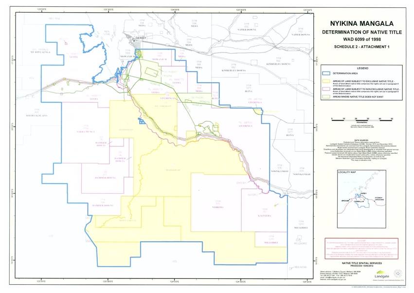
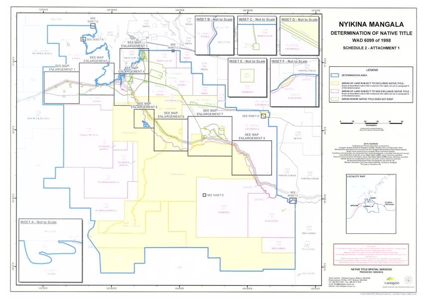
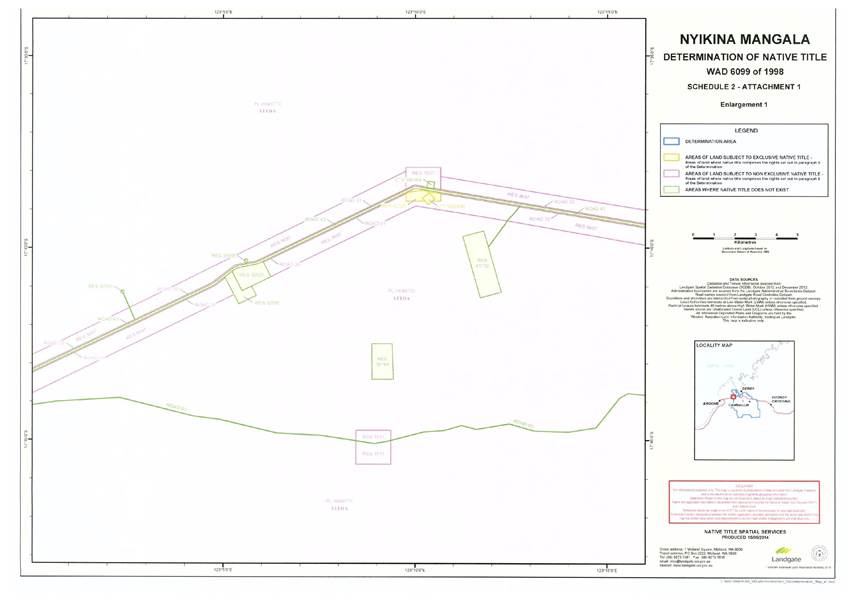
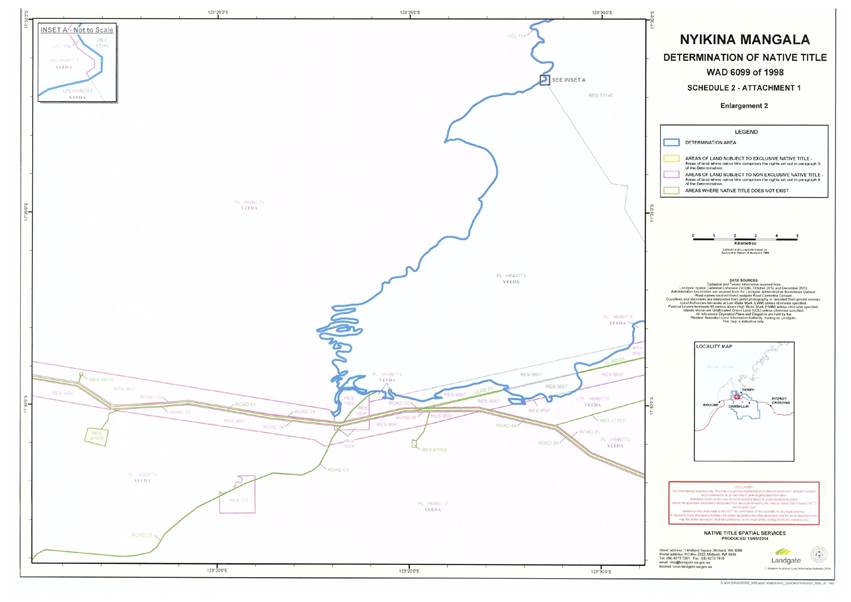
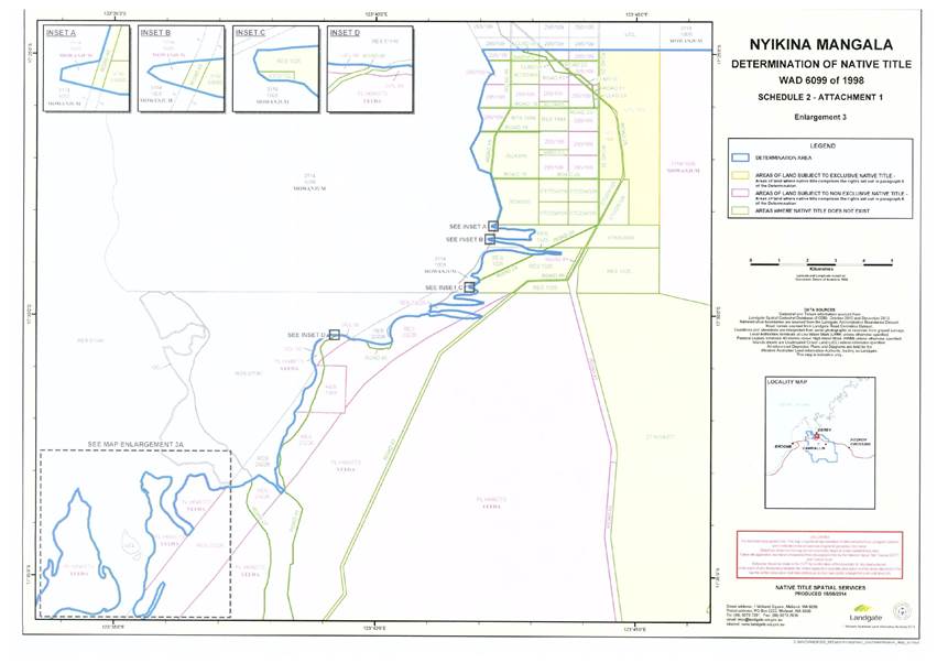
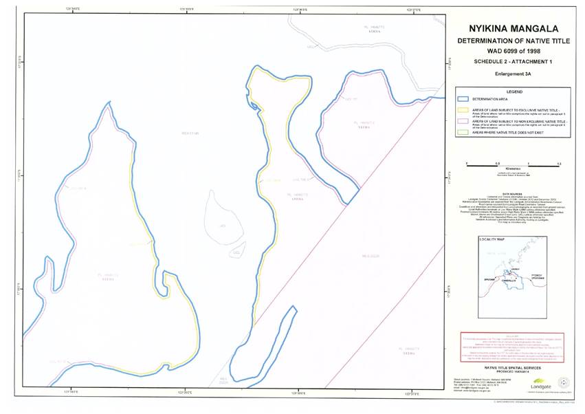
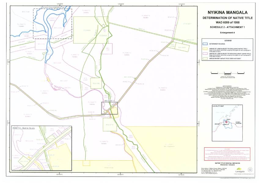
1. The Determination Area is the land and waters described in Schedule One and depicted on the maps comprising Schedule Two.
2. Native title exists in those parts of the Determination Area identified in Schedules Three and Four (Native Title Area).
3. Native title does not exist in those parts of the Determination Area identified in Schedule Five.
Native title holders (s 225(a) Native Title Act 1993)
4. The native title in the Determination Area is held by the Nyikina Mangala People. The Nyikina Mangala People are the people referred to in Schedule Six.
The nature and extent of native title rights and interests (s225(b) Native Title Act 1993) and exclusiveness of native title (s225(e) Native Title Act 1993)
Exclusive native title rights and interests
5. Subject to paragraphs 7, 8 and 9 the nature and extent of the native title rights and interests in relation to each part of the Determination Area referred to in Schedule Three, being areas where there has been no extinguishment of native title or areas where any extinguishment must be disregarded, are:
(a) except in relation to flowing and underground waters, the right to possession, occupation, use and enjoyment of that part of the Determination Area to the exclusion of all others; and
(b) in relation to flowing and underground waters, the right to use and enjoy the flowing and underground waters, including:
(i) the right to hunt on, fish from, take, use, share and exchange the natural resources of the flowing and underground waters for personal, domestic, cultural or non-commercial communal purposes;
(ii) the right to take, use, share and exchange the flowing and underground waters for personal, domestic, cultural or non-commercial communal purposes.
Non-exclusive rights and interests
6. Subject to paragraphs 7, 8 and 9, the nature and extent of the native title rights and interests in relation to each part of the Determination Area referred to in Schedule Four, being areas where there has been a partial extinguishment of native title and where any extinguishment is not required to be disregarded, are that they confer the following non-exclusive rights on the Native Title Holders, including the right to conduct activities necessary to give effect to them:
(a) the right to access and move freely through and within each part of the Determination Area referred to in Schedule Four;
(b) the right to live, being to enter and remain on, camp and erect shelters and other structures for those purposes on the Determination Area referred to in Schedule Four;
(c) the right to:
(i) hunt, gather and fish for personal, domestic, cultural and non-commercial communal purposes;
(ii) take and use flora and fauna for personal, domestic, cultural and non-commercial communal purposes;
(iii) take, use, share and exchange the natural resources of each part of the Determination Area referred to in Schedule Four including soil, sand, clay, gravel, ochre, timber, charcoal, resin and stone for personal, domestic, cultural and non-commercial communal purposes;
(iv) engage in cultural activities in the area, including the transmission of cultural heritage knowledge;
(v) conduct and participate in ceremonies;
(vi) hold meetings; and
(vii) visit, maintain and protect from physical harm, areas, places and sites of importance in each part of the Determination Area referred to in Schedule Four.
7. The native title rights and interests referred to in paragraphs 5(b) and 6 do not confer:
(a) possession, occupation, use and enjoyment of those parts of the Determination Area on the Native Title Holders to the exclusion of all others; nor
(b) a right to control the access of others to the land or waters of those parts of the Determination Area.
8. Notwithstanding anything in this Determination there are no native title rights and interests in the Determination Area in or in relation to:
(a) minerals as defined in the Mining Act 1904 (WA) (repealed) and the Mining Act 1978 (WA); or
(b) petroleum as defined in the Petroleum Act 1936 (WA) (repealed) and the Petroleum and Geothermal Energy Resources Act 1967 (WA);
(c) geothermal energy resources and geothermal energy as defined in the Petroleum and Geothermal Energy Resources Act 1967 (WA); or
(d) water lawfully captured by the holders of Other Interests,
except the right to take and use ochre to the extent that ochre is not a mineral pursuant to the Mining Act 1904 (WA).
9. Native title rights and interests are subject to and exercisable in accordance with:
(a) the laws of the State and the Commonwealth, including the common law; and
(b) the traditional laws and customs of the Native Title Holders for personal, domestic, cultural and non-commercial communal purposes (including social, religious, spiritual and ceremonial purposes).
Areas to which s 47, s 47A and s 47B of the Native Title Act apply
10. Section 47, section 47A and section 47B of the Native Title Act apply to disregard any prior extinguishment in relation to the areas described in Schedule Seven.
The nature and extent of any other interests
11. The nature and extent of other rights and interests in relation to the Determination Area are those set out in Schedule Eight.
Relationship between native title rights and other interests
12. The relationship between the native title rights and interests described in paragraphs 5 and 6 and the other interests referred to in paragraph 11 (“the other rights and interests”) is that:
(a) to the extent that any of the other rights and interests are inconsistent with the continued existence, enjoyment or exercise of the native title rights and interests, the native title rights and interests continue to exist in their entirety, but the native title rights and interests have no effect in relation to the other rights and interests to the extent of the inconsistency during the currency of the other interests; and otherwise,
(b) the existence and exercise of the native title rights and interests do not prevent the doing of any activity required or permitted to be done by or under the other rights and interests. The other rights and interests, and the doing of any activity required or permitted to be done by or under the other rights and interests, prevail over the native title rights and interests and any exercise of the native title rights and interests, but, subject to the operation of section 24JB(2) of the Native Title Act, do not extinguish them.
Liberty to Apply
13. The parties have liberty to apply to establish the precise location and boundaries of the public works and adjacent land and waters identified in relation to any part or parts of the Determination Area referred to in paragraph 4.3 of Schedule Five of this Determination.
Definitions and interpretation
14. In this Determination, unless the contrary intention appears:
“Determination Area” means the land and waters described in Schedule One and depicted on the maps at Schedule Two;
“flowing water” means the following water within the Determination Area:
(a) water which flows, whether permanently, intermittently or occasionally, within any river, creek, stream or brook; and
(b) any natural collection of water into, through, or out of which a river, creek, stream or brook flows;
“land” includes the airspace over, or subsoil under, land, but does not include "waters" and, for the avoidance of doubt, includes any natural collection of water found on the land which does not fall within the definition of "waters";
“Native Title Act” means the Native Title Act 1993 (Cth);
“non-commercial communal” includes social, cultural, religious, spiritual and ceremonial purposes;
“underground water” means water from and including an underground water source, including water that percolates from the ground;
“waters” has the same meaning as in the Native Title Act; and includes flowing and underground water.
15. In the event of any inconsistency between the written description of an area in Schedule One or Schedules Three to Five and the area as depicted on the maps at Schedule Two, the written description prevails.
SCHEDULE ONE
DETERMINATION AREA
The Determination Area, generally shown as bordered in blue on the maps at Schedule Two, comprises all that land and waters bounded by the following description:
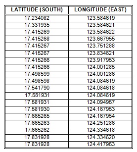
All those lands and waters commencing at the westernmost north-western corner of the north-western severance of Pastoral Lease 3114/576 (Noonkanbah) being a point on the present boundary of Native Title Determination WAD6229/1998 Noonkanbah (WC1998/009) and extending southerly and generally easterly along boundaries of that native title determination to the intersection of the prolongation southerly of the western boundary of Lot 4 as shown on Deposited Plan DP89313 with the Mean High Water Mark; Then generally north-easterly along that water mark to the intersection with Native Title Determination WAD6229/1998 Noonkanbah (WC1998/009); Then generally easterly along the boundaries of that native title determination to Longitude 124.852611° East; Then south-westerly to the easternmost north-eastern corner of the Pastoral Lease 3114/757 (Kalyeeda); Then southerly along the eastern boundary of that pastoral lease and onwards to a western corner of Pastoral Lease 3114/1210 (Millijidee); Then southerly along a western boundary of that pastoral lease to the intersection with a north-eastern corner of Native Title Determination WAD6077/1998 Ngurrara (Area A) (WC1996/032) at Latitude 19.016027° South; Then generally westerly along boundaries of that native title determination to its westernmost north-western corner at Latitude 19.044946° South, Longitude 123.501304° East; Then westerly to Latitude 19.044947° South, Longitude 123.421026° East, being a point on a present boundary of Native Title Determination WAD6100/1998 Karajarri People (Area A) (WC2000/002); Then generally northerly along boundaries of that native title determination to the intersection with the southernmost southern boundary of Pastoral Lease 3114/844 (Dampier Downs); Then generally north-westerly and generally north-easterly along boundaries of that pastoral lease to the intersection with the south-western corner of Pastoral Lease 3114/1194 (Yakka Munga); Then northerly along the western boundary of that pastoral lease to the intersection with a southern boundary of the south-westernmost severance of Pastoral Lease H649773 (Yeeda); Then westerly and northerly along boundaries of that severance and onwards to the westernmost south-western corner of the north-western severance of Pastoral Lease H649773 (Yeeda); Then generally northerly and easterly along the boundaries of that severance to its northernmost north-eastern corner; Then easterly and generally south-easterly passing through the following coordinate positions:
Then southerly to a point on the northern boundary of Pastoral Lease I087500 (Liveringa) at Longitude 124.417954° East; Then easterly and southerly along boundaries of that pastoral lease to the intersection with Aboriginal Lease H087314; Then easterly, southerly and westerly along boundaries of that aboriginal lease to the intersection of the prolongation northerly of westernmost boundary of the south-western severance of Pastoral Lease 3114/1271 (Blina); Then southerly to the northernmost north-western corner of that severance and then southerly, easterly and again southerly along the boundaries of that pastoral lease back to the commencement point.
Excluded Areas
All that land comprising Lots 1 and 19 as shown on Deposited Plan 180688 and being the land described in certificate of title volume 1388 folio 272;
All that land comprising Lot 2 as shown on Deposited Plan 230170 and being the land described in certificate of title volume 1670 folio 643;
All that land comprising Lots 4, 5, 6, 7, 8 and 9 as shown on Deposited Plan 230170 being General Lease H057490;
All that land comprising Lot 18 as shown on Deposited Plan 230170 and being the land described in certificate of title volume 1659 folio 693; and
Derby Port Area as Vested in the Minister for Transport by proclamation on 5 February 1982 under the Marine and Harbours Act 1981 (WA).
Note:
• Geographic Coordinates provided in Decimal Degrees.
• All referenced Deposited Plans and Diagrams are held by the Western Australian Land Information Authority, trading as Landgate.
• Cadastral boundaries sourced from Landgate Spatial Cadastral Database (SCDB) dated 30th December 2013.
• Native Title Determination WAD6229/1998 Noonkanbah (WC1998/009), as determined by the Federal Court on 27 April 2007.
• Native Title Determination WAD6077/1998 Ngurrara (Area A) (WC1996/032), as determined by the Federal Court on 8 November 2007.
• Native Title Determination WAD6100/1998 Karajarri People (Area A) (WC2000/002), as determined by the Federal Court on 12 February 2002.
Datum: Geocentric Datum of Australia 1994 (GDA94)
Prepared by: Native Title Spatial Services (Landgate) 8th May 2014
Use of Co-ordinates:
Where co-ordinates are used within the description to represent cadastral or topographical boundaries or the intersection with such, they are intended as a guide only. As an outcome of the custodians of cadastral and topographic data continuously recalculating the geographic position of their data based on improved survey and data maintenance procedures, it is not possible to accurately define such a position other than by detailed ground survey.
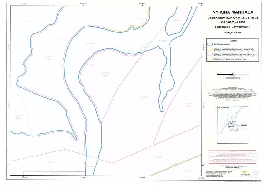
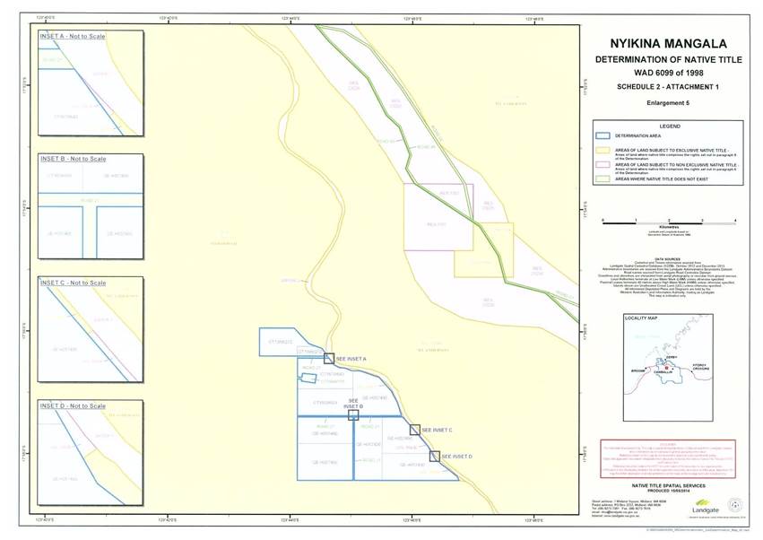
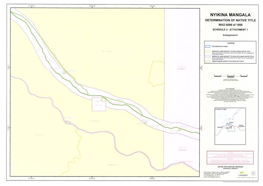
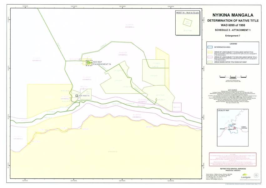
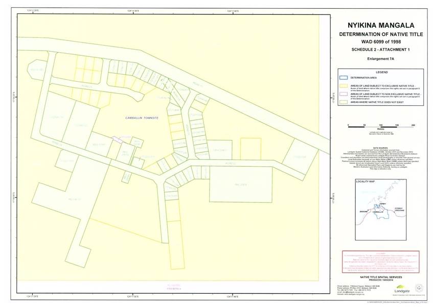
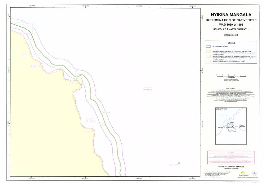
SCHEDULE TWO
MAPS OF THE DETERMINATION AREA
SCHEDULE THREE
EXCLUSIVE NATIVE TITLE AREAS
Areas where native title comprises the rights set out in paragraph 5
The following land and waters generally shown as orange on the maps at Schedule Two:
Pastoral Leases to which section 47 Native Title Act applies:
|
Tenure ID |
Location |
Interest Holder |
|
L236487 |
Lot 257 on DP 238351 (Mt Anderson Pastoral Lease) |
Ngyginah Cattle Company Pty Ltd |
Freehold Areas to which section 47A Native Title Act applies:
|
Tenure ID |
Location |
Interest Holder |
|
CT 1403/398 |
Lot 1 DP 207529 |
Looma Community Inc. |
|
CT 1403/400 |
Lot 3 on DP 207529 |
Looma Community Inc. |
|
CT 1417/796 |
Lot 75 on DP 213140 |
Aboriginal Lands Trust |
|
CT 1802/940 |
Lot 15 on DP 144040 |
Bidan Aboriginal Corporation |
|
CT 1933/126 |
Lot 85 on DP 187042 |
Looma Community Inc. |
|
CT 258/105A |
Lot 1 on DP 250840 |
Looma Pastoral Co Pty Ltd |
Reserve Areas to which section 47A Native Title Act applies:
|
Tenure ID |
Description |
|
Reserve 40277 |
Created for the purpose of "Use and benefit of Aboriginal Inhabitants" vested in the Pandanus Park Aboriginal Corporation. |
|
Reserve 41497 |
Created for the purpose of "Use and benefit of Aboriginal Inhabitants" vested in the Aboriginal Lands Trust. |
|
Reserve 42326 |
Created for the purpose of "Use and benefit of Aboriginal Inhabitants" and historically vested in the Aboriginal Lands Trust by proclamation published in the Government Gazette on 30 October 1992. |
Lease Areas to which section 47A Native Title Act applies:
|
Tenure ID |
Description |
|
DH087314 |
A lease in respect of Fitzroy Location 275 on Land Administration Plan 18350, for the purpose of "use and benefit of Aboriginal inhabitants" held by Jimbalakudunj Aboriginal Corporation. |
|
PL 3114/1036 |
A pastoral lease located on Lots 6 and 274 on DP 220700, known as Mowla Bluff pastoral station, which is held by the Ngi-Ngi Aboriginal Corporation. |
|
PL 3114/1165 |
A pastoral lease located on Lots 5 and 269 on DP 220368, known as Myroodah pastoral station, which is held by the Indigenous Land Corporation. |
UCL Areas to which section 47B Native Title Act applies:
|
Tenure ID |
General Area Description |
|
LR 3109/355 (UCL 13) |
Lot 10 on DP 220070 |
|
UCL 18 |
An area of unallocated Crown land being part of former Fitzroy Location 39 and which is abutted by general lease H711938 to the south, CT 1702/12 to the west, UCL 19 to the north and pastoral lease I087500 to the east and generally labelled UCL 18 on map "Enlargement 7". |
|
UCL 19 |
An area of unallocated Crown land being part of former Fitzroy Location 39 and which is abutted by UCL 18 to the south, CT 1702/12 to the west and south west, and pastoral lease I087500 to the west, north and east and generally labelled UCL 19 on map "Enlargement 7". |
|
UCL 51 |
An area of unallocated Crown land which formerly comprised pastoral lease 398/413 (CL 76/1971). |
|
LR 3007/046 (UCL 54) |
Lot 293 on DP 230160 |
|
LR 3008/481 (UCL 58) |
Lot 65 on DP 215037 |
|
LR 3008/482 (UCL 59) |
Lot 66 on DP 215037 |
|
LR 3008/480 (UCL 60) |
Lot 64 on DP 215037 |
|
LR 3008/495 (UCL 61) |
Lot 72 on DP 215037 |
|
LR 3008/484 (UCL 62) |
Lot 67 on DP 215037 |
|
LR 3008/479 (UCL 63) |
Lot 63 on DP 215037 |
|
LR 3008/494 (UCL 64) |
Lot 71 on DP 215037 |
|
LR 3008/487 (UCL 65) |
Lot 68 on DP 215037 |
|
LR 3008/478 (UCL 66) |
Lot 62 on DP 215037 |
|
LR 3008/493 (UCL 67) |
Lot 70 on DP 215037 |
|
LR 3008/491 (UCL 68) |
Lot 69 on DP 215037 |
|
LR 3008/476 (UCL 69) |
Lot 61 on DP 215037 |
|
LR 3008/496 (UCL 70) |
Lot 73 on DP 215037 |
|
LR 3008/504 (UCL 71) |
Lot 82 on DP 215037 |
|
LR 3008/503 (UCL 72) |
Lot 81 on DP 215037 |
|
LR 3008/502 (UCL 73) |
Lot 80 on DP 215037 |
|
LR 3008/497 (UCL 74) |
Lot 79 on DP 215037 |
|
LR 3008/469 (UCL 75) |
Lot 9 on DP 207529 |
|
LR 3008/467 (UCL 76) |
Lot 8 on DP 207529 |
|
LR 3008/518 (UCL 77) |
Lot 7 on DP 207529 |
|
UCL 78 |
An area of unallocated Crown land being part of former pastoral lease 1416/98 (CL 819/1924) and which is generally abutted by PL I087500 on the eastern, southern and western external boundaries of that area and Road 17 on its northern external boundary and generally labelled "UCL 78" on Map "Enlargement 7A". |
|
LR 3022/816 (UCL 79) |
Lot 54 on DP 181288 |
|
LR 3008/474 (UCL 80) |
Lot 58 on DP 184395 |
|
LR 3022/812 (UCL 81) |
Lot 47 on DP 209097 |
|
UCL 82 |
An area of unallocated Crown land generally located within Camballin and which is abutted by Road 17 to the north-east, CT 1252/847 to the south east, road 22 to the south and generally labelled "UCL 82" on Map "Enlargement 7A". |
|
LR 3008/472 (UCL 83) |
Lot 51 on DP 180382 |
|
UCL 84 |
An area of unallocated Crown land being part of former pastoral lease 1416/98 (CL 819/1924) and which is generally abutted by PL I087500 on all but the southern boundary, which abuts Road 17 and generally labelled "UCL 84" on Map "Enlargement 7A". |
|
Part LR 3124/304 (Part UCL 85) |
Part Lot 91 on DP 27443, being those parts which are not subject to H593843 (easement to water authority of Western Australia for right of carriageway purposes). |
|
UCL 87 |
An area of unallocated Crown Land which is generally adjacent to a portion of PL H649773 and Water Feature 9, which is generally labelled and marked "UCL 87" on Map "Enlargement 4". |
|
UCL 88 |
An area of unallocated Crown Land which is generally adjacent to a portion of PL H649773 and Water Feature 2, and is otherwise located near the eastern most northern boundary of the Determination Area, which is generally labelled and marked "UCL 88" on Map "Attachment 1" at Inset F. |
|
UCL 90 |
An area of unallocated Crown Land which is generally adjacent to a portion of PL H649773, surrounded by Water Feature 4 and which abuts Road 38 to the north, which is generally labelled and marked "UCL 90" on Map "Enlargement 4" at Inset A. |
|
UCL 92 |
An area of unallocated Crown Land which is generally surrounded by Water Feature 9 to the east, north and west and which abuts Road 38 to the south, which is generally labelled and marked "UCL 92" on Map "Enlargement 4" at Inset A. |
|
UCL 93 |
An area of unallocated Crown Land which is generally surrounded by Water Feature 3 which is generally labelled and marked "UCL 93" on Map "Enlargement 6". |
|
UCL 101 |
An area of unallocated Crown land being part of former pastoral lease PL 786/98 generally abutting parts of the southern boundary of the Determination Area and otherwise adjacent to UCL 51 and pastoral lease 3114/0571, which is generally labelled and marked "UCL 101" on Map "Attachment 1". |
|
LR 3143/36 (UCL 103 and 104) |
Lot 350 on DP 52837. |
Those parts of 40 metre wide strips, or thereabouts, of UCL listed in the table immediately below, situated immediately landward of the High Water Mark being:
|
Tenure ID |
General Area Description |
|
UCL 96D |
All that Unallocated Crown Land commencing at the westernmost south-western corner of Lot 75 as shown on Deposited Plan 213140 (Certificate of Title 1417/796) and extending generally north-easterly along the boundaries of that lot to at approximately 615378mE, 7995401mN; Then south-easterly to approximately 615460mE, 7995334mN being a point on the Mean High Water Mark; Then generally south-westerly along that water mark to the intersection with Pastoral Lease I087500 (Liveringa); Then northerly along the boundary of that pastoral lease back to the commencement point. |
|
UCL 96E |
All that Unallocated Crown Land commencing at approximately 615997mE, 7996186mN being a point on a south-eastern boundary of Lot 75 as shown on Deposited Plan 213140 (Certificate of Title 1417/796) and extending generally north-easterly and generally easterly along the boundaries of that lot to approximately 617394mE, 7997228mN; Then southerly to approximately 617386mE, 7997152mN being a point on the Mean High Water Mark; Then generally westerly and generally south-westerly along that water mark to approximately 616085mE, 7996156mN and then north-westerly back to the commencement point. |
|
UCL 96F |
All that Unallocated Crown Land commencing at approximately 620562mE, 7998042mN being a point on a southern boundary of Lot 75 as shown on Deposited Plan 213140 (Certificate of Title 1417/796) and extending generally south-easterly and generally north-easterly along the boundaries of that lot to approximately 622189mE, 7997830mN; Then south-easterly to approximately 622267mE, 7997693mN being a point on the Mean High Water Mark; Then generally south-westerly and generally north-westerly along that water mark to approximately 620566mE, 7998005mN and then northerly back to the commencement point. |
|
UCL 106A |
All that Unallocated Crown Land commencing at approximately 563609mE, 8058045mN being a point on a present boundary of Pastoral Lease H649773 (Yeeda) and extending generally northerly, generally westerly and generally southerly along the boundaries of that pastoral lease to the intersection with a north western boundary of Reserve 23226; Then south-westerly along boundaries of that reserve to the intersection with the High Water Mark; Then generally northerly, generally easterly and generally southerly along that water mark to approximately 563637mE, 8058074mN and then south-westerly back to the commencement point. |
|
UCL 107C |
All that Unallocated Crown Land commencing at approximately 560791mE, 8054567mN being a point on a present boundary of Pastoral Lease H649773 (Yeeda) and extending generally easterly and generally northerly along the boundaries of that pastoral lease to approximately 561061mE, 8058046mN; Then easterly to approximately 561101mE, 8058041mN being a point on the High Water Mark; Then generally southerly and generally westerly along that water mark to approximately 560781mE, 8054528mN and then northerly back to the commencement point. |
|
UCL 109C |
All that Unallocated Crown Land commencing at approximately 578875mE, 8016093mN being a point on a north-eastern boundary of Lot 2 as shown on Deposited Plan 230170 (Certificate of Title 1670/643) and extending generally easterly along boundaries of that lot to the intersection with Lot 4 as shown on Deposited Plan 230170 (General Lease H057490); Then generally south-easterly along the north-eastern boundaries of that lot to its south-eastern corner; Then south-easterly to the north-eastern corner of Lot 8 as shown on Deposited Plan 230170 (General Lease H057490); Then south-easterly along the north-eastern boundary of that lot to approximately 581265mE, 8014025mN; Then north-easterly to approximately 581280mE, 8014037mN being a point on the Mean High Water Mark; Then generally north-westerly along that water mark to approximately 578889mE, 8016106mN and then south-westerly back to the commencement point. |
|
UCL 109D |
All that Unallocated Crown Land commencing at approximately 581813.000mE, 8013249.000mN being a point on a north-eastern boundary of Lot 9 as shown on Deposited Plan 230170 (General Lease H057490) and extending generally south-easterly along boundaries of that lot to the intersection with a northern boundary of Pastoral Lease 3114/1165 (Myroodah); Then easterly along the boundary of that pastoral lease to the intersection with the Mean High Water Mark; Then generally north-westerly along that water mark to approximately 581852.000mE, 8013279.000mN and then south-westerly back to the commencement point. |
Note to the General Area Descriptions provided in the table immediately above:
Prepared by: Native Title Spatial Services (Landgate), 8th May 2014.
Note: All referenced Deposited Plans and Diagrams are held by the Western Australian Land Information Authority, trading as Landgate.
Cadastral boundaries sourced from Landgate Spatial Cadastral Database (SCDB) dated 30th December 2013.
Coordinates supplied by State Solicitor's Office (coordinates provided to the State Solicitor's Office by the Kimberley Land Council).
Datum: GDA 1994, Grid Coordinates (Easting, Northing, MGA Zone 51)
Use of Co-ordinates:
Where co-ordinates are used within the description to represent cadastral or topographical boundaries or the intersection with such, they are intended as a guide only. As an outcome of the custodians of cadastral and topographic data continuously recalculating the geographic position of their data based on improved survey and data maintenance procedures, it is not possible to accurately define such a position other than by detailed ground survey.
SCHEDULE FOUR
NON - EXCLUSIVE NATIVE TITLE AREAS
Areas where native title comprises the rights set out in paragraph
The following land and waters generally shown as pink on the maps at Schedule Two:
1. Pastoral Leases:
|
Tenure ID |
Name |
Interest Holder |
|
PL 3114/1008 (excluding former lease J601693) (CL 1973/180) |
Lots 252 and 253 on DP 238848 (Mowanjum pastoral station) |
Mowanjum Aboriginal Corporation |
|
PL 3114/1210 (CL 1988/69) |
Lots 9 and 60 on DP 238001 (Millijiddee pastoral station) |
Kadjina Community Inc |
|
Pastoral Licence 295/109 (CL 1990/230) |
Lots 6 – 9, 16 -19, 25 - 27, 33 - 35, 39 - 43, 46 - 49, 52 - 55, 58 - 61, 65 - 67, 72, 73, 78, 83, 84, 88, 89 on DP 230140; Lots 64, 70, 71, 76, 81, 82, 87, 92, 97 on DP 226564; Lots 22, 30, 38 on DP 50849; and Lots 23, 24, 31and 32 on DP 144056. |
Mowanjum Aboriginal Corporation |
|
3114/571 (CL 1966/144) |
Nerrima Pastoral Lease |
Quixot Pty Ltd |
|
That portion of Pastoral Lease 3114/594 falling within the Determination Area (CL 1967/255) |
Meda Pastoral Lease |
Jock Hugh MacLachlan |
|
3114/757 (CL 1967/593) |
Kalyeeda Pastoral Lease |
Peter James Camp and Cheryl Marie Camp |
|
3114/0844 (CL 1975/20) |
Dampier Downs Pastoral Lease |
Michael De Long |
|
398/667 (CL 1986/170) |
Dampier Downs Pastoral Lease |
Michael De Long |
|
398/740 (CL 1985/189) |
Dampier Downs Pastoral Lease |
Michael De Long |
|
3114/1194 (CL 1984/280) |
Yakka Munga Pastoral Lease |
Wyloo Pty Ltd |
|
That portion of Pastoral Lease 3114/1271 falling within the Determination Area (CL 1992/402) |
Blina Pastoral Lease |
Callum Hugh MacLachlan |
|
That portion of H649773 falling within the Determination Area (including those areas now covered by Roads 36 to 42. Note: see Schedule 8 for a description of those roads and excluding those areas covered by Roads 1, 2 and 3) |
Yeeda Pastoral Lease |
Yeeda Pastoral Company Pty Ltd |
|
I087500 |
Liveringa Pastoral Lease |
Clover Cattle Co Pty Ltd |
|
398/0728 (CL 1985/152) |
Clover Cattle Co Pty Ltd |
2. Reserves:
Historical
|
Tenure ID |
Location |
Purpose |
|
Reserve 09697 |
Those former portions of Reserve 09697 which are now covered by Roads 29 to 35 (Note: see Schedule 8 for a description of those roads). |
Reserve created for the purpose of "Kimberley - De Grey Stock Route". |
Current
|
Tenure ID |
Location |
Purpose |
|
Reserve 00717 |
Dampier |
Reserve created for "public purposes" |
|
Reserve 00727 (excluding those areas covered by Road 3) |
Dampier |
Reserve created for the purpose of "water and stopping place" |
|
Reserve 00781 |
Fitzroy |
Reserve for the purpose of "water" |
|
Reserve 01304 |
Fitzroy |
Reserve for the purpose of "water and stopping place" |
|
Reserve 01305 |
Fitzroy |
Reserve created for the purpose of "water and stopping place" |
|
Reserve 01307 |
Fitzroy |
Reserve created for the purpose of "water and stopping place". |
|
Reserve 01310 |
Fitzroy |
Reserve created for the purpose of "water and stopping place". |
|
Reserve 01311 |
Fitzroy |
Reserve created for the purpose of "water and stopping place". |
|
Reserve 01399 |
Fitzroy |
Reserve created for the purpose of "water and stopping place". |
|
Part Reserve 01400 (excluding that portion formerly covered by lease 804/42) |
Dampier |
Reserve created for the purpose of "water and stopping place". |
|
Reserve 01507 |
Lot 397 on 29396 |
Reserve created for the purpose of "watering place". |
|
Part Reserve 01508 (excluding those areas covered by Road 3) |
Lots 395 and 396 on DP 29541 |
Reserve created for the purpose of "watering place" |
|
Reserve 01509 |
Lot 316 on DP 92134 |
Reserve created for the purpose of "watering place" |
|
Part Reserve 01511 (excluding those areas covered by Road 3) |
Dampier |
Reserve created for the purpose of "watering place" |
|
Part Reserve 09697 (excluding those areas covered by Road 3) |
Lot 265 on 240321; Lot 85 on DP213637; Lot 245 on DP 174675; Lot 278 on DP 240321; Lot 56 on DP 240312; Lot 116 on DP; 240321; |
Reserve created for the purpose of "Kimberley - De Grey Stock Route". |
|
Part Reserve 23226, excluding those portions formerly covered by Road 2 special lease 1617/152 and leases 332/973 and 332/974 |
Fitzroy |
Reserve created for the purpose of "Stock route-Fitzroy Crossing the Nobby's Well" |
|
Reserve 23227, excluding that portion formerly covered by Road 2 |
Lot 276 on DP 92144 |
Reserve created for the purpose of "resting place for travellers and stock" |
|
Reserve 50419 |
Lot 500 on DP 56718 |
Reserve created for the purpose of "rubbish disposal site" |
3. Areas of Unallocated Crown Land
a. Water Features
|
Tenure ID |
General Area Description |
|
Water 2 |
Being a portion of the Fitzroy River |
|
Water 3 |
Being a portion of the Fitzroy River |
|
Water 4 |
Being a portion of the Fitzroy River |
|
Water 5 |
Being a portion of the Fitzroy River |
|
Water 6 |
Being a portion of the Fitzroy River |
|
Water 7 |
Being a portion of the Fitzroy River |
|
Water 8 |
Being a portion of the Fitzroy River |
|
Part Water 9 |
Being a portion of the Fitzroy River and excluding that part of Water 9 historically covered by Road 02. |
b. Those areas of unallocated Crown land described in the table immediately
below.
|
Tenure ID |
General Area Description |
|
LR 3009/621 (UCL 23) |
Lot 98 on DP 185354 |
|
LR 3009/626 (UCL 24) |
Lot 227 on DP 187572 |
|
UCL 97 |
A 40 metre wide strip of unallocated Crown land abutting part of the boundary of DH 649773 and the Port of Derby (Res 51146). |
|
UCL 98 |
A 40 metre wide strip of unallocated Crown land abutting part of the boundary of DH 649773 and the Port of Derby (Res 51146). |
|
UCL 99 |
A 40 metre wide strip of unallocated Crown land abutting part of the boundary of DH 649773 and the Port of Derby (Res 51146). |
|
UCL 111 |
A 40 metre wide strip of unallocated Crown land abutting part of the boundary of DH 649773 and the Port of Derby (Res 51146). |
|
UCL 114 |
A 40 metre wide strip of unallocated Crown land abutting part of the boundary of PL H 649773 and the Port of Derby (Res 51146). |
c. Those parts of the UCL areas described in the table immediately below which are not included within the 40 metre strips described in Schedule Three and Schedule Seven.
|
Tenure ID |
General Area Description |
|
UCL 96A |
All that Unallocated Crown Land commencing at approximately 615378mE, 7995401mN being a point on a south-eastern boundary of Lot 75 as shown on Deposited Plan 213140 (Certificate of Title 1417/796) and extending north-easterly along the boundary of that lot to approximately 615997mE, 7996186mN; Then easterly to approximately 616085mE, 7996156mN being a point on the Mean High Water Mark; Then generally south-westerly along that water mark to approximately 615460mE, 7995334mN and then north-westerly back to the commencement point. |
|
UCL 96B |
All that Unallocated Crown Land commencing at approximately 617394mE, 7997228mN being a point on a southern boundary of Lot 75 as shown on Deposited Plan 213140 (Certificate of Title 1417/796) and extending generally easterly along the boundary of that lot to approximately 620562mE, 7998042mN; Then southerly to approximately 620566mE, 7998005mN being a point on the Mean High Water Mark; Then generally westerly along that water mark to approximately 617386mE, 7997152mN and then northerly back to the commencement point. |
|
UCL 96C |
All that Unallocated Crown Land commencing at the easternmost south-eastern corner of Lot 75 as shown on Deposited Plan 213140 (Certificate of Title 1417/796) being a point on a present boundary of Pastoral Lease I087500 (Liveringa); Then southerly along the boundary of that pastoral lease to the intersection with the Mean High Water Mark; Then generally westerly along that water mark to approximately 622267mE, 7997693mN; Then north-westerly to approximately 622189mE, 7997830mN being a point on a southern boundary of Lot 75 as shown on Deposited Plan 213140 (Certificate of Title 1417/796) and then generally easterly along the boundary of that lot back to the commencement point. |
|
UCL 106B |
All that Unallocated Crown Land commencing at approximately 563609mE, 8058045mN being a point on a present boundary of Pastoral Lease H649773 (Yeeda) and extending north-easterly to approximately 563637mE, 8058074mN being a point on the High Water Mark; Then generally south-easterly along that water mark to the intersection with a north western boundary of Reserve 23226; Then south-westerly along boundaries of that reserve to the intersection with Pastoral Lease H649773 (Yeeda); Then generally north-westerly along the boundary of that pastoral lease back to the commencement point. |
|
UCL 107A |
All that Unallocated Crown Land commencing at approximately 561061mE, 8058046mN being a point on a present boundary of Pastoral Lease H649773 (Yeeda) and extending generally north-westerly, generally south-westerly, generally south-easterly, generally westerly and northerly along the boundaries of that pastoral lease to the intersection with the High Water Mark; Then generally easterly, generally north-westerly, generally north-easterly and generally south-easterly along that water mark to approximately 561101mE, 8058041mN and then westerly back to the commencement point. |
|
UCL 107B |
All that Unallocated Crown Land commencing at approximately 560791mE, 8054567mN being a point on a present boundary of Pastoral Lease H649773 (Yeeda) and extending southerly to approximately 560781mE, 8054528mN being a point on the High Water Mark; Then generally westerly and generally southerly along that water mark to the intersection with a northern boundary of Reserve 9697; Then north-westerly along a northern boundary of that reserve to the intersection with Pastoral Lease H649773 (Yeeda); Then generally northerly and generally easterly along the boundary of that pastoral lease back to the commencement point. |
|
UCL 109A |
All that Unallocated Crown Land commencing at the northernmost north-eastern corner of Lot 2 as shown on Deposited Plan 230170 (Certificate of Title 1670/643) and extending generally south-easterly along the boundary of that lot to approximately 578875mE, 8016093mN; Then north-easterly to approximately 578889mE, 8016106mN being a point on the Mean High Water Mark; Then north-westerly along that water mark back to the commencement point. |
|
UCL 109B |
All that Unallocated Crown Land commencing at approximately 581265mE, 8014025mN being a point on a north-eastern boundary of Lot 8 as shown on Deposited Plan 230170 (General Lease H057490) and extending generally south-easterly along the boundary of that lot to the intersection with Lot 9 as shown on Deposited Plan 230170 (General Lease H057490); Then south-easterly along the eastern boundary of that lot to approximately 581813mE, 8013249mN; Then north-easterly to approximately 581852mE, 8013279mN being a point on the Mean High Water Mark; Then generally north-westerly along that water mark back to approximately 581280mE, 8014037mN then south-westerly back to the commencement point. |
Note to the General Area Descriptions provided in the table immediately above:
Prepared by: Native Title Spatial Services (Landgate), 8th May 2014.
Note: All referenced Deposited Plans and Diagrams are held by the Western Australian Land Information Authority, trading as Landgate.
Cadastral boundaries sourced from Landgate Spatial Cadastral Database (SCDB) dated 30th December 2013.
Coordinates supplied by State Solicitor's Office (coordinates provided to the State Solicitor's Office by the Kimberley Land Council).
Datum: GDA 1994, Grid Coordinates (Easting, Northing, MGA Zone 51)
Use of Co-ordinates:
Where co-ordinates are used within the description to represent cadastral or topographical boundaries or the intersection with such, they are intended as a guide only. As an outcome to the custodians of cadastral and topographic data continuously recalculating the geographic position of their data based on improved survey and data maintenance procedures, it is not possible to accurately define such a position other than by detailed ground survey.
4. Other
|
Tenure ID |
Location |
Purpose |
|
H593843 |
Subject F within Lot 91 on DP 27443 |
Easement for the purpose of "right of carriageway" |
SCHEDULE FIVE
AREAS WHERE NATIVE TITLE DOES NOT EXIST
Native title does not exist in the following land and waters, by reason of extinguishment.
(Note: with the exception of public works, which are captured by the definition at paragraph 4 of Part 1 of this Schedule, the areas described in Schedule Five are generally shown as green on the maps at Schedule Two.)
1. Freehold:
|
CT 1252/847 |
CT 1593/592 |
CT 1777/249 |
CT 2224/326 |
|
CT 1403/399 |
CT 1614/877 |
CT 1914/101 |
CT 2542/823 |
|
CT 1403/401 |
CT 1632/84 |
CT 1994/155 |
CT 2561/504 |
|
CT 1403/402 |
CT 1659/129 |
CT 2008/389 |
CT 2566/729 |
|
CT 1403/403 |
CT 1674/450 |
CT 2027/511 |
CT 2566/730 |
|
CT 1403/404 |
CT 1702/11 |
CT 2106/169 |
CT 2586/192 |
|
CT 1403/405 |
CT 1702/12 |
CT 2112/256 |
CT 2586/193 |
|
CT 1426/391 |
CT 1741/349 |
CT 2124/40 |
CT 2586/194 |
|
CT 1462/224 |
CT 1741/350 |
CT 2124/41 |
CT 2586/195 |
|
CT 1577/290 |
CT 1777/245 |
CT 2208/28 |
CT 2600/9 |
|
CT 1579/981 |
CT 1777/246 |
CT 2222/101 |
2. Leases:
Historical
|
35243/55 |
372/152 |
3116/3680 |
|
39665/55 |
1617/152 |
|
|
39667/55 |
804/42 |
|
|
39714/55 |
332/973 |
|
|
347/02969 |
332/974 |
Current
|
GE H711938 |
GE H711940 |
GE K224601 |
|
GE H711939 |
GE I150242 |
3. Reserves:
|
Tenure ID |
Location |
Purpose |
|
RES 01306 |
Fitzroy |
for the purpose of "sand and shingle for government requirements". |
|
RES 01325 |
Fitzroy Location |
for the purpose of "commonage travellers and stock". |
|
RES 01484 |
Lot 77 and 102 on DP 226564 |
for the purpose of "stopping place for travellers and stock" |
|
RES 20667 |
Fitzroy Location 20 |
for the purpose "aerial landing ground" |
|
RES 26414 |
Camballin Location 36 |
for the purpose of "recreation" |
|
RES 26639 |
Camballin Location 49 |
for "water supply purposes" |
|
RES 26640 |
Camballin Location 50 |
for "water supply purposes" |
|
RES 32595 |
Dampier Locations 83 and 152 |
for the purpose of "quarry" |
|
RES 35866 |
Camballin Location 57 |
for the purpose of "power station site" |
|
RES 37014 |
Lot 153 on DP 91365 |
for the purpose of "recreation" |
|
RES 37787 |
Lot 97 on DP 216439 |
for the purpose of "quarry main roads department" |
|
RES 38710 |
Lot 302 on DP 45665 |
for the purpose of "microwave translator site" |
|
RES 38995 |
Lot 306 on DP 45663 |
for the purpose of "depot site - main roads department" |
|
RES 39093 |
Lot 151 on DP 215826 |
for the purpose of "gravel" |
|
RES 39164 |
Lot 217 on DP 91532 |
for the purpose of "gravel" |
|
RES 39165 |
Lot 304 on DP 45661 |
for the purpose of "Repeater Station Site" |
|
RES 39166 |
Lot 300 on DP 45662 |
for the purpose of "Repeater Station Site" |
|
RES 39540 |
Lot 87 on DP 187427 |
for the purpose of "Radio Communications Site" |
|
RES 40199 |
Lot 222 on DP 187426 |
for the purpose of "Radio Communications Site" |
|
RES 40778 |
Lot 359 on DP 36522 Lot 145 on DP 215976 |
for the purpose of "Repeater Station Site and Access" |
|
RES 41344 |
Lot 232 on DP 188488 |
for the purpose of "Repeater Station Site" |
|
RES 41642 |
Lot 230 on DP 217175 |
for the purpose of "gravel" |
|
RES 41679 |
Lot 4 on DP 91680 |
for the purpose of "Repeater Station Site" |
|
RES 41732 |
Lot 301 on DP 45664 |
for the purpose of "gravel" |
|
RES 46707 |
Lot 84 on DP 187042 |
for the purpose of "water supply buffer" |
|
RES 47653 |
Lot 369 on DP 220472 |
for the purpose of "sand" |
|
RES 47654 |
Lot 370 on DP 220472 |
for the purpose of "gravel" |
|
RES 47655 |
Lot 368 on DP 220472 |
for the purpose of "gravel" |
|
RES 47849 |
Lot 55 on DP 215920 |
for the purpose of "water supply" |
4. The areas the subject of the following public works:
4.1 Roads:
|
Road number |
Location |
|
CLRD 1 |
A portion of Road 222 (being a portion of the Great Northern Highway) as published in the Government Gazette on 17 September 1885 and depicted on DP 240321. |
|
CLRD 2 |
Portion Road No. 14232 (now closed), as published in the Government Gazette on 20 March 1931 and extended by order in council published in the Government Gazette on 23 March 1973. |
|
CLRD 3 |
Road 8656 as published in the Government Gazette on 20 March 1931. |
|
CLRD 5, 6, 7 and 8 |
Each being portions of Road 9455 as published in the Government Gazette on 5 April 1935. |
|
Roads 01 and 05 |
Each being portions of Road 1725 as described by notices published in the Government Gazette on 25 December 1903 and January 8 1904; which were opened by the West Kimberley Road Board by notices published in the Government Gazette on 9 and 23 September 1904; and generally depicted on CPP 507 015. |
|
Road 02 |
Road number 221, being a Main Road from Yeeda Station to Lulingui Station as described in the Government Gazette published on September 17 1885 and depicted on plan 507012. |
|
Road 03 |
A portion of Road 222 (being a portion of the Great Northern Highway) as published in the Government Gazette on 17 September 1885 and depicted on CPP 506 791. |
|
Road 06 |
Road 8658 as published in the Government Gazette on 20 March 1931. |
|
Road 07 |
Road 8659 as published in the Government Gazette on 20 March 1931. |
|
Road 08 |
Road 8660, as published in the Government Gazette on 20 March 1931. |
|
Road 09 |
Road 8661, as published in the Government Gazette on 20 March 1931. |
|
Roads 04 and 13 |
Road 12452 (Coleman Street) as published in the Government Gazette on 15 March 1963. |
|
Road 14 |
Road 14232 as published in the Government Gazette on 20 March 1931 and extended by order in council published in the Government Gazette on 23 March 1973. |
|
Road 16 |
Road 18462 (Myroodah-Luluigui Road) as published in the Government Gazette on 5 September 1995. |
|
Road 17 |
Road 18463 (Camballin-Noonkanbah Road) as published in the Government Gazette on 5 September 1995. |
|
Road 18 |
Road 18464 as published in the Government Gazette on 5 September 1995. |
|
Road 19 |
Those roads shown on DP 226564 which are abutted by lots 70 and 76, lots 71 and 77, lot 102, lots 76 and 81, lots 77 and 82 and lots 87 and 92 as depicted on that plan. |
|
Road 20 |
Those roads shown on DP 230140 which are located on a portion of the eastern boundary of that plan, are located between lots 58 and 64, lots 59 and 65, lots 60 and 66, lots 61 and 67, lots 73 and 78, lots 88 and 93 and lots 89 and 94 as depicted on that plan. |
|
Road 21 |
Those two chain roads depicted on DP 230170. |
|
Road 22 |
Durack Street and Forrest Street as depicted on DP 207529. |
|
Road 23 |
Kennedy Street and Lincoln Street as depicted on DP 215037. |
|
Road 24 |
Durack Street and Nordell Street shown as depicted on Plan 7529 and Plan 15920. |
|
Road 25 |
Road 11952 as published in the Government Gazette on 19 August 1966, 8 May 1970, and 14 November 1969 (wherein the road was described as Road 9455). |
|
Road 26 |
Portion of the Great Northern Highway as depicted on plans 18880, 18881, 18882, 18883, 18884 and 18885, dedicated as public street by order of the Minister for Lands as published in the Government Gazette on 27 June 1997. |
|
Road 27 |
Road 220 as shown on CPP 135/300 plan 3, which road is described by notice published in the Government Gazette on 17 September 1885. |
|
Road 28 |
Road 9455 as published in the Government Gazette on 5 April 1935. |
|
Road 43 |
Road 222 (being a portion of the Great Northern Highway) as published in the Government Gazette on 17 September 1885 and shown on CPP 507016 and CPP 506 791. |
|
Road 44 |
Road 14382 as published in the Gazette on 18 September 1970. |
|
Road 45 |
A main road starting from the South side of Derby Townsite and extending in a sourtherly direction passing Nobby's Well, Yeeda Station, Gnana Pool, Willare Pool, and through the reserve in Lease N 1369, thence in a south-easterly direction to a spring near Mt. Anderson, and from thence in a general easterly direction along the South side of the Grant Range to a large permanent pool known as Upper Liveringa, and from thence passing a permanent pool known as Yallanungy and by Lake Josceline to Mount Wynne and Road 219 as described in the Government Gazette published on 9 October 1925. |
|
Road 46 |
Road 296 being a main road, three chains wide, from Derby to Hall's Creek, via Yeeda, Liveringa, Mount Pierre, and the Upper Mary River as published in the Government Gazette on 15 October 1889. |
|
Road 47 |
That road which is shown on: CPP 507 015 as a portion of the Great Northern Highway; CPP 506 791; and as extending from and to the north west of Langey Crossing Road and joining the Derby Highway on SE 51-7. |
|
Road 48 |
That part of the Derby Highway shown on DP 194734 and 26382. |
|
Road 49 |
That road shown within PL 3114/975 on DP 213140. |
|
Road 50 |
That road which abuts a portion of the Great Northern Highway and the eastern boundary of Reserve 41642 and is depicted on Department of Land Administration Plan No 17175. |
|
Road 51 |
Road 9455 as published in the Government Gazette on 195 April 1935. |
|
Road 52 |
Road 11052 as published in the Government Gazette on 7 April 1955. |
4.2 Other
|
Tenure ID |
General area description |
|
LR 3112/586 (UCL 113) |
Lot 301 on DP 220070. |
4.3 Any other public works as that expression is defined in the Native Title Act and the Titles (Validation) and Native Title (Effect of Past Acts) Act 1995 (WA) and to which section 12J of the Titles (Validation) and Native Title (Effect of Past Acts) Act 1995 (WA) or section 23C(2) of the Native Title Act applies, within the external boundary of the Determination Area including the land and waters defined in section 251D of the Native Title Act.
SCHEDULE SIX
DESCRIPTION OF THE NATIVE TITLE HOLDERS
Nyikina Mangala People, referred to in paragraph 4, are the descendants of:
Marrkal and Minbukar and Kinara and Karlmurl; Ngurkwan, Yayika and Minyang; Polly Wurrayin and Charlie Djawali, Bundangurra and Jambo; Intiri and Nulanula, and Yawingka and Kalyuka; Kitty Kujaja and Charlie Mangurl; Lucy Muninga and Edward Yedawarra and unnamed mother of Fulgentius Fraser; Maggie Nimbanirl; Dim and the mother of Bobby Ah Choo; Bundangurra and Mabel Ah Chee; Jimgula; Niyna Philomena; Kupa and Ngamariny; Gurupirin; Nani; Jinangkal and Nyuntunga; Yana and Nyani, Ngata and Kalkululu; Andy Marunjari and Marjory Spratt and her unnamed mother; Wilidi and Muna and Tutu and Warda; Muwa and Nijajira; Bobby Yingirr and Molly, and Latpij and Wayurl ; Nipper Tapaji and his father Larry; Cissy Punturu and Dan Palangga; Tommy Numarid.
SCHEDULE SEVEN
AREAS TO WHICH SECTIONS 47, 47A and 47B NATIVE TITLE ACT 1993 (CTH) APPLY
Pastoral Leases to which section 47 Native Title Act applies:
|
Tenure ID |
Location |
Interest Holder |
|
L236487 |
Lot 257 on DP 238351 (Mt Anderson Pastoral Lease) |
Ngyginah Cattle Company Pty Ltd |
Freehold Areas to which section 47A Native Title Act applies:
|
Tenure ID |
Location |
Interest Holder |
|
CT 1403/398 |
Lot 1 DP 207529 |
Looma Community Inc. |
|
CT 1403/400 |
Lot 3 on DP 207529 |
Looma Community Inc. |
|
CT 1417/796 |
Lot 75 on DP 213140 |
Aboriginal Lands Trust |
|
CT 1802/940 |
Lot 15 on DP 144040 |
Bidan Aboriginal Corporation |
|
CT 1933/126 |
Lot 85 on DP 187042 |
Looma Community Inc. |
|
CT 258/105A |
Lot 1 on DP 250840 |
Looma Pastoral Co Pty Ltd |
Lease Areas to which section 47A Native Title Act applies:
|
Tenure ID |
Description |
|
DH087314 |
A lease in respect of Fitzroy Location 275 on Land Administration Plan 18350, for the purpose of "use and benefit of Aboriginal inhabitants" held by Jimbalakudunj Aboriginal Corporation. |
|
PL 3114/1036 |
A pastoral lease located on Lots 6 and 274 on DP 220700, known as Mowla Bluff pastoral station, which is held by the Ngi-Ngi Aboriginal Corporation. |
|
PL 3114/1165 |
A pastoral lease located on Lots 5 and 269 on DP 220368, known as Myroodah pastoral station, which is held by the Indigenous Land Corporation. |
Reserve Areas to which section 47A Native Title Act applies:
|
Tenure ID |
Description |
|
Reserve 40277 |
Created for the purpose of "Use and benefit of Aboriginal Inhabitants" vested in the Pandanus Park Aboriginal Corporation. |
|
Reserve 41497 |
Created for the purpose of "Use and benefit of Aboriginal Inhabitants" vested in the Aboriginal Lands Trust. |
|
Reserve 42326 |
Created for the purpose of "Use and benefit of Aboriginal Inhabitants" and historically vested in the Aboriginal Lands Trust by proclamation published in the Government Gazette on 30 October 1992. |
UCL Areas to which s47B Native Title Act applies:
|
Tenure ID |
General Area Description |
|
LR 3109/355 (UCL 13) |
Lot 10 on DP 220070 |
|
UCL 18 |
An area of unallocated Crown land being part of former Fitzroy Location 39 and which is abutted by general lease H711938 to the south, CT 1702/12 to the west, UCL 19 to the north and pastoral lease I087500 to the east and generally labelled UCL 18 on map "Enlargement 7". |
|
UCL 19 |
An area of unallocated Crown land being part of former Fitzroy Location 39 and which is abutted by UCL 18 to the south, CT 1702/12 to the west and south west, and pastoral lease I087500 to the west, north and east and generally labelled UCL 18 on map "Enlargement 7". |
|
UCL 51 |
An area of unallocated Crown land which formerly comprised pastoral lease 398/413 (CL 76/1971). |
|
LR 3007/046 (UCL 54) |
Lot 293 on DP 230160 |
|
LR 3008/481 (UCL 58) |
Lot 65 on DP 215037 |
|
LR 3008/482 (UCL 59) |
Lot 66 on DP 215037 |
|
LR 3008/480 (UCL 60) |
Lot 64 on DP 215037 |
|
LR 3008/495 (UCL 61) |
Lot 72 on DP 215037 |
|
LR 3008/484 (UCL 62) |
Lot 67 on DP 215037 |
|
LR 3008/479 (UCL 63) |
Lot 63 on DP 215037 |
|
LR 3008/494 (UCL 64) |
Lot 71 on DP 215037 |
|
LR 3008/487 (UCL 65) |
Lot 68 on DP 215037 |
|
LR 3008/478 (UCL 66) |
Lot 62 on DP 215037 |
|
LR 3008/493 (UCL 67) |
Lot 70 on DP 215037 |
|
LR 3008/491 (UCL 68) |
Lot 69 on DP 215037 |
|
LR 3008/476 (UCL 69) |
Lot 61 on DP 215037 |
|
LR 3008/496 (UCL 70) |
Lot 73 on DP 215037 |
|
LR 3008/504 (UCL 71) |
Lot 82 on DP 215037 |
|
LR 3008/503 (UCL 72) |
Lot 81 on DP 215037 |
|
LR 3008/502 (UCL 73) |
Lot 80 on DP 215037 |
|
LR 3008/497 (UCL 74) |
Lot 79 on DP 215037 |
|
LR 3008/469 (UCL 75) |
Lot 9 on DP 207529 |
|
LR 3008/467 (UCL 76) |
Lot 8 on DP 207529 |
|
LR 3008/518 (UCL 77) |
Lot 7 on DP 207529 |
|
UCL 78 |
An area of unallocated Crown land being part of former pastoral lease 1416/98 (CL 819/1924) and which is generally abutted by PL I087500 on the eastern, southern and western external boundaries of that area and Road 17 on its northern external boundary and generally labelled "UCL 78" on Map "Enlargement 7A". |
|
LR 3022/816 (UCL 79) |
Lot 54 on DP 181288 |
|
LR 3008/474 (UCL 80) |
Lot 58 on DP 184395 |
|
LR 3022/812 (UCL 81) |
Lot 47 on DP 209097 |
|
UCL 82 |
An area of unallocated Crown land generally located within Camballin and which is abutted by Road 17 to the north-east, CT 1252/847 to the south east, road 22 to the south and generally labelled "UCL 82" on Map "Enlargement 7A". |
|
LR 3008/472 (UCL 83) |
Lot 51 on DP 180382 |
|
UCL 84 |
An area of unallocated Crown land being part of former pastoral lease 1416/98 (CL 819/1924) and which is generally abutted by PL I087500 on all but the southern boundary, which abuts Road 17 and generally labelled "UCL 84" on Map "Enlargement 7A". |
|
Part LR 3124/304 (Part UCL 85) |
Part Lot 91 on DP 27443, being those parts which are not subject to H593843 (easement to water authority of Western Australia for right of carriageway purposes). |
|
UCL 87 |
An area of unallocated Crown Land which is generally adjacent to a portion of PL H649773 and Water Feature 9, which is generally labelled and marked "UCL 87" on Map "Enlargement 4". |
|
UCL 88 |
An area of unallocated Crown Land which is generally adjacent to a portion of PL H649773 and Water Feature 2, and is otherwise located near the eastern most northern boundary of the Determination Area, which is generally labelled and marked "UCL 88" on Map "Attachment 1" at Inset F. |
|
UCL 90 |
An area of unallocated Crown Land which is generally adjacent to a portion of PL H649773, surrounded by Water Feature 4 and which abuts Road 38 to the north, which is generally labelled and marked "UCL 90" on Map "Enlargement 4" at Inset A. |
|
UCL 92 |
An area of unallocated Crown Land which is generally surrounded by Water Feature 9 to the east, north and west and which abuts Road 38 to the south, which is generally labelled and marked "UCL 92" on Map "Enlargement 4" at Inset A. |
|
UCL 93 |
An area of unallocated Crown Land which is generally surrounded by Water Feature 3 which is generally labelled and marked "UCL 93" on Map "Enlargement 6". |
|
UCL 101 |
An area of unallocated Crown land being part of former pastoral lease PL 786/98 generally abutting parts of the southern boundary of the Determination Area and otherwise adjacent to UCL 51 and pastoral lease 3114/0571, which is generally labelled and marked "UCL 101" on Map "Attachment 1". |
|
LR 3143/36 (UCL 103 and 104) |
Lot 350 on DP 52837 |
Those parts of 40 metre wide strips (or thereabouts) of UCL listed in the table immediately above, situated immediately landward of the High Water Mark being:
|
Tenure ID |
General Area Description |
|
UCL 96D |
All that Unallocated Crown Land commencing at the westernmost south-western corner of Lot 75 as shown on Deposited Plan 213140 (Certificate of Title 1417/796) and extending generally north-easterly along the boundaries of that lot to at approximately 615378mE, 7995401mN; Then south-easterly to approximately 615460mE, 7995334mN being a point on the Mean High Water Mark; Then generally south-westerly along that water mark to the intersection with Pastoral Lease I087500 (Liveringa); Then northerly along the boundary of that pastoral lease back to the commencement point. |
|
UCL 96E |
All that Unallocated Crown Land commencing at approximately 615997mE, 7996186mN being a point on a south-eastern boundary of Lot 75 as shown on Deposited Plan 213140 (Certificate of Title 1417/796) and extending generally north-easterly and generally easterly along the boundaries of that lot to approximately 617394mE, 7997228mN; Then southerly to approximately 617386mE, 7997152mN being a point on the Mean High Water Mark; Then generally westerly and generally south-westerly along that water mark to approximately 616085mE, 7996156mN and then north-westerly back to the commencement point. |
|
UCL 96F |
All that Unallocated Crown Land commencing at approximately 620562mE, 7998042mN being a point on a southern boundary of Lot 75 as shown on Deposited Plan 213140 (Certificate of Title 1417/796) and extending generally south-easterly and generally north-easterly along the boundaries of that lot to approximately 622189mE, 7997830mN; Then south-easterly to approximately 622267mE, 7997693mN being a point on the Mean High Water Mark; Then generally south-westerly and generally north-westerly along that water mark to approximately 620566mE, 7998005mN and then northerly back to the commencement point. |
|
UCL 106A |
All that Unallocated Crown Land commencing at approximately 563609mE, 8058045mN being a point on a present boundary of Pastoral Lease H649773 (Yeeda) and extending generally northerly, generally westerly and generally southerly along the boundaries of that pastoral lease to the intersection with a north western boundary of Reserve 23226; Then south-westerly along boundaries of that reserve to the intersection with the High Water Mark; Then generally northerly, generally easterly and generally southerly along that water mark to approximately 563637mE, 8058074mN and then south-westerly back to the commencement point. |
|
UCL 107C |
All that Unallocated Crown Land commencing at approximately 560791mE, 8054567mN being a point on a present boundary of Pastoral Lease H649773 (Yeeda) and extending generally westerly and generally northerly along the boundaries of that pastoral lease to approximately 561061mE, 8058046mN; Then easterly to approximately 561101mE, 8058041mN being a point on the High Water Mark; Then generally southerly and generally westerly along that water mark to approximately 560781mE, 8054528mN and then northerly back to the commencement point. |
|
UCL 109C |
All that Unallocated Crown Land commencing at approximately 578875mE, 8016093mN being a point on a north-eastern boundary of Lot 2 as shown on Deposited Plan 230170 (Certificate of Title 1670/643) and extending generally easterly along boundaries of that lot to the intersection with Lot 4 as shown on Deposited Plan 230170 (General Lease H057490); Then generally south-easterly along the north-eastern boundaries of that lot to its south-eastern corner; Then south-easterly to the north-eastern corner of Lot 8 as shown on Deposited Plan 230170 (General Lease H057490); Then south-easterly along the north-eastern boundary of that lot to approximately 581265mE, 8014025mN; Then north-easterly to approximately 581280mE, 8014037mN being a point on the Mean High Water Mark; Then generally north-westerly along that water mark to approximately 578889mE, 8016106mN and then south-westerly back to the commencement point. |
|
UCL 109D |
All that Unallocated Crown Land commencing at approximately 581813.000mE, 8013249.000mN being a point on a north-eastern boundary of Lot 9 as shown on Deposited Plan 230170 (General Lease H057490) and extending generally south-easterly along boundaries of that lot to the intersection with a northern boundary of Pastoral Lease 3114/1165 (Myroodah); Then easterly along the boundary of that pastoral lease to the intersection with the Mean High Water Mark; Then generally north-westerly along that water mark to approximately 581852.000mE, 8013279.000mN and then south-westerly back to the commencement point. |
Note to the General Area Descriptions provided in the table immediately above:
Prepared by: Native Title Spatial Services (Landgate), 8th May 2014.
Note: All referenced Deposited Plans and Diagrams are held by the Western Australian Land Information Authority, trading as Landgate.
Cadastral boundaries sourced from Landgate Spatial Cadastral Database (SCDB) dated 30th December 2013.
Coordinates supplied by State Solicitor' s Office (coordinates provided to the State Solicitor's Office by the Kimberley Land Council).
Datum: GDA 1994, Grid Coordinates (Easting, Northing, MGA Zone 51)
Use of Co-ordinates:
Where co-ordinates are used within the description to represent cadastral or topographical boundaries or the intersection with such, they are intended as a guide only. As an outcome of the custodians of cadastral and topographic data continuously recalculating the geographic position of their data based on improved survey and data maintenance procedures, it is not possible to accurately define such a position other than by detailed ground survey.
SCHEDULE EIGHT
OTHER INTERESTS
1. Pastoral Leases
|
Tenure ID |
Location |
Interest Holder |
|
PL 3114/1008 (CL 1973/180) |
Lots 252 and 253 on DP 238848 (Mowanjum pastoral station) |
Mowanjum Aboriginal Corporation |
|
PL 3114/1036 (CL 1983/148) |
Lots 6 and 274 on DP 220700 (Mowla Bluff pastoral station) |
Ngi-Ngi Aboriginal Corporation |
|
PL 3114/1165 (CL 1982/146) |
Lots 5 and 269 on DP 220368 (Myroodah pastoral station) |
Indigenous Land Corporation |
|
PL 3114/1210 (CL 1988/69) |
Lots 9 and 60 on DP 238001 (Millijiddee pastoral station) |
Kadjina Community Inc |
|
Pastoral Licence 295/109 (CL 1990/230) |
Lots 6 – 9, 16 -19, 25 - 27, 33 - 35, 39 -43, 46 - 49, 52 - 55, 58 - 61, 65 - 67, 72, 73, 78, 83, 84, 88, 89 on DP 230140; Lots 64, 70, 71, 76, 81, 82, 87, 92, 97 on DP 226564; Lots 22, 30, 38 on DP 50849; and Lots 23, 24, 31and 32 on DP 144056. |
Mowanjum Aboriginal Corporation |
|
L236487 |
Mt Anderson Pastoral Lease |
Ngyginah Cattle Company Pty Ltd |
|
3114/571 (CL 1966/144) |
Nerrima Pastoral Lease |
Quixot Pty Ltd |
|
That portion of Pastoral Lease 3114/594 falling within the Determination Area (CL 1967/255) |
Meda Pastoral Lease |
Jock Hugh MacLachlan |
|
3114/757 (CL 1967/593) |
Kalyeeda Pastoral Lease |
Peter James Camp and Cheryl Marie Camp |
|
3114/0844 (CL 1975/20) |
Dampier Downs Pastoral Lease |
Michael De Long |
|
398/667 (CL 1986/170) |
Dampier Downs Pastoral Lease |
Michael De Long |
|
398/740 (CL 1985/189) |
Dampier Downs Pastoral Lease |
Michael De Long |
|
3114/1194 (CL 1984/280) |
Yakka Munga Pastoral Lease |
Wyloo Pty Ltd |
|
That portion of Pastoral Lease 3114/1271 falling within the Determination Area (CL 1992/402) |
Blina Pastoral Lease |
Callum Hugh MacLachlan |
|
That portion of Pastoral Lease H649773 falling within the Determination Area |
Yeeda Pastoral Lease |
Yeeda Pastoral Company Pty Ltd |
|
I087500 |
Liveringa Pastoral Lease |
Clover Cattle Co Pty Ltd |
|
398/0728 (CL 1985/152) |
Clover Cattle Co Pty Ltd |
2. Freehold Interests
|
Tenure ID |
Location |
Interest Holder |
|
CT 1403/398 |
Lot 1 DP 207529 |
Looma Community Inc. |
|
CT 1403/400 |
Lot 3 on DP 207529 |
Looma Community Inc. |
|
CT 1403/404 |
Lot 42 on DP 209097 |
Looma Community Inc. |
|
CT 1417/796 |
Lot 75 on DP 213140 |
Aboriginal Lands Trust |
|
CT 1802/940 |
Lot 15 on DP 144040 |
Bidan Aboriginal Corporation |
|
CT 1933/126 |
Lot 85 on DP 187042 |
Looma Community Inc. |
|
CT 258/105A |
Lot 1 on DP 250840 |
Looma Pastoral Co Pty Ltd |
3. Leases
|
Tenure ID |
Description |
|
DH087314 |
A lease in respect of Fitzroy Location 275 on Land Administration Plan 18350, for the purpose of "use and benefit of Aboriginal inhabitants" held by Jimbalakudunj Aboriginal Corporation. |
|
J509083 |
A lease in respect of a portion of Lot 75 on DP 213140, held by Western Power Corporation and which is sub-leased to EDL NGD (WA) Pty Ltd (sub-lease number J633384), which interests are recorded on CT 75/DP213140. |
|
J434735 |
A lease in respect of Lot 15 on DP 144040 held by Bedunburru Aboriginal Corporation. |
4. Roads
|
Tenure ID |
Location |
|
Roads 29 to 35 (inclusive) |
Lots 389, 390, 415, 417, 416, 418, 420 and 426 on DP 218391 |
|
Roads 36 to 42 (inclusive) |
Lots 342, 343, 344 and 414 on DP 218392 |
5. Reserves
The interests of persons who have the care, control and management of the following reserves, and the interests of persons entitled to access and use these reserves for the respective purposes for which they are reserved, subject to any statutory limitations upon those rights:
|
Tenure ID |
Description |
|
Reserve 00717 |
Reserve created for "public purposes" |
|
Reserve 00727 |
Reserve created for the purpose of "water and stopping place" |
|
Reserve 00781 |
Reserve for the purpose of "water" |
|
Reserve 01304 |
Reserve for the purpose of "water and stopping place" |
|
Reserve 01305 |
Reserve created for the purpose of "water and stopping place" |
|
Reserve 01307 |
Reserve created for the purpose of "water and stopping place" |
|
Reserve 01310 |
Reserve created for the purpose of "water and stopping place" |
|
Reserve 01311 |
Reserve created for the purpose of "water and stopping place" |
|
Reserve 01399 |
Reserve created for the purpose of "water and stopping place" |
|
Reserve 01400 |
Reserve created for the purpose of "water and stopping place" |
|
Reserve 01507 |
Reserve created for the purpose of "watering place" |
|
Reserve 01508 |
Reserve created for the purpose of "watering place" |
|
Reserve 01509 |
Reserve created for the purpose of "watering place" |
|
Reserve 01511 |
Reserve created for the purpose of "watering place" |
|
Reserve 09697 |
Reserve created for the purpose of "Kimberley - De Grey Stock Route" |
|
Reserve 23226 |
Reserve created for the purpose of "Stock route-Fitzroy Crossing the Nobby's Well" |
|
Reserve 23227 |
Reserve created for the purpose of "resting place for travellers and stock" |
|
Reserve 40277 |
Reserve created for the purpose of "Use and benefit of Aboriginal Inhabitants" vested in the Pandanus Park Aboriginal Corporation |
|
Reserve 41497 |
Reserve created for the purpose of "Use and benefit of Aboriginal Inhabitants" vested in the Aboriginal Lands Trust |
|
Reserve 42326 |
Reserve created for the purpose of "Use and benefit of Aboriginal Inhabitants" and historically vested in the Aboriginal Lands Trust by proclamation published in the Government Gazette on 30 October 1992 |
|
Reserve 50419 |
Reserve created for the purpose of "rubbish disposal site" |
6. The interests of persons holding leases over areas of the reserves identified in paragraph 2 above.
7. Easement
|
Tenure ID |
Location |
Purpose |
|
H593843 |
Subject F within Lot 91 on DP 27443 |
Easement for the purpose of "right of carriageway" |
8. Existing petroleum interests under the Petroleum and Geothermal Energy Resources Act 1967 (WA)
|
Tenement ID |
Tenement Type |
Date of grant |
|
EP 129 |
Exploration Permit |
22/01/2007 |
|
EP 371 |
Exploration Permit |
05/05/2000 |
|
EP 371 |
Exploration Permit |
07/09/2009 |
|
EP 391 |
Exploration Permit |
02/08/2004 |
|
EP 428 |
Exploration Permit |
07/10/2004 |
|
EP 431 |
Exploration Permit |
02/11/2004 |
|
EP 436 |
Exploration Permit |
24/10/2007 |
|
EP 457 |
Exploration Permit |
24/10/2007 |
|
EP 458 |
Exploration Permit |
18/02/2011 |
|
EP 476 |
Exploration Permit |
09/05/2004 |
|
EP 487 |
Exploration Permit |
14/03/2014 |
|
PL 7 R1 |
Pipeline Licence |
19/05/2006 |
|
L 6 R1 |
Production Licence |
19/05/2006 |
|
L 8 R1 |
Production Licence |
01/01/2013 |
|
SPA 7 AO |
Special Prospecting Authority |
05/05/2000 |
9. Existing Interests under the Mining Act 1978 (WA)
|
Tenement ID |
Tenement Type |
Date of grant |
|
E 0401219 |
Exploration Licence |
18/03/2008 |
|
E 0401383 |
Exploration Licence |
27/10/2003 |
|
E 0401386 |
Exploration Licence |
21/01/2004 |
|
E 0401433 |
Exploration Licence |
14/04/2005 |
|
E 0401515 |
Exploration Licence |
20/04/2006 |
|
E 0401516 |
Exploration Licence |
20/04/2006 |
|
E 0401517 |
Exploration Licence |
20/04/2006 |
|
E 0401518 |
Exploration Licence |
13/09/2007 |
|
E 0401519 |
Exploration Licence |
20/04/2006 |
|
E 0401520 |
Exploration Licence |
20/04/2006 |
|
E 0401521 |
Exploration Licence |
20/04/2006 |
|
E 0401522 |
Exploration Licence |
20/04/2006 |
|
E 0401523 |
Exploration Licence |
20/04/2006 |
|
E 0401524 |
Exploration Licence |
20/04/2006 |
|
E 0401525 |
Exploration Licence |
13/09/2007 |
|
E 0401529 |
Exploration Licence |
20/04/2006 |
|
E 0401670 |
Exploration Licence |
15/10/2009 |
|
E 0401723 |
Exploration Licence |
01/12/2008 |
|
E 0401728 |
Exploration Licence |
17/10/2008 |
|
E 0401753 |
Exploration Licence |
24/02/2009 |
|
E 0401767 |
Exploration Licence |
04/03/2009 |
|
E 0401768 |
Exploration Licence |
04/03/2009 |
|
E 0401770 |
Exploration Licence |
04/03/2009 |
|
E 0401785 |
Exploration Licence |
04/03/2009 |
|
E 0401833 |
Exploration Licence |
15/10/2009 |
|
E 0401834 |
Exploration Licence |
24/07/2009 |
|
E 0401835 |
Exploration Licence |
15/10/2009 |
|
E 0401842 |
Exploration Licence |
15/10/2009 |
|
E 0401889 |
Exploration Licence |
07/04/2011 |
|
E 0401892 |
Exploration Licence |
30/08/2010 |
|
E 0401902 |
Exploration Licence |
07/04/2011 |
|
E 0401998 |
Exploration Licence |
04/07/2011 |
|
E 0402036 |
Exploration Licence |
02/05/2013 |
|
E 0402037 |
Exploration Licence |
17/12/2012 |
|
E 0402038 |
Exploration Licence |
21/05/2013 |
|
E 0402039 |
Exploration Licence |
17/12/2012 |
|
E 0402040 |
Exploration Licence |
17/12/2012 |
|
E 0402044 |
Exploration Licence |
06/07/2011 |
|
E 0402050 |
Exploration Licence |
18/05/2012 |
|
E 0402053 |
Exploration Licence |
06/07/2011 |
|
E 0402066 |
Exploration Licence |
06/12/2012 |
|
E 0402067 |
Exploration Licence |
03/12/2012 |
|
E 0402081 |
Exploration Licence |
02/05/2012 |
|
E 0402089 |
Exploration Licence |
20/10/2011 |
|
E 0402138 |
Exploration Licence |
17/07/2012 |
|
E 0402139 |
Exploration Licence |
17/07/2012 |
|
E 0402148 |
Exploration Licence |
27/11/2012 |
|
E 0402153 |
Exploration Licence |
14/012014 |
|
E 0402156 |
Exploration Licence |
18/09/2013 |
|
E 0402171 |
Exploration Licence |
21/02/2013 |
|
E 0402177 |
Exploration Licence |
15/07/2013 |
|
E 0402181 |
Exploration Licence |
08/04/2013 |
|
E 0402194 |
Exploration Licence |
01/11/2012 |
|
G 0400013 |
General Purpose Lease |
30/12/1987 |
|
G 0400015 |
General Purpose Lease |
28/01/1987 |
|
G 0400026 |
General Purpose Lease |
21/09/1990 |
|
G 0400040 |
General Purpose Lease |
21/07/2003 |
|
G 0400041 |
General Purpose Lease |
14/07/2004 |
|
M 0400014 |
Mining Lease |
31/05/1983 |
|
M 0400017 |
Mining Lease |
26/10/1983 |
|
M 0400018 |
Mining Lease |
26/10/1983 |
|
M 0400019 |
Mining Lease |
26/10/1983 |
|
M 0400020 |
Mining Lease |
26/10/1983 |
|
M 0400021 |
Mining Lease |
26/10/1983 |
|
M 0400022 |
Mining Lease |
26/10/1983 |
|
M 0400069 |
Mining Lease |
10/04/1985 |
|
M 0400070 |
Mining Lease |
14/08/1985 |
|
M 0400075 |
Mining Lease |
12/09/1985 |
|
M 0400099 |
Mining Lease |
01/10/1985 |
|
M 0400215 |
Mining Lease |
02/05/1990 |
|
M 0400220 |
Mining Lease |
21/09/1990 |
|
M 0400286 |
Mining Lease |
23/03/1993 |
|
M 0400312 |
Mining Lease |
03/04/1996 |
|
M 0400322 |
Mining Lease |
02/02/1998 |
|
M 0400340 |
Mining Lease |
17/05/2000 |
|
M 0400342 |
Mining Lease |
15/02/2001 |
|
L 0400056 |
Miscellaneous Licence |
21/09/2012 |
10. Other Rights and Interests
(a) Rights and interests, including licences and permits, granted by the Crown in right of the Commonwealth or the State pursuant to statute or otherwise in the exercise of its executive power and under any regulations made pursuant to such legislation;
(b) Rights or interests held by reason of the force and operation of the laws of the State or of the Commonwealth including the force and operation of the Rights in Water and Irrigation Act 1914 (WA);
(c) Rights and interests of members of the public arising under the common law including but not limited to:
(i) the public right to fish;
(ii) the public right to navigate;
(iii) the right of any person to use any road in the Determination Area, subject to the laws of the State, over which, as at the date of this Determination, members of the public have a right of access under common law;
(d) The right to access land by:
(i) an employee or agent or instrumentality of the State;
(ii) an employee or agent or instrumentality of the Commonwealth;
(iii) an employee or agent or instrumentality of any local Government authority;
as required in the performance of his or her statutory or common law duties where such access would be permitted to private land.
(e) Rights of any person to access and enjoy, subject to the laws of the State, Stock Routes.
(f) (i) Without limiting the operation of any other paragraph in Schedule Eight, but subject to paragraph (f)(ii), the rights of holders from time to time of existing petroleum interests under the Petroleum and Geothermal Energy Resources Act 1967 (WA), petroleum pipelines under the Petroleum Pipelines Act 1969 (WA) and existing mining tenements under the Mining Act 1978 (WA) including those mentioned at paragraphs 8 and 9 above to use, including by servants, agents and contractors, roads and tracks as are existing at the time of this Determination in the Determination Area to the extent reasonably necessary to have access to the area subject of the petroleum, pipeline and mineral interests for the purposes of exercising the rights granted by those interests;
(ii) Nothing in paragraph (f)(i) above allows any upgrade, extension, widening or other improvement to the road or track other than work done to maintain such road or track in reasonable repair.
(g) So far as confirmed pursuant to section 14 of the Titles (Validation) and Native Title (Effect of Past Acts) Act 1995 (WA) as at the date of this Determination, any existing public access to and enjoyment of:
(i) waterways;
(ii) the beds and banks or foreshores of waterways;
(iii) stock routes; or
(iv) areas that were public places at the end of 31 December 1993.
(h) Any other:
(i) legal or equitable estate or interest in the land or waters; or
(ii) any other right, including a right under an option and a right of
redemption, charge, power or privilege over, or in connection with:
(A) the land or waters; or
(B) an estate or interest in the land or waters; or
(iii) restriction on the use of the land or waters, whether or not annexed to other land or waters.
(i) Without limiting the operation of any other paragraph in Schedule Eight, for the avoidance of doubt, the rights and interests of Clover Cattle Co. Pty Ltd in respect of its permit to sow and cultivate crops for silage production, granted to it under section 120 of the Land Administration Act 1997 (WA) in relation to the land the subject of Pastoral Lease 3114/975 (Crown Lease 227/1974) (now Pastoral Lease I087500).
(j) The rights and interests of Telstra Corporation Limited:
(i) as the owner or operator of telecommunications facilities within the Determination Area;
(ii) created pursuant to the Post and Telegraph Act 1901 (Cth), the Telecommunications Act 1975 (Cth), the Australian Telecommunications Corporation Act 1989 (Cth), the Telecommunications Act 1991 (Cth) and the Telecommunications Act 1997 (Cth) including rights:
(A) to inspect land;
(B) to install and operate telecommunications facilities; and
(C) to alter, remove, replace, maintain, repair and ensure the proper functioning of its telecommunications facilities;
(iii) to occupy its Taylors Bore site being a 90 metres x 100 metres square the centre point of which is at Latitude 18º 50' 34.954" South and Longitude 124 º 42' 24.94 East;
(iv) to occupy its Logue River Optical Fibre Regenerator site being an area of 20 metres x 30 metres located within the Great Northern Highway road reserve approximately 1.47 kilometres West of the intersection of the Great Northern Highway and Logue River, the South-Western corner of which is at Latitude 17º 40' 30.55" South and Longitude 123º 21' 54.17 East;
(v) for its employees, agents or contractors to, access its telecommunications facilities in and in the vicinity of the Determination Area in performance of their duties; and
(vi) under any lease, licence or easement relating to its telecommunications facilities in the Determination Area, including a licence to access its Taylors Bore site granted by the Kadjina Aboriginal Community Inc on 16 March 1993.
|
IN THE FEDERAL COURT OF AUSTRALIA |
|
|
WESTERN AUSTRALIA DISTRICT REGISTRY |
|
|
GENERAL DIVISION |
WAD 6099 of 1998 |
|
BETWEEN: |
JOHN WATSON, ANTHONY WATSON, CYRIL ARCHER, ROSITA SHAW, RONA CHARLES, ANNIE MILGIN, DAVID BANJO, HARRY WATSON, JOE GREEN & ROBERT WATSON Applicant |
|
AND: |
STATE OF WESTERN AUSTRALIA, THE COMMONWEALTH OF AUSTRALIA, CHERYL MAREE CAMP, PETER JAMES CAMP, CLOVER CATTLE CO. PTY LTD, MICHAEL DE LONG, CALLUM HUGH MACLACHLAN, JOCK HUGH MACLACHLAN, QUIXOT PTY LTD, WYLOO PTY LTD, YEEDA STATION PTY LTD & TELSTRA CORPORATION LIMITED Respondents |
|
JUDGE: |
GILMOUR J |
|
DATE: |
29 MAY 2014 |
|
PLACE: |
LANJI LANJI (LANGEY CROSSING) |
REASONS FOR JUDGMENT
1 This proceeding is an application made pursuant to s 61 of the Native Title Act 1993 (Cth) (Native Title Act) for a determination of native title. It has been on foot for many years. On 24 June 1996, two men, one of whom was the present first named applicant, John Watson, lodged an application for determination of native title with the National Native Title Tribunal (NNTT) pursuant to the Native Title Act as it then stood.
2 On 30 September 1998, pursuant to the Native Title Amendment Act 1998 (Cth), that application became a proceeding in this Court and was allocated Federal Court file number WAG 6099 of 1998.
3 On 21 September 1999, pursuant to an order of the Court, application WAG 6099 of 1998 was amended and combined with six other native title applications: WAG 6138 of 1998; WAG 6167 of 1998; WAG 6168 of 1998; WAG 6204 of 1998; WAG 6234 of 1998 and W6025 of 1999. Together, all seven applications were continued in and became one proceeding (Nyikina Mangala Application).
4 The Nyikina Mangala Application covers an area of approximately 26,215 square kilometres of land and waters located to the south of Derby, east of Broome and west of Fitzroy Crossing. Apart from a small exception, the southern boundary of the Nyikina Mangala Application area adjoins a portion of the northern boundary of the Ngurrara Area A determination (WAD 6077/1998).
Agreement of parties to resolve the proceeding
5 Until 2 August 2012, the Nyikina Mangala Application was in mediation being conducted by the NNTT pursuant to the Native Title Act. On that date, the proceeding was referred to case management before a Registrar of the Court. At a case management conference held on 4 October 2012, Barker J ordered that the matter be referred to mediation by a Registrar of the Court and that the connection evidence hearing of the proceeding would commence on country on 2 July 2013. Subsequently, it transpired that none of the respondent parties wished to contest the applicant’s case with regard to the issue of connection and, on 22 May 2013, the trial programming orders were vacated by consent. The facts and circumstances which gave rise to this outcome are set out in Watson v State of Western Australia (No 3) [2014] FCA 127, (Watson (No 3)), at [14] – [36].
6 Following further mediation and case management conducted by Registrars of the Court, the parties have reached an agreement as to the terms of a determination of native title and a form of orders to provide recognition of the native title rights and interests held by the Nyikina Mangala People in relation to part of the land and waters covered by the Nyikina Mangala Application (Nyikina Mangala Part A Determination Area).
7 The parties have agreed in respect of the balance of the land and waters the subject of the Nyikina Mangala Application that no determination be made at present and the matter remain in case management before a Registrar of the Court.
8 Consent orders signed by each of the parties to the proceeding have been filed together with a Minute of Proposed Consent Determination (Minute). The parties, or their representatives, who have signed the Minute are:
(a) the applicant;
(b) State of Western Australia;
(c) The Commonwealth of Australia;
(d) Cheryl Maree Camp, Peter James Camp, Michael De Long, Callum Hugh MacLachlan, Jock Hugh MacLachlan, Wyloo Pty Ltd and Yeeda Station Pty Ltd;
(e) Clover Cattle Pty Ltd and Quixot Pty Ltd; and
(f) Telstra Corporation Limited.
9 Pursuant to s 56(2)(a) of the Native Title Act, the applicant has nominated the Walalakoo Aboriginal Corporation ICN 8041 (Corporation) as the prescribed body corporate to hold the determined native title in trust for the native title holders. That nomination is in writing and the Corporation has given its consent to the nomination. I am satisfied that the requirements of the Native Title Act and of the Native Title (Prescribed Bodies Corporate) Regulations 1999 (Cth) have been met.
10 The external boundaries of the Nyikina Mangala Part A Determination Area are described in Schedule One to the Minute. In summary, the Part A Determination Area includes all of the land and waters covered by the Nyikina Mangala Application except:
(a) Lots 1 and 19 as shown on Deposited Plan 180688, being the land described in certificate of title volume 1388 folio 272;
(b) Lot 2 as shown on Deposited Plan 230170 being the land described in certificate of title volume 1670 folio 643;
(c) Lots 4, 5, 6, 7, 8 and 9 as shown on Deposited Plan 230170 being General Lease H057490; and
(d) Lot 18 as shown on Deposited Plan 230170 being the land described in certificate of title volume 1659 folio 693.
11 The applicant has indicated an intention to file a further native title determination application over those excluded areas of land and waters referred to at [10] above on the basis that s 47A of the Native Title Act may have application to those areas. The State of Western Australia has agreed to consider such a contention, upon receipt of relevant information, including any evidence and upon the filing of the proposed application.
12 Schedule One to the Minute refers to a further excluded area: namely, the Derby Port Area as vested in the Western Australian Minister for Transport by proclamation on 5 February 1982 under the Marine and Harbours Act 1981 (WA). As set out in notes C and D to the Minute, it has been agreed by the parties, as they stood as at 12 February 2013, that any extant native title rights and interests in the Derby Port Area were extinguished by that vesting proclamation. Accordingly, it is agreed that area is not, and never has been, claimed in the Nyikina Mangala Application. In contrast to those excluded areas referred to at [10], the Derby Port Area is not covered by, nor is it subject to the Nyikina Mangala Application.
Native Title Holding Group
13 The Application is made by John Watson, Anthony Watson, Cyril Archer, Rosita Shaw, Rona Charles, Annie Milgin, David Banjo, Harry Watson, Joe Green and Robert Watson on behalf of the Nyikina Mangala People. The Nyikina Mangala People are persons who are descended from the named apical ancestors described in Schedule Six of the Minute.
14 The parties agree that the Nyikina Mangala People are bound together by a normative system of laws and customs which, on the basis of known fact and reasonable inference, has continued to be observed by its members in a substantially uninterrupted manner since prior to the declaration of sovereignty over Western Australia. On 16 November 2012, the Applicant filed an anthropological report authored by Dr Kingsley Palmer (First Palmer Report).
15 The First Palmer Report provides matters of fact and Dr Palmer's opinions, derived from those stated facts, as to the connection of Nyikina Mangala People to the areas covered by the Nyikina Mangala Application.
16 Schedule Six of the Minute includes the name of an apical ancestor, Tommy Numarid, whose name is not included in the Form 1 filed in the Nyikina Mangala Application. This does not have the effect of excluding any persons who are stated therein to be members of the native title claim group. Rather, by including the name of Tommy Numarid, the evident purpose is to include his descendants, even though they are not described as being members of the native title holding group according to the Form 1.
17 In support of the native title holding group described in Schedule Six of the Minute, the applicant has filed:
(a) a further anthropological report of Dr Palmer entitled "Report on Skinner Family's request to be included as claimants" and dated February 2014 (Second Palmer Report); and
(b) an affidavit of Jacki Lynn Cole, Principal Legal Officer, Kimberley Land Council, sworn on 14 May 2014.
18 On 20 May 2014, pursuant to orders of the Court, the applicant provided to my chambers, on a confidential basis, a complete copy of the Second Palmer Report which I have read as well as filing and serving a redacted version, as referred to in those orders.
19 Notwithstanding the limitations in the evidence relied upon by the applicant in support of this aspect of the Minute, it is jointly submitted by the applicant and State of Western Australia that it is appropriate that they provide their consent to the Nyikina Mangala Part A Determination and, relatedly, that it would be appropriate for the Court to make a determination of native title recognising the persons described in Schedule Six of the Minute as the native title holding group for the Nyikina Mangala Part A Determination Area.
20 In his second report Dr Palmer states that he has received information about Tommy Numarid from persons alive today who assert that they are his descendants and that, in summary:
(a) Tommy was from Mangala country, but moved away to the coast after witnessing a massacre, but returned after he married his wife, Kitty, at Beagle Bay;
(b) Dr Palmer's informants do not know where Tommy's country was situated, other than that it was 'in the desert country', which those informants understand to mean Mangala, while at other times some of those informants report that Tommy was from 'round the Mowla Bluff area';
(c) Tommy's daughter, Liddy, was a Nyikina person which leads Dr Palmer's informants to suggest that Tommy may have been of mixed Nyikina and Mangala descent; and
(d) in suggesting that Tommy may have been Nyikina through his mother, one of Dr Palmer's informants stated:
We never really asked about these things. We just accepted it. We never asked questions. In those days you couldn’t ask questions because you'd get a hiding for being cheeky. We never knew where Tommy was born – he could have been a Nyikina man through his mother.
21 Other than the information provided by his identified informants, Dr Palmer did not identify any other historical or ethnographic material relevant to Tommy Numarid. Nonetheless, Dr Palmer did consider research collated by Professor Norman Tindale in 1953 at Derby. That information records Liddy, the asserted daughter of Tommy, as Nyikina and "of Manguel Creek". No information is provided by Professor Tindale as to Liddy's parents or the basis upon which her Nyikina identity was reckoned.
22 One senior living member of the native title claim group, Peter Clancy, is said to have known Liddy, and her daughter Patsy, and recalls them being Nyikina people who participated in ritual business. Mr Clancy was born in about 1930.
23 Dr Palmer concludes in relation to Tommy Numarid, that:
…there is both a lack of information regarding the country of origin of Tommy as well as an inconsistency in the account provided to me. Consequently I am of the view that there is insufficient evidence to provide an expert view as to where the country in which Tommy Numarid exercised customary rights and duties was located. It follows from this that I am not able to provide a view as to whether the descendants of Tommy possess customary rights to the application area through filiative links to Tommy.
Overall and based on these data I am of the view that there is insufficient evidence for me to provide a concluded view as to the country of origin of Tommy. The data I have considered supports the negative conclusion that his country was not in the vicinity of Manguel Creek but lay further to the south in what is identified by Nyikina and Mangala claimants as Mangala country. It is possible that this lay within the claim area, but there is no certainty in this regard.
It is possible that Liddy gained rights to the Manguel Creek area from her father's mother or father, but again there is no evidence upon which to base such a view. It is further possible that she gained rights to the Manguel Creek area through some form of a totemic attachment. However, there is no evidence upon which to base such a view.
…Given the lack of data as to how rights to Manguel Creek country were gained by Liddy I am unable to provide a view as to the customary content of those rights and their derivation as asserted now. It is possible that they were gained by descent (from Tommy's mother perhaps) or through some form of totemic attachment. It is equally possible that they are now asserted through historical ties to the location and the adoption by Liddy of some form of Nyikina identity.
Given that Liddy was born in about 1897, I think it reasonable to conclude that Kitty [mother of Liddy] was probably born in about 1877, and Tommy in about 1872 which is prior to the date of effective sovereignty in the region which I have judged to be was in the early 1880s. I conclude then that Tommy was likely to have been in possession of his country at or prior to the date of effective sovereignty.
24 The question of whether the descendants of Tommy Numarid should be included within the proposed native title holding group was considered at an authorisation meeting convened on 25 to 27 March 2014. Details of that meeting, including the steps taken and efforts made to notify Nyikina Mangala People and the descendants of Tommy Numarid of that meeting, are set out in the affidavit of Jacki Cole, sworn on 14 May 2014.
25 In summary, that affidavit relevantly states:
(a) prior to the authorisation meeting, the Kimberley Land Council gave notice of that meeting by, inter alia, writing both by post and email to those Nyikina Mangala People whose relevant contact details are known to the Kimberley Land Council, as well as distributing information about the meeting in person, via word of mouth, provision of written notices to a number of community organisations with a request that notice be posted on relevant notice boards and publishing a notice in the Broome Advertiser, Kimberley Echo and Pilbara Echo;
(b) the written notice for the authorisation meeting specifically invited descendants of Tommy Numarid and advised that the meeting would consider, inter alia, "[a]mending the Nyikina Mangala claim group description as currently worded in the Nyikina Mangala [n]ative [t]itle determination application based on the further anthropological work".
(c) in correspondence sent to known Nyikina Mangala People, it was also stated that "[t]he claim group will be asked to assess some further anthropological research by Dr Kingsley Palmer, and to make a decision based on this information as to whether a further apical ancestor, Tommy Numarid, should be included in the Nyikina Mangala claim group description" [original emphasis].
(d) on the first day of the authorisation meeting, 143 people attended the meeting who were entitled to vote on the basis that they were identified as descendants of an ancestor named in the Form 1 (which did not include the descendants of Tommy Numarid).
(e) those persons present at the authorisation meeting and entitled to vote at that time, decided that "[i]t is moved that the current claim group description for the Nyikina Mangala native title claim be amended to include Tommy Numarid as an additional apical ancestor".
(f) upon the decision of the native title claim group as described in the Form 1, the descendants of Tommy Numarid present at the authorisation meeting, were then entitled to vote on resolutions to be made at that meeting. Relevantly, the members of the amended native title claim group present unanimously decided that:
(i) decisions at that meeting would ultimately be made by a majority of the attendees at that meeting, with certain procedural matters first having been observed; and
(ii) the presently named persons jointly comprising the applicant were confirmed to be or continued to be authorised to act in that capacity.
Inclusion of Tommy Numarid as an apical ancestor
26 The making of a consent determination, whether by s 87 or s 87A of the Native Title Act, is distinct from a contested hearing. In the former, the Court is not required to make ultimate findings of fact but in the end must be satisfied that it would be appropriate to make the orders sought. In Munn (for and on behalf of the Gunggari People) v Queensland (2001) 115 FCR 109 (Munn), Emmett J considered, at [30], that:
…in an appropriate case, the Court may well ask to be shown the evidence upon which the parties have based their decision to reach a compromise. Either way, I would not contemplate that, where the court is being asked to make an order under s 87, any findings would be made on those matters. The Court would look at the evidence only for the purpose of satisfying itself that those parties who have agreed to compromise the matter, particularly the State on behalf of the community generally, are acting in good faith and rationally.
27 As in Munn, the Court may look to the basis upon which a relevant government party has agreed to compromise a matter. In doing so, the Court may find comfort in the assumption that the State has faithfully discharged its public duty, but it is nonetheless the Court, and only the Court which must be satisfied as to the appropriateness of such an order, as, in the end, it is the Court and not the State, which is responsible for doing justice to all: Brooks (on behalf of the Mamu people) v Queensland (No 3) [2013] FCA 741 at [36].
28 In respect of whether the contemporary native title claim group accept Tommy as a relevant ancestor, I find the available material persuasive. It is clear the issue of the addition of Tommy was considered by the native title claim group and that it was decided, in accordance with the agreed and adopted decision making process, that his descendants should be included as native title holders, even though there are limitations in the factual basis upon which it is asserted that Tommy was a Nyikina Mangala ancestor. Nonetheless, those limitations are not fatal.
29 Although Dr Palmer has formed the view that there is insufficient evidence to enable him to reach a concluded view about Tommy's identity, it is equally the case that Dr Palmer did not identify information which would entirely discount that contention. In the context of a litigated determination, such evidence may not be sufficient. However, as has been set out above, in the context of a consent determination, a party is not required to prove, or have proved to them, matters of fact as if the proceeding were contested. Although the available information may be limited, it should be considered in that context. It is not unreasonable to expect that where a party is not required to prove a particular matter, it will not lead evidence of a kind, or make all of the inquiries, that would be expected to be made in a litigated proceeding.
30 In this instance, there is information which provides some support to the identity of Tommy Numarid as an apical ancestor of the Nyikina Mangala native title claim group:
(a) principally, members of the native title claim group accept that he was such a person; and
(b) there is some evidence that that information has been passed between at least two generations of Tommy's descendants.
31 Where Tommy is said to have been born perhaps over 140 years ago, there is a compelling basis to accept why there would be a limitation in the available source materials.
32 Both the applicant and State of Western Australia in their joint submissions state that it is open for this Court to find that it would be appropriate to make a determination in the terms sought, notwithstanding the apparent difficulties regarding this aspect of the description of the native title holding group. I accept those submissions for the reasons I have outlined.
Authorisation issues
33 Although the description of the claim group in the Nyikina Mangala Application has not been amended to conform with the description in Schedule Six of the Minute, the Court is not limited to making a determination in the form sought in the application and may proceed to make a determination in such form as it sees fit based on the evidence, provided the application is valid: Billy Patch on behalf of the Birriliburu People v State of Western Australia [2008] FCA 944 at [18]. In my view it would be appropriate for the Court to make a determination as sought in the Minute. The native title claim group, being representative of all persons proposed to be recognised as native title holders, has considered and confirmed the authorisation of the applicant to act in that capacity and to enter into the Nyikina Mangala Part A Determination.
34 My reasons for so concluding are very similar to those applied in Sharpe v State of Western Australia [2013] FCA 599, at [19]-[23] (Sharpe), in that:
(a) there will be a satisfactory resolution of the Nyikina Mangala Application for all parties;
(b) the nature of any defect in authorisation does not arise out of any dispute within or between the Nyikina Mangala People and is not a matter which the proposed native title holders have not had an opportunity to consider;
(c) recognition of the native title rights and interests of the native title holding group as described in the Minute will not result in the exclusion of any person said to hold native title rights and interests as a Nyikina Mangala person;
(d) the description of the native title holding group in Schedule Six of the Minute was widely notified and advertised in the process of notifying the authorisation meeting;
(e) the question of the applicant’s on-going authorisation was specifically considered and confirmed by resolution at the authorisation meeting;
(f) the Nyikina Mangala People have been made aware of the proposed determination of native title and have authorised the applicant to agree to the making of the Minute in its current terms, including the description of the proposed native title holding group; and
(g) by signing and filing the Minute the State has agreed to the persons described in Schedule Six of the Minute being recognised as the holders of native title rights and interests in the Determination Area.
35 To the extent that it might be thought that there is a defect in the authorisation of this application I find, pursuant to s 84D(4) of the Native Title Act, that it is in the interests of justice and would be appropriate for the Court to make the Determination. This long running application should not fail simply on authorisation grounds. My reasons for so concluding are, in effect, the same as applied in Sharpe, at [20] - [21] where I referred to Barunga v State of Western Australia [2011] FCA 518 (Barunga), at [12]-[21].
36 In Barunga, some of the members of the applicant group were deceased at the time of the making of an agreement for the determination of native title by consent in that matter. The native title holding group recognised in the determination then made was a larger group of people than the native title claimant group on whose behalf the application was brought. In the present case, for the same reasoning I adopted in Barunga, I would exercise my discretion under s 84D(4)(a) of the Native Title Act to make the determination sought despite any perceived defect in authorisation.
Requirements of s 87A of the Native Title Act
37 Section 87A of the Native Title Act provides, in effect, that the Court may make a determination of native title by consent over part of an application area without holding a hearing where:
(a) the period specified in the notice given under section 66 of the Native Title Act has ended (s 87A(1)(b));
(b) there is an agreement for a proposed determination of native title in relation to part of an area covered by the native title application (s 87A(1)(b));
(c) the terms of the proposed determination are in writing, signed by or on behalf of all of the parties required to be parties to the agreement pursuant to section 87A(1)(c) and are filed with the Court (ss 87A(1)(c), 87A(1)(d) and 87A(2));
(d) the Registrar of the Federal Court has given notice to the other parties to the proceeding who have not become, or are not required to be, parties to the agreement that the proposed determination of native title has been filed with the Court (s 87A(3));
(e) the Court has taken into account any objection made by the other parties to the proceeding (s 87A(5));
(f) the Court is satisfied that an order in, or consistent with, those terms would be within the power of the Court (s 87A(4)(a)); and
(g) it appears appropriate to the Court to make the orders sought (s 87A(4)(b)).
38 The first three of the above criteria have been met. The Nyikina Mangala Application was notified pursuant to s 66 of the Native Title Act with the notification period ending on 11 October 2000. There is an agreement for a proposed determination of native title in relation to part of the land and waters the subject of the Nyikina Mangala Application, the terms of which are in writing and signed by or on behalf of all of the parties and contained in the Minute. The fourth and fifth criteria are not applicable as all relevant parties to the application are parties to the agreement the subject of the Minute. Hence the Registrar need not give notice to any party pursuant to s 87A(3). It follows that there are no objections for the Court to take into account pursuant to s 87A(5). There is no reason why the Court should not be satisfied that an order in, or consistent with, the terms of the agreement as reflected in the Minute is within the power of the Court and that there is no barrier under ss 13(1)(a), 67(1), 68, 94A and 225 of the Native Title Act to the making of a consent determination of native title, as proposed by the parties. I am satisfied that the Court has jurisdiction to make the orders sought and there is nothing in the agreed terms that would suggest that the power of the Court would be exceeded by making those orders.
39 It remains for me to consider whether it appears to be appropriate to make the orders consented to by the parties. In Wurrunmurra v State of Western Australia [2012] FCA 1399, at [22], citing my earlier decision in Goonack v State of Western Australia [2011] FCA 516, I considered the terms and operation of s 87A(4) of the Native Title Act, as follows:
[25] The terms of s 87A(4) of the Native Title Act do not necessarily require the Court to receive evidence, make findings, embark on its own inquiry on the merits of the claim made in the application or even to form a concluded view as to whether the legal requirements for proving native title have been met. It is appropriate for the Court to make orders under s 87A where no evidence of the primary facts substantiating native title has been received if the Court is satisfied that the parties have freely and on an informed basis come to an agreement: Brown v Western Australia at [23]-[24] in respect of s 87A and Hughes v Western Australia [2007] FCA 365 at [9]; Ward v Western Australia [2006] FCA 1848 at [8]. The exercise of the Court’s discretion pursuant to s 87A of the Native Title Act imports the same principles as those applying to the making of a consent determination of native title under section 87: Brown v Western Australia [2007] FCA 1025; Nangkiriny v Western Australia (2002) 117 FCR 6; Nangkiriny v Western Australia [2004] FCA 1156; James v Western Australia [2002] FCA 1208; Hughes v Western Australia and under alternatively s 87 and s 87A; Brown v Western Australia.
[26] The requirements of s 87A(4) of the Native Title Act will be met where the Court is satisfied that the State, through competent legal representation, is satisfied as to the cogency of the evidence upon which the applicant relies. Generally this will not involve the Court making findings on the evidence on which the State relies, but it might consider that evidence for the limited purpose of being satisfied that the State is acting in good faith and rationally: Munn v Queensland (2001) 115 FCR 109 at [29]-[30] and Lovett v Victoria [2007] FCA 474 at [37].
40 In Watson (No 3), I held, at [54] and [60], that the State has played an active role in the negotiation of the proposed consent determination, an important factor also referred to by Emmett J in Munn, at [29]. Whilst the decision in Watson (No 3) is presently the subject of an appeal to the Full Court (WAD 56 of 2014) the grounds of appeal do not challenge or seek to disturb this particular finding of fact. As is jointly submitted by the applicant and the State, in doing so, the State acting on behalf of the community generally, having regard to the requirements of the Native Title Act and through a rigorous and detailed assessment process, has satisfied itself that the determination is justified in all the circumstances.
41 The State also had regard to the First Palmer Report filed by the applicant, to support the Nyikina Mangala People's connection to the Nyikina Mangala Part A Determination Area in accordance with their traditional system of law and custom.
42 It is also submitted that the ethnographic and historical materials, combined with Aboriginal evidence provided is sufficient evidence that the Nyikina Mangala People have maintained a physical presence in the Nyikina Mangala Application area since the acquisition of British sovereignty. The materials were sufficient to enable the State to conclude that this connection had not been severed and that the State was satisfied that the material presented was sufficient to evidence the maintenance of connection according to traditional laws and customs in the Nyikina Mangala Application area.
43 Further, during the course of negotiations of the Nyikina Mangala Application, the applicant's legal representatives provided the State with material in support of the application of ss 47, 47A and 47B of the Native Title Act to the Nyikina Mangala Part A Determination Area. The material, which included affidavits and tenure documents, showed members of the Nyikina Mangala community at locations within the Nyikina Mangala Part A Determination Area, discussing their occupation of those locations at or around the time that the Nyikina Mangala Application was made. It is submitted that this material was sufficient to support the application of ss 47, 47A and 47B of the Native Title Act to those areas described in Schedule Seven of the Minute.
44 In all the circumstances I am satisfied that it would be appropriate and within power to make orders under ss 87A and 94A of the Native Title Act. That includes an order that the Corporation is to hold the rights and interests from time to time comprising the native title in trust for the native title holders pursuant to s 56(2) of the Native Title Act.
45 The effect is that the native title claim group, being the Nyikina Mangala People, in accordance with the traditional laws acknowledged and the traditional customs observed by them, are to be recognised as the native title holders for the Nyikina Mangala Part A Determination Area.
46 I propose therefore to make orders, in effect, as sought in the Minute.
|
I certify that the preceding forty-six (46) numbered paragraphs are a true copy of the Reasons for Judgment herein of the Honourable Justice Gilmour. |
Associate:
Dated: 29 May 2014

