
FEDERAL COURT OF AUSTRALIA
Dodd on behalf of the Gudjala People Core Country Claim #1 v State of Queensland (No 3) [2014] FCA 231
|
QUD 147 of 2006: |
|
|
Solicitor for the Applicant: |
North Queensland Land Council |
|
Solicitor for the First Respondent: |
Crown Law |
|
Solicitor for the Second and Third Respondents: |
Gilkerson Legal |
|
Solicitor for the Fourth Respondent: |
MacDonnells Law |
|
Solicitor for the Fifth and Sixth Respondents: |
Gilkerson Legal |
|
Solicitor for the Seventh – Twentieth Various Respective Pastoral Respondents: |
Thynne & Macartney |
FEDERAL COURT OF AUSTRALIA
Dodd on behalf of the Gudjala People Core Country Claim #1 v State of Queensland (No 3) [2014] FCA 231
CORRIGENDUM
1. In paragraph 5 of the Reasons for Judgment, in the first sentence the words “Western Queensland” should read “Northern Queensland”.
2. In paragraph 5 of the Reasons for Judgment, in the second sentence, the word “Finders” should read “Flinders”.
3. In paragraph 5 of the Reasons for Judgment, in the last sentence, the word “applicants” should read “applicant”.
4. In paragraph 26 of the Reasons for Judgment, the word “Leichardt” in this paragraph should read “Leichhardt”.
5. In paragraph 26 of the Reasons for Judgment, in the second sentence, the word “Gilbery” should read “Gilbert”.
6. In paragraph 28 of the Reasons for Judgment, in the last sentence, the word “Warungu” should read “Warrungnu”.
7. In paragraph 28 of the Reasons for Judgment, in the second sentence, the word “northern” should be deleted and the sentence should read “ceremonial exchange with their neighbours the Gugu-Badhun, Wulguru”.
|
I certify that the preceding seven (7) numbered paragraphs are a true copy of the Corrigendum to the Reasons for Judgment herein of the Honourable Justice Logan. |
Associate:
Dated: 19 March 2014
|
IN THE FEDERAL COURT OF AUSTRALIA |
|
|
DATE OF ORDER: |
|
|
WHERE MADE: |
BEING SATISFIED that an order in the terms set out below is within the power of the Court, and it appearing appropriate to the Court to do so, pursuant to s 87A of the Native Title Act 1993 (Cth)
BY CONSENT THE COURT ORDERS THAT:
1. There be a determination of native title in the terms set out below (the "determination").
2. Each party to the proceedings is to bear its own costs.
BY CONSENT THE COURT DETERMINES THAT:
3. The Determination Area is the land and waters described in Schedule 1, and depicted in the map attached to Schedule 1. To the extent of any inconsistency between the written description and the map, the written description prevails.
4. Native title exists in relation to that part of the Determination Area described in Parts 1, 2, 3 and 4 of Schedule 1.
5. The native title is held by the Gudjala People described in Schedule 3 (the "native title holders").
6. Subject to paragraphs 10, 11 and 12 below the nature and extent of the native title rights and interests in relation to the land and waters described in Part 1 of Schedule 1 are:
(a) other than in relation to Water, the rights to possession, occupation, use and enjoyment of the area to the exclusion of all others; and
(b) in relation to Water, the non-exclusive rights to:
(i) hunt, fish and gather from the Water of the area;
(ii) take and use the Natural Resources of the Water in the area; and
(iii) take and use the Water of the area,
for personal, domestic and non-commercial communal purposes.
7. Subject to paragraphs 10, 11 and 12 below the nature and extent of the native title rights and interests in relation to the land and waters described in Part 2 of Schedule 1 are the non-exclusive rights to:
(a) access, be present on, move about on and travel over the area;
(b) camp, and live temporarily on the area as part of camping, and for that purpose build temporary shelters;
(c) hunt, fish and gather on the land and waters of the area for personal, domestic and non-commercial communal purposes;
(d) take and use Natural Resources from the land and waters of the area for personal, domestic and non-commercial communal purposes;
(e) take and use the Water of the area for personal, domestic and non-commercial communal purposes;
(f) conduct ceremonies on the area;
(g) be buried and bury native title holders within the area;
(h) maintain places of importance and areas of significance to the native title holders under their traditional laws and customs and protect those places and areas from physical harm;
(i) teach on the area the physical and spiritual attributes of the area; and
(j) light fires on the area for domestic purposes including cooking, but not for the purpose of hunting or clearing vegetation.
8. Subject to paragraphs 10, 11 and 12 below the nature and extent of the native title rights and interests in relation to the land and waters described in Part 3 of Schedule 1 are the non-exclusive rights to:
(a) access, be present on, move about on and travel over the area;
(b) maintain places of importance and areas of significance to the native title holders under their traditional laws and customs and protect those places and areas from physical harm; and
(c) teach on the area the physical and spiritual attributes of the area.
9. Subject to paragraphs 10, 11 and 12 below the nature and extent of the native title rights and interests in relation to the land and waters described in Part 4 of Schedule 1 is the non-exclusive right to access, be present on, move about on and travel over the area.
10. The native title rights and interests are subject to and exercisable in accordance with:
(a) the Laws of the State and the Commonwealth;
(b) the traditional laws acknowledged and traditional customs observed by the native title holders; and
(c) the terms and conditions of the agreements referred to in paragraph 1 of Schedule 4.
11. The native title rights and interests referred to in paragraphs 6(b), 7, 8 and 9 do not confer possession, occupation, use or enjoyment to the exclusion of all others.
12. There are no native title rights in or in relation to minerals as defined by the Mineral Resources Act 1989 (Qld) and petroleum as defined by the Petroleum Act 1923 (Qld) and the Petroleum and Gas (Production and Safety) Act 2004 (Qld).
13. The nature and extent of any other interests in relation to the Determination Area (or respective parts thereof) are set out in Schedule 4.
14. The relationship between the native title rights and interests described in paragraphs 6, 7, 8 and 9 and the other interests described in Schedule 4 (the "other interests") is that:
(a) the other interests continue to have effect, and the rights conferred by or held under the other interests may be exercised notwithstanding the existence of the native title rights and interests;
(b) to the extent the other interests are inconsistent with the continued existence, enjoyment or exercise of the native title rights and interests in relation to the land and waters of the Determination Area, the native title continues to exist in its entirety but the native title rights and interests have no effect in relation to the other interests to the extent of the inconsistency for so long as the other interests exist; and
(c) the other interests and any activity that is required or permitted by or under, and done in accordance with, the other interests, or any activity that is associated with or incidental to such an activity, prevail over the native title rights and interests and any exercise of the native title rights and interests.
DEFINITIONS AND INTERPRETATION
15. In this determination, unless the contrary intention appears:
|
"land" and "waters", respectively, have the same meanings as in the Native Title Act 1993 (Cth); |
|
"Laws of the State and the Commonwealth" means the common law and the laws of the State of Queensland and the Commonwealth of Australia, and includes legislation, regulations, statutory instruments, local planning instruments and local laws; |
|
"Natural Resources" means: (a) any animal, plant, fish and bird life found on or in the lands and waters of the Determination Area; and (b) any clays, soil or rock found on or below the surface of the Determination Area, that have traditionally been taken and used by the native title holders, but does not include: (a) animals that are the private personal property of another; (b) crops that are the private personal property of another; and (c) minerals as defined in the Mineral Resources Act 1989 (Qld) or petroleum as defined in the Petroleum Act 1923 (Qld) and the Petroleum and Gas (Production and Safety) Act 2004 (Qld); |
|
"Water" means: (a) water which flows, whether permanently or intermittently, within a river, creek or stream; (b) any natural collection of water, whether permanent or intermittent; and (c) water from an underground water source. |
|
Other words and expressions used in this determination have the same meanings as they have in Part 15 of the Native Title Act 1993 (Cth). |
THE COURT DETERMINES THAT:
16. The native title is not held in trust.
17. The Ngrragoonda Aboriginal Corporation ICN 7982, incorporated under the Corporations (Aboriginal and Torres Strait Islander) Act 2006 (Cth), is to:
(a) be the prescribed body corporate for the purpose of s 57(2) of the Native Title Act 1993 (Cth); and
(b) perform the functions mentioned in s 57(3) of the Native Title Act 1993 (Cth) after becoming a registered native title body corporate.
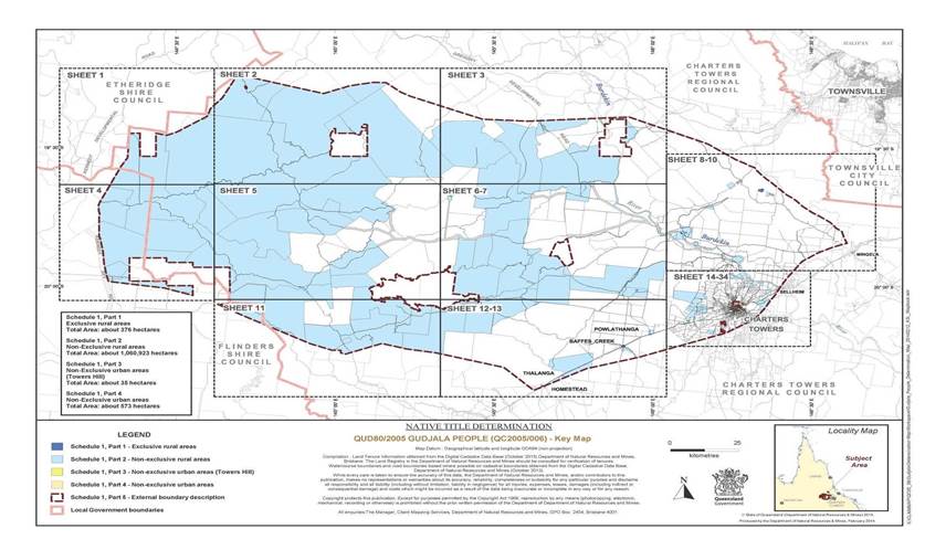
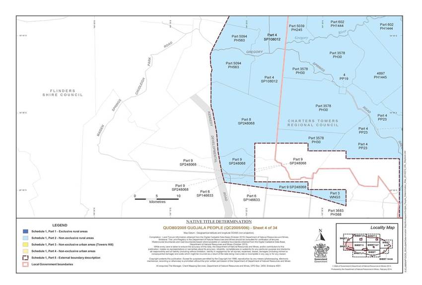
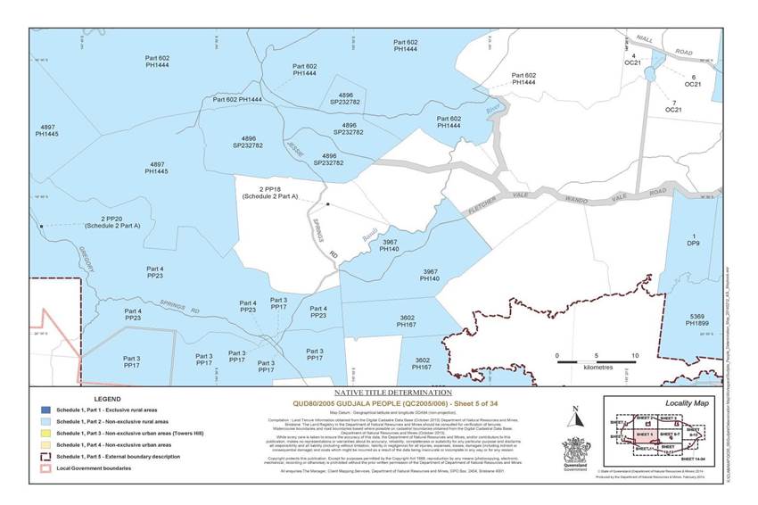
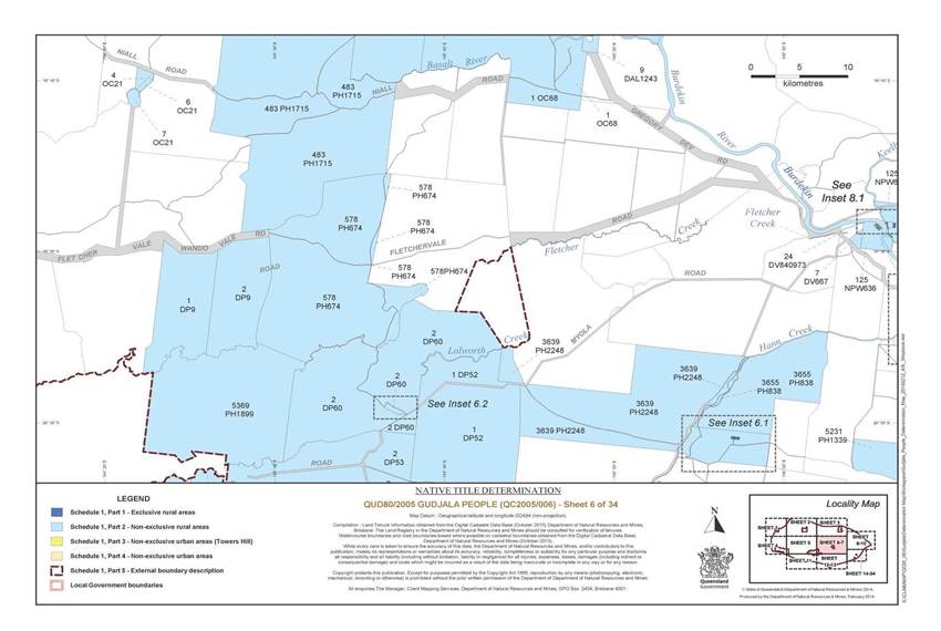
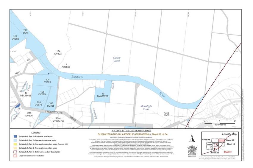
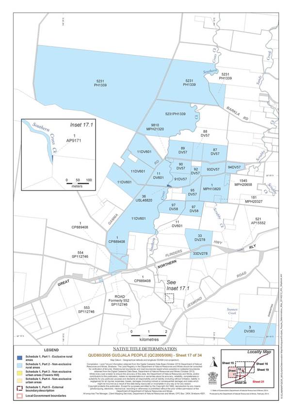
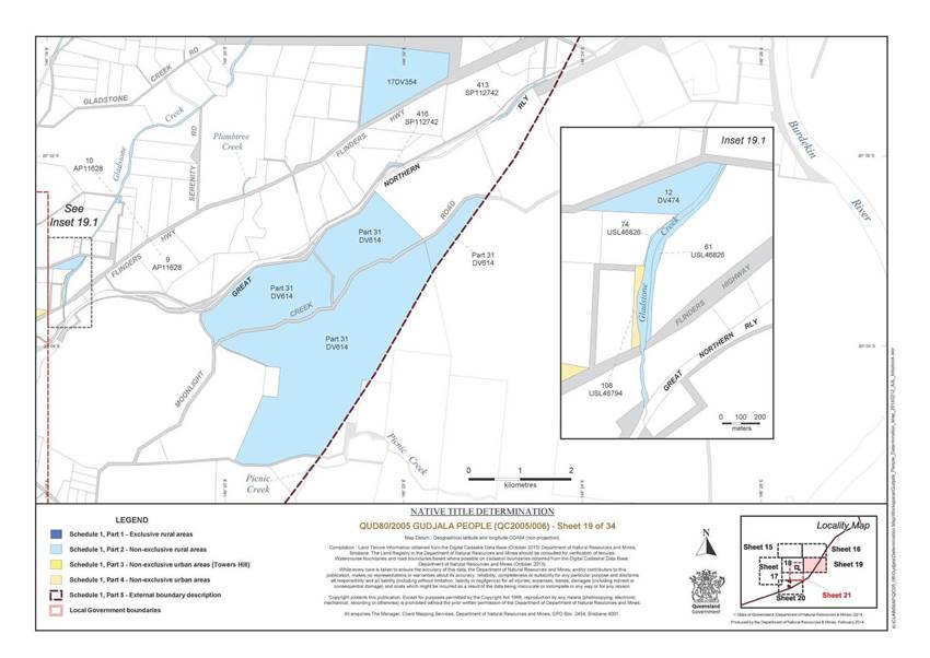
Schedule 1 — DETERMINATION AREA
A. Description of Determination Area
The Determination Area comprises all of the land and waters described in Parts 1, 2, 3 and 4 below, to the extent that they are within the external boundary described in Part 5 below, and depicted on the determination map, excluding the areas described in Schedule 2.
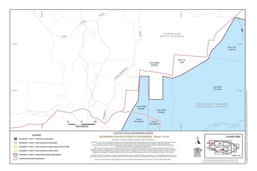
Part 1 – Exclusive Rural Areas
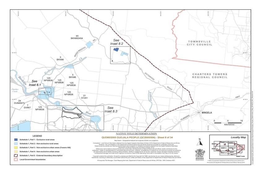
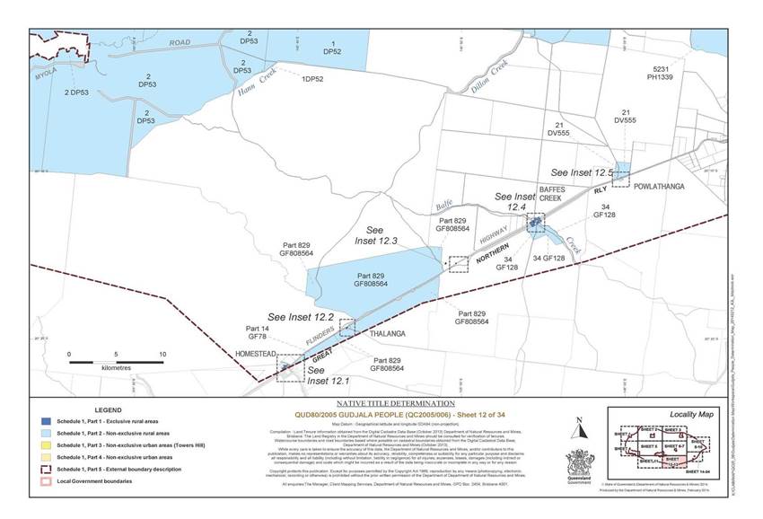
All of the land and waters described in the following table and depicted in dark blue on the determination map:
|
Area description (as at date of determination) |
Determination map sheet number1 |
|
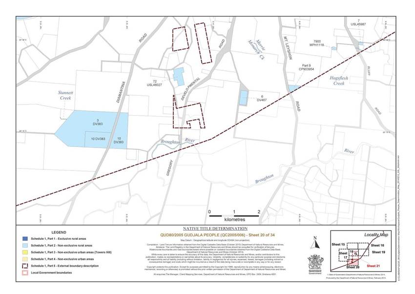
Lot 21 on Plan AP13523 |
7 |
|
Lot 30 on Plan AP13523 |
7 |
|
Lot 16 on Plan AP13526 |
33 |
|
Lot 521 on Plan AP15552 |
17 |
|
Lot 2 on Plan AP4715 |
13 |
|
Lot 20 on Plan AP7676 |
13 |
|
Lot 130 on Plan AP7676 |
13 |
|
Lot 1 on Plan AP9171 |
17 |
|
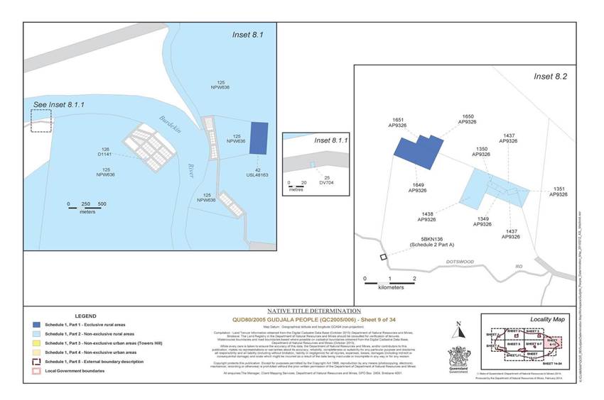
Lot 1649 on Plan AP9326 |
9 |
|
Lot 1650 on Plan AP9326 |
9 |
|
Lot 1651 on Plan AP9326 |
9 |
|
Lot 1 on Plan H5502 |
13 |
|
Lot 750 on Plan MPH20581 |
24 |
|
That part of Lot 6370 on MPH21172 excluding that part formerly subject to Exploration Mining Permit No. 8150 |
34 |
|
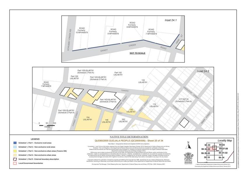
The area of road formerly described as Lot 7 on Plan MPH40879 * |
25 |
|
The area of road formerly described as Lot 8 on Plan MPH40879 * |
25 |
|
The area of road formerly described as Lot 9 on Plan MPH40879 * |
25 |
|
The area of road formerly described as Lot 10 on Plan MPH40879 * |
25 |
|
Lot 1 on Plan N25565 |
16 |
|
Lot 1 on Plan OC9 |
3 |
|
Lot 1 on Plan T6371 |
13 |
|
Lot 2 on Plan T6371 |
13 |
|
Lot 3 on Plan T6371 |
13 |
|
Lot 4 on Plan T6371 |
13 |
|
Lot 5 on Plan T6371 |
13 |
|
Lot 6 on Plan T6371 |
13 |
|
Lot 7 on Plan T6371 |
13 |
|
Lot 8 on Plan T6371 |
13 |
|
Lot 9 on Plan T6371 |
13 |
|
Lot 10 on Plan T6371 |
13 |
|
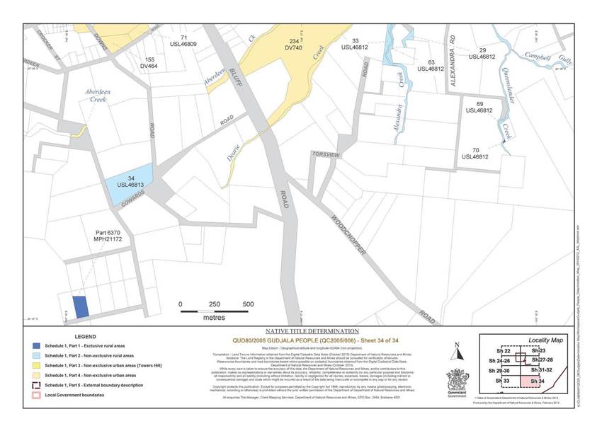
Lot 70 on Plan USL46812 |
34 |
|
Lot 32 on Plan USL46819 |
29 |
|
Lot 36 on Plan USL46820 |
17 |
|
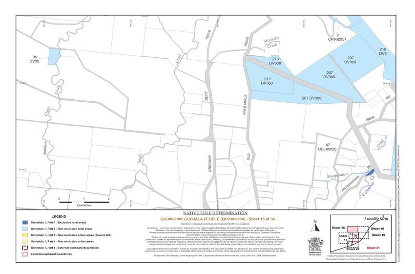
Lot 47 on Plan USL46828 |
15 |
|
Lot 10 on Plan USL48053 |
13 |
|
Lot 15 on Plan USL48053 |
13 |
|
Lot 16 on Plan USL48053 |
13 |
|
Lot 17 on Plan USL48053 |
13 |
|
Lot 42 on Plan USL48163 |
9 |
1 Where an area is depicted on more than one sheet, only the first sheet number is referenced.
* denotes areas to which s 24KA of the Native Title Act 1993 (Cth) applies
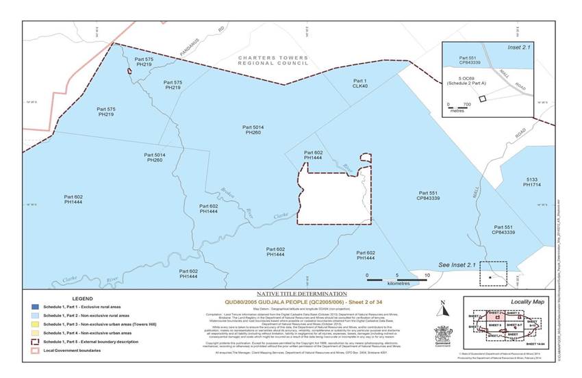
Part 2 – Non-Exclusive Rural Areas
All of the land and waters described in the following table and depicted in light blue on the determination map:
|
Area description (as at date of determination) |
Determination map sheet number2 |
|
That part of Lot 275 on Plan DV706 excluding that part subject to Trustee Lease No. 602825079 |
16 |
|
Lot 9 on Plan AP11628 |
18 |
|
Lot 10 on Plan AP11628 |
18 |
|
Lot 68 on Plan AP11741 |
29 |
|
Lot 191 on Plan AP11756 |
18 |
|
The area of road formerly described as Lot 191 on Plan DV544 * |
18 |
|
Lot 52 on Plan AP13685 |
31 |
|
Lot 53 on Plan AP13685 |
31 |
|
Lot 1349 on Plan AP9326 |
9 |
|
Lot 1350 on Plan AP9326 |
9 |
|
Lot 1351 on Plan AP9326 |
9 |
|
Lot 1437 on Plan AP9326 |
9 |
|
Lot 1438 on Plan AP9326 |
9 |
|
Lot 45 on Plan BKN802454 |
8 |
|
Lot 5 on Plan BKN96 |
8 |
|
That part of Lot 1 on Plan CLK40 that is within the external boundary |
2 |
|
That part of Lot 551 on Plan CP843339 that is within the external boundary |
2 |
|
Lot 3 on Plan CP858255 |
3 |
|
That part of Lot 4835 on Plan CP858256 that is within the external boundary |
3 |
|
Lot 1 on Plan CP889408 |
17 |
|
Lot 235 on Plan CP894369 |
33 |
|
That part of Lot 3 on Plan CP898336 that is within the external boundary |
3 |
|
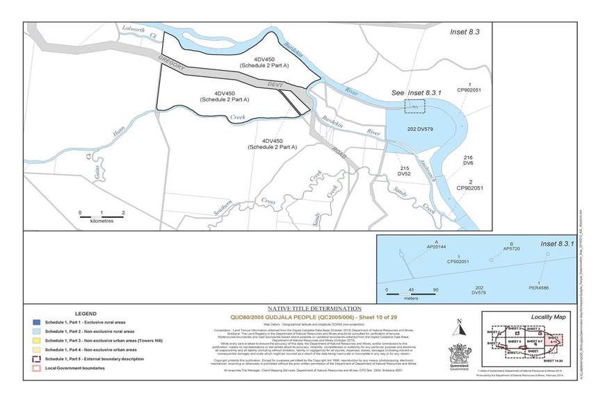
Lot 2 on Plan CP902051 |
10 |
|
Lot 1 on Plan CP902051 |
10 |
|
Lot A on Plan AP20144 |
10 |
|
Lot B on Plan AP5720 |
10 |
|
Lot 1 on Plan PER4586 |
10 |
|
That part of Lot 9 on Plan CP903954 that is within the external boundary |
20 |
|
Lot 126 on Plan D1141 |
9 |
|
Lot 21 on Plan D1241 |
8 |
|
Lot 9 on Plan DAL1243 |
6 |
|
Lot 7 on Plan DP21 |
11 |
|
Lot 1 on Plan DP52 |
6 |
|
Lot 2 on Plan DP53 |
6 |
|
That part of Lot 5 on Plan DP59 that is within the external boundary |
11 |
|
Lot 2 on Plan DP60 |
6 |
|
Lot 1 on Plan DP9 |
5 |
|
Lot 2 on Plan DP9 |
6 |
|
That part of Lot 2 on Plan DV16 that is within the external boundary |
16 |
|
Lot 4 on Plan DV17 |
18 |
|
Lot 33 on Plan DV278 |
17 |
|
Lot 39 on Plan DV30 |
15 |
|
Lot 104 on Plan DV323 |
16 |
|
Lot 106 on Plan DV325 |
16 |
|
Lot 17 on Plan DV354 |
19 |
|
Lot 213 on Plan DV360 |
15 |
|
Lot 207 on Plan DV369 |
15 |
|
Lot 3 on Plan DV383 |
20 |
|
Lot 10 on Plan DV383 |
20 |
|
Lot 6 on Plan DV467 |
20 |
|
Lot 12 on Plan DV474 |
19 |
|
Lot 215 on Plan DV52 |
10 |
|
Lot 21 on Plan DV555 |
12 |
|
Lot 1 on Plan DV557 |
13 |
|
Lot 87 on Plan DV57 |
17 |
|
Lot 88 on Plan DV57 |
17 |
|
Lot 89 on Plan DV57 |
17 |
|
Lot 90 on Plan DV57 |
17 |
|
Lot 91 on Plan DV57 |
17 |
|
Lot 92 on Plan DV57 |
17 |
|
Lot 93 on Plan DV57 |
17 |
|
Lot 94 on Plan DV57 |
17 |
|
Lot 95 on Plan DV57 |
17 |
|
Lot 200 on Plan DV577 |
33 |
|
Lot 202 on Plan DV579 |
10 |
|
Lot 97 on Plan DV58 |
17 |
|
Lot 216 on Plan DV6 |
10 |
|
Lot 11 on Plan DV601 |
17 |
|
That part of Lot 31 on Plan DV614 that is within the external boundary |
19 |
|
Lot 7 on Plan DV667 |
6 |
|
Lot 265 on Plan DV676 |
16 |
|
Lot 266 on Plan DV676 |
16 |
|
Lot 25 on Plan DV704 |
9 |
|
Lot 19 on Plan DV800729 |
16 |
|
Lot 24 on Plan DV840973 |
6 |
|
Lot 26 on Plan GF124 |
13 |
|
Lot 21 on Plan GF125 |
13 |
|
Lot 34 on Plan GF128 |
12 |
|
Lot 1 on Plan GF199 |
13 |
|
That part of Lot 14 on Plan GF78 that is within the external boundary |
12 |
|
That part of Lot 829 on Plan GF808564 that is within the external boundary |
12 |
|
Lot 25 on Plan GF93 |
13 |
|
That part of Lot 14 on Plan LH8 that is within the external boundary |
1 |
|
Lot 7900 on Plan MPH1118 |
20 |
|
Lot 1 on Plan MPH13820 |
17 |
|
Lot 181 on Plan MPH20327 |
17 |
|
Lot 1 on Plan MPH20471 |
18 |
|
Lot 1545 on Plan MPH20658 |
17 |
|
Lot 9810 on Plan MPH21320 |
17 |
|
Lot 125 on Plan NPW636 |
6 |
|
Lot 4 on Plan OC21 |
5 |
|
Lot 6 on Plan OC21 |
5 |
|
Lot 7 on Plan OC21 |
5 |
|
Lot 1 on Plan OC68 |
3 |
|
Lot 5231 on Plan PH1339 |
6 |
|
Lot 3967 on Plan PH140 |
5 |
|
That part of Lot 602 on Plan PH1444 that is within the external boundary |
1 |
|
Lot 4897 on Plan PH1445 |
4 |
|
Lot 3602 on Plan PH167 |
5 |
|
Lot 5133 on Plan PH1714 |
3 |
|
Lot 483 on Plan PH1715 |
3 |
|
That part of Lot 4244 on Plan PH1716 that is within the external boundary |
3 |
|
Lot 5369 on Plan PH1899 |
5 |
|
That part of Lot 575 on Plan PH219 that is within the external boundary |
1 |
|
Lot 3639 on Plan PH2248 |
6 |
|
That part of Lot 5039 on Plan PH245 that is within the external boundary |
1 |
|
That part of Lot 5014 on Plan PH260 that is within the external boundary |
2 |
|
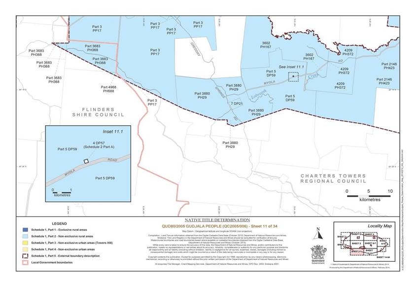
That part of Lot 3880 on Plan PH29 that is within the external boundary |
2 |
|
That part of Lot 3578 on Plan PH30 that is within the external boundary |
4 |
|
That part of Lot 3683 on Plan PH368 that is within the external boundary |
4 |
|
Lot 4209 on Plan PH372 |
11 |
|
That part of Lot 2146 on Plan PH423 that is within the external boundary |
11 |
|
That part of Lot 5094 on Plan PH563 that is within the external boundary |
4 |
|
Lot 578 on Plan PH674 |
6 |
|
That part of Lot 4968 on Plan PH688 that is within the external boundary |
11 |
|
Lot 4610 on Plan PH837 |
7 |
|
Lot 3655 on Plan PH838 |
6 |
|
That part of Lot 3 on Plan PP17 that is within the external boundary |
5 |
|
Lot 4 on Plan PP19 |
4 |
|
That part of Lot 4 on Plan PP23 that is within the external boundary |
4 |
|
The area of road formerly described as Lot 552 on Plan SP112746 * |
17 |
|
That part of Lot 4 on Plan SP108012 that is within the external boundary |
1 |
|
Lot 593 on Plan SP108231 |
13 |
|
Lot 594 on Plan SP108231 |
13 |
|
Lot 631 on Plan SP108232 |
13 |
|
Lot 632 on Plan SP108232 |
13 |
|
Lot 413 on Plan SP112742 |
19 |
|
Lot 416 on Plan SP112742 |
19 |
|
Lot 493 on Plan SP112744 |
33 |
|
Lot 553 on Plan SP112746 |
17 |
|
Lot 554 on Plan SP112746 |
17 |
|
That part of Lot 6 on Plan SP146633 that is within the external boundary |
4 |
|
That part of Lot 3932 on Plan SP221799 that is within the external boundary |
3 |
|
Lot 4896 on Plan SP232782 |
5 |
|
That part of Lot 8 on Plan SP248068 that is within the external boundary |
4 |
|
That part of Lot 9 on Plan SP248068 that is within the external boundary |
4 |
|
Lot 22 on Plan T6371 |
13 |
|
Lot 7 on Plan USL45987 |
20 |
|
Lot 15 on Plan USL46796 |
33 |
|
Lot 66 on Plan USL46796 |
33 |
|
Lot 6 on Plan USL46811 |
31 |
|
Lot 38 on Plan USL46811 |
31 |
|
Lot 40 on Plan USL46811 |
31 |
|
Lot 29 on Plan USL46812 |
31 |
|
Lot 33 on Plan USL46812 |
31 |
|
Lot 63 on Plan USL46812 |
34 |
|
Lot 69 on Plan USL46812 |
34 |
|
Lot 34 on Plan USL46813 |
34 |
|
Lot 61 on Plan USL46826 |
19 |
|
Lot 74 on Plan USL46826 |
19 |
|
Lot 72 on Plan USL48027 |
20 |
|
That part of Lot 1 on Plan WG193 that is within the external boundary |
3 |
|
That part of Lot 3 on Plan WNG3 that is within the external boundary |
4 |
|
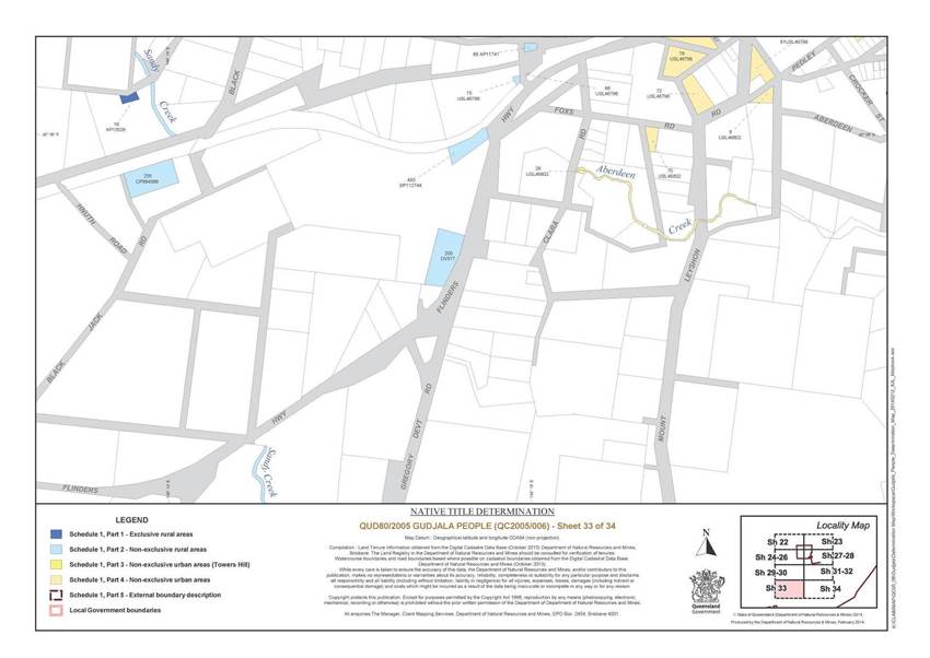
Save for any waters forming part of a lot on plan, all waterways, natural lakes, creeks and rivers within the external boundary including but not limited to: the Burdekin River, the Clarke River, the Gregory River, the Basalt River, the Broken River, and the Star River | |
2 Where an area is depicted on more than one sheet, only the first sheet number is referenced.
* denotes area to which s 24KA of the Native Title Act 1993 (Cth) applies.
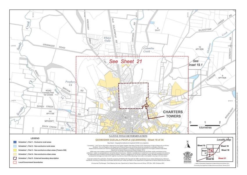
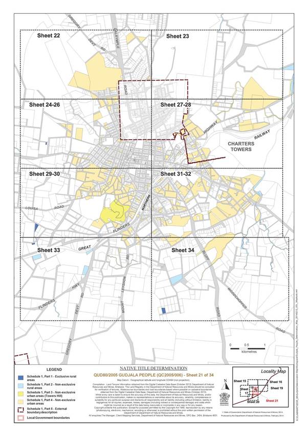
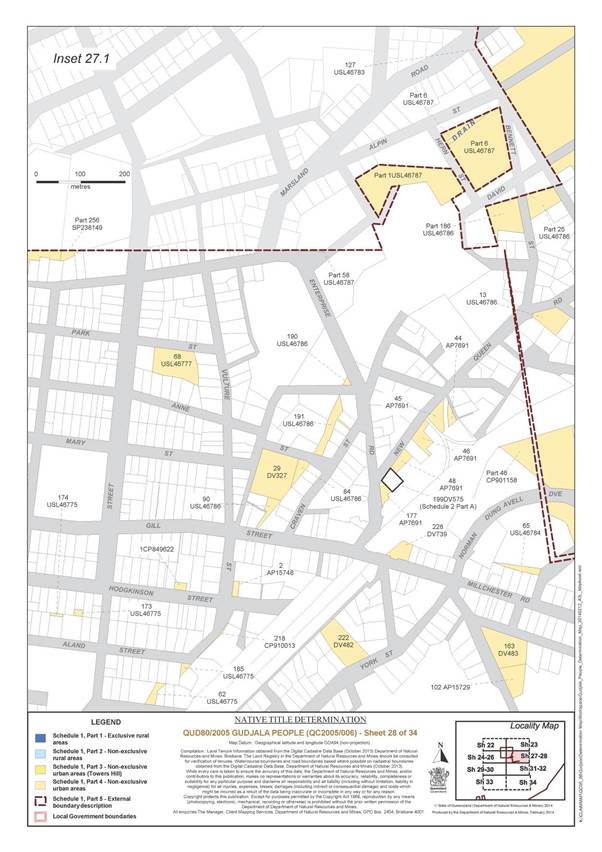
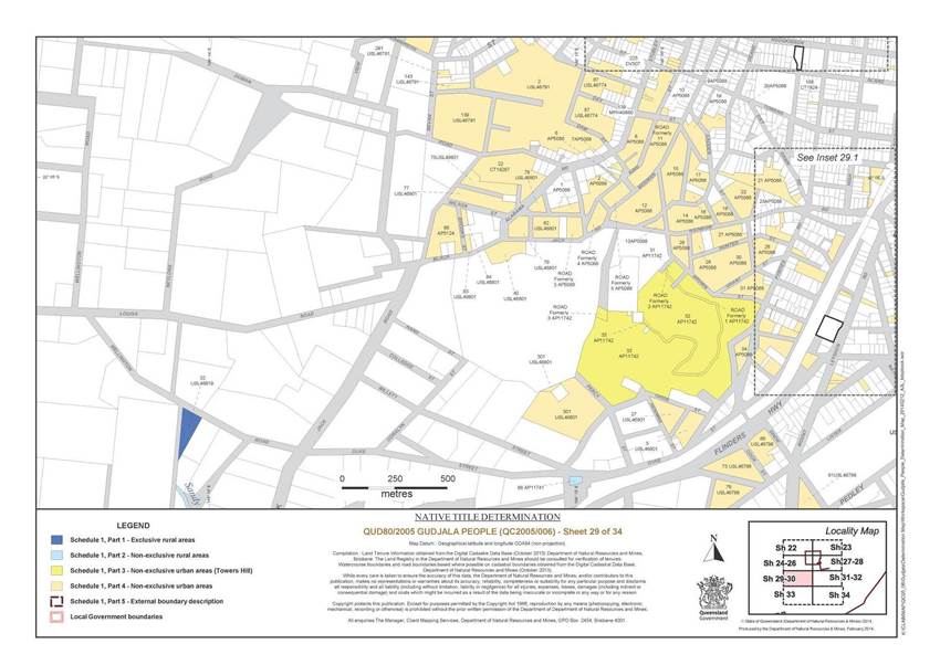
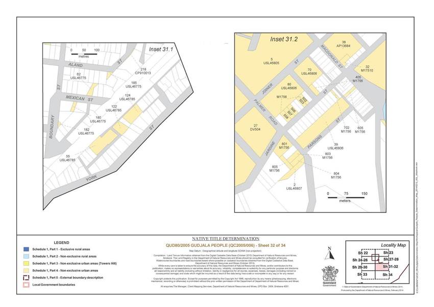
Part 3 – Non-Exclusive Urban Areas (Towers Hill)
All of the land and waters described in the following table and depicted in yellow on the determination map:
|
Area description (as at date of determination) |
Determination map sheet number3 |
|
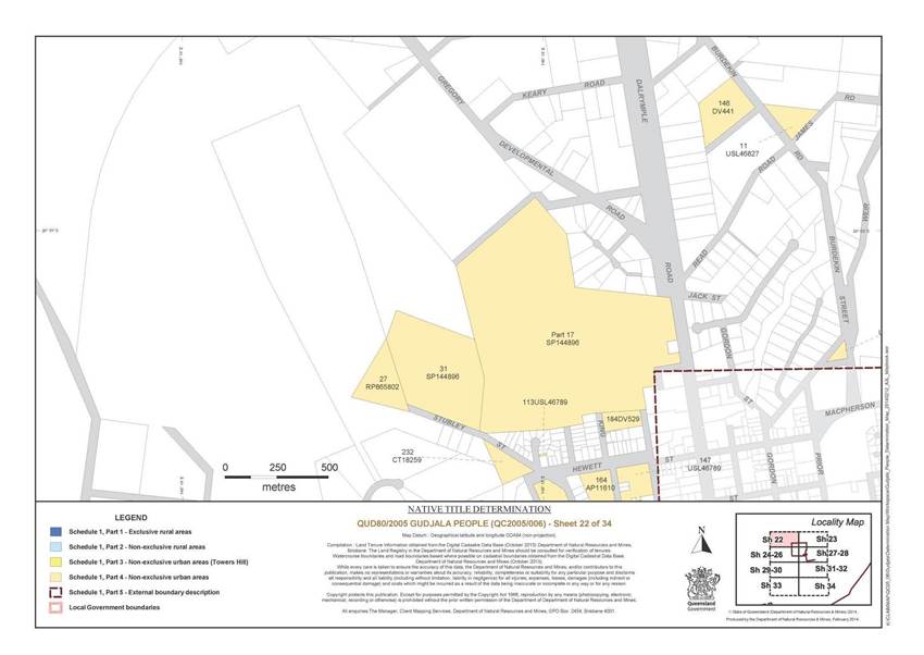
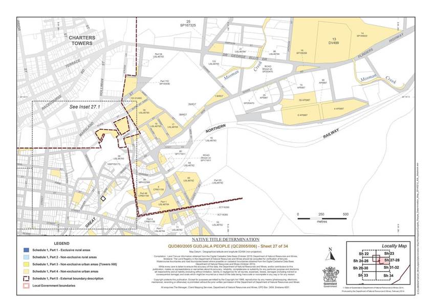
Lot 31 on Plan AP11742 |
29 |
|
Lot 32 on Plan AP11742 |
29 |
|
Lot 33 on Plan AP11742 |
29 |
|
The areas of road described as Lots 1, 2 and 3 on Plan AP11742 * |
29 |
3 Where an area is depicted on more than one sheet, only the first sheet number is referenced.
* denotes areas to which s 24KA of the Native Title Act 1993 (Cth) applies.
Part 4 – Non-Exclusive Urban Areas
All of the land and waters described in the following table and depicted in tan on the determination map:
|
Area description (as at date of determination) |
Determination map sheet number4 |
|
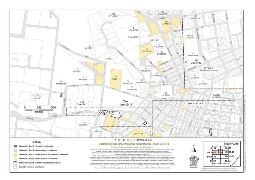
Lot 64 on Plan DV234 |
24 |
|
That part of Lot 256 on Plan SP238149 that is within the external boundary |
28 |
|
Lot 13 on Plan SP185815 |
31 |
|
That part of Lot 128 on Plan USL46806 excluding that part formerly subject to Mining Homestead Perpetual Lease No. 9604 |
31 |
|
Lot 60 Plan SP171611 |
27 |
|
The area of road shown on Plan SP171611 between stations 4-5-19-20-21-23-13-4 * |
27 |
|
Lot 1 on Plan AP11606 |
31 |
|
Lot 2 on Plan AP11606 |
31 |
|
Lot 3 on Plan AP11606 |
31 |
|
Lot 1 on Plan AP11610 |
24 |
|
Lot 164 on Plan AP11610 |
24 |
|
Lot 4 on Plan AP13507 |
31 |
|
Lot 38 on Plan AP13684 |
32 |
|
Lot 2 on Plan AP15748 |
28 |
|
Lot 1 on Plan AP4725 |
31 |
|
Lot 16 on Plan AP4725 |
31 |
|
Lot 33 on Plan AP4725 |
31 |
|
Lot 34 on Plan AP4725 |
31 |
|
Lot 38 on Plan AP4725 |
31 |
|
Lot 49 on Plan AP4725 |
31 |
|
Lot 71 on Plan AP4725 |
31 |
|
Lot 77 on Plan AP4725 |
31 |
|
Lot 154 on Plan AP4725 |
31 |
|
Lot 1 on Plan AP5088 |
29 |
|
Lot 2 on Plan AP5088 |
29 |
|
Lot 6 on Plan AP5088 |
29 |
|
Lot 7 on Plan AP5088 |
29 |
|
Lot 8 on Plan AP5088 |
29 |
|
Lot 9 on Plan AP5088 |
29 |
|
Lot 10 on Plan AP5088 |
29 |
|
The area of road formerly described as Lot 11 on Plan AP5088 * |
29 |
|
Lot 12 on Plan AP5088 |
29 |
|
Lot 13 on Plan AP5088 |
29 |
|
Lot 14 on Plan AP5088 |
29 |
|
Lot 15 on Plan AP5088 |
29 |
|
Lot 16 on Plan AP5088 |
29 |
|
Lot 17 on Plan AP5088 |
29 |
|
Lot 18 on Plan AP5088 |
29 |
|
Lot 19 on Plan AP5088 |
29 |
|
Lot 20 on Plan AP5088 |
29 |
|
Lot 21 on Plan AP5088 |
29 |
|
Lot 22 on Plan AP5088 |
29 |
|
Lot 23 on Plan AP5088 |
29 |
|
Lot 24 on Plan AP5088 |
30 |
|
Lot 25 on Plan AP5088 |
30 |
|
Lot 26 on Plan AP5088 |
29 |
|
Lot 27 on Plan AP5088 |
29 |
|
Lot 28 on Plan AP5088 |
29 |
|
Lot 29 on Plan AP5088 |
29 |
|
Lot 30 on Plan AP5088 |
29 |
|
Lot 31 on Plan AP5088 |
29 |
|
Lot 34 on Plan AP5088 |
29 |
|
Lot 35 on Plan AP5088 |
30 |
|
Lot 86 on Plan AP5124 |
29 |
|
Lot 4 on Plan AP5667 |
27 |
|
Lot 6 on Plan AP5667 |
27 |
|
Lot 15 on Plan AP5667 |
27 |
|
Lot 25 on Plan AP5667 |
27 |
|
Lot 59 on Plan AP5667 |
27 |
|
Lot 65 on Plan AP5667 |
27 |
|
Lot 44 on Plan AP7691 |
28 |
|
Lot 45 on Plan AP7691 |
28 |
|
Lot 46 on Plan AP7691 |
28 |
|
Lot 48 on Plan AP7691 |
28 |
|
Lot 177 on Plan AP7691 |
28 |
|
Lot 159 on Plan AP9342 |
31 |
|
Lot 1 on Plan BIRD7 |
27 |
|
Lot 2 on Plan BIRD7 |
27 |
|
Lot 3 on Plan BIRD7 |
27 |
|
Lot 1 on Plan CP849622 |
28 |
|
Lot 25 on Plan CP850650 |
31 |
|
Lot 5 on Plan CP901158 |
27 |
|
That part of Lot 4 on Plan CP901158 that is within the external boundary |
27 |
|
That part of Lot 46 on Plan CP901158 that is within the external boundary |
27 |
|
Lot 218 on Plan CP910013 |
28 |
|
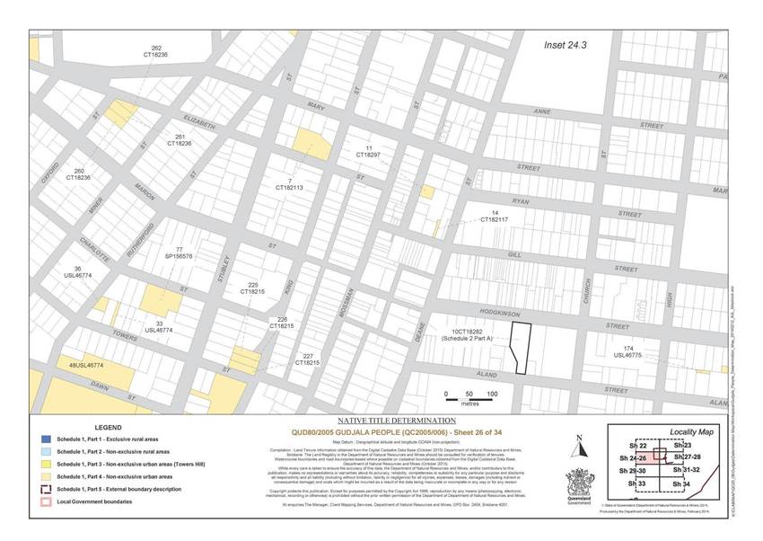
Lot 7 on Plan CT182113 |
26 |
|
Lot 14 on Plan CT182117 |
26 |
|
Lot 225 on Plan CT18215 |
26 |
|
Lot 226 on Plan CT18215 |
26 |
|
Lot 227 on Plan CT18215 |
26 |
|
Lot 259 on Plan CT1822 |
31 |
|
Lot 260 on Plan CT18236 |
26 |
|
Lot 261 on Plan CT18236 |
26 |
|
Lot 262 on Plan CT18236 |
26 |
|
Lot 188 on Plan CT1824 |
29 |
|
Lot 10 on Plan CT18250 |
24 |
|
Lot 40 on Plan CT18250 |
24 |
|
Lot 232 on Plan CT18259 |
22 |
|
Lot 22 on Plan CT18267 |
29 |
|
Lot 2 on Plan CT18293 |
27 |
|
Lot 3 on Plan CT18293 |
27 |
|
Lot 11 on Plan CT18297 |
26 |
|
Lot 29 on Plan DV327 |
28 |
|
Lot 146 on Plan DV441 |
22 |
|
Lot 153 on Plan DV460 |
27 |
|
Lot 155 on Plan DV464 |
34 |
|
Lot 219 on Plan DV475 |
30 |
|
Lot 33 on Plan DV480 |
31 |
|
Lot 222 on Plan DV482 |
28 |
|
Lot 163 on Plan DV483 |
28 |
|
Lot 102 on Plan AP15729 |
28 |
|
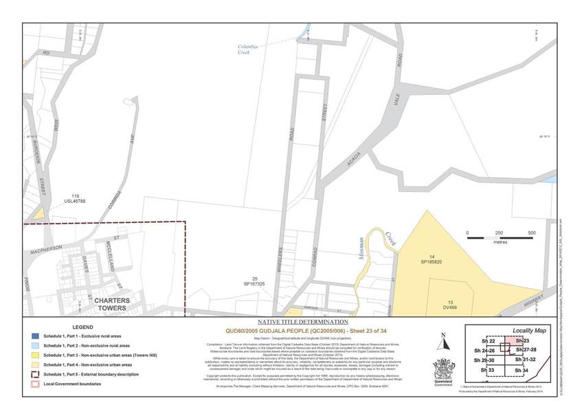
Lot 13 on Plan DV499 |
23 |
|
Lot 27 on Plan DV504 |
31 |
|
Lot 225 on Plan DV507 |
29 |
|
Lot 184 on Plan DV529 |
22 |
|
Lot 196 on Plan DV561 |
31 |
|
Lot 29 on Plan DV562 |
31 |
|
That part of Lot 210 on Plan DV610 that is within the external boundary |
24 |
|
Lot 7 on Plan DV643 |
30 |
|
Lot 11 on Plan DV728 |
31 |
|
Lot 228 on Plan DV739 |
28 |
|
Lot 234 on Plan DV740 |
31 |
|
Lot 12 on Plan DV840956 |
24 |
|
Lot 32 on Plan M17510 |
32 |
|
Lot 405 on Plan M1756 |
32 |
|
Lot 502 on Plan M1756 |
32 |
|
Lot 503 on Plan M1756 |
32 |
|
Lot 506 on Plan M1756 |
32 |
|
Lot 507 on Plan M1756 |
32 |
|
Lot 508 on Plan M1756 |
32 |
|
Lot 605 on Plan M1756 |
32 |
|
Lot 702 on Plan M1756 |
32 |
|
Lot 801 on Plan M1756 |
32 |
|
Lot 803 on Plan M1756 |
32 |
|
Lot 804 on Plan M1756 |
32 |
|
Lot 805 on Plan M1756 |
32 |
|
Lot 37 on Plan M1759 |
31 |
|
Lot 88 on Plan MPH32368 |
27 |
|
Lot 1 on Plan MPH33088 |
30 |
|
Lot 2 on Plan MPH33088 |
30 |
|
Lot 159 on Plan MPH33474 |
31 |
|
Lot 26 on Plan MPH40658 |
24 |
|
Lot 27 on Plan MPH40658 |
24 |
|
Lot 139 on Plan MPH40660 |
29 |
|
Lot 195 on Plan MPH40915 |
30 |
|
Lot 196 on Plan MPH40915 |
30 |
|
Lot 1 on AP15921 |
24 |
|
Lot 2 on AP15921 |
24 |
|
Lot 3 on AP15921 |
24 |
|
Lot 4 on AP15921 |
24 |
|
The area of road formerly described as Lot 3 on Plan AP5088 * |
29 |
|
The area of road formerly described as Lot 4 on Plan AP5088 * |
29 |
|
The area of road formerly described as Lot 5 on Plan AP5088 * |
29 |
|
Lot 27 on Plan RP865802 |
22 |
|
Lot 16 on Plan SP106208 |
27 |
|
That part of Lot 255 on Plan SP142524 that is within the external boundary |
24 |
|
That part of Lot 152 on Plan SP143440 that is within the external boundary |
27 |
|
Lot 31 on Plan SP144896 |
22 |
|
That part of Lot 17 on Plan SP144896 that is within the external boundary |
22 |
|
Lot 3 on Plan SP146272 |
31 |
|
Lot 16 on Plan SP150173 |
27 |
|
Lot 77 on Plan SP156576 |
26 |
|
Lot 25 on Plan SP167325 |
23 |
|
Lot 14 on Plan SP185820 |
23 |
|
Lot 1 on Plan SP250470 |
27 |
|
The area of road shown on Plan SP250470 between stations 2-3-4-5-2 * |
27 |
|
Lot 40 on Plan USL46769 |
24 |
|
Lot 96 on Plan USL46769 |
24 |
|
Lot 108 on Plan USL46769 |
24 |
|
Lot 180 on Plan USL46773 |
24 |
|
Lot 33 on Plan USL46774 |
26 |
|
Lot 36 on Plan USL46774 |
26 |
|
Lot 48 on Plan USL46774 |
26 |
|
Lot 67 on Plan USL46774 |
29 |
|
Lot 87 on Plan USL46774 |
29 |
|
Lot 62 on Plan USL46775 |
28 |
|
Lot 173 on Plan USL46775 |
28 |
|
Lot 174 on Plan USL46775 |
26 |
|
Lot 180 on Plan USL46775 |
32 |
|
Lot 182 on Plan USL46775 |
32 |
|
Lot 185 on Plan USL46775 |
28 |
|
Lot 68 on Plan USL46777 |
28 |
|
Lot 53 on Plan USL46782 |
27 |
|
Lot 63 on Plan USL46782 |
27 |
|
Lot 64 on Plan USL46782 |
27 |
|
Lot 71 on Plan USL46782 |
27 |
|
Lot 140 on Plan USL46782 |
31 |
|
Lot 166 on Plan USL46782 |
31 |
|
That part of Lot 65 on Plan USL46782 that is within the external boundary |
27 |
|
Lot 17 on Plan USL46783 |
27 |
|
Lot 18 on Plan USL46783 |
27 |
|
Lot 19 on Plan USL46783 |
27 |
|
Lot 29 on Plan USL46783 |
27 |
|
Lot 30 on Plan USL46783 |
27 |
|
Lot 131 on Plan USL46783 |
27 |
|
Lot 127 on Plan USL46783 |
28 |
|
That part of Lot 54 on Plan USL46783 that is within the external boundary |
27 |
|
Lot 65 on Plan USL46784 |
28 |
|
That part of Lot 1 on Plan USL46784 that is within the external boundary |
27 |
|
Lot 55 on Plan USL46785 |
32 |
|
Lot 122 on Plan USL46785 |
32 |
|
Lot 124 on Plan USL46785 |
32 |
|
Lot 13 on Plan USL46786 |
28 |
|
Lot 84 on Plan USL46786 |
28 |
|
Lot 90 on Plan USL46786 |
28 |
|
Lot 190 on Plan USL46786 |
28 |
|
Lot 191 on Plan USL46786 |
28 |
|
That part of Lot 186 on Plan USL46786 that is within the external boundary |
28 |
|
That part of Lot 25 on Plan USL46786 that is within the external boundary |
28 |
|
That part of Lot 1 on Plan USL46787 that is within the external boundary |
28 |
|
That part of Lot 58 on Plan USL46787 that is within the external boundary |
28 |
|
That part of Lot 6 on Plan USL46787 that is within the external boundary |
28 |
|
Lot 119 on Plan USL46788 |
22 |
|
Lot 113 on Plan USL46789 |
22 |
|
Lot 147 on Plan USL46789 |
22 |
|
Lot 161 on Plan USL46789 |
24 |
|
Lot 3 on Plan USL46790 |
24 |
|
Lot 5 on Plan USL46790 |
24 |
|
Lot 6 on Plan USL46790 |
24 |
|
Lot 13 on Plan USL46790 |
24 |
|
Lot 54 on Plan USL46790 |
24 |
|
Lot 2 on Plan USL46791 |
24 |
|
Lot 119 on Plan USL46791 |
25 |
|
Lot 133 on Plan USL46791 |
25 |
|
Lot 135 on Plan USL46791 |
25 |
|
Lot 139 on Plan USL46791 |
29 |
|
That part of Lot 142 on Plan USL46791 excluding those parts formerly subject to Gold Fields Homestead Lease No. 4359, Gold Fields Homestead Lease No. 5019, Gold Fields Homestead Lease No. 538, Gold Fields Homestead Lease No. 1700, Gold Fields Homestead Lease No. 1833, Miner’s Homestead Lease No. 6448, Miner’s Homestead Lease No. 3527, Miner’s Homestead Lease No. 6856 and Miner’s Homestead Lease No. 6220 |
25 |
|
Lot 143 on Plan USL46791 |
29 |
|
Lot 148 on Plan USL46791 |
25 |
|
Lot 154 on Plan USL46791 |
25 |
|
That part of Lot 155 on Plan USL46791 excluding those parts formerly subject to Gold Fields Homestead Lease No. 1354, Gold Fields Homestead Lease No. 3793 and Gold Fields Homestead Lease No. 985 |
25 |
|
Lot 262 on Plan USL46791 |
25 |
|
Lot 281 on Plan USL46791 |
24 |
|
Lot 12 on Plan USL46793 |
31 |
|
Lot 21 on Plan USL46794 |
27 |
|
Lot 98 on Plan USL46794 |
27 |
|
Lot 108 on Plan USL46794 |
19 |
|
Lot 2 on Plan USL46798 |
31 |
|
Lot 15 on Plan USL46798 |
31 |
|
Lot 61 on Plan USL46798 |
29 |
|
Lot 66 on Plan USL46798 |
29 |
|
Lot 72 on Plan USL46798 |
33 |
|
Lot 73 on Plan USL46798 |
29 |
|
Lot 79 on Plan USL46798 |
29 |
|
Lot 153 on Plan USL46798 |
30 |
|
Lot 168 on Plan USL46798 |
30 |
|
Lot 24 on Plan USL46799 |
31 |
|
Lot 34 on Plan USL46799 |
31 |
|
Lot 38 on Plan USL46799 |
31 |
|
Lot 43 on Plan USL46799 |
31 |
|
Lot 112 on Plan USL46799 |
31 |
|
Lot 117 on Plan USL46799 |
30 |
|
Lot 122 on Plan USL46799 |
30 |
|
Lot 129 on Plan USL46799 |
30 |
|
Lot 146 on Plan USL46799 |
30 |
|
Lot 13 on Plan USL46800 |
30 |
|
Lot 15 on Plan USL46800 |
30 |
|
Lot 43 on Plan USL46800 |
30 |
|
Lot 99 on Plan USL46800 |
30 |
|
Lot 116 on Plan USL46800 |
30 |
|
Lot 153 on Plan USL46800 |
30 |
|
Lot 155 on Plan USL46800 |
30 |
|
Lot 162 on Plan USL46800 |
30 |
|
Lot 164 on Plan USL46800 |
30 |
|
Lot 166 on Plan USL46800 |
30 |
|
Lot 280 on Plan USL46800 |
30 |
|
Lot 3 on Plan USL46801 |
29 |
|
Lot 27 on Plan USL46801 |
29 |
|
Lot 40 on Plan USL46801 |
29 |
|
Lot 62 on Plan USL46801 |
29 |
|
Lot 75 on Plan USL46801 |
29 |
|
Lot 77 on Plan USL46801 |
29 |
|
Lot 78 on Plan USL46801 |
29 |
|
Lot 79 on Plan USL46801 |
29 |
|
Lot 83 on Plan USL46801 |
29 |
|
Lot 84 on Plan USL46801 |
29 |
|
Lot 301 on Plan USL46801 |
29 |
|
Lot 9 on Plan USL46802 |
33 |
|
Lot 29 on Plan USL46802 |
33 |
|
Lot 70 on Plan USL46802 |
33 |
|
Lot 1 on Plan USL46805 |
31 |
|
Lot 2 on Plan USL46805 |
31 |
|
Lot 3 on Plan USL46805 |
31 |
|
Lot 5 on Plan USL46805 |
31 |
|
Lot 6 on Plan USL46805 |
31 |
|
Lot 9 on Plan USL46805 |
31 |
|
Lot 13 on Plan USL46805 |
31 |
|
Lot 15 on Plan USL46805 |
31 |
|
Lot 18 on Plan USL46805 |
31 |
|
Lot 20 on Plan USL46805 |
31 |
|
Lot 23 on Plan USL46805 |
31 |
|
Lot 33 on Plan USL46805 |
31 |
|
Lot 35 on Plan USL46805 |
31 |
|
Lot 47 on Plan USL46805 |
31 |
|
Lot 39 on Plan USL46806 |
32 |
|
Lot 70 on Plan USL46806 |
32 |
|
Lot 80 on Plan USL46806 |
32 |
|
Lot 2 on Plan USL46807 |
32 |
|
Lot 36 on Plan USL46807 |
31 |
|
Lot 1 on Plan USL46808 |
31 |
|
Lot 3 on Plan USL46808 |
31 |
|
Lot 10 on Plan USL46808 |
31 |
|
Lot 13 on Plan USL46808 |
31 |
|
Lot 25 on Plan USL46808 |
31 |
|
Lot 8 on Plan USL46809 |
31 |
|
Lot 71 on Plan USL46809 |
31 |
|
Lot 12 on Plan USL46810 |
31 |
|
Lot 15 on Plan USL46810 |
31 |
|
Lot 26 on Plan USL46810 |
31 |
|
Lot 29 on Plan USL46810 |
31 |
|
Lot 66 on Plan USL46810 |
31 |
|
Lot 109 on Plan USL46810 |
31 |
|
Lot 11 on Plan USL46827 |
22 |
|
Save for any waters forming part of a lot on plan, all waterways, natural lakes, creeks and rivers within the external boundary including but not limited to: Aberdeen Creek, Dearie Creek, and Millchester Creek | |
4 Where an area is depicted on more than one sheet, only the first sheet number is referenced.
* denotes areas to which s 24KA of the Native Title Act 1993 (Cth) applies.
Part 5 – External Boundary Description
Commencing at a point north east of the town of Charters Towers on the centreline of the Burdekin River at Longitude 146.407413° East, also being a point on the north western boundary of native title determination application QUD6244/1998 Birriah People (QC1998/012), and extending generally south westerly and generally westerly passing through the following coordinate points:
|
Longitude° (East) |
Latitude° (South) |
|
146.403255 |
20.005354 |
|
146.394463 |
20.021747 |
|
146.387272 |
20.033821 |
|
146.372233 |
20.053391 |
|
146.361437 |
20.071216 |
|
146.351818 |
20.085023 |
|
146.341578 |
20.097687 |
|
146.330733 |
20.110927 |
|
146.327912 |
20.117028 |
|
146.232580 |
20.169100 |
|
145.959480 |
20.256431 |
|
145.793730 |
20.297741 |
|
145.626894 |
20.376012 |
|
145.532334 |
20.293396 |
|
145.317674 |
20.240676 |
|
145.227462 |
20.227089 |
|
145.147576 |
20.206978 |
|
145.031824 |
20.245570 |
|
144.920962 |
20.207523 |
|
144.704129 |
20.103708 |
|
144.594686 |
20.046709 |
|
144.462298 |
20.006961 |
then westerly to a point on the eastern boundary of an un-named road reserve and the western boundary of the second most north easterly severance of Lot 6 on Plan SP146633 (the severance being immediately west of the Kennedy Developmental Road reserve) at Latitude 19.982842° South; then generally northerly along the eastern boundary of that road reserve and the Kennedy Developmental Road reserve to Latitude 19.694482° South; then generally north easterly and generally south easterly passing through the following coordinate points:
|
Longitude° (East) |
Latitude° (South) |
|
144.325347 |
19.566703 |
|
144.345351 |
19.536735 |
|
144.351119 |
19.448476 |
|
144.434451 |
19.448475 |
|
144.469046 |
19.455856 |
|
144.499055 |
19.444968 |
|
144.596964 |
19.386766 |
|
144.607123 |
19.359052 |
|
144.644071 |
19.321176 |
|
144.692755 |
19.236545 |
|
144.963558 |
19.305256 |
|
145.044257 |
19.277876 |
|
145.076964 |
19.271831 |
|
145.121401 |
19.264720 |
|
145.160863 |
19.265787 |
|
145.184326 |
19.282854 |
|
145.204946 |
19.298853 |
|
145.238141 |
19.315069 |
|
145.464464 |
19.397699 |
|
145.607733 |
19.404810 |
|
145.927306 |
19.389862 |
|
146.167280 |
19.483737 |
|
146.179336 |
19.489603 |
|
146.262736 |
19.543014 |
|
146.292074 |
19.557061 |
|
146.307084 |
19.566282 |
|
146.323354 |
19.572376 |
|
146.331931 |
19.584786 |
|
146.348769 |
19.602358 |
|
146.365236 |
19.618097 |
|
146.369994 |
19.620740 |
|
146.425587 |
19.671857 |
|
146.438719 |
19.679959 |
|
146.456164 |
19.693178 |
|
146.475196 |
19.712741 |
|
146.506387 |
19.735475 |
|
146.527533 |
19.747636 |
|
146.560310 |
19.769314 |
|
146.573527 |
19.782004 |
|
146.578284 |
19.789406 |
|
146.599048 |
19.804043 |
|
146.605276 |
19.824879 |
then south easterly to a point on the western boundary of native title determination application QUD6244/1998 Birriah People (QC1998/012) at Longitude 146.614965° East, Latitude 19.846002° South; then generally south westerly along that native title determination application boundary passing through the following coordinate points:
|
Longitude° (East) |
Latitude° (South) |
|
146.601231 |
19.849477 |
|
146.563847 |
19.862509 |
|
146.523795 |
19.880315 |
|
146.473331 |
19.911258 |
|
146.429911 |
19.965524 |
|
146.416086 |
19.985842 |
then south westerly back to the commencement point.
Data reference and source
Native title determination application QUD6244/1998 Birriah People (QC1998/012) as accepted for registration on 14 August 2007.
Mining tenement data sourced from the Department of Natural Resources and Mines (October 2013), unless otherwise indicated.
Cadastre data sourced from Department of Natural Resources and Mines (August 2013).
Reference datum
Geographical coordinates have been provided by the National Native Title Tribunal Geospatial Services and are referenced to the Geocentric Datum of Australia 1994 (GDA94) in decimal degrees, and are based on the spatial reference data acquired from the various custodians at the time.
Use of coordinates
Where coordinates are used within the description to represent cadastral or topographical boundaries or the intersection with such, they are intended as a guide only. As an outcome to the custodians of cadastral and topographic data continuously recalculating the geographic position of their data based on improved survey and data maintenance procedures, it is not possible to accurately define such a position other than by detailed ground survey.
Prepared by Geospatial Services, National Native Title Tribunal (24 October 2013).
A. Map of Determination Area
Schedule 2 — AREAS NOT FORMING PART OF THE DETERMINATION AREA
The areas described below do not form part of the Determination Area.
Part A
1. Land and waters within the external boundary, as described in Part 5 of Schedule 1, that at the time at which the native title determination application was made:
(a) were the subject of one or more previous exclusive possession acts, as defined in s 23B of the Native Title Act 1993 (Cth) (despite the fact that the areas, or parts of them, may have been subject to earlier acts that extinguished native title); and
(b) to which none of ss 47, 47A or 47B of the Native Title Act 1993 (Cth) applied,
do not form part of the Determination Area on the basis that they could not be claimed, in accordance with s 61A of the Native Title Act 1993 (Cth).
2. Specifically, and to avoid any doubt, the land and waters referred to in Part A (1) above include the acts described in ss 23B(2) and 23B(3) of the Native Title Act 1993 (Cth) to which s 20 of the Native Title (Queensland) Act 1993 (Qld) applies and include, but are not limited to, the following areas:
(a) Lot 4 on Plan DV450;
(b) Lot 7 on Plan WG321;
(c) Lot 2 on Plan PP18;
(d) Lot 2 on Plan PP20;
(e) Lot 4 on Plan DP57;
(f) Lot 3 on Plan DP58;
(g) Lot 5 on Plan OC69;
(h) Lot 31 on Plan GF184;
(i) Lot 5 on Plan BKN136;
(j) Lot 52 on Plan DV308;
(k) those parts of Lot 142 on Plan USL46791 formerly subject to Gold Fields Homestead Lease No. 4359, Gold Fields Homestead Lease No. 5019, Gold Fields Homestead Lease No. 538, Gold Fields Homestead Lease No. 1700, Gold Fields Homestead Lease No. 1833, Miner’s Homestead Lease No. 6448, Miner’s Homestead Lease No. 3527, Miner’s Homestead Lease No. 6856 and Miner’s Homestead Lease No. 6220; and
(l) those parts of Lot 155 on Plan USL46791 formerly subject to Gold Fields Homestead Lease No. 1354, Gold Fields Homestead Lease No. 3793 and Gold Fields Homestead Lease No. 985.
3. Specifically, and to avoid any doubt, the land and waters described in Part A (1) above include the land or waters upon which any public work, as defined in s 253 of the Native Title Act 1993 (Cth), is or was constructed, established, or situated, and to which ss 23B(7) and 23C(2) of the Native Title Act 1993 (Cth) and / or s 21 of the Native Title (Queensland) Act 1993 (Qld) applies, together with any adjacent land or waters in accordance with s 251D of the Native Title Act 1993 (Cth), including but not limited to the whole of the land and waters described as:
(a) Lot 3 on Plan CP857094;
(b) Lot 1 on Plan CT182116;
(c) Lot 10 on Plan CT18282;
(d) Lot 227 on Plan DV512; and
(e) Lot 199 on Plan DV575.
Part B
Land and waters specifically excluded from the Gudjala People Core Country Claim #1 native title determination application filed on 12 December 2013, being:
Lot 11 on Plan NPW348;
Exploration Permit for Minerals No. 13653 (as at 11 April 2002);
that part of Exploration Permit for Minerals No. 13650 (as at 11 April 2002) that is south of the centreline of the Clarke River;
Exploration Permit for Minerals No. 13462 (as at 11 April 2002);
Exploration Permit for Minerals No. 13655 (as at 11 April 2002);
Exploration Permit for Minerals No. 13676 (as at 11 April 2002);
Exploration Permit for Minerals No. 13700 (as at 12 July 2002);
Mining Lease No. 10281;
Mining Lease No. 10282;
Mining Lease No. 10283;
Mining Lease No. 10284;
Mining Lease No. 10285; and
Mining Lease No. 10290.
Part C
On the basis that native title has been extinguished and is not claimed, the parties have agreed that the Determination Area does not include any land or waters on which any permanent improvement consisting of:
(a) a homestead, house, shed or other building;
(b) an airstrip;
(c) a constructed dam or any other constructed stock watering point, bore, turkey nest, squatters’ tank or other water storage facility; or
(d) stock yards and trap yards,
has, at the date of the determination, been constructed (including any adjacent land the exclusive use of which is reasonably necessary for the enjoyment of the improvement) in accordance with the rights of the lessee under, and within the boundaries of the following pastoral leases:
1. Term Lease No. 235739 comprising Lot 1 on Plan CLK40 and commonly known as Porphyry Creek Holding;
2. Pastoral Holding No. 11/551 comprising Lot 551 on Plan CP843339 and commonly known as Maryvale;
3. Preferential Pastoral Holding No. 11/4835 comprising Lot 4835 on Plan CP858256 and commonly known as Spyglass;
4. Term Lease No. 231119 comprising Lot 3 on Plan CP898336 and commonly known as Mileslake;
5. Pastoral Holding No. 11/3732 comprising Lot 1 on Plan DP52 and commonly known as Hann;
6. Pastoral Holding No. 11/3703 comprising Lot 2 on Plan DP53 and commonly known as Wangaroo;
7. Pastoral Holding No. 11/2759 comprising Lot 5 on Plan DP59 and commonly known as Amarra;
8. Stud Holding No. 11/590 comprising Lot 2 on Plan DP60 and commonly known as Toomba Stud;
9. Pastoral Holding No. 11/3868 comprising Lots 1 and 2 on Plan DP9 and commonly known as Allingham;
10. Term Lease No. 232893 comprising Lots 90, 91, 92, 93, 94 and 95 on Plan DV57, and Lot 97 on Plan DV58, and commonly known as Featherby;
11. Pastoral Holding No. 11/5409 comprising Lot 202 on Plan DV579 and commonly known as Basalt;
12. Pastoral Holding No. 11/4293 comprising Lot 11 on Plan DV601 and commonly known as Gamma;
13. Pastoral Holding No. 11/5439 comprising Lot 31 on Plan DV614 and commonly known as Millchester;
14. Term Lease No. 234170 comprising Lot 829 on Plan GF808564 and commonly known as Thalanga;
15. Pastoral Holding No. 18/228 comprising Lot 14 on Plan LH8 and commonly known as Lyndhurst;
16. Term Lease No. 232893 comprising Lot 1 on Plan MPH13820, Lot 181 on Plan MPH20327, Lot 1545 on Plan MPH20658, and Lot 9810 on Plan MPH21320, and commonly known as Run 4265;
17. Term Lease No. 231118 comprising Lot 1 on Plan OC68 and commonly known as Hillgrove;
18. Pastoral Holding No. 11/5231 comprising Lot 5231 on Plan PH1339 and commonly known as Barkla;
19. Preferential Pastoral Holding No. 11/3967 comprising Lot 3967 on Plan PH140 and commonly known as Cuba Plains;
20. Pastoral Holding No. 11/602 comprising Lot 602 on Plan PH1444 and commonly known as Wando Vale;
21. Preferential Pastoral Holding No. 11/4897 comprising Lot 4897 on Plan PH1445 and commonly known as Newburgh;
22. Preferential Pastoral Holding No. 11/3602 comprising Lot 3602 on Plan PH167 and commonly known as Bubbling Spring;
23. Preferential Pastoral Holding No. 11/5133 comprising Lot 5133 on Plan PH1714 and commonly known as Spring Park;
24. Pastoral Holding No. 11/483 comprising Lot 483 on Plan PH1715 and commonly known as Bluff Downs;
25. Pastoral Holding No. 11/4244 comprising Lot 4244 on Plan PH1716 and commonly known as Allensleigh;
26. Pastoral Holding No. 11/5369 comprising Lot 5369 on Plan PH1899 and commonly known as Leonidas;
27. Preferential Pastoral Holding No. 11/575 comprising Lot 575 on Plan PH219 and commonly known as Shield Creek Holding;
28. Preferential Pastoral Holding No. 11/3639 comprising Lot 3639 on Plan PH2248 and commonly known as Myrrlumbing;
29. Preferential Pastoral Holding No. 18/5039 comprising Lot 5039 on Plan PH245 and commonly known as Barker;
30. Preferential Pastoral Holding No. 11/5014 comprising Lot 5014 on Plan PH260 and commonly known as Wade Holding;
31. Pastoral Holding No. 11/3880 comprising Lot 3880 on Plan PH29 and commonly known as Lolworth;
32. Pastoral Holding No. 11/3578 comprising Lot 3578 on Plan PH30 and commonly known as Turrets;
33. Preferential Pastoral Holding No. 23/3683 comprising Lot 3863 on Plan PH368 and commonly known as Porcupine;
34. Preferential Pastoral Holding No. 11/4209 comprising Lot 4209 on Plan PH372 and commonly known as Wall Creek Holding;
35. Preferential Development Holding No. 11/2146 comprising Lot 2146 on Plan PH423 and commonly known as Myola;
36. Preferential Pastoral Holding No. 23/5094 comprising Lot 5094 on Plan PH563 and commonly known as Clothes Peg;
37. Preferential Pastoral Holding No. 11/578 comprising Lot 578 on Plan PH674 and commonly known as Southwick West;
38. Preferential Pastoral Holding No. 23/4968 comprising Lot 4968 on Plan PH688 and commonly known as Strathtay;
39. Pastoral Holding No. 11/4610 comprising Lot 4610 on Plan PH837 and commonly known as Dillon Creek Holding;
40. Pastoral Holding No. 11/3655 comprising Lot 3655 on Plan PH838 and commonly known as Fern Spring;
41. Pastoral Holding No. 11/498 B comprising Lot 3 on Plan PP17 and commonly known as Cargoon;
42. Preferential Pastoral Holding No. 23/3576 comprising Lot 4 on Plan PP23 and commonly known as Reedy Springs;
43. Pastoral Holding No. 23/4335 comprising Lot 4 on Plan SP108012 and commonly known as Cheviot Hills Holding;
44. Pastoral Holding No. 23/5523 comprising Lot 6 on Plan SP146633 and commonly known as Mount Sturgeon Holding;
45. Preferential Pastoral Holding No. 44/3932 comprising Lot 3932 on Plan SP221799 and commonly known as Laroona;
46. Term Lease No. 234201 comprising Lot 4896 on Plan SP232782 and commonly known as Junction Creek Holding;
47. Term Lease No. 233527 comprising Lot 8 on Plan SP248068 and commonly known as Pretty Plains Holding;
48. Term Lease No. 233528 comprising Lot 9 on Plan SP248068 and commonly known as The Twins;
49. Preferential Pastoral Holding No. 11/3933 comprising Lot 1 on Plan WG193 and commonly known as Starbright; and
50. Term Lease No. 233526 comprising Lot 3 on Plan WNG3 and commonly known as Mount Kings Holding.
Schedule 3 — NATIVE TITLE HOLDERS
The native title holders are the Gudjala People. The Gudjala People are the descendants of one or more of the following people:
(a) Alice Anning (also known as Alice White) of Bluff Downs station;
(b) Cissy McGregor;
(c) Maggie “Ton Ton” Thompson;
(d) Topsy Hann; or
(e) Zoe (mother of Hoya Siemon/Bowman).
Schedule 4 — OTHER INTERESTS IN THE DETERMINATION AREA
The nature and extent of the other interests in relation to the Determination Area are the following as they exist as at the date of the determination:
1. The rights and interests of the parties under the following agreements:
(a) Elizabeth Dodd, Andrew (Smokey) Anderson, Gloria Santo, Christine Hero and Priscilla Michelle Huen on their own behalf and on behalf of the Gudjala People, the Ngrragoonda Aboriginal Corporation ICN 7982, the State of Queensland, and the Ngrragoonda Aboriginal Corporation RNTBC ICN 7982 as parties to the Gudjala protected areas indigenous land use agreement (body corporate agreement), which was authorised by the native title claim group on 5 September 2013 and executed by Elizabeth Dodd on 24 January 2014, Andrew (Smokey) Anderson on 23 January 2014, Gloria Santo on 21 January 2014, Christine Hero on 17 January 2014, Priscilla Michelle Huen on 21 January 2014, the Ngrragoonda Aboriginal Corporation ICN 7982 on 17 January 2014, and the State of Queensland on 3 and 5 February 2014, and that agreement once it becomes registered as a body corporate ILUA following execution of the agreement by the registered native title body corporate;
(b) Elizabeth Dodd, Andrew (Smokey) Anderson, Gloria Santo, Christine Hero and Priscilla Michelle Huen on their own behalf and on behalf of the Gudjala People, the Ngrragoonda Aboriginal Corporation ICN 7982, Flinders Shire Council, and Charters Towers Regional Council as parties to the local government indigenous land use agreement (area agreement), which was authorised by the native title claim group on 8 November 2013 and executed by Elizabeth Dodd on 24 January 2014, Andrew (Smokey) Anderson on 23 January 2014, Gloria Santo on 21 January 2014, Christine Hero on 17 January 2014, Priscilla Michelle Huen on 21 January 2014, the Ngrragoonda Aboriginal Corporation ICN 7982 on 17 January 2014, Flinders Shire Council on 20 January 2014, and Charters Towers Regional Council on 28 January 2014, and that agreement once it becomes registered as an area ILUA following execution of the agreement by the registered native title body corporate;
(c) Elizabeth Dodd, Andrew (Smokey) Anderson, Gloria Santo, Christine Hero and Priscilla Michelle Huen on their own behalf and on behalf of the Gudjala People and Ergon Energy Corporation Limited ACN 087 646 062 as parties to the indigenous land use agreement executed on 1 November 2013.
2. The rights and interests of Telstra Corporation Limited ACN 051 775 556:
(a) as the owner or operator of telecommunications facilities installed within the Determination Area;
(b) created pursuant to the Post and Telegraph Act 1901 (Cth), the Telecommunications Act 1975 (Cth), the Australian Telecommunications
Corporation Act 1989 (Cth), the Telecommunications Act 1991 (Cth) and the Telecommunications Act 1997 (Cth), including rights:
(i) to inspect land;
(ii) to install and operate telecommunication facilities;
(iii) to alter, remove, replace, maintain, repair and ensure the proper functioning of its telecommunications facilities;
(c) for its employees, agents or contractors to access its telecommunication facilities in and in the vicinity of the Determination Area in performance of their duties; and
(d) under any lease, licence, access agreement or easement relating to its telecommunications facilities in the Determination Area.
3. The rights and interests of Ergon Energy Corporation ACN 087 646 062:
(a) as the owner and operator of any “Works” as that term is defined in the Electricity Act 1994 (Qld) within the Determination Area;
(b) as a distribution entity and the holder of a distribution authority under the Electricity Act 1994 (Qld);
(c) created under the Electricity Act 1994 (Qld) and the Government Owned Corporations Act 1993 (Qld) including:
(i) rights in relation to any agreement relating to the Determination Area existing or entered into before the date on which these orders are made;
(ii) rights to enter the Determination Area by its employees, agents or contractors to exercise any of the rights and interests referred to in this paragraph; and
(iii) to inspect, maintain and manage any Works in the Determination Area.
4. The rights and interests of the State of Queensland and the Charters Towers Regional Council and Flinders Shire Council to access, use, operate, maintain and control the dedicated roads in the Determination Area and the rights and interests of the public to use and access the roads.
5. The rights and interests of Charters Towers Regional Council and Flinders Shire Council:
(a) under their local government jurisdiction and functions under the Local Government Act 2009 (Qld), under the Land Protection (Pest and Stock Route Management) Act 2002 (Qld) and under any other legislation, for that part of the Determination Area within the area declared to be their respective local government areas;
(b) as the:
(i) lessor under any leases which were validly entered into before the date on which these orders are made and whether separately particularised in these orders or not;
(ii) grantor of any licences or other rights and interests which were validly granted before the date on which these orders were made and whether separately particularised in these orders or not;
(iii) holder of any estate or interest in land, as trustee of any reserves, that exist in the Determination Area;
(c) as the owner and operator of infrastructure, and those facilities and other improvements located in the Determination Area validly constructed or established on or before the date on which these orders are made, including but not limited to:
(i) undedicated but constructed roads except for those not operated by Council;
(ii) water pipelines and water supply infrastructure;
(iii) drainage facilities;
(iv) watering point facilities;
(d) to enter the land for the purposes described in paragraphs (a), (b) and (c) above by their employees, agents or contractors to:
(i) exercise any of the rights and interests referred to in paragraph 5 above;
(ii) inspect, maintain and repair the infrastructure, facilities and other improvements referred to in paragraph (c) above;
(iii) undertake operational activities in its capacity as a local government such as feral animal control, weed control, erosion control, waste management and fire management.
6. The rights and interests of Citigold Corporation Limited ACN 060 397 177 and its related bodies corporate (as that term is defined in the Corporations Act 2001 (Cth)) as a holder of the following:
(a) permits, licences and leases granted under the Mineral Resources Act 1989 (Qld); and
(b) permit to occupy PO15894 granted under the Land Act 1994 (Qld).
7. The rights and interests of the holders of any leases, licences, reservations, permits, easements or authorities granted under the Land Act 1994 (Qld), and any relevant regulations or subordinate legislation made under that Act.
8. The rights and interests of the holders of any permits, claims, licences or leases granted under the Mineral Resources Act 1989 (Qld).
9. So far as confirmed pursuant to s 212(2) of the Native Title Act 1993 (Cth) and s 18 of the Native Title (Queensland) Act 1993 (Qld) as at the date of this determination, any existing public access to, and enjoyment of, the following places in the Determination Area:
(a) waterways;
(b) beds and banks or foreshores of waterways;
(c) stock routes; and
(d) areas that were public places at the end of 31 December 1993.
10. Any other rights and interests:
(a) held by the State of Queensland or Commonwealth of Australia; or
(b) existing by reason of the force and operation of the Laws of the State or the Commonwealth.
Note: Entry of orders is dealt with in Rule 39.32 of the Federal Court Rules 2011.
|
IN THE FEDERAL COURT OF AUSTRALIA |
|
|
QUEENSLAND DISTRICT REGISTRY |
|
|
GENERAL DIVISION |
QUD 147 of 2006 |
|
BETWEEN: |
ELIZABETH DODD, ANDREW (SMOKEY) ANDERSON, CHRISTINE HERO, PRISCILLA MICHELLE HUEN AND GLORIA SANTO ON BEHALF OF THE GUDJALA PEOPLE CORE COUNTRY CLAIM #2 Applicant |
|
AND: |
STATE OF QUEENSLAND First Respondent CHARTERS TOWERS REGIONAL COUNCIL Second Respondent FLINDERS SHIRE COUNCIL Third Respondent ERGON ENERGY CORPORATION LIMITED Fourth Respondent CITIGOLD CORPORATION LIMITED Fifth Respondent GREAT MINES PTY LTD Sixth Respondent Allingham Holdings Pty Ltd, Kenneth Ernest Dudley Anning, Richard Dudley Anning, Atkinson Developments Pty Ltd, Camm Enterprises (Aust) Pty Ltd, Lydia Jane Dennis, Elizabeth Anne Lyons, Gerard Frances Lyons, Lynette Margaret Maitland, Percy William George Maitland, Maryvale HN1 Pastoral Company Pty Ltd, Julia Caroline Ross, Daniel John Turley and Marie Ann Turley Seventh – Twentieth Various Pastoral Respondents |
|
JUDGE: |
LOGAN J |
|
DATE OF ORDER: |
18 MARCH 2014 |
|
WHERE MADE: |
CHARTERS TOWERS |
BEING SATISFIED that an order in the terms set out below is within the power of the Court, and it appearing appropriate to the Court to do so, pursuant to s 87A of the Native Title Act 1993 (Cth)
BY CONSENT THE COURT ORDERS THAT:
1. There be a determination of native title in the terms set out below (the "determination").
2. Each party to the proceedings is to bear its own costs.
BY CONSENT THE COURT DETERMINES THAT:
3. The Determination Area is the land and waters described in Schedule 1, and depicted in the map attached to Schedule 1. To the extent of any inconsistency between the written description and the map, the written description prevails.
4. Native title exists in relation to that part of the Determination Area described in Part 1 and Part 2 of Schedule 1.
5. The native title is held by the Gudjala People described in Schedule 3 (the "native title holders").
6. Subject to paragraphs 8, 9 and 10 below the nature and extent of the native title rights and interests in relation to the land and waters described in Part 1 of Schedule 1 are the non-exclusive rights to:
(a) access, be present on, move about on and travel over the area;
(b) camp, and live temporarily on the area as part of camping, and for that purpose build temporary shelters;
(c) hunt, fish and gather on the land and waters of the area for personal, domestic and non-commercial communal purposes;
(d) take and use Natural Resources from the land and waters of the area for personal, domestic and non-commercial communal purposes;
(e) take and use the Water of the area for personal, domestic and non-commercial communal purposes;
(f) conduct ceremonies on the area;
(g) be buried and bury native title holders within the area;
(h) maintain places of importance and areas of significance to the native title holders under their traditional laws and customs and protect those places and areas from physical harm;
(i) teach on the area the physical and spiritual attributes of the area; and
(j) light fires on the area for domestic purposes including cooking, but not for the purpose of hunting or clearing vegetation.
7. Subject to paragraphs 8, 9 and 10 below the nature and extent of the native title rights and interests in relation to the land and waters described in Part 2 of Schedule 1 is the non-exclusive right to access, be present on, move about on and travel over the area.
8. The native title rights and interests are subject to and exercisable in accordance with:
(a) the Laws of the State and the Commonwealth;
(b) the traditional laws acknowledged and traditional customs observed by the native title holders; and
(c) the terms and conditions of the agreements referred to in paragraph 1 of Schedule 4.
9. The native title rights and interests referred to in paragraphs 6 and 7 do not confer possession, occupation, use or enjoyment to the exclusion of all others.
10. There are no native title rights in or in relation to minerals as defined by the Mineral Resources Act 1989 (Qld) and petroleum as defined by the Petroleum Act 1923 (Qld) and the Petroleum and Gas (Production and Safety) Act 2004 (Qld).
11. The nature and extent of any other interests in relation to the Determination Area (or respective parts thereof) are set out in Schedule 4.
12. The relationship between the native title rights and interests described in paragraphs 6 and 7 and the other interests described in Schedule 4 (the "other interests") is that:
(a) the other interests continue to have effect, and the rights conferred by or held under the other interests may be exercised notwithstanding the existence of the native title rights and interests;
(b) to the extent the other interests are inconsistent with the continued existence, enjoyment or exercise of the native title rights and interests in relation to the land and waters of the Determination Area, the native title continues to exist in its entirety but the native title rights and interests have no effect in relation to the other interests to the extent of the inconsistency for so long as the other interests exist; and
(c) the other interests and any activity that is required or permitted by or under, and done in accordance with, the other interests, or any activity that is associated with or incidental to such an activity, prevail over the native title rights and interests and any exercise of the native title rights and interests.
DEFINITIONS AND INTERPRETATION
13. In this determination, unless the contrary intention appears:
|
"land" and "waters", respectively, have the same meanings as in the Native Title Act 1993 (Cth); |
|
"Laws of the State and the Commonwealth" means the common law and the laws of the State of Queensland and the Commonwealth of Australia, and includes legislation, regulations, statutory instruments, local planning instruments and local laws; |
|
"Natural Resources" means: (a) any animal, plant, fish and bird life found on or in the lands and waters of the Determination Area; and (b) any clays, soil or rock found on or below the surface of the Determination Area, that have traditionally been taken and used by the native title holders, but does not include: (a) animals that are the private personal property of another; (b) crops that are the private personal property of another; and (c) minerals as defined in the Mineral Resources Act 1989 (Qld) or petroleum as defined in the Petroleum Act 1923 (Qld) and the Petroleum and Gas (Production and Safety) Act 2004 (Qld); |
|
"Water" means: (a) water which flows, whether permanently or intermittently, within a river, creek or stream; (b) any natural collection of water, whether permanent or intermittent; (c) water from an underground water source. |
Other words and expressions used in this determination have the same meanings as they have in Part 15 of the Native Title Act 1993 (Cth).
THE COURT DETERMINES THAT:
14. The native title is not held in trust.
15. The Ngrragoonda Aboriginal Corporation ICN 7982, incorporated under the Corporations (Aboriginal and Torres Strait Islander) Act 2006 (Cth), is to:
(a) be the prescribed body corporate for the purpose of s 57(2) of the Native Title Act 1993 (Cth); and
(b) perform the functions mentioned in s 57(3) of the Native Title Act 1993 (Cth) after becoming a registered native title body corporate
Schedule 1 — DETERMINATION AREA
Description of Determination Area
The Determination Area comprises all of the land and waters described in Parts 1 and 2 below, to the extent that they are within the external boundary described in Part 3 below, and depicted on the determination map, excluding the areas described in Schedule 2.
Part 1 – Non-Exclusive Rural Areas
All of the land and waters described in the following table and depicted in light blue on the determination map:
|
Area description (as at date of determination) |
Determination map sheet number |
|
That part of Lot 551 on Plan CP843339 that is within the external boundary |
1 |
|
That part of Lot 3 on Plan CP898336 that is within the external boundary |
2 |
|
Lot 11 on Plan NPW348 |
4 |
|
That part of Lot 602 on Plan PH1444 that is within the external boundary |
1 |
|
That part of Lot 5039 on Plan PH245 that is within the external boundary |
1 |
|
That part of Lot 3880 on Plan PH29 that is within the external boundary |
4 |
|
That part of Lot 3578 on Plan PH30 that is within the external boundary |
3 |
|
That part of Lot 3683 on Plan PH368 that is within the external boundary |
3 |
|
Lot 4067 on Plan PH98 |
3 |
|
That part of Lot 3 on Plan PP17 that is within the external boundary |
3 |
|
That part of Lot 4 on Plan PP23 that is within the external boundary |
3 |
|
That part of Lot 6 on Plan SP146633 that is within the external boundary |
3 |
|
That part of Lot 8 on Plan SP248068 that is within the external boundary |
3 |
|
That part of Lot 9 on Plan SP248068 that is within the external boundary |
3 |
|
That part of Lot 1 on Plan WG193 that is within the external boundary |
2 |
|
That part of Lot 3 on Plan WNG3 that is within the external boundary |
3 |
|
Save for any waters forming part of a lot on plan, all waterways, natural lakes, creeks and rivers within the external boundary including but not limited to: Porcupine Creek, the Clarke River, Glenmiddle Creek, the Burdekin River and the Star River | |
Part 2 – Non-Exclusive Urban Areas
All of the land and waters described in the following table and depicted in tan on the determination map:
|
Area description (as at date of determination) |
Determination map sheet number |
|
Lot 74 on Plan AP15758 |
5 |
|
That part of Lot 4 on Plan CP901158 that is within the external boundary |
6 |
|
That part of Lot 46 on Plan CP901158 that is within the external boundary |
6 |
|
Lot 4 on Plan CP906665 |
5 |
|
Lot 11 on Plan CT182114 |
5 |
|
Lot 1 on Plan CT182119 |
5 |
|
Lot 2 on Plan CT182119 |
5 |
|
Lot 2 on Plan CT18239 |
5 |
|
Lot 150 on Plan DV459 |
5 |
|
Lot 226 on Plan DV510 |
5 |
|
Lot 186 on Plan DV540 |
5 |
|
Lot 190 on Plan DV546 |
5 |
|
Lot 195 on Plan DV552 |
5 |
|
That part of Lot 210 on Plan DV610 that is within the external boundary |
5 |
|
Lot 1 on Plan DV840972 |
5 |
|
Lot 1 on Plan MPH32388 |
5 |
|
Lot 67 on Plan MPH40006 |
5 |
|
Lot 68 on Plan MPH40006 |
5 |
|
Lot 69 on Plan MPH40006 |
5 |
|
Lot 70 on Plan MPH40006 |
5 |
|
Lot 71 on Plan MPH40006 |
5 |
|
Lot 72 on Plan MPH40006 |
5 |
|
Lot 73 on Plan MPH40006 |
5 |
|
Lot 90 on Plan MPH40554 |
5 |
|
Lot 91 on Plan MPH40554 |
5 |
|
Lot 1 on Plan MPH590 |
5 |
|
Lot 151 on Plan SP112339 |
5 |
|
That part of Lot 255 on Plan SP142524 that is within the external boundary |
5 |
|
That part of Lot 152 on Plan SP143440 that is within the external boundary |
5 |
|
That part of Lot 17 on Plan SP144896 that is within the external boundary |
5 |
|
That part of Lot 256 on Plan SP238149 that is within the external boundary |
5 |
|
Lot 61 on Plan SP250466 |
5 |
|
Lot 62 on Plan SP250466 |
5 |
|
The area of road shown on Plan SP250466 between stations 3-4-13-11-3 and 11-13-14-10-11 * |
5 |
|
Lot 111 on Plan USL46780 |
5 |
|
That part of Lot 65 on Plan USL46782 that is within the external boundary |
6 |
|
Lot 33 on Plan USL46783 |
5 |
|
That part of Lot 54 on Plan USL46783 that is within the external boundary |
5 |
|
That part of Lot 1 on Plan USL46784 that is within the external boundary |
6 |
|
That part of Lot 186 on Plan USL46786 that is within the external boundary |
5 |
|
That part of Lot 25 on Plan USL46786 that is within the external boundary |
5 |
|
Lot 4 on Plan USL46787 |
5 |
|
Lot 5 on Plan USL46787 |
5 |
|
Lot 22 on Plan USL46787 |
5 |
|
Lot 118 on Plan USL46787 |
5 |
|
That part of Lot 1 on Plan USL46787 that is within the external boundary |
5 |
|
That part of Lot 58 on Plan USL46787 that is within the external boundary |
5 |
|
That part of Lot 6 on Plan USL46787 that is within the external boundary |
5 |
|
Lot 173 on Plan USL46788 |
5 |
|
Lot 39 on Plan USL46795 |
5 |
|
Lot 141 on Plan USL46795 |
5 |
|
Save for any waters forming part of a lot on plan, all waterways, natural lakes, creeks and rivers within the external boundary including but not limited to: Mossman Creek | |
* denotes an area to which s 24KA of the Native Title Act 1993 (Cth) applies
Part 3 – External Boundary Description
The external boundary encompasses land and waters within the following areas, which are further described as:
• Lot 11 on Plan NPW348;
• Exploration Permit for Minerals No. 13653 (as at 11 April 2002);
• that part of Exploration Permit for Minerals No. 13650 (as at 11 April 2002) that is south of the centreline of the Clarke River;
• Exploration Permit for Minerals No. 13462 (as at 11 April 2002);
• Exploration Permit for Minerals No. 13655 (as at 11 April 2002);
• that part of Exploration Permit for Minerals No. 13676 (as at 11 April 2002) that is north of a line extending between coordinate points located at Longitude 145.031824° East, Latitude 20.245570° South and Longitude 144.920962° East, Latitude 20.207523° South;
• that part of Exploration Permit for Minerals No. 13700 (as at 12 July 2002) that is north of a line defined by the following coordinate points:
|
Longitude° (East) |
Latitude° (South) |
|
144.704129 |
20.103708 |
|
144.594686 |
20.046709 |
|
144.462298 |
20.006961 |
• Mining Lease No. 10281;
• Mining Lease No. 10282;
• Mining Lease No. 10283;
• Mining Lease No. 10284; and
• Mining Lease No. 10285.
Data reference and source
• Mining tenement data sourced from the Department of Natural Resources and Mines (October 2013), unless otherwise indicated.
• Cadastre data sourced from Department of Natural Resources and Mines (August 2013).
Reference datum
Geographical coordinates have been provided by the NNTT Geospatial Services and are referenced to the Geocentric Datum of Australia 1994 (GDA94), in decimal degrees and are based on the spatial reference data acquired from the various custodians at the time
Use of coordinates
Where coordinates are used within the description to represent cadastral or topographical boundaries or the intersection with such, they are intended as a guide only. As an outcome to the custodians of cadastral and topographic data continuously recalculating the geographic position of their data based on improved survey and data maintenance procedures, it is not possible to accurately define such a position other than by detailed ground survey.
Prepared by Geospatial Services, National Native Title Tribunal (24 October 2013).
B. Map of Determination Area
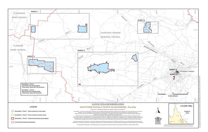
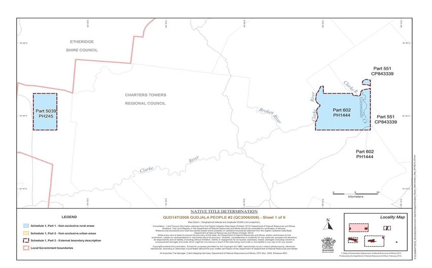
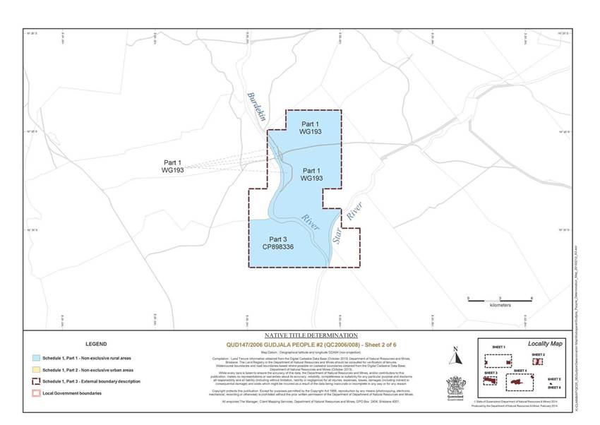
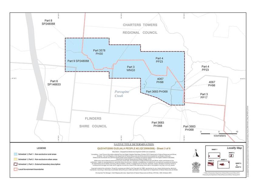
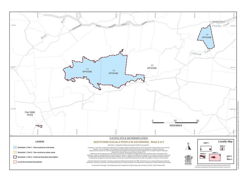
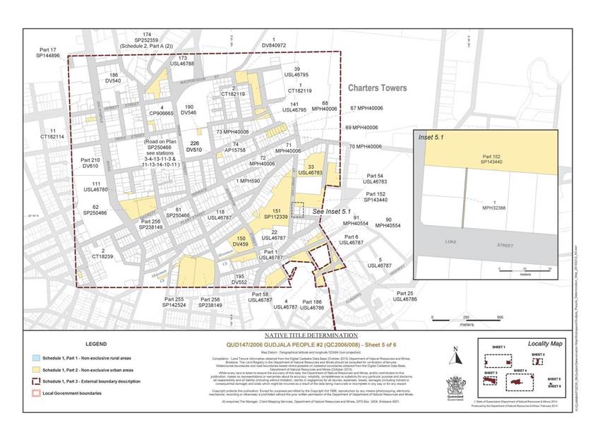
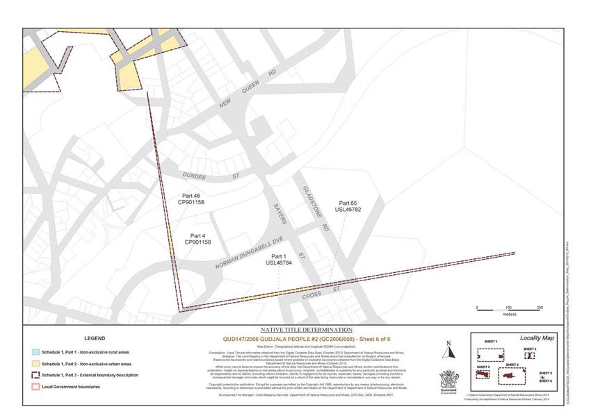
Schedule 2 — AREAS NOT FORMING PART OF THE DETERMINATION AREA
The areas described below do not form part of the Determination Area.
Part A
1. Land and waters within the external boundary, as described in Part 3 of Schedule 1, that at the time at which the native title determination application was made:
(a) were the subject of one or more previous exclusive possession acts, as defined in s 23B of the Native Title Act 1993 (Cth) (despite the fact that the areas, or parts of them, may have been subject to earlier acts that extinguished native title); and
(b) to which none of ss 47, 47A or 47B of the Native Title Act 1993 (Cth) applied,
do not form part of the Determination Area on the basis that they could not be claimed, in accordance with s 61A of the Native Title Act 1993 (Cth).
2. Specifically, and to avoid any doubt, the land and waters referred to in Part A (1) above include the acts described in ss 23B(2) and 23B(3) of the Native Title Act 1993 (Cth) to which s 20 of the Native Title (Queensland) Act 1993 (Qld) applies and include, but are not limited to, the whole of the land and waters described as Lot 174 on Plan SP252359.
3. Specifically, and to avoid any doubt, the land and waters described in Part A (1) above include the land or waters upon which any public work, as defined in s 253 of the Native Title Act 1993 (Cth), is or was constructed, established, or situated, and to which ss 23B(7) and 23C(2) of the Native Title Act 1993 (Cth) and / or s 21 of the Native Title (Queensland) Act 1993 (Qld) applies, together with any adjacent land or waters in accordance with s 251D of the Native Title Act 1993 (Cth).
Part B
On the basis that native title has been extinguished and is not claimed, the parties have agreed that the Determination Area does not include any land or waters on which any permanent improvement consisting of:
(a) a homestead, house, shed or other building;
(b) an airstrip;
(c) a constructed dam or any other constructed stock watering point, bore, turkey nest, squatters’ tank or other water storage facility; or
(d) stock yards and trap yards,
has, at the date of the determination, been constructed (including any adjacent land the exclusive use of which is reasonably necessary for the enjoyment of the improvement) in accordance with the rights of the lessee under, and within the boundaries of the following pastoral leases:
1. Pastoral Holding No. 11/551 comprising Lot 551 on Plan CP843339 and commonly known as Maryvale;
2. Term Lease No. 231119 comprising Lot 3 on Plan CP898336 and commonly known as Mileslake;
3. Pastoral Holding No. 11/3880 comprising Lot 3880 on Plan PH29 and commonly known as Lolworth;
4. Pastoral Holding No. 11/3578 comprising Lot 3578 on Plan PH30 and commonly known as Turrets;
5. Pastoral Holding No. 23/4067 comprising Lot 4067 on Plan PH98 and commonly known as Upland;
6. Preferential Pastoral Holding No. 18/5039 comprising Lot 5039 on Plan PH245 and commonly known as Barker;
7. Preferential Pastoral Holding No. 23/3683 comprising Lot 3683 on Plan PH368 and commonly known as Porcupine;
8. Pastoral Holding No. 11/602 comprising Lot 602 on Plan PH1444 and commonly known as Wando Vale;
9. Pastoral Holding No. 11/498 B comprising Lot 3 on Plan PP17 and commonly known as Cargoon;
10. Preferential Pastoral Holding No. 23/3576 comprising Lot 4 on Plan PP23 and commonly known as Reedy Springs;
11. Pastoral Holding No. 23/5523 comprising Lot 6 on Plan SP146633 and commonly known as Mount Sturgeon Holding;
12. Term Lease No. 233527 comprising Lot 8 on Plan SP248068 and commonly known as Pretty Plains Holding;
13. Term Lease No. 233528 comprising Lot 9 on Plan SP248068 and commonly known as The Twins;
14. Preferential Pastoral Holding No. 11/3933 comprising Lot 1 on Plan WG193 and commonly known as Starbright; and
15. Term Lease No. 233526 comprising Lot 3 on Plan WNG3 and commonly known as Mount King Holding.
Schedule 3 — NATIVE TITLE HOLDERS
The native title holders are the Gudjala People. The Gudjala People are the descendants of one or more of the following people:
(a) Alice Anning (also known as Alice White) of Bluff Downs station;
(b) Cissy McGregor;
(c) Maggie “Ton Ton” Thompson;
(d) Topsy Hann; or
(e) Zoe (mother of Hoya Siemon / Bowman).
Schedule 4 — OTHER INTERESTS IN THE DETERMINATION AREA
The nature and extent of the other interests in relation to the Determination Area are the following as they exist as at the date of the determination:
1. The rights and interests of the parties under the following agreements:
(a) Elizabeth Dodd, Andrew (Smokey) Anderson, Gloria Santo, Christine Hero and Priscilla Michelle Huen on their own behalf and on behalf of the Gudjala People, the Ngrragoonda Aboriginal Corporation ICN 7982, the State of Queensland, and the Ngrragoonda Aboriginal Corporation RNTBC ICN 7982 as parties to the Gudjala protected areas indigenous land use agreement (body corporate agreement), which was authorised by the native title claim group on 5 September 2013 and executed by Elizabeth Dodd on 24 January 2014, Andrew (Smokey) Anderson on 23 January 2014, Gloria Santo on 21 January 2014, Christine Hero on 17 January 2014, Priscilla Michelle Huen on 21 January 2014, the Ngrragoonda Aboriginal Corporation ICN 7982 on 17 January 2014, and the State of Queensland on 3 and 5 February 2014, and that agreement once it becomes registered as a body corporate ILUA following execution of the agreement by the registered native title body corporate;
(b) Elizabeth Dodd, Andrew (Smokey) Anderson, Gloria Santo, Christine Hero and Priscilla Michelle Huen on their own behalf and on behalf of the Gudjala People, the Ngrragoonda Aboriginal Corporation ICN 7982, Flinders Shire Council, and Charters Towers Regional Council as parties to the local government indigenous land use agreement (area agreement), which was authorised by the native title claim group on 8 November 2013 and executed by Elizabeth Dodd on 24 January 2014, Andrew (Smokey) Anderson on 23 January 2014, Gloria Santo on 21 January 2014, Christine Hero on 17 January 2014, Priscilla Michelle Huen on 21 January 2014, the Ngrragoonda Aboriginal Corporation ICN 7982 on 17 January 2014, Flinders Shire Council on 20 January 2014, and Charters Towers Regional Council on 28 January 2014, and that agreement once it becomes registered as an area ILUA following execution of the agreement by the registered native title body corporate;
(c) Elizabeth Dodd, Andrew (Smokey) Anderson, Gloria Santo, Christine Hero and Priscilla Michelle Huen on their own behalf and on behalf of the Gudjala People and Ergon Energy Corporation Limited ACN 087 646 062 as parties to the indigenous land use agreement executed on 1 November 2013.
2. The rights and interests of Ergon Energy Corporation ACN 087 646 062:
(a) as the owner and operator of any “Works” as that term is defined in the Electricity Act 1994 (Qld) within the Determination Area;
(b) as a distribution entity and the holder of a distribution authority under the Electricity Act 1994 (Qld);
(c) created under the Electricity Act 1994 (Qld) and the Government Owned Corporations Act 1993 (Qld) including:
(i) rights in relation to any agreement relating to the Determination Area existing or entered into before the date on which these orders are made;
(ii) rights to enter the Determination Area by its employees, agents or contractors to exercise any of the rights and interests referred to in this paragraph; and
(iii) to inspect, maintain and manage any Works in the Determination Area.
3. The rights and interests of the State of Queensland and the Charters Towers Regional Council and Flinders Shire Council to access, use, operate, maintain and control the dedicated roads in the Determination Area and the rights and interests of the public to use and access the roads.
4. The rights and interests of Charters Towers Regional Council and Flinders Shire Council:
(a) under their local government jurisdiction and functions under the Local Government Act 2009 (Qld), under the Land Protection (Pest and Stock Route Management) Act 2002 (Qld) and under any other legislation, for that part of the Determination Area within the area declared to be their respective local government areas;
(b) as the:
(i) lessor under any leases which were validly entered into before the date on which these orders are made and whether separately particularised in these orders or not;
(ii) grantor of any licences or other rights and interests which were validly granted before the date on which these orders were made and whether separately particularised in these orders or not;
(iii) holder of any estate or interest in land, as trustee of any reserves, that exist in the Determination Area;
(c) as the owner and operator of infrastructure, and those facilities and other improvements located in the Determination Area validly constructed or established on or before the date on which these orders are made, including but not limited to:
(i) undedicated but constructed roads except for those not operated by Council;
(ii) water pipelines and water supply infrastructure;
(iii) drainage facilities;
(iv) watering point facilities;
(d) to enter the land for the purposes described in paragraphs (a), (b) and (c) above by their employees, agents or contractors to:
(i) exercise any of the rights and interests referred to in paragraph 4 above;
(ii) inspect, maintain and repair the infrastructure, facilities and other improvements referred to in paragraph (c) above;
(iii) undertake operational activities in its capacity as a local government such as feral animal control, weed control, erosion control, waste management and fire management.
5. The rights and interests of the holders of any leases, licences, reservations, permits, easements or authorities granted under the Land Act 1994 (Qld), and any relevant regulations or subordinate legislation made under that Act.
6. The rights and interests of the holders of any permits, claims, licences or leases granted under the Mineral Resources Act 1989 (Qld), including (but not limited to) those held by Citigold Corporation Limited ACN 060 397 177 and its related bodies corporate.
7. So far as confirmed pursuant to s 212(2) of the Native Title Act 1993 (Cth) and s 18 of the Native Title Act (Queensland) Act 1993 (Qld) as at the date of this determination, any existing public access to, and enjoyment of, the following places in the Determination Area:
(a) waterways;
(b) beds and banks or foreshores of waterways;
(c) stock routes; and
(d) areas that were public places at the end of 31 December 1993.
8. Any other rights and interests:
(a) held by the State of Queensland or Commonwealth of Australia; or
(b) existing by reason of the force and operation of the Laws of the State or the Commonwealth.
Note: Entry of orders is dealt with in Rule 39.32 of the Federal Court Rules 2011.
|
QUEENSLAND DISTRICT REGISTRY |
|
|
GENERAL DIVISION |
QUD 80 of 2005 |
|
BETWEEN: |
ELIZABETH DODD, ANDREW (SMOKEY) ANDERSON, CHRISTINE HERO, PRISCILLA MICHELLE HUEN AND GLORIA SANTO ON BEHALF OF THE GUDJALA PEOPLE CORE COUNTRY CLAIM #1 Applicant |
|
AND: |
STATE OF QUEENSLAND First Respondent THE COMMONWEALTH OF AUSTRALIA Second Respondent CHARTERS TOWERS REGIONAL COUNCIL Third Respondent FLINDERS SHIRE COUNCIL Fourth Respondent ERGON ENERGY CORPORATION LIMITED Fifth Respondent CITIGOLD CORPORATION LIMITED Sixth Respondent RICHARD DUDLEY ANNING, HENRY JAMES ATKINSON, SUSAN ATKINSON, LESLIE ARTHUR BRAZIER, MARION LINDA BRAZIER, MICHELLE MAREE BURGE, JOHN DAVID BURGE, HELEN MARGARET COOK, PHILLIP LEONARD COOK, JACQUELINE OLGA CORE HEATH, WARREN ROBERT JACKSON, ROBERT CHARLES LAWRIE TRADING AS RC & JJ LAWRIE, ELIZABETH ANNE LYONS, GERARD FRANCES LYONS, JOHN DOMINIC LYONS, RONDA MARGARET LYONS, LYNETTE MARGARET MAITLAND, PERCY WILLIAM GEORGE MAITLAND, HECTOR EDMOND MOODY, MARGARET JEAN MOODY, NACRE PTY LTD, TREVOR TORKINGTON, VENETTA BAVERLEY TORKINGTON, DANIEL JOHN TURLEY, MARIE ANN TURLEY, JOHN NORMAN JAMES WEIR AND PRUE ANN WEIR Seventh – Thirty-Third Various Pastoral Respondents JAMES COOK UNIVERSITY Thirty-Fourth Respondent |
|
IN THE FEDERAL COURT OF AUSTRALIA |
|
|
QUEENSLAND DISTRICT REGISTRY |
|
|
GENERAL DIVISION |
QUD 147 of 2006 |
|
BETWEEN: |
ELIZABETH DODD, ANDREW (SMOKEY) ANDERSON, CHRISTINE HERO, PRISCILLA MICHELLE HUEN AND GLORIA SANTO ON BEHALF OF THE GUDJALA PEOPLE CORE COUNTRY CLAIM #2 Applicant |
|
AND: |
STATE OF QUEENSLAND First Respondent CHARTERS TOWERS REGIONAL COUNCIL Second Respondent FLINDERS SHIRE COUNCIL Third Respondent ERGON ENERGY CORPORATION LIMITED Fourth Respondent CITIGOLD CORPORATION LIMITED Fifth Respondent GREAT MINES PTY LTD Sixth Respondent Allingham Holdings Pty Ltd, Kenneth Ernest Dudley Anning, Richard Dudley Anning, Atkinson Developments Pty Ltd, Camm Enterprises (Aust) Pty Ltd, Lydia Jane Dennis, Elizabeth Anne Lyons, Gerard Frances Lyons, Lynette Margaret Maitland, Percy William George Maitland, Maryvale HN1 Pastoral Company Pty Ltd, Julia Caroline Ross, Daniel John Turley and Marie Ann Turley Seventh – Twentieth Various Pastoral Respondents |
|
JUDGE: |
LOGAN J |
|
DATE: |
18 MARCH 2014 |
|
PLACE: |
CHARTERS TOWERS |
REASONS FOR JUDGMENT
1 Reasons for judgement in respect of consent determination in a native title application can have about them a similarity of language that might lead the uninformed to think that there is something glib or routine about them. Nothing could be further from the truth. All that is routine is the application of by now well settled principles the correctness of which, once explained in earlier authority, is not enhanced by paraphrasing. What is never routine are the customs, usages and affinity for particular land and the remarkable cherishing and preservation of them over so many generations, notwithstanding the impact of European settlement, which enables an Aboriginal people, in this case the Gudjala People, represented by Elizabeth Dodd, Andrew (Smokey) Anderson, Gloria Santo, Christine Hero and Priscilla Michelle Huen (the applicant) to establish native title. Also never routine is the opportunity offered by a determination, made with the agreement of all interested parties and by a public exercise of the judicial power of the Commonwealth, to evidence that objectives specified by the Commonwealth Parliament in the Native Title Act 1993 (Cth) (the Act) are being met in practice.
2 The applications being determined today, by consent, are QUD 80 of 2005, Gudjala People # 1 and QUD 147 of 2006, Gudjala People # 2. The determination under the Act is in favour of the Gudjala Native Title claimants in respect to the land and waters within the areas set out in Schedule 1 in each determination.
3 The State of Queensland, the Commonwealth of Australia, Charters Towers Regional Council, Flinders Shire Council, Citigold Corporation Limited, Ergon Energy Corporation Limited, Great Mines Pty Ltd, James Cook University and various Pastoralists are respondent parties to the applications.
4 The two applications in these proceedings are being determined together due to the geographic proximity and the application concerning similar materials and involving materially the same anthropological evidence.
5 The subject land today is generally known as Western Queensland, in the Regional Shire Councils of Etheridge, Finders and Charters Towers. Native Title rights are sought for determination by the applicants under the Act.
6 One of the Commonwealth Parliament’s objectives in respect of the Act is the resolution of claims for the recognition of native title by agreement. That objective is borne out in s 87 of the Act by the Native Title Amendment Act 2009 (Cth).
7 Like many such claims, these claims have been long in their gestation. In earlier judgements in cases like the present, for example in 2012 in Hoolihan on behalf of the Gugu Badhun People # 2 v State of Queensland [2012] FCA 800; Archer on behalf of the Djungan People #1 v State of Queensland [2012] FCA 801 and Fisher on behalf of the Ewamian People #2 v State of Queensland [2013] FCA 1249, I observed that native title claims which linger unresolved on a court list are an affront to our system of justice. I related in those cases how Parliament’s objective of consensual resolution had been met. The statements which I then made are just as applicable to this case. In this case, too, the achievement of Parliament’s objective would not have been possible without much hard and dedicated work by experienced legal advisers, the responsible actions of the parties guided by their advisers and, especially latterly, intensive case management, particularly by the Court’s registrars. I commend the parties and the legal practitioners involved in the cases being heard today for the work latterly undertaken in bringing them to final, consensual resolution.
8 In the aftermath of Wik Peoples v Queensland (1996) 187 CLR 1, the Executive Government of the Commonwealth made provision for legal assistance to be provided to pastoralists in relation to native title claims via a scheme known as the Native Title Respondent Funding Scheme under s 213A of the Act. Over the now almost six years during which I have been responsible for the management of the list of native title cases in this region, and as I have stated in other determinations, I have directly observed how, in combination with responsible legal representation of applicants, via the North Queensland Land Council, of the State, via the Crown Solicitor and of other respondents, this legal assistance to pastoralists has repeatedly and beneficially contributed to the administration of justice and thus to Parliament’s goal of national reconciliation in this important area of the Court’s jurisdiction. This legal assistance to pastoralists was terminated with effect at the end of 2012 by the then Commonwealth Executive Government. The current Executive Government announced late last year that funding of the legal assistance would be restored, with the eligibility criteria revised, on 1 January 2014. It has very recently come to my attention in the course of the management of native title cases in this region that this funding has yet to flow through to those representing and advising pastoralists and other primary producers with respect to native title claims.
9 Discretionary value judgments in respect of public monies appropriated by Parliament are for the Executive Government of the day to make. What I can say again, and have in earlier determinations stated, based on direct experience, is that the addressing of the hitherto “unacceptably long time” for the resolution of native title cases and the recent experience of “faster and better claim resolution” to which the then Attorney General made reference previously (Echoes of Mabo: AIATSIS Native Title Conference, 6 June 2012, Speech by the Honourable Nicola Roxon MP, Attorney-General, http://www.attorneygeneral.gov.au/ Speeches/Pages/2012/Second% 20Quarter/6-June-2012---Echoes-of-Mabo---AIATSIS-Native-Title-Conference.aspx Accessed 7 December 2012) is best achieved by a combination of responsible legal representation of all interested parties and intensive case management and proactive, targeted use of alternative dispute resolution where appropriate by the judges and registrars of this Court. As I noted last year in an interlocutory judgment concerning one of the current claims for determination, Dodd on behalf of the Gudjala People Core Country Claim #1 v State of Queensland (No 2) [2013] FCA 787 at [4]:
[T]o my direct observation in court in respect of the regions of the State for which I have had case management responsibility, the collective representation of pastoral respondents enabled by that scheme greatly facilitated the responsible, consensual resolution of native title claims and removed much of the angst such claims might otherwise have occasioned such respondents.
10 I understand from submissions made in the course of case management of another native title case that, since the restoration of funding was announced, bids for the available funding have been submitted and that these may well exceed funds presently available. No interest group could expect any government uncritically to underwrite legal expenses from public funds. Even accepting this, the present absence of any decision in respect of the allocation of any funds is fraught with the imminent risk of inhibiting the Court’s ability to conclude native title cases both efficiently and consensually, with all of the benefits such disposal entails. Absence of any decision is, I understand, also inhibiting the formulation of alternative means of funding at least some advice and representation for pastoralists and other primary producers generally. I further understand that local government, which is almost always an interested respondent party in a native title case is likewise being affected by a present absence of certainty as to funding from the Commonwealth. Here, too, there is an imminent risk of jeopardising the progress to finality of native title cases. The present situation is truly fraught with a risk of a return to “unacceptably long times” for the resolution of native title cases, with all of the adverse consequences for public and private interests that entails.
11 While it is for the Executive Government to propose and for Parliament to approve particular appropriations of public money, where that public money is directed to the provision of legal assistance to a party to a native title proceeding, be that party applicant, pastoralist or otherwise, so as to assist in the achievement of the objectives of the Act, it is for the judicial branch to ensure that the conduct of parties so assisted entails the responsible use of the benefit so conferred. That is a subject given regular attention by the Court via the intensive case management of native title claims. In this regard and truly there are secular inspirations to be drawn from scripture: “From those to whom much is given, much is expected” (Gospel of St Luke, Ch. 12, v 48, condensed and rendered in modern form).
12 In Baker on behalf of the Muluridji People v State of Queensland [2011] FCA 1432 (Muluridji) I adopted observations made in King v Northern Territory of Australia [2011] FCA 582 (King) per Mansfield J. His Honour made a number of observations about the preamble to the Act. I am in complete agreement not only with the substance of his Honour’s observations in King but also with the manner in which he expressed them. They are exactly apposite in the present proceedings also. As I observed in Muluridji, I propose therefore to adopt them as my own in these reasons for judgment without further attribution.
13 The preamble to the Act recognised, on behalf of all people of Australia, that the Aboriginal peoples of Australia inhabited this country for many years prior to European settlement, and that the Aboriginal peoples had been progressively dispossessed of their lands. It recorded that, by the overwhelming vote of the people of Australia, the Constitution was amended to enable laws such as the Act to be passed, to facilitate the recognition by our shared legal system of the native title rights and interests in their land. This is an occasion when the Court is to make orders declaring that the groups of Aboriginal persons in the current applications have always been the traditional owners of the land. By the Court’s orders, the Australian community collectively recognises that status. It is important to emphasise that the Court’s orders do not grant that status. The Court is declaring that it exists and has always existed at least since European settlement.
14 The applicants have filed the following documents relevant to the consent determinations in the applications:
(a) Dr Anthony Redmond (September 2009) Anthropologist’s Report Gudjala, Gudjala #1 ((QUD80/05) Gudjala #2 (QUD147/06) Vol 1 and 2 (The Connection Report);
(b) Historian Val Donovan (December 2010) Historical Report in relation to QUD80/2005, Elizabeth Dodd & Ors on behalf of the Gudjala People and QUD147/2006, Elizabeth Dodd & Ors on behalf of the Gudjala People #2 (Historical Report);
(c) Dr Anthony Redmond (21 June 2011) Supplementary Anthropologist’s Report: QUD80/205 (sic), Elizabeth Dodd & Ors on behalf of the Gudjala People and QUD147/2006, Elizabeth Dodd & Ors on behalf of the Gudjala People #2;
(d) Dr Anthony Redmond (June 2011) Gudjala Table 2 Rights and Interests;
(e) Dr Anthony Redmond (March 2012) Further information relating to Gudjala #1 and #2 arising from Experts Conference with State 13-14 February 2012;
(f) Dr Anthony Redmond and Dr Alison Pembroke (March 2012) Native Title Rights and Interests in the Upper Burdekin Region;
(g) Dr Anthony Redmond (4 September 2013) Gudjala #1 (QUD80/05) Gudjala #2 (QUD147/06) File note on Gloria Mitchell / Santo & Joe, mother of Hoya Siemons / Masso;
(h) Affidavit of Gloria Santo, being annexure “CAT4” to the affidavit of Cheryl Ann Thomson filed on 20 November 2013;
(i) Report of the Conferences Experts 13 February 2012;
(j) A copy of the Conferences of Experts Report.
SECTION 87 OF THE ACT
15 Section 87 of the Act provides that the Court may make a determination of native title by consent over an area covered by a native title application and without holding a hearing where:
(a) the period specified in the notice given under s 66 of the Act has ended (s 87(1));
(b) there is an agreement between the parties on the terms of an order of the Court in relation to the proceedings (s 87(1)(a)(i));
(c) the terms of the agreement are in writing and are signed by or on behalf of the parties and filed with the Court (s 87(1)(b));
(d) the Court is satisfied that an order in, or consistent with, those terms would be within its power (s 87(1)(c)); and
(e) having satisfied the criteria relevantly detailed, the Court considers the making of orders as it appears to the Court to be appropriate to do so pursuant to s 87(1A) of the Act. The Court may make a determination in accordance with s 87(2), as is relevant to these proceedings.
16 The focus of the Court in considering whether the orders sought are appropriate under s 87(1) and s 87(2) is on the making of the agreement by the parties. In Muluridji I cited observations of North J in Lovett on behalf of the Gunditjmara People v State of Victoria [2007] FCA 474. Such remarks are apt to be adopted in this case. His Honour stated:
[36] … The Act is designed to encourage parties to take responsibility for resolving proceeding without the need for litigation. Section 87 must be construed in this context. The power must be exercised flexibly and with regard to the purpose for which the section is designed.
[37] In this context, when the Court is examining the appropriateness of an agreement, it is not required to examine whether the agreement is grounded on a factual basis which would satisfy the Court at a hearing of the application. The primary consideration of the Court is to determine whether there is an agreement and whether it was freely entered into on an informed basis: Nangkiriny v State of Western Australia (2002) 117 FCR 6; [2002] FCA 660, Ward v State of Western Australia [2006] FCA 1848. Insofar as this latter consideration applies to a State party, it will require the Court to be satisfied that the State party has taken steps to satisfy itself that there is a credible basis for an application: Munn v Queensland (2001) 115 FCR 109; [2001] FCA 1229.
17 As such, the Court is not required to make its own inquiry of the merits of the applicants’ claim to be satisfied that the orders sought are supportable and in accordance with the law: Cox on behalf of the Yungngora People v State of Western Australia [2007] FCA 588 at [3]. The Court may consider such evidence to determine whether the State is acting in good faith and rationally: Munn (for and on behalf of the Gunggari People) v Queensland (2001) 115 FCR 109 at [29]-[30].
18 In Smith v State of Western Australia (2000) 104 FCR 494 at [38], Madgwick J stated:
[38] … State governments are necessarily obliged to subject claims for native title over lands and waters owned and occupied by the State and State agencies, to scrutiny just as careful as the community would expect in relation to claims by non-Aborigines to significant rights over such land.
SECTION 94A OF THE ACT
19 Section 94A of the Act requires that a native title determination order must satisfy the requirements of s 225 of the Act. Section 225 provides:
A determination of native title is a determination whether or not native title exists in relation to a particular area (the determination area) of land or waters and, if it does exist, a determination of:
(a) who the persons, or each group of persons, holding the common or group rights comprising the native title are; and
(b) the nature and extent of the native title rights and interests in relation to the determination area; and
(c) the nature and extent of any other interests in relation to the determination area; and
(d) the relationship between the rights and interests in paragraphs (b) and (c) (taking into account the effect of this Act); and
(e) to the extent that the land or waters in the determination area are not covered by a non-exclusive agricultural lease or a non-exclusive pastoral lease -- whether the native title rights and interests confer possession, occupation, use and enjoyment of that land or waters on the native title holders to the exclusion of all others.
Note: The determination may deal with the matters in paragraphs (c) and (d) by referring to a particular kind or particular kinds of non-native title interests.
[emphasis in original]
20 Section 223(1) of the Act defines ‘native title’ and ‘native title rights and interests’ as:
(1) … the communal, group or individual rights and interests of Aboriginal peoples or Torres Strait Islanders in relation to land or waters, where:
(a) the rights and interests are possessed under the traditional laws acknowledged, and the traditional customs observed, by Aboriginal peoples or Torres Strait Islanders; and
(b) the Aboriginal peoples or Torres Strait Islanders, by those laws and customs, have a connection with the land or waters; and
(c) the rights and interests are recognised by the common law of Australia.
21 In Members of the Yorta Yorta Aboriginal Community v State of Victoria (2002) 214 CLR 422, Gleeson CJ, Gummow and Hayne JJ (with McHugh J agreeing) stated the relevant principles with respect to s 223 of the Act, at [46] to [55] and [80] to [83]:
(a) A traditional law or custom which is the source of native title rights and interests is one which has been passed from generation to generation of a society, usually by word of mouth and common practice.
(b) The origins of the law or custom from which native title rights and interests stem must be found in the normative rules of the relevant Aboriginal or Torres Strait Islander society that existed before the assertion of sovereignty by the British Crown – it is only those rules that are “traditional” laws and customs.
(c) That normative system must have a continuous existence and vitality since sovereignty.
(d) If that society ceases to exist as a group which acknowledges and observes those pre-sovereignty laws and customs, those laws and customs cease to have continued existence and vitality.
(e) Only native title rights or interests that existed at the time of the change in sovereignty will be recognised. However, some change to, or adaptation of, traditional laws or customs or some interruption in the enjoyment or exercise of native title rights or interests in the period between the Crown asserting sovereignty and the present will not necessarily be fatal to a native title claim.
(f) In many cases, perhaps most, claimants will invite the Court to infer, from evidence led at trial, the content of traditional laws and customs at times earlier than those described in the evidence.
22 Further, there is authority of this Court, exercising appellate jurisdiction, which lends itself to a determinative conclusion that physical presence is not a necessary requirement for continuing connection. See, for example, Moses v State of Western Australia [2007] FCAFC 78 at [306] per Moore, North and Mansfield JJ.
APpLICATION OF sECTION 223 and section 225 to THE gudjala people
23 Identification as part of the Gudjala People is based from principles of perpetual filiation to a small number of ancestors who were themselves owners of the country within the claim area. The ethnographic evidence indicates that Gudjala people are members of what senior anthropologist Professor Bruce Rigsby, terms “a single regional Aboriginal jural public, and the several beneficial titles to particular lands and waters are not constituted in isolation from that wider jural public” (2002/200). The traditional laws and customs are shared with their close neighbours the Gugu Badhun, Wulguru and Warungu to their north and east.
24 The area claimed is situated predominantly to the north and west of Charters Towers in regional north Queensland, which includes both lands and waters within the claim area. The terrain is comprised of open woodlands and sclerophyll forest that is bordered by the Clarke River to the north, the Burdekin River to the east, the Cape River to the south and the Einasleigh River to the west. Post settlement, the Gudjala People adapted their connection to their country as history evolved, with pastoral leases now covering the majority of country in the claim area.
25 It should be highlighted that the body of evidence establishing a body of traditional law and custom shared between Gudjala people and their near neighbours is of particular importance because in the current case, some commentators in respect of the Gudjala people consider that the ethnographic record is very thin (Hagen 2001, 2005; Brayshaw 1977).This notwithstanding, it is stated in the Connection Report at [127], that it is “well demonstrated in the exploration and archaeological record” that the “Aboriginal people in the claim region possessed a body of laws and customs.” These laws and customs concerned the way in which the land was occupied, enjoyed, used and spoken for at sovereignty, despite the lack of written records relation to the period prior to sovereignty (The Historical Report at 7).
26 The first indication of an habitation in the region is from the Journals of Leichardt and Gilbery where presence of frequent camp sites on the Burdekin River was recorded in early 1845, Leichardt notes, ‘the Aborigines themselves had remained hidden from sight until about fifty men, women and children were encountered at the Valley of Lagoons (1847”246; Gilbert, Journal May 11, 1845).
27 Despite forced dislocations, frontier conflict, coercive labour practices and draconian state interventions into Gudjala people’s personal and social lives, the Gudjala native title claim group and their predecessors have continuously exercised their right of possession, occupation, use and enjoyment of their traditional country since before the assertion of British Sovereignty (26 January 1788 (the date of legal Sovereignty)).
28 The Gudjala people share linguistic features, the use of a distinctive type of section terminology, shared patterns of inter-marriage and ceremonial exchange with their northern neighbours the Gugu-Badhun, Wulguru and Warungu.
29 The material provides that, a major factor facilitating ongoing occupation of their traditional country by their predecessors and the contemporary members of the Gudjala claimant group has been their strategic alliances with various station owners in the post-contact period. Activities including the hunting, preparation and consumption of animals, plants and other materials taken from the claim area continue to be a marker of the claimants’. On the materials, Gudjala people build consubstantiality with country in a spiritual and physical nature through individual and group interactions with it. “Birth, residence and death places and events are constantly talked about and referred to by the wider group as part of their inscriptive practice on country” (See Rumsey 1994).
30 The recollection of stories concerning traditional locations in the claim area continued to be transmitted across the generations. Gudjala people place strong emphasis upon the narrator being properly “in place” because they believe that it adds legitimacy and authority to the stories themselves, with the stories told, continue to be a focus of belonging to country in the contemporary contact and concern the natural and supernatural events.
31 Anthropological records and linguistic literature from the twentieth century establish considerable evidence that antecedents of the Gudjala claimant group expressed a physical connection to the claim area through kinship, marriage, mortuary practices and spiritual beings. Particular mention is made of the Great Basalt Wall region north-west of Charters Towers and its use as a “veritable stronghold” in the mid to late 19th Century (the Connection Report at 130).
32 The material provides that the Gudjala People have an identity and a connection to the land through the application of a shared body of traditional laws and customs that forms part of the greater jural public. Evidence exists of a normative system of law and custom in regard to marriage laws and the observation of section protocols. These laws and customs are salient to the reproduction of the claimants’ society.
33 Further evidence, in the form of oral histories of the claimants, indicates that the transfer of Gudjala cultural knowledge has continued throughout the 20th Century. The Gudjala People have maintained a physical connection, as well as an ongoing cultural and spiritual connection to their lands.
34 Accordingly, it is appropriate to make the proposed orders which recognise:
(a) that the claim group comprises a society united in and by their acknowledgement and observance of a body of accepted traditional laws and customs;
(b) that the present day body of accepted laws and customs of the society in essence is the same body of laws and customs acknowledged and observed by the ancestors or members of the society adapted to modern circumstances;
(c) that the acknowledgement and observance of those laws and customs has continued substantially uninterrupted by each generation since sovereignty, and that the society has continued to exist throughout that period as a body united in and by its acknowledgement and observance of those laws and customs; and
(d) that the claim group still possesses rights and interests under the traditional laws acknowledged and the traditional customs observed by them, and that those laws and customs give them a connection to the land.
THE APPLICATION OF SECTION 87 to the GUDJALA people claims
35 The requirements of s 87 of the Act have been satisfied in the present case. In particular:
(a) The period specified in the notice given under s 66 closed application on 13 March 2006 for Gudjala People (QUD 80/2005) and 2 February 2011 for Gudjala People #2 (QUD 147/2006).
(b) The parties have reached agreement as to the terms of determinations of native title (s 87(1)(a)(i)).
(c) The parties have recorded their agreement in short minutes of consent (s 87(1)(b)).
(d) An order in terms of or consistent with the short minutes of consent would be within the Court’s power (s 87(1)(c)) because:
(i) the applications are valid and were made in accordance with s 61 of the Act; and
(ii) the applications are for a determination of native title in relation to an area for which there is no approved determination of native title (s 13(1)(a)).
The short minutes comply with s 94A and s 225 of the Act (s 87(1)(c)); and
(e) It is appropriate that the Court make the orders sought because:
(i) all parties are legally represented;
(ii) it is consistent with objects in the Act that issues and disputes concerning native title are resolved by mediation;
(iii) the State of Queensland has taken a real interest in negotiating the consent determination. In participating in these negotiations, the State of Queensland, acting on behalf of the general community, having had regard to the Act’s requirements and having conducted a thorough assessment process, is satisfied that the determination is justified in all the circumstances;
(iv) the connection material filed by the applicants satisfies s 223 of the Act and supports the making of the proposed determinations;
(v) the requirements of ss 56, 94A and 225 of the Act are satisfied; and
(vi) the proposed determinations are unambiguous and certain as to the rights declared.
satisfying section 57 of the act
36 Under s 55 of the Act, the Court is required, either at the time of the Determination or as soon as practicable after it, to make such determinations as are required by s 56 and s 57 of the Act. They respectively relate to holding the native title on trust or otherwise and if not held on trust, the non-trust functions of the prescribed body corporate.
37 As to the proposed determinations, Ms Cheryl Ann Thomson has filed on 5 March 2014 that the native title is not to be held on trust and the Ngrragoonda Aboriginal Corporation is to be the prescribed body corporate under s 57 of the Act. The Ngrragoonda Aboriginal Corporation was registered on 8 November 2013 under the Corporations (Aboriginal and Torres Strait Islanders) Act 2006 (Cth). It will perform the functions mentioned in s 57(3) of the Act.
38 The Court notes that Ms Cheryl Ann Thomson has further filed on 5 March 2014 a Notice of Nomination and Consent of Ngrragoonda Aboriginal Corporation as the Prescribed Body Corporate, which satisfies the requirements of s 57(2) of the Act.
39 The Ngrragoonda Aboriginal Corporation satisfies the requirements of the Native Title (Prescribed Bodies Corporate) Regulations 1999 (Cth) because:
(a) it is an Aboriginal and Torres Strait Islander Corporation: reg 4(1));
(b) its purpose, as set out in its Rules of the Corporation, satisfy reg 4(2)(b);
(c) the eligibility requirements of the Rules of the Corporation operate to ensure that all members of the corporation at the time of the determination are included or proposed to be included in the determinations as persons who have native title rights and interests in relation to the determination area: reg 4(2)(b).
40 Finally, and at the risk of repetition, it needs to be understood that agreements of the kind that have brought about today’s hearing and determinations do not just happen. They involve co-operation by all of the parties in the administration of justice, careful attention by them and their advisers to the requirements of the Act in relation to the proof of native title, related effort in the gathering of relevant evidence and the ready making of concessions as to whether on the evidence native title can be proved. They also involve the regular review by the Court at regional directions hearings, and in the intervals in between by the Court’s registrars, to ensure that an application is both prosecuted with due diligence by an applicant and not unreasonably delayed by a respondent in its progress towards a hearing like today or, if needs be, a contested hearing. Ensuring that is important in any litigation but is especially so in a proceeding under the Act which serves a wider public interest recognised in the preamble and which, through the allocation of judicial and other court resources and via the provision of various forms of legal aid, involves a considerable investment of public money.
41 For the reasons given, the Determinations are now made.
|
I certify that the preceding forty-one (41) numbered paragraphs are a true copy of the Reasons for Judgment herein of the Honourable Justice Logan. |
Associate:

