
FEDERAL COURT OF AUSTRALIA
Lander v State of South Australia [2014] FCA 125
|
IN THE FEDERAL COURT OF AUSTRALIA |
|
|
SOUTH AUSTRALIA DISTRICT REGISTRY |
|
|
GENERAL DIVISION |
SAD 163 of 2008 |
DIERI NO 2 NATIVE TITLE CLAIM
|
BETWEEN: |
EDWARD LANDER AND OTHERS NAMED IN THE SCHEDULE OF PARTIES Applicant |
|
AND: |
STATE OF SOUTH AUSTRALIA AND OTHERS NAMED IN THE SCHEDULE OF PARTIES Respondent |
|
JUDGE: |
white j |
|
DATE OF ORDER: |
26 February 2014 |
|
WHERE MADE: |
port augusta |
THE COURT NOTES THAT:
A. This determination covers part of the land and waters which:
(a) are subject to the Dieri No 2 Native Title Determination Application (SAD 163 of 2008) (“the Dieri No 2 Claim”); and
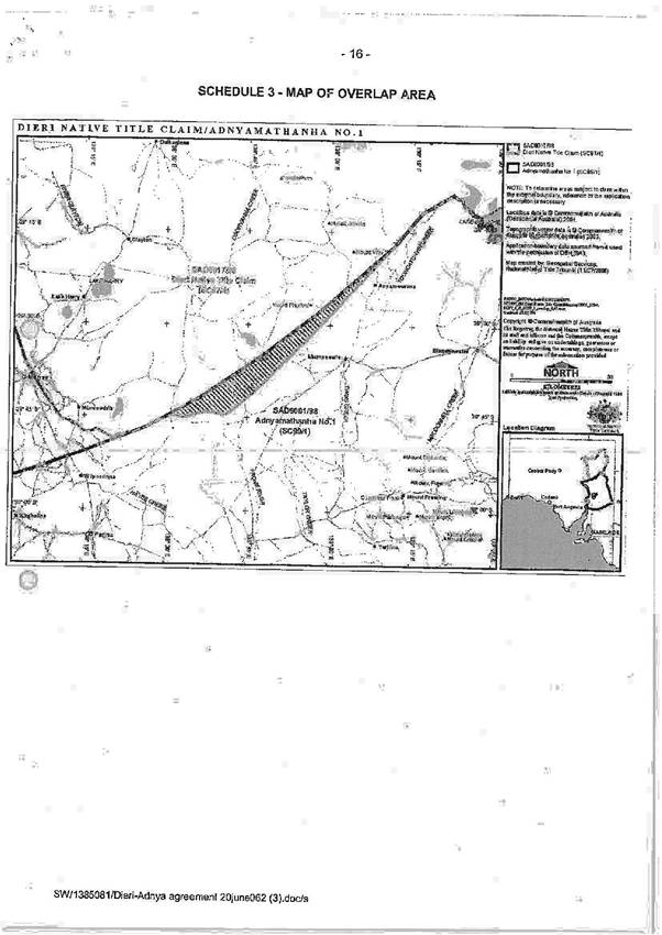
(b) form part of the undetermined area of the Adnyamathanha No 1 Native Title Determination Application (SAD 6001 of 1998) (“the Adnyamathanha claim”) which overlaps the Dieri No 2 Claim.
B. This determination is being made together with a consent determination over the remaining part of the Dieri No 2 claim in favour of the Adnyamathanha People.
C. The Parties to this determination (“the Parties”) agree that those areas listed in Schedule 2 are not included in the Determination Area having been excluded by the Applicants’ applications for a determination of native title.
D. The Parties have now reached agreement as to the terms of a determination of native title to be made in relation to the Determination Area. They have filed an agreement in writing with this Court pursuant to section 87A (1) of the Native Title Act 1993 (Cth) (“the Native Title Act”) to seek the making of consent orders for a determination.
E. The Parties acknowledge that the effect of the making of this determination will be that those Dieri people described in Paragraph 6, in accordance with their traditional laws and customs, will be recognised as the native title holders for the Determination Area.
F. The Parties have agreed that the prospective registered native title body corporate in respect of the Determination Area, Dieri Aboriginal Corporation RNTBC, may have liberty to apply to seek a variation of the determination of native title in this matter, as it relates to pastoral improvements in the Determination Area in the event that the ruling of the Federal Court of Australia in De Rose v South Australia (No.2) [2005] FCAFC 110; (2005) 145 FCR 290 with respect to pastoral improvements is overturned, set aside or otherwise found to be an incorrect legal ruling by the High Court of Australia in the context of an appeal to the High Court of Australia from the decision of the Federal Court of Australia in Brown (on behalf of the Ngarla People) v State of Western Australia [2012] FCAFC 154; (2012) 208 FCR 505.
G. The Parties have requested that the Court make a determination over the Determination Area without a trial.
BY CONSENT THE COURT MAKES THE FOLLOWING DETERMINATION OF NATIVE TITLE PURSUANT TO SECTIONS 87A OF THE NATIVE TITLE ACT:
1. In this determination including its schedules, unless the contrary intention appears, the words and expressions used have the same meaning as they are given in Part 15 of the Native Title Act.
2. In this determination:
(a) “Determination Area” means that part of the land and waters of the Dieri No 2 Claim and the overlapping part of the Adnyamathanha No 1 claim as is described in Schedule 1 (and shown in the maps forming part of that Schedule), apart from those excluded areas which are described in Paragraph 16 and in Schedule 2 (“excluded areas”);
(b) “Adnyamathanha Determination Area” means the area of the consent determination being made in favour of the Adnyamathanha people over the remaining area of the Dieri No 2 claim.
3. In this determination including its schedules, in the event of an inconsistency between a description of an area in a schedule and the depiction of that area on the map in Schedule 1, the written description shall prevail.
Existence of Native Title
4. Subject to Paragraphs 12 to 16 herein, native title exists in the Determination Area.
5. Native title does not exist in relation to the areas and resources described in Paragraphs 12, 15 and 16 herein.
The Native Title Holders
6. The Native Title Holders in relation to the Determination Area are those living Aboriginal persons who are described in Schedule 3 who:
(a) identify as Dieri; and
(b) are recognised by other Native Title Holders under the relevant Dieri traditional laws and customs as having maintained an affiliation with, and continuing to hold native title rights and interests in the Determination Area.
Native title rights and interests
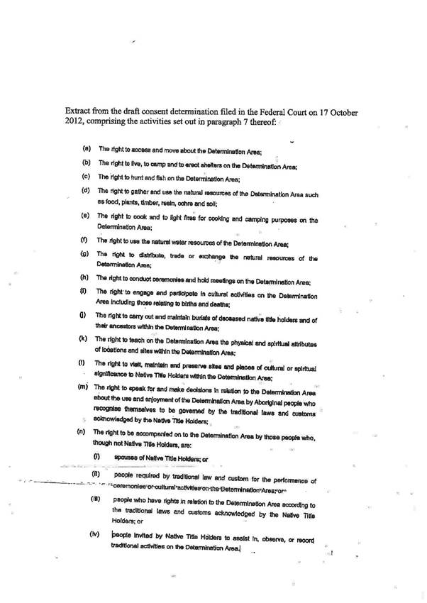
7. Subject to Paragraphs 8, 9 and 10, the nature and extent of the native title rights and interests held by the Native Title Holders are rights to use, stay on and enjoy the land and waters of the Determination Area, being:
(a) The right to access and move about the Determination Area;
(b) The right to live, to camp and to erect shelters on the Determination Area;
(c) The right to hunt and fish on the Determination Area;
(d) The right to gather and use the natural resources of the Determination Area such as food, plants, timber, resin, ochre and soil;
(e) The right to cook and to light fires for cooking and camping purposes on the Determination Area;
(f) The right to use the natural water resources of the Determination Area;
(g) The right to distribute, trade or exchange the natural resources of the Determination Area;
(h) The right to conduct ceremonies and hold meetings on the Determination Area;
(i) The right to engage and participate in cultural activities on the Determination Area including those relating to births and deaths;
(j) The right to carry out and maintain burials of deceased native title holders and of their ancestors within the Determination Area;
(k) The right to teach on the Determination Area the physical and spiritual attributes of locations and sites within the Determination Area;
(l) The right to visit, maintain and preserve sites and places of cultural or spiritual significance to Native Title Holders within the Determination Area;
(m) The right to speak for and make decisions in relation to the Determination Area about the use and enjoyment of the Determination Area by Aboriginal people who recognise themselves to be governed by the traditional laws and customs acknowledged by the Native Title Holders of the Determination Area;
(n) The right to be accompanied on to the Determination Area by those people who, though not Native Title Holders, are:
(i) spouses of Native Title Holders; or
(ii) people required by traditional law and custom for the performance of ceremonies or cultural activities on the Determination Area; or
(iii) people who have rights in relation to the Determination Area according to the traditional laws and customs acknowledged by the Native Title Holders.
8. The native title rights and interests described in Paragraph 7 do not confer possession, occupation, use and enjoyment of the Determination Area on the Native Title Holders to the exclusion of others.
9. The native title rights and interests are for personal, domestic and non-commercial communal use.
10. The native title rights and interests are subject to and exercisable in accordance with:
(a) the traditional laws and customs of the Native Title Holders;
(b) the valid laws of the State and Commonwealth, including the common law.
For the avoidance of doubt, the native title rights and interests expressed in Paragraph 7(f) are subject to the Natural Resources Management Act 2004 (SA).
Nature and extent of other rights and interests and Relationship with Native Title
11. The nature and extent of other rights and interests in relation to the Determination Area are:
(a) The rights and interests within the Determination Area created by the pastoral leases described in Schedule 4;
(b) the interests of the Crown in right of the State of South Australia;
(c) the interests of persons to whom valid or validated rights and interests have been granted or recognised by the Crown in right of the State of South Australia or by the Commonwealth of Australia pursuant to statute or otherwise in the exercise of executive power;
(d) rights or interests held by reason of the force and operation of the laws of the State or of the Commonwealth;
(e) the rights to access land by an employee or agent or instrumentality of the State, Commonwealth or other statutory authority as required in the performance of his or her statutory or common law duties (in accordance with any valid legislation);
(f) the rights and interests of Telstra Corporation Limited:
(i) as the owner or operator of telecommunications facilities within the Determination Area;
(ii) created pursuant to the Post and Telegraph Act 1901 (Cth), the Telecommunications Act 1975 (Cth), the Australian Telecommunications Corporation Act 1989 (Cth), the Telecommunications Act 1991 (Cth) and the Telecommunications Act 1997 (Cth), including:
(1) to inspect land;
(2) to install and operate existing and new telecommunications facilities;
(3) to alter, remove, replace, maintain, repair and ensure the proper functioning of its existing and any new telecommunications facilities, including cabling, customer terminal sites and ancillary facilities; and
(iii) for its employees, agents or contractors to enter the Determination Area to access its facilities, in and in the vicinity of, the Determination Area in the performance of their duties;
(iv) under any leases, licences, access agreements or easements relating to its telecommunications facilities in the Determination Area;
12. Native title rights and interests do not exist in respect of those parts of the Determination Area being any house, shed or other building or airstrip or any dam or other stock watering point constructed pursuant to the pastoral leases referred to in Paragraph 11(a). These areas comprise the land on which the improvements of the kind referred to herein have been constructed prior to the date hereof and include any adjacent land or waters the exclusive use of which is necessary for the enjoyment of the improvements referred to.
13. For the avoidance of doubt, Paragraph 12 does not preclude the possibility of further extinguishment, according to law, of native title over other limited parts of the Determination Area by reason of the construction of new pastoral improvements of the kind referred to in Paragraph 12 after the date of this determination.
14. Subject to Paragraph 15, the relationship between the native title rights and interests in the Determination Area that are described in Paragraph 7 and the other rights and interests that are referred to in Paragraph 11 (“the Other rights and interests”) is that:
(a) the Other rights and interests co-exist with the native title rights and interests;
(b) in the event of inconsistency, the Other rights and interests prevail over the native title rights and interests and any exercise of the native title rights and interests, but do not extinguish them; and
(c) the existence of the native title rights and interests does not prevent the doing of any activity required or permitted to be done by, in accordance with or under the Other rights and interests.
15. Native title rights and interests do not exist in:
(a) Minerals, as defined in section 6 of the Mining Act 1971 (SA); or
(b) Petroleum, as defined in section 4 of the Petroleum and Geothermal Energy Act 2000 (SA); or
(c) a naturally occurring underground accumulation of a regulated substance as defined in section 4 of the Petroleum and Geothermal Energy Act 2000 (SA), below a depth of 100 metres from the surface of the earth; or
(d) a natural reservoir, as defined in section 4 of the Petroleum and Geothermal Energy Act 2000 (SA), below a depth of 100 metres from the surface of the earth;
(e) geothermal energy, as defined in section 4 of the Petroleum and Geothermal Energy Act 2000 (SA) the source of which is below a depth of 100 metres from the surface of the earth.
For the purposes of this Paragraph 15 and the avoidance of doubt:
(i) a geological structure (in whole or in part) on or at the earth's surface or a natural cavity which can be accessed or entered by a person through a natural opening in the earth's surface, is not a natural reservoir;
(ii) thermal energy contained in a hot or natural spring is not geothermal energy as defined in section 4 of the Petroleum and Geothermal Energy Act 2000 (SA);
(iii) the absence from this order of any reference to a natural reservoir or a naturally occurring accumulation of a regulated substance, as those terms are defined in section 4 of the Petroleum and Geothermal Energy Act 2000 (SA), above a depth 100 metres below the surface of the earth or geothermal energy the source of which is above a depth of 100 metres below the surface of the earth is not, of itself, to be taken as an indication of the existence or otherwise of native title rights or interests in such natural reservoir, naturally occurring accumulation of a regulated substance or geothermal energy.
16. Native title rights do not exist in the areas covered by public works attributable to the State or Commonwealth (including the land defined in section 251D of the Native Title Act) which were constructed, established or situated prior to 23 December 1996 or commenced to be constructed or established on or before that date.
17. Public works constructed, established or situated after 23 December 1996 have had such effect on native title rights and interests as has resulted from Part 2 Division 3 of the Native Title Act.
AND THE COURT MAKES THE FOLLOWING FURTHER ORDERS:
18. The native title is not to be held in trust.
19. In respect of the Determination Area, Dieri Aboriginal Corporation RNTBC is to:
(a) be the prescribed body corporate for the purposes of section 57(2) of the Native Title Act; and
(b) perform the functions mentioned in section 57(3) of the Native Title Act after becoming the registered native title body corporate in relation to Part 1 of the Determination Area.
20. The Native Title Holders (through Dieri Aboriginal Corporation RNTBC), the State or any other Respondent have liberty to apply on 14 days’ notice to a single judge of the Court for the following purposes:
(a) to establish the precise location and boundaries of any public works and adjacent land and waters referred to in Paragraphs 16 and 17 of this Order;
(b) to establish the effect on native title rights and interests of any public works referred to in Paragraph 17 of this Order;
(c) to determine whether any particular area is included in the description in Paragraph 12 or Schedule 2 of this Order; or
(d) to address, if appropriate, any changes to paragraphs 12 and 13 above in light of the decision of the High Court of Australia in State of Western Australia v Brown & Others (No P37 of 2012 HCA) as it relates to pastoral improvements.
AND THE COURT MAKES THE FOLLOWING ANCILLARY ORDERS PURSUANT TO SECTION 87A(5) OF THE NATIVE TITLE ACT:
21. The Court notes in relation to the Determination Area as follows:
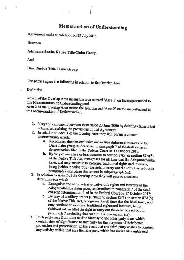
(a) The Dieri People and the Adnyamathanha People have entered into a Memorandum of Understanding between them in the terms of the document comprising the “Annexure A” to Schedule 5, under which both groups agree in particular that:
(i) the Adnyamathanha People hold traditional rights and interests in the Determination Area;
(ii) the Dieri People hold traditional rights and interests in the Adnyamathanha Determination Area;
(b) The Agreement provides that the traditional rights and interests referred to in sub-paragraph (a):
(i) are not native title rights and interests; and
(ii) co-exist with the native title rights and interests.
(c) The State and other Respondent parties are not bound by the Memorandum of Understanding referred to in Paragraph 22(a) but acknowledge that the provisions of relevant State and Commonwealth legislation apply according to their terms from time to time in relation to the Determination Area.
(d) The consent determination made in relation to the Adnyamathanha Determination Area is in the terms of the document comprising Schedule 6.
Note: Entry of orders is dealt with in Rule 39.32 of the Federal Court Rules 2011.
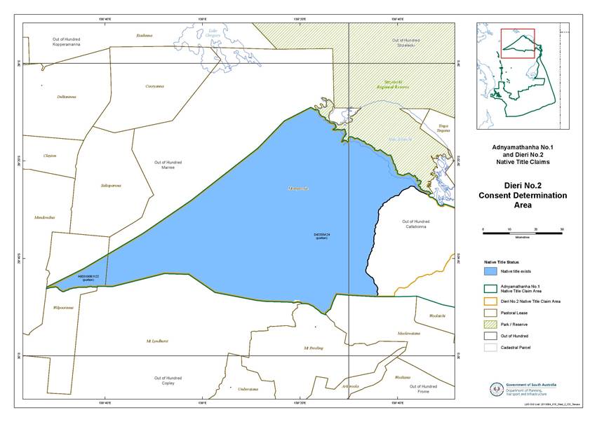
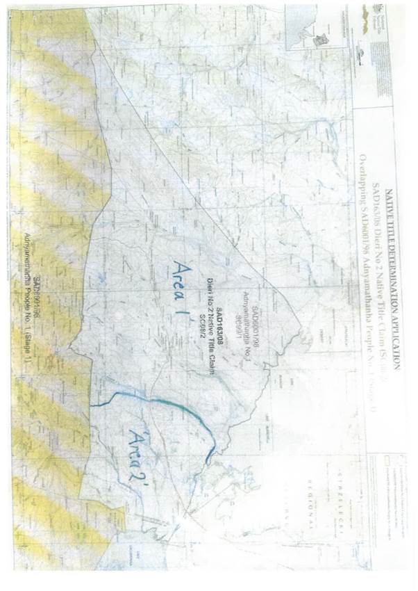
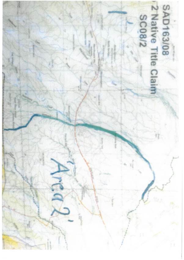
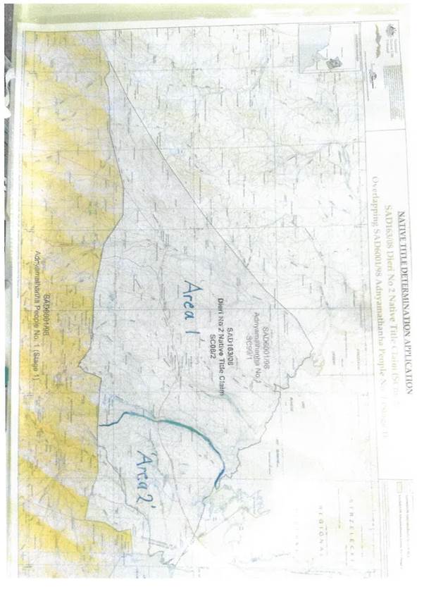
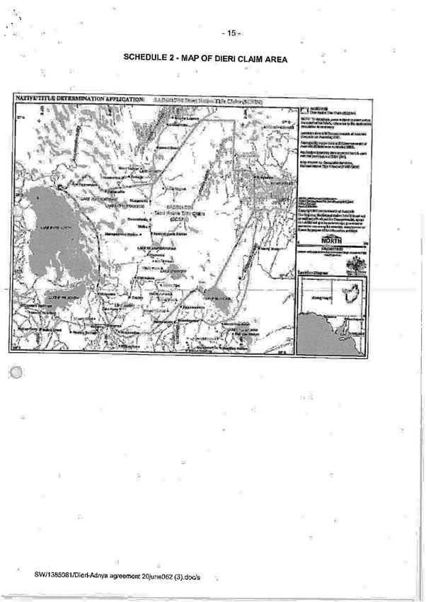
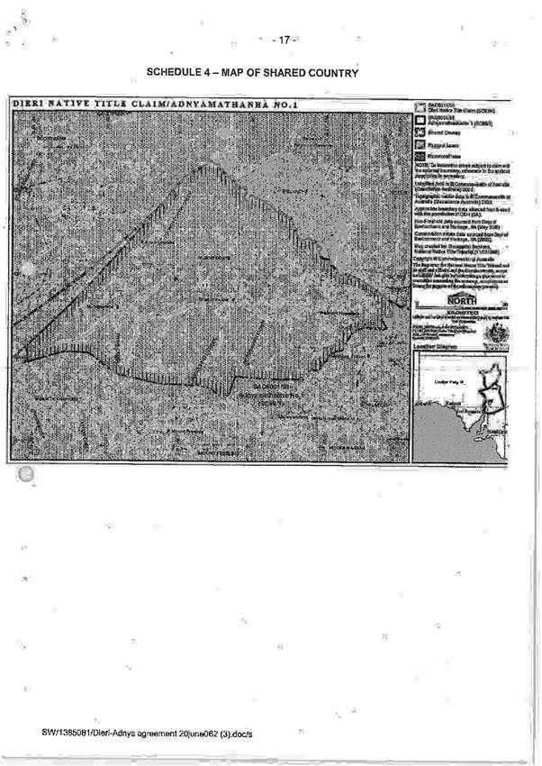
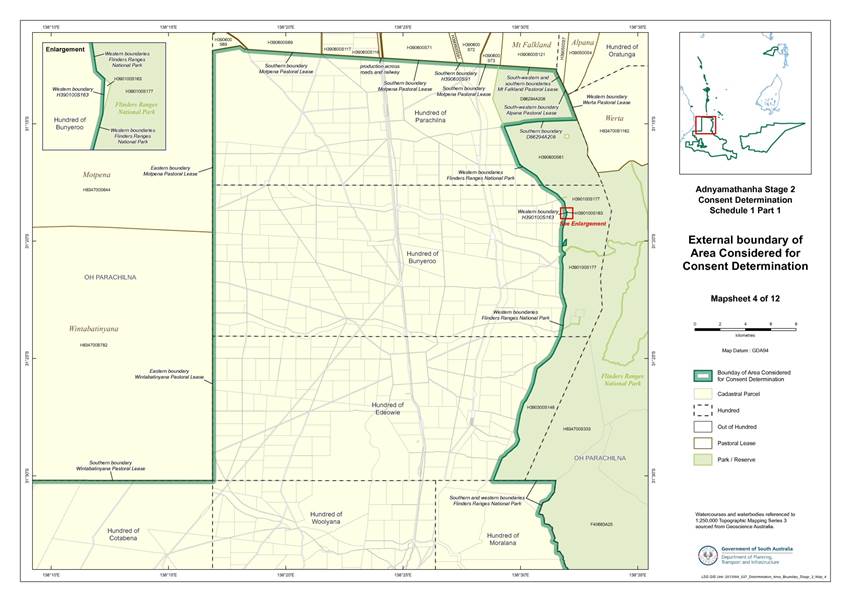
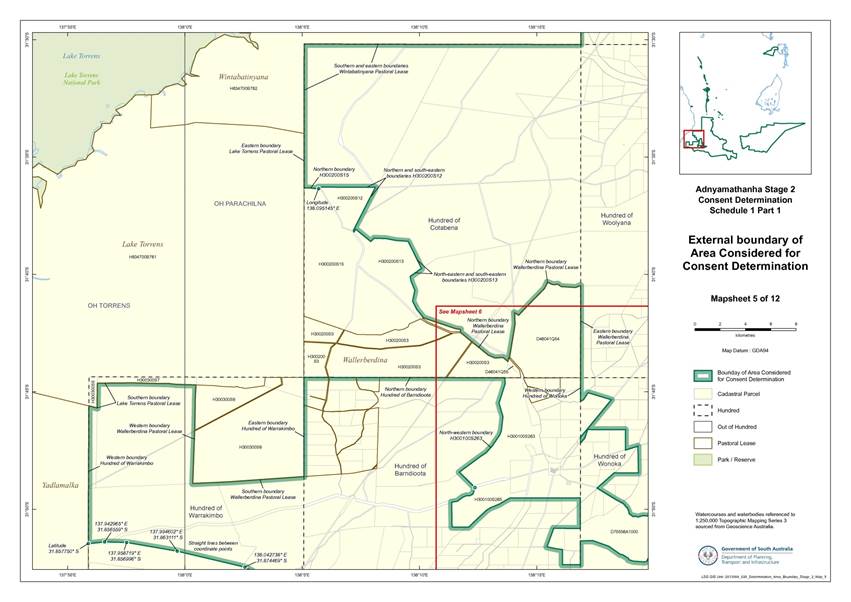
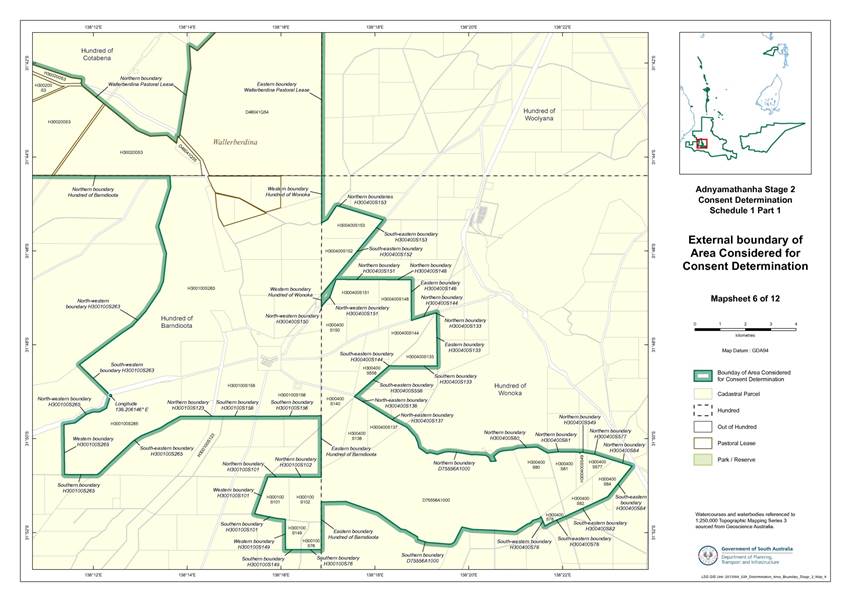
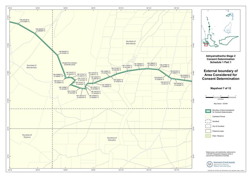
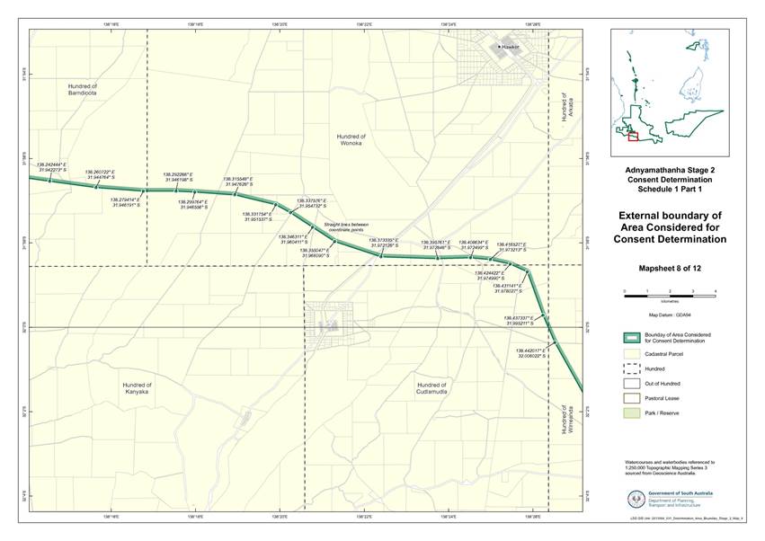
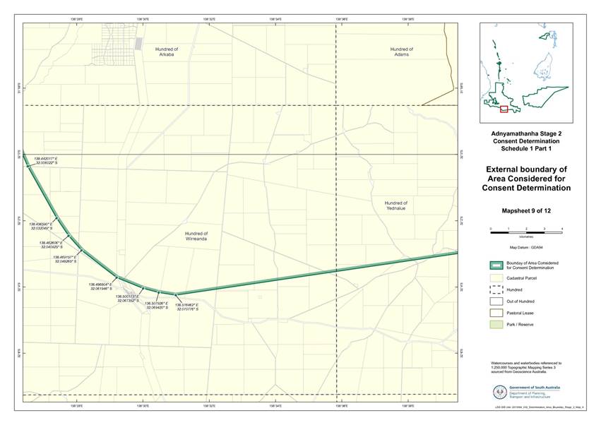
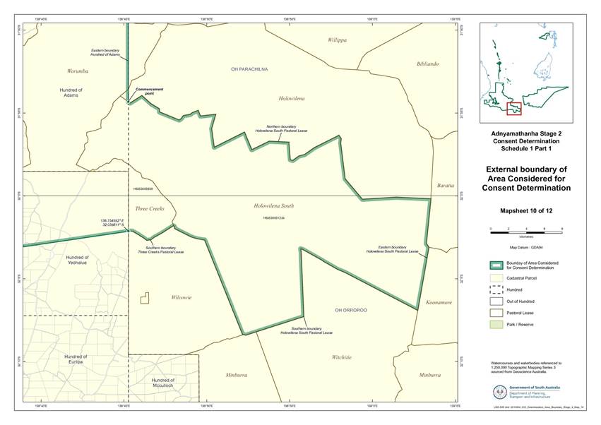
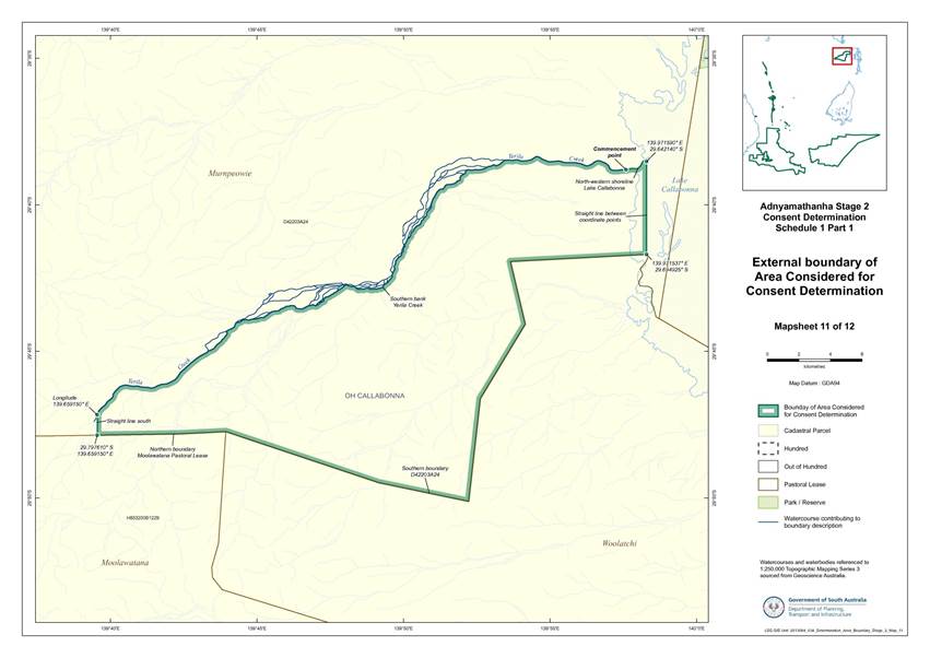
SCHEDULE 1 - Description and Map of the Determination Area
External boundary description
The Determination Area is located wholly within and comprises all the land and waters bounded by the following line:
Commencing at the intersection of the western boundary of Wilpoorinna Pastoral Lease - Block 1122, OH(Marree) with Latitude 29.764891 South; then generally north-easterly in straight lines connecting the following coordinate points
|
Longitude (East) |
Latitude (South) |
|
138.594515 |
29.701424 |
|
138.795702 |
29.581792 |
|
138.961899 |
29.467992 |
|
139.189327 |
29.289997 |
|
139.279715 |
29.196623 |
|
139.370103 |
29.149934 |
|
139.375935 |
29.152852 |
|
139.380983 |
29.156313 |
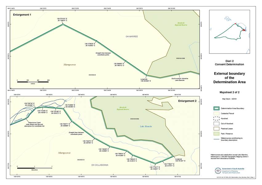
Then south-easterly in a straight line to the intersection of the south-western shoreline of Lake Blanche (Deposited Plan 33310 Allotment 2008) with Longitude 139.384583 East; then generally south-easterly along the said shoreline of Lake Blanche to Longitude 139.781381 East; then generally south-westerly and north-westerly in straight lines connecting the following coordinate points
|
Longitude (East) |
Latitude (South) |
|
139.775627 |
29.447571 |
|
139.771817 |
29.449001 |
|
139.759949 |
29.444512 |
|
139.756934 |
29.442290 |
|
139.748206 |
29.440069 |
|
139.740272 |
29.435784 |
|
139.728371 |
29.426898 |
|
139.723899 |
29.420390 |
|
139.720196 |
29.420072 |
|
139.713450 |
29.419549 |
|
139.709740 |
29.420090 |
The latter coordinate being an intersection with Petermorra Creek. Generally south-westerly and southerly along the said Petermorra Creek, generally being straight lines connecting the following coordinate points
|
Longitude (East) |
Latitude (South) |
|
139.709240 |
29.420750 |
|
139.708550 |
29.421410 |
|
139.707740 |
29.422210 |
|
139.706900 |
29.423030 |
|
139.705700 |
29.424800 |
|
139.704220 |
29.425730 |
|
139.697380 |
29.428440 |
|
139.696990 |
29.428600 |
|
139.694580 |
29.429570 |
|
139.690840 |
29.430690 |
|
139.689520 |
29.431120 |
|
139.688100 |
29.431580 |
|
139.686420 |
29.433140 |
|
139.684450 |
29.433980 |
|
139.682870 |
29.434980 |
|
139.680660 |
29.437250 |
|
139.679080 |
29.439610 |
|
139.679060 |
29.439630 |
|
139.677290 |
29.441540 |
|
139.676000 |
29.443200 |
|
139.675830 |
29.443770 |
|
139.674440 |
29.445040 |
|
139.673520 |
29.447610 |
|
139.671750 |
29.449670 |
|
139.669680 |
29.451820 |
|
139.668220 |
29.452070 |
|
139.666870 |
29.451580 |
|
139.664970 |
29.451540 |
|
139.662200 |
29.452160 |
|
139.660830 |
29.452220 |
|
139.660360 |
29.452240 |
|
139.658250 |
29.452750 |
|
139.655280 |
29.454360 |
|
139.653070 |
29.456460 |
|
139.650360 |
29.457520 |
|
139.647170 |
29.458650 |
|
139.645780 |
29.459280 |
|
139.644420 |
29.459900 |
|
139.641360 |
29.461580 |
|
139.639990 |
29.463990 |
|
139.639530 |
29.464800 |
|
139.638120 |
29.466570 |
|
139.636630 |
29.467160 |
|
139.634020 |
29.468390 |
|
139.632210 |
29.469670 |
|
139.631320 |
29.471810 |
|
139.630420 |
29.473010 |
|
139.628400 |
29.473740 |
|
139.626270 |
29.474390 |
|
139.624980 |
29.475730 |
|
139.624510 |
29.475650 |
|
139.623050 |
29.475560 |
|
139.621640 |
29.475940 |
|
139.620350 |
29.477060 |
|
139.618700 |
29.479070 |
|
139.617970 |
29.479680 |
|
139.615480 |
29.481980 |
|
139.617210 |
29.483500 |
|
139.617210 |
29.484180 |
|
139.616950 |
29.484630 |
|
139.616810 |
29.486210 |
|
139.615780 |
29.487340 |
|
139.614230 |
29.488240 |
|
139.613450 |
29.489360 |
|
139.611770 |
29.489700 |
|
139.611150 |
29.489990 |
|
139.610020 |
29.490970 |
|
139.609310 |
29.492620 |
|
139.608660 |
29.495560 |
|
139.608010 |
29.496120 |
|
139.606320 |
29.496500 |
|
139.605690 |
29.497020 |
|
139.605300 |
29.498480 |
|
139.604780 |
29.498930 |
|
139.603620 |
29.499610 |
|
139.602750 |
29.500890 |
|
139.602190 |
29.502760 |
|
139.601410 |
29.504120 |
|
139.601360 |
29.505550 |
|
139.601780 |
29.507610 |
|
139.601050 |
29.509400 |
|
139.601000 |
29.511110 |
|
139.602470 |
29.513550 |
|
139.603180 |
29.514950 |
|
139.603040 |
29.515860 |
|
139.602650 |
29.516530 |
|
139.602000 |
29.519240 |
|
139.601730 |
29.521830 |
|
139.601340 |
29.522850 |
|
139.601460 |
29.524990 |
|
139.601200 |
29.525330 |
|
139.601200 |
29.526570 |
|
139.600971 |
29.527625 |
|
139.600890 |
29.528000 |
|
139.601050 |
29.531870 |
|
139.600780 |
29.536390 |
|
139.600260 |
29.537740 |
|
139.600000 |
29.538040 |
|
139.598830 |
29.539430 |
|
139.598440 |
29.540220 |
|
139.598310 |
29.541120 |
|
139.598950 |
29.541910 |
|
139.598820 |
29.542700 |
|
139.598040 |
29.544280 |
|
139.596880 |
29.545740 |
|
139.596490 |
29.546640 |
|
139.595450 |
29.547880 |
|
139.593540 |
29.549110 |
|
139.593110 |
29.551260 |
|
139.591370 |
29.552960 |
|
139.591550 |
29.554760 |
|
139.591160 |
29.556000 |
|
139.591330 |
29.557610 |
|
139.591980 |
29.557900 |
|
139.592700 |
29.559160 |
|
139.592570 |
29.559950 |
|
139.591790 |
29.561410 |
|
139.589710 |
29.563890 |
|
139.589190 |
29.565130 |
|
139.589190 |
29.566030 |
|
139.589570 |
29.567160 |
|
139.589180 |
29.569980 |
|
139.589430 |
29.571000 |
|
139.589040 |
29.571900 |
|
139.588390 |
29.572580 |
|
139.587870 |
29.573930 |
|
139.588230 |
29.574800 |
|
139.588960 |
29.575870 |
the latter coordinate being an intersection of the said Petermorra Creek with Wattleowie Creek; then southerly along the said Wattleowie Creek, generally being straight lines connecting the following coordinate points
|
Longitude (East) |
Latitude (South) |
|
139.589150 |
29.576640 |
|
139.589150 |
29.577540 |
|
139.589530 |
29.578450 |
|
139.591070 |
29.580260 |
|
139.591670 |
29.581470 |
|
139.589660 |
29.585220 |
|
139.588340 |
29.585670 |
|
139.587700 |
29.586230 |
|
139.587310 |
29.587020 |
|
139.587300 |
29.587580 |
|
139.586910 |
29.588370 |
|
139.586910 |
29.590180 |
|
139.586390 |
29.591640 |
|
139.586380 |
29.593000 |
|
139.585860 |
29.593900 |
|
139.585990 |
29.594910 |
|
139.585600 |
29.595590 |
|
139.585590 |
29.598180 |
|
139.586350 |
29.600220 |
|
139.586350 |
29.601460 |
|
139.585940 |
29.603260 |
|
139.585430 |
29.606530 |
|
139.584900 |
29.607550 |
|
139.585800 |
29.609470 |
|
139.585680 |
29.611200 |
|
139.585670 |
29.611390 |
|
139.586310 |
29.611780 |
|
139.586310 |
29.613760 |
|
139.586820 |
29.614940 |
|
139.586950 |
29.615230 |
|
139.586550 |
29.616240 |
|
139.586680 |
29.617590 |
|
139.586420 |
29.618380 |
|
139.585800 |
29.619010 |
|
139.583830 |
29.620860 |
|
139.583650 |
29.622530 |
|
139.583940 |
29.623910 |
|
139.583730 |
29.626190 |
|
139.583540 |
29.627740 |
|
139.582370 |
29.629210 |
|
139.582270 |
29.629860 |
|
139.581670 |
29.630110 |
|
139.579780 |
29.631680 |
|
139.578870 |
29.633480 |
|
139.578980 |
29.640260 |
|
139.577940 |
29.642170 |
|
139.576900 |
29.643520 |
|
139.576380 |
29.644760 |
|
139.574820 |
29.646900 |
|
139.574430 |
29.647920 |
|
139.574410 |
29.649600 |
|
139.574250 |
29.650430 |
|
139.573380 |
29.651750 |
|
139.572860 |
29.653330 |
|
139.571560 |
29.654230 |
|
139.570650 |
29.655470 |
|
139.570230 |
29.657620 |
|
139.570120 |
29.659870 |
|
139.569210 |
29.661330 |
|
139.569080 |
29.662120 |
|
139.568810 |
29.665050 |
|
139.568630 |
29.667230 |
|
139.567370 |
29.669790 |
|
139.566780 |
29.670410 |
|
139.565660 |
29.670340 |
|
139.564520 |
29.671610 |
|
139.564320 |
29.673370 |
|
139.565080 |
29.675190 |
|
139.564610 |
29.676610 |
|
139.564960 |
29.679350 |
|
139.565000 |
29.681060 |
|
139.565110 |
29.684220 |
|
139.564850 |
29.684790 |
|
139.564850 |
29.685350 |
|
139.565750 |
29.687500 |
|
139.565740 |
29.688630 |
|
139.564820 |
29.689730 |
|
139.563790 |
29.691550 |
|
139.563790 |
29.692230 |
|
139.563270 |
29.693360 |
|
139.561970 |
29.694480 |
|
139.561580 |
29.695840 |
|
139.560800 |
29.696740 |
|
139.560410 |
29.697640 |
|
139.560400 |
29.700570 |
|
139.559870 |
29.702380 |
|
139.558450 |
29.704180 |
|
139.557920 |
29.706210 |
|
139.558750 |
29.708180 |
|
139.558040 |
29.709140 |
|
139.558030 |
29.710160 |
|
139.559000 |
29.711700 |
|
139.558920 |
29.713660 |
|
139.559180 |
29.714380 |
|
139.560080 |
29.715920 |
|
139.560980 |
29.716710 |
|
139.561630 |
29.717050 |
|
139.562780 |
29.718180 |
|
139.563940 |
29.719760 |
|
139.565230 |
29.720900 |
|
139.566260 |
29.721460 |
|
139.567920 |
29.722660 |
|
139.568320 |
29.723430 |
|
139.570900 |
29.725540 |
|
139.572440 |
29.727350 |
|
139.573860 |
29.728250 |
|
139.574760 |
29.729270 |
|
139.575660 |
29.730060 |
|
139.576820 |
29.730740 |
|
139.577210 |
29.730740 |
|
139.579020 |
29.731540 |
|
139.579660 |
29.732100 |
|
139.581210 |
29.732790 |
|
139.582370 |
29.734140 |
|
139.582750 |
29.735380 |
|
139.583520 |
29.736970 |
|
139.584680 |
29.738550 |
|
139.585580 |
29.740580 |
|
139.586210 |
29.743970 |
|
139.585940 |
29.746790 |
|
139.586031 |
29.747900 |
|
139.586060 |
29.748260 |
|
139.586450 |
29.748930 |
|
139.586450 |
29.749500 |
|
139.587090 |
29.750850 |
|
139.588450 |
29.752640 |
|
139.589410 |
29.754440 |
|
139.590820 |
29.755940 |
|
139.593010 |
29.757410 |
|
139.594560 |
29.758770 |
|
139.595710 |
29.760940 |
|
139.597900 |
29.765100 |
|
139.598540 |
29.766570 |
|
139.599430 |
29.769840 |
|
139.599430 |
29.771190 |
|
139.599170 |
29.772100 |
|
139.598780 |
29.772430 |
|
139.598120 |
29.773670 |
|
139.597860 |
29.775030 |
|
139.597850 |
29.777510 |
|
139.597330 |
29.778520 |
|
139.596290 |
29.779420 |
|
139.596160 |
29.780330 |
|
139.596290 |
29.780350 |
|
139.597580 |
29.781910 |
|
139.597570 |
29.783940 |
|
139.598080 |
29.785070 |
|
139.599110 |
29.786200 |
|
139.599630 |
29.787440 |
|
139.599620 |
29.789140 |
|
139.599360 |
29.790150 |
|
139.598190 |
29.791840 |
|
139.597670 |
29.793190 |
|
139.595330 |
29.795900 |
|
139.593331 |
29.797535 |
the latter coordinate being the southern boundary of Murnpeowie Pastoral Lease – Deposited Plan 42203 Allotment 24; then generally westerly along the southern boundary of the said Allotment 24 to a south-eastern corner of the said Wilpoorinna Pastoral Lease; then generally westerly along the eastern boundary of the said Wilpoorinna Pastoral Lease to its intersection with the centreline of Frome River; then generally westerly along the said centreline of Frome River to its intersection with the western boundary of the said Block 1122, OH(Marree); then northerly along the said western boundary of Block 1122 to the point of commencement.
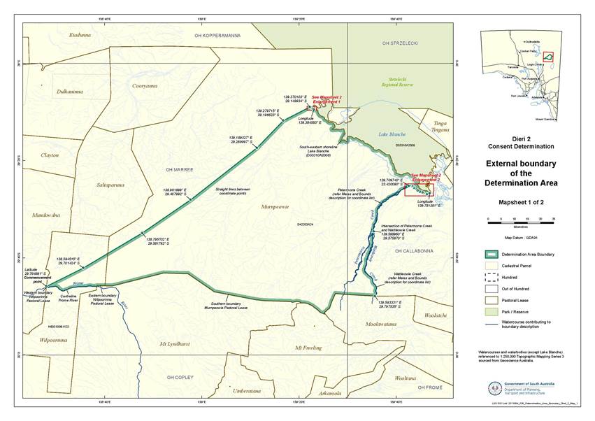
Reference datum
Geographical coordinates have been provided by the NNTT Geospatial services and geographical coordinates are referenced to the Geocentric Datum of Australia 1994 (GDA94), in decimal degrees.
Watercourses and water bodies (except Lake Blanche) referenced to 1:250,000 Topographic Mapping Series 3 – sourced from Geoscience Australia.
Use of Coordinates
Where coordinates are used within the description to represent cadastral or topographical boundaries or the intersection with such, they are intended as a guide only. As an outcome of the custodians of cadastral and topographical data continuously recalculating the geographic position of their data based on improved survey and data maintenance procedures, it is not possible to accurately define such a position other than by detailed ground survey.
SCHEDULE 2 - Areas that have been excluded from the Determination Area
1. The following areas are agreed to have been excluded from the Determination Area by reason of the fact that native title has been extinguished in those areas:
1.1. Any areas in relation to which native title has been extinguished by an act attributable to the State of South Australia pursuant to any of the following sections of the Native Title (South Australia) Act 1994 (SA):
a) Sections 33 and 34 (Category A past acts);
b) Section 35 (Category B past acts that are wholly inconsistent with the continued existence, enjoyment or exercise of any native title rights or interests);
c) Sections 36B and 36C (Category A intermediate period acts);
d) Section 36D (Category B intermediate period acts that are wholly inconsistent with the continued existence, enjoyment or exercise of any native title rights or interests);
e) Sections 36F and 36G (previous exclusive possession acts other than “excepted acts”);
1.2. Any areas in relation to which native title has been extinguished by an act attributable to the Commonwealth of Australia pursuant to any of the following sections of the Native Title Act:
a) Section 15(1)(a), (b) (Category A past acts);
b) Section 15(1)(c) (Category B past acts that are wholly inconsistent with the continued existence, enjoyment or exercise of any native title rights or interests);
c) Section 22B(a), (b) (Category A intermediate period acts);
d) Section 22B(c) (Category B intermediate period acts that are wholly inconsistent with the continued existence, enjoyment or exercise of any native title rights or interests);
e) Sections 23B and 23C (previous exclusive possession acts).
1.3. Any areas in relation to which native title rights and interests have otherwise been wholly extinguished.
2. For the avoidance of doubt and without limiting the above, Native Title has been extinguished in relation to areas in respect of which any of the following acts have been done by the Crown in right of the State of South Australia on or before 23 December 1996:
2.1. Freehold grants (other than pursuant to the Aboriginal Lands Trust Act 1966 (SA));
2.2. Perpetual leases (other than leases which are subject to a reservation or condition expressly for the benefit of Aboriginal people);
2.3. Non-perpetual leases (other than pastoral leases or non-exclusive agricultural leases or leases subject to a reservation or condition expressly for the benefit of Aboriginal people),
where:
2.4. in the case of grants to the Crown or a statutory authority, made prior to 31 October 1975 (or after 1 January 1994, if an “intermediate period act”);
2.5. in the case of grants other than to the Crown or a statutory authority, made prior to 1 January 1994 (or after 1 January 1994, if a “past act” or “intermediate period act”).
3. Native title rights have been extinguished over all roads which have been delineated in a public map pursuant to section 5(d)(II) of the Crown Lands Act 1929 (SA) or sections 70(3) or (4) of the Crown Land Management Act 2009 (SA) or which have otherwise been validly established pursuant to South Australian Statute or common law.
SCHEDULE 3 – The descendants of Dieri Apical Ancestors
The descendants (whether biologically or by adoption) of:
a) Ruby Merrick and Tim Maltalinha (also known as Tim Merrick), who are the parents of the sibling set comprised of Martin, Gottlieb, Rebecca and Selma (or Thelma);
b) Kuriputhanha (known as “Queen Annie”), mother of Karla-warru (also known as Annie);
c) Mary Dixon (born at Killalpaninna), mother of the sibling set comprised of Dear Dear (known as “Tear”), Jack Garret, George Mungerannie, Joe Shaw and Henry;
d) Bertha, mother of the sibling set comprised of Johannes and Susanna;
e) Walter Kennedy, husband of Selma (also known as Thelma) nee Merrick;
f) Florrie, wife of Martin Merrick;
g) Clara Stewart (nee Murray), mother of Eddie Stewart; and
h) The man from Pinngipania (born at Lake Hope) and the woman Kulibani (born at Kalamarina) who are the parents of Sam Tintibana (also known as Dindibana Ginjimilina).
SCHEDULE 4 – Pastoral Leases wholly or partially in the Determination Area
|
Pastoral Lease Name |
Pastoral Lease Number |
Crown Lease Number Volume/Folio |
|
Murnpeowie (part) |
PE 2519 |
CL 1598/37 |
|
Wilpoorinna (part) |
PE 2210 |
CL 1287/6 |
SCHEDULE 5 – The Memorandum of Understanding between the Adnyamathanha People and the Dieri People
“Annexure A”: The Memorandum of Understanding between Adnyamathanha native title claim group and Dieri native title claim group dated 29 July 2013 (varying Agreement dated 20 June 2006 – see “Annexure B”, as redacted).

SCHEDULE 5 – The Memorandum of Understanding between the Adnyamathanha People and the Dieri People
“Annexure B”: Agreement dated 20 June 2006 between Adnyamathanha native title claim group and Dieri native title claim group, with clause 5 redacted.


SCHEDULE 6 – The terms of the Consent Determination to be made in favour of the Adnyamathanha People in the remainder of the Dieri No 2 Claim Area
|
IN THE FEDERAL COURT OF AUSTRALIA |
|
ADNYAMATHANHA NATIVE TITLE CLAIM
|
VINCENT COULTHARD AND OTHERS NAMED IN THE SCHEDULE OF PARTIES Applicant | |
|
AND: |
STATE OF SOUTH AUSTRALIA AND OTHERS NAMED IN THE SCHEDULE OF PARTIES Respondent |
|
DATE OF ORDER: |
|
|
WHERE MADE: |
IKARa |
THE COURT NOTES THAT:
A. This determination covers part of the land and waters which:
(a) are subject to the Dieri No 2 Native Title Determination Application (SAD 163 of 2008) (“the Dieri No 2 Claim”); and
(b) form part of the undetermined area of the Adnyamathanha No 1 Native Title Determination Application (SAD 6001 of 1998) (“the Adnyamathanha claim”) which overlaps the Dieri No 2 Claim.
B. This determination is being made together with a consent determination over the remaining part of the Dieri No 2 claim in favour of the Dieri People.
C. The Parties to this determination (“the Parties”) agree that those areas listed in Schedule 2 are not included in the Determination Area having been excluded by the Applicants’ applications for a determination of native title.
D. The Parties have now reached agreement as to the terms of a determination of native title to be made in relation to the Determination Area. They have filed an agreement in writing with this Court pursuant to section 87A (1) of the Native Title Act 1993 (Cth) (“the Native Title Act”) to seek the making of consent orders for a determination.
E. The Parties acknowledge that the effect of the making of this determination will be that those Adnyamathanha people described in Paragraph 6, in accordance with their traditional laws and customs, will be recognised as the native title holders for the Determination Area.
F. The Parties have agreed that the prospective registered native title body corporate in respect of the Determination Area, Adnyamathanha Traditional Lands Association (Aboriginal Corporation) RNTBC, may have liberty to apply to seek a variation of the determination of native title in this matter, as it relates to pastoral improvements in the Determination Area in the event that the ruling of the Federal Court of Australia in De Rose v South Australia (No 2) [2005] FCAFC 110; (2005) 145 FCR 290 with respect to pastoral improvements is overturned, set aside or otherwise found to be an incorrect legal ruling by the High Court of Australia in the context of an appeal to the High Court of Australia from the decision of the Federal Court of Australia in Brown (on behalf of the Ngarla People) v State of Western Australia [2012] FCAFC 154; (2012) 208 FCR 505.
G. The Parties have requested that the Court make a determination over the Determination Area without a trial.
BY CONSENT THE COURT MAKES THE FOLLOWING DETERMINATION OF NATIVE TITLE PURSUANT TO SECTION 87A OF THE NATIVE TITLE ACT:
1. In this determination including its schedules, unless the contrary intention appears, the words and expressions used have the same meaning as they are given in Part 15 of the Native Title Act.
2. In this determination:
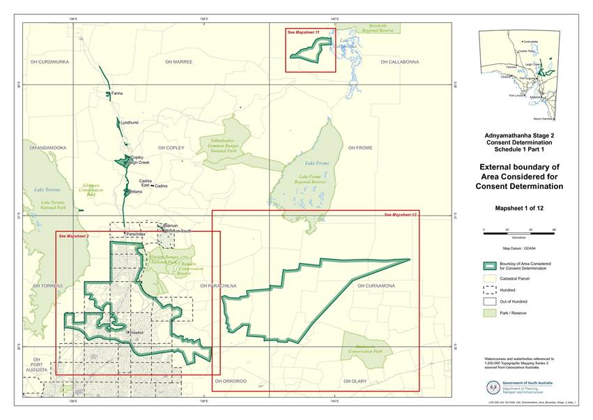
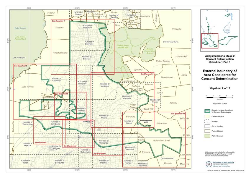
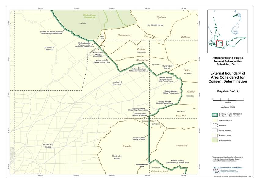
2.1 “Determination Area” means that part of the land and waters of the Dieri No 2 Claim and the overlapping part of the Adnyamathanha No 1 claim as is described in Schedule 1 (and shown in the maps forming part of that Schedule), apart from those excluded areas which are described in Paragraph 16 and in Schedule 2 (“excluded areas”);
2.2 “Dieri Determination Area” means the area of the consent determination being made in favour of the Dieri people over the remaining area of the Dieri No.2 claim.
3. In this determination including its schedules, in the event of an inconsistency between a description of an area in a schedule and the depiction of that area on the map in Schedule 1, the written description shall prevail.
Existence of Native Title
4. Subject to Paragraphs 12 to 16 herein, native title exists in the Determination Area.
5. Native title does not exist in relation to the areas and resources described in Paragraphs 12, 15 and 16 herein.
The Native Title Holders
6. The Native Title Holders in relation to the Determination Area are those living Aboriginal persons who are described in Schedule 3 who:
6.1 identify as Adnyamathanha; and
6.2 are recognised by other Native Title Holders under the relevant Adnyamathanha traditional laws and customs as having maintained an affiliation with, and continuing to hold native title rights and interests in the Determination Area.
Native title rights and interests
7. Subject to Paragraphs 8, 9 and 10, the nature and extent of the native title rights and interests held by the Native Title Holders are rights to use, stay on and enjoy the land and waters of the Determination Area, being:
7.1 The right to access and move about the Determination Area;
7.2 The right to live, to camp and to erect shelters on the Determination Area;
7.3 The right to hunt and fish on the Determination Area;
7.4 The right to gather and use the natural resources of the Determination Area such as food, plants, timber, resin, ochre and soil;
7.5 The right to cook and to light fires for cooking and camping purposes on the Determination Area;
7.6 The right to use the natural water resources of the Determination Area;
7.7 The right to distribute, trade or exchange the natural resources of the Determination Area;
7.8 The right to conduct ceremonies and hold meetings on the Determination Area;
7.9 The right to engage and participate in cultural activities on the Determination Area including those relating to births and deaths;
7.10 The right to carry out and maintain burials of deceased native title holders and of their ancestors within the Determination Area;
7.11 The right to teach on the Determination Area the physical and spiritual attributes of locations and sites within the Determination Area;
7.12 The right to visit, maintain and preserve sites and places of cultural or spiritual significance to Native Title Holders within the Determination Area;
7.13 The right to speak for and make decisions in relation to the Determination Area about the use and enjoyment of the Determination Area by Aboriginal people who recognise themselves to be governed by the traditional laws and customs acknowledged by the Native Title Holders of the Determination Area;
7.14 The right to be accompanied on to the Determination Area by those people who, though not Native Title Holders, are:
7.14.1 spouses of Native Title Holders; or
7.14.2 people required by traditional law and custom for the performance of ceremonies or cultural activities on the Determination Area; or
7.14.3 people who have rights in relation to the Determination Area according to the traditional laws and customs acknowledged by the Native Title Holders.
8. The native title rights and interests described in Paragraph 7 do not confer possession, occupation, use and enjoyment of the Determination Area on the Native Title Holders to the exclusion of others.
9. The native title rights and interests are for personal, domestic and non-commercial communal use.
10. The native title rights and interests are subject to and exercisable in accordance with:
10.1 the traditional laws and customs of the Native Title Holders;
10.2 the valid laws of the State and Commonwealth, including the common law.
For the avoidance of doubt, the native title rights and interests expressed in Paragraph 7(f) are subject to the Natural Resources Management Act 2004 (SA).
Nature and extent of other rights and interests and Relationship with Native Title
11. The nature and extent of other rights and interests in relation to the Determination Area are:
11.1 The rights and interests within the Determination Area created by the pastoral leases described in Schedule 4;
11.2 the interests of the Crown in right of the State of South Australia;
11.3 the interests of persons to whom valid or validated rights and interests have been granted or recognised by the Crown in right of the State of South Australia or by the Commonwealth of Australia pursuant to statute or otherwise in the exercise of executive power;
11.4 rights or interests held by reason of the force and operation of the laws of the State or of the Commonwealth;
11.5 the rights to access land by an employee or agent or instrumentality of the State, Commonwealth or other statutory authority as required in the performance of his or her statutory or common law duties (in accordance with any valid legislation);
11.6 the rights and interests of Telstra Corporation Limited:
11.6.1 as the owner or operator of telecommunications facilities within the Determination Area;
11.6.2 created pursuant to the Post and Telegraph Act 1901 (Cth), the Telecommunications Act 1975 (Cth), the Australian Telecommunications Corporation Act 1989 (Cth), the Telecommunications Act 1991 (Cth) and the Telecommunications Act 1997 (Cth), including:
(4) to inspect land;
(5) to install and operate existing and new telecommunications facilities;
(6) to alter, remove, replace, maintain, repair and ensure the proper functioning of its existing and any new telecommunications facilities, including cabling, customer terminal sites and ancillary facilities; and
(i) for its employees, agents or contractors to enter the Determination Area to access its facilities, in and in the vicinity of, the Determination Area in the performance of their duties;
(ii) under any leases, licences, access agreements or easements relating to its telecommunications facilities in the Determination Area;
(e) the rights and interests of Epic Energy South Australia Pty Ltd (formerly Tenneco Gas South Australia Pty Ltd) (“Epic”):
(i) as:
(A) holders of Pipeline Licence No. 1 (PL1) issued pursuant to the Petroleum Act 1940 (SA) on 12 March 1969 and renewed on 27 March 1990 pursuant to the Petroleum Act 1940 (SA) and continuing in force by the operation of clause 2 of the Schedule to the Petroleum Act 2000 (SA); and
(B) owner of the pipeline the subject thereof by virtue of having been a purchaser of the pipeline (as purchaser is defined in section 16 of the Natural Gas Authority Act 1967 (SA) as amended by the Pipelines Authority (Sale of Pipelines) Amendment Act 1995 (SA) (“Sale Legislation”) from the former Pipeline Authority of South Australia (“PASA”), now the Natural Gas Authority of South Australia (“NGASA”) pursuant to a Sale Agreement dated 30 June 1995 under the Sale Legislation;
(ii) where the licensed pipeline was established pursuant to the Natural Gas Authority Act 1967 (SA) and is located within a statutory easement established by section 9 of the Sale Legislation and section 28 of the Sale Legislation provides:
“(1) The creation of the statutory easement under this Act, or the grant of a pipeline lease, does not affect any native title that may exist in the land to which the easement or lease relates.
(2) The statutory easement or a pipeline lease under this Act does not derogate from pre-existing rights of Aboriginal people to enter, travel across or stay on land subject to the easement or lease.”;
(iii) the statutory easement entitles Epic, inter alia, to install, maintain and operate the pipeline and to carry out authorised purposes including the installation, operation, inspection, extension, alteration, repair and removal of the pipeline or associated equipment and the carrying out of maintenance work on the pipeline or associated equipment;
(iv) for Epic, its employees, agents and contractors (or any of them) to enter the Determination Area to access Epic’s rights and interests and to do all things necessary to exercise those rights and interests and perform all obligations in the vicinity of the Determination Area in performance of their duties;
(f) the rights and interests of the “Producers” as defined in the Cooper Basin (Ratification) Act 1975 (SA):
(i) as holders of Pipeline Licence No.2 (PL2) granted to the Producers on 26 November 1981 under the Petroleum Act 1940 (SA) and renewed on 3 May 2003 under the Petroleum Act 2000 (SA) and continuing in force by the operation of clause 2 of the Schedule to the Petroleum Act 2000 (SA);
(ii) created pursuant to the Stoney Point (Liquids Project) Ratification Act 1981 (SA);
(iii) granted to the Producers pursuant to the former PASA (now NGASA) and the Producers’ Right of Way Agreement dated 26 November 1981;
(iv) for the Producers’ employees, agents or contractors to enter the Determination Area to access the Producers’ rights and interests and to do all things necessary to exercise those rights and interests in the vicinity of the Determination Area in performance of their duties.
12. Native title rights and interests do not exist in respect of those parts of the Determination Area being any house, shed or other building or airstrip or any dam or other stock watering point constructed pursuant to the pastoral leases referred to in Paragraph 11(a). These areas comprise the land on which the improvements of the kind referred to herein have been constructed prior to the date hereof and include any adjacent land or waters the exclusive use of which is necessary for the enjoyment of the improvements referred to.
13. For the avoidance of doubt, Paragraph 12 does not preclude the possibility of further extinguishment, according to law, of native title over other limited parts of the Determination Area by reason of the construction of new pastoral improvements of the kind referred to in Paragraph 12 after the date of this determination.
14. Subject to Paragraph 15, the relationship between the native title rights and interests in the Determination Area that are described in Paragraph 7 and the other rights and interests that are referred to in Paragraph 11 (“the Other rights and interests”) is that:
(a) the Other rights and interests co-exist with the native title rights and interests;
(b) in the event of inconsistency, the Other rights and interests prevail over the native title rights and interests and any exercise of the native title rights and interests, but do not extinguish them; and
(c) the existence of the native title rights and interests does not prevent the doing of any activity required or permitted to be done by, in accordance with or under the Other rights and interests.
15. Native title rights and interests do not exist in:
(a) Minerals, as defined in section 6 of the Mining Act 1971 (SA); or
(b) Petroleum, as defined in section 4 of the Petroleum and Geothermal Energy Act 2000 (SA); or
(c) a naturally occurring underground accumulation of a regulated substance as defined in section 4 of the Petroleum and Geothermal Energy Act 2000 (SA), below a depth of 100 metres from the surface of the earth; or
(d) a natural reservoir, as defined in section 4 of the Petroleum and Geothermal Energy Act 2000 (SA), below a depth of 100 metres from the surface of the earth;
(e) geothermal energy, as defined in section 4 of the Petroleum and Geothermal Energy Act 2000 (SA) the source of which is below a depth of 100 metres from the surface of the earth.
For the purposes of this Paragraph 15 and the avoidance of doubt:
(i) a geological structure (in whole or in part) on or at the earth's surface or a natural cavity which can be accessed or entered by a person through a natural opening in the earth's surface, is not a natural reservoir;
(ii) thermal energy contained in a hot or natural spring is not geothermal energy as defined in section 4 of the Petroleum and Geothermal Energy Act 2000 (SA);
(iii) the absence from this order of any reference to a natural reservoir or a naturally occurring accumulation of a regulated substance, as those terms are defined in section 4 of the Petroleum and Geothermal Energy Act 2000 (SA), above a depth 100 metres below the surface of the earth or geothermal energy the source of which is above a depth of 100 metres below the surface of the earth is not, of itself, to be taken as an indication of the existence or otherwise of native title rights or interests in such natural reservoir, naturally occurring accumulation of a regulated substance or geothermal energy.
16. Native title rights do not exist in the areas covered by public works attributable to the State or Commonwealth (including the land defined in section 251D of the Native Title Act) which were constructed, established or situated prior to 23 December 1996 or commenced to be constructed or established on or before that date.
17. Public works constructed, established or situated after 23 December 1996 have had such effect on native title rights and interests as has resulted from Part 2 Division 3 of the Native Title Act.
AND THE COURT MAKES THE FOLLOWING FURTHER ORDERS:
18. The native title is not to be held in trust.
19. In respect of the Determination Area, Adnyamathanha Traditional Lands Association (Aboriginal Corporation) RNTBC is to:
(a) be the prescribed body corporate for the purposes of section 57(2) of the Native Title Act; and
(b) perform the functions mentioned in section 57(3) of the Native Title Act after becoming the registered native title body corporate in relation to Part 1 of the Determination Area.
20. The Native Title Holders (through Adnyamathanha Traditional Lands Association (Aboriginal Corporation) RNTBC), the State or any other Respondent have liberty to apply on 14 days’ notice to a single judge of the Court for the following purposes:
20.1 to establish the precise location and boundaries of any public works and adjacent land and waters referred to in Paragraphs 16 and 17 of this Order;
20.2 to establish the effect on native title rights and interests of any public works referred to in Paragraph 17 of this Order; or
20.3 to determine whether any particular area is included in the description in Paragraph 12 or Schedule 2 of this Order.
20.4 to address, if appropriate, any changes to paragraphs 12 and 13 above in light of the decision of the High Court of Australia in State of Western Australia v Brown & Others (No P37 of 2012 HCA) as it relates to pastoral improvements.
AND THE COURT MAKES THE FOLLOWING ANCILLARY ORDERS PURSUANT TO SECTION 87A(5) OF THE NATIVE TITLE ACT:
22. The Court notes in relation to the Determination Area as follows:
(a) The Dieri People and the Adnyamathanha People have entered into a Memorandum of Understanding between them in the terms of the document comprising the “Annexure A” to Schedule 5, under which both groups agree in particular that:
(i) the Adnyamathanha People hold traditional rights and interests in the Dieri Determination Area;
(ii) the Dieri People hold traditional rights and interests in the Determination Area;
(b) The Agreement provides that the traditional rights and interests referred to in sub-paragraph (a):
(i) are not native title rights and interests; and
(ii) co-exist with the native title rights and interests.
(a) The State and other Respondent parties are not bound by the Memorandum of Understanding referred to in Paragraph 21(a) but acknowledge that the provisions of relevant State and Commonwealth legislation apply according to their terms from time to time in relation to the Determination Area.
(b) The consent determination made [or expected to be made] in relation to the Dieri Determination Area is in the terms of the document comprising Schedule 6.
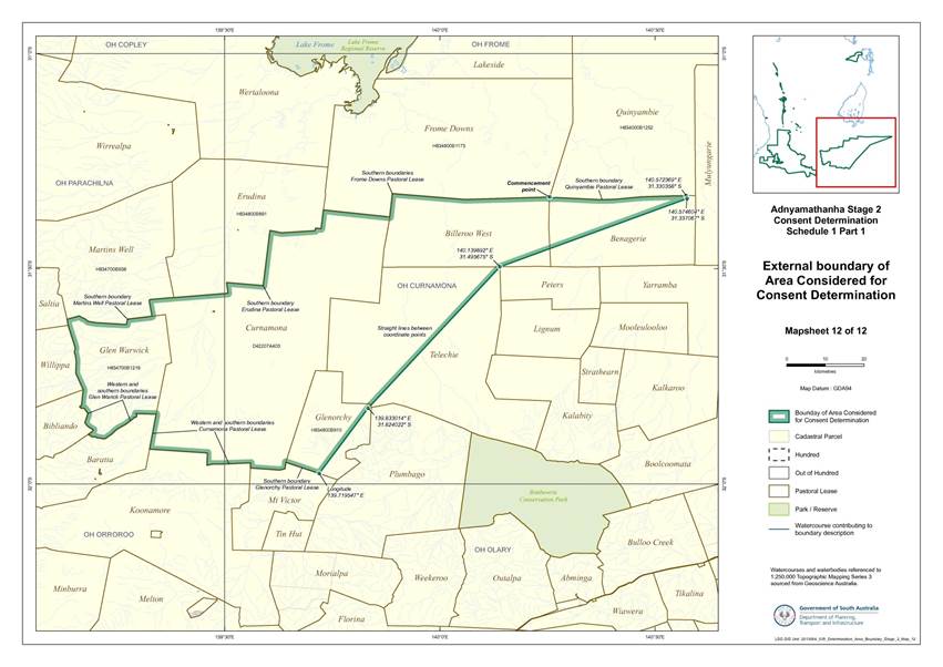
SCHEDULE 1 - Description and Map of the Determination Area
External boundary description
The Determination Area is located wholly within and comprises all the land and waters bounded by the following line:
That portion within the external boundary of Allotment 24 in Deposited Plan 42203 as follows; commencing at Longitude 139.771817 East Latitude 29.449001 South; then generally south-easterly in straight lines connecting the following coordinate points
|
Longitude (East) |
Latitude (South) |
|
139.778008 |
29.456626 |
|
139.786104 |
29.457580 |
|
139.798726 |
29.466526 |
|
139.800913 |
29.467984 |
|
139.803100 |
29.474550 |
|
139.806745 |
29.481845 |
|
139.814763 |
29.486951 |
|
139.822053 |
29.485491 |
|
139.823510 |
29.480385 |
|
139.833677 |
29.482455 |
|
139.888386 |
29.502268 |
|
139.919003 |
29.518316 |
|
139.948160 |
29.537281 |
|
139.972215 |
29.553329 |
|
139.995541 |
29.567919 |
Then in a straight line south-easterly to the intersection of the north-western shoreline of Lake Callabonna with Longitude 139.997650 East; then generally south-westerly along the said shoreline of Lake Callabonna to its intersection with the southern bank of Yerila Creek; then generally south-westerly along the said southern bank of Yerila Creek to its intersection with Longitude 139.659150 East; then south to the intersection of the northern boundary of Moolawatana Pastoral Lease - Block 1229, OH(Callabonna) with Longitude 139.659150 East; then westerly along the northern boundary of the said Block 1229, OH (Marree & Callabonna) to its intersection with Wattleowie Creek at Longitude 139.593331 East; then generally northerly along Wattleowie Creek, generally being straight lines connecting the following coordinate points
|
Longitude (East) |
Latitude (South) |
|
139.595330 |
29.795900 |
|
139.597670 |
29.793190 |
|
139.598190 |
29.791840 |
|
139.599360 |
29.790150 |
|
139.599620 |
29.789140 |
|
139.599630 |
29.787440 |
|
139.599110 |
29.786200 |
|
139.598080 |
29.785070 |
|
139.597570 |
29.783940 |
|
139.597580 |
29.781910 |
|
139.596290 |
29.780350 |
|
139.596160 |
29.780330 |
|
139.596290 |
29.779420 |
|
139.597330 |
29.778520 |
|
139.597850 |
29.777510 |
|
139.597860 |
29.775030 |
|
139.598120 |
29.773670 |
|
139.598780 |
29.772430 |
|
139.599170 |
29.772100 |
|
139.599430 |
29.771190 |
|
139.599430 |
29.769840 |
|
139.598540 |
29.766570 |
|
139.597900 |
29.765100 |
|
139.595710 |
29.760940 |
|
139.594560 |
29.758770 |
|
139.593010 |
29.757410 |
|
139.590820 |
29.755940 |
|
139.589410 |
29.754440 |
|
139.588450 |
29.752640 |
|
139.587090 |
29.750850 |
|
139.586450 |
29.749500 |
|
139.586450 |
29.748930 |
|
139.586060 |
29.748260 |
|
139.586031 |
29.747900 |
|
139.585940 |
29.746790 |
|
139.586210 |
29.743970 |
|
139.585580 |
29.740580 |
|
139.584680 |
29.738550 |
|
139.583520 |
29.736970 |
|
139.582750 |
29.735380 |
|
139.582370 |
29.734140 |
|
139.581210 |
29.732790 |
|
139.579660 |
29.732100 |
|
139.579020 |
29.731540 |
|
139.577210 |
29.730740 |
|
139.576820 |
29.730740 |
|
139.575660 |
29.730060 |
|
139.574760 |
29.729270 |
|
139.573860 |
29.728250 |
|
139.572440 |
29.727350 |
|
139.570900 |
29.725540 |
|
139.568320 |
29.723430 |
|
139.567920 |
29.722660 |
|
139.566260 |
29.721460 |
|
139.565230 |
29.720900 |
|
139.563940 |
29.719760 |
|
139.562780 |
29.718180 |
|
139.561630 |
29.717050 |
|
139.560980 |
29.716710 |
|
139.560080 |
29.715920 |
|
139.559180 |
29.714380 |
|
139.558920 |
29.713660 |
|
139.559000 |
29.711700 |
|
139.558030 |
29.710160 |
|
139.558040 |
29.709140 |
|
139.558750 |
29.708180 |
|
139.557920 |
29.706210 |
|
139.558450 |
29.704180 |
|
139.559870 |
29.702380 |
|
139.560400 |
29.700570 |
|
139.560410 |
29.697640 |
|
139.560800 |
29.696740 |
|
139.561580 |
29.695840 |
|
139.561970 |
29.694480 |
|
139.563270 |
29.693360 |
|
139.563790 |
29.692230 |
|
139.563790 |
29.691550 |
|
139.564820 |
29.689730 |
|
139.565740 |
29.688630 |
|
139.565750 |
29.687500 |
|
139.564850 |
29.685350 |
|
139.564850 |
29.684790 |
|
139.565110 |
29.684220 |
|
139.565000 |
29.681060 |
|
139.564960 |
29.679350 |
|
139.564610 |
29.676610 |
|
139.565080 |
29.675190 |
|
139.564320 |
29.673370 |
|
139.564520 |
29.671610 |
|
139.565660 |
29.670340 |
|
139.566780 |
29.670410 |
|
139.567370 |
29.669790 |
|
139.568630 |
29.667230 |
|
139.568810 |
29.665050 |
|
139.569080 |
29.662120 |
|
139.569210 |
29.661330 |
|
139.570120 |
29.659870 |
|
139.570230 |
29.657620 |
|
139.570650 |
29.655470 |
|
139.571560 |
29.654230 |
|
139.572860 |
29.653330 |
|
139.573380 |
29.651750 |
|
139.574250 |
29.650430 |
|
139.574410 |
29.649600 |
|
139.574430 |
29.647920 |
|
139.574820 |
29.646900 |
|
139.576380 |
29.644760 |
|
139.576900 |
29.643520 |
|
139.577940 |
29.642170 |
|
139.578980 |
29.640260 |
|
139.578870 |
29.633480 |
|
139.579780 |
29.631680 |
|
139.581670 |
29.630110 |
|
139.582270 |
29.629860 |
|
139.582370 |
29.629210 |
|
139.583540 |
29.627740 |
|
139.583730 |
29.626190 |
|
139.583940 |
29.623910 |
|
139.583650 |
29.622530 |
|
139.583830 |
29.620860 |
|
139.585800 |
29.619010 |
|
139.586420 |
29.618380 |
|
139.586680 |
29.617590 |
|
139.586550 |
29.616240 |
|
139.586950 |
29.615230 |
|
139.586820 |
29.614940 |
|
139.586310 |
29.613760 |
|
139.586310 |
29.611780 |
|
139.585670 |
29.611390 |
|
139.585680 |
29.611200 |
|
139.585800 |
29.609470 |
|
139.584900 |
29.607550 |
|
139.585430 |
29.606530 |
|
139.585940 |
29.603260 |
|
139.586350 |
29.601460 |
|
139.586350 |
29.600220 |
|
139.585590 |
29.598180 |
|
139.585600 |
29.595590 |
|
139.585990 |
29.594910 |
|
139.585860 |
29.593900 |
|
139.586380 |
29.593000 |
|
139.586390 |
29.591640 |
|
139.586910 |
29.590180 |
|
139.586910 |
29.588370 |
|
139.587300 |
29.587580 |
|
139.587310 |
29.587020 |
|
139.587700 |
29.586230 |
|
139.588340 |
29.585670 |
|
139.589660 |
29.585220 |
|
139.591670 |
29.581470 |
|
139.591070 |
29.580260 |
|
139.589530 |
29.578450 |
|
139.589150 |
29.577540 |
|
139.589150 |
29.576640 |
|
139.588960 |
29.575870 |
the latter coordinate being an intersection of the said Wattleowie Creek with Petermorra Creek; then generally northerly along the said Petermorra Creek, generally being straight lines connecting the following coordinate points
|
Longitude (East) |
Latitude (South) |
|
139.588230 |
29.574800 |
|
139.587870 |
29.573930 |
|
139.588390 |
29.572580 |
|
139.589040 |
29.571900 |
|
139.589430 |
29.571000 |
|
139.589180 |
29.569980 |
|
139.589570 |
29.567160 |
|
139.589190 |
29.566030 |
|
139.589190 |
29.565130 |
|
139.589710 |
29.563890 |
|
139.591790 |
29.561410 |
|
139.592570 |
29.559950 |
|
139.592700 |
29.559160 |
|
139.591980 |
29.557900 |
|
139.591330 |
29.557610 |
|
139.591160 |
29.556000 |
|
139.591550 |
29.554760 |
|
139.591370 |
29.552960 |
|
139.593110 |
29.551260 |
|
139.593540 |
29.549110 |
|
139.595450 |
29.547880 |
|
139.596490 |
29.546640 |
|
139.596880 |
29.545740 |
|
139.598040 |
29.544280 |
|
139.598820 |
29.542700 |
|
139.598950 |
29.541910 |
|
139.598310 |
29.541120 |
|
139.598440 |
29.540220 |
|
139.598830 |
29.539430 |
|
139.600000 |
29.538040 |
|
139.600260 |
29.537740 |
|
139.600780 |
29.536390 |
|
139.601050 |
29.531870 |
|
139.600890 |
29.528000 |
|
139.600971 |
29.527625 |
|
139.601200 |
29.526570 |
|
139.601200 |
29.525330 |
|
139.601460 |
29.524990 |
|
139.601340 |
29.522850 |
|
139.601730 |
29.521830 |
|
139.602000 |
29.519240 |
|
139.602650 |
29.516530 |
|
139.603040 |
29.515860 |
|
139.603180 |
29.514950 |
|
139.602470 |
29.513550 |
|
139.601000 |
29.511110 |
|
139.601050 |
29.509400 |
|
139.601780 |
29.507610 |
|
139.601360 |
29.505550 |
|
139.601410 |
29.504120 |
|
139.602190 |
29.502760 |
|
139.602750 |
29.500890 |
|
139.603620 |
29.499610 |
|
139.604780 |
29.498930 |
|
139.605300 |
29.498480 |
|
139.605690 |
29.497020 |
|
139.606320 |
29.496500 |
|
139.608010 |
29.496120 |
|
139.608660 |
29.495560 |
|
139.609310 |
29.492620 |
|
139.610020 |
29.490970 |
|
139.611150 |
29.489990 |
|
139.611770 |
29.489700 |
|
139.613450 |
29.489360 |
|
139.614230 |
29.488240 |
|
139.615780 |
29.487340 |
|
139.616810 |
29.486210 |
|
139.616950 |
29.484630 |
|
139.617210 |
29.484180 |
|
139.617210 |
29.483500 |
|
139.615480 |
29.481980 |
|
139.617970 |
29.479680 |
|
139.618700 |
29.479070 |
|
139.620350 |
29.477060 |
|
139.621640 |
29.475940 |
|
139.623050 |
29.475560 |
|
139.624510 |
29.475650 |
|
139.624980 |
29.475730 |
|
139.626270 |
29.474390 |
|
139.628400 |
29.473740 |
|
139.630420 |
29.473010 |
|
139.631320 |
29.471810 |
|
139.632210 |
29.469670 |
|
139.634020 |
29.468390 |
|
139.636630 |
29.467160 |
|
139.638120 |
29.466570 |
|
139.639530 |
29.464800 |
|
139.639990 |
29.463990 |
|
139.641360 |
29.461580 |
|
139.644420 |
29.459900 |
|
139.645780 |
29.459280 |
|
139.647170 |
29.458650 |
|
139.650360 |
29.457520 |
|
139.653070 |
29.456460 |
|
139.655280 |
29.454360 |
|
139.658250 |
29.452750 |
|
139.660360 |
29.452240 |
|
139.660830 |
29.452220 |
|
139.662200 |
29.452160 |
|
139.664970 |
29.451540 |
|
139.666870 |
29.451580 |
|
139.668220 |
29.452070 |
|
139.669680 |
29.451820 |
|
139.671750 |
29.449670 |
|
139.673520 |
29.447610 |
|
139.674440 |
29.445040 |
|
139.675830 |
29.443770 |
|
139.676000 |
29.443200 |
|
139.677290 |
29.441540 |
|
139.679060 |
29.439630 |
|
139.679080 |
29.439610 |
|
139.680660 |
29.437250 |
|
139.682870 |
29.434980 |
|
139.684450 |
29.433980 |
|
139.686420 |
29.433140 |
|
139.688100 |
29.431580 |
|
139.689520 |
29.431120 |
|
139.690840 |
29.430690 |
|
139.694580 |
29.429570 |
|
139.696990 |
29.428600 |
|
139.697380 |
29.428440 |
|
139.704220 |
29.425730 |
|
139.705700 |
29.424800 |
|
139.706900 |
29.423030 |
|
139.707740 |
29.422210 |
|
139.708550 |
29.421410 |
|
139.709240 |
29.420750 |
|
139.709740 |
29.420090 |
Then generally south-easterly in straight lines connecting the following coordinate points
|
Longitude (East) |
Latitude (South) |
|
139.713450 |
29.419549 |
|
139.720196 |
29.420072 |
|
139.723899 |
29.420390 |
|
139.728371 |
29.426898 |
|
139.740272 |
29.435784 |
|
139.748206 |
29.440069 |
|
139.756934 |
29.442290 |
|
139.759949 |
29.444512 |
|
139.771817 |
29.449001 |
The latter coordinate being the point of commencement.
Reference datum
Geographical coordinates have been provided by the NNTT Geospatial services and geographical coordinates are referenced to the Geocentric Datum of Australia 1994 (GDA94), in decimal degrees.
Watercourses and waterbodies (except Lake Blanche) referenced to 1:250,000 Topographic Mapping Series 3 – sourced from Geoscience Australia.
Use of Coordinates
Where coordinates are used within the description to represent cadastral or topographical boundaries or the intersection with such, they are intended as a guide only. As an outcome of the custodians of cadastral and topographical data continuously recalculating the geographic position of their data based on improved survey and data maintenance procedures, it is not possible to accurately define such a position other than by detailed ground survey.
SCHEDULE 2 - Areas that have been excluded from the Determination Area
1. The following areas are agreed to have been excluded from the Determination Area by reason of the fact that native title has been extinguished in those areas:
1.1. Any areas in relation to which native title has been extinguished by an act attributable to the State of South Australia pursuant to any of the following sections of the Native Title (South Australia) Act 1994 (SA):
a) Sections 33 and 34 (Category A past acts);
b) Section 35 (Category B past acts that are wholly inconsistent with the continued existence, enjoyment or exercise of any native title rights or interests);
c) Sections 36B and 36C (Category A intermediate period acts);
d) Section 36D (Category B intermediate period acts that are wholly inconsistent with the continued existence, enjoyment or exercise of any native title rights or interests);
e) Sections 36F and 36G (previous exclusive possession acts other than “excepted acts”);
1.2. Any areas in relation to which native title has been extinguished by an act attributable to the Commonwealth of Australia pursuant to any of the following sections of the Native Title Act:
a) Section 15(1)(a), (b) (Category A past acts);
b) Section 15(1)(c) (Category B past acts that are wholly inconsistent with the continued existence, enjoyment or exercise of any native title rights or interests);
c) Section 22B(a), (b) (Category A intermediate period acts);
d) Section 22B(c) (Category B intermediate period acts that are wholly inconsistent with the continued existence, enjoyment or exercise of any native title rights or interests);
e) Sections 23B and 23C (previous exclusive possession acts).
1.3. Any areas in relation to which native title rights and interests have otherwise been wholly extinguished.
2. For the avoidance of doubt and without limiting the above, Native Title has been extinguished in relation to areas in respect of which any of the following acts have been done by the Crown in right of the State of South Australia on or before 23 December 1996:
2.1. Freehold grants (other than pursuant to the Aboriginal Lands Trust Act 1966 (SA));
2.2. Perpetual leases (other than leases which are subject to a reservation or condition expressly for the benefit of Aboriginal people);
2.3. Non-perpetual leases (other than pastoral leases or non-exclusive agricultural leases or leases subject to a reservation or condition expressly for the benefit of Aboriginal people),
where:
2.4. in the case of grants to the Crown or a statutory authority, made prior to 31 October 1975 (or after 1 January 1994, if an “intermediate period act”);
2.5. in the case of grants other than to the Crown or a statutory authority, made prior to 1 January 1994 (or after 1 January 1994, if a “past act” or “intermediate period act”).
3. Native title rights have been extinguished over all roads which have been delineated in a public map pursuant to section 5(d)(II) of the Crown Lands Act 1929 (SA) or sections 70(3) or (4) of the Crown Land Management Act 2009 (SA) or which have otherwise been validly established pursuant to South Australian Statute or common law.
SCHEDULE 3 – The descendants of Adnyamathanha Apical Ancestors
The descendants (whether biologically or by adoption) of:
a) Mt Serle Bob;
b) Polly, wife of Mt Serle Bob;
c) Quartpot Tommy;
d) Mt Serle Bob’s sister, wife of Quartpot Tommy;
e) Willy Austin Snr;
f) Nicholas Demell;
g) Emily McKenzie, wife of Nicholas Demell;
h) Sydney Ryan;
i) Mary, wife of Sydney Ryan;
j) the siblings Angepena Billy or Mary;
k) Fanny, wife of Angepena Billy; and
l) the siblings Sara Johnson, Matilda Johnson, Fred Johnson, Natalie Johnson, Jessie Johnson or Sydney Jackson.
SCHEDULE 4 – Pastoral Leases wholly or partially in the Determination Area
|
Pastoral Lease Name |
Pastoral Lease Number |
Crown Lease Number Volume/Folio |
|
Murnpeowie (part) |
PE 2519 |
CL 1598/37 |
SCHEDULE 5 – The Memorandum of Understanding between the Adnyamathanha People and the Dieri People
“Annexure A”: The Memorandum of Understanding between Adnyamathanha native title claim group and Dieri native title claim group dated 29 July 2013 (varying Agreement dated 20 June 2006 – see “Annexure B”, as redacted).
SCHEDULE 5 – The Memorandum of Understanding between the Adnyamathanha People and the Dieri People
“Annexure B”: Agreement dated 20 June 2006 between Adnyamathanha native title claim group and Dieri native title claim group, with clause 5 redacted.
4.
SCHEDULE 6 - OMITTED
SCHEDULE OF PARTIES
|
IN THE FEDERAL COURT OF AUSTRALIA |
|
|
SOUTH AUSTRALIA DISTRICT REGISTRY |
|
|
GENERAL DIVISION |
SAD 163 of 2008 |
DIERI NO 2 NATIVE TITLE CLAIM
Applicants:
Applicant: IRENE KEMP
Applicant: DAVID MUNGERANNIE
Applicant: SYLVIA STUART
Applicant: RHONDA GEPP-KENNEDY
Respondents:
Respondent: CAULDRON ENERGY LIMITED
Respondent: EPIC ENERGY SOUTH AUSTRALIA PTY LTD
Respondent: TEALE & ASSOCIATES PTY LTD
Respondent: ALLIANCE PETROLEUM AUSTRALIA PTY LTD
Respondent: BRIDGE OIL DEVELOPMENTS PTY LTD
Respondent: SANTOS LIMITED
Respondent: DELHI PETROLEUM PTY LTD
Respondent: ORIGIN ENERGY RESOURCES LIMITED
Respondent: SANTOS (BOL) PTY LTD
Respondent: SANTOS PETROLEUM PTY LTD
Respondent: REEF OIL PTY LTD
Respondent: BASIN OIL PTY LTD
Respondent: VAMGAS PTY LTD
Respondent: SANTOS (NARNL COOPER) PTY LTD
|
SOUTH AUSTRALIA DISTRICT REGISTRY |
|
|
GENERAL DIVISION |
SAD 163 of 2008 |
DIERI NO 2 NATIVE TITLE CLAIM
|
BETWEEN: |
EDWARD LANDER AND OTHERS NAMED IN THE SCHEDULE OF PARTIES Applicant |
|
AND: |
STATE OF SOUTH AUSTRALIA AND OTHERS NAMED IN THE SCHEDULE OF PARTIES Respondent |
|
JUDGE: |
WHITE J |
|
DATE: |
26 february 2014 |
|
PLACE: |
port augusta |
REASONS FOR JUDGMENT
1 The Dieri People and the Adnyamathanha People have made overlapping claims for native title in respect of an area of land located to the north and north-west of the northern end of the Flinders Ranges.
2 The Dieri, the Adnyamathanha, the State of South Australia, and the other parties to the respective proceedings have reached agreement about these overlapping claims. The claim of the Dieri is to be recognised in respect of the western portion of the claimed area and the claim of the Adnyamathanha recognised with respect to the eastern portion. Each of the Dieri and the Adnyamathanha have agreed between themselves to recognise the traditional rights of the other in the area over which they will not hold native title.
3 Yesterday, by consent, the Court made two determinations of native title in favour of the Adnyamathanha. The second of these, referred to by the parties as Adnyamathanha No 1 – Stage Three, gave effect to the parties’ agreement that the claim of the Adnyamathanha should be recognised in respect of the eastern portion of the overlap area. That determination was made pursuant to s 87A of the Native Title Act 1993 (Cth) (NTA) on the application lodged by the Adnyamathanha People in this Court on 30 September 1998 (the Adnyamathanha No 1 Claim).
4 The application by the Dieri (known as the Dieri No 2 Native Title Claim) was lodged in this Court in September 2008. The Dieri No 2 Claim overlaps the northern part of the Adnyamathanha No 1 Claim.
5 The area which is the subject of the present proposed determination comprises a relatively small portion of the Adnyamathanha No 1 Claim, but (together with the area the subject of Adnyamathanha No 1 – Stage Three determination) the whole of the Dieri No 2 Claim. The making of the proposed determination will therefore have the effect of determining finally the whole of the Dieri No 2 Claim.
6 The parties used the short-hand labels “B1” for the area in respect of which a determination is to be made in favour of the Dieri, and the short-hand label “B2” for the area the subject of Adnyamathanha No 1 – Stage Three.
7 Both areas have an irregular shape. Area B1 is bounded on its north-west side by a line commencing at a point on the western boundary of the Wilpoorinna Pastoral Lease and running generally in a north-east direction; on its north-eastern side by the western shoreline of Lake Blanche (and by an imaginary prolongation of that shoreline); on its eastern side by the Petermorra and Wattleowie Creeks; and on its southern boundary by the southern boundary of the Murnpeowie Pastoral Lease. This is necessarily an imprecise description of the area. It is described with specificity in Schedule 1 of the proposed determination.
8 Area B2, which is smaller than Area B1, abuts Area B1 on its western boundary, so that it is generally bordered by the Petermorra and Wattleowie Creeks on its western side. It is not necessary in these reasons to describe Area B2 further.
9 This Court has previously made a determination by consent in favour of the Dieri. On 1 May 2012, Mansfield J made a determination under s 87 of the NTA in the Dieri No 1 Claim in respect of a large area in the north-eastern region of South Australia (Lander v State of South Australia [2012] FCA 427). The southern boundary of the Dieri No 1 Claim adjoins the north-western boundary of Area B1.
Section 87A
10 The parties seek the determination under s 87A of the NTA. Section 87A permits the Court to make a determination by consent (and without a hearing) if it is satisfied that:
(a) there is agreement by all parties to the proceedings at the time the agreement is made on a proposed determination of native title in respect of a claim area (s 87A(1)(b)-(c));
(b) the period specified in the Registrar’s notice under s 66 has ended (s 87A(1)(b));
(c) the terms of the proposed determination are in writing and have been signed by, or on behalf of, each of the parties (s 87A(1)(d)) and a copy has been filed with the Court (s 87A(2));
(d) the Registrar has given notice to the other parties to the proceedings of the filing of the proposed determination (s 87A(3));
(e) an order in, or consistent with, the terms of the proposed determination would be within its power (s 87A(4)(a)); and
(f) it is appropriate to make the determination (s 87A(4)(b)).
Approach to the application of s 87A
11 One of the policies of the NTA is to encourage parties to reach agreements with respect to claims of native title, without the necessity for a formal court hearing. Sections 87 and 87A reflect that policy by permitting the Court to give effect to the parties’ agreement without itself hearing and determining the merits of an application.
12 On the other hand, a determination of native title binds not only the parties to the proceedings in which it is made, but everyone else in the community. Because of this, the Court must be satisfied that the determination it is asked to make is supportable and in accordance with the law: Cox on behalf of the Yungngora People v State of Western Australia [2007] FCA 588 at [3].
13 The approach of the Court in these circumstances has been described in a number of cases. In Lovett on behalf of the Gunditjmara People v State of Victoria [2007] FCA 474, North J said:
35 In the present case the Court has heard some evidence, but not a comprehensive case sufficient to establish the facts which would support a determination. Section 87(1) obviously contemplates that the Court can make orders in such circumstances because it applies when there is no hearing or no full hearing of the case.
36 The focus of the section is on the making of an agreement by the parties. This reflects the importance placed by the Act on mediation as the primary means of resolving native title applications. Indeed, Parliament has established the National Native Title Tribunal with the function of conducting mediations in such cases. The Act is designed to encourage parties to take responsibility for resolving proceedings without the need for litigation. Section 87 must be construed in this context. The power must be exercised flexibly and with regard to the purpose for which the section is designed.
37 In this context, when the Court is examining the appropriateness of an agreement, it is not required to examine whether the agreement is grounded on a factual basis which would satisfy the Court at a hearing of the application. The primary consideration of the Court is to determine whether there is an agreement and whether it was freely entered into on an informed basis: … Insofar as this latter consideration applies to a State party, it will require the Court to be satisfied that the State party has taken steps to satisfy itself that there is a credible basis for an application: … There is a question as to how far a State party is required to investigate in order to satisfy itself of a credible basis for an application. One reason for the often inordinate time taken to resolve some of these cases is the overly demanding nature of the investigation conducted by State parties. The scope of these investigations demanded by some States is reflected in the complex connection guidelines published by some States.
38 The power conferred by the Act on the Court to approve agreements is given in order to avoid lengthy hearings before the Court. The Act does not intend to substitute a trial, in effect, conducted by State parties for a trial before the Court. Thus, something significantly less than the material necessary to justify a judicial determination is sufficient to satisfy a State party of a credible basis for an application. The Act contemplates a more flexible process than is often undertaken in some cases. …
(Citations omitted)
As can be seen, North J emphasised the role of the relevant State in investigating and assessing claims for native title, and the weight which the Court is entitled to give to the State’s evaluation of that evidence and its consent to a determination.
14 In Nelson v Northern Territory of Australia [2010] FCA 1343 at [12]-[13]; (2010) 190 FCR 344 at 348, Reeves J referred to the significance of the State’s role in agreements leading to proposed consent determinations, and referred to further passages in the reasons of North J in Lovett. Reeves J said:
It is appropriate to make some comments about the difficult balance a State party needs to strike between its role in protecting the community’s interests, including the stringency of the processes it follows in assessing the underlying evidence going to the existence of native title, and its role in the native title system as a whole, to ensure that it, like the Court and all other parties, takes a flexible approach that is aimed at facilitating negotiation and achieving agreement. In Lovett North J commented:
… There is a question as to how far a State party is required to investigate in order to satisfy itself of a credible basis for an application. One reason for the often inordinate time taken to resolve some of these cases is the overly demanding nature of the investigation conducted by State parties. The scope of these investigations demanded by some States is reflected in the complex connection guidelines published by some States.
The power conferred by the Act on the Court to approve agreements is given in order to avoid lengthy hearings before the Court. The Act does not intend to substitute a trial, in effect, conducted by State parties for a trial before the Court. Thus, something significantly less than the material necessary to justify a judicial determination is sufficient to satisfy a State party of a credible basis for an application. The Act contemplates a more flexible process than is often undertaken in some cases.
I respectfully agree with North J in these observations. …
15 Madgwick J emphasised the responsibility of a State in assessing claims for native title in Smith v Western Australia [2000] FCA 1249 at [38]; (2000) 104 FCR 494 at 501-2:
… State governments are necessarily obliged to subject claims for native title over lands and waters owned and occupied by the State and State agencies, to scrutiny just as carefully as the community would expect in relation to claims by non-Aborigines to significant rights over such land. The State is faced with a good many such claims. A deal of proper caution is to be expected. …
16 Finally, it is appropriate to refer to the reasons of Keane CJ in King v State of South Australia [2011] FCA 1386 at [19]; (2011) 285 ALR 454 at 458:
More recently, the Court has been prepared to rely upon the processes of the relevant State or Territory about the requirements of s 223 being met to be satisfied that the making of the agreed orders is appropriate. That is because each State and Territory has developed a protocol or procedure by which it determines whether native title (as defined in s 223) has been established. It acts in the public interest and as the public guardian in doing so. It has access to anthropological, and where appropriate, archaeological, historical and linguistic expertise. It has a legal team to manage and supervise the testing as to the existence of native title in the claimant group. Although the Court must, of course, preserve to itself the question whether it is satisfied that the proposed orders are appropriate in the circumstances of each particular application, generally the Court reaches the required satisfaction by reliance upon those processes. They are commonly explained in the joint submissions of the parties in support of the orders agreed. …
17 The approach set out in these passages has been applied in a number of cases in this Court and I consider that it can be applied in the present case. The State of South Australia has developed a rigorous process for assessing the evidence in native title claims against the requirements of the NTA. This process is outlined in the State’s policy document entitled “Consent Determinations in South Australia: A Guide to Preparing Native Title Reports”. The State assessed the respective claims of the Dieri and the Adnyamathanha in respect of the overlap area using the process set out in its policy document.
The evidence and materials reviewed by the State
18 The joint written submissions of the State and of the applicants (including the Adnyamathanha) indicate that the State has had regard to an extensive range of material. The principal evidence provided by the Dieri consisted of five documents co-authored by two anthropologists, Drs Fergie and Lucas. Dr Fergie holds a senior lectureship, and Dr Lucas a lectureship, in anthropology at the University of Adelaide. Each is a consultant anthropologist with considerable professional and academic experience, both generally and with regard to native title. In addition, the State had regard to preservation evidence taken on country by this Court from Mrs Irene Warren and Mr Bob Kennedy (both claimants), and Mr George Bell (a pastoralist). Finally, I note that the State was supplied with various statements and affidavits from the claimants.
19 The Adnyamathanha provided the State with four documents authored by Mr Ellis, an anthropologist. He is a consultant with over 40 years’ experience in Aboriginal traditions and heritage generally, and it is accepted that he has a specialised knowledge of the Adnyamathanha. In addition, the Adnyamathanha provided the State with numerous signed witness statements deposing to matters bearing upon the continued existence of native title in the overlap area.
20 The State assessed this material with the assistance of its then in-house anthropologist, Mr McCaul, and an independent expert, Dr Martin. Dr Martin holds a PhD in anthropology and has been involved in a large number of native title matters. A conference of the anthropological experts, chaired by Professor Peter Sutton, was held on 2 and 3 May 2010. The experts reached a generally agreed conclusion which, amongst other things, led to further material being supplied.
21 The State then sought an opinion from independent counsel, Ms Gabrielle Brown, who has experience in native title matters. Ms Brown provided an opinion to the effect that the requirements of the State’s policy guidelines had been met and that no further evidence was required.
22 In October 2011, the Crown Solicitor’s Office circulated a position paper to all respondent parties. That paper explained the basis for the conclusion of the Crown Solicitor’s Office and proceeded on the basis that the claimant groups were then content to have a joint determination of native title.
23 However, subsequently it became apparent that there was not unanimity of views about such a joint determination. This Court then convened a mediation. Agreement was reached at that mediation on 29 July 2013 that the overlap area would be divided into two discrete areas: Area B1 for which the Dieri would be the native title holders and Area B2 for which the Adnyamathanha would be the native title holders, with each recognising the traditional rights of the other group.
24 Mr Michael Evans QC, the former Crown Advocate, considered the proposal emerging from the mediation. He advised that the two proposed determinations are appropriate.
25 The State then circulated a revised position paper to the respondent parties in November 2013. All affected parties signed the proposed determinations in favour of the Dieri and the Adnyamathanha to indicate their agreement or have removed themselves as a party to the proceedings.
Consideration
26 I am satisfied that the “procedural” requirements of s 87A have been satisfied. Each of the current parties in the Dieri No 2 proceeding is a party to the agreement; the terms of the proposed determination have been reduced to writing and have been signed by or on behalf of each party; and the period specified in the respective notices under s 66 has expired. The proposed determination is to be made on an application which is valid under the NTA and within the Court’s jurisdiction under s 61 of the NTA.
27 Section 94A of the NTA requires that an order of this Court determining a native title claim must set out details of the matters mentioned in s 225. Section 225 provides:
225 Determination of native title
A determination of native title is a determination whether or not native title exists in relation to a particular area (the determination area) of land or waters and, if it does exist, a determination of:
(a) who the persons, or each group of persons, holding the common or group rights comprising the native title are; and
(b) the nature and extent of the native title rights and interests in relation to the determination area; and
(c) the nature and extent of any other interests in relation to the determination area; and
(d) the relationship between the rights and interests in paragraphs (b) and (c) (taking into account the effect of this Act); and
(e) to the extent that the land or waters in the determination area are not covered by a non-exclusive agricultural lease or a non-exclusive pastoral lease—whether the native title rights and interests confer possession, occupation, use and enjoyment of that land or waters on the native title holders to the exclusion of all others.
Note: The determination may deal with the matters in paragraphs (c) and (d) by referring to a particular kind or particular kinds of non-native title interests.
28 As can be seen, s 225(b) refers to “native title rights and interests”. That expression is defined in s 223(1) of the NTA as follows:
(1) The expression native title or native title rights and interests means the communal, group or individual rights and interests of Aboriginal peoples or Torres Strait Islanders in relation to land or waters, where:
(a) the rights and interests are possessed under the traditional laws acknowledged, and the traditional customs observed, by the Aboriginal peoples or Torres Strait Islanders; and
(b) the Aboriginal peoples or Torres Strait Islanders, by those laws and customs, have a connection with the land or waters; and
(c) the rights and interests are recognised by the common law of Australia.
29 The requirements of s 223(1) were considered by the High Court in Members of the Yorta Yorta Aboriginal Community v Victoria [2002] HCA 58; (2002) 214 CLR 422. The relevant principles were also reviewed by Mansfield J in Risk v Northern Territory of Australia [2006] FCA 404. Those principles require that there be a recognisable group or society which presently recognises and observes traditional laws and customs in the area of the proposed determination.
30 The following matters are pertinent to the identification of that group or society:
(a) That they are a society united in and by their acknowledgement and observance of a body of accepted laws and customs;
(b) That the present day body of accepted laws and customs of the society is in essence the same body of laws and customs acknowledged and observed by the ancestors or members of the society adapted to modern circumstances; and
(c) That the acknowledgement and observance of those laws and customs has continued substantially uninterrupted by each generation since sovereignty, and that the society has continued to exist throughout that period as a body united in and by its acknowledgement and observance of those laws and customs.
31 The claimants must show that they still possess rights and interests under the traditional laws acknowledged and the traditional customs observed by them, and that those laws and customs give them a connection to the land (Lander v State of South Australia [2012] FCA 427 at [34]).
The relevant society
32 The Dieri No 2 claim group is the same as the group granted native title in the Dieri No 1 Claim. The group comprises the descendants (whether biologically or by adoption) of named persons who identify as Dieri and who are recognised by other native title holders under the relevant Dieri traditional laws and customs as having maintained an affiliation with, and continuing to hold native title rights and interests in, Area B1.
33 In Lander v State of South Australia [2012] FCA 427, Mansfield J concluded that the material justified a conclusion that the Dieri are a society satisfying the requirements of the NTA. Mansfield J referred (at [36]), amongst other things, to material indicating that the contemporary Dieri People observe laws and customs which have evolved from those of the original Dieri relating to:
• Principles of recruitment to the group;
• Identifying with the language;
• Principles of marriage;
• Modes of respect of systems of authority;
• Responsibility for nurturing, teaching and reproducing Dieri ways.
34 Dr Martin considers that the Dieri constitute a society in the relevant sense and counsel for the State has reached the same view. This is so even though the principles of its membership are changing in the light of changed circumstances, such as the development of communities and towns in which claimants live away from the claim area.
The relationship between the claim group’s society and the society in the determination area at sovereignty
35 The State has accepted the conclusions of Drs Fergie, Lucas and Martin that the members of the Dieri claim group have descended from those in occupation of the claim area at sovereignty. The material supporting this conclusion comprises evidence provided by the claimants, as well as extensive research carried out by Drs Lucas and Fergie. In Lander v State of South Australia, Mansfield J summarised the evidence on this topic as follows:
40 The evidence suggests that there are a substantial number of members of the Dieri People whose ancestors going back to first contact and close to the time of sovereignty were demonstrably associated with the Determination area at the time. Further, the evidence from historic ethnography suggests that the other mechanisms by which claimants obtain rights in country, i.e. birth, long-term residence and religious knowledge, are likely to have also been operating at the time of sovereignty. Across the generations this has allowed those whose ancestors were primarily associated with country elsewhere within the domain of the “Lakes” group, to establish connections to the claim area. It is a process that continues today.
A similar conclusion is warranted in the present case.
Has there been substantially uninterrupted observance of traditional laws and customs since sovereignty?
36 The State considers that there is ample evidence that the Dieri People continue to exercise and observe traditional laws and customs in respect of the Area B1. That exercise and observance includes:
• generations of people living in Marree, near to the Area B1, who continue to transmit knowledge of the country and to maintain contact with the country;
• transmission of knowledge by a number of older people to the claimants;
• fragments of original religious and mythology systems still informing aspects of everyday life, for example, links to the Bronze Wing Pigeon, Snake, White Cockatoo and Black Cockatoo;
• maintenance of male initiatory practices (although these are not necessarily specific to the Dieri);
• the observance of the need to treat country with respect;
• the acknowledgement of the right to take game or bush tucker in Dieri country but not beyond;
• hunting and camping.
37 The indications that the contemporary society operates by way of specific laws and customs, giving rise to rights and obligations to persons and to land include:
• current practice of the kinship system;
• observation and practice of rituals such as funerals;
• being on and knowing the country;
• learning and teaching others about the country;
• attachment to and memories of “old” people’s places;
• expression of ownership and practice of maintenance, care and protection of the country through work area clearances;
• political organisation and structure continuing in a traditional way;
• speaking of the Dieri language;
• birth and death rights.
38 Having regard to these matters, the State has satisfied itself that the Dieri People practice traditional laws and customs that have a continued existence and vitality, and have their origins in those likely to have been held at sovereignty.
Connection to the determination area by traditional laws and customs
39 Claimants for native title must follow traditional laws and customs which are connected to the land and which give rise to rights and responsibilities in relation to that land. Mansfield J observed in Lander v State of South Australia [2012] FCA 427 at [49]:
[I]t is not “connection” to the land in the abstract that must be considered, but the content of the traditional laws and customs, the nature and extent of the connection with the land required under those laws and customs, and the relationship between the laws and customs and rights or interests in land which is important.
40 The evidence considered by the State indicates that two of the principles of Dieri group membership operative until the early twentieth century were birth in Dieri country and long-term residence in that country. Those principles remain important in the senior generations of the Dieri, but are adapting in the twentieth century given that many claimants live in communities and towns away from Dieri country. The anthropologists have found strong evidence of transmission of the traditional law and customs specifically concerning Dieri connection to land, and of spiritual dimensions in that connection. Dr Martin has accepted that there is evidence of the normative character of Dieri law and custom, examples of which in relation to connection to the country include:
• treating the country with respect;
• being introduced to the country by senior people;
• Elders needing to show the people around;
• rights to take tucker;
• kangaroo hunting;
• children being “shown” the country.
41 Evidence of the claimants exercising rights and interests in the claim area include:
• observing the importance of rock holes;
• death practices;
• land-based ceremonies such as funerals;
• teaching of physical and spiritual attributes of the land;
• maintaining sites through work area clearances;
• ritual roles on the land.
In addition, the evidence has confirmed the presence of numerous sites of relevance to the Dieri within the claim area.
42 The conclusions of the State in these respects are similar to those reached by Mansfield J in Lander v State of South Australia [2012] FCA 427 at [49]-[52].
The relationship between the traditional laws and customs with the relevant society and the rights and interests claimed by the applicant
43 The rights and interests to be recognised are set out in paragraph 7 of the proposed determination. I note that those rights are consistent with rights recognised by this Court elsewhere and consistent with the traditional rights and interests which would have been observed previously.
44 I also note that the State has satisfied itself that the native title rights and interests in Area B1 arise from the Dieri’s traditional laws and customs, and that they have evolved from the native title rights and interests as they were likely to have been at sovereignty.
Recognisable by laws of Australia
45 I am satisfied that there is no right or interest to be recognised by the proposed determination which would not be recognised by the law of Australia.
Section 225
46 Earlier in these reasons I set out in full s 225 of the NTA. I am satisfied that the proposed determination satisfies the elements of s 225 as required by s 94A of the NTA. Paragraphs 2, 4 and Schedule 1 in the proposed determination set out with appropriate particularity the area in which native title exists.
47 Paragraph 6 and Schedule 3 of the proposed determination define the group of native title holders and the criteria by which group membership is determined. The State has satisfied itself that the description in the Schedule reflects the evidence about relevant ancestors through whom individuals hold rights and interests in land.
48 Paragraph 7 of the proposed determination sets out the nature and extent of the native title rights and interests in the determination area.
49 Paragraph 11 of the proposed determination sets out in an appropriate way the nature and extent of other interests in the determination area. I note in this regard that there has been ample opportunity for other interest-holders to identify themselves and join as parties to the claim.
50 Paragraphs 12, 15, 16 and Schedule 2 set out areas, resources and improvements in respect of which native title does not exist.
51 Paragraph 14 of the proposed determination describes, as required by s 225(d), the relationship between the native title rights referred to in paragraph 7 and the other rights listed in paragraph 11.
52 In relation to s 225(e), I note that the majority of the Areas B1 and B2 are covered by parts of two non-exclusive pastoral leases. There are no areas where the native title rights and interests confer possession, occupation, use and enjoyment of land and waters on the native title holders to the exclusion of all others.
53 By ss 55 and 56 of the NTA, the Court must determine whether the native title is to be held in trust and, if so, by whom. Paragraph 18 of the proposed orders provides expressly that the native title is not to be held in trust.
General
54 As indicated at the commencement of these reasons, it is significant that the parties have reached agreement on the terms of the proposed determinations and join in asking the Court to make the determinations. Those parties include the two claimant groups, the State of South Australia, affected pastoralists, South Australian Native Title Services Ltd, Telstra Corporation Ltd, Epic Energy South Australia Pty Ltd, Cauldron Energy Ltd and Teale and Associates Pty Ltd.
55 The State has searched the cadastre and mining tenements in the proposed determination area and has not identified any other party as holding a relevant interest. No party has identified any additional interest and no party has objected to the making of the consent determination.
56 It is apparent that nearly all parties have had independent legal advice. There is no reason to suppose that a lack of representation has disadvantaged any unrepresented respondent.
57 The parties are agreed that the prospective registered native title body corporate, Dieri Aboriginal Corporation RNTBC, has liberty to apply to seek a variation of the determination of native title in this matter, as it relates to pastoral improvements, in the event that the ruling of this Court in De Rose v South Australia (No 2) [2005] FCAFC 110; (2005) 145 FCR 290 with respect to pastoral improvements is overturned, set aside or otherwise found to be an incorrect legal ruling by the High Court in the context of an appeal to the High Court from the decision of this Court in Brown (on behalf of the Ngarla People) v State of Western Australia [2012] FCAFC 154; (2012) 208 FCR 505.
Conclusion
58 Having regard to the above matters, I am satisfied that the proposed determination is appropriate and should be made. I will make orders in the terms proposed by the parties.
|
I certify that the preceding fifty-eight (58) numbered paragraphs are a true copy of the Reasons for Judgment herein of the Honourable Justice White. |
Associate:

