
FEDERAL COURT OF AUSTRALIA
Coulthard v State of South Australia [2014] FCA 124
|
IN THE FEDERAL COURT OF AUSTRALIA |
|
|
SOUTH AUSTRALIA DISTRICT REGISTRY |
|
|
GENERAL DIVISION |
SAD 6001 of 1998 |
ADNYAMATHANHA NATIVE TITLE CLAIM
|
BETWEEN: |
VINCENT COULTHARD AND OTHERS NAMED IN THE SCHEDULE OF PARTIES Applicant |
|
AND: |
STATE OF SOUTH AUSTRALIA AND OTHERS NAMED IN THE SCHEDULE OF PARTIES Respondent |
|
JUDGE: |
WHITE J |
|
DATE OF ORDER: |
25 february 2014 |
|
WHERE MADE: |
IKARA |
BY CONSENT THE COURT MAKES THE FOLLOWING DETERMINATIONS OF NATIVE TITLE PURSUANT TO SECTION 87A OF THE NATIVE TITLE ACT THAT:
1. There be a determination of native title rights and interests over part of the area covered by the Adnyamathanha No 1 Native Title Determination Application, being the area described in Schedule 1 to the Orders annexed hereto and marked “A”, in the terms set out in those Orders.
2. There be a determination of native title rights and interests over part of the area covered by the Adnyamathanha No 1 Native Title Determination Application, being the area described in Schedule 1 to the Orders annexed hereto and marked “B”, in the terms set out in those Orders.
Note: Entry of orders is dealt with in Rule 39.32 of the Federal Court Rules 2011.
SCHEDULE OF PARTIES
|
IN THE FEDERAL COURT OF AUSTRALIA |
|
|
SOUTH AUSTRALIA DISTRICT REGISTRY |
|
|
GENERAL DIVISION |
SAD 6001 of 1998 |
ADNYAMATHANHA NATIVE TITLE CLAIM
Applicants
Applicant: THATHY (GERALDINE) ANDERSON
Applicant: ANGELINA STUART
Applicant: BEVERLEY PATTERSON
Applicant: STEWART PATTERSON
Applicant: GORDON SAMUEL COULTHARD
Applicant: MARK MCKENZIE
Applicant: IRENE KEMP
Applicant: RHONDA GEPP-KENNEDY
Applicant: EDWARD LANDERS
Applicant: DAVID MUNGERANNIE
Applicant: SYLVIA STUART
Applicant: MICHAEL ANDERSON
Applicant: ROGER JOHNSON
Applicant: MARK MCKENZIE (SNR)
Applicant: ANGELINA STUART
Respondents
Respondent: DISTRICT COUNCIL OF ORROROO/CARRIETON
Respondent: PETERBOROUGH DISTRICT COUNCIL
Respondent: THE FLINDERS RANGES COUNCIL
Respondent: AESTAS PTY LTD
Respondent: ALPANA PTY LTD
Respondent: AJ & PA MCBRIDE PTY LTD
Respondent: MARGARET CAMPBELL DOMAN
Respondent: FREDERICK SPENCER HOWE DOMAN
Respondent: ELSPETH MARY DOMAN
Respondent: ANDREW SPENCER DOMAN
Respondent: CR & S PTY LTD
Respondent: COMMODORE STATION PTY LTD
Respondent: RICHARD BURY
Respondent: DENIS F BEST
Respondent: THOMAS ALASTAIR DOMAN
Respondent: JILL LARRITT
Respondent: IAN C FERGUSON NOMINEES PTY LTD
Respondent: HGM PASTORAL PTY LTD
Respondent: FRANCIS CAPOWIE PTY LTD
Respondent: BRENTON JOHN LUCKRAFT
Respondent: MOOLOOLOO PROPRIETORS PTY LTD
Respondent: JAMES RANEMBE MORGAN
Respondent: MUTOOROO PASTORAL COMPANY PTY LTD
Respondent: ANNE NEED
Respondent: GRAHAM ANDREW RAGLESS
Respondent: QUINYAMBIE PASTORAL CO PTY LTD
Respondent: PARTACOONA PAST CO PTY LTD
Respondent: ORATANA PTY
Respondent: OLARY INVESTMENTS PTY LTD
Respondent: NILPENA PARTNERS
Respondent: PAULINE ANN RAGLESS
Respondent: RICHARD WILLIAM RAGLESS
Respondent: RETEP PTY LTD
Respondent: PHILLIP LEONARD SEARLE
Respondent: SOUTH AUSTRALIAN FARMERS FEDERATION
Respondent: GRISELDA SPRIGG
Respondent: DOUGLAS P SPRIGG
Respondent: MARGARET SPRIGG
Respondent: TEETULPA PASTORAL CO PTY LTD
Respondent: DAVID JOHN WARWICK
Respondent: RICHARD MARCHANT WARWICK
Respondent: WITCHELINA PTY LTD
Respondent: WOODLENE PTY LTD
Respondent: DJ SMITH
Respondent: PO SMITH
Respondent: JA SMITH
Respondent: WARREN FARGHER
Respondent: JO SMITH
Respondent: WINNIFRIED FARGHER
Respondent: PA SMITH
Respondent: CATHERINE DRIVER
Respondent: JULIE RESCHKE
Respondent: WILLIAM RESCHKE
Respondent: DARREL FARGHER
Respondent: ROY DRIVER
Respondent: REX FARGHER
Respondent: UNIMIN AUSTRALIA LIMITED
Respondent: PERILYA LTD
Respondent: MAGNESIUM DEVELOPMENTS LIMITED
Respondent: EQUINOX RESOURCES NL
Respondent: EPIC ENERGY SOUTH AUSTRALIA PTY LTD
Respondent: HEATHGATE RESOURCES PTY LTD ACN 011 018 32
Respondent: KEVIN CLARENCE WEDDING
Respondent: ALLIANCE PETROLEUM AUSTRALIA PTY LTD
Respondent: BASIN OIL PTY LTD
Respondent: SOUTH AUSTRALIAN APIARISTS ASSOCIATION INC
Respondent: VAMGAS PTY LTD
Respondent: YUNTA DISTRICT HALL INC
Respondent: DESERT RIDERS INC
Respondent: COPLEY AND DISTRICT PROGRESS ASSOCIATION INC
Respondent: BLINMAN PROGRESS ASSOC INC
Respondent: BELTANA SPORT & SOCIAL PROGRESS ASSOC INC
Respondent: C H KETTLE
Respondent: RJ KETTLE
Respondent: ORIGIN ENERGY RESOURCES LIMITED
Respondent: BRIDGE OIL DEVELOPMENTS PTY LTD
Respondent: REEF OIL PTY LTD
Respondent: SANTOS (BOL) PTY LTD
Respondent: SANTOS PETROLEUM PTY LTD
Respondent: DELHI PETROLEUM PTY LTD
Respondent: SANTOS LTD
Respondent: URANIUM ONE AUSTRALIA PTY LTD
Respondent: SOUTH AUSTRALIAN NATIVE TITLE SERVICES LTD
Respondent: MERIDIAN RESOURCES PTY LTD ACN 107 376 385
Respondent: EXCO OPERATIONS (SA) LTD ACN 105 161 564
Respondent: HAVILAH RESOURCES NL
Respondent: TASMAN RESOURCES LTD
Respondent: SYDNEY WILLIAM NICHOLLS
Respondent: PEPINNINI RESOURCES CURNAMONA PTY LTD
Respondent: SINOSTEEL URANIUM SA PTY LTD
Respondent: TELSTRA CORPORATION LIMITED
Respondent: SANTOS (NARNL COOPER) PTY LTD
Respondent: SA POWER NETWORKS (FORMERLY KNOW AS ETSA UTILITIES)
Respondent: SOUTH AUSTRALIAN NATIVE TITLE SERVICES LTD
|
annexure a | |
|
IN THE FEDERAL COURT OF AUSTRALIA |
|
|
SOUTH AUSTRALIA DISTRICT REGISTRY |
|
|
GENERAL DIVISION |
SAD 6001 of 1998 |
ADNYAMATHANHA NATIVE TITLE CLAIM
|
BETWEEN: |
VINCENT COULTHARD AND OTHERS NAMED IN THE SCHEDULE OF PARTIES Applicant |
|
AND: |
STATE OF SOUTH AUSTRALIA AND OTHERS NAMED IN THE SCHEDULE OF PARTIES Respondent |
|
JUDGE: |
WHITE J |
|
DATE OF ORDER: |
25 february 2014 |
|
WHERE MADE: |
ikara |
THE COURT NOTES THAT:
A. This determination covers certain parts of the land and waters subject to the Adnyamathanha No 1 Native Title Determination Application (SAD 6001 of 1998) (“the Adnyamathanha No 1 Claim”) which are not covered by the consent determinations on 30 March 2009. The area considered for the recognition of native title in this determination is described in Schedule 1, Part 1 of this determination.
B. Schedule 1, Part 2 describes the Determination Area where native title exists. The Parties to the determination (“the Parties”) agree that those areas listed in Schedule 2 are not included in the Determination Area having been excluded by the Applicant’s application for a determination of native title.
C. The Parties have now reached agreement as to the terms of a determination of native title to be made in relation to the Determination Area. They have filed an agreement in writing with this Court pursuant to section 87A (1) of the Native Title Act 1993 (Cth) (“the Native Title Act”) to seek the making of consent orders for a determination.
D. The Parties acknowledge that the effect of the making of this determination will be that those people described in Paragraph 6, in accordance with their traditional laws and customs, will be recognised as the native title holders for the Determination Area (“the Native Title Holders”).
E. The Parties have agreed that the prospective registered native title body corporate, Adnyamathanha Traditional Lands Association (Aboriginal Corporation) RNTBC, may have liberty to apply to seek a variation of the determination of native title in this matter, as it relates to pastoral improvements, in the event that the ruling of the Federal Court of Australia in De Rose v South Australia (No 2) [2005] FCAFC 110; (2005) 145 FCR 290 with respect to pastoral improvements is overturned, set aside or otherwise found to be an incorrect legal ruling by the High Court of Australia in the context of an appeal to the High Court of Australia from the decision of the Federal Court of Australia in Brown (on behalf of the Ngarla People) v State of Western Australia [2012] FCAFC 154; (2012) 208 FCR 505.
F. The Parties have requested that the Court make a determination over the Determination Area without a trial.
G. The following areas within the external boundaries of the Adnyamathanha No 1 Native Title Claim remain to be considered:
(a) That area overlapped by the Ngadjuri Nation Native Title Claim (SAD 147 of 2010);
(b) That area overlapped by the Malyangapa Peoples Native Title Claim (SAD 251 of 2013);
(c) That area to the east of the Ngadjuri Nation claim and south of this determination area (described by the parties as Area F); and
(d) The area of the Adnyamathanha No 3 Native Title Claim (SAD 69 of 2010).
BY CONSENT THE COURT MAKES THE FOLLOWING DETERMINATION OF NATIVE TITLE PURSUANT TO SECTION 87A OF THE NATIVE TITLE ACT:
1. In this determination, including its schedules, unless the contrary intention appears, the words and expressions used have the same meaning as they are given in Part 15 of the Native Title Act.
2. In this determination, the “Determination Area” means those parts of the area of the Adnyamathanha No 1 Claim as are described in Schedule 1, Part 2 (and shown in the maps forming part of that Schedule), apart from those excluded areas which are described in Paragraph 18 and in Schedule 2.
3. In this determination including its schedules, in the event of an inconsistency between a description of an area in a schedule and the depiction of that area on the maps in Schedule 1, the written description shall prevail.
Existence of Native Title
4. Subject to Paragraphs 13 to 18 herein, native title exists in the Determination Area.
5. Native title does not exist in relation to the areas and resources described in Paragraphs 13, 17 and 18 herein.
The Native Title Holders
6. The Native Title Holders are those living Aboriginal persons who are described in Schedule 3 who:
(a) identify as Adnyamathanha; and
(b) are recognised by other Native Title Holders under the relevant Adnyamathanha traditional laws and customs as having maintained an affiliation with, and continuing to hold native title rights and interests in, the Determination Area.
Native title rights and interests
7. Subject to Paragraphs 8, 9, 10 and 11, the nature and extent of the native title rights and interests held by all Native Title Holders in relation to the Determination Area are rights to use, stay on and enjoy the land and waters of the Determination Area, being:
(a) The right to access and move about the Determination Area;
(b) The right to live, to camp and to erect shelters on the Determination Area;
(c) The right to hunt and fish on the Determination Area;
(d) The right to gather and use the natural resources of the Determination Area such as food, plants, timber, resin, ochre and soil;
(e) The right to cook and to light fires for cooking and camping purposes on the Determination Area;
(f) The right to use the natural water resources of the Determination Area;
(g) The right to distribute, trade or exchange the natural resources of the Determination Area;
(h) The right to conduct ceremonies and hold meetings on the Determination Area;
(i) The right to engage and participate in cultural activities on the Determination Area including those relating to births and deaths;
(j) The right to carry out and maintain burials of deceased native title holders and of their ancestors within the Determination Area;
(k) The right to teach on the Determination Area the physical and spiritual attributes of locations and sites within the Determination Area;
(l) The right to visit, maintain and preserve sites and places of cultural or spiritual significance to Native Title Holders within the Determination Area;
(m) The right to speak for and make decisions in relation to the Determination Area about the use and enjoyment of the Determination Area by Aboriginal people who recognise themselves to be governed by the traditional laws and customs acknowledged by the Native Title Holders;
(n) The right to be accompanied on to the Determination Area by those people who, though not Native Title Holders, are:
(i) spouses of Native Title Holders; or
(ii) people required by traditional law and custom for the performance of ceremonies or cultural activities on the Determination Area; or
(iii) people who have rights in relation to the Determination Area according to the traditional laws and customs acknowledged by the Native Title Holders.
8. Subject to Paragraph 9, the native title rights and interests described in Paragraph 7 do not confer possession, occupation, use and enjoyment of the Determination Area on the Native Title Holders to the exclusion of others.
9. The nature and extent of native title rights and interests in relation to each part of the Determination Area referred to in Schedule 4 (being areas where extinguishment of native title rights and interests over the areas therein prior to 25 July 1997 is to be disregarded in accordance with section 47A or section 47B of the Native Title Act) are an entitlement against the whole world to possession, occupation, use and enjoyment of the land and waters of that part.
10. The native title rights and interests are for personal, domestic and non-commercial communal use.
11. The native title rights and interests are subject to and exercisable in accordance with:
(a) the traditional laws and customs of the Native Title Holders;
(b) the valid laws of the State and Commonwealth, including the common law.
For the avoidance of doubt, the native title rights and interests expressed in Paragraph 7(f) is subject to the Natural Resources Management Act 2004 (SA).
Nature and extent of the other rights and interests and Relationship with Native Title
12. The nature and extent of the other rights and interests in relation to the Determination Area are:
(a) The rights and interests within the Determination Area created by the pastoral leases described in Schedule 5;
(b) the interests of the Crown in right of the State of South Australia;
(c) the interests of persons to whom valid or validated rights and interests have been granted or recognised by the Crown in right of the State of South Australia or by the Commonwealth of Australia pursuant to statute or otherwise in the exercise of executive power;
(d) rights or interests held by reason of the force and operation of the laws of the State or of the Commonwealth;
(e) the rights to access land by an employee or agent or instrumentality of the State, Commonwealth or other statutory authority as required in the performance of his or her statutory or common law duties (in accordance with any valid legislation);
(f) the rights and interests of Telstra Corporation Limited:
(i) as the owner or operator of telecommunications facilities within the Determination Area;
(ii) created pursuant to the Post and Telegraph Act 1901 (Cth), the Telecommunications Act 1975 (Cth), the Australian Telecommunications Corporation Act 1989 (Cth), the Telecommunications Act 1991 (Cth) and the Telecommunications Act 1997 (Cth), including:
(1) to inspect land;
(2) to install and operate existing and new telecommunications facilities;
(3) to alter, remove, replace, maintain, repair and ensure the proper functioning of its existing and any new telecommunications facilities, including cabling, customer terminal sites and ancillary facilities; and
(iii) for its employees, agents or contractors to enter the Determination Area to access its facilities, in and in the vicinity of, the Determination Area in the performance of their duties;
(iv) under any leases, licences, access agreements or easements relating to its telecommunications facilities in the Determination Area;
(a) the rights and interests of Epic Energy South Australia Pty Ltd (formerly Tenneco Gas South Australia Pty Ltd) (“Epic”):
(i) as:
(A) holders of Pipeline Licence No. 1 (PL1) issued pursuant to the Petroleum Act 1940 (SA) on 12 March 1969 and renewed on 27 March 1990 pursuant to the Petroleum Act 1940 (SA) and continuing in force by the operation of clause 2 of the Schedule to the Petroleum Act 2000 (SA); and
(B) owner of the pipeline the subject thereof by virtue of having been a purchaser of the pipeline (as purchaser is defined in section 16 of the Natural Gas Authority Act 1967 (SA) as amended by the Pipelines Authority (Sale of Pipelines) Amendment Act 1995 (SA) (“Sale Legislation”) from the former Pipeline Authority of South Australia (“PASA”), now the Natural Gas Authority of South Australia (“NGASA”) pursuant to a Sale Agreement dated 30 June 1995 under the Sale Legislation;
(ii) where the licensed pipeline was established pursuant to the Natural Gas Authority Act 1967 (SA) and is located within a statutory easement established by section 9 of the Sale Legislation and section 28 of the Sale Legislation provides:
“(1) The creation of the statutory easement under this Act, or the grant of a pipeline lease, does not affect any native title that may exist in the land to which the easement or lease relates.
(2) The statutory easement or a pipeline lease under this Act does not derogate from pre-existing rights of Aboriginal people to enter, travel across or stay on land subject to the easement or lease.”;
(iii) the statutory easement entitles Epic, inter alia, to install, maintain and operate the pipeline and to carry out authorised purposes including the installation, operation, inspection, extension, alteration, repair and removal of the pipeline or associated equipment and the carrying out of maintenance work on the pipeline or associated equipment;
(iv) for Epic, its employees, agents and contractors (or any of them) to enter the Determination Area to access Epic’s rights and interests and to do all things necessary to exercise those rights and interests and perform all obligations in the vicinity of the Determination Area in performance of their duties;
(b) the rights and interests of the “Producers” as defined in the Cooper Basin (Ratification) Act 1975 (SA):
(i) as holders of Pipeline Licence No.2 (PL2) granted to the Producers on 26 November 1981 under the Petroleum Act 1940 (SA) and renewed on 3 May 2003 under the Petroleum Act 2000 (SA) and continuing in force by the operation of clause 2 of the Schedule to the Petroleum Act 2000 (SA);
(ii) created pursuant to the Stoney Point (Liquids Project) Ratification Act 1981 (SA);
(iii) granted to the Producers pursuant to the former PASA (now NGASA) and the Producers’ Right of Way Agreement dated 26 November 1981;
(iv) for the Producers’ employees, agents or contractors to enter the Determination Area to access the Producers’ rights and interests and to do all things necessary to exercise those rights and interests in the vicinity of the Determination Area in performance of their duties.
(c) the rights and interests:
(i) of Perilya Freehold Mining Pty Ltd and Australian Coloured Oxides Pty Ltd, as holders of exploration licence EL 5367, granted pursuant to the Mining Act 1971 (SA) and as holders of any renewal or any subsequent exploration licence granted pursuant to the Mining Act 1971 (SA);
(ii) of Perilya Limited and Minotaur Operations Pty Ltd, as holders of exploration licence EL 4388, granted pursuant to the Mining Act 1971 (SA) and as holders of any renewal or any subsequent exploration licence granted pursuant to the Mining Act 1971 (SA); and
(iii) for the holders of the interests in paragraphs (i) and (ii), their respective employees, agents or contractors to enter the Determination Area to access those interests and to do all things necessary to exercise their rights in respect of those interests in the vicinity of the Determination Area.
(d) the rights, interests and entitlements of SA Power Networks (a partnership of Spark Infrastructure SA (No.1) Pty Ltd, Spark Infrastructure SA (No.2) Pty Ltd, Spark Infrastructure SA (No.3) Pty Ltd, CKI Utilities Development Limited and PAl Utilities Development Limited) and its related and successor entities, including its rights, interests and entitlements:
(i) to exercise its entitlements and discharge its obligations as the owner and/or operator of electricity infrastructure (as defined in the Electricity Act 1996 (SA)) ("Electricity Act") and telecommunications facilities and infrastructure on the Determination Area including but not limited to the electricity infrastructure identified in Schedule 6 ("Existing Infrastructure");
(ii) to exercise its entitlements and discharge its obligations as the holder of a licence under the Electricity Act and/or as an electricity entity under the Electricity Act;
(iii) to exercise its entitlements and discharge its obligations as the holder of a carrier licence under the Telecommunications Act 1997 (Cth);
(iv) to install new electricity and telecommunications infrastructure on the Determination Area ("New Infrastructure") and modify, maintain and repair Existing Infrastructure;
(v) under easements, leases or licences (whether registered, unregistered, statutory or otherwise) relating to Existing Infrastructure or New Infrastructure on the Determination Area ("Easements");
(vi) to provide its employees, agents or contractors with access to Existing Infrastructure, New Infrastructure and the Easements on the Determination Area; and
(vii) to the extent permitted by law, to restrain any person from performing any act, or compel any person to perform any act, for the purposes of ensuring that SA Power Networks complies with its obligations under any law, including, but not limited to, excluding any person from entering an area containing Existing Infrastructure or New Infrastructure for the purposes of maintaining the safety of any person and the security and protection of such infrastructure; and
(e) the rights and interests of The Flinders Ranges Council:
(i) under the Local Government Act 1934 (SA) and the Local Government Act 1999 (SA);
(ii) as an entity exercising statutory powers in respect of land and waters within the Determination Area; and
(iii) in relation to dedicated land placed under its care, control and management pursuant to the Crown Land Act 1929 (SA) or the Crown Land Management Act 2009 (SA).
13. Native title rights and interests do not exist in respect of those parts of the Determination Area being any house, shed or other building or airstrip or any dam or other stock watering point constructed pursuant to the pastoral leases referred to in Paragraph 12(a). These areas comprise the land on which the improvements of the kind referred to herein have been constructed prior to the date hereof and include any adjacent land or waters the exclusive use of which is necessary for the enjoyment of the improvements referred to.
14. For the avoidance of doubt, Paragraph 13 does not preclude the possibility of further extinguishment, according to law, of native title over other limited parts of the Determination Area by reason of the construction of new pastoral improvements of the kind referred to in Paragraph 13 after the date of this determination.
15. Subject to Paragraph 16, the relationship between the native title rights and interests in the Determination Area that are described in Paragraph 7 and the other rights and interests that are referred to in Paragraph 12 (“the Other rights and interests”) is that:
(a) the Other rights and interests co-exist with the native title rights and interests;
(b) in the event of inconsistency, the Other rights and interests prevail over the native title rights and interests and any exercise of the native title rights and interests, but do not extinguish them;
(c) the existence of the native title rights and interests does not prevent the doing of any activity required or permitted to be done by, in accordance with or under the Other rights and interests.
16. For the avoidance of doubt, the relationship between the Aboriginal-held interests listed in Item 1 of Schedule 4 and the native title rights and interests in the Determination Area that are described in Paragraphs 7 and 9 is governed by the non-extinguishment principle as defined in section 238 of the Native Title Act.
17. Native title rights and interests do not exist in:
(a) Minerals, as defined in section 6 of the Mining Act 1971 (SA); or
(b) Petroleum, as defined in section 4 of the Petroleum and Geothermal Energy Act 2000 (SA); or
(c) a naturally occurring underground accumulation of a regulated substance as defined in section 4 of the Petroleum and Geothermal Energy Act 2000 (SA), below a depth of 100 metres from the surface of the earth; or
(d) a natural reservoir, as defined in section 4 of the Petroleum and Geothermal Energy Act 2000 (SA), below a depth of 100 metres from the surface of the earth; or
(e) geothermal energy, as defined in section 4 of the Petroleum and Geothermal Energy Act 2000 (SA) the source of which is below a depth of 100 metres from the surface of the earth.
For the purposes of this Paragraph 17 and the avoidance of doubt:
(i) a geological structure (in whole or in part) on or at the earth's surface or a natural cavity which can be accessed or entered by a person through a natural opening in the earth's surface, is not a natural reservoir;
(ii) thermal energy contained in a hot or natural spring is not geothermal energy as defined in section 4 of the Petroleum and Geothermal Energy Act 2000 (SA);
(iii) the absence from this order of any reference to a natural reservoir or a naturally occurring accumulation of a regulated substance, as those terms are defined in section 4 of the Petroleum and Geothermal Energy Act 2000 (SA), above a depth 100 metres below the surface of the earth or geothermal energy the source of which is above a depth of 100 metres below the surface of the earth is not, of itself, to be taken as an indication of the existence or otherwise of native title rights or interests in such natural reservoir, naturally occurring accumulation of a regulated substance or geothermal energy.
18. Native title rights do not exist in the areas covered by public works attributable to the State or Commonwealth (including the land defined in section 251D of the Native Title Act) which were constructed, established or situated prior to 23 December 1996 or commenced to be constructed or established on or before that date.
19. Public works constructed, established or situated after 23 December 1996 have had such effect on native title rights and interests as has resulted from Part 2 Division 3 of the Native Title Act.
AND THE COURT MAKES THE FOLLOWING FURTHER ORDERS:
20. The native title is not to be held in trust.
21. Adnyamathanha Traditional Lands Association (Aboriginal Corporation) RNTBC is to:
(a) be the prescribed body corporate for the purposes of section 57(2) of the Native Title Act; and
(b) perform the functions mentioned in section 57(3) of the Native Title Act after becoming the registered native title body corporate in relation to the Determination Area.
22. The Parties have liberty to apply on 14 days’ notice to a single judge of the Court for the following purposes:
(a) to determine whether any particular area is included in the description in Paragraph 13 or Schedule 2 of this Order;
(b) to establish the precise location and boundaries of any public works and adjacent land and waters referred to in Paragraphs 18 and 19 of this Order;
(c) to establish the effect on native title rights and interests of any public works referred to in Paragraph 19 of this Order; or
(d) to address, if appropriate, any changes to paragraphs 13 and 14 in light of the decision of the High Court of Australia in State of Western Australia v Brown and Others (No P37 of 2012) HCA as it relates to pastoral improvements.
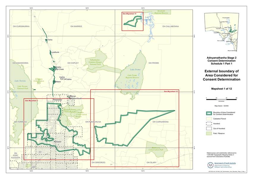
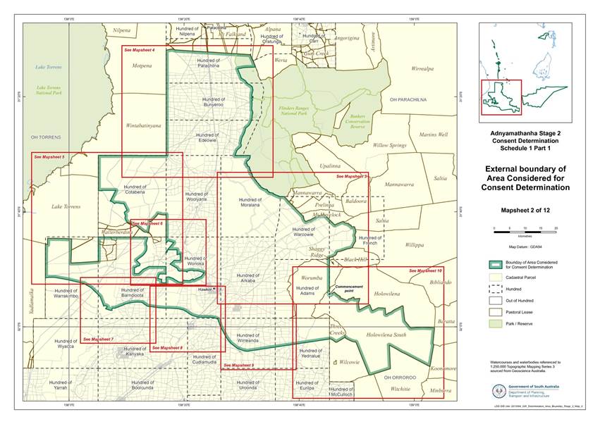
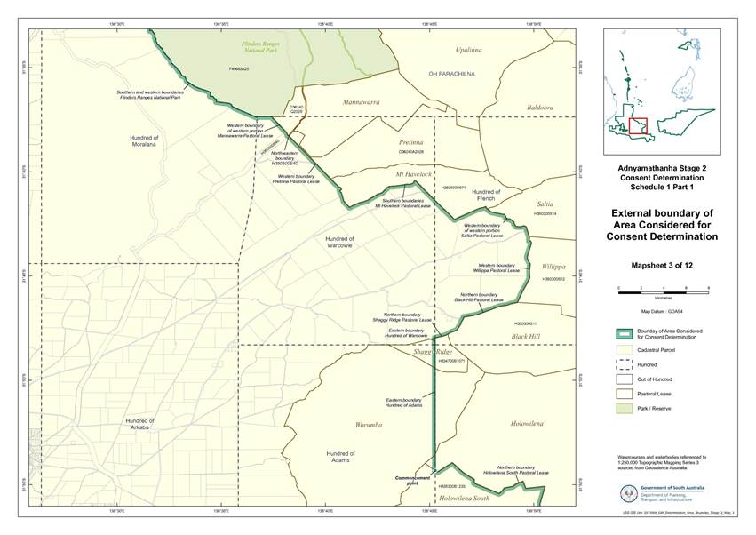
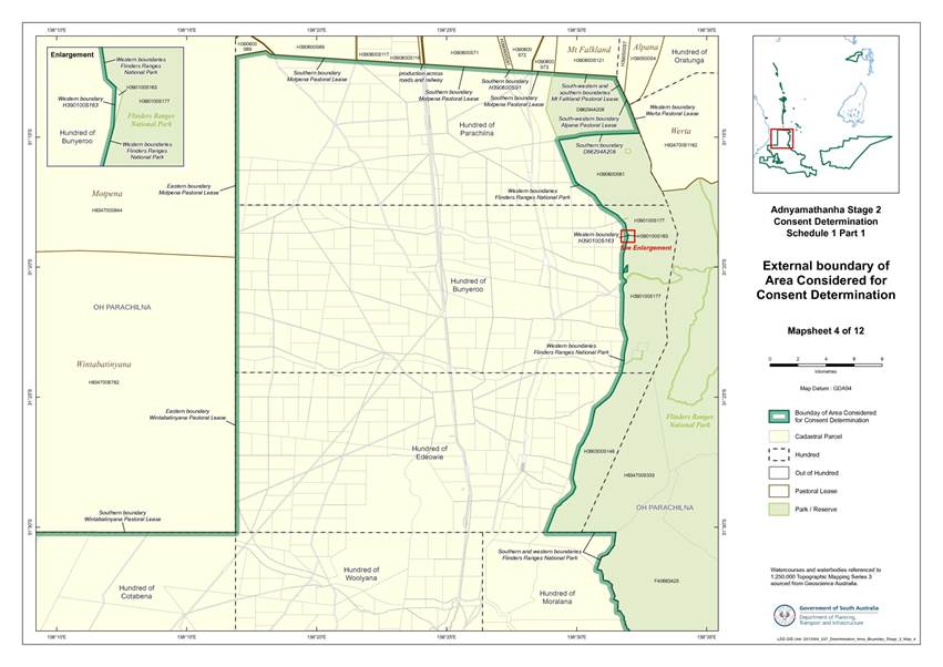
SCHEDULE 1 - Description and Maps of the Determination Area
Schedule 1, Part 1 –Area considered for this Consent Determination
Comprises the following non-contiguous areas:
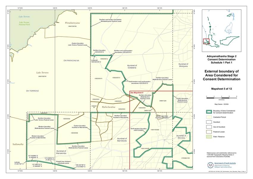
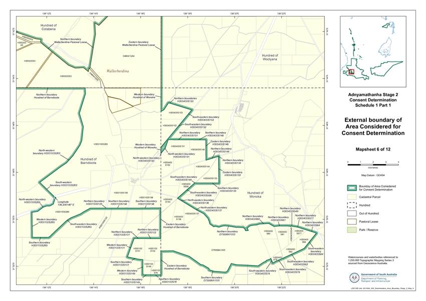
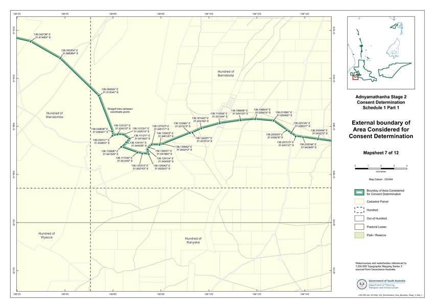
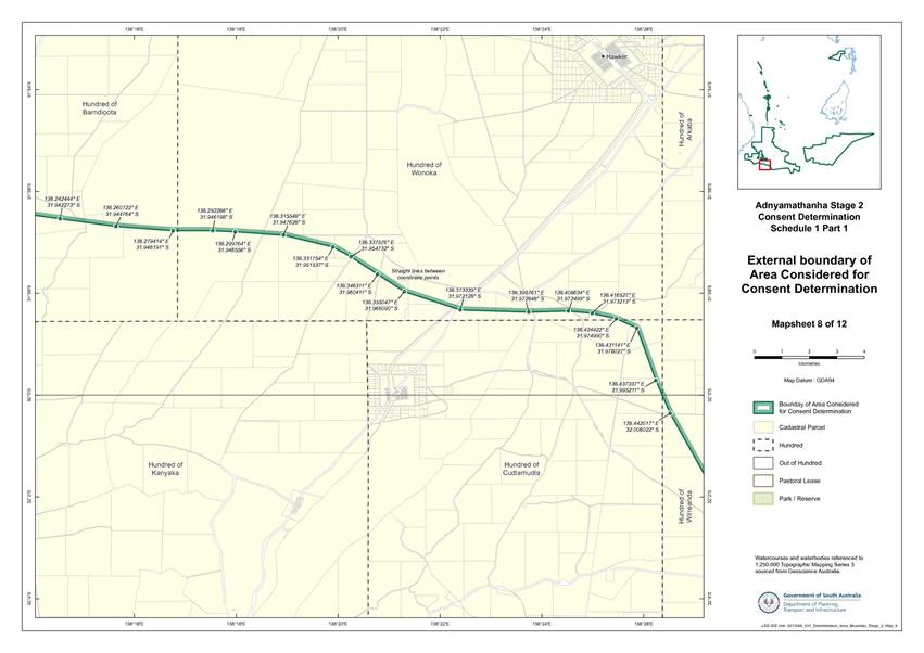
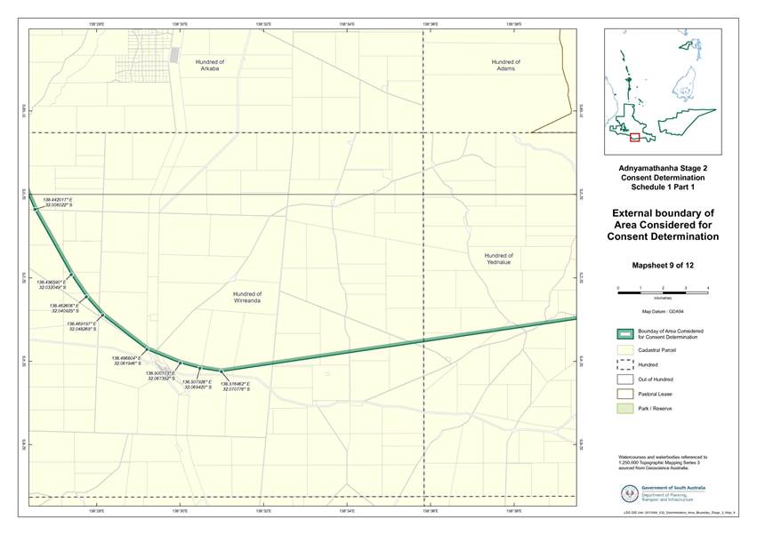
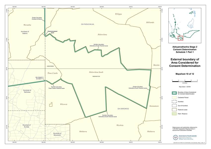
1) The land within the boundary formed by the following line; Commencing at point being the intersection of the northern boundary of Holowilena South Pastoral Lease - Block 1233, OH(Parachilna) with the eastern boundary of the Hundred of Adams; northerly along the eastern boundaries of the Hundreds of Adams and Warcowie (through Holowilena, Worumba and Shaggy Ridge Pastoral Leases) to the northern boundary of Shaggy Ridge Pastoral Lease - Block 1071, Hundreds of Warcowie & French; north-easterly along the northern boundary of Shaggy Ridge Pastoral Lease and the northern boundary Black Hill Pastoral Lease - Section 11, Hundred of French; northerly along the western boundary of Willippa Pastoral Lease - Section 12 Hundred of French; north-westerly along the western boundary of the western portion of Saltia Pastoral Lease - Section 14, Hundred of French; generally north-westerly along the southern boundaries of Mt Havelock Pastoral Lease - Block 671, Hundreds of French and Warcowie; north-westerly along the western boundary of Prelinna Pastoral Lease - Allotment 2028 in Deposited Plan 36240; north-westerly along the north-eastern boundaries of Section 40, Hundred of Warcowie; north-westerly along the western boundaries of the western portion of Mannawarra Pastoral Lease - Piece 2029 in Deposited Plan 36240 to the southern boundary of Flinders Ranges National Park - Allotment 25 in Filed Plan 40683; generally north-westerly along the southern & western boundaries of the Flinders Ranges National Park - Allotment 25 in Filed Plan 40683, Section 333, OH(Parachilna), Section 148, Hundred of Edeowie, Section 177, Hunderd of Bunyeroo (and across roads) to the southern corner of Section 163, Hundred of Bunyeroo; northerly along the western boundary of the said Section 163 to its northern corner; generally north-westerly along the western boundaries of the Flinders Ranges National Park – Section 177, Hundred of Bunyeroo (and across road) and Section 61, Hundred of Parachilna to the north-western corner of the said Section 61, and production across road to the southern boundary of Allotment 208 in Deposited Plan 86294; easterly along the southern boundary of the said Allotment 208 to the western boundary of Werta Pastoral Lease - Block 1162, OH(Parachilna); north-westerly along the western boundaries of Werta Pastoral Lease, Alpana Pastoral Lease - Section 4, Hundred of Oratunga; north-westerly along the south-western boundaries of Mt Falkland Pastoral Lease - Section 7, Hundred of Oratunga; westerly along the southern boundary of Mt Falkland Pastoral Lease - Section 121, Hundred of Parachilna, Motpena Pastoral Lease – Sections 73, 72 (and across road); westerly along the southern boundary of Section 91, Hundred of Parachilna; westerly along the southern boundaries of Motpena Pastoral Lease - Sections 71, 116, 117 and 69, Hundred of Parachilna, (and across railway & roads) to an eastern boundary of Motpena Pastoral Lease - Section 644, OH(Parachilna); southerly along the said eastern boundary of Motpena Pastoral Lease and the eastern boundary of Wintabatinyana Pastoral Lease - Block 782, OH(Parachilna) to the south-eastern corner of Wintabatinyana Pastoral Lease; westerly and southerly along southern and eastern boundaries of Wintabatinyana Pastoral Lease to the north-eastern corner of Lake Torrens Pastoral Lease - Block 761, OH(Parachilna); southerly along the eastern boundary of said Lake Torrens Pastoral Lease to its intersection with the north-western corner of Section 15, Hundred of Cotabena; easterly, along the northern boundary of the said Section 15 to its north-eastern corner at Longitude 138.095145 East and across road to the north-western corner of Section 12, Hundred of Cotabena; easterly and south-westerly along the northern and south-eastern boundaries of said Section 12 to its south-eastern corner; south-easterly across road to the western-most corner of Section 13, Hundred of Cotabena; north-easterly to the northern-most corner of the said Section 13; generally south-easterly, along the north-eastern and south-eastern boundaries of the said Section 13 to the northern boundary of Wallerberdina Pastoral Lease - Section 3, Hundred of Cotabena; south-easterly, north-easterly, easterly and southerly along northern and eastern boundaries of Wallerberdina Pastoral Lease (including production across roads and railway) - Section 3, Pieces 55 and 54 in Deposited Plan 46041, Hundred of Cotabena; southerly along the western boundary of the Hundred of Wonoka to its intersection with the north-west corner of Section 153, Hundred of Wonoka; north-easterly and south-easterly along the northern boundaries of the said Section 153; south-westerly along the south-eastern boundaries of Sections 153 & 152, Hundred of Wonoka to the western boundary of the said Hundred; southerly along the said Hundred boundary to the north-western corner of Section 150, Hundred of Wonoka; north-easterly along the north-western boundaries of Sections 150 & 151, Hundred of Wonoka; easterly along the northern boundaries of Sections 151 & 148, Hundred of Wonoka; southerly along the eastern boundary of the said Section 148 and its production across road to the northern boundary of Section 144, Hundred of Wonoka; north-easterly along the northern boundaries of Sections 144 & 133 (including across road); southerly and westerly along the eastern & southern boundaries of the said Section 133 (and production across road) to the south-eastern boundary of the said Section 144; south-westerly along the south-eastern boundaries of Sections 144 and 558, Hundred of Wonoka and across road to the eastern-most corner of Section 140, Hundred of Wonoka; generally south-easterly across road to the northern-most corner of Section 138, Hundred of Wonoka and along the north-eastern boundaries of Sections 138, 137, the northern boundaries of Allotment 1000 in Deposited Plan 75556, Section 80 (and across road to the north-western corner of Section 81), Sections 81, 549, 577 and 84, Hundred of Wonoka; south-westerly along the south-eastern boundaries of Sections 84, 82 (and across road) and Section 78, Hundred of Wonoka; north-westerly along the south-western boundary of the said Section 78; generally westerly along the southern boundaries of the said Allotment 1000 in Deposited Plan 75556; southerly along the eastern boundary of the Hundred of Barndioota to the south-eastern corner of Section 76, Hundred of Barndioota; westerly along the southern boundaries of the said Section 76 (and across road) and Section 149, Hundred of Barndioota; northerly along the western boundary of the said Section 149 and its production across road to its intersection with the southern boundary of Section 101, Hundred of Barndioota; westerly, north-easterly and easterly along the southern, western and northern boundaries of said Section 101; easterly along the northern boundary of Section 102, Hundred of Barndioota; northerly along the eastern boundary of the Hundred of Barndioota to its intersection with the easterly production, across road, of the southern boundary of Section 156, Hundred of Barndioota; westerly along the said production and southern boundaries of Section 156 (and across road), Section 158 and the northern boundary of Section 123, Hundred of Barndioota; generally south-westerly, westerly, northerly and north-easterly along the south-eastern, southern, western and north-western boundaries of Section 265, Hundred of Barndioota to a north-western corner of the said Section 265 at Longitude 138.206146 East; north-westerly across road to the southern-most corner of Section 263, Hundred of Barndioota; north-westerly and generally north-easterly along the south-western and north-western boundaries of the said Section 263 and production across road to the northern boundary of the Hundred of Barndioota, being the southern boundary of Wallerberdina Pastoral Lease - Section 3, Hundred of Cotabena; along the said Hundred boundary to the north-western corner of the Hundred of Barndioota; southerly along the eastern boundary of the Hundred of Warrakimbo to the south-eastern corner of Section 8, Hundred of Warrakimbo (Wallerberdina Pastoral Lease); westerly & northerly along the southern & western boundaries of Wallerberdina Pastoral Lease – the said Section 8 (and across road) to the southern boundary of Lake Torrens Pastoral Lease (the south-eastern corner of Section 7, Hundred of Warrakimbo); westerly along the southern boundary of Lake Torrens Pastoral Lease – the said Section 7; southerly and westerly along eastern & southern boundary of Lake Torrens Pastoral Lease – Section 5, Hundred of Warrakimbo; southerly along the western boundary of the Hundred of Warrakimbo to its intersection with Latitude 31.857750 South; then generally south-easterly in straight lines passing through the following coordinate points
|
Longitude (East) |
Latitude (South) |
|
137.942965 |
31.856559 |
|
137.958719 |
31.856996 |
|
137.994602 |
31.863111 |
|
138.042738 |
31.874469 |
|
138.063305 |
31.886264 |
|
138.089999 |
31.912040 |
|
138.099626 |
31.936941 |
|
138.099701 |
31.939800 |
|
138.103127 |
31.939012 |
|
138.107051 |
31.939014 |
|
138.111211 |
31.941853 |
|
138.109141 |
31.944335 |
|
138.105826 |
31.947525 |
|
138.117049 |
31.951432 |
|
138.120373 |
31.952143 |
|
138.124942 |
31.952500 |
|
138.124104 |
31.949308 |
|
138.124931 |
31.947889 |
|
138.127003 |
31.946117 |
|
138.132402 |
31.946120 |
|
138.134892 |
31.945412 |
|
138.153560 |
31.937973 |
|
138.155221 |
31.937619 |
|
138.161443 |
31.934785 |
|
138.174308 |
31.931244 |
|
138.188838 |
31.929123 |
|
138.198804 |
31.928419 |
|
138.211680 |
31.929490 |
|
138.220833 |
31.935878 |
|
138.223745 |
31.938007 |
|
138.227073 |
31.940137 |
|
138.232058 |
31.940849 |
|
138.242444 |
31.942273 |
|
138.260722 |
31.944764 |
|
138.279414 |
31.946191 |
|
138.292288 |
31.946198 |
|
138.299764 |
31.946556 |
|
138.315548 |
31.947628 |
|
138.331754 |
31.951537 |
|
138.337576 |
31.954732 |
|
138.346311 |
31.960411 |
|
138.355047 |
31.966090 |
|
138.373335 |
31.972128 |
|
138.395761 |
31.972848 |
|
138.408634 |
31.972499 |
|
138.416527 |
31.973213 |
|
138.424422 |
31.974990 |
|
138.431141 |
31.978027 |
|
138.437337 |
31.995211 |
|
138.442017 |
32.006022 |
|
138.456590 |
32.032049 |
|
138.462606 |
32.040925 |
|
138.469157 |
32.048265 |
|
138.486804 |
32.061946 |
|
138.500173 |
32.067352 |
|
138.507926 |
32.069420 |
|
138.516462 |
32.070776 |
|
138.754592 |
32.035611 |
The latter point being the south-western corner of Three Creeks Pastoral Lease – Block 838, OH(Orroroo); generally easterly along the southern boundaries of the said Three Creeks Pastoral Lease; generally south-easterly, northerly and north-westerly along the southern, eastern and northern boundaries of Holowilena South Pastoral Lease – Block 1233, OH(Orroroo & Parachilna) to its intersection with the eastern boundary of the Hundred of Adams being the point of commencement.
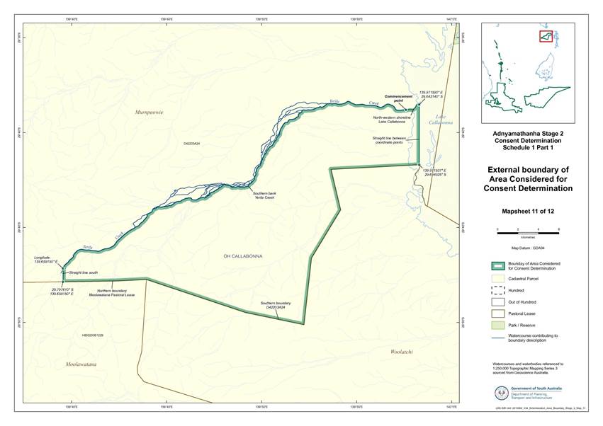
2) That portion within the external boundary of Allotment 24 in Deposited Plan 42203 (Murnpeowie Pastoral Lease) as follows; commencing at intersection of the shoreline of Lake Callabonna with the southern bank of Yerila Creek; then generally south-westerly along the said southern bank of Yerila Creek to its intersection with Longitude 139.659150 East; then south to the intersection of the northern boundary of Moolawatana Pastoral Lease - Block 1229, OH(Callabonna) with Longitude 139.659150 East, then easterly, northerly, and easterly along the southern boundaries of the said Allotment 24 to a corner on the southern boundary at Longitude 139.971537 East, Latitude 29.694925 South; then northerly to the western shoreline of Lake Callabonna (at Longitude 139.971590 East, Latitude 29.642140 South); then westerly along the said shoreline of Lake Callabonna to the point of commencement.
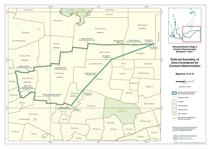
3) Commencing at the south-eastern corner of Frome Downs Pastoral Lease Block 1173, OH(Curnamona); then generally south-westerly along the southern boundaries of the said Frome Downs Pastoral Lease and Erudina Pastoral Lease – Block 891, OH(Curnamona & Parachilna) & Martins Well Pastoral Lease - Block 938, OH(Parachilna); then southerly & generally north-easterly along the western & southern boundaries of Glen Warwick Pastoral Lease – Block 1218, OH(Parachilna); then southerly and easterly along the western and southern boundaries of Curnamona Pastoral Lease – Allotment 403 in Deposited Plan 42207, OH(Parachilna & Curnamona) to the south-western corner of Glenorchy Pastoral Lease – Block 910, OH(Curnamona); then south-easterly along the southern boundary of the said Glenorchy Pastoral Lease to its intersection with Longitude 139.719547 East; then in straight lines passing through the following coordinate points
|
Longitude (East) |
Latitude (South) |
|
139.833014 |
31.824022 |
|
140.139892 |
31.495675 |
|
140.574604 |
31.337067 |
|
140.572369 |
31.330358 |
The latter coordinate being a point on the southern boundary of Quinyambie Pastoral Lease – Block 1252, OH(Curnamona); then generally westerly along the southern boundary of the said Quinyambie Pastoral Lease to the point of commencement.
4) Those parcels excluded from the Adnyamathanha No.1 Consent Determination dated 30 March 2009 listed at Items 2 to 11 inclusive of Schedule 1, Appendix 2 of that determination apart from Allotment 207 in Filed Plan 43315 (Angepena Pastoral Lease, over which a determination of native title was made on 30 March 2009).
For the avoidance of doubt the area considered excludes the Adnyamathanha No.3 Native Title Claim (SAD 69 of 2010) Area, including the township of Hookina and any allotments which fall within the external boundaries of the Adnyamathanha No.3 Native Title Claim Area and sections 160, 161, 228 and 229 of the Hundred of Barndioota.
Reference datum
Geographical coordinates have been provided by the NNTT Geospatial services and geographical coordinates are referenced to the Geocentric Datum of Australia 1994 (GDA94), in decimal degrees.
Watercourses and waterbodies referenced to 1:250,000 Topographic Mapping Series 3 – sourced from Geoscience Australia.
Use of Coordinates
Where coordinates are used within the description to represent cadastral or topographical boundaries or the intersection with such, they are intended as a guide only. As an outcome of the custodians of cadastral and topographical data continuously recalculating the geographic position of their data based on improved survey and data maintenance procedures, it is not possible to accurately define such a position other than by detailed ground survey.
Schedule 1, Part 2 – Areas where native title is recognised in this Consent Determination
(Determination Area)
• Out of Hundreds (Callabonna).
Portion of Murnpeowie Pastoral Lease (PE 2519 Crown Lease 1598/37) – being that portion of Allotment 24 in Deposited Plan 42203, within Part 1.
• Out of Hundreds (Curnamona).
Portion of Glenorchy Pastoral Lease (PE 2205 Crown Lease 1277/22) – being that portion of Block 910, within in Part 1;
Portion of Telechie Pastoral Lease (PE 2365 Crown Lease 1299/9) - being that portion of Block 947, within Part 1;
Portion of Billeroo West Pastoral Lease (PE 2300 Crown Lease 1286/12) – being that portion of Block 120, within Part 1;
Portion of Benagerie Pastoral Lease (PE 2359 Crown Lease 1292/4) – being that portion of Block 121, within Part 1.
• Out of Hundreds (Parachilna & Curnamona).
Curnamona Pastoral Lease (PE 2326 Crown Lease 1301/7) – Allotment 403 in Deposited Plan 42207.
• Out of Hundreds (Parachilna).
Glen Warwick Pastoral Lease (PE 2307A Crown Lease 1410/11) – Block 1218.
• Out of Hundreds (Parachilna & Orroroo) & Hundred of Adams.
Portion of Holowilena South Pastoral Lease (PE 2260A Crown Lease 1437/27) – being that portion of Block 1233, which was NOT formerly subject to Miscellaneous Lease 5011 (Crown Lease 72/51).
• Hundred of Adams.
Portion of Worumba Pastoral Lease (PE 2291 Crown Lease 1287/27) - being that portion of Block 840, within Part 1, which was also NOT formerly subject to Miscellaneous Lease 5011 (Crown Lease 72/51).
• Hundred of Adams & Warcowie.
Portion of Shaggy Ridge Pastoral Lease (PE 2335 Crown Lease 1290/34) - being that portion of Block 1071 within Part 1.
• Out of Hundreds (Copley).
|
Plan Type |
Plan No |
Parcel Type |
Parcel No |
Hundred Name |
|
D |
34087 |
A |
2012 |
OH(COPLEY) |
|
D |
44831 |
Q |
2 |
OH(COPLEY) |
|
D |
44831 |
Q |
3 |
OH(COPLEY) |
|
D |
44831 |
Q |
4 |
OH(COPLEY) |
|
D |
44831 |
Q |
5 |
OH(COPLEY) |
|
D |
44831 |
Q |
6 |
OH(COPLEY) |
|
D |
44831 |
Q |
9 |
OH(COPLEY) |
|
D |
44831 |
Q |
10 |
OH(COPLEY) |
|
H |
833900 |
S |
129 |
OH(COPLEY) |
|
H |
833900 |
S |
491 |
OH(COPLEY) |
|
H |
833900 |
S |
1049 |
OH(COPLEY) |
|
H |
833900 |
S |
1051 |
OH(COPLEY) |
• Hundred of Carr.
|
Plan Type |
Plan No |
Parcel Type |
Parcel No |
Hundred Name |
|
H |
390200 |
S |
360 |
CARR |
|
H |
390200 |
S |
361 |
CARR |
|
H |
390200 |
S |
362 |
CARR |
|
H |
390200 |
S |
363 |
CARR |
|
H |
390200 |
S |
364 |
CARR |
• Town of Beltana and Land Adjacent and Suburban to Beltana.
|
Plan Type |
Plan No |
Parcel Type |
Parcel No |
Hundred Name |
|
F |
36653 |
A |
8 |
OH(COPLEY) |
|
F |
36653 |
A |
22 |
OH(COPLEY) |
|
F |
36653 |
A |
38 |
OH(COPLEY) |
|
F |
36653 |
A |
39 |
OH(COPLEY) |
|
F |
36653 |
A |
47 |
OH(COPLEY) |
|
F |
36653 |
A |
48 |
OH(COPLEY) |
|
F |
36653 |
A |
134 |
OH(COPLEY) |
|
F |
36653 |
A |
135 |
OH(COPLEY) |
|
H |
833900 |
S |
684 |
OH(COPLEY) |
|
H |
833900 |
S |
973 |
OH(COPLEY) |
|
H |
833900 |
S |
974 |
OH(COPLEY) |
|
T |
833901 |
A |
52 |
OH(COPLEY) |
|
T |
833901 |
A |
53 |
OH(COPLEY) |
|
T |
833901 |
A |
62 |
OH(COPLEY) |
• Town of Cadnia (Plan Number 833902) and Land Adjacent to Cadnia.
|
Plan Type |
Plan No |
Parcel Type |
Parcel No |
Hundred Name |
|
H |
833900 |
S |
1042 |
OH(COPLEY) |
|
H |
833900 |
S |
1043 |
OH(COPLEY) |
|
T |
833902 |
A |
21 |
OH(COPLEY) |
|
T |
833902 |
A |
40 |
OH(COPLEY) |
|
T |
833902 |
A |
44 |
OH(COPLEY) |
|
T |
833902 |
A |
46 |
OH(COPLEY) |
|
T |
833902 |
A |
48 |
OH(COPLEY) |
|
T |
833902 |
A |
49 |
OH(COPLEY) |
|
T |
833902 |
A |
50 |
OH(COPLEY) |
• Town of Farina and Land Adjacent and Suburban to Farina.
|
Plan Type |
Plan No |
Parcel Type |
Parcel No |
Hundred Name |
|
H |
833900 |
S |
126 |
OH(COPLEY) |
|
H |
833900 |
S |
979 |
OH(COPLEY) |
|
T |
833905 |
A |
119 |
OH(COPLEY) |
|
T |
833905 |
A |
120 |
OH(COPLEY) |
|
T |
833905 |
A |
122 |
OH(COPLEY) |
|
T |
833905 |
A |
263 |
OH(COPLEY) |
|
T |
833905 |
A |
264 |
OH(COPLEY) |
|
T |
833905 |
A |
265 |
OH(COPLEY) |
|
T |
833905 |
A |
423 |
OH(COPLEY) |
|
T |
833905 |
A |
424 |
OH(COPLEY) |
• Town of Lyndhurst and Adjacent to Lyndhurst.
|
Plan Type |
Plan No |
Parcel Type |
Parcel No |
Hundred Name |
|
D |
22928 |
A |
96 |
OH(COPLEY) |
|
T |
833906 |
A |
1 |
OH(COPLEY) |
|
T |
833906 |
A |
11 |
OH(COPLEY) |
|
T |
833906 |
A |
12 |
OH(COPLEY) |
|
T |
833906 |
A |
13 |
OH(COPLEY) |
|
T |
833906 |
A |
14 |
OH(COPLEY) |
|
T |
833906 |
A |
15 |
OH(COPLEY) |
|
T |
833906 |
A |
16 |
OH(COPLEY) |
|
T |
833906 |
A |
18 |
OH(COPLEY) |
|
T |
833906 |
A |
19 |
OH(COPLEY) |
|
T |
833906 |
A |
20 |
OH(COPLEY) |
|
T |
833906 |
A |
21 |
OH(COPLEY) |
|
T |
833906 |
A |
22 |
OH(COPLEY) |
|
T |
833906 |
A |
23 |
OH(COPLEY) |
|
T |
833906 |
A |
24 |
OH(COPLEY) |
|
T |
833906 |
A |
25 |
OH(COPLEY) |
|
T |
833906 |
A |
26 |
OH(COPLEY) |
|
T |
833906 |
A |
27 |
OH(COPLEY) |
|
T |
833906 |
A |
28 |
OH(COPLEY) |
|
T |
833906 |
A |
30 |
OH(COPLEY) |
|
T |
833906 |
A |
32 |
OH(COPLEY) |
|
T |
833906 |
A |
33 |
OH(COPLEY) |
|
T |
833906 |
A |
34 |
OH(COPLEY) |
|
T |
833906 |
A |
45 |
OH(COPLEY) |
|
T |
833906 |
A |
46 |
OH(COPLEY) |
|
T |
833906 |
A |
47 |
OH(COPLEY) |
|
T |
833906 |
A |
48 |
OH(COPLEY) |
|
T |
833906 |
A |
49 |
OH(COPLEY) |
|
T |
833906 |
A |
50 |
OH(COPLEY) |
|
T |
833906 |
A |
51 |
OH(COPLEY) |
|
T |
833906 |
A |
52 |
OH(COPLEY) |
|
T |
833906 |
A |
53 |
OH(COPLEY) |
|
T |
833906 |
A |
54 |
OH(COPLEY) |
|
T |
833906 |
A |
55 |
OH(COPLEY) |
|
T |
833906 |
A |
56 |
OH(COPLEY) |
|
T |
833906 |
A |
62 |
OH(COPLEY) |
|
T |
833906 |
A |
63 |
OH(COPLEY) |
|
T |
833906 |
A |
64 |
OH(COPLEY) |
|
T |
833906 |
A |
65 |
OH(COPLEY) |
• Town of Copley and Adjacent to Copley. (*except OL 16326 - pipeline land; ^except Public Works land).
|
Plan Type |
Plan No |
Parcel Type |
Parcel No |
Hundred Name |
|
D |
40749 |
Q |
5^ |
OH(COPLEY) |
|
D |
40749 |
Q |
6^ |
OH(COPLEY) |
|
D |
40749 |
Q |
7^ |
OH(COPLEY) |
|
D |
40749 |
Q |
8* |
OH(COPLEY) |
|
D |
40749 |
Q |
9 |
OH(COPLEY) |
|
H |
833900 |
S |
1278 |
OH(COPLEY) |
• Town of Parachilna.
|
Plan Type |
Plan No |
Parcel Type |
Parcel No |
Hundred Name |
|
T |
390401 |
A |
15 |
NILPENA |
• Town of Blinman.
|
Plan Type |
Plan No |
Parcel Type |
Parcel No |
Hundred Name |
|
T |
390202 |
A |
180 |
CARR |
|
T |
390202 |
A |
185 |
CARR |
|
T |
390202 |
A |
205 |
CARR |
• Town of Blinman South.
|
Plan Type |
Plan No |
Parcel Type |
Parcel No |
Hundred Name |
|
D |
56533 |
A |
505 |
CARR |
|
D |
56534 |
A |
507 |
CARR |
|
D |
56534 |
A |
508 |
CARR |
|
D |
56534 |
A |
509 |
CARR |
|
D |
56534 |
A |
510 |
CARR |
|
D |
56534 |
A |
511 |
CARR |
|
D |
56534 |
A |
512 |
CARR |
|
D |
56535 |
A |
501 |
CARR |
|
D |
56535 |
A |
502 |
CARR |
|
T |
390201 |
A |
1 |
CARR |
|
T |
390201 |
A |
2 |
CARR |
|
T |
390201 |
A |
4 |
CARR |
|
T |
390201 |
A |
5 |
CARR |
|
T |
390201 |
A |
6 |
CARR |
|
T |
390201 |
A |
7 |
CARR |
|
T |
390201 |
A |
8 |
CARR |
|
T |
390201 |
A |
9 |
CARR |
|
T |
390201 |
A |
10 |
CARR |
|
T |
390201 |
A |
11 |
CARR |
|
T |
390201 |
A |
12 |
CARR |
|
T |
390201 |
A |
13 |
CARR |
|
T |
390201 |
A |
15 |
CARR |
|
T |
390201 |
A |
16 |
CARR |
|
T |
390201 |
A |
17 |
CARR |
|
T |
390201 |
A |
18 |
CARR |
|
T |
390201 |
A |
20 |
CARR |
|
T |
390201 |
A |
21 |
CARR |
|
T |
390201 |
A |
22 |
CARR |
|
T |
390201 |
A |
23 |
CARR |
|
T |
390201 |
A |
24 |
CARR |
|
T |
390201 |
A |
25 |
CARR |
|
T |
390201 |
A |
26 |
CARR |
|
T |
390201 |
A |
27 |
CARR |
|
T |
390201 |
A |
28 |
CARR |
|
T |
390201 |
A |
29 |
CARR |
|
T |
390201 |
A |
30 |
CARR |
|
T |
390201 |
A |
31 |
CARR |
|
T |
390201 |
A |
32 |
CARR |
|
T |
390201 |
A |
35 |
CARR |
|
T |
390201 |
A |
36 |
CARR |
|
T |
390201 |
A |
37 |
CARR |
|
T |
390201 |
A |
40 |
CARR |
|
T |
390201 |
A |
41 |
CARR |
|
T |
390201 |
A |
42 |
CARR |
|
T |
390201 |
A |
45 |
CARR |
|
T |
390201 |
A |
46 |
CARR |
|
T |
390201 |
A |
47 |
CARR |
|
T |
390201 |
A |
48 |
CARR |
|
T |
390201 |
A |
50 |
CARR |
|
T |
390201 |
A |
51 |
CARR |
|
T |
390201 |
A |
52 |
CARR |
|
T |
390201 |
A |
53 |
CARR |
|
T |
390201 |
A |
54 |
CARR |
|
T |
390201 |
A |
55 |
CARR |
|
T |
390201 |
A |
56 |
CARR |
|
T |
390201 |
A |
57 |
CARR |
|
T |
390201 |
A |
58 |
CARR |
|
T |
390201 |
A |
59 |
CARR |
|
T |
390201 |
A |
60 |
CARR |
|
T |
390201 |
A |
61 |
CARR |
|
T |
390201 |
A |
62 |
CARR |
|
T |
390201 |
A |
63 |
CARR |
|
T |
390201 |
A |
64 |
CARR |
|
T |
390201 |
A |
66 |
CARR |
|
T |
390201 |
A |
67 |
CARR |
|
T |
390201 |
A |
68 |
CARR |
|
T |
390201 |
A |
71 |
CARR |
|
T |
390201 |
A |
72 |
CARR |
|
T |
390201 |
A |
73 |
CARR |
|
T |
390201 |
A |
74 |
CARR |
|
T |
390201 |
A |
76 |
CARR |
|
T |
390201 |
A |
77 |
CARR |
|
T |
390201 |
A |
78 |
CARR |
|
T |
390201 |
A |
79 |
CARR |
|
T |
390201 |
A |
81 |
CARR |
|
T |
390201 |
A |
82 |
CARR |
|
T |
390201 |
A |
84 |
CARR |
|
T |
390201 |
A |
85 |
CARR |
|
T |
390201 |
A |
86 |
CARR |
|
T |
390201 |
A |
87 |
CARR |
|
T |
390201 |
A |
89 |
CARR |
|
T |
390201 |
A |
90 |
CARR |
|
T |
390201 |
A |
91 |
CARR |
|
T |
390201 |
A |
92 |
CARR |
|
T |
390201 |
A |
94 |
CARR |
|
T |
390201 |
A |
95 |
CARR |
|
T |
390201 |
A |
96 |
CARR |
|
T |
390201 |
A |
97 |
CARR |
|
T |
390201 |
A |
99 |
CARR |
|
T |
390201 |
A |
100 |
CARR |
|
T |
390201 |
A |
101 |
CARR |
|
T |
390201 |
A |
102 |
CARR |
|
T |
390201 |
A |
103 |
CARR |
|
T |
390201 |
A |
106 |
CARR |
|
T |
390201 |
A |
112 |
CARR |
|
T |
390201 |
A |
113 |
CARR |
|
T |
390201 |
A |
114 |
CARR |
|
T |
390201 |
A |
115 |
CARR |
|
T |
390201 |
A |
116 |
CARR |
|
T |
390201 |
A |
117 |
CARR |
|
T |
390201 |
A |
118 |
CARR |
|
T |
390201 |
A |
119 |
CARR |
|
T |
390201 |
A |
120 |
CARR |
|
T |
390201 |
A |
124 |
CARR |
|
T |
390201 |
A |
125 |
CARR |
|
T |
390201 |
A |
126 |
CARR |
|
T |
390201 |
A |
127 |
CARR |
|
T |
390201 |
A |
129 |
CARR |
|
T |
390201 |
A |
143 |
CARR |
|
T |
390201 |
A |
150 |
CARR |
• Hundred of Parachilna.
|
Plan Type |
Plan No |
Parcel Type |
Parcel No |
Hundred Name |
|
H |
390600 |
S |
92 |
PARACHILNA |
|
H |
390600 |
S |
93 |
PARACHILNA |
• Hundred of Bunyeroo.
|
Plan Type |
Plan No |
Parcel Type |
Parcel No |
Hundred Name |
|
H |
390100 |
S |
178 |
BUNYEROO |
|
H |
390100 |
S |
179 |
BUNYEROO |
|
H |
390100 |
S |
180 |
BUNYEROO |
|
H |
390100 |
S |
181 |
BUNYEROO |
|
H |
390100 |
S |
182 |
BUNYEROO |
|
H |
390100 |
S |
183 |
BUNYEROO |
|
H |
390100 |
S |
184 |
BUNYEROO |
|
H |
390100 |
S |
185 |
BUNYEROO |
|
H |
390100 |
S |
186 |
BUNYEROO |
|
H |
390100 |
S |
187 |
BUNYEROO |
• Hundred of Edeowie (Plan Number 390300) & Town of Edeowie (Plan Number 390301).
|
Plan Type |
Plan No |
Parcel Type |
Parcel No |
Hundred Name |
|
H |
390300 |
S |
151 |
EDEOWIE |
|
H |
390300 |
S |
152 |
EDEOWIE |
|
H |
390300 |
S |
154 |
EDEOWIE |
|
H |
390300 |
S |
155 |
EDEOWIE |
|
H |
390300 |
S |
156 |
EDEOWIE |
|
H |
390300 |
S |
157 |
EDEOWIE |
|
H |
390300 |
S |
158 |
EDEOWIE |
|
T |
390301 |
A |
98 |
EDEOWIE |
|
T |
390301 |
A |
104 |
EDEOWIE |
|
T |
390301 |
A |
105 |
EDEOWIE |
|
T |
390301 |
A |
106 |
EDEOWIE |
|
T |
390301 |
A |
107 |
EDEOWIE |
|
T |
390301 |
A |
108 |
EDEOWIE |
|
T |
390301 |
A |
109 |
EDEOWIE |
|
T |
390301 |
A |
110 |
EDEOWIE |
|
T |
390301 |
A |
111 |
EDEOWIE |
• Hundred of Woolyana (Plan Number 300500) & Town of Mernmerna (Plan Number 300501).
|
Plan Type |
Plan No |
Parcel Type |
Parcel No |
Hundred Name |
|
H |
300500 |
S |
245 |
WOOLYANA |
|
H |
300500 |
S |
246 |
WOOLYANA |
|
T |
300501 |
A |
120 |
WOOLYANA |
|
T |
300501 |
A |
121 |
WOOLYANA |
|
T |
300501 |
A |
122 |
WOOLYANA |
|
T |
300501 |
A |
123 |
WOOLYANA |
|
T |
300501 |
A |
124 |
WOOLYANA |
|
T |
300501 |
A |
125 |
WOOLYANA |
|
T |
300501 |
A |
126 |
WOOLYANA |
|
T |
300501 |
A |
127 |
WOOLYANA |
|
T |
300501 |
A |
132 |
WOOLYANA |
|
T |
300501 |
A |
134 |
WOOLYANA |
|
T |
300501 |
A |
135 |
WOOLYANA |
|
T |
300501 |
A |
136 |
WOOLYANA |
|
T |
300501 |
A |
137 |
WOOLYANA |
|
T |
300501 |
A |
138 |
WOOLYANA |
|
T |
300501 |
A |
139 |
WOOLYANA |
|
T |
300501 |
A |
140 |
WOOLYANA |
|
T |
300501 |
A |
141 |
WOOLYANA |
|
T |
300501 |
A |
142 |
WOOLYANA |
|
T |
300501 |
A |
143 |
WOOLYANA |
• Hundred of Moralana.
|
Plan Type |
Plan No |
Parcel Type |
Parcel No |
Hundred Name |
|
H |
350400 |
S |
19 |
MORALANA |
|
H |
350400 |
S |
20 |
MORALANA |
|
H |
350400 |
S |
21 |
MORALANA |
|
H |
350400 |
S |
22 |
MORALANA |
|
H |
350400 |
S |
23 |
MORALANA |
|
H |
350400 |
S |
24 |
MORALANA |
|
H |
350400 |
S |
25 |
MORALANA |
|
H |
350400 |
S |
26 |
MORALANA |
|
H |
350400 |
S |
27 |
MORALANA |
|
H |
350400 |
S |
28 |
MORALANA |
• Hundred of Warcowie.
|
Plan Type |
Plan No |
Parcel Type |
Parcel No |
Hundred Name |
|
H |
350500 |
S |
40 |
WARCOWIE |
• Town of Wonoka.
|
Plan Type |
Plan No |
Parcel Type |
Parcel No |
Hundred Name |
|
T |
300401 |
A |
1 |
WONOKA |
|
T |
300401 |
A |
2 |
WONOKA |
|
T |
300401 |
A |
3 |
WONOKA |
|
T |
300401 |
A |
4 |
WONOKA |
|
T |
300401 |
A |
5 |
WONOKA |
|
T |
300401 |
A |
6 |
WONOKA |
|
T |
300401 |
A |
7 |
WONOKA |
|
T |
300401 |
A |
8 |
WONOKA |
|
T |
300401 |
A |
9 |
WONOKA |
|
T |
300401 |
A |
10 |
WONOKA |
|
T |
300401 |
A |
11 |
WONOKA |
|
T |
300401 |
A |
12 |
WONOKA |
|
T |
300401 |
A |
13 |
WONOKA |
|
T |
300401 |
A |
14 |
WONOKA |
|
T |
300401 |
A |
15 |
WONOKA |
|
T |
300401 |
A |
16 |
WONOKA |
|
T |
300401 |
A |
17 |
WONOKA |
|
T |
300401 |
A |
18 |
WONOKA |
|
T |
300401 |
A |
19 |
WONOKA |
|
T |
300401 |
A |
20 |
WONOKA |
|
T |
300401 |
A |
21 |
WONOKA |
|
T |
300401 |
A |
22 |
WONOKA |
|
T |
300401 |
A |
23 |
WONOKA |
|
T |
300401 |
A |
24 |
WONOKA |
|
T |
300401 |
A |
25 |
WONOKA |
|
T |
300401 |
A |
26 |
WONOKA |
|
T |
300401 |
A |
27 |
WONOKA |
|
T |
300401 |
A |
28 |
WONOKA |
|
T |
300401 |
A |
29 |
WONOKA |
|
T |
300401 |
A |
30 |
WONOKA |
|
T |
300401 |
A |
31 |
WONOKA |
|
T |
300401 |
A |
32 |
WONOKA |
|
T |
300401 |
A |
33 |
WONOKA |
|
T |
300401 |
A |
34 |
WONOKA |
|
T |
300401 |
A |
35 |
WONOKA |
|
T |
300401 |
A |
36 |
WONOKA |
|
T |
300401 |
A |
37 |
WONOKA |
|
T |
300401 |
A |
38 |
WONOKA |
|
T |
300401 |
A |
39 |
WONOKA |
|
T |
300401 |
A |
40 |
WONOKA |
|
T |
300401 |
A |
41 |
WONOKA |
|
T |
300401 |
A |
42 |
WONOKA |
|
T |
300401 |
A |
43 |
WONOKA |
|
T |
300401 |
A |
44 |
WONOKA |
|
T |
300401 |
A |
45 |
WONOKA |
|
T |
300401 |
A |
46 |
WONOKA |
|
T |
300401 |
A |
47 |
WONOKA |
|
T |
300401 |
A |
48 |
WONOKA |
|
T |
300401 |
A |
49 |
WONOKA |
|
T |
300401 |
A |
50 |
WONOKA |
|
T |
300401 |
A |
51 |
WONOKA |
|
T |
300401 |
A |
52 |
WONOKA |
|
T |
300401 |
A |
53 |
WONOKA |
|
T |
300401 |
A |
54 |
WONOKA |
|
T |
300401 |
A |
55 |
WONOKA |
|
T |
300401 |
A |
56 |
WONOKA |
|
T |
300401 |
A |
57 |
WONOKA |
|
T |
300401 |
A |
58 |
WONOKA |
|
T |
300401 |
A |
59 |
WONOKA |
|
T |
300401 |
A |
60 |
WONOKA |
|
T |
300401 |
A |
61 |
WONOKA |
|
T |
300401 |
A |
62 |
WONOKA |
|
T |
300401 |
A |
63 |
WONOKA |
|
T |
300401 |
A |
64 |
WONOKA |
|
T |
300401 |
A |
65 |
WONOKA |
|
T |
300401 |
A |
66 |
WONOKA |
|
T |
300401 |
A |
67 |
WONOKA |
|
T |
300401 |
A |
68 |
WONOKA |
|
T |
300401 |
A |
69 |
WONOKA |
|
T |
300401 |
A |
70 |
WONOKA |
|
T |
300401 |
A |
71 |
WONOKA |
|
T |
300401 |
A |
72 |
WONOKA |
|
T |
300401 |
A |
73 |
WONOKA |
|
T |
300401 |
A |
74 |
WONOKA |
|
T |
300401 |
A |
75 |
WONOKA |
|
T |
300401 |
A |
76 |
WONOKA |
|
T |
300401 |
A |
77 |
WONOKA |
|
T |
300401 |
A |
78 |
WONOKA |
|
T |
300401 |
A |
79 |
WONOKA |
|
T |
300401 |
A |
80 |
WONOKA |
|
T |
300401 |
A |
81 |
WONOKA |
|
T |
300401 |
A |
82 |
WONOKA |
|
T |
300401 |
A |
83 |
WONOKA |
|
T |
300401 |
A |
84 |
WONOKA |
|
T |
300401 |
A |
85 |
WONOKA |
|
T |
300401 |
A |
86 |
WONOKA |
|
T |
300401 |
A |
87 |
WONOKA |
|
T |
300401 |
A |
88 |
WONOKA |
|
T |
300401 |
A |
89 |
WONOKA |
|
T |
300401 |
A |
90 |
WONOKA |
|
T |
300401 |
A |
91 |
WONOKA |
|
T |
300401 |
A |
92 |
WONOKA |
|
T |
300401 |
A |
93 |
WONOKA |
|
T |
300401 |
A |
94 |
WONOKA |
|
T |
300401 |
A |
95 |
WONOKA |
|
T |
300401 |
A |
96 |
WONOKA |
|
T |
300401 |
A |
97 |
WONOKA |
|
T |
300401 |
A |
98 |
WONOKA |
|
T |
300401 |
A |
99 |
WONOKA |
|
T |
300401 |
A |
100 |
WONOKA |
|
T |
300401 |
A |
101 |
WONOKA |
|
T |
300401 |
A |
102 |
WONOKA |
|
T |
300401 |
A |
103 |
WONOKA |
|
T |
300401 |
A |
104 |
WONOKA |
|
T |
300401 |
A |
105 |
WONOKA |
|
T |
300401 |
A |
106 |
WONOKA |
|
T |
300401 |
A |
107 |
WONOKA |
|
T |
300401 |
A |
108 |
WONOKA |
|
T |
300401 |
A |
109 |
WONOKA |
|
T |
300401 |
A |
110 |
WONOKA |
|
T |
300401 |
A |
111 |
WONOKA |
|
T |
300401 |
A |
112 |
WONOKA |
|
T |
300401 |
A |
113 |
WONOKA |
|
T |
300401 |
A |
114 |
WONOKA |
|
T |
300401 |
A |
115 |
WONOKA |
|
T |
300401 |
A |
116 |
WONOKA |
|
T |
300401 |
A |
117 |
WONOKA |
|
T |
300401 |
A |
118 |
WONOKA |
|
T |
300401 |
A |
122 |
WONOKA |
|
T |
300401 |
A |
123 |
WONOKA |
|
T |
300401 |
A |
144 |
WONOKA |
|
T |
300401 |
A |
145 |
WONOKA |
|
T |
300401 |
A |
146 |
WONOKA |
|
T |
300401 |
A |
147 |
WONOKA |
|
T |
300401 |
A |
148 |
WONOKA |
|
T |
300401 |
A |
149 |
WONOKA |
|
T |
300401 |
A |
150 |
WONOKA |
|
T |
300401 |
A |
151 |
WONOKA |
|
T |
300401 |
A |
152 |
WONOKA |
|
T |
300401 |
A |
153 |
WONOKA |
|
T |
300401 |
A |
154 |
WONOKA |
|
T |
300401 |
A |
155 |
WONOKA |
|
T |
300401 |
A |
156 |
WONOKA |
|
T |
300401 |
A |
157 |
WONOKA |
|
T |
300401 |
A |
158 |
WONOKA |
• Town of Hawker.
|
Plan Type |
Plan No |
Parcel Type |
Parcel No |
Hundred Name |
|
T |
300402 |
A |
137 |
WONOKA |
|
T |
300402 |
A |
138 |
WONOKA |
|
T |
300402 |
A |
139 |
WONOKA |
|
T |
300402 |
A |
140 |
WONOKA |
|
T |
300402 |
A |
141 |
WONOKA |
|
T |
300402 |
A |
142 |
WONOKA |
|
T |
300402 |
A |
143 |
WONOKA |
|
T |
300402 |
A |
144 |
WONOKA |
|
T |
300402 |
A |
145 |
WONOKA |
|
T |
300402 |
A |
146 |
WONOKA |
|
T |
300402 |
A |
147 |
WONOKA |
|
T |
300402 |
A |
148 |
WONOKA |
|
T |
300402 |
A |
165 |
WONOKA |
|
T |
300402 |
A |
166 |
WONOKA |
|
T |
300402 |
A |
167 |
WONOKA |
|
T |
300402 |
A |
168 |
WONOKA |
|
T |
300402 |
A |
169 |
WONOKA |
|
T |
300402 |
A |
170 |
WONOKA |
|
T |
300402 |
A |
171 |
WONOKA |
|
T |
300402 |
A |
172 |
WONOKA |
|
T |
300402 |
A |
189 |
WONOKA |
|
T |
300402 |
A |
190 |
WONOKA |
|
T |
300402 |
A |
191 |
WONOKA |
|
T |
300402 |
A |
192 |
WONOKA |
|
T |
300402 |
A |
193 |
WONOKA |
|
T |
300402 |
A |
194 |
WONOKA |
|
T |
300402 |
A |
195 |
WONOKA |
|
T |
300402 |
A |
196 |
WONOKA |
|
T |
300402 |
A |
213 |
WONOKA |
|
T |
300402 |
A |
214 |
WONOKA |
|
T |
300402 |
A |
215 |
WONOKA |
|
T |
300402 |
A |
216 |
WONOKA |
|
T |
300402 |
A |
218 |
WONOKA |
|
T |
300402 |
A |
219 |
WONOKA |
• Hundred of Wonoka.
|
Plan Type |
Plan No |
Parcel Type |
Parcel No |
Hundred Name |
|
H |
300400 |
S |
240 |
WONOKA |
|
H |
300400 |
S |
241 |
WONOKA |
|
H |
300400 |
S |
260 |
WONOKA |
|
H |
300400 |
S |
311 |
WONOKA |
|
H |
300400 |
S |
313 |
WONOKA |
|
H |
300400 |
S |
319 |
WONOKA |
|
H |
300400 |
S |
476 |
WONOKA |
|
H |
300400 |
S |
516 |
WONOKA |
|
H |
300400 |
S |
517 |
WONOKA |
|
H |
300400 |
S |
518 |
WONOKA |
|
H |
300400 |
S |
520 |
WONOKA |
|
H |
300400 |
S |
523 |
WONOKA |
|
H |
300400 |
S |
524 |
WONOKA |
|
H |
300400 |
S |
541 |
WONOKA |
|
H |
300400 |
S |
542 |
WONOKA |
• Hundred of Arkaba (Plan Number 350200) & Town of Chapmanton (Plan Number 350201).
|
Plan Type |
Plan No |
Parcel Type |
Parcel No |
Hundred Name |
|
H |
350200 |
S |
51 |
ARKABA |
|
H |
350200 |
S |
52 |
ARKABA |
|
H |
350200 |
S |
374 |
ARKABA |
|
H |
350200 |
S |
375 |
ARKABA |
|
H |
350200 |
S |
382 |
ARKABA |
|
H |
350200 |
S |
383 |
ARKABA |
|
H |
350200 |
S |
384 |
ARKABA |
|
H |
350200 |
S |
385 |
ARKABA |
|
H |
350200 |
S |
386 |
ARKABA |
|
H |
350200 |
S |
407 |
ARKABA |
|
H |
350200 |
S |
409 |
ARKABA |
|
T |
350201 |
A |
11 |
ARKABA |
|
T |
350201 |
A |
12 |
ARKABA |
|
T |
350201 |
A |
13 |
ARKABA |
|
T |
350201 |
A |
14 |
ARKABA |
|
T |
350201 |
A |
15 |
ARKABA |
|
T |
350201 |
A |
38 |
ARKABA |
|
T |
350201 |
A |
39 |
ARKABA |
|
T |
350201 |
A |
40 |
ARKABA |
|
T |
350201 |
A |
41 |
ARKABA |
|
T |
350201 |
A |
42 |
ARKABA |
|
T |
350201 |
A |
98 |
ARKABA |
|
T |
350201 |
A |
99 |
ARKABA |
|
T |
350201 |
A |
100 |
ARKABA |
|
T |
350201 |
A |
101 |
ARKABA |
|
T |
350201 |
A |
104 |
ARKABA |
|
T |
350201 |
A |
123 |
ARKABA |
|
T |
350201 |
A |
124 |
ARKABA |
|
T |
350201 |
A |
125 |
ARKABA |
|
T |
350201 |
A |
126 |
ARKABA |
|
T |
350201 |
A |
127 |
ARKABA |
|
T |
350201 |
A |
128 |
ARKABA |
|
T |
350201 |
A |
129 |
ARKABA |
|
T |
350201 |
A |
130 |
ARKABA |
• Hundred of Wirreanda. (*Only that portion within Part 1 of this Schedule 1)
|
Plan Type |
Plan No |
Parcel Type |
Parcel No |
Hundred Name |
|
H |
340500 |
S |
129 |
WIRREANDA |
|
H |
340500 |
S |
130 |
WIRREANDA |
|
H |
340500 |
S |
131 |
WIRREANDA |
|
H |
340500 |
S |
132 |
WIRREANDA |
|
H |
340500 |
S |
133 |
WIRREANDA |
|
H |
340500 |
S |
135* |
WIRREANDA |
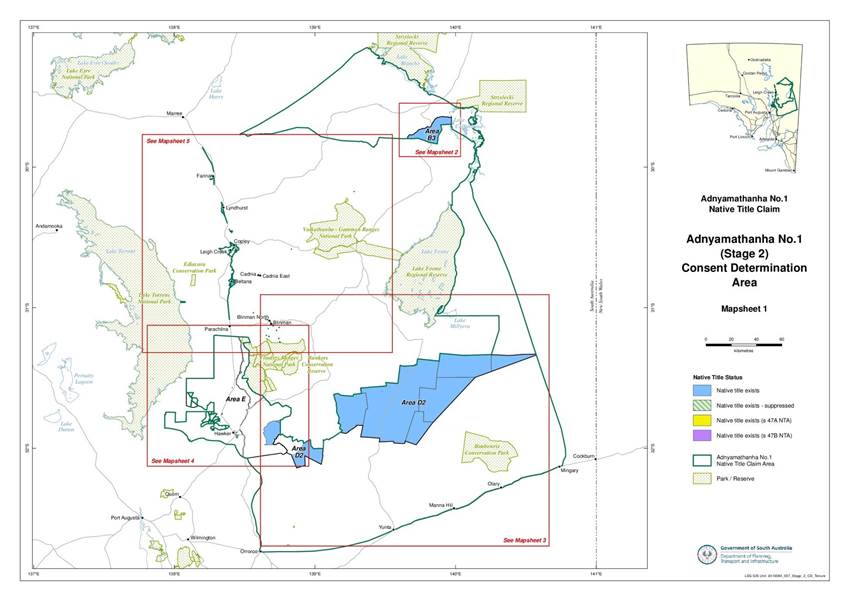
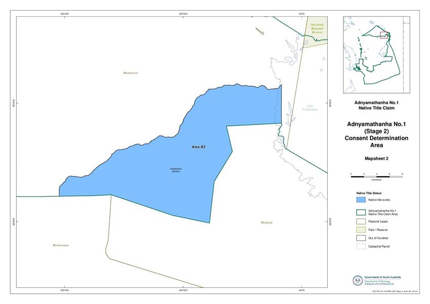
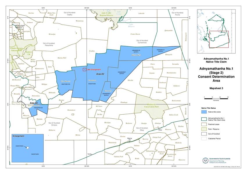
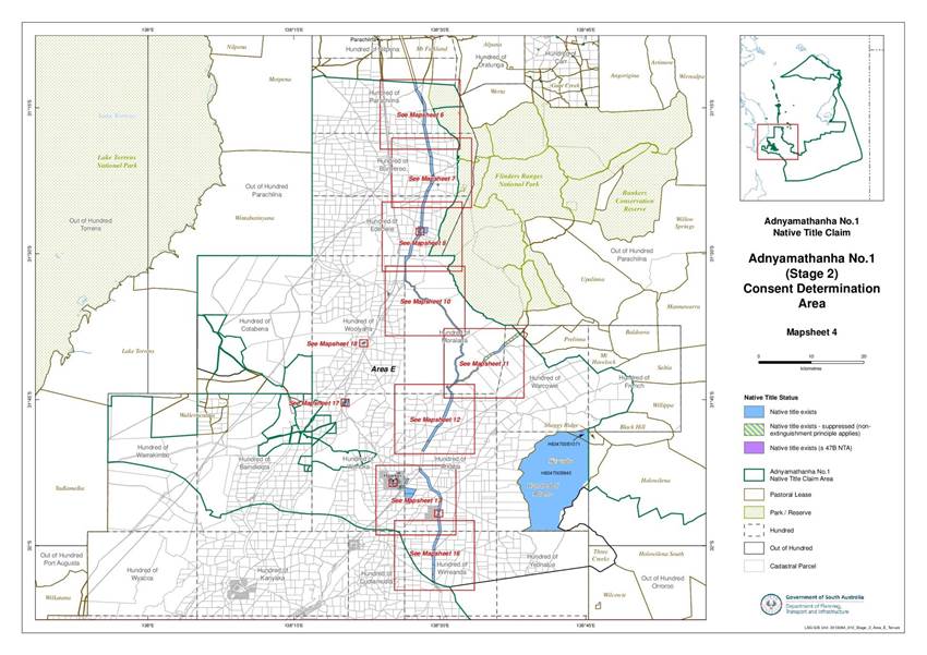
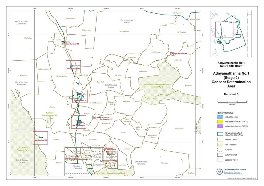
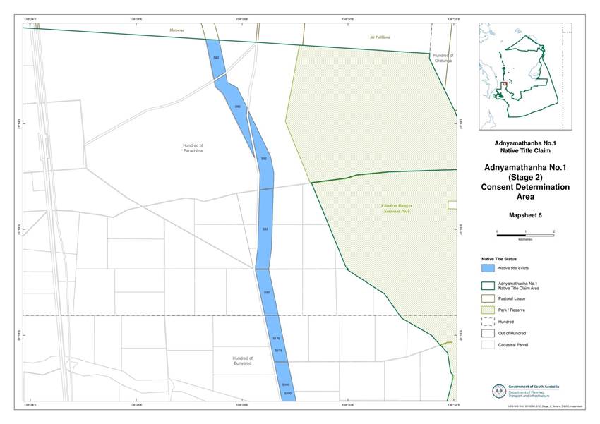
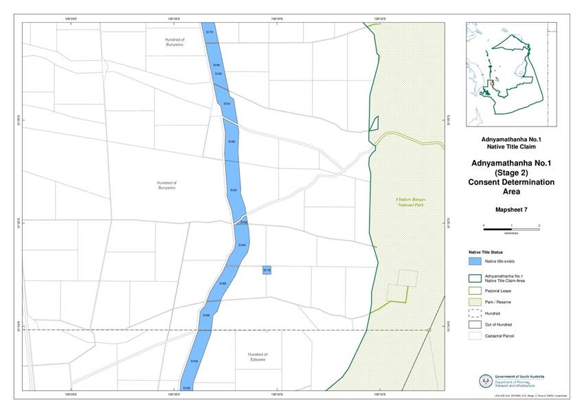
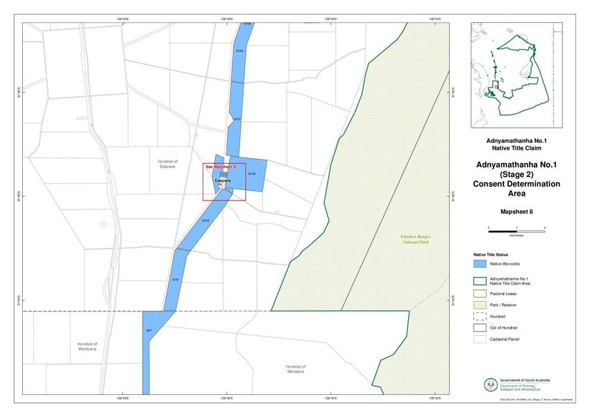
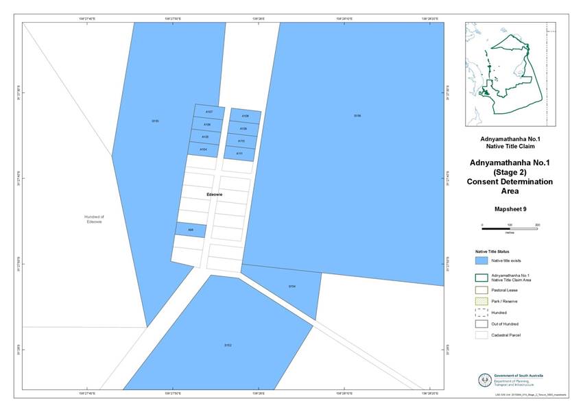
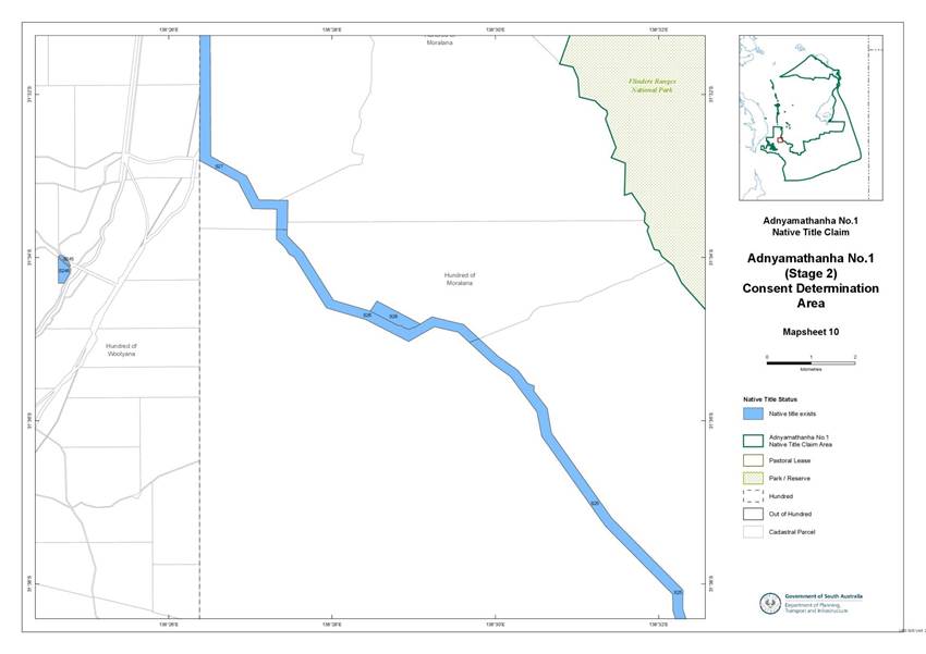
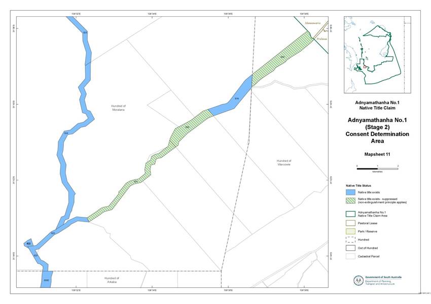
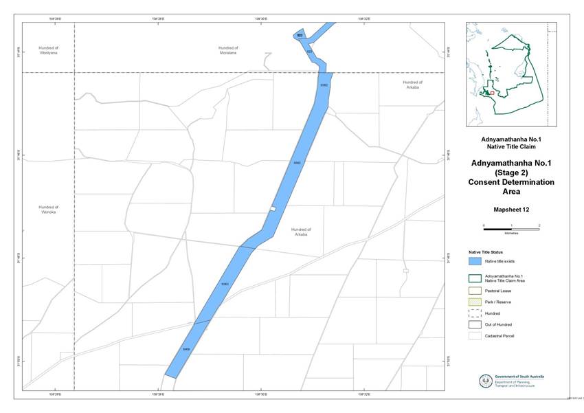
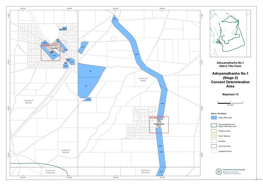
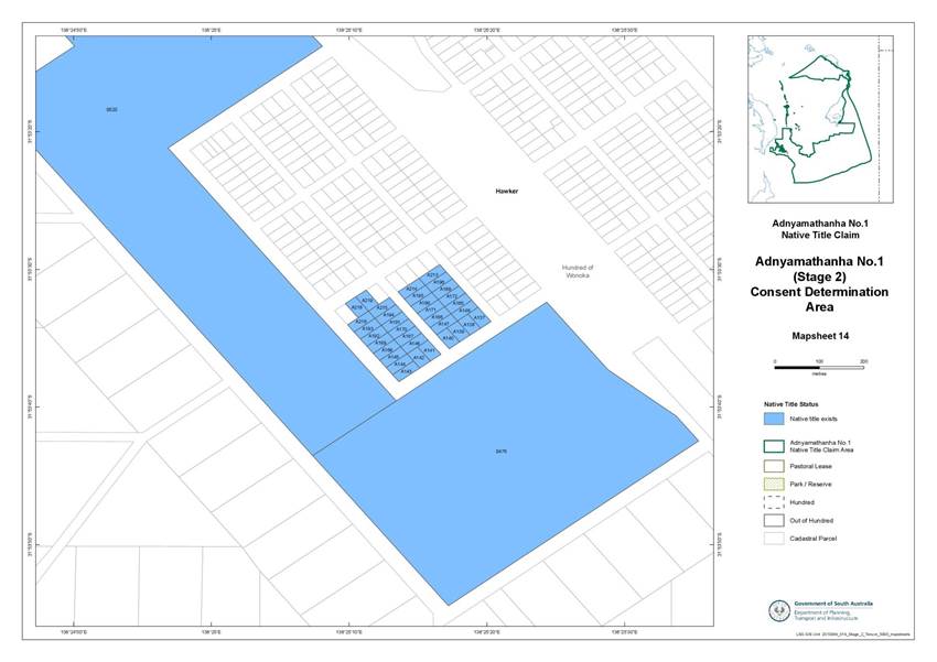
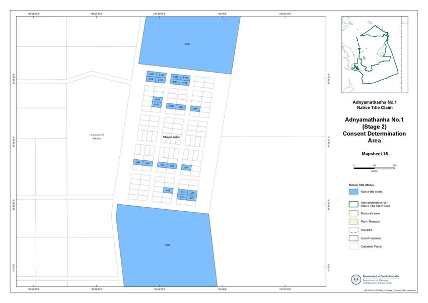
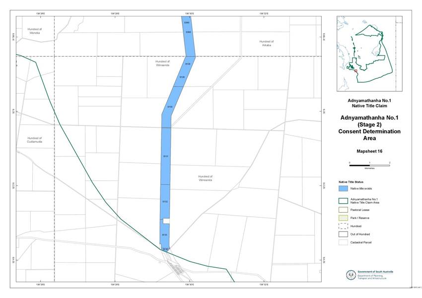
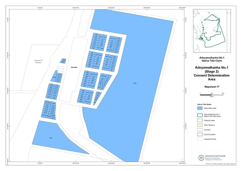
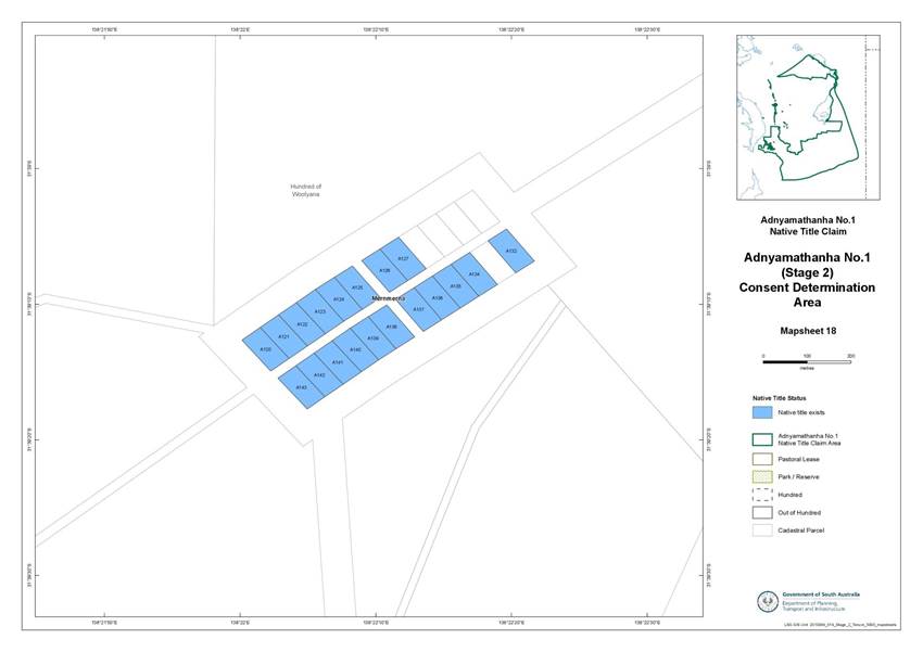
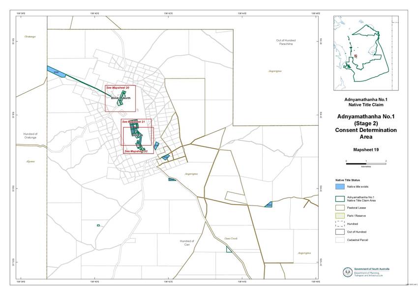
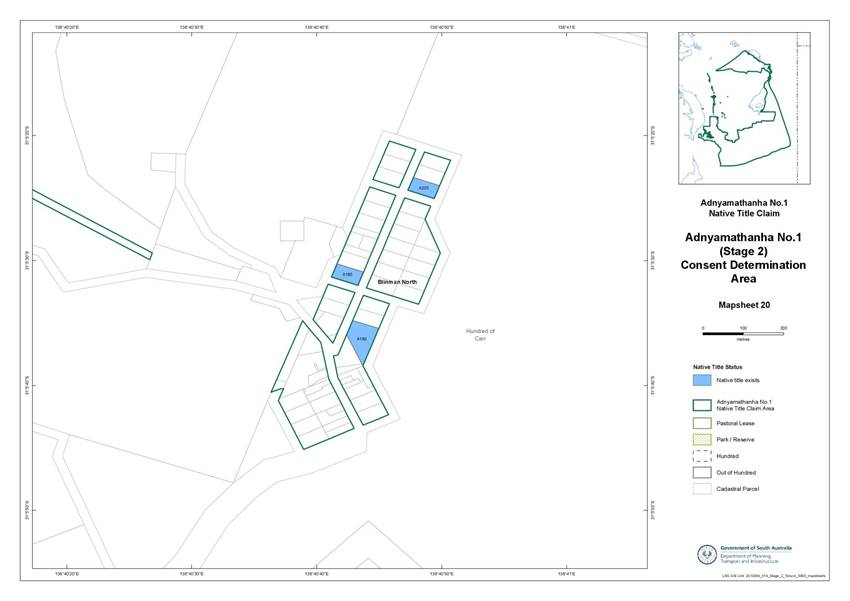
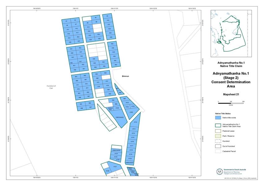
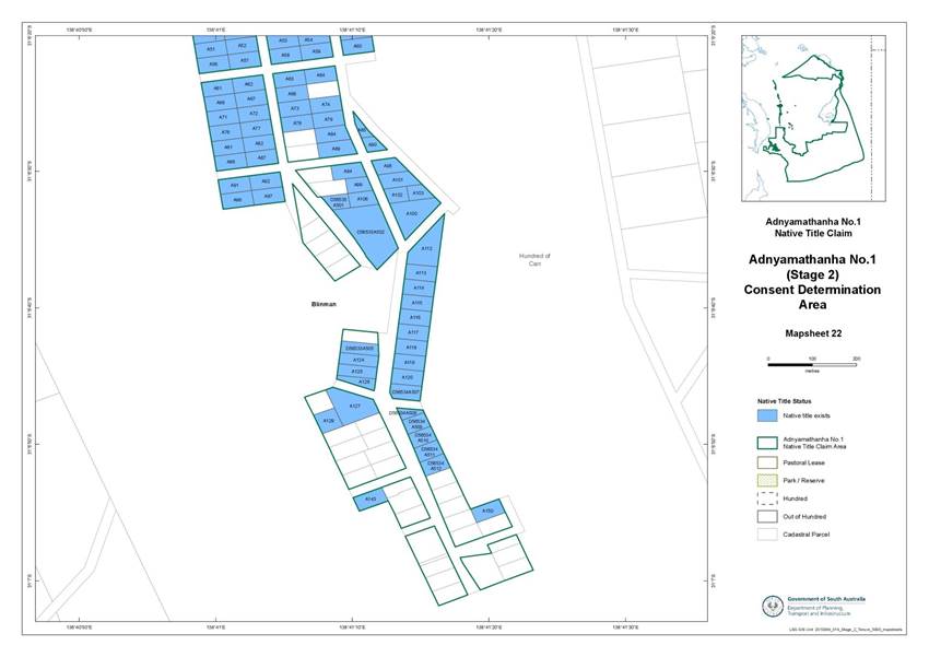
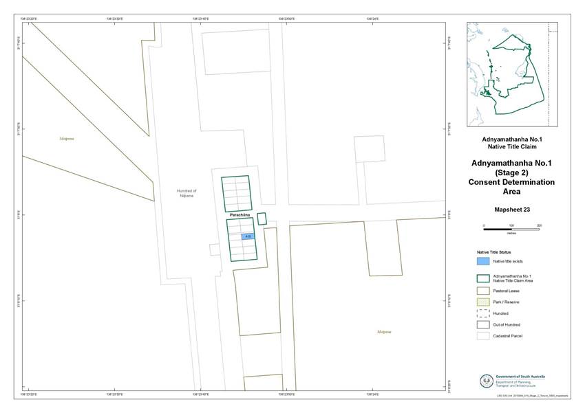
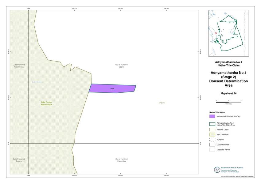
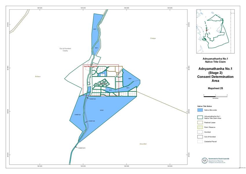
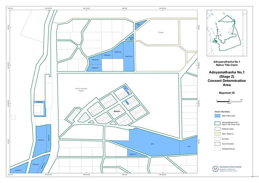
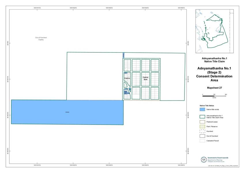
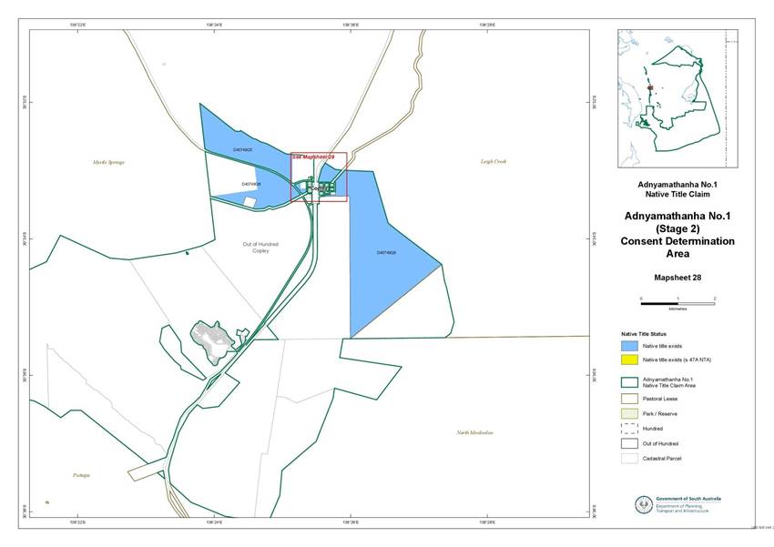
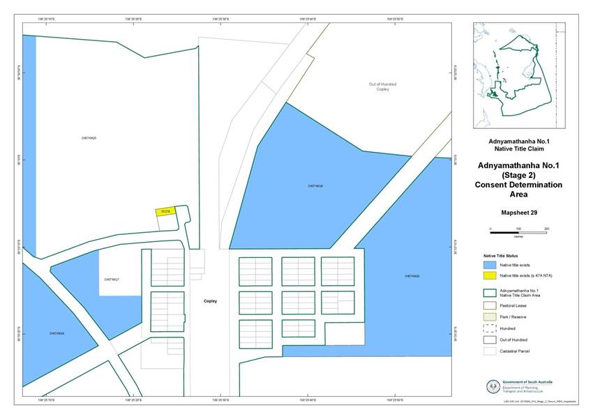
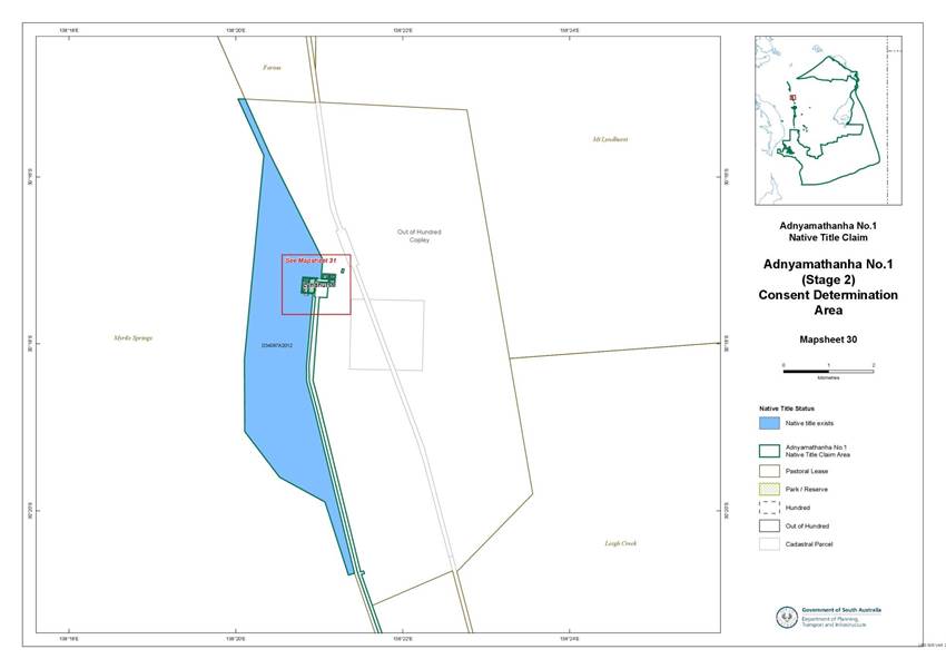
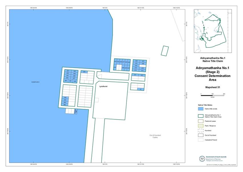
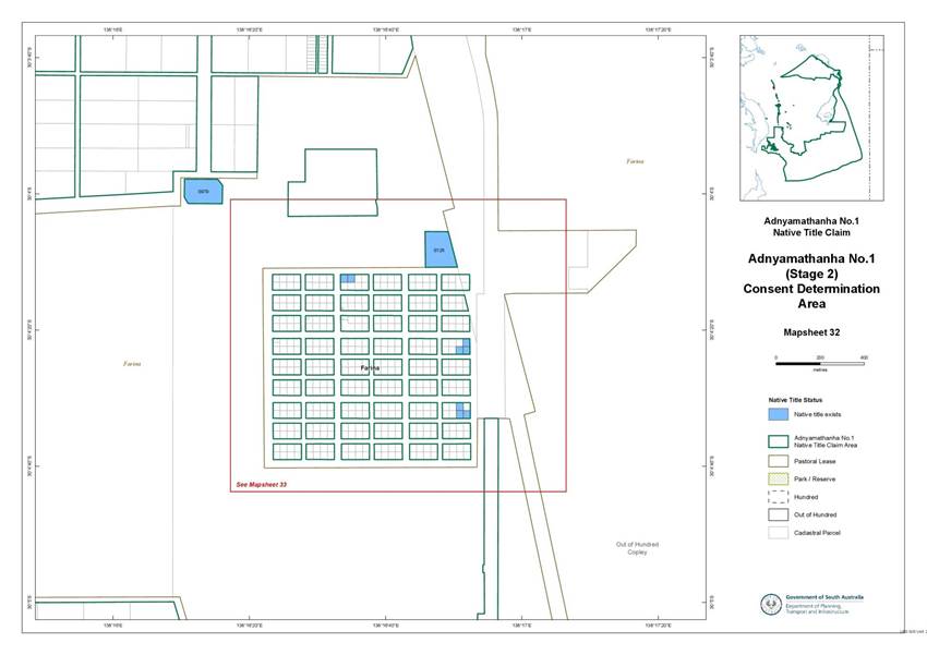
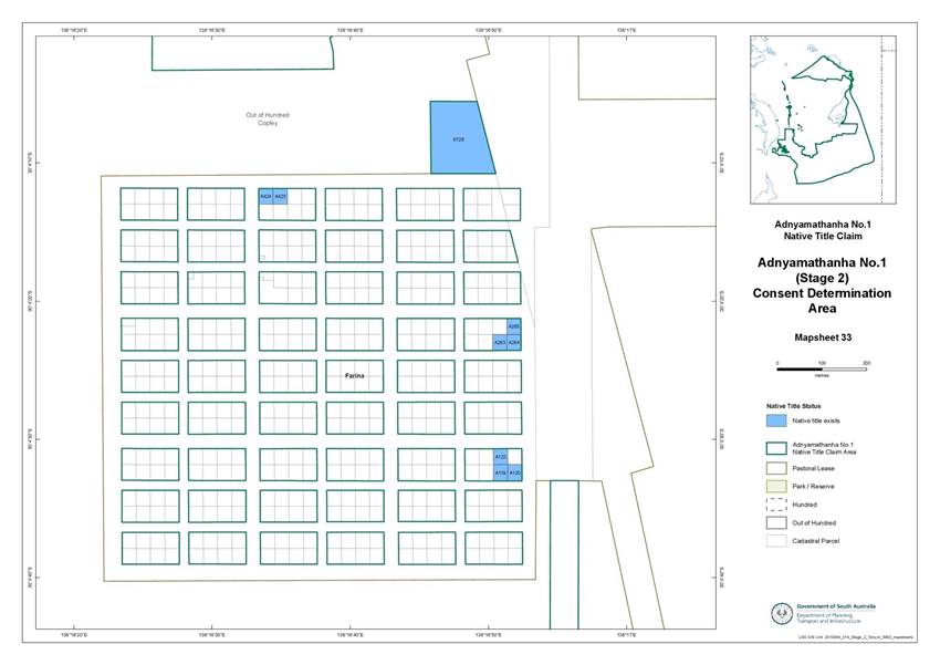
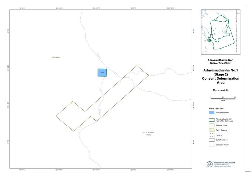
SCHEDULE 2 - Areas that have been excluded from the Determination Area
1. The following areas are agreed to have been excluded from the Determination Area by reason of the fact that native title has been extinguished in those areas:
1.1. Any areas in relation to which native title has been extinguished by an act attributable to the State of South Australia pursuant to any of the following sections of the Native Title (South Australia) Act 1994 (SA):
a) Sections 33 and 34 (Category A past acts);
b) Section 35 (Category B past acts that are wholly inconsistent with the continued existence, enjoyment or exercise of any native title rights or interests);
c) Sections 36B and 36C (Category A intermediate period acts);
d) Section 36D (Category B intermediate period acts that are wholly inconsistent with the continued existence, enjoyment or exercise of any native title rights or interests);
e) Sections 36F and 36G (previous exclusive possession acts other than “excepted acts”);
1.2. Any areas in relation to which native title has been extinguished by an act attributable to the Commonwealth of Australia pursuant to any of the following sections of the Native Title Act:
a) Section 15(1)(a), (b) (Category A past acts);
b) Section 15(1)(c) (Category B past acts that are wholly inconsistent with the continued existence, enjoyment or exercise of any native title rights or interests);
c) Section 22B(a), (b) (Category A intermediate period acts);
d) Section 22B(c) (Category B intermediate period acts that are wholly inconsistent with the continued existence, enjoyment or exercise of any native title rights or interests);
e) Sections 23B and 23C (previous exclusive possession acts).
1.3. Any areas in relation to which native title rights and interests have otherwise been wholly extinguished.
2. For the avoidance of doubt and without limiting the above, Native Title has been extinguished in relation to areas in respect of which any of the following acts have been done by the Crown in right of the State of South Australia on or before 23 December 1996:
2.1. Freehold grants (other than pursuant to the Aboriginal Lands Trust Act 1966 (SA));
2.2. Perpetual leases (other than leases which are subject to a reservation or condition expressly for the benefit of Aboriginal people);
2.3. Non-perpetual leases (other than pastoral leases or non-exclusive agricultural leases or leases subject to a reservation or condition expressly for the benefit of Aboriginal people),
where:
2.4. in the case of grants to the Crown or a statutory authority, made prior to 31 October 1975 (or after 1 January 1994, if an “intermediate period act”);
2.5. in the case of grants other than to the Crown or a statutory authority, made prior to 1 January 1994 (or after 1 January 1994, if a “past act” or “intermediate period act”).
3. Native title rights have been extinguished over all roads which have been delineated in a public map pursuant to section 5(d)(II) of the Crown Lands Act 1929 (SA) or sections 70(3) or (4) of the Crown Land Management Act 2009 (SA) or which have otherwise been validly established pursuant to South Australian Statute or common law.
SCHEDULE 3 – The descendants of Adnyamathanha Apical Ancestors
The descendants (whether biologically or by adoption) of:
a) Mt Serle Bob;
b) Polly, wife of Mt Serle Bob;
c) Quartpot Tommy;
d) Mt Serle Bob’s sister, wife of Quartpot Tommy;
e) Willy Austin Snr;
f) Nicholas Demell;
g) Emily McKenzie, wife of Nicholas Demell;
h) Sydney Ryan;
i) Mary, wife of Sydney Ryan;
j) the siblings Angepena Billy or Mary;
k) Fanny, wife of Angepena Billy; and
l) the siblings Sara Johnson, Matilda Johnson, Fred Johnson, Natalie Johnson, Jessie Johnson or Sydney Jackson.
SCHEDULE 4 – Areas where extinguishment of native title must be disregarded by reason of Section 47A or Section 47B, Native Title Act
Item 1: Out of Hundreds (Copley) H833900 Section 1278 (CT 5425/77 vested in the Aboriginal Lands Trust);
Item 2: Out of Hundreds (Copley) Section 1049 (CR 5770/658 - excised from Nilpena Pastoral Lease)
SCHEDULE 5 – Pastoral Leases wholly or partially in the Determination Area
|
Pastoral Lease Name |
Pastoral Lease Number |
Crown Lease Number Volume/Folio |
|
Murnpeowie (part) |
PE 2519 |
CL 1598/37 |
|
Benagerie (part) |
PE 2359 |
CL 1292/4 |
|
Billeroo West (part) |
PE 2300 |
CL 1286/12 |
|
Telechie (part) |
PE 2365 |
CL 1299/9 |
|
Glenorchy (part) |
PE 2205 |
CL 1277/22 |
|
Curnamona |
PE 2326 |
CL 1301/7 |
|
Glen Warwick |
PE 2307A |
CL 1410/11 |
|
Holowilena South (part) |
PE 2260A |
CL 1437/27 |
|
Worumba (part) |
PE 2291 |
CL 1287/27 |
|
Shaggy Ridge (part) |
PE 2335 |
CL 1290/34 |
SCHEDULE 6 – Existing interest of SA Power Networks
|
DCBD ID |
Hundred |
Title Ref |
Asset type |
|
H833900 S1043 |
OUT OF HUNDREDS (COPLEY) |
CR 5770/657 |
Pole Mounted Transformer |
|
T833901 A62 |
OUT OF HUNDREDS (COPLEY) |
CR 5747/992 |
Underground Low Voltage Service Conductor |
|
H300400 S517 |
WONOKA |
CR 5497/327 |
Overhead Low Voltage Service Conductor |
|
ANNEXURE B | |
|
IN THE FEDERAL COURT OF AUSTRALIA |
|
ADNYAMATHANHA NATIVE TITLE CLAIM
|
VINCENT COULTHARD AND OTHERS NAMED IN THE SCHEDULE OF PARTIES Applicant | |
|
AND: |
STATE OF SOUTH AUSTRALIA AND OTHERS NAMED IN THE SCHEDULE OF PARTIES Respondent |
|
DATE OF ORDER: |
|
|
WHERE MADE: |
IKARa |
THE COURT NOTES THAT:
A. This determination covers part of the land and waters which:
(a) are subject to the Dieri No 2 Native Title Determination Application (SAD 163 of 2008) (“the Dieri No 2 Claim”); and
(b) form part of the undetermined area of the Adnyamathanha No 1 Native Title Determination Application (SAD 6001 of 1998) (“the Adnyamathanha claim”) which overlaps the Dieri No 2 Claim.
B. This determination is being made together with a consent determination over the remaining part of the Dieri No 2 claim in favour of the Dieri People.
C. The Parties to this determination (“the Parties”) agree that those areas listed in Schedule 2 are not included in the Determination Area having been excluded by the Applicants’ applications for a determination of native title.
D. The Parties have now reached agreement as to the terms of a determination of native title to be made in relation to the Determination Area. They have filed an agreement in writing with this Court pursuant to section 87A (1) of the Native Title Act 1993 (Cth) (“the Native Title Act”) to seek the making of consent orders for a determination.
E. The Parties acknowledge that the effect of the making of this determination will be that those Adnyamathanha people described in Paragraph 6, in accordance with their traditional laws and customs, will be recognised as the native title holders for the Determination Area.
F. The Parties have agreed that the prospective registered native title body corporate in respect of the Determination Area, Adnyamathanha Traditional Lands Association (Aboriginal Corporation) RNTBC, may have liberty to apply to seek a variation of the determination of native title in this matter, as it relates to pastoral improvements in the Determination Area in the event that the ruling of the Federal Court of Australia in De Rose v South Australia (No 2) [2005] FCAFC 110; (2005) 145 FCR 290 with respect to pastoral improvements is overturned, set aside or otherwise found to be an incorrect legal ruling by the High Court of Australia in the context of an appeal to the High Court of Australia from the decision of the Federal Court of Australia in Brown (on behalf of the Ngarla People) v State of Western Australia [2012] FCAFC 154; (2012) 208 FCR 505.
G. The Parties have requested that the Court make a determination over the Determination Area without a trial.
BY CONSENT THE COURT MAKES THE FOLLOWING DETERMINATION OF NATIVE TITLE PURSUANT TO SECTION 87A OF THE NATIVE TITLE ACT:
1. In this determination including its schedules, unless the contrary intention appears, the words and expressions used have the same meaning as they are given in Part 15 of the Native Title Act.
2. In this determination:
(a) “Determination Area” means that part of the land and waters of the Dieri No 2 Claim and the overlapping part of the Adnyamathanha No 1 claim as is described in Schedule 1 (and shown in the maps forming part of that Schedule), apart from those excluded areas which are described in Paragraph 16 and in Schedule 2 (“excluded areas”);
(b) “Dieri Determination Area” means the area of the consent determination being made in favour of the Dieri people over the remaining area of the Dieri No 2 claim.
3. In this determination including its schedules, in the event of an inconsistency between a description of an area in a schedule and the depiction of that area on the map in Schedule 1, the written description shall prevail.
Existence of Native Title
4. Subject to Paragraphs 12 to 16 herein, native title exists in the Determination Area.
5. Native title does not exist in relation to the areas and resources described in Paragraphs 12, 15 and 16 herein.
The Native Title Holders
6. The Native Title Holders in relation to the Determination Area are those living Aboriginal persons who are described in Schedule 3 who:
(a) identify as Adnyamathanha; and
(b) are recognised by other Native Title Holders under the relevant Adnyamathanha traditional laws and customs as having maintained an affiliation with, and continuing to hold native title rights and interests in the Determination Area.
Native title rights and interests
7. Subject to Paragraphs 8, 9 and 10, the nature and extent of the native title rights and interests held by the Native Title Holders are rights to use, stay on and enjoy the land and waters of the Determination Area, being:
(a) The right to access and move about the Determination Area;
(b) The right to live, to camp and to erect shelters on the Determination Area;
(c) The right to hunt and fish on the Determination Area;
(d) The right to gather and use the natural resources of the Determination Area such as food, plants, timber, resin, ochre and soil;
(e) The right to cook and to light fires for cooking and camping purposes on the Determination Area;
(f) The right to use the natural water resources of the Determination Area;
(g) The right to distribute, trade or exchange the natural resources of the Determination Area;
(h) The right to conduct ceremonies and hold meetings on the Determination Area;
(i) The right to engage and participate in cultural activities on the Determination Area including those relating to births and deaths;
(j) The right to carry out and maintain burials of deceased native title holders and of their ancestors within the Determination Area;
(k) The right to teach on the Determination Area the physical and spiritual attributes of locations and sites within the Determination Area;
(l) The right to visit, maintain and preserve sites and places of cultural or spiritual significance to Native Title Holders within the Determination Area;
(m) The right to speak for and make decisions in relation to the Determination Area about the use and enjoyment of the Determination Area by Aboriginal people who recognise themselves to be governed by the traditional laws and customs acknowledged by the Native Title Holders of the Determination Area;
(n) The right to be accompanied on to the Determination Area by those people who, though not Native Title Holders, are:
(i) spouses of Native Title Holders; or
(ii) people required by traditional law and custom for the performance of ceremonies or cultural activities on the Determination Area; or
(iii) people who have rights in relation to the Determination Area according to the traditional laws and customs acknowledged by the Native Title Holders.
8. The native title rights and interests described in Paragraph 7 do not confer possession, occupation, use and enjoyment of the Determination Area on the Native Title Holders to the exclusion of others.
9. The native title rights and interests are for personal, domestic and non-commercial communal use.
10. The native title rights and interests are subject to and exercisable in accordance with:
(a) the traditional laws and customs of the Native Title Holders;
(b) the valid laws of the State and Commonwealth, including the common law.
For the avoidance of doubt, the native title rights and interests expressed in Paragraph 7(f) are subject to the Natural Resources Management Act 2004 (SA).
Nature and extent of other rights and interests and relationship with Native Title
11. The nature and extent of other rights and interests in relation to the Determination Area are:
(a) The rights and interests within the Determination Area created by the pastoral leases described in Schedule 4;
(b) the interests of the Crown in right of the State of South Australia;
(c) the interests of persons to whom valid or validated rights and interests have been granted or recognised by the Crown in right of the State of South Australia or by the Commonwealth of Australia pursuant to statute or otherwise in the exercise of executive power;
(d) rights or interests held by reason of the force and operation of the laws of the State or of the Commonwealth;
(e) the rights to access land by an employee or agent or instrumentality of the State, Commonwealth or other statutory authority as required in the performance of his or her statutory or common law duties (in accordance with any valid legislation);
(f) the rights and interests of Telstra Corporation Limited:
(i) as the owner or operator of telecommunications facilities within the Determination Area;
(ii) created pursuant to the Post and Telegraph Act 1901 (Cth), the Telecommunications Act 1975 (Cth), the Australian Telecommunications Corporation Act 1989 (Cth), the Telecommunications Act 1991 (Cth) and the Telecommunications Act 1997 (Cth), including:
(1) to inspect land;
(2) to install and operate existing and new telecommunications facilities;
(3) to alter, remove, replace, maintain, repair and ensure the proper functioning of its existing and any new telecommunications facilities, including cabling, customer terminal sites and ancillary facilities; and
(i) for its employees, agents or contractors to enter the Determination Area to access its facilities, in and in the vicinity of, the Determination Area in the performance of their duties;
(ii) under any leases, licences, access agreements or easements relating to its telecommunications facilities in the Determination Area;
(o) the rights and interests of Epic Energy South Australia Pty Ltd (formerly Tenneco Gas South Australia Pty Ltd) (“Epic”):
(i) as:
(A) holders of Pipeline Licence No. 1 (PL1) issued pursuant to the Petroleum Act 1940 (SA) on 12 March 1969 and renewed on 27 March 1990 pursuant to the Petroleum Act 1940 (SA) and continuing in force by the operation of clause 2 of the Schedule to the Petroleum Act 2000 (SA); and
(B) owner of the pipeline the subject thereof by virtue of having been a purchaser of the pipeline (as purchaser is defined in section 16 of the Natural Gas Authority Act 1967 (SA) as amended by the Pipelines Authority (Sale of Pipelines) Amendment Act 1995 (SA) (“Sale Legislation”) from the former Pipeline Authority of South Australia (“PASA”), now the Natural Gas Authority of South Australia (“NGASA”) pursuant to a Sale Agreement dated 30 June 1995 under the Sale Legislation;
(ii) where the licensed pipeline was established pursuant to the Natural Gas Authority Act 1967 (SA) and is located within a statutory easement established by section 9 of the Sale Legislation and section 28 of the Sale Legislation provides:
“(1) The creation of the statutory easement under this Act, or the grant of a pipeline lease, does not affect any native title that may exist in the land to which the easement or lease relates.
(2) The statutory easement or a pipeline lease under this Act does not derogate from pre-existing rights of Aboriginal people to enter, travel across or stay on land subject to the easement or lease.”;
(iii) the statutory easement entitles Epic, inter alia, to install, maintain and operate the pipeline and to carry out authorised purposes including the installation, operation, inspection, extension, alteration, repair and removal of the pipeline or associated equipment and the carrying out of maintenance work on the pipeline or associated equipment;
(iv) for Epic, its employees, agents and contractors (or any of them) to enter the Determination Area to access Epic’s rights and interests and to do all things necessary to exercise those rights and interests and perform all obligations in the vicinity of the Determination Area in performance of their duties;
(p) the rights and interests of the “Producers” as defined in the Cooper Basin (Ratification) Act 1975 (SA):
(i) as holders of Pipeline Licence No.2 (PL2) granted to the Producers on 26 November 1981 under the Petroleum Act 1940 (SA) and renewed on 3 May 2003 under the Petroleum Act 2000 (SA) and continuing in force by the operation of clause 2 of the Schedule to the Petroleum Act 2000 (SA);
(ii) created pursuant to the Stoney Point (Liquids Project) Ratification Act 1981 (SA);
(iii) granted to the Producers pursuant to the former PASA (now NGASA) and the Producers’ Right of Way Agreement dated 26 November 1981;
(iv) for the Producers’ employees, agents or contractors to enter the Determination Area to access the Producers’ rights and interests and to do all things necessary to exercise those rights and interests in the vicinity of the Determination Area in performance of their duties.
12. Native title rights and interests do not exist in respect of those parts of the Determination Area being any house, shed or other building or airstrip or any dam or other stock watering point constructed pursuant to the pastoral leases referred to in Paragraph 11(a). These areas comprise the land on which the improvements of the kind referred to herein have been constructed prior to the date hereof and include any adjacent land or waters the exclusive use of which is necessary for the enjoyment of the improvements referred to.
13. For the avoidance of doubt, Paragraph 12 does not preclude the possibility of further extinguishment, according to law, of native title over other limited parts of the Determination Area by reason of the construction of new pastoral improvements of the kind referred to in Paragraph 12 after the date of this determination.
14. Subject to Paragraph 15, the relationship between the native title rights and interests in the Determination Area that are described in Paragraph 7 and the other rights and interests that are referred to in Paragraph 11 (“the Other rights and interests”) is that:
(a) the Other rights and interests co-exist with the native title rights and interests;
(b) in the event of inconsistency, the Other rights and interests prevail over the native title rights and interests and any exercise of the native title rights and interests, but do not extinguish them; and
(c) the existence of the native title rights and interests does not prevent the doing of any activity required or permitted to be done by, in accordance with or under the Other rights and interests.
15. Native title rights and interests do not exist in:
(a) Minerals, as defined in section 6 of the Mining Act 1971 (SA); or
(b) Petroleum, as defined in section 4 of the Petroleum and Geothermal Energy Act 2000 (SA); or
(c) a naturally occurring underground accumulation of a regulated substance as defined in section 4 of the Petroleum and Geothermal Energy Act 2000 (SA), below a depth of 100 metres from the surface of the earth; or
(d) a natural reservoir, as defined in section 4 of the Petroleum and Geothermal Energy Act 2000 (SA), below a depth of 100 metres from the surface of the earth; or
(e) geothermal energy, as defined in section 4 of the Petroleum and Geothermal Energy Act 2000 (SA) the source of which is below a depth of 100 metres from the surface of the earth.
For the purposes of this Paragraph 15 and the avoidance of doubt:
(i) a geological structure (in whole or in part) on or at the earth's surface or a natural cavity which can be accessed or entered by a person through a natural opening in the earth's surface, is not a natural reservoir;
(ii) thermal energy contained in a hot or natural spring is not geothermal energy as defined in section 4 of the Petroleum and Geothermal Energy Act 2000 (SA);
(iii) the absence from this order of any reference to a natural reservoir or a naturally occurring accumulation of a regulated substance, as those terms are defined in section 4 of the Petroleum and Geothermal Energy Act 2000 (SA), above a depth 100 metres below the surface of the earth or geothermal energy the source of which is above a depth of 100 metres below the surface of the earth is not, of itself, to be taken as an indication of the existence or otherwise of native title rights or interests in such natural reservoir, naturally occurring accumulation of a regulated substance or geothermal energy.
16. Native title rights do not exist in the areas covered by public works attributable to the State or Commonwealth (including the land defined in section 251D of the Native Title Act) which were constructed, established or situated prior to 23 December 1996 or commenced to be constructed or established on or before that date.
17. Public works constructed, established or situated after 23 December 1996 have had such effect on native title rights and interests as has resulted from Part 2 Division 3 of the Native Title Act.
AND THE COURT MAKES THE FOLLOWING FURTHER ORDERS:
18. The native title is not to be held in trust.
19. In respect of the Determination Area, Adnyamathanha Traditional Lands Association (Aboriginal Corporation) RNTBC is to:
(a) be the prescribed body corporate for the purposes of section 57(2) of the Native Title Act; and
(b) perform the functions mentioned in section 57(3) of the Native Title Act after becoming the registered native title body corporate in relation to Part 1 of the Determination Area.
20. The Native Title Holders (through Adnyamathanha Traditional Lands Association (Aboriginal Corporation) RNTBC), the State or any other Respondent have liberty to apply on 14 days’ notice to a single judge of the Court for the following purposes:
(a) to establish the precise location and boundaries of any public works and adjacent land and waters referred to in Paragraphs 16 and 17 of this Order;
(b) to establish the effect on native title rights and interests of any public works referred to in Paragraph 17 of this Order; or
(c) to determine whether any particular area is included in the description in Paragraph 12 or Schedule 2 of this Order.
(d) to address, if appropriate, any changes to paragraphs 12 and 13 above in light of the decision of the High Court of Australia in State of Western Australia v Brown & Others (No P37 of 2012 HCA) as it relates to pastoral improvements.
AND THE COURT MAKES THE FOLLOWING ANCILLARY ORDERS PURSUANT TO SECTION 87A(5) OF THE NATIVE TITLE ACT:
21. The Court notes in relation to the Determination Area as follows:
(a) The Dieri People and the Adnyamathanha People have entered into a Memorandum of Understanding between them in the terms of the document comprising the “Annexure A” to Schedule 5, under which both groups agree in particular that:
(i) the Adnyamathanha People hold traditional rights and interests in the Dieri Determination Area;
(ii) the Dieri People hold traditional rights and interests in the Determination Area;
(b) The Agreement provides that the traditional rights and interests referred to in sub-paragraph (a):
(i) are not native title rights and interests; and
(ii) co-exist with the native title rights and interests.
(a) The State and other Respondent parties are not bound by the Memorandum of Understanding referred to in Paragraph 21(a) but acknowledge that the provisions of relevant State and Commonwealth legislation apply according to their terms from time to time in relation to the Determination Area.
(b) The consent determination made [or expected to be made] in relation to the Dieri Determination Area is in the terms of the document comprising Schedule 6.
SCHEDULE 1 - Description and Map of the Determination Area
External boundary description
The Determination Area is located wholly within and comprises all the land and waters bounded by the following line:
That portion within the external boundary of Allotment 24 in Deposited Plan 42203 as follows; commencing at Longitude 139.771817 East Latitude 29.449001 South; then generally south-easterly in straight lines connecting the following coordinate points
|
Longitude (East) |
Latitude (South) |
|
139.778008 |
29.456626 |
|
139.786104 |
29.457580 |
|
139.798726 |
29.466526 |
|
139.800913 |
29.467984 |
|
139.803100 |
29.474550 |
|
139.806745 |
29.481845 |
|
139.814763 |
29.486951 |
|
139.822053 |
29.485491 |
|
139.823510 |
29.480385 |
|
139.833677 |
29.482455 |
|
139.888386 |
29.502268 |
|
139.919003 |
29.518316 |
|
139.948160 |
29.537281 |
|
139.972215 |
29.553329 |
|
139.995541 |
29.567919 |
Then in a straight line south-easterly to the intersection of the north-western shoreline of Lake Callabonna with Longitude 139.997650 East; then generally south-westerly along the said shoreline of Lake Callabonna to its intersection with the southern bank of Yerila Creek; then generally south-westerly along the said southern bank of Yerila Creek to its intersection with Longitude 139.659150 East; then south to the intersection of the northern boundary of Moolawatana Pastoral Lease - Block 1229, OH(Callabonna) with Longitude 139.659150 East; then westerly along the northern boundary of the said Block 1229, OH (Marree & Callabonna) to its intersection with Wattleowie Creek at Longitude 139.593331 East; then generally northerly along Wattleowie Creek, generally being straight lines connecting the following coordinate points
|
Longitude (East) |
Latitude (South) |
|
139.595330 |
29.795900 |
|
139.597670 |
29.793190 |
|
139.598190 |
29.791840 |
|
139.599360 |
29.790150 |
|
139.599620 |
29.789140 |
|
139.599630 |
29.787440 |
|
139.599110 |
29.786200 |
|
139.598080 |
29.785070 |
|
139.597570 |
29.783940 |
|
139.597580 |
29.781910 |
|
139.596290 |
29.780350 |
|
139.596160 |
29.780330 |
|
139.596290 |
29.779420 |
|
139.597330 |
29.778520 |
|
139.597850 |
29.777510 |
|
139.597860 |
29.775030 |
|
139.598120 |
29.773670 |
|
139.598780 |
29.772430 |
|
139.599170 |
29.772100 |
|
139.599430 |
29.771190 |
|
139.599430 |
29.769840 |
|
139.598540 |
29.766570 |
|
139.597900 |
29.765100 |
|
139.595710 |
29.760940 |
|
139.594560 |
29.758770 |
|
139.593010 |
29.757410 |
|
139.590820 |
29.755940 |
|
139.589410 |
29.754440 |
|
139.588450 |
29.752640 |
|
139.587090 |
29.750850 |
|
139.586450 |
29.749500 |
|
139.586450 |
29.748930 |
|
139.586060 |
29.748260 |
|
139.586031 |
29.747900 |
|
139.585940 |
29.746790 |
|
139.586210 |
29.743970 |
|
139.585580 |
29.740580 |
|
139.584680 |
29.738550 |
|
139.583520 |
29.736970 |
|
139.582750 |
29.735380 |
|
139.582370 |
29.734140 |
|
139.581210 |
29.732790 |
|
139.579660 |
29.732100 |
|
139.579020 |
29.731540 |
|
139.577210 |
29.730740 |
|
139.576820 |
29.730740 |
|
139.575660 |
29.730060 |
|
139.574760 |
29.729270 |
|
139.573860 |
29.728250 |
|
139.572440 |
29.727350 |
|
139.570900 |
29.725540 |
|
139.568320 |
29.723430 |
|
139.567920 |
29.722660 |
|
139.566260 |
29.721460 |
|
139.565230 |
29.720900 |
|
139.563940 |
29.719760 |
|
139.562780 |
29.718180 |
|
139.561630 |
29.717050 |
|
139.560980 |
29.716710 |
|
139.560080 |
29.715920 |
|
139.559180 |
29.714380 |
|
139.558920 |
29.713660 |
|
139.559000 |
29.711700 |
|
139.558030 |
29.710160 |
|
139.558040 |
29.709140 |
|
139.558750 |
29.708180 |
|
139.557920 |
29.706210 |
|
139.558450 |
29.704180 |
|
139.559870 |
29.702380 |
|
139.560400 |
29.700570 |
|
139.560410 |
29.697640 |
|
139.560800 |
29.696740 |
|
139.561580 |
29.695840 |
|
139.561970 |
29.694480 |
|
139.563270 |
29.693360 |
|
139.563790 |
29.692230 |
|
139.563790 |
29.691550 |
|
139.564820 |
29.689730 |
|
139.565740 |
29.688630 |
|
139.565750 |
29.687500 |
|
139.564850 |
29.685350 |
|
139.564850 |
29.684790 |
|
139.565110 |
29.684220 |
|
139.565000 |
29.681060 |
|
139.564960 |
29.679350 |
|
139.564610 |
29.676610 |
|
139.565080 |
29.675190 |
|
139.564320 |
29.673370 |
|
139.564520 |
29.671610 |
|
139.565660 |
29.670340 |
|
139.566780 |
29.670410 |
|
139.567370 |
29.669790 |
|
139.568630 |
29.667230 |
|
139.568810 |
29.665050 |
|
139.569080 |
29.662120 |
|
139.569210 |
29.661330 |
|
139.570120 |
29.659870 |
|
139.570230 |
29.657620 |
|
139.570650 |
29.655470 |
|
139.571560 |
29.654230 |
|
139.572860 |
29.653330 |
|
139.573380 |
29.651750 |
|
139.574250 |
29.650430 |
|
139.574410 |
29.649600 |
|
139.574430 |
29.647920 |
|
139.574820 |
29.646900 |
|
139.576380 |
29.644760 |
|
139.576900 |
29.643520 |
|
139.577940 |
29.642170 |
|
139.578980 |
29.640260 |
|
139.578870 |
29.633480 |
|
139.579780 |
29.631680 |
|
139.581670 |
29.630110 |
|
139.582270 |
29.629860 |
|
139.582370 |
29.629210 |
|
139.583540 |
29.627740 |
|
139.583730 |
29.626190 |
|
139.583940 |
29.623910 |
|
139.583650 |
29.622530 |
|
139.583830 |
29.620860 |
|
139.585800 |
29.619010 |
|
139.586420 |
29.618380 |
|
139.586680 |
29.617590 |
|
139.586550 |
29.616240 |
|
139.586950 |
29.615230 |
|
139.586820 |
29.614940 |
|
139.586310 |
29.613760 |
|
139.586310 |
29.611780 |
|
139.585670 |
29.611390 |
|
139.585680 |
29.611200 |
|
139.585800 |
29.609470 |
|
139.584900 |
29.607550 |
|
139.585430 |
29.606530 |
|
139.585940 |
29.603260 |
|
139.586350 |
29.601460 |
|
139.586350 |
29.600220 |
|
139.585590 |
29.598180 |
|
139.585600 |
29.595590 |
|
139.585990 |
29.594910 |
|
139.585860 |
29.593900 |
|
139.586380 |
29.593000 |
|
139.586390 |
29.591640 |
|
139.586910 |
29.590180 |
|
139.586910 |
29.588370 |
|
139.587300 |
29.587580 |
|
139.587310 |
29.587020 |
|
139.587700 |
29.586230 |
|
139.588340 |
29.585670 |
|
139.589660 |
29.585220 |
|
139.591670 |
29.581470 |
|
139.591070 |
29.580260 |
|
139.589530 |
29.578450 |
|
139.589150 |
29.577540 |
|
139.589150 |
29.576640 |
|
139.588960 |
29.575870 |
the latter coordinate being an intersection of the said Wattleowie Creek with Petermorra Creek; then generally northerly along the said Petermorra Creek, generally being straight lines connecting the following coordinate points
|
Longitude (East) |
Latitude (South) |
|
139.588230 |
29.574800 |
|
139.587870 |
29.573930 |
|
139.588390 |
29.572580 |
|
139.589040 |
29.571900 |
|
139.589430 |
29.571000 |
|
139.589180 |
29.569980 |
|
139.589570 |
29.567160 |
|
139.589190 |
29.566030 |
|
139.589190 |
29.565130 |
|
139.589710 |
29.563890 |
|
139.591790 |
29.561410 |
|
139.592570 |
29.559950 |
|
139.592700 |
29.559160 |
|
139.591980 |
29.557900 |
|
139.591330 |
29.557610 |
|
139.591160 |
29.556000 |
|
139.591550 |
29.554760 |
|
139.591370 |
29.552960 |
|
139.593110 |
29.551260 |
|
139.593540 |
29.549110 |
|
139.595450 |
29.547880 |
|
139.596490 |
29.546640 |
|
139.596880 |
29.545740 |
|
139.598040 |
29.544280 |
|
139.598820 |
29.542700 |
|
139.598950 |
29.541910 |
|
139.598310 |
29.541120 |
|
139.598440 |
29.540220 |
|
139.598830 |
29.539430 |
|
139.600000 |
29.538040 |
|
139.600260 |
29.537740 |
|
139.600780 |
29.536390 |
|
139.601050 |
29.531870 |
|
139.600890 |
29.528000 |
|
139.600971 |
29.527625 |
|
139.601200 |
29.526570 |
|
139.601200 |
29.525330 |
|
139.601460 |
29.524990 |
|
139.601340 |
29.522850 |
|
139.601730 |
29.521830 |
|
139.602000 |
29.519240 |
|
139.602650 |
29.516530 |
|
139.603040 |
29.515860 |
|
139.603180 |
29.514950 |
|
139.602470 |
29.513550 |
|
139.601000 |
29.511110 |
|
139.601050 |
29.509400 |
|
139.601780 |
29.507610 |
|
139.601360 |
29.505550 |
|
139.601410 |
29.504120 |
|
139.602190 |
29.502760 |
|
139.602750 |
29.500890 |
|
139.603620 |
29.499610 |
|
139.604780 |
29.498930 |
|
139.605300 |
29.498480 |
|
139.605690 |
29.497020 |
|
139.606320 |
29.496500 |
|
139.608010 |
29.496120 |
|
139.608660 |
29.495560 |
|
139.609310 |
29.492620 |
|
139.610020 |
29.490970 |
|
139.611150 |
29.489990 |
|
139.611770 |
29.489700 |
|
139.613450 |
29.489360 |
|
139.614230 |
29.488240 |
|
139.615780 |
29.487340 |
|
139.616810 |
29.486210 |
|
139.616950 |
29.484630 |
|
139.617210 |
29.484180 |
|
139.617210 |
29.483500 |
|
139.615480 |
29.481980 |
|
139.617970 |
29.479680 |
|
139.618700 |
29.479070 |
|
139.620350 |
29.477060 |
|
139.621640 |
29.475940 |
|
139.623050 |
29.475560 |
|
139.624510 |
29.475650 |
|
139.624980 |
29.475730 |
|
139.626270 |
29.474390 |
|
139.628400 |
29.473740 |
|
139.630420 |
29.473010 |
|
139.631320 |
29.471810 |
|
139.632210 |
29.469670 |
|
139.634020 |
29.468390 |
|
139.636630 |
29.467160 |
|
139.638120 |
29.466570 |
|
139.639530 |
29.464800 |
|
139.639990 |
29.463990 |
|
139.641360 |
29.461580 |
|
139.644420 |
29.459900 |
|
139.645780 |
29.459280 |
|
139.647170 |
29.458650 |
|
139.650360 |
29.457520 |
|
139.653070 |
29.456460 |
|
139.655280 |
29.454360 |
|
139.658250 |
29.452750 |
|
139.660360 |
29.452240 |
|
139.660830 |
29.452220 |
|
139.662200 |
29.452160 |
|
139.664970 |
29.451540 |
|
139.666870 |
29.451580 |
|
139.668220 |
29.452070 |
|
139.669680 |
29.451820 |
|
139.671750 |
29.449670 |
|
139.673520 |
29.447610 |
|
139.674440 |
29.445040 |
|
139.675830 |
29.443770 |
|
139.676000 |
29.443200 |
|
139.677290 |
29.441540 |
|
139.679060 |
29.439630 |
|
139.679080 |
29.439610 |
|
139.680660 |
29.437250 |
|
139.682870 |
29.434980 |
|
139.684450 |
29.433980 |
|
139.686420 |
29.433140 |
|
139.688100 |
29.431580 |
|
139.689520 |
29.431120 |
|
139.690840 |
29.430690 |
|
139.694580 |
29.429570 |
|
139.696990 |
29.428600 |
|
139.697380 |
29.428440 |
|
139.704220 |
29.425730 |
|
139.705700 |
29.424800 |
|
139.706900 |
29.423030 |
|
139.707740 |
29.422210 |
|
139.708550 |
29.421410 |
|
139.709240 |
29.420750 |
|
139.709740 |
29.420090 |
Then generally south-easterly in straight lines connecting the following coordinate points
|
Longitude (East) |
Latitude (South) |
|
139.713450 |
29.419549 |
|
139.720196 |
29.420072 |
|
139.723899 |
29.420390 |
|
139.728371 |
29.426898 |
|
139.740272 |
29.435784 |
|
139.748206 |
29.440069 |
|
139.756934 |
29.442290 |
|
139.759949 |
29.444512 |
|
139.771817 |
29.449001 |
The latter coordinate being the point of commencement.
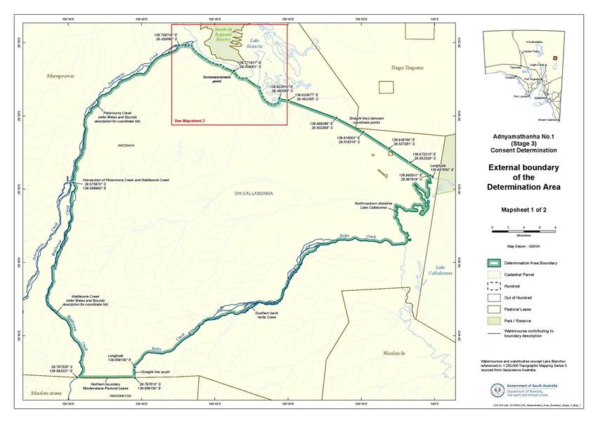
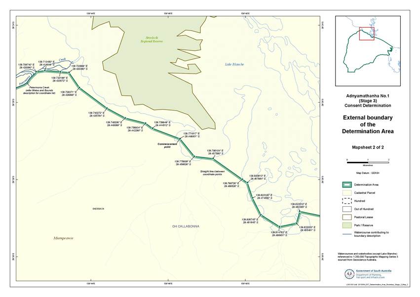
Reference datum
Geographical coordinates have been provided by the NNTT Geospatial services and geographical coordinates are referenced to the Geocentric Datum of Australia 1994 (GDA94), in decimal degrees.
Watercourses and waterbodies (except Lake Blanche) referenced to 1:250,000 Topographic Mapping Series 3 – sourced from Geoscience Australia.
Use of Coordinates
Where coordinates are used within the description to represent cadastral or topographical boundaries or the intersection with such, they are intended as a guide only. As an outcome of the custodians of cadastral and topographical data continuously recalculating the geographic position of their data based on improved survey and data maintenance procedures, it is not possible to accurately define such a position other than by detailed ground survey.
SCHEDULE 2 - Areas that have been excluded from the Determination Area
1. The following areas are agreed to have been excluded from the Determination Area by reason of the fact that native title has been extinguished in those areas:
1.1. Any areas in relation to which native title has been extinguished by an act attributable to the State of South Australia pursuant to any of the following sections of the Native Title (South Australia) Act 1994 (SA):
a) Sections 33 and 34 (Category A past acts);
b) Section 35 (Category B past acts that are wholly inconsistent with the continued existence, enjoyment or exercise of any native title rights or interests);
c) Sections 36B and 36C (Category A intermediate period acts);
d) Section 36D (Category B intermediate period acts that are wholly inconsistent with the continued existence, enjoyment or exercise of any native title rights or interests);
e) Sections 36F and 36G (previous exclusive possession acts other than “excepted acts”);
1.2. Any areas in relation to which native title has been extinguished by an act attributable to the Commonwealth of Australia pursuant to any of the following sections of the Native Title Act:
a) Section 15(1)(a), (b) (Category A past acts);
b) Section 15(1)(c) (Category B past acts that are wholly inconsistent with the continued existence, enjoyment or exercise of any native title rights or interests);
c) Section 22B(a), (b) (Category A intermediate period acts);
d) Section 22B(c) (Category B intermediate period acts that are wholly inconsistent with the continued existence, enjoyment or exercise of any native title rights or interests);
e) Sections 23B and 23C (previous exclusive possession acts).
1.3. Any areas in relation to which native title rights and interests have otherwise been wholly extinguished.
2. For the avoidance of doubt and without limiting the above, Native Title has been extinguished in relation to areas in respect of which any of the following acts have been done by the Crown in right of the State of South Australia on or before 23 December 1996:
2.1. Freehold grants (other than pursuant to the Aboriginal Lands Trust Act 1966 (SA));
2.2. Perpetual leases (other than leases which are subject to a reservation or condition expressly for the benefit of Aboriginal people);
2.3. Non-perpetual leases (other than pastoral leases or non-exclusive agricultural leases or leases subject to a reservation or condition expressly for the benefit of Aboriginal people),
where:
2.4. in the case of grants to the Crown or a statutory authority, made prior to 31 October 1975 (or after 1 January 1994, if an “intermediate period act”);
2.5. in the case of grants other than to the Crown or a statutory authority, made prior to 1 January 1994 (or after 1 January 1994, if a “past act” or “intermediate period act”).
3. Native title rights have been extinguished over all roads which have been delineated in a public map pursuant to section 5(d)(II) of the Crown Lands Act 1929 (SA) or sections 70(3) or (4) of the Crown Land Management Act 2009 (SA) or which have otherwise been validly established pursuant to South Australian Statute or common law.
SCHEDULE 3 – The descendants of Adnyamathanha Apical Ancestors
The descendants (whether biologically or by adoption) of:
a) Mt Serle Bob;
b) Polly, wife of Mt Serle Bob;
c) Quartpot Tommy;
d) Mt Serle Bob’s sister, wife of Quartpot Tommy;
e) Willy Austin Snr;
f) Nicholas Demell;
g) Emily McKenzie, wife of Nicholas Demell;
h) Sydney Ryan;
i) Mary, wife of Sydney Ryan;
j) the siblings Angepena Billy or Mary;
k) Fanny, wife of Angepena Billy; and
l) the siblings Sara Johnson, Matilda Johnson, Fred Johnson, Natalie Johnson, Jessie Johnson or Sydney Jackson.
SCHEDULE 4 – Pastoral Leases wholly or partially in the Determination Area
|
Pastoral Lease Name |
Pastoral Lease Number |
Crown Lease Number Volume/Folio |
|
Murnpeowie (part) |
PE 2519 |
CL 1598/37 |
SCHEDULE 5 – The Memorandum of Understanding between the Adnyamathanha People and the Dieri People
“Annexure A”: The Memorandum of Understanding between Adnyamathanha native title claim group and Dieri native title claim group dated 29 July 2013 (varying Agreement dated 20 June 2006 – see “Annexure B”, as redacted).

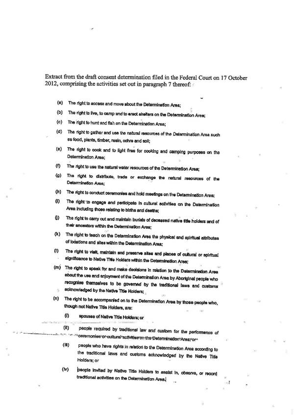
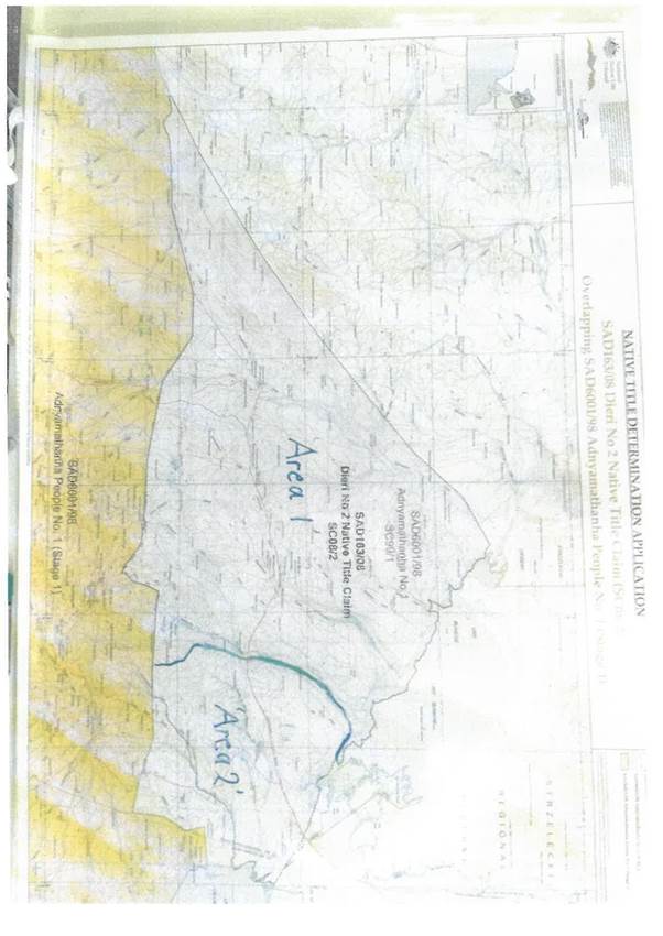
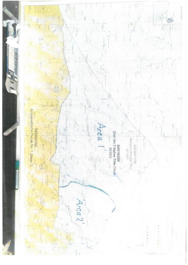
SCHEDULE 5 – The Memorandum of Understanding between the Adnyamathanha People and the Dieri People
“Annexure B”: Agreement dated 20 June 2006 between Adnyamathanha native title claim group and Dieri native title claim group, with clause 5 redacted.
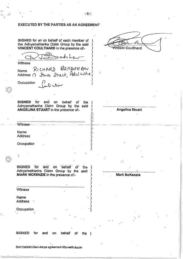
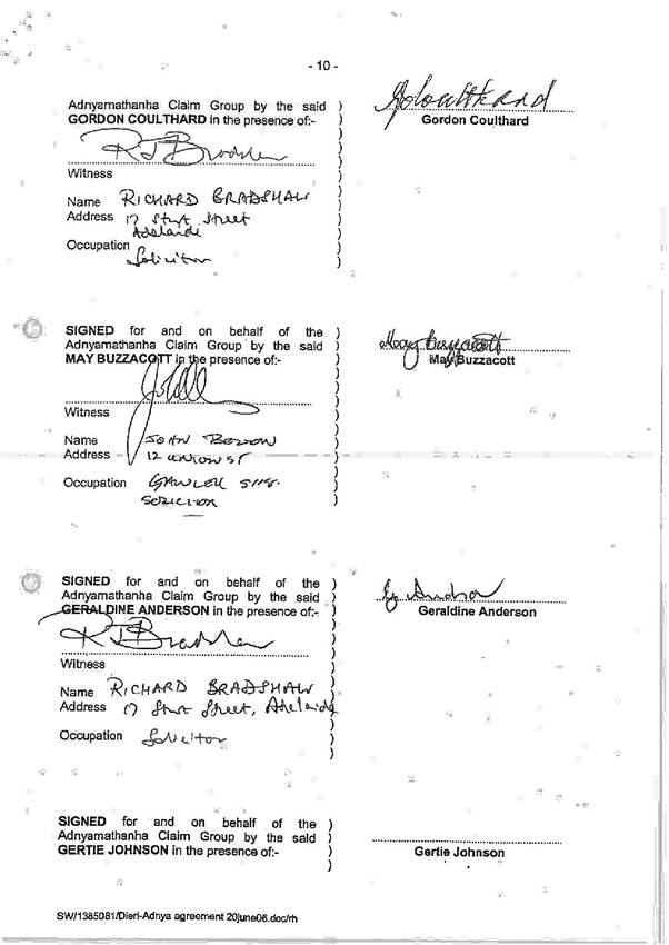
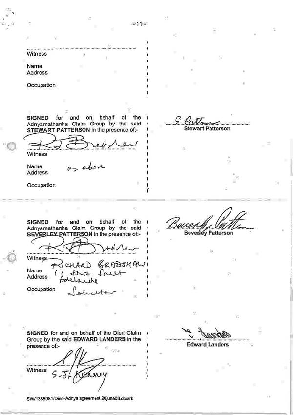
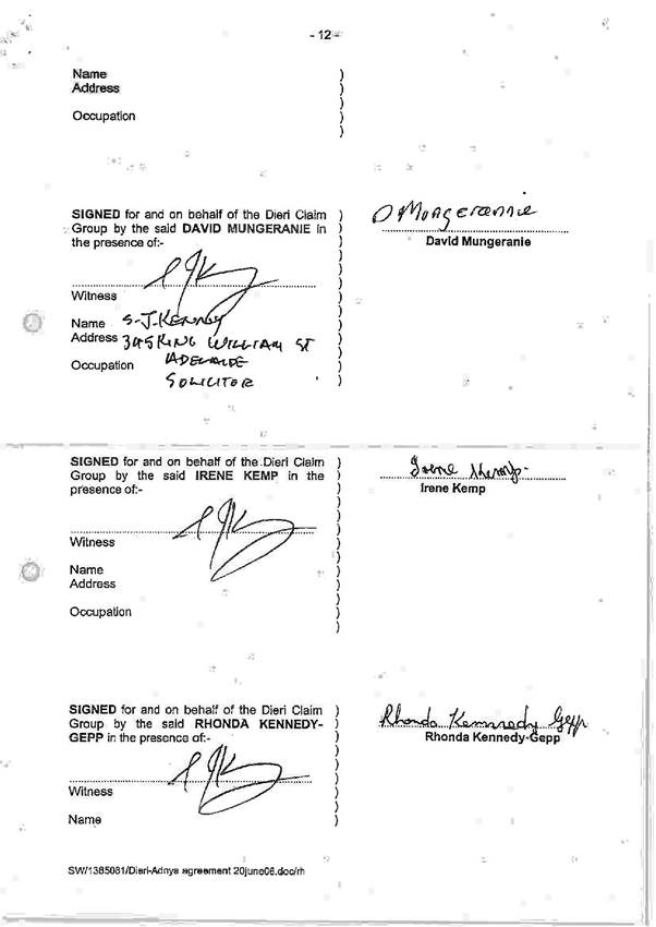
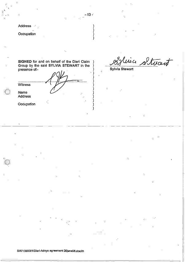
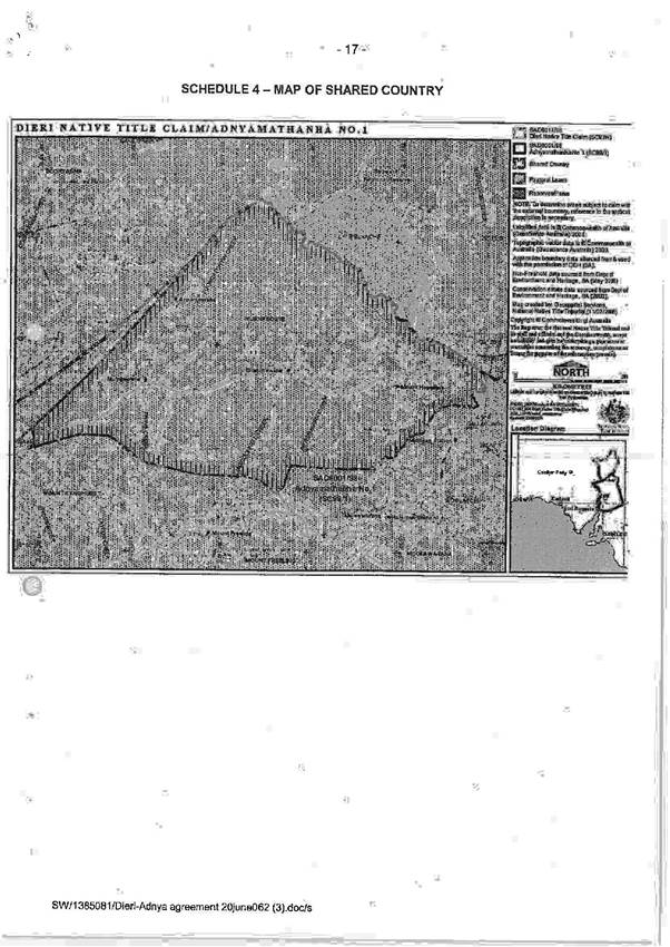
SCHEDULE 6 – The terms of the Consent Determination to be made in favour of the Dieri People in the remainder of the Dieri No 2 Claim Area
|
IN THE FEDERAL COURT OF AUSTRALIA |
|
|
SOUTH AUSTRALIA DISTRICT REGISTRY |
|
|
GENERAL DIVISION |
SAD 163 of 2008 |
DIERI NO 2 NATIVE TITLE CLAIM
|
BETWEEN: |
EDWARD LANDER AND OTHERS NAMED IN THE SCHEDULE OF PARTIES Applicant |
|
AND: |
STATE OF SOUTH AUSTRALIA AND OTHERS NAMED IN THE SCHEDULE OF PARTIES Respondent |
|
JUDGE: |
white j |
|
DATE OF ORDER: |
26 February 2014 |
|
WHERE MADE: |
port augusta |
THE COURT NOTES THAT:
A. This determination covers part of the land and waters which:
(a) are subject to the Dieri No 2 Native Title Determination Application (SAD 163 of 2008) (“the Dieri No 2 Claim”); and
(b) form part of the undetermined area of the Adnyamathanha No 1 Native Title Determination Application (SAD 6001 of 1998) (“the Adnyamathanha claim”) which overlaps the Dieri No 2 Claim.
B. This determination is being made together with a consent determination over the remaining part of the Dieri No 2 claim in favour of the Adnyamathanha People.
C. The Parties to this determination (“the Parties”) agree that those areas listed in Schedule 2 are not included in the Determination Area having been excluded by the Applicants’ applications for a determination of native title.
D. The Parties have now reached agreement as to the terms of a determination of native title to be made in relation to the Determination Area. They have filed an agreement in writing with this Court pursuant to section 87A (1) of the Native Title Act 1993 (Cth) (“the Native Title Act”) to seek the making of consent orders for a determination.
E. The Parties acknowledge that the effect of the making of this determination will be that those Dieri people described in Paragraph 6, in accordance with their traditional laws and customs, will be recognised as the native title holders for the Determination Area.
F. The Parties have agreed that the prospective registered native title body corporate in respect of the Determination Area, Dieri Aboriginal Corporation RNTBC, may have liberty to apply to seek a variation of the determination of native title in this matter, as it relates to pastoral improvements in the Determination Area in the event that the ruling of the Federal Court of Australia in De Rose v South Australia (No 2) [2005] FCAFC 110; (2005) 145 FCR 290 with respect to pastoral improvements is overturned, set aside or otherwise found to be an incorrect legal ruling by the High Court of Australia in the context of an appeal to the High Court of Australia from the decision of the Federal Court of Australia in Brown (on behalf of the Ngarla People) v State of Western Australia [2012] FCAFC 154; (2012) 208 FCR 505.
G. The Parties have requested that the Court make a determination over the Determination Area without a trial.
BY CONSENT THE COURT MAKES THE FOLLOWING DETERMINATION OF NATIVE TITLE PURSUANT TO SECTIONS 87A OF THE NATIVE TITLE ACT:
12. In this determination including its schedules, unless the contrary intention appears, the words and expressions used have the same meaning as they are given in Part 15 of the Native Title Act.
13. In this determination:
(a) “Determination Area” means that part of the land and waters of the Dieri No 2 Claim and the overlapping part of the Adnyamathanha No 1 claim as is described in Schedule 1 (and shown in the maps forming part of that Schedule), apart from those excluded areas which are described in Paragraph 16 and in Schedule 2 (“excluded areas”);
(b) “Adnyamathanha Determination Area” means the area of the consent determination being made in favour of the Adnyamathanha people over the remaining area of the Dieri No 2 claim.
14. In this determination including its schedules, in the event of an inconsistency between a description of an area in a schedule and the depiction of that area on the map in Schedule 1, the written description shall prevail.
Existence of Native Title
15. Subject to Paragraphs 12 to 16 herein, native title exists in the Determination Area.
16. Native title does not exist in relation to the areas and resources described in Paragraphs 12, 15 and 16 herein.
The Native Title Holders
17. The Native Title Holders in relation to the Determination Area are those living Aboriginal persons who are described in Schedule 3 who:
(a) identify as Dieri; and
(b) are recognised by other Native Title Holders under the relevant Dieri traditional laws and customs as having maintained an affiliation with, and continuing to hold native title rights and interests in the Determination Area.
Native title rights and interests
18. Subject to Paragraphs 8, 9 and 10, the nature and extent of the native title rights and interests held by the Native Title Holders are rights to use, stay on and enjoy the land and waters of the Determination Area, being:
(a) The right to access and move about the Determination Area;
(b) The right to live, to camp and to erect shelters on the Determination Area;
(c) The right to hunt and fish on the Determination Area;
(d) The right to gather and use the natural resources of the Determination Area such as food, plants, timber, resin, ochre and soil;
(e) The right to cook and to light fires for cooking and camping purposes on the Determination Area;
(f) The right to use the natural water resources of the Determination Area;
(g) The right to distribute, trade or exchange the natural resources of the Determination Area;
(h) The right to conduct ceremonies and hold meetings on the Determination Area;
(i) The right to engage and participate in cultural activities on the Determination Area including those relating to births and deaths;
(j) The right to carry out and maintain burials of deceased native title holders and of their ancestors within the Determination Area;
(k) The right to teach on the Determination Area the physical and spiritual attributes of locations and sites within the Determination Area;
(l) The right to visit, maintain and preserve sites and places of cultural or spiritual significance to Native Title Holders within the Determination Area;
(m) The right to speak for and make decisions in relation to the Determination Area about the use and enjoyment of the Determination Area by Aboriginal people who recognise themselves to be governed by the traditional laws and customs acknowledged by the Native Title Holders of the Determination Area;
(n) The right to be accompanied on to the Determination Area by those people who, though not Native Title Holders, are:
(i) spouses of Native Title Holders; or
(ii) people required by traditional law and custom for the performance of ceremonies or cultural activities on the Determination Area; or
(iii) people who have rights in relation to the Determination Area according to the traditional laws and customs acknowledged by the Native Title Holders.
19. The native title rights and interests described in Paragraph 7 do not confer possession, occupation, use and enjoyment of the Determination Area on the Native Title Holders to the exclusion of others.
20. The native title rights and interests are for personal, domestic and non-commercial communal use.
21. The native title rights and interests are subject to and exercisable in accordance with:
(a) the traditional laws and customs of the Native Title Holders;
(b) the valid laws of the State and Commonwealth, including the common law.
For the avoidance of doubt, the native title rights and interests expressed in Paragraph 7(f) are subject to the Natural Resources Management Act 2004 (SA).
Nature and extent of other rights and interests and Relationship with Native Title
22. The nature and extent of other rights and interests in relation to the Determination Area are:
(a) The rights and interests within the Determination Area created by the pastoral leases described in Schedule 4;
(b) the interests of the Crown in right of the State of South Australia;
(c) the interests of persons to whom valid or validated rights and interests have been granted or recognised by the Crown in right of the State of South Australia or by the Commonwealth of Australia pursuant to statute or otherwise in the exercise of executive power;
(d) rights or interests held by reason of the force and operation of the laws of the State or of the Commonwealth;
(e) the rights to access land by an employee or agent or instrumentality of the State, Commonwealth or other statutory authority as required in the performance of his or her statutory or common law duties (in accordance with any valid legislation);
(f) the rights and interests of Telstra Corporation Limited:
(i) as the owner or operator of telecommunications facilities within the Determination Area;
(ii) created pursuant to the Post and Telegraph Act 1901 (Cth), the Telecommunications Act 1975 (Cth), the Australian Telecommunications Corporation Act 1989 (Cth), the Telecommunications Act 1991 (Cth) and the Telecommunications Act 1997 (Cth), including:
(4) to inspect land;
(5) to install and operate existing and new telecommunications facilities;
(6) to alter, remove, replace, maintain, repair and ensure the proper functioning of its existing and any new telecommunications facilities, including cabling, customer terminal sites and ancillary facilities; and
(iii) for its employees, agents or contractors to enter the Determination Area to access its facilities, in and in the vicinity of, the Determination Area in the performance of their duties;
(iv) under any leases, licences, access agreements or easements relating to its telecommunications facilities in the Determination Area;
23. Native title rights and interests do not exist in respect of those parts of the Determination Area being any house, shed or other building or airstrip or any dam or other stock watering point constructed pursuant to the pastoral leases referred to in Paragraph 11(a). These areas comprise the land on which the improvements of the kind referred to herein have been constructed prior to the date hereof and include any adjacent land or waters the exclusive use of which is necessary for the enjoyment of the improvements referred to.
24. For the avoidance of doubt, Paragraph 12 does not preclude the possibility of further extinguishment, according to law, of native title over other limited parts of the Determination Area by reason of the construction of new pastoral improvements of the kind referred to in Paragraph 12 after the date of this determination.
25. Subject to Paragraph 15, the relationship between the native title rights and interests in the Determination Area that are described in Paragraph 7 and the other rights and interests that are referred to in Paragraph 11 (“the Other rights and interests”) is that:
(a) the Other rights and interests co-exist with the native title rights and interests;
(b) in the event of inconsistency, the Other rights and interests prevail over the native title rights and interests and any exercise of the native title rights and interests, but do not extinguish them; and
(c) the existence of the native title rights and interests does not prevent the doing of any activity required or permitted to be done by, in accordance with or under the Other rights and interests.
26. Native title rights and interests do not exist in:
(a) Minerals, as defined in section 6 of the Mining Act 1971 (SA); or
(b) Petroleum, as defined in section 4 of the Petroleum and Geothermal Energy Act 2000 (SA); or
(c) a naturally occurring underground accumulation of a regulated substance as defined in section 4 of the Petroleum and Geothermal Energy Act 2000 (SA), below a depth of 100 metres from the surface of the earth; or
(d) a natural reservoir, as defined in section 4 of the Petroleum and Geothermal Energy Act 2000 (SA), below a depth of 100 metres from the surface of the earth;
(e) geothermal energy, as defined in section 4 of the Petroleum and Geothermal Energy Act 2000 (SA) the source of which is below a depth of 100 metres from the surface of the earth.
For the purposes of this Paragraph 15 and the avoidance of doubt:
(i) a geological structure (in whole or in part) on or at the earth's surface or a natural cavity which can be accessed or entered by a person through a natural opening in the earth's surface, is not a natural reservoir;
(ii) thermal energy contained in a hot or natural spring is not geothermal energy as defined in section 4 of the Petroleum and Geothermal Energy Act 2000 (SA);
(iii) the absence from this order of any reference to a natural reservoir or a naturally occurring accumulation of a regulated substance, as those terms are defined in section 4 of the Petroleum and Geothermal Energy Act 2000 (SA), above a depth 100 metres below the surface of the earth or geothermal energy the source of which is above a depth of 100 metres below the surface of the earth is not, of itself, to be taken as an indication of the existence or otherwise of native title rights or interests in such natural reservoir, naturally occurring accumulation of a regulated substance or geothermal energy.
27. Native title rights do not exist in the areas covered by public works attributable to the State or Commonwealth (including the land defined in section 251D of the Native Title Act) which were constructed, established or situated prior to 23 December 1996 or commenced to be constructed or established on or before that date.
28. Public works constructed, established or situated after 23 December 1996 have had such effect on native title rights and interests as has resulted from Part 2 Division 3 of the Native Title Act.
AND THE COURT MAKES THE FOLLOWING FURTHER ORDERS:
29. The native title is not to be held in trust.
30. In respect of the Determination Area, Dieri Aboriginal Corporation RNTBC is to:
(a) be the prescribed body corporate for the purposes of section 57(2) of the Native Title Act; and
(b) perform the functions mentioned in section 57(3) of the Native Title Act after becoming the registered native title body corporate in relation to Part 1 of the Determination Area.
31. The Native Title Holders (through Dieri Aboriginal Corporation RNTBC), the State or any other Respondent have liberty to apply on 14 days’ notice to a single judge of the Court for the following purposes:
(a) to establish the precise location and boundaries of any public works and adjacent land and waters referred to in Paragraphs 16 and 17 of this Order;
(b) to establish the effect on native title rights and interests of any public works referred to in Paragraph 17 of this Order; or
(c) to determine whether any particular area is included in the description in Paragraph 12 or Schedule 2 of this Order.
(d) to address, if appropriate, any changes to paragraphs 12 and 13 above in light of the decision of the High Court of Australia in State of Western Australia v Brown & Others (No P37 of 2012 HCA) as it relates to pastoral improvements.
AND THE COURT MAKES THE FOLLOWING ANCILLARY ORDERS PURSUANT TO SECTION 87A(5) OF THE NATIVE TITLE ACT:
32. The Court notes in relation to the Determination Area as follows:
(a) The Dieri People and the Adnyamathanha People have entered into a Memorandum of Understanding between them in the terms of the document comprising the “Annexure A” to Schedule 5, under which both groups agree in particular that:
(i) the Adnyamathanha People hold traditional rights and interests in the Determination Area;
(ii) the Dieri People hold traditional rights and interests in the Adnyamathanha Determination Area;
(b) The Agreement provides that the traditional rights and interests referred to in sub-paragraph (a):
(i) are not native title rights and interests; and
(ii) co-exist with the native title rights and interests.
(c) The State and other Respondent parties are not bound by the Memorandum of Understanding referred to in Paragraph 22(a) but acknowledge that the provisions of relevant State and Commonwealth legislation apply according to their terms from time to time in relation to the Determination Area.
(d) The consent determination made in relation to the Adnyamathanha Determination Area is in the terms of the document comprising Schedule 6.
Note: Entry of orders is dealt with in Rule 39.32 of the Federal Court Rules 2011.
SCHEDULE 1 - Description and Map of the Determination Area
External boundary description
The Determination Area is located wholly within and comprises all the land and waters bounded by the following line:
Commencing at the intersection of the western boundary of Wilpoorinna Pastoral Lease - Block 1122, OH(Marree) with Latitude 29.764891 South; then generally north-easterly in straight lines connecting the following coordinate points
|
Longitude (East) |
Latitude (South) |
|
138.594515 |
29.701424 |
|
138.795702 |
29.581792 |
|
138.961899 |
29.467992 |
|
139.189327 |
29.289997 |
|
139.279715 |
29.196623 |
|
139.370103 |
29.149934 |
|
139.375935 |
29.152852 |
|
139.380983 |
29.156313 |
Then south-easterly in a straight line to the intersection of the south-western shoreline of Lake Blanche (Deposited Plan 33310 Allotment 2008) with Longitude 139.384583 East; then generally south-easterly along the said shoreline of Lake Blanche to Longitude 139.781381 East; then generally south-westerly and north-westerly in straight lines connecting the following coordinate points
|
Longitude (East) |
Latitude (South) |
|
139.775627 |
29.447571 |
|
139.771817 |
29.449001 |
|
139.759949 |
29.444512 |
|
139.756934 |
29.442290 |
|
139.748206 |
29.440069 |
|
139.740272 |
29.435784 |
|
139.728371 |
29.426898 |
|
139.723899 |
29.420390 |
|
139.720196 |
29.420072 |
|
139.713450 |
29.419549 |
|
139.709740 |
29.420090 |
The latter coordinate being an intersection with Petermorra Creek. Generally south-westerly and southerly along the said Petermorra Creek, generally being straight lines connecting the following coordinate points
|
Longitude (East) |
Latitude (South) |
|
139.709240 |
29.420750 |
|
139.708550 |
29.421410 |
|
139.707740 |
29.422210 |
|
139.706900 |
29.423030 |
|
139.705700 |
29.424800 |
|
139.704220 |
29.425730 |
|
139.697380 |
29.428440 |
|
139.696990 |
29.428600 |
|
139.694580 |
29.429570 |
|
139.690840 |
29.430690 |
|
139.689520 |
29.431120 |
|
139.688100 |
29.431580 |
|
139.686420 |
29.433140 |
|
139.684450 |
29.433980 |
|
139.682870 |
29.434980 |
|
139.680660 |
29.437250 |
|
139.679080 |
29.439610 |
|
139.679060 |
29.439630 |
|
139.677290 |
29.441540 |
|
139.676000 |
29.443200 |
|
139.675830 |
29.443770 |
|
139.674440 |
29.445040 |
|
139.673520 |
29.447610 |
|
139.671750 |
29.449670 |
|
139.669680 |
29.451820 |
|
139.668220 |
29.452070 |
|
139.666870 |
29.451580 |
|
139.664970 |
29.451540 |
|
139.662200 |
29.452160 |
|
139.660830 |
29.452220 |
|
139.660360 |
29.452240 |
|
139.658250 |
29.452750 |
|
139.655280 |
29.454360 |
|
139.653070 |
29.456460 |
|
139.650360 |
29.457520 |
|
139.647170 |
29.458650 |
|
139.645780 |
29.459280 |
|
139.644420 |
29.459900 |
|
139.641360 |
29.461580 |
|
139.639990 |
29.463990 |
|
139.639530 |
29.464800 |
|
139.638120 |
29.466570 |
|
139.636630 |
29.467160 |
|
139.634020 |
29.468390 |
|
139.632210 |
29.469670 |
|
139.631320 |
29.471810 |
|
139.630420 |
29.473010 |
|
139.628400 |
29.473740 |
|
139.626270 |
29.474390 |
|
139.624980 |
29.475730 |
|
139.624510 |
29.475650 |
|
139.623050 |
29.475560 |
|
139.621640 |
29.475940 |
|
139.620350 |
29.477060 |
|
139.618700 |
29.479070 |
|
139.617970 |
29.479680 |
|
139.615480 |
29.481980 |
|
139.617210 |
29.483500 |
|
139.617210 |
29.484180 |
|
139.616950 |
29.484630 |
|
139.616810 |
29.486210 |
|
139.615780 |
29.487340 |
|
139.614230 |
29.488240 |
|
139.613450 |
29.489360 |
|
139.611770 |
29.489700 |
|
139.611150 |
29.489990 |
|
139.610020 |
29.490970 |
|
139.609310 |
29.492620 |
|
139.608660 |
29.495560 |
|
139.608010 |
29.496120 |
|
139.606320 |
29.496500 |
|
139.605690 |
29.497020 |
|
139.605300 |
29.498480 |
|
139.604780 |
29.498930 |
|
139.603620 |
29.499610 |
|
139.602750 |
29.500890 |
|
139.602190 |
29.502760 |
|
139.601410 |
29.504120 |
|
139.601360 |
29.505550 |
|
139.601780 |
29.507610 |
|
139.601050 |
29.509400 |
|
139.601000 |
29.511110 |
|
139.602470 |
29.513550 |
|
139.603180 |
29.514950 |
|
139.603040 |
29.515860 |
|
139.602650 |
29.516530 |
|
139.602000 |
29.519240 |
|
139.601730 |
29.521830 |
|
139.601340 |
29.522850 |
|
139.601460 |
29.524990 |
|
139.601200 |
29.525330 |
|
139.601200 |
29.526570 |
|
139.600971 |
29.527625 |
|
139.600890 |
29.528000 |
|
139.601050 |
29.531870 |
|
139.600780 |
29.536390 |
|
139.600260 |
29.537740 |
|
139.600000 |
29.538040 |
|
139.598830 |
29.539430 |
|
139.598440 |
29.540220 |
|
139.598310 |
29.541120 |
|
139.598950 |
29.541910 |
|
139.598820 |
29.542700 |
|
139.598040 |
29.544280 |
|
139.596880 |
29.545740 |
|
139.596490 |
29.546640 |
|
139.595450 |
29.547880 |
|
139.593540 |
29.549110 |
|
139.593110 |
29.551260 |
|
139.591370 |
29.552960 |
|
139.591550 |
29.554760 |
|
139.591160 |
29.556000 |
|
139.591330 |
29.557610 |
|
139.591980 |
29.557900 |
|
139.592700 |
29.559160 |
|
139.592570 |
29.559950 |
|
139.591790 |
29.561410 |
|
139.589710 |
29.563890 |
|
139.589190 |
29.565130 |
|
139.589190 |
29.566030 |
|
139.589570 |
29.567160 |
|
139.589180 |
29.569980 |
|
139.589430 |
29.571000 |
|
139.589040 |
29.571900 |
|
139.588390 |
29.572580 |
|
139.587870 |
29.573930 |
|
139.588230 |
29.574800 |
|
139.588960 |
29.575870 |
the latter coordinate being an intersection of the said Petermorra Creek with Wattleowie Creek; then southerly along the said Wattleowie Creek, generally being straight lines connecting the following coordinate points
|
Longitude (East) |
Latitude (South) |
|
139.589150 |
29.576640 |
|
139.589150 |
29.577540 |
|
139.589530 |
29.578450 |
|
139.591070 |
29.580260 |
|
139.591670 |
29.581470 |
|
139.589660 |
29.585220 |
|
139.588340 |
29.585670 |
|
139.587700 |
29.586230 |
|
139.587310 |
29.587020 |
|
139.587300 |
29.587580 |
|
139.586910 |
29.588370 |
|
139.586910 |
29.590180 |
|
139.586390 |
29.591640 |
|
139.586380 |
29.593000 |
|
139.585860 |
29.593900 |
|
139.585990 |
29.594910 |
|
139.585600 |
29.595590 |
|
139.585590 |
29.598180 |
|
139.586350 |
29.600220 |
|
139.586350 |
29.601460 |
|
139.585940 |
29.603260 |
|
139.585430 |
29.606530 |
|
139.584900 |
29.607550 |
|
139.585800 |
29.609470 |
|
139.585680 |
29.611200 |
|
139.585670 |
29.611390 |
|
139.586310 |
29.611780 |
|
139.586310 |
29.613760 |
|
139.586820 |
29.614940 |
|
139.586950 |
29.615230 |
|
139.586550 |
29.616240 |
|
139.586680 |
29.617590 |
|
139.586420 |
29.618380 |
|
139.585800 |
29.619010 |
|
139.583830 |
29.620860 |
|
139.583650 |
29.622530 |
|
139.583940 |
29.623910 |
|
139.583730 |
29.626190 |
|
139.583540 |
29.627740 |
|
139.582370 |
29.629210 |
|
139.582270 |
29.629860 |
|
139.581670 |
29.630110 |
|
139.579780 |
29.631680 |
|
139.578870 |
29.633480 |
|
139.578980 |
29.640260 |
|
139.577940 |
29.642170 |
|
139.576900 |
29.643520 |
|
139.576380 |
29.644760 |
|
139.574820 |
29.646900 |
|
139.574430 |
29.647920 |
|
139.574410 |
29.649600 |
|
139.574250 |
29.650430 |
|
139.573380 |
29.651750 |
|
139.572860 |
29.653330 |
|
139.571560 |
29.654230 |
|
139.570650 |
29.655470 |
|
139.570230 |
29.657620 |
|
139.570120 |
29.659870 |
|
139.569210 |
29.661330 |
|
139.569080 |
29.662120 |
|
139.568810 |
29.665050 |
|
139.568630 |
29.667230 |
|
139.567370 |
29.669790 |
|
139.566780 |
29.670410 |
|
139.565660 |
29.670340 |
|
139.564520 |
29.671610 |
|
139.564320 |
29.673370 |
|
139.565080 |
29.675190 |
|
139.564610 |
29.676610 |
|
139.564960 |
29.679350 |
|
139.565000 |
29.681060 |
|
139.565110 |
29.684220 |
|
139.564850 |
29.684790 |
|
139.564850 |
29.685350 |
|
139.565750 |
29.687500 |
|
139.565740 |
29.688630 |
|
139.564820 |
29.689730 |
|
139.563790 |
29.691550 |
|
139.563790 |
29.692230 |
|
139.563270 |
29.693360 |
|
139.561970 |
29.694480 |
|
139.561580 |
29.695840 |
|
139.560800 |
29.696740 |
|
139.560410 |
29.697640 |
|
139.560400 |
29.700570 |
|
139.559870 |
29.702380 |
|
139.558450 |
29.704180 |
|
139.557920 |
29.706210 |
|
139.558750 |
29.708180 |
|
139.558040 |
29.709140 |
|
139.558030 |
29.710160 |
|
139.559000 |
29.711700 |
|
139.558920 |
29.713660 |
|
139.559180 |
29.714380 |
|
139.560080 |
29.715920 |
|
139.560980 |
29.716710 |
|
139.561630 |
29.717050 |
|
139.562780 |
29.718180 |
|
139.563940 |
29.719760 |
|
139.565230 |
29.720900 |
|
139.566260 |
29.721460 |
|
139.567920 |
29.722660 |
|
139.568320 |
29.723430 |
|
139.570900 |
29.725540 |
|
139.572440 |
29.727350 |
|
139.573860 |
29.728250 |
|
139.574760 |
29.729270 |
|
139.575660 |
29.730060 |
|
139.576820 |
29.730740 |
|
139.577210 |
29.730740 |
|
139.579020 |
29.731540 |
|
139.579660 |
29.732100 |
|
139.581210 |
29.732790 |
|
139.582370 |
29.734140 |
|
139.582750 |
29.735380 |
|
139.583520 |
29.736970 |
|
139.584680 |
29.738550 |
|
139.585580 |
29.740580 |
|
139.586210 |
29.743970 |
|
139.585940 |
29.746790 |
|
139.586031 |
29.747900 |
|
139.586060 |
29.748260 |
|
139.586450 |
29.748930 |
|
139.586450 |
29.749500 |
|
139.587090 |
29.750850 |
|
139.588450 |
29.752640 |
|
139.589410 |
29.754440 |
|
139.590820 |
29.755940 |
|
139.593010 |
29.757410 |
|
139.594560 |
29.758770 |
|
139.595710 |
29.760940 |
|
139.597900 |
29.765100 |
|
139.598540 |
29.766570 |
|
139.599430 |
29.769840 |
|
139.599430 |
29.771190 |
|
139.599170 |
29.772100 |
|
139.598780 |
29.772430 |
|
139.598120 |
29.773670 |
|
139.597860 |
29.775030 |
|
139.597850 |
29.777510 |
|
139.597330 |
29.778520 |
|
139.596290 |
29.779420 |
|
139.596160 |
29.780330 |
|
139.596290 |
29.780350 |
|
139.597580 |
29.781910 |
|
139.597570 |
29.783940 |
|
139.598080 |
29.785070 |
|
139.599110 |
29.786200 |
|
139.599630 |
29.787440 |
|
139.599620 |
29.789140 |
|
139.599360 |
29.790150 |
|
139.598190 |
29.791840 |
|
139.597670 |
29.793190 |
|
139.595330 |
29.795900 |
|
139.593331 |
29.797535 |
the latter coordinate being the southern boundary of Murnpeowie Pastoral Lease – Deposited Plan 42203 Allotment 24; then generally westerly along the southern boundary of the said Allotment 24 to a south-eastern corner of the said Wilpoorinna Pastoral Lease; then generally westerly along the eastern boundary of the said Wilpoorinna Pastoral Lease to its intersection with the centreline of Frome River; then generally westerly along the said centreline of Frome River to its intersection with the western boundary of the said Block 1122, OH(Marree); then northerly along the said western boundary of Block 1122 to the point of commencement.
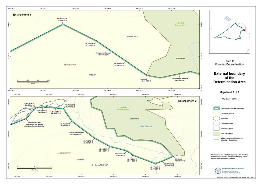
Reference datum
Geographical coordinates have been provided by the NNTT Geospatial services and geographical coordinates are referenced to the Geocentric Datum of Australia 1994 (GDA94), in decimal degrees.
Watercourses and water bodies (except Lake Blanche) referenced to 1:250,000 Topographic Mapping Series 3 – sourced from Geoscience Australia.
Use of Coordinates
Where coordinates are used within the description to represent cadastral or topographical boundaries or the intersection with such, they are intended as a guide only. As an outcome of the custodians of cadastral and topographical data continuously recalculating the geographic position of their data based on improved survey and data maintenance procedures, it is not possible to accurately define such a position other than by detailed ground survey.
SCHEDULE 2 - Areas that have been excluded from the Determination Area
4. The following areas are agreed to have been excluded from the Determination Area by reason of the fact that native title has been extinguished in those areas:
4.1. Any areas in relation to which native title has been extinguished by an act attributable to the State of South Australia pursuant to any of the following sections of the Native Title (South Australia) Act 1994 (SA):
a) Sections 33 and 34 (Category A past acts);
b) Section 35 (Category B past acts that are wholly inconsistent with the continued existence, enjoyment or exercise of any native title rights or interests);
c) Sections 36B and 36C (Category A intermediate period acts);
d) Section 36D (Category B intermediate period acts that are wholly inconsistent with the continued existence, enjoyment or exercise of any native title rights or interests);
e) Sections 36F and 36G (previous exclusive possession acts other than “excepted acts”);
4.2. Any areas in relation to which native title has been extinguished by an act attributable to the Commonwealth of Australia pursuant to any of the following sections of the Native Title Act:
a) Section 15(1)(a), (b) (Category A past acts);
b) Section 15(1)(c) (Category B past acts that are wholly inconsistent with the continued existence, enjoyment or exercise of any native title rights or interests);
c) Section 22B(a), (b) (Category A intermediate period acts);
d) Section 22B(c) (Category B intermediate period acts that are wholly inconsistent with the continued existence, enjoyment or exercise of any native title rights or interests);
e) Sections 23B and 23C (previous exclusive possession acts).
4.3. Any areas in relation to which native title rights and interests have otherwise been wholly extinguished.
5. For the avoidance of doubt and without limiting the above, Native Title has been extinguished in relation to areas in respect of which any of the following acts have been done by the Crown in right of the State of South Australia on or before 23 December 1996:
5.1. Freehold grants (other than pursuant to the Aboriginal Lands Trust Act 1966 (SA));
5.2. Perpetual leases (other than leases which are subject to a reservation or condition expressly for the benefit of Aboriginal people);
5.3. Non-perpetual leases (other than pastoral leases or non-exclusive agricultural leases or leases subject to a reservation or condition expressly for the benefit of Aboriginal people),
where:
5.4. in the case of grants to the Crown or a statutory authority, made prior to 31 October 1975 (or after 1 January 1994, if an “intermediate period act”);
5.5. in the case of grants other than to the Crown or a statutory authority, made prior to 1 January 1994 (or after 1 January 1994, if a “past act” or “intermediate period act”).
6. Native title rights have been extinguished over all roads which have been delineated in a public map pursuant to section 5(d)(II) of the Crown Lands Act 1929 (SA) or sections 70(3) or (4) of the Crown Land Management Act 2009 (SA) or which have otherwise been validly established pursuant to South Australian Statute or common law.
SCHEDULE 3 – The descendants of Dieri Apical Ancestors
The descendants (whether biologically or by adoption) of:
a) Ruby Merrick and Tim Maltalinha (also known as Tim Merrick), who are the parents of the sibling set comprised of Martin, Gottlieb, Rebecca and Selma (or Thelma);
b) Kuriputhanha (known as “Queen Annie”), mother of Karla-warru (also known as Annie);
c) Mary Dixon (born at Killalpaninna), mother of the sibling set comprised of Dear Dear (known as “Tear”), Jack Garret, George Mungerannie, Joe Shaw and Henry;
d) Bertha, mother of the sibling set comprised of Johannes and Susanna;
e) Walter Kennedy, husband of Selma (also known as Thelma) nee Merrick;
f) Florrie, wife of Martin Merrick;
g) Clara Stewart (nee Murray), mother of Eddie Stewart; and
h) The man from Pinngipania (born at Lake Hope) and the woman Kulibani (born at Kalamarina) who are the parents of Sam Tintibana (also known as Dindibana Ginjimilina).
SCHEDULE 4 – Pastoral Leases wholly or partially in the Determination Area
|
Pastoral Lease Name |
Pastoral Lease Number |
Crown Lease Number Volume/Folio |
|
Murnpeowie (part) |
PE 2519 |
CL 1598/37 |
|
Wilpoorinna (part) |
PE 2210 |
CL 1287/6 |
SCHEDULE 5 – The Memorandum of Understanding between the Adnyamathanha People and the Dieri People
“Annexure A”: The Memorandum of Understanding between Adnyamathanha native title claim group and Dieri native title claim group dated 29 July 2013 (varying Agreement dated 20 June 2006 – see “Annexure B”, as redacted).
SCHEDULE 5 – The Memorandum of Understanding between the Adnyamathanha People and the Dieri People
“Annexure B”: Agreement dated 20 June 2006 between Adnyamathanha native title claim group and Dieri native title claim group, with clause 5 redacted.
4.
|
IN THE FEDERAL COURT OF AUSTRALIA |
|
|
SOUTH AUSTRALIA DISTRICT REGISTRY |
|
|
GENERAL DIVISION |
SAD 6001 of 1998 |
ADNYAMATHANHA NATIVE TITLE CLAIM
|
BETWEEN: |
VINCENT COULTHARD AND OTHERS NAMED IN THE SCHEDULE OF PARTIES Applicant |
|
AND: |
STATE OF SOUTH AUSTRALIA AND OTHERS NAMED IN THE SCHEDULE OF PARTIES Respondent |
|
JUDGE: |
WHITE J |
|
DATE: |
25 february 2014 |
|
PLACE: |
ikara |
REASONS FOR JUDGMENT
1 A total of five native title claims have been made by the Adnyamathanha People in this Court but, for the purposes of this judgment, only two (the first and the second) need be mentioned. The first is known as the Adnyamathanha No 1 Native Title Claim (Adnyamathanha No 1 Claim). The second is known as the Adnyamathanha No 2 Native Title Claim (Adnyamathanha No 2 Claim). Both were commenced on 30 September 1998. There had been earlier proceedings in the National Native Title Tribunal.
2 The Adnyamathanha No 1 Claim related to a very substantial area of South Australia extending roughly from the eastern boundary of Lake Torrens beyond the eastern boundary of Lake Frome almost to the New South Wales border and, in the north, from the Strzelecki Ranges to its southern boundary being a line running more or less east from Port Augusta.
3 The Adnyamathanha No 2 Claim related to the area of the Flinders Ranges National Park.
4 On 30 March 2009, the Court made three determinations by consent on those claims: one relating to the area of the Angepena Pastoral Lease; the second relating to a much larger area within the Adnyamathanha No 1 Claim; and the third relating to the whole of the Flinders Ranges National Park which was the subject of the Adnyamathanha No 2 Claim. See Adnyamathanha No 1 Native Title Claim Group v The State of South Australia (No 2) [2009] FCA 359 and the earlier decision of Mansfield J in Adnyamathanha No 1 Native Title Claim Group v The State of South Australia [2009] FCA 358. The parties refer to the first two of these determinations as “Adnyamathanha No 1 – Stage One”.
5 Certain areas were excluded from the second of these listed determinations. This was principally because the State had not then had adequate opportunity to investigate and assess the claim of the Adnyamathanha in respect of those areas, including issues as to tenure and extinguishment.
6 The Court is now asked to make two further determinations by consent in relation to additional areas within the area of the Adnyamathanha No 1 Claim. One of the proposed determinations relates to an area in respect of which the Dieri People have also made a claim for native title. That area is located to the north and north-west of the northern end of the Flinders Ranges. The Adnyamathanha, the Dieri, the State of South Australia and other parties have reached agreement with respect to the overlapping claims and the second of the proposed determinations is to give effect, in part, to that agreement. The Dieri, the Adnyamathanha, the State and others propose a separate determination in favour of the Dieri to give effect to the remaining parts of the agreement. That will be the subject of a separate decision and separate reasons.
7 The parties have given the short-hand label Adnyamathanha No 1 – Stage Two to the first of the proposed determinations and Adnyamathanha No 1 – Stage Three to the proposed determination relating to the area in respect of which the Dieri have also claimed native title. It is convenient to adopt those same short-hand labels in these reasons.
8 The areas which are the subject of the proposed Adnyamathanha No 1 – Stage Two determination comprise a number of non-contiguous areas within the area of the Adnyamathanha No 1 Claim. By reason of their number, location and configuration, it is not easy to describe them in a short-hand way. Each of the areas is surrounded by, or abuts, lands which were the subject of the determinations in Adnyamathanha No 1 – Stage One. The areas are described with appropriate specificity in Schedule 1 Part 2 of the proposed Adnyamathanha No 1 – Stage Two determination.
9 The area which is the subject of the proposed Adnyamathanha No 1 – Stage Three determination and of the separate proposed determination in favour of the Dieri comprises a relatively small portion of the Adnyamathanha No 1 Claim.
10 The parties are agreed that the claim of the Dieri is to be recognised in respect of the western portion of the overlapping area, and that the claim of the Adnyamathanha be recognised with respect to the eastern portion. Each of the Dieri and the Adnyamathanha have agreed between themselves to recognise the traditional rights of the other in the area over which they will not hold native title.
11 The parties have given the short-hand label “B1” to the area in respect of which a determination is to be made in favour of the Dieri, and the short-hand label “B2” to the area in respect of which a determination is to be made in favour of the Adnyamathanha.
12 It is not necessary to describe Area B1 more particularly. Area B2 is bordered generally by the Petermorra and Wattleowie Creeks on its western side, by Yerila Creek on its south-east side, and by part of the eastern shore line of Lake Callabonna on its eastern side. It is not practical to attempt a short-hand description of its remaining boundaries in these reasons. Area B2 is described with appropriate specificity in the proposed Adnyamathanha No 1 – Stage Three determination.
The statutory requirements
13 Section 87A of the Native Title Act 1993 (Cth) (NTA) provides (relevantly):
87A Power of Federal Court to make determination for part of an area
Application
(1) This section applies if:
(a) there is a proceeding in relation to an application for a determination of native title; and
(b) at any stage of the proceeding after the end of the period specified in the notice given under section 66, agreement is reached on a proposed determination of native title in relation to an area (the determination area) included in the area covered by the application; and
(c) all of the following persons are parties to the agreement:
(i) the applicant;
(ii) each registered native title claimant in relation to any part of the determination area who is a party to the proceeding at the time the agreement is made;
(iv) each representative Aboriginal/Torres Strait Islander body for any part of the determination area who is a party to the proceeding at the time the agreement is made;
(v) each person who holds an interest in relation to land or waters in any part of the determination area at the time the agreement is made, and who is a party to the proceeding at the time the agreement is made;
(vi) each person who claims to hold native title in relation to land or waters in the determination area and who is a party to the proceeding at the time the agreement is made;
(vii) the Commonwealth Minister, if the Commonwealth Minister is a party to the proceeding at the time the agreement is made or has intervened in the proceeding at any time before the agreement is made;
(viii) if any part of the determination area is within the jurisdictional limits of a State or Territory, the State or Territory Minister for the State or Territory if the State or Territory Minister is a party to the proceeding at the time the agreement is made;
(ix) any local government body for any part of the determination area who is a party to the proceeding at the time the agreement is made; and
(d) the terms of the proposed determination are in writing and signed by or on behalf of each of those parties.
Proposed determination may be filed with the Court
(2) A party to the agreement may file a copy of the terms of the proposed determination of native title with the Federal Court.
Certain parties to the proceeding to be given notice
(3) The Registrar of the Federal Court must give notice to the other parties to the proceeding that the proposed determination of native title has been filed with the Court.
Orders may be made
(4) The Court may make an order in, or consistent with, the terms of the proposed determination of native title without holding a hearing, or if a hearing has started, without completing the hearing, if the Court considers that:
(a) an order in, or consistent with, the terms of the proposed determination would be within its power; and
(b) it would be appropriate to do so.
Note: As the Court’s order involves making a determination of native title, the order needs to comply with section 94A (which deals with the requirements of native title determination orders).
…
As can be seen, s 87A applies when all the parties to a proceeding for the determination of native title reach agreement in respect of part of the claimed area and when specified requirements of a procedural kind are satisfied. When those circumstances exist, the Court is authorised to make a determination without conducting a hearing but the Court must still be satisfied that the terms of the proposed determination are within its power and that the making of the determination is appropriate.
14 In the present case, after the expiry of the notification period fixed under s 66, the parties have reached agreement for a consent determination. That agreement, signed by all parties to the proceedings in the categories listed in s 87A(1)(c), has been filed in the Court, and the Registrar has given the notice required by subsection (3). Plainly, the determination sought by the parties is within the Court’s power (s 61).
15 Section 94A of the NTA requires, in addition, that an order of the Court set out details of the matters specified in s 225 of the NTA. Section 225 provides:
225 Determination of native title
A determination of native title is a determination whether or not native title exists in relation to a particular area (the determination area) of land or waters and, if it does exist, a determination of:
(a) who the persons, or each group of persons, holding the common or group rights comprising the native title are; and
(b) the nature and extent of the native title rights and interests in relation to the determination area; and
(c) the nature and extent of any other interests in relation to the determination area; and
(d) the relationship between the rights and interests in paragraphs (b) and (c) (taking into account the effect of this Act); and
(e) to the extent that the land or waters in the determination area are not covered by a non-exclusive agricultural lease or a non-exclusive pastoral lease—whether the native title rights and interests confer possession, occupation, use and enjoyment of that land or waters on the native title holders to the exclusion of all others.
Note: The determination may deal with the matters in paragraphs (c) and (d) by referring to a particular kind or particular kinds of non-native title interests.
The expression “native title rights and interests” used in s 225(b) is defined in s 223(1) as follows:
(1) The expression native title or native title rights and interests means the communal, group or individual rights and interests of Aboriginal peoples or Torres Strait Islanders in relation to land or waters, where:
(a) the rights and interests are possessed under the traditional laws acknowledged, and the traditional customs observed, by the Aboriginal peoples or Torres Strait Islanders; and
(b) the Aboriginal peoples or Torres Strait Islanders, by those laws and customs, have a connection with the land or waters; and
(c) the rights and interests are recognised by the common law of Australia.
The appropriateness of the orders
16 As already indicated, s 87A(4)(b) requires the Court to be satisfied that it is appropriate to make the proposed determination. That requirement reflects the fact that a determination made by consent will bind the community generally, and not just the parties to the present proceeding: Munn for and on behalf of the Gunggari People v State of Queensland [2001] FCA 1229 at [22]; (2001) 115 FCR 109 at 114.
The material on which the Court relies
17 There was a time when the Court, before making a determination by consent, would consider evidence bearing upon the appropriateness of the determination. However, it is now possible for the Court to adopt a more flexible approach. Section 87A(4) contemplates expressly that the Court may make a determination by consent without holding a hearing. In relation to the counterpart provision in s 87, Keane CJ in King v State of South Australia [2011] FCA 1386 at [19]; (2011) 285 ALR 454 at 458 referred to the permissible approach:
More recently, the Court has been prepared to rely upon the processes of the relevant State or Territory about the requirements of s 223 being met to be satisfied that the making of the agreed orders is appropriate. That is because each State and Territory has developed a protocol or procedure by which it determines whether native title (as defined in s 223) has been established. It acts in the public interest and as the public guardian in doing so. It has access to anthropological, and where appropriate, archaeological, historical and linguistic expertise. It has a legal team to manage and supervise the testing as to the existence of native title in the claimant group. Although the Court must, of course, preserve to itself the question whether it is satisfied that the proposed orders are appropriate in the circumstances of each particular application, generally the Court reaches the required satisfaction by reliance upon those processes. They are commonly explained in the joint submissions of the parties in support of the orders agreed. That is the case in this instance.
As can be seen, Keane CJ emphasised the important role of the relevant State in assessing claims of native title and indicated that this Court is entitled to attach considerable weight to the State’s evaluation.
18 Keane CJ observed further in King v State of South Australia (at [21], 458) that, when s 87 is invoked, the Court does not routinely embark on its own inquiry into the merits of the claim in order to be satisfied that the orders sought are supportable and in accordance with law. This does not mean, however, that the Court may not have regard to evidence for the limited purpose of being satisfied that the consenting State is acting in good faith and rationally (at [21], 458).
19 Madgwick J too has emphasised the responsibility of a State in assessing claims for native title. In Smith v Western Australia [2000] FCA 1249 at [38]; (2000) 104 FCR 494 at 501-2, Madgwick J said:
… State governments are necessarily obliged to subject claims for native title over lands and waters owned and occupied by the State and State agencies, to scrutiny just as carefully as the community would expect in relation to claims by non-Aborigines to significant rights over such land. The State is faced with a good many such claims. A deal of proper caution is to be expected. …
20 In Lovett on behalf of the Gunditjmara People v State of Victoria [2007] FCA 474, North J, at [35]-[38], spoke of the significance to be attached to agreements in the resolution of native title claims. Although North J made these remarks in relation to s 87 of the NTA, they are also apposite to s 87A:
35 In the present case the Court has heard some evidence, but not a comprehensive case sufficient to establish the facts which would support a determination. Section 87(1) obviously contemplates that the Court can make orders in such circumstances because it applies when there is no hearing or no full hearing of the case.
36 The focus of the section is on the making of an agreement by the parties. This reflects the importance placed by the Act on mediation as the primary means of resolving native title applications. Indeed, Parliament has established the National Native Title Tribunal with the function of conducting mediations in such cases. The Act is designed to encourage parties to take responsibility for resolving proceedings without the need for litigation. Section 87 must be construed in this context. The power must be exercised flexibly and with regard to the purpose for which the section is designed.
37 In this context, when the Court is examining the appropriateness of an agreement, it is not required to examine whether the agreement is grounded on a factual basis which would satisfy the Court at a hearing of the application. The primary consideration of the Court is to determine whether there is an agreement and whether it was freely entered into on an informed basis: … Insofar as this latter consideration applies to a State party, it will require the Court to be satisfied that the State party has taken steps to satisfy itself that there is a credible basis for an application: … There is a question as to how far a State party is required to investigate in order to satisfy itself of a credible basis for an application. One reason for the often inordinate time taken to resolve some of these cases is the overly demanding nature of the investigation conducted by State parties. The scope of these investigations demanded by some States is reflected in the complex connection guidelines published by some States.
38 The power conferred by the Act on the Court to approve agreements is given in order to avoid lengthy hearings before the Court. The Act does not intend to substitute a trial, in effect, conducted by State parties for a trial before the Court. Thus, something significantly less than the material necessary to justify a judicial determination is sufficient to satisfy a State party of a credible basis for an application. The Act contemplates a more flexible process than is often undertaken in some cases. …
(Citations omitted)
Consideration
21 In the present case, the parties have not presented any evidence by tendering statements or anthropological reports. Instead, the applicants and the State have presented joint written submissions which, in addition to referring to some material, identify the evidence which the State has assessed before consenting to the proposed determinations. Those submissions, and the material to which reference has been made, are to be assessed having regard to the following matters:
(1) Consent determinations have already been made in respect of some of the Adnyamathanha No 1 claim area. Those determinations followed a detailed assessment of material and involved an acceptance by the State that the Adnyamathanha People are a recognisable group or society which recognises and observes traditional laws in the areas covered by the Adnyamathanha No 1 – Stage One Determination. The Court has accepted that the Adnyamathanha society has evolved from the original groups in the area and continues to hold native title rights in the area ([2009] FCA 359 at [25]-[26]).
(2) The areas which are the subject of the proposed determinations are either surrounded by, or abut, areas covered by Adnyamathanha No 1 – Stage One.
(3) Those areas which are the subject of Adnyamathanha No 1 – Stage Two were excluded from Adnyamathanha No 1 – Stage One because the State had had insufficient time in which to resolve issues about extinguishment and tenure. Just on five years have elapsed since Adnyamathanha No 1 – Stage One. The State has now had an adequate opportunity to subject the claims to scrutiny.
(4) The State has a rigorous process for assessing the evidence in native title claims. That process is outlined in a policy document entitled “Consent Determinations in South Australia: A Guide to Preparing Native Title Reports”. The process has been applied in the present case.
(5) The Adnyamathanha have provided the State with four documents authored by Mr Ellis, an anthropologist. He is a consultant with over 40 years’ experience in Aboriginal traditions and heritage generally, and it is accepted that he has a specialised knowledge of the Adnyamathanha. In addition, the Adnyamathanha have provided the State with numerous signed witness statements deposing to matters bearing upon the continued existence of native title in the area in respect of which they, and the Dieri, have made overlapping claims.
(6) The State has also received considerable anthropological opinion, particularly in respect of the area over which the Dieri made the overlapping claim. The State assessed the material with the assistance of its then in-house anthropologist, Mr McCaul, and an independent expert, Dr Martin. Dr Martin holds a PhD in anthropology and has been involved in a large number of native title matters. Professor Peter Sutton chaired a conference of the anthropological experts on 2 and 3 May 2010. At that conference, the experts reached a generally agreed conclusion and, in some respects, sought the provision of further material.
(7) To some extent, the State has relied on the same evidence which it assessed in relation to Adnyamathanha No 1 – Stage One. That material was assessed by the former Solicitor-General, Mr Kourakis SC, who advised that the evidence was sufficient for the consent determinations made in March 2009 and recommended the obtaining of witness statements in relation to further areas.
(8) The further material which the State has obtained since March 2009 has been assessed in the Crown Solicitor’s Office and by the current Solicitor-General. In addition, the former Crown Advocate, Mr Evans QC, has concluded that the material was sufficient for a recommendation to the State Cabinet that the State agree to the proposed Adnyamathanha No 1 – Stage Two determination and that no further evidence is required. Mr Evans also reviewed the material concerning the proposed Adnyamathanha No 1 – Stage Three determination and agreed that that proposed determination was appropriate.
(9) In respect of one area which is the subject of the proposed Adnyamathanha No 1 – Stage Two determination and the area which is the subject of the proposed Stage Three determination, the State has, in addition, obtained opinions from Ms Gabrielle Brown at the Independent Bar. Ms Brown too has concluded that a decision by the State to consent to the current orders is justifiable on the basis of the material before her.
(10) The State has distributed a Position Paper in relation to both proposed determinations. In those papers it has explained its evaluation of the material to all the other respondent parties. All parties have either signed the agreements to indicate their assent or have removed themselves as a party to the proceeding.
Section 223
22 As noted earlier, s 223 defines the expressions “native title” and “native title rights and interests”. The latter is the expression used in s 225(b). The content of “native title rights and interests” for the purposes of s 223(1) was considered extensively by the High Court in Members of the Yorta Yorta Aboriginal Community v State of Victoria [2002] HCA 58; (2002) 214 CLR 422. The authorities were also reviewed by Mansfield J in Risk v Northern Territory of Australia [2006] FCA 404 at [44]-[58].
23 The Adnyamathanha and the State relied upon these authorities and there has been no dispute about their application in the present case. That makes it unnecessary presently to attempt any elaboration of the expression “native title rights and interests”. It is sufficient simply to refer to the decisions in Yorta Yorta and Risk v Northern Territory, and to note that a claim group must show that it still possesses rights and interests under the traditional laws acknowledged and the traditional customs observed by them, and that those laws and customs give them a connection to the land.
The relevant society for the purposes of s 223
24 As already noted, in Adnyamathanha No 1 – Stage One ([2009] FCA 359]), Mansfield J referred to anthropological, historical and ethnographic materials, as well as evidence of the applicants, indicating that the Adnyamathanha People are, in the relevant sense, a society united by traditional law and custom. This was so despite the fact that there are a number of sub-groups within the Adnyamathanha People. The State relies upon the same material in relation to the proposed determinations for its acceptance that the Adnyamathanha People are sufficiently identified and are a society united by traditional law and custom. It is appropriate for the Court presently to take the same view as it did in 2009.
The relationship between the claim group society and the society in the determination areas at sovereignty
25 The relevant date of sovereignty for the Adnyamathanha No 1 claim area is 1788. The State accepted, for the purposes of Adnyamathanha No 1 – Stage One, the ancestral association of the Adnyamathanha People to the areas which were the subject of those determinations.
26 The anthropological experts have agreed that the Adnyamathanha have ritual interests in mura sites in Area B2. Dr Martin, in particular, has accepted that there is evidence of significant ritual association within the area of the constituent groupings now comprising the contemporary Adnyamathanha society.
27 The State informed the Court that it has assessed further evidence including numerous witness statements and summaries. On the basis of that material, the State accepts that the contemporary Adnyamathanha People observe laws and customs which have evolved from those of the original inhabitants, including laws and customs relating to:
• principles of recruitment to the group;
• identifying with the language;
• principles of marriage;
• modes of respect of systems of authority;
• responsibility for nurturing, teaching and reproducing Adnyamathanha ways.
28 I am satisfied that this element of the matter has been properly addressed.
Substantially uninterrupted observance of traditional laws and customs since sovereignty
29 In Adnyamathanha No 1 – Stage One, the Court accepted that the Adnyamathanha continue to exercise traditional laws and customs. The State considers that the material in the further statements provided to it since Adnyamathanha No 1 – Stage One is indicative of much of the claimants’ behaviour being regulated or influenced by traditional laws and customs, and that there has been continuity of the core features of Adnyamathanha society from the past to the present. While there has inevitably been some adaptation and evolution of the laws and customs of the Adnyamathanha society, the State accepts that the society today acknowledges and observes a body of laws and customs which is substantially the same system which existed at sovereignty.
Connection to the determination areas by traditional laws and customs
30 Section 223(1)(b) requires that the claimants have a connection with the land. This requires attention to the content of the traditional laws and customs, the nature and extent of the connection with the land required under those laws and customs, and the relationship between the laws and customs and the rights or interests in land.
31 The State has satisfied itself that the claim group has established a continuing connection of its members with the proposed determination areas. The activities undertaken by the Adnyamathanha in and across the proposed determination areas include:
• travelling over and monitoring land;
• visiting, camping and living;
• hunting and gathering and sharing resources;
• making decisions and actively managing, conserving and protecting resources;
• managing sites;
• seeking to control access;
• spiritual practices;
• using the Adnyamathanha language; and
• teaching children and grandchildren on the country.
32 The specific rights and interests which will be recognised are set out in paragraph 7 of each of the proposed determinations. In addition to referring to the statements of particular witnesses, the State has drawn attention to the fact that these rights are consistent with rights recognised by this Court in respect of other native title claims, and are consistent with the rights and interests recognised in Adnyamathanha No 1 – Stage One.
Recognised by the common law of Australia
33 Section 223(1)(c) requires that the rights and interests be recognised by the common law of Australia. I accept that there is no right or interest contemplated by the proposed determinations which would not be recognised by the law of Australia.
Section 225
34 As previously noted, s 225 of the NTA specifies the matters which a determination by this Court of native title must include. I am satisfied that the requirements of s 225 have been established.
35 First, each proposed determination sets out with particularity the area in which native title is being recognised (paras 2, 4 and Schedule 1, Part 2). In addition, the proposed determinations identify with particularity the areas in respect of which native title is not recognised as existing (para 5).
36 Paragraph 6 of each proposed determination identifies the group of native title holders and the criteria by which group membership is to be determined. Essentially, the native title holders are persons who are descendants, whether biologically or by adoption, of named persons, who identify as Adnyamathanha, and who are recognised by other native title holders under the relevant Adnyamathanha traditional laws and customs as having maintained an affiliation with, and continuing to hold native title rights and interests in, the determination area.
37 Paragraphs 7 to 11 inclusive in the proposed determination in Adnyamathanha No 1 – Stage Two and paras 7 to 10 inclusive in the proposed determination in Adnyamathanha No 1 – Stage Three set out the nature and extent of the native title rights and interests in the determination areas.
38 Next, para 12 and para 11 of the respective proposed determinations list the nature and extent of other interests in the determination areas. The interests of some 10 different persons, or classes of persons, have been identified.
39 Paragraphs 13, 17 and 18, and paras 12, 15 and 16 of the respective proposed determinations identify the areas and resources in relation to which native title does not exist.
40 Subsequent paragraphs in each of the respective proposed determinations address the relationship between the native title rights and interests in the determination areas described in para 7, and the other rights and interests. In some instances, the respective rights and interests are to co-exist and provision is made for the resolution of any inconsistencies.
41 By ss 55 and 56 of the NTA, the Court must determine whether the native title is to be held in trust and, if so, by whom. Paragraph 20 of the proposed Stage Two and para 18 of the proposed Stage Three determination provide expressly that the native title is not to be held in trust.
General
42 The agreement of the parties to the determinations, although necessary for an exercise of power under s 87A, is also relevant to the appropriateness of the orders. The circumstance that all affected parties both consent to, and support, the making of the determination is a significant matter. No party to the proceeding makes any objection to the making of the determination.
43 The parties who have signed the proposed determinations include the Adnyamathanha, the State, South Australian Native Title Services Ltd, pastoralists, SA Power Networks, Sinosteel Uranium SA Pty Ltd, Pepinnini Resources Curnamona Pty Ltd, Telstra Corporation Ltd, the South Australian Apiarists Association Inc, Perilya Ltd, SANTOS, Epic Energy South Australia Pty Ltd, Heathgate Resources Pty Ltd, Havilah Resources Pty Ltd, Meridian Resources Pty Ltd, the Flinders Ranges Council, the Blinman Progress Association Inc, and the Beltana Sport and Social Progress Association Inc.
44 All parties have had the opportunity to obtain independent legal advice. There is no reason to suppose that a lack of legal representation has caused disadvantage to any party.
45 The parties have agreed that the prospective registered native title body corporate, Adnyamathanha Traditional Lands Association (Aboriginal Corporation) RNTBC, may have liberty to apply to seek a variation of the determinations of native title, as they relate to pastoral improvements, in the event that the ruling of the Federal Court of Australia in De Rose v State of South Australia (No 2) [2005] FCAFC 110; (2005) 145 FCR 290 with respect to pastoral improvements is overturned, set aside or otherwise found to be an incorrect legal ruling by the High Court of Australia in the context of the appeal to the High Court from the decision of the Federal Court of Australia in Brown (on behalf of the Ngarla People) v State of Western Australia [2012] FCAFC 154; (2012) 208 FCR 505.
46 As the authorities quoted earlier in these reasons indicate, parties to native title claims are encouraged to reach agreements and ss 87 and 87A provide the means by which determinations may be made to give effect to their agreements. In the present case, I am satisfied that it is appropriate to make the determinations under s 87A upon which the parties are agreed and that to do so will give effect to the objects of the NTA.
47 It is important to note that the orders of this Court will not amount to a grant of native title to the Adnyamathanha People. They are instead a public and formal recognition that the native title rights and interests of the Adnyamathanha exist, and have always existed, at least since European settlement.
48 I will make orders in both cases in the terms proposed by the parties.
|
I certify that the preceding forty-eight (48) |
Associate:

