
FEDERAL COURT OF AUSTRALIA
Brooks on behalf of the Mamu People v State of Queensland (No 4) [2013] FCA 1453
IN THE FEDERAL COURT OF AUSTRALIA |
|
STEPHEN BROOKS, ALFRED JOYCE, VICTOR MAUND, DEAN PURCELL, ANTHONY EDWARDS, HENRY EPONG AND BRENDA MATHESON ON BEHALF OF THE MAMU PEOPLE Applicant |
AND: |
First Respondent CAIRNS REGIONAL COUNCIL Second Respondent CASSOWARY COAST REGIONAL COUNCIL Third Respondent TABLELANDS REGIONAL COUNCIL Fourth Respondent ERGON ENERGY CORPORATION LIMITED Fifth Respondent GREGORY LEIGH BINDER, WAYNE DOUGLAS BUIE, DAVID CARACCIOLO, JOHN COOK, MARIO CORICA, NEVILLE DAVIES, RON FORSTER, MARIE GIDDINS, ROBERT GIDDINS, BRIAN HART, STEVEN HOWE, LARRY JONES, NORBERT KUROWSKI, WILLIAM JAMES LANE, PETER JORG PAHLKE, STEPHEN PENSINI, MARK DAVID RYAN, MARTIN SCHENCKEL, MICHAEL JOHN SCHULZ, JOHN NICHOLAS TAIFALOS, MICHAEL J TAIFALOS, JAMES ARTHUR TODD, LORNA KIRI WELSFORD, IAN WHITEHOUSE AND BARRY WILSON Sixth Respondent |
DATE OF ORDER: |
|
WHERE MADE: |
THE COURT ORDERS THAT:
Being satisfied that an order in the terms set out below is within the power of the Court, and it appearing appropriate to the Court to do so, pursuant to s 87A of the Native Title Act 1993 (Cth),
BY CONSENT THE COURT ORDERS THAT:
1. There be a determination of native title in the terms set out below (“the determination”).
2. The determination will take effect on the date the last of the agreements referred to in paragraph 1 of Schedule 3 is registered on the Register of Indigenous Land Use Agreements.
3. In the event that all of the agreements referred to in order 2 are not registered on the Register of Indigenous Land Use Agreements within nine (9) months of the date of this order or such later time as this Court may order, the matter is to be listed for further directions.
4. Each party to the proceeding is to bear its own costs.
BY CONSENT THE COURT DETERMINES THAT:
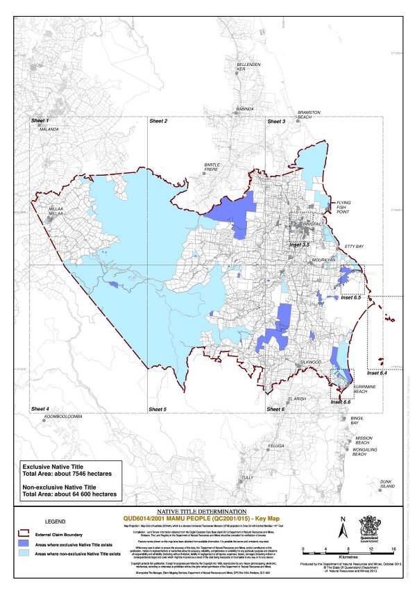
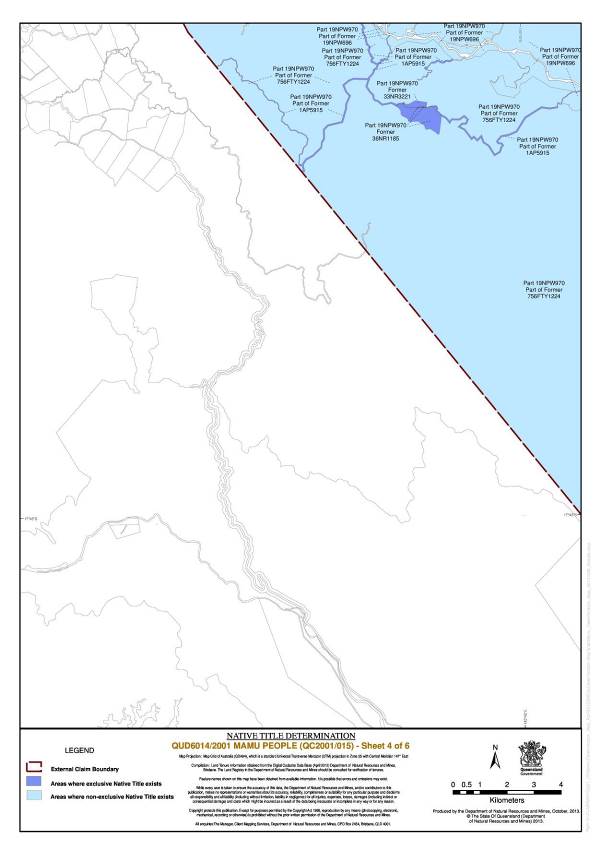
5. The determination area is the land and waters described in Schedule 1, and shown on the plans attached to Schedule 1 (the “Determination Area”).
6. Native title exists in relation to that part of the Determination Area described in Part 1 and Part 2 of Schedule 1.
7. The native title is held by the Mamu People described in Schedule 2 (the “native title holders”).
8. Subject to paragraphs 10, 11 and 12 below the nature and extent of the native title rights and interests in relation to the land and waters described in Part 1 of Schedule 1 are:
(a) other than in relation to Water, the rights to possession, occupation, use and enjoyment of the area to the exclusion of all others;
(b) in relation to Water, the non-exclusive rights to:
(i) hunt, fish and gather from the Water of the area;
(ii) take and use the Natural Resources of the Water of the area; and
(iii) take and use the Water of the area,
for personal, domestic and non-commercial communal purposes.
9. Subject to paragraphs 10, 11 and 12 below the nature and extent of the native title rights and interests in relation to the land and waters described in Part 2 of Schedule 1 are the non-exclusive rights to:
(a) access, be present on, move about on and travel over the area;
(b) to camp on the area and, for that purpose, erect temporary shelters on the area;
(c) hunt, fish and gather on the land and waters of the area for personal, domestic, and non-commercial communal purposes;
(d) take and use Natural Resources from the land and waters of the area for personal, domestic and non-commercial communal purposes;
(e) take and use the Water of the area for personal, domestic and non-commercial communal purposes;
(f) conduct ceremonies on the area;
(g) maintain places of importance and areas of significance to the native title holders under their traditional laws and customs and protect those places and areas from physical harm;
(h) teach on the area the physical and spiritual attributes of the area;
(i) light fires on the area for domestic purposes including cooking, but not for the purpose of hunting or clearing vegetation; and
(j) be buried and bury native title holders within the area.
10. The native title rights and interests are subject to and exercisable in accordance with:
(a) the Laws of the State and the Commonwealth; and
(b) the traditional laws acknowledged and traditional customs observed by the native title holders.
11. The native title rights and interests referred to in paragraphs 8(b) and 9 do not confer possession, occupation, use or enjoyment to the exclusion of all others.
12. There are no native title rights and interests in or in relation to minerals as defined by the Mineral Resources Act 1989 (Qld) and petroleum as defined by the Petroleum Act 1923 (Qld) and the Petroleum and Gas (Production and Safety) Act 2004 (Qld).
13. The nature and extent of any other interests in relation to the Determination Area (or respective parts thereof) are set out in Schedule 3.
14. The relationship between the native title rights and interests described in paragraphs 8 and 9 and the other interests described in Schedule 3 (the “other interests”) is that:
(a) the other interests continue to have effect, and the rights conferred by or held under the other interests may be exercised notwithstanding the existence of the native title rights and interests;
(b) to the extent the other interests are inconsistent with the continued existence, enjoyment or exercise of the native title rights and interests in relation to the land and waters of the Determination Area, the native title continues to exist in its entirety but the native title rights and interests have no effect in relation to the other interests to the extent of the inconsistency for so long as the other interests exist; and
(c) the other interests and any activity that is required or permitted by or under, and done in accordance with, the other interests, or any activity that is associated with or incidental to such an activity, prevail over the native title rights and interests and any exercise of the native title rights and interests.
15. In this determination, unless the contrary intention appears:
“land” and “waters”, respectively, have the same meanings as in the Native Title Act 1993 (Cth);
“Laws of the State and the Commonwealth” means the common law and the laws of the State of Queensland and the Commonwealth of Australia, and includes legislation, regulations, statutory instruments, local planning instruments and local laws;
“Local Government Acts” has the meaning given in the Local Government Act 2009 (Qld);
“Local Government Area” has the meaning given in the Local Government Act 2009 (Qld);
“Natural Resources” means:
(a) any animal, plant, fish and bird life found on or in the Determination Area; and
(b) any clays, soil, sand, gravel or rock on or below the surface of the Determination Area,
that have traditionally been taken and used by the native title holders, but does not include:
i. animals that are the private personal property of another;
ii. crops that are the private personal property of another;
iii. minerals as defined in the Mineral Resources Act 1989 (Qld) or petroleum as defined in the Petroleum Act 1923 (Qld) and the Petroleum and Gas (Production and Safety) Act 2004 (Qld);
“Reserve” means a reserve dedicated or taken to be a reserve under the Land Act 1994 (Qld);
“Water” means:
(a) water which flows, whether permanently or intermittently, within a river, creek or stream;
(b) any natural collection of water, whether permanent or intermittent;
(c) water from an underground water source; and
(d) tidal water.
Other words and expressions used in this Determination have the same meanings as they have in Part 15 of the Native Title Act 1993 (Cth).
THE COURT FURTHER DETERMINES THAT:
16. Upon paragraphs 5-15 taking effect:
(a) The native title is not held in trust; and
(b) The Mamu Aboriginal Corporation, ICN 3789, incorporated under the Corporations (Aboriginal and Torres Strait Islander) Act 2006 (Cth), is to:
i. be the prescribed body corporate for the purpose of s 57(2) of the Native Title Act 1993 (Cth); and
ii. perform the functions mentioned in s 57(3) of the Native Title Act 1993 (Cth) after becoming a registered native title body corporate.
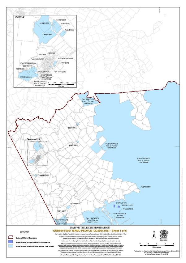
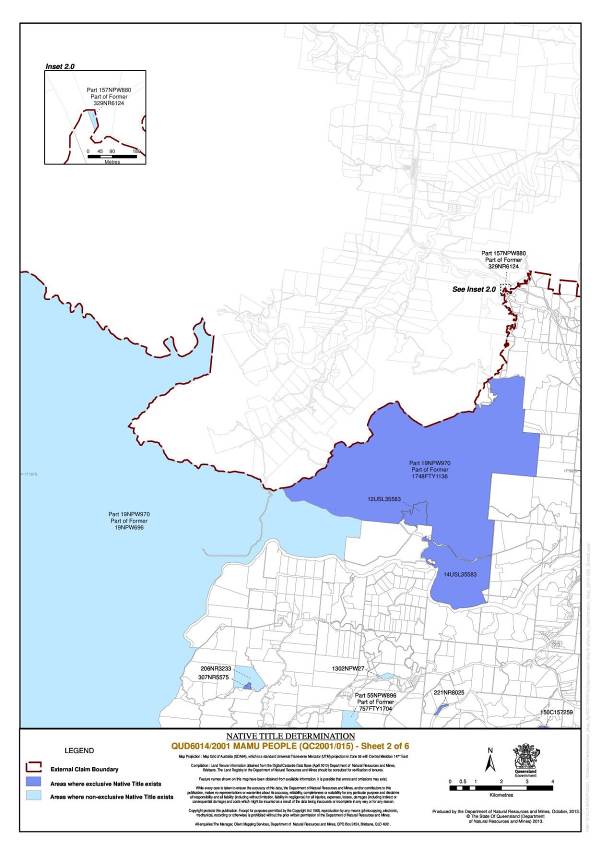
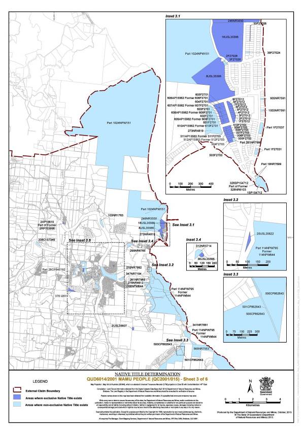
SCHEDULE 1 – DETERMINATION AREA
A. Description of Determination Area
The Determination Area comprises all of the land and waters described in Parts 1 and 2 below, to the extent that they are within the External Boundary Description as described in Part 3 below, excluding any area of land and waters on which any public work as defined in s 253 of the Native Title Act 1993 (Cth) (the “NTA”) is constructed, established or situated, and to which ss 23B(7) and 23C(2) of the NTA and/or s 23B(7) of the NTA and s 21 of the Native Title (Queensland) Act 1993 (Qld), applies, together with any adjacent land or waters in accordance with s 251D of the NTA.
Part 1 Exclusive Areas
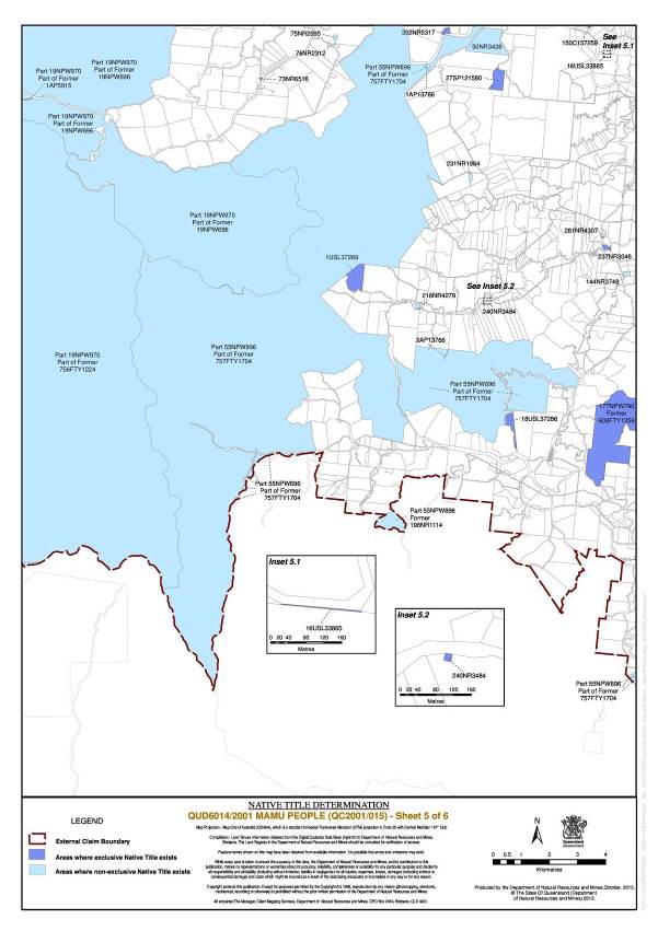
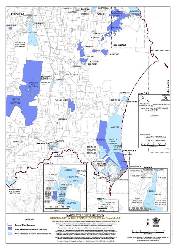
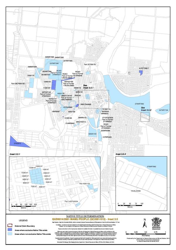
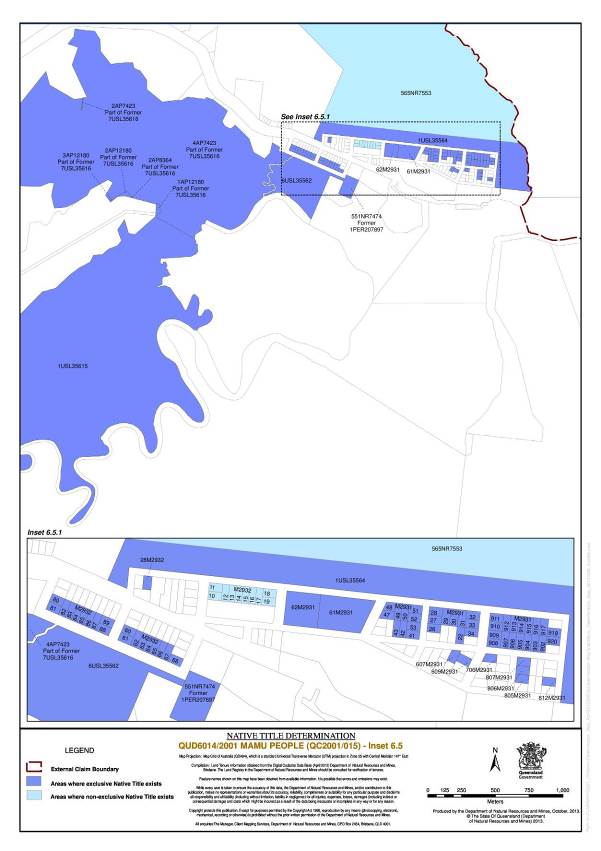
All of the land and waters described in column 1 of the following table and shown on the determination map described in column 2 of the following table:
Area Description (at time of determination) |
Sheet Number on Map |
Lot 551 on Plan NR7474 formerly described as Lot 1 on Plan PER207897 |
6 (inset 6.5) |
Lot 61 on Plan M2931 |
6 (inset 6.5) |
Lot 62 on Plan M2931 |
6 (inset 6.5) |
Lot 27 on Plan SP121580 |
5 |
That part of Lot 19 on Plan NPW970 formerly described as Lot 36 on Plan NR1185, Lot 33 on Plan NR3221, part of Lot 1 on Plan AP5915 and part of Lot 1748 on Plan FTY1136 to the extent of the external boundary |
2 and 4 |
Lot 1 on Plan USL37289 |
5 |
Lot 300 on Plan C157232 |
6 |
Lot 150 on Plan C157259 |
2 and 5 |
Lot 289 on Plan CP849966 |
3 (inset 3.5) |
Lot 601 on Plan F2701 |
3 (inset 3.1) |
Lot 602 on Plan F2701 |
3 (inset 3.1) |
Lot 603 on Plan F2701 |
3 (inset 3.1) |
Lot 604 on Plan F2701 |
3 (inset 3.1) |
Lot 605 on Plan F2701 |
3 (inset 3.1) |
Lot 606 on Plan AP15562 formerly described as Lot 606 on Plan F2701 |
3 (inset 3.1) |
Lot 607 on Plan AP15562 formerly described as Lot 607 on Plan F2701 |
3 (inset 3.1) |
Lot 608 on Plan AP15562 formerly described as Lot 608 on Plan F2701 |
3 (inset 3.1) |
Lot 609 on Plan AP15562 formerly described as Lot 609 on Plan F2701 |
3 (inset 3.1) |
Lot 610 on Plan AP15562 formerly described as Lot 610 on Plan F2701 |
3 (inset 3.1) |
Lot 1 on Plan F27012 |
3 (inset 3.1) |
Lot 2 on Plan F27012 |
3 (inset 3.1) |
Lot 3 on Plan F27012 |
3 (inset 3.1) |
Lot 4 on Plan F27012 |
3 (inset 3.1) |
Lot 5 on Plan F27012 |
3 (inset 3.1) |
Lot 6 on Plan F27012 |
3 (inset 3.1) |
Lot 7 on Plan F27012 |
3 (inset 3.1) |
Lot 8 on Plan F27012 |
3 (inset 3.1) |
Lot 9 on Plan F27012 |
3 (inset 3.1) |
Lot 33 on Plan F27026 |
3 (inset 3.1) |
Lot 503 on Plan F2703 |
3 (inset 3.1) |
Lot 504 on Plan F2703 |
3 (inset 3.1) |
Lot 505 on Plan F2703 |
3 (inset 3.1) |
Lot 506 on Plan F2703 |
3 (inset 3.1) |
Lot 507 on Plan F2703 |
3 (inset 3.1) |
Lot 508 on Plan F2703 |
3 (inset 3.1) |
Lot 509 on Plan F2703 |
3 (inset 3.1) |
Lot 510 on Plan F2703 |
3 (inset 3.1) |
Lot 511 on Plan AP15563 formerly described as Lot 511 on Plan F2703 |
3 (inset 3.1) |
Lot 512 on Plan AP15563 formerly described as Lot 512 on Plan F2703 |
3 (inset 3.1) |
Lot 370 on Plan I2815 |
3 (insert 3.5) |
Lot 22 on Plan M2931 |
6 (inset 6.5) |
Lot 26 on Plan M2931 |
6 (inset 6.5) |
Lot 27 on Plan M2931 |
6 (inset 6.5) |
Lot 28 on Plan M2931 |
6 (inset 6.5) |
Lot 29 on Plan M2931 |
6 (inset 6.5) |
Lot 30 on Plan M2931 |
6 (inset 6.5) |
Lot 31 on Plan M2931 |
6 (inset 6.5) |
Lot 32 on Plan M2931 |
6 (inset 6.5) |
Lot 33 on Plan M2931 |
6 (inset 6.5) |
Lot 34 on Plan M2931 |
6 (inset 6.5) |
Lot 41 on Plan M2931 |
6 (inset 6.5) |
Lot 42 on Plan M2931 |
6 (inset 6.5) |
Lot 43 on Plan M2931 |
6 (inset 6.5) |
Lot 47 on Plan M2931 |
6 (inset 6.5) |
Lot 48 on Plan M2931 |
6 (inset 6.5) |
Lot 49 on Plan M2931 |
6 (inset 6.5) |
Lot 50 on Plan M2931 |
6 (inset 6.5) |
Lot 51 on Plan M2931 |
6 (inset 6.5) |
Lot 52 on Plan M2931 |
6 (inset 6.5) |
Lot 53 on Plan M2931 |
6 (inset 6.5) |
Lot 607 on Plan M2931 |
6 (inset 6.5) |
Lot 609 on Plan M2931 |
6 (inset 6.5) |
Lot 706 on Plan M2931 |
6 (inset 6.5) |
Lot 805 on Plan M2931 |
6 (inset 6.5) |
Lot 806 on Plan M2931 |
6 (inset 6.5) |
Lot 807 on Plan M2931 |
6 (inset 6.5) |
Lot 812 on Plan M2931 |
6 (inset 6.5) |
Lot 902 on Plan M2931 |
6 (inset 6.5) |
Lot 903 on Plan M2931 |
6 (inset 6.5) |
Lot 904 on Plan M2931 |
6 (inset 6.5) |
Lot 905 on Plan M2931 |
6 (inset 6.5) |
Lot 906 on Plan M2931 |
6 (inset 6.5) |
Lot 907 on Plan M2931 |
6 (inset 6.5) |
Lot 908 on Plan M2931 |
6 (inset 6.5) |
Lot 909 on Plan M2931 |
6 (inset 6.5) |
Lot 910 on Plan M2931 |
6 (inset 6.5) |
Lot 911 on Plan M2931 |
6 (inset 6.5) |
Lot 912 on Plan M2931 |
6 (inset 6.5) |
Lot 913 on Plan M2931 |
6 (inset 6.5) |
Lot 914 on Plan M2931 |
6 (inset 6.5) |
Lot 915 on Plan M2931 |
6 (inset 6.5) |
Lot 916 on Plan M2931 |
6 (inset 6.5) |
Lot 917 on Plan M2931 |
6 (inset 6.5) |
Lot 919 on Plan M2931 |
6 (inset 6.5) |
Lot 920 on Plan M2931 |
6 (inset 6.5) |
Lot 28 on Plan M2932 |
6 (inset 6.5) |
Lot 60 on Plan M2932 |
6 (inset 6.5) |
Lot 61 on Plan M2932 |
6 (inset 6.5) |
Lot 62 on Plan M2932 |
6 (inset 6.5) |
Lot 63 on Plan M2932 |
6 (inset 6.5) |
Lot 64 on Plan M2932 |
6 (inset 6.5) |
Lot 65 on Plan M2932 |
6 (inset 6.5) |
Lot 66 on Plan M2932 |
6 (inset 6.5) |
Lot 67 on Plan M2932 |
6 (inset 6.5) |
Lot 68 on Plan M2932 |
6 (inset 6.5) |
Lot 80 on Plan M2932 |
6 (inset 6.5) |
Lot 81 on Plan M2932 |
6 (inset 6.5) |
Lot 82 on Plan M2932 |
6 (inset 6.5) |
Lot 83 on Plan M2932 |
6 (inset 6.5) |
Lot 84 on Plan M2932 |
6 (inset 6.5) |
Lot 85 on Plan M2932 |
6 (inset 6.5) |
Lot 86 on Plan M2932 |
6 (inset 6.5) |
Lot 87 on Plan M2932 |
6 (inset 6.5) |
Lot 88 on Plan M2932 |
6 (inset 6.5) |
Lot 89 on Plan M2932 |
6 (inset 6.5) |
Lot 237 on Plan NR3046 |
5 |
Lot 240 on Plan NR3484 |
5 |
Lot 246 on Plan NR3550 |
3 |
Lot 264 on Plan NR3664 |
6 (inset 6.3) |
Lot 276 on Plan NR4659 |
6 |
Lot 302 on Plan NR5317 |
5 |
Lot 500 on Plan NR5365 |
6 |
Lot 307 on Plan NR5575 |
2 |
Lot 505 on Plan NR6210 |
6 (inset 6.1) |
Lot 310 on Plan NR6269 |
6 (inset 6.6) |
Lot 73 on Plan NR6516 |
5 |
Lot 179 on Plan AP15774 formerly described as Lot 179 on Plan NR7768 |
6 |
Lot 221 on Plan NR8025 |
2 |
Lot 2 on Plan AP15815 formerly described as part of Lot 2 on Plan RP703998 |
3 |
Lot 81 on Plan RP729817 |
3 (inset 3.5) |
Lot 99 on Plan RP894626 |
6 (inset 6.2) |
Lot 1 on Plan S7931 |
6 (inset 6.1) |
Lot 2 on Plan S7931 |
6 (inset 6.1) |
Lot 3 on Plan S7931 |
6 (inset 6.1) |
Lot 4 on Plan S7931 |
6 (inset 6.1) |
Lot 5 on Plan S7931 |
6 (inset 6.1) |
Lot 6 on Plan S7931 |
6 (inset 6.1) |
Lot 7 on Plan S7931 |
6 (inset 6.1) |
Lot 8 on Plan S7931 |
6 (inset 6.1) |
Lot 9 on Plan S7931 |
6 (inset 6.1) |
Lot 10 on Plan S7931 |
6 (inset 6.1) |
Lot 11 on Plan S7931 |
6 (inset 6.1) |
Lot 12 on Plan S7931 |
6 (inset 6.1) |
Lot 13 on Plan S7931 |
6 (inset 6.1) |
Lot 14 on Plan S7931 |
6 (inset 6.1) |
Lot 15 on Plan S7931 |
6 (inset 6.1) |
Lot 16 on Plan S7931 |
6 (inset 6.1) |
Lot 17 on Plan S7931 |
6 (inset 6.1) |
Lot 18 on Plan S7931 |
6 (inset 6.1) |
Lot 19 on Plan S7931 |
6 (inset 6.1) |
Lot 20 on Plan S7931 |
6 (inset 6.1) |
Lot 21 on Plan S7931 |
6 (inset 6.1) |
Lot 37 on Plan USL21976 |
1 |
Lot 41 on Plan USL21976 |
1 |
Lot 48 on Plan USL21976 |
1 |
Lot 10 on Plan USL31330 |
6 (inset 6.6) |
Lot 5 on Plan USL31333 |
6 (inset 6.6) |
Lot 9 on Plan USL31344 |
6 (inset 6.6) |
Lot 2 on Plan USL31346 |
6 (inset 6.6) |
Lot 18 on Plan USL33826 |
6 (inset 6.2) |
Lot 78 on Plan USL33826 |
6 (inset 6.2) |
Lot 80 on Plan USL33826 |
6 (inset 6.2) |
Lot 86 on Plan USL33826 |
6 (inset 6.2) |
Lot 4 on Plan SP237165 and area of road* formerly described as Lot 176 on Plan USL33845 |
3 (inset 3.5) |
Lot 16 on Plan USL33865 |
5 |
Lot 6 on Plan USL35562 |
6 (inset 6.5) |
Lot 1 on Plan USL35564 |
6 (inset 6.5) |
Lot 8 on Plan USL35566 |
3 |
Lot 18 on Plan USL35566 |
3 |
Lot 36 on Plan USL35566 |
3 (inset 3.4) |
Lot 12 on Plan USL35583 |
2 |
Lot 14 on Plan USL35583 |
2 |
Lot 15 on Plan USL35596 |
3 (inset 3.5) |
Lot 2 on Plan USL35607 |
3 |
Lot 1 on Plan USL35610 |
6 |
Lot 3 on Plan USL35611 |
6 |
Lot 4 on Plan USL35611 |
6 |
Lot 1 on Plan USL35615 |
6 (inset 6.5) |
Lots 2 and 4 on Plan AP7423, Lots 1, 2 and 3 on Plan AP12180 and Lot 2 on Plan AP8364 formerly described as Lot 7 on Plan USL35616 |
6 (inset 6.5) |
Lot 20 on Plan USL35622 |
3 (inset 3.2) |
Lot 2 on Plan USL35641 |
6 |
Lot 4 on Plan USL35641 |
6 |
Lot 16 on Plan USL35641 |
6 |
Lot 3 on Plan USL36765 |
6 (inset 6.4) |
Lot 24 on Plan USL37265 |
6 |
Lot 30 on Plan USL37265 |
6 |
Lot 96 on Plan USL37282 |
6 |
Lot 18 on Plan USL37286 |
5 |
Lot 177 on Plan NPW790 formerly described as Lot 608 on Plan FTY1356 |
5 and 6 |
Lot 11 on Plan I28120 |
3 (inset 3.5) |
Lot 12 on Plan I28120 |
3 (inset 3.5) |
Lot 281 on Plan NR4307 |
5 |
Lot 31 on Plan I28166 |
3 (inset 3.5) |
That part of Lot 14 on Plan SP131205 excluding area formerly described as Lot 145 on Plan NR3345 |
6 |
Area of road* formerly described as part of Lot 301 on Plan NR6948 |
3 (inset 3.5) |
* denotes an area to which s 24KA of the Native Title Act 1993 (Cth) applies
Part 2 Non-Exclusive Areas
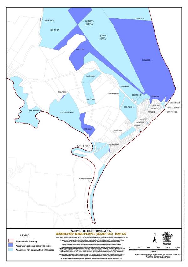
All of the land and waters described in column 1 of the following table and shown on the determination map described in column 2 of the following table:
Area Description (at time of determination) |
Sheet Number on Map |
Lot 333 on Plan NR6707 |
6 |
Lot 1 on Plan AP15832 formerly described as Lot 1 on Plan PER7028 |
6 (inset 6.6) |
Lot 500 on Plan CP862643 |
3 (inset 3.3), 6 |
Lot 363 on Plan C153412 |
3 (inset 3.5) |
Lot 338 on Plan C157349 |
3 |
That part of Lot 979 on Plan CP819017 excluding area formerly described as Allotment 7 of Section 6 on Plan K7982 |
6 (inset 6.6) |
That part of Lot 601 on Plan CP840989 excluding area delineated as road on Plan NR5277 |
1 |
That part of Lot 28 on Plan CP845192 excluding areas described as Allotment 1 of Section 2 on Plan I28163, Allotment 2 of Section 22 on plan I28120, Allotment 4 of Section 22 on Plan I28120, Allotment 5 of Section 27 on Plan I28120, Allotment 4 of Section 27 on Plan I28120, Allotment 4 of Section 28 on Plan I28120 and area delineated as road on Plan I28120 |
3 (inset 3.5) |
Lot 271 Plan SP167909 and area of road* formerly described as Lot 271 on Plan NR6501 |
3 (inset 3.5) |
Lot 509 on Plan CP855886 |
6 (inset 6.6) |
Lot 501 on Plan CP862643 |
3 (inset 3.3) |
Lot 562 on Plan SP167070 and area of road* formerly described as Lot 562 on CP909295 |
6 (inset 6.2) |
Lot 288 on Plan SP179145 formerly described as part of Lot 288 on CP898590 |
3 (inset 3.5) |
Lot 2 on Plan F27028 |
3 (inset 3.1) |
Lot 3 on Plan F27028 |
3 (inset 3.1) |
That part of Lot 1 on Plan F27031 excuding areas described as Allotment 1 of Section 13 on Plan M2708, Allotment 9 of Section 13 on Plan M2708, Allotment 3A of Section 13 on Plan M2708, Allotment 2 of Section 13 on Plan M2708, Allotment 14 of Section 13 on Plan M2708, Allotment 8 of Section 13 on Plan M2708 and Allotment 7 of Section 13 on Plan M2708 |
3 (inset 3.1) |
That part of Lot 1 on Plan F27037 excluding area delineated as road on Plan F2708 |
3 (inset 3.1) |
Lot 82 on Plan I281103 |
3 (inset 3.5) |
That part of Lot 4 on I281133 excluding area described as Allotment 4 of Section 4, Town of Geraldton |
3 (inset 3.5) |
Lot 21 on Plan I281172 |
3 (inset 3.5) |
Lot 8 on Plan I281178 |
3 (inset 3.5) |
Lot 29 on Plan I28118 |
3 (inset 3.5) |
Lot 36 on Plan I28118 |
3 (inset 3.5) |
Lot 8 on Plan I281185 |
3 (inset 3.5) |
That part of Lot 227 on Plan I28178 excluding area delineated as road on Plan I28152 |
3 (inset 3.5) |
Lot 1 on Plan I28147 |
3 (inset 3.5) |
Lot 2 on Plan I28147 |
3 (inset 3.5) |
Lot 3 on Plan I28147 |
3 (inset 3.5) |
Lot 4 on Plan I28147 |
3 (inset 3.5) |
Lot 5 on Plan I28147 |
3 (inset 3.5) |
Lot 6 on Plan I28147 |
3 (inset 3.5) |
Lot 7 on Plan I28147 |
3 (inset 3.5) |
Lot 8 on Plan I28147 |
3 (inset 3.5) |
Lot 9 on Plan I28147 |
3 (inset 3.5) |
Lot 10 on Plan I28147 |
3 (inset 3.5) |
Lot 11 on Plan I28147 |
3 (inset 3.5) |
Lot 12 on Plan I28147 |
3 (inset 3.5) |
Lot 13 on Plan I28147 |
3 (inset 3.5) |
Lot 6 on Plan I28183 |
3 (inset 3.5) |
Lot 9 on Plan K79812 |
6 (inset 6.6) |
Lot 205 on Plan K7985 |
6 (inset 6.6) |
Lot 206 on Plan K7985 |
6 (inset 6.6) |
Lot 10 on Plan M2932 |
6 (inset 6.5) |
Lot 11 on Plan M2932 |
6 (inset 6.5) |
Lot 12 on Plan M2932 |
6 (inset 6.5) |
Lot 13 on Plan M2932 |
6 (inset 6.5) |
Lot 14 on Plan M2932 |
6 (inset 6.5) |
Lot 15 on Plan M2932 |
6 (inset 6.5) |
Lot 16 on Plan M2932 |
6 (inset 6.5) |
Lot 17 on Plan M2932 |
6 (inset 6.5) |
Lot 18 on Plan M2932 |
6 (inset 6.5) |
Lot 19 on Plan M2932 |
6 (inset 6.5) |
Lot 23 on Plan M7095 |
1 |
Lot 24 on Plan M7095 |
1 |
That part of Lot 25 on Plan M7095 excluding area formerly described as Portion 159 on Plan NR466 |
1 |
That part of Lot 44 on Plan M70916 excluding area described as Portion 159 on Plan NR466 |
1 |
Lot 556 on Plan NR1143 |
6 |
That part of Lot 552 on Plan NR1555 excluding area described as Portion 159 on Plan NR466 |
1 |
Lot 481 on Plan NR1689 |
1 |
Lot 490 on Plan NR1689 |
1 |
Lot 487 on Plan NR1722 |
1 |
Lot 103 on Plan NR1763 |
3 |
Lot 231 on Plan NR1964 |
5 |
Lot 75 on Plan NR2095 |
5 |
Lot 475 on Plan NR2238 |
1 |
Lot 76 on Plan NR2312 |
5 |
Lot 302 on Plan NR3077 |
1 |
Lot 206 on Plan NR3233 |
2 |
Lot 6 on Plan SP237165, Lot A on Plan AP20141 and area of road* formerly described as Lot 276 on NR3311 |
3 (inset 3.5) |
Lot 144 on Plan NR3748 |
5 |
Lot 218 on Plan NR4279 |
5 |
Lot 278 on Plan NR4612 |
3 |
Lot 16 on Plan NR4631 |
6 |
Lot 233 on Plan NR4631 |
6 |
Lot 457 on Plan NR4686 |
6 (inset 6.6) |
Lot 458 on Plan NR4686 |
6 (inset 6.6) |
Lot 273 on Plan NR4819 |
3 (inset 3.1) |
That part of Lot 83 on Plan NR4904 excluding area described as Portion 168 on Plan NR1886 |
6 |
Lot 601 on Plan SP148846 and part of Lot 600 on Plan SP148846 formerly described as Lot 599 on NR5162 |
1 |
Lot 552 on Plan NR5190 |
6 |
Lot 576 on Plan NR5275 |
1 |
Lot 303 on Plan NR5368 |
3 (inset 3.5) |
Lot 107 on Plan NR5465 |
3 (inset 3.5) |
Lot 312 on Plan NR5714 |
3 (inset 3.4) |
Lot 581 on Plan NR5770 |
1 |
Lot 559 on Plan NR5787 |
6 |
That part of Lot 511 on Plan NR5893 excluding area delineated as road on Plan NR4558 |
6 (inset 6.6) |
Lot 509 on Plan NR6091 |
1 |
Lot 584 on Plan NR6091 |
1 |
Lots 1 and 328 on Plan SP154712 formerly described as Lot 328 on Plan NR6103 |
3 (inset 3.1) |
Lot 66 on Plan NR6122 |
3 (inset 3.5) |
Lot 529 on Plan NR6437 |
6 (inset 6.6) |
Lot 559 on Plan NR6476 |
6 |
Lot 231 on Plan NR6480 |
6 |
Lot 302 on Plan NR6480 |
6 |
Lot 456 on Plan NR6726 |
6 (inset 6.1) |
Lot 335 on Plan NR6769 |
6 (inset 6.2) |
Lot 61 on Plan NR6878 |
6 (inset 6.2) |
Lot 214 on Plan NR6943 |
3 (inset 3.5) |
Lot 568 on Plan NR7175 |
1 |
Lot 347 on Plan NR7194 |
3 (inset 3.5) |
Lot 350 on Plan NR7394 |
3 (inset 3.5) |
Lot 348 on Plan NR7395 |
3 (inset 3.5) |
Lot 2 on Plan I281116 |
3 (inset 3.5) |
Lot 35 on Plan NR7412 |
6 (inset 6.6) |
Lot 565 on Plan NR7553 |
3, 6 (inset 6.5) |
Lot 905 on Plan NR7591 |
3 (inset 3.1) |
Lot 1003 on Plan NR7591 |
3 (inset 3.1) |
That part of Lot 19 on Plan NR7699 excluding area described as Portion 19 on Plan NR2179 |
3 (inset 3.1) |
Lot 341 on Plan NR7861 |
3 |
Lot 510 on Plan NR7893 |
1 |
Lot 571 on Plan NR7909 |
6 (inset 6.1) |
Lot 572 on Plan NR7910 |
6 (inset 6.1) |
Lot 261 on Plan NR7965 |
3 |
That part of Lot 281 on Plan NR7990 excluding area delineated as road on Plan F2703 |
3 (inset 3.1) |
Lot 270 on Plan NR7992 |
3 (inset 3.5) |
Lot 8 on Plan NR8003 |
3 (inset 3.5) |
Lot 9 on Plan NR8003 |
3 (inset 3.5) |
That part of Lot 14 on Plan SP193034, formerly described as Lot 14 on Plan NR802850, excluding areas delineated as road on Plan I281135 and Plan I28186 |
3 (inset 3.5) |
Lot 99 on Plan NR8045 |
6 (inset 6.6) |
Lot 19 on Plan NR8067 |
3 (inset 3.5) |
Lot 293 on Plan NR808519 |
6 (inset 6.1) |
Lot 294 on Plan NR808519 |
6 (inset 6.1) |
Lot 554 on Plan NR8091 |
6 (inset 6.6) |
Lot 99 on Plan NR814101 |
6 (inset 6.6) |
Lot 562 on Plan NR814104 |
6 (inset 6.6) |
Lot 458 on Plan NR835440 |
1 |
That part of Lot 605 on Plan NR835440 excluding area described as Portion 159 on Plan NR466 |
1 |
Lot 606 on Plan NR835440 |
1 |
Lot 602 on Plan NR922 |
1 |
Lot 2 on Plan S7935 |
6 (inset 6.1) |
Lot 1608 on Plan NPW23 |
6 (inset 6.6) |
Lot 1302 on Plan NPW27 |
2 |
Lot 421 on Plan NPW614 |
6 (inset 6.4) |
That part of Lot 114 on Plan NPW795 formerly described as Lot 114 on Plan NPW644 |
3 (inset 3.2) |
Lot 1008 on Plan NPW644 |
3 |
Lot 205 on Plan NR2759 |
6 |
Lot 219 on Plan NR3214 |
6 |
Lot 220 on Plan NR3214 |
6 |
Lot 221 on Plan NR3214 |
6 |
Lot 50 on Plan NR3438 |
5 |
Lot 553 on Plan NR6079 |
6 (inset 6.6) |
Lot 299 on Plan NR6765 |
3 |
Lot 349 on Plan NR7394 |
3 (inset 3.5) |
Lot 351 on Plan NR7394 |
3 (inset 3.5) |
Lot 337 on Plan NR7395 |
3 (inset 3.5) |
Lot 346 on Plan NR7395 |
3 (inset 3.5) |
Lot 347 on Plan NR7395 |
3 (inset 3.5) |
That part of Lot 55 on Plan NPW896 formerly described as Lot 196 on NR1114 and part of Lot 757 on FTY1704 to the extent of the external boundary |
2, 5 and 6 |
That part of Lot 560 on Plan NR5588 excluding area delineated as road on Plan K7981 |
6(inset 6.6) |
Lot 4 on Plan CP849966 |
3 (inset 3.5) |
That part of Lot 536 on Plan SP136922 excluding area formerly described as Portion 495 on Plan NR5127 and area delineated as road (esplanade) on Plan NR4558 (registered 27/01/1964), NR6525 (registered 22/05/1978), K79814 (registered 9/10/1964) and NR3387 (registered 16/12/1952) |
6 (inset 6.6) |
Lots 1 and 2 on Plan AP13766 formerly described as part of Lot 757 on FTY1704 |
5 |
Lot 1 on Plan AP14607 formerly described as part of Lot 756 on Plan FTY1224 |
1 |
Lot 39 on Plan F27024 |
3 |
That part of Lot 157 on Plan NPW880 formerly described as part of Lot 329 on Plan NR6124 to the extent of the external boundary |
2 |
That part of Lot 19 on Plan NPW970 formerly described as part of Lot 756 on Plan FTY1224 and part of Lot 19 on NPW696 to the extent of the external boundary |
1, 2, 4 and 5 |
That part of Lot 1024 on Plan NPW151 to the extent of the external boundary |
3 (inset 3.1) |
That part of Lot 1445 on Plan NPW191 to the extent of the external boundary |
6 (inset 6.6) |
* denotes an area to which s 24KA of the Native Title Act 1993 (Cth) applies
Part 3
External Boundary Description
Commencing at the centreline of the mouth of Maria Creek, and extending generally north westerly and generally south westerly along the centreline of that creek and North Maria Creek to its source at approximately Longitude 145.970665° East; then north westerly to the intersection of the centreline of South Liverpool Creek and an eastern boundary of Japoon National Park (Lot 55 NPW896); then northerly and generally north westerly along the boundaries of that National Park to the northernmost corner of former Lot 196 NR1114; then generally south easterly, generally westerly and generally north easterly along the eastern, southern and western boundaries of that Lot to again a point on a northern boundary of Japoon National Park (Lot 55 NPW896), being the southernmost corner of Lot 36 NR1578; then generally westerly and generally northerly along the northern and eastern boundaries of that National Park to the centreline of Liverpool Creek; then generally westerly and generally southerly along the centreline of that creek to the eastern boundary of Lot 66 on NPW890; then generally north westerly along the boundaries of that Lot to approximately Longitude 145.771231° East, being the mountain peak shown as elevation 705 on 1:100,000 topographic map 8062 “Tully”; then north westerly to the peak of Mount Father Clancy; then continuing north westerly to the intersection of the Milla Milla Malanda Road and the centreline of a tributary of Dirran Creek at approximately Longitude 145.578118° East, Latitude 17.483773° South; then generally north easterly along the centreline of that tributary and the centreline of Dirran Creek to the prolongation of the southern bank of the Johnstone River; then generally south easterly along that bank to its intersection with the north eastern corner of Lot 425 on NR1349; then easterly along the prolongation of the northern boundary of that lot to the northern bank of the Johnstone River; then north westerly to the southernmost corner of Lot 4 on Native Title Determination Plan AP14230 (native title determination QC6027/99 Ngadjon Jii People 2 (QC99/030)); then easterly along the southern boundary of that determination to the south west corner of Lot 335 on NR1424; then easterly to the south western corner of Lot 1 on Native Title Determination Plan AP14230 (native title determination QC6027/99 Ngadjon Jii People 2 (QC99/030)); then generally easterly along the southern boundary of that determination and the centrelines of Kiandra Creek and Russell River to the western boundary of the Cairns Regional Council Local Government Area; then generally southerly along that regional council boundary to the watershed of a range at approximately Latitude 17.466809° South; then generally south westerly along that watershed to a point easterly of Twin Pinnacles at Longitude 145.809977° East, Latitude 17.484304° South; then south easterly along the watershed of the Francis Range (Ridgeline) to the intersection of the western boundaries of the Cassowary Coast Regional Council and Cairns Regional Council Local Government Areas; then generally easterly, generally north easterly and generally south easterly along the boundaries of those regional councils to the peak of Mount Chalmynia; then north easterly to the centre of the head waters of a tributary of Canal Creek at approximately Longitude 145.922756° East, Latitude 17.481827° South; then generally north easterly along the centreline of that tributary and the centreline of Canal Creek to the prolongation westerly of the northern most boundary of Lot 3 SP109846; then easterly along that prolongation to a southern boundary of Eubenangee Swamp National Park (Lot 157 NPW880); then generally easterly along the southern boundaries of that National Park to the south western corner of Lot 83 NR4378; then north easterly to the north eastern corner of Lot 91 NR16, being also the boundary of Ella Bay National Park (Lot 1024 NPW151); then generally westerly, generally north westerly and generally north easterly along the western boundaries of that National Park to the eastern most corner of Lot 49 USL21851; then generally north easterly along the watershed (Ridgeline) of the Seymour Range to the High Water Mark on the Australian coastline at Latitude 17.387991° South; then generally southerly along that High Water Mark of the coastline back to the commencement point.
B. Map of Determination Area
 SCHEDULE 2 – NATIVE TITLE HOLDERS
The native title holders are those Aboriginal People who are Mamu People on the basis of descent from:-
(a) one of the following persons:
1. Bambun; or
2. Paddy Brooks (Dungginyu) (including descendants of his relationship with Maggie); or
3. Bombetta Wa-Way (aka Bombita, Bumbida, Betsy, Betty); or
4. Emily Purcell/Deagon; or
5. Nellie Deagon; or
6. Polly Watson; or
7. Kitty Christmas; or
8. Annie Innisfail; or
9. Polly Armie (Armi); or
10. Lizzie Romelo; or
11. William Weare; or
12. Sandy Millay Millay; or
(b) a relationship between the following persons:
1. Charlie Deagon and Kitty; or
2. Charlie Deagon and Jinny (aka Jenny, Jeanie).
SCHEDULE 3 – OTHER INTERESTS IN THE DETERMINATION AREA
The nature and extent of the other interests in relation to the Determination Area are the following, as they exist as at the date of the determination:
1. The rights and interests of the parties under the following indigenous land use agreements:
(a) Niree Appo, Stephen Brooks, John Edwards, Alfred Joyce, Robert Major, Victor Maund, Dean Purcell and Billy Tinkum on their own behalf and on behalf of the Mamu People (QUD6014/2001) and on behalf of the Mamu Aboriginal Corporation ICN 3789 and the Cairns Regional Council as parties to the Cairns Regional Council ILUA dated 9 March 2012; and
(b) Niree Appo, Stephen Brooks, John Edwards, Alfred Joyce, Robert Major, Victor Maund, Dean Purcell and Billy Tinkum on their own behalf and on behalf of the Mamu People (QUD6014/2001) and the Cassowary Coast Regional Council as parties to the Cassowary Coast Regional Council ILUA registered on 15 November 2010; and
(c) Niree Appo, Stephen Brooks, John Edwards, Alfred Joyce, Robert Major, Victor Maund, Dean Purcell and Billy Tinkum on their own behalf and on behalf of the Mamu People (QUD6014/2001) and the Tablelands Regional Council as parties to the Tablelands Regional Council ILUA registered on 15 November 2012; and
(d) Niree Appo, Stephen Brooks, John Edwards, Alfred Joyce, Robert Major, Victor Maund, Dean Purcell and Billy Tinkum on their own behalf and on behalf of the Mamu People (QUD6014/2001) and the Mamu Aboriginal Corporation ICN 3789 and Ergon Energy Corporation Limited (ABN 50 087 646 062) as parties to the Ergon Energy ILUA registered on 16 May 2012.
(e) Stephen Brooks, Anthony Edwards, Henry Epong, Brenda Matheson, Alfred Joyce, Victor Maund and Dean Purcell on their own behalf and on behalf of the Mamu People (QUD6014/2001) and the Mamu Aboriginal Corporation ICN 3789 and the State of Queensland as parties to the Mamu Protected Areas ILUA.
2. The rights and interests of the Cairns Regional Council (“Council”) under “Local Government Acts” as defined in the Local Government Act 2009 (Qld) which apply to the Determination Area including any right the Council or its employees or agents have:
(a) as owner and operator of infrastructure, facilities and other improvements which are in the Determination Area as at the date of this determination; and
(b) to enter and exercise rights within the Determination Area in accordance with the Local Government Act 2009 (Qld).
3. The rights and interests of the Cassowary Coast Regional Council for that part of the Determination Area within its Local Government Area, including:
(i) as the owner and operator of infrastructure, facilities and other improvements which are in the Determination Area as at the date of this Determination;
(ii) the right to enter the Determination Area and exercise its powers and responsibilities under Local Government Acts; and
(iii) under any lease, licence, access agreement, easement, Reserve or other interest in the Determination Area.
4. The rights and interests of the Tablelands Regional Council for that part of the Determination Area within its Local Government Area, including:
(i) as the owner and operator of infrastructure, facilities and other improvements which are in the Determination Area as at the date of this Determination;
(ii) the right to enter the Determination Area and exercise its powers and responsibilities under Local Government Acts; and
(iii) under any lease, licence, access agreement, easement, Reserve or other interest in the Determination Area.
5. The rights and interests of Ergon Energy Corporation Limited (ABN 50 087 646 062):
(a) as the owner and operator of any “Works” as that term is defined in the Electricity Act 1994 (Qld) within the Determination Area;
(b) as a distribution entity and the holder of a distribution authority under the Electricity Act 1994 (Qld); and
(c) created under the Electricity Act 1994 (Qld) and the Government Owned Corporations Act 1993 (Qld); including:
i) rights in relation to any agreement relating to the Determination Area existing or entered into before the date on which these orders are made;
ii) rights to enter the Determination Area by its employees, agents or contractors to exercise any of the rights and interests referred to in this paragraph; and
iii) to inspect, maintain and manage any Works in the Determination Area.
6. The rights and interests of Telstra Corporation Limited:
(a) as the owner or operator of telecommunications facilities within the Determination Area;
(b) created pursuant to the Post and Telegraph Act 1901 (Cth), the Telecommunications Act 1975 (Cth), the Australian Telecommunications Corporation Act 1989 (Cth), the Telecommunications Act 1991 (Cth) and the Telecommunications Act 1997 (Cth), including rights:
i) to inspect land;
ii) to install and operate telecommunications facilities; and
iii) to alter, remove, replace, maintain, repair and ensure the proper functioning of its telecommunications facilities;
(c) for its employees, agents or contractors to access its telecommunications facilities in and in the vicinity of the Determination Area in performance of their duties; and
(d) under any lease, licence, access agreement or easement relating to its telecommunications facilities in the Determination Area.
7. The rights and interests of the State of Queensland in Reserves, the rights and interests of the persons in whom the Reserves are vested, including the Cassowary Coast Regional Council and the Tablelands Regional Council, and the rights and interests of members of the public and other persons entitled to access and use those Reserves for the respective purpose for which they are reserved.
8. The rights and interests of the State of Queensland and the Cassowary Coast Regional Council and the Tablelands Regional Council as the local government for the Local Government Area in which any dedicated road is situated, to access, use, operate, maintain and control the dedicated roads in the Determination Area and the rights and interests of the public to use and access the dedicated roads.
9. So far as confirmed pursuant to s 212(2) of the Native Title Act 1993 (Cth) and s 18 of the Native Title (Queensland) Act 1993 (Qld) as at the date of the determination, any existing public access to, and enjoyment of, the following places in the Determination Area:
(a) waterways;
(b) beds and banks or foreshores of waterways;
(c) coastal waters;
(d) beaches;
(da) stock routes;
(e) areas that were public places as at the end of 31 December 1993.
10. The rights and interests of the holder of any authority, licence, permit or permission granted under the Fisheries Act 1994 (Qld) or any Fisheries Regulation made under that Act that authorises a commercial fishing operation in the waters of the Determination Area.
11. The rights and interests of the holders of any leases, licences, reservations, permits, easements or authorities or other instruments granted or issued pursuant to the Land Act 1994 (Qld) and subordinate legislation as may be current at the date of this determination.
12. The rights and interests of holders of any permits, claims, licenses or leases under the Mineral Resources Act 1989 (Qld) and any subordinate legislation, declarations or management plans made under that Act.
13. The rights and interests of the holders of any licences, permits or allocations, under the Water Act 2000 (Qld) and any relevant regulations or subordinate legislation made under that Act.
14. The rights and interests of the State of Queensland pursuant to the Nature Conservation Act 1992 (Qld) and any subordinate legislation relating to the use and management of the Determination Area.
15. The rights and interests of the holders of any leases, agreements, licenses, permits or authorities granted under the Nature Conservation Act 1992 (Qld).
16. Any other rights and interests held by the State of Queensland or Commonwealth, or by reason of the force and operation of the Laws of the State and the Commonwealth, as may be current at the date of this determination.
Note: Entry of orders is dealt with in Rule 39.32 of the Federal Court Rules 2011.
QUEENSLAND DISTRICT REGISTRY |
|
GENERAL DIVISION |
QUD 6014 of 2001 |
BETWEEN: |
STEPHEN BROOKS, ALFRED JOYCE, VICTOR MAUND, DEAN PURCELL, ANTHONY EDWARDS, HENRY EPONG AND BRENDA MATHESON ON BEHALF OF THE MAMU PEOPLE Applicant |
AND: |
STATE OF QUEENSLAND First Respondent CAIRNS REGIONAL COUNCIL Second Respondent CASSOWARY COAST REGIONAL COUNCIL Third Respondent TABLELANDS REGIONAL COUNCIL Fourth Respondent ERGON ENERGY CORPORATION LIMITED Fifth Respondent GREGORY LEIGH BINDER, WAYNE DOUGLAS BUIE, DAVID CARACCIOLO, JOHN COOK, MARIO CORICA, NEVILLE DAVIES, RON FORSTER, MARIE GIDDINS, ROBERT GIDDINS, BRIAN HART, STEVEN HOWE, LARRY JONES, NORBERT KUROWSKI, WILLIAM JAMES LANE, PETER JORG PAHLKE, STEPHEN PENSINI, MARK DAVID RYAN, MARTIN SCHENCKEL, MICHAEL JOHN SCHULZ, JOHN NICHOLAS TAIFALOS, MICHAEL J TAIFALOS, JAMES ARTHUR TODD, LORNA KIRI WELSFORD, IAN WHITEHOUSE AND BARRY WILSON Sixth Respondent |
JUDGE: |
DOWSETT J |
DATE: |
1 NOVEMBER 2013 |
PLACE: |
INNISFAIL |
REASONS FOR JUDGMENT
1 The history of this matter is set out in earlier reasons delivered on 31 July 2013. I do not propose to repeat that history. The applicant group is presently comprised of:
Stephen Brooks;
Alfred Joyce;
Victor Maund;
Dean Purcell;
Anthony Edwards;
Henry Epong; and
Brenda Matheson.
2 The claim area stretches from Cooper Point in the north to North Maria Creek in the south, extending inland for a distance of about 50 kilometres. On the coast, the principal centre is Innisfail.
3 In considering this matter I have had regard to reports of Dr J Weiner, Dr N Heijm, Ms C Daniell, Dr Sandra Pannell, Dr Anthony Redmond, Dr Diana McCarthy, Dr Rosalind Glass, Dr Kevin Mayo and Mr Bruce White.
4 In their report of October 2004 Weiner and Heijm say at 3.4:
As we stated in the Introduction, Mamu is one of six contiguous named languages – Girramay, Djirrbal, Gulnay, Djiru, Mamu and Ngadjon-Jii – that comprise a regional language group called “Dyirbal” by Dixon. Territorially, the Dyirbul languages extend from approximately Cardwell to approximately Herberton and includes most of the drainage basins of the Russell, Johnstone, Tully, Murray and Upper Herbert Rivers. Mamu is the language primarily associated with the North and South Johnstone River countries … .
Affiliation with Mamu and its territory distinguishes the claimant group from neighbouring tribal groups. Mamu People recognise that the use of “tribe” refers to a common ownership of Mamu language, but also to their mutual acknowledgement of traditional ownership rights in the country with which Mamu is affiliated. This corresponds with classic usage of the name Mamu. It is clear that people spoke more than one language and that within each language represented as distinct, dialects were also recognised. In line with the general Aboriginal culture of opposition-making described above, Dyirbal peoples’ tribal identity was not based solely on language use, but on the deliberate identification with one language and/or dialect as their own in opposition to all other locally identified languages and ways of speaking.
5 At 3.8 of their 2004 report Weiner & Heijm state:
Mamu country centres on the watersheds of the North and South Johnstone Rivers and their major tributaries such as the Beatrice and Russell Rivers. It extends as far north as Cooper Creek, as far south as North Maria Creek and as far west as Milaa Milaa.
In the north their neighbours are the Lower Coastal Yidinji, in the north-west, the Ngadjon Jii and Jirrbal, and in the south, the Djiru.
The Mamu native title claim area accords with both Tindale’s (1974) and Dixon's maps of that country (eg, 1976), probably because they both used George Watson as an informant as to the extent of Mamu country.
6 It may not be strictly correct to refer to the Russell River as a tributary of the North or South Johnstone Rivers. However, at some points the Russell and North Johnstone Rivers flow near to each other. The Lower Coastal Yidinji is the group now known as the Wanyurr Majay People.
7 The Determination Area is historically divided into parts which co-incide with dialectal variations and recognized family areas. The areas are identified by Weiner & Heijm at para 3.9 as follows::
3.9.1 Waribarra
The name Waribarra refers to the gorge (wari = gorge) country of the North Johnstone. Waribarra includes the area north of approximately the Palmerston Highway (which follows traditional pathways for much of its length) and the North Johnstone River country west to about Millaa Millaa.
3.9.2 Dulgubarra
The name Dulgubarra refers to the thick scrub country (dulgu = thick scrubby country) north of the South Johnstone river. Dulgubarra is the area around Jordan Creek towards the South Johnstone. Mamu people generally regard the Palmerstone highway and the South Johnstone River to be boundaries of Dulgubarra.
3.9.3 Bagirbarra
Bagirbarra is generally held to be the country between the North Johnstone and the Russell rivers. The etymology of Bagirbarra is uncertain.
3.9.4 Wabubarra (Mandubarra)
Wabubarra is the area around Silkwood and Japoonvale extending west towards Downey Creek. Mamu people regard Liverpool Creek and the South Johnstone River as the northern boundary of Wabubarra, Downey Creek as its western boundary and North Maria Creek as its southern boundary.
3.9.5 Dyirribarra
Dyirribarra is the area from Innisfail and the Johnstone River south towards Liverpool Creek. The etymology of Dyirribarra is uncertain. Mamu people regard the boundaries of Dyirribarra to be the Johnstone River and Liverpool Creek.
8 According to the application the families comprising the claim group identify with the various areas as follows:
The Watson family |
Dulgubarra |
The Epong and Tinkum family |
Wabubarra |
The Brooks family |
Waribarra and the Millaa-Millaa area |
The Joyce family |
Waribarra and the area between Innisfail and Millaa Millaa |
Robert Major’s descendants |
Dulgubarra |
Purcell and Deagon families |
Dulgubarra |
Edwards family |
Dyirribarra |
9 In more recent times, Ms Daniell has identified a claim by the Edwards family to an interest in Bagirbarra.
10 On 25 July 2012 the parties to this application filed an agreement pursuant to s 87A(2) of the Native Title Act 1993 (Cth) (the “Act”). The orders which are now proposed recognize exclusive and non-exclusive native title rights in the Determination Area. Schedule 1 to the proposed orders comprises two parts, Part 1 listing those areas where exclusive native title is recognized and Part 2, areas where non-exclusive native title is recognized. Pursuant to s 13 and Parts 3 and 4 of the Act, the Court may make determinations concerning native title in relation to areas over which there is no existing approved determination. The present Determination Area is not subject to any other claim or determination by the Court.
11 When, as here, the parties have reached agreement, the Court may, if it is satisfied that it is appropriate, make orders giving effect to such agreement. Courts resolve matters which are in dispute between parties. The ambit of each dispute is identified by the parties, and only disputes so identified fall for resolution by the Court. When parties make admissions or concessions, the issues for determination are narrowed. Nonetheless, the Court may, in some circumstances, decline to act on such admissions or concessions. Where, as here, the proceedings have significance for people other than the parties, the Court must give especial consideration to the appropriateness of making consent orders.
12 Since the filing of the s 87A agreement, other indigenous people have sought to be joined in the proceedings, in order to establish interests in the claim area which are not recognized in the s 87A agreement and will not be recognized in the orders which I propose to make. I declined to join those parties, primarily because they had failed to raise their claims at the appropriate times, notwithstanding their being aware that these proceedings were on foot. Much time, effort and money is invested in the conduct of native title proceedings. By their nature, such proceedings are difficult to resolve speedily. Where parties wait until late in the conduct of such proceedings before seeking to be joined, they should not be surprised if the Court refuses to join them, notwithstanding the fact that they may have arguable reasons for seeking joinder.
13 The Mamu People have had the benefit of legal advice. I keep in mind the substantial public interest in matters of this kind. I see no reason to doubt that the proposed orders have been drafted with appropriate regard for that interest. The State and the respondent local authorities are well placed to protect it.
14 The agreed native title rights and interests in that part of the Determination Area identified in Part 1 of Schedule 1 to the proposed orders (other than in relation to water), are the rights to possession, occupation, use and enjoyment to the exclusion of all others, subject to paras 10, 11 and 12 of the proposed orders. The nature and extent of the native title rights and interests to that part of the Determination Area identified in Part 2 in Schedule 1 above the high water mark (other than in relation to water) are, subject to paras 10,11 and 12, the non-exclusive rights to:
(a) access, be present on, move about on and travel over the area;
(b) camp on the area and, for that purpose, erect temporary shelters on the area;
(c) hunt, fish and gather on the land and waters of the area for personal, domestic and non-commercial communal purposes;
(d) take and use exchange natural resources from the land and waters of the area for personal, domestic and non-commercial communal purposes;
(e) take and use the water of the area for personal, domestic and non-commercial communal purposes;
(f) conduct ceremonies on the area;
(g) maintain places of importance and areas of significance to the native title holders under their traditional laws and customs and protect those places and areas from physical harm;
(h) teach on the area the physical and spiritual attributes of the area;
(i) light fires on the area for domestic purposes including cooking, but not for the purpose of hunting or clearing vegetation; and
(j) be buried and bury native title holders within the area.
15 The nature and extent of the native title rights and interests in relation to water within the Determination Area are the non-exclusive rights to:
(i) hunt, fish, and gather from the water of the area; and
(ii) take and use the water for personal, domestic and non-commercial communal purposes.
16 Where the Court makes a determination of native title, s 94A of the Act requires that it set out details of the matters mentioned in s 225. Appropriate details appear below.
17 The Mamu people are described in Schedule 2 to the proposed orders as being the descendants of the following persons:
Bambun; or
Paddy Brooks (Dungginyu) (including descendants of his relationship with Maggie); or
Bombetta Wa-Way (aka Bombita, Bumbida, Betsy, Betty); or
Emily Purcell/Deagon; or
Nellie Deagon; or
Polly Watson; or
Kitty Christmas; or
Annie Innisfail; or
Polly Armie (Armi); or
Lizzie Romelo; or
William Weare; or
Sandy Millay Millay;
or descendants of the relationship between Charlie Deagon and Kitty or that between Charlie Deagon and Jinny (aka Jenny, Jeanie).
18 The history of first European contact is significant in determining whether or not a determination should be made. As is well known, in 1770 Cook sailed from Botany Bay, north up the eastern coast of Australia. However he seems not to have made any relevant record concerning this part of the coast. In 1848, the vessel Rattlesnake sailed up the coast, passing close to the mouth of Maria Creek. A party went up the creek, meeting about 20 indigenous people. They saw huts near the mouth of the creek. The huts were roofed with tea tree bark. In 1872, the Brig Maria was lost off the coast of the Determination Area, with some survivors making land. A few of them landed at Cooper Point and were looked after by Aboriginal people. Dr Weiner describes those people as Mamu. The survivors eventually reached the Johnstone River and were rescued by HMS Basilisk. There appears to have been no suggestion that in their travels, they crossed tribal boundaries. Other survivors were killed by indigenous people, again said to have been Mamu. As a result there was significant retribution against them. Such retribution has become part of Mamu folk lore. It occurred on Banana Island at the mouth of the Johnstone River, east of Innisfail, but south of the river. Banana Island is a site of significance to the Mamu.
19 In 1873 Dalrymple explored the Johnstone River area, naming numerous features, including Seymour Range, Flying Fish Point, Gladys Inlet and Coquette Point. Dalrymple and Henry Nind, a member of his party, saw a large number of indigenous people “on both banks” of the Johnstone River and a “bora ground, trodden hard and smooth by successive generations of native men”. There were many rafts made of light logs or banana stems, lashed together with lawyer vine. Between 1882 and 1884 Palmerston visited the North and South Johnstone Rivers and the Russell River, effectively opening a route from Innisfail to Herberton, relying upon an existing track system. He recorded various areas of habitation and bora grounds, some apparently having recognizably Mamu names. Because of his violence towards them, Palmerston is also recalled unfavourably in Mamu folk lore. Again, there seems to have been no reason to believe that the North Johnstone River was a boundary between different groups.
20 In 1889 Archibald Meston reported on his scientific expedition to the Bellenden-Ker Range area. He subsequently compiled lists of the dialects of the Russell, Mulgrave and Johnstone River areas. According to a subsequent linguistic researcher, RMW Dixon, the words associated with the Russell and Johnstone Rivers were “entirely Dyirbul”, in contrast to the list of words derived from the Mulgrave River, of which some were Dyirbul and some, Yidinji. This finding suggests that at the time of Meston’s expedition, the area around the Johnstone and Russell Rivers was peopled by Dyirbul-speakers, and that the influence of that language extended to the Mulgrave River. It may follow that any “shared” area (between Dyirbul- and Yidinji-speakers) was north of the Russell River. Dr Pannell suggests that the first description of indigenous people as Mamu was by the Reverend JB Gribble who established the Yarrabah Anglican Mission. In a diary entry dated 1891, he referred to the “Russell Tribe” as “Mam-oo”. Thus, at that time, the Dyirbul language was the language of the Russell River, and the Dyirbul-speaking Mamu People were associated with that river.
21 Dr Weiner provides a comprehensive summary of the impact of European settlement in the Determination Area. He says that:
The Mamu have managed to retain their presence on country and have succeeded in maintaining their customary cultural and social laws, with modification in the fact of colonial transformation of their landscape and outright appropriation of their land:
• The rainforest in the Johnstone River area was cleared only gradually and well into the 20th century and provided subsistence for local Mamu people. In addition, inaccessible areas of the forest remained well into the 20th century and in these places Mamu people camped and maintained a strong version of their pre-contact life on country.
• Although many Aboriginal people between Innisfail and Cardwell were removed to Hull River Mission starting in 1914, the destruction of this Mission as a result of the 1918 cyclone allowed many Aboriginal people to escape back into the bush. A few who remained were sent to Palm Island. However, only a few Mamu people were sent to Palm Island and of these, a number returned to the Johnstone River area. Removals therefore did not cause a significant deterioration in the quality of local Aboriginal social life in the Johnstone River area. Mamu people lived in camps on their traditional country well into the 20th century and some of the present senior members of the claim group remember living and growing up in such camps.
22 Dr Weiner goes on to summarize the impact of the establishment of the main colonial industries on Mamu culture and social life:
• Timber-getters and their camps were initially attacked and raided. Subsequently, there was an accommodation with local Aboriginal people in the Johnstone rainforest and many Mamu men found employment in the local timber industry in the early 20th century. The later establishment of the National Park system did more to prevent Mamu people from having access to their rainforest country than did its gradual and incomplete clearing by the timber industry.
• Small farms utilized Aboriginal labour generally under conditions that suited Aboriginal people - their labour was intermittent and geared to their life and traditional subsistence patterns on country. Some sympathetic property owners allowed Aboriginal people to camp on uncleared portions of their land holdings and so agricultural expansion accommodated rather than pushed out the Aboriginal way of life in the Johnstone River area.
• Sugar cane farming utilized blackbirded South Sea Islander labour at first but with the end of the South Sea Islander slave trade in the early 20th century southern Europeans and Aborigines became employed as cane-cutters. Most senior Mamu men were employed as cane-cutters at some stage in their life and as with small scale agriculture, they fitted the cane-cutting season into their yearly Aboriginal camp and subsistence pattern.
• Gold miners along the Johnstone and Beatrice Rivers were at first attacked and raided, and there were Aboriginal and settler deaths as a result of miners penetrating Mamu country. As was the case with the timber industry however, small-scale mining gradually incorporated Aboriginal labour and some Mamu men wound up establishing their own gold mining camps on Mamu country.
In sum, the advent of settlers and their tropical colonial economy did not eradicate either the Mamu as a people, the main foundations of their traditional economic life, nor their traditional customs and laws. All of these survived into the 20th century and Mamu law and custom, with the inevitable modifications caused by the incorporation of Aborigines into a western cultural nation state, has survived to the present day in a form that has recognizable continuities with law and custom at the time of settlement.
23 Ms Daniell, in Chapter 3 of her Summary, explores the Mamu People’s spiritual beliefs in their Old People who, they believe, can provide a connection or channel between the material and spiritual worlds, often in the form of messages, signs or warnings. The Old People’s spirits are spoken of in the present tense, an indication that the laws and customs continue to be observed to the present day.
24 Ms Daniell provides a comprehensive summary of each of the family groupings and the traditional laws and customs observed, the rights and interests that arise therefrom and the activities undertaken by Mamu people in respect of the Determination Area. She also analyses the data collected from the Mamu People by Drs Weiner and Heijm, together with her own research, opining that the Mamu People have continued to observe and acknowledge Mamu traditional law and custom and to exercise their rights and interests over the Determination Area, from first European contact to the present day.
25 There is no reason to doubt that the people occupying this area at the time of the visit by the Rattlesnake were the descendants of people who were here prior to the assertion of British sovereignty in 1788. There also is no reason to doubt that at, and prior to 1788, the then occupants held rights and interests over the land pursuant to traditional laws and customs. The claim group has succeeded to those rights and interests pursuant to such traditional laws and customs which defined a pre-sovereignty society from which the claim group is descended. I infer that the Mamu people have enjoyed an unbroken physical connection with the Determination Area from a time prior to the assertion of British sovereignty in 1788 until the present day. The rights and interests which I recognise today are derived from a continuous observance of traditional laws and customs. The orders recognize, at Schedule 3, other interests in the Determination Area and the relationships between those interests and the native title interests.
26 Section 55 of the Act requires that, where native title is to be held on trust, the Court make a determination pursuant to s 56. Otherwise, the Court must make a determination pursuant to s 57 of the Act. Order 16 of the proposed orders provides that native title is not to be held on trust. The applicant has nominated the Mamu Aboriginal Corporation (ICN3789) (incorporated under the Corporations (Aboriginal and Torres Strait Islander) Act 2006 (Cth) (the “Corporation”) as the prescribed body corporate for the purposes of s 57(2) of the Act to act for the common law holders, to perform the functions set out in the Act and the Native Title (Prescribed Bodies Corporate) Regulations 1999 (Cth) and for the other objects and purposes set out in the Rules of the Corporation. The Corporation was registered on 18 April 2001. On 16 July 2011, the applicant filed all relevant material necessary in order to satisfy the requirements of s 57.
27 I am satisfied that it is appropriate that I make the orders sought, without any further hearing of the application. I now make those orders which appear in a draft which I initial and place with the papers.
28 The orders which I have made recognize rights and interests derived from traditional laws and customs which existed prior to the assertion of British sovereignty. I do not come here today to give anything to the Mamu People. Rather I come on behalf of all Australian people to recognize existing rights and interests, which rights and interests have their roots in times before 1788. In so doing I bind all people, for all time, including the Commonwealth of Australia, the State of Queensland and the Cairns, Cassowary Coast and Tablelands Regional Councils.
29 We acknowledge that European settlement has caused great pain to the Mamu People. This belated recognition of their traditional ownership can only partially compensate them for that pain. Nonetheless, we hope that it offers them the promise of a better future in which we will all share.
30 On behalf of the Judges of the Court and our staff, and on behalf of all other Australians, I congratulate the Mamu People upon achieving recognition of their native title rights and interests and wish them well for the future.
I certify that the preceding thirty (30) numbered paragraphs are a true copy of the Reasons for Judgment herein of the Honourable Justice Dowsett. |
Associate:

