
FEDERAL COURT OF AUSTRALIA
Bandjalang People No 1 and No 2 v Attorney General of New South Wales [2013] FCA 1278
FEDERAL COURT OF AUSTRALIA
Bandjalang People No 1 and No 2 v Attorney General of New South Wales [2013] FCA 1278
CORRIGENDUM
1 In the first sentence of paragraph 18, delete 1992 and insert in its place 2002.
I certify that the preceding one (1) numbered paragraph is a true copy of the Corrigendum to Reasons for Judgment herein of the Honourable Justice Jagot. |
Associate:
Dated: 29 January 2014.
FEDERAL COURT OF AUSTRALIA
Bandjalang People No 1 and No 2 v Attorney General of New South Wales [2013] FCA 1278
CORRIGENDUM
1 Amended orders have been inserted as at 30 January 2014.
I certify that the preceding one (1) numbered paragraph is a true copy of the Corrigendum to Reasons for Judgment herein of the Honourable Justice Jagot. |
Associate:
Dated: 17 February 2014.
IN THE FEDERAL COURT OF AUSTRALIA | |
ANTHONY EDWARD WILSON and DOUGLAS STEVEN WILSON ON BEHALF OF BANDJALANG PEOPLE NO 1 Applicant | |
AND: | THE NSW ATTORNEY GENERAL AS THE STATE MINISTER FOR NEW SOUTH WALES AND OTHERS Respondent |
DATE OF ORDER: | |
WHERE MADE: | (AMENDED PURSUANT TO R. 39.05) |
BEING SATISFIED that a determination of native title in the terms sought by the parties is within the power of the Court, and it appearing appropriate to do so by consent of the parties and pursuant to ss. 87(4) and 94A of the Native Title Act 1993 (Cth) 1993,
THE COURT NOTES THAT:
A. It is the intention of the State of New South Wales and the Applicant without delay to enter into an Indigenous Land Use Agreement for the following purposes:
i. To establish regimes for the future management of the State Forests, National Parks, Crown reserves, the travelling stock reserves and the fisheries resource within the Consent Determination Area;
ii. To provide a regime for the undertaking of Future Acts in the Consent Determination Area; and
iii. To achieve a final settlement with the Bandjalang People for any past affect to their native title rights and interests.
A. The parties have agreed that the land within the claim area for the Proceedings that wasubject to an order under Regulation 54 of the National Security (General) Regulations be included within the Consent Determination Area.
B. The parties have also agreed that the NSW Attorney General may seek to vary the Consent Determination Area in accordance with s.13(1)(b) and (5) of the Native Title Act 1993 (Cth) in the event that the High Court decision (or a Full Federal Court decision in respect of which either special leave to appeal to the High Court is refused or is not sought) that an order under Regulation 54 of the National Security (General) Regulations wholly extinguishes any native title rights and interests by seeking to remove from the Consent Determination Area that part of the Consent Determination Area that was subject to an order made under Regulation 54.
C. Subject to paragraph E of these notations below, if the NSW Attorney General makes an application to seek a variation of the determination in accordance with paragraph C above, the parties agree to orders being made that provide for the application for variation to be served on the parties to the Proceeding, that any party wishing to respond to the application for variation shall, within 28 days of the service of the application, file a Notice of Address for Service, that any party who does not file a Notice of Address for Service within the stated 28 days shall no longer be a party to the application for variation, and that any party who files a Notice of Address for Service will consent to the application for variation being argued on the merits.
D. For the avoidance of doubt:
i. nothing in paragraph D above of these notations or otherwise prevents any party from opposing a variation to the determination on the basis of the merits of such application; and
ii. nothing in paragraphs C and D above of these notations or otherwise is or will be an admission by any of the parties that if a Full Federal Court or High Court decision of the nature referred to in those paragraphs is made, the NSW Attorney General will necessarily be entitled to a variation of the determination.
THE COURT ORDERS THAT:
1. There be a determination of native title in the terms set out below (the Determination).
2. The native title is to be held on trust.
3. The Bandjalang Aboriginal Corporation Prescribed Body Corporate (ICN 7930) is to:
(a) be the prescribed body corporate for the purposes of s. 57(1) of the Native Title Act 1993 (Cth); and
(b) perform the functions set out in s. 57(1) of the Native Title Act 1993 (Cth) and the Native Title (Prescribed Bodies Corporate) Regulations 1999 (Cth).
4. There be no orders as to costs.
Note: Entry of orders is dealt with in Rule 39.32 of the Federal Court Rules 2011.
THE COURT DETERMINES THAT:
Existence of Native Title
1. Native title exists in relation to:
(a) each of the areas of land and waters described in Schedule One, to the extent that each falls within the external boundaries of the claim area as described in Attachment B to the Further Amended Claimant Application in the Proceedings (which is reproduced as Schedule Three to this Consent Determination) ("External Boundaries"); and
(b) all land between the mean high water mark and the mean low water mark within the External Boundaries
(c) collectively the areas described at (a) and (b) above are the "Consent Determination Area".
Native title holders
2. Native title is held by the Bandjalang People who are Aboriginal persons who are:
(a) the biological descendants of:
(i) King Harry, Jack Wilson, Susannah mother of Frank Jock Jnr, Michael “Mundoon” Wilson, George James, Eliza Breckenridge, Jack Breckenridge, Frank Jock Jnr, Ada Jock, Gibson Robinson, Grace Bond; and
(b) persons adopted or incorporated into the families of those persons (and the biological descendants of any such adopted or incorporated persons) and who identify as and are accepted as Bandjalang People in accordance with Bandjalang traditional laws and customs.
Nature and extent of native title rights and interests
3. Subject to paragraphs 4 to 9 inclusive the nature and extent of the native title rights and interests held by the Bandjalang People in the Consent Determination Area identified in Schedule One, are the non-exclusive rights set out below:
(a) the right to hunt, fish and gather the traditional natural resources of the Consent Determination Area for non-commercial personal, domestic and communal use;
(b) the right to take and use waters on or in the Consent Determination Area;
(c) the right to access and camp on the Consent Determination Area;
(d) the right to do the following activities on the land:
(i) conduct ceremonies;
(ii) teach the physical, cultural and spiritual attributes of places and areas of importance on or in the land and waters; and
(iii) to have access to, maintain and protect from physical harm, sites in the Consent Determination Area which are of significance to the Bandjalang People under their traditional laws and customs.
General Limitations
4. Native title does not exist in:
(a) minerals as defined in the Mining Act 1992 (NSW) and the Mining Regulation 2010 (NSW); and
(b) petroleum as defined in the Petroleum (Onshore) Act 1991 (NSW) and the Petroleum (Submerged Lands) Act 1982 (NSW).
5. Native title rights and interests do not exist in the areas within the Consent Determination Area covered by Public Works (including the land defined in section 251D of the Native Title Act 1993 (Cth)) which were constructed, established or situated prior to 23 December 1996 or commenced to be constructed or established on or before that date.
6. Public Works within the Consent Determination Area constructed, established or situated after 23 December 1996 have had or will have, if yet to be constructed, such effect as has resulted from Part 2 Division 3 of the Native Title Act 1993 (Cth).
7. Native title rights and interests do not exist in any area of land which has been dedicated as a public road or a main road in accordance with the statutory requirements for such dedication, even if the land is no longer so dedicated.
8. The native title rights and interests described in paragraph 3 are exercised for personal, domestic and non-commercial communal purposes and do not confer possession, occupation, use or enjoyment to the exclusion of all others. The native title rights and interests do not confer any right to control public access or public use of the land and waters of the Consent Determination Area.
9. The native title rights and interests in the Consent Determination Area are subject to and exercisable in accordance with:
(a) the laws of the State of New South Wales and the Commonwealth , including the common law; and
(b) the traditional laws acknowledged and traditional customs observed by the Bandjalang People.
Nature and extent of other rights and interests
10. The nature and extent of other rights and interests in the Consent Determination Area are described in Schedule Two.
11. Any reference in a clause of Schedule Two to a specific right or interest, which is said to be included in a broader class of rights or interests described in that clause, is included for abundant caution and is not intended to limit the generality of that broader class.
Relationship between native title rights and interests and other rights and interests
12. The relationship between the native title rights and interests in the Consent Determination Area that are described in paragraph 3 and the other rights and interests described in paragraph 10 and Schedule Two (“the Other Interests”) is that:
(a) the Other Interests continue to have effect; and
(b) the Other Interests and any activity done in accordance with or incidental to the exercise of a right conferred or held under the Other Interests, while they are in existence, prevail over but do not extinguish the native title rights and interests and any exercise of those native title rights and interests.
(c) the native title is subject to extinguishment by:
(i) the lawful powers of the Commonwealth and of the State of New South Wales; and/or
(ii) the lawful grant or creation of interests pursuant to the Laws of the Commonwealth and the State of New South Wales.
Definitions
13. In these orders, unless the contrary intention appears:
“Bandjalang People” means the native title holders as described in order 2.
“camp” means to stay on the Consent Determination Area for temporary periods. Tents or other like structures are permitted. It does not include the right to permanently reside or build permanent structures or fixtures.
“Consent Determination Area” means the land and waters described and mapped in Schedule One.
“laws” include statutes, regulations and other subordinate legislation and the common law.
“Proceedings” means the application for determination of native title made by Anthony Edward Wilson and Douglas Steven Wilson for and on behalf of the Bandjalang People (NC96/16; NSD6034/98) and any matters arising from those proceedings.
14. If a word or expression is not defined in these orders, but is defined in the Native Title Act 1993 (Cth), then it has the meaning given to it in the Native Title Act 1993 (Cth).
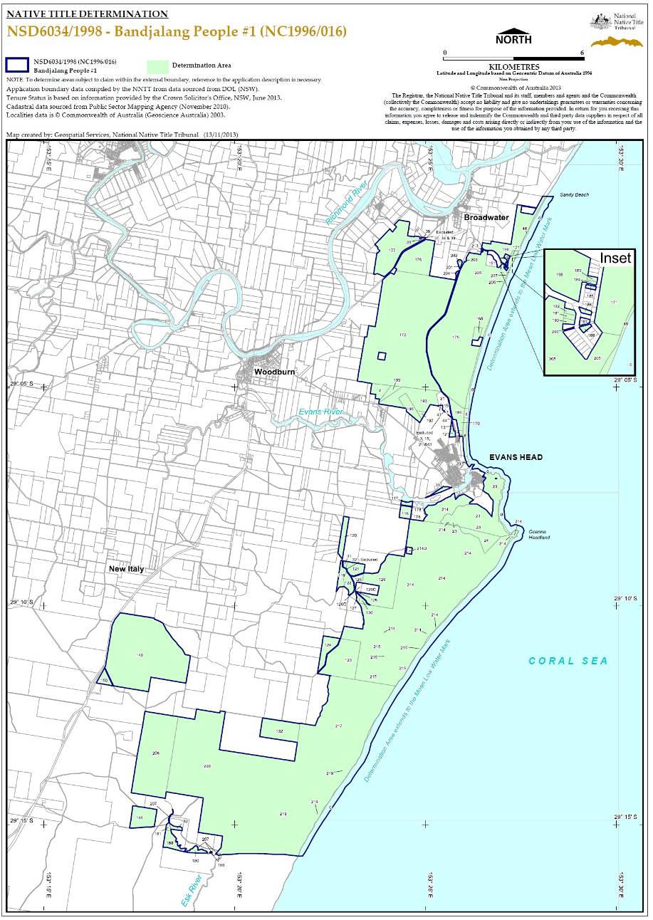
SCHEDULE ONE – CONSENT DETERMINATION AREA
The land and waters in which the Bandjalang People hold native title are the parcels described in Annexure A as shown on the map attached at Annexure B.
In the event of an inconsistency between the written description provided in this attachment and the map, the written description shall prevail.
Annexure A to SCHEDULE ONE
DESCRIPTION OF THE CONSENT DETERMINATION AREA
ID AREA | PARCEL | DESCRIPTION OF LAND |
2 | Lot 7050 DP 1112972 | |
8 | Lot 7015 DP 1076665 & Lot 7096 DP 1113511 | |
11 | Lot 7020 DP 1051335 | |
12 | Lot 7019 DP 1051692 | |
13 | Lot 7094 DP 1113512 | |
20 | Unidentified Crown Land as shown on the map at Annexure B | |
23 | Lot 7307 DP 1153014 | |
24 | Lot 7308 DP 1153014 | |
30 | Lot 7017 DP 1112984 | |
31 | Lot 91 DP 755614 | |
32 | Lot 7301 DP 1163536 | |
44 | Lot 7095 DP 1113843 | |
48 | Unidentified Crown Land as shown on the map at Annexure B | |
116 | Lot 161 DP 755624 | Bundjalung National Park GG 25/1/1980 |
117 | Unidentified land | Bundjalung National Park GG 30/1/1981 |
119 | Lot 70 DP 755614 | Bundjalung National Park GG 25/1/1980 |
120 | Lot 42 DP 755614 | Bundjalung National Park GG 4/11/1983 |
122 | Lot 49 DP 755614 | Bundjalung National Park GG 25/1/1980 |
123 | Unidentified land | Bundjalung National Park GG 25/1/1980 |
124 | Unidentified land | Bundjalung National Park GG 25/1/1980 |
125 | Part of Lot 7302 DP 1163536 | Bundjalung National Park GG 25/1/1980 |
126 except in relation to 126(c) | Part of Lot 52 DP 755614 | Bundjalung National Park GG 25/1/1980 |
127 | Part of 7302 DP 1163536 | Bundjalung National Park GG 25/1/1980 |
129 except in relation to 129 (C) | Part of Lot 53 DP 755614 | Bundjalung National Park GG 25/1/1980 |
130 | Part of Lot 53 DP 755614 | Bundjalung National Park GG 25/1/1980 |
132 | Lot 13 DP 755613 | Bundjalung National Park GG 25/1/1980 |
144 | Unidentified | Bundjalung National Park GG 26/2/1999 addition |
149 | Part of Lot 3 DP 755610 | Tabbimoble Swamp Nature Reserve GG 26/2/1999 |
150 | Part of Lot 3 DP 755610 | Tabbimoble Swamp Nature Reserve GG 26/2/1999 |
168 | Lot 63 DP 755624 | Broadwater National Park GG 12/7/1974 |
170 | Lot 7058 DP 96632 | Broadwater National Park GG 5/3/1999 |
171 | Unidentified land | Broadwater National Park GG 22/8/1980 |
172 | Unidentified | Broadwater National Park GG 12/7/1974 |
175 | Unidentified | Broadwater National Park GG 12/7/1974 |
176 | Unidentified | Broadwater National Park GG 12/7/1974 |
177 | Unidentified | Broadwater National Park GG 28/5/1982 |
178 | Unidentified | Bundjalung National Park GG 25/1/1980 |
179 | Unidentified | Bundjalung National Park GG 25/1/1980 |
180 | Unidentified | Bundjalung National Park GG 25/1/1980 |
181 | Unidentified | Bundjalung National Park GG 25/1/1980 & 22/7/1983 |
182 | Unidentified | Bundjalung National Park GG 25/1/1980 & 22/7/1983 |
183 | Lot 377 DP 755624 | Broadwater National Park GG 19/7/1985 |
184 | Lot 378 DP 755624 | Broadwater National Park GG 19/7/1985 |
185 | Lot 379 DP 755624 | Broadwater National Park GG 19/7/1985 |
186 | Lot 384 DP 755624 | Broadwater National Park GG 19/7/1985 |
187 | Lot 386 DP 755624 | Broadwater National Park GG 19/7/1985 |
188 | Lot 387 DP 755624 | Broadwater National Park GG 19/7/1985 |
190 | Lot 399 DP 755624 | Broadwater National Park GG 19/7/1985 |
191 | Lot 400 DP 755624 | Broadwater National Park GG 19/7/1985 |
192 | Lot 401 DP 755624 | Broadwater National Park GG 19/7/1985 |
193 | Lot 7105 DP 1123365 | Broadwater National Park GG 5/3/1999 |
194 | Part of Lot 7058 DP 96632 | Broadwater National Park GG 5/3/1999 |
196 | Lot 7014 DP 1057092 | Broadwater National Park GG 5/3/1999 |
197 | Unidentified | Broadwater National Park GG 5/3/1999 |
198 | Unidentified | Broadwater National Park GG 22/8/1980 |
200 | Unidentified | Broadwater National Park GG 22/8/1980 |
201 | Unidentified | Broadwater National Park GG 12/7/1974 |
202 | Unidentified | Broadwater National Park GG 12/7/1974 |
203 | Unidentified | Broadwater National Park GG 12/7/1974 |
204 | Unidentified | Broadwater National Park GG 12/7/1974 |
205 | Unidentified | Broadwater National Park GG 12/7/1974 |
206 | Unidentified | Bundjalung National Park GG 25/1/1980 |
207 | Unidentified | Part Esk River |
213 | Unidentified | Broadwater National Park GG 22/8/1980 |
214 Except in relation to 214D | Unidentified | Bundjalung National Park GG 25/1/1980 |
215 | Unidentified | Bundjalung National Park GG 25/1/1980 |
217 | Unidentified | Bundjalung National Park GG 25/1/1980 |
219 North of the southern boundary | Unidentified | Bundjalung National Park GG 25/1/1980 |
220 | Unidentified | Bundjalung National Park GG 25/1/1980 |
Annexure B to SCHEDULE ONE
MAP OF CONSENT DETERMINATION AREA
SCHEDULE TWO
OTHER RIGHTS AND INTERESTS
1. The rights and interests of Telstra Corporation Limited;
(a) as the owner or operator of telecommunications facilities within the Consent Determination Area;
(b) as the holder of a carrier licence under the Telecommunications Act 1997 (Cth);
(c) created pursuant to the Post and Telegraph Act 1901 (Cth), the Telecommunications Act 1975 (Cth), the Australian Telecommunications Corporations Act 1989 (Cth), the Telecommunications Act 1991 (Cth) and the Telecommunications Act 1997 (Cth), including rights
(i) to inspect land;
(ii) to install and operate telecommunications facilities; and
(iii) to alter, remove, replace, maintain, repair and ensure the proper functioning of its telecommunications facilities;
(d) for its employees, agents or contractors to access its telecommunications facilities in and in the vicinity of the Consent Determination Area in performance of their duties;
(e) under any lease, licence, access agreement or easement relating to its telecommunications facilities in the Consent Determination Area: and
(f) under a consent granted by the NSW Minister for the Environment on 13 January 1995 for the installation of an underground fibre optic cable through Broadwater National Park.
1. The rights and interests of the Richmond Valley Council and Clarence Valley Council under their local government jurisdiction and as entities exercising statutory powers in respect of the land and waters in their local government areas, including existing access to public work.
2. The rights and interests of the Crown in right of the State of New South Wales.
3. The rights and interests granted or recognised by the State of New South Wales pursuant to statute or otherwise in the exercise of its executive power and under any regulations made pursuant to such legislation, and including, for the avoidance of any doubt, but not limited to, the following rights and interests that have been granted or recognised by:
(a) permissive occupancy C130 (PO 1952/3) granted to the Commonwealth by the State of New South Wales under s 136K of the Crown Lands Consolidation Act 1913 (NSW); and
(b) permissive occupancy C241 (PO 1963/30) granted to the Commonwealth by the State of New South Wales under s 136K of the Crown Lands Consolidation Act 1913 (NSW).
(c) (i) the day use area at Broadwater Beach in Broadwater National Park;
(ii) the day use area at Gummigurrah in Bundjalung National Park; and
(iii) the camping area at Black Rocks in Bundjalung National Park.
4. The rights and interests granted by the Commonwealth pursuant to statute or otherwise in the exercise of its executive power and under any regulations made pursuant to such legislation and including, for the avoidance of any doubt, but not limited to, the following rights and interests:
(a) the "Defence Practice Area" otherwise declared and described as "Item and Map No. 8 Evans Head" in the Schedule to the "Declaration of Defence Practice Areas" made by the Minister for Defence pursuant to sub-regulation 49(1) of the Defence Force Regulations on 17 October 1994, and published in Commonwealth of Australia Gazette No. GN 46 on 23 November 1994.
5. The rights or interests held by reason of the force and operation of the laws of the State of New South Wales or of the Commonwealth.
6. The rights and interests of members of the public arising under the common law including but not limited to:
(a) the public right to fish;
(b) the public right to navigate.
7. The right to access land by an employee or agent or instrumentality of the State of New South Wales, of the Commonwealth or of other statutory authority as required in the performance of his or her statutory or common law duties.
8. So far as confirmed pursuant to sections 16 and 18 of the Native Title (New South Wales) Act 1994 as at the date of the determination, any existing public access to and enjoyment of:
(a) waterways;
(b) the beds and banks or foreshores of waterways;
(c) coastal waters;
(d) beaches;
(e) stock routes; and
(f) areas that were public places at the end of 31 December 1993.
9. Any other:
(a) legal or equitable estate or interest in the land or waters of the Consent Determination Area; or
(b) right (including a right under an option and a right of redemption), charge, power or privilege over, or in connection with:
(i) the land or waters of the Consent Determination Area; or
(ii) an estate or interest in the land or waters of the Consent Determination Area.
SCHEDULE THREE
EXTERNAL BOUNDARIES
Eastern boundary Description
The Eastern boundary of the of the application is described as Commencing at the north eastern most corner of Broadwater National Park and extending easterly to the Mean Low Water Mark of the South Pacific Ocean at Latitude 29.010562° South and east to a point 200 metres seaward of that Mean Low Water Mark; then generally southerly along a buffer 200 metres seaward of that Mean Low Water Mark to Latitude 29.262071° South.
Southern Boundary Description
Commencing at point 200 metres seaward of the Mean Low Water Mark of the South Pacific Ocean at Latitude 29.262071° South and extending generally westerly through the following coordinate points;
Longitude (East) | Latitude (South) |
153.360841 | 29.262077 |
153.358195 | 29.261741 |
153.354467 | 29.261408 |
153.350453 | 29.261418 |
153.346922 | 29.261166 |
153.342022 | 29.261097 |
153.335250 | 29.261115 |
153.330938 | 29.261468 |
153.328489 | 29.261474 |
153.326235 | 29.261741 |
153.323896 | 29.260799 |
153.319573 | 29.260981 |
153.313098 | 29.260735 |
153.309566 | 29.260057 |
153.303778 | 29.258780 |
153.296623 | 29.258462 |
153.286520 | 29.256237 |
153.279618 | 29.254752 |
Then westerly to a point on the eastern boundary of Devils Pulpit State Forest, also a point on a western boundary of Bundjalung National Park at Latitude 29.254752° South.
The application area also covers all land and waters including the following land parcels:
STATE ID (Area Number) | Current Lot Description |
2 | Lot 7050 DP1112972 |
3 | Part Lot 10 DP1075394 |
8 | Lot 7096 DP1113511 |
8 | Lot 7015 DP1076665 Crown Land, between the High Water Mark and Low Water Mark |
11 | Lot 7020 DP1051335 |
12 | Lot 7019 DP1051692 |
13 | Lot 7094 DP1113512 |
15 | Part Lot 10 DP1075394 |
20 | Unidentified Crown Land Crown Land, between the High Water Mark and Low Water Mark |
21 | Part Lot 10 DP1075394 |
23 | Lot 7092 DP1113531 |
23 | Lot 7012 DP1112973 |
23 | Lot 7091 DP1113534 |
24 | Lot 7002 DP1112982 |
30 | Lot 7017 DP1112984 |
31 | Lot 91 DP755614 |
32 | Lot 7001 DP92541 |
32 | Part Lot 52 DP755614 |
37 | Lot 10 DP868045 |
38 | Lot 13 DP868045 |
39 | Lot 7011 DP1051693 |
43 | Part Lot 10 DP1075394 |
44 | Lot 7095 DP1113843 |
48 | Crown Land, between the High Water Mark and Low Water Mark |
116 | Part Lot 161 DP755624 Part Bundjalung National Park |
117 | Part Lot 161 DP755624 Part Bundjalung National Park |
117 | Unidentified Crown Land |
119 | Lot 70 DP755614 Part Bundjalung National Park |
120 | Lot 42 DP755614 Part Bundjalung National Park |
122 | Lot 49 DP755614 Part Bundjalung National Park |
123 | Part Crown Plan 357 – 3052 Part Bundjalung National Park |
124 | Part Crown Plan 357 – 3052 Part Bundjalung National Park |
125 | Part Lot52 DP755614 Part Bundjalung National Park |
126 Except in relation to 126C | Part Lot52 DP755614 Part Bundjalung National Park |
127 | Part Lot 52 DP755614 Part Bundjalung National Park |
129 Except in relation to 129C | Part Lot 53 DP755614 Part Bundjalung National Park |
130 | Part Lot 53 DP755614 Part Bundjalung National Park |
132 | Lot 13 DP755613 Part Bundjalung National Park |
144 | Part Lot 19 DP755629 Part Bundjalung National Park |
149 | Part Lot 3 DP755610 Part Tabbimoble Swamp Nature Reserve |
150 | Part Lot 3 DP755610 Part Tabbimoble Swamp Nature Reserve |
151 | Lot 283 DP755624 Part Broadwater National Park |
168 | Lot 63 DP755624 Part Broadwater National Park |
170 | Part Lot 7058 DP96632 Part Broadwater National Park |
171 | Lot 1701 – 3050 Part Broadwater National Park |
172 | Part Broadwater National Park |
175 | Part Broadwater National Park |
176 | Part Broadwater National Park |
177 | Part Broadwater National Park |
178 | Part Bundjalung National Park |
179 | Part Broadwater National Park |
180 North of the Southern Boundary as Described | Part Bundjalung National Park |
181 | Part Bundjalung National Park |
182 | Part Bundjalung National Park |
183 | Lot 377 DP755624 Part Broadwater National Park |
184 | Lot 378 DP755624 Part Broadwater National Park |
185 | Lot 379 DP755624 Part Broadwater National Park |
186 | Lot 384 DP755624 Part Broadwater National Park |
187 | Lot 386 DP755624 Part Broadwater National Park |
188 | Lot 387 DP755624 Part Broadwater National Park |
190 | Lot 399 DP755624 Part Broadwater National Park |
191 | Lot 400 DP755624 Part Broadwater National Park |
192 | Lot 401 DP755624 Part Broadwater National Park |
193 | Part Lot 7048 DP1057102 Part Broadwater National Park |
193 | Lot 7105 DP1123365 Part Broadwater National Park |
194 | Part Lot 7058 DP96632 Part Broadwater National Park |
196 | Lot 7014 DP1057092 Part Broadwater National Park |
197 | Part Broadwater National Park |
198 | Part Broadwater National Park |
198 | Part Broadwater National Park |
198 | Part Broadwater National Park |
200 | Part Broadwater National Park |
201 | Part Broadwater National Park |
202 | Part Broadwater National Park |
203 | Part Broadwater National Park |
204 | Part Broadwater National Park |
205 | Part Broadwater National Park |
206 | Part Broadwater National Park |
207 North of the Southern Boundary as described | Part Esk River |
213 | Part Broadwater National Park |
214 Except in relation to 214D | Part Bundjalung National Park |
215 | Part Bundjalung National Park |
217 | Part Bundjalung National Park |
219 North of the Southern Boundary as described | Part Bundjalung National Park |
220 | Part Bundjalung National Park |
and;
That portion of Bundajlung National Park north of State ID 214 and south of that parcel of unidentified Crown land west of Lot 529 on DP721119. Bounded in the east by State ID 23, in the west by Oyster Creek and south of Evans River.
Note
Data Reference and source
• Application boundary data compiled by National Native Title Tribunal based on data sourced from Dept of Lands, Land and Property Information Division, NSW.
• Area Numbers sourced from the historical and current land tenure report 20 May 2003.
• Cadastral data sourced from Public Sector Mapping Agency (May 2008) some lot references sourced from Dept of Lands (NSW), online Geospatial Portal (Nov 2007).
• Road reserve data sourced from Dept of Lands, NSW (July 2001).
• Conservation data sourced from Department of Environment and Conservation NSW (June 2006).
Reference datum
Geographical coordinates have been provided by the NNTT Geospatial Unit and are referenced to the Geocentric Datum of Australia 1994 (GDA94), in decimal degrees and are based on the spatial reference data acquired from the various custodians at the time
Use of Coordinates
Where coordinates are used within the description to represent cadastral or topographical boundaries or the intersection with such, they are intended as a guide only. As an outcome to the custodians of cadastral and topographic data continuously recalculating the geographic position of their data based on improved survey and data maintenance procedures, it is not possible to accurately define such a position other than by detailed ground survey.
IN THE FEDERAL COURT OF AUSTRALIA | |
NEW SOUTH WALES DISTRICT REGISTRY | |
GENERAL DIVISION | NSD 6107 of 1998 |
BETWEEN: | ANTHONY EDWARD WILSON and DOUGLAS STEVEN WILSON ON BEHALF OF THE BANDJALANG PEOPLE NO 2 Applicant |
AND: | THE NSW ATTORNEY GENERAL AS THE STATE MINISTER FOR NEW SOUTH WALES AND OTHERS Respondent |
JUDGE: | JAGOT J |
DATE OF ORDER: | 2 DECEMBER 2013 |
WHERE MADE: | evans head (AMENDED PURSUANT TO R. 39.05) |
BEING SATISFIED that a determination of native title in the terms sought by the parties is within the power of the Court, and it appearing appropriate to do so by consent of the parties and pursuant to ss. 87(4) and 94A of the Native Title Act 1993 (Cth) 1993,
THE COURT NOTES THAT:
A. It is the intention of the State of New South Wales and the Applicant without delay to enter into an Indigenous Land Use Agreement for the following purposes:
i. to establish regimes for the future management of the State Forests, National Parks, Crown reserves, the travelling stock reserves and the fisheries resource within the Consent Determination Area;
ii. to provide a regime for the undertaking of Future Acts in the Consent Determination Area; and
iii. to achieve a final settlement with the Bandjalang People for any past affect to their native title rights and interests.
THE COURT ORDERS THAT:
1. There be a determination of native title in the terms set out below (the Determination).
2. The native title is to be held on trust.
3. The Bandjalang Aboriginal Corporation Prescribed Body Corporate (ICN 7930) is to:
(a) be the prescribed body corporate for the purposes of s. 57(1) of the Native Title Act 1993 (Cth); and
(b) to perform the functions set out in s. 57(1) of the Native Title Act 1993 (Cth) and the Native Title (Prescribed Bodies Corporate) Regulations 1999 (Cth).
4. There be no orders as to costs.
Note: Entry of orders is dealt with in Rule 39.32 of the Federal Court Rules 2011.
THE COURT DETERMINES THAT:
Existence of Native Title
1. Native title exists in relation to each of the areas of land and waters described in Schedule One, to the extent that each falls within the external boundaries of the claim area as described in Attachment B to the Further Amended Claimant Application in these proceedings (which is reproduced as Schedule Three to this Consent Determination) ("External Boundaries") (“Consent Determination Area”). Each of the areas described in Schedule One is to be taken to include any creek occurring within its boundaries.
Native title holders
2. Native title is held by the “Bandjalang People” who are Aboriginal persons who are:
(a) the biological descendants of:
(i) King Harry, Jack Wilson, Susannah mother of Frank Jock Jnr, Michael “Mundoon” Wilson, George James, Eliza Breckenridge, Jack Breckenridge, Frank Jock Jnr, Ada Jock, Gibson Robinson, Grace Bond; and
(b) Persons adopted or incorporated into the families of those persons (and the biological descendants of any such adopted or incorporated persons) and who identify as and are accepted as Bandjalang People in accordance with Bandjalang traditional laws and customs.
Nature and extent of native title rights and interests
3. Subject to paragraphs 4 to 9 the nature and extent of the native title rights and interests held by the Bandjalang People in the Consent Determination Area identified in Schedule One, are the non-exclusive rights set out below:
(a) the right to hunt, fish and gather the traditional natural resources of the Consent Determination Area for non-commercial personal, domestic and communal use;
(b) the right to take and use waters on or in the Consent Determination Area;
(c) the right to access and camp on the Consent Determination Area;
(d) the right to do the following activities on the land:
(i) conduct ceremonies;
(ii) teach the physical, cultural and spiritual attributes of places and areas of importance on or in the land and waters; and
(iii) to have access to, maintain and protect from physical harm, sites in the Consent Determination Area which are of significance to the Bandjalang People under their traditional laws and customs.
General Limitations
4. Native title does not exist in:
(a) Minerals as defined in the Mining Act 1992 (NSW) and the Mining Regulation 2010 (NSW); and
(b) Petroleum as defined in the Petroleum (Onshore) Act 1991 (NSW) and the Petroleum (Submerged Lands) Act 1982 (NSW).
5. Native title rights and interests do not exist in the areas covered by Public Works (including the land defined in section 251D of the Native Title Act (Cth) 1993) which were constructed, established or situated prior to 23 December 1996 or commenced to be constructed or established on or before that date.
6. Public Works constructed, established or situated after 23 December 1996 have had or will have, if yet to be constructed, such effect as results from Part 2 Division 3 of the Native Title Act (Cth) 1993.
7. Native title rights and interests do not exist in any area of land which has been dedicated as a public road or a main road in accordance with the statutory requirements for such dedication, even if the land is no longer so dedicated.
8. The native title rights and interests described in paragraph 3 are exercised for personal, domestic and non-commercial communal purposes and do not confer possession, occupation, use or enjoyment to the exclusion of all others. The native title rights and interests do not confer any right to control public access or public use of the land and waters of the Consent Determination Area.
9. The native title rights and interests in the Consent Determination Area are subject to and exercisable in accordance with:
(a) the laws of the State of New South Wales and the Commonwealth, including the common law; and
(b) the traditional laws acknowledged and traditional customs observed by the Bandjalang People.
Nature and extent of other rights and interests
10. The nature and extent of other rights and interests in the Consent Determination Area are described in Schedule Two.
11. Any reference in a clause of Schedule Two to a specific right or interest, which is said to be included in a broader class of rights or interests described in that clause, is included for abundant caution and is not intended to limit the generality of that broader class.
Relationship between native title rights and interests and other rights and interests
12. The relationship between the native title rights and interests in the Consent Determination Area that are described in paragraph 3 and the other rights and interests described in paragraph 10 and Schedule Two (“the Other Interests”) is that:
(a) the Other Interests continue to have effect; and
(b) the Other Interests and any activity done in accordance with or incidental to the exercise of a right conferred or held under the Other Interests, while they are in existence, prevail over but do not extinguish the native title rights and interests and any exercise of those native title rights and interests.
(c) the native title is subject to extinguishment by:
(i) the lawful powers of the Commonwealth and of the State of New South Wales; and/or
(ii) the lawful grant or creation of interests pursuant to the Laws of the Commonwealth and the State of New South Wales.
Definitions
13. In these orders, unless the contrary intention appears:
“Bandjalang People” means the native title holders as described in order 2.
“camp” means to stay on the Consent Determination Area for temporary periods. Tents or other like structures are permitted. It does not include the right to permanently reside or build permanent structures or fixtures.
“Consent Determination Area” means the land and waters described and mapped in Schedule One.
“laws” include statutes, regulations and other subordinate legislation and the common law.
“Proceedings” means the application for determination of native title made by Anthony Edward Wilson and Douglas Steven Wilson for and on behalf of the Bandjalang People (NC98/19; NSD6107/98) and any matters arising from those proceedings.
14. If a word or expression is not defined in these orders, but is defined in the Native Title Act 1993 (Cth), then it has the meaning given to it in the Native Title Act 1993 (Cth).
SCHEDULE ONE
CONSENT DETERMINATION AREA
1. The land and waters in which the Bandjalang People hold native title are the parcels described in Annexure A and as shown on the map attached at Annexure B.
2. Save for the land described as unidentified land in column 3 in the Annexure A, in the event of an inconsistency between the written description provided in this attachment and the map, the written description shall prevail
3. Columns 1 and 2 in Annexure A of schedule one set out the Area and Identification (ID) numbers respectively for each individual parcel of land within the consent determination area. The Area and ID numbers are internal identifiers used by the State for convenience.
4. Column 3 contains the parcel identifiers. Where possible this is by reference to the lot and deposited plan. However where no lot and deposited plan is available, the land is identified by reference to the map attached at Annexure B of Schedule One.
5. In many instances native title exists over part of a parcel but has been extinguished over the balance of the parcel. In those instances, Column 4 contains a short reference to the act or fact that has caused the extinguishment of the native title over those areas.
6. The spatial extent of extinguishment has not been surveyed or otherwise fixed but is to be determined by the spatial extent of the extinguishing act or interest referred to in Column 4. In a given parcel it is possible that, as a result of the spatial extent of an extinguishing act or interest being determined, native title may be found to have been extinguished over the entire parcel.
Annexure A to SCHEDULE ONE
DESCRIPTION OF THE CONSENT DETERMINATION AREA
Area | ID | Description of Land | Comments including Roads and Public Works Limitations |
1 | 8 | Part of closed Road adjoining the bottom half of Lot 13 in Deposited Plan 845649 | Only that part of the lot not affected by a road, that road being subject to clause 7. |
1 | 12 | Closed Road adjoining Lot 194 in DP755742 | Only that part of the lot not affected by a road, that road being subject to clause 7. |
2 | 2 | 24/755727 | |
2 | 4 | 330/726561 | |
2 | 5 | 245/755727 | |
2 | 6 | Unidentified land adjoining Lot 24/755727 as shown on the maps at Annexure B (now Lot 7308/1162852) | |
2 | 7 | 7304/1138123 | |
2 | 181 | 7015/1051717 (excluding that part of the land which is the Richmond River see ID 329) | |
2 | 183 | 243/755727 | Only that part of the lot not affected by public work being development for sporting grounds and facilities, that public work being subject to clause 5. |
2 | 184 | 190/755727 | Only that part of the lot not affected by public work being development for sporting grounds and facilities, that public work being subject to clause 5. |
2 | 231 | Unidentified land abutting north west boundary of ID222 of Area 2 (Abutting Lot 194/755627) | |
2 | 232 | 7007/92627 | |
2 | 275 | 7006/92628 | Only that part of the lot not affected by public works, being drainage and associated infrastructure, that public work being subject to clause 5. |
2 | 278 | Unidentified Land as shown on the maps at Annexure B (within Lot 27/755627) | |
2 | 289 | Unidentified land as shown on the maps at Annexure B (within Lot 33/755627) | |
2 | 295 | Unidentified land as shown on the maps at Annexure B (within Lot 38/755627) | |
2 | 300 | 7015/1120401 | |
2 | 329 | Part of the Richmond River (tidal waterway) | |
2 | 330 | Horseshoe Lagoon (non-tidal waterway) | |
2 | 331 | Crown waterway (non-tidal) as shown on the maps at Annexure B (Adjoining 2/102290) | |
3 | 26 | Closed Road – adjoining Lot 21 DP8737 | Only that part of the lot not affected by a road, that road being subject to clause 7. |
3 | 57 | 246/755742 | Only that part of the lot not affected by a road, that road being subject to clause 7. |
3 | 243 | 7003/1054006 | Only that part of the lot not affected by public work being development for cricket oval including sheds that public work being subject to clause 5. |
3 | 338 | Part of the Long Lagoon (non-tidal waterway) | |
3 | 339 | Part of the Richmond River (tidal waterway) | |
3 | 340 | Part of Oakey Creek (non-tidal waterway) | |
4 | 10 | 259/728186 | |
4 | 143 | 216/755742 | |
4 | 174 | 260/728185 | |
4 | 190 | 6/252746 | Only that part of the lot not affected by a road, that road being subject to clause 7. |
4 | 192 | 7/252746 | Only that part of the lot not affected by a road, that road being subject to clause 7. |
4 | 193 | Walshs Creek Non tidal | |
4 | 194 | Richmond River Tidal | |
6 | 59 | 139/755618 | |
6 | 60 | 112/755618 | |
6 | 61 | 111/755618 | |
6 | 64 | 49/755618 | |
6 | 69 | Mongogarie Creek | |
6 | 70 | Cherrytree Creek | |
6 | 72 | 1/242829 | Only that part of the lot not affected by a road, that road being subject to clause 7. |
7 | 13 | 7002/1050851 | |
7 | 23 | Closed Road Adjoining Lot 2 DP 573121 | Only that part of the lot not affected by a road, that road being subject to clause 7. |
7 | 45 | 7007/1050852 | |
7 | 73 | Land adjoining Lots 101 and 103 in DP 755606, and Lot 139 in DP 5125 | |
7 | 75 | Mongogarie Creek (non-tidal waterway) as shown on the maps at Annexure B | |
7 | 76 | Middle Creek (non-tidal waterway) | |
8 | 29 | 248/755627 | Only that part of the lot not affected by public work being development for Yorklea School, Community Centre and RFS Headquarters, that public work being subject to clause 5. |
8 | 85 | 161/755623 | Only that part of the lot not affected by public work being development for a horse riding facility, that public work being subject to clause 5. |
8 | 86 | 7001/92675 | Only that part of the lot not affected by a road, that road being subject to clause 7. |
8 | 87 | 211/42433 | That part of the lot not affected by public work being development for a horse riding facility, that public work being subject to clause 5. That part not affected by a road, that road being subject to clause 7. |
8 | 88 | 210/42433 | |
8 | 89 | 7005/1054013 | |
8 | 94 | Closed road adjoining Lot 161 in DP 755623 (now 7300/DP1177568) | Only that part of the lot not affected by a road, that road being subject to clause 7. |
8 | 168 | Unidentified land adjoining Lots 84, 185, 52 and 53 in DP 755623 | |
8 | 231 | 114/1031643 | |
8 | 233 | 32/755606 | |
8 | 279 | Shannon Brook Non-tidal | |
8 | 280 | Branch Creek Non-tidal | |
8 | 281 | Drainage reserve adjoining Lot 2 in DP 807368 | |
9 | 15 | 133/755634 | Only that part of the lot not affected by a road, that road being subject to clause 7. |
9 | 16 | 7001/92649 | That part of the lot not affected by public work being development for Cattle Tick Dip Site since 1953. Fenced yards and earthworks, that public work being subject to clause 5. That part of the lot not affected by a road, that road being subject to clause 7. |
9 | 17 | 7300/1161352 | Only that part not affected by a road, that road being subject to clause 7. |
9 | 183 | 7001/1054024 | |
9 | 256 | Unidentified land as shown on the maps at Annexure B (Adjoining Allot 2 Lot 2 DP1494) | Only that part of the lot not affected by a road, that road being subject to clause 7. |
9 | 470 | 5/256992 | Only that part of the lot not affected by a road, that road being subject to clause 7. |
9 | 471 | 6/256992 | Only that part of the lot not affected by a road, that road being subject to clause 7. |
10 | 74 | 352/728160 | |
10 | 75 | 353/728160 | |
10 | 87 | 7304/1145407 | |
10 | 108 | 7002/1053005 | |
10 | 109 | 72/755628 | |
10 | 185 | 256/726656 | |
10 | 195 | 9/252746 | Only that part of the lot not affected by a road, that road being subject to clause 7. |
10 | 196 | 8/252746 | Only that part of the lot not affected by a road, that road being subject to clause 7. |
10 | 198 | 10/252746 | Only that part of the lot not affected by a road, that road being subject to clause 7. |
10 | 201 | 1/63/758257 | |
10 | 365 | 7300/1152640 | |
10 | 370 | Part of the Lagoon (non-tidal waterway) | |
11 | 5 | 213/755728 | |
11 | 35 | Unidentified land as shown on the maps at Annexure B (Adjoining Lot 1 DP953829 and Lot 19 DP755728 | Only that part of the lot not affected by a road, that road being subject to clause 7. |
11 | 61 | 246/755728 | Only that part of the lot not affected by public work being development for cattle handling facilities, that public work being subject to clause 5. Only that part of the lot not affected by a road, that road being subject to clause 7. |
11 | 79 | 242/755728 | |
11 | 80 | 243/755728 | |
11 | 81 | 244/755728 | |
11 | 82 | 181/755728 | |
11 | 86 | 71/755628 | |
11 | 87 | 7001/92680 | |
11 | 162 | 1/44756 | Only that part of the lot not affected by a road, that road being subject to clause 7. |
11 | 356 | 340/727822 | |
11 | 461 | 246/755631 | Only that part of the lot not affected by public work being development for night soil depot and landfill, that public work being subject to clause 5. |
11 | 462 | 342/728104 | Only that part of the lot not affected by a road, that road being subject to clause 7. |
11 | 463 | 343/728104 | |
11 | 499 | 2/251860 | Only that part of the lot not affected by a road, that road being subject to clause 7. |
11 | 500 | 3/251860 | Only that part of the lot not affected by a road, that road being subject to clause 7. |
11 | 501 | 5/251860 | Only that part of the lot not affected by a road, that road being subject to clause 7. |
11 | 526 | Unidentified land as shown on the maps at Annexure B (Adjoining Lot 1 DP798966) | |
11 | 539 | 310/755631 | |
11 | 545 | 351/728135 | Only that part not affected by public work being developed as Coraki Riverside Park including caravan park, amenities, constructed beach, landscaping and amphitheatre, that public work being subject to clause 5. |
11 | 546 | 350/728135 | Only that part of the lot not affected by public work being development for Coraki Riverside Park including wharves and boat ramp, that public work being subject to clause 5. |
11 | 611 | 187/755631 | Only that part of the lot not affected by public work being development for cattle tick dip infrastructure, that public work being subject to clause 5. |
11 | 622 | 188/755631 | Only that part of the lot not affected by public work being development for Coraki Cattle Pound, fenced with yards with trough, that public work being subject to clause 5. |
11 | 623 | 341/728103 | |
11 | 624 | 345/728106 | |
11 | 625 | 349/728108 | Only that part of the lot not affected by public work being development for Coraki Hockey Fields with buildings and earthworks, including amenities, canteen, shelter and lights, that public work being subject to clause 5. |
11 | 738 | 337/728156 | Only that part of the lot not affected by public work being development for Coraki sports fields (rugby league and hockey), including tennis courts, basketball, a skate park, a canteen and other amenities, landscaping, a large drain through the site and a former horse racecourse, that public work being subject to clause 5. |
11 | 739 | 101/755631 | |
11 | 842 | 6/23/758291 | |
11 | 843 | 5/23/758291 | |
11 | 1142.1 | 347/728109 | Only that part of the lot not affected by public work being development for Coraki Memorial Park parks infrastructure including war memorial, landscaping, amenities, pathways, road, parking, fill, a shelter, shade sails and fixed playground equipment, that public work being subject to clause 5. |
11 | 1144.1 | 344/728105 | |
11 | 1145.1 | Part of the Wilsons River (tidal waterway) as shown on the maps at Annexure B | |
12 | 66 | Unidentified land adjoining Lot 4 in Deposited Plan 717103 | Only that part of the lot not affected by a road, that road being subject to clause 7. |
12 | 67 | Unidentified land adjoining Lot 32 in Deposited Plan 627286 | Only that part of the lot not affected by a road, that road being subject to clause 7. |
12 | 68 | Unidentified land adjoining Lot 2 in Deposited Plan 706413 | Only that part of the lot not affected by a road, that road being subject to clause 7. |
14 | 2 | 7300/1143257 | |
14 | 9 | 99/726569 | |
14 | 23 | 85/755636 | |
14 | 33 | 7301/1146727 | |
14 | 34 | 7302/1146727 | |
14 | 35 | 7303/1146727 | |
14 | 36 | 7304/1146727 | |
14 | 40 | 64/755604 | |
14 | 41 | 66/755604 | |
14 | 42 | 43/755604 | |
14 | 72 | 7300/1143007 | |
14 | 73 | Busby Creek | |
14 | 77 | 7301/1146725 | |
14- | 78 | 69/755604 | |
14 | 79 | 98/726569 | |
14 | 80 | 1/722771 | Only that part of the lot not affected by a road, that road being subject to clause 7. |
15 | 9 | 64/755604 | |
15 | 10 | 7304/1146727 | |
15 | 13 | 7300/1144004 | |
15 | 18 | Unidentified land adjoining Lots 106/755616, 114/755616 and 110/755616 | |
15 | 80 | 7300/1144348 | |
15 | 99 | 119/46878 | |
15 | 100 | 113/755616 | |
15 | 118 | 7005/92542 | |
15 | 119 | 7004/92542 | |
15 | 148 | Sandy Creek (non-tidal waterway) as shown on the maps at Annexure B | |
15 | 149 | Busbys Creek (non-tidal waterway) as shown on the maps at Annexure B | |
15 | 150 | Myrtle Creek (non-tidal waterway) as shown on the maps at Annexure B | |
16 | 18 | 7301/1146838 | |
16 | 21 | Unidentified land as shown on the maps at Annexure B (Adjoining Lot 2 DP545456 and Lot 16 DP839378) | |
16 | 22 | 78/755621 | |
16 | 23 | 49/755621 | |
16 | 30 | 7003/92533 | |
16 | 37 | 7310/1147265 | |
16 | 38 | 7311/1147265 | |
16 | 39 | 7312/1147265 | |
16 | 40 | 7313/1147265 | |
16 | 41 | 7309/1147265 | |
16 | 42 | 7308/1147265 | |
16 | 48 | 7304/1146782 | |
16 | 50 | 16/755621 | Only that part of the lot not affected by public work being development for Rappville Landfill and Transfer Station, that public work being subject to clause 5. |
16 | 51 | 12/755621 | |
16 | 83 | 7306/1147042 | |
16 | 90 | Fiddle Creek as shown on the maps at Annexure B | |
16 | 91 | Sandy Creek as shown on the maps at Annexure B | |
17 | 60 | Closed Road (Adjoining Lot 11 DP702010) | Only that part of the lot not affected by a road, that road being subject to clause 7. |
17 | 81 | Closed non-public Crown subdivision road adjoin Lot 1 in Deposited Plan 908595 | Only that part of the lot not affected by a road, that road being subject to clause 7. |
17 | 97 | 1/908595 | |
17 | 99 | 7003/92546 | |
17 | 100 | 7003/1050829 | |
17 | 117 | Unidentified land adjoining Lot 113 DP 755612 | |
17 | 118 | Unidentified land as shown on the maps at Annexure B (Adjoining Lot 1 DP755612) | |
17 | 119 | Part of Camp Creek (non-tidal waterway) as shown on the maps at Annexure B. | |
18 | 76 | Unidentified land below lot 1 in Deposited Plan 619685 | |
18 | 77 | 110/ DP755612 | |
18 | 78 | Unidentified land adjoining 58/755607 and1/755612 | |
18 | 79 | Unidentified land adjoining Lot 17 in DP 860145 as shown on the maps at Annexure B. | |
19 | 65 | Closed Road adjoining 783/794107 | Only that part of the lot not affected by a road, that road being subject to clause 7. |
19 | 104 | 192/755631 | |
19 | 105 | 193/755631 | |
19 | 106 | 221/755631 | |
19 | 112 | Closed Road (Adjoining Lot 136 DP755631) | Only that part of the lot not affected by a road, that road being subject to clause 7. |
19 | 123 | Closed Roads through 150/755631 and 137/755631 (Adjoining Lot 150 and Lot 137 DP755631) | Only that part of the lot not affected by a road, that road being subject to clause 7. |
19 | 134 | 1/631162 | |
19 | 135 | 2/631162 | |
19 | 136 | 3/631162 | |
19 | 141 | Closed Road as shown on the maps at Annexure B (Adjoining Lot 3 DP620109) | Only that part of the lot not affected by a road, that road being subject to clause 7. |
19 | 152 | Unidentified land through 11/738070, 12/738070, 7/264108, 6/264108, 5/264108 | |
19 | 157 | Unidentified land adjoining Lot 314 in Deposited Plan 755631 and River | |
19 | 177 | Unidentified land adjoining Lot 201 in DP 755631 and Lot 4 in DP 738253 | |
19 | 193 | Part of Bungawalbin Creek (tidal waterway) as shown on the maps at Annexure B | |
19 | 194 | Part of Bungawalbin Creek (tidal waterway) as shown on the maps at Annexure B | |
20 | 110 | 7002/92602 | Only that part of the lot not affected by a road, that road being subject to clause 7. |
20 | 111 | 7003/92603 | Only that part of the lot not affected by a road, that road being subject to clause 7. |
20 | 138 | Closed road as shown on the maps at Annexure B (within Lot 1 DP122858) | Only that part of the lot not affected by a road, that road being subject to clause 7. |
20 | 185 | 152/755603 | |
20 | 187 | Closed road as shown on the maps at Annexure B (within Lot 11 DP755603) | Only that part of the lot not affected by a road, that road being subject to clause 7. |
20 | 254 | Unidentified land as shown on the maps at Annexure B (Adjoining Lot 2 DP1081829) | Only that part of the lot not affected by a road, that road being subject to clause 7. |
20 | 256 | Unidentified land as shown on the maps at Annexure B (Adjoining Lot 17 DP1087147) | Only that part of the lot not affected by a road, that road being subject to clause 7. |
20 | 257 | Unidentified land as shown on the maps at Annexure B (Adjoining Lot 17 DP1087147) | Only that part of the lot not affected by a road, that road being subject to clause 7. |
20 | 286 | Unidentified land as shown on the maps at Annexure B (Adjoining Lot 1 DP981554) | Only that part of the lot not affected by a road, that road being subject to clause 7. |
20 | 340 | Unidentified land as shown on the maps at Annexure B(Adjoining Lot 270 DP728198) | Only that part of the lot not affected by a road, that road being subject to clause 7. |
20 | 341 | 270/728198 | |
20 | 342 | 271/728198 | |
20 | 548 | Richmond River as shown on the maps at Annexure B | |
20 | 549 | Swan Bay as shown on the maps at Annexure B | |
20 | 550 | Swampy Creek as shown on the maps at Annexure B | |
20 | 551 | Bungawalbin Creek as shown on the maps at Annexure B | |
20 | 552 | Sandy Creek as shown on the maps at Annexure B | |
20 | 553 | Bora Creek as shown on the maps at Annexure B | |
21 | 20 | 1/712974 | |
21 | 21 | 1/712972 | |
21 | 25 | 1/712973 | |
21 | 45 | 1/261225 | |
21 | 46 | 2/261225 | |
21 | 47 | 3/261225 | |
21 | 52 | 417/755624 | |
21 | 53 | 365/755624 | |
21 | 54 | 2/872308 | |
21 | 55 | 5/872309 | |
21 | 56 | 7/872309 | |
21 | 57 | 2/614743 | |
21 | 58 | 531/721343 | |
21 | 240 | 1/27/759110 | Only that part of the lot not affected by public work being Woodburn Park, used to stockpile mineral sands (major earthwork), that public work being subject to clause 5. |
21 | 383 | 1/31/759110 | |
21 | 526 | 542/821656 | |
21 | 573 | 2/1006289 | |
21 | 574 | 347/755624 (now 2/963095) | |
21 | 575 | 348/755624 (now 2/963095) | |
21 | 579 | 1/821927 | Only that part of the lot not affected by a road, that road being subject to clause 7. |
21 | 592 | 200/755624 | Only that part of the lot not affected by public work being previously developed for Rileys Hill Public School (now Rileys Hill Community Centre), including landscaping, fixed playground equipment and fixed sporting infrastructure, that public work being subject to clause 5. |
21 | 593 | 477/755624 | |
21 | 595 | 1/129076 | |
21 | 597 | 2/B/250411 | |
21 | 611 | 17/B/250411 | |
21 | 612 | 18/B/250411 | |
21 | 613 | 19/B/250411 | |
21 | 614 | 20/B/250411 | |
21 | 615 | 21/B/250411 | |
21 | 616 | 22/B/250411 | |
21 | 617 | 23/B/250411 | |
21 | 618 | 24/B/250411 | |
21 | 619 | 9/A/250411 | |
21 | 620 | 10/A/250411 | |
21 | 621 | 11/A/250411 | |
21 | 622 | 12/A/250411 | |
21 | 623 | 13/A/250411 | |
21 | 624 | 365/755624 | |
21 | 625 | 1/16/759110 | |
21 | 774 | 271/728180 | |
21 | 779 | 124/755691 | |
21 | 780 | 117/755691 | Only that Part of the lot not affected by Public work (Dungarubba Hall), water tanks, that public work being subject to clause 5 and partial road subject to clause 7. |
21 | 781 | Closed road passing through 2/875523 | Only that part of the lot not affected by a road, that road being subject to clause 7. |
21 | 846 | Closed road adjoining 152/755699 | Only that part of the lot not affected by a road, that road being subject to clause 7. |
21 | 853 | 7046/1024027 | |
21 | 856 | 7009/1052506 | |
21 | 857 | 7010/1052506 | |
21 | 858 | 7007/1021524 | |
21 | 875 | 361/914704 | |
22 | 160 | 7008/92609 | |
22 | 165 | 5/846760 | |
22 | 168 | 1/604378 | |
22 | 174 | Part of the Richmond River (Tidal) – Crown Waterway Parish of Broadwater County of Rous as shown on the maps at Annexure B | |
22 | 175 | Part of the Richmond River (Tidal) – Crown Waterway Parish of Riley County of Richmond as shown on the maps at Annexure B | |
22 | 176 | Site of Licence 390250 on Richmond River Tidal as shown on the maps at Annexure B | |
22 | 177 | Site of Licence 390250 on Richmond River Tidal as shown on the maps at Annexure B | |
22 | 178 | Site of Crown Permissive Occupancy 157011 – Richmond River Tidal as shown on the maps at Annexure B | |
22 | 179 | Site of Crown Licence 397577 as shown on the maps at Annexure B | |
22 | 180 | Crown Licence 403844 – Richmond River Tidal as shown on the maps at Annexure B | |
22 | 181 | Crown Licence 201097 – Richmond River Tidal as shown on the maps at Annexure B | |
22 | 182 | Crown Licence 394430- Richmond River Tidal as shown on the maps at Annexure B | |
22 | 183 | Crown Licence 201019 – Richmond River Tidal as shown on the maps at Annexure B | |
22 | 184 | Crown Licence 201056 – Richmond River Tidal as shown on the maps at Annexure B | |
22 | 185 | Crown Licence 378756 – Richmond River Tidal as shown on the maps at Annexure B | |
22 | 186 | Crown Licence 201094 – Richmond River Tidal as shown on the maps at Annexure B | |
22 | 187 | Crown Licence 201039 – Richmond River Tidal as shown on the maps at Annexure B | |
22 | 188 | Crown Licence 467410 – Richmond River Tidal as shown on the maps at Annexure B | |
22 | 189 | Crown Licence 166660 – Richmond River Tidal as shown on the maps at Annexure B | |
22 | 190 | Crown Licence 201037 – Richmond River Tidal as shown on the maps at Annexure B | |
22 | 191 | Crown Licence 202717 – Richmond River Tidal as shown on the maps at Annexure B | |
23 | 1 | Myrtle Creek | |
23 | 20 | 7300/1144145 | |
24 | 50 | 7002 /DP92534 | |
24 | 60 | 94/755635 | |
24 | 116 | 29/755608 | |
24 | 117 | Myrtle Creek | |
24 | 118 | Four Mile Creek | |
25 | 15 | 6/241031 | Only that part of the lot not affected by a road, that road being subject to clause 7. |
25 | 18 | 5/241031 | Only that part of the lot not affected by a road, that road being subject to clause 7. |
25 | 19 | 4/241031 | Only that part of the lot not affected by a road, that road being subject to clause 7. |
25 | 20 | 3/241031 | Only that part of the lot not affected by a road, that road being subject to clause 7. |
25 | 21 | 2/241031 | Only that part of the lot not affected by a road, that road being subject to clause 7. |
25 | 24 | 1/241031 | Only that part of the lot not affected by a road, that road being subject to clause 7. |
25 | 26 | 7305/1146782 | |
25 | 27 | 97/755621 | |
25 | 59 | 7001/94674 | |
25 | 112 | 150/755620 | |
25 | 113 | Unidentified as shown on the maps at Annexure B (Adjoining Lots 130 and 158 DP755620) | |
25 | 114 | 23/755620 | |
25 | 115 | 21/755620 | |
25 | 116 | 22/755620 | |
25 | 117 | 24/755620 | |
25 | 118 | 144/755620 | |
25 | 119 | 7002/1028470 | |
25 | 123 | 60/755620 | Only that part of the lot not affected by a road, that road being subject to clause 7. |
25 | 124 | 7300/1147282 | |
25 | 167 | 7315/1150632 | |
25 | 168 | 105/821984 | |
25 | 179 | 1/5/758869 | |
25 | 203 | 60/1143788 | |
25 | 221 | 80/1143790 | |
25 | 224 | 18/755621 | |
25 | 225 | 7007/92537 | Only that part of the lot not affected by a road, that road being subject to clause 7. |
25 | 271 | Part of Myrtle Creek Road, unidentified land adjoining part of Lot 155 in DP 755620 | Only that part of the lot not affected by a road, that road being subject to clause 7. |
25 | 274 | 8/241031 | Only that part of the lot not affected by a road, that road being subject to clause 7. |
25 | 275 | Pumphouse Waterhole (non-tidal waterway) as shown on the maps at Annexure B. | |
25 | 276 | Part of Myrtle Creek (non-tidal waterway) as shown on the maps at Annexure B | |
25 | 277 | 7301/1145112 | |
25 | 278 | 66/755620 | |
26 | 19 | Closed road adjoining Lot 15 in Deposited Plan 755607 | Only that part of the lot not affected by a road, that road being subject to clause 7. |
26 | 89 | 141/755620 | |
26 | 90 | Unidentified land adjoining Lots 4 to 6 in Deposited Plan 264440 | |
26 | 91 | Unidentified land adjoining Lot 10 DP701873; Lot 30 DP755607 and Lot 9 in DP701873 | |
26 | 92 | Unidentified land adjoining Lot 28 DP755607; Lot 34 DP755607 | |
26 | 94 | Part of the Two Mile Creek (non-tidal waterway) as shown on the maps at Annexure B. | |
27 | 39 | 7300/1143819 | |
27 | 51 | 7001/92545 | |
27 | 62 | 7302/1165914 | Only that part of the lot not affected by a road, that road being subject to clause 7. |
27 | 63 | Unidentified land adjoining Lot 57 in DP755607 and Lot 30 in DP755607 and Lot 58 in DP755607 | |
27 | 64 | Unidentified land adjoining Lot A DP368416; Lot 1 Dp863209 | |
27 | 65 | 9/755607 | |
27 | 66 | 8/755607 | |
27 | 67 | 10/755607 | |
27 | 68 | 61/755607 | |
27 | 71 | 159/820005 | |
27 | 72 | 30/755601 | |
27 | 73 | 31/755601 | |
27 | 74 | 34/755601 | |
27 | 75 | 35/755601 | |
27 | 77 | Part of the Deep Lagoon (non-tidal waterway) and Bungawalbin Creek (tidal waterway) as shown on the maps at Annexure B. | |
28 | 3 | 82/755609 | |
28 | 4 | 84/755609 | |
28 | 52 | Unidentified land as shown on the maps at Annexure B (Adjoining Lot 2 DP863209) | |
28 | 58 | 255/755631 | |
28 | 61 | 256/755631 | |
28 | 66 | 209/755603 | |
28 | 70 | 7301/1152023 | |
28 | 73 | 210/755603 (now Lots 219 and 220 DP1184550 and Lot 7302 DP1143147) | |
28 | 77 | Unidentified land as shown on the maps at Annexure B (Adjoining Lot 209 DP755603) | |
28 | 115 | Unidentified land as shown on the maps at Annexure B (Adjoining Lot 122 DP755609) | |
28 | 118 | 7300/1143229 | |
28 | 119 | Unidentified land as shown on the maps at Annexure B (Adjoining Lot 19 DP755609) | |
28 | 120 | Unidentified land as shown on the maps at Annexure B (Adjoining Lots 83 and 84 DP755609 | |
28 | 121 | A strip of unidentified land within Lot 82 in DP 755609 as shown on the maps at Annexure B | |
29 | 221 | 21/755610 | |
29 | 224 | 4/755610 | |
29 | 225 | 60/755609 | |
29 | 226 | 99/755609 | |
29 | 227 | 107/755609 | |
29 | 229 | 72/755609 | |
29 | 230 | 73/755609 | |
29 | 231 | 129/755609 | |
29 | 235 | Unidentified land adjoining part of Lot 25 in DP 755610 as shown on the maps at Annexure B | Only that part of the lot not affected by a road, that road being subject to clause 7. |
29 | 239 | Unidentified land adjoining Lot 122 in DP 755609 and part of Lot 25 in DP 755610 as shown on the maps at Annexure B. | |
29 | 240 | Unidentified land adjoining Lot 107 in DP 755609 as shown on the maps at Annexure B. | |
29 | 241 | Part of Rocky Mouth Creek (non-tidal waterway) as shown on the maps at Annexure B | |
30 | 0.5 | 8/791853 | Only that part of the lot not affected by a road, that road being subject to clause 7. |
30 | 0.6 | 9/791853 | Only that part of the lot not affected by a road, that road being subject to clause 7. |
30 | 96 | 7060/1065370 | |
30 | 97 | 7005/1065371 | |
30 | 98 | 7061/1065370 | |
30 | 99 | 7099/1113635 | |
30 | 100 | 7100/1113635 | |
30 | 101 | 7101/1113535 | |
30 | 109 | 2/1158542 | |
30 | 112 | 7103/1113538 | |
30 | 113 | 7104/1113538 | |
30 | 114 | 7102/1113538 | |
30 | 183 | 190/755624 | |
30 | 184 | 189/755624 | |
30 | 185 | 415/755624 | |
30 | 192 | Unidentified land adjoining Lot 139 DP755624 | |
30 | 194 | 154/755624 | |
30 | 203 | 197/755624 | |
30 | 207A | Part 429/755624 | |
30 | 214 | 7081/1113522 | |
30 | 216A | Part 503/755624 | |
30 | 226 | 152/755624 | |
30 | 227 | 7056/96631 | |
30 | 228 | 458/755624 | |
30 | 314 | 7004/92607 | |
30 | 341 | Unidentified land adjoining Lots 36 and 90 in DP 755614 | Only that part of the lot not affected by a road, that road being subject to clause 7. |
31 | 8 | 7034/1112995 | Only that part of the lot not affected by a road, that road being subject to clause 7. |
31 | 9 | 7079/1113524 | |
31 | 10 | 370/755624 | Only that part of the lot not affected by public work being Evans Head night soil depot and landfill, that public work being subject to clause 5. |
31 | 11 | 7080/1113529 | |
31 | 12 | 7073/1113463 | |
31 | 13 | 7072/1113463 | |
31 | 14 | 7068/1109610 | |
31 | 15 | 7067/1109610 | |
31 | 18 | 7065/1109609 | |
31 | 19 | 7066/1109609 | |
31 | 21 | 4/25/758403 | |
31 | 35 | 6/775828 | |
31 | 36 | 1/726511 | Only that part of the lot not affected by a road, that road being subject to clause 7. |
31 | 37 | 7074/1096182 | |
31 | 58 | 7076/1113527 | |
31 | 59 | 7075/1113527 | |
31 | 60 | 7071/1109608 | |
31 | 101 | 15/727468 | |
31 | 195 | 7017/1112984 | |
31 | 196 | 7097/1113638 | |
31 | 199 | 7030/1075732 | |
31 | 204 | 13/112782 | |
31 | 205 | 14/112782 | |
31 | 218 | 7013/92610 | |
31 | 236 | 2/727469 | |
31 | 453 | 7304/1136547 | |
31 | 481 | 7303/1136547 | Only that part of the lot not affected by public work being development for Silver Sands holiday Park. Contains a surf club, car park, drainage infrastructure, concrete revetment wall, cycle ways, skate park, filling, landscaping, roads, stormwater infrastructure, that public work being subject to clause 5. |
31 | 487 | 7033/92651 | Only that part of the lot not affected by public work being part of Stan Payne Oval. Site subject to major earthworks in 1938-40 associated with an air base, that public work being subject to clause 5. |
31 | 490 | 4922/1151963 | Only that part of the lot not affected by public work being part of Stan Payne Oval. Site subject of major earthworks in 1938-40 associated with an air base. Also contains cricket oval, drainage, car park, training area for fire fighters, road and pathways, that public work being subject to clause 5. |
31 | 748 | 2/1012063 | Only that part of the lot not affected by a road, that road being subject to clause 7. |
31 | 828 | 7040/1052589 | Only that part of the lot not affected by public work being part of the site occupied by wetland infrastructure, cycleway, amenities, tracks, boardwalk and beach access, that public work being subject to clause 5. |
31 | 829 | 7093/1113518 | Only that part of the lot not affected by public work including board walk and beach access, that public work being subject to clause 5. |
31 | 873 | 2/1012063 | Only that part of the lot not affected by a road, that road being subject to clause 7. |
31 | 889 | 7028/1113043 | Only that part of the lot not affected by public work being Kalimna Park infrastructure including amenities such as fixed tables, chairs and barbeques and landscaping, that public work being subject to clause 5. |
31 | 898 | 517/755624 | |
31 | 899 | 9/43/758403 | |
31 | 901 | 10/43/758403 | |
31 | 902 | 11/43/758403 | |
31 | 903 | 12/43/758403 | |
31 | 904 | 13/43/758403 | |
31 | 905 | 14/43/758403 | |
31 | 906 | 15/43/758403 | |
31 | 907 | 16/43/758403 | |
31 | 908 | 17/43/758403 | |
31 | 909 | 18/43/758403 | |
31 | 910 | 19/43/758403 | |
31 | 911 | 3/44/758403 | |
31 | 912 | 1/44/758403 | |
31 | 913 | 2/44/758403 | |
31 | 919 | 7064/1095755 | |
31 | 921 | 7063/1095754 | |
31 | 925 | 5/247154 | |
31 | 1098 | 7026/1112980 | Only that part of the lot not affected by public work being South Evans Head Drainage Reserve and associated infrastructure, that public work being subject to clause 5. |
31 | 1146 | 7027/1112996 | Only that part of the lot not affected by public work being original quarry and currently including Razor Back lookout and Shark Bay. Contains roads, car park, lookout, marine rescue facilities, playground equipment, fixed tables, chairs and barbeques, shelters, quarry, landscaping and amenities, that public work being subject to clause 5. |
31 | 1153 | 7089/1113373 | |
31 | 1155 | 1/40/758403 | |
31 | 1156 | 2/40/758403 | |
31 | 1157 | 3/40/758403 | |
31 | 1158 | 4/40/758403 | |
31 | 1159 | 5/40/758403 | |
31 | 1160 | Unidentified Land adjoining Ocean Road and Allot 5 Lot 40 DP 758403 | |
31 | 1968 | 7098/1113382 | |
32 | 1 | 29/755608 | |
32 | 2 | 30/755608 | |
32 | 3 | 32/755608 | |
32 | 4 | 31/755608 | |
32 | 5 | 1/755617 | |
32 | 6 | 2/755617 | |
32 | 17 | Unidentified Land as shown on the maps at Annexure B (Adjoining Lot 23 DP755608) | Only that part of the lot not affected by a road, that road being subject to clause 7. |
32 | 22 | Unidentified land as shown on the maps at Annexure B (Adjoining Lot 137 DP755620) | Only that part of the lot not affected by a road, that road being subject to clause 7. |
33 | 18 | 34/755622 (Auto consol 15183-189 | |
33 | 20 | 22/755620 | |
33 | 34 | 7001/92538 | |
33 | 54 | 102/755605 | |
33 | 55 | Unidentified land to the south-west of lot 44 in deposited plan 704327 (Adjoining Lot 26 DP755622) | |
33 | 56 | 7004/92539 | |
33 | 58 | 94/755605 | |
33 | 60 | 7300/1145531 | |
33 | 64 | 52/755632 | |
34 | 2 | 139/755620 | |
34 | 3 | Land adjoining Lot 141 in Deposited Plan 755620 | Only that part of the lot not affected by a road, that road being subject to clause 7. |
34 | 4 | Land adjoining Lot 139 in Deposited Plan 755620 | Only that part of the lot not affected by a road, that road being subject to clause 7. |
34 | 13 | Land adjoining Lot 48 in Deposited Plan 755632 | Only that part of the lot not affected by a road, that road being subject to clause 7. |
34 | 15 | 50/755632 | |
34 | 16 | Land adjoining Lot 50 in Deposited Plan 755632 | Only that part of the lot not affected by a road, that road being subject to clause 7. |
34 | 17 | 53/755632 | |
34 | 19 | Land adjoining Lot 52 and 53 in Deposited Plan 755632 | Only that part of the lot not affected by a road, that road being subject to clause 7. |
34 | 20 | Land adjoining Lot 47 in Deposited Plan 755632 | Only that part of the lot not affected by a road, that road being subject to clause 7. |
34 | 23 | Land adjoining Lots 134 and 153 in Deposited Plan 755620 | Only that part of the lot not affected by a road, that road being subject to clause 7. |
34 | 25 | Land adjoining Lot 91 in Deposited Plan 755632 | Only that part of the lot not affected by a road, that road being subject to clause 7. |
34 | 26 | Land adjoining Lots 49, 50, 48, 51 and 33 in Deposited Plan 755632 | Only that part of the lotnot affected by a road, that road being subject to clause 7. |
34 | 30 | Land adjoining Lots 44 and 64 in Deposited Plan 755632 | Only that part of the lot not affected by a road, that road being subject to clause 7. |
34 | 32 | 59/755620 | |
34 | 33 | Land adjoining State Forest and near Lot 13 in Deposited Plan 755620 | Only that part of the lot not affected by a road, that road being subject to clause 7. |
34 | 34 | Land adjoining Lot 153 in Deposited Plan 755620 | |
35 | 11 | 34/755601 | |
35 | 34 | 7300/1144154 | |
35 | 51 | 29/755615 | |
35 | 60 | 31/755610 | |
35 | 61 | Unidentified land adjoining lot 31 in Deposited Plan 755610 | |
35 | 62 | 30/755610 | |
35 | 63 | 33/755615 | |
35 | 64 | Unidentified land adjoining Lots 32 and 31 in Deposited Plan 755615 | |
35 | 65 | 43/ 755615 | Only that part of the lot that is reserved under the National Parks and Wildlife Act (NSW) (1974) at the date of this determination |
35 | 66 | Unidentified Land adjoining Lots 30, 31, 32, 33, 43, 46, 47, 49 and 50 in Deposited Plan 755615 | |
35 | 67 | 46/755615 | |
35 | 68 | 47/755615 | Only that part of the lot that is reserved under the National Parks and Wildlife Act (NSW) (1974) at the date of this determination |
35 | 69 | 50/755615 | Only that part of the lot that is reserved under the National Parks and Wildlife Act (NSW) (1974) at the date of this determination |
35 | 70 | 31/ 755615 | |
35 | 71 | 30/755615 | |
35 | 72 | 7003/92715 | |
35 | 73 | 4/755632 | |
35 | 74 | Physics Creek and Bungawalbin Creek | |
36 | 4 | 36/755610 | |
36 | 6 | Unidentified land as shown on the maps at Annexure B (Adjoining lot 36 DP755610 | |
36 | 7 | 37/755610 | |
36 | 11 | 12/755610 | |
36 | 12 | 53/755615 | |
36 | 13 | Unidentified land as shown on the maps at Annexure B (within Lot 53 DP755615) | |
36 | 21 | Jackybulbin Creek - Parish of Lawrence County of Clarence | |
37 | 1 | Lot 20 in Deposited Plan 755610 | |
37 | 5 | Lot 11 in Deposited Plan 755610 | |
37 | 7 | Lot 4 in Deposited Plan 247562 | |
37 | 8 | Lot 3 in Deposited Plan 247562 | |
37 | 9 | Lot 2 in Deposited Plan 247562 | |
37 | 23 | Land Adjoining Lot 5 and 2 in Deposited Plan 755613 | |
37 | 27 | 38/755614 | |
37 | 34 | 7301/1143242 | |
38 | 9 | 1/755613 | |
38 | 10 | 3/755613 | |
39 | 18 | Lot 7300 in Deposited Plan 1143399 | |
39 | 19 | Lot 8 in Deposited Plan 755617 | |
39 | 25 | Part of Myall Creek (Non-Tidal) | |
39 | 26 | Part of Camira Creek (Non-Tidal) | |
39 | 27 | Part of Camira Creek (Non-Tidal) | |
40 | 2 | 7001/92548 | |
40 | 12 | Unidentified land as shown on the maps at Annexure B (Adjoining Lot 73 DP755605) | |
40 | 13 | Unidentified land as shown on the maps at Annexure B (Adjoining Lot 73 DP755605) | |
40 | 14 | Unidentified land as shown on the maps at Annexure B (Adjoining Lot 73 DP755605) | |
40 | 33 | Unidentified land as shown on the maps at Annexure B (Adjoining Lot 36 DP755605) | |
40 | 34 | Unidentified land as shown on the maps at Annexure B (Adjoining Lot 1 DP653466) | |
40 | 73 | Unidentified land as shown on the maps at Annexure B (within Lot 11A DP12978) | Only that part of the lot not affected by a road, that road being subject to clause 7. |
40 | 74 | Unidentified land as shown on the maps at Annexure B (within Lot 11A DP12978) | Only that part of the lot not affected by a road, that road being subject to clause 7. |
40 | 75 | Unidentified land as shown on the maps at Annexure B (within Lot 11A DP12978) | Only that part of the lot not affected by a road, that road being subject to clause 7. |
40 | 78 | 7301/1145531 | |
40 | 97 | 36/755619 | |
40 | 100 | 7300/1144180 | |
40 | 101 | 14/755619 | |
40 | 102 | 39/755619 | Only that part of the lot not affected by public work being the Whiporie Landfill and transfer depot, that public work being subject to clause 5. |
40 | 126 | Unidentified land as shown on the maps at Annexure B | |
40 | 127 | Unidentified land as shown on the maps at Annexure B | |
41 | 1 | 54/755632 | |
41 | 2 | Unidentified land within Lots 54, 46, 20, 12, 11, 3, 9, 10, 7, 2, 39in DP 755632 | |
41 | 8 | Unidentified land as shown on the maps at Annexure B (Adjoining Lot 8 DP751357) | |
41 | 28 | Unidentified land within 6/755619 | |
41 | 29 | Unidentified land as shown on the maps at Annexure B (Adjoining Lot 6 DP755619) | Only that part of the lot not affected by a road, that road being subject to clause 7. |
41 | 32 | 20/755619 | |
41 | 49 | Part Myall Creek (in the Parishes of Whiporie and Myall, County of Richmond) Non-tidal | |
41 | 50 | Part Mangrove Creek (in the Parish of Richmond, County of Clarence) Non-tidal | |
41 | 53 | Unidentified land adjoining Lot 31 in DP 755619 as shown on the maps at Annexure B | Only that part of the lot not affected by a road, that road being subject to clause 7. |
42 | 1 | Unidentified land adjoining Lots 30 and 31 in Deposited Plan 755619 and lot 1 in Deposited Plan 751367 | |
42 | 2 | Unidentified land as shown on the maps at Annexure B | |
42 | 3 | Unidentified land adjoining Lots 49, 35, 34, 21, 19 and 17 in Deposited Plan 755615 | |
42 | 19 | 54/755615 | |
42 | 41 | 1/751367 | |
42 | 45 | Mangrove Creek | |
43 | 1 | 53/755615 | |
43 | 2 | 10/755629 | |
43 | 3 | Unidentified land adjoining 10/755629 and 53/755615 | |
43 | 4 | 30/755629 | |
43 | 5 | 1/1134934 | |
44 | 1 | Unidentified as shown on the maps at Annexure B (Adjoining Lot 50 DP755617) | |
45 | 1 | Unidentified land as shown on the maps at Annexure B (Adjoining Banyabba Creek) | |
45 | 2 | Unidentified land as shown on the maps at Annexure B (Adjoining Lot 12A DP12978 and Lot 90 DP755605 | |
45 | 3 | 54/751357 | |
45 | 4 | 50/751357 | |
45 | 5 | 52/751357 | |
45 | 6 | 48/751357 | |
45 | 7 | 47/751357 | |
45 | 8 | 45/751357 | |
45 | 9 | Unidentified land as shown on the maps at Annexure B (Adjoining Lot 45 DP751357) | |
45 | 14 | 46/751357 | |
45 | 15 | 40/751357 | |
45 | 36 | Saltwater Creek Non Tidal | |
45 | 37 | Travellers Rest Creek Non Tidal | |
45 | 38 | Banyabba Creek Non Tidal | |
45 | 40 | Unidentified land adjoining Lots 11, 15, 16, 31 and 46 in DP 751357, as shown on the maps at Annexure B | |
45 | 41 | Unidentified land adjoining Lots 47, 50 and 54 in DP 751357, as shown on the maps at Annexure B | |
45 | 42 | Unidentified land adjoining Lots 1 and 25 in DP 751357 as shown on the maps at Annexure B as shown on the maps at Annexure B | |
46 | 48 | 67/751382 | |
46 | 49 | 55/751357 | |
46 | 50 | 7002/96614 | |
46 | 51 | 235/751377 | |
46 | 55 | Unidentified closed road adjoining Lot 21 DP751357 as shown on the maps at Annexure B | Only that part of the lot not affected by a road, that road being subject to clause 7. |
46 | 56 | Unidentified closed road adjoining Lot 20 DP751357 as shown on the maps at Annexure B | Only that part of the lot not affected by a road, that road being subject to clause 7. |
46 | 57 | 51/751357 | |
46 | 58 | 19/751357 | |
46 | 59 | 8/751357 | |
46 | 60 | 56/751357 | |
46 | 61 | 67/751382 | |
46 | 62 | Unidentified land adjoining lot 20 DP 751357 and Lot 8 DP751357 as shown on the maps at Annexure B | |
46 | 63 | 70/751382 | Only that part of the lot that is reserved under the National Parks and Wildlife Act (NSW) (1974) at the date of this determination |
46 | 64 | 71/751382 | |
46 | 65 | Unidentified land adjoining Lots 12 and 16 in DP 839379, as shown on the maps at Annexure B | |
46 | 70 | 41/751357 | |
46 | 71 | Unidentified land marked as 4-2390 as shown on the maps at Annexure B. Land adjoins Lots 20 and 21 in DP 751357. | |
47 | 4 | 70/751382 | Only that part of the lot that is reserved under the National Parks and Wildlife Act (NSW) (1974) at the date of this determination |
47 | 5 | 71/751382 | Only that part of the lot that is reserved under the National Parks and Wildlife Act (NSW) (1974) at the date of this determination |
48 | 26 | 64/751387 | |
48 | 27 | 65/751387 | |
48 | 28 | 70/822811 | |
48 | 31 | 63/751387 | |
48 | 39 | 7001/1054575 | |
48 | 49 | Part Sportsman Creek (Non- Tidal) as shown on the maps at Annexure B | |
49 | 66 | 7005/1126962 | |
49 | 67 | 7004/92576 | |
49 | 86 | Unidentified land adjoining Lot 222 in Deposited Plan 751377 | |
50 | 15 | 316/751386 | |
50 | 33 | Land above Lot 265 DP751386 and below Lot 2 DP773689 | |
50 | 34 | 265/751386 | |
50 | 54 | Land above Lot 7002 and below Lot 265 in DP751386 as shown on the maps at Annexure B | |
50 | 57 | Unidentified land adjoining Lots 85 and 265 in DP 751386, as shown on the maps at Annexure B. | |
51 | 4 | Crown Waterway – part Sportmans Creek | |
51 | 18 | Crown Waterway Parish of Lawrence County Clarence (Former Tidal Inlet) | |
51 | 20 | 7300/1142472 | |
51 | 44 | Crown Waterway – Part of Warragai Creek | |
51 | 46 | 320/751386 | |
51 | 47 | 321/751386 | |
51 | 48 | 217/751386 | |
51 | 56 | 7001/92577 | |
51 | 57 | 355/751386 | |
51 | 59 | 15/751386 | Only that part of the lot that is reserved under the National Parks and Wildlife Act (NSW) (1974) at the date of this determination |
51 | 78 | 81/751386 | |
51 | 79 | 79/751386 | |
51 | 80 | Previously a reserve road now part of the State Forest. Land adjoining Lot 74 in DP751386 and lot 79 in DP751386 | Only that part of the lot not affected by a road, that road being subject to clause 7. |
51 | 81 | 74/751386 | |
52 | 17 | 7003/92905 | |
52 | 24 | 7002/92906 | |
52 | 25 | 7003/92906 | |
52 | 73 | 7015/93007 | |
52 | 74 | 7301/1145476 | |
52 | 75 | 268/1139113 | Only that part of the lot not affected by a road, that road being subject to clause 7. |
52 | 76 | 267/1139113 | |
53 | 1 | 84/751386 | |
53 | 3 | 40/751386 | |
53 | 4 | 39/751386 | |
53 | 5 | 43/751386 | |
53 | 6 | 42/751386 | |
53 | 7 | 7/820691 | Only that part of the lot not affected by a road, that road being subject to clause 7. |
53 | 8 | 80/751386 | |
53 | 10 | 38/751386 | |
53 | 11 | 29/751386 | |
53 | 58 | 6/820691 | Only that part of the lot not affected by a road, that road being subject to clause 7. |
53 | 59 | 7/820691 | Only that part of the lot not affected by a road, that road being subject to clause 7. |
Annexure B to SCHEDULE ONE
MAP OF THE CONSENT DETERMINATION AREA
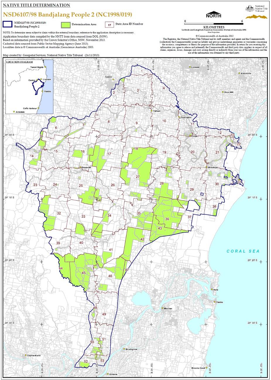
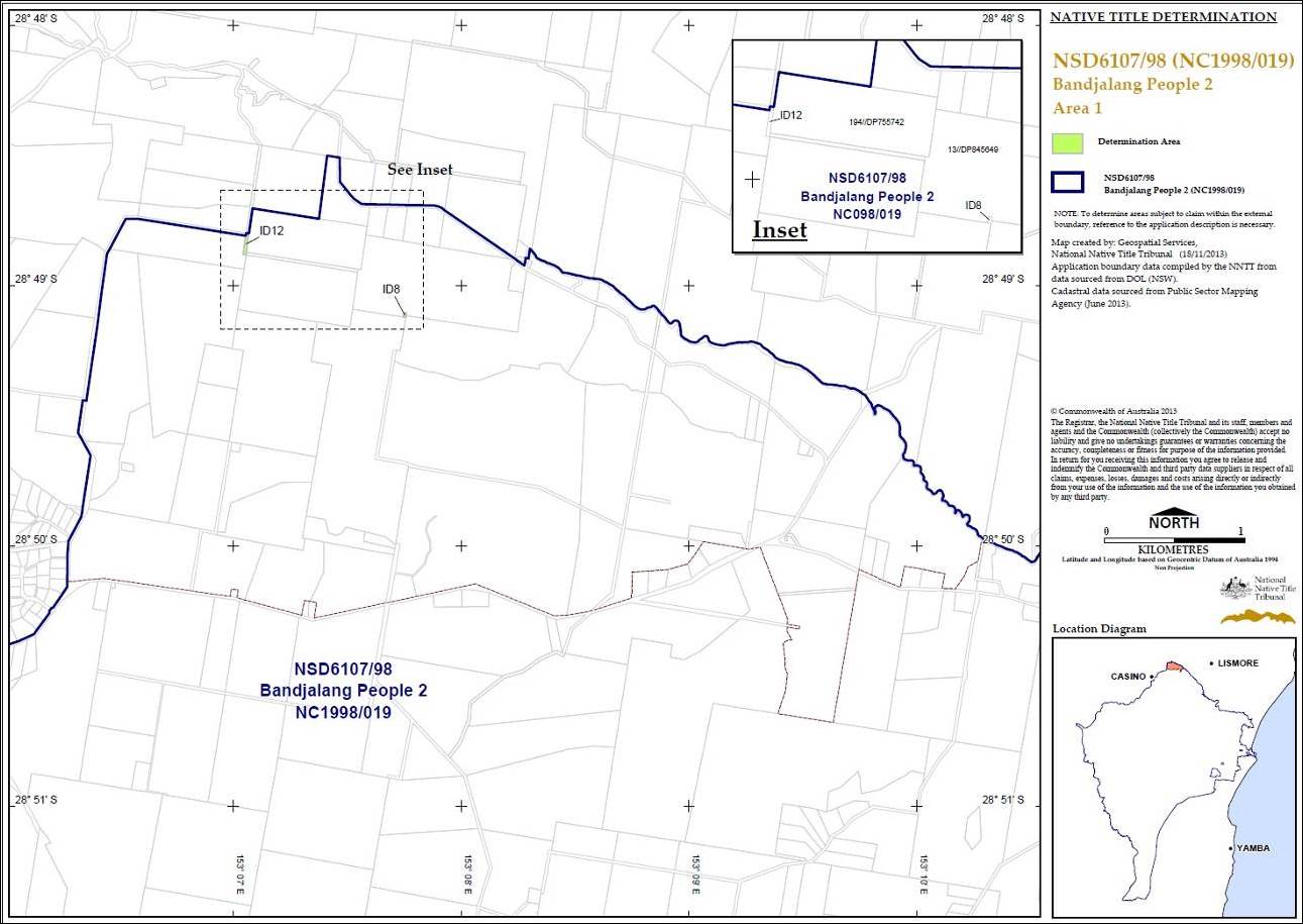
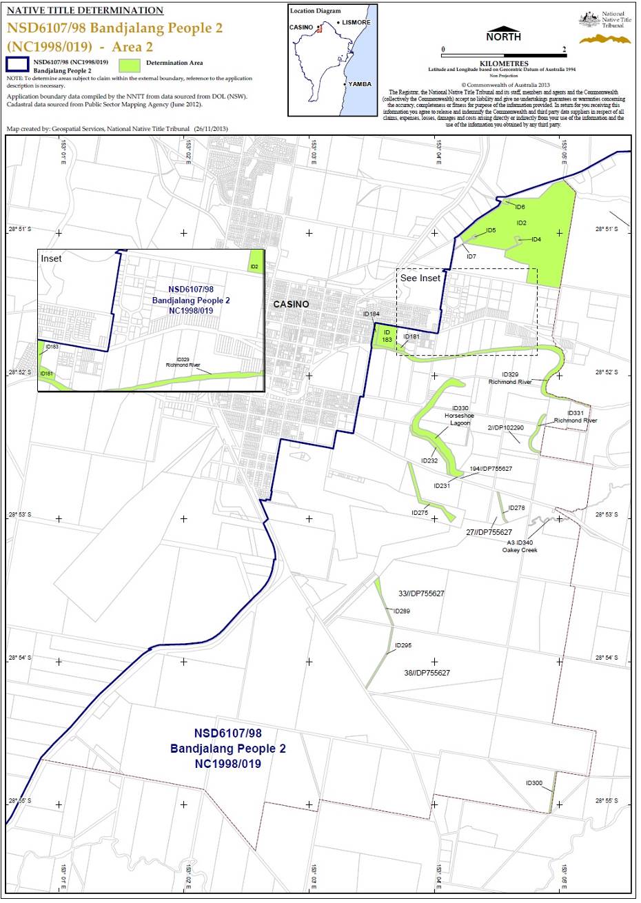
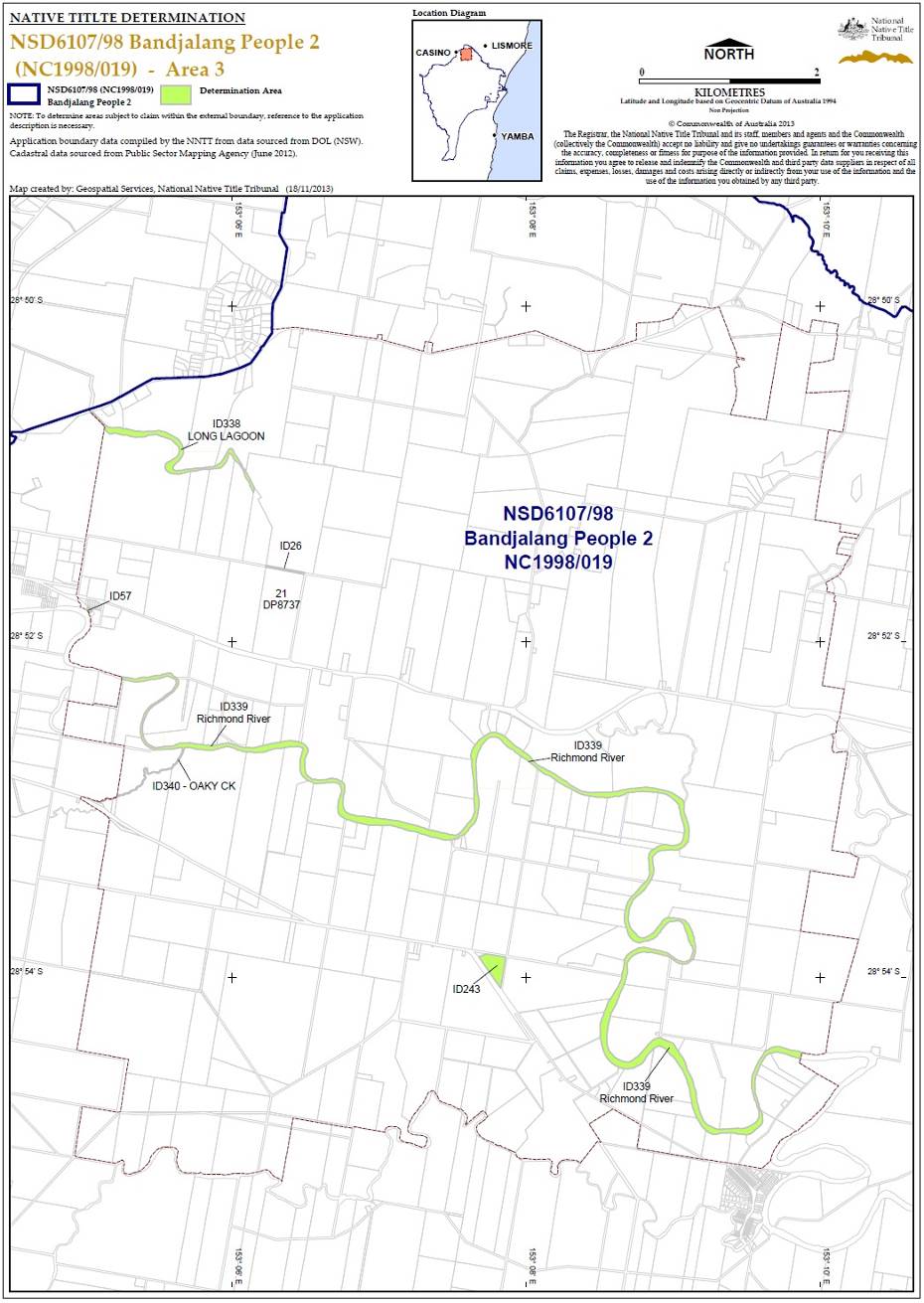
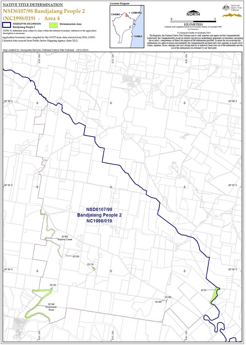
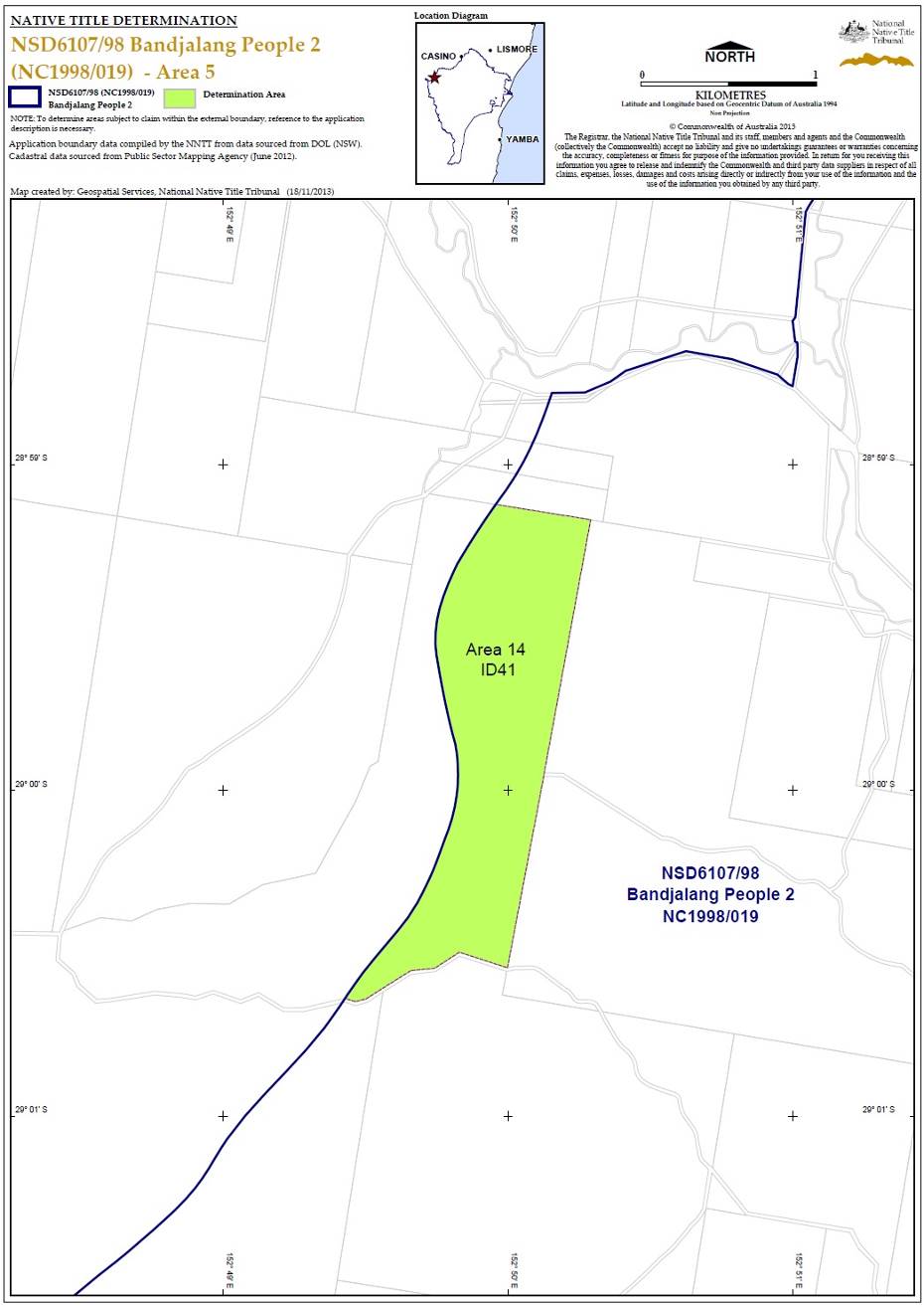
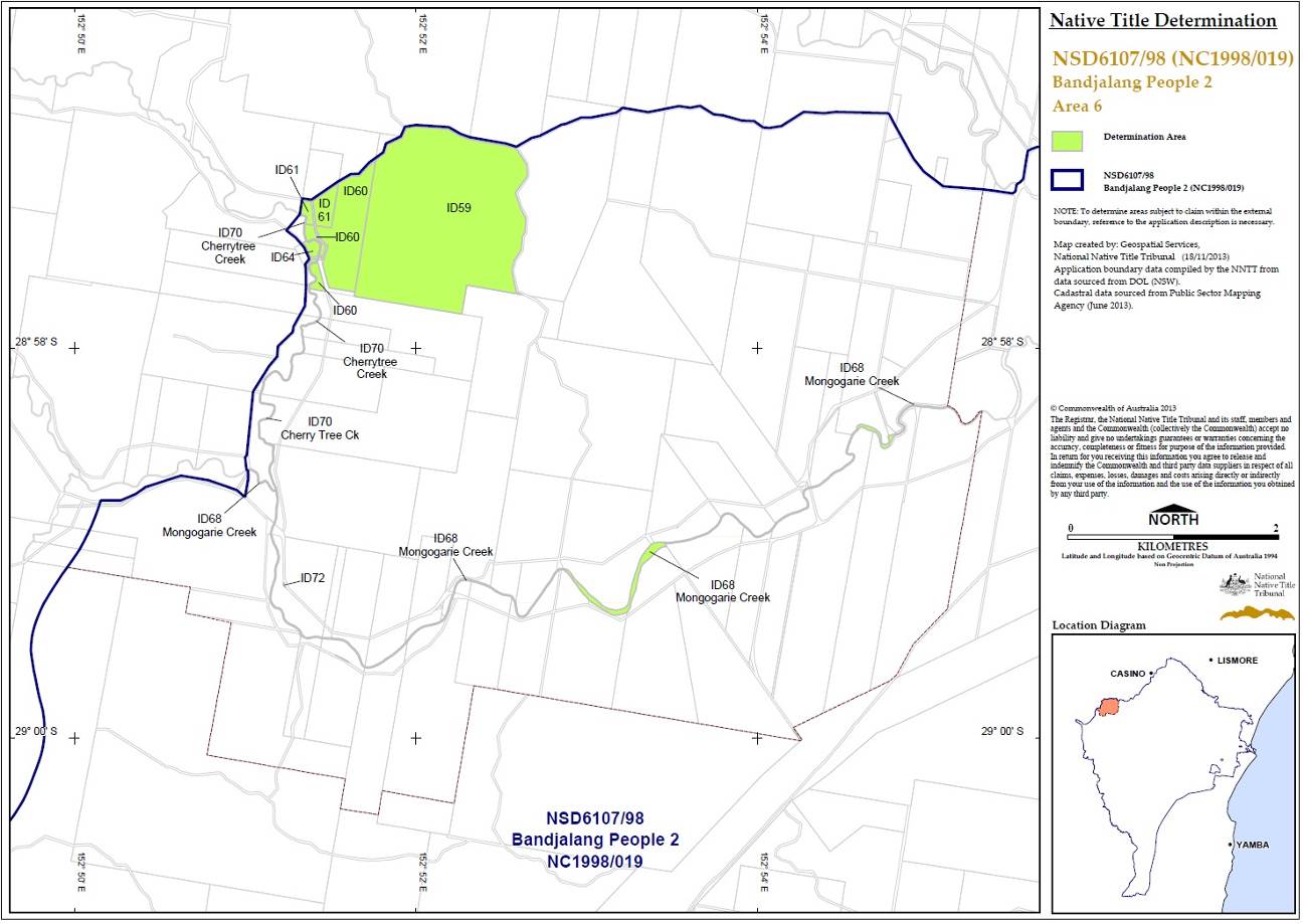
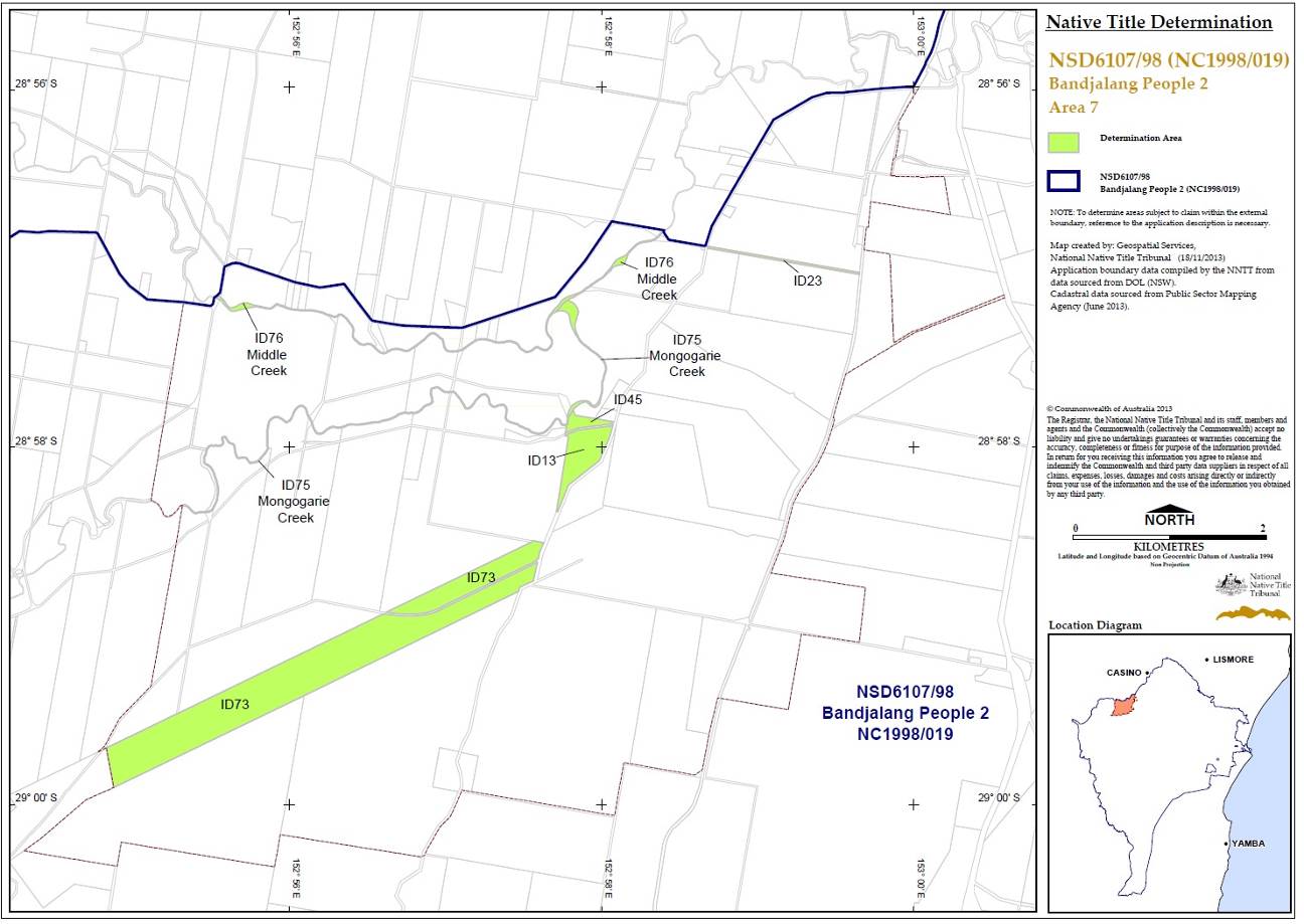
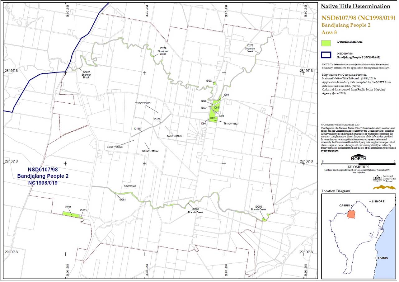
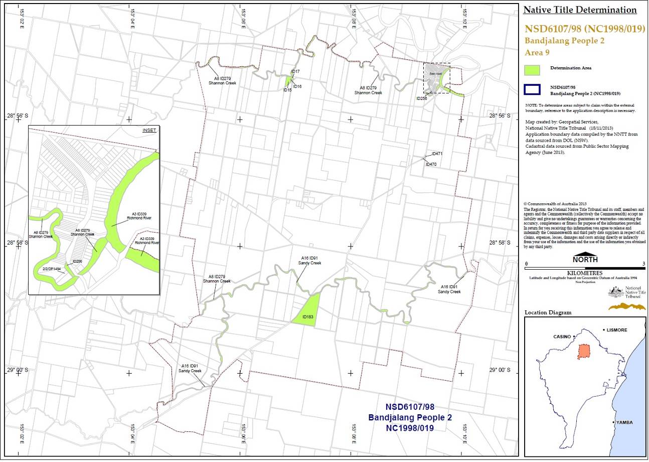
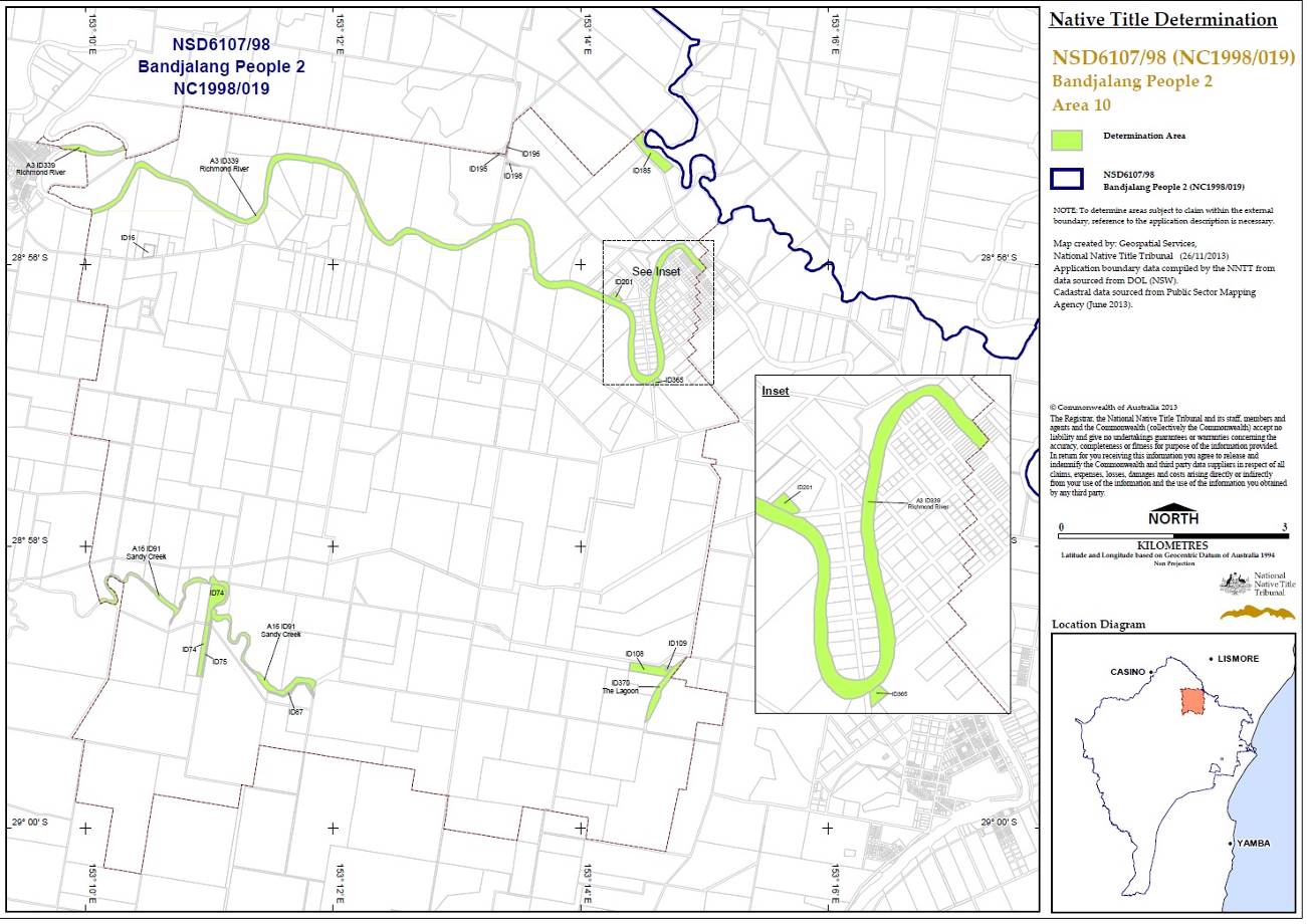
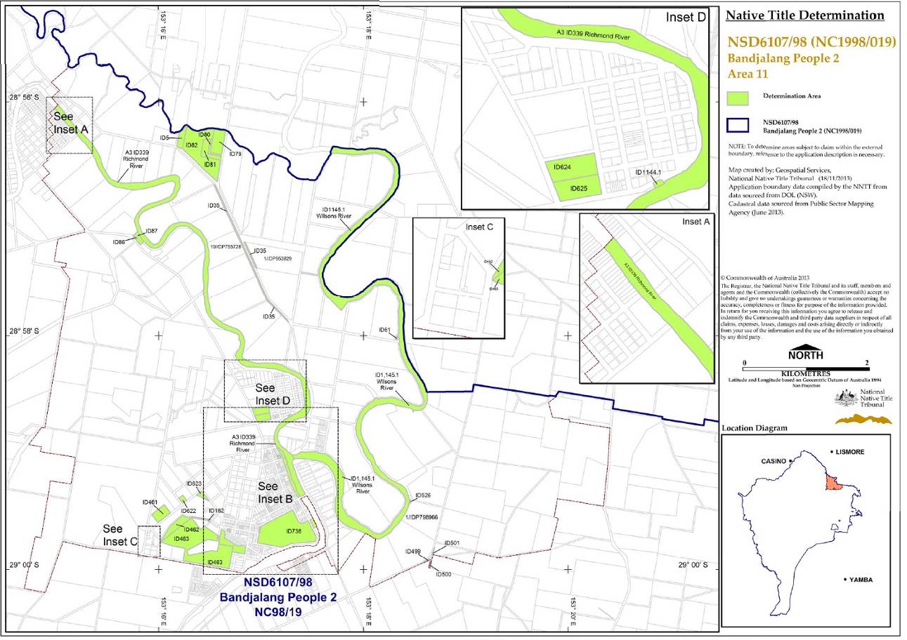
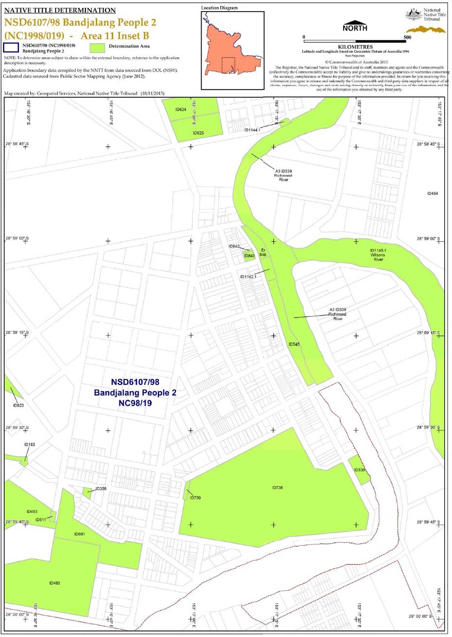
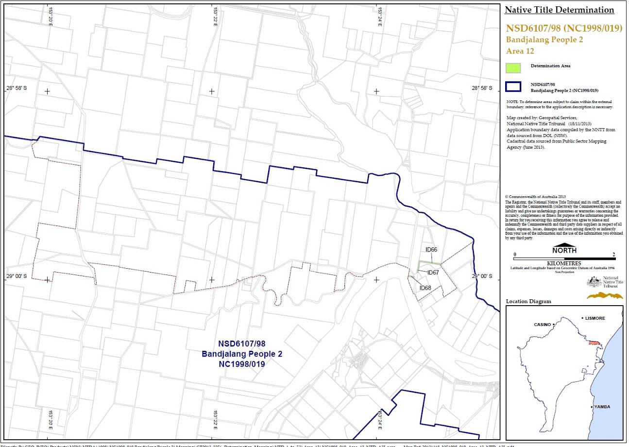
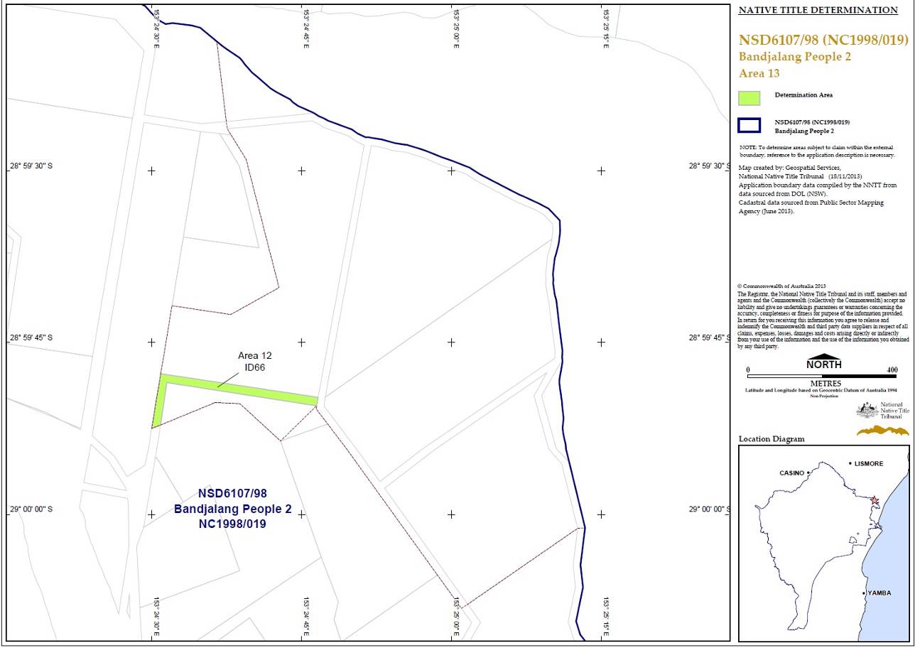
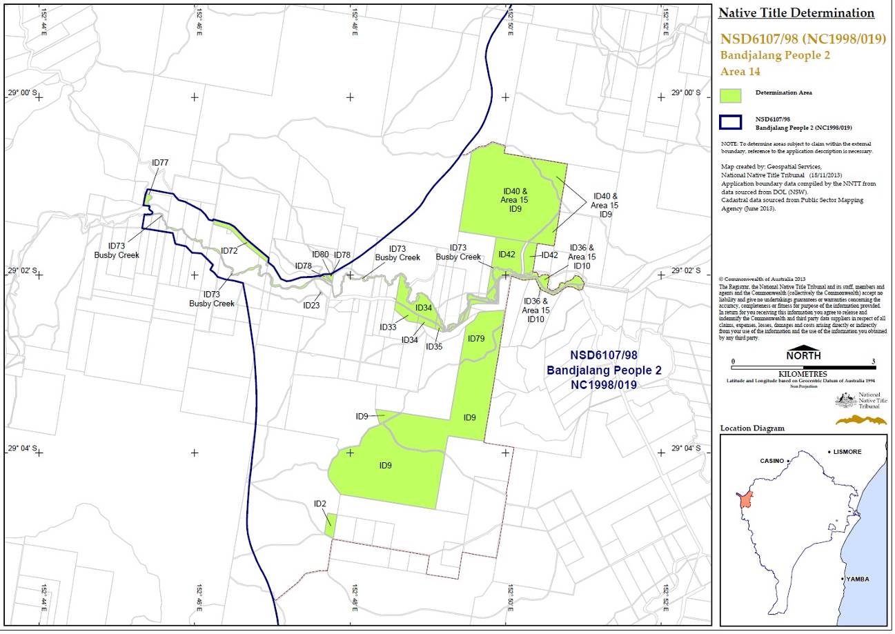
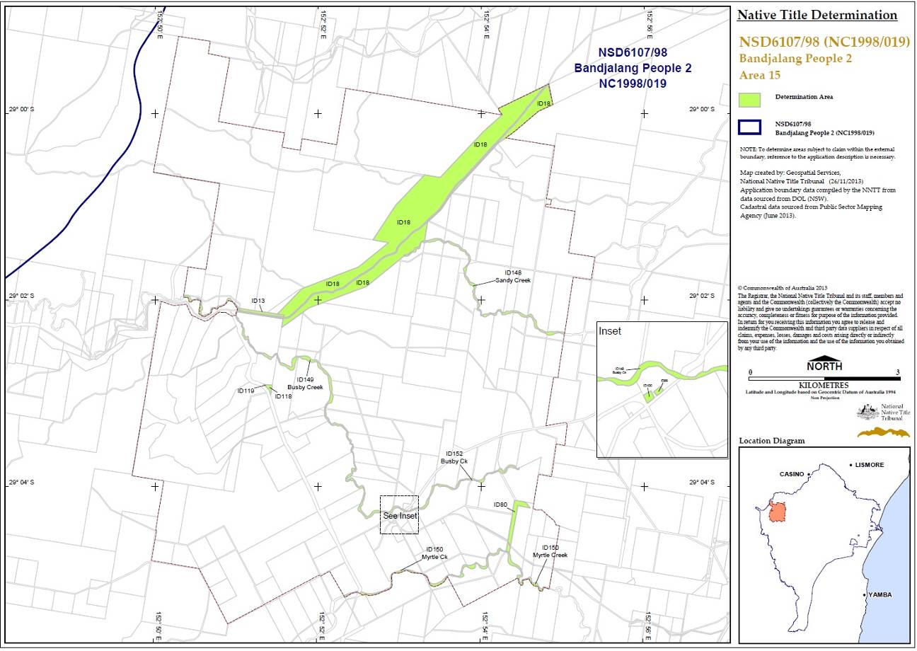
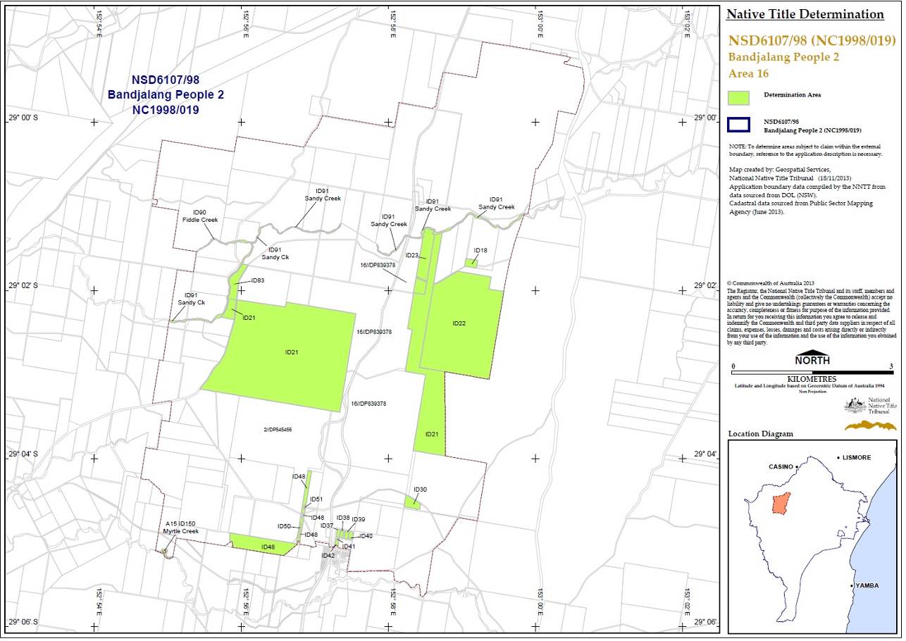
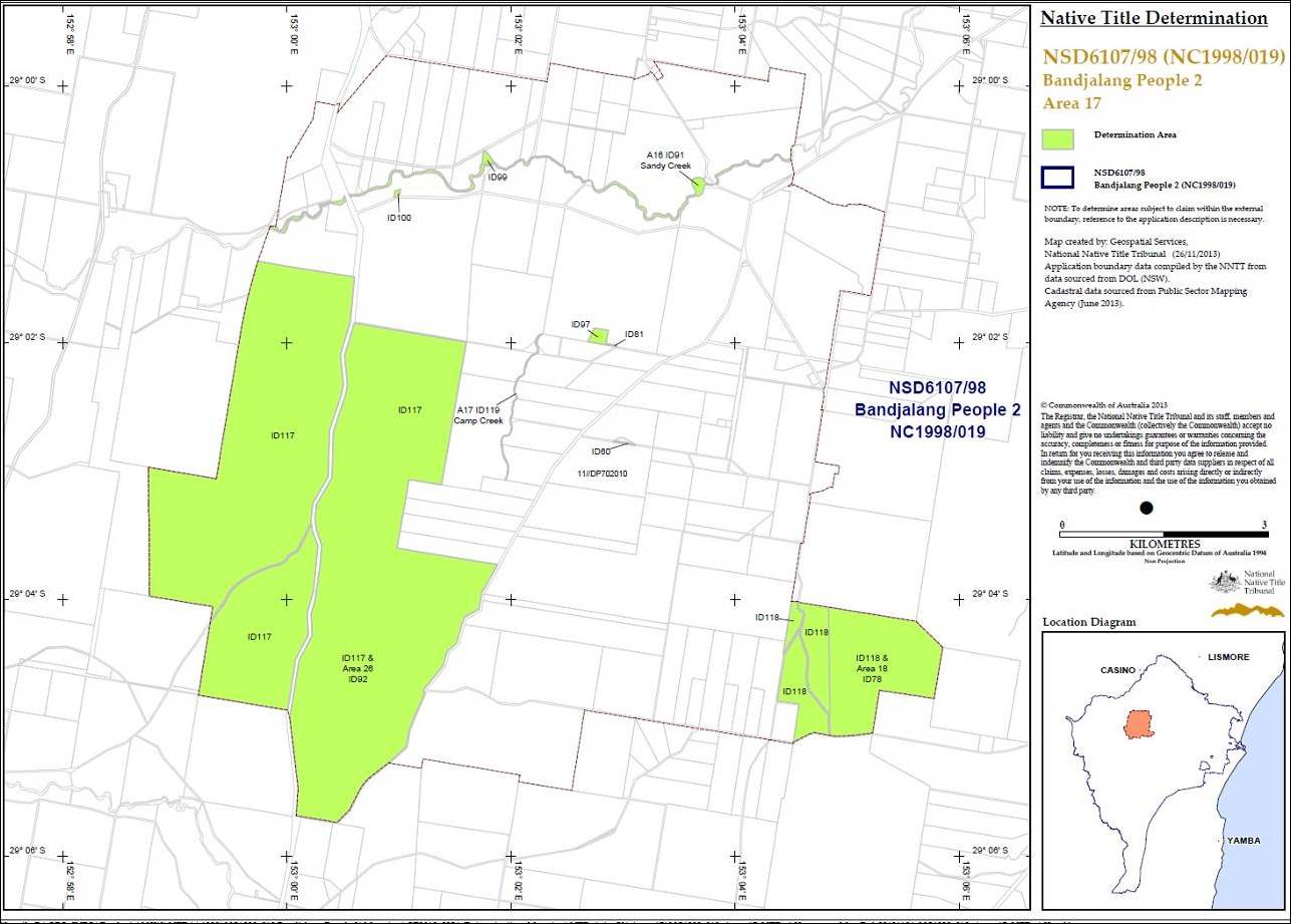
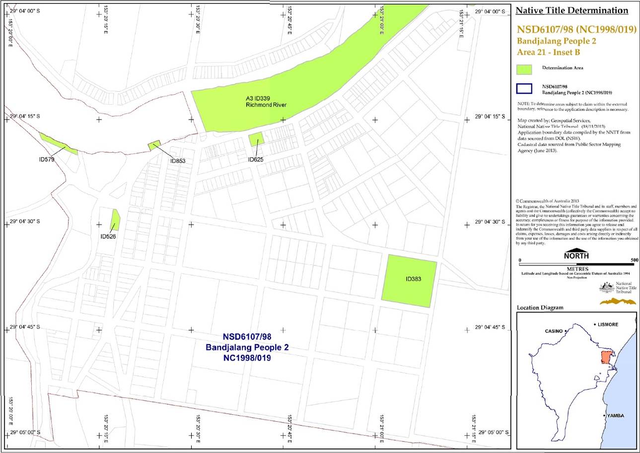
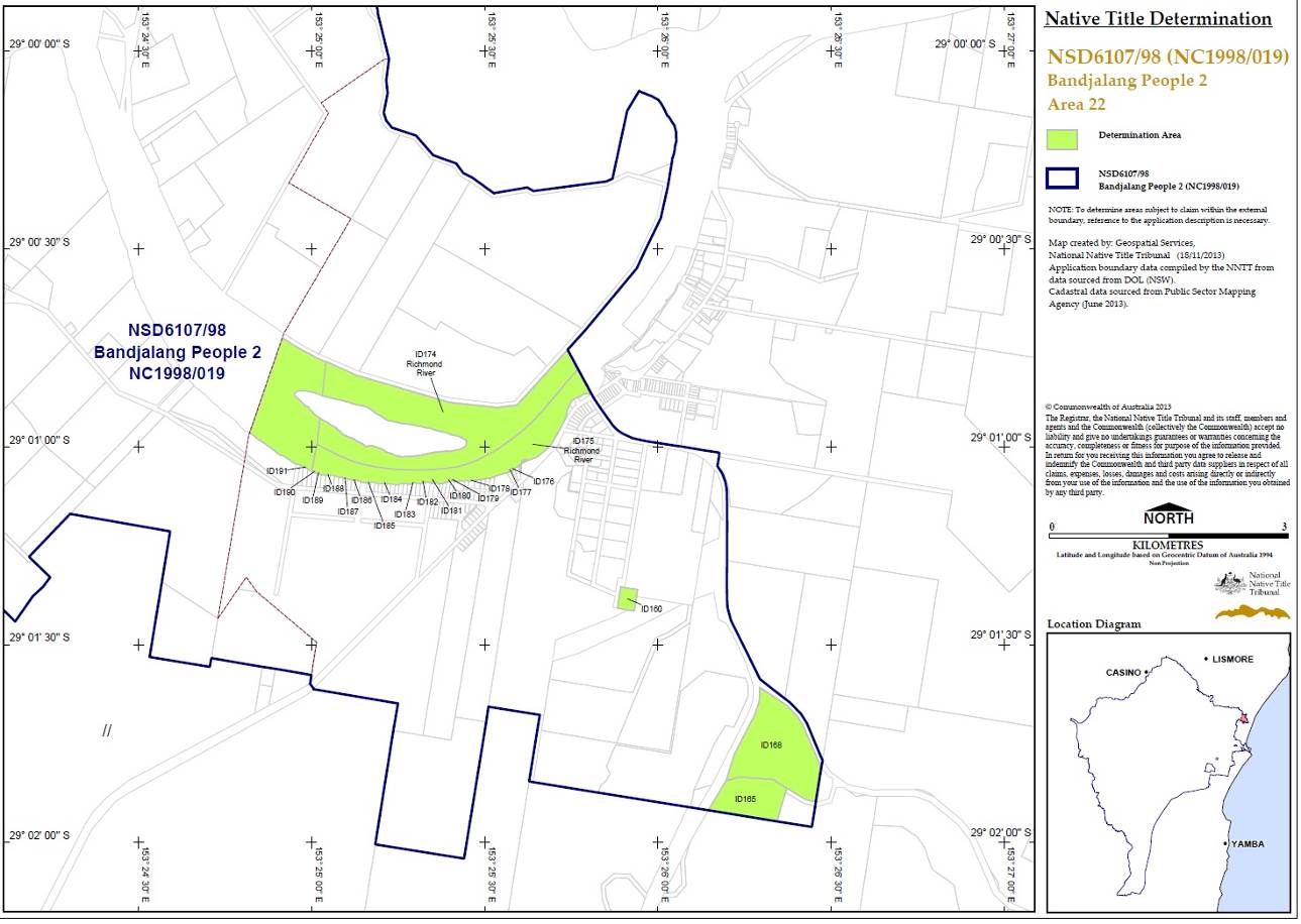
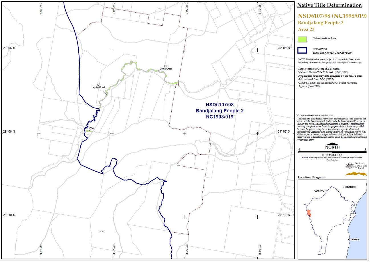
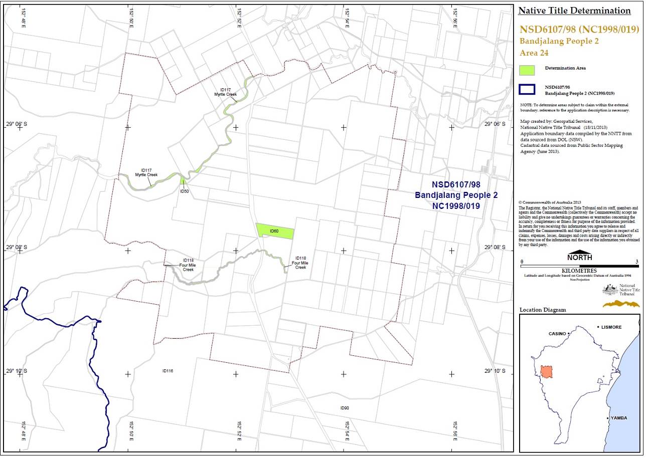


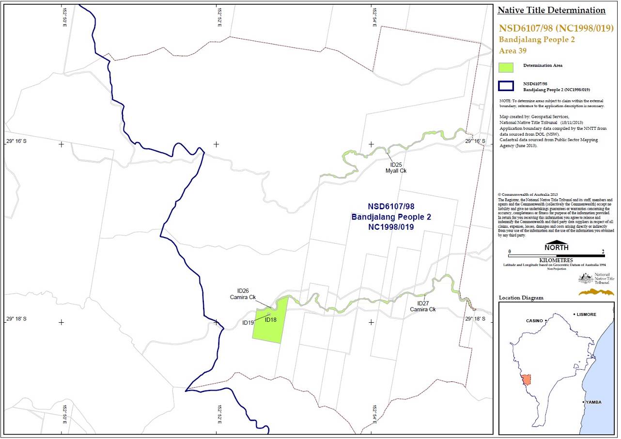
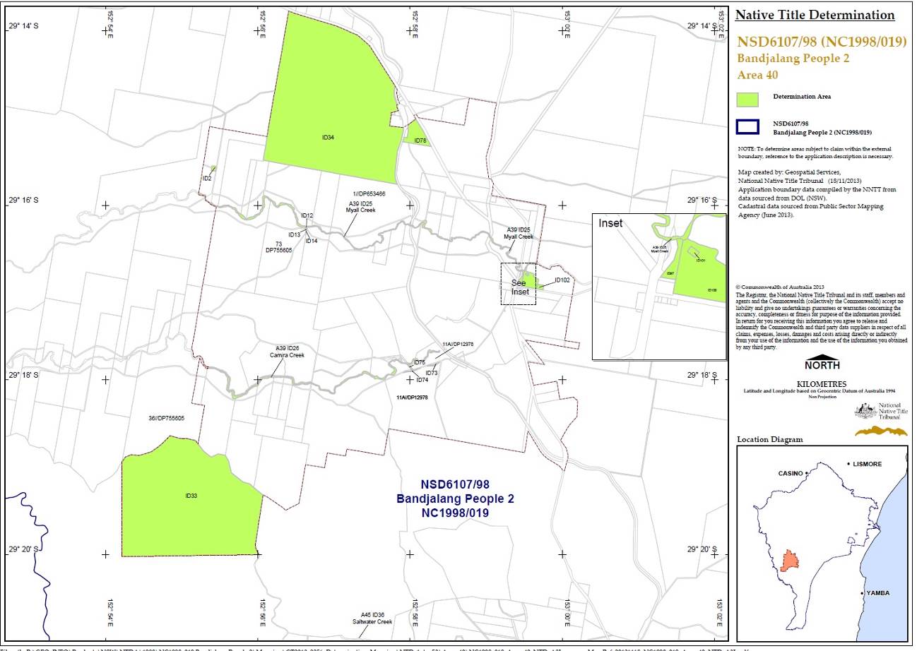

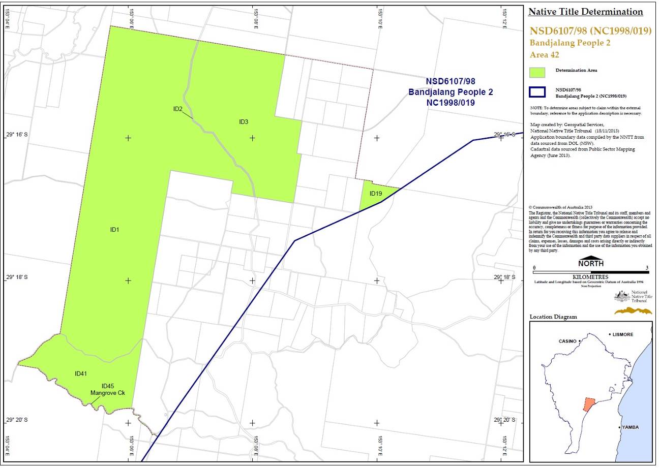
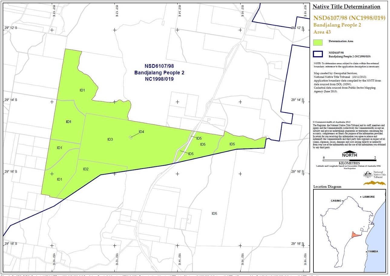
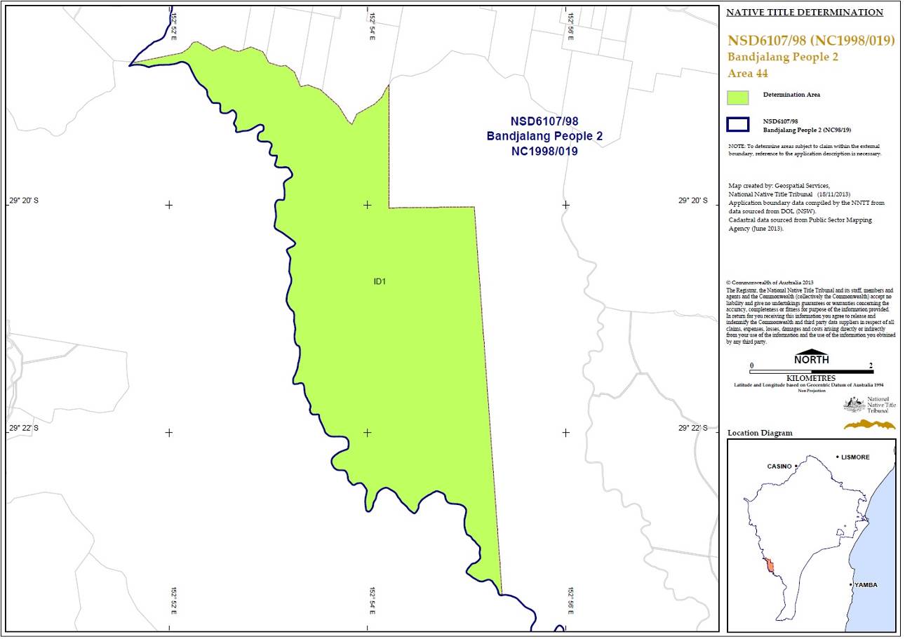

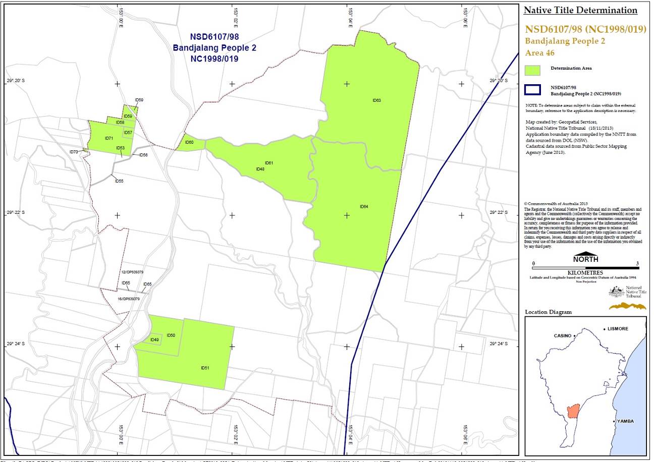
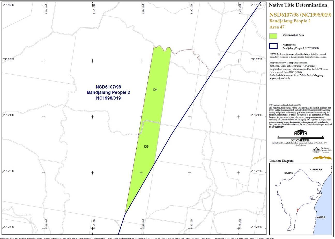
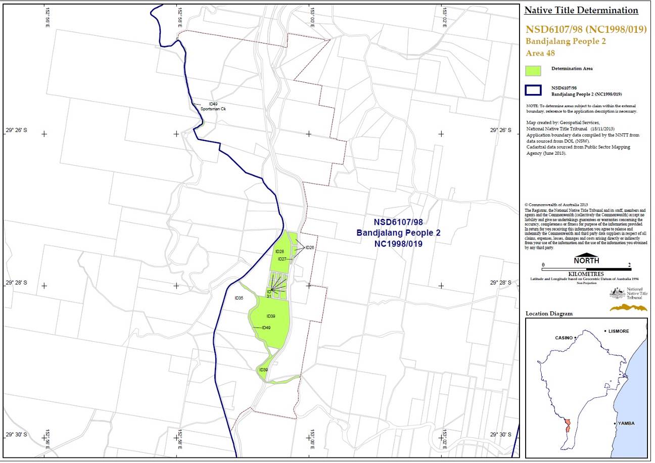
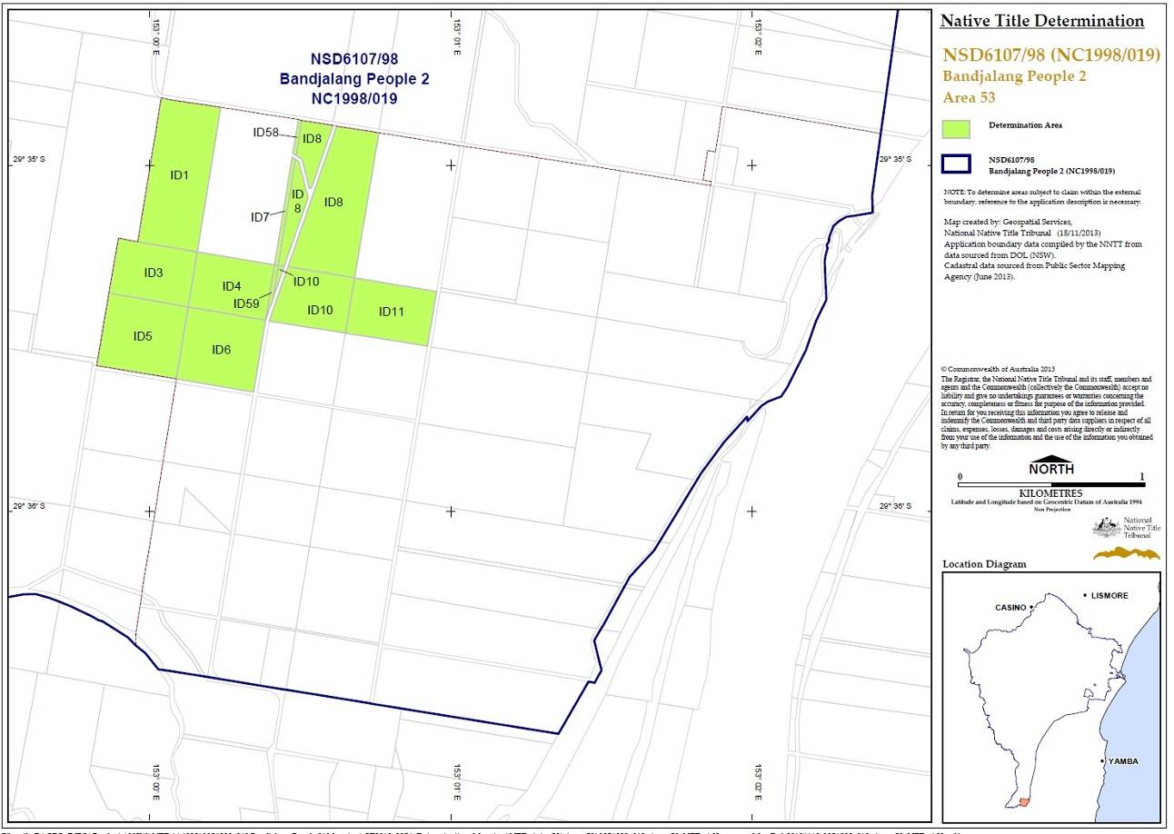
SCHEDULE TWO
OTHER RIGHTS AND INTERESTS
1. The rights and interests of Telstra Corporation Limited;
(a) as the owner or operator of telecommunications facilities within the Consent Determination Area;
(b) as the holder of a carrier licence under the Telecommunications Act 1997 (Cth);
(c) created pursuant to the Post and Telegraph Act 1901 (Cth), the Telecommunications Act 1975 (Cth), the Australian Telecommunications Corporations Act 1989 (Cth), the Telecommunications Act 1991 (Cth) and the Telecommunications Act 1997 (Cth), including rights
(i) to inspect land;
(ii) to install and operate telecommunications facilities; and
(iii) to alter, remove, replace, maintain, repair and ensure the proper functioning of its telecommunications facilities;
(d) for its employees, agents or contractors to access its telecommunications facilities in and in the vicinity of the Consent Determination Area in performance of their duties; and
(e) under any lease, licence, access agreement or easement relating to its telecommunications facilities in the Consent Determination Area.
1. The rights and interests of an energy services corporation within the meaning of the Energy Services Corporations Act 1995 (NSW) to exercise functions, powers or rights in accordance with the laws of the State of New South Wales or Commonwealth and as owner and operator of electricity transmission facilities and associated infrastructure situated on the Consent Determination Area including but not limited to the right to enter the Consent Determination Area in order to access, use, install, maintain, repair, replace, upgrade or otherwise deal with facilities and infrastructure.
2. The rights and interests of the Richmond Valley Council, Clarence Valley Council and Lismore City Council under their local government jurisdiction and as entities exercising statutory powers in respect of the land and waters in their local government area, including existing access to public work.
3. The rights and interests of the Crown in right of the State of New South Wales.
4. The rights and interests granted or recognised by the State of New South Wales pursuant to statute or otherwise in the exercise of its executive power and under any regulations made pursuant to such legislation.
5. The rights and interests granted by the Commonwealth pursuant to statute or otherwise in the exercise of its executive power and under any regulations made pursuant to such legislation.
6. The rights or interests held by reason of the force and operation of the laws of the State of New South Wales or of the Commonwealth.
7. The rights and interests of New South Wales Aboriginal Land Council, Bogal Local Aboriginal Land Council, Casino-Boolangle Local Aboriginal Land Council, Jali Local Aboriginal Land Council, Ngulingah Local Aboriginal Land Council and/or Yaegl Local Aboriginal Land Council arising under the Aboriginal Land Rights Act 1983 (NSW) in relation to land which is subject to an undetermined Aboriginal land claim made by one or more of them under s.36 of the Aboriginal Land Rights Act 1983 (NSW), including the right of that Council or those Councils to have that claim determined according to law and, subject only to a determination that the land is claimable Crown land as defined in s.36(1) of that Act, the right to the transfer of an estate in fee-simple, which estate will be subject to any native title rights and interests existing in relation to the land immediately before the transfer, as described in s.36(9) of that Act.
8. The rights and interests of members of the public arising under the common law including but not limited to:
(a) the public right to fish;
(b) the public right to navigate;
9. The right to access land by an employee or agent or instrumentality of the State, Commonwealth or other statutory authority as required in the performance of his or her statutory or common law duties.
10. So far as confirmed pursuant to sections 16 and 18 of the Native Title (New South Wales) Act 1994 as at the date of this determination, any existing public access to and enjoyment of:
(a) waterways;
(b) the beds and banks or foreshores of waterways;
(c) coastal waters;
(d) beaches;
(e) stock routes;
(f) areas that were public places at the end of 31 December 1993.
11. Any other:
(a) legal or equitable estate or interest in the land or waters of the Consent Determination Area; or
(b) right (including a right under an option and a right of redemption), charge, power or privilege over, or in connection with:
(i) the land or waters of the Consent Determination Area; or
(ii) an estate or interest in the land or waters of the Consent Determination Area.
SCHEDULE THREE
EXTERNAL BOUNDARIES
Description
All the land and waters with the area commencing at a point on the eastern boundary of Devils Pulpit State Forest, being a western boundary of Bundjalung National park at Latitude 29.254752° South; and extending generally south westerly and generally southerly passing through the following coordinate points.
Longitude (East) | Latitude (South) |
153.264756 | 29.255241 |
153.227477 | 29.262587 |
153.192489 | 29.267155 |
153.167808 | 29.281629 |
153.144657 | 29.290681 |
153.113298 | 29.329522 |
153.093752 | 29.355259 |
153.077801 | 29.379187 |
153.068028 | 29.404464 |
153.064957 | 29.436957 |
153.062885 | 29.462769 |
153.053646 | 29.494724 |
153.043861 | 29.531731 |
153.043774 | 29.532011 |
153.043662 | 29.532373 |
153.043649 | 29.532705 |
153.042673 | 29.557416 |
153.042173 | 29.571270 |
153.040003 | 29.584791 |
Then southerly to the southern boundary of Lawrence Road road reserve at Longitude 153.040025° East; then generally south westerly along that road reserve to the prolongation easterly of the northern boundary of Lot 56 DP751386; then westerly to the north eastern corner of that lot; then southerly and generally westerly along the boundaries of that lot, southern boundaries of Lot 55 DP665203, Lot 2 DP373160 and Lot 10 DP820691 and onwards to the south eastern corner of Lot 53 DP751386; again westerly along the southern boundaries of that lot, Lot 11 DP113364 and again Lot 53 DP751386 to the eastern bank of Bunyip Creek; then westerly to the western bank of that creek at Latitude 29.607567° South; then generally north westerly and generally westerly along the bank of that creek to Longitude 152.935264° East; then north westerly to the western boundary of The Summerland Way road reserve at Latitude 29.614039° South; then generally northerly and generally north westerly along that road reserve and the western boundary of Khan Road road reserve to the eastern boundary of Lot 69 DP725852 (Gurranang State Conservation Area); then northerly, westerly and generally north westerly along boundaries of that lot to its northern most corner; again north westerly to the western bank of Sportsmans Creek at Latitude 29.432304° South; then generally north easterly, generally north westerly and generally westerly along the bank of that creek to Longitude 152.863356° East; again generally westerly and generally northerly passing through the following coordinate points.
Longitude (East) | Latitude (South) |
152.862999 | 29.313041 |
152.862483 | 29.312881 |
152.862155 | 29.312824 |
152.861523 | 29.312760 |
152.861089 | 29.312768 |
152.860564 | 29.312826 |
152.860015 | 29.312978 |
152.861668 | 29.311168 |
152.861889 | 29.311039 |
152.862348 | 29.310682 |
152.862725 | 29.310435 |
152.863328 | 29.309955 |
152.863569 | 29.309875 |
152.864158 | 29.309429 |
152.864412 | 29.309379 |
152.864740 | 29.309249 |
152.865093 | 29.309155 |
152.865396 | 29.308983 |
152.865723 | 29.308760 |
152.865813 | 29.308660 |
152.866083 | 29.308157 |
152.866256 | 29.307745 |
152.866500 | 29.307267 |
152.866876 | 29.306828 |
152.866909 | 29.306600 |
152.866864 | 29.305951 |
152.866915 | 29.305531 |
152.867019 | 29.305202 |
152.867182 | 29.304696 |
152.867256 | 29.303150 |
152.867304 | 29.302835 |
152.867386 | 29.302519 |
152.867524 | 29.302182 |
152.867884 | 29.301557 |
152.868285 | 29.301206 |
152.868080 | 29.300955 |
152.867957 | 29.300847 |
152.867596 | 29.300626 |
152.867169 | 29.300196 |
152.866889 | 29.299988 |
152.866291 | 29.299702 |
152.865724 | 29.299510 |
152.865191 | 29.299360 |
152.864871 | 29.299203 |
152.864346 | 29.298902 |
152.864044 | 29.298788 |
152.864033 | 29.297992 |
152.863933 | 29.297246 |
152.863941 | 29.296866 |
152.863799 | 29.295296 |
152.863764 | 29.294364 |
152.863665 | 29.293876 |
152.863501 | 29.293360 |
152.863295 | 29.292995 |
152.863171 | 29.292730 |
152.863122 | 29.292515 |
152.863073 | 29.291521 |
152.862743 | 29.291181 |
152.861183 | 29.290086 |
152.860961 | 29.289915 |
152.860600 | 29.289578 |
152.860255 | 29.289206 |
152.859992 | 29.288812 |
152.859802 | 29.288325 |
152.859663 | 29.288117 |
152.859433 | 29.287895 |
152.858941 | 29.287523 |
152.858760 | 29.287343 |
152.858390 | 29.286684 |
152.858086 | 29.285889 |
152.857872 | 29.285581 |
152.857560 | 29.285223 |
152.857034 | 29.284743 |
152.856690 | 29.284571 |
152.856575 | 29.284543 |
152.856526 | 29.284485 |
152.856493 | 29.284485 |
152.856181 | 29.284314 |
152.855238 | 29.284064 |
152.854779 | 29.283979 |
152.854590 | 29.283915 |
152.855472 | 29.281518 |
152.855521 | 29.281518 |
152.855693 | 29.281417 |
152.855914 | 29.281223 |
152.856094 | 29.280994 |
152.856486 | 29.280369 |
152.856601 | 29.280097 |
152.857206 | 29.278977 |
152.857369 | 29.278755 |
152.857729 | 29.278410 |
152.857844 | 29.278259 |
152.857885 | 29.278108 |
152.857964 | 29.277390 |
152.858203 | 29.277312 |
152.858446 | 29.277197 |
152.858826 | 29.276967 |
152.859006 | 29.276759 |
152.859300 | 29.276292 |
152.859365 | 29.276120 |
152.859676 | 29.275632 |
152.859938 | 29.275059 |
152.860461 | 29.274577 |
152.860739 | 29.274261 |
152.861296 | 29.273493 |
152.861385 | 29.273279 |
152.861680 | 29.272990 |
152.862229 | 29.272579 |
152.862572 | 29.272164 |
152.862670 | 29.271999 |
152.862858 | 29.271504 |
152.863364 | 29.270428 |
152.863756 | 29.269223 |
152.863870 | 29.268749 |
152.863992 | 29.268426 |
152.864137 | 29.268233 |
152.863844 | 29.268025 |
152.863721 | 29.267846 |
152.863393 | 29.267488 |
152.863168 | 29.267336 |
152.863089 | 29.267338 |
152.863066 | 29.267311 |
152.862827 | 29.267367 |
152.862679 | 29.267546 |
152.862320 | 29.268135 |
152.862140 | 29.268343 |
152.862017 | 29.268429 |
152.861730 | 29.268587 |
152.861411 | 29.268595 |
152.861222 | 29.268545 |
152.861050 | 29.268445 |
152.860697 | 29.268137 |
152.859736 | 29.267150 |
152.859113 | 29.266655 |
152.858874 | 29.266526 |
152.858604 | 29.266462 |
152.858473 | 29.266462 |
152.858249 | 29.266516 |
152.857973 | 29.266685 |
152.857736 | 29.266980 |
152.857613 | 29.267188 |
152.857442 | 29.267626 |
152.857361 | 29.267998 |
152.857239 | 29.268880 |
152.857173 | 29.268938 |
152.857009 | 29.268953 |
152.856764 | 29.268896 |
152.855869 | 29.268502 |
152.855148 | 29.268274 |
152.854780 | 29.268194 |
152.852540 | 29.267575 |
152.852031 | 29.267493 |
152.851671 | 29.267511 |
152.851294 | 29.267477 |
152.851089 | 29.267427 |
152.850851 | 29.267291 |
152.850514 | 29.266933 |
152.850268 | 29.266625 |
152.850252 | 29.266568 |
152.850071 | 29.266410 |
152.849850 | 29.266331 |
152.849645 | 29.266310 |
152.849448 | 29.266325 |
152.849342 | 29.266418 |
152.849208 | 29.266654 |
152.848686 | 29.266312 |
152.848439 | 29.266118 |
152.848234 | 29.265889 |
152.848037 | 29.265596 |
152.847856 | 29.265180 |
152.847725 | 29.264986 |
152.847610 | 29.264865 |
152.846909 | 29.264310 |
152.846789 | 29.264149 |
152.846739 | 29.263961 |
152.846773 | 29.263603 |
152.846921 | 29.262848 |
152.846934 | 29.262729 |
152.846819 | 29.262485 |
152.846639 | 29.262213 |
152.846532 | 29.261861 |
152.846523 | 29.261559 |
152.846531 | 29.261302 |
152.846465 | 29.260987 |
152.846464 | 29.260671 |
152.846548 | 29.260301 |
152.846584 | 29.260211 |
152.846834 | 29.259577 |
152.846626 | 29.259308 |
152.846413 | 29.259158 |
152.846142 | 29.259015 |
152.846060 | 29.259001 |
152.845759 | 29.258854 |
152.845256 | 29.258615 |
152.844748 | 29.258443 |
152.844326 | 29.258250 |
152.844356 | 29.257961 |
152.844197 | 29.257002 |
152.844230 | 29.255845 |
152.844187 | 29.255604 |
152.843940 | 29.255275 |
152.843883 | 29.255024 |
152.843865 | 29.254378 |
152.843782 | 29.253716 |
152.843795 | 29.253382 |
152.843782 | 29.253231 |
152.843757 | 29.253152 |
152.843461 | 29.252708 |
152.843354 | 29.252400 |
152.843329 | 29.252199 |
152.843370 | 29.251927 |
152.843476 | 29.251647 |
152.843787 | 29.251116 |
152.842180 | 29.250300 |
152.840687 | 29.249542 |
152.840548 | 29.248403 |
152.840554 | 29.247768 |
152.840058 | 29.246517 |
152.839996 | 29.246322 |
152.839995 | 29.246136 |
152.840044 | 29.245935 |
152.840207 | 29.245462 |
152.840482 | 29.244857 |
152.840630 | 29.244100 |
152.840637 | 29.243663 |
152.840621 | 29.243146 |
152.840406 | 29.242797 |
152.840062 | 29.242411 |
152.839628 | 29.241967 |
152.839452 | 29.241847 |
152.839284 | 29.241746 |
152.838858 | 29.241560 |
152.838612 | 29.241374 |
152.837875 | 29.240989 |
152.837433 | 29.240717 |
152.837023 | 29.240374 |
152.836745 | 29.240253 |
Then westerly to the eastern boundary of an unnamed road reserve passing through Lot 2 DP755617 at Latitude 29.240187° South; then generally northerly along that road reserve to the southern boundary of Lot 31 DP755608; then westerly along the boundary of that lot to Longitude 152.847533° East; then generally northerly and generally north westerly and again generally northerly passing through the following coordinate points.
Longitude (East) | Latitude (South) |
152.847541 | 29.215949 |
152.847524 | 29.215770 |
152.847393 | 29.215627 |
152.847188 | 29.215549 |
152.846845 | 29.215521 |
152.846599 | 29.215464 |
152.846378 | 29.215371 |
152.846173 | 29.215178 |
152.846058 | 29.214978 |
152.845771 | 29.214627 |
152.845714 | 29.214477 |
152.845707 | 29.214303 |
152.845542 | 29.214212 |
152.845329 | 29.213961 |
152.845083 | 29.213740 |
152.844780 | 29.213633 |
152.844518 | 29.213612 |
152.844216 | 29.213627 |
152.843913 | 29.213591 |
152.843700 | 29.213513 |
152.843348 | 29.213227 |
152.843299 | 29.213213 |
152.843282 | 29.213184 |
152.842881 | 29.213078 |
152.842669 | 29.213056 |
152.842546 | 29.213057 |
152.842225 | 29.213126 |
152.841883 | 29.212879 |
152.841760 | 29.212728 |
152.841670 | 29.212492 |
152.841655 | 29.212240 |
152.841759 | 29.211869 |
152.842150 | 29.211367 |
152.842240 | 29.211087 |
152.842264 | 29.210829 |
152.842214 | 29.210507 |
152.842083 | 29.210300 |
152.841984 | 29.210192 |
152.841624 | 29.209921 |
152.841559 | 29.209835 |
152.841559 | 29.209694 |
152.841607 | 29.209405 |
152.841836 | 29.209125 |
152.841925 | 29.208925 |
152.841966 | 29.208695 |
152.841858 | 29.208165 |
152.841866 | 29.207915 |
152.842037 | 29.207635 |
152.842152 | 29.207527 |
152.842470 | 29.207369 |
152.842691 | 29.207318 |
152.843280 | 29.207246 |
152.843353 | 29.207224 |
152.843419 | 29.207167 |
152.843451 | 29.207009 |
152.843426 | 29.206845 |
152.843352 | 29.206665 |
152.843262 | 29.206558 |
152.843074 | 29.206451 |
152.842747 | 29.206394 |
152.842566 | 29.206294 |
152.841838 | 29.206116 |
152.841716 | 29.206081 |
152.841159 | 29.205795 |
152.840873 | 29.205708 |
152.840782 | 29.205567 |
152.840618 | 29.205108 |
152.840462 | 29.204944 |
152.840118 | 29.204687 |
152.839766 | 29.204258 |
152.839429 | 29.203974 |
152.839103 | 29.203886 |
152.838563 | 29.203830 |
152.837998 | 29.203709 |
152.837793 | 29.203609 |
152.837449 | 29.203380 |
152.836647 | 29.202923 |
152.835149 | 29.202224 |
152.834495 | 29.202081 |
152.834344 | 29.202002 |
152.834069 | 29.201882 |
152.833734 | 29.201775 |
152.833374 | 29.201704 |
152.832662 | 29.201726 |
152.832098 | 29.201706 |
152.831820 | 29.201678 |
152.831468 | 29.201571 |
152.831451 | 29.201585 |
152.831116 | 29.201328 |
152.830903 | 29.201278 |
152.830214 | 29.201319 |
152.829905 | 29.201437 |
152.829137 | 29.201596 |
152.829006 | 29.201596 |
152.828821 | 29.201547 |
152.828368 | 29.201318 |
152.828196 | 29.201204 |
152.827957 | 29.200948 |
152.827819 | 29.200775 |
152.827638 | 29.200230 |
152.827523 | 29.200080 |
152.827220 | 29.199816 |
152.826974 | 29.199644 |
152.826672 | 29.199487 |
152.826639 | 29.199444 |
152.826524 | 29.199387 |
152.826189 | 29.199294 |
152.825780 | 29.199223 |
152.825664 | 29.199178 |
152.825379 | 29.199002 |
152.824969 | 29.198537 |
152.824715 | 29.198315 |
152.824404 | 29.198145 |
152.824191 | 29.198066 |
152.823897 | 29.198008 |
152.823463 | 29.197988 |
152.823210 | 29.197995 |
152.822686 | 29.198126 |
152.822498 | 29.198147 |
152.823050 | 29.195424 |
152.823491 | 29.194900 |
152.823630 | 29.194656 |
152.823743 | 29.194255 |
152.823776 | 29.194011 |
152.823775 | 29.193711 |
152.823726 | 29.193281 |
152.823511 | 29.192350 |
152.823339 | 29.191813 |
Then north westerly to a point on the western bank of Fullers Arm at Latitude 29.191710° South; then generally northerly along the bank of that watercourse to the southern bank of Cabbage Tree Creek; then generally westerly along the bank of that creek to Longitude 152.814088° East; then generally westerly and generally northerly passing through the following coordinate points.
Longitude (East) | Latitude (South) |
152.813861 | 29.153762 |
152.813508 | 29.153669 |
152.813019 | 29.153627 |
152.812813 | 29.153592 |
152.812364 | 29.153399 |
152.812102 | 29.153342 |
152.811824 | 29.153328 |
152.811505 | 29.153264 |
152.811072 | 29.153050 |
152.810369 | 29.152635 |
152.810106 | 29.152449 |
152.809386 | 29.152028 |
152.809043 | 29.151849 |
152.808790 | 29.151735 |
152.808274 | 29.151628 |
152.807817 | 29.151615 |
152.807547 | 29.151680 |
152.806959 | 29.151953 |
152.806771 | 29.152003 |
152.806559 | 29.152003 |
152.806248 | 29.151918 |
152.806083 | 29.151897 |
152.805920 | 29.151918 |
152.805618 | 29.152026 |
152.801855 | 29.150298 |
152.801446 | 29.149740 |
152.801331 | 29.149425 |
152.800905 | 29.148738 |
152.800667 | 29.148172 |
152.800585 | 29.147886 |
152.800577 | 29.147521 |
152.800739 | 29.147126 |
152.800984 | 29.146868 |
152.801147 | 29.146596 |
152.801515 | 29.146251 |
152.801799 | 29.145921 |
152.802078 | 29.145498 |
152.802110 | 29.145341 |
152.802077 | 29.145033 |
152.802125 | 29.144682 |
152.802272 | 29.144488 |
152.802395 | 29.144244 |
152.802395 | 29.144087 |
152.802354 | 29.143979 |
152.802213 | 29.143865 |
152.801977 | 29.143722 |
152.801642 | 29.143622 |
152.801544 | 29.143529 |
Then northerly to a point on the southern bank of Four Mile Creek at Longitude 152.801515° East; then generally westerly and generally south westerly along the bank of that creek to the southern boundary of an unnamed road reserve passing through Lot 77 DP755635 at Latitude 29.149361° South; then generally north westerly along that road reserve and onwards to the western boundary of Seery Road road reserve; then generally north easterly along that road reserve to the southern boundary of Wyan Creek Road road reserve; then generally north westerly and generally northerly along that road reserve to the northern bank of Myrtle Creek; then generally north easterly along the bank of that creek to Latitude 29.123443° South; then generally north westerly and generally northerly passing through the following coordinate points.
Latitude (South) | |
152.791725 | 29.123079 |
152.790751 | 29.122685 |
152.790030 | 29.122263 |
152.789457 | 29.121833 |
152.789212 | 29.121704 |
152.788819 | 29.121432 |
152.788057 | 29.120974 |
152.787582 | 29.120522 |
152.787402 | 29.120308 |
152.786862 | 29.119591 |
152.786338 | 29.118760 |
152.785904 | 29.118380 |
152.785609 | 29.118166 |
152.784938 | 29.117734 |
152.784992 | 29.116953 |
152.785081 | 29.115383 |
152.785151 | 29.113813 |
152.785201 | 29.112243 |
152.785233 | 29.110911 |
152.785255 | 29.109578 |
152.785261 | 29.108245 |
152.785245 | 29.106913 |
152.785201 | 29.105582 |
152.785118 | 29.104097 |
152.785005 | 29.102613 |
152.784862 | 29.101130 |
152.784689 | 29.099651 |
152.784485 | 29.098178 |
152.784461 | 29.098034 |
152.784137 | 29.096550 |
152.783767 | 29.095068 |
152.783335 | 29.093602 |
152.782831 | 29.092168 |
152.782239 | 29.090781 |
152.781828 | 29.089996 |
152.781372 | 29.089233 |
152.780898 | 29.088477 |
152.780436 | 29.087715 |
152.780017 | 29.086933 |
152.779549 | 29.085958 |
152.779100 | 29.084967 |
152.778691 | 29.083959 |
152.778348 | 29.082936 |
152.778092 | 29.081901 |
152.777935 | 29.080715 |
152.777898 | 29.079504 |
152.777939 | 29.078279 |
152.778017 | 29.077051 |
152.778092 | 29.075832 |
152.778188 | 29.074439 |
152.778328 | 29.073047 |
152.778493 | 29.071656 |
152.778667 | 29.070266 |
152.778832 | 29.068876 |
152.779052 | 29.067100 |
152.779297 | 29.065326 |
152.779535 | 29.063551 |
152.779736 | 29.061775 |
152.779869 | 29.059995 |
152.779935 | 29.057926 |
152.779933 | 29.055850 |
152.779869 | 29.053773 |
152.779747 | 29.051699 |
152.779573 | 29.049635 |
152.779434 | 29.048358 |
152.779270 | 29.047083 |
152.779086 | 29.045810 |
152.778889 | 29.044539 |
152.778684 | 29.043270 |
152.778395 | 29.041569 |
152.778086 | 29.039871 |
152.777755 | 29.038176 |
152.777403 | 29.036486 |
Then northerly to the north eastern corner of the south western severance of Lot 65 DP755636, a point on the southern boundary of Busbys School Road road reserve; then generally north westerly and generally westerly along that road reserve to the north western corner of the southern severance of Lot 13 DP755636; then northerly to and along the western boundary of the northern severance of that lot and onwards to the northern bank of Busbys Creek; then generally easterly and generally north westerly along the bank of that creek and the western bank of Lollback Creek to the northern boundary of Lot 36 DP755604; then westerly along the boundary of that lot to the western boundary of Wyan Alice Road road reserve; then generally northerly, easterly and generally south easterly along that road reserve to Longitude 152.792097° East; then generally easterly and generally north easterly passing through the following coordinate points.
Longitude (East) | Latitude (South) |
152.793252 | 29.033441 |
152.793561 | 29.033551 |
152.794120 | 29.033241 |
152.794433 | 29.033167 |
152.794744 | 29.033147 |
152.795881 | 29.033123 |
152.796474 | 29.032822 |
152.797056 | 29.032529 |
152.797639 | 29.032232 |
152.798219 | 29.031933 |
152.798797 | 29.031630 |
152.799359 | 29.031336 |
152.799921 | 29.031041 |
152.800482 | 29.030742 |
152.801037 | 29.030435 |
152.801586 | 29.030118 |
152.802086 | 29.029812 |
152.802582 | 29.029497 |
152.803075 | 29.029176 |
152.803565 | 29.028851 |
152.804053 | 29.028526 |
152.805118 | 29.027812 |
152.806172 | 29.027085 |
152.807221 | 29.026349 |
152.808267 | 29.025608 |
152.809311 | 29.024865 |
152.809824 | 29.024503 |
152.810338 | 29.024143 |
152.810850 | 29.023780 |
152.811357 | 29.023412 |
152.811859 | 29.023034 |
152.812524 | 29.022524 |
152.813188 | 29.022009 |
152.813839 | 29.021478 |
152.814462 | 29.020921 |
152.815044 | 29.020328 |
152.815436 | 29.019857 |
152.815800 | 29.019362 |
152.816151 | 29.018855 |
152.816504 | 29.018350 |
152.816876 | 29.017861 |
152.817952 | 29.016658 |
152.819118 | 29.015529 |
152.820319 | 29.014428 |
152.821502 | 29.013310 |
152.822609 | 29.012130 |
152.823065 | 29.011581 |
152.823509 | 29.011022 |
152.823947 | 29.010459 |
152.824389 | 29.009897 |
152.824839 | 29.009344 |
152.825482 | 29.008629 |
152.826159 | 29.007937 |
152.826830 | 29.007244 |
152.827464 | 29.006527 |
152.828025 | 29.005762 |
152.828333 | 29.005258 |
152.828621 | 29.004742 |
152.828891 | 29.004214 |
152.829143 | 29.003677 |
152.829379 | 29.003135 |
152.829616 | 29.002576 |
152.829846 | 29.002009 |
152.830054 | 29.001435 |
152.830223 | 29.000856 |
152.830336 | 29.000270 |
152.830386 | 28.999750 |
152.830404 | 28.999220 |
152.830389 | 28.998688 |
152.830338 | 28.998159 |
152.830255 | 28.997644 |
152.830079 | 28.997083 |
152.829914 | 28.996518 |
152.829764 | 28.995949 |
152.829625 | 28.995377 |
152.829503 | 28.994801 |
152.829379 | 28.994232 |
152.829255 | 28.993657 |
152.829150 | 28.993081 |
152.829089 | 28.992506 |
152.829094 | 28.991939 |
152.829184 | 28.991311 |
152.829347 | 28.990683 |
152.829568 | 28.990061 |
152.829831 | 28.989454 |
152.830116 | 28.988873 |
152.830366 | 28.988431 |
152.830645 | 28.988005 |
152.830943 | 28.987588 |
152.831248 | 28.987174 |
152.831548 | 28.986760 |
152.832092 | 28.986035 |
152.832663 | 28.985327 |
152.833235 | 28.984621 |
152.833782 | 28.983900 |
152.834275 | 28.983147 |
152.834654 | 28.982479 |
152.835009 | 28.981793 |
152.835338 | 28.981093 |
152.835639 | 28.980382 |
Then north easterly to the northern boundary of an unnamed road reserve passing through lot 2 DP832403, south of Mongogarie Creek at Longitude 152.835913° East; then generally easterly along that road reserve to the northern boundary of Lot 1 DP113913; again generally easterly along the boundaries of that lot and again the northern boundary of that unnamed road reserve to the western boundary of another unnamed road reserve, west of Cherry Tree Creek; then generally northerly along the boundary of that road reserve to Latitude 29.956606° South; then north easterly to the western most corner of Lot 111 DP755618; then northerly along the boundary of that lot to the northern boundary of an unnamed road reserve passing through that lot; then generally north easterly and generally easterly along the boundary of that road reserve and the boundary of Hogarth Range Road road reserve to the western boundary of Mongogarie Road road reserve; then generally northerly, generally easterly and generally north easterly along that road reserve to the western boundary of the Nor-coa Railway reserve; then generally north easterly along that railway reserve to the southern boundary of Shannon Brook Road; then northerly to the south western corner of Lot 1 DP180967; then north easterly and south easterly along boundaries of that lot to again the western boundary of the Nor-coan Railway reserve; then generally north easterly along that railway reserve to the prolongation easterly of the southern boundary of Lot 108 DP755633; then westerly along that prolongation to the southern most corner of that lot; then generally north easterly along the boundary of an unnamed road reserve west of Nor-coa Railway reserve to the southern boundary of Lot 167 DP755627; then easterly and generally northerly along boundaries of that lot and the eastern boundary of Lot 7001 DP1059064 to its eastern most north eastern corner; then north easterly to the south western corner of Lot 72 DP755627; then north westerly and generally easterly along the boundary that lot and western and northern boundaries of Lot 73 DP755627 to the western boundary of Lot 101 DP971685; then generally northerly along boundaries of that lot to the southern boundary of Bennett Street road reserve; then westerly along that road reserve to the prolongation southerly of the eastern boundary of Walker Street road reserve; then generally northerly to and along that road reserve to the southern boundary of Light Street road reserve, then easterly along that road reserve and onwards to the eastern boundary of East Street road reserve, then northerly to the southern boundary of Hare Street road reserve, then easterly along that road reserve and onwards to the prolongation southerly of the eastern boundary of Boundary Street road reserve, then northerly to and along that road reserve to the southern boundary of Hartley Street road reserve, then easterly along that road reserve to the prolongation southerly of the eastern boundary of Grays Lane road reserve, then generally northerly to and along that road reserve and the eastern boundary of Short Street road reserve to the southern boundary of Johnston Street; then easterly along that road reserve to the prolongation southerly of the eastern boundary of Dyraaba Street road reserve, then generally northerly and westerly to and along that road reserve to the southeast corner of Lot 3 DP859772; then generally northerly along the boundary of that lot, the eastern boundary of Lot 101 DP828533; southern and eastern boundaries of Lot 318 DP755727 to the north eastern corner of Lot 318 DP755727; then north westerly to the northern boundary of Spring Grove Road road reserve at 153.069353 East°; then generally north easterly and generally northerly along that road reserve and the western boundary of Pratts Road road reserve to the north eastern corner of the southern severance of Lot 2 DP707496; then easterly along the prolongation of the northern boundary of that severance to the eastern boundary of Pratts Road road reserve; again generally northerly and generally easterly along that road reserve to the prolongation southerly of the western boundary of Lot 9 DP114205; then northerly to the south western corner of that lot and easterly along the southern boundary of that lot to the western boundary of Lot 194 DP755742; then northerly and easterly along boundaries of that lot to the southwest corner of Lot 184 DP755742; then northerly and easterly along boundaries of that lot and onwards to the eastern boundary of Gores Road road reserve; then generally south easterly along that road reserve to the western boundary of an unnamed road reserve north of Lot 11 DP845649; then northerly and easterly along that road reserve to the western boundary of Lot 10 DP845649; then northerly along the boundary of that lot to the northern bank of Pelican Creek; then generally south easterly along the bank of that creek to the northern boundary of Lot 2 DP866264; then generally easterly and southerly along boundaries of that lot to the northern boundary of Caniaba Road road reserve; then easterly along that road reserve to again the northern bank of Pelican Creek; again generally south easterly along the bank of that creek to Longitude 153.194725° East; then easterly to north western corner of Lot 105 DP755736; then southerly and easterly along boundaries of that lot to again the northern bank of Pelican Creek; again generally south easterly along the bank of that creek to the western boundary of Lot 145 DP755736; then southerly and generally south easterly along boundaries of that lot, southern boundaries of Lot 125 DP755736, Lot 13 DP113663 and Lot 14 DP113663 to the north western corner of Lot 4 DP122848; then generally southerly and generally south easterly along boundaries of that lot, northern and eastern boundaries of Lot 2 DP534003 to again the northern bank of Pelican Creek; then generally south easterly again along the bank of that creek to the western boundary of Lot 139 DP755736; then generally southerly and generally south easterly along the boundary of that lot, western boundary of Lot 2 DP594856, western and southern boundaries of Lot 4 DP739070 and northern and eastern boundaries of Lot 259 DP728186 to an eastern bank of again Pelican Creek; then generally southerly and generally south easterly along the bank of that creek to the southern bank of the Wilsons River; then northerly to the northern bank of that river at Longitude 153.295028° East; then generally easterly and generally southerly along the bank of that river to the northern boundary of Delelvin Lane road reserve; then generally easterly along that road reserve and northerly along the western boundary of Tuckurimba Road road reserve to the prolongation westerly of the northern boundary of Paffs Lane road reserve; then easterly to and along that road reserve and the northern boundary of Lot 2 DP114827 to again the northern boundary of Paffs Lane roads reserve; again generally easterly again along that road reserve and the northern boundary of Maxwell Road road reserve and onwards to the eastern boundary of Wyrallah Road road reserve; then southerly along that road reserve to the northern boundary of Dungarubba Road road reserve; then easterly along that road reserve to the southern boundary of Lot 1 DP627659; then generally easterly along boundaries of that lot, southern and eastern boundaries of Lot 154 DP755691, southern boundary of Lot 170 DP755691, southern and western boundaries of Lot 1 DP115382, southern boundary of Lot 227 DP755691, northern and eastern boundaries of Lot 162 DP755691, western, southern and eastern boundaries of Lot 226 DP755691 to the prolongation westerly of the southern boundary of Lot 126 DP755691, then generally easterly to and along boundaries of that lot, western and northern boundaries of Lot 29 DP755691 to the western bank of the Tuckean Broadwater; then generally south easterly along the bank of that broadwater to the western bank of the Richmond River; then generally south westerly along the bank of that river to Latitude 29.012574° South; then south easterly to the north western corner of Lot 9, Section 5 DP2769, being the northern boundary of McDonald Street road reserve; then generally south easterly along that road reserve, northern and eastern boundaries of the Broadwater Evans Head Road road reserve and northern boundary of Broadwater Beach Road road reserve and onwards to the High Water Mark of the South Pacific Ocean; then generally southerly along that high water mark to Latitude 29.262076° South; then generally westerly passing through the following coordinate points back to the commencement point.
Longitude (East) | Latitude (South) |
153.360841 | 29.262077 |
153.358195 | 29.261741 |
153.354467 | 29.261408 |
153.350453 | 29.261418 |
153.346922 | 29.261166 |
153.342022 | 29.261097 |
153.335250 | 29.261115 |
153.330938 | 29.261468 |
153.328489 | 29.261474 |
153.326235 | 29.261741 |
153.323896 | 29.260799 |
153.319573 | 29.260981 |
153.313098 | 29.260735 |
153.309566 | 29.260057 |
153.303778 | 29.258780 |
153.296623 | 29.258462 |
153.286520 | 29.256237 |
The application excludes any area within the external boundary of native title determination application NSD6034/98 Bandjalang People #1 (NC96/16) as accepted for registration on 16 February 2000.
The application does not include any area which was not previously claimed by NSD6107/98 Bandjalang People #2 (NC98/19).
Note
Data Reference and source
• Application boundary compiled by National Native Title Tribunal.
• Cadastre data (CADLite) sourced from Public Sector Mapping Agency (2007).
• Roads based on casement data sourced from Dept of Lands, NSW (2006). Some road names have been sourced from Dept of Lands, GeoSpatial portal (GSP) website.
• Rivers and Creeks based on casement data sourced from Dept of Lands, NSW (2006) where available or topographic image data (1:100K) supplied by Geoimage Pty Ltd under licence from Geoscience Australia. Image data is © Commonwealth of Australia.
Reference datum
Geographical coordinates have been provided by the NNTT Geospatial Services and are referenced to the Geocentric Datum of Australia 1994 (GDA94), in decimal degrees and are based on the spatial reference data acquired from the various custodians at the time
Use of Coordinates
Where coordinates are used within the description to represent cadastral or topographical boundaries or the intersection with such, they are intended as a guide only. As an outcome to the custodians of cadastral and topographic data continuously recalculating the geographic position of their data based on improved survey and data maintenance procedures, it is not possible to accurately define such a position other than by detailed ground survey.
NEW SOUTH WALES DISTRICT REGISTRY | |
GENERAL DIVISION | NSD 6034 of 1998 NSD 6107 of 1998 |
BETWEEN: | BANDJALANG PEOPLE NO 1 BANDJALANG PEOPLE NO 2 Applicant
|
AND: | THE NSW ATTORNEY GENERAL AS THE STATE MINISTER FOR NEW SOUTH WALES AND OTHERS Respondent
|
JUDGE: | JAGOT J |
DATE: | 2 DECEMBER 2013 |
PLACE: | EVANS HEAD |
INTRODUCTION
1 The importance of what is about to happen today for the Bandjalang people cannot be overstated. Today, after some seventeen years, the Bandjalang people will at last be recognised for what, in fact, they have always been, the traditional owners of the land identified in the two amended applications for determinations of native title lodged on behalf of the Bandjalang people known as the Bandjalang No 1 and Bandjalang No 2 claims. Every party to the proceedings consents to the making of orders which embody these acts of recognition and, in so doing, has given effect to that part of the Preamble to the Native Title Act 1993 (Cth) (the NTA) which records that “the common law of Australia recognises a form of native title that reflects the entitlement of the indigenous inhabitants of Australia, in accordance with their laws and customs, to their traditional lands”.
2 Your combined efforts and achievements in reaching this result will justifiably give rise to a real and well deserved sense of pride and celebration. That is only right. I know the work of the parties over the past months has been tireless and that as problems and issues have arisen, as they always do, the parties have dealt with them constructively and sensibly, not losing sight of the ultimate goal.
3 In this time of celebration, however, we should not overlook the fact that this process has taken seventeen years to complete. The matters have been through the hands of five judges of the Court. One of those judges, the esteemed Hely J who heard preservation evidence in 2002, subsequently passed away. So too the original applicant on both claims, Lawrence Wilson, did not live to see this day. We, who together are responsible for managing the legislative scheme for the determination of native title applications in New South Wales, should not forget on this day, of all days, that the past injustices which the Preamble to the NTA identifies have led to Aboriginal peoples and Torres Strait Islanders being “as a group, the most disadvantaged in Australian society” are not rectified as that Act contemplates by assuming that the express overarching purpose of all of the civil practice and procedure provisions of the Court do not apply to native title applications. The overarching purpose, with which all parties and their lawyers must act consistently, as set out in ss 37M and 37N of the Federal Court of Australia Act 1976 (Cth), is to facilitate the just resolution of disputes, according to law, and as quickly, inexpensively and efficiently as possible.
4 The fact that the NTA embodies a scheme emphasising the importance of outcomes based on agreement rather than judicial imposition, if at all possible, should act to support and promote the conduct of native title matters in a way which routinely ensures that disputes are resolved by agreement and according to law, and as quickly, inexpensively and efficiently as possible. There is no conflict between these schemes and, indeed, the overarching purpose should enhance the operation of the NTA as contemplated. To date in New South Wales, however, there have been only two determinations by consent of native title. Today, we will see the third and fourth determinations made. The passing of seventeen years to obtain this result is not what either statute contemplates. Failure to recognise and redress this reality will undermine the objects of both statutes. Renewed dedication to ensuring that native title disputes are resolved justly, according to law, and as quickly, inexpensively and efficiently as possible is required. That dedication, and the flexibility of mind to see constructive resolutions and new ways of doing things, which I do see in the terms of the proposed determinations in the present case, is a responsibility we share. It is not only my hope, but also my expectation, that the work which has enabled these determinations to be made today will enable future outcomes of a similar kind to be more readily achievable.
THE RELEVANT POWERS AND PROVISIONS
5 Section 87(1) of the NTA permits the Court, at any stage of proceedings after the end of the period specified in the notice given under s 66, to make an order in or consistent with the terms of an agreement between the parties without holding a hearing where:
(a) agreement is reached between the parties on the terms of an order of the Federal Court in relation to:
(i) the proceedings; or
(ii) a part of the proceedings; or
(iii) a matter arising out of the proceedings; and
(b) the terms of the agreement, in writing signed by or on behalf of the parties, are filed with the Court; and
(c) the Court is satisfied that an order in, or consistent with, those terms would be within the power of the Court.
6 By s 87(1A) the Court may, if it appears appropriate to do so, act in accordance with whichever of the succeeding provisions is applicable in the particular case.
7 Section 87(5) provides that that if such an order makes a determination of native title the order may also give effect to terms of the agreement that involve matters other than native title and is the applicable provision in the present case. It follows that the orders may be made provided that the requirements of ss 87(1) and 87(1A) are satisfied.
8 In the present case the notice periods under s 66 of the NTA have ended and agreement has been reached between the parties on the terms of orders in relation to both proceedings. The terms of the agreement have been recorded in writing, signed on behalf of all parties, and filed with the Court. The parties, accordingly, seek orders pursuant to s 87(5) making determinations of native title and other matters.
9 As explained by Keane CJ in King on behalf of The Eringa Native Title Claim Group v State of South Australia (2011) 285 ALR 454; [2011] FCA 1386 (Eringa), s 87(1)(c) requires the order to be within the power of the Court. As a consequence, the provisions of s 223, 225 and 94A of the NTA are called up for consideration.
10 Section 223(1) informs us that:
The expression native title or native title rights and interests means the communal, group or individual rights and interests of Aboriginal peoples or Torres Strait Islanders in relation to land or waters, where:
(a) the rights and interests are possessed under the traditional laws acknowledged, and the traditional customs observed, by the Aboriginal peoples or Torres Strait Islanders; and
(b) the Aboriginal peoples or Torres Strait Islanders, by those laws and customs, have a connection with the land or waters; and
(c) the rights and interests are recognised by the common law of Australia.
11 By s 94A an “order in which the Federal Court makes a determination of native title must set out details of the matters mentioned in section 225 (which defines determination of native title)”.
12 Section 225 provides that:
A determination of native title is a determination whether or not native title exists in relation to a particular area (the determination area ) of land or waters and, if it does exist, a determination of:
(a) who the persons, or each group of persons, holding the common or group rights comprising the native title are; and
(b) the nature and extent of the native title rights and interests in relation to the determination area; and
(c) the nature and extent of any other interests in relation to the determination area; and
(d) the relationship between the rights and interests in paragraphs (b) and (c) (taking into account the effect of this Act); and
(e) to the extent that the land or waters in the determination area are not covered by a non-exclusive agricultural lease or a non-exclusive pastoral lease - whether the native title rights and interests confer possession, occupation, use and enjoyment of that land or waters on the native title holders to the exclusion of all others.
13 In Eringa at [16] Keane CJ explained that it is important to explain why these statutory requirements have been satisfied because orders recognising native title have effect not only as between the parties but also as between all people within Australia. At [19] Keane CJ observed that:
…the court has been prepared to rely upon the processes of the relevant State or Territory about the requirements of s 223 being met to be satisfied that the making of the agreed orders is appropriate. That is because each State and Territory has developed a protocol or procedure by which it determines whether native title (as defined in s 223) has been established. It acts in the public interest and as the public guardian in doing so. It has access to anthropological, and where appropriate, archaeological, historical and linguistic expertise. It has a legal team to manage and supervise the testing as to the existence of native title in the claimant group. Although the court must, of course, preserve to itself the question whether it is satisfied that the proposed orders are appropriate in the circumstances of each particular application, generally the court reaches the required satisfaction by reliance upon those processes.
14 At [20] Keane CJ cited with approval the observations of North J in Lovett (on behalf of the Gunditjmara People) v Victoria [2007] FCA 474 at [36]-[37] where this was said:
The Act [Native Title Act] is designed to encourage parties to take responsibility for resolving proceeding without the need for litigation. Section 87 must be construed in this context. The power must be exercised flexibly and with regard to the purpose for which the section is designed.
In this context, when the court is examining the appropriateness of an agreement, it is not required to examine whether the agreement is grounded on a factual basis which would satisfy the Court at a hearing of the application. The primary consideration of the Court is to determine whether there is an agreement and whether it was freely entered into on an informed basis: Nangkiriny v State of Western Australia (2002) 117 FCR 6; [2002] FCA 660; Ward v Western Australia [2006] FCA 1848. Insofar as this latter consideration applies to a State party, it will require the Court to be satisfied that the State party has taken steps to satisfy itself that there is a credible basis for an application: Munn v Queensland (2001) 115 FCR 109; [2001] FCA 1229.
15 Under s 56 of the NTA, “[o]ne of the determinations that the Federal Court must make is whether the native title is to be held in trust, and, if so, by whom”. Section 56(2) sets out the steps the Court must take in respect of that determination.
APPROPRIATE TO MAKE ORDERS?
16 I am satisfied that it is appropriate to make the orders sought. There is no question that the relevant procedural requirements are satisfied. Equally, the evidence which has been adduced by the parties discloses that they have reached an agreement freely and on a properly informed basis.
17 The native title claim group consists of the descendants, both biological and adopted, of 12 apical ancestors who identify as and are accepted to be Bandjalang people in accordance with the traditional laws and customs of those people. The claims relate to land on the north coast of New South Wales at and around Evans Head.
18 As the affidavit of Janet Moss, solicitor for the State of New South Wales (the State), discloses, anthropological and linguistic evidence was provided by the applicants to the State in support of the Bandjalang claims as early as 1992. In the same year evidence was given before Hely J by two members of the claim group. Thereafter, sixteen members of the claim group provided statements in support of the claim. A supplementary anthropological report was also provided. The State retained another anthropologist to review all of the material with which it had been provided. The State also had available to it expert assistance from an in-house anthropologist and historian. The State raised issues of concern to it which were addressed thereafter including through further anthropological and historical reports and material and amendments to the applications. The State also had available to it legal advice from the Crown Solicitor’s Office and counsel, both senior and junior. By 2009 the State had the benefit of counsel’s advice that it could be satisfied that there was a cogent and credible basis for a consent determination recognising non-exclusive native title rights and interests of the Bandjalang people within the claim areas.
19 These conclusions are consistent with the opinions expressed in other affidavits. Michael Bennett, historian, who has been involved in the preparation of material to support the claims since June 2002 has expressed the opinion that the present Bandjalang people are “the descendants of the Bandjalang apical ancestors whose predecessors at sovereignty exercised and held rights and interests which have as their source a system of traditional law and custom which continues to be binding upon and observed by Bandjalang People”. Simon Correy, anthropologist, has been involved in these claims since 2002. He has expressed the opinion that the “Bandjalang People of the present are the same Bandjalang group who at sovereignty exercised and held rights and interests which have as their source a system of traditional law and custom which continues to be binding upon and observed by Bandjalang People”.
20 It will be apparent that these opinions directly engage the relevant requirements for the establishment of native title rights and interests. Keane CJ summarised those requirements in Eringa at [3] as follows:
1. that the claim group comprises a society united in and by their acknowledgement and observance of a body of accepted laws and customs; and
2. that the present day body of accepted laws and customs of the society in essence is the same body of laws and customs acknowledged and observed by the ancestors or members of the society adapted to modern circumstances; and
3. that the acknowledgement and observance of those laws and customs has continued substantially uninterrupted by each generation since sovereignty, and that the society has continued to exist throughout that period as a body united in and by its acknowledgement and observance of those laws and customs.
21 In the joint submissions which have been filed and signed by the parties it is recorded that the parties propose that the rights and interests that should be recognised in the claim areas to be the subject of the determinations are non-exclusive rights to: (a) hunt, fish and gather the traditional natural resources for non-commercial, personal and domestic use, (b) take and use waters, (c) access and camp, (d) conduct ceremonies, teach the physical, cultural and spiritual attributes of places and areas of importance on or in the land and water, and have access to, maintain and protect from physical harm sites which are of significance to the Bandjalang people under their traditional laws and customs.
22 The proposed determinations reflect this agreement. The proposed determinations identify the land, the holders of native title, the nature and extent of their non-exclusive native title rights and interests, limits on and exclusions from those rights and interests, and the relationship between those rights and interests and other interests. The determinations also propose that the native title be held on trust by the Bandjalang Aboriginal Corporation Prescribed Body Corporate (the Corporation). The affidavits of Victoria Edwards, solicitor, disclose that this Corporation, registered under the Corporations (Aboriginal and Torres Strait Islanders) Act 2006 (Cth) on 13 August 2013, was nominated to hold the native title on trust at a meeting of the claim group on 25 October 2013. The Corporation accepted this nomination on the same day. Otherwise, the requirements of s 56(2) of the NTA are satisfied and, pursuant to s 87(5), the determinations should include this part of the terms agreed between the parties.
CONCLUSIONS
23 Agreement having been reached between all parties and all substantive and procedural requirements having been met, orders should be made which recognise the native title rights and interests of the Bandjalang people in accordance with the proposed consent determinations. I note the matters set out in those proposed determinations and make orders accordingly.
I certify that the preceding twenty-three (23) numbered paragraphs are a true copy of the Reasons for Judgment herein of the Honourable Justice Jagot. |
Associate:

