
FEDERAL COURT OF AUSTRALIA
Fisher on behalf of the Ewamian People #2 v State of Queensland [2013] FCA 1249
FEDERAL COURT OF AUSTRALIA
Fisher on behalf of the Ewamian People #2 v State of Queensland [2013] FCA 1249
CORRIGENDUM
1. On page 12 of the Reasons for Judgment, in the heading at the top of the page the word “Western Yalanji” should read “Ewamian”, therefore the heading should read “The Application of Section 87 of the Ewamian People Claims”.
I certify that the preceding one (1) numbered paragraph is a true copy of the Corrigendum to the Reasons for Judgment herein of the Honourable Justice Logan. |
Associate:
Dated: 28 November 2013
IN THE FEDERAL COURT OF AUSTRALIA |
|
BARRY FISHER, DAVID HUDSON AND NOEL LACEY ON BEHALF OF THE EWAMIAN PEOPLE #2 Applicant |
AND: |
First Respondent ETHERIDGE SHIRE COUNCIL Second Respondent ERGON ENERGY CORPORATION LIMITED Third Respondent TELSTRA CORPORATION LIMITED Fourth Respondent KATHLEEN MAY MCFARLANE, ROBERT WALTER MCFARLANE, JEAN STODDART AND ROBERT BRIAN STODDART Fifth – Eighth Various Pastoral Respondents |
DATE OF ORDER: |
|
WHERE MADE: |
BEING SATISFIED that an order in the terms set out below is within the power of the Court, and it appearing appropriate to the Court to do so, pursuant to s 87 of the Native Title Act 1993 (Cth)
BY CONSENT THE COURT ORDERS THAT:
1. There be a determination of native title in the terms set out below ("the Determination").
2. Each party to the proceedings is to bear its own costs.
BY CONSENT THE COURT DETERMINES THAT:
3. The determination area is the land and waters described in Schedule 1, and depicted in the map attached to Schedule 1 and to the extent of any inconsistency between the written description and the map, the written description prevails (the “Determination Area”).
4. Native title exists in relation to that part of the Determination Area described in Part 1, Part 2 and Part 3 of Schedule 1.
5. The native title is held by the Ewamian People described in Schedule 3 ("the Native Title Holders").
6. Subject to paragraphs 9, 10 and 11 below the nature and extent of the native title rights and interests in relation to the land and waters described in Part 1 of Schedule 1 are:
(a) other than in relation to Water, the rights to possession, occupation, use and enjoyment of the area to the exclusion of all others; and
(b) in relation to Water, the non-exclusive rights to:
(i) hunt, fish and gather from the Water of the area;
(ii) take and use the Natural Resources of the Water in the area; and
(iii) take and use the Water of the area,
for personal, domestic and non-commercial communal purposes.
7. Subject to paragraphs 9, 10 and 11 below the nature and extent of the native title rights and interests in relation to the land and waters described in Part 2 of Schedule 1 are the non-exclusive rights to:
(a) access, be present on, move about on and travel over the area;
(b) to occupy, use and camp on the area, but not to reside permanently, and for that purpose to construct temporary structures;
(c) hunt, fish and gather on the land and waters of the area for personal, domestic and non-commercial communal purposes;
(d) take and use Natural Resources from the land and waters of the area for personal, domestic and non-commercial communal purposes;
(e) take and use the Water of the area for personal, domestic and non-commercial communal purposes;
(f) conduct ceremonies on the area;
(g) be buried and bury Native Title Holders within the area;
(h) maintain places of importance and areas of significance to the Native Title Holders under their traditional laws and customs and protect those places and areas from physical harm;
(i) teach on the area the physical and spiritual attributes of the area; and
(j) light fires on the area for domestic purposes including cooking, but not for the purpose of hunting or clearing vegetation.
8. Subject to paragraphs 9, 10 and 11 below the nature and extent of the native title rights and interests in relation to the land and waters described in Part 3 of Schedule 1 are the non-exclusive rights to:
(a) access, be present on, move about on and travel over the area.
9. The native title rights and interests are subject to and exercisable in accordance with:
(a) the Laws of the State and the Commonwealth;
(b) the traditional laws acknowledged and traditional customs observed by the Native Title Holders; and
(c) the terms and conditions of the agreements referred to in paragraph 1 of Schedule 4.
10. The native title rights and interests referred to in paragraphs 6(b), 7 and 8 do not confer possession, occupation, use or enjoyment to the exclusion of all others.
11. There are no native title rights in or in relation to minerals as defined by the Mineral Resources Act 1989 (Qld) and petroleum as defined by the Petroleum Act 1923 (Qld) and the Petroleum and Gas (Production and Safety) Act 2004 (Qld).
12. The nature and extent of any other interests in relation to the Determination Area (or respective parts thereof) are set out in Schedule 4.
13. The relationship between the native title rights and interests described in paragraphs 6, 7 and 8 and the other interests described in Schedule 4 (the "Other Interests") is that:
(a) the Other Interests continue to have effect, and the rights conferred by or held under the Other Interests may be exercised notwithstanding the existence of the native title rights and interests;
(b) to the extent the Other Interests are inconsistent with the continued existence, enjoyment or exercise of the native title rights and interests in relation to the land and waters of the Determination Area, the native title continues to exist in its entirety but the native title rights and interests have no effect in relation to the Other Interests to the extent of the inconsistency for so long as the Other Interests exist;
(c) the Other Interests and any activity that is required or permitted by or under, and done in accordance with, the Other Interests, or any activity that is associated with or incidental to such an activity, prevail over the native title rights and interests and any exercise of the native title rights and interests;
(d) when the native title rights (referred to in paragraphs 6, 7 and 8) are intended to be exercised on a pastoral lease, they may only be exercised if the lessee of the pastoral lease, or a person otherwise responsible for the management of the pastoral lease, is given sufficient prior notice of the intention to access the pastoral lease in order to allow:
(i) any safety issues to be addressed; and
(ii) a suitable route of access to be agreed;
(e) when the native title right to hunt (referred to in paragraph 7(c) above) is intended to be conducted on a pastoral lease using firearms, it may only be exercised:
(i) in areas where stock are not present; and
(ii) if the lessee of the pastoral lease, or a person otherwise responsible for the management of the pastoral lease, is given sufficient prior notice of the intention to hunt in order to allow any safety issues to be addressed;
(f) when the native title right to maintain and protect places of importance and areas of significance (referred to in paragraph 7(h) above) is intended to involve the erection of a structure to protect from physical harm a place or area on a pastoral lease, it may only be exercised if:
(i) the structure will not materially impact on activities permitted or required by the pastoral lease; and
(ii) the lessee of the pastoral lease, or a person otherwise responsible for the management of the pastoral lease, is given sufficient advance notice of the intention to erect the structure in order to allow any safety issues to be addressed.
14. The native title is not held in trust.
15. The Tatampi Puranga Aboriginal Corporation ICN 7950, incorporated under the Corporations (Aboriginal and Torres Strait Islander) Act 2006 (Cth), is to:
(a) be the prescribed body corporate for the purpose of s 57(2) of the Native Title Act 1993 (Cth); and
(b) perform the functions mentioned in s 57(3) of the Native Title Act 1993 (Cth) after becoming a registered native title body corporate.
Definitions and Interpretations
16. In this determination, unless the contrary intention appears:
"firearm" has the same meaning as in the Weapons Act 1990 (Qld);
"land" and "waters", respectively, have the same meanings as in the Native Title Act 1993 (Cth);
"Laws of the State and the Commonwealth" means the common law and the laws of the State of Queensland and the Commonwealth of Australia, and includes legislation, regulations, statutory instruments, local planning instruments and local laws;
"Natural Resources" means:
(a) any animal, plant, fish and bird life found on or in the lands and waters of the Determination Area; and
(b) any clays, soil, sand, gravel or rock found on or below the surface of the Determination Area,
that have traditionally been taken and used by the Native Title Holders, but does not include:
(a) animals that are the private personal property of another;
(b) crops that are the private personal property of another; and
(c) minerals as defined in the Mineral Resources Act 1989 (Qld) or petroleum as defined in the Petroleum Act 1923 (Qld) and the Petroleum and Gas (Production and Safety) Act 2004 (Qld);
"stock" has the same meaning as in the Stock Act 1915 (Qld);
"Water" means:
(a) water which flows, whether permanently or intermittently, within a river, creek or stream;
(b) any natural collection of water, whether permanent or intermittent; and
(c) water from an underground water source.
Other words and expressions used in this Determination have the same meanings as they have in Part 15 of the Native Title Act 1993 (Cth).
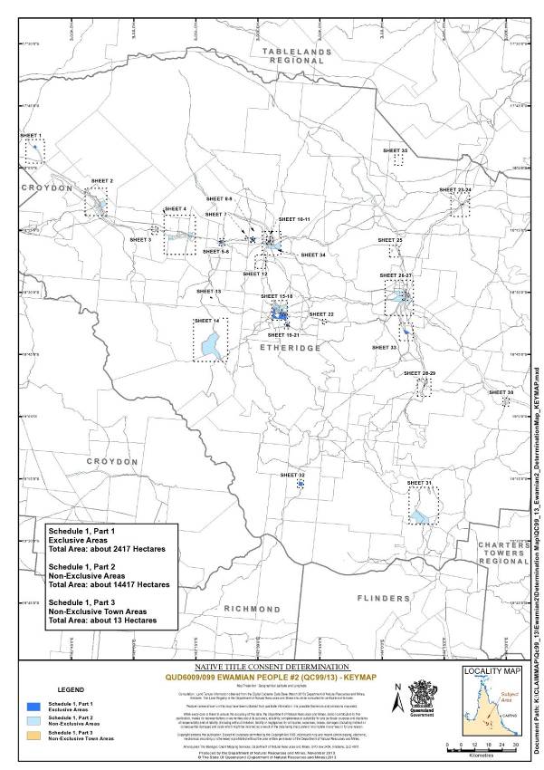
Schedule 1 — DETERMINATION AREA
A. Description of Determination Area
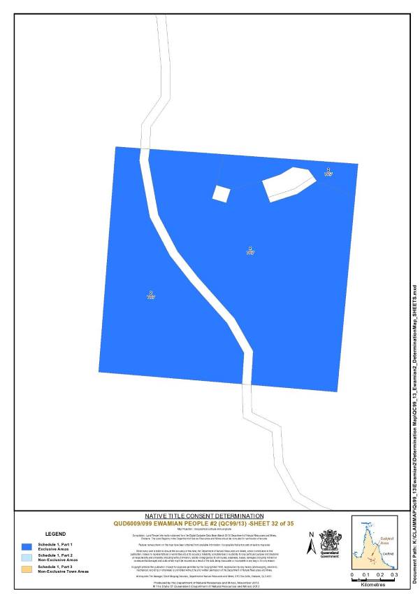
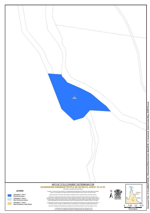
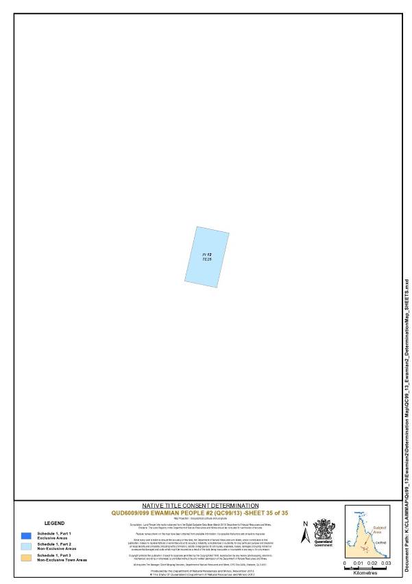
The Determination Area comprises all of the land and waters described in Parts 1, 2 and 3 below, and depicted in the map, excluding the areas described in Schedule 2.
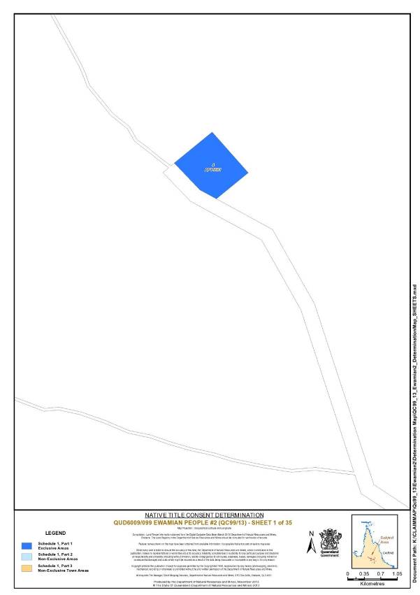
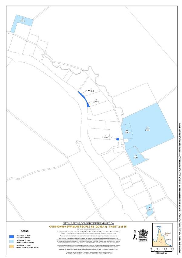
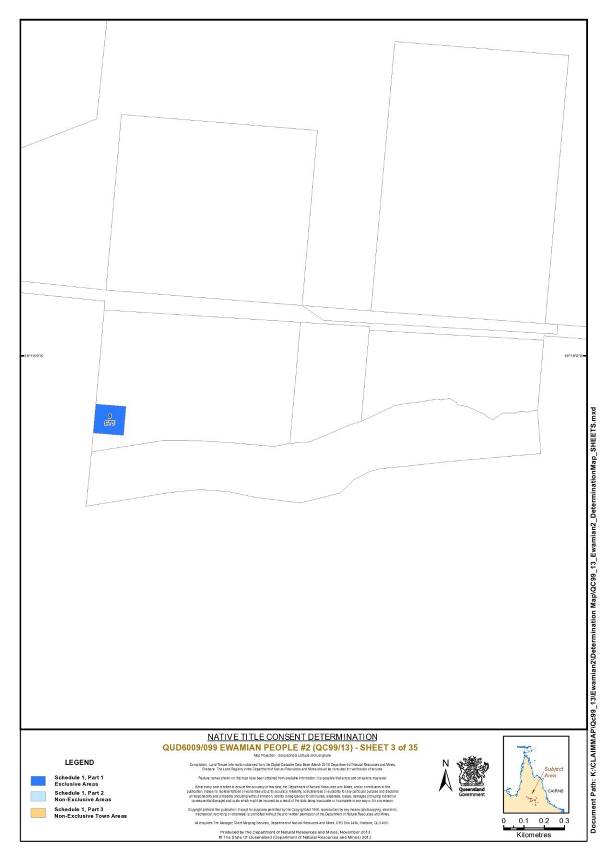
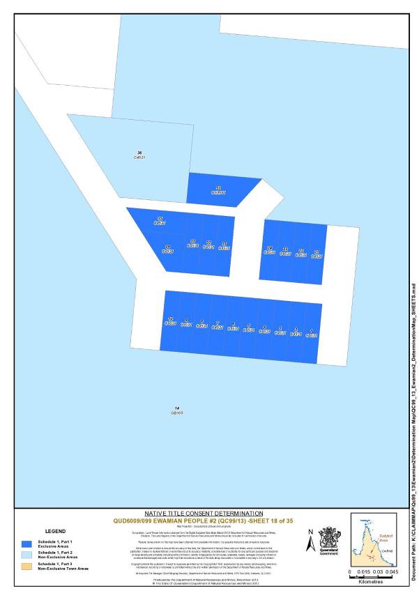
Part 1 – Exclusive Areas
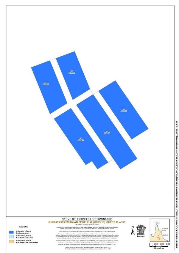
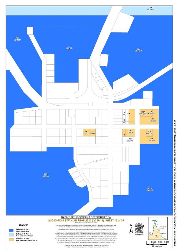
All of the land and waters described in the following table and depicted in dark blue on the determination map:
Area Description (at time of Determination) |
Determination Map Reference |
That part of Lot 1 on Plan AP11612 not covered by Exploration Permit for Minerals No. 8788 as at 18 March 1999 and excluding area identified as proposed refuse site on Plan IS151435 |
15 and 17 |
Lot 1 on AP22305 |
15 |
Lot 3 on AP22305 |
15 |
That part of Lot 4 on Plan AP11612 not covered by Exploration Permit for Minerals No’s. 8788 and 10295 as at 18 March 1999 |
15 |
That part of Lot 5 on Plan AP11612 not covered by Exploration Permit for Minerals No. 8788 as at 18 March 1999 |
15 and 16 |
That part of Lot 34 on Plan AP11612 formerly described as Lot 34 on Plan USL535 |
15 and 16 |
Lot 6 on Plan AP14370 |
15 |
Lot 3 on Plan AP15550 |
27 |
Lot 4 on Plan AP15561 |
1 |
Lot 1 on Plan AP4545 |
2 |
Lot 2 on Plan AP4545 |
2 |
That part of Lot 2 on Plan AP5902 not covered by Exploration Permit for Minerals No. 8788 as at 18 March 1999 |
15 and 17 |
Lot 28 on Plan C3222 |
6 |
Lot 304 on Plan C3222 |
6 |
Lot 305 on Plan C3222 |
6 |
Lot 310 on Plan C3222 |
6 |
Lot 311 on Plan C3222 |
6 |
Lot 312 on Plan C3222 |
6 |
Lot 313 on Plan C3222 |
6 |
Lot 316 on Plan C3222 |
6 |
Lot 317 on Plan C3222 |
6 |
Lot 1 on Plan C4521 |
18 |
Lot 2 on Plan C4521 |
18 |
Lot 3 on Plan C4521 |
18 |
Lot 4 on Plan C4521 |
18 |
Lot 5 on Plan C4521 |
18 |
Lot 6 on Plan C4521 |
18 |
Lot 7 on Plan C4521 |
18 |
Lot 8 on Plan C4521 |
18 |
Lot 9 on Plan C4521 |
18 |
Lot 10 on Plan C4521 |
18 |
Lot 21 on Plan C4521 |
18 |
Lot 22 on Plan C4521 |
18 |
Lot 23 on Plan C4521 |
18 |
Lot 24 on Plan C4521 |
18 |
Lot 31 on Plan C4521 |
18 |
Lot 32 on Plan C4521 |
18 |
Lot 33 on Plan C4521 |
18 |
Lot 34 on Plan C4521 |
18 |
Lot 35 on Plan C4521 |
18 |
Lot 3 on Plan C8262 |
2 |
That part of Lot 704 on Plan D4251 not covered by Mining Lease No. 3398 as at 18 March 1999 |
9 |
That part of Lot 705 on Plan D4251 not covered by Mining Lease No. 3398 as at 18 March 1999 |
9 |
That part of Lot 706 on Plan D4251 not covered by Mining Lease No. 3398 as at 18 March 1999 |
9 |
That part of Lot 707 on Plan D4251 not covered by Mining Lease No. 3398 as at 18 March 1999 |
9 |
That part of Lot 708 on Plan D4251 not covered by Mining Lease No. 3398 as at 18 March 1999 |
9 |
Lot 709 on Plan D4251 |
9 |
Lot 8 on Plan ET5 |
3 |
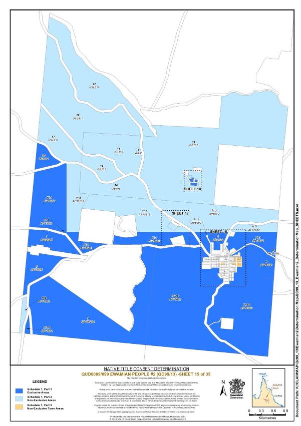
That part of Lot 24 on Plan GB100 not covered by Mining Lease No’s. 3331 and 3395 as at 18 March 1999 and excluding area described in Schedule 2 |
5 and 6 |
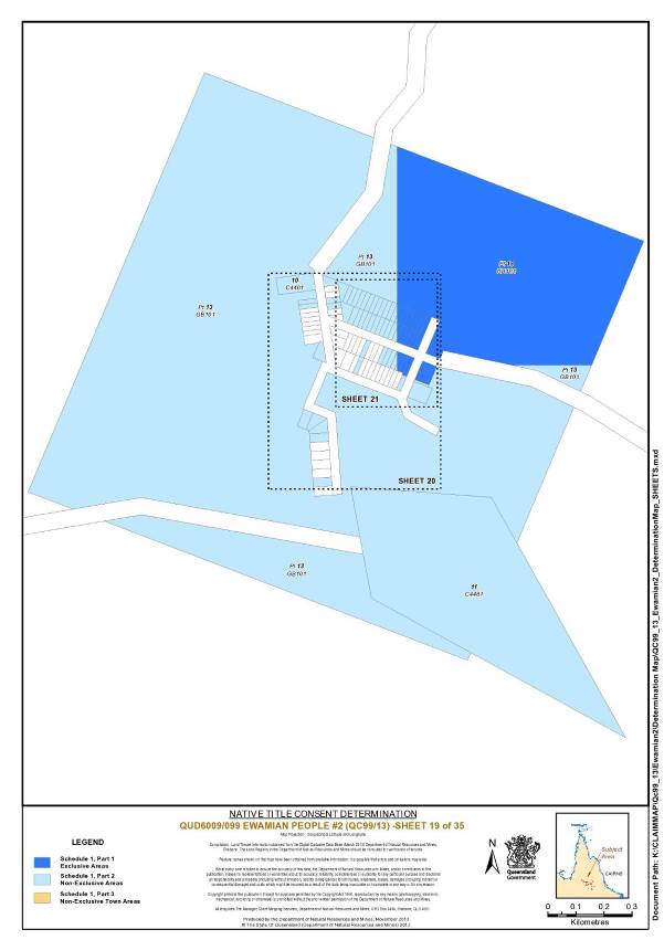
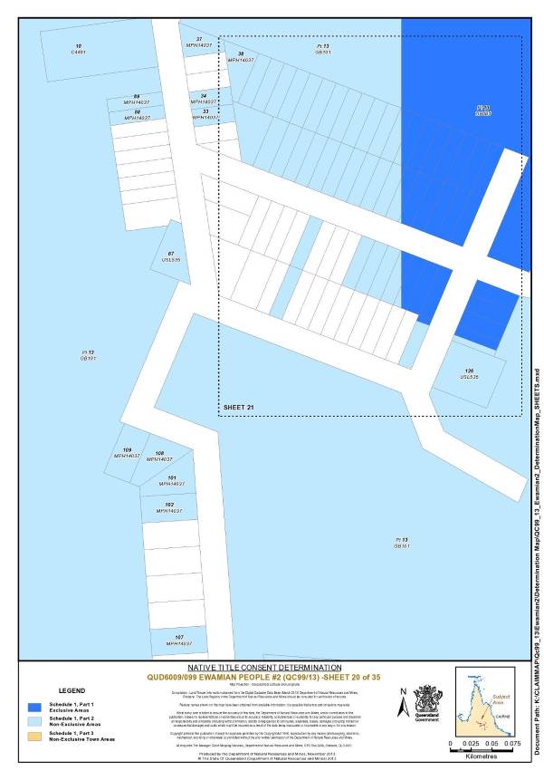
That part of Lot 13 on Plan GB101 not covered by Exploration Permit for Minerals No. 8751 as at 18 March 1999 |
19, 20 and 21 |
That part of Lot 19 on Plan GB104 not covered by Mining Lease No. 3398 as at 18 March 1999 |
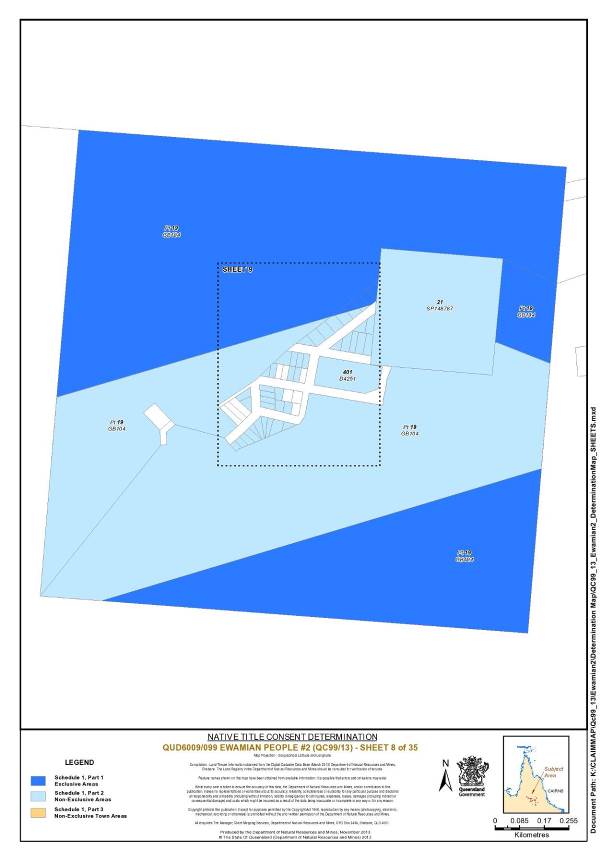
8 and 9 |
Lot 29 on Plan GB14 |
22 |
Lot 7 on Plan GB25 |
33 |
Lot 12 on Plan GB89 |
10 and 11 |
Lot 1 on Plan MPH14035 |
6 |
Lot 2 on Plan MPH14035 |
6 |
That part of Lot 11 on Plan MPH14035 not covered by Mining Lease No. 3395 as at 18 March 1999 |
6 |
Lot 26 on Plan MPH14035 |
6 |
Lot 27 on Plan MPH14035 |
6 |
Lot 28 on Plan MPH14035 |
6 |
Lot 29 on Plan MPH14035 |
6 |
Lot 34 on Plan MPH14035 |
6 |
Lot 35 on Plan MPH14035 |
6 |
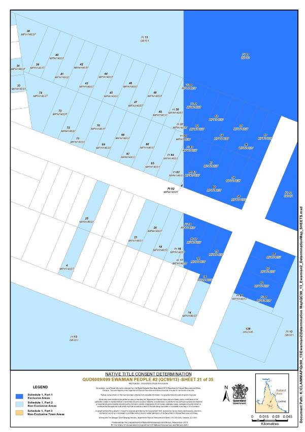
That part of Lot 14 on Plan MPH14037 not covered by Mining Lease No. 3278 as at 18 March 1999 |
21 |
Lot 15 on Plan MPH14037 |
21 |
Lot 16 on Plan MPH14037 |
21 |
That part of Lot 17 on Plan MPH14037 not covered by Exploration Permit for Minerals No. 8751 as at 18 March 1999 |
21 |
That part of Lot 18 on Plan MPH14037 not covered by Exploration Permit for Minerals No. 8751 as at 18 March 1999 |
21 |
That part of Lot 50 on Plan MPH14037 not covered by Exploration Permit for Minerals No. 8751 as at 18 March 1999 |
21 |
That part of Lot 51 on Plan MPH14037 not covered by Exploration Permit for Minerals No. 8751 as at 18 March 1999 |
21 |
Lot 52 on Plan MPH14037 |
21 |
Lot 53 on Plan MPH14037 |
21 |
Lot 54 on Plan MPH14037 |
21 |
Lot 55 on Plan MPH14037 |
21 |
Lot 56 on Plan MPH14037 |
21 |
Lot 57 on Plan MPH14037 |
21 |
Lot 58 on Plan MPH14037 |
21 |
Lot 59 on Plan MPH14037 |
21 |
Lot 60 on Plan MPH14037 |
21 |
Lot 61 on Plan MPH14037 |
21 |
That part of Lot 62 on Plan MPH14037 not covered by Exploration Permit for Minerals No. 8751 as at 18 March 1999 |
21 |
That part of Lot 63 on Plan MPH14037 not covered by Exploration Permit for Minerals No. 8751 as at 18 March 1999 |
21 |
That part of Lot 64 on Plan MPH14037 not covered by Exploration Permit No. 8751 as at 18 March 1999 |
21 |
That part of Lot 91 on Plan MPH14037 not covered by Mining Lease No. 3278 as at 18 March 1999 |
21 |
Lot 92 on Plan MPH14037 |
21 |
Lot 93 on Plan MPH14037 |
21 |
Lot 94 on Plan MPH14037 |
21 |
Lot 1 on Plan MPH22837 |
6 |
That part of Lot 20 on Plan N25351 not covered by Mining Lease No. 3395 as at 18 March 1999 |
5 |
Lot 10 on Plan USL311 |
15 |
Lot 53 on Plan USL311 |
18 |
Lot 3 on Plan USL436 |
15 and 16 |
Lot 33 on Plan USL482 |
13 |
Lot 34 on Plan USL482 |
13 |
Lot 39 on Plan USL482 |
13 |
Lot 41 on Plan USL482 |
13 |
Lot 43 on Plan USL482 |
13 |
Lot 5 on Plan SP179214 |
15 |
Lot 2 on Plan VR7 |
32 |
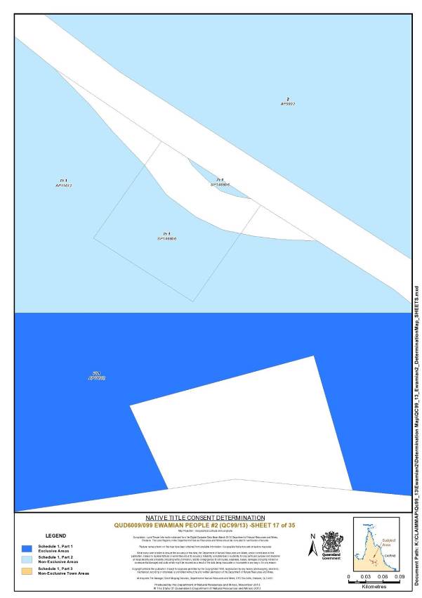
Part 2 — Non-Exclusive Areas
All of the land and waters described in the following table and depicted in light blue on the determination map:
Area Description (at time of Determination) |
Determination Map Reference |
||||||
That part of Lot 4 on Plan AP11612 covered by Exploration Permit for Minerals No’s. 8788 and 10295 as at 18 March 1999 |
15 |
||||||
That part of Lot 5 on Plan AP11612 covered by Exploration Permit for Minerals No. 8788 as at 18 March 1999 |
15 and 16 |
||||||
Lot 149 on Plan AP11612 |
15 |
||||||
That part of Lot 2 on Plan AP5902 covered by Exploration Permit for Minerals No. 8788 as at 18 March 1999 |
15 and 17 |
||||||
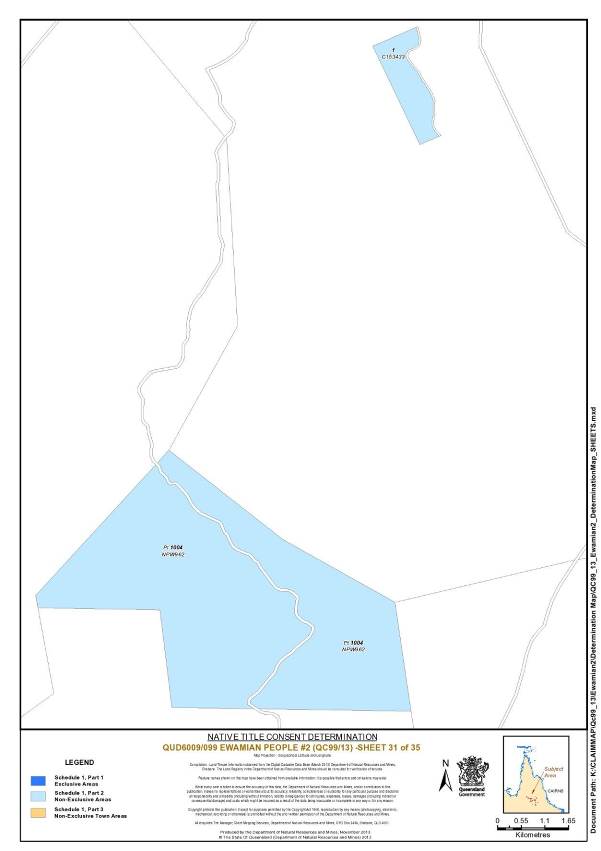
Lot 1 on Plan C153433 |
31 |
||||||
That part of Lot 21 on Plan C153517 excluding area described in Schedule 2. |
5 |
||||||
Lot 39 on Plan C157377 |
26 and 27 |
||||||
Lot 26 on Plan C3222 |
6 |
||||||
Lot 27 on Plan C3222 |
6 |
||||||
Lot 205 on Plan C3222 |
6 |
||||||
Lot 206 on Plan C3222 |
6 |
||||||
Lot 207 on Plan C3222 |
6 |
||||||
Lot 10 on Plan C4481 |
19 and 20 |
||||||
Lot 11 on Plan C4481 |
19 |
||||||
Lot 36 on Plan C4521 |
18 |
||||||
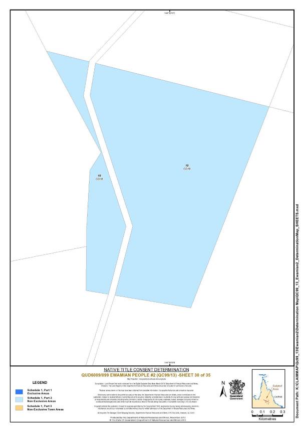
Lot 10 on Plan CD18 |
30 |
||||||
Lot 21 on Plan CD4 |
26 and 27 |
||||||
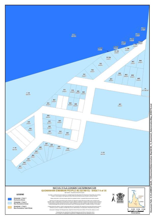
Lot 104 on Plan D4251 |
9 |
||||||
Lot 105 on Plan D4251 |
9 |
||||||
Lot 201 on Plan D4251 |
9 |
||||||
Lot 202 on Plan D4251 |
9 |
||||||
Lot 203 on Plan D4251 |
9 |
||||||
Lot 204 on Plan D4251 |
9 |
||||||
Lot 205 on Plan D4251 |
9 |
||||||
Lot 206 on Plan D4251 |
9 |
||||||
Lot 207 on Plan D4251 |
9 |
||||||
Lot 208 on Plan D4251 |
9 |
||||||
Lot 209 on Plan D4251 |
9 |
||||||
Lot 210 on Plan D4251 |
9 |
||||||
Lot 301 on Plan D4251 |
9 |
||||||
Lot 302 on Plan D4251 |
9 |
||||||
Lot 303 on Plan D4251 |
9 |
||||||
Lot 304 on Plan D4251 |
9 |
||||||
Lot 305 on Plan D4251 |
9 |
||||||
Lot 309 on Plan D4251 |
9 |
||||||
Lot 310 on Plan D4251 |
9 |
||||||
Lot 401 on Plan D4251 |
8 and 9 |
||||||
Lot 501 on Plan D4251 |
9 |
||||||
Lot 502 on Plan D4251 |
9 |
||||||
Lot 505 on Plan D4251 |
9 |
||||||
Lot 506 on Plan D4251 |
9 |
||||||
Lot 508 on Plan D4251 |
9 |
||||||
Lot 509 on Plan D4251 |
9 |
||||||
Lot 510 on Plan D4251 |
9 |
||||||
Lot 511 on Plan D4251 |
9 |
||||||
Lot 601 on Plan D4251 |
9 |
||||||
Lot 602 on Plan D4251 |
9 |
||||||
Lot 603 on Plan D4251 |
9 |
||||||
Lot 604 on Plan D4251 |
9 |
||||||
Lot 605 on Plan D4251 |
9 |
||||||
Lot 606 on Plan D4251 |
9 |
||||||
Lot 607 on Plan D4251 |
9 |
||||||
Lot 701 on Plan D4251 |
9 |
||||||
Lot 702 on Plan D4251 |
9 |
||||||
Lot 703 on Plan D4251 |
9 |
||||||
That part of Lot 704 on Plan D4251 covered by Mining Lease No. 3398 as at 18 March 1999 |
9 |
||||||
That part of Lot 705 on Plan D4251 covered by Mining Lease No. 3398 as at 18 March 1999 |
9 |
||||||
That part of Lot 706 on Plan D4251 covered by Mining Lease No. 3398 as at 18 March 1999 |
9 |
||||||
That part of Lot 707 on Plan D4251 covered by Mining Lease No. 3398 as at 18 March 1999 |
9 |
||||||
That part of Lot 708 on Plan D4251 covered by Mining Lease No. 3398 as at 18 March 1999 |
9 |
||||||
Lot 40 on Plan ET16 |
2 |
||||||
That part of Lot 12 on Plan TE28 covered by Mining Claim No. 30032 as at 18 March 1999 |
35 |
||||||
Lot 34 on Plan ET30 |
2 |
||||||
Lot 35 on Plan ET38 |
2 |
||||||
Lot 30 on Plan ET39 |
2 |
||||||
Lot 32 on Plan ET40 |
2 |
||||||
That part of Lot 24 on Plan GB100 covered by Mining Lease No’s. 3331 and 3395 as at 18 March 1999 and excluding area described in Schedule 2 |
5 and 6 |
||||||
That part of Lot 13 on Plan GB101 covered by Exploration Permit for Minerals No. 8751 as at 18 March 1999 |
19, 20 and 21 |
||||||
Lot 1 on Plan GB103 |
34 |
||||||
That part of Lot 19 on Plan GB104 covered by Mining Lease No. 3398 as at 18 March 1999 |
8 and 9 |
||||||
Lot 14 on Plan GB105 |
15 and 18 |
||||||
Lot 22 on Plan GB21 |
4 |
||||||
That part of Lot 38 on Plan GB22 exclusive of area identified as a proposed Refuse site and delineated by stations 1-2-3-4-1 on IS151436 |
26 and 27 |
||||||
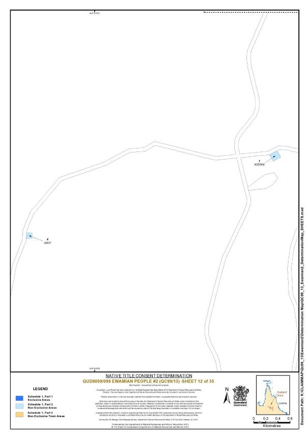
Lot 4 on Plan GB31 |
12 |
||||||
That part of Lot 5 on Plan GB35 excluding the area described in Schedule 2 |
15 |
||||||
Lot 7 on Plan GB70 |
34 |
||||||
That part of Lot 8 on GB86 west of the line joining the north east corner of Lot 1 on AP8329 and the southwest corner of Lot 99 on SP206971, being the western boundary of the former Town Reserve R. 54.29 |
10 and 34 |
||||||
Lot 23 on Plan GB87 |
4 |
||||||
That part of Lot 42 on Plan GB99 excluding the area described in Schedule 2 |
27 |
||||||
That part of Lot 11 on Plan MPH14035 covered by Mining Lease No. 3395 as at 18 March 1999 |
6 |
||||||
Lot 12 on Plan MPH14035 |
6 |
||||||
Lot 13 on Plan MPH14035 |
6 |
||||||
Lot 14 on Plan MPH14035 |
6 |
||||||
Lot 18 on Plan MPH14035 |
6 |
||||||
Lot 4 on Plan MPH14037 |
21 |
||||||
That part of Lot 14 on Plan MPH14037 covered by Mining Lease No. 3278 as at 18 March 1999 |
21 |
||||||
That part of Lot 17 on Plan MPH14037 covered by Exploration Permit for Minerals No. 8751 as at 18 March 1999 |
21 |
||||||
That part of Lot 18 on Plan MPH14037 covered by Exploration Permit for Minerals No. 8751 as at 18 March 1999 |
21 |
||||||
Lot 19 on Plan MPH14037 |
21 |
||||||
Lot 20 on Plan MPH14037 |
21 |
||||||
Lot 21 on Plan MPH14037 |
21 |
||||||
Lot 25 on Plan MPH14037 |
21 |
||||||
Lot 33 on Plan MPH14037 |
20 and 21 |
||||||
Lot 34 on Plan MPH14037 |
20 and 21 |
||||||
Lot 37 on Plan MPH14037 |
20 |
||||||
Lot 38 on Plan MPH14037 |
20 and 21 |
||||||
Lot 39 on Plan MPH14037 |
21 |
||||||
Lot 40 on Plan MPH14037 |
21 |
||||||
Lot 41 on Plan MPH14037 |
21 |
||||||
Lot 42 on Plan MPH14037 |
21 |
||||||
Lot 43 on Plan MPH14037 |
21 |
||||||
Lot 44 on Plan MPH14037 |
21 |
||||||
Lot 45 on Plan MPH14037 |
21 |
||||||
Lot 46 on Plan MPH14037 |
21 |
||||||
Lot 47 on Plan MPH14037 |
21 |
||||||
Lot 48 on Plan MPH14037 |
21 |
||||||
Lot 49 on Plan MPH14037 |
21 |
||||||
That part of Lot 50 on Plan MPH14037 covered by Exploration Permit for Minerals No. 8751 as at as at 18 March 1999 |
21 |
||||||
That part of Lot 51 on Plan MPH14037 covered by Exploration Permit for Minerals No. 8751 as at 18 March 1999 |
21 |
||||||
That part of Lot 62 on Plan MPH14037 not covered by Exploration Permit for Minerals No. 8751 as at 18 March 1999 |
21 |
||||||
That part of Lot 63 on Plan MPH14037 covered by Exploration Permit for Minerals No. 8751 as at 18 March 1999 |
21 |
||||||
That part of Lot 64 on Plan MPH14037 covered by Exploration Permit for Minerals No. 8751 as at 18 March 1999 |
21 |
||||||
Lot 65 on Plan MPH14037 |
21 |
||||||
Lot 66 on Plan MPH14037 |
21 |
||||||
Lot 67 on Plan MPH14037 |
21 |
||||||
Lot 68 on Plan MPH14037 |
21 |
||||||
Lot 69 on Plan MPH14037 |
21 |
||||||
Lot 70 on Plan MPH14037 |
21 |
||||||
Lot 71 on Plan MPH14037 |
21 |
||||||
Lot 72 on Plan MPH14037 |
21 |
||||||
Lot 73 on Plan MPH14037 |
21 |
||||||
Lot 74 on Plan MPH14037 |
21 |
||||||
Lot 88 on Plan MPH14037 |
20 |
||||||
Lot 89 on Plan MPH14037 |
20 |
||||||
That part of Lot 91 on Plan MPH14037 covered by Mining Lease No. 3278 as at 18 March 1999 |
21 |
||||||
Lot 101 on Plan MPH14037 |
20 |
||||||
Lot 102 on Plan MPH14037 |
20 |
||||||
Lot 107 on Plan MPH14037 |
20 |
||||||
Lot 108 on Plan MPH14037 |
20 |
||||||
Lot 109 on Plan MPH14037 |
20 |
||||||
That part of Lot 20 on Plan N25351 covered by Mining Lease No. 3395 as at 18 March 1999 |
5 |
||||||
Lot 1 on Plan N25586 |
12 |
||||||
Lot 43 on Plan SP113960 |
25 |
||||||
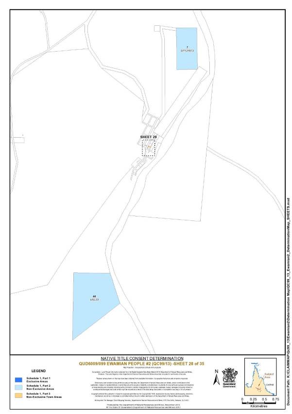
That part of Lot 7 on Plan SP121873 excluding area described in Schedule 2 |
28 |
||||||
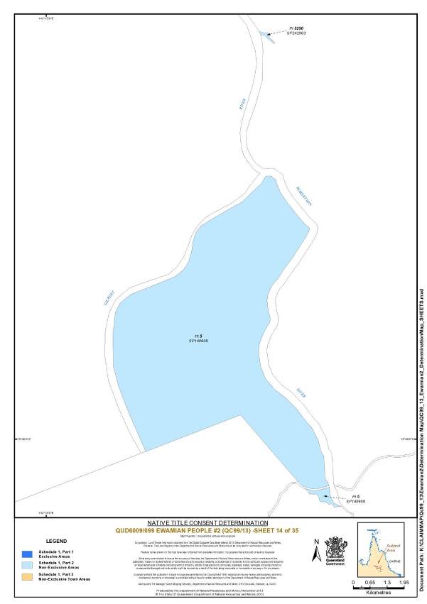
That part of Lot 5 on Plan SP140908 formerly described as that part of Lot 5 on LG813289 bounded by the Gilbert River, Robertson River and the southern boundary of former Lot 5 on LG813289 |
14 |
||||||
That part of Lot 1 on Plan SP146606 excluding historical road described as Lot B on Plan AP5902 |
17 |
||||||
Lot 21 on Plan SP148787 |
8 and 9 |
||||||
Lot 17 on Plan USL311 |
15 |
||||||
Lot 19 on Plan USL311 |
15 |
||||||
Lot 22 on Plan USL311 |
15 |
||||||
Lot 44 on Plan USL33 |
28 |
||||||
Lot 67 on Plan USL535 |
20 |
||||||
Lot 126 on Plan USL535 |
20 and 21 |
||||||
Lot 10 on Plan USL734 |
7 |
||||||
Lot 11 on Plan USL734 |
7 |
||||||
That part of 5250 on Plan SP242983 covered by Mining Lease No. 30189 as at 18 March 1999 |
14 |
||||||
That part of Lot 1 on Plan AP11612 subject to Exploration Permit for Minerals No. 8788 as at 18 March 1999 |
15 and 17 |
||||||
That part of Lot 1004 on Plan NPW962 being within an area defined as: Commencing at a point on the eastern boundary of Lot 1004 on NPW962 at Latitude 19.429145 South; then westerly and northerly passing through the following coordinate points:
Then westerly, to a point on the western boundary of Lot 1004 on NPW962 at Latitude 19.407541 South; then north westerly, north easterly, south easterly and southerly along the boundary of Lot 1004 on NPW962 back to the commencement point. |
31 |
Part 3 – Non-Exclusive Town Areas
All of the land and waters described in the following table and depicted in tan on the determination map:
Area Description (at time of Determination) |
Determination Map Reference |
Lot 501 on Plan E5081 |
27 |
Lot 8 on Plan F5871 |
16 |
Lot 9 on Plan F5871 |
16 |
Lot 53 on Plan F5871 |
16 |
Lot 54 on Plan F5871 |
16 |
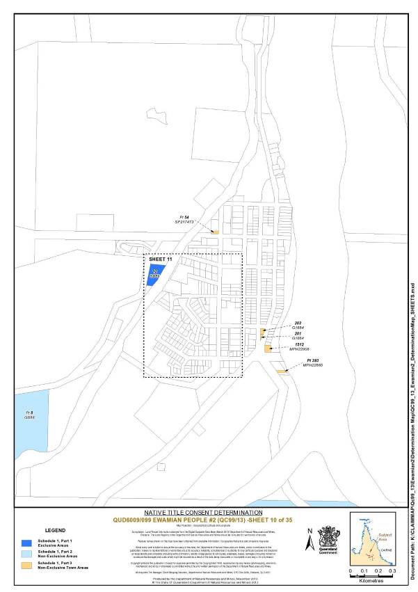
Lot 201 on Plan G1884 |
10 |
Lot 202 on Plan G1884 |
10 |
Lot 81 on Plan MPH14034 |
27 |
Lot 1091 on Plan MPH2251 |
16 |
Lot 1127 on Plan MPH2251 |
16 |
Lot 1174 on Plan MPH2251 |
16 |
Lot 2 on Plan MPH2257 |
16 |
Lot 34 on Plan MPH34804 |
23 and 24 |
Lot 36 on Plan MPH34804 |
23 and 24 |
Lot 37 on Plan MPH34804 |
23 and 24 |
Lot 38 on Plan MPH34804 |
23 and 24 |
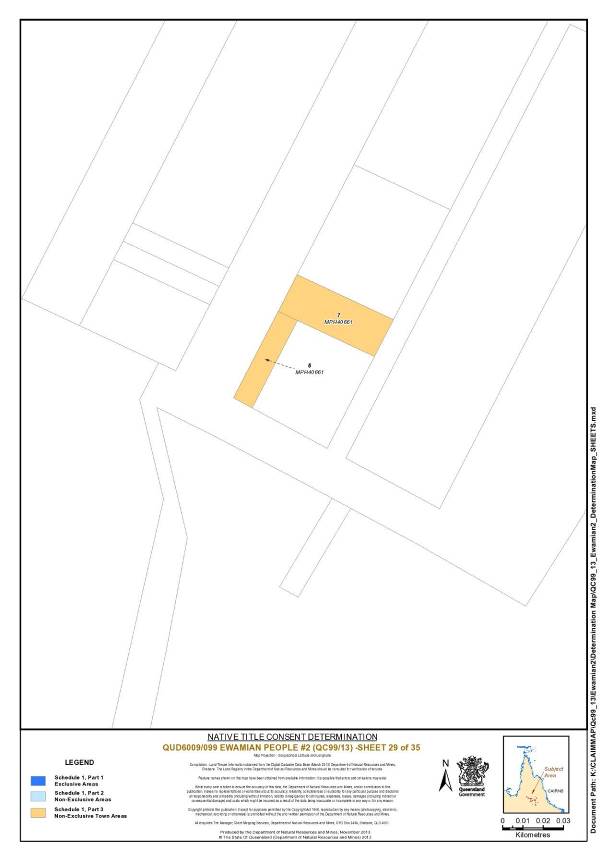
Lot 6 on Plan MPH40661 |
28 and 29 |
Lot 7 on Plan MPH40661 |
28 and 29 |
That part of Lot 54 on Plan SP217473 formerly described as Lot 8 on USL506 |
10 |
Lot 175 on Plan USL436 |
16 |
Lot 177 on Plan USL436 |
16 |
Lot 200 on Plan USL436 |
16 |
Lot 31 on Plan USL44 |
27 |
Lot 60 on Plan USL44 |
27 |
Lot 168 on Plan USL44 |
27 |
Lot 170 on Plan SP217454 |
27 |
Lot 1512 on Plan MPH22958 |
10 |
That part of Lot 393 on Plan MPH22865 not covered by Exploration Permit for Minerals No. 8787 as at 18 March 1999 |
10 |
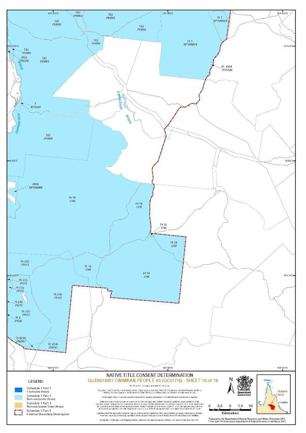
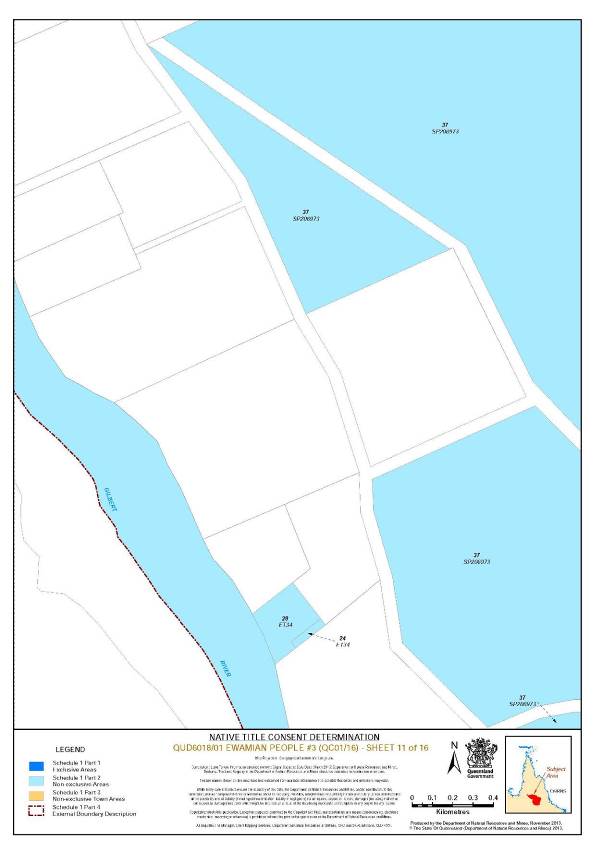
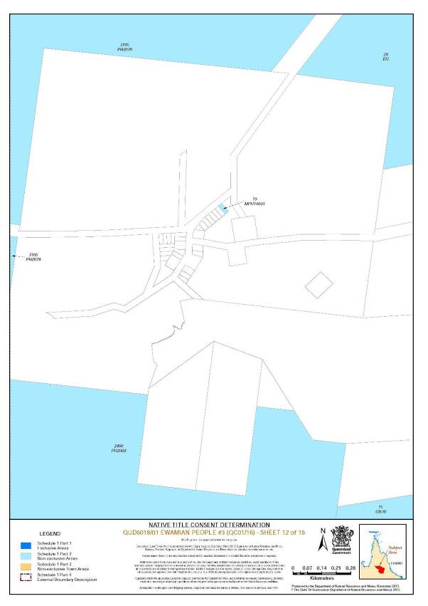
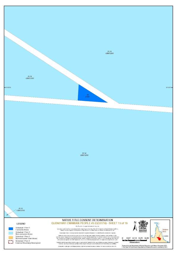
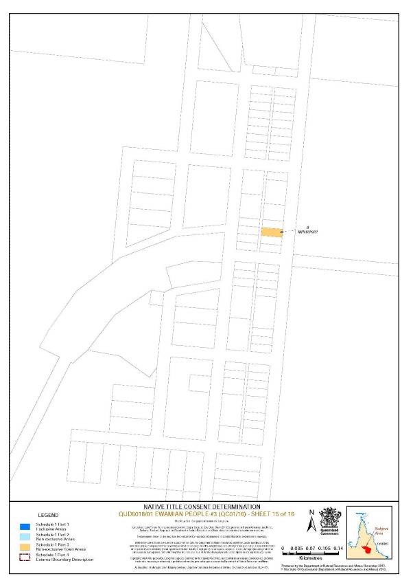
B. Map of Determination Area

Schedule 2 — AREAS NOT FORMING PART OF THE DETERMINATION AREA
The following areas of land and waters are excluded from the Determination Area.
Part A
On the basis that native title has been extinguished and is not claimed, the parties have agreed that the excluded areas include any land or waters on which any permanent improvement consisting of:
(a) a homestead, house, shed or other building;
(b) an airstrip;
(c) a constructed dam or any other constructed stock watering point, bore, turkey nest, squatters’ tank or other water storage facility; or
(d) stock yards and trap yards,
has, at the date of the Determination, been constructed (including any adjacent land the exclusive use of which is reasonably necessary for the enjoyment of the improvement) in accordance with the rights of the lessee under, and within the boundaries of the following pastoral leases:
(i) Term Lease No. 236442 comprising Lot 4 on Plan GB31 and commonly known as Mount Sullivan;
(ii) Preferential Pastoral Holding 18/5235 comprising Lot 5 on Plan SP140908 and commonly known as Helliman Creek; and
(iii) Preferential Pastoral Holding No 18/5250 comprising Lot 5250 on Plan SP242983 and commonly known as Townley.
Part B
The areas in this Part are excluded from the Determination Area on the grounds that at the time at which the native title determination application was made:
i. these areas were the subject of one or more previous exclusive possession acts, as defined in s 23B of the Native Title Act 1993 (Cth), despite the fact that the areas, or parts of them, may have been subject to earlier acts that extinguished native title; and
ii. in relation to the areas in paragraph 1 of this Part, none of ss 47, 47A or 47B of the Native Title Act 1993 (Cth) applied; and
iii. therefore, in accordance with s 61A of the Native Title Act 1993 (Cth), these areas could not be claimed.
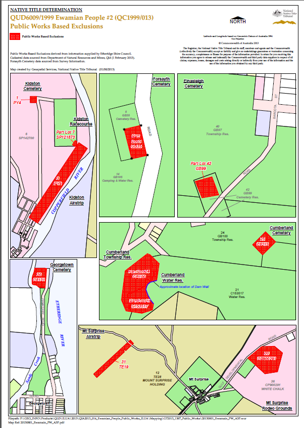
Public Works Based Exclusions:
A. Land or waters on which any public work, as defined in s 253 of the Native Title Act 1993 (Cth), is or was constructed, established, or situated, and to which ss 23B(7) and 23C(2) of the Native Title Act 1993 (Cth) and/or s 23B(7) of the Native Title Act 1993 (Cth) and s 21 of the Native Title (Queensland) Act 1993 (Qld) applies, together with any adjacent land or waters in accordance with s 251D of the Native Title Act 1993 (Cth).
B. Land or waters described in paragraph A immediately above includes, for the avoidance of doubt:
1. the whole of the land and waters shown on the map included in this Schedule and described as:
i. Lot 20 on C8131 (Georgetown Cemetery);
ii. Lot 25 on C8215 (Cumberland Cemetery);
iii. Lot 30 on CP900291 (Mt Surprise Rodeo Grounds);
iv. Lot 1 on PY4 (Kidston Cemetery);
v. Lot 3 on PY9 (Kidston Airstrip);
vi. Lot 31 on TE19 (Mt Surprise Airstrip);
2. that part of the land and waters shown on the map included in this Schedule and described as:
i. Lot 24 on GB100 (Cumberland Township Reserve), the part being more particularly described as within Lot 24 on GB 100 and east of a line passing through the following co-ordinates
Latitude (South) |
Longitude (East) |
18.302858 |
143.350957 |
18.302740 |
143.350104 |
18.302180 |
143.349860 |
18.300708 |
143.350060 |
18.299836 |
143.351249 |
18.299896 |
143.351398 |
18.300338 |
143.351881 |
ii. Lot 21 on C153517 (Cumberland Water Reserve), the part being more particularly described as within Lot 21 on C153517 and west of a line commencing at 143.351398° east, 18.299896° south, then passing through the following co-ordinate
Latitude (South) |
Longitude (East) |
18.300338 |
143.351881 |
then southerly to the northern boundary of the Dam Wall at 143.351750° east, then generally south westerly and generally south easterly along that dam wall (including the dam wall) to a point on its southern boundary at 143.351579° east, then southerly and generally westerly passing through the following coordinates
Latitude (South) |
Longitude (East) |
18.302688 |
143.351520 |
18.302858 |
143.350957 |
18.302740 |
143.350104 |
iii. Lot 7 on SP121873 (Kidston Racecourse), the part being more particularly described as within Lot 7 on SP 121873 and southeast of a line commencing at a point on the southern boundary of that lot at 144.177843° East, then passing through the following co-ordinates
Latitude (South) |
Longitude (East) |
18.860219 |
144.177459 |
18.859458 |
144.177980 |
to a point on the eastern boundary of Lot 7 on SP 121873 at 18.859664° South.
iv. Lot 42 on GB99 (Einasleigh Cemetery), the part being more particularly described as within Lot 42 on GB99 and bounded by the following co-ordinates
Latitude (South) |
Longitude (East) |
18.522900 |
144.090283 |
18.523617 |
144.090567 |
18.523733 |
144.089867 |
18.523083 |
144.089583 |
v. Lot 5 on GB35 (Forsayth Cemetery), the part being more particularly described as within Lot 5 on GB35 and southeast of a line commencing at a point on the southern boundary of that lot at 143.583983° east, then passing through the following co-ordinates
Latitude (South) |
Longitude (East) |
18.564967 |
143.583717 |
to a point on the eastern boundary of Lot 5 on GB35 at 18.564842° south.
Reference datum: Geocentric Datum of Australia 1994 (GDA94)
Note: to the extent of any inconsistency between the written description in this Schedule and the map, the written description prevails.
Schedule 3 — NATIVE TITLE HOLDERS
The Native Title Holders are the Ewamian People. The Ewamian People are the:
1. biological descendants of the following people:
(a) Norman Clarke;
(b) Harry Plate;
(c) Emily Collins;
(d) Arthur Georgetown;
(e) Pearl Georgetown;
(f) Ethel Georgetown;
(g) Thomas Lacey;
(h) Dora Hudson;
(i) Frank Hudson;
(j) Minnie Willie;
(k) Mick Morris; or
(l) Ben Sloppa aka Ben Mudd; or
2. the adopted persons of Ethel Georgetown, Jim Harvey, Minnie Willie, John Edward Morris and Alfred Morris being persons who have been recruited by adoption as a member of the Ewamian People in accordance with their traditional law and custom.
Schedule 4 — OTHER INTERESTS IN THE DETERMINATION AREA
The nature and extent of the Other Interests in relation to the Determination Area are the following as they exist as at the date of the determination:
1. The rights and interests of the parties under the following agreements:
(a) Barry Fisher, Katie Georgetown, David Hudson, Noel Lacey and Ronald Richards and the State of Queensland as parties to the Ewamian-Etheridge Townships Indigenous Land Use Agreement registered on 12 March 2004;
(b) Barry Fisher, Katie Georgetown, David Hudson, Noel Lacey and Ronald Richards and the State of Queensland as parties to the Ewamian (Towns of Forsayth, Einasleigh, Georgetown and Mount Surprise) Indigenous Land Use Agreement registered on 1 December 2008;
(c) the agreement between Barry Fisher, David Hudson, Ron Richards and Noel Lacey and the State of Queensland, which was authorised by the native title claim group on 19, 21 and 22 August 2013 and executed by Barry Fisher on 11 November 2013, David Hudson on 15 November 2013, Ron Richards on 14 November 2013 and Noel Lacey on 7 November 2013 and the State of Queensland on 23 and 29 October 2013 (the Ewamian Protected Areas ILUA), and that agreement once it becomes registered as a body corporate ILUA following execution of the agreement by the Registered Native Title Body Corporate;
(d) the agreement between Barry Fisher, David Hudson, Ron Richards and Noel Lacey and Ergon Energy Corporation Limited, which was authorised by the native title claim group on 19, 21 and 22 August 2013 (the Ergon ILUA), and that agreement once it becomes registered as a body corporation ILUA following execution of the agreement by the Registered Native Title Body Corporate;
(e) the agreement between Barry Fisher, Katie Georgetown, David Hudson, Noel Lacey and Ronald Richards and the Etheridge Shire Council as parties to the Ewamian-Etheridge Shire Area ILUA No. 3 (QI 2005/04) registered on 25 February 2008 ;
(f) the agreement between Barry Fisher, Katie Georgetown, David Hudson, Noel Lacey and Ronald Richards and the Etheridge Shire Council as parties to the Ewamian-Etheridge Shire Council (Ten Mile Landfill Project) ILUA (QI 2011/051) registered on 6 February 2012; and
(g) the agreement between Ronald Richards, David Charles Hudson, Noel Lacey, Graham Fisher, Frank Fisher and Alex Sandow and Telstra Corporation Limited as parties to the Ewamian People #2 (Telstra ILUA) Indigenous Land Use Agreement (QI 1999/003) registered 23 December 1999.
2. The rights and interests of the holders of any leases, licences, reservations, permits, easements or authorities granted under the Land Act 1994 (Qld), and any relevant regulations or subordinate legislation made under that Act, including the following leases:
(a) Pastoral Holding Term Lease No. 236442 comprising Lot 4 on Plan GB31 and commonly known as Mount Sullivan;
(b) Preferential Pastoral Holding 18/5235 comprising Lot 5 on Plan SP140908 and commonly known as Helliman Creek; and
(c) Preferential Pastoral Holding No 18/5250 comprising Lot 5250 on Plan SP242983 and commonly known as Townley.
3. The rights and interests of Telstra Corporation Limited ACN 051 755 566:
(a) as the owner or operator of telecommunications facilities installed within the Determination Area;
(b) created pursuant to the Post and Telegraph Act 1901 (Cth), the Telecommunications Act 1975 (Cth), the Australian Telecommunications Corporation Act 1989 (Cth), the Telecommunications Act 1991 (Cth) and the Telecommunications Act 1997 (Cth), including rights:
(i) to inspect land;
(ii) to install and operate existing and new telecommunication facilities, including cabling, customer terminal sites, customer radio sites and ancillary facilities;
(iii) to alter, remove, replace, maintain, repair and ensure the proper functioning of its existing and any new telecommunications facilities including cabling, customer terminal sites, customer radio sites, and ancillary facilities;
(c) for its employees, agents or contractors to access the Determination Area for the purposes of exercising the rights in (i)(ii)and (iii) above in respect of telecommunication facilities in and in the vicinity of the Determination Area;
(d) under any leases, relating to its telecommunications facilities in the Determination Area.
4. The rights and interests of Ergon Energy Corporation Limited ACN 087 646 062:
(a) as the owner and operator of any “Works” as that term is defined in the Electricity Act 1994 (Qld) within the Determination Area;
(b) as a distribution entity and the holder of a distribution authority under the Electricity Act 1994 (Qld)
(c) created under the Electricity Act 1994 (Qld) and the Government Owned Corporations Act 1993 (Qld) including:
(i) rights in relation to any agreement relating to the Determination Area existing or entered into before the date on which these orders are made;
(ii) rights to enter the Determination Area by its employees, agents or contractors to exercise any of the rights and interests referred to in this paragraph; and
(iii) to inspect, maintain and manage any Works in the Determination Area.
5. The rights and interests of the Etheridge Shire Council (“the Council”) including any rights the Council, its employees, agents or contractors have;
(a) under its local government jurisdiction and functions under the Local Government Act 2009 (Qld), under the Land Protection (Pests and Stock Route Management) Act 2002 (Qld) and under any other legislation, for that part of the Determination Area within its local government area, as defined in the Local Government Act 2009 (Qld);
(b) as the:
(i) lessor under any leases which were entered into as at the date of the Determination;
(ii) grantor of any licences or other rights and interests which were granted as at the date of the Determination;
(iii) holder of any estate or interest in land, and as trustee of any reserves, that exist in the Determination Area as at the date of the Determination;
(iv) the grantee of any easements under the Land Act 1994 (Qld) which were granted as at the date of the Determination;
(c) as the owner and operator of infrastructure, facilities and other improvements located in the Determination Area as at the date of the Determination, including but not limited to:
(i) dedicated roads operated by the Council;
(ii) gravel pits operated by the Council;
(iii) undedicated but constructed roads except for those not operated by the Council;
(iv) water pipelines and other water supply infrastructure;
(v) drainage facilities; and
(vi) cemetery and cemetery related facilities; and
(d) to enter the land described in paragraphs 5(a) to 5(c) to:
(i) exercise any of the rights and interests referred to in paragraphs 5(a) to 5(c) of Schedule 4;
(ii) inspect, maintain and repair the infrastructure, facilities and other improvements referred to in paragraph 5(c) of Schedule 4; and
(iii) undertake operational activities in its capacity as a local government such as feral animal control, weed control, erosion control, waste management and fire management.
6. The rights and interests of the State of Queensland or any other person existing by reason of the force and operation of the laws of the State of Queensland, including those existing by reason of the following legislation or any regulation, statutory instrument, declaration, plan, authority, permit, lease or licence made, granted, issued or entered into under that legislation:
(a) the Land Act 1994 (Qld);
(b) the Nature Conservation Act 1992 (Qld);
(c) the Forestry Act 1959 (Qld);
(d) the Water Act 2000 (Qld);
(e) the Petroleum Act 1923 (Qld) or Petroleum and Gas Act 2004 (Qld);
(f) the Mineral Resources Act 1989 (Qld);
(g) the Integrated Planning Act 1997 (Qld) or Sustainable Planning Act 2009 (Qld);
(h) the Transport Infrastructure Act 1994 (Qld); and
(i) the Fire and Rescue Service Act 1990 (Qld) or Ambulance Service Act 1991 (Qld);
7. Any other rights and interests:
(a) held by the State of Queensland or Commonwealth of Australia; or
(b) existing by reason of the force and operation of the Laws of the State or the Commonwealth.
Note: Entry of orders is dealt with in Rule 39.32 of the Federal Court Rules 2011.
IN THE FEDERAL COURT OF AUSTRALIA |
|
QUEENSLAND DISTRICT REGISTRY |
|
GENERAL DIVISION |
QUD 6018 of 2001 |
BETWEEN: |
BARRY FISHER, DAVID HUDSON AND NOEL LACEY ON BEHALF OF THE EWAMIAN PEOPLE #3 Applicant |
AND: |
STATE OF QUEENSLAND First Respondent ETHERIDGE SHIRE COUNCIL Second Respondent TABLELANDS REGIONAL COUNCIL Third Respondent ERGON ENERGY CORPORATION LIMITED Fourth Respondent TELSTRA CORPORATION LIMITED Fifth Respondent ALLYN JOHN ZABEL Sixth Respondent JENNIANN ALEXANDER, BRIAN ALEXANDER, ALUSA PTY LTD, ALLEN JOHN BETHEL, ATHOL R BETHEL, CARMEL MAREE BETHEL, LORNA MAUREEN BETHEL, RALPH JAMES BETHEL, VICTOR GERALD COLLINS, DON ARTHUR CONDON, LEANNE MARGARET CONDON, LLOYD CURLEY, LORNA MARY DIXON, THOMAS MALCOLM DIXON, LORRAINE EDITH EVERINGHAM, WILLIAM WINSTON EVERINGHAM, ROBERT DALTON FRENCH, BRIAN FURBER, MICHAEL LYLE FURBER, STEWART GEIGER, EDWARD JAMES HUGHES, EDWARD JOHN HUGHES, PATRICIA ANN KIRO AND MR PHILLIP JAMES CRANWELL AS PERSONAL REPRESENTATIVE OF WILLIAM THOMAS ADAMSON (DECEASED), MALCOLM NORMAN LARSEN, LINLEY V LETHBRIDGE, LUXMORE G LETHBRIDGE, EDWARD STEPHEN LOUDON, LYNETTE MARGARET MAITLAND, PERCY WILLIAM GEORGE MAITLAND, BRIAN DESMOND MARRINAN, JOAN EDNA MINTRIM, LANCE WILLIAM MINTRIM, NACRE PTY LTD AS TRUSTEE AND DOUGLAS STANLEY KEOUGH, VALERIE E NORRIS, RONALD N NORRIS, LORRAINE MAY PEDRACINI, BEVERLEY ISABELL PEDRACINI, DARREN JOSEPH PEDRACINI, JOSEPH BARRY PEDRACINI, REGINALD JOSEPH PEDRACINI, LAWRENCE FRANCIS PRIOR, GEORGE EDWARD RYAN, JANET CLAIRE RYAN, LEONARD WILLIAM RYAN, IAN WILLIAM TINCKNELL, ALLYN ZABEL AS EXECUTOR OF THE ESTATE OF DAWN HOOLIHAN (DECEASED) Seventh – Fifty-First Various Pastoral Respondents |
JUDGE: |
LOGAN J |
DATE OF ORDER: |
26 NOVEMBER 2013 |
WHERE MADE: |
GEORGETOWN |
BEING SATISFIED that an order in the terms set out below is within the power of the Court, and it appearing appropriate to the Court to do so, pursuant to s 87 of the Native Title Act 1993 (Cth)
BY CONSENT THE COURT ORDERS THAT:
1. There be a determination of native title in the terms set out below ("the Determination").
2. Each party to the proceedings is to bear its own costs.
BY CONSENT THE COURT DETERMINES THAT:
3. The Determination Area is the land and waters described in Schedule 1, and depicted in the map attached to Schedule 1 and to the extent of any inconsistency between the written description and the map, the written description prevails (the “Determination Area”).
4. Native title exists in relation to that part of the Determination Area described in Part 1, Part 2 and Part 3 of Schedule 1.
5. The native title is held by the Ewamian People described in Schedule 3 ("the Native Title Holders").
6. Subject to paragraphs 9, 10 and 11 below the nature and extent of the native title rights and interests in relation to the land and waters described in Part 1 of Schedule 1 are:
(a) other than in relation to Water, the rights to possession, occupation, use and enjoyment of the area to the exclusion of all others; and
(b) in relation to Water, the non-exclusive rights to:
(i) hunt, fish and gather from the Water of the area;
(ii) take and use the Natural Resources of the Water in the area; and
(iii) take and use the Water of the area,
for personal, domestic and non-commercial communal purposes.
7. Subject to paragraphs 9, 10 and 11 below the nature and extent of the native title rights and interests in relation to the land and waters described in Part 2 of Schedule 1 are the non-exclusive rights to:
(a) access, be present on, move about on and travel over the area;
(b) to occupy, use and camp on the area, but not to reside permanently, and for that purpose to construct temporary structures;
(c) hunt, fish and gather on the land and waters of the area for personal, domestic and non-commercial communal purposes;
(d) take and use Natural Resources from the land and waters of the area for personal, domestic and non-commercial communal purposes;
(e) take and use the Water of the area for personal, domestic and non-commercial communal purposes;
(f) conduct ceremonies on the area;
(g) be buried and bury Native Title Holders within the area;
(h) maintain places of importance and areas of significance to the Native Title Holders under their traditional laws and customs and protect those places and areas from physical harm;
(i) teach on the area the physical and spiritual attributes of the area; and
(j) light fires on the area for domestic purposes including cooking, but not for the purpose of hunting or clearing vegetation.
8. Subject to paragraphs 9, 10 and 11 below the nature and extent of the native title rights and interests in relation to the land and waters described in Part 3 of Schedule 1 are the non-exclusive rights to:
(a) access, be present on, move about on and travel over the area.
9. The native title rights and interests are subject to and exercisable in accordance with:
(a) the Laws of the State and the Commonwealth;
(b) the traditional laws acknowledged and traditional customs observed by the Native Title Holders; and
(c) the terms and conditions of the agreements referred to in paragraph 1 of Schedule 4.
10. The native title rights and interests referred to in paragraphs 6(b), 7 and 8 do not confer possession, occupation, use or enjoyment to the exclusion of all others.
11. There are no native title rights in or in relation to minerals as defined by the Mineral Resources Act 1989 (Qld) and petroleum as defined by the Petroleum Act 1923 (Qld) and the Petroleum and Gas (Production and Safety) Act 2004 (Qld).
12. The nature and extent of any other interests in relation to the Determination Area (or respective parts thereof) are set out in Schedule 4.
13. The relationship between the native title rights and interests described in paragraphs 6, 7 and 8 and the other interests described in Schedule 4 (the "Other Interests") is that:
(a) the Other Interests continue to have effect, and the rights conferred by or held under the Other Interests may be exercised notwithstanding the existence of the native title rights and interests;
(b) to the extent the Other Interests are inconsistent with the continued existence, enjoyment or exercise of the native title rights and interests in relation to the land and waters of the Determination Area, the native title continues to exist in its entirety but the native title rights and interests have no effect in relation to the Other Interests to the extent of the inconsistency for so long as the other interests exist;
(c) the Other Interests and any activity that is required or permitted by or under, and done in accordance with, the Other Interests, or any activity that is associated with or incidental to such an activity, prevail over the native title rights and interests and any exercise of the native title rights and interests;
(d) when the native title rights (referred to in paragraphs 6, 7 and 8) are intended to be exercised on a pastoral lease, they may only be exercised if the lessee of the pastoral lease, or a person otherwise responsible for the management of the pastoral lease, is given sufficient prior notice of the intention to access the pastoral lease in order to allow:
(i) any safety issues to be addressed; and
(ii) a suitable route of access to be agreed;
(e) when the native title right to hunt (referred to in paragraph 7(c) above) is intended to be conducted on a pastoral lease using firearms, it may only be exercised:
(i) in areas where stock are not present; and
(ii) if the lessee of the pastoral lease, or a person otherwise responsible for the management of the pastoral lease, is given sufficient prior notice of the intention to hunt in order to allow any safety issues to be addressed;
(f) when the native title right to maintain and protect places of importance and areas of significance (referred to in paragraph 7(h) above) is intended to involve the erection of a structure to protect from physical harm a place or area on a pastoral lease, it may only be exercised if:
(i) the structure will not materially impact on activities permitted or required by the pastoral lease; and
(ii) the lessee of the pastoral lease, or a person otherwise responsible for the management of the pastoral lease, is given sufficient advance notice of the intention to erect the structure in order to allow any safety issues to be addressed.
14. The native title is not held in trust.
15. The Tatampi Puranga Aboriginal Corporation ICN 7950, incorporated under the Corporations (Aboriginal and Torres Strait Islander) Act 2006 (Cth), is to:
(a) be the prescribed body corporate for the purpose of s 57(2) of the Native Title Act 1993 (Cth); and
(b) perform the functions mentioned in s57(3) of the Native Title Act 1993 (Cth) after becoming a registered native title body corporate.
Definitions and Interpretation
16. In this determination, unless the contrary intention appears:
"firearm" has the same meaning as in the Weapons Act 1990 (Qld);
"land" and "waters", respectively, have the same meanings as in the Native Title Act 1993 (Cth);
"Laws of the State and the Commonwealth" means the common law and the laws of the State of Queensland and the Commonwealth of Australia, and includes legislation, regulations, statutory instruments, local planning instruments and local laws;
"Local Government Act" has the meaning in the Local Government Act 2009 (Qld);
"Local Government Area" has the meaning in the Local Government Act 2009 (Qld);
"Natural Resources" means:
(a) any animal, plant, fish and bird life found on or in the lands and waters of the Determination Area; and
(b) any clays, soil, sand, gravel or rock found on or below the surface of the Determination Area,
that have traditionally been taken and used by the Native Title Holders, but does not include:
(a) animals that are the private personal property of another;
(b) crops that are the private personal property of another; and
(c) minerals as defined in the Mineral Resources Act 1989 (Qld) or petroleum as defined in the Petroleum Act 1923 (Qld) and the Petroleum and Gas (Production and Safety) Act 2004 (Qld);
"stock" has the same meaning as in the Stock Act 1915 (Qld);
"Water" means:
(a) water which flows, whether permanently or intermittently, within a river, creek or stream;
(b) any natural collection of water, whether permanent or intermittent; and
(c) water from an underground water source.
Other words and expressions used in this Determination have the same meanings as they have in Part 15 of the Native Title Act 1993 (Cth).
Schedule 1 — DETERMINATION AREA
A. Description of Determination Area
The Determination Area comprises all of the land and waters described in Parts 1, 2 and 3 below, to the extent that they are within the External Boundary Description as described in Part 4 below, and depicted in the map, excluding the areas described in Schedule 2.
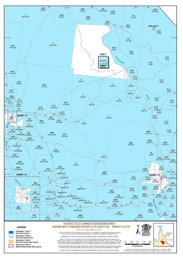
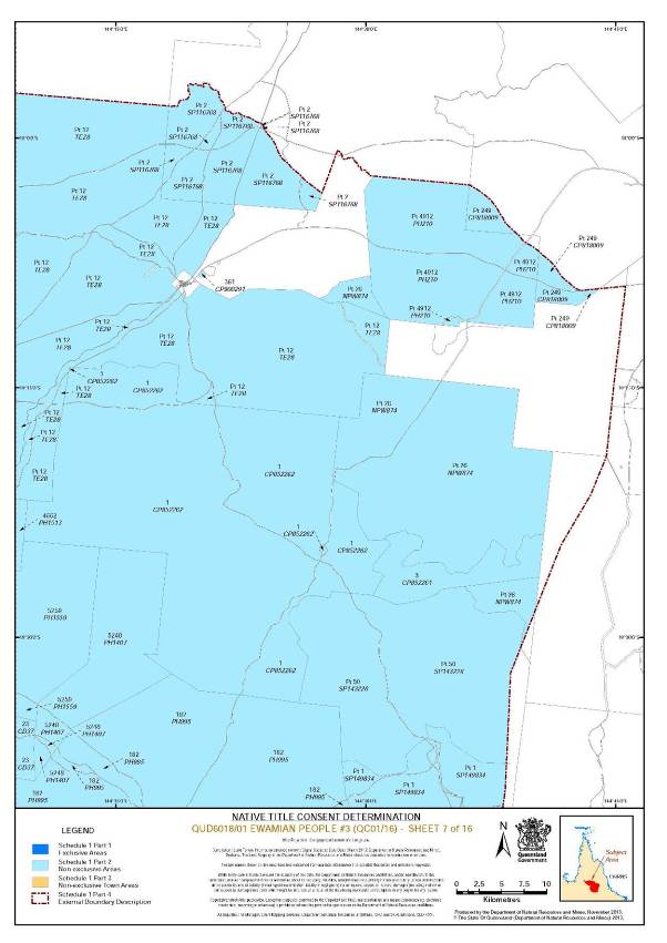
All of the land and waters described in the following table and depicted in dark blue on the determination map:
Area Description (at time of Determination) |
Determination Map Reference |
Lot 1 on Plan SP217455 |
6 |
Lot 10 on Plan ET41 |
13 |
Lot 1 on Plan AP8329 |
14 |
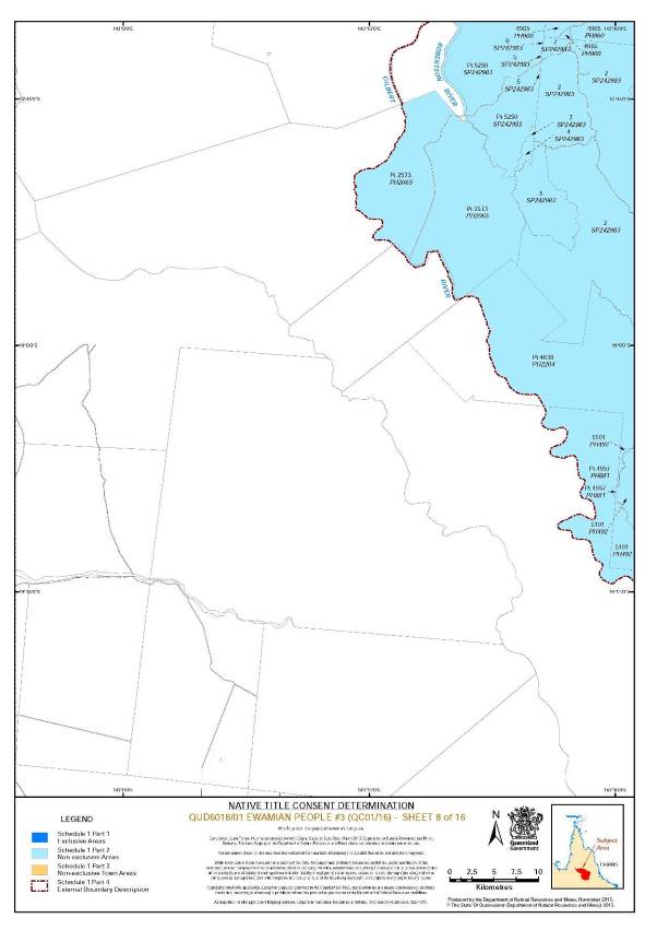
Part 2 – Non-Exclusive Areas
All of the land and waters described in the following table and depicted in light blue on the determination map:
Area Description (at time of Determination) |
Determination Map Reference |
Lot 320 on Plan AP4581 |
9 |
Lot 1 on Plan AP4584 |
10 |
Lot 195 on Plan AP5897 |
6 |
Lot 60 on Plan C4522 |
16 |
Lot 23 on Plan CD37 |
6 and 7 |
Lot 1 on Plan CD836222 |
6 |
That part of Lot 249 on Plan CP818009 to the extent that it is within the external boundary |
7 |
Lot 3 on Plan CP852261 |
7 |
Lot 1 on Plan CP852262 |
7 |
Lot 507 on Plan CP865042 |
3 and 6 |
Lot 361 on Plan CP900291 |
7 |
Lot 1 on Plan EI3 |
5 and 6 |
Lot 28 on Plan EI3 |
5 and 12 |
Lot 5 on Plan EI813291 |
2, 3, 5 and 6 |
That part of Lot 171 on Plan EI835473 to the extent that it is within the external boundary |
1, 2, 3 and 5 |
Lot 24 on Plan ET34 |
11 |
Lot 28 on Plan ET34 |
11 |
That part of Lot 3 on Plan ET42 to the extent that it is within the external boundary |
5 |
That part of Lot 38 on Plan ET813287 to the extent that it is within the external boundary |
4 and 5 |
Lot 16 on Plan GB107 |
16 |
Lot 2 on Plan GB122 |
6 |
Lot 1 on Plan GB123 |
6 |
Lot 14 on Plan GB28 |
6 |
Lot 2 on Plan GB30 |
5 |
Lot 15 on Plan GB30 |
5 and 12 |
That part of Lot 14 on Plan GB813293 to the extent that it is within the external boundary |
5 and 13 |
Lot 9 on Plan GB82 |
16 |
Lot 5 on Plan GB835476 |
6 |
Lot 16 on Plan GB88 |
6 |
That part of Lot 14 on Plan LH8 to the extent that it is within the external boundary |
9 and 10 |
Lot 19 on Plan MPH14035 |
12 |
That part of Lot 26 on Plan NPW874 to the extent that it is within the external boundary and excluding areas formerly described as Lot 1 on Plan TE18 and Lot 1 on Plan TE25 |
7 |
Lot 196 on Plan OL149 |
6 and 16 |
Lot 197 on Plan OL150 |
6 and 9 |
Lot 321 on Plan OL156 |
6 |
Lot 329 on Plan OL158 |
9 |
That part of Lot 330 on Plan OL159 to the extent that it is within the external boundary |
9 |
Lot 340 on Plan OL161 |
9 |
Lot 313 on Plan OL419 |
6 and 14 |
That part of Lot 277 on Plan OL431 to the extent that it is within the external boundary |
9 |
Lot 4533 on Plan PH1199 |
5 and 6 |
Lot 4328 on Plan PH1217 |
9 |
Lot 3420 on Plan PH124 |
6 |
Lot 4616 on Plan PH1245 |
5 |
Lot 4604 on Plan PH1260 |
3 and 6 |
Lot 4661 on Plan PH1280 |
9 |
Lot 2833 on Plan PH1388 |
5 |
Lot 5248 on Plan PH1407 |
7 |
That part of Lot 4665 on Plan PH1417 to the extent that it is within the external boundary |
3 |
Lot 4863 on Plan PH1501 |
6 |
Lot 4662 on Plan PH1513 |
6 and 7 |
Lot 5259 on Plan PH1559 |
6 and 7 |
Lot 5277 on Plan PH1565 |
6 |
That part of Lot 4594 on Plan PH1586 to the extent that it is within the external boundary |
10 |
Lot 5307 on Plan PH1663 |
5 |
Lot 2248 on Plan PH2034 |
1, 2, 4 and 5 |
That part of Lot 2573 on Plan PH2065 to the extent that it is within the external boundary |
8 |
Lot 2460 on Plan PH2068 |
5 and 12 |
Lot 3105 on Plan PH2079 |
5 and 12 |
That part of Lot 4912 on Plan PH210 to the extent that it is within the external boundary |
7 |
Lot 214 on Plan PH2125 |
5 |
That part of Lot 4638 on Plan PH2204 to the extent that it is within the external boundary |
8 and 9 |
Lot 4926 on Plan PH2242 |
6 and 9 |
That part of Lot 5039 on Plan PH245 to the extent that it is within the external boundary |
10 |
Lot 4627 on Plan PH25 |
6 |
Lot 5026 on Plan PH251 |
3 and 6 |
Lot 2824 on Plan PH272 |
5 and 6 |
Lot 5082 on Plan PH418 |
9 |
Lot 5101 on Plan PH492 |
8 and 9 |
Lot 3055 on Plan PH526 |
6, 9 and 10 |
Lot 2034 on Plan PH568 |
5 |
Lot 5119 on Plan PH597 |
5 |
Lot 3075 on Plan PH728 |
6 and 14 |
That part of Lot 235 on Plan PH73 to the extent that it is within the external boundary |
9 and 10 |
Lot 5173 on Plan PH807 |
9 |
Lot 3813 on Plan PH863 |
6 |
Lot 3911 on Plan PH880 |
5 |
That part of Lot 4957 on Plan PH881 to the extent that it is within the external boundary |
8 and 9 |
That part of Lot 4979 on Plan PH9 excluding areas delineated as road on Plan RA433 |
9 |
Lot 4965 on Plan PH960 |
5, 6, 8, 9 and 16 |
Lot 182 on Plan PH995 |
6, 7, 9 and 10 |
That part of Lot 2 on Plan PY26 to the extent that it is within the external boundary |
9 and 10 |
Lot 3 on Plan PY835471 |
9 |
Lot 327 on Plan PY839254 |
6 and 9 |
That part of Lot 4 on Plan SE1 to the extent that it is within the external boundary |
1, 2 and 4 |
Lot 4941 on Plan SP116199 |
6 and 16 |
Lot 5103 on Plan SP116199 |
6 |
That part of Lot 2 on Plan SP116768 to the extent that it is within the external boundary |
7 |
That part of Lot 50 on Plan SP143226 to the extent that it is within the external boundary |
7 |
Lot 50 on Plan SP144125 |
9 |
Lot 52 on Plan SP144125 |
9 |
That part of Lot 1 on Plan SP149834 to the extent that it is within the external boundary excluding areas delineated as road on Plan PH1519 |
7 and 10 |
Lot 2698 on Plan SP166986 |
9 and 10 |
That part of Lot 5 on Plan SP196211 to the extent that it is within the external boundary |
9 |
Lot 5306 on Plan SP201262 |
5, 6 and 16 |
Lot 37 on Plan SP206973 |
4, 5 and 11 |
Lot 53 on Plan SP242966 |
5, 6 and 14 |
Lot 1 on Plan SP242983 |
9 and 16 |
Lot 2 on Plan SP242983 |
8 and 9 |
Lot 3 on Plan SP242983 |
8 |
Lot 4 on Plan SP242983 |
8 |
Lot 5 on Plan SP242983 |
8 |
Lot 6 on Plan SP242983 |
8 |
Lot 7 on Plan SP242983 |
8 |
That part of Lot 5250 on Plan SP242983 to the extent that it is within the external boundary and excluding that part formerly subject to Mining Lease No. 30189 as at 30 April 2001 |
5 and 8 |
That part of Lot 12 on Plan TE28 excluding area described as Mining Claim No. 30032 as at 30 April 2001 |
6 and 7 |
Part of Lot 2 on Plan VR6 to the extent of the external boundary |
9 |
That part of Lot 315 on Plan VR840983 to the extent that it is within the external boundary |
9 |
Save for any waterways forming part of a lot on plan, all waterways, natural lakes, creeks and rivers within the external boundary including but not limited to: Etheridge River, Einasleigh River, Copperfield Creek, Gilbert River, Robertson River, Oak River, Delaney River and Sandy Creek |
3, 4, 5, 6, 8, 9, 10, 11, 14 and 16 |
Part 3 – Non-Exclusive Town Areas
All of the land and waters described in the following table and depicted in tan on the determination map:
Area Description (at time of Determination) |
Determination Map Reference |
Lot 9 on Plan MPH22922 |
15 |
Part 4 – External Boundary Description
The external boundary encompasses land within the following external boundaries which are further described as:
Commencing at the junction of the centrelines of the Gilbert and Einasleigh Rivers (Approximate Easting (minus 2673) Northing 8059480 – Point A)
And bounded thence
In an easterly direction by the centreline of the Einasleigh River to a point where the centerline’s of the Einasleigh and Etheridge Rivers and the Etheridge Shire boundary coincide.
(Approximate Easting 73227 Northing 8050689 – Point B)
And bounded thence
In a northerly, easterly and southeasterly direction by the Local Government Boundary of the Shire of Etheridge to its intersection with the centreline of the Gulf Development Road
(Approximate Easting 258114 Northing 7991231 – Point C)
And bounded thence
In an easterly direction by the centreline of the Gulf Development Road to its intersection with the northern section of the eastern boundary of the Undara Volcanic National Park
(Approximate Easting 26305 Northing 799200 – Point D)
And bounded thence
In a southerly direction by the eastern boundary of the Undara Volcanic National Park for approximately 18900 metres to a point where the National Park boundary turns in a westerly direction
(Approximate Easting 26135 Northing 797320 – Point E)
And bounded thence
In a southerly direction for approximately 4750 metres to a high point mapped as 1010 metres
(Approximate Easting 25960 Northing 796880 – Point F)
And bounded thence
In a southerly direction for approximately 6360 metres to a high point on the Great Dividing Range mapped as the high point of Mount Tabletop at 1002 metres
(Approximate Easting 25650 Northing 796320 – Point G)
And bounded thence
In a south-southwesterly direction for approximately 15200 metres to a high point of 695 metres
(Approximate Easting 25145 Northing 794905 – Point H)
(This high point of 695 is mapped on 1:100,000 Topographic Survey Map Sheet 7861 (Edition 1) St Ronans as approximate Easting 25130 Northing 794870)
And bounded thence
In a southerly direction for approximately 13200 metres to a high point of 555 metres
(Approximate Easting 25100 Northing 793595 – Point I)
And bounded thence
In a southerly direction for approximately 9600 metres to its intersection with the centreline of the Kennedy Development Road
(Approximate Easting 24970 Northing 792665 – Point J)
And bounded thence
In a southerly and southeasterly direction by the centreline of the Kennedy Developmental Road to its intersection with the centreline of the Gregory Developmental Road
(Approximate Easting 242824 Northing 7911003 – Point K)
And bounded thence
In a southeasterly and southerly direction by the centreline of the Kennedy Developmental Road to its intersection with the northern boundary of the Parish of Lyndhurst County of Lyndhurst
(Approximate Easting 232844 Northing 7879157 – Point L)
Being also a point on the centreline of the Kennedy Developmental Road approximately 12 kilometres south of the northern boundary of the Lyndhurst Pastoral Lease (Lot 14 on Plan LH8) and being near to a Stock Route (RC4776)
And bounded thence
In an easterly direction by the northern Boundary of the Parish of Lyndhurst approximately bearing 94 degrees 43 minutes for a distance of approximately 8000 metres (Point M)
And bounded thence
In a southerly direction by the eastern Boundary of the Parish of Lyndhurst approximately bearing 184 degrees 43 minutes for a distance of approximately 16500 metres (Point N)
And bounded thence
In a westerly direction by the southern Boundary of the Parish of Lyndhurst to the boundary of the Parish of Dumbano being also the centreline of the Einasleigh River approximately bearing 274 degrees 43 minutes for a distance of approximately 15500 metres (Point O)
And bounded thence
In a northerly direction by a western Boundary of the Parish of Lyndhurst being the centreline of the Einasleigh River for a distance of approximately 3000 metres (Point P)
And bounded thence
In a westerly direction by the southern Boundary of the Parish of Lyndhurst to the southwestern corner of the Parish of Eastdale approximately bearing 274 degrees 43 minutes for a distance of approximately 8000 metres
(Approximate Easting 215762 Northing 7866977 – Point Q)
And bounded thence
In a southerly direction by a line bearing 184 degrees 43 minutes for a distance of 17000 metres (Point R)
And bounded thence
In a westerly direction by a line to the common corner of the Parishes of Titterstone, Juntala and Blackcap approximately bearing 274 degrees 43 minutes for a distance of approximately 21500 metres (Point S)
And bounded thence
In a westerly direction by the southern boundary of the Parish of Blackcap to the ridge of the Gilbert Range approximately bearing 274 degrees 43 minutes for a distance of approximately 4500 metres (Point T)
And bounded thence
In a northerly direction by the western boundary of the Parish of Blackcap also along the ridge of the Gilbert Range approximately bearing 004 degrees 43 minutes for a distance of approximately 2000 metres (Point U)
And bounded thence
In a westerly direction by the southern boundary of the Parish of Blackcap and a prolongation westerly of the southern boundary of the Parish of Blackcap to the centreline of the Gilbert River (being also to a point approximately 2000 metres northeast and upstream of the intersection of Anning Creek with the Gilbert River) being in all approximately bearing 274 degrees 43 minutes for a distance of approximately 23,410 metres from the ridgeline to the River
(Approximate Easting 165383 Northing 7855939 – Point V)
And bounded thence
In a northerly and westerly direction by the centreline of the Gilbert River to the point of commencement
However the external boundaries of the Ewamian claim exclude Bulleringa National Park (being Lot 4620 on Plan PH1283) located on the northern boundary of this claim.
Note regarding geographic coordinates
Geographic coordinates are in metres. Coordinate points A, B and C and K, L, M, N, O, P, Q, R, S, T, U, V and W are referenced to Australian Geodetic Datum 1984 (AGD84) Australian Map Grid Zone 55. Coordinate points D, E, F, G, H, I and J are referenced to Geocentric Datum of Australia 1994 (GDA94) Grid Zone SE55 – 09 Einasleigh. These coordinates are based on the position of 1:250,000 topographic Maps, BLIN maps sourced from Department of Natural Resources, Qld.
Use of Coordinates and Bearings and Distances
Where coordinates are used within the description to represent cadastral and topographic boundaries or the intersection with such, they are intended as a guide only. As an outcome to the custodians of cadastral and topographic data continuously recalculating the geographic position of their data based on improved survey and data maintenance procedures, it is not possible to accurately define such a position other than by ground survey.
References to existing cadastral boundaries (including Lots, Parishes and County boundaries are meant to refer to those actual boundaries. Where bearings and distances are also provided they are meant as a guide only and are approximate.
References to centrelines of rivers or watercourses refer to a point midway between the banks of the river or watercourse.
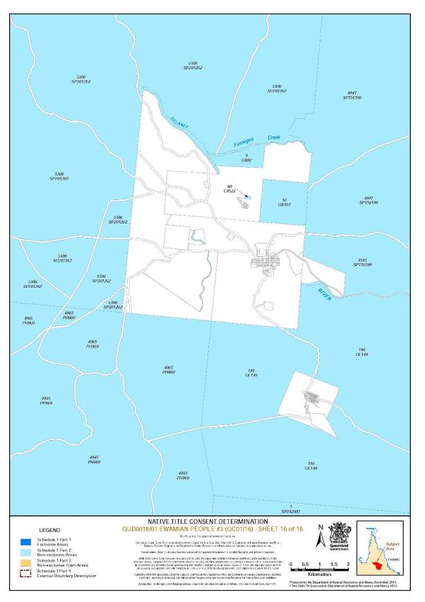
B. Map of Determination Area


Schedule 2 — AREAS NOT FORMING PART OF THE DETERMINATION AREA
The following areas of land and waters are excluded from the Determination Area.
Part A
On the basis that native title has been extinguished and is not claimed, the parties have agreed that the excluded areas include any land or waters on which any permanent improvement consisting of:
(a) a homestead, house, shed or other building;
(b) an airstrip;
(c) a constructed dam or any other constructed stock watering point, bore, turkey nest, squatters’ tank or other water storage facility; or
(d) stock yards and trap yards,
has, at the date of the Determination, been constructed (including any adjacent land the exclusive use of which is reasonably necessary for the enjoyment of the improvement) in accordance with the rights of the lessee under, and within the boundaries of the following pastoral leases:
(i) Preferential Pastoral Holding No. 18/5247 comprising Lot 23 on Plan CD37 and commonly known as Baroota
(ii) Pastoral Holding No. 18/249 comprising Lot 249 on Plan CP818009 and commonly known as St. Ronans
(iii) Term Lease No. 222006 comprising Lot 1 on Plan CP852262 and commonly known as Rosella Plains
(iv) Preferential Pastoral Holding No. 18/5026 comprising Lot 507 on Plan CP865042 and Lot 5026 on Plan PH251 and commonly known as Namarrong
(v) Pastoral Holding No. 18/5522 comprising Lot 1 on Plan EI3 and commonly known as Lane Creek
(vi) Pastoral Holding No. 18/5521 comprising Lot 28 on Plan EI3 and commonly known as Mount Turner
(vii) Term Lease No. 233948 comprising Lot 5 on Plan EI813291 and commonly known as Galloway
(viii) Pastoral Holding No. 18/171 comprising Lot 171 on Plan EI835473 and commonly known as Abingdon Downs
(ix) Preferential Pastoral Holding No. 18/5427 comprising Lot 3 on Plan ET42 and commonly known as Forest Home
(x) Pastoral Holding Run No. 18/5514 comprising Lot 38 on Plan ET813287 and commonly known as Chadshunt
(xi) Pastoral Holding No. 18/3074 comprising Lot 2 on Plan GB122 and commonly known as Rockvale
(xii) Pastoral Holding Run No. 18/5510 comprising Lot 1 on Plan GB123 and commonly known as Kungaree
(xiii) Pastoral Holding No. 18/5365 comprising Lot 14 on Plan GB28 and commonly known as Shrimp Creek
(xiv) Term Lease No. 235617 comprising Lots 2 and 15 on Plan GB30 and commonly known as McDonald Creek
(xv) Preferential Pastoral Holding No. 18/5428 comprising Lot 14 on Plan GB813293 and commonly known as Blancourt
(xvi) Term Lease No. 236603 comprising Lot 5 on Plan GB835476 and commonly known as Haycock
(xvii) Pastoral Holding No. 18/228 comprising Lot 14 on Plan LH8 and commonly known as Lyndhurst
(xviii) Pastoral Holding No. 18/4533 comprising Lot 4533 on Plan PH1199 and commonly known as Ironhurst
(xix) Pastoral Holding No. 18/4328 comprising Lot 4328 on Plan PH1217 and commonly known as Percy River
(xx) Pastoral Holding No. 18/3420 comprising Lot 3420 on Plan PH124 and commonly known as Stockman
(xxi) Pastoral Holding No. 18/4616 comprising Lot 4616 on Plan PH1245 and commonly known as Mount Sircom
(xxii) Pastoral Holding No. 18/4604 comprising Lot 4604 on Plan PH1260 and commonly known as Anglesey
(xxiii) Pastoral Holding No. 18/4661 comprising Lot 4661 on Plan PH1280 and commonly known as Granite Creek
(xxiv) Pastoral Holding No. 18/2833 comprising Lot 2833 on Plan PH1388 and commonly known as Namul
(xxv) Preferential Pastoral Holding No. 18/5248 comprising Lot 5248 on Plan PH1407 and commonly known as Ellendale
(xxvi) Pastoral Holding No. 18/4665 comprising Lot 4665 on Plan PH1417 and commonly known as Eresby
(xxvii) Pastoral Holding No. 18/4662 comprising Lot 4662 on Plan PH1513 and commonly known as Mount Alder
(xxviii) Term Lease No. 236337 comprising Lot 5259 on Plan PH1559 and commonly known as Mount Juliet
(xxix) Pastoral Holding No. 18/5277 comprising Lot 5277 on Plan PH1565 and commonly known as Routh
(xxx) Pastoral Holding No. 22/4594 comprising Lot 4594 on Plan PH1586 and commonly known as Conjuboy
(xxxi) Term Lease No. 234423 comprising Lot 5307 on Plan PH1663 and commonly known as Marquis
(xxxii) Pastoral Holding No. 18/2248 comprising Lot 2248 on Plan PH2034 and commonly known as Kutchera
(xxxiii) Pastoral Holding No. 18/2573 comprising Lot 2573 on Plan PH2065 and commonly known as North Head
(xxxiv) Pastoral Holding No. 18/2460 comprising Lot 2460 on Plan PH2068 and commonly known as Cumberland
(xxxv) Pastoral Holding No. 18/3105 comprising Lot 3105 on Plan PH2079 and commonly known as Cumberland East
(xxxvi) Preferential Pastoral Holding No. 18/4912 comprising Lot 4912 on Plan PH210 and commonly known as Billgolla
(xxxvii) Pastoral Holding No. 18/214 comprising Lot 214 on Plan PH2125 and commonly known as Huonfels
(xxxviii) Pastoral Holding No. 18/4926 comprising Lot 4926 on Plan PH2242 and commonly known as Wirra Wirra
(xxxix) Preferential Pastoral Holding No. 18/5039 comprising Lot 5039 on Plan PH245 and commonly known as Barker
(xl) Pastoral Holding No. 18/4627 comprising Lot 4627 on Plan PH25 and commonly known as Cumbana
(xli) Pastoral Holding No. 18/2824 comprising Lot 2824 on Plan PH272 and commonly known as Sutherland
(xlii) Pastoral Holding No. 18/5082 comprising Lot 5082 on Plan PH418 and commonly known as Ados
(xliii) Pastoral Holding No. 18/5101 comprising Lot 5101 on Plan PH492 and commonly known as Ortona
(xliv) Pastoral Holding No. 18/3055 comprising Lot 3055 on Plan PH526 and commonly known as Narrawa
(xlv) Pastoral Holding No. 18/2034 comprising Lot 2034 on Plan PH568 and commonly known as Midhills
(xlvi) Pastoral Holding No. 18/5119 comprising Lot 5119 on Plan PH597 and commonly known as Delaney
(xlvii) Preferential Pastoral Holding No. 18/3075 comprising Lot 3075 on Plan PH728 and commonly known as Mistletoe
(xlviii) Pastoral Holding No. 18/235 comprising Lot 235 on Plan PH73 and commonly known as Oak Park
(xlix) Pastoral Holding No. 18/5173 comprising Lot 5173 on Plan PH807 and commonly known as Percyvale
(l) Pastoral Holding No. 18/3813 comprising Lot 3813 on Plan PH863 and commonly known as The Dairy Paddock
(li) Pastoral Holding No. 18/3911 comprising Lot 3911 on Plan PH880 and commonly known as Paramount
(lii) Pastoral Holding No. 18/4979 comprising Lot 4979 on Plan PH9 and commonly known as Shoreham
(liii) Pastoral Holding No. 18/4965 comprising Lot 4965 on Plan PH960 and commonly known as Ropewalk
(liv) Pastoral Holding No. 18/182 comprising Lot 182 on Plan PH995 and commonly known as Carpentaria Downs
(lv) Pastoral Holding No. 18/257 comprising Lot 2 on Plan PY26 and commonly known as Yarraman
(lvi) Pastoral Holding No. 18/5198 comprising Lot 3 on Plan PY835471 and commonly known as Bagstowe
(lvii) Term Lease No. 236770 comprising Lot 327 on Plan PY839254 and commonly known as Mopata
(lviii) Pastoral Holding No. 34/248 comprising Lot 4 on Plan SE1 and commonly known as Strathmore
(lix) Pastoral Holding No 18/4941 comprising Lot 4941 on Plan SP116199 and commonly known as Jenkins Creek
(lx) Pastoral Holding No. 18/5103 comprising Lot 5103 on Plan SP116199 and commonly known as Mount Talbot
(lxi) Pastoral Holding No. 9/246 comprising Lot 2 on Plan SP116768 and commonly known as Springfield
(lxii) Term Lease No. 220131 comprising Lot 50 on Plan SP143226 and commonly known as Spring Creek
(lxiii) Pastoral Holding No. 18/3750 comprising Lot 50 on Plan SP144125 and commonly known as Ballynure
(lxiv) Pastoral Holding No. 18/3752 comprising Lot 52 on Plan SP144125 and commonly known as Welfern
(lxv) Term Lease No. 218272 comprising Lot 1 on Plan SP149834 and commonly known as Lynwater
(lxvi) Term Lease No. 220683 comprising Lot 2698 on Plan SP166986 and commonly known as Noel
(lxvii) Pastoral Holding No. 18/5199 comprising Lot 5 on Plan SP196211 and commonly known as Duffer
(lxviii) Term Lease No. 235562 comprising Lot 5306 on Plan SP201262 and commonly known as Rose Glen
(lxix) Pastoral Holding No. 18/5527 comprising Lot 37 on Plan SP206973 and commonly known as Arrongulla
(lxx) Pastoral Holding No. 18/5250 comprising Lot 5250 on Plan SP242983 and commonly known as Townley
(lxxi) Term Lease No. 236580 comprising Lot 1 on Plan SP242983 and commonly known as Robinhood
(lxxii) Term Lease No. 236581 comprising Lots 2, 3, 4, 5, 6 and 7 on Plan SP242983 and commonly known as Howlong
(lxxiii) Term Lease No. 236442 comprising Lot 53 on Plan SP242966 and commonly known as Mount Sullivan
(lxxiv) Pastoral Development Holding No. 18/234 comprising Lot 12 on Plan TE28 and commonly known as Mt Surprise
(lxxv) Pastoral Holding No. 18/5478 comprising Lot 2 on Plan VR6 and commonly known as Perryvale
Part B
The areas in this Part are excluded from the Determination Area on the grounds that at the time at which the native title determination application was made:
i. these areas were the subject of one or more previous exclusive possession acts, as defined in s 23B of the Native Title Act 1993 (Cth), despite the fact that the areas, or parts of them, may have been subject to earlier acts that extinguished native title; and
ii. in relation to the areas in paragraph 1 of this Part, none of ss 47, 47A or 47B of the Native Title Act 1993 (Cth) applied; and
iii. therefore, in accordance with s 61A of the Native Title Act 1993 (Cth), these areas could not be claimed.
Public Works Based Exclusions:
A. Land or waters on which any public work, as defined in s 253 of the Native Title Act 1993 (Cth), is or was constructed, established, or situated, and to which ss 23B(7) and 23C(2) of the Native Title Act 1993 (Cth) and/or s 23B(7) of the Native Title Act 1993 (Cth) and s 21 of the Native Title (Queensland) Act 1993 (Qld) applies, together with any adjacent land or waters in accordance with s 251D of the Native Title Act 1993 (Cth).
Schedule 3 — NATIVE TITLE HOLDERS
The Native Title Holders are the Ewamian People. The Ewamian People are the:
1. biological descendants of the following people:
(a) Norman Clarke;
(b) Harry Plate;
(c) Emily Collins;
(d) Arthur Georgetown;
(e) Pearl Georgetown;
(f) Ethel Georgetown;
(g) Thomas Lacey;
(h) Dora Hudson;
(i) Frank Hudson;
(j) Minnie Willie;
(k) Mick Morris; or
(l) Ben Sloppa aka Ben Mudd; or
2. the adopted persons of Ethel Georgetown, Jim Harvey, Minnie Willie, John Edward Morris and Alfred Morris being persons who have been recruited by adoption as a member of the Ewamian People in accordance with their traditional law and custom.
Schedule 4 — OTHER INTERESTS IN THE DETERMINATION AREA
The nature and extent of the other interests in relation to the Determination Area are the following as they exist as at the date of the determination:
1. The rights and interests of the parties under the following agreements:
(a) Barry Fisher, Katie Georgetown, David Hudson, Noel Lacey and Ronald Richards and the State of Queensland as parties to the Ewamian-Etheridge Townships Indigenous Land Use Agreement registered on 12 March 2004;
(b) Barry Fisher, Katie Georgetown, David Hudson, Noel Lacey and Ronald Richards and the State of Queensland as parties to the Ewamian (Towns of Forsayth, Einasleigh, Georgetown and Mount Surprise) Indigenous Land Use Agreement registered on 1 December 2008;
(c) the agreement between Barry Fisher, David Hudson, Ron Richards and Noel Lacey and the State of Queensland, which was authorised by the native title claim group on 19, 21 and 22 August 2013 and executed by Barry Fisher on 11 November 2013, David Hudson on 15 November 2013, Ron Richards on 14 November 2013 and Noel Lacey on 7 November 2013 and the State of Queensland on 23 and 29 October 2013 (the Ewamian Protected Areas ILUA), and that agreement once it becomes registered as a body corporate ILUA following execution of the agreement by the Registered Native Title Body Corporate;
(d) the agreement between Barry Fisher, David Hudson, Ron Richards and Noel Lacey and Ergon Energy Corporation Limited, which was authorised by the native title claim group on 19, 21 and 22 August 2013 (the Ergon ILUA), and that agreement once it becomes registered as a body corporate ILUA following execution of the agreement by the Registered Native Title Body Corporate;
(e) the agreement between Barry Fisher, Katie Georgetown, David Hudson, Noel Lacey and Ronald Richards and the Etheridge Shire Council as parties to the Ewamian-Etheridge Shire Area ILUA No. 3 (QI 2005/04) registered on 25 February 2008; and
(f) the agreement between Barry Fisher, Katie Georgetown, David Hudson, Noel Lacey and Ronald Richards and the Etheridge Shire Council as parties to the Ewamian-Etheridge Shire Council (Ten Mile Landfill Project) ILUA (QI 2011/051) registered on 6 February 2012.
2. The rights and interests of the holders of any leases, licences, reservations, permits, easements or authorities granted under the Land Act 1994 (Qld), and any relevant regulations or subordinate legislation made under that Act, including the following leases;
(a) Preferential Pastoral Holding No. 18/5247 comprising Lot 23 on Plan CD37 and commonly known as Baroota
(b) Pastoral Holding No. 18/249 comprising Lot 249 on Plan CP818009 and commonly known as St. Ronans
(c) Term Lease No. 222006 comprising Lot 1 on Plan CP852262 and commonly known as Rosella Plains
(d) Preferential Pastoral Holding No. 18/5026 comprising Lot 507 on Plan CP865042 and Lot 5026 on Plan PH251 and commonly known as Namarrong
(e) Pastoral Holding No. 18/5522 comprising Lot 1 on Plan EI3 and commonly known as Lane Creek
(f) Pastoral Holding No. 18/5521 comprising Lot 28 on Plan EI3 and commonly known as Mount Turner
(g) Term Lease No. 233948 comprising Lot 5 on Plan EI813291 and commonly known as Galloway
(h) Pastoral Holding No. 18/171 comprising Lot 171 on Plan EI835473 and commonly known as Abingdon Downs
(i) Preferential Pastoral Holding No. 18/5427 comprising Lot 3 on Plan ET42 and commonly known as Forest Home
(j) Pastoral Holding Run No. 18/5514 comprising Lot 38 on Plan ET813287 and commonly known as Chadshunt
(k) Pastoral Holding No. 18/3074 comprising Lot 2 on Plan GB122 and commonly known as Rockvale
(l) Pastoral Holding Run No. 18/5510 comprising Lot 1 on Plan GB123 and commonly known as Kungaree
(m) Pastoral Holding No. 18/5365 comprising Lot 14 on Plan GB28 and commonly known as Shrimp Creek
(n) Term Lease No. 235617 comprising Lots 2 and 15 on Plan GB30 and commonly known as McDonald Creek
(o) Preferential Pastoral Holding No. 18/5428 comprising Lot 14 on Plan GB813293 and commonly known as Blancourt
(p) Term Lease No. 236603 comprising Lot 5 on Plan GB835476 and commonly known as Haycock
(q) Pastoral Holding No. 18/228 comprising Lot 14 on Plan LH8 and commonly known as Lyndhurst
(r) Pastoral Holding No. 18/4533 comprising Lot 4533 on Plan PH1199 and commonly known as Ironhurst
(s) Pastoral Holding No. 18/4328 comprising Lot 4328 on Plan PH1217 and commonly known as Percy River
(t) Pastoral Holding No. 18/3420 comprising Lot 3420 on Plan PH124 and commonly known as Stockman
(u) Pastoral Holding No. 18/4616 comprising Lot 4616 on Plan PH1245 and commonly known as Mount Sircom
(v) Pastoral Holding No. 18/4604 comprising Lot 4604 on Plan PH1260 and commonly known as Anglesey
(w) Pastoral Holding No. 18/4661 comprising Lot 4661 on Plan PH1280 and commonly known as Granite Creek
(x) Pastoral Holding No. 18/2833 comprising Lot 2833 on Plan PH1388 and commonly known as Namul
(y) Preferential Pastoral Holding No. 18/5248 comprising Lot 5248 on Plan PH1407 and commonly known as Ellendale
(z) Pastoral Holding No. 18/4665 comprising Lot 4665 on Plan PH1417 and commonly known as Eresby
(aa) Pastoral Holding No. 18/4662 comprising Lot 4662 on Plan PH1513 and commonly known as Mount Alder
(bb) Term Lease No. 236337 comprising Lot 5259 on Plan PH1559 and commonly known as Mount Juliet
(cc) Pastoral Holding No. 18/5277 comprising Lot 5277 on Plan PH1565 and commonly known as Routh
(dd) Pastoral Holding No. 22/4594 comprising Lot 4594 on Plan PH1586 and commonly known as Conjuboy
(ee) Term Lease No. 234423 comprising Lot 5307 on Plan PH1663 and commonly known as Marquis
(ff) Pastoral Holding No. 18/2248 comprising Lot 2248 on Plan PH2034 and commonly known as Kutchera
(gg) Pastoral Holding No. 18/2573 comprising Lot 2573 on Plan PH2065 and commonly known as North Head
(hh) Pastoral Holding No. 18/2460 comprising Lot 2460 on Plan PH2068 and commonly known as Cumberland
(ii) Pastoral Holding No. 18/3105 comprising Lot 3105 on Plan PH2079 and commonly known as Cumberland East
(jj) Preferential Pastoral Holding No. 18/4912 comprising Lot 4912 on Plan PH210 and commonly known as Billgolla
(kk) Pastoral Holding No. 18/214 comprising Lot 214 on Plan PH2125 and commonly known as Huonfels
(ll) Pastoral Holding No. 18/4926 comprising Lot 4926 on Plan PH2242 and commonly known as Wirra Wirra
(mm) Preferential Pastoral Holding No. 18/5039 comprising Lot 5039 on Plan PH245 and commonly known as Barker
(nn) Pastoral Holding No. 18/4627 comprising Lot 4627 on Plan PH25 and commonly known as Cumbana
(oo) Pastoral Holding No. 18/2824 comprising Lot 2824 on Plan PH272 and commonly known as Sutherland
(pp) Pastoral Holding No. 18/5082 comprising Lot 5082 on Plan PH418 and commonly known as Ados
(qq) Pastoral Holding No. 18/5101 comprising Lot 5101 on Plan PH492 and commonly known as Ortona
(rr) Pastoral Holding No. 18/3055 comprising Lot 3055 on Plan PH526 and commonly known as Narrawa
(ss) Pastoral Holding No. 18/2034 comprising Lot 2034 on Plan PH568 and commonly known as Midhills
(tt) Pastoral Holding No. 18/5119 comprising Lot 5119 on Plan PH597 and commonly known as Delaney
(uu) Preferential Pastoral Holding No. 18/3075 comprising Lot 3075 on Plan PH728 and commonly known as Mistletoe
(vv) Pastoral Holding No. 18/235 comprising Lot 235 on Plan PH73 and commonly known as Oak Park
(ww) Pastoral Holding No. 18/5173 comprising Lot 5173 on Plan PH807 and commonly known as Percyvale
(xx) Pastoral Holding No. 18/3813 comprising Lot 3813 on Plan PH863 and commonly known as The Dairy Paddock
(yy) Pastoral Holding No. 18/3911 comprising Lot 3911 on Plan PH880 and commonly known as Paramount
(zz) Pastoral Holding No. 18/4979 comprising Lot 4979 on Plan PH9 and commonly known as Shoreham
(aaa) Pastoral Holding No. 18/4965 comprising Lot 4965 on Plan PH960 and commonly known as Ropewalk
(bbb) Pastoral Holding No. 18/182 comprising Lot 182 on Plan PH995 and commonly known as Carpentaria Downs
(ccc) Pastoral Holding No. 18/257 comprising Lot 2 on Plan PY26 and commonly known as Yarraman
(ddd) Pastoral Holding No. 18/5198 comprising Lot 3 on Plan PY835471 and commonly known as Bagstowe
(eee) Term Lease No. 236770 comprising Lot 327 on Plan PY839254 and commonly known as Mopata
(fff) Pastoral Holding No. 34/248 comprising Lot 4 on Plan SE1 and commonly known as Strathmore
(ggg) Pastoral Holding No 18/4941 comprising Lot 4941 on Plan SP116199 and commonly known as Jenkins Creek
(hhh) Pastoral Holding No. 18/5103 comprising Lot 5103 on Plan SP116199 and commonly known as Mount Talbot
(iii) Pastoral Holding No. 9/246 comprising Lot 2 on Plan SP116768 and commonly known as Springfield
(jjj) Term Lease No. 220131 comprising Lot 50 on Plan SP143226 and commonly known as Spring Creek
(kkk) Pastoral Holding No. 18/3750 comprising Lot 50 on Plan SP144125 and commonly known as Ballynure
(lll) Pastoral Holding No. 18/3752 comprising Lot 52 on Plan SP144125 and commonly known as Welfern
(mmm) Term Lease No. 218272 comprising Lot 1 on Plan SP149834 and commonly known as Lynwater
(nnn) Term Lease No. 220683 comprising Lot 2698 on Plan SP166986 and commonly known as Noel
(ooo) Pastoral Holding No. 18/5199 comprising Lot 5 on Plan SP196211 and commonly known as Duffer
(ppp) Term Lease No. 235562 comprising Lot 5306 on Plan SP201262 and commonly known as Rose Glen
(qqq) Pastoral Holding No. 18/5527 comprising Lot 37 on Plan SP206973 and commonly known as Arrongulla
(rrr) Pastoral Holding No. 18/5250 comprising Lot 5250 on Plan SP242983 and commonly known as Townley
(sss) Term Lease No. 236581 comprising Lot 1 on Plan SP242983 and commonly known as Robinhood
(ttt) Term Lease No. 236581 comprising Lots 2, 3, 4, 5, 6 and 7 on Plan SP242983 and commonly known as Howlong
(uuu) Term Lease No. 236442 comprising Lot 53 on Plan SP242966 and commonly known as Mount Sullivan
(vvv) Pastoral Development Holding No. 18/234 comprising Lot 12 on Plan TE28 and commonly known as Mt Surprise
(www) Pastoral Holding No. 18/5478 comprising Lot 2 on Plan VR6 and commonly known as Perryvale.
3. The rights and interests of Telstra Corporation Limited ACN 051 755 566:
(a) as the owner or operator of telecommunications facilities installed within the Determination Area;
(b) created pursuant to the Post and Telegraph Act 1901 (Cth), the Telecommunications Act 1975 (Cth), the Australian Telecommunications Corporation Act 1989 (Cth), the Telecommunications Act 1991 (Cth) and the Telecommunications Act 1997 (Cth), including rights:
(i) to inspect land;
(ii) to install and operate existing and new telecommunication facilities, including cabling, customer terminal sites, customer radio sites and ancillary facilities;
(iii) to alter, remove, replace, maintain, repair and ensure the proper functioning of its existing and any new telecommunications facilities including cabling, customer terminal sites, customer radio sites, and ancillary facilities;
(c) its employees, agents or contractors to access the Determination Area for the purposes of exercising the rights in (i), (ii)and (iii) above in respect of telecommunication facilities in and in the vicinity of the Determination Area;
(d) under any leases, relating to its telecommunications facilities in the Determination Area.
4. The rights and interests of Ergon Energy Corporation Limited ACN 087 646 062:
(a) as the owner and operator of any “Works” as that term is defined in the Electricity Act 1994 (Qld) within the Determination Area;
(b) as a distribution entity and the holder of a distribution authority under the Electricity Act 1994 (Qld)
(c) created under the Electricity Act 1994 (Qld) and the Government Owned Corporations Act 1993 (Qld) including:
(i) rights in relation to any agreement relating to the Determination Area existing or entered into before the date on which these orders are made;
(ii) rights to enter the Determination Area by its employees, agents or contractors to exercise any of the rights and interests referred to in this paragraph; and
(iii) to inspect, maintain and manage any Works in the Determination Area.
5. The rights and interests of the Tablelands Regional Council for that part of the Determination Area within its Local Government Area, including:
(a) its powers, functions, responsibilities and jurisdiction under a Local Government Act;
(b) its rights and interests under any interest in land or waters within the Determination Area including under any lease, licence, access agreement or easement in the Determination Area;
(c) the rights to use, operate, maintain, replace, restore, remediate, repair and otherwise exercise all other rights as the owners and operators of infrastructure, structures, earthworks, access works, facilities and other improvements within the Determination Area;
(d) the rights under any agreements between the Tablelands Regional Council and any third party which relates to land or water in the Determination Area; and
(e) the rights of their employees, agents and contractors to enter upon the Determination Area for the purpose of performing their powers and responsibilities under paragraphs 5(a) to 5(d).
6. The rights and interests of the Etheridge Shire Council including any rights the Etheridge Shire Council, its employees, agents or contractors have;
(a) under its local government jurisdiction and functions under the Local Government Act 2009 (Qld), under the Land Protection (Pests and Stock Route Management) Act 2002 (Qld) and under any other legislation, for that part of the Determination Area within its Local Government Area;
(b) as the:
(i) lessor under any leases which were entered into as at the date of the Determination;
(ii) grantor of any licences or other rights and interests which were granted as at the date of the Determination;
(iii) holder of any estate or interest in land, and as trustee of any reserves, that exist in the Determination Area as at the date of the Determination;
(iv) the grantee of any easements under the Land Act 1994 (Qld) which were granted as at the date of the Determination;
(c) as the owner and operator of infrastructure, facilities and other improvements located in the Determination Area as at the date of the Determination, including but not limited to:
(i) dedicated roads operated by the Etheridge Shire Council;
(ii) gravel pits operated by the Etheridge Shire Council;
(iii) undedicated but constructed roads except for those not operated by the Etheridge Shire Council;
(iv) water pipelines and other water supply infrastructure;
(v) drainage facilities; and
(vi) cemetery and cemetery related facilities; and
(d) to enter the land described in paragraphs 6(a) to 6(c) to:
(i) exercise any of the rights and interests referred to in paragraphs 6(a) to 6(c) of Schedule 4;
(ii) inspect, maintain and repair the infrastructure, facilities and other improvements referred to in paragraph 6(c) of Schedule 4; and
(iii) undertake operational activities in its capacity as a local government such as feral animal control, weed control, erosion control, waste management and fire management.
7. The rights and interests of the State of Queensland or any other person existing by reason of the force and operation of the laws of the State of Queensland, including those existing by reason of the following legislation or any regulation, statutory instrument, declaration, plan, authority, permit, lease or licence made, granted, issued or entered into under that legislation:
(a) the Land Act 1994 (Qld);
(b) the Nature Conservation Act 1992 (Qld);
(c) the Forestry Act 1959 (Qld);
(d) the Water Act 2000 (Qld);
(e) the Petroleum Act 1923 (Qld) or Petroleum and Gas Act 2004 (Qld);
(f) the Mineral Resources Act 1989 (Qld);
(g) the Integrated Planning Act 1997 (Qld) or Sustainable Planning Act 2009 (Qld);
(h) the Transport Infrastructure Act 1994 (Qld); and
(i) the Fire and Rescue Service Act 1990 (Qld) or Ambulance Service Act 1991 (Qld);
8. Any other rights and interests:
(a) held by the State of Queensland or Commonwealth of Australia; or
(b) existing by reason of the force and operation of the Laws of the State or the Commonwealth.
Note: Entry of orders is dealt with in Rule 39.32 of the Federal Court Rules 2011.
QUEENSLAND DISTRICT REGISTRY |
|
GENERAL DIVISION |
QUD 6009 of 1999 |
BETWEEN: |
BARRY FISHER, DAVID HUDSON AND NOEL LACEY ON BEHALF OF THE EWAMIAN PEOPLE #2 Applicant |
AND: |
STATE OF QUEENSLAND First Respondent ETHERIDGE SHIRE COUNCIL Second Respondent ERGON ENERGY CORPORATION LIMITED Third Respondent TELSTRA CORPORATION LIMITED Fourth Respondent KATHLEEN MAY MCFARLANE, ROBERT WALTER MCFARLANE, JEAN STODDART AND ROBERT BRIAN STODDART Fifth - Eighth Various Pastoral Respondents |
IN THE FEDERAL COURT OF AUSTRALIA |
|
QUEENSLAND DISTRICT REGISTRY |
|
GENERAL DIVISION |
QUD 6018 of 2001 |
BETWEEN: |
BARRY FISHER, DAVID HUDSON AND NOEL LACEY ON BEHALF OF THE EWAMIAN PEOPLE #3 Applicant |
AND: |
STATE OF QUEENSLAND First Respondent ETHERIDGE SHIRE COUNCIL Second Respondent TABLELANDS REGIONAL COUNCIL Third Respondent ERGON ENERGY CORPORATION LIMITED Fourth Respondent TELSTRA CORPORATION LIMITED Fifth Respondent ALLYN JOHN ZABEL Sixth Respondent JENNIANN ALEXANDER, BRIAN ALEXANDER, ALUSA PTY LTD, ALLEN JOHN BETHEL, ATHOL R BETHEL, CARMEL MAREE BETHEL, LORNA MAUREEN BETHEL, RALPH JAMES BETHEL, VICTOR GERALD COLLINS, DON ARTHUR CONDON, LEANNE MARGARET CONDON, LLOYD CURLEY, LORNA MARY DIXON, THOMAS MALCOLM DIXON, LORRAINE EDITH EVERINGHAM, WILLIAM WINSTON EVERINGHAM, ROBERT DALTON FRENCH, BRIAN FURBER, MICHAEL LYLE FURBER, STEWART GEIGER, EDWARD JAMES HUGHES, EDWARD JOHN HUGHES, PATRICIA ANN KIRO AND MR PHILLIP JAMES CRANWELL AS PERSONAL REPRESENTATIVE OF WILLIAM THOMAS ADAMSON (DECEASED), MALCOLM NORMAN LARSEN, LINLEY V LETHBRIDGE, LUXMORE G LETHBRIDGE, EDWARD STEPHEN LOUDON, LYNETTE MARGARET MAITLAND, PERCY WILLIAM GEORGE MAITLAND, BRIAN DESMOND MARRINAN, JOAN EDNA MINTRIM, LANCE WILLIAM MINTRIM, NACRE PTY LTD AS TRUSTEE AND DOUGLAS STANLEY KEOUGH, VALERIE E NORRIS, RONALD N NORRIS, LORRAINE MAY PEDRACINI, BEVERLEY ISABELL PEDRACINI, DARREN JOSEPH PEDRACINI, JOSEPH BARRY PEDRACINI, REGINALD JOSEPH PEDRACINI, LAWRENCE FRANCIS PRIOR, GEORGE EDWARD RYAN, JANET CLAIRE RYAN, LEONARD WILLIAM RYAN, IAN WILLIAM TINCKNELL, ALLYN ZABEL AS EXECUTOR OF THE ESTATE OF DAWN HOOLIHAN (DECEASED) Seventh – Fifty-First Various Pastoral Respondents |
JUDGE: |
LOGAN J |
DATE: |
26 NOVEMBER 2013 |
PLACE: |
GEORGETOWN |
REASONS FOR JUDGMENT
1 Reasons for judgement in respect of consent determination in a native title application can have about them a similarity of language that might lead the uninformed to think that there is something glib or routine about them. Nothing could be further from the truth. All that is routine is the application of by now well settled principles the correctness of which, once explained in earlier authority, is not enhanced by paraphrasing. What is never routine are the customs, usages and affinity for particular land and the remarkable cherishing and preservation of them over so many generations, notwithstanding the impact of European settlement, which enables an Aboriginal people, in this case the Ewamian People, represented by the applicant to establish native title. Also never routine is the opportunity offered by a determination, made with the agreement of all interested parties and by a public exercise of the judicial power of the Commonwealth, to evidence that objectives specified by the Commonwealth Parliament in the Native Title Act 1993 (Cth) (the Act) are being met in practice.
2 The applications that are the subject of these proceedings, QUD6009/1999, “Ewamian People # 2” and QUD6018/2001, “Ewamian People # 3”, are for the determination of native title rights and interests under the Act in favour of the native title holders of land and waters within the bounds of the land described in the Schedules to the proposed determinations.
3 The State of Queensland, Tablelands Regional Council, Etheridge Shire Council and various pastoralists are respondent parties to the applications.
4 The applications are being heard together as they are geographically proximate and entail consideration of materially the same anthropological evidence concerning the Ewamian People. The applicants seek a determination of native title on behalf of the Ewamian People over various lands and waters in the savannah area of Queensland west of the Great Dividing Range, including the Townships of Georgetown, Forsyth, Mt Surprise and Einasleigh.
5 The properties over which the proposed consent determinations will be granted are described in more detail in the maps contained in the various Schedules to the determinations in each application. As those maps reveal, the Ewamian # 2 claim is a ‘lot specific’ claim in the sense that a number of discrete allotments defined by lot on plan descriptions covering a total approximate area of 186.1159 sq km comprise the claim. The Ewamian # 3 claim is a broad based country claim, subject to certain stipulated exceptions, covering an area of 28, 485.2912 sq km.
6 One of the Commonwealth Parliament’s objectives in respect of the Act is the resolution of claims for the recognition of native title by agreement. That objective is borne out in s 87 of the Act by the Native Title Amendment Act 2009 (Cth).
7 Like many such claims, these claims have been long in their gestation. In earlier judgements in cases like the present, for example last year in Hoolihan on behalf of the Gugu Badhun People # 2 v State of Queensland [2012] FCA 800 and Archer on behalf of the Djungan People #1 v State of Queensland [2012] FCA 801, I have observed that native title claims which linger unresolved on a court list are an affront to our system of justice. I related in those cases how Parliament’s objective of consensual resolution had been met. The statements which I then made are just as applicable to this case. In this case, too, the achievement of Parliament’s objective would not have been possible without much hard and dedicated work by experienced legal advisers, the responsible actions of the parties guided by their advisers and, especially latterly, intensive case management, particularly by the Court’s registrars. I commend the parties and the legal practitioners involved in the cases being heard today for the work latterly undertaken in bringing them to final, consensual resolution.
8 In the aftermath of Wik Peoples v Queensland (1996) 187 CLR 1, the Executive Government of the Commonwealth made provision for legal assistance to be provided to pastoralists in relation to native title claims via a scheme known as the Native Title Respondent Funding Scheme. Over the now five years during which I have been responsible for the management of the list of native title cases in this region, and as I have stated in other determinations, I have directly observed how, in combination with responsible legal representation of applicants, via the North Queensland Land Council, of the State, via the Crown Solicitor and of other respondents, this legal assistance to pastoralists has repeatedly and beneficially contributed to the administration of justice and thus to Parliament’s goal of national reconciliation in this important area of the Court’s jurisdiction. This legal assistance to pastoralists was terminated with effect at the end of 2012 by the then Commonwealth Executive Government. The current Executive Government has since announced the restoration of that funding.
9 Such value judgments are for the Executive Government of the day to make. What I can say again, and have in earlier determinations stated, based on direct experience, is that the addressing of the hitherto “unacceptably long time” for the resolution of native title cases and the recent experience of “faster and better claim resolution” to which the then Attorney General made reference last year (Echoes of Mabo: AIATSIS Native Title Conference, 6 June 2012, Speech by the Honourable Nicola Roxon MP, Attorney-General, http://www.attorneygeneral.gov.au/Speeches/Pages/2012/Second% 20Quarter/6-June-2012---Echoes-of-Mabo---AIATSIS-Native-Title-Conference.aspx Accessed 7 December 2012) is best achieved by a combination of responsible legal representation of all interested parties and intensive case management and proactive, targeted use of alternative dispute resolution where appropriate by the judges and registrars of this Court. As I noted this year in Dodd on behalf of the Gudjala People Core Country Claim #1 v State of Queensland (No 2) [2013] FCA 787 at [4]:
[T]o my direct observation in court in respect of the regions of the State for which I have had case management responsibility, the collective representation of pastoral respondents enabled by that scheme greatly facilitated the responsible, consensual resolution of native title claims and removed much of the angst such claims might otherwise have occasioned such respondents.
10 Further, while it is for the Executive Government to propose and for Parliament to approve particular appropriations of public money, where that public money is directed to the provision of legal assistance to a party to a native title proceeding, be that party applicant, pastoralist or otherwise, so as to assist in the achievement of the objectives of the Act, it is for the judicial branch to ensure that the conduct of parties so assisted entails the responsible use of the benefit so conferred. That is a subject given regular attention by the Court via the intensive case management of native title claims. In this regard and truly there are secular inspirations to be drawn from scripture: “From those to whom much is given, much is expected” (Gospel of St Luke, Ch. 12, v 48, condensed and rendered in modern form).
11 In Baker on behalf of the Muluridji People v State of Queensland [2011] FCA 1432 (Muluridji) I adopted observations made in King v Northern Territory of Australia [2011] FCA 582 (King) per Mansfield J. His Honour made a number of observations about the preamble to the Act. I am in complete agreement not only with the substance of his Honour’s observations in King but also with the manner in which he expressed them. They are exactly apposite in the present proceedings also. As I observed in Muluridji, I propose therefore to adopt them as my own in these reasons for judgment without further attribution.
12 The preamble to the Act recognised, on behalf of all people of Australia, that the Aboriginal peoples of Australia inhabited this country for many years prior to European settlement, and that the Aboriginal peoples had been progressively dispossessed of their lands. It recorded that, by the overwhelming vote of the people of Australia, the Constitution was amended to enable laws such as the Act to be passed, to facilitate the recognition by our shared legal system of the native title rights and interests in their land. This is an occasion when the Court is to make orders declaring that the groups of Aboriginal persons in the current applications have always been the traditional owners of the land. By the Court’s orders, the Australian community collectively recognises that status. It is important to emphasise that the Court’s orders do not grant that status. The Court is declaring that it exists and has always existed at least since European settlement.
13 The applicants have filed the following documents relevant to the consent determinations in the applications:
(a) Affidavit of Mr Martin Doré, filed on 14 October 2013, annexing:
(i) the Certificate of Incorporation of a Registered Native Title Body Corporate – the Tatampi Puranga Aboriginal Corporation ICN 7950 (the Corporation); and
(ii) the Rules of the Corporation.
(b) Outline of Submissions on behalf of the Applicant in support of the Corporation to be the Prescribed Body Corporate under s 57 of the Act, filed on 28 October 2013;
(c) Affidavit of Mr Martin Doré, filed on 29 October 2013;
(d) Affidavit of Mr Martin Doré, filed on 30 October 2013, annexing:
(i) An amended copy of the Rules of the Corporation;
(e) Notice of Nomination and Consent of the Prescribed Body Corporate, filed on 12 November 2013;
(f) Affidavit of Mr Martin Doré, filed on 5 November 2013, annexing:
(i) the “Connection Report”, prepared by Dr Sandra Pannell dated February 2004 (Pannell 2004);
(g) Affidavit of Mr Martin Doré, filed on 5 November 2013, annexing:
(i) the “Executive Summary of Connection Materials”, prepared by Dr Sandra Pannell, dated June 2012 (Pannell Exec Summary 2012);
(h) Outline of Submissions on behalf of the Applicant in support of the proposed consent determinations, filed on 5 November 2013;
(i) Agreement under s 87 of the Act and draft consent determination orders filed by the State of Queensland on 26 August 2013 (QUD6009/99); and
(j) Agreement under s 87 of the Act and draft consent determination orders filed by the State of Queensland on 26 August 2013 (QUD6018/01).
SECTION 87 OF THE ACT
14 Section 87 of the Act provides that the Court may make a determination of native title by consent over an area covered by a native title application and without holding a hearing where:
(a) The period specified in the notice given under s 66 of the Act has ended (s 87(1));
(b) There is an agreement between the parties on the terms of an order of the Court in relation to the proceedings (s 87(1)(a)(i));
(c) The terms of the agreement are in writing and are signed by or on behalf of the parties and filed with the Court (s 87(1)(b));
(d) The Court is satisfied that an order in, or consistent with, those terms would be within its power (s 87(1)(c)); and
(e) Having satisfied the criteria relevantly detailed, the Court considers the making of orders as it appears to the Court to be appropriate to do so pursuant to s 87(1A) of the Act. The Court may make a determination in accordance with s 87(2), as is relevant to these proceedings.
15 The focus of the Court in considering whether the orders sought are appropriate under s 87(1) and s 87(2) is on the making of the agreement by the parties. In Muluridji I cited observations of North J in Lovett on behalf of the Gunditjmara People v State of Victoria [2007] FCA 474. Such remarks are apt to be adopted in this case. His Honour stated:
[36] … The Act is designed to encourage parties to take responsibility for resolving proceeding without the need for litigation. Section 87 must be construed in this context. The power must be exercised flexibly and with regard to the purpose for which the section is designed.
[37] In this context, when the Court is examining the appropriateness of an agreement, it is not required to examine whether the agreement is grounded on a factual basis which would satisfy the Court at a hearing of the application. The primary consideration of the Court is to determine whether there is an agreement and whether it was freely entered into on an informed basis: Nangkiriny v State of Western Australia (2002) 117 FCR 6; [2002] FCA 660, Ward v State of Western Australia [2006] FCA 1848. Insofar as this latter consideration applies to a State party, it will require the Court to be satisfied that the State party has taken steps to satisfy itself that there is a credible basis for an application: Munn v Queensland (2001) 115 FCR 109; [2001] FCA 1229.
16 As such, the Court is not required to make its own inquiry of the merits of the applicants’ claim to be satisfied that the orders sought are supportable and in accordance with the law: Cox on behalf of the Yungngora People v State of Western Australia [2007] FCA 588 at [3]. The Court may consider such evidence to determine whether the State is acting in good faith and rationally: Munn (for and on behalf of the Gunggari People) v Queensland (2001) 115 FCR 109 at [29]-[30].
17 In Smith v State of Western Australia (2000) 104 FCR 494 at [38], Madgwick J stated:
[38] … State governments are necessarily obliged to subject claims for native title over lands and waters owned and occupied by the State and State agencies, to scrutiny just as careful as the community would expect in relation to claims by non-Aborigines to significant rights over such land.
SECTION 94A OF THE ACT
18 Section 94A of the Act requires that a native title determination order must satisfy the requirements of s 225 of the Act. Section 225 provides:
A determination of native title is a determination whether or not native title exists in relation to a particular area (the determination area) of land or waters and, if it does exist, a determination of:
(a) who the persons, or each group of persons, holding the common or group rights comprising the native title are; and
(b) the nature and extent of the native title rights and interests in relation to the determination area; and
(c) the nature and extent of any other interests in relation to the determination area; and
(d) the relationship between the rights and interests in paragraphs (b) and (c) (taking into account the effect of this Act); and
(e) to the extent that the land or waters in the determination area are not covered by a non-exclusive agricultural lease or a non-exclusive pastoral lease -- whether the native title rights and interests confer possession, occupation, use and enjoyment of that land or waters on the native title holders to the exclusion of all others.
Note: The determination may deal with the matters in paragraphs (c) and (d) by referring to a particular kind or particular kinds of non-native title interests.
[emphasis in original]
19 Section 223(1) of the Act defines ‘native title’ and ‘native title rights and interests’ as:
(1) … the communal, group or individual rights and interests of Aboriginal peoples or Torres Strait Islanders in relation to land or waters, where:
(a) the rights and interests are possessed under the traditional laws acknowledged, and the traditional customs observed, by Aboriginal peoples or Torres Strait Islanders; and
(b) the Aboriginal peoples or Torres Strait Islanders, by those laws and customs, have a connection with the land or waters; and
(c) the rights and interests are recognised by the common law of Australia.
20 In Members of the Yorta Yorta Aboriginal Community v State of Victoria (2002) 214 CLR 422, Gleeson CJ, Gummow and Hayne JJ (with McHugh J agreeing) stated the relevant principles with respect to s 223 of the Act, at [46] to [55] and [80] to [83]:
(a) A traditional law or custom which is the source of native title rights and interests is one which has been passed from generation to generation of a society, usually by word of mouth and common practice.
(b) The origins of the law or custom from which native title rights and interests stem must be found in the normative rules of the relevant Aboriginal or Torres Strait Islander society that existed before the assertion of sovereignty by the British Crown – it is only those rules that are “traditional” laws and customs.
(c) That normative system must have a continuous existence and vitality since sovereignty.
(d) If that society ceases to exist as a group which acknowledges and observes those pre-sovereignty laws and customs, those laws and customs cease to have continued existence and vitality.
(e) Only native title rights or interests that existed at the time of the change in sovereignty will be recognised. However, some change to, or adaptation of, traditional laws or customs or some interruption in the enjoyment or exercise of native title rights or interests in the period between the Crown asserting sovereignty and the present will not necessarily be fatal to a native title claim.
(f) In many cases, perhaps most, claimants will invite the Court to infer, from evidence led at trial, the content of traditional laws and customs at times earlier than those described in the evidence.
21 Further, there is authority of this Court, exercising appellate jurisdiction, which lends itself to a determinative conclusion that physical presence is not a necessary requirement for continuing connection. See, for example, Moses v State of Western Australia [2007] FCAFC 78 at [306] per Moore, North and Mansfield JJ.
APPLICATION OF SECTION 223 AND SECTION 225 TO THE EWAMIAN SOCIETY
22 The evidence establishes that the Ewamian People used and occupied the claim area covered by the applications at the time of first European contact and, by inference, prior to 26 January 1788 (the date of legal Sovereignty).
23 The name, ‘Ewamian’, is derived from a customary belief that other spirit beings, called Quinkan or Ewamian (‘little people’), also known as ‘spirit dogs’ and ‘feather-foot people’, jointly inhabit Ewamian country, with whom the Ewamian People are required to communicate when engaging in activities on country (Pannell 2004: pp 82-83, 94). Identification as part of the Ewamian People, or ‘Georgetown Mob’, is principally founded upon a link to one or more ancestors who are identified as having a connection to lands and waters in Ewamian country. Ewamian also refers to a way of speaking.
24 While the traditional laws and customs of the Ewamian People bear similarities to those of neighbouring Aboriginal groups, such as Tagalaka and Wakamin, the Ewamian People recognise themselves as distinct from their neighbours, see generally: Parnell 2004: Chapter 3.
25 The earliest known reference to the identity of the Aboriginal inhabitants of Ewamian country traces back a letter dated 15 December 1882, from explorer Edward Palmer to A.W. Howitt. In that letter, which formed part of a series of correspondence which culminated in an article published in the Journal of the Royal Anthropological Institute of Great Britain and Ireland in 1884 titled ‘Australian Tribes’, Palmer offered descriptions of aboriginal occupiers of parts of lands now claimed in the proposed consent determinations.
26 Anthropological records and linguistic literature from the twentieth century establish considerable evidence that antecedents of the Ewamian claimant group expressed a physical connection to the claim area through birth and occupation. The unpublished works of anthropologists Lauriston Sharp and Norman Tindale, and the socio-linguist, Peter Sutton are crucial sources in this regard. Archaeological research from the twentieth century has also uncovered many examples of Aboriginal rock art, such as ochred hand stencils, located in various caves and rock shelters in the claim area.
27 Further evidence, in the form of oral histories of the claimants, indicates that the transfer of Ewamian cultural knowledge has continued throughout the 20th Century. The Ewamian People have maintained a physical connection, as well as an ongoing cultural and spiritual connection to their lands.
28 The material provides that the Ewamian People have an identity and a connection to the land through the application of normative rules associated with dreaming stories and significant places. Such normative rules include laws governing group membership, a kinship system of land tenure, customary burial practices for deceased individuals and rules governing the use of flora, fauna and other natural resources, see: Pannell Exec Summary 2012: pp 33-42.
29 Further, the material supports the intergenerational transfer of those laws and customs, both orally and by demonstration, and support for the inference that they, and the rights and interests possessed by them, originated in a pre-Sovereignty Ewamian society.
30 It is also apparent that while there has been some adaptation of traditional use and enjoyment of the land as a result of sustained European settlement, the changes have not affected the laws and customs of the Ewamian People to the extent where those laws and customs are no longer observed.
31 Accordingly, it is appropriate to make the proposed orders which recognise:
(a) That the claim group comprises a society united in and by their acknowledgement and observance of a body of accepted traditional laws and customs;
(b) That the present day body of accepted laws and customs of the society in essence is the same body of laws and customs acknowledged and observed by the ancestors or members of the society adapted to modern circumstances;
(c) That the acknowledgement and observance of those laws and customs has continued substantially uninterrupted by each generation since sovereignty, and that the society has continued to exist throughout that period as a body united in and by its acknowledgement and observance of those laws and customs; and
(d) That the claim group still possesses rights and interests under the traditional laws acknowledged and the traditional customs observed by them, and that those laws and customs give them a connection to the land.
THE APPLICATION OF SECTION 87 TO THE WESTERN YALANJI PEOPLE CLAIMS
32 The requirements of s 87 of the Act have been satisfied in the present case. In particular:
(a) The period specified in the notice given under s 66 ended on 20 June 2001 for QUD6009/1999, and 27 February 2002 for QUD6018/2001;
(b) The parties have reached agreement as to the terms of determinations of native title (s 87(1)(a)(i));
(c) The parties have recorded their agreement in short minutes of consent (s 87(1)(b));
(d) An order in terms of or consistent with the short minutes of consent would be within the Court’s power (s 87(1)(c)) because:
(i) The applications are valid and were made in accordance with s 61 of the Act; and
(ii) The applications are for a determination of native title in relation to an area for which there is no approved determination of native title (s 13(1)(a)).
The short minutes comply with s 94A and s 225 of the Act (s 87(1)(c)); and
(e) It is appropriate that the Court make the orders sought because:
(i) All parties are legally represented;
(ii) It is consistent with objects in the Act that issues and disputes concerning native title are resolved by mediation;
(iii) The State of Queensland has taken a real interest in negotiating the consent determination. In participating in these negotiations, the State of Queensland, acting on behalf of the general community, having had regard to the Act’s requirements and having conducted a thorough assessment process, is satisfied that the determination is justified in all the circumstances;
(iv) The connection material filed by the applicants satisfies s 223 of the Act and supports the making of the proposed determinations;
(v) The requirements of ss 56, 94A and 225 of the Act are satisfied; and
(vi) The proposed determinations are unambiguous and certain as to the rights declared.
SATISFYING SECTION 57 OF THE ACT
33 Under s 55 of the Act, the Court is required, either at the time of the Determination or as soon as practicable after it, to make such determinations as are required by s 56 and s 57 of the Act. They respectively relate to holding the native title on trust or otherwise and if not held on trust, the non-trust functions of the prescribed body corporate.
34 As to the proposed determinations, Mr Doré has deposed in his affidavit sworn and filed on 29 October 2013, the native title is not to be held on trust. It provides for an Aboriginal corporation, the Tatampi Puranga Aboriginal Corporation, to be the prescribed body corporate under s 57 of the Act. The Tatampi Puranga Aboriginal Corporation was registered on 8 October 2013 under the Corporations (Aboriginal and Torres Strait Islanders) Act 2006 (Cth). It will perform the functions mentioned in s 57(3) of the Act.
35 The Court notes that Mr Doré has further filed on 12 November 2013 a Notice of Nomination and Consent of Tatampi Puranga Aboriginal Corporation as the Prescribed Body Corporate, which satisfies the requirements of s 57(2) of the Act.
36 The Tatampi Puranga Aboriginal Corporation satisfies the requirements of the Native Title (Prescribed Bodies Corporate) Regulations 1999 (Cth) because:
(a) it is an Aboriginal and Torres Strait Islander Corporation: reg 4(1));
(b) its purpose, as set out in its Rules of the Corporation, satisfy reg 4(2)(b);
(c) the eligibility requirements of the Rules of the Corporation operate to ensure that all members of the corporation at the time of the determination are included or proposed to be included in the determinations as persons who have native title rights and interests in relation to the determination area: reg 4(2)(b).
37 Finally, and at the risk of repetition, it needs to be understood that agreements of the kind that have brought about today’s hearing and determinations do not just happen. They involve co-operation by all of the parties in the administration of justice, careful attention by them and their advisers to the requirements of the Act in relation to the proof of native title, related effort in the gathering of relevant evidence and the ready making of concessions as to whether on the evidence native title can be proved. They also involve the regular review by the Court at regional directions hearings, and in the intervals in between by the Court’s registrars, to ensure that an application is both prosecuted with due diligence by an applicant and not unreasonably delayed by a respondent in its progress towards a hearing like today or, if needs be, a contested hearing. Ensuring that is important in any litigation but is especially so in a proceeding under the Act which serves a wider public interest recognised in the preamble and which, through the allocation of judicial and other court resources and via the provision of various forms of legal aid, involves a considerable investment of public money.
38 For the reasons given, the Determinations are now made.
I certify that the preceding thirty-eight (38) numbered paragraphs are a true copy of the Reasons for Judgment herein of the Honourable Justice Logan. |
Associate:

