
FEDERAL COURT OF AUSTRALIA
Joseph on behalf of the Tableland Yidinji People #3 v State of Queensland
[2013] FCA 280
IN THE FEDERAL COURT OF AUSTRALIA | |
DATE OF ORDER: | |
WHERE MADE: |
THE COURT ORDERS THAT:
BEING SATISFIED that an order in the terms set out below is within the power of the Court, and it appearing appropriate to the Court to do so, pursuant to s 87 of the Native Title Act 1993 (Cth)
BY CONSENT THE COURT ORDERS THAT:
1. There be a determination of native title in the terms set out below (“the determination”).
2. The determination will take effect upon the agreements referred to in paragraph 1 of Schedule 4 being registered on the Register of Indigenous Land Use Agreements.
3. In the event that the agreements referred to in paragraph 2 are not registered on the Register of Indigenous Land Use Agreements within six (6) months of the date of this order or such later time as this Court may order, the matter is to be listed for further directions.
4. Each party to the proceedings is to bear its own costs.
BY CONSENT THE COURT DETERMINES THAT:
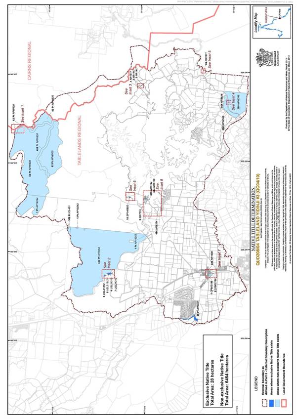
5. The Determination Area is the land and waters described in Schedule 1, and depicted on the map attached to Schedule 1 (“the Determination Area”).
6. Native title exists in relation to that part of the Determination Area described in Part 1 and Part 2 of Schedule 1.
7. The native title is held by the Tableland Yidinji People described in Schedule 3 (“the native title holders”).
8. Subject to paragraphs 10, 11 and 12 below the nature and extent of the native title rights and interests in relation to the land and waters described in Part 1 of Schedule 1 are:
(a) other than in relation to Water, the rights to possession, occupation, use and enjoyment of the area to the exclusion of all others; and
(b) in relation to Water, the non-exclusive rights to:
(i) hunt, fish and gather from the Water of the area;
(ii) take and use the Natural Resources of the Water in the area; and
(iii) take and use the Water of the area,
for personal, domestic and non-commercial communal purposes.
9. Subject to paragraphs 10, 11 and 12 below the nature and extent of the native title rights and interests in relation to the land and waters described in Part 2 of Schedule 1 are the non-exclusive rights to:
(a) access, be present on, move about on and travel over the area;
(b) camp, and for that purpose, build temporary shelters;
(c) hunt, fish and gather on the land and waters of the area for personal, domestic and non-commercial communal purposes;
(d) take, use and share Natural Resources from the land and waters of the area for personal, domestic and non-commercial communal purposes;
(e) take and use the Water of the area for personal, domestic and non-commercial communal purposes;
(f) light fires on the area for domestic purposes including cooking, but not for the purpose of hunting or clearing vegetation;
(g) conduct ceremonies on the area;
(h) teach on the area the physical and spiritual attributes of the area;
(i) maintain places of importance and areas of significance to the native title holders under their traditional laws and customs and protect those places and areas from physical harm; and
(j) be buried and bury native title holders within the area.
10. The native title rights and interests are subject to and exercisable in accordance with:
(a) the Laws of the State and the Commonwealth; and
(b) the traditional laws acknowledged and traditional customs observed by the native title holders.
11. The native title rights and interests referred to in paragraphs 8(b) and 9 do not confer possession, occupation, use or enjoyment to the exclusion of all others.
12. There are no native title rights in or in relation to minerals as defined by the Mineral Resources Act 1989 (Qld) and petroleum as defined by the Petroleum Act 1923 (Qld) and the Petroleum and Gas (Production and Safety) Act 2004 (Qld).
13. The nature and extent of any other interests in relation to the Determination Area (or respective parts thereof) are set out in Schedule 4.
14. The relationship between the native title rights and interests described in paragraphs 8 and 9 and the other interests described in Schedule 4 (the "other interests") is that:
(a) the other interests continue to have effect, and the rights conferred by or held under the other interests may be exercised notwithstanding the existence of the native title rights and interests;
(b) to the extent the other interests are inconsistent with the continued existence, enjoyment or exercise of the native title rights and interests in relation to the land and waters of the Determination Area, the native title continues to exist in its entirety but the native title rights and interests have no effect in relation to the other interests to the extent of the inconsistency for so long as the other interests exist; and
(c) the other interests and any activity that is required or permitted by or under, and done in accordance with, the other interests, or any activity that is associated with or incidental to such an activity, prevail over the native title rights and interests and any exercise of the native title rights and interests.
DEFINITIONS AND INTERPRETATION
15. In this determination, unless the contrary intention appears:
“External Boundary Description” means the boundary described in Part 3 of Schedule 1;
“land” and “waters”, respectively, have the same meanings as in the Native Title Act 1993 (Cth);
“Laws of the State and the Commonwealth” means the common law and the laws of the State of Queensland and the Commonwealth of Australia, and includes legislation, regulations, statutory instruments, local planning instruments and local laws;
“Natural Resources” means:
(a) any animal, plant, fish and bird life found on or in the lands and waters of the Determination Area; and
(b) any clays, soil, sand, gravel or rock found on or below the surface of the Determination Area,
that have traditionally been taken and used by the native title holders, but does not include:
(a) animals that are the private personal property of another;
(b) crops that are the private personal property of another; and
(c) minerals as defined in the Mineral Resources Act 1989 (Qld) or petroleum as defined in the Petroleum Act 1923 (Qld) and the Petroleum and Gas (Production and Safety) Act 2004 (Qld);
“Reserves” means reserves that are dedicated or taken to be reserves under the Land Act 1994 (Qld);
“Water” means:
(a) water which flows, whether permanently or intermittently, within a river, creek or stream;
(b) any natural collection of water, whether permanent or intermittent; and
(c) water from an underground water source.
Other words and expressions used in this Determination have the same meanings as they have in Part 15 of the Native Title Act 1993 (Cth).
THE COURT DETERMINES THAT:
16. Upon the determination taking effect the native title is not to be held in trust.
17. The Applicant shall file and serve submissions within 6 months which demonstrate that:
(i) The Tableland Yidinji Aboriginal Corporation (ICN:7109), incorporated under the Corporations (Aboriginal and Torres Strait Islander) Act 2006 (Cth), has amended its rules so as to allow any of the native title holders who is of 18 years of age to, but no other persons, to apply for membership;
(ii) That it is otherwise proper to determine that the said corporation:
(a) be the prescribed body corporate for the purpose of s 57(2) of the Native Title Act 1993 (Cth); and
(b) perform the functions mentioned in s 57(3) of the Native Title Act 1993 (Cth).
18. If no respondent party has, within 2 weeks of being served, filed submissions in opposition to the Court making the said orders, then the Registrar shall have power to make the said orders without attendance of any party.
19. In the event that there are no submissions filed within the time specified in paragraph 18 or such later time as the Court may order, the Registered Native Title Claimants are to forthwith apply to the Court for further directions.
20. Until such time as there is a prescribed body corporate in relation to the Determination Area any notices required under the Native Title Act 1993 (Cth) or otherwise to be served on the native title holders, the native title claim group or the registered native title claimants may be served upon the North Queensland Land Council Native Title Representatives Body Aboriginal Corporation, and such notice shall be deemed to be sufficient.
LIST OF SCHEDULES
Schedule 1 — DETERMINATION AREA
Schedule 2 — AREAS NOT FORMING PART OF THE DETERMINATION AREA
Schedule 3 — NATIVE TITLE HOLDERS
Schedule 4 — OTHER INTERESTS IN THE DETERMINATION AREA
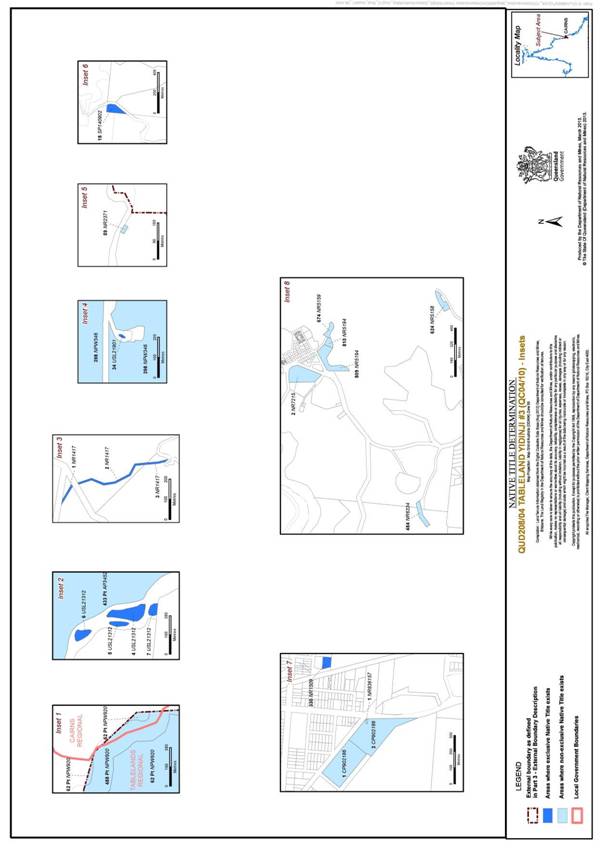
Schedule 1 — DETERMINATION AREA
A. Description of Determination Area
The Determination Area comprises all of the land and waters described in Parts 1 and 2 below, to the extent that they are within the External Boundary Description as described in Part 3 below, and depicted in the attached map, excluding the areas described in Schedule 2.
To the extent of any inconsistency between the written description and the map, the written description prevails.
Part 1 — Exclusive Areas, depicted in dark blue on the attached map:
All of the land and waters described in the following table:
Area Description (at time of determination) |
Lot 4 on Plan USL21312 |
Lot 5 on Plan USL21312 |
Lot 6 on Plan USL21312 |
Lot 7 on Plan USL21312 |
Lot 34 on Plan USL21901 |
*Lot 39 on Plan AP9467 to the extent that it is within the External Boundary Description |
Lot 1 on Plan NR1417 |
Lot 2 on Plan NR1417 |
Lot 3 on Plan NR1417 |
Lot 330 on Plan NR1509 |
Lot 18 on Plan SP140902 |
Note: Descriptions commencing with ‘*’denote lots where only part of the whole lot described is subject to this Part of Schedule 1.
Part 2 — Non-Exclusive Areas, depicted in light blue on the attached map:
All of the land and waters described in the following table:
Area Description (at time of determination) |
*Lot 488 on Plan NPW920 to the extent that it is within the External Boundary Description |
*Lot 62 on Plan NPW920 to the extent that it is within the External Boundary Description |
*Lot 433 on Plan AP3452 to the extent that it is within the External Boundary Description |
*Lot 1 on Plan AP19243 which was formerly within Lot 550 on Plan NR7202 |
*Lot 358 on Plan OL451 to the extent that it is within the External Boundary Description |
Lot 398 on Plan NPW346 |
Lot 59 on Plan NR2371 |
Lot 564 on Plan NR6628 |
Lot 1 on Plan CP902186 |
Lot 2 on Plan CP902186 |
Lot 624 on Plan NR5158 |
Lot 674 on Plan NR5159 |
Lot 809 on Plan NR5194 |
Lot 810 on Plan NR5194 |
Lot 484 on Plan NR6334 |
Lot 2 on Plan NR7215 |
Lot 1 on Plan NR836157 |
*Lot 1 on Plan AP19244 to the extent that it is within the External Boundary Description |
*Lot 1 on AP19253 to the extent that it is within the External Boundary Description |
Save for any waters forming part of a lot on plan, all waters within the External Boundary Description |
Note: Descriptions commencing with ‘*’denote lots where only part of the whole lot described is subject to this Part of Schedule 1.
Part 3 — External Boundary Description
Commencing on the southern bank of the intersection of the Barron River and Rocky Creek and extending generally south-easterly along the southern banks of Barron River to Latitude 17.100431° south; then north-easterly across that River to the opposite bank at Latitude 17.100170° south; then generally easterly through the following points:
Points | Longitude (°East) | Latitude (°South) |
1 | 145.468359 | 17.101083 |
2 | 145.472970 | 17.102159 |
3 | 145.476504 | 17.101467 |
4 | 145.480410 | 17.100780 |
5 | 145.482881 | 17.101160 |
6 | 145.484879 | 17.103388 |
7 | 145.484725 | 17.105232 |
and onto the southern bank of Tinaroo Creek at Longitude 145.485310° east; then generally easterly along the southern banks of that creek to Longitude 145.502710° east; then generally north-easterly and generally northerly through the following points:
Points | Longitude (°East) | Latitude (°South) |
1 | 145.504241 | 17.105155 |
2 | 145.504779 | 17.104003 |
3 | 145.508083 | 17.101544 |
4 | 145.509773 | 17.101159 |
5 | 145.512146 | 17.101010 |
6 | 145.513727 | 17.101349 |
7 | 145.514574 | 17.101010 |
8 | 145.515364 | 17.100163 |
9 | 145.516663 | 17.099316 |
10 | 145.518527 | 17.098864 |
11 | 145.519769 | 17.098243 |
12 | 145.520672 | 17.097961 |
13 | 145.521293 | 17.097735 |
14 | 145.522084 | 17.098300 |
15 | 145.523777 | 17.098356 |
16 | 145.525139 | 17.097394 |
17 | 145.530327 | 17.095476 |
18 | 145.530609 | 17.094347 |
19 | 145.528746 | 17.092879 |
20 | 145.527521 | 17.089710 |
21 | 145.528689 | 17.087853 |
22 | 145.530210 | 17.087328 |
23 | 145.528520 | 17.084562 |
24 | 145.533437 | 17.079568 |
25 | 145.533360 | 17.078340 |
26 | 145.532054 | 17.074806 |
27 | 145.533514 | 17.073115 |
28 | 145.532230 | 17.071020 |
29 | 145.532976 | 17.068121 |
30 | 145.530902 | 17.064817 |
31 | 145.532380 | 17.062550 |
32 | 145.533090 | 17.061420 |
33 | 145.532970 | 17.060630 |
34 | 145.531800 | 17.059380 |
35 | 145.532040 | 17.058140 |
36 | 145.532510 | 17.057350 |
37 | 145.533000 | 17.053630 |
38 | 145.536357 | 17.051602 |
and onto the southern bank of Emerald Creek at Longitude 145.540709° east; then generally south-easterly along the southern banks of that creek to Longitude 145.563144° east; then generally north-easterly and generally south-easterly through the following points:
Points | Longitude (°East) | Latitude (°South) |
1 | 145.564913 | 17.057667 |
2 | 145.566608 | 17.058129 |
3 | 145.568765 | 17.058437 |
4 | 145.570048 | 17.057667 |
5 | 145.573591 | 17.056075 |
6 | 145.576210 | 17.056691 |
7 | 145.582011 | 17.057718 |
8 | 145.584630 | 17.057256 |
9 | 145.585554 | 17.057410 |
10 | 145.588378 | 17.057821 |
11 | 145.591305 | 17.058026 |
12 | 145.592229 | 17.057154 |
13 | 145.592846 | 17.055818 |
14 | 145.591716 | 17.054278 |
15 | 145.587968 | 17.052686 |
16 | 145.586530 | 17.050992 |
17 | 145.587095 | 17.046987 |
18 | 145.589867 | 17.046319 |
19 | 145.593462 | 17.046627 |
20 | 145.598186 | 17.048784 |
21 | 145.603064 | 17.049811 |
22 | 145.606864 | 17.050889 |
23 | 145.611434 | 17.050889 |
24 | 145.615336 | 17.051967 |
25 | 145.618982 | 17.055767 |
26 | 145.619187 | 17.059824 |
27 | 145.617801 | 17.061878 |
28 | 145.616723 | 17.063880 |
29 | 145.617749 | 17.067269 |
30 | 145.620882 | 17.068450 |
31 | 145.621652 | 17.069785 |
32 | 145.623038 | 17.072044 |
33 | 145.625965 | 17.073892 |
34 | 145.628378 | 17.075279 |
35 | 145.629713 | 17.077641 |
36 | 145.632281 | 17.079130 |
37 | 145.636543 | 17.080875 |
38 | 145.639777 | 17.084059 |
39 | 145.644553 | 17.088835 |
40 | 145.645939 | 17.090119 |
41 | 145.647480 | 17.094329 |
42 | 145.647890 | 17.095510 |
43 | 145.649123 | 17.102287 |
44 | 145.649431 | 17.108911 |
45 | 145.652717 | 17.116100 |
46 | 145.655233 | 17.119591 |
47 | 145.660008 | 17.125239 |
48 | 145.664630 | 17.127858 |
49 | 145.665400 | 17.131709 |
50 | 145.661241 | 17.135509 |
51 | 145.661087 | 17.139410 |
52 | 145.661600 | 17.145983 |
53 | 145.664116 | 17.149834 |
54 | 145.667043 | 17.152606 |
55 | 145.672794 | 17.156868 |
56 | 145.675875 | 17.156817 |
57 | 145.678288 | 17.158203 |
58 | 145.689379 | 17.156098 |
59 | 145.691587 | 17.156303 |
60 | 145.691895 | 17.157227 |
61 | 145.692306 | 17.159897 |
62 | 145.692922 | 17.164210 |
63 | 145.692974 | 17.166572 |
64 | 145.690406 | 17.170167 |
and onto the northern boundary of Lot 181 on Plan NPW894 (Gadgarra National Park, formerly Lot 310 on Plan AP6350) at Longitude 145.687330° east; then westerly and generally southerly along the northern and western boundaries of that Lot to the northern most corner of Madigan Road; then north-easterly then generally southerly, then general westerly along the northern, eastern and southern boundaries of former Lot 475 on Plan AP6352 till it meets Gillies Range Road at approximately latitude 17.218737° south; then generally southerly along the western boundary of Lot 181 on Plan NPW894 to Latitude 17.262663° south; then generally north-westerly through the following points:
Points | Longitude (°East) | Latitude (°South) |
1 | 145.658664 | 17.261673 |
2 | 145.657988 | 17.261769 |
3 | 145.657650 | 17.262301 |
4 | 145.656346 | 17.262204 |
5 | 145.654558 | 17.262494 |
6 | 145.652868 | 17.261866 |
7 | 145.651515 | 17.262156 |
8 | 145.648714 | 17.262397 |
9 | 145.646298 | 17.262059 |
10 | 145.645381 | 17.261382 |
11 | 145.640454 | 17.260899 |
12 | 145.639198 | 17.260947 |
13 | 145.635092 | 17.261334 |
14 | 145.628258 | 17.260154 |
15 | 145.627018 | 17.259571 |
16 | 145.624417 | 17.256793 |
17 | 145.623016 | 17.255393 |
18 | 145.621229 | 17.252350 |
19 | 145.619875 | 17.250079 |
20 | 145.618233 | 17.246650 |
21 | 145.616929 | 17.245104 |
22 | 145.615528 | 17.244524 |
23 | 145.611712 | 17.241385 |
24 | 145.609104 | 17.239887 |
25 | 145.606399 | 17.239646 |
26 | 145.603356 | 17.240370 |
27 | 145.600385 | 17.242037 |
28 | 145.599854 | 17.241989 |
29 | 145.598863 | 17.242713 |
30 | 145.597921 | 17.243800 |
31 | 145.597318 | 17.243583 |
32 | 145.596593 | 17.244090 |
33 | 145.596062 | 17.244959 |
34 | 145.593091 | 17.244838 |
35 | 145.592524 | 17.244577 |
36 | 145.590809 | 17.243401 |
37 | 145.587294 | 17.238596 |
38 | 145.587128 | 17.237841 |
39 | 145.585266 | 17.237327 |
40 | 145.584714 | 17.236621 |
41 | 145.577292 | 17.230599 |
42 | 145.576545 | 17.229106 |
43 | 145.571644 | 17.227332 |
44 | 145.568423 | 17.225464 |
45 | 145.566322 | 17.222758 |
46 | 145.564289 | 17.222704 |
47 | 145.560814 | 17.222478 |
48 | 145.556738 | 17.221766 |
49 | 145.552417 | 17.216155 |
50 | 145.549268 | 17.214701 |
51 | 145.546200 | 17.212723 |
52 | 145.544020 | 17.212037 |
53 | 145.538973 | 17.215468 |
54 | 145.538610 | 17.216195 |
55 | 145.537560 | 17.221161 |
and onto the northern bank of Mazlin Creek at Longitude 145.537182° east; then generally south-westerly and generally north-westerly along the northern banks of that creek to an unnamed road at Longitude 145.453054° east; then generally north-westerly through the following points:
Points | Longitude (°East) | Latitude (°South) |
1 | 145.452707 | 17.241685 |
2 | 145.452634 | 17.241008 |
3 | 145.452537 | 17.239193 |
4 | 145.452054 | 17.238105 |
5 | 145.450433 | 17.237863 |
6 | 145.449102 | 17.237742 |
7 | 145.448546 | 17.237210 |
8 | 145.447772 | 17.237282 |
9 | 145.447070 | 17.238056 |
10 | 145.446441 | 17.238081 |
11 | 145.445837 | 17.237839 |
12 | 145.445304 | 17.237282 |
13 | 145.444579 | 17.236944 |
14 | 145.443635 | 17.236702 |
15 | 145.443200 | 17.236194 |
16 | 145.442619 | 17.235686 |
17 | 145.441893 | 17.235202 |
18 | 145.441289 | 17.235178 |
19 | 145.440732 | 17.234936 |
20 | 145.438671 | 17.234957 |
21 | 145.437609 | 17.234236 |
22 | 145.436049 | 17.233135 |
23 | 145.435957 | 17.232919 |
24 | 145.435931 | 17.232493 |
25 | 145.435728 | 17.232204 |
26 | 145.435531 | 17.231293 |
27 | 145.435459 | 17.230946 |
28 | 145.435354 | 17.230520 |
29 | 145.435144 | 17.230323 |
30 | 145.434777 | 17.230185 |
and onto the eastern bank of Rocky Creek at Latitude 17.230276° south; then generally northerly along the eastern banks of that creek to Latitude 17.214648° south; then generally northerly through the following points:
Points | Longitude (°East) | Latitude (°South) |
1 | 145.429690 | 17.212080 |
2 | 145.429570 | 17.211410 |
3 | 145.431080 | 17.209020 |
4 | 145.431170 | 17.205410 |
5 | 145.432550 | 17.202120 |
and again onto the eastern bank of Rocky Creek at Latitude 17.197694° south; then generally northerly along the eastern banks of that creek back to the commencement point.
Reference datum
Geographical coordinates are referenced to the Geocentric Datum of Australia 1994 (GDA94), in decimal degrees and are based on spatial reference data acquired from the various custodians at the time.
Data Reference and source
• External boundary description is based in part on spatial data sourced from the Department of Natural Resource and Mines (QLD) August 2012.
• Cadastral data and Lot on Plan details sourced from Department of Natural Resource and Mines (QLD) August 2012.
• River banks based where possible on Casement data sourced from Department of Natural Resource and Mines (QLD) August 2012, specifically the following watercourses: Baron River, Rocky Creek, Mazlin Creek. All other watercourses digitised from 100k raster topography sheets © Commonwealth of Australia (Geoscience Australia).
B. Map of Determination Area
Schedule 2 — AREAS NOT FORMING PART OF THE DETERMINATION AREA
Part 1
The areas in this Part are excluded from the Determination Area on the grounds that the amended native title determination application filed on 17 June 2005 expressly excluded:
1. All land and waters within amended Native Title Determination Application QUD6030/99 Tableland Yidinji People (QC99/36) as filed with the Federal Court on 17 June 2005 and registered on the Register of Native Title Claims on 6 September 2005.
2. All land and waters within Native Title Determination Application Q6012/01 Combined Dulabed Malanbarra Yidinji Claim (QC01/14) as filed with the Federal Court on 3 April 2003 and registered on the Register of Native Claims on 10 December 2004.
Part 2
The areas in this Part are excluded from the Determination Area on the grounds that at the time at which the native title determination application was made:
• these areas were the subject of one or more previous exclusive possession acts, as defined in s 23B of the Native Title Act 1993 (Cth), despite the fact that the areas, or parts of them, may have been subject to earlier acts that extinguished native title; and
• therefore, in accordance with s 61A of the Native Title Act 1993 (Cth), these areas could not be claimed.
Public Works Based Exclusions:
1. The land and waters on which any public work, as defined in s 253 of the Native Title Act 1993 (Cth), is or was constructed, established or situated, and to which ss 23B(7) and 23C(2) of the Native Title Act 1993 (Cth) and/or s 23B(7) of the Native Title Act 1993 (Cth) and s 21 of the Native Title (Queensland) Act 1993 (Qld), applies, together with any adjacent land or waters in accordance with s 251D of the Native Title Act 1993 (Cth).
Schedule 3 — NATIVE TITLE HOLDERS
1. The native title holders are the Tableland Yidinji People. The Tableland Yidinji People are the biological descendants of:
(a) Jinny / Jeannie / Jinnie Cowley aka Pott / Putt aka Nimble / Nimbie / Baker;
(b) Charlie Cowley and Polly Cowley;
(c) Billy Camp;
(d) Johnny;
(e) Annie aka Lucy Tanna;
(f) Billy Possum; or
(g) Lucy Kairi.
Schedule 4 — OTHER INTERESTS IN THE DETERMINATION AREA
The nature and extent of the other interests in relation to the Determination Area are the following as they exist as at the date of the determination:
1. The rights and interests of the parties under the following indigenous land use agreements:
(a) Lloyd (aka Con) Stewart, Catherine (Nola) Joseph, Evelyn (Dawn) Johnson, on their own behalf and on behalf of the Tableland Yidinji People, the Tableland Yidinji Aboriginal Corporation ICN 7109, Wet Tropics Management Authority and the State of Queensland as parties to the Tableland Yidinji Protected Areas ILUA executed on behalf of the Tableland Yidinji People on 20 September 2012;
(b) Peter Rosas, Lloyd Stewart (aka Con Stewart), Catherine (Nola) Joseph and Evelyn (Dawn) Johnson and Cairns Regional Council as parties to the Cairns Regional Council Tableland Yidinji Indigenous Land Use Agreement QI2012/076, dated 3 September 2012;
(c) Mr Lloyd Stewart (aka Con Stewart), Ms Evelyn (Dawn) Johnson, Mrs Catherine (Nola) Joseph and Mr Peter Rosas (deceased) as the Applicants of the Native Title Determination Applications QUD6030/1999 (Tableland Yidinji People) and QUD208/2004 (Tableland Yidinji People #3) and the Tablelands Regional Council as parties to the Tablelands Regional Council ILUA dated 24 April 2010; and
(d) Mr Lloyd Stewart (aka Con Stewart), Ms Evelyn (Dawn) Johnson, Mrs Catherine (Nola) Joseph and Mr Peter Rosas on their own behalf and on behalf of the Tableland Yidinji People (QUD6030/1999) and Tableland Yidinji People #3 (QUD208/2004) and Ergon Energy Corporation Limited (ACN 087 646 062) as parties to the ILUA QI2012/066, dated 22 June 2012.
2. The rights and interests of Telstra Corporation Limited (ACN 051 775 556):
(a) as the owner or operator of telecommunications facilities within the Determination Area;
(b) created pursuant to the Post and Telegraph Act 1901 (Cth), the Telecommunications Act 1975 (Cth), the Australian Telecommunications Corporation Act 1989 (Cth), the Telecommunications Act 1991 (Cth) and the Telecommunications Act 1997 (Cth), including rights:
(i) to inspect land;
(ii) to install and operate existing and new telecommunication facilities;
(iii) to alter, remove, replace, maintain, repair and ensure the proper functioning of its telecommunications facilities;
(c) for its employees, agents or contractors to access its telecommunications facilities in and in the vicinity of the Determination Area in performance of their duties;
(d) under any licence or access agreement relating to its telecommunications facilities in the Determination Area.
3. The rights and interests of Ergon Energy Corporation Limited (ACN 087 646 062):
(a) as the owner and operator of any “Works” as that term is defined in the Electricity Act 1994 (Qld) within the Determination Area;
(b) as a distribution entity and the holder of a distribution authority under the Electricity Act 1994 (Qld); and
(c) created under the Electricity Act 1994 (Qld) and the Government Owned Corporations Act 1993 (Qld) including:
(i) rights in relation to any agreement relating to the Determination Area existing or entered into before the date on which these orders are made;
(ii) rights to enter the Determination Area by its employees, agents or contractors to exercise any of the rights and interests referred to in this paragraph; and
(iii) to inspect, maintain and manage any Works in the Determination Area.
4. The rights and interests of the State of Queensland, the Cairns Regional Council or the Tablelands Regional Council to access, use, operate, maintain and control the dedicated roads in the Determination Area and the rights and interests of the public to use and access the roads.
5. The rights and interests of the State of Queensland in Reserves, the rights and interests of the trustees of those Reserves and of the persons entitled to access and use those Reserves for the respective purpose for which they are reserved.
6. The rights and interests of the Cairns Regional Council under “Local Government Acts” as defined in the Local Government Act 2009 (Qld) which apply to the Determination Area, including any rights the Cairns Regional Council or its employees or agents have:
(a) as owner and operator of infrastructure, facilities and other improvements which are in the Determination Area as at the date of this determination; and
(b) to enter and exercise rights within the Determination Area in accordance with the Local Government Act 2009 (Qld).
7. The rights and interests of the Tablelands Regional Council under the Local Government Act 2009 (Qld) for that part of the Determination Area within its Local Government Area, as defined in that Act, including:
(a) as owner and operator of infrastructure, facilities and other improvements which are in the Determination Area as at the date of this determination; and
(b) the rights of its employees, agents and contractors to enter upon the Determination Area for the purpose of exercising Council’s powers and responsibilities.
8. The rights and interests of Black & White (Quick Service) Taxis Limited ACN 009 754 705:
(a) as the owner or operator of telecommunications facilities and other infrastructure within the Determination Area; and
(b) as the grantee of an authority under s 35 of the Nature Conservation Act 1992 (Qld) relating to the use and management of its telecommunications facilities in the Determination Area.
9. The rights and interests of Mrs Kay Lorraine Evans, Mr James Bernard Evans and Mr Grahame James Evans, being the holders of an Occupational Licence dated 10 July 1946 bearing title reference 17662139 over Lot 433 on Crown Plan AP3452.
10. The rights and interests of the State of Queensland or any other person existing by reason of the force and operation of the laws of the State of Queensland, including those existing by reason of the following legislation or any regulation, statutory instrument, declaration, plan, authority, permit, lease or licence made, granted, issued or entered into under that legislation:
(a) the Land Act 1994 (Qld);
(b) the Nature Conservation Act 1992 (Qld);
(c) the Forestry Act 1959 (Qld);
(d) the Water Act 2000 (Qld);
(e) the Petroleum Act 1923 (Qld) or Petroleum and Gas Act 2004 (Qld);
(f) the Mineral Resources Act 1989 (Qld);
(g) the Integrated Planning Act 1997 (Qld) or Sustainable Planning Act 2009 (Qld);
(h) the Transport Infrastructure Act 1994 (Qld); and
(i) the Fire and Rescue Service Act 1990 (Qld) or Ambulance Service Act 1991 (Qld).
11. Any other rights and interests:
(a) held by the State of Queensland or Commonwealth of Australia; or
(b) existing by reason of the force and operation of the Laws of the State or the Commonwealth.
Note: Entry of orders is dealt with in Rule 39.32 of the Federal Court Rules 2011.
QUEENSLAND DISTRICT REGISTRY | |
GENERAL DIVISION | QUD 208 of 2004 |
BETWEEN: | CATHERINE (NOLA) JOSEPH AND EVELYN (DAWN) JOHNSON ON BEHALF OF THE TABLELAND YIDINJI PEOPLE #3 Applicant
|
AND: | STATE OF QUEENSLAND First Respondent CAIRNS REGIONAL COUNCIL Second Respondent TABLELANDS REGIONAL COUNCIL Third Respondent ERGON ENERGY CORPORATION LIMITED Fourth Respondent BLACK & WHITE (QUICK SERVICE) TAXIS LTD Fifth Respondent GUISEPPE MASASSO Sixth Respondent
|
JUDGE: | DOWSETT J |
DATE: | 26 MARCH 2013 |
PLACE: | CAIRNS |
REASONS FOR JUDGMENT
1 Since 1998, the Tableland Yidinji People have filed three claims for a determination of native title over land and waters on the Atherton Tableland in North Queensland, two in 1998 which were combined by order of the Court in 2000 and the current claim which was filed in 2004. On 14 December 2012, I made orders determining the combined application. The present claim area adjoins the area covered by the combined application. It is located around the upper Barron River and its tributaries and Lake Tinaroo.
2 Catherine (Nola) Joseph and Evelyn (Dawn) Johnson are the applicant in these proceedings.
3 This application has been amended a number of times, most recently on 14 December 2012. Notification of the amended application closed on 23 February 2013. The respondents remain the State of Queensland, Tablelands Regional Council, Cairns Regional Council, Black and White (Quick Service) Taxis Ltd, Ergon Energy Corporation Limited and Guiseppe Masasso.
4 The reason for this application not being determined at the same time as the other was that, at a very late stage, it was discovered that some parts of the present claim area were amenable to an order for exclusive possession in favour of the claim group. In those circumstances, I considered it desirable that the application be renotified, and that has been done.
5 Much of what I say I said in relation to the combined application, however in my view it bears repeating.
6 In their report Hafner and Weiner say:
Yidinyji country stretches from the Cairns and coastal region south of Cairns up through the Goldsborough Valley and Mulgrave River regions to the Atherton Tablelands. Yidinyji territory has previously been described as divided into separate ecological zones, with a corresponding division of the social world … . Indigenous groups identifying as Yidinyji comprise five separate native title claim groups, each claiming specific right to speak for a portion of country traditionally recognised as being encompassed by the Yidinyji language-culture complex. The claimants distinguish themselves from other Yidinyji social groupings thus defined, although like them, they describe themselves as members of the “Yidinyji tribe”. The claimants are identified by other Yidinyji people as “Tableland mob” … or as “Top End Yidi” …., in distinction to other Yidinyji groups: the people of the Cairns region (“Gimuy”), Yarrabah (“Mandingalbay”), Lower Coastal, and the Goldsborough Valley (“Valley mob”, or “Dulabed” and “Malanbarra”) with whom they share a common tribal linguistic identity.
The Tablelands Yidinyji claimant group comprises four separate families in the post-classical sense. Members of these families trace their descent from ancestors who were known to have used, occupied and had the authority to speak for country in the claim area. Membership in the group depends on being a member of one of these Tablelands Yidinyji families, self-identification as a Tablelands Yidinyji person, and being recognised and accepted by the Tablelands Yidinyji as one of their members. The Tablelands Yidinyji generally talk about themselves as being “from here” (i.e. the Tablelands), without necessarily invoking a group name. A senior applicant, Nola Joseph, remembers her mother referring to the Yidinyji people of the Tablelands as “Wayimbarra”, a term she remembers as referring to a type of honeyeater which was found all over the Tablelands. This term is similar to a word Meston … recorded, Warganbarra, meaning ‘open forest people’. Charlie Green and Dawn Johnson say they were told by their parents that their grandfather was of the Gambirrbarra or Bundabara people. These terms have been recorded by Dixon, and before that by Meston … .
Thus the members of the group see themselves as related to but distinct from other Yidinyji people associated with the Mulgrave River valley and the Cairns and coastal regions, with whom they share relationships based on common identity and kinship. The applicants are members of families whose genealogies are appended to the report. The claimant group includes but is not limited to the applicants mentioned in section 3.1 above.
7 The Act authorizes the Court to determine that native title exists over areas in respect of which there is no existing determination. The claim area is not subject to any other claim or approved determination. Where, at any time after notification, the parties agree upon the orders to be made in relation to such proceedings, the Court may make appropriate orders. In exercising the judicial power of the Commonwealth, this Court resolves disputes identified by the parties. The parties may narrow those issues by admission or concession. Any such agreement must be freely made, on an informed basis. In some cases, the Court may decline to act upon such admissions or concession. Where, as here, the proceedings have significance for people other than the parties, I must give careful consideration to the appropriateness of the proposed consent orders.
8 I see no reason to doubt the appropriateness of the parties’ consensual resolution of the matters previously in dispute. They have had the benefit of legal advice and substantial anthropological research. The proceedings were commenced over 9 years ago, and have been publicized in accordance with the Act. I am satisfied that the proposed orders have been drafted with regard to the public interest, represented by the State of Queensland and relevant local authorities.
9 Where the Court determines that native title exists, s 94A of the Act requires that the Court determine the matters mentioned in s 225. I must therefore identify:
the persons or groups holding the native title;
the nature and extent of the native title rights and interests in relation to the claim area;
the nature and extent of any other interests in relation to the determination area;
the relationship between such rights and interests and those other interests; and
to the extent that the land and water in the claim area are not covered by a non-exclusive agricultural lease or a non-exclusive pastoral lease, whether the native title rights and interests confer exclusive possession, occupation, use and enjoyment of that land and water.
10 The parties agree that the native title rights and interests identified in Part 1 of Schedule 1 are, subject to paragraphs 10, 11, and 12 of the proposed orders, the rights to possession, occupation, use and enjoyment of the area to the exclusion of all others.
11 In relation to water, the parties agree to recognition of the non-exclusive rights to hunt, fish and gather from the water, to take and use the natural resources of the water in the area and to take and use the water of the area for personal, domestic and non-commercial communal purposes.
12 The parties agree that the non-exclusive native title rights and interests identified in Part 2 of Schedule 1 are, subject to paragraphs 10, 11, and 12 of the proposed orders, to:
(a) access, be present on, move about on and travel over the area;
(b) camp, and for that purpose, build temporary shelters;
(c) hunt, fish and gather on the land and water of the area for personal, domestic and non-commercial communal purposes;
(d) take, use and share natural resources from the land and water of the area for personal, domestic and non-commercial communal purposes;
(e) take and use the water of the area for personal, domestic and non-commercial communal purposes;
(f) light fires on the area for domestic purposes including cooking, but not for the purpose of hunting or clearing vegetation;
(g) conduct ceremonies on the area;
(h) teach on the area the physical and spiritual attributes of the area;
(i) maintain places of importance and areas of significance to the native title holders under their traditional laws and customs and protect those places and areas from physical harm; and
(j) be buried and bury native title holders within the area;
13 In considering this matter, I have been greatly assisted by an anthropological overview prepared in 2004 by Dr Diane Hafner and Dr James Weiner and updated in October 2006, a 2009 report by Dr Anthony Redmond entitled “The Relationship between the Tableland Yidinji Native Title Claim Group” and the “Regional Aboriginal Society of the Cairns Hinterland and Coastal Plain Region and an historical report” by Dr Rosalind Kidd written in 2009.
14 Hafner and Weiner say, concerning the pre-history of the area:
Horsfall, who conducted PhD. research in the north Queensland rainforest (1987), reports that the earliest known date of occupation in the rainforest region is 5100 BP at Jiyer Cave on the Russell River … to the south of the claim region. She notes that although the data is “spare and somewhat contradictory”, there appears to have been increased frequency of use of sites within the last 2000 years. Both Jiyer Cave and another site, MR2 in the lower Mulgrave River valley, contain the remains of toxic nuts up to 2000 years old. Horsfall sees the presence of these remains as evidence for the prehistoric occupation of the region, because complex processing is necessary to render these nuts edible.
Horsfall and Fuary see no reason to believe that the wet tropics region of northeast Queensland had not been occupied by Aboriginal groups since the earliest days of human settlement in Australia … . Two findings indicate this. First, the presence of charcoal particle deposits in pollen cores at Lynch’sx Crater on the Atherton Tablelands indicates the possible presence of people and their firesticks from about 38000 years ago … . These pollen deposits indicate that at about that time, the region of the Crater was covered by rainforest, but between then and 26000 BP, this vegetation type was gradually replaced by sclerophyll. This suggests a reduction in rainfall during the period. The increased amount of charcoal present in the deposits suggests increased burning, possibly due to intensified human activity.
At about 9000 BP, the record indicates that rainfall increased, and rainforest again colonised the Atherton Tablelands. This implies that the rainforest culture known from the ethnographic record would have developed from the time of the expansion of the rainforests … . The second piece of evidence Horsfall discusses is the Aboriginal legend of the formation of the crater lakes Barrine, Eacham, and Euramoo, detailing what seems like volcanic eruption. Horsfall ascribes this legend to Ngadgon-Jii tradition, but Yidinyji people claim it as a Yidinyji legend as well … .
15 Concerning early European contact Hafner and Weiner say:
J.V. Mulligan and G.E. Dalrymple were among the earliest explorers to enter parts of the Yidinyji domain. In 1873, Dalrymple headed an expedition commissioned by the Queensland government to explore the coast and rivers between Cardwell and Cooktown. Dalrymple’s party travelled north up the coast, entering the Yidinyji domain and encountering large numbers of Aborigines in the Bellenden Kerr and Mulgrave River regions …. . However, it was the 1872 discovery of alluvial gold on the Palmer River by the government surveyor William Hann that opened the far north up to settlement. By 1876, the new port and township of Thornton on Trinity Bay was being established on the coast … .
Mulligan explored parts of the Barron, believing at the time that he was on the Mitchell River … . He found clear evidence of existing Aboriginal occupation. His party was blocked by the dense rainforest of the Tableland, eventually arriving at the upper reaches of the Tableland via an Aboriginal walking track:
… the native track passed on the west side of the scrub right between the range of hills and the scrub. A splendid track, the best native track I ever saw anywhere. There are roads off the main track to each of their townships, which consist of well thatched gunyahs … . We counted eleven townships since we came to the edge of the scrub, and we have only travelled four miles along it … .
16 The authors continue:
By 1872, the squatter John Atherton established Emerald End Station, near the present-day Mareeba, after hearing Mulligan’s report of good grazing land along the route he had taken … . Atherton and another grazier, James Robson, found tin deposits at Tinaroo Creek and the Wild River, leading to the first tin rush in the country … .
The density of the rainforest between the Tableland and the coast at first restricted settlement of the region. Supplying the goldfields from the coast proved to be expensive and difficult … . Attempts to use the Aboriginal walking tracks that cut through steep scarp and dense rainforest to the port of Thornton (later renamed Cairns), were foiled by Aboriginal resistance and the nature of the country … . Roads cut through the rainforest ensured the life of the Tablelands settlements. In 1880, the adventurer Christie Palmerston and others cut a track through the Atherton scrub to Port Douglas. It was used to cart supplies up to the Tableland and return to the coast with bagged tin and timber … . In the same year, James Robson extended a track from the Mulgrave through Boar Pocket to join up with the Herberton Road, providing a shorter route down the range for pack teams. From 1882 to 1903, Cobb and Co. operated a coach service between Port Douglas and Herberton, until Atherton was linked to the Cairns railway service … .
By 1880, timber-cutters had penetrated rainforest areas as far north as the Bloomfield River. Loggers rapidly stripped the lowland forests in the Cairns region of valuable timbers … . By 1881, with the Daintree and Johnstone River stands exhausted, the timber-cutters arrived on the Atherton Tableland, where the last untouched red cedar stands still stood … .
…
One of the last refuges available to Aborigines was the rainforest of the Atherton region. The landscape on the Tableland was considerably changed by the massive loss of forest. Miners and small cattle stations impinged from the west, restricting Yidinyji access to traditional resources. The dense rainforest remaining provided some refuge, but it no longer provided sufficient food … . The Land Act passed in 1884 and its subsequent amendments enabled small, poorly resourced selectors to take up land in the north. They followed in the tracks of the timber cutters, utilising the land they cleared. Prior’s Pocket, later renamed Atherton, and land in the kairi area were surveyed and the first allotment of land sold in 1886 … . In the same year, land in the Allumbah Pocket (now Yungaburra), lake Eacham and Ball Pocket (later renamed Kulara) areas was surveyed under the Village Settlement Scheme, and settlement began in 1890 … . The township of Tolga was originally named Martin Town after the brothers who established the first sawmill there, supplying timber to the Hodgkinson goldfield … .
Birtles … notes that the large semi-permanent camp located at Cur-Cur near Prior’s Pocket survived for less than four years after European contact. Relations between Aborigines and settlers were characterised by violence. With the loss of the natural resources upon which their livelihood depended, rainforest Aborigines throughout the north were forced into the position of raiding farms and occasionally spearing cattle in order not to starve … . This brought swift retaliation from the settlers:
There is an abundance of records of the violent reaction of north Queensland Europeans to Aboriginal “depredations” on stock and property. Official “protection” from Aboriginal “savagery” was provided by several detachments of Aboriginal troopers allotted the task of “dispersing” Aboriginal camps – a policy which disguised a multitude of tragedies … .
17 Dr Redmond refers to the broad regional neighbouring groups and opines that:
Yidinji People have participated in this active social network of exchanges, shared laws and custom with their regional neighbours since before sovereignty and through these exchanges their shared laws and customs have been able to be reproduced across the wider regional society.
18 Dr Redmond explains that:
While there are relatively discrete clusters of families with demonstrable connections to discrete areas of country within the Yidinji research areas this does not imply the existence of separate communities with distinct bodies of laws and customs under which their various rights to land are held. Rather, it would appear that a single society of Yidinji people and their close neighbours hold a body of law and custom distributing rights and interests amongst the local groups constituting that society. There is an important distinction to be made between the structure of claimant groups and the regional society which upholds the law and custom pertaining to the wider area.
19 Seven Tableland Yidinji claimants, Lloyd Stewart, Sally Davis, Viola Davis, Patrick Stewart, Evelyn Dawn Johnson, Leonard Anning and Catherine (Nola) Joseph filed affidavit material in connection with the combined application attesting to the continued acknowledgment and observance of traditional laws and customs by the Tableland Yidinji people in relation to the land and water which are the subject of this determination. Matters of descent, residence, use and occupation are addressed in this evidence. The deponents describe how their knowledge of Tableland Yidinji laws and customs has been handed down to them from their parents, grandparents, great grandparents, aunts and uncles. The affidavits contain comprehensive descriptions of hunting, gathering, sharing food, bush medicine, initiations, spiritual matters, language and significant sites. There is also substantial evidence concerning the transmission of knowledge and continuing exercise of traditional laws and customs.
20 In her affidavit, Evelyn Dawn Johnson deposes to her knowledge of the traditional laws and customs of her people. She says that her mother Minnie Green was traditionally said to have been born in a hollow log on the banks of the Mazlin River in 1903 or 1906. Before she was placed with the Green family, aged 12 or 13 years old, she experienced a very traditional life style in the rainforest under the canopy of tall timbers. Her home was a traditional humpy made of a lawyer cane frame, woven grass and large leaves. Ms Johnson goes on to say that her mother told her that the rainforest sustained them with food resources, carpet snake, porcupine, possums and flying fox.
21 Sally Davis learned hunting from her parents and says that:
Mum and Dad showed us how to find jumbin bidi bidi which are like witchetty grub. The men would hunt the kangaroo, wallaby and possum and bring them back to us. The food would be prepared and we kids would watch them cook it. It would get shared out, always to the elders first.
22 Viola Davis was born on 17 September 1937. She has extensive knowledge of seven generations of her family. She has learnt traditional laws and customs from her mother who, in turn, learnt “gardening and work on the land” from her father and “all the bush skills and how to live from Yidinji country” from her mother and grandmother. Viola went hunting and fishing and gives detailed evidence of traditional food gathering, saying that “we learned to fish for jewfish, eels and turtle, we learnt how to find turtle eggs in the banks of the rivers” and “we learnt how to watch to see what and when to harvest”. She has passed on much of this information to her children.
23 Patrick Stewart was born on 19 November 1974. He gives evidence of traditional language, sites, foods, ceremonies and burial rites. He continues to pass on to his nieces and nephews, knowledge which he derived from his father.
24 Leonard Anning was born on 27 July 1934. He has learnt and taught the Yidinji laws and customs. He gives detailed evidence of his family’s life on Yidinji country, methods of hunting and gathering and many other aspects of traditional life. When growing up, he learnt a special fishing technique which involved smashing a Tolga vine into running water in order to stun the fish. He has passed on hunting techniques to his children.
25 Catherine Joseph was born on 20 April 1935. She says that her “family frequently went to lots of places in Yidinji country, going to places like Lake Tinaroo, Lake Eacham, Lake Barrine, the Barron River and Tinaroo, Dimbulah and all over the Tablelands”. She knows sites which are of traditional or ceremonial importance and traditional stories such as the importance of the Willy Wagtail, which she describes as a “messenger bird”.
26 This, and other evidence demonstrate the Yidinji people’s continuing connection with the claim area and the nature and content of traditional laws and customs passed down to the claim group. They comprise a normative body of law and customs handed down through succeeding generations since the time of sovereignty and, of course, long before.
27 Despite early dispossession, traditional laws and customs have survived, although in modified forms, any changes being properly seen as attributable to the need to adapt to European settlement. There is clear evidence that those who occupied and possessed the area in the 1860s and their descendants have continued to reside in and/or visit the area. I infer that the members of the claim group are the descendants of those persons who occupied the claim area at the time of first European contact. I am satisfied that the Tableland Yidinji people have an unbroken physical connection to the claim area, dating back to a time prior to 1788.
ORDERS AND DETERMINATION
28 The Court has had the benefit of the applicant’s submissions. The State has conducted a thorough examination of the available material and is satisfied that the proposed determination is appropriate. The other respondent parties agree.
29 I find that the claim group comprises Tableland Yidinji people, descended from people who, pursuant to traditional law and custom, were in occupation of the land and water of the claim area at the time of first assertion of British sovereignty. Those people formed and form a society, united in and by their acknowledgement and observance of those traditional laws and customs. Through such observance, the Tableland Yidinji people have maintained a connection with the claim area since a time prior to 1788.
30 The proposed orders recognize that the Tableland Yidinji people, as holders of Native Title, are entitled to possess, occupy, use and enjoy the area described in Part 1 of Schedule 1 save in relation to water and the non-exclusive use and enjoyment of the land and water described in Part 2 of Schedule 1. Schedule 4 and orders 13 and 14 of the proposed orders recognize other interests in the claim area and the relationships between those interests and the native title rights and interests.
31 The Tableland Yidinji native title claim group defines itself by its descent from apical ancestors known to have occupied country in the claim area, described in Schedule 3 of the proposed orders as the biological descendants of:
(a) Jinny/Jeannie/Jinnie Cowley aka Pott/Putt aka Nimble/Nimbie/Baker:
(b) Charlie Cowley and Polly Cowley;
(c) Billy Camp;
(d) Johnny;
(e) Annie aka Lucy Tanna;
(f) Billy Possum; and
(g) Lucy Kairi.
32 The Hafner and Weiner report examines the biographies of the claimants and carefully explores the histories of each of the families, including their biological descent from the named ancestors.
33 Proposed order 16 provides that the native title is not to be held in trust. By order 17(i) the Tableland Yidinji Aboriginal Corporation (ICN 7109) is to be the prescribed body corporate for the purposes of s 57(2) of the Act and is to perform the functions set out in s 57(3) after becoming the registered native title body corporate.
34 I am satisfied that the Court should make the orders sought.
35 I now make orders in terms of the draft, which draft will be placed with the papers.
36 I have not come here today to give anything to the Tableland Yidinji people. Rather I have come to recognize, on behalf of all Australians, that they are the traditional owners of this land pursuant to traditional laws and customs which have their roots in ancient times. I now recognize that traditional ownership. In so doing, I bind all Australians for all time, including the State of Queensland, Cairns Regional Council, and Tablelands Regional Council.
37 I congratulate the parties upon the spirit of co-operation which has, after long delay, led to this happy day. I have referred only briefly to the pain and sadness which the Tableland Yidinji people have suffered as the result of European settlement. We hope that today’s determination will ease that pain and sadness.
38 On behalf of all Australians, and particularly on behalf of the Judges of this Court and our staff, I congratulate the Tableland Yidinji people upon this recognition of their traditional ownership and wish them well for the future.
I certify that the preceding thirty-eight (38) numbered paragraphs are a true copy of the Reasons for Judgment herein of the Honourable Justice Dowsett. |
Associate:

