
FEDERAL COURT OF AUSTRALIA
Owens on behalf of the Tagalaka People v State of Queensland [2012] FCA 1396
IN THE FEDERAL COURT OF AUSTRALIA | |
DATE OF ORDER: | |
WHERE MADE: |
BEING SATISFIED that an order in the terms set out below is within the power of the Court, and it appearing appropriate to the Court to do so, pursuant to s 87 of the Native Title Act 1993 (Cth),
BY CONSENT THE COURT ORDERS THAT:
1. There be a determination of native title in the terms set out below ("the Determination").
2. Each party to the proceeding is to bear its own costs.
THE COURT DETERMINES THAT:
3. The Determination Area is the land and waters described in Schedule 1, and depicted in the map attached to Schedule 1.
4. Native title exists in relation to that part of the Determination Area described in Part 1 and Part 2 of Schedule 1.
5. Native title does not exist in relation to that part of the Determination Area described in Part 3 of Schedule 1.
6. The native title is held by the Tagalaka People described in Schedule 3 ("the native title holders").
7. Subject to paragraphs 9, 10 and 11 below the nature and extent of the native title rights and interests in relation to the land and waters described in Part 1 of Schedule 1 are:
(a) other than in relation to Water, the rights to possession, occupation, use and enjoyment of the area to the exclusion of all others; and
(b) in relation to Water, the non-exclusive rights to:
(i) hunt, fish and gather from the Water of the area;
(ii) take and use the Natural Resources of the Water of the area; and
(iii) take and use the Water of the area,
for personal, domestic and non-commercial communal purposes.
8. Subject to paragraphs 9, 10 and 11 below the nature and extent of the native title rights and interests in relation to the land and waters described in Part 2 of Schedule 1 are the non-exclusive rights to:
(a) access, be present on, move about on and travel over the area;
(b) camp on the area and, for that purpose, erect temporary shelters on the area;
(c) hunt, fish and gather on the land and waters of the area for personal, domestic and non-commercial communal purposes;
(d) take, use, share and exchange Natural Resources from the land and waters of the area for personal, domestic and non-commercial communal purposes;
(e) take and use the Water of the area for personal, domestic and non-commercial communal purposes;
(f) light fires on the area for domestic purposes including cooking but not for the purposes of hunting or clearing vegetation;
(g) conduct ceremonies on the area;
(h) teach on the area the physical and spiritual attributes of the area; and
(i) maintain places of importance and areas of significance to the native title holders under their traditional laws and customs and protect those places and areas from physical harm.
9. The native title rights and interests are subject to and exercisable in accordance with:
(a) the Laws of the State and the Commonwealth; and
(b) the traditional laws acknowledged and traditional customs observed by the native title holders.
10. The native title rights and interests referred to in paragraphs 7(b) and 8 do not confer possession, occupation, use or enjoyment to the exclusion of all others.
11. There are no native title rights in or in relation to:
(a) minerals as defined by the Mineral Resources Act 1989 (Qld); and
(b) petroleum as defined by the Petroleum Act 1923 (Qld) and the Petroleum and Gas (Production and Safety) Act 2004 (Qld).
12. The nature and extent of other rights and interests in relation to the Determination Area (or respective parts thereof) are the rights and interests set out in Schedule 4 (the “Other Interests”).
13. The relationship between the native title rights and interests described in paragraphs 7 and 8 and the Other Interests described in Schedule 4 is that:
(a) the Other Interests continue to have effect, and the rights conferred by or held under the Other Interests may be exercised notwithstanding the existence of the native title rights and interests;
(b) to the extent the Other Interests are inconsistent with the continued existence, enjoyment or exercise of the native title rights and interests in relation to the land and waters of the Determination Area, the native title continues to exist in its entirety but the native title rights and interests have no effect in relation to the Other Interests to the extent of the inconsistency for so long as the Other Interests exist; and
(c) the Other Interests and any activity that is required or permitted by or under, and done in accordance with, the Other Interests, or any activity that is associated with or incidental to such an activity, prevail over the native title rights and interests and any exercise of the native title rights and interests.
14. The native title is not to be held in trust.
15. An Aboriginal Corporation whose name will be nominated in writing within three months is to:
(a) be the prescribed body corporate for the purposes of s 57(2) of the Native Title Act 1993 (Cth);
(b) perform the functions mentioned in s 57(3) of the Native Title Act 1993 (Cth).
16. In the event that there is no nomination within the time specified in paragraph 15 or such later time as the Court may order, the Registered Native Title Claimants are to forthwith apply to the Court for further directions.
17 Until such time as there is a prescribed body corporate in relation to the Determination Area any notices required under the Native Title Act 1993 (Cth) or otherwise to be served on the Native Title Holders, the native title claim group or the Registered Native Title Claimants may be served upon the North Queensland Land Council Native Title Representative Body Aboriginal Corporation, and such notice shall be deemed to be sufficient.
18. In this Determination, unless the contrary intention appears:
“Determination Area” means the land and waters described in Schedule 1 (which excludes the land and waters described in Schedule 2) and shown on the map in Schedule 1, and to the extent of any inconsistency between the written description and the map, the written description prevails;
“land” and “waters”, respectively, have the same meanings as in the Native Title Act 1993 (Cth);
“Laws of the State and the Commonwealth” means the common law and the laws of the State of Queensland and the Commonwealth of Australia, and includes legislation, regulations, statutory instruments, local planning instruments and local laws;
“Natural Resources” means:
(a) any animal, plant, fish and bird life found on or in the Determination Area; and
(b) any clays, soil, sand, gravel or rock found on or below the surface of the Determination Area,
that have traditionally been taken and used by the native title holders, but does not include:
(c) minerals as defined in the Mineral Resources Act 1989 (Qld) or petroleum as defined in the Petroleum Act 1923 (Qld) and the Petroleum and Gas (Production and Safety) Act 2004 (Qld).
“Water” means:
(a) water which flows, whether permanently or intermittently, within a river, creek or stream;
(b) any natural collection of water, whether permanent or intermittent; and
(c) water from an underground water source.
Other words and expressions used in this Determination have the same meanings as they have in Part 15 of the Native Title Act 1993 (Cth).
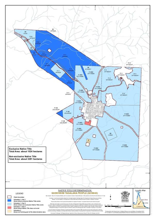
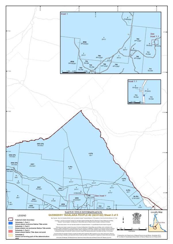
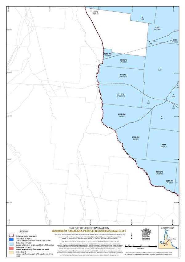
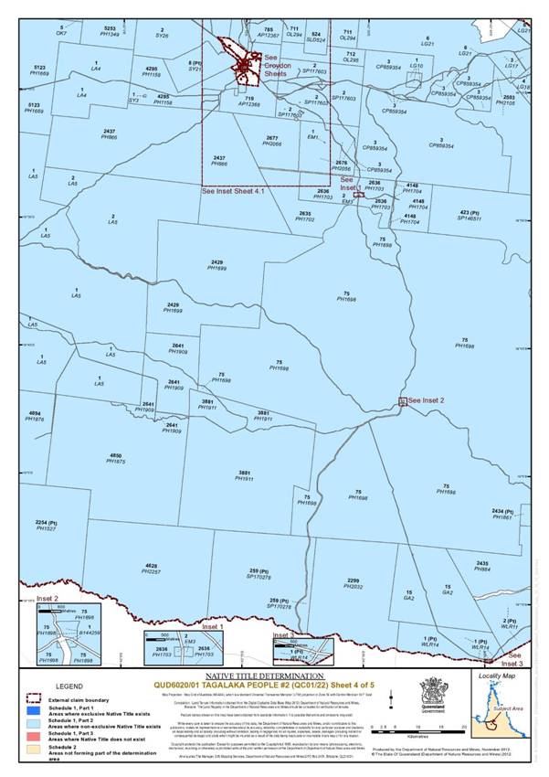
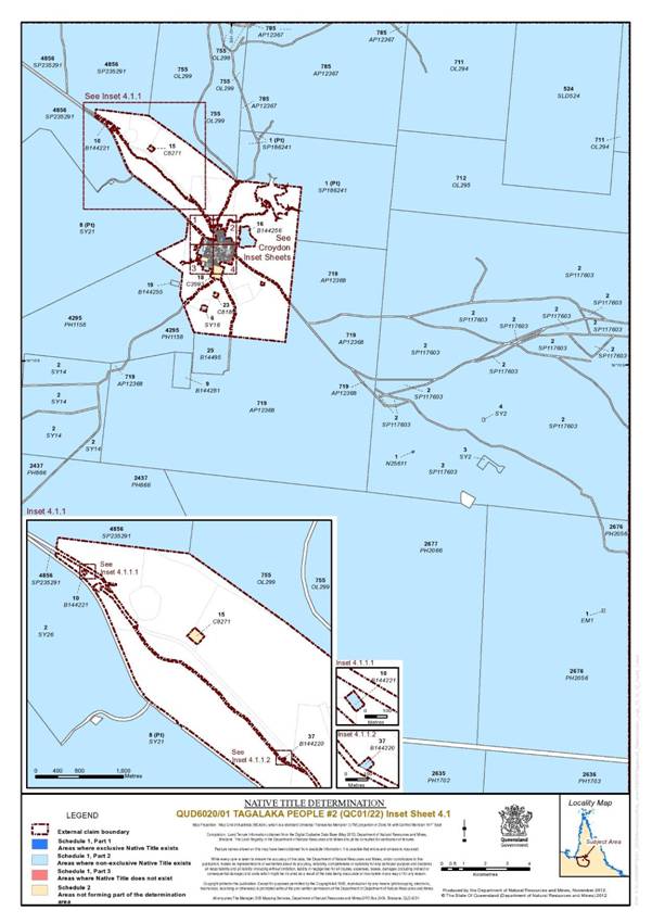
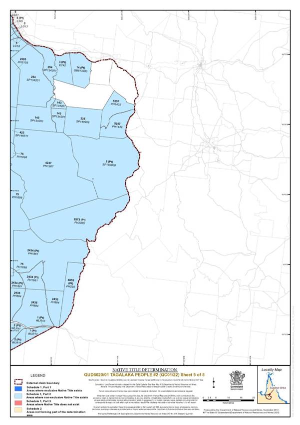
SCHEDULE 1 — DETERMINATION AREA
A. Description of Determination Area
The determination area comprises all of the land and waters described in Parts 1, 2 and 3 below and depicted in the map attached, excluding the areas described in Schedule 2.
PART 1 – Exclusive Areas
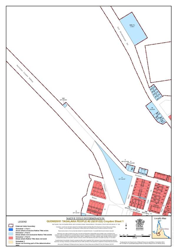
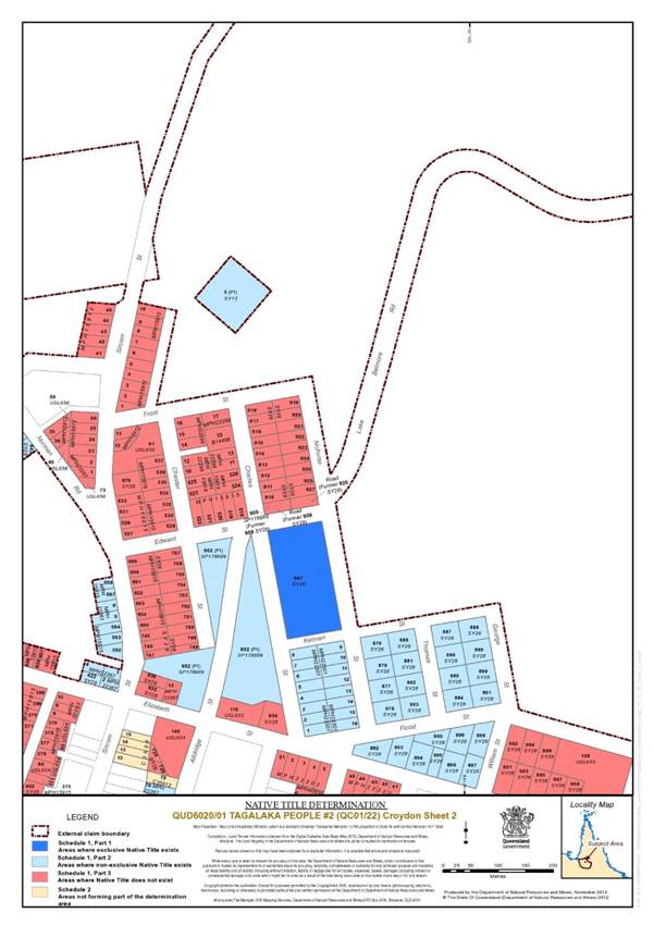
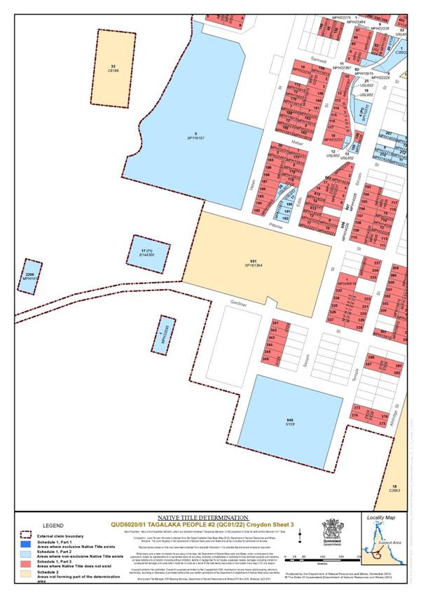
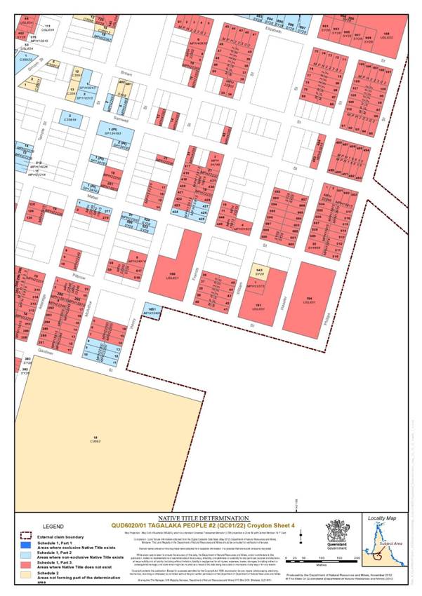
All of the land and waters described in column 1 of the following table and depicted in dark blue on the determination map:
Area Description (at time of Determination) | Area Description (at time of claim) |
Lot 38 on Plan B144291 | Lot 38 on Plan B144291 |
That part of Lot 34 on Plan USL48264 which was not covered by EPM 9438 as at 25 September 1998. | Part of Lot 34 on Plan USL48264 |
That part of Lot 1 on Plan AP5928 which previously formed part of Lot 46 on Plan USL48265 and which was not covered by Mining Lease No.5248 as at 25 September 1998. | Part of Lot 46 on Plan USL48265 |
That part of Lot 1 on Plan AP5928 which previously formed part of Lot 78 on Plan USL48265 and which was not covered by Mining Lease No.5248 as at 25 September 1998. | Part of Lot 78 on Plan USL48265 |
That part of Lot 81 on Plan AP5928 which previously formed part of Lot 78 on Plan USL48265 and which was not covered by Mining Lease No.5248 as at 25 September 1998. | Part of Lot 78 on Plan USL48265 |
The area of Road now shown on Plan AP52928 which previously formed part of Lot 78 on Plan USL48265. | Part of Lot 78 on Plan USL48265 |
That part of Lot 1 on Plan AP5928 which previously formed part of Lot 81 on Plan USL48265 and which was not covered by Mining Lease No.5248 as at 25 September 1998. | Part of Lot 81 on Plan USL48265 |
That part of Lot 4 on Plan AP5928 which previously formed part of Lot 81 on Plan USL48265. | Part of Lot 81 on Plan USL48265 |
That part of Lot 81 on Plan AP5928 which previously formed part of Lot 81 on Plan USL48265. | Part of Lot 81 on Plan USL48265 |
The area of Road now shown on Plan AP5928 which previously formed part of Lot 81 on Plan USL48265. | Part of Lot 81 on Plan USL48265 |
PART 2 – Non-Exclusive Areas
All of the land and waters described in column 1 of the following table and depicted in light blue on the determination map:
Area Description (at time of Determination) | Area Description (at time of claim) |
Lot 30 on Plan SY24. | Part of Lot 30 on Plan SY24 |
That part of Lot 4 on Plan AP5928 which previously formed part of Lot 30 on Plan SY24. | Part of Lot 30 on Plan SY24 |
That part of Lot 952 on Plan SP178689 which previously formed part of Lot 952 on Plan C3591, excluding: a) that part of Lot 952 on Plan SP178689 intersected by Alldridge Street within the Croydon township comprising an eastern and western severance: • the western severance comprises the area bounded by Edward Street in the north; Alldridge Street in the east; Elizabeth Street in the south; the south eastern and north eastern boundaries of Lot 13 on Plan MPH 22367; the north eastern boundary of Lot 936 on Plan SY28; Sircom Street to the west, the southern boundaries of Lots 747 and 748 on Plan SY28; the southern boundary of Chester Street; and Chester Street to the west; and • the eastern severance comprises the area bounded by Charles Street to the east; the northern boundaries of Lot 934 on Plan SY28 and Lot 115 on Plan USL655 to the south; and Alldridge Street to the west. b) those parts which are not excluded in Part 3 of Schedule 1 and Schedule 2. | Part of Lot 952 on Plan C3591 |
That part of Lot 1 on Plan SP186241 which previously formed part of Lot 952 on Plan C3591. | Part of Lot 952 on Plan C3591 |
That part of Lot 50 on Plan C3593 which is not excluded in Schedule 2. | Part of Lot 50 on Plan C3593 |
That part of Lot 34 on Plan USL48264 which was covered by EPM 9438 as at 25 September 1998, excluding that part of Lot 34 on Plan USL48264 described in Part 3 below. | Part of Lot 34 on Plan USL48264 |
That part of Lot 1 on Plan AP5928 which previously formed part of Lot 46 on Plan USL48265 and which was covered by Mining Lease No.5248 as at 25 September 1998 . | Part of Lot 46 on Plan USL48265 |
That part of Lot 1 on Plan AP5928 which previously formed part of Lot 78 on Plan USL48265 and which was covered by Mining Lease No.5248 as at 25 September 1998. | Part of Lot 78 on Plan USL48265 |
That part of Lot 1 on Plan AP5928 which previously formed part of Lot 81 on Plan USL48265 and which was covered by Mining Lease No.5248 as at 25 September 1998. | Part of Lot 81 on Plan USL48265 |
PART 3 – Areas within the Determination Area where native title does not exist
All of the land and waters described in column 1 of the following table and depicted in red on the determination map:
Area Description (at time of Determination) | Area Description (at time of claim) |
That part of Lot 34 on Plan USL48264 described as: Commencing at the most southern point of Lot 34 on plan USL48264, thence north westerly along the boundary of that lot for a distance of approximately 500 metres, thence by a straight line north easterly to the most western point of Lot 1 on plan MPH22480, thence south easterly and north easterly along the boundary of that lot to its intersection with Lot 34 on plan USL48264, thence southerly along the boundary of that lot back to the point of commencement. Commencing at the most southern point of Lot 34 on plan USL48264, thence north westerly along the boundary of that lot for a distance of approximately 500 metres, thence by a straight line north easterly to the most western point of Lot 1 on plan MPH22480, thence south easterly and north easterly along the boundary of that lot to its intersection with Lot 34 on plan USL48264, thence southerly along the boundary of that lot back to the point of commencement. | Part of Lot 34 on Plan USL48264 |
That part of Lot 952 on Plan SP178689 more particularly described as all the land within the areas bounded by the following sets of co-ordinates: Latitude Longitude -18.212110 142.238147 -18.214100 142.237591 -18.215114 142.241495 -18.211968 142.242400 -18.211658 142.241213 -18.212825 142.240878 | Part of Lot 952 on Plan C3591 |
B. Map of Determination Area
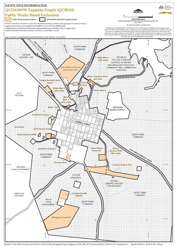
SCHEDULE 2 — AREAS NOT FORMING PART OF THE DETERMINATION AREA
The areas in this Schedule are excluded from the Determination Area on the grounds that at the time at which the native title determination application was made:
i. these areas were the subject of one or more previous exclusive possession acts, as defined in s 23B of the Native Title Act 1993 (Cth), despite the fact that the areas, or parts of them, may have been subject to earlier acts that extinguished native title; and
ii. therefore, in accordance with s 61A of the Native Title Act 1993 (Cth), these areas could not be claimed.
Public Works Based Exclusions:
A. Land or waters on which any public work, as defined in s 253 of the Native Title Act 1993 (Cth), is or was constructed, established, or situated, and to which ss 23B(7) and 23C(2) of the Native Title Act 1993 (Cth) and/or s 23B(7) of the Native Title Act 1993 (Cth) and s 21 of the Native Title (Queensland) Act 1993 (Qld) applies, together with any adjacent land or waters in accordance with s 251D of the Native Title Act 1993 (Cth).
B. Land or waters described in paragraph A immediately above includes, for the avoidance of doubt:
1. the whole of the land and waters shown on the map included in this Schedule and described as Lot 40 on Plan SY1 (Croydon Landfill);
2. part of the land and waters shown on the map included in this Schedule and described as:
i. Lot 952 on Plan SP178689 (Croydon Town Reserve), the parts being more particularly described as all the land within the areas bounded by the following sets of co-ordinates:
Sandstone Quarry 1 | |
Latitude | Longitude |
-18.202763 | 142.236062 |
-18.201893 | 142.236908 |
-18.202182 | 142.235154 |
-18.201417 | 142.235850 |
Sandstone Quarry 2 | |
Latitude | Longitude |
-18.211193 | 142.238099 |
-18.211339 | 142.238770 |
-18.210907 | 142.238920 |
-18.210739 | 142.238246 |
Mittagong Gravel Pit | |
Latitude | Longitude |
-18.233631 | 142.233030 |
-18.236612 | 142.234303 |
-18.235377 | 142.241071 |
-18.229551 | 142.244741 |
-18.228508 | 142.240140 |
Pump shed and well | |
Latitude | Longitude |
-18.206733 | 142.231821 |
-18.207.816 | 142.231344 |
-18.207711 | 142.232064 |
-18.206695 | 142.232244 |
Storage shed | |
Latitude | Longitude |
-18.213506 | 142.241852 |
-18.214966 | 142.240376 |
-18.215598 | 142.241760 |
-18.213280 | 142.240792 |
Water Treatment Plant and Tank | |
Latitude | Longitude |
-18.192243 | 142.249035 |
-18.191362 | 142.249859 |
-18.191292 | 142.247261 |
-18.190167 | 142.248105 |
Golden Butterfly North (Dam) | |
Latitude | Longitude |
-18.193159 | 142.233301 |
-18.192098 | 142.234378 |
-18.194344 | 142.234692 |
-18.193753 | 142.235833 |
Water Tank | |
Latitude | Longitude |
-18.198557 | 142.240278 |
-18.199007 | 142.241396 |
-18.198511 | 142.240888 |
-18.198054 | 142.241517 |
Airport Road Gravel Pit | |
Latitude | Longitude |
-18.214952 | 142.253460 |
-18.215086 | 142.251092 |
-18.213322 | 142.251070 |
-18.213275 | 142.253181 |
Lake Belmore Access and Gravel Area | |
Latitude | Longitude |
-18.187228 | 142.237505 |
-18.182989 | 142.241803 |
-18.185529 | 142.246672 |
-18.192339 | 142.240740 |
Sandstone Quarry Area | |
Latitude | Longitude |
-18.206762 | 142.235684 |
-18.206954 | 142.233842 |
-18.208330 | 142.233828 |
-18.208426 | 142.235442 |
Iguana Consul Mining Museum | |
Latitude | Longitude |
-18.192710 | 142.245505 |
-18.193600 | 142.246003 |
-18.194512 | 142.245216 |
-18.194287 | 142.244911 |
-18.194030 | 142.244967 |
-18.193923 | 142.244427 |
ii. Lot 952 on Plan SP178689 (Croydon Town Reserve), the parts being more particularly described as all the land within the distance nominated from either side of the centreline of the following sets of co-ordinates:
Airport Access Road – 15 metres from the centreline | |
Latitude | Longitude |
-18.205519 | 142.250591 |
-18.206416 | 142.250415 |
-18.206594 | 142.250405 |
-18.206733 | 142.250423 |
-18.206920 | 142.250473 |
-18.207064 | 142.250548 |
-18.207445 | 142.250792 |
-18.208093 | 142.251263 |
-18.208674 | 142.251732 |
-18.209918 | 142.252929 |
-18.210224 | 142.253135 |
-18.210390 | 142.253197 |
-18.211009 | 142.253274 |
-18.214202 | 142.253279 |
-18.219325 | 142.253315 |
-18.214454 | 142.253362 |
-18.215914 | 142.253992 |
-18.216098 | 142.254018 |
-18.216282 | 142.253979 |
-18.216859 | 142.253.722 |
Water main 2 – 10 metres from the centreline | |
Latitude | Longitude |
-18.192142 | 142.247960 |
-18.191460 | 142.247945 |
-18.193356 | 142.248707 |
-18.196420 | 142.247889 |
-18.196769 | 142.247731 |
-18.197064 | 142.247488 |
-18.197285 | 142.247128 |
-18.197460 | 142.246427 |
-18.197603 | 142.246105 |
-18.197827 | 142.245996 |
-18.199928 | 142.245657 |
-18.200686 | 142.245443 |
Water main 3 – 10 metres from the centreline | |
Latitude | Longitude |
-18.190336 | 142.245135 |
-18.191300 | 142.244829 |
-18.192855 | 142.244441 |
-18.196785 | 142.243872 |
-18.197392 | 142.243698 |
-18.198012 | 142.243134 |
-18.198617 | 142.241528 |
Water main 4 – 10 metres from the centreline | |
Latitude | Longitude |
-18.193518 | 142.235146 |
-18.193676 | 142.235513 |
-18.196918 | 142.237396 |
-18.197211 | 142.237598 |
-18.198476 | 142.239290 |
-18.198698 | 142.240926 |
-18.198662 | 142.2401356 |
iii. Lot 952 on Plan SP178689 (Croydon Town Reserve) and Lot 1 on Plan SP186241 (Term Lease), the part being more particularly described as all the land within the distance nominated from either side of the centreline of the following set of co-ordinates:
Water main 1 – 10 metres from the centreline | |
Latitude | Longitude |
-18.178509 | 142.261475 |
-18.178645 | 142.259767 |
-18.178750 | 142.259044 |
-18.179734 | 142.254898 |
-18.182312 | 142.249934 |
-18.182565 | 142.249720 |
-18.185754 | 142.248383 |
-18.186055 | 142.248176 |
-18.188194 | 142.246423 |
-18.189296 | 142.245652 |
-18.191471 | 142.249172 |
iv. Lot 50 on Plan C3593 (Croydon Landing Reserve) and Lot 952 on Plan SP178689 (Croydon Town Reserve), the part being more particularly described as all the land within the area bounded by the following co-ordinates:
Croydon Airport Area | |
Latitude | Longitude |
-18.216958 | 142.246402 |
-18.217186 | 142.249794 |
-18.216903 | 142.253528 |
-18.216726 | 142.253821 |
-18.216804 | 142.254327 |
-18.218034 | 142.254200 |
-18.218.563 | 142.255503 |
-18.219775 | 142.263328 |
-18.219610 | 142.264138 |
-18.221007 | 142.263387 |
-18.219812 | 142.255953 |
-18.220422 | 142.255825 |
-18.220344 | 142.255386 |
-18.219732 | 142.255501 |
-18.218241 | 142.246416 |
Note: to the extent of any inconsistency between the written description in this Schedule and the map, the written description prevails.
SCHEDULE 3 — NATIVE TITLE HOLDERS
The native title holders are the Tagalaka People who are descendants of the following people:
(a) Nelly Robertson (nee Grogan);
(b) Edith Echo;
(c) Edith Sargent;
(d) Charlie Hayes (aka Short Charlie);
(e) Herbie East;
(f) Topsy Cane (aka Topsy Owens);
(g) Jack Fortune; or
(h) Left hand Charlie.
SCHEDULE 4 — OTHER INTERESTS IN THE DETERMINATION AREA
The nature and extent of the Other Interests in relation to the Determination Area are the following, as they exist as at the date of the Determination:
1. The rights and interests of the parties under the following indigenous land use agreements:
(a) Tagalaka People and the State of Queensland as parties to the Tagalaka Croydon Area Indigenous Land Use Agreement #1 registered on 19 August 2005;
(b) Tagalaka People and the State of Queensland as parties to the Tagalaka (Town of Croydon) Indigenous Land Use Agreement registered on 5 September 2008;
(c) native title holders and the Croydon Shire Council as parties to the Croydon Shire Council/Tagalaka People True Blue Tourist Facility ILUA (QIA 2009/068) registered on 14 May 2010;
(d) native title holders and the Croydon Shire Council as parties to the Tagalaka Croydon Area ILUA #2 (QIA 2006/047) registered on 11 February 2008; and
(e) native title holders and Ergon Energy Corporation Limited authorised on 1 May 2012.
2. The rights and interests of Croydon Shire Council (the “Council”) including any rights the Council, its employees, agents or contractors have;
(a) under its local government jurisdiction and functions under the Local Government Act 2009 (Qld), under the Land Protection (Pests and Stock Route Management) Act 2002 (Qld) and under any other legislation, for that part of the Determination Area within its local government area, as defined in the Local Government Act 2009 (Qld);
(b) as the:
(i) lessor under any leases which were entered into as at the date of the Determination;
(ii) grantor of any licences or other rights and interests which were granted as at the date of the Determination;
(iii) holder of any estate or interest in land, and as trustee of any reserves, that exist in the Determination Area as at the date of the Determination;
(c) as the owner and operator of infrastructure, facilities and other improvements located in the Determination Area as at the date of the Determination, including but not limited to:
(i) dedicated roads operated by Council;
(ii) gravel pits operated by Council;
(iii) undedicated but constructed roads except for those not operated by Council;
(iv) water pipelines and other water supply infrastructure;
(v) drainage facilities; and
(vi) cemetery and cemetery related facilities; and
(d) to enter the land described in paragraph (a) to (c) to:
(i) exercise any of the rights and interests referred to in paragraphs 2(a) to 2(c) of Schedule 4;
(ii) inspect, maintain and repair the infrastructure, facilities and other improvements referred to in paragraph 2(c) of Schedule 4; and
(iii) undertake operational activities in its capacity as a local government such as feral animal control, weed control, erosion control, waste management and fire management.
3. The rights and interests of Telstra Corporation Limited:
(a) as the owner or operator of telecommunications facilities within the Determination Area;
(b) created pursuant to the Post and Telegraph Act 1901 (Cth), the Telecommunications Act 1975 (Cth), the Australian Telecommunications Corporation Act 1989 (Cth), the Telecommunications Act 1991 (Cth) and the Telecommunications Act 1997 (Cth) including rights:
(i) to inspect land;
(ii) to install and operate telecommunication facilities; and
(iii) to alter, remove, replace, maintain, repair and ensure the proper functioning of its existing and any new telecommunication facilities; and
(c) for its employees, agents or contractors to access its telecommunications facilities in and in the vicinity of the Determination Area in performance of their duties.
4. The rights and interests of Ergon Energy Corporation Ltd:
(a) as the owner and operator of any “Works” as that term is defined in the Electricity Act 1994 (Qld) within the Determination Area;
(b) as a distribution entity and the holder of a distribution authority under the Electricity Act 1994 (Qld);
(c) created under the Electricity Act 1994 (Qld) and the Government Owned Corporations Act 1993 (Qld), including:
(i) rights in relation to any agreement relating to the Determination Area existing or entered into before the date on which these orders are made;
(ii) rights to enter the Determination Area by its employees, agents or contractors to exercise any of the rights and interests referred to in this paragraph; and
(iii) to inspect, maintain and manage any Works in the Determination Area.
5. The rights and interests of the holders of any authorities, licences, permits or allocations issued under the Water Act 2000 (Qld);
6. The rights and interests of the holders of any leases, licences, reservations, permits, easements or authorities granted under the Land Act 1994 (Qld), and any relevant regulations or subordinate legislation made under the Act;
7. The rights and interests of the holders of any permits, claims, licences or leases granted under the Mineral Resources Act 1989 (Qld); and
8. Any other rights and interests held by the State of Queensland or Commonwealth of Australia, or by reason of the force and operation of the Laws of the State or Commonwealth.
Note: Entry of orders is dealt with in Rule 39.32 of the Federal Court Rules 2011
IN THE FEDERAL COURT OF AUSTRALIA | |
QUEENSLAND DISTRICT REGISTRY | |
GENERAL DIVISION | QUD 6020 of 2001 |
BETWEEN: | JANET BUSCH, BEVERLY BOWYANG, GLADYS CALLOPE, MAUREEN DOUGLAS, BILL FORTUNE AND JANETTE OWENS ON BEHALF OF THE TAGALAKA PEOPLE #2 Applicant |
AND: | STATE OF QUEENSLAND First Respondent CARPENTARIA SHIRE COUNCIL Second Respondent CROYDON SHIRE COUNCIL Third Respondent ETHERIDGE SHIRE COUNCIL Fourth Respondent ERGON ENERGY CORPORATION LIMITED Fifth Respondent ALLEN JOHN BETHEL, CARMEL MAREE BETHEL, SYLVIA BING-CHEW, WAYNE BING-CHEW, CEDAR DAWN PTY LTD, ERIC MERVYN ELLEMS, TERRENCE JOHN FLUTE, G & C CONNOLLY PTY LTD AS TRUSTEE FOR THE G & C CONNOLLY FAMILY TRUST, ALAN ROSS GAYNOR, URSULA JANE GAYNOR, COLLEEN OLIVE HENRY, MERVYN ROY HENRY, RAYELENE MARGARET HENRY, DAVID BAILEY HINRICHSEN, JOSEPHINE BATHIA HOBBS, BARRY GILBERT HUGHES, EDWARD JAMES HUGHES, SHARON DALE HUGHES, TAMMY MARIE HUGHES, DIANE OLIVE JENSEN, KELVIN JOHN JENSEN, ROBYN MAY LETHBRIDGE, BARRY JOHN MARTIN, IAN BRUCE MARTIN, JOHN ALBERT MARTIN, RAY JOSEPH MARTIN, KATHLEEN MAY MCFARLANE, ROBERT WALTER MCFARLANE, CAROL ELIZABETH RYAN, GREGORY JAMES RYAN, DAVID ANTHONY SIMMONS, HELEN JOYCE SIMMONS, DAVID WILLIS, JAMES HARDWICK WILLIS AND JANETTE PEARL WILLIS Sixth – Fortieth Various Pastoral Respondents |
JUDGE: | LOGAN J |
DATE OF ORDER: | 10 DECEMBER 2012 |
WHERE MADE: | CROYDON |
BEING SATISFIED that an order in the terms set out below is within the power of the Court, and it appearing appropriate to the Court to do so, pursuant to s 87A of the Native Title Act 1993 (Cth),
BY CONSENT THE COURT ORDERS THAT:
1. There be a determination of native title in the terms set out below ("the Determination").
2. Each party to the proceeding is to bear its own costs.
THE COURT DETERMINES THAT:
3. The Determination Area is the land and waters described in Schedule 1, and depicted in the map attached to Schedule 1.
4. Native title exists in relation to that part of the Determination Area described in Part 1 and Part 2 of Schedule 1.
5. Native title does not exist in relation to that part of the Determination Area described in Part 3 of Schedule 1.
6. The native title is held by the Tagalaka People described in Schedule 3 ("the native title holders").
7. Subject to paragraphs 9, 10 and 11 below the nature and extent of the native title rights and interests in relation to the land and waters described in Part 1 of Schedule 1 are:
(a) other than in relation to Water, the rights to possession, occupation, use and enjoyment of the area to the exclusion of all others; and
(b) in relation to Water, the non-exclusive rights to:
(i) hunt, fish and gather from the Water of the area;
(ii) take and use the Natural Resources of the Water of the area; and
(iii) take and use the Water of the area,
for personal, domestic and non-commercial communal purposes.
8. Subject to paragraphs 9, 10 and 11 below the nature and extent of the native title rights and interests in relation to the land and waters described in Part 2 of Schedule 1 are the non-exclusive rights to:
(a) access, be present on, move about on and travel over the area;
(b) camp on the area and, for that purpose, erect temporary shelters on the area;
(c) hunt, fish and gather on the land and waters of the area for personal, domestic and non-commercial communal purposes;
(d) take, use, share and exchange Natural Resources from the land and waters of the area for personal, domestic and non-commercial communal purposes;
(e) take and use the Water of the area for personal, domestic and non-commercial communal purposes;
(f) light fires on the area for domestic purposes including cooking but not for the purposes of hunting or clearing vegetation;
(g) conduct ceremonies on the area;
(h) teach on the area the physical and spiritual attributes of the area; and
(i) maintain places of importance and areas of significance to the native title holders under their traditional laws and customs and protect those places and areas from physical harm.
9. The native title rights and interests are subject to and exercisable in accordance with:
(a) the Laws of the State and the Commonwealth; and
(b) the traditional laws acknowledged and traditional customs observed by the native title holders.
10. The native title rights and interests referred to in paragraphs 7(b) and 8 do not confer possession, occupation, use or enjoyment to the exclusion of all others.
11. There are no native title rights in or in relation to:
(a) minerals as defined by the Mineral Resources Act 1989 (Qld); and
(b) petroleum as defined by the Petroleum Act 1923 (Qld) and the Petroleum and Gas (Production and Safety) Act 2004 (Qld).
12. The nature and extent of other rights and interests in relation to the Determination Area (or respective parts thereof) are the rights and interests set out in Schedule 4 (the “Other Interests”).
13. The relationship between the native title rights and interests described in paragraphs 7 and 8 and the Other Interests described in Schedule 4 is that:
(a) the Other Interests continue to have effect, and the rights conferred by or held under the Other Interests may be exercised notwithstanding the existence of the native title rights and interests;
(b) to the extent the Other Interests are inconsistent with the continued existence, enjoyment or exercise of the native title rights and interests in relation to the land and waters of the Determination Area, the native title continues to exist in its entirety but the native title rights and interests have no effect in relation to the Other Interests to the extent of the inconsistency for so long as the Other Interests exist; and
(c) the Other Interests and any activity that is required or permitted by or under, and done in accordance with, the Other Interests, or any activity that is associated with or incidental to such an activity, prevail over the native title rights and interests and any exercise of the native title rights and interests.
14. The native title is not to be held in trust.
15. An Aboriginal Corporation whose name will be nominated in writing within three months is to:
(a) be the prescribed body corporate for the purposes of s 57(2) of the Native Title Act 1993 (Cth);
(b) perform the functions mentioned in s 57(3) of the Native Title Act 1993 (Cth).
16. In the event that there is no nomination within the time specified in paragraph 15 or such later time as the Court may order, the Registered Native Title Claimants are to forthwith apply to the Court for further directions.
17. Until such time as there is a prescribed body corporate in relation to the Determination Area any notices required under the Native Title Act 1993 (Cth) or otherwise to be served on the Native Title Holders, the native title claim group or the Registered Native Title Claimants may be served upon the North Queensland Land Council Native Title Representative Body Aboriginal Corporation, and such notice shall be deemed to be sufficient.
18. In this Determination, unless the contrary intention appears:
“Determination Area” means the land and waters described in Schedule 1 (which excludes the land and waters described in Schedule 2) and shown on the map in Schedule 1, and to the extent of any inconsistency between the written description and the map, the written description prevails;
“External Boundary Description” means the boundary described in Part 4 of Schedule 1;
“land” and “waters”, respectively, have the same meanings as in the Native Title Act 1993 (Cth);
“Laws of the State and the Commonwealth” means the common law and the laws of the State of Queensland and the Commonwealth of Australia, and includes legislation, regulations, statutory instruments, local planning instruments and local laws;
“Natural Resources” means:
(a) any animal, plant, fish and bird life found on or in the Determination Area; and
(b) any clays, soil, sand, gravel or rock found on or below the surface of the Determination Area,
that have traditionally been taken and used by the native title holders, but does not include:
(c) minerals as defined in the Mineral Resources Act 1989 (Qld) or petroleum as defined in the Petroleum Act 1923 (Qld) and the Petroleum and Gas (Production and Safety) Act 2004 (Qld).
“Water” means:
(a) water which flows, whether permanently or intermittently, within a river, creek or stream;
(b) any natural collection of water, whether permanent or intermittent; and
(c) water from an underground water source.
Other words and expressions used in this Determination have the same meanings as they have in Part 15 of the Native Title Act 1993 (Cth).
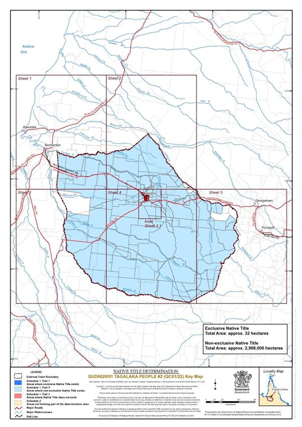
SCHEDULE 1 — DETERMINATION AREA
A. Description of Determination Area
The determination area comprises all of the land and waters described in Parts 1, 2 and 3 below, to the extent that they are within the External Boundary Description as described in Part 4 below, and depicted in the map attached, excluding the areas described in Schedule 2.
PART 1 – Exclusive Areas
All of the land and waters described in the following tables and depicted in dark blue on the determination map:
Area Description (at time of Determination) |
Lot 1 on Plan B14470 |
Lot 101 on Plan EH4101 |
Lot 102 on Plan EH4101 |
Lot 103 on Plan EH4101 |
Lot 104 on Plan EH4101 |
Lot 105 on Plan EH4101 |
Lot 106 on Plan EH4101 |
Lot 107 on Plan EH4101 |
Lot 108 on Plan EH4101 |
Lot 109 on Plan EH4101 |
Lot 110 on Plan EH4101 |
Lot 111 on Plan EH4101 |
Lot 112 on Plan EH4101 |
Lot 113 on Plan EH4101 |
Lot 114 on Plan EH4101 |
Lot 115 on Plan EH4101 |
Lot 116 on Plan EH4101 |
Lot 117 on Plan EH4101 |
Lot 118 on Plan EH4101 |
Lot 119 on Plan EH4101 |
Lot 120 on Plan EH4101 |
Lot 201 on Plan EH4101 |
Lot 202 on Plan EH4101 |
Lot 203 on Plan EH4101 |
Lot 204 on Plan EH4101 |
Lot 205 on Plan EH4101 |
Lot 206 on Plan EH4101 |
Lot 207 on Plan EH4101 |
Lot 208 on Plan EH4101 |
Lot 209 on Plan EH4101 |
Lot 210 on Plan EH4101 |
Lot 211 on Plan EH4101 |
Lot 212 on Plan EH4101 |
Lot 213 on Plan EH4101 |
Lot 214 on Plan EH4101 |
Lot 215 on Plan EH4101 |
Lot 216 on Plan EH4101 |
Lot 217 on Plan EH4101 |
Lot 218 on Plan EH4101 |
Lot 219 on Plan EH4101 |
Lot 220 on Plan EH4101 |
Lot 301 on Plan EH4101 |
Lot 302 on Plan EH4101 |
Lot 303 on Plan EH4101 |
Lot 304 on Plan EH4101 |
Lot 305 on Plan EH4101 |
Lot 306 on Plan EH4101 |
Lot 307 on Plan EH4101 |
Lot 308 on Plan EH4101 |
Lot 309 on Plan EH4101 |
Lot 310 on Plan EH4101 |
Lot 311 on Plan EH4101 |
Lot 312 on Plan EH4101 |
Lot 313 on Plan EH4101 |
Lot 314 on Plan EH4101 |
Lot 315 on Plan EH4101 |
Lot 316 on Plan EH4101 |
Lot 317 on Plan EH4101 |
Lot 318 on Plan EH4101 |
Lot 319 on Plan EH4101 |
Lot 320 on Plan EH4101 |
Lot 401 on Plan EH4101 |
Lot 402 on Plan EH4101 |
Lot 403 on Plan EH4101 |
Lot 404 on Plan EH4101 |
Lot 405 on Plan EH4101 |
Lot 406 on Plan EH4101 |
Lot 407 on Plan EH4101 |
Lot 408 on Plan EH4101 |
Lot 409 on Plan EH4101 |
Lot 410 on Plan EH4101 |
Lot 411 on Plan EH4101 |
Lot 412 on Plan EH4101 |
Lot 413 on Plan EH4101 |
Lot 414 on Plan EH4101 |
Lot 415 on Plan EH4101 |
Lot 416 on Plan EH4101 |
Lot 417 on Plan EH4101 |
Lot 418 on Plan EH4101 |
Lot 419 on Plan EH4101 |
Lot 420 on Plan EH4101 |
Lot 501 on Plan EH4101 |
Lot 502 on Plan EH4101 |
Lot 503 on Plan EH4101 |
Lot 504 on Plan EH4101 |
Lot 505 on Plan EH4101 |
Lot 506 on Plan EH4101 |
Lot 507 on Plan EH4101 |
Lot 508 on Plan EH4101 |
Lot 509 on Plan EH4101 |
Lot 510 on Plan EH4101 |
Lot 511 on Plan EH4101 |
Lot 512 on Plan EH4101 |
Lot 513 on Plan EH4101 |
Lot 514 on Plan EH4101 |
Lot 515 on Plan EH4101 |
Lot 516 on Plan EH4101 |
Lot 517 on Plan EH4101 |
Lot 518 on Plan EH4101 |
Lot 519 on Plan EH4101 |
Lot 520 on Plan EH4101 |
Lot 601 on Plan EH4101 |
Lot 602 on Plan EH4101 |
Lot 603 on Plan EH4101 |
Lot 604 on Plan EH4101 |
Lot 605 on Plan EH4101 |
Lot 606 on Plan EH4101 |
Lot 607 on Plan EH4101 |
Lot 608 on Plan EH4101 |
Lot 609 on Plan EH4101 |
Lot 610 on Plan EH4101 |
Lot 611 on Plan EH4101 |
Lot 612 on Plan EH4101 |
Lot 613 on Plan EH4101 |
Lot 614 on Plan EH4101 |
Lot 615 on Plan EH4101 |
Lot 616 on Plan EH4101 |
Lot 617 on Plan EH4101 |
Lot 618 on Plan EH4101 |
Lot 619 on Plan EH4101 |
Lot 620 on Plan EH4101 |
Lot 701 on Plan EH4101 |
Lot 702 on Plan EH4101 |
Lot 703 on Plan EH4101 |
Lot 704 on Plan EH4101 |
Lot 705 on Plan EH4101 |
Lot 706 on Plan EH4101 |
Lot 707 on Plan EH4101 |
Lot 708 on Plan EH4101 |
Lot 709 on Plan EH4101 |
Lot 710 on Plan EH4101 |
Lot 711 on Plan EH4101 |
Lot 712 on Plan EH4101 |
Lot 713 on Plan EH4101 |
Lot 714 on Plan EH4101 |
Lot 715 on Plan EH4101 |
Lot 716 on Plan EH4101 |
Lot 717 on Plan EH4101 |
Lot 718 on Plan EH4101 |
Lot 719 on Plan EH4101 |
Lot 720 on Plan EH4101 |
Lot 801 on Plan EH4101 |
Lot 802 on Plan EH4101 |
Lot 803 on Plan EH4101 |
Lot 804 on Plan EH4101 |
Lot 805 on Plan EH4101 |
Lot 806 on Plan EH4101 |
Lot 807 on Plan EH4101 |
Lot 808 on Plan EH4101 |
Lot 809 on Plan EH4101 |
Lot 810 on Plan EH4101 |
Lot 811 on Plan EH4101 |
Lot 812 on Plan EH4101 |
Lot 813 on Plan EH4101 |
Lot 814 on Plan EH4101 |
Lot 815 on Plan EH4101 |
Lot 816 on Plan EH4101 |
Lot 817 on Plan EH4101 |
Lot 818 on Plan EH4101 |
Lot 819 on Plan EH4101 |
Lot 820 on Plan EH4101 |
Lot 4 on Plan EH4102 |
Lot 5 on Plan EH4102 |
Lot 101 on Plan H4151 |
Lot 102 on Plan H4151 |
Lot 103 on Plan H4151 |
Lot 104 on Plan H4151 |
Lot 105 on Plan H4151 |
Lot 106 on Plan H4151 |
Lot 107 on Plan H4151 |
Lot 108 on Plan H4151 |
Lot 109 on Plan H4151 |
Lot 110 on Plan H4151 |
Lot 111 on Plan H4151 |
Lot 112 on Plan H4151 |
Lot 113 on Plan H4151 |
Lot 114 on Plan H4151 |
Lot 115 on Plan H4151 |
Lot 116 on Plan H4151 |
Lot 117 on Plan H4151 |
Lot 118 on Plan H4151 |
Lot 119 on Plan H4151 |
Lot 120 on Plan H4151 |
Lot 201 on Plan H4151 |
Lot 202 on Plan H4151 |
Lot 203 on Plan H4151 |
Lot 204 on Plan H4151 |
Lot 205 on Plan H4151 |
Lot 207 on Plan H4151 |
Lot 208 on Plan H4151 |
Lot 209 on Plan H4151 |
Lot 210 on Plan H4151 |
Lot 211 on Plan H4151 |
Lot 212 on Plan H4151 |
Lot 213 on Plan H4151 |
Lot 214 on Plan H4151 |
Lot 215 on Plan H4151 |
Lot 216 on Plan H4151 |
Lot 217 on Plan H4151 |
Lot 218 on Plan H4151 |
Lot 219 on Plan H4151 |
Lot 220 on Plan H4151 |
Lot 301 on Plan H4151 |
Lot 302 on Plan H4151 |
Lot 303 on Plan H4151 |
Lot 304 on Plan H4151 |
Lot 305 on Plan H4151 |
Lot 306 on Plan H4151 |
Lot 307 on Plan H4151 |
Lot 308 on Plan H4151 |
Lot 309 on Plan H4151 |
Lot 310 on Plan H4151 |
Lot 311 on Plan H4151 |
Lot 312 on Plan H4151 |
Lot 313 on Plan H4151 |
Lot 314 on Plan H4151 |
Lot 315 on Plan H4151 |
Lot 316 on Plan H4151 |
Lot 317 on Plan H4151 |
Lot 318 on Plan H4151 |
Lot 319 on Plan H4151 |
Lot 320 on Plan H4151 |
Lot 401 on Plan H4151 |
Lot 402 on Plan H4151 |
Lot 403 on Plan H4151 |
Lot 404 on Plan H4151 |
Lot 405 on Plan H4151 |
Lot 406 on Plan H4151 |
Lot 407 on Plan H4151 |
Lot 408 on Plan H4151 |
Lot 409 on Plan H4151 |
Lot 410 on Plan H4151 |
Lot 411 on Plan H4151 |
Lot 412 on Plan H4151 |
Lot 413 on Plan H4151 |
Lot 414 on Plan H4151 |
Lot 415 on Plan H4151 |
Lot 416 on Plan H4151 |
Lot 417 on Plan H4151 |
Lot 418 on Plan H4151 |
Lot 419 on Plan H4151 |
Lot 420 on Plan H4151 |
Lot 4 on Plan N25324 |
Lot 1 on Plan N25611 |
Lot 947 on Plan SY28 |
PART 2 – Non-Exclusive Areas
All of the land and waters described in the following tables and depicted in light blue on the determination map:
Area Description (at time of Determination) |
Lot 2 on Plan SY14 |
Lot 254 on Plan SP134201 |
Lot 524 on Plan SLD524 |
Lot 711 on Plan OL294 |
Lot 712 on Plan OL295 |
Lot 719 on Plan AP12368 |
Lot 423 on Plan SP146511 |
Lot 755 on Plan OL299 |
Lot 785 on Plan AP12367 |
Lot 2132 (Pt) on Plan PH654 |
Lot 271(Pt) on Plan CP847171 |
Lot 2676 on Plan PH2056 |
Lot 4628 on Plan PH2257 |
Lot 259 (Pt) on Plan SP170278 |
Lot 2299 on Plan PH2032 |
Lot 4 (Pt) on Plan SE1 |
Lot 2255 (Pt) on Plan PH2033 |
Lot 4856 on Plan SP235291 |
Lot 15 on Plan GA2 |
Lot 3 on Plan CP859354 |
Lot 2636 on Plan PH1703 |
Lot 2677 on Plan PH2066 |
Lot 2396 on Plan PH2039 |
Lot 2393 (Pt) on Plan PH2040 |
Lot 4894 on Plan PH1876 |
Lot 2503 on Plan PH2105 |
Lot 2573 (Pt) on Plan PH2065 |
Lot 5 on Plan OK7 |
Lot 3881 on Plan PH1911 |
Lot 2397 on Plan PH1081 |
Lot 6 on Plan LG21 |
Lot 4295 on Plan PH1158 |
Lot 2435 on Plan PH884 |
Lot 4655 (Pt) on Plan PH235 |
Lot 2635 on Plan PH1702 |
Lot 4850 on Plan PH1875 |
Lot 2429 on Plan PH1699 |
Lot 2 on Plan SY26 |
Lot 2 on Plan LA5 |
Lot 5123 on Plan PH1669 |
Lot 1 on Plan LA5 |
Lot 4148 on Plan PH1704 |
Lot 143 on Plan SP134201 |
Lot 2434 (Pt) on Plan PH1861 |
Lot 1 (Pt) on Plan WLR10 |
Lot 2641 on Plan PH1909 |
Lot 2437 on Plan PH866 |
Lot 1 on Plan LA4 |
Lot 5253 on Plan PH1349 |
Lot 2062 (Pt) on Plan PH1405 |
Lot 2398 on Plan PH1412 |
Lot 2254 (Pt) on Plan PH1527 |
Lot 75 on Plan PH1698 |
Lot 2853 (Pt) on Plan PH1902 |
Lot 2 on Plan SP117603 |
Lot 2 (Pt) on Plan WLR11 |
Lot 2 (Pt) on Plan NM104 |
Lot 2 (Pt) on Plan NM108 |
Lot 2 on Plan LA3 |
Lot 1 (Pt) on Plan OK4 |
Lot 1 on Plan SY17 |
Lot 38 (Pt) on Plan ET813287 |
Lot 1 (Pt) on Plan WLR14 |
Lot 3 on Plan LG17 |
Lot 4 on Plan LG18 |
Lot 37 on Plan B144220 |
Lot 10 on Plan B144221 |
Lot 5 (Pt) on Plan SP140908 |
Lot 236 on Plan SP140908 |
Lot 5237 on Plan PH1367 |
Lot 5257 on Plan PH1432 |
Lot 5262 (Pt) on Plan PH1850 |
Lot 3 (Pt) on Plan ET42 |
Lot 14 (Pt) on Plan GB813293 |
Lot 207 on Plan MPH14026 |
Lot 210 on Plan MPH14026 |
Lot 212 on Plan MPH14026 |
Lot 2 on Plan SP110313 |
Lot 2 on Plan EM3 |
Lot 1 on Plan EM1 |
Lot 3 on Plan SY2 |
Lot 1 on Plan SY3 |
Lot 4 on Plan SY2 |
Lot 232 on Plan SP109395 |
Lot 1 on Plan LG10 |
Lot 6 on Plan SY16 |
Lot 2 on Plan C35919 |
Lot 1 on Plan C35922 |
Lot 946 on Plan SY28 |
Lot 63 on Plan SP112716 |
Lot 64 on Plan SP112716 |
Lot 65 on Plan SP112716 |
Lot 66 on Plan SP112716 |
Lot 67 on Plan SP112716 |
Lot 3 on Plan SP116187 |
Lot 5 on Plan SP116187 |
Lot 2 on Plan B14470 |
Lot 1 on Plan B144259 |
Lot 1 on Plan SP110313 |
Lot 25 on Plan B14495 |
Lot 19 on Plan B144255 |
Lot 16 on Plan B144256 |
Lot 9 on Plan B144281 |
Lot 1 on Plan MPH124 |
Lot 2 on Plan MPH124 |
Lot 3 on Plan MPH124 |
Lot 4 on Plan MPH124 |
Lot 5 on Plan MPH124 |
Lot 109 on Plan MPH14026 |
Lot 2206 on Plan MPH141 |
Lot 82 on Plan MPH15915 |
Lot 180 on Plan MPH15915 |
Lot 181 on Plan MPH15915 |
Lot 182 on Plan MPH15915 |
Lot 277 on Plan MPH15915 |
Lot 424 on Plan MPH15915 |
Lot 425 on Plan MPH15915 |
Lot 426 on Plan MPH15915 |
Lot 427 on Plan MPH15915 |
Lot 592 on Plan MPH15915 |
Lot 593 on Plan MPH15915 |
Lot 594 on Plan MPH15915 |
Lot 597 on Plan MPH15915 |
Lot 598 on Plan MPH15915 |
Lot 9 on Plan MPH22228 |
Lot 1 on Plan MPH22249 |
Lot 5 on Plan MPH22261 |
Lot 6 on Plan MPH22261 |
Lot 8 on Plan MPH22300 |
Lot 9 on Plan MPH22300 |
Lot 10 on Plan MPH22300 |
Lot 11 on Plan MPH22300 |
Lot 12 on Plan MPH22300 |
Lot 13 on Plan MPH22300 |
Lot 51 on Plan MPH22300 |
Lot 1 on Plan MPH22301 |
Lot 2 on Plan MPH22301 |
Lot 3 on Plan MPH22301 |
Lot 4 on Plan MPH22301 |
Lot 5 on Plan MPH22301 |
Lot 6 on Plan MPH22301 |
Lot 7 on Plan MPH22301 |
Lot 8 on Plan MPH22301 |
Lot 9 on Plan MPH22301 |
Lot 10 on Plan MPH22301 |
Lot 11 on Plan MPH22301 |
Lot 12 on Plan MPH22301 |
Lot 13 on Plan MPH22301 |
Lot 14 on Plan MPH22301 |
Lot 15 on Plan MPH22301 |
Lot 16 on Plan MPH22301 |
Lot 2 on Plan MPH22368 |
Lot 3 on Plan MPH22368 |
Lot 1651 on Plan MPH22408 |
Lot 1 on Plan MPH33585 |
Lot 80 on Plan SY28 |
Lot 422 on Plan SY28 |
Lot 506 on Plan SY28 |
Lot 523 on Plan SY28 |
Lot 524 on Plan SY28 |
Lot 764 on Plan SY28 |
Lot 765 on Plan SY28 |
Lot 766 on Plan SY28 |
Lot 843 on Plan SY28 |
Lot 844 on Plan SY28 |
Lot 845 on Plan SY28 |
Lot 846 on Plan SY28 |
Lot 876 on Plan SY28 |
Lot 877 on Plan SY28 |
Lot 878 on Plan SY28 |
Lot 879 on Plan SY28 |
Lot 880 on Plan SY28 |
Lot 881 on Plan SY28 |
Lot 882 on Plan SY28 |
Lot 883 on Plan SY28 |
Lot 884 on Plan SY28 |
Lot 885 on Plan SY28 |
Lot 886 on Plan SY28 |
Lot 887 on Plan SY28 |
Lot 888 on Plan SY28 |
Lot 889 on Plan SY28 |
Lot 890 on Plan SY28 |
Lot 891 on Plan SY28 |
Lot 892 on Plan SY28 |
Lot 893 on Plan SY28 |
Lot 894 on Plan SY28 |
Lot 895 on Plan SY28 |
Lot 896 on Plan SY28 |
Lot 897 on Plan SY28 |
Lot 898 on Plan SY28 |
Lot 899 on Plan SY28 |
Lot 900 on Plan SY28 |
Lot 938 on Plan SY28 |
Lot 17 on Plan USL651 |
Lot 26 on Plan USL651 |
Lot 12 on Plan USL652 |
Lot 13 on Plan USL652 |
Lot 19 on Plan USL652 |
Lot 21 on Plan USL652 |
Lot 53 on Plan USL654 |
Lot 2 on Plan MPH22483 |
Lot 5 on Plan MPH22483 |
Lot 9 on Plan MPH22218 |
Lot 11 on Plan MPH22218 |
Lot 13 on Plan MPH22218 |
Lot 14 on Plan MPH22218 |
Lot 18 on Plan MPH22367 |
Lot 953 on Plan C3591 |
Lot 3 on Plan SP116187 |
Lot 5 on Plan SP116187 |
Lot 2 on Plan SY804350 |
Lot 1 on Plan MPH22367 |
Lot 2 on Plan MPH22367 |
Lot 4 on Plan MPH22367 |
Lot 16 on Plan USL656 |
Area Description (at time of Determination) |
That part of Lot 5 on Plan LG5, excluding the area of Road shown on Plan LG5. |
That part of Lot 1 on Plan SP186241 formally described as Lot 719 on Plan OL434 and Lot 785 on Plan OL300. |
That part of Lot 8 on Plan SY21 which was not covered by historical Miners Homestead Lease No.2201 described as Lot 1 Parish of Croydon. |
That part of Lot 1 on Plan SP134193 which was not covered by: − historical Gold Fields Homestead Lease No. 513 described as Allotment 8 of Section 16 on Plan MPH15915; − historical Gold Fields Homestead Lease No. 632 described as Allotment 7 of Section 16 on Plan MPH15915; − historical Gold Fields Homestead Lease No. 990 described as Allotment 12 of Section 16 on Plan MPH15915; − historical Gold Fields Homestead Lease No. 1093 described as Allotments 10 and 11 of Section 16 on Plan MPH15915; or − historical Miners Homestead Lease No. 2000 described as Allotment 6 of Section 16 on Plan MPH15915. |
That part of Lot 2 on Plan SP134193 which was not covered by historical Gold Fields Homestead Lease No. 632 described as Allotment 20 of Section 16 on Plan MPH15915. |
That part of Lot 4 on Plan SP110310 which was not covered by historical Gold Fields Homestead Lease No. 971 described as Allotment 7 of Section 1 on Plan MPH14026. |
That part of Lot 5 on Plan SY12 which is not excluded in Schedule 2. |
That part of Lot 949 on Plan C3591 which is not excluded in Schedule 2. |
That part of Lot 17 on Plan B144300 which is not excluded in Schedule 2. |
That part of Lot 952 on Plan SP178689 intersected by Alldridge Street within the Croydon township comprising an eastern and western severance: • the western severance comprises the area bounded by Edward Street in the north; Alldridge Street in the east; Elizabeth Street in the south; the south eastern and north eastern boundaries of Lot 13 on Plan MPH 22367; the north eastern boundary of Lot 936 on Plan SY28; Sircom Street to the west, the southern boundaries of Lots 747 and 748 on Plan SY28; the southern boundary of Chester Street; and Chester Street to the west; and • the eastern severance comprises the area bounded by Charles Street to the east; the northern boundaries of Lot 934 on Plan SY28 and Lot 115 on Plan USL655 to the south; and Alldridge Street to the west. |
PART 3 – Areas within the Determination Area where native title does not exist
All of the land and waters described in the following tables and depicted in red on the determination map:
Area Description (at time of Determination) |
Lot 33 on Plan B14468 |
Lot 35 on Plan B14468 |
Lot 108 on Plan MPH14026 |
Lot 113 on Plan MPH14026 |
Lot 114 on Plan MPH14026 |
Lot 115 on Plan MPH14026 |
Lot 116 on Plan MPH14026 |
Lot 117 on Plan MPH14026 |
Lot 603 on Plan MPH14026 |
Lot 607 on Plan MPH14026 |
Lot 608 on Plan MPH14026 |
Lot 613 on Plan MPH14026 |
Lot 615 on Plan MPH14026 |
Lot 703 on Plan MPH14026 |
Lot 704 on Plan MPH14026 |
Lot 705 on Plan MPH14026 |
Lot 706 on Plan MPH14026 |
Lot 707 on Plan MPH14026 |
Lot 708 on Plan MPH14026 |
Lot 709 on Plan MPH14026 |
Lot 710 on Plan MPH14026 |
Lot 711 on Plan MPH14026 |
Lot 712 on Plan MPH14026 |
Lot 714 on Plan MPH14026 |
Lot 716 on Plan MPH14026 |
Lot 717 on Plan MPH14026 |
Lot 1 on Plan MPH15912 |
Lot 2 on Plan MPH15912 |
Lot 3 on Plan MPH15912 |
Lot 4 on Plan MPH15912 |
Lot 5 on Plan MPH15912 |
Lot 6 on Plan MPH15912 |
Lot 7 on Plan MPH15912 |
Lot 8 on Plan MPH15912 |
Lot 9 on Plan MPH15912 |
Lot 10 on Plan MPH15912 |
Lot 12 on Plan MPH15912 |
Lot 13 on Plan MPH15912 |
Lot 23 on Plan MPH15912 |
Lot 24 on Plan MPH15912 |
Lot 25 on Plan MPH15912 |
Lot 26 on Plan MPH15912 |
Lot 35 on Plan MPH15912 |
Lot 36 on Plan MPH15912 |
Lot 41 on Plan MPH15912 |
Lot 42 on Plan MPH15912 |
Lot 43 on Plan MPH15912 |
Lot 44 on Plan MPH15912 |
Lot 45 on Plan MPH15912 |
Lot 22 on Plan MPH15914 |
Lot 24 on Plan MPH15914 |
Lot 25 on Plan MPH15914 |
Lot 26 on Plan MPH15914 |
Lot 27 on Plan MPH15914 |
Lot 28 on Plan MPH15914 |
Lot 29 on Plan MPH15914 |
Lot 30 on Plan MPH15914 |
Lot 31 on Plan MPH15914 |
Lot 32 on Plan MPH15914 |
Lot 33 on Plan MPH15914 |
Lot 34 on Plan MPH15914 |
Lot 35 on Plan MPH15914 |
Lot 36 on Plan MPH15914 |
Lot 37 on Plan MPH15914 |
Lot 38 on Plan MPH15914 |
Lot 39 on Plan MPH15914 |
Lot 79 on Plan MPH15915 |
Lot 85 on Plan MPH15915 |
Lot 86 on Plan MPH15915 |
Lot 87 on Plan MPH15915 |
Lot 128 on Plan MPH15915 |
Lot 129 on Plan MPH15915 |
Lot 130 on Plan MPH15915 |
Lot 148 on Plan MPH15915 |
Lot 150 on Plan MPH15915 |
Lot 156 on Plan MPH15915 |
Lot 159 on Plan MPH15915 |
Lot 160 on Plan MPH15915 |
Lot 161 on Plan MPH15915 |
Lot 163 on Plan MPH15915 |
Lot 165 on Plan MPH15915 |
Lot 166 on Plan MPH15915 |
Lot 168 on Plan MPH15915 |
Lot 170 on Plan MPH15915 |
Lot 172 on Plan MPH15915 |
Lot 177 on Plan MPH15915 |
Lot 179 on Plan MPH15915 |
Lot 183 on Plan MPH15915 |
Lot 184 on Plan MPH15915 |
Lot 185 on Plan MPH15915 |
Lot 186 on Plan MPH15915 |
Lot 187 on Plan MPH15915 |
Lot 188 on Plan MPH15915 |
Lot 189 on Plan MPH15915 |
Lot 190 on Plan MPH15915 |
Lot 251 on Plan MPH15915 |
Lot 276 on Plan MPH15915 |
Lot 280 on Plan MPH15915 |
Lot 282 on Plan MPH15915 |
Lot 283 on Plan MPH15915 |
Lot 284 on Plan MPH15915 |
Lot 285 on Plan MPH15915 |
Lot 286 on Plan MPH15915 |
Lot 287 on Plan MPH15915 |
Lot 295 on Plan MPH15915 |
Lot 298 on Plan MPH15915 |
Lot 299 on Plan MPH15915 |
Lot 300 on Plan MPH15915 |
Lot 301 on Plan MPH15915 |
Lot 302 on Plan MPH15915 |
Lot 303 on Plan MPH15915 |
Lot 304 on Plan MPH15915 |
Lot 307 on Plan MPH15915 |
Lot 308 on Plan MPH15915 |
Lot 309 on Plan MPH15915 |
Lot 310 on Plan MPH15915 |
Lot 312 on Plan MPH15915 |
Lot 313 on Plan MPH15915 |
Lot 314 on Plan MPH15915 |
Lot 315 on Plan MPH15915 |
Lot 323 on Plan MPH15915 |
Lot 324 on Plan MPH15915 |
Lot 325 on Plan MPH15915 |
Lot 326 on Plan MPH15915 |
Lot 327 on Plan MPH15915 |
Lot 328 on Plan MPH15915 |
Lot 329 on Plan MPH15915 |
Lot 330 on Plan MPH15915 |
Lot 331 on Plan MPH15915 |
Lot 332 on Plan MPH15915 |
Lot 335 on Plan MPH15915 |
Lot 336 on Plan MPH15915 |
Lot 337 on Plan MPH15915 |
Lot 358 on Plan MPH15915 |
Lot 359 on Plan MPH15915 |
Lot 360 on Plan MPH15915 |
Lot 362 on Plan MPH15915 |
Lot 363 on Plan MPH15915 |
Lot 366 on Plan MPH15915 |
Lot 367 on Plan MPH15915 |
Lot 368 on Plan MPH15915 |
Lot 369 on Plan MPH15915 |
Lot 370 on Plan MPH15915 |
Lot 371 on Plan MPH15915 |
Lot 372 on Plan MPH15915 |
Lot 373 on Plan MPH15915 |
Lot 375 on Plan MPH15915 |
Lot 376 on Plan MPH15915 |
Lot 377 on Plan MPH15915 |
Lot 378 on Plan MPH15915 |
Lot 379 on Plan MPH15915 |
Lot 417 on Plan MPH15915 |
Lot 418 on Plan MPH15915 |
Lot 419 on Plan MPH15915 |
Lot 420 on Plan MPH15915 |
Lot 421 on Plan MPH15915 |
Lot 422 on Plan MPH15915 |
Lot 423 on Plan MPH15915 |
Lot 428 on Plan MPH15915 |
Lot 430 on Plan MPH15915 |
Lot 431 on Plan MPH15915 |
Lot 444 on Plan MPH15915 |
Lot 445 on Plan MPH15915 |
Lot 483 on Plan MPH15915 |
Lot 484 on Plan MPH15915 |
Lot 489 on Plan MPH15915 |
Lot 490 on Plan MPH15915 |
Lot 491 on Plan MPH15915 |
Lot 492 on Plan MPH15915 |
Lot 493 on Plan MPH15915 |
Lot 494 on Plan MPH15915 |
Lot 495 on Plan MPH15915 |
Lot 496 on Plan MPH15915 |
Lot 497 on Plan MPH15915 |
Lot 498 on Plan MPH15915 |
Lot 501 on Plan MPH15915 |
Lot 502 on Plan MPH15915 |
Lot 503 on Plan MPH15915 |
Lot 504 on Plan MPH15915 |
Lot 505 on Plan MPH15915 |
Lot 506 on Plan MPH15915 |
Lot 507 on Plan MPH15915 |
Lot 508 on Plan MPH15915 |
Lot 509 on Plan MPH15915 |
Lot 510 on Plan MPH15915 |
Lot 511 on Plan MPH15915 |
Lot 512 on Plan MPH15915 |
Lot 513 on Plan MPH15915 |
Lot 514 on Plan MPH15915 |
Lot 515 on Plan MPH15915 |
Lot 516 on Plan MPH15915 |
Lot 517 on Plan MPH15915 |
Lot 518 on Plan MPH15915 |
Lot 519 on Plan MPH15915 |
Lot 520 on Plan MPH15915 |
Lot 521 on Plan MPH15915 |
Lot 522 on Plan MPH15915 |
Lot 523 on Plan MPH15915 |
Lot 524 on Plan MPH15915 |
Lot 525 on Plan MPH15915 |
Lot 526 on Plan MPH15915 |
Lot 527 on Plan MPH15915 |
Lot 528 on Plan MPH15915 |
Lot 529 on Plan MPH15915 |
Lot 530 on Plan MPH15915 |
Lot 531 on Plan MPH15915 |
Lot 532 on Plan MPH15915 |
Lot 533 on Plan MPH15915 |
Lot 534 on Plan MPH15915 |
Lot 535 on Plan MPH15915 |
Lot 536 on Plan MPH15915 |
Lot 537 on Plan MPH15915 |
Lot 599 on Plan MPH15915 |
Lot 600 on Plan MPH15915 |
Lot 601 on Plan MPH15915 |
Lot 602 on Plan MPH15915 |
Lot 603 on Plan MPH15915 |
Lot 604 on Plan MPH15915 |
Lot 605 on Plan MPH15915 |
Lot 606 on Plan MPH15915 |
Lot 607 on Plan MPH15915 |
Lot 608 on Plan MPH15915 |
Lot 609 on Plan MPH15915 |
Lot 610 on Plan MPH15915 |
Lot 611 on Plan MPH15915 |
Lot 9 on Plan MPH15920 |
Lot 12 on Plan MPH15920 |
Lot 1 on Plan MPH22204 |
Lot 1 on Plan MPH22220 |
Lot 2 on Plan MPH22220 |
Lot 9 on Plan MPH22220 |
Lot 12 on Plan MPH22220 |
Lot 14 on Plan MPH22220 |
Lot 4 on Plan MPH22221 |
Lot 5 on Plan MPH22221 |
Lot 6 on Plan MPH22221 |
Lot 10 on Plan MPH22221 |
Lot 11 on Plan MPH22221 |
Lot 16 on Plan MPH22222 |
Lot 17 on Plan MPH22222 |
Lot 19 on Plan MPH22223 |
Lot 13 on Plan MPH22225 |
Lot 15 on Plan MPH22225 |
Lot 18 on Plan MPH22226 |
Lot 6 on Plan MPH22228 |
Lot 46 on Plan MPH22229 |
Lot 2 on Plan MPH22230 |
Lot 3 on Plan MPH22230 |
Lot 7 on Plan MPH22230 |
Lot 9 on Plan MPH22230 |
Lot 12 on Plan MPH22230 |
Lot 19 on Plan MPH22230 |
Lot 1 on Plan MPH22231 |
Lot 20 on Plan MPH22231 |
Lot 18 on Plan MPH22232 |
Lot 21 on Plan MPH22232 |
Lot 10 on Plan MPH22233 |
Lot 11 on Plan MPH22233 |
Lot 14 on Plan MPH22236 |
Lot 15 on Plan MPH22236 |
Lot 16 on Plan MPH22236 |
Lot 17 on Plan MPH22236 |
Lot 21 on Plan MPH22236 |
Lot 1 on Plan MPH22248 |
Lot 2 on Plan MPH22248 |
Lot 4 on Plan MPH22248 |
Lot 11 on Plan MPH22248 |
Lot 12 on Plan MPH22248 |
Lot 13 on Plan MPH22248 |
Lot 14 on Plan MPH22248 |
Lot 15 on Plan MPH22248 |
Lot 16 on Plan MPH22248 |
Lot 17 on Plan MPH22248 |
Lot 19 on Plan MPH22248 |
Lot 20 on Plan MPH22248 |
Lot 2 on Plan MPH22249 |
Lot 8 on Plan MPH22249 |
Lot 9 on Plan MPH22249 |
Lot 10 on Plan MPH22249 |
Lot 16 on Plan MPH22250 |
Lot 14 on Plan MPH22251 |
Lot 19 on Plan MPH22251 |
Lot 8 on Plan MPH22253 |
Lot 9 on Plan MPH22253 |
Lot 10 on Plan MPH22253 |
Lot 1 on Plan MPH22266 |
Lot 2 on Plan MPH22266 |
Lot 1 on Plan MPH22267 |
Lot 2 on Plan MPH22267 |
Lot 1 on Plan MPH22275 |
Lot 3 on Plan MPH22275 |
Lot 7 on Plan MPH22278 |
Lot 8 on Plan MPH22278 |
Lot 10 on Plan MPH22298 |
Lot 11 on Plan MPH22298 |
Lot 12 on Plan MPH22298 |
Lot 13 on Plan MPH22298 |
Lot 14 on Plan MPH22298 |
Lot 15 on Plan MPH22298 |
Lot 16 on Plan MPH22298 |
Lot 17 on Plan MPH22298 |
Lot 5 on Plan MPH22300 |
Lot 6 on Plan MPH22300 |
Lot 7 on Plan MPH22300 |
Lot 14 on Plan MPH22300 |
Lot 15 on Plan MPH22300 |
Lot 16 on Plan MPH22300 |
Lot 36 on Plan MPH22300 |
Lot 37 on Plan MPH22300 |
Lot 38 on Plan MPH22300 |
Lot 39 on Plan MPH22300 |
Lot 40 on Plan MPH22300 |
Lot 41 on Plan MPH22300 |
Lot 42 on Plan MPH22300 |
Lot 43 on Plan MPH22300 |
Lot 44 on Plan MPH22300 |
Lot 45 on Plan MPH22300 |
Lot 58 on Plan MPH22300 |
Lot 59 on Plan MPH22300 |
Lot 2 on Plan MPH22302 |
Lot 3 on Plan MPH22302 |
Lot 4 on Plan MPH22302 |
Lot 5 on Plan MPH22302 |
Lot 8 on Plan MPH22302 |
Lot 9 on Plan MPH22302 |
Lot 11 on Plan MPH22302 |
Lot 21 on Plan MPH22302 |
Lot 33 on Plan MPH22302 |
Lot 34 on Plan MPH22302 |
Lot 36 on Plan MPH22302 |
Lot 37 on Plan MPH22302 |
Lot 38 on Plan MPH22302 |
Lot 39 on Plan MPH22302 |
Lot 40 on Plan MPH22302 |
Lot 41 on Plan MPH22302 |
Lot 42 on Plan MPH22302 |
Lot 43 on Plan MPH22302 |
Lot 44 on Plan MPH22302 |
Lot 45 on Plan MPH22302 |
Lot 46 on Plan MPH22302 |
Lot 47 on Plan MPH22302 |
Lot 48 on Plan MPH22302 |
Lot 49 on Plan MPH22302 |
Lot 50 on Plan MPH22302 |
Lot 66 on Plan MPH22302 |
Lot 67 on Plan MPH22302 |
Lot 68 on Plan MPH22302 |
Lot 69 on Plan MPH22302 |
Lot 70 on Plan MPH22302 |
Lot 71 on Plan MPH22302 |
Lot 72 on Plan MPH22302 |
Lot 73 on Plan MPH22302 |
Lot 74 on Plan MPH22302 |
Lot 75 on Plan MPH22302 |
Lot 76 on Plan MPH22302 |
Lot 77 on Plan MPH22302 |
Lot 78 on Plan MPH22302 |
Lot 79 on Plan MPH22302 |
Lot 80 on Plan MPH22302 |
Lot 91 on Plan MPH22302 |
Lot 92 on Plan MPH22302 |
Lot 93 on Plan MPH22302 |
Lot 94 on Plan MPH22302 |
Lot 95 on Plan MPH22302 |
Lot 96 on Plan MPH22302 |
Lot 97 on Plan MPH22302 |
Lot 98 on Plan MPH22302 |
Lot 99 on Plan MPH22302 |
Lot 100 on Plan MPH22302 |
Lot 101 on Plan MPH22302 |
Lot 102 on Plan MPH22302 |
Lot 103 on Plan MPH22302 |
Lot 104 on Plan MPH22302 |
Lot 105 on Plan MPH22302 |
Lot 106 on Plan MPH22302 |
Lot 107 on Plan MPH22302 |
Lot 108 on Plan MPH22302 |
Lot 109 on Plan MPH22302 |
Lot 110 on Plan MPH22302 |
Lot 1 on Plan MPH22303 |
Lot 2 on Plan MPH22303 |
Lot 3 on Plan MPH22303 |
Lot 4 on Plan MPH22303 |
Lot 5 on Plan MPH22303 |
Lot 6 on Plan MPH22303 |
Lot 7 on Plan MPH22303 |
Lot 8 on Plan MPH22303 |
Lot 9 on Plan MPH22303 |
Lot 10 on Plan MPH22359 |
Lot 10 on Plan MPH22367 |
Lot 11 on Plan MPH22367 |
Lot 12 on Plan MPH22367 |
Lot 13 on Plan MPH22367 |
Lot 1 on Plan MPH22373 |
Lot 1 on Plan MPH22460 |
Lot 2 on Plan MPH22460 |
Lot 3 on Plan MPH22460 |
Lot 4 on Plan MPH22460 |
Lot 6 on Plan MPH22460 |
Lot 7 on Plan MPH22460 |
Lot 8 on Plan MPH22460 |
Lot 9 on Plan MPH22460 |
Lot 10 on Plan MPH22460 |
Lot 1 on Plan MPH22484 |
Lot 3 on Plan MPH22487 |
Lot 4 on Plan MPH31623 |
Lot 3 on Plan MPH34748 |
Lot 6 on Plan MPH34974 |
Lot 12 on Plan MPH40303 |
Lot 14 on Plan MPH40303 |
Lot 31 on Plan MPH40303 |
Lot 45 on Plan MPH40303 |
Lot 5 on Plan MPH40362 |
Lot 6 on Plan MPH40362 |
Lot 1 on Plan MPH40918 |
Lot 6 on Plan MPH40930 |
Lot 178 on Plan SY28 |
Lot 341 on Plan SY28 |
Lot 342 on Plan SY28 |
Lot 343 on Plan SY28 |
Lot 344 on Plan SY28 |
Lot 345 on Plan SY28 |
Lot 346 on Plan SY28 |
Lot 366 on Plan SY28 |
Lot 367 on Plan SY28 |
Lot 373 on Plan SY28 |
Lot 374 on Plan SY28 |
Lot 375 on Plan SY28 |
Lot 376 on Plan SY28 |
Lot 382 on Plan SY28 |
Lot 383 on Plan SY28 |
Lot 402 on Plan SY28 |
Lot 516 on Plan SY28 |
Lot 517 on Plan SY28 |
Lot 592 on Plan SY28 |
Lot 593 on Plan SY28 |
Lot 594 on Plan SY28 |
Lot 595 on Plan SY28 |
Lot 596 on Plan SY28 |
Lot 597 on Plan SY28 |
Lot 598 on Plan SY28 |
Lot 599 on Plan SY28 |
Lot 600 on Plan SY28 |
Lot 601 on Plan SY28 |
Lot 602 on Plan SY28 |
Lot 603 on Plan SY28 |
Lot 604 on Plan SY28 |
Lot 605 on Plan SY28 |
Lot 606 on Plan SY28 |
Lot 607 on Plan SY28 |
Lot 679 on Plan SY28 |
Lot 729 on Plan SY28 |
Lot 730 on Plan SY28 |
Lot 745 on Plan SY28 |
Lot 746 on Plan SY28 |
Lot 747 on Plan SY28 |
Lot 748 on Plan SY28 |
Lot 749 on Plan SY28 |
Lot 750 on Plan SY28 |
Lot 751 on Plan SY28 |
Lot 752 on Plan SY28 |
Lot 753 on Plan SY28 |
Lot 754 on Plan SY28 |
Lot 755 on Plan SY28 |
Lot 756 on Plan SY28 |
Lot 757 on Plan SY28 |
Lot 901 on Plan SY28 |
Lot 902 on Plan SY28 |
Lot 903 on Plan SY28 |
Lot 904 on Plan SY28 |
Lot 905 on Plan SY28 |
Lot 906 on Plan SY28 |
Lot 907 on Plan SY28 |
Lot 908 on Plan SY28 |
Lot 909 on Plan SP178688 and Road (formerly described as Lot 909 on Plan SY28) |
Lot 910 on Plan SY28 |
Lot 911 on Plan SY28 |
Lot 912 on Plan SY28 |
Lot 913 on Plan SY28 |
Lot 914 on Plan SY28 |
Lot 915 on Plan SY28 |
Lot 916 on Plan SY28 |
Lot 917 on Plan SY28 |
Lot 918 on Plan SY28 |
Lot 919 on Plan SY28 |
Lot 920 on Plan SY28 |
Lot 921 on Plan SY28 |
Lot 922 on Plan SY28 |
Lot 923 on Plan SY28 |
Lot 924 on Plan SY28 |
Lot 925 on Plan SY28 |
Lot 926 on Plan SY28 |
Lot 927 on Plan SY28 |
Road (formerly described as Lot 928 on Plan SY28) |
Lot 934 on Plan SY28 |
Lot 935 on Plan SY28 |
Lot 936 on Plan SY28 |
Lot 166 on Plan USL651 |
Lot 191 on Plan USL651 |
Lot 194 on Plan USL651 |
Lot 57 on Plan USL654 |
Lot 62 on Plan USL654 |
Lot 86 on Plan USL654 |
Lot 92 on Plan USL654 |
Lot 111 on Plan USL654 |
Lot 145 on Plan USL654 |
Lot 108 on Plan USL655 |
Lot 115 on Plan USL655 |
Lot 59 on Plan USL656 |
Lot 65 on Plan USL656 |
Lot 73 on Plan USL656 |
Lot 91 on Plan USL656 |
PART 4 – External Boundary Description
Commencing at the intersection of the centrelines of the Norman River and Clara River and extending generally northerly through the following coordinate points;
Longitude ° East | Latitude ° South |
141.320408 | 18.446018 |
141.323666 | 18.417357 |
141.327515 | 18.368577 |
141.318534 | 18.321016 |
141.308270 | 18.299065 |
141.280044 | 18.250285 |
141.254384 | 18.200285 |
141.222310 | 18.151505 |
141.212046 | 18.113700 |
141.208197 | 18.066139 |
141.212046 | 18.013701 |
141.221027 | 17.941750 |
141.226159 | 17.897848 |
141.226159 | 17.866141 |
141.221027 | 17.819799 |
141.218461 | 17.757605 |
141.214612 | 17.721019 |
Then northerly to a point on the centreline of the Carron River at Longitude 141.213814° East; then generally south easterly and generally north easterly along the centreline of the Carron River to its intersection with the centreline of Rocky Creek; then generally easterly along the centreline of Rocky Creek to its intersection with the centreline of an unnamed creek at Longitude 141.862010° East; then generally north easterly along the centreline of that unnamed creek to Longitude 142.036540° East; then northerly and generally north easterly along the centreline of a tributary of that unnamed creek to Longitude 142.067201° East; then north easterly to the southernmost south east corner of Lot 232 on Plan PH284 (Miranda Downs Pastoral Lease); then generally north easterly along the south eastern boundary of that pastoral lease to its intersection with the centreline of the Gilbert River; then generally south easterly and generally southerly along the centreline of that river to its intersection with the centreline of Wall Creek; then generally south westerly and generally westerly along the centreline of Wall Creek to its source at Longitude 143.125400° East; then south easterly to the source of a tributary of Fog Creek at Latitude 18.934830° South; then generally southerly along the centreline of that tributary and the centreline of Fog Creek to its intersection with the centreline of the Clara River; then south westerly to the intersection of the centrelines of Borah Creek and the Norman River; then generally westerly, generally north westerly and generally northerly along the centreline of the Norman River back to the commencement point.
The application area does not cover any areas subject to:
• The land and waters subject to native title determination application QUD6109/98 Tagalaka People (QC98/43) as accepted for registration 31st August, 2000
• The land and waters subject to native title determination application QUD6009/99 Ewamian People 2 (QC99/13) as accepted for registration 9th July, 2002
Note
Data Reference and source
• Application boundary data compiled by National Native Title Tribunal.
• Rivers/Creeks where available are based on Casement data sourced from the Department of Natural Resources and Mines, Qld (August, 2012) – else Topographic vector data is © Commonwealth of Australia (Geoscience Australia) 2003, or Local Government Authority boundaries where applicable
• Non-Freehold data sourced from Department of Natural Resources and Mines, Qld (August, 2012).
Reference datum
Geographical coordinates have been provided by the NNTT Geospatial Services and are referenced to the Geocentric Datum of Australia 1994 (GDA94), in decimal degrees and are based on the spatial reference data acquired from the various custodians at the time
Use of Coordinates
Where coordinates are used within the description to represent cadastral or topographical boundaries or the intersection with such, they are intended as a guide only. As an outcome to the custodians of cadastral and topographic data continuously recalculating the geographic position of their data based on improved survey and data maintenance procedures, it is not possible to accurately define such a position other than by detailed ground survey.
Prepared by Geospatial Services, National Native Title Tribunal (04 October 2012)
B. Map of Determination Area
SCHEDULE 2 – AREAS NOT FORMING PART OF THE DETERMINATION AREA
The following areas of land and waters are excluded from the Determination Area.
Part A
On the basis that native title has been extinguished and is not claimed, the parties have agreed that the excluded areas include any land or waters on which any permanent improvement consisting of:
(a) a homestead, house, shed or other building;
(b) an airstrip;
(c) a constructed dam or any other constructed stock watering point, bore, turkey nest, squatters’ tank or other water storage facility; or
(d) stock yards and trap yards,
has, at the date of the determination, been constructed (including any adjacent land the exclusive use of which is reasonably necessary for the enjoyment of the improvement) in accordance with the rights of the lessee under, and within the boundaries of the following pastoral leases:
(i) Pastoral Holding 23/2627 comprising Lot 15 on Plan GA2 and commonly known as Agantra;
(ii) Pastoral Holding 34/2393 comprising Lot 2393 on Plan PH2040 and commonly known as Arduno;
(iii) Pastoral Holding 34/4894 comprising Lot 4894 on Plan PH1876 and commonly known as Beach;
(iv) Pastoral Holding 34/3665 comprising Lot 8 (Pt) on Plan SY21 and commonly known as Belmore;
(v) Pastoral Holding 34/5415 comprising Lot 2 (Pt) on Plan NM108 and commonly known as Broadwater;
(vi) Pastoral Holding 18/5514 comprising Lot 38 on Plan ET813287 and commonly known as Chadshunt;
(vii) Pastoral Holding 34/2423 comprising Lot 1 on Plan LA5 and commonly known as Claraville;
(viii) Pastoral Holding 34/2853 comprising Lot 2853 on Plan PH1902 and commonly known as Clotilda;
(ix) Pastoral Holding 34/5253 comprising Lot 5253 on Plan PH1349 and commonly known as Ella Vale;
(x) Pastoral Holding 34/4148 comprising Lot 4148 on Plan PH1704 and commonly known as Entrona;
(xi) Pastoral Holding 34/75 comprising Lot 75 on Plan PH1698 and commonly known as Esmeralda;
(xii) Pastoral Holding 34/5123 comprising Lot 5123 on Plan PH1669 and commonly known as Florence;
(xiii) Pastoral Holding 23/4655 comprising Lot 4655 (Pt) on Plan PH235 and commonly known as Fog Creek;
(xiv) Pastoral Holding 34/5423 comprising Lot 2 on Plan NM104 and commonly known as Glenore;
(xv) Pastoral Holding 34/3840 comprising Lot 1 on Plan LA4 and commonly known as Guildford;
(xvi) Pastoral Holding 34/5435 comprising Lot 2 on Plan LA3 and commonly known as Gum Creek;
(xvii) Pastoral Holding 34/5458 comprising Lot 1 on Plan OK4 and commonly known as Haydon;
(xviii) Pastoral Holding 34/2062 comprising Lot 2062 on Plan PH1405 and commonly known as Karron;
(xix) Pastoral Holding 18/4231 comprising Lot 423 on SP146511 and commonly known as Linley;
(xx) Pastoral Holding 23/2254 comprising Lot 2254 (Pt) on Plan PH1527 and commonly known as Lucksome;
(xxi) Pastoral Holding 18/5143 comprising Lot 143 on SP134201 and commonly known as Malacura;
(xxii) Pastoral Holding 34/2410 comprising Lot 5 on Plan OK7 and commonly known as May Vale;
(xxiii) Pastoral Holding 34/2676 comprising Lot 2676 on Plan PH2056 and commonly known as Mittagong;
(xxiv) Pastoral Holding 34/2677 comprising Lot 2677 on Plan PH2066 and commonly known as Mittagong;
(xxv) Pastoral Holding 34/2635 comprising Lot 2635 on Plan PH1702 and commonly known as Mittagong;
(xxvi) Pastoral Holding 34/2429 comprising Lot 2429 on Plan PH1699 and commonly known as Mittagong;
(xxvii) Pastoral Holding 34/2447 comprising Lot 2 on Plan LA5 and commonly known as Mittagong;
(xxviii) Pastoral Holding 34/2437 comprising Lot 2437 on Plan PH866 and commonly known as Mittagong;
(xxix) Pastoral Holding 34/4850 comprising Lot 4850 on Plan PH1875 and commonly known as Momba;
(xxx) Pastoral Holding 34/4715 comprising Lot 2 on Plan SP117603 and commonly known as Mooremount;
(xxxi) Pastoral Holding 18/2503 comprising Lot 2503 on Plan PH2105 and commonly known as Mount Little;
(xxxii) Pastoral Holding 13/2255 comprising Lot 2255 (Pt) on Plan PH2033 and commonly known as Mundjuro;
(xxxiii) Pastoral Holding 23/3226 comprising Lot 1 (Pt) on Plan WLR10 and commonly known as New Water;
(xxxiv) Pastoral Holding 18/2573 comprising Lot 2573 (Pt) on Plan PH2065 and commonly known as Northhead;
(xxxv) Pastoral Holding 34/2397 comprising Lot 2397 on Plan PH1081 and commonly known as Oakland Park;
(xxxvi) Pastoral Holding 34/2636 comprising Lot 2636 on Plan PH1703 and commonly known as Pepatra;
(xxxvii) Pastoral Holding 34/3881 comprising Lot 3881 on Plan PH1911 and commonly known as Prospect;
(xxxviii) Pastoral Holding 34/2641 comprising Lot 2641 on Plan PH1909 and commonly known as Prospect;
(xxxix) Pastoral Holding 34/2707 comprising Lot 2 on Plan SY26 and commonly known as Reigate;
(xl) Pastoral Holding 18/5527 comprising Lot 3 on Plan LG17 and Lot 4 on Plan LG18 and commonly known as Rockyview;
(xli) Pastoral Holding 23/4628 comprising Lot 4628 on Plan PH2257 and commonly known as Roderick;
(xlii) Pastoral Holding 34/5446 comprising Lot 1 on Plan SY17 and commonly known as Tabletop;
(xliii) Pastoral Holding 34/4295 comprising Lot 4295 on Plan PH1158 and commonly known as The Lakes;
(xliv) Pastoral Holding 34/2398 comprising Lot 2398 on Plan PH1412 and commonly known as Timora;
(xlv) Pastoral Development Holding comprising Lot 271 (Pt) on Plan CP847171 and commonly known as Vena Park;
(xlvi) Pastoral Development Holding 13/2132 comprising Lot 2132 (Pt) on Plan PH654 and commonly known as Miecolon;
(xlvii) Preferential Pastoral Holding 18/5428 comprising Lot 14 on Plan GB813293 commonly known as Blancourt;
(xlviii) Preferential Pastoral Holding 34/5262 comprising Lot 5262 (Pt) on PH1850 and commonly known as Yappar River;
(xlix) Preferential Pastoral Holding 18/5236 comprising Lot 236 on Plan SP140908 and commonly known as Carnes;
(l) Preferential Pastoral Holding 18/5427 comprising Lot 3 (Pt) on Plan ET42 and commonly known as Forest Home;
(li) Preferential Pastoral Holding 18/5257 comprising Lot 5257 on Plan PH1432 and commonly known as Green Hills;
(lii) Preferential Pastoral Holding 18/5235 comprising Lot 5 on Plan SP140908 and commonly known as Heliman Creek;
(liii) Preferential Pastoral Holding 18/5237 comprising Lot 5237 on Plan PH1367 and commonly known as Paddy’s Station (aka Candlow);
(liv) Term Lease 0/232856 comprising Lot 2299 on Plan and PH2032 commonly known as Dumas;
(lv) Term Lease 0/234794 comprising Lot 4856 on Plan SP235291 and commonly known as Golden Gate;
(lvi) Term Lease 0/221967 comprising Lot 259 (Pt) on Plan SP170278 and commonly known as Trenton;
(lvii) Occupation Licence 34/719 comprising Lot 719 on Plan AP12368 and commonly known as Alehvale;
(lviii) Occupation Licence 34/524 comprising Lot 524 on Plan SLD524 and commonly known as Golden Gate;
(lix) Occupation Licence 34/711 comprising Lot 711 on Plan OL294 and commonly known as Golden Gate;
(lx) Occupation Licence 34/712 comprising Lot 712 on Plan OL295 and commonly known as Golden Gate;
(lxi) Occupation Licence 34/755 comprising Lot 755 on Plan OL299 and commonly known as Golden Gate;
(lxiii) Occupation Licence 34/785 comprising Lot 785 on Plan AP12367 and commonly known as Golden Gate; and
(lxiii) Trustee Permit 714571004 comprising Lot 3 on Plan CP859354 and commonly known as Littleton.
Part B
The areas in this Part are excluded from the Determination Area on the grounds that at the time at which the native title determination application was made:
i. these areas were the subject of one or more previous exclusive possession acts, as defined in s 23B of the Native Title Act 1993 (Cth), despite the fact that the areas, or parts of them, may have been subject to earlier acts that extinguished native title; and
ii. in relation to the areas in paragraph 1 of this Part, none of ss 47, 47A or 47B of the Native Title Act 1993 (Cth) applied; and
iii. therefore, in accordance with s 61A of the Native Title Act 1993 (Cth), these areas could not be claimed.
Tenure Based Exclusions (ss 23B(2) and 23B(3) Native Title Act 1993 (Cth)):
1. Lot 3 on OK810526; and
2. That part of Lot 951 on Plan SP161394 which was covered by:
(a) historical Gold Fields Homestead Lease No. 1138 described as Allotments 12 and 13 of Section 21 Town of Croydon; and
(b) historical Gold Fields Homestead Lease No. 1345 described as Allotments 19 and 20 of Section 21 Town of Croydon.
Public Works Based Exclusions:
A. Land or waters on which any public work, as defined in s 253 of the Native Title Act 1993 (Cth), is or was constructed, established, or situated, and to which ss 23B(7) and 23C(2) of the Native Title Act 1993 (Cth) and/or s 23B(7) of the Native Title Act 1993 (Cth) and s 21 of the Native Title (Queensland) Act 1993 (Qld) applies, together with any adjacent land or waters in accordance with s 251D of the Native Title Act 1993 (Cth).
B. Land or waters described in paragraph A immediately above includes, for the avoidance of doubt:
1. the whole of the land and waters shown on the map included in this Schedule and described as:
i. Lot 15 on Plan C8271;
ii. Lot 943 on Plan SY28;
iii. Lot 12 on Plan C3597;
iv. Lot 14 on Plan C3598;
v. Lot 1 on Plan C35911;
vi. Lot 2 on Plan C35911;
vii. Lot 19 on Plan C35912;
viii. Lot 5 on Plan C35913;
ix. Lot 13 on Plan C3597;
x. Lot 23 on Plan C8189;
xi. Lot 32 on Plan C8186;
xii. Lot 12 on Plan C3598;
xiii. Lot 13 on Plan C3598;
xiv. Lot 15 on Plan C3598;
xv. Lot 481 on Plan SY28;
xvi. Lot 482 on Plan SY28;
xvii. Lot 18 on Plan C3593;
2. that part of the land and waters shown on the map included in this Schedule and described as:
i. Lot 5 on Plan SY12, the part being more particularly described as all the land within the areas bounded by the following co-ordinates
Iguana Consul Mining Museum (Excluding Lot 10 on Plan MPH15912 and unnamed street) | |
Latitude | Longitude |
-18.192710 | 142.245505 |
-18.193600 | 142.246003 |
-18.194512 | 142.245216 |
-18.194287 | 142.244911 |
-18.194030 | 142.244967 |
-18.193923 | 142.244427 |
ii. Lot 949 on Plan C3591, the part being more particularly described as all the land north west of the south eastern boundary of the track within Lot 949 on Plan C3591 bounded by the following co-ordinates
Lake Belmore Access and Gravel Area | |
Latitude | Longitude |
-18.190184 | 142.239534 |
-18.189709 | 142.240338 |
-18.189941 | 142.240487 |
-18.190691 | 142.239861 |
ii. Lot 17 on Plan B144300, the part being more particularly described as all the land within the distance nominated from the centreline of the following co-ordinates
Sandstone Quarry Area Track – 15m from the centreline | |
Latitude | Longitude |
-18.207940 | 142.236523 |
-18.207760 | 142.235867 |
-18.207705 | 142.235601 |
-18.207678 | 142.236603 |
-18.207495 | 142.235921 |
-18.207437 | 142.235635 |
iii. Lot 951 on Plan SP161394 which was not covered by
a. historical Gold Fields Homestead Lease No. 1138 described as Allotments 12 and 13 of Section 21 Town of Croydon; and
b. historical Gold Fields Homestead Lease No. 1345 described as Allotments 19 and 20 of Section 21 Town of Croydon.
Note: to the extent of any inconsistency between the written description in this Schedule and the map, the written description prevails.
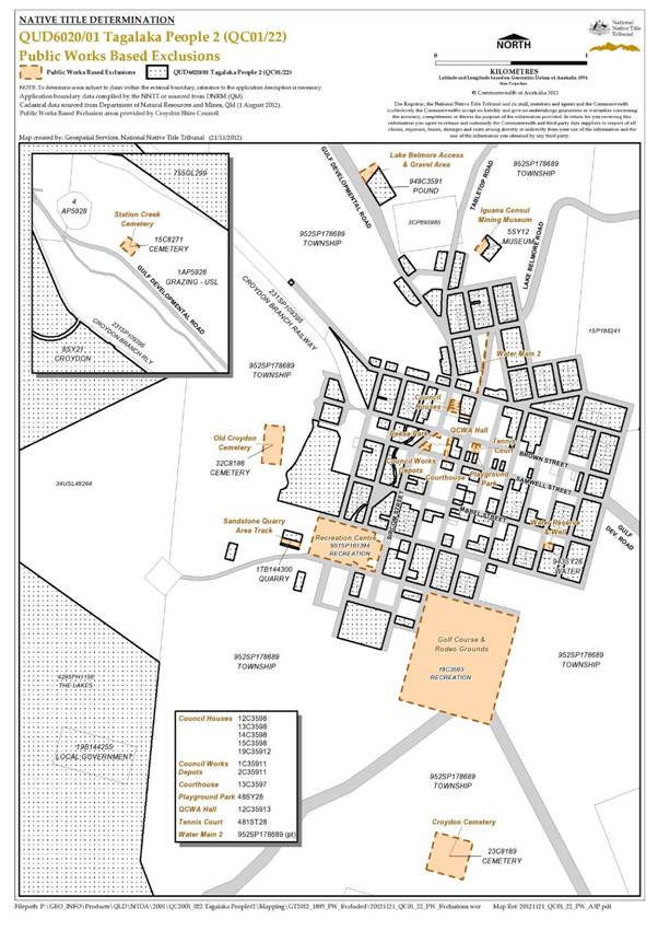
SCHEDULE 3 — NATIVE TITLE HOLDERS
The native title holders are the Tagalaka People who are descendants of the following people:
(a) Nelly Robertson (nee Grogan);
(b) Edith Echo;
(c) Edith Sargent;
(d) Charlie Hayes (aka Short Charlie);
(e) Herbie East;
(f) Topsy Cane (aka Topsy Owens);
(g) Jack Fortune; or
(h) Left hand Charlie.
SCHEDULE 4 — OTHER INTERESTS IN THE DETERMINATION AREA
The nature and extent of the Other Interests in relation to the Determination Area are the following, as they exist as at the date of the Determination:
1. The rights and interests of the parties under the following indigenous land use agreements:
(a) Tagalaka People and the State of Queensland as parties to the Tagalaka Croydon Area Indigenous Land Use Agreement #1 registered on 19 August 2005;
(b) Tagalaka People and the State of Queensland as parties to the Tagalaka (Town of Croydon) Indigenous Land Use Agreement registered on 5 September 2008;
(c) native title holders and the Croydon Shire Council registered on 11 February 2008;
(d) native title holders and the Croydon Shire Council as parties to the Croydon Shire Council/Tagalaka People True Blue Tourist Facility ILUA (QIA 2009/068) registered on 14 May 2010;
(e) native title holders and the Croydon Shire Council as parties to the Tagalaka Croydon Area ILUA #2 (QIA 2006/047) registered on 11 February 2008;
(f) native title holders and the Carpentaria Shire Council authorised on 1 May 2012;
(g) native title holders and the Croydon Shire Council authorised on 1 May 2012;
(h) native title holders and the Etheridge Shire Council authorised on 1 May 2012;
(i) native title holders and Ergon Energy Corporation Limited authorised on 1 May 2012;
(j) Tagalaka People/Agantra ILUA authorised on 1 May 2012;
(k) Tagalaka People/Alehvale and Mooremount ILUA authorised on 1 May 2012;
(l) Tagalaka People/Arduno, Haydon and Timora ILUA authorised on 1 May 2012;
(m) Tagalaka People/Beach ILUA authorised on 1 May 2012;
(n) Tagalaka People/Belmore ILUA authorised on 1 May 2012;
(o) Tagalaka People/Blancourt ILUA authorised on 1 May 2012;
(p) Tagalaka People/Broadwater ILUA authorised on 1 May 2012;
(q) Tagalaka People/Carnes ILUA authorised on 1 May 2012;
(r) Tagalaka People/Chadshunt ILUA authorised on 1 May 2012;
(s) Tagalaka People/Claraville ILUA authorised on 1 May 2012;
(t) Tagalaka People/Clotilda ILUA authorised on 1 May 2012;
(u) Tagalaka People/Dumas ILUA authorised on 1 May 2012;
(v) Tagalaka People/Ella Vale and Yappar River ILUA authorised on 1 May 2012;
(w) Tagalaka People/Entrona and Pepatra ILUA authorised on 1 May 2012;
(x) Tagalaka People/Esmeralda ILUA authorised on 1 May 2012;
(y) Tagalaka People/Florence ILUA authorised on 1 May 2012;
(z) Tagalaka People/Fog Creek ILUA authorised on 1 May 2012;
(aa) Tagalaka People/Forest Home ILUA authorised on 1 May 2012;
(bb) Tagalaka People/Glenore ILUA authorised on 1 May 2012;
(cc) Tagalaka People/Golden Gate ILUA authorised on 1 May 2012;
(dd) Tagalaka People/Green Hills ILUA authorised on 1 May 2012;
(ee) Tagalaka People/Guildford ILUA authorised on 1 May 2012;
(ff) Tagalaka People/Gum Creek ILUA authorised on 1 May 2012;
(gg) Tagalaka People/Heliman Creek ILUA authorised on 1 May 2012;
(hh) Tagalaka People/Karron and May Vale ILUA authorised on 1 May 2012;
(ii) Tagalaka People/Linley ILUA authorised on 1 May 2012;
(jj) Tagalaka People/Lucksome ILUA authorised on 1 May 2012;
(kk) Tagalaka People/Malacura ILUA authorised on 1 May 2012;
(ll) Tagalaka People/Miecolon and Vena Park ILUA authorised on 1 May 2012;
(mm) Tagalaka People/Mundjuro ILUA authorised on 1 May 2012;
(nn) Tagalaka People/New Water ILUA authorised on 1 May 2012;
(oo) Tagalaka People/Northhead ILUA authorised on 1 May 2012;
(pp) Tagalaka People/Oakland Park ILUA authorised on 1 May 2012;
(qq) Tagalaka People/Paddy’s Station (aka Candlow) ILUA authorised on 1 May 2012;
(rr) Tagalaka People/Prospect ILUA authorised on 1 May 2012;
(ss) Tagalaka People/Reigate ILUA authorised on 1 May 2012;
(tt) Tagalaka People/Rockyview ILUA authorised on 1 May 2012;
(uu) Tagalaka People/Roderick ILUA authorised on 1 May 2012;
(vv) Tagalaka People/Tabletop ILUA authorised on 1 May 2012;
(ww) Tagalaka People/The Lakes ILUA authorised on 1 May 2012;
(xx) Tagalaka People/Trenton ILUA authorised on 1 May 2012;
2. The rights and interests of the Croydon Shire Council, the Carpentaria Shire Council or the Etheridge Shire Council (the “Councils”) including any rights the Councils, their employees, agents or contractors have;
(a) under their local government jurisdiction and functions under the Local Government Act 2009 (Qld), under the Land Protection (Pests and Stock Route Management) Act 2002 (Qld) and under any other legislation, for that part of the Determination Area within their local government areas, as defined in the Local Government Act 2009 (Qld);
(b) as the:
(i) lessors under any leases which were entered into as at the date of the Determination ;
(ii) grantors of any licences or other rights and interests which were granted as at the date of the Determination;
(iii) holders of any estates or interests in land, and as trustees of any reserves, that exist in the Determination Area as at the date of the Determination;
(c) as the owners and operators of infrastructure, facilities and other improvements located in the Determination Area as at the date of the Determination, including but not limited to:
(i) dedicated roads operated by the Councils;
(ii) gravel pits operated by the Councils;
(iii) undedicated but constructed roads except for those not operated by the Councils;
(iv) water pipelines and other water supply infrastructure;
(v) drainage facilities; and
(vi) cemetery and cemetery related facilities; and
(d) to enter the land described in paragraphs 2(a) to 2(c) of Schedule 4 to:
(i) exercise any of the rights and interests referred to in paragraphs (a) to (c);
(ii) inspect, maintain and repair the infrastructure, facilities and other improvements referred to in paragraph (c);and
(iii) undertake operational activities in their capacity as a local government such as feral animal control, weed control, erosion control, waste management and fire management.
3. The rights and interests of Telstra Corporation Limited:
(a) as the owner or operator of telecommunications facilities within the Determination Area;
(b) created pursuant to the Post and Telegraph Act 1901 (Cth), the Telecommunications Act 1975 (Cth), the Australian Telecommunications Corporation Act 1989 (Cth), the Telecommunications Act 1991 (Cth) and the Telecommunications Act 1997 (Cth) including rights:
(i) to inspect land;
(ii) to install and operate telecommunication facilities; and
(iii) to alter, remove, replace, maintain, repair and ensure the proper functioning of its existing and any new telecommunication facilities;
(c) for its employees, agents or contractors to access its telecommunications facilities in and in the vicinity of the Determination Area in performance of their duties ; and
(d) under any licence or access agreement relating to its telecommunication facilities in the Determination Area.
4. The rights and interests of Ergon Energy Corporation Ltd:
(a) as the owner and operator of any “Works” as that term is defined in the Electricity Act 1994 (Qld) within the Determination Area;
(b) as a distribution entity and the holder of a distribution authority under the Electricity Act 1994 (Qld);
(c) created under the Electricity Act 1994 (Qld) and the Government Owned Corporations Act 1993 (Qld), including:
(i) rights in relation to any agreement relating to the Determination Area existing or entered into before the date on which these orders are made;
(ii) rights to enter the Determination Area by its employees, agents or contractors to exercise any of the rights and interests referred to in this paragraph; and
(iii) and to inspect, maintain and manage any Works in the Determination Area.
5. The rights and interests of the holders of any authorities, licences, permits or allocations issued under the Water Act 2000 (Qld);
6. The rights and interests of the holders of any leases, licences, reservations, permits, easements or authorities granted under the Land Act 1994 (Qld), and any relevant regulations or subordinate legislation made under the Act;
7. The rights and interests of the holders of any permits, claims, licences or leases granted under the Mineral Resources Act 1989 (Qld); and
8. Any other rights and interests held by the State of Queensland or Commonwealth of Australia, or by reason of the force and operation of the Laws of the State or Commonwealth.
Note: Entry of orders is dealt with in Rule 39.32 of the Federal Court Rules 2011
QUEENSLAND DISTRICT REGISTRY | |
GENERAL DIVISION | QUD 6109 of 1998 |
BETWEEN: | JANETTE OWENS, CLARA BOOTH, BEVERLY BOWYANG, JANET BUSCH, GLADYS CALLOPE, JOSEPH CALLOPE, ALMA DOUGLAS, BILL FORTUNE AND JOHNNY MILES ON BEHALF OF THE TAGALAKA PEOPLE Applicant
|
AND: | STATE OF QUEENSLAND First Respondent CROYDON SHIRE COUNCIL Second Respondent ERGON ENERGY CORPORATION LIMITED Third Respondent
|
IN THE FEDERAL COURT OF AUSTRALIA | |
QUEENSLAND DISTRICT REGISTRY | |
GENERAL DIVISION | QUD 6020 of 2001 |
BETWEEN: | JANET BUSCH, BEVERLY BOWYANG, GLADYS CALLOPE, MAUREEN DOUGLAS, BILL FORTUNE AND JANETTE OWENS ON BEHALF OF THE TAGALAKA PEOPLE #2 Applicant |
AND: | STATE OF QUEENSLAND First Respondent CARPENTARIA SHIRE COUNCIL Second Respondent CROYDON SHIRE COUNCIL Third Respondent ETHERIDGE SHIRE COUNCIL Fourth Respondent ERGON ENERGY CORPORATION LIMITED Fifth Respondent ALLEN JOHN BETHEL, CARMEL MAREE BETHEL, SYLVIA BING-CHEW, WAYNE BING-CHEW, CEDAR DAWN PTY LTD, ERIC MERVYN ELLEMS, TERRENCE JOHN FLUTE, G & C CONNOLLY PTY LTD AS TRUSTEE FOR THE G & C CONNOLLY FAMILY TRUST, ALAN ROSS GAYNOR, URSULA JANE GAYNOR, COLLEEN OLIVE HENRY, MERVYN ROY HENRY, RAYELENE MARGARET HENRY, DAVID BAILEY HINRICHSEN, JOSEPHINE BATHIA HOBBS, BARRY GILBERT HUGHES, EDWARD JAMES HUGHES, SHARON DALE HUGHES, TAMMY MARIE HUGHES, DIANE OLIVE JENSEN, KELVIN JOHN JENSEN, ROBYN MAY LETHBRIDGE, BARRY JOHN MARTIN, IAN BRUCE MARTIN, JOHN ALBERT MARTIN, RAY JOSEPH MARTIN, KATHLEEN MAY MCFARLANE, ROBERT WALTER MCFARLANE, CAROL ELIZABETH RYAN, GREGORY JAMES RYAN, DAVID ANTHONY SIMMONS, HELEN JOYCE SIMMONS, DAVID WILLIS, JAMES HARDWICK WILLIS AND JANETTE PEARL WILLIS Sixth – Fortieth Various Pastoral Respondents |
JUDGE: | LOGAN J |
DATE: | 10 DECEMBER 2012 |
PLACE: | CROYDON |
REASONS FOR JUDGMENT
1 The applications that are the subject of these proceedings are for the determination of native title rights and interests under the Native Title Act 1993 (Cth) (the Act) in favour of the native title holders of land and waters within the bounds of the land described in Schedule 1 to the proposed determinations.
2 In particular, for determination today, is QUD 6109 of 1998, “Tagalaka People” and, pursuant to orders of 3 October 2012, QUD 6020 of 2001, “Tagalaka People #2 Part A”. The orders of 3 October 2012 further contemplate the later, separate consideration of whether native title rights and interests exist in respect of another portion of land on which there is a pastoral development holding, which is to be “Tagalaka People #2 Part B”.
3 The applications for orders in the terms of the proposed determinations for QUD 6109 of 1998 and QUD 6020 of 2001 (Part A) are being heard together as they are geographically proximate and entail consideration of materially the same anthropological evidence concerning the Tagalaka People. The applicants seek a determination of native title on behalf of the Tagalaka People over various lands in and proximate to the township of Croydon in the Gulf Country of north-western Queensland.
4 The properties over which the proposed consent determination will be granted are described in more detail in the maps in Schedule 1 to the determinations.
5 One of the Commonwealth Parliament’s objectives in respect of the Act is the resolution of claims for the recognition of native title by agreement. That objective is borne out in s 87 together with, as relevant to QUD 6020 of 2001, s 87A of the Act.
6 These claims have been long in their gestation. I made observations earlier this year in Hoolihan on behalf of the Gugu Badhun People # 2 v State of Queensland [2012] FCA 800 and Archer on behalf of the Djungan People #1 v State of Queensland [2012] FCA 801 that native title claims which linger unresolved on a court list are an affront to our system of justice. I related in those cases how Parliament’s objective of consensual resolutions had been met. The statements which I then made are just as applicable to this case. The achievement of Parliament’s objective would not have been possible without much hard and dedicated work by experienced legal advisers, the responsible actions of the parties guided by their advisers and, especially latterly, intensive case management, particularly by the Court’s registrars. I commend the parties and the legal practitioners involved in cases being heard today for the work latterly undertaken in bringing them to final, consensual resolution.
7 In the aftermath of Wik Peoples v Queensland (1996) 187 CLR 1, the Executive Government of the Commonwealth made provision for legal assistance to be provided to pastoralists in relation to native title claims. Over the time during which I have been responsible for the management of the list of native title cases in this region, I have directly observed how, in combination with responsible legal representation of applicants, via the North Queensland Land Council, of the State, via the Crown Solicitor and of other respondents, this legal assistance to pastoralists has repeatedly and beneficially contributed to the administration of justice and thus to Parliament’s goal of national reconciliation in this important area of the Court’s jurisdiction. Recently, it has been announced by the Attorney-General that this legal assistance to pastoralists will cease with effect from the end of this year. Such value judgments are for the Executive Government of the day to make. What I can say, based on direct experience, is that the addressing of the hitherto “unacceptably long time” for the resolution of native title cases and the recent experience of “faster and better claim resolution” to which the Attorney has made reference (Echoes of Mabo: AIATSIS Native Title Conference, 6 June 2012, Speech by the Honourable Nicola Roxon MP, Attorney-General, http://www.attorneygeneral.gov.au/Speeches/Pages/2012/Second%20
Quarter/6-June-2012---Echoes-of-Mabo---AIATSIS-Native-Title-Conference.aspx Accessed 7 December 2012) requires a combination of responsible legal representation of all interested parties and intensive case management and proactive, targeted use of alternative dispute resolution where appropriate by the judges and registrars of this Court. There is much work yet to be done in the native title list in this State and much scope for misunderstanding and unnecessary acrimony and delay in relation to native title claims in the absence of responsible legal representation.
8 In Baker on behalf of the Muluridji People v State of Queensland [2011] FCA 1432 (Muluridji) I adopted observations made in King v Northern Territory of Australia [2011] FCA 582 (King) per Mansfield J. His Honour made a number of observations about the preamble to the Act. I am in complete agreement not only with the substance of his Honour’s observations in King but also with the manner in which he expressed them. They are exactly apposite in the present proceedings also. As I observed in Muluridji, I propose therefore to adopt them as my own in these reasons for judgment without further attribution.
9 The preamble to the Act recognised, on behalf of all people of Australia, that the Aboriginal peoples of Australia inhabited this country for many years prior to European settlement, and that the Aboriginal peoples had been progressively dispossessed of their lands. It recorded that, by the overwhelming vote of the people of Australia, the Constitution was amended to enable laws such as the Act to be passed, to facilitate the recognition by our shared legal system of the native title rights and interests in their land. This is an occasion when the Court is to make orders declaring that the groups of Aboriginal persons in the current applications have always been the traditional owners of the land. By the Court’s orders, the Australian community collectively recognises that status. It is important to emphasise that the Court’s orders do not grant that status. The Court is declaring that it exists and has always existed at least since European settlement.
10 The applicant has filed the following documents principally relevant to QUD 6109 of 1998:
(a) Affidavit of Mr Gregory Bell affirmed and filed on 23 November 2012, exhibiting:
(i) Dr Sandra Pannell, ‘Tagalaka Native Title Determination Applications (QC98/43 & QC01/22) Draft Connection Report’, June 2002 (the “Connection Report”);
(ii) Dr Sandra Pannell, ‘Tagalaka Native Title Determination Applications (QC98/43 & QC01/22) Supplementary Report (No 1)’, October 2006;
(iii) Dr Sandra Pannell, ‘Tagalaka Native Title Determination Applications (QC98/43 & QC01/22) Tagalaka Claimant Statements’ (the “Tagalaka Claimant Statements”); and
(iv) Dr Sandra Pannell, ‘Tagalaka Native Title Determination Applications (QC98/43 & QC01/22) Executive Summary of Connection Materials’, October 2011 (the “Executive Summary”).
(b) Affidavit of Mr Gregory Bell affirmed on 23 November 2012 and filed on 26 November 2012, deposing to compliance with s 56 and s 57 of the Act regarding the prescribed body corporate and exhibiting:
(i) a certificate of incorporation of the Tagalaka Tribal Aboriginal Corporation dated 15 December 1994; and
(ii) ‘Notice of Nomination and Consent of the Prescribed Body Corporate’.
(c) Outline of submissions in support of the proposed consent determination filed on 29 November 2012;
(d) Further amended native title determination application (Form 1) filed on 30 November 2012; and
(e) Proposed orders and Determination of Native Title by Consent (s 87 Agreement), signed by the parties and filed on 3 December 2012.
11 The applicant has filed the following documents principally relevant to QUD 6020 of 2001:
(a) Affidavit of Mr Gregory Bell affirmed and filed on 23 November 2012, exhibiting:
(i) Dr Sandra Pannell, ‘Tagalaka Native Title Determination Applications (QC98/43 & QC01/22) Draft Connection Report, June 2002’ (the “Connection Report”);
(ii) Dr Sandra Pannell, ‘Tagalaka Native Title Determination Applications (QC98/43 & QC01/22) Supplementary Report (No 1)’, October 2006;
(iii) Dr Sandra Pannell, ‘Tagalaka Native Title Determination Applications (QC98/43 & QC01/22) Tagalaka Claimant Statements’ (the “Tagalaka Claimant Statements”); and
(iv) Dr Sandra Pannell, ‘Tagalaka Native Title Determination Applications (QC98/43 & QC01/22) Executive Summary of Connection Materials’, October 2011 (the “Executive Summary”).
(b) Affidavit of Mr Gregory Bell affirmed on 23 November 2012 and filed on 26 November 2012, deposing to compliance with s 56 and s 57 of the Act regarding the prescribed body corporate and exhibiting:
(i) a certificate of incorporation of the Tagalaka Tribal Aboriginal Corporation dated 15 December 1994; and
(ii) ‘Notice of Nomination and Consent of the Prescribed Body Corporate’.
(c) Outline of submissions in support of the proposed consent determination filed on 29 November 2012;
(d) Further amended native title determination application (Form 1) filed on 30 November 2012; and
(e) Proposed orders and Determination of Native Title by Consent (s 87A Agreement), signed by the parties and filed on 3 December 2012.
SECTION 87 OF THE ACT
12 The applicants in QUD6109 of 1998 submit that it is appropriate in the circumstances for the Court to exercise its discretion under s 87(1A) of the Act.
13 Section 87 of the Act provides that the Court may make a determination of native title by consent over an area covered by a native title application and without holding a hearing where:
(a) The period specified in the notice given under s 66 of the Act has ended (s 87(1));
(b) There is an agreement between the parties on the terms of an order of the Court in relation to the proceedings (s 87(1)(a)(i));
(c) The terms of the agreement are in writing and are signed by or on behalf of the parties and filed with the Court (s 87(1)(b));
(d) The Court is satisfied that an order in, or consistent with, those terms would be within its power (s 87(1)(c)); and
(e) Having satisfied the criteria relevantly detailed, the Court considers the making of orders as it appears to the Court to be appropriate to do so pursuant to s 87(1A) of the Act. The Court may make a determination in accordance with s 87(2), as is relevant to these proceedings.
14 The focus of the Court in considering whether the orders sought are appropriate under s 87(1) and s 87(2) is on the making of the agreement by the parties. In Muluridji I cited observations of North J in Lovett on behalf of the Gunditjmara People v State of Victoria [2007] FCA 474. Such remarks are apt to be adopted in this case. His Honour stated:
[36] … The Act is designed to encourage parties to take responsibility for resolving proceeding without the need for litigation. Section 87 must be construed in this context. The power must be exercised flexibly and with regard to the purpose for which the section is designed.
[37] In this context, when the Court is examining the appropriateness of an agreement, it is not required to examine whether the agreement is grounded on a factual basis which would satisfy the Court at a hearing of the application. The primary consideration of the Court is to determine whether there is an agreement and whether it was freely entered into on an informed basis: Nangkiriny v State of Western Australia (2002) 117 FCR 6; [2002] FCA 660, Ward v State of Western Australia [2006] FCA 1848. Insofar as this latter consideration applies to a State party, it will require the Court to be satisfied that the State party has taken steps to satisfy itself that there is a credible basis for an application: Munn v Queensland (2001) 115 FCR 109; [2001] FCA 1229.
15 As such, the Court is not required to make its own inquiry of the merits of the applicant’s claim to be satisfied that the orders sought are supportable and in accordance with the law: Cox on behalf of the Yungngora People v State of Western Australia [2007] FCA 588 at [3]. The Court may consider such evidence to determine whether the State is acting in good faith and rationally: Munn (for and on behalf of the Gunggari People) v Queensland (2001) 115 FCR 109 at [29]-[30].
16 In Smith v State of Western Australia (2000) 104 FCR 494 at [38], Madgwick J stated:
[38] … State governments are necessarily obliged to subject claims for native title over lands and waters owned and occupied by the State and State agencies, to scrutiny just as careful as the community would expect in relation to claims by non-Aborigines to significant rights over such land.
SECTION 87A OF THE ACT
17 The applicants in QUD 6020 of 2001, insofar as the proceeding encompasses Tagalaka #2 Part A, submit that it is appropriate in the circumstances for the Court to exercise its discretion under s 87A(4) of the Act. The submissions of the applicants in support of the Court making orders in the terms of the proposed consent determination, confirm the utilisation of s 87A of the Act as the orders sought pertain to a part of the area of the application in QUD 6020 of 2001.
18 Section 87A of the Act provides, in effect, that the Court may make a determination of native title by consent over part of an application area without holding a hearing where:
(a) the period specified in the notice given under s 66 of the Act has ended (s 87A(1)(b));
(b) there is an agreement for a proposed determination of native title in relation to part of an area covered by the native title application (s 87A(1)(b));
(c) the terms of the proposed determination are in writing, signed by or on behalf of all of the parties required to be parties to the agreement pursuant to s 87A(1)(c) and are filed with the Court (ss 87A(1)(c), 87A(1)(d) and 87A(2));
(d) the registrar of the Federal Court has given notice to the other parties to the proceeding who have not become, or are not required to be, parties to the agreement that the proposed determination of native title has been filed with the Court (s 87A(3));
(e) the Court has taken into account any objection made by the other parties to the proceeding (s 87A(8));
(f) the Court is satisfied that an order in, or consistent with, those terms would be within the power of the Court (s 87A(4)(a)); and
(g) it appears appropriate to the Court to make the orders sought (s 87A(4)(b)).
19 In May v State of Western Australia [2012] FCA 1333 at [13], Gilmour J, citing his Honour’s earlier decision in Goonack v State of Western Australia [2011] FCA 516 considered the operation of s 87A(4) as follows:
[25] The terms of s 87A(4) of the Native Title Act do not necessarily require the Court to receive evidence, make findings, embark on its own inquiry on the merits of the claim made in the application or even to form a concluded view as to whether the legal requirements for proving native title have been met. It is appropriate for the Court to make orders under s 87A where no evidence of the primary facts substantiating native title has been received if the Court is satisfied that the parties have freely and on an informed basis come to an agreement: Brown v Western Australia at [23]-[24] in respect of s 87A and Hughes v Western Australia [2007] FCA 365 at [9]; Ward v Western Australia [2006] FCA 1848 at [8]. The exercise of the Court’s discretion pursuant to s 87A of the Native Title Act imports the same principles as those applying to the making of a consent determination of native title under section 87: Brown v Western Australia [207] FCA 1025; Nangkiriny v Western Australia (2002) 117 FCR 6; Nangkiriny v Western Australia [2004] FCA 1156; James v Western Australia [2002] FCA 1208; Hughes v Western Australia and under alternatively s 87 and s 87A; Brown v Western Australia.
[26] The requirements of s 87A(4) of the Native Title Act will be met where the Court is satisfied that the State, through competent legal representation, is satisfied as to the cogency of the evidence upon which the applicant relies. Generally this will not involve the Court making findings on the evidence on which the State relies, but it might consider that evidence for the limited purpose of being satisfied that the State is acting in good faith and rationally: Munn v Queensland (2001) 115 FCR 109 at [29]-[30] and Lovett v Victoria [2007] FCA 474 at [37].
[emphasis added]
20 As the Court is guided by the same principles as between s 87 and s 87A of the Act in exercising its discretion, these reasons for judgment will consider together the requirements of the Act which inform the Court as to whether a proposed determination of native title by consent is appropriate.
SECTION 94A OF THE ACT
21 Section 94A of the Act requires that a native title determination order must satisfy the requirements of s 225 of the Act. Section 225 provides:
A determination of native title is a determination whether or not native title exists in relation to a particular area (the determination area) of land or waters and, if it does exist, a determination of:
(a) who the persons, or each group of persons, holding the common or group rights comprising the native title are; and
(b) the nature and extent of the native title rights and interests in relation to the determination area; and
(c) the nature and extent of any other interests in relation to the determination area; and
(d) the relationship between the rights and interests in paragraphs (b) and (c) (taking into account the effect of this Act); and
(e) to the extent that the land or waters in the determination area are not covered by a non-exclusive agricultural lease or a non-exclusive pastoral lease -- whether the native title rights and interests confer possession, occupation, use and enjoyment of that land or waters on the native title holders to the exclusion of all others.
Note: The determination may deal with the matters in paragraphs (c) and (d) by referring to a particular kind or particular kinds of non-native title interests.
[emphasis in original]
22 Section 223(1) of the Act defines ‘native title’ and ‘native title rights and interests’ as:
(1) … the communal, group or individual rights and interests of Aboriginal peoples or Torres Strait Islanders in relation to land or waters, where:
(a) the rights and interests are possessed under the traditional laws acknowledged, and the traditional customs observed, by Aboriginal peoples or Torres Strait Islanders; and
(b) the Aboriginal peoples or Torres Strait Islanders, by those laws and customs, have a connection with the land or waters; and
(c) the rights and interests are recognised by the common law of Australia.
23 In Members of the Yorta Yorta Aboriginal Community v State of Victoria (2002) 214 CLR 422, Gleeson CJ, Gummow and Hayne JJ (with McHugh J agreeing) stated the relevant principles with respect to s 223 of the Act, at [46] to [55] and [80] to [83]:
(a) A traditional law or custom which is the source of native title rights and interests is one which has been passed from generation to generation of a society, usually by word of mouth and common practice.
(b) The origins of the law or custom from which native title rights and interests stem must be found in the normative rules of the relevant Aboriginal or Torres Strait Islander society that existed before the assertion of sovereignty by the British Crown – it is only those rules that are “traditional” laws and customs.
(c) That normative system must have a continuous existence and vitality since sovereignty.
(d) If that society ceases to exist as a group which acknowledges and observes those pre-sovereignty laws and customs, those laws and customs cease to have continued existence and vitality.
(e) Only native title rights or interests that existed at the time of the change in sovereignty will be recognised. However, some change to, or adaptation of, traditional laws or customs or some interruption in the enjoyment or exercise of native title rights or interests in the period between the Crown asserting sovereignty and the present will not necessarily be fatal to a native title claim.
(f) In many cases, perhaps most, claimants will invite the Court to infer, from evidence led at trial, the content of traditional laws and customs at times earlier than those described in the evidence.
24 Further, there is authority of this Court, exercising appellate jurisdiction, which lends itself to a determinative conclusion that physical presence is not a necessary requirement for continuing connection. See, for example, Moses v State of Western Australia [2007] FCAFC 78 at [306] per Moore, North and Mansfield JJ.
APpLICATION OF sECTION 223 and section 225 to THE tagalaka SOCIETY
25 Dr Parnell’s Connection Report evidences there were indigenous people in the Croydon area at the time of first contact and in the pre-sovereignty period.
26 The applicants and those Aboriginal people they represent collectively identify themselves as ‘Tagalaka’. Dr Parnell opines that in “the claimants’ use, Tagalaka broadly denotes three elements of people’s social and cultural identity” (p 8, the Connection Report). In summary, these three elements are a way of speaking, as commonly used by the claimants’ immediate forebears, a defined area of land and waters and an identifiable group of largely kin-related people who claim a connection to Tagalaka-speaking forebears (p 8, the Connection Report).
27 From the filed material mentioned previously, including the Executive Summary, it appears that the Aboriginal persons who spoke the ‘Dagalag’ dialect of the Southern Pama language group used and occupied Tagalaka country, prior to 1788 (the date of the assertion of British sovereignty). Archaeological records furnished in support of occupation attests to Aboriginal people occupying the Croydon region, including the uplands of the Gregory Ranges to the Carpentaria Plain, in the pre-sovereignty period.
28 While the Tagalaka language forms part of the broader Southern Pama language group, the applicants submit that the Tagalaka claimants are to be distinguished from other Aboriginal peoples and other Aboriginal groups in the region, such as Kurtjar and Ewamain, on the basis of language, country and group identity.
29 The earliest known reference to the identity of Aboriginal people in the claimed area is a letter drafted by a pastoral lease holder, Edward Palmer in December, 1882. Dr Parnell cites Palmer’s referral to the ‘Dagalaggan’ tribe, an orthographic variant of the Tagalaka tribe (p88, the Connection Report). Overall, as the applicants’ submissions conclude, the anthropological evidence from the 19th and 20th centuries locates orthographic variants of the ethnonym, Tagalaka, in the southern Gulf Country, in approximately the same vicinity as the present claimed area.
30 It is also clear on the evidence to hand that the use of the Tagalaka dialect and the transfer of Tagalaka cultural knowledge have continued throughout the 20th Century. The Court is asked to infer that the Tagalaka people today are descended from the community of people who spoke the Tagalaka dialect and used and occupied Tagalaka country prior to 1788. This is supported by historical material which locates the community of the Tagalaka people, including the apical ancestors, in the early days of European contact, in this case from the 1880s, and establishes the basis for the finding that they are descended from a pre-sovereignty community of Tagalaka ancestors.
31 The material also provides that the Tagalaka people have an identity and a connection to the land through the application of normative rules associated with dreaming stories and significant places. Through this connection with the land, the Tagalaka people, as an organised society, possessed native title rights and interests in accordance with their observed and acknowledged traditional laws and customs. The material supports the intergenerational transfer of those laws and customs and support for the inference that they, and the rights and interests possessed by them, originated in a pre-sovereignty Tagalaka society.
32 It is also apparent that while there has been some adaptation of laws and customs as a result of sustained European settlement, those changes have not affected the laws and customs of the Tagalaka people to the extent where those laws and customs are no longer observed.
33 Accordingly, it is appropriate to make the proposed orders which recognise:
(a) That the claim group comprises a society united in and by their acknowledgement and observance of a body of accepted traditional laws and customs;
(b) That the present day body of accepted laws and customs of the society in essence is the same body of laws and customs acknowledged and observed by the ancestors or members of the society adapted to modern circumstances;
(c) That the acknowledgement and observance of those laws and customs has continued substantially uninterrupted by each generation since sovereignty, and that the society has continued to exist throughout that period as a body united in and by its acknowledgement and observance of those laws and customs; and
(d) That the claim group still possesses rights and interests under the traditional laws acknowledged and the traditional customs observed by them, and that those laws and customs give them a connection to the land.
THE APPLICATION OF SECTION 87 to the tagalaka people claim
34 The requirements of s 87 of the Act have been satisfied in the present case. In particular:
(a) The period specified in the notice given under s 66 ended on 19 December 2000 (s 87(1));
(b) The parties have reached an agreement as to the terms of a determination of native title (s 87(1)(a)(i));
(c) The parties have recorded their agreement in a short minute of consent (s 87(1)(b));
(d) An order in terms of or consistent with the short minute of consent would be within the Court’s power (s 87(1)(c)) because:
(i) The Applications are valid and were made in accordance with s 61 of the Act; and
(ii) The Applications are for a determination of native title in relation to an area for which there is no approved determination of native title (s 13(1)(a)).
The short minute complies with s 94A and s 225 of the Act (s 87(1)(c)); and
(e) It is appropriate that the Court make the orders sought because:
(i) All parties are legally represented;
(ii) It is consistent with objects in the Act that issues and disputes concerning native title are resolved by mediation;
(iii) The State of Queensland has played an active role in negotiating the consent determination. In participating in these negotiations, the State of Queensland, acting on behalf of the general community, having had regard to the Act’s requirements and having conducted a thorough assessment process, is satisfied that the determination is justified in all the circumstances;
(iv) The material relied upon by the applicants is capable of satisfying s 47B of the Act;
(v) The connection material filed by the applicants satisfies s 223 of the Act and supports the making of the proposed determination;
(vi) The requirements of s 94A and s 225 of the Act are satisfied; and
(vii) The proposed determination is unambiguous and certain as to the rights declared.
THE APPLICATION OF SECTION 87A to the tagalaka people #2 claim
35 The requirements of s 87A of the Act have been satisfied in the present case. In particular:
(a) the period specified in the notice given under s 66 ended on 7 May 2002 (s 87A(1)(b));
(b) there is an agreement for a proposed determination of native title in relation to part of an area covered by the native title application (s 87A(1)(b));
(c) the terms of the proposed determination are in writing, signed by or on behalf of all of the parties required to be parties to the agreement pursuant to s 87A(1)(c) and are filed with the Court (ss 87A(1)(c), 87A(1)(d) and 87A(2));
(d) as all parties to the proceeding signed the proposed minute of consent, the registrar was not required to give notice to the other parties to the proceeding (s 87A(3));
(e) as no objection was received, the Court is not required to take into account any objection made by the other parties to the proceeding (s 87A(8));
(f) the Court is satisfied that an order in, or consistent with, the terms sought would be within the power of the Court (s 87A(4)(a)); and
(g) it appears appropriate to the Court to make the orders sought (s 87A(4)(b)).
The short minute complies with s 94A and s 225 of the Act (s 87A(4)); and
(h) It is appropriate that the Court make the orders sought because:
(i) All parties are legally represented;
(ii) It is consistent with objects in the Act that issues and disputes concerning native title are resolved by mediation;
(iii) The State of Queensland has played an active role in negotiating the consent determination. In participating in these negotiations, the State of Queensland, acting on behalf of the general community, having had regard to the Act’s requirements and having conducted a thorough assessment process, is satisfied that the determination is justified in all the circumstances;
(iv) The material relied upon by the applicants is capable of satisfying s 47B of the Act;
(v) The connection material filed by the applicants satisfies s 223 of the Act and supports the making of the proposed determination;
(vi) The requirements of s 94A and s 225 of the Act are satisfied; and
(vii) The proposed determination is unambiguous and certain as to the rights declared.
determinations pursuant to section 56 and 57 of the act
36 Under s 55 of the Act, the Court is required, either at the time of the Determination or as soon as practicable after it, to make such determinations as are required by s 56 and s 57 of the Act. They respectively relate to holding the native title on trust or otherwise and if not held on trust, the non-trust functions of the prescribed body corporate. As to the proposed determinations, Mr Bell has deposed in his affidavit, affirmed and filed in both proceedings on 23 November 2012, the native title is not to be held on trust. It provides for an Aboriginal corporation, the Tagalaka Tribal Aboriginal Corporation, to be the prescribed body corporate under s 57 of the Act. That body corporate was registered on 15 December 1994. It will perform the functions mentioned in s 57(3) of the Act.
37 The Court notes that Mr Bell has exhibited to his affidavit, affirmed and filed in both proceedings on 23 November 2012, a Notice of Nomination and Consent of the Prescribed Body Corporate, which satisfies the requirements of s 57(2) of the Act.
38 Further, Mr Bell affirms that the Tagalaka Tribal Corporation intends drafting a new set of rules so as to satisfy the requirements of s 4 of the Native Title (Prescribed Bodies Corporate) Regulations 1999 (Cth).
39 Finally, and at the risk of repetition, it needs to be understood that agreements of the kind that have brought about today’s hearing and determinations do not just happen. They involve co-operation by all of the parties in the administration of justice, careful attention by them and their advisers to the requirements of the Act in relation to the proof of native title, related effort in the gathering of relevant evidence and the ready making of concessions as to whether on the evidence native title can be proved. They also involve the regular review by the Court at regional directions hearings, and in the intervals in between by the Court’s registrars, to ensure that an application is both prosecuted with due diligence by an applicant and not unreasonably delayed by a respondent in its progress towards a hearing like today or, if needs be, a contested hearing. Ensuring that is important in any litigation but is especially so in a proceeding under the Act which serves a wider public interest recognised in the preamble and which, through the allocation of judicial and other court resources and via the provision of various forms of legal aid, involves a considerable investment of public money.
40 For the reasons given, the Determinations are now made.
I certify that the preceding forty (40) numbered paragraphs are a true copy of the Reasons for Judgment herein of the Honourable Justice Logan. |
Associate:

