
FEDERAL COURT OF AUSTRALIA
Murgha on behalf of the Combined Gunggandji Claim v State of Queensland [2011] FCA 1511
IN THE FEDERAL COURT OF AUSTRALIA | |
DATE OF ORDER: | |
WHERE MADE: |
THE COURT ORDERS THAT:
Being satisfied that a determination in the terms sought by the parties is within the power of the Court, and it appearing appropriate to the Court to do so,
BY CONSENT THE COURT DETERMINES THAT:
1. Native title exists in relation to the Determination Area identified in Schedule 2.
2. The native title is held by the persons described in Schedule 1 (the “native title holders”).
3. Subject to paragraphs 5, 6 and 7 the nature and extent of the native title rights and interests, other than in relation to Water, are as follows:
(a) in relation to that part of the Determination Area identified in Schedule 3, the rights to possession, occupation, use and enjoyment to the exclusion of all others; and
(b) in relation to that part of the Determination Area identified in Schedule 4, the non-exclusive rights to:
(i) be present on, including by accessing and traversing the Determination Area; and
(ii) take and use Traditional Natural Resources from the Determination Area for personal, domestic and non-commercial communal purposes.
4. Subject to paragraphs 5, 6 and 7 the nature and extent of the native title rights and interests in relation to Water within the Determination Area are the non-exclusive rights to:
(a) hunt and fish in or on, and gather from, the Water for personal, domestic and non-commercial communal purposes; and
(b) take and use the Water for personal, domestic and non-commercial communal purposes.
5. There are no native title rights and interests in or in relation to minerals as defined by the Mineral Resources Act 1989 (Qld) and petroleum as defined by the Petroleum Act 1923 (Qld) and the Petroleum and Gas (Production and Safety) Act 2004 (Qld).
6. The native title rights and interests are subject to and exercisable in accordance with:
(a) the Laws of the State and the Commonwealth; and
(b) the traditional laws acknowledged and traditional customs observed by the native title holders.
7. The native title rights and interests referred to in paragraphs 3(b) and 4 do not confer possession, occupation, use or enjoyment to the exclusion of all others.
8. The nature and extent of any other rights and interests in relation to the Determination Area (or respective parts thereof) are set out in Schedule 5.
9. The relationship between the native title rights and interests described in paragraphs 3 and 4 and the other rights and interests described in Schedule 5 (the “other rights and interests”) is that:
(a) the other rights and interests continue to have effect, and the rights conferred by or held under the other rights and interests may be exercised notwithstanding the existence of the native title rights and interests;
(b) to the extent the other rights and interests are inconsistent with the continued existence, enjoyment or exercise of the native title rights and interests in relation to the land and waters of the Determination Area identified in Schedules 3 and 4, the native title continues to exist in its entirety but the native title rights and interests have no effect in relation to the other rights and interests to the extent of the inconsistency for so long as the other rights and interests exist; and
(c) the other rights and interests and any activity that is required or permitted by or under, and done in accordance with, the other rights and interests, or any activity that is associated with or incidental to such an activity, prevail over the native title rights and interests and any exercise of the native title rights and interests.
10. The words and expressions used in this determination have the same meanings as they have in Part 15 of the Native Title Act 1993 (Cth) except for the following defined words and expressions:
“Determination Area” means the land and waters described in Part A of Schedule 2 and shown on the plan in Part B of Schedule 2, and to the extent of any inconsistency between them, Part A of Schedule 2 prevails;
“High Water Mark” has the meaning given in the Land Act 1994 (Qld);
“Laws of the State and the Commonwealth” means the common law and the laws of the State of Queensland and the Commonwealth of Australia, and includes legislation, regulations, statutory instruments, local planning instruments and local laws;
“Traditional Natural Resources” means:
(a) “animals” as defined in the Nature Conservation Act 1992 (Qld), but not including fish;
(b) “plants” as defined in the Nature Conservation Act 1992 (Qld); and
(c) any clay, soil, sand, gravel or rock on or below the surface of the Determination Area,
that have traditionally been taken and used by the native title holders; and
“Water” means water as defined by the Water Act 2000 (Qld).
THE COURT DETERMINES THAT:
11. Paragraphs 1 to 10 take effect upon the agreements referred to in paragraph 1 of Schedule 5 being registered on the Register of Indigenous Land Use Agreements.
12. Upon paragraphs 1 to 10 taking effect:
(a) The native title is not held in trust;
(b) The Gunggandji PBC Aboriginal Corporation (ICN: 7421), incorporated under the Corporations (Aboriginal and Torres Strait Islander) Act 2006 (Cth), is to:
(i) be the prescribed body corporate for the purpose of s 57(2) of the Native Title Act 1993 (Cth); and
(ii) perform the functions mentioned in s 57(3) of the Native Title Act 1993 (Cth) after becoming a registered native title body corporate.
13. In the event that the agreements referred to in paragraph 11 are not registered on the Register of Indigenous Land Use Agreements within six (6) months of the date of this order or such later time as this Court may order, the matter is to be listed for further directions.
SCHEDULE 1 – Native title holders
The native title holders are those Aboriginal People:
(a) who are Gunggandji People on the basis of descent from one of the following persons:
(i) Merumanai II, or his wife Tonkobulu of King Beach (being the parents of Albert Underwood, Djaradjoan, Menmuny/King John Barlow/Merumanai III, and Nellie married to Loui);
(ii) Billy Brown (husband of Jinny Katchewan of Cape Grafton);
(iii) Billy Church/Goondor (the father of Maggie 1, Maggie 2 and Nora);
(iv) Kari (the father of George Christian);
(v) Mandi Tjapir (sister of Kari and wife of Billy Church);
(vi) Kutubi/Bertie Harris;
(vii) Mary Ann, or her brother Paddy of Jilji (husband of Nora);
(viii) Nego/Nengo (the mother of Maggie 2);
(ix) Mandekala of Cape Grafton or Njemnga/Njewnga of Cape Grafton (the parents of Jinny Katchewan of Cape Grafton);
(x) Rosie of Buddabadoo;
(xi) Billy (Woopah) of Buddabadoo;
(xii) Harry Myngha; or
(b) who have been recruited by adoption as a member of the Gunggandji People in accordance with their traditional law and custom.
SCHEDULE 2 – Determination Area
PART A
All of the land and waters described in column 1 of the following table and shown on the determination plan described in column 2 of the following table, excluding any area of land and waters on which a public work, as defined in s 253 of the Native Title Act 1993 (Cth), is constructed, established or situated, and to which ss 23B(7) and 23C(2) of the Native Title Act 1993 (Cth) and/or s 23B(7) of the Native Title Act 1993 (Cth) and s 21 of the Native Title (Queensland) Act 1993 (Qld), applies, together with any adjacent land and waters in accordance with s 251D of the Native Title Act 1993 (Cth):
Area Description as at date of determination | Lot on Determination Plan |
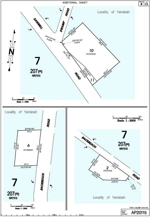
Part of Lot 207 on Plan NR 7310, being within that part of the Yarrabah deed of grant in trust dated 27 October 1986 (‘DOGIT’), commencing at a point located at a point on Lot 207 on Plan NR7310 located at Oombunghi Beach and known as Djilji and having longitude 145.9001070° East and latitude 16.98053900° South, and bounded thence by a line up to and thence generally along a centreline of a ridgeline bearing 283° 15’22” distant 1623.8 metres to a point having longitude 145.8852403° East latitude 16.97739693° South and bounded thence by a line generally along a centreline of a ridgeline bearing 293° 57’47” distant 397.2 metres to a point having longitude 145.8818395° East latitude 16.97592003° South and bounded thence by a line across the Oombunghi Creek bearing 330° 48’21” distant 2723.2 metres to a point having longitude 145.8694932° East latitude 16.95436586° South being also a point that is on a centreline of a ridgeline, and bounded thence by a line generally along the centreline of a ridgeline bearing 290° 29’51” distant 318.9 metres to a point having longitude 145.866693° East latitude 16.9533408° South being also a point that is on a centreline of a ridgeline, and bounded thence by a line generally along a centreline of a ridgeline bearing 296° 54’08” distant 460.0 metres to Mount Gorton being also a point on the DOGIT boundary, and also a point having longitude 145.862852° East latitude16.951438° South and bounded thence by a line along the boundary of Lot 207 on Plan NR7310 being also along the centreline of a ridgeline bearing north westerly distant 2861.09 metres, co-incident to the eastern boundary of Lot 802 on NPW1160, to Mount Murray Prior being also a point on the DOGIT boundary, and also a point having longitude 145.847091° East latitude 16.932085° South and bounded thence along the remaining boundaries of the DOGIT Lot 207 on Plan NR7310 from Mount Murray Prior in a clockwise direction northerly, until a point co-incident with the eastern boundary of Lot 208 on NPW1160, and bounded thence by the boundary of the DOGIT Lot 207 on Plan NR7310 easterly and northerly to the southeast corner of Lot 108 on Plan RP712063 being also a point on Mission Bay and bounded thence along the northern and eastern boundaries of the DOGIT Lot 207 on Plan NR7310 including along the foreshores of Mission Bay, Cape Grafton, Turtle Bay, Wide Bay and Oombunghi Beach back to the point of commencement, excluding Lot 1 on SP204115, Lot 2 on SP204116, Lot 13 on SP159893, Lot 16 on SP159907, Lot 6 on SP159906, Lots 21 and 23 on SP159892, Lot 3 on SP159907, Lots 10 and 11 on SP241400. All datam referred to above is AGD84. | Part of Lot 7 on Plan AP20115 |
Lot 208 on Plan NPW1160 (formerly part of Lot 207 on Plan NR7310) | Part of Lot 7 on Plan AP20115 |
Lot 802 on Plan NPW1160 (formerly part of Lot 207 on Plan NR7310) | Part of Lot 7 on Plan AP20115 |
Lot 201 on Plan NR7310 to the High Water Mark | Lot 8 on Plan AP20115 |
Part of Lot 785 on Plan AP6375, commencing at a point being the south western corner of Lot 12 on Plan RP748577 and having longitude 145.827208° East, and latitude 16.910714° South, and bounded thence by the northern boundary of Lot 785 on Plan AP6375 which is coincidental to the southern boundary of Lot 12 on Plan RP748577, and bounded thence by the south western boundaries of Lot 785 on Plan AP6375 to the southern corner of Lot 204 on Plan SP154564 and bounded thence by the north western and north eastern boundaries of Lot 785 on Plan AP6375 to the boundary of the Yarrabah DOGIT, Lot 207 on Plan NR7310 and bounded thence by part of the eastern boundaries of Lot 785 on Plan AP6375 coincident with the boundary of the Yarrabah DOGIT, Lot 207 on Plan NR7310 in a westerly and southerly direction along the watershed, coincident with the western boundary of Lot 11 on Plan NPW1160 to Mt Yarrabah and bounded thence by the eastern boundaries of Lot 785 on Plan AP6375 coincident with the western boundary of Lot 11 on Plan NPW1160 and thence by the boundary of the Yarrabah DOGIT, Lot 207 on Plan NR7310 in a southerly direction along the watershed to Mt Murray Prior being also to a point having longitude 145.847091° East, latitude 16.932085° South, and bounded thence along a centreline of a tributary of Mick Creek bearing 311°57’39” distant 1677.3 metres to a point having longitude 145.8354422° East, latitude 16.92188265° South, and bounded thence along the same centreline of a tributary of Mick Creek bearing 359°41’44” distant 868.6 metres to a point having longitude 145.835447° East, latitude 16.914032° South, being also to the intersection of the centreline of Mick Creek and the centreline of a Mick Creek tributary, and bounded thence by a line along the centreline of Mick Creek bearing 292°21’33” distant 951.2 metres to the south western corner of Lot 12 on Plan RP748577 being the point of commencement. All datam referred to above is AGD84. | Part of Lot 7 on Plan AP20115 |
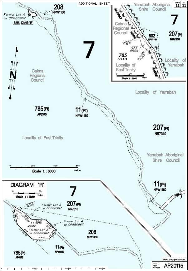
Part of Lot 11 on Plan NPW1160 (excluding part of former Lot A on Plan CP880967) | Part of Lot 7 on Plan AP20115 |
Lot 204 on Plan SP154564 | Part of Lot 7 on Plan AP20115 |
Lot 5 on Plan USL22041 to the High Water Mark | Part of Lot 7 on Plan AP20115 |
Lot 124 on Plan NR5447 | Part of Lot 7 on Plan AP20115 |
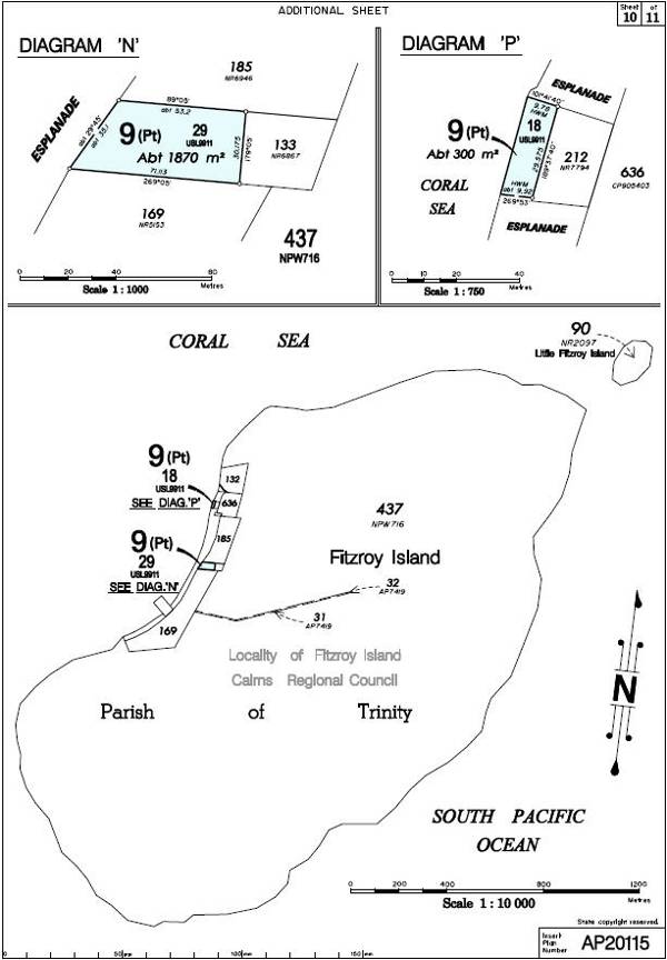
Lot 18 on Plan USL9911 to the High Water Mark | Part of Lot 9 on Plan AP20115 |
Lot 29 on Plan USL9911 | Part of Lot 9 on Plan AP20115 |
PART B
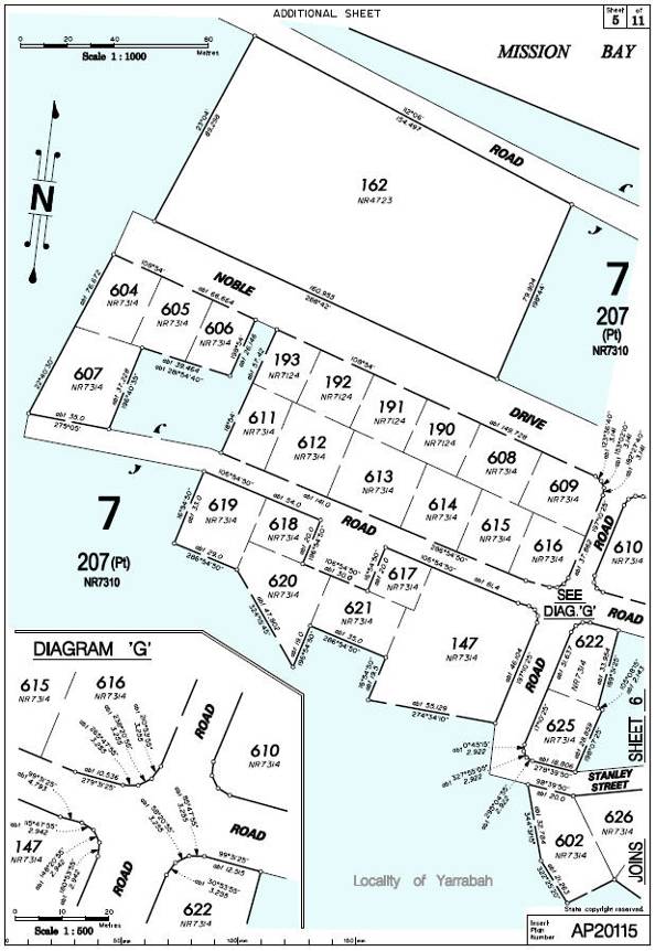
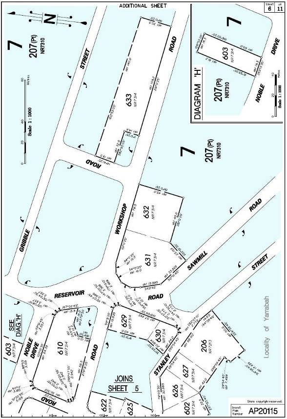
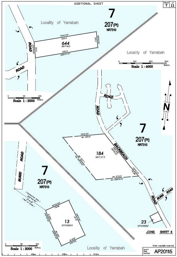
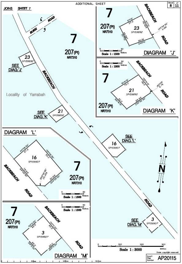
Determination Plans
 SCHEDULE 3 – Areas where exclusive native title exists
Area Description as at date of determination | Lot on Determination Plan |
Part of Lot 207 on Plan NR 7310, being within that part of the Yarrabah deed of grant in trust dated 27 October 1986 (‘DOGIT’), commencing at a point located at a point on Lot 207 on Plan NR7310 located at Oombunghi Beach and known as Djilji and having longitude 145.9001070° East and latitude 16.98053900° South, and bounded thence by a line up to and thence generally along a centreline of a ridgeline bearing 283° 15’22” distant 1623.8 metres to a point having longitude 145.8852403° East latitude 16.97739693° South and bounded thence by a line generally along a centreline of a ridgeline bearing 293° 57’47” distant 397.2 metres to a point having longitude 145.8818395° East latitude 16.97592003° South and bounded thence by a line across the Oombunghi Creek bearing 330° 48’21” distant 2723.2 metres to a point having longitude 145.8694932° East latitude 16.95436586° South being also a point that is on a centreline of a ridgeline, and bounded thence by a line generally along the centreline of a ridgeline bearing 290° 29’51” distant 318.9 metres to a point having longitude 145.866693° East latitude 16.9533408° South being also a point that is on a centreline of a ridgeline, and bounded thence by a line generally along a centreline of a ridgeline bearing 296° 54’08” distant 460.0 metres to Mount Gorton being also a point on the DOGIT boundary, and also a point having longitude 145.862852° East latitude16.951438° South and bounded thence by a line along the boundary of Lot 207 on Plan NR7310 being also along the centreline of a ridgeline bearing north westerly distant 2861.09 metres, co-incident to the eastern boundary of Lot 802 on NPW1160, to Mount Murray Prior being also a point on the DOGIT boundary, and also a point having longitude 145.847091° East latitude 16.932085° South and bounded thence along the remaining boundaries of the DOGIT Lot 207 on Plan NR7310 from Mount Murray Prior in a clockwise direction northerly, until a point co-incident with the eastern boundary of Lot 208 on NPW1160, and bounded thence by the boundary of the DOGIT Lot 207 on Plan NR7310 easterly and northerly to the southeast corner of Lot 108 on Plan RP712063 being also a point on Mission Bay and bounded thence along the northern and eastern boundaries of the DOGIT Lot 207 on Plan NR7310 including along the foreshores of Mission Bay, Cape Grafton, Turtle Bay, Wide Bay and Oombunghi Beach back to the point of commencement. But excluding • Lot 1 on SP204115, • Lot 2 on SP204116, • Lot 13 on SP159893, • Lot 16 on SP159907, • Lot 6 on SP159906, • Lots 21 and 23 on SP159892, • Lot 3 on SP159907,and • Lots 10 and 11 on SP241400. * All datam referred to above is AGD84. | Part of Lot 7 on Plan AP20115 |
Lot 208 on Plan NPW1160 (formerly part of Lot 207 on Plan NR7310)* | Part of Lot 7 on Plan AP20115 |
Lot 802 on Plan NPW1160 (formerly part of Lot 207 on Plan NR7310)* | Part of Lot 7 on Plan AP20115 |
Lot 201 on Plan NR7310 to the High Water Mark* | Lot 8 on Plan AP20115 |
‘*’ denotes areas to which s 47A of the Native Title Act 1993 (Cth) applies.
SCHEDULE 4 – Areas where non-exclusive native title exists
Area Description as at date of determination | Lot on Determination Plan |
Part of Lot 785 on Plan AP6375, commencing at a point being the south western corner of Lot 12 on Plan RP748577 and having longitude 145.827208° East, and latitude 16.910714° South, and bounded thence by the northern boundary of Lot 785 on Plan AP6375 which is coincidental to the southern boundary of Lot 12 on Plan RP748577, and bounded thence by the south western boundaries of Lot 785 on Plan AP6375 to the southern corner of Lot 204 on Plan SP154564 and bounded thence by the north western and north eastern boundaries of Lot 785 on Plan AP6375 to the boundary of the Yarrabah DOGIT, Lot 207 on Plan NR7310 and bounded thence by part of the eastern boundaries of Lot 785 on Plan AP6375 coincident with the boundary of the Yarrabah DOGIT, Lot 207 on Plan NR7310 in a westerly and southerly direction along the watershed, coincident with the western boundary of Lot 11 on Plan NPW1160 to Mt Yarrabah and bounded thence by the eastern boundaries of Lot 785 on Plan AP6375 coincident with the western boundary of Lot 11 on Plan NPW1160 and thence by the boundary of the Yarrabah DOGIT, Lot 207 on Plan NR7310 in a southerly direction along the watershed to Mt Murray Prior being also to a point having longitude 145.847091° East, latitude 16.932085° South, and bounded thence along a centreline of a tributary of Mick Creek bearing 311°57’39” distant 1677.3 metres to a point having longitude 145.8354422° East, latitude 16.92188265° South, and bounded thence along the same centreline of a tributary of Mick Creek bearing 359°41’44” distant 868.6 metres to a point having longitude 145.835447° East, latitude 16.914032° South, being also to the intersection of the centreline of Mick Creek and the centreline of a Mick Creek tributary, and bounded thence by a line along the centreline of Mick Creek bearing 292°21’33” distant 951.2 metres to the south western corner of Lot 12 on Plan RP748577 being the point of commencement. All datam referred to above is AGD84. | Part of Lot 7 on Plan AP20115 |
Part of Lot 11 on Plan NPW1160 (excluding part of former Lot A on Plan CP880967) | Part of Lot 7 on Plan AP20115 |
Lot 204 on Plan SP154564 | Part of Lot 7 on Plan AP20115 |
Lot 5 on Plan USL22041 to the High Water Mark | Part of Lot 7 on Plan AP20115 |
Lot 124 on Plan NR5447 | Part of Lot 7 on Plan AP20115 |
Lot 18 on Plan USL9911 | Part of Lot 9 on Plan AP20115 |
Lot 29 on Plan USL9911 | Part of Lot 9 on Plan AP20115 |
SCHEDULE 5 – Other interests in the determination area
1. The rights and interests of the parties under the following indigenous land use agreements:
(a) Leslie Murgha, State of Queensland and Yarrabah Aboriginal Shire Council as parties to the Yarrabah Blockholders ILUA QI2011/013, dated 19 April 2011;
(b) Leslie Murgha, State of Queensland and Yarrabah Aboriginal Shire Council as parties to the Yarrabah DOGIT Transfer ILUA QI2011/014, dated 19 April 2011;
(c) Leslie Murgha and State of Queensland as parties to the Yarrabah Towers ILUA QI2011/015, dated 19 April 2011;
(d) Leslie Murgha, Gunggandji PBC Aboriginal Corporation, State of Queensland and Wet Tropics Management Authority as parties to the Yarrabah Protected Areas ILUA QI2011/020, dated 4 May 2011;
(e) Leslie Murgha and Yarrabah Aboriginal Shire Council as parties to the Yarrabah Local Government ILUA QI2011/016, dated 1 April 2011;
(f) Leslie Murgha and Cairns Regional Council as parties to the Cairns Regional Council/Combined Gunggandji ILUA QI2011/048, dated 19 June 2011; and
(g) Leslie Murgha and Ergon Energy Corporation Limited as parties to the Ergon Energy ILUA QI2011/017, dated 11 April 2011.
2. The rights and interests of the grantee and others under the Deed of Grant in Trust dated 25 October 1986 being Title Reference Number 21328056 and/or any Deed of Grant granted or re-granted to Yarrabah Aboriginal Shire Council as grantee in substitution for, replacement of or in succession to the said Deed of Grant in Trust.
3. The rights and interests of any holder of a perpetual lease granted under the Aborigines and Torres Strait Islanders (Land Holding) Act 1985 (Qld) within the external boundary of that Part of Lot 207 on Plan NR7310 described in Schedule 2.
4. The rights and interests of the Yarrabah Aboriginal Shire Council under Local Government Acts as defined in the Local Government Act 2009 (Qld) which apply to the Determination Area including any rights the Council or its employees or agents have:
(a) as owner and operator of infrastructure, facilities and other improvements which are in the Determination Area as at the date of this determination; and
(b) to enter and exercise rights within the Determination Area in accordance with the Local Government Act 2009 (Qld).
5. The rights and interests of the Cairns Regional Council under Local Government Acts as defined in the Local Government Act 2009 (Qld) which apply to the Determination Area including any rights the Council or its employees or agents have:
(a) as owner and operator of infrastructure, facilities and other improvements which are in the Determination Area as at the date of this determination; and
(b) to enter and exercise rights within the Determination Area in accordance with the Local Government Act 2009 (Qld).
6. The rights and interests of Telstra Corporation Limited:
(a) as the owner or operator of telecommunications facilities within the Determination Area;
(b) created pursuant to the Post and Telegraph Act 1901 (Cth), the Telecommunications Act 1975 (Cth), the Australian Telecommunications Corporation Act 1989 (Cth), the Telecommunications Act 1991 (Cth) and the Telecommunications Act 1997 (Cth) including rights:
(i) to inspect land;
(ii) to install and operate telecommunication facilities;
(iii) to alter, remove, replace, maintain, repair and ensure the proper functioning of its telecommunication facilities; and
(iv) for its employees, agents or contractors to access the Determination Area for the purposes of exercising the rights in (i), (ii) and (iii) above in respect of telecommunications facilities in and in the vicinity of the Determination Area;
(c) under any licence relating to its telecommunications facilities in the Determination Area.
7. The rights and interests of Ergon Energy Corporation Limited:
(a) as the owner and operator of ‘Works’ as that term is defined in the Electricity Act 1994 (Qld) within the Determination Area;
(b) as a distribution entity and the holder of a distribution authority under the Electricity Act 1994 (Qld);
(c) created under the Electricity Act 1994 (Qld) and the Government Owned Corporations Act 1993 (Qld), including:
(i) rights in relation to any agreement relating to the Determination Area existing or entered into before the date on which these orders are made;
(ii) rights to enter the Determination Area by its employees, agents or contractors to exercise any of the rights and interests referred to in this paragraph; and to inspect, maintain and manage any Works in the Determination Area.
8. The rights and interests of Black & White (Quick Service) Taxis Ltd ACN 009 754 705:
(a) as the owner or operator of telecommunications facilities and other infrastructure within the Determination Area;
(b) as the grantee of an authority under s 34 of the Nature Conservation Act 1992 (Qld) relating to the use and management of its telecommunications facilities in the Determination Area; and
(c) as the permittee under an easement between the State of Queensland and the Yarrabah Aboriginal Shire Council which includes rights for Black & White (Quick Service) Taxis Ltd ACN 009 754 705, its employees, agents or contractors to access its telecommunications facilities within the Determination Area.
9. The rights and interests of Miles Electronics Pty Ltd:
(a) as the owner or operator of telecommunications facilities and other infrastructure within the Determination Area;
(b) as the grantee of an authority under s 34 of the Nature Conservation Act 1992 (Qld) relating to the use and management of its telecommunications facilities in the Determination Area;
(c) as the permittee under an easement between the State of Queensland and the Yarrabah Aboriginal Shire Council which includes rights for Miles Electronics Pty Ltd, its employees, agents or contractors to access its telecommunications facilities within the Determination Area.
10. The rights and interests of Seven Network (Operations) Limited:
(a) as the owner or operator of telecommunications facilities and other infrastructure within the Determination Area;
(b) as the grantee of an authority under s 34 of the Nature Conservation Act 1992 (Qld) relating to the use and management of its telecommunications facilities in the Determination Area;
(c) as the permittee under an easement between the State of Queensland and the Yarrabah Aboriginal Shire Council which includes rights for Seven Network (Operations) Limited, its employees, agents or contractors to access its telecommunications facilities within the Determination Area.
11. The rights and interests of Southern Cross Media Australia Pty Ltd:
(a) as the owner or operator of telecommunications facilities and other infrastructure within the Determination Area;
(b) as the grantee of an authority under s 34 of the Nature Conservation Act 1992 (Qld) relating to its telecommunications facilities in the Determination Area;
(c) as the permittee under an easement between the State of Queensland and the Yarrabah Aboriginal Shire Council which includes rights for Southern Cross Media Australia Pty Ltd, its employees, agents or contractors to access its telecommunications facilities within the Determination Area.
12. The rights and interests of the State of Queensland pursuant to the Forestry Act 1959 (Qld) and subordinate legislation relating to the use and management of that part of the Malbon Thompson Forest Reserve within the Determination Area.
13. The rights and interests of the State of Queensland pursuant to the Nature Conservation Act 1992 (Qld) and subordinate legislation relating to the use and management of that part of the Malbon Thompson Forest Reserve within the Determination Area.
14. The rights and interests of the Wet Tropics Management Authority pursuant to the Wet Tropics World Heritage Protection and Management Act 1993 (Qld) and the Wet Tropics Management Plan 1998 (Qld).
15. The rights and interests of the holders of any leases, agreements, licences, permits or authorities granted under the Forestry Act 1959 (Qld) as may be current at the date of this determination.
16. The rights and interests of the holders of any leases, agreements, licences, permits or authorities granted under the Nature Conservation Act 1992 (Qld) as may be current at the date of this determination.
17. The rights and interests of the holders of any permits granted under the Wet Tropics Management Plan 1998 (Qld) as may be current at the date of this determination.
18. Any other rights and interests held by the State of Queensland or Commonwealth of Australia, or by reason of the force and operation of the laws of the State and the Commonwealth, as may be current at the date of this determination.
Note: Entry of orders is dealt with in Rule 39.32 of the Federal Court Rules 2011.
QUEENSLAND DISTRICT REGISTRY | |
GENERAL DIVISION | QUD 6013 of 2001 |
BETWEEN: | LESLIE MURGHA ON BEHALF OF THE COMBINED GUNGGANDJI CLAIM Applicant
|
AND: | STATE OF QUEENSLAND First Respondent CAIRNS REGIONAL COUNCIL Second Respondent YARRABAH ABORIGINAL SHIRE COUNCIL Third Respondent BLACK AND WHITE (QUICK SERVICE) TAXIS PTY LTD ACN 009 754 705 Fourth Respondent ERGON ENERGY CORPORATION LIMITED Fifth Respondent MILES ELECTRONICS PTY LTD Sixth Respondent SEVEN NETWORK (OPERATIONS) LIMITED Seventh Respondent SOUTHERN CROSS MEDIA AUSTRALIA PTY LTD Eighth Respondent TELSTRA CORPORATION LIMITED Ninth Respondent MICHAEL CONNOLLY, VANCE HENRY GORDON, PERCY & ALF NEAL, DARRYL RALPH POLLARD, ELAINE MARINA POLLARD AND ALLAN MIMO YEATMAN Tenth Respondent
|
JUDGE: | DOWSETT J |
DATE: | 19 DECEMBER 2011 |
PLACE: | YARRABAH |
REASONS FOR JUDGMENT
1 On 27 April 2001, the Court ordered the combination of two separate claims lodged with the National Native Title Tribunal in 1994 and 1995 by the Gurrabana-Gungganyji People and by Les Murgha and Vincent Schreiber for and on behalf of the Gunggandji People. Both claims sought Native Title determinations pursuant to the Native Title Act 1993 (Cth) (the “Act”). The combined proceeding (QUD 6013 of 2001) are now described as the “Combined Gunggandji claim”. I shall refer to them as the “Gunggandji claim”. Progress towards this determination has been slow, the matter being complicated by the need to resolve difficult legal questions arising under state legislation enacted for the benefit of Aboriginal people.
2 The Gunggandji claim was originally brought by Les Murgha, Frederick Noble and Stewart Harris on their own behalf and on behalf of the Combined Gunggandji People. In 2005 Mr Noble ceased to be a member of the applicant group. Sadly, as is often the case in Native Title matters, Mr Stewart Harris, the Gurrabana elder passed away in 2010. Mr Harris was a very knowledgeable, and highly respected elder in his community and an important source of information for the anthropologists and the linguists working in North Queensland over many years. Mr Murgha alone now constitutes the applicant group.
3 The respondents to the Gunggandji claim are the State of Queensland, the Cairns Regional Council, the Yarrabah Aboriginal Shire Council, Black and White (Quick Service) Taxis Pty Ltd, Ergon Energy Corporation Limited, Miles Electronics Pty Ltd, Seven Network (Operations) Limited, Southern Cross Media Australia Pty Ltd, Telstra Corporation Limited and a number of Yarrabah residents who have statutory and other interests in parts of the claim area which are held pursuant to a deed of grant in trust. The North Queensland Land Council is the native title representative body for the area. It represents the applicant in these proceedings.
4 Since May 2010 the claim has been the subject of intense case management under the supervision of court staff. This has led to closely focussed negotiations concerning the outstanding issues. Two of those responsible for that management are here today, Ms Louise Anderson and Ms Chris Fewings. Ms Anderson has administrative responsibility for the court’s Native Title work throughout Australia. Ms Fewings is responsible for all Native Title work in Queensland. That they have spent so much time on this claim is evidence of the difficulties which have had to be resolved and the symbolic importance of Yarrabah in the wider Native Title process. The parties have reached an agreement which has been signed by all of them. The agreement was filed on 30 November 2011. The orders to be made today arise out of that agreement.
5 Pursuant to s 13 and Parts 3 and 4 of the Act, the Court may make determinations concerning Native Title in relation to areas over which there is no existing approved determination. I note that there are no approved determinations of Native Title over the area which is the subject of the proposed determination. Section 87 of the Act provides that if the parties to an application reach written agreement as to proposed orders in relation to the proceedings or part of the proceedings, the Court may make appropriate orders in, or consistent with, the terms of the agreement without conducting a full hearing of the application. The Court must take a number of matters into account in determining whether the proposed orders are appropriate.
6 The primary evidence in this case is contained in the report of Dr Bruce Rigsby dated July 2002. The applicant relies on that report to establish the existence of traditional laws and customs linking the Combined Gunggandji People to the claim area. The parties have also had the benefit of the assistance of other eminent anthropologists, historians and linguists. Dr Rigsby relies on the earlier work of anthropologists and ethnographers such as Archibald Meston, Walter Roth, Eric Mjöberg, Lauriston Sharp, Norman Tindale and Joseph Birdsell. He has also had regard to the work of Ernest Gribble, the son of the Reverend John Gribble who landed at Mission Bay on 17 June 1892. Ernest Gribble spent a considerable period of his life living amongst the people of Yarrabah.
7 The claim group is a combination of three smaller groups, the Gurrabana-Gungganyji (sometimes called the “Harris Family”), the Greater Gunggandji (for which group Mr Murgha speaks) and the Descendants of George Christian. The list of apical ancestors appears elsewhere in these reasons. The claim relates primarily to the Yarrabah region. It includes land held under the deed of grant in trust to which I have referred and surrounding lands. Over the years agreement has been reached with the other indigenous peoples in the Yarrabah area, the Mandingalbay Yidinji and the Lower Coastal Yidinji, as to areas of exclusive and shared traditional ownership. Broadly speaking, this claim lies to the east of the Yarrabah region. The Mandingalbay Yidinji land is to the west. The Lower Coastal Yidinji claim an area to the south.
8 The Yarrabah region is bordered to the east by the Pacific Ocean, between Cape Grafton in the north and Deception Point (or Wunggu) in the south. The northern boundary is marked by various bays and waterways including Trinity Inlet. The western boundary is in the vicinity of Wright Creek and the Mulgrave River as far south as its confluence with the Russell River. The region is dominated by three mountain ranges running more or less north-south, the Murray Prior Range, the Nisbet Range and the Malbon Thompson Range. Dr Rigsby describes the division of traditional ownership as follows:
The Combined Gunggandji and Mandingalbay Yidinji claimant groups agreed to recognise the area east of a line between Mick Creek and Jilji as being Combined Gunggandji land today. Although the core members of the Mandingalbay Yidinji claimant group know much of that area well and they recognise sites and places on it which figure in their oral history and myths or legends, they agreed not to contest the Combined Gungganji claim there. Similarly, the two claimant groups recognised the claim area west of the crest of the Malbon Thomson Range (including a separate area at Woolanmaroo, just north of Mutchero Inlet) as being Mandingalbay Yidinji land. Although many Gungganyji people know much of that area well and they recognise sites and places on it that figure in their oral history and myths or legends, they agreed not contest the Mandingalbay Yidinji claim there. Finally, the Combined Gunggandji and Mandingalbay Yidinji claimant groups agreed to lodge a joint claim over the area whose eastern boundary runs along the coast from Jilji to Palmer Point and whose western boundary runs northward along the crest of the Malbon Thompson Range, then to May Peak. From May Peak, its western boundary is less easily described, but we can say that the country it includes lies west of the crest of the Murray Prior Range and it takes in the Nisbet Range.
9 As to the Lower Coastal Yidinji, Dr Rigsby says:
Some of the members of the group listed just above do not now identify themselves as Mandingalbay Yidinji people, but as Lower Coastal Yidinji people. Nonetheless, they assert that they have traditional ownership and native title rights at Woolanmaroo and in the coastal area from Palmer Point to Jilji. …
10 Dr Rigsby reports the history of the Gunggandji people’s early contact with Europeans. In 1770, some eighteen years prior to British sovereignty, Captain James Cook, in the Endeavour, sailed up the eastern coast of Australia. In his journal he recorded that on the night of June 8, some of his crew saw numerous fires on the shore. At the first light on June 9, they found their ship “abreast of some small islands”, known to the local people as “Wanaga”. Cook named them “Frankland Islands” after Admiral Sir Thomas Frankland. The Endeavour rounded Yanggija, which Cook called “Cape Grafton”. The Duke of Grafton was Prime Minister at the time of the Endeavour’s departure from England. Cook dropped anchor in the sheltered waters of Mission Bay. He later wrote in his journal:
As soon as the ship was brought to anchor I went ashore accompanied by Mr Banks and Dr Solander, the first thing I did was to look for fresh water and with that view rode out towards the Cape [Grafton] because in the bottom of the bay was a low mangrove island and found two small streams which were difficult to get to on account of the surf and rocks along the shore. As we came around the Cape we saw in Sandy Cove a small stream of water run over the beach but here I did not go in the boat because I found it was not easy to land.
11 Dr Rigsby says that the Harris family still tell the story of Cook’s visit. The rock art site at Wijiny Cave (just north of King Beach) pictures a ship which they believe to be Cook’s. Dr Rigsby visited the site on September 7, 2001 with Edgar “Man” Harris and Clayton Harris, and saw an image of a sailing ship. However he notes that it is “sloop rigged” and therefore probably not a representation of the Endeavour.
12 Dr Rigsby provides detail concerning the earlier European explorers in the region. He refers to an incident on June 22, 1819, when the Mermaid, under Phillip King’s command, anchored in the bay on the western side of Fitzroy Island to shelter from a fresh south easterly wind. Fitzroy Island is within the claim area and is of particular significance to the Gurabana clan of the Gunggandji People. The naturalist, Cunningham and others went ashore. They found water. Cunningham noted in his log that:
An old beaten path from the beach to the back thick brushes, proved to us the Island had been visited (although not recently) by the Aborigines… Traces of natives were noticed in various parts such as the remains of fires, large holes formed in the search for grubs or larvae of insects and two old huts were discovered on an angle of the shore (quoted by Jones 1964:4).
13 On 17 June 1821, Cunningham again sailed past Fitzroy Island, noting further evidence of Aboriginal use and occupation as follows:
(W)e all proceeded to go north to a passing between Grafton and the Island, we remark’d several Natives at the extremity of the Coral beach of the latter, whereon we had land’d two year’s since. These people on being seen, arose and brandish’d their wammarah’s, and then resumed their Seat again on the rocks.
14 Given the abundance of resources in the coastal region, it seems probable that the people seen by Cook were part of the same society as was subsequently seen by Cunningham. There is no reason to believe that they did not remain in the area until European settlement.
15 In 1873, the Queensland Government commissioned George Dalrymple to “explore the coast and rivers between Cardwell and Cooktown”. He described the valley floor country around the Mulgrave and Russell Rivers as “eminently suitable for European occupation”. Dalrymple’s report soon attracted settlers. In a few years Cairns was a growing township. The influx of settlers, including miners and timber getters, inevitably displaced Aboriginal people, including the Gunggandji people. When the Yarrabah Mission was established by the Reverend John Gribble in June 1892, many Aboriginal people, dispossessed of their land by European and Chinese settlers, moved to the relative safety of the mission. Dr Rigsby says that the mission was a place of safety and sustenance for local people, for people from the wider region and for people from further away in Queensland who were also adversely affected by European settlement. The missionaries aimed to protect Aboriginal people from European vices and to convert them to Christianity. These well-motivated activities had the unfortunate, but inevitable effect of creating a relationship of authority over the Aboriginal people. Dr Rigsby’s report also discloses the sad history of Aboriginal life on the mission. Another consequence was that traditional owners, the Gunggandji People, were seen to be sharing their country with others who had come voluntarily to the mission or been forcibly moved there from their own country. This sharing of country created conflicting interests and expectations which have continued to the present time. Some of the conflict has been resolved in the course of these proceedings. No doubt other aspects remain to be resolved in the future.
16 It is interesting to note that Dr Fiona Powell found, in Gribble’s diaries, reference to Aboriginal people regularly visiting the Yarrabah Mission lands for ceremonial, social and economic reasons, suggesting that in the midst of dislocation, the Gunggandji People retained their identity and contact with their lands.
17 In 1960, the Church ceded its control of the mission to the State government. However it was not until the deed of grant in trust dated 31 October 1986, that the people on the Yarrabah reserve received a degree of autonomy.
18 The native title claim group is identified as being the descendants, by birth or adoption, of the following persons:
(i) Merumanai II, or his wife Tonkobulu of King Beach (being the parents of Albert Underwood, Djaradjoan, Menmuny/King John Barlow/Merumanai III, and Nellie married to Loui);
(ii) Billy Brown (husband of Jinny Katchewan of Cape Grafton);
(iii) Billy Church/Goondor (the father of Maggie 1, Maggie 2 and Nora);
(iv) Kari (the father of George Christian);
(v) Mandi Tjapir (sister of Kari and wife of Billy Church);
(vi) Kutuba/Bertie Harris;
(vii) Mary Ann, or her brother Paddy of Jilji (husband of Nora);
(viii) Nego/Nengo (the mother of Maggie 2);
(ix) Mandekala of Cape Grafton or Njemnga/Njewnga of Cape Grafton (the parents of Jinny Katchewan of Cape Grafton);
(x) Rosie of Buddabadoo;
(xi) Billy (Woopah) of Buddabadoo; and
(xii) Harry Myngha.
19 Dr Rigsby provides much genealogical and historical information concerning the Gunggandji people, their lands and the connection between the two. He provides quite specific information concerning some sites such as Jimijimi, King Beach, Ganyjuganyju and Gidila and the off-shore islands and reefs. He also gives a more general overview of the traditional laws and customs concerning the ownership of land in the Yarrabah region. He identifies incidents of such laws and customs concerning:
the right to possession, occupation, use and enjoyment;
responsibility for maintenance and proper use;
the cultural property of the claimant group; and
the power to transmit ownership to descendants.
He also refers to procedures for dispute resolution concerning these matters.
20 Prima facie, the grant of land pursuant to the deed of grant in trust extinguished Native Title in the subject land. However s 47A of the Act provides for the disregard of that consequence for present purposes. I accept that relevant investigations have been carried out by the parties, and that s 47A has been engaged.
21 Where the Court makes a determination of native title, s 94A of the Act requires that it set out details of the matters mentioned in s 225. I am satisfied that the evidence demonstrates that the Combined Gunggandji People were a normative society at sovereignty. Through the continued acknowledgement and observance of the traditional laws and customs identified in Chapters 7 and 8 of Dr Rigsby’s report, they have maintained a connection with the Determination Area. I am satisfied that the claimed rights and interests are derived from the observance of traditional laws and customs.
22 Having regard to the evidence, the terms of the proposed orders and the applicant’s submissions, I am satisfied that all of the matters addressed in s 225 of the Act are appropriately dealt with in the proposed orders. I am also satisfied that the orders sought by the parties are in accordance with the requirements of s 87(2) of the Act.
23 Pursuant to s 223 of the Act:
(1) The expression native title or native title rights and interests means the communal, group or individual rights and interests of Aboriginal peoples or Torres Strait Islanders in relation to land or waters, where:
(a) the rights and interests are possessed under the traditional laws acknowledged, and the traditional customs observed, by the Aboriginal peoples or Torres Strait Islanders; and
(b) the Aboriginal peoples or Torres Strait Islanders, by those laws and customs, have a connection with the land or waters; and
(c) the rights and interests are recognised by the common law of Australia.
24 The “Determination Area” is defined in para 1 of the proposed orders and described in Schedule 2, Part A. Schedule 3 lists those areas where exclusive Native Title is to be recognised. Schedule 4 lists those areas where non-exclusive Native Title is to be recognized.
25 The proposed orders recognize that, subject to paras 5, 6 and 7 the nature and extent of the Native Title rights and interests (other than in relation to water) are, in respect of the area which is described in Schedule 3, the rights to possession, occupation, use and enjoyment to the exclusion of all others. In relation to that part of the Determination Area which is identified in Schedule 4, the Native Title rights and interests (other than in relation to water) are non-exclusive rights to be present on, including by accessing and traversing the Determination Area, and to take and use traditional natural resources from the Determination Area for personal, domestic and non-commercial communal purposes.
26 Subject to paras 5, 6 and 7 the nature and extent of the Native Title rights and interests in relation to water within the Determination Area are the non-exclusive rights to hunt and fish in or on, and gather from, the water for personal, domestic and non-commercial communal purposes, and to take and use the water for personal, domestic and non-commercial communal purposes.
27 Where Native Title is to be held on trust, s 55 of the Act requires the Court to make a determination as contemplated by s 56 of the Act. In other cases, the Court is to act pursuant to s 57(2). Order 12(a) of the proposed orders provides that Native Title is not to be held on trust. By order 12(b) the Gunggandji PBC Aboriginal Corporation (ICN7421) is to be the prescribed body corporate for the purposes of s 57(2) of the Act, and is to perform the functions set out in s 57(3). The applicant has nominated that corporation as the Prescribed Body Corporate to perform the functions set out in the Act and the Native Title (Prescribed Bodies Corporate) Regulations 1999 (Cth) and for the other objects and purposes set out in its rules. The corporation was registered on 22 July 2010. On 17 November 2011, the applicant filed the affidavit of Martin Doré and submissions in support the Prescribed Body Corporate determination. I am satisfied that the requirements of s 57 are satisfied. I am also satisfied that it is within the power of the Court to make the orders sought, and that such orders may properly be made without a full hearing of the application. I congratulate all those who have assisted the Gunggandji People in reaching this point in their history. In particular, the lawyers, including those acting for the other parties, have played a significant role. I congratulate the respondents upon their cooperation and, of course, I congratulate the Gunggandji People.
28 I do not come here today to give anything to the Gunggandji people. I come on behalf of the Australian people to recognize their traditional ownership of this land in a way which will bind all people, for all time. In particular, my order will bind the State of Queensland, the Cairns Regional Council, the Yarrabah Aboriginal Shire Council, Black and White (Quick Service) Taxis Pty Ltd, Ergon Energy Corporation Limited, Miles Electronics Pty Ltd, Seven Network (Operations) Limited, Southern Cross Media Australia Pty Ltd, Telstra Corporation Limited, together with all other people and all other corporations.
29 Not all of the Gunggandji peoples’ traditional rights have survived the arrival of European settlers. Much has been lost, but perhaps something has also been gained. The merging of cultures usually involves both positive and negative consequences for all involved.
30 I now make orders in the form of the draft which I initial and place with the papers.
31 On behalf of all Australians, I congratulate the Gunggandji people upon this recognition of their traditional rights. Particularly I congratulate you on behalf of the Judges of this Court and our staff. We wish you well and hope that our shared future will reflect the qualities of your society and culture as well as those of all other people who now or will, in the future, make up the Australian nation.
I certify that the preceding thirty-one (31) numbered paragraphs are a true copy of the Reasons for Judgment herein of the Honourable Justice Dowsett. |
Associate:

