
FEDERAL COURT OF AUSTRALIA
Doyle on behalf of the Kalkadoon People #4 v State of Queensland (No 3)
[2011] FCA 1466
IN THE FEDERAL COURT OF AUSTRALIA | |
DATE OF ORDER: | |
WHERE MADE: |
THE COURT ORDERS THAT:
BEING SATISFIED that a determination in the terms sought by the parties is within the power of the Court, and it appearing appropriate to the Court to do so, pursuant to s 87 of the Native Title Act 1993 (Cth)
BY CONSENT THE COURT DETERMINES THAT:
1. Native title exists in the parts of the Determination Area identified in Schedules 2 and 3 and does not exist in the part of the Determination Area identified in Schedule 4B.
2. The native title is held by the persons described in Schedule 1 (the “native title holders”).
3. Subject to paragraphs 5, 6 and 7 the nature and extent of the native title rights and interests in relation to the Determination Area, other than in relation to Water, are:
(a) in relation to that part of the Determination Area identified in Schedule 2, the rights to possession, occupation, use and enjoyment to the exclusion of all others; and
(b) in relation to that part of the Determination Area identified in Schedule 3 (“the Area”), the non-exclusive rights to:
(i) be present on, including by accessing, traversing and Camping on, the Area;
(ii) take (including by hunting), use, share and exchange Traditional Natural Resources from the Area for personal, domestic and non-commercial communal purposes;
(iii) conduct cultural and spiritual activities and ceremonies on the Area;
(iv) be buried and to bury native title holders in the ground, within the Area;
(v) maintain places of importance and areas of significance to the native title holders under their traditional laws and customs and protect those places and areas, by lawful means, from physical harm;
(vi) teach on the Area the physical and spiritual attributes of the Area; and
(vii) hold meetings on the Area.
4. Subject to paragraphs 5, 6 and 7 the nature and extent of the native title rights and interests in relation to Water within the Determination Area are the non-exclusive rights to:
(a) hunt and fish in or on, and gather from, the Water for personal, domestic and non-commercial communal purposes; and
(b) take and use the Water for personal, domestic and non-commercial communal purposes.
5. There are no native title rights in or in relation to minerals as defined by the Mineral Resources Act 1989 (Qld) and petroleum as defined by the Petroleum Act 1923 (Qld) and the Petroleum and Gas (Production and Safety) Act 2004 (Qld).
6. The native title rights and interests are subject to and exercisable in accordance with:
(a) the Laws of the State and the Commonwealth; and
(b) the traditional laws acknowledged and traditional customs observed by the native title holders.
7. The native title rights and interests referred to in paragraphs 3(b) and 4 do not confer the right to possession, occupation, use or enjoyment to the exclusion of all others.
8. The nature and extent of any other rights in relation to the Determination Area (or respective parts thereof) are set out in Schedule 6.
9. The relationship between the native title rights and interests described in paragraphs 3 and 4 and the other rights described in Schedule 6 is that:
(a) the other rights continue to have effect, and the rights conferred by or held under the other rights may be exercised notwithstanding the existence of the native title rights and interests;
(b) to the extent the other rights are inconsistent with the continued existence, enjoyment or exercise of the native title rights and interests in relation to the land and waters of the Determination Area, the native title continues to exist in its entirety but the native title rights and interests have no effect in relation to the other rights to the extent of the inconsistency for so long as the other rights exist; and
(c) the other rights and any activity that is required or permitted by or under, and done in accordance with, the other rights, or any activity that is associated with, or incidental to such an activity, prevail over the native title rights and interests and any exercise of the native title rights and interests but do not extinguish the native title rights and interests except in accordance with the law.
10. The words and expressions used in this determination have the same meanings as they have in Part 15 of the Native Title Act 1993 (Cth) except for the following defined words and expressions:
“Camping” does not include permanent residence or the construction of permanent structures or fixtures;
“External Boundary” means the boundary described and shown in Schedule 5A;
“Determination Area” means the land and waters described in Schedules 2, 3 and 4B and shown on the maps in Schedule 5B, and does not include those areas described in Schedule 4A. To the extent of any inconsistency, Schedules 2, 3, 4A, 4B and 5A prevail over Schedule 5B;
“Laws of the State and the Commonwealth” means the common law and the laws of the State of Queensland and the Commonwealth of Australia, and includes legislation, regulations, statutory instruments, local planning instruments and local laws;
“Traditional Natural Resources” means:
(a) “animals” as defined in the Nature Conservation Act 1992 (Qld), but not including:
(i) fish; or
(ii) animals;
that are the private personal property of another;
(b) “plants” as defined in the Nature Conservation Act 1992 (Qld); and
(c) any clay, soil, sand, gravel or rock on or below the surface of the Determination Area,
that have traditionally been taken and used by the native title holders; and
“Water” means water as defined by the Water Act 2000 (Qld).
THE COURT ORDERS THAT:
11. Paragraphs 1-10 take effect upon the agreements referred to in paragraphs 1(a), 3(e), 9(d), 10(d), 11(b) and 12(d) of Schedule 6 being registered on the Register of Indigenous Land Use Agreements.
12. Upon paragraphs 1-10 taking effect:
(a) The native title is not held in trust.
(b) The Kalkadoon Native Title Aboriginal Corporation, incorporated under the Corporations (Aboriginal and Torres Strait Islander) Act 2006 (Cth), is to:
(i) be the prescribed body corporate for the purpose of ss 56 and 57(2) of the Native Title Act 1993 (Cth);
(ii) act as agent for the native title holders; and
(iii) perform the functions mentioned in s 57(3) of the Native Title Act 1993 (Cth) after becoming a registered native title body corporate.
13. In the event that the agreements referred to in paragraph 11 are not registered on the Register of Indigenous Land Use Agreements within six (6) months of the date of this order or such later time as this Court may order, the matter is to be listed for further directions.
14. Each party to the proceeding is to bear its own costs.
SCHEDULE 1 – Native title holders
SCHEDULE 2 – Areas in the Determination Area where exclusive native title exists
SCHEDULE 3 – Areas in the Determination Area where non-exclusive native title exists
SCHEDULE 4A – Areas excluded from the Determination Area
SCHEDULE 4B – Areas in the Determination Area where native title has been extinguished
SCHEDULE 5A – External Boundary
SCHEDULE 5B – Determination maps
SCHEDULE 6 – Other interests
SCHEDULE 1 – Native title holders
The native title holders are the Kalkadoon People. The Kalkadoon People are the biological descendants of the following people:
1. Lardie Roberts (aka Lardie Moonlight);
2. Dolly Prosser;
3. Kitty Frogg;
4. Annie Whip (mother of Martin Connelly (Snr));
5. Ida (aka Ada) Elston;
6. Leichardt Toby;
7. Rosie Waddibungera (mother of George Thorpe);
8. Willy Malcolm;
9. Nancy Daniels;
10. Fanny (Nellie) McLennan;
11. Nellie and Jimmy (parents of Topsy, Harry, Annie Sam and Jack Kippen);
12. Maggie Sautelle;
13. Daisy Barton (nee McLean);
14. Mundi MacDonald (aka King Mundie);
15. Charlie Caldwell (Snr);
16. Carbine;
17. Jimmy Rolleston and Louisa Muni (parents of Bessie Mowbray);
18. Gypsy Reid (aka Gypsy Ryan);
19. Nellie Monkira;
20. Polly Wilson (nee Hopkins) Marajundu;
21. Jack Elston;
22. Jessie Frogg (Snr);
23. Polly Alroy (aka Polly George);
24. Nobie Clay;
25. Spider;
26. Maryann (mother of Annie Reid and Eva Patterson);
27. Sophie MacDonald;
28. Julie (mother of Eulie and Lizzie Hickson); and
29. Bessie Ah Fat.
SCHEDULE 2 – Areas in the Determination Area where exclusive native title exists
The land and waters comprised of the lots listed below:
No. Description
1. Lot 5 on CP865892 (formerly Lot 5 onTG34 (Calton Hills Holdings - PH 13/4151));
2. Lot 8 on TG35 (Canworth Holdings - PH 13/5539);
3. Lot 2 on SP162421 (formerly Lot 2 on BR9 (Gundaria Holdings - PH 13/2514));
4. Lot 12 on RD186 (Injilinji Youth Centre);
5. Lot 77 on CP894140 (Kalkadoon Information Centre);
6. Lot 6 on CP889285 (Wulliberi Aboriginal Reserve);
7. Lot 9 on RD207 (Orana Park Aboriginal Reserve); and
8. Lot 20 on RD46 (Yallambee Aboriginal Reserve).
SCHEDULE 3 – Areas in the Determination Area where non-exclusive native title exists
(a) The land and waters comprised of the lots and part lots listed below:
No. Description
1. Lot 467 on AP11730 and Lot 2 on SP183412 (formerly Lot 467 on AP11627)
2. Part of Lot 572 on CP857742 not subject to Schedule 4B(a) and 4B(b)
3. Part of Lot 574 on CP857742 not subject to Schedule 4B(a) and 4B(b)
4. Part of Lot 575 on CP857742 not subject to Schedule 4B(a)
5. Lot 416 on OL104
6. Lot 570 on OL118
7. Part of Lot 579 on OL121 not subject to Schedule 4B(a)
8. Lot 381 on OL27
9. Part of Lot 385 on OL28 not subject to Schedule 4B(a)
10. Part of Lot 573 on SP110102 not subject to Schedule 4B(a)
11. Part of Lot 4 on GY805051 within the External Boundary
12. Part of Lot 2999 on PH1926 within the External Boundary and not subject to Schedule 4B(a)
13. Part of Lot 59 on TG40 not subject to Schedule 4B(a) and 4B(b)
14. Lot 1 on AA29
15. Part of Lot 100 on AA31 not subject to Schedule 4B(a) and 4B(c)
16. Part of Lot 1 on BD102 not subject to Schedule 4B(a)
17. Part of Lot 1 on BK33 within the External Boundary and not subject to Schedule 4B(a)
18. Lot 6 on BR12
19. Part of Lot 15 on CP805055 not subject to Schedule 4B(a) and 4B(b)
20. Part of Lot 521 on CP905413 within the External Boundary and not subject to Schedule 4B(a)
21. Part of Lot 16 on CW62 within the External Boundary and not subject to Schedule 4B(a) and 4B(c)
22. Part of Lot 16 on CW64 within the External Boundary and not subject to Schedule 4B(b)
23. Part of Lot 7 on CW67 within the External Boundary and not subject to Schedule 4(a) and 4B(c)
24. Part of Lot 8 on GR49 within the External Boundary and not subject to Schedule 4B(a)
25. Lot 1 on LS14
26. Part of Lot 5 on LS17 within the External Boundary and not subject to Schedule 4B(a)
27. Part of Lot 3 on LS18 within the External Boundary and not subject to Schedule 4B(a)
28. Lot 1 on MPH13989
29. Part of Lot 4373 on PH1159 within the External Boundary and not subject to Schedule 4B(c)
30. Part of Lot 2628 on PH1162 within the External Boundary
31. Part of Lot 3522 on PH1192 not subject to Schedule 4B(a)
32. Part of Lot 5214 on PH1272 not subject to Schedule 4B(a)
33. Part of Lot 2585 on PH1274 not subject to Schedule 4B(a)
34. Part of Lot 342 on PH1337 not subject to Schedule 4B(a) and 4B(c)
35. Part of Lot 2577 on PH139 not subject to Schedule 4B(a)
36. Lot 4963 on PH1431
37. Part of Lot 2965 on PH1525 not subject to Schedule 4B(a)
38. Lot 2545 on PH1545
39. Part of Lot 2658 on PH1622 not subject to Schedule 4B(a)
40. Lot 4757 on PH1623
41. Part of Lot 4511 on PH1667 not subject to Schedule 4B(a)
42. Part of Lot 5364 on PH1891 within the External Boundary and not subject to Schedule 4B(a)
43. Part of Lot 2984 on PH1906 within the External Boundary and not subject to Schedule 4B(a)
44. Part of Lot 85 on PH1944 not subject to Schedule 4B(a)
45. Part of Lot 100 on PH1945 not subject to Schedule 4B(a)
46. Part of Lot 2588 on SP237659 (formerly Lot 2588 on PH2037) not subject to Schedule 4B(a)
47. Part of Lot 3192 on PH2082 not subject to Schedule 4B(a)
48. Part of Lot 3487 on SP247223 (formerly Lot 3487 on PH2127) not subject to Schedule 4B(a)
49. Part of Lot 3635 on PH2175 not subject to Schedule 4B(a)
50. Part of Lot 4554 on PH2190 within the External Boundary
51. Part of Lot 4893 on PH2202 within the External Boundary
52. Part of Lot 2547 on PH2215 not subject to Schedule 4B(a)
53. Part of Lot 4144 on PH2265 within the External Boundary and not subject to Schedule 4B(a)
54. Part of Lot 2510 on PH461 within the External Boundary
55. Part of Lot 2657 on PH533 not subject to Schedule 4B(a)
56. Part of Lot 3721 on PH810 not subject to Schedule 4B(a)
57. Part of Lot 3743 on PH811 not subject to Schedule 4B(a)
58. Part of Lot 5184 on PH917 within the External Boundary and not subject to Schedule 4B(a) and 4B(c)
59. Part of Lot 5183 on PH921 within the External Boundary and not subject to Schedule 4B(a)
60. Part of Lot 80 on SP112345 within the External Boundary and not subject to Schedule 4B(a)
61. Part of Lot 3 on SP117500 within the External Boundary and not subject to Schedule 4B(a)
62. Part of Lot 4 on SP120452 within the External Boundary and not subject to Schedule 4B(a)
63. Part of Lot 69 on SP223507 and an area identified as road and delineated by stations numbers 5-8-11-12-9-21-23-24-6-5 on SP223507 (formerly Lot 69 on SP122682) not subject to Schedule 4B(a)
64. Part of Lot 5 on SP177589 and Lot 554 on SP177589 (formerly Lot 554 on SP137128) not subject to Schedule 4B(a)
65. Lot 1 on SP177588, Lot 2 on SP177588, Lot 3 on SP177588, Lot 4 on SP177588 and part of Lot 220 on SP177588 (formerly Lot 220 on SP137138) not subject to Schedule 4B(a) and 4B(b)
66. Part of Lot 922 on SP137139 not subject to Schedule 4B(a)
67. Lot 1 on SP212806 and Part of Lot 50 on SP212806 (formerly Lot 50 on SP158585) within the External Boundary and not subject to Schedule 4B(a)
68. Part of Lot 2324 on SP162422 within the External Boundary and not subject to Schedule 4B(a)
69. Lot 5 on SW43
70. Part of Lot 427 on SW805054 within the External Boundary and not subject to Schedule 4B(a)
71. Part of Lot 1 on UN7 within the External Boundary and not subject to Schedule 4B(a)
72. Part of Lot 4 on UN803944 within the External Boundary and not subject to Schedule 4B(a)
73. Part of Lot 2 on BD56 not subject to Schedule 4B(a)
74. Part of Lot 3 on BD56 not subject to Schedule 4B(a)
75. Part of Lot 4 on BD56 not subject to Schedule 4B(a)
76. Part of Lot 1 on GR14 not subject to Schedule 4B(a)
77. Part of Lot 2 on GR16 not subject to Schedule 4B(a)
78. Part of Lot 4 on GR16 not subject to Schedule 4B(a)
79. Part of Lot 2 on GR27 not subject to Schedule 4B(a)
80. Part of Lot 3 on GR27 not subject to Schedule 4B(a)
81. Part of Lot 2 on GR41 not subject to Schedule 4B(a)
82. Part of Lot 1 on GR42 not subject to Schedule 4B(a)
83. Part of Lot 4126 on SP247222 (formerly Lot 4126 on PH1069) within the External Boundary and not subject to Schedule 4B(a)
84. Lot 4025 on PH173
85. Lot 3263 on PH1788
86. Lot 5263 on PH1905
87. Part of Lot 10 on SP223544 (formerly Lot 3523 on PH2138) within the External Boundary
88. Part of Lot 3942 on PH2162 not subject to Schedule 4B(a)
89. Part of Lot 3692 on PH2168 not subject to Schedule 4B(a)
90. Lot 3678 on SP243815 (formerly Lot 3678 on PH2169)
91. Lot 4060 on PH2181
92. Lot 3421 on SP238152 (formerly Lot 3421 on PH2273)
93. Part of Lot 4196 on PH339 within the External Boundary and not subject to Schedule 4B(a)
94. Part of Lot 8 on TW8 within the External Boundary and not subject to Schedule 4B(a)
95. Part of Lot 12 on BD121 not subject to Schedule 4B(a)
96. Lot 1 on KI7
97. Part of Lot 14 on RD217 not subject to Schedule 4B(c)
98. Lot 1 on CP891312 (formerly part of Lot 1 on RD55)
99. Part of Lot 12 on SW807930 not subject to Schedule 4B(a)
100. Part of Lot 10 on BD182 not subject to Schedule 4B(a)
101. Part of Lot 18 on GR28 not subject to Schedule 4B(a)
102. Part of Lot 6 on GR33 not subject to Schedule 4B(a)
103. Lot 71 on RD205
104. Part of Lot 7 on SW42 within the External Boundary not subject to Schedule 4B(a)
105. Part of Lot 7 on TG20 not subject to Schedule 4B(a)
106. Lot 12 on TG36
107. Lot 1 on AP11594
108. Lot 1 on AP11600
109. Lot 1 on AP11627
110. Lot 1 on AP5086
111. Lot 6 on AP5108
112. Lot 14 on AP5698
113. Lot 1 on AP5736
114. Lot 2 on AP6599
115. Lot 2 on AP6629
116. Lot 2 on AP6633
117. Lot 4 on AP6633
118. Lot 1 on AP6654
119. Lot 1 on AP7720
120. Lot 1 on AP9335
121. Lot 1 on B144111
122. Lot 6 on MPH21938
123. Lot 1 on PER6272
124. Lot 895 on SP139542
125. Lot 1 on AA28
126. Lot 2 on AA36
127. Lot 2 on AA841846
128. Lot 9 on BD141
129. Lot 1 on BR4
130. Part of Lot 82 on SP134707, part of Lot 73 on SP134707 and Lot 84 on SP134707 (formerly part of Lot 82 on CP849604) as shown on the map in Schedule 5
131. Lot 29 on CP854048
132. Lot 6 on CP891611
133. Lot 103 on CP891612
134. Lot 102 on CP891613
135. Lot 104 on CP891614
136. Lot 2 on CP891615
137. Lot 51 on CP891616
138. Lot 95 on SP134707 (formerly Lot 95 on CP892033)
139. Part of Lot 82 on SP 134707, part of Lot 73 on SP 134707 and an area identified as road and delineated by stations numbers Y-23-22-19-Z-Y on SP134707 (formerly Lot 73 on CP892034)
140. Lot 4 on CP892039
141. Lot 6 on CP894140
142. Part of Lot 265 on FTY1762 within the External Boundary and not subject to Schedule 4B(c)
143. Lot 4 on H6522
144. Lot 8 on K5191
145. Lot 1 on K5192
146. Lot 1 on KI4
147. Lot 51 on M758103
148. Lot 1 on M758112
149. Part of Lot 12 on M758118 not subject to Schedule 4A(b) as shown on the map in Schedule 5)
150. Lot 12 on M758120
151. Lot 41 on M758126
152. Lot 20 on M758139
153. Lot 7 on M758143
154. Lot 25 on M758144
155. Lot 1 on M758150
156. Lot 1 on M758153
157. Part of Lot 40 on M758175 as shown on the map in Schedule 5
158. Lot 6 on M758188
159. Lot 7 on M758189
160. Lot 15 on M75819
161. Lot 33 on M758190
162. Lot 21 on M758197
163. Lot 75 on M758198
164. Lot 61 on M758200
165. Lot 1 on M758203
166. Lot 13 on M758213
167. Lot 14 on M758213
168. Lot 17 on M758218
169. Lot 25 on M758222
170. Lot 31 on M758222
171. Lot 21 on M758223
172. Lot 1 on M758229
173. Lot 11 on M758229
174. Lot 8 on M758235
175. Lot 11 on M758235
176. Lot 29 on M758235
177. Lot 18 on M758242
178. Lot 19 on M758242
179. Lot 20 on M758242
180. Lot 42 on M758249
181. Lot 7 on M758251
182. Lot 21 on M758251
183. Lot 10 on M75859
184. Lot 11 on M75872
185. Lot 105 on M75877
186. Lot 18 on M75882
187. Lot 59 on M75887
188. Lot 9 on M75889
189. Lot 31 on M75889
190. Lot 1 on M75896
191. Lot 1 on M75897
192. Lot 171 on MPH13993
193. Lot 8 on MPH22018
194. Lot 32 on MPH22068
195. Lot 14 on MPH22119
196. Lot 37 on MPH22129
197. Lot 21 on MPH40048
198. Lot 56 on RD104
199. Lot 27 on RD120
200. Lot 25 on RD131
201. Lot 97 on RD133
202. Lot 8 on SP214922 and Lot 9 on SP214922 (formerly part of Lot 16 on RD136)
203. Lot 13 on RD137
204. Lot 29 on RD143
205. Lot 2 on RD148
206. Lot 48 on RD148
207. Lot 98 on RD164
208. Lot 52 on RD166
209. Lot 63 on RD172
210. Lot 93 on RD175
211. Lot 65 on RD179
212. Lot 17 on RD181
213. Lot 11 on RD186
214. Lot 44 on RD198
215. Lot 94 on RD200
216. Lot 42 on RD203
217. Lot 57 on RD204
218. Lot 58 on RD204
219. Part of Lot 72 on SP134707 and Part of Lot 73 on SP134707 (formerly Lot 72 on RD209) as shown on the map in Schedule 5
220. Lot 43 on RD225
221. Part of Lot 6 on RD228 as shown on the map in Schedule 5
222. Lot 8 on RD234
223. Lot 83 on RD236
224. Lot 84 on RD236
225. Lot 5 on RD242
226. Lot 1 on RD246
227. Part of Lot 40 on RD247 as shown on the map in Schedule 5
228. Lot 41 on RD247
229. Lot 91 on SP134706 (formerly Lot 91 on RD250)
230. Lot 14 on RD273
231. Lot 32 on RD64
232. Lot 5 on RD80
233. Lot 38 on RD83
234. Lot 24 on RD92
235. Lot 19 on RD93
236. Lot 20 on RD95
237. Lot 1 on SP125095
238. Part of Lot 90 on SP128452 not subject to Schedule 4B(b)
239. Lot 2 on SP158988
240. Lot 2 on SW10
241. Lot 12 on SW13
242. Lot 3 on SW22
243. Lot 3 on SW23
244. Lot 8 on SW24
245. Lot 5 on SW25
246. Lot 6 on SW26
247. Lot 10 on SW34
248. Lot 8 on SW36
249. Lot 11 on SW807930
250. Lot 2 on TG2
251. Lot 11 on TG20
252. Lot 1 on TG22
253. Lot 9 on TG29
254. Lot 2 on AP17205 (formerly Lot 2 on AA37)
255. Lot 3 on AP11600
256. Lot 7 on AP11600
257. Lot 1 on AP2076
258. Lot 3 on AP3535
259. Lot 3 on AP3553
260. Lot 4 on AP3553
261. Lot 5 on AP3553
262. Lot 1 on AP3558
263. Lot 56 on AP5086
264. Lot 2 on AP5118
265. Lot 106 on AP5657
266. Lot 2 on AP5736
267. Lot 3 on AP6599
268. Lot 1 on AP6629
269. Lot 1 on AP6633
270. Lot 3 on AP6633
271. Part of Lot 13 on MPH30185 (formerly Lot 13 on AP6638)
272. Lot 48 on AP6654
273. Lot 41 on AP7720
274. Lot 51 on AP7720
275. Lot 1 on AP9133
276. Lot 24 on AP9335
277. Lot 9 on B15715
278. Lot 353 on AP13671 (formerly Lot 353 on BD42)
279. Lot 381 on AP13672 (formerly Lot 381 on BD42)
280. Lot 411 on AP17198 (formerly Lot 411 on BD42)
281. Lot 1 on BD56
282. Lot 8 on BD73
283. Lot 9 on CP819326
284. Lot 52 on CP901164
285. Lot 54 on CP901164
286. Lot 18 on CW11
287. Lot 1 on G10183
288. Lot 1 on G10184
289. Lot 1 on GR3
290. Lot 1 on H6521
291. Lot 2 on H6521
292. Lot 102 on H6521
293. Lot 103 on H6521
294. Lot 104 on H6521
295. Lot 106 on H6521
296. Lot 107 on H6521
297. Lot 108 on H6521
298. Lot 109 on H6521
299. Lot 201 on H6521
300. Lot 202 on H6521
301. Lot 203 on H6521
302. Lot 204 on H6521
303. Lot 205 on H6521
304. Lot 206 on H6521
305. Lot 207 on H6521
306. Lot 302 on H6521
307. Lot 303 on H6521
308. Lot 304 on H6521
309. Lot 401 on H6521
310. Lot 402 on H6521
311. Lot 403 on H6521
312. Lot 404 on H6521
313. Lot 405 on H6521
314. Lot 501 on H6521
315. Lot 502 on H6521
316. Lot 503 on H6521
317. Lot 504 on H6521
318. Lot 505 on H6521
319. Lot 506 on H6521
320. Lot 601 on H6521
321. Lot 602 on H6521
322. Lot 603 on H6521
323. Lot 604 on H6521
324. Lot 605 on H6521
325. Lot 606 on H6521
326. Lot 607 on H6521
327. Lot 608 on H6521
328. Lot 609 on H6521
329. Lot 610 on H6521
330. Lot 611 on H6521
331. Lot 612 on H6521
332. Lot 613 on H6521
333. Lot 614 on H6521
334. Lot 615 on H6521
335. Lot 616 on H6521
336. Lot 5 on H6523
337. Lot 2 on K5192
338. Lot 1 on M5971
339. Lot 6 on M5971
340. Lot 10 on M5971
341. Lot 1 on M5972
342. Lot 2 on M5972
343. Lot 3 on M5972
344. Lot 4 on M5972
345. Lot 5 on M5972
346. Lot 6 on M5972
347. Lot 7 on M5972
348. Lot 8 on M5972
349. Lot 9 on M5972
350. Lot 10 on M5972
351. Lot 11 on M5972
352. Lot 12 on M5972
353. Lot 13 on M5972
354. Lot 14 on M5972
355. Lot 15 on M5972
356. Lot 16 on M5972
357. Lot 17 on M5972
358. Lot 18 on M5972
359. Lot 19 on M5972
360. Lot 20 on M5972
361. Lot 1 on M5974
362. Lot 106 on M758114
363. Lot 105 on M758115
364. Lot 7 on M758156
365. Lot 51 on M758195
366. Lot 4 on M758239
367. Lot 1 on AP157111 and Lot 2 on AP15711 (formerly part of Lot 1 on M75893)
368. Lot 2 on M75893
369. Lot 3 on M75893
370. Part 59 on TG40 (formerly Lot 2 on MP10101) not subject to Schedule 4B(a) and 4B(b)
371. Part 59 on TG40 (formerly Lot 2 on MP10102) not subject to Schedule 4B(a) and 4B(b)
372. Lot 2 on MP26471
373. Lot 5 on MP26471
374. Lot 1 on MPH13977
375. Lot 2 on MPH13977
376. Lot 3 on MPH13977
377. Lot 4 on MPH13977
378. Lot 5 on MPH13977
379. Lot 6 on MPH13977
380. Lot 7 on MPH13977
381. Lot 8 on MPH13977
382. Lot 9 on MPH13977
383. Lot 10 on MPH13977
384. Lot 11 on MPH13977
385. Lot 12 on MPH13977
386. Lot 13 on MPH13977
387. Lot 14 on MPH13977
388. Lot 15 on MPH13977
389. Lot 16 on MPH13977
390. Lot 17 on MPH13977
391. Lot 18 on MPH13977
392. Lot 20 on MPH13977
393. Lot 21 on MPH13977
394. Lot 22 on MPH13977
395. Lot 23 on MPH13977
396. Lot 24 on MPH13977
397. Lot 25 on MPH13977
398. Lot 26 on MPH13977
399. Lot 27 on MPH13977
400. Lot 28 on MPH13977
401. Lot 29 on MPH13977
402. Lot 30 on MPH13977
403. Lot 31 on MPH13977
404. Lot 32 on MPH13977
405. Lot 33 on MPH13977
406. Lot 34 on MPH13977
407. Lot 35 on MPH13977
408. Lot 36 on MPH13977
409. Lot 37 on MPH13977
410. Lot 38 on MPH13977
411. Lot 39 on MPH13977
412. Lot 40 on MPH13977
413. Lot 41 on MPH13977
414. Lot 42 on MPH13977
415. Lot 43 on MPH13977
416. Lot 44 on MPH13977
417. Lot 45 on MPH13977
418. Lot 46 on MPH13977
419. Lot 47 on MPH13977
420. Lot 48 on MPH13977
421. Lot 49 on MPH13977
422. Lot 50 on MPH13977
423. Lot 51 on MPH13977
424. Lot 52 on MPH13977
425. Lot 53 on MPH13977
426. Lot 54 on MPH13977
427. Lot 55 on MPH13977
428. Lot 56 on MPH13977
429. Lot 57 on MPH13977
430. Lot 58 on MPH13977
431. Lot 59 on MPH13977
432. Lot 60 on MPH13977
433. Lot 61 on MPH13977
434. Lot 62 on MPH13977
435. Lot 63 on MPH13977
436. Lot 64 on MPH13977
437. Lot 65 on MPH13977
438. Lot 66 on MPH13977
439. Lot 67 on MPH13977
440. Lot 68 on MPH13977
441. Lot 70 on MPH13977
442. Lot 71 on MPH13977
443. Lot 72 on MPH13977
444. Lot 73 on MPH13977
445. Lot 74 on MPH13977
446. Lot 75 on MPH13977
447. Lot 76 on MPH13977
448. Lot 77 on MPH13977
449. Lot 78 on MPH13977
450. Lot 79 on MPH13977
451. Lot 80 on MPH13977
452. Lot 82 on MPH13977
453. Lot 83 on MPH13977
454. Lot 85 on MPH13977
455. Lot 86 on MPH13977
456. Lot 87 on MPH13977
457. Lot 88 on MPH13977
458. Lot 89 on MPH13977
459. Lot 90 on MPH13977
460. Lot 91 on MPH13977
461. Lot 92 on MPH13977
462. Lot 93 on MPH13977
463. Lot 94 on MPH13977
464. Lot 95 on MPH13977
465. Lot 96 on MPH13977
466. Lot 97 on MPH13977
467. Lot 98 on MPH13977
468. Lot 99 on MPH13977
469. Lot 100 on MPH13977
470. Lot 101 on MPH13977
471. Lot 102 on MPH13977
472. Lot 103 on MPH13977
473. Lot 104 on MPH13977
474. Lot 105 on MPH13977
475. Lot 106 on MPH13977
476. Lot 107 on MPH13977
477. Lot 112 on MPH13977
478. Lot 113 on MPH13977
479. Lot 114 on MPH13977
480. Lot 115 on MPH13977
481. Lot 116 on MPH13977
482. Lot 117 on MPH13977
483. Lot 1 on MPH13980
484. Lot 2 on MPH13980
485. Lot 3 on MPH13980
486. Lot 4 on MPH13980
487. Lot 5 on MPH13980
488. Lot 6 on MPH13980
489. Lot 7 on MPH13980
490. Lot 8 on MPH13980
491. Lot 9 on MPH13980
492. Lot 10 on MPH13980
493. Lot 21 on MPH13980
494. Lot 22 on MPH13980
495. Lot 23 on MPH13980
496. Lot 24 on MPH13980
497. Lot 25 on MPH13980
498. Lot 26 on MPH13980
499. Lot 27 on MPH13980
500. Lot 28 on MPH13980
501. Lot 29 on MPH13980
502. Lot 30 on MPH13980
503. Lot 31 on MPH13980
504. Lot 32 on MPH13980
505. Lot 33 on MPH13980
506. Lot 34 on MPH13980
507. Lot 35 on MPH13980
508. Lot 36 on MPH13980
509. Lot 37 on MPH13980
510. Lot 38 on MPH13980
511. Lot 39 on MPH13980
512. Lot 40 on MPH13980
513. Lot 41 on MPH13980
514. Lot 42 on MPH13980
515. Lot 43 on MPH13980
516. Lot 44 on MPH13980
517. Lot 45 on MPH13980
518. Lot 46 on MPH13980
519. Lot 47 on MPH13980
520. Lot 48 on MPH13980
521. Lot 49 on MPH13980
522. Lot 50 on MPH13980
523. Lot 51 on MPH13980
524. Lot 52 on MPH13980
525. Lot 53 on MPH13980
526. Lot 54 on MPH13980
527. Lot 55 on MPH13980
528. Lot 56 on MPH13980
529. Lot 57 on MPH13980
530. Lot 58 on MPH13980
531. Lot 59 on MPH13980
532. Lot 60 on MPH13980
533. Lot 61 on MPH13980
534. Lot 62 on MPH13980
535. Lot 63 on MPH13980
536. Lot 64 on MPH13980
537. Lot 65 on MPH13980
538. Lot 66 on MPH13980
539. Lot 67 on MPH13980
540. Lot 68 on MPH13980
541. Lot 71 on MPH13980
542. Lot 72 on MPH13980
543. Lot 73 on MPH13980
544. Lot 74 on MPH13980
545. Lot 75 on MPH13980
546. Lot 76 on MPH13980
547. Lot 77 on MPH13980
548. Lot 78 on MPH13980
549. Lot 81 on MPH13980
550. Lot 82 on MPH13980
551. Lot 83 on MPH13980
552. Lot 84 on MPH13980
553. Lot 85 on MPH13980
554. Lot 86 on MPH13980
555. Lot 87 on MPH13980
556. Lot 88 on MPH13980
557. Lot 89 on MPH13980
558. Lot 90 on MPH13980
559. Lot 99 on MPH13980
560. Lot 1 on MPH13984
561. Lot 2 on MPH13984
562. Lot 3 on MPH13984
563. Lot 4 on MPH13984
564. Lot 5 on MPH13984
565. Lot 6 on MPH13984
566. Lot 7 on MPH13984
567. Lot 8 on MPH13984
568. Lot 9 on MPH13984
569. Lot 10 on MPH13984
570. Lot 11 on MPH13984
571. Lot 12 on MPH13984
572. Lot 13 on MPH13984
573. Lot 14 on MPH13984
574. Lot 15 on MPH13984
575. Lot 16 on MPH13984
576. Lot 21 on MPH13984
577. Lot 22 on MPH13984
578. Lot 23 on MPH13984
579. Lot 24 on MPH13984
580. Lot 25 on MPH13984
581. Lot 26 on MPH13984
582. Lot 27 on MPH13984
583. Lot 28 on MPH13984
584. Lot 29 on MPH13984
585. Lot 30 on MPH13984
586. Lot 31 on MPH13984
587. Lot 32 on MPH13984
588. Lot 33 on MPH13984
589. Lot 34 on MPH13984
590. Lot 35 on MPH13984
591. Lot 36 on MPH13984
592. Lot 37 on MPH13984
593. Lot 38 on MPH13984
594. Lot 39 on MPH13984
595. Lot 40 on MPH13984
596. Lot 41 on MPH13984
597. Lot 42 on MPH13984
598. Lot 51 on MPH13984
599. Lot 52 on MPH13984
600. Lot 53 on MPH13984
601. Lot 54 on MPH13984
602. Lot 61 on MPH13991
603. Lot 20 on MPH14008
604. Lot 28 on MPH14008
605. Lot 55 on MPH14014
606. Lot 3 on MPH21884
607. Lot 8 on MPH21884
608. Lot 4 on MPH21893
609. Lot 5 on MPH21893
610. Lot 6 on MPH21893
611. Lot 7 on MPH21893
612. Lot 8 on MPH21893
613. Lot 9 on MPH21893
614. Lot 10 on MPH21893
615. Lot 11 on MPH21893
616. Lot 12 on MPH21893
617. Lot 13 on MPH21893
618. Lot 14 on MPH21893
619. Lot 15 on MPH21893
620. Lot 16 on MPH21893
621. Lot 17 on MPH21893
622. Lot 18 on MPH21893
623. Lot 19 on MPH21893
624. Lot 20 on MPH21893
625. Lot 21 on MPH21893
626. Lot 22 on MPH21893
627. Lot 23 on MPH21893
628. Lot 24 on MPH21893
629. Lot 25 on MPH21893
630. Lot 26 on MPH21893
631. Lot 27 on MPH21893
632. Lot 31 on MPH21893
633. Lot 32 on MPH21893
634. Lot 33 on MPH21893
635. Lot 34 on MPH21893
636. Lot 35 on MPH21893
637. Lot 36 on MPH21893
638. Lot 37 on MPH21893
639. Lot 1 on MPH21894
640. Lot 2 on MPH21894
641. Lot 3 on MPH21894
642. Lot 4 on MPH21894
643. Lot 5 on MPH21894
644. Lot 6 on MPH21894
645. Lot 7 on MPH21894
646. Lot 8 on MPH21894
647. Lot 9 on MPH21894
648. Lot 10 on MPH21894
649. Lot 11 on MPH21894
650. Lot 12 on MPH21894
651. Lot 13 on MPH21894
652. Lot 14 on MPH21894
653. Lot 21 on MPH21894
654. Lot 22 on MPH21894
655. Lot 23 on MPH21894
656. Lot 24 on MPH21894
657. Lot 25 on MPH21894
658. Lot 26 on MPH21894
659. Lot 27 on MPH21894
660. Lot 31 on MPH21894
661. Lot 32 on MPH21894
662. Lot 33 on MPH21894
663. Lot 34 on MPH21894
664. Lot 41 on MPH21894
665. Lot 51 on MPH21894
666. Lot 52 on MPH21894
667. Lot 53 on MPH21894
668. Lot 54 on MPH21894
669. Lot 55 on MPH21894
670. Lot 56 on MPH21894
671. Lot 57 on MPH21894
672. Lot 58 on MPH21894
673. Lot 59 on MPH21894
674. Lot 60 on MPH21894
675. Lot 61 on MPH21894
676. Lot 62 on MPH21894
677. Lot 63 on MPH21894
678. Lot 64 on MPH21894
679. Lot 1939 on MPH21898
680. Lot 2 on MPH21935
681. Lot 36 on MPH21949
682. Lot 62 on MPH21949
683. Lot 25 on MPH21950
684. Lot 27 on MPH21950
685. Lot 84 on MPH21950
686. Lot 35 on MPH21963
687. Lot 44 on MPH21963
688. Lot 18 on MPH21968
689. Lot 21 on MPH21968
690. Lot 22 on MPH21968
691. Lot 23 on MPH21968
692. Lot 24 on MPH21968
693. Lot 25 on MPH21968
694. Lot 1 on MPH21972
695. Lot 2 on MPH21972
696. Lot 3 on MPH21972
697. Lot 4 on MPH21972
698. Lot 12 on MPH21972
699. Lot 13 on MPH21972
700. Lot 14 on MPH21972
701. Lot 18 on MPH21972
702. Lot 19 on MPH21972
703. Lot 20 on MPH21972
704. Lot 9 on MPH21976
705. Lot 2 on MPH22007
706. Lot 76 on MPH22018
707. Lot 2 on MPH22024
708. Lot 2 on MPH22027
709. Lot 1 on MPH22077
710. Lot 4 on MPH22077
711. Lot 5 on MPH22079
712. Lot 51 on MPH22085
713. Lot 52 on MPH22085
714. Lot 29 on MPH22086
715. Lot 49 on MPH22086
716. Lot 1 on MPH22108
717. Lot 8 on MPH22115
718. Lot 17 on MPH22122
719. Lot 4 on MPH30172
720. Lot 1 on MPH30243
721. Lot 23 on MPH30299
722. Lot 1 on MPH30397
723. Lot 2 on MPH30397
724. Lot 2 on MPH30421
725. Lot 15 on MPH30626
726. Lot 16 on MPH30626
727. Lot 1 on MPH32819
728. Lot 5 on MPH34947
729. Lot 6 on MPH34947
730. Lot 23 on MPH35579
731. Lot 22 on MPH40029
732. Lot 25 on MPH40048
733. Lot 27 on MPH40048
734. Lot 35 on MPH40048
735. Lot 40 on MPH40048
736. Lot 42 on MPH40048
737. Lot 31 on MPH40050
738. Lot 65 on MPH40094
739. Lot 1 on MPH40245
740. Lot 45 on MPH40745
741. Lot 7 on MPH40835
742. Lot 14 on MPH4180
743. Lot 344 on MPH4195
744. Lot 646 on MPH4207
745. Lot 1145 on MPH4291
746. Lot 1146 on MPH4291
747. Lot 1573 on MPH4417
748. Lot 1574 on MPH4418
749. Lot 1747 on MPH4447
750. Lot 11747 on MPH4447
751. Lot 1806 on MPH4450
752. Lot 1866 on MPH4460
753. Lot 1867 on MPH4460
754. Lot 1744 on MPH4463
755. Lot 11744 on MPH4463
756. Lot 111 on MPH4465
757. Lot 121 on MPH4465
758. Lot 131 on MPH4465
759. Lot 211 on MPH4465
760. Lot 221 on MPH4465
761. Lot 231 on MPH4465
762. Lot 19 on MPH4467
763. Lot 1746 on MPH4468
764. Lot 11746 on MPH4468
765. Lot 6 on MPH4479
766. Lot 7 on MPH4479
767. Lot 2 on MPH4480
768. Lot 1 on MPH4481
769. Lot 2 on MPH7962
770. Lot 1 on MPH7978
771. Lot 7 on MPH8053
772. Lot 8 on MPH8053
773. Lot 9 on MPH8053
774. Lot 10 on MPH8053
775. Lot 11 on MPH8053
776. Lot 12 on MPH8053
777. Lot 13 on MPH8053
778. Lot 2 on MPH8113
779. Lot 4 on MTC6762
780. Lot 7 on MTC6763
781. Part of Lot 426 on OL107 not subject to Schedule 4B(b)
782. Part of Lot 444 on OL111 not subject to Schedule 4B(b)
783. Lot 1 on AP3535 (formerly Lot 1 on PER6355)
784. Lot 7 on Q6831
785. Lot 8 on Q6831
786. Lot 9 on Q6831
787. Lot 10 on Q6831
788. Lot 11 on Q6831
789. Lot 12 on Q6831
790. Lot 2 on RD157
791. Lot 49 on RD228
792. Lot 5 on RD289
793. Lot 6 on RD289
794. Lot 7 on RD289
795. Lot 8 on RD289
796. Lot 9 on RD289
797. Lot 10 on RD289
798. Lot 11 on RD289
799. Lot 12 on RD289
800. Lot 13 on RD289
801. Lot 14 on RD289
802. Lot 15 on RD289
803. Lot 3 on SP189948, Lot 4 on SP189948 and Lot 1 on AP13524 (formerly part of Lot 1 on RD32)
804. Lot 1 on AP15789, Lot 2 on AP15789 and Lot 3 on AP15789 (formerly Lot 17 on RD79)
805. Lot 12 on RD810915
806. Lot 20 on RD812295
807. Lot 17 on RP837568
808. Lot 64 on RP907590
809. Lot 63 on RP907591
810. Lot 8 on SP128450
811. Lot 9 on SP128450
812. Lot 10 on SP128450
813. Part of Lot 422 on SP128451 not subject to Schedule 4B(b)
814. Lot 1 on SW1
815. Lot 24 on SW12
816. Lot 3 on SW24
817. Lot 6 on SW27
818. Lot 1 on SW3
819. Lot 7 on SW45
820. Lot 305 on SW45
821. Lot 91 on SW47
822. Lot 92 on SW47
823. Lot 93 on SW47
824. Lot 94 on SW47
825. Lot 95 on SW47
826. Lot 96 on SW47
827. Lot 97 on SW47
828. Lot 98 on SW47
829. Lot 201 on AP15841 (formerly Lot 201 on SW6)
830. Lot 202 on AP15842 (formerly Lot 202 on SW6)
831. Lot 231 on AP15842 (formerly Lot 231 on SW6)
832. Lot 271 on AP15843 (formerly Lot 271 on SW6)
833. Lot 321 on AP15843 (formerly Lot 321 on SW6)
834. Lot 322 on AP15844 (formerly Lot 322 on SW6)
835. Lot 331 on AP15844 (formerly Lot 331 on SW6)
836. Lot 351 on AP15845 (formerly Lot 351 on SW6)
837. Part of Lot 381 on AP15846 (formerly Lot 381 on SW6) within the External Boundary
838. Lot 1 on TG1
839. Lot 5 on TG10
840. Lot 6 on TG11
841. Lot 5 on TG18
842. Lot 3 on TG36
843. Part of Lot 59 on TG40 (formerly Lot 2 on TG41) not subject to Schedule 4B(a) and 4B(b)
844. Part of Lot 59 on TG40 (formerly Lot 4 on TG41) not subject to Schedule 4B(a) and 4B(b)
845. Lot 2 on TG42
846. Lot 4 on TG42
847. Lot 5 on TG42
848. Lot 3 on TG43
849. Lot 5 on TG43
850. Lot 2 on TG44
851. Lot 4 on TG44
852. Lot 5 on TG44
853. Lot 2 on TG45
854. Lot 4 on TG45
855. Lot 3 on TG5
856. Part of Lot 59 on TG40 (formerly Lot 11 on TG7) not subject to Schedule 4B(a) and 4B(b)
857. Part of Lot 59 on TG40 (formerly Lot 21 on TG7) not subject to Schedule 4B(a) and 4B(b)
858. Part of Lot 59 on TG40 (formerly Lot 31 on TG7) not subject to Schedule 4B(a) and 4B(b)
859. Part of Lot 59 on TG40 (formerly Lot 32 on TG7) not subject to Schedule 4B(a) and 4B(b)
860. Part of Lot 59 on TG40 (formerly Lot 33 on TG7) not subject to Schedule 4B(a) and 4B(b)
861. Part of Lot 59 on TG40 (formerly Lot 41 on TG7) not subject to Schedule 4B(a) and 4B(b)
862. Part of Lot 42 on USL45821 not subject to Schedule 4B(b)
863. Lot 15 on USL45822
864. Part of Lot 10 on USL45826 not subject to Schedule 4B(b) and 4B(c)
865. Lot 45 on USL45826
866. Lot 8 on USL45827
867. Lot 9 on USL45827
868. Lot 19 on USL45828
869. Lot 30 on USL47801
870. Part of Lot 2 on USL47804 not subject to Schedule 4B(b)
871. Lot 52 on USL47811
872. Lot 59 on USL47811
873. Lot 31 on USL47812
874. Lot 129 on USL47812
875. Lot 49 on USL47817
876. Lot 42 on USL47822
877. Lot 11 on USL47825
878. Lot 2 on USL47826
879. Lot 6 on USL47826
880. Lot 8 on USL47826
881. Lot 12 on USL47834
882. Lot 26 on USL47834
883. Lot 16 on USL47835
884. Lot 84 on USL47838
885. Lot 9 on USL47846
886. Lot 36 on USL47848
887. Lot 41 on USL47855
888. Lot 3 on USL47856
889. Lot 4 on USL47860
890. Lot 31 on USL47860
891. Lot 40 on USL47861
892. Lot 41 on USL47861
893. Lot 47 on USL47861
894. Lot 1 on USL47862
895. Lot 29 on USL47890
896. Lot 36 on USL47890
897. Lot 95 on USL47890
898. Lot 4 on USL47893
899. Lot 4 on USL47894
900. Part of Lot 33 on SP195029 (formerly Lot 32 on USL48234)
901. Part of Lot 33 on SP195029, Lot 34 on SP195029, Lot 35 on SP195029, Lot 36 on SP195029, Lot 37 on SP195029, Lot 84 on SP195029 and an area identified as road and delineated by stations numbers 1-2-3-4-5-6-7-8-9-10-11-12-14-13-14-15-1 on SP195029 (formerly Lot 33 on USL48234)
902. Lot 11 on USL48252
903. Lot 13 on USL48252
904. Lot 43 on USL48252
905. Lot 71 on USL48252
906. Lot 151 on USL48252
907. Lot 16 on USL48254
908. Lot 40 on USL48254
909. Lot 58 on USL48254
910. Lot 1 on SP219125, Lot 4 on SP219125 and Lot 5 on SP219125 a(formerly part of Lot 40 on USL48255)
911. Lot 45 on USL48255
912. Lot 48 on USL48260
913. Lot 49 on AP15880 (formerly part of Lot 49 on USL48260)
914. Lot 54 on USL48260
915. Lot 55 on USL48260
916. Lot 57 on AP15880 (formerly part of Lot 57 on USL48260)
917. Lot 58 on AP15880 (formerly part of Lot 58 on USL48260)
918. Lot 60 on AP15880 (formerly part of Lot 60 on USL48260)
919. Lot 39 on USL700
920. Lot 3 on USL767
921. Lot 5 on USL767
922. Lot 136 on USL767
923. Lot 164 on USL767
924. Lot 224 on USL767
925. Lot 225 on USL767
926. Lot 275 on USL767
927. Lot 277 on USL767
928. Lot 283 on USL767
929. Lot 16 on USL769
930. Lot 40 on USL769
931. Lot 48 on USL769
932. Lot 50 on USL769
933. Lot 55 on USL769
934. Lot 58 on USL769
935. Lot 64 on USL769
936. Lot 65 on USL769
937. Lot 69 on USL769
938. Lot 70 on USL769
939. Lot 79 on USL769
940. Lot 91 on USL769
941. Lot 95 on USL769
(b) The waters within the External Boundary not subject to Schedule 4B including, but not limited to, the following rivers and creeks:
1. Alexandra River;
2. Breakaway Creek;
3. Cabbage Tree Creek;
4. Cloncurry River;
5. Corella River;
6. Death Adder Gully;
7. Depot Creek;
8. Dismal Creek;
9. Dugald River;
10. Fiery Creek;
11. Gunpowder Creek;
12. Jimmy Creek;
13. King Gully;
14. Leichhardt River;
15. Lena Creek;
16. Malbon River;
17. Mcphee Creek;
18. Middle Creek;
19. Myally Creek;
20. Sandy Creek;
21. Spear Creek;
22. Spring Creek;
23. Tommy Creek;
24. Torpedo Creek;
25. Urquhart Creek;
26. Wilfred Creek; and
27. Wills Creek.
SCHEDULE 4A – Areas excluded from the Determination Area
The following areas are wholly excluded from the Determination Area on the grounds that they have been the subject of a previous exclusive possession act, as defined in s 23B of the Native Title Act 1993 (Cth) and therefore, in accordance with s 61A of the Native Title Act 1993 (Cth), could not be claimed:
(a) The land or waters on which any public work, as defined in s 253 of the Native Title Act 1993 (Cth), is constructed, established or situated, and to which ss 23B(7) and 23C(2) of the Native Title Act 1993 (Cth) and/or s 23B(7) of the Native Title Act 1993 (Cth) and s 21 of the Native Title (Queensland) Act 1993 (Qld), applies, together with any adjacent land or waters in accordance with s 251D of the Native Title Act 1993 (Cth).
(b) Specifically, and to avoid any doubt, the land and waters described in paragraph (a) above includes the whole of the land and waters described as:
1. Lot 40 on M758125 (pump station);
2. Lot 22 on M758133 (pump station);
3. Lot 4 on M758206 (pump station);
4. Lot 41 on RD203 (pump station);
5. Lot 17 on M758117 (pump station);
6. Lot 8 on MPH22119 (Turanga car park);
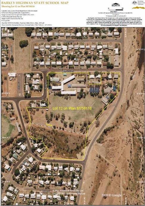
7. That part of Lot 12 on M758118 (Barkly Highway State School) that is north of the east-west fence line shown on Map 4A below;
8. Lot 11 on SP159000 (Happy Valley State School);
9. Lot 46 on RD142 (Healy State School);
10. Lot 3 on M758232 (residence);
11. Lot 10 on M758231 (residence);
12. Lot 1 on SP159001 (Mt Isa Central State School);
13. Lot 23 on MPH40065 (residence);
14. Lot 64 on MPH30760 (residence);
15. Lot 1 on M758183 (residence);
16. Lot 36 on MPH40096 (residence);
17. Lot 27 on M758211 (residence);
18. Lot 13 on M75858 (residence);
19. Lot 55 on RD116 (residence);
20. Lot 25 on M758221 (residence);
21. Lot 24 on M758145 (residence);
22. Lot 85 on M758179 (residence);
23. Lot 101 on M758179 (residence);
24. Lot 4 on M758246 (residence);
25. Lot 58 on M758247 (residence);
26. Lot 4 on M758248 (residence);
27. Lot 23 on M758123 (residence);
28. Lot 1 on RD115 (residence);
29. Lot 1 on SP158999 (residence);
30. Lot 1 on M758186 (residence);
31. Lot 12 on MPH40091 (residence);
32. Lot 3 on CP 863424 (East Leichhardt River Optic Fibre Regenerator Site);
33. Lot 313 on CP 863227 (Corella River Optic Fibre Regenerator Site);
34. Lot 321 on SP 139282;
35. Lot 191 on SP 136499;
36. Lot 111 on SP 136498;
37. Lot 62 on SP 136497;
38. Lot 51 on SP 136496;
39. Lot 12 on SP 136495;
40. Lot 341 on SP 136492;
41. Lot 301 on SP 136491;
42. Lot 282 on SP 136490;
43. Lot 284 on SP 136490;
44. Lot 261 on SP 136489;
45. Lot 262 on SP 136489;
46. Lot 222 on SP 136488;
47. Lot 181 on SP 136487;
48. Lot 12 on SP 136483;
49. Lot 11 on SP 136482;
50. Lot 361 on SP 136481;
51. Lot 131 on Sp 136480;
52. Lot 111 on SP 136479;
53. Lot 171 on SP 136476;
54. Lot 161 on SP 136475;
55. Lot 351 on SP 136470;
56. Lot 352 on SP 136470;
57. Lot 251 on SP 136469;
58. Lot 252 on SP 136469;
59. Lot 211 on SP 136468;
60. Lot 172 on Sp 136467;
61. Lot 131 on SP 136466;
62. Lot 112 on SP 136465;
63. Lot 91 on SP 136464;
64. Lot 61 on SP136463;
65. Lot 12 on SP 136443;
66. Lot 13 on SP 136443;
67. Lot 191 on SP 136441;
68. Lot 26 on SP 130412;
69. Lot 281 on SP 130190;
70. Lot 321 on SP 130185;
71. Lot 301 on SP 130184;
72. Lot 251 on SP 130182;
73. Lot 1 on SP 122674;
74. Lot 241 on SP 122509;
75. Lot 2 on RP 724915;
76. Lot 7 on GR 43;
77. Lot 2 on CW59;
78. Lot 17 on CP 891312;
79. Lot 13 on CP 891310;
80. Lot 9 on CP 891285;
81. Lot 10 on CP 891285;
82. Lot 12 on CP 891285;
83. Lot 14 on CP 891285;
84. Lot 30 on RD 88;
85. Lot 40 on RD 195;
86. Lot 39 on RD 194;
87. Lot 38 on RD 193;
88. Lot 51 of RD 193;
89. Lot 68 on RD 193;
90. Lot 35 on RD 192;
91. Lot 36 on RD 192;
92. Lot 37 on RD 192;
93. Lot 32 on RD 191;
94. Lot 33 on RD 191;
95. Lot 34 on RD 191;
96. Lot 31 on RD 161;
97. Lot 10 on CP865891; and
98. Lot 1 on SW802391.
(c) Those areas of Mining Lease number 8058 which are previous exclusive possession acts by reason of s 23B(2)(c)(vii) of the Native Title Act 1993 (Cth) (“dissected mining lease areas”).
Map 4A - Barkly Highway State School
SCHEDULE 4B – Areas where native title has been extinguished
(a) Those areas of land and waters within the boundaries of the pastoral leases listed below on which any permanent improvement consisting of:
(i) a house, shed or other outbuilding;
(ii) an airstrip;
(iii) a constructed dam or any other constructed stock watering point, bore, turkey nest, squatters’ tank or other water storage facility; or
(iv) stock yards or trap yards
has, at the date of the determination, been constructed (including any adjacent land the exclusive use of which is reasonably necessary for the enjoyment of the improvement) in accordance with the rights of the lessee under the pastoral lease.
1. Alcala (Pastoral Holding 13/3522 comprising Lot 3522 on PH1192);
2. Canobie (Pastoral Holding 13/50 comprising Lot 50 on SP158585);
3. Heywood (Pastoral Holding 13/5345 comprising Lot 100 on AA31);
4. Murrumba (Pastoral Holding 13/2555 comprising Lot 922 on SP137139 and Occupation Licence 13/573 comprising Lot 572 on CP857742, Lot 574 on CP857742, Lot 575 on CP857742 and Lot 573 on SP110102);
5. Thorntonia (Pastoral Holding 8/2516 comprising Lot 1 on UN7);
6. Hillside (Pastoral Holding 13/3635 comprising Lot 3635 on PH2175);
7. Angus (aka Rosebud) (Pastoral Holding 13/4414 comprising Lot 5 on SP177589 and Lot 554 on SP177589) (formerly Lot 554 on SP137128);
8. Coll (aka Rifle Creek) (Pastoral Holding 13/5184 comprising Lot 5184 on PH917);
9. Bendigo Park (aka Yadthor) (Pastoral Holding 13/5183 comprising Lot 5183 on PH921);
10. Roxmere (Pastoral Holding 13/4893 comprising Lot 4893 on PH1337);
11. Ballaghmore Downs (Pastoral Holding 13/3721 comprising Lot 3721 on PH810);
12. Tyndool (Pastoral Holding 13/3743 comprising Lot 3743 on PH811);
13. Granada (Pastoral Holding 13/85 comprising Lot 85 on PH1944 and Preferential Pastoral Holding 13/3740 comprising Lot 1 on GR14, Lot 2 on GR27 and Lot 3 on GR27);
14. Buckingham Downs (Pastoral Development Holding 13/2999 comprising Lot 2999 on PH1926);
15. Gereta (Pastoral Holding 13/2588 comprising Lot 2588 on PH2037);
16. Regent (Pastoral Holding 13/2585 comprising Lot 2585 on PH1274, Occupation Licence 13/579 comprising Lot 579 on OL121 and Term Lease 0/221467 comprising Lot 7 on TG20);
17. Ibis Creek (Preferential Pastoral Holding 13/1496 comprising Lot 4196 on PH339);
18. The Nobbies (aka Dugald) (Pastoral Holding 13/3768 comprising Lot 2 on GR16 and Lot 4 on GR16);
19. Chum Vale (Pastoral Holding 13/5211 comprising Lot 521 on CP905413);
20. Jersey Plains (Pastoral Holding 13/4144 comprising Lot 4144 on PH2265);
21. Bloodwood (Pastoral Holding 13/5219 comprising Lot 1 on BD102);
22. Gleeson (Pastoral Holding 13/2965 comprising Lot 2965 on PH1525);
23. Barr Creek (Pastoral Holding 8/5553 comprising Lot 4 on UN803944);
24. Toorah Vale (Pastoral Holding 8/4511 comprising Lot 4511 on PH1667);
25. Bortala (aka Alsace) (Pastoral Holding 13/2658 comprising Lot 2658 on PH1622 and Occupation Licence 8/835 comprising Lot 385 on OL28);
26. May Downs (aka Meltham) (Pastoral Holding 13/2324 comprising Lot 2324 on SP162422);
27. Lorraine/Talawanta (Pastoral Holding 8/3705 comprising Lot 5 on LS17);
28. Ashover (Pastoral Holding 13/5470 comprising Lot 7 on CW67);
29. Brightlands (Term Lease 233216 comprising Lot 427 on SW805054);
30. Bulonga (Pastoral Holding 13/2547 comprising Lot 2547 on PH2215, Term Lease 0/210349 comprising Lot 7 on SW42 and Term Lease 0/0233884 comprising Lot 12 on SW807930);
31. Carsland (Preferential Pastoral Holding 13/3692 comprising Lot 3692 on PH2168);
32. Patricia Vale (Preferential Pastoral Holding 13/2846 comprising Lot 2 on GR41);
33. Quamby (Preferential Pastoral Holding 13/3742 comprising Lot 1 on GR42);
34. Evandean (Preferential Pastoral Holding 13/3712 comprising Lot 2 on BD56, Lot 3 on BD56 and Lot 4 on BD56);
35. Yambini (Pastoral Holding 13/2577 comprising Lot 2577 on PH139, Term Lease 0/221462 comprising Lot 18 on GR28 and Term Lease 0/208859 comprising Lot 6 on GR33);
36. Venus (aka Jessivale) (Pastoral Holding 13/3487 comprising Lot 3487 on PH2127 and Term Lease 0/214868 comprising Lot 10 on BD182);
37. Corella Park (Term Lease 0/232052 comprising Lot 3942 on PH2162);
38. Ginburra (aka Lanark) (Preferential Pastoral Holding 13/4126 comprising Lot 4126 on PH1069);
39. Mount Maggie (Pastoral Holding 13/5214 comprising Lot 5214 on PH1272);
40. Timberu (Pastoral Holding 13/2200 comprising Lot 220 on SP177588 and Special Lease 13/51258 comprising Lot 12 on BD121);
41. Devoncourt (Pastoral Holding 13/69 comprising Lot 69 on SP122682 );
42. Stradbroke (aka Stanbroke) (Pastoral Holding 13/5398 comprising Lot 16 on CW62);
43. Bannockburn (aka Koolamarra) (Pastoral Holding 13/3192 comprising Lot 3192 on PH2082);
44. Boomara (Pastoral Holding 13/5430 comprising Lot 3 on LS18);
45. Coolullah (Pastoral Holding 13/64 comprising Lot 59 on TG40);
46. Clonagh (Pastoral Holding 13/57 comprising Lot 8 on GR49 );
47. Corella (Pastoral Holding 0/233456 comprising Lot 10 on SP223544);
48. Bushy Park (Pastoral Holding 13/342 comprising Lot 342 on PH1337 );
49. Augustus Downs (Pastoral Holding 8/41 comprising Lot 4 on SP120452);
50. Fort Constantine (Pastoral Holding 13/80 comprising Lot 80 on SP112345);
51. Kamilaroi (Pastoral Holding 8/100 comprising Lot 100 on PH1945);
52. Whites Hill (Pastoral Holding 13/2657 comprising Lot 2657 on PH533);
53. Ardmore (Pastoral Holding 0/212277 comprising Lot 3 on SP117500);
54. Mellish Park (Pastoral Holding 8/2984 comprising Lot 2984 on PH1906);
55. Berguna (Preferential Pastoral Holding 8/5498 comprising Lot 8 on TW8);
56. Nardoo (Pastoral Holding 8/5448 comprising Lot 1 on BK33);
57. Farley (Pastoral Holding 13/1384 comprising Lot 5 onSW43 and Lot 1 on MPH13989);
58. Girla (aka Girila) (Pastoral Holding 13/4554 comprising Lot 4554 on PH2190);
59. Haslingden (Pastoral Holding 13/5563 comprising Lot 15 on CP805055); and
60. Starcross (Pastoral Holding 13/5364 comprising Lot 5364 on PH1891).
(b) The land and waters within:
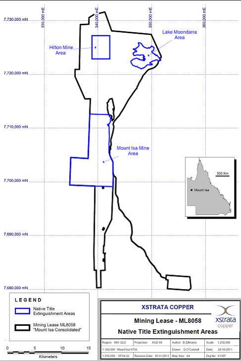
1. That portion of ML8058 identified as Hilton Mine area; being bound by NE Corner 342 200m Easting, 7 727 200m Northing; SW Corner 338 900m Easting, 7 722 900m Northing as shown on Map 4B below.
2. That portion of ML8058 identified as Lake Moondarra Area; being that part of the Lake Moondarra north of the 7 721 005m Northing as shown on Map 4B below.
3. That portion of ML8058 identified as Mount Isa Mine Area; being that portion of ML8058 within the external boundary described as follows:
Commencing at a corner on the western boundary of ML8058 at 7 699 203.7m North and extending easterly to a point on the eastern boundary of that mining tenement and the eastern boundary of Lot 10 on USL45826 at 7 699 188.7mN; then generally northerly along the eastern boundaries of that lot, Lot 422 on SP128451, Lot 7 on SP128450, Lot 42 on USL45821, Lot 1 on RD 157 to 7 710 274.1mN; then Northerly to the south eastern corner of the western severance of Lot 2 on USL47804; then generally northerly and generally south westerly along boundaries of that western severance to the western most corner of that Lot; then south westerly to the eastern boundary of Lot 42 on USL45821; then northerly to intersect to south westerly prolongation of the southern boundary of Lot 48 on USL47804; then generally north easterly and generally northerly along southern and eastern boundaries of that lot and Lot 1 on RD 158 to the northernmost corner of Lot 1 on RD 158; then westerly to the western boundary of ML8058 at 7 712 618.9mN; then generally southerly and easterly along western boundaries of that tenement back to the commencement point as shown on Map 4B below.
Note: all coordinates in paragraphs 1, 2 and 3 above are based on AMG Zone 54 – AGD84 projection.
4. Mining Leases 5432, 5434, 2484, 5414, 5424, 2485 and 2455 upon which mines or associated infrastructure and works have been established or constructed pursuant to the mining leases as at the date of this determination, or upon which mines or associated infrastructure and works are established or constructed in the future pursuant to the mining leases.
(c) The land and waters described below in respect of which native title rights and interests were taken by the State of Queensland by Proclamation dated 30 January 1997 as amended by Proclamation dated 11 June 1998:
1. Easement U over Lot 16 on CW62;
2. Easement P and R over Lot 7 on CW67;
3. Easement M and N over Lot 342 on PH1337;
4. Easement K and L over Lot 4373 on PH1159;
5. Easement G, H and J over Lot 5184 on PH917;
6. Easement E over Lot 100 on AA31;
7. Easement B and C over Lot 14 on RD217;
8. Easement A over Lot 10 on USL45826;
9. Easement F over Lot 15 of RD222 (now part of Lot 265 on FTY1762); and
10. Lot 574 on SP110102.
(d) The land and waters described below in respect of which native title rights and interests were surrendered to the State of Queensland:
1. Kalkadoon/Mount Isa Northridge Industrial Estate ILUA Registered on 8 September 2003 as QI2002/064:
a. Lot 51 on CP901164;
b. Lot 53 on CP901164;
c. Lot 55 on CP901164;
d. Lot 11 on MPH40048;
e. Lot 36 on MPH40048;
f. Lot 37 on MPH40048;
g. Lot 38 on MPH40048;
h. Lot 39 on MPH40048;
i. Lot 41 on MPH40048;
j. Lot 1 on SP223470 (formerly Lot 1 on BIRD12, Lot 2 on AP3558 and Lot 3 on AP3558); and
k. Proposed area 11 shown on Identification Survey IS117599 (to be subdivided out of Lot 1 of SP223470).
2. Kalkadoon/Gliderport ILUA registered on 13 June 2008 as QI2007/015:
a. Lot 1 on SP189948.
Map 4B - ML8058 Extinguishment Areas
SCHEDULE 5A – External Boundary
The External Boundary is described below and shown on Map 5A.
Commencing at a point on the eastern bank of Fiery Creek at Latitude 18.824066 South and extending generally south easterly passing through the following coordinate points.
Longitude (East) | Latitude (South) |
139.410671 | 18.828626 |
139.450726 | 18.834527 |
139.486592 | 18.837073 |
139.518085 | 18.843540 |
139.559862 | 18.849451 |
139.601623 | 18.856156 |
139.644149 | 18.866910 |
139.694345 | 18.879452 |
139.734450 | 18.884458 |
139.775199 | 18.899169 |
139.824444 | 18.917299 |
139.868603 | 18.933679 |
139.909336 | 18.950774 |
139.941453 | 18.970902 |
139.967638 | 18.988465 |
139.988695 | 19.005912 |
140.007139 | 19.025725 |
140.027319 | 19.044765 |
140.052694 | 19.061487 |
140.070443 | 19.073998 |
140.091672 | 19.084154 |
140.122346 | 19.093696 |
140.147056 | 19.101489 |
140.177784 | 19.108591 |
140.204201 | 19.117217 |
140.232277 | 19.129107 |
140.266343 | 19.141919 |
140.294417 | 19.154605 |
140.319924 | 19.167236 |
140.346293 | 19.179877 |
140.370870 | 19.197335 |
Then south easterly to the western bank of Dismal Creek at Latitude 19.212076° South; then generally southerly along western banks of that creek to a southern boundary of Lot 3 on LS18 (Boomarra Pastoral Holding); then easterly, southerly and again easterly along southern boundaries of that lot to Longitude 140.486681° East; then generally northerly and generally easterly, passing through the following coordinate points.
Longitude (East) | Latitude (South) |
140.486537 | 19.658189 |
140.488014 | 19.646205 |
140.491905 | 19.632938 |
140.498140 | 19.624837 |
140.504968 | 19.615119 |
140.508028 | 19.604275 |
140.510017 | 19.595741 |
140.510535 | 19.585375 |
140.507432 | 19.576416 |
140.501532 | 19.566323 |
140.494924 | 19.558423 |
140.487952 | 19.550295 |
140.483884 | 19.541686 |
140.481495 | 19.531109 |
140.478539 | 19.525026 |
140.478008 | 19.519388 |
140.480893 | 19.516721 |
140.488035 | 19.516213 |
140.489222 | 19.513326 |
140.487747 | 19.510688 |
140.487701 | 19.505161 |
140.490333 | 19.501344 |
140.495415 | 19.500734 |
140.498442 | 19.500714 |
140.505528 | 19.493643 |
140.509223 | 19.486479 |
140.514843 | 19.478035 |
140.525191 | 19.470250 |
140.534452 | 19.462932 |
140.544789 | 19.454224 |
140.555278 | 19.449084 |
140.566487 | 19.443362 |
140.576372 | 19.438456 |
140.587378 | 19.437339 |
140.594858 | 19.437979 |
140.597614 | 19.440014 |
140.600371 | 19.441934 |
140.602706 | 19.443792 |
140.605108 | 19.445021 |
140.607699 | 19.445735 |
140.610229 | 19.446448 |
140.612882 | 19.446934 |
140.615475 | 19.447419 |
140.618009 | 19.447788 |
140.620844 | 19.448218 |
140.623199 | 19.448471 |
140.625674 | 19.448667 |
140.628028 | 19.448920 |
140.630926 | 19.449236 |
140.633274 | 19.449947 |
140.635742 | 19.450717 |
140.639526 | 19.452538 |
140.645247 | 19.454595 |
140.648189 | 19.456230 |
140.650712 | 19.457516 |
140.653227 | 19.459662 |
140.658265 | 19.462923 |
140.660899 | 19.465184 |
140.663340 | 19.468362 |
140.665974 | 19.470566 |
140.668782 | 19.473460 |
140.670869 | 19.475889 |
140.672715 | 19.478315 |
140.674376 | 19.481083 |
140.676101 | 19.483507 |
140.678302 | 19.486625 |
140.679969 | 19.488877 |
140.681696 | 19.491130 |
140.683604 | 19.493442 |
140.686229 | 19.496448 |
140.688978 | 19.499284 |
140.691492 | 19.501487 |
140.694660 | 19.504671 |
140.697652 | 19.507337 |
140.700776 | 19.509087 |
140.704327 | 19.510554 |
140.706854 | 19.511610 |
140.709199 | 19.512779 |
140.710890 | 19.513025 |
140.713903 | 19.514487 |
140.719028 | 19.516829 |
140.724766 | 19.518315 |
140.729893 | 19.520370 |
140.734118 | 19.521842 |
140.738640 | 19.523892 |
140.742254 | 19.525933 |
140.746173 | 19.527689 |
140.750401 | 19.528875 |
140.755540 | 19.529782 |
140.767412 | 19.535816 |
140.775412 | 19.537388 |
140.782905 | 19.534958 |
140.788076 | 19.531230 |
140.791077 | 19.528557 |
140.819161 | 19.526708 |
140.825546 | 19.523314 |
140.830971 | 19.521607 |
140.840385 | 19.520946 |
140.848896 | 19.519134 |
140.854635 | 19.512277 |
140.862131 | 19.509471 |
140.873278 | 19.508420 |
140.882043 | 19.503436 |
140.890993 | 19.502464 |
140.899946 | 19.503433 |
140.907696 | 19.503363 |
140.913977 | 19.501810 |
140.918805 | 19.500269 |
140.922296 | 19.498280 |
140.926874 | 19.496166 |
140.933034 | 19.494613 |
140.939936 | 19.494550 |
140.946015 | 19.493713 |
140.950321 | 19.492402 |
140.953398 | 19.490069 |
140.957397 | 19.486278 |
140.960474 | 19.482341 |
Then north easterly to the intersection of the centrelines of Dugald River and Cloncurry River; then generally southerly passing through the following coordinate points.
Longitude (East) | Latitude (South) |
140.966776 | 19.494301 |
140.967850 | 19.507573 |
140.963527 | 19.524846 |
140.957355 | 19.536187 |
140.950189 | 19.545465 |
140.944116 | 19.554963 |
140.933422 | 19.563006 |
140.922761 | 19.574157 |
140.915343 | 19.582861 |
140.907333 | 19.592950 |
140.900271 | 19.601074 |
140.892975 | 19.610005 |
140.886138 | 19.616744 |
140.878490 | 19.626945 |
140.867456 | 19.637866 |
140.857388 | 19.648777 |
140.849490 | 19.658518 |
140.841729 | 19.669984 |
140.836755 | 19.681311 |
140.832988 | 19.692167 |
140.831761 | 19.702540 |
140.831154 | 19.714175 |
140.826547 | 19.726074 |
140.821826 | 19.738665 |
140.817935 | 19.749521 |
140.814378 | 19.757496 |
140.807046 | 19.764121 |
140.802780 | 19.774059 |
140.797782 | 19.783658 |
140.795200 | 19.792315 |
140.794236 | 19.804873 |
140.792495 | 19.812718 |
140.787260 | 19.823009 |
140.783932 | 19.830060 |
140.783387 | 19.836052 |
140.783728 | 19.845836 |
140.785123 | 19.851812 |
140.787754 | 19.859965 |
140.789650 | 19.867433 |
140.790951 | 19.876058 |
140.790455 | 19.887001 |
140.788232 | 19.895309 |
140.785500 | 19.901319 |
140.784220 | 19.906856 |
140.782838 | 19.914352 |
140.781568 | 19.920810 |
140.780536 | 19.926921 |
140.780103 | 19.932221 |
140.776893 | 19.939041 |
140.774270 | 19.943898 |
140.769590 | 19.949578 |
140.766496 | 19.955936 |
140.766574 | 19.963765 |
140.767492 | 19.970551 |
140.768646 | 19.976644 |
140.770790 | 19.984571 |
140.774605 | 19.989491 |
140.777547 | 19.992114 |
140.778686 | 19.996710 |
140.778553 | 19.998437 |
140.773780 | 20.004764 |
140.771007 | 20.009026 |
140.767388 | 20.014441 |
140.763896 | 20.020891 |
140.762361 | 20.029173 |
140.763248 | 20.035609 |
140.763538 | 20.043886 |
140.763586 | 20.052393 |
140.762059 | 20.062285 |
140.757967 | 20.070231 |
140.753379 | 20.076798 |
140.746745 | 20.087511 |
140.742409 | 20.095917 |
140.738313 | 20.103517 |
140.732275 | 20.112272 |
140.726606 | 20.122061 |
140.722387 | 20.129662 |
140.718654 | 20.137490 |
140.713956 | 20.146586 |
140.711807 | 20.154755 |
140.711735 | 20.164297 |
140.710825 | 20.176601 |
140.710391 | 20.186604 |
140.708235 | 20.193623 |
140.706943 | 20.202709 |
140.704786 | 20.209498 |
140.702877 | 20.217091 |
140.699155 | 20.227564 |
140.694820 | 20.237118 |
140.690475 | 20.245177 |
140.686990 | 20.254269 |
140.683502 | 20.263131 |
140.680751 | 20.273370 |
140.676780 | 20.283267 |
140.670725 | 20.290641 |
140.663094 | 20.299973 |
140.659590 | 20.306075 |
140.656711 | 20.315509 |
140.654081 | 20.325977 |
140.651455 | 20.337135 |
140.648580 | 20.347834 |
140.644729 | 20.358305 |
140.641244 | 20.368545 |
140.637018 | 20.377178 |
140.632316 | 20.388340 |
140.627352 | 20.395710 |
140.621041 | 20.402162 |
140.613987 | 20.406202 |
140.605713 | 20.410015 |
140.598536 | 20.413824 |
140.591965 | 20.417172 |
140.585278 | 20.421440 |
140.576882 | 20.425711 |
140.570435 | 20.429518 |
140.563747 | 20.434015 |
140.559006 | 20.437818 |
140.555612 | 20.442653 |
140.552225 | 20.449442 |
140.550297 | 20.455079 |
140.547888 | 20.462326 |
140.547062 | 20.469225 |
140.546119 | 20.477044 |
140.545785 | 20.484517 |
140.545816 | 20.492104 |
140.544991 | 20.499003 |
140.543308 | 20.505329 |
140.541010 | 20.510047 |
140.537487 | 20.513962 |
140.533508 | 20.518238 |
140.524736 | 20.527164 |
140.517048 | 20.532281 |
140.504845 | 20.540420 |
140.495085 | 20.547853 |
140.487398 | 20.553431 |
140.478856 | 20.559588 |
140.471781 | 20.565736 |
140.463483 | 20.572121 |
140.454084 | 20.578973 |
140.446881 | 20.583854 |
140.438452 | 20.588510 |
140.428065 | 20.593291 |
140.418778 | 20.597375 |
140.408991 | 20.599040 |
140.399576 | 20.601971 |
140.391385 | 20.605240 |
140.386994 | 20.609988 |
140.387382 | 20.616786 |
140.390458 | 20.621956 |
140.391695 | 20.626098 |
140.388766 | 20.628879 |
140.385835 | 20.631199 |
140.387562 | 20.635224 |
140.388310 | 20.639830 |
140.386977 | 20.643986 |
140.384413 | 20.646534 |
140.378668 | 20.649560 |
140.373541 | 20.654542 |
140.369515 | 20.659287 |
140.363391 | 20.658628 |
140.356531 | 20.657740 |
140.347962 | 20.658128 |
140.342460 | 20.661151 |
140.335249 | 20.665796 |
Then south westerly to Latitude 20.666138° South along a line drawn to Longitude 140.327171° East, Latitude 20.667448; then generally south westerly and generally south easterly passing through the following coordinate points.
Longitude (East) | Latitude (South) |
140.323780 | 20.671449 |
140.321341 | 20.673026 |
140.321924 | 20.674610 |
140.322647 | 20.676078 |
140.322947 | 20.677194 |
140.323120 | 20.683573 |
140.324084 | 20.686020 |
140.297906 | 20.719172 |
140.296556 | 20.721133 |
140.296227 | 20.721896 |
140.295725 | 20.723028 |
140.294679 | 20.724912 |
140.293355 | 20.726872 |
140.292482 | 20.727740 |
140.290667 | 20.730036 |
140.293074 | 20.732525 |
140.293223 | 20.733648 |
140.295868 | 20.735942 |
140.297246 | 20.737409 |
Then south easterly to a point, at Latitude 20.754238° South, on a line drawn between Longitude 140.333703° East, Latitude 20.752092° South and Longitude 140.334581° East and Latitude 20.761457° South; then generally southerly, generally south westerly, generally south easterly, generally easterly, generally southerly passing through the following coordinate points.
Longitude (East) | Latitude (South) |
140.334581 | 20.761457 |
140.339849 | 20.768482 |
140.339557 | 20.779311 |
140.332240 | 20.788676 |
140.317440 | 20.799248 |
140.314610 | 20.805370 |
140.324338 | 20.812383 |
140.331070 | 20.817651 |
140.334289 | 20.827894 |
140.334582 | 20.838138 |
140.341606 | 20.843114 |
140.340142 | 20.851016 |
140.331069 | 20.858040 |
140.331069 | 20.864771 |
140.331655 | 20.874430 |
140.332825 | 20.888185 |
140.336045 | 20.895210 |
140.336045 | 20.913356 |
140.331070 | 20.922721 |
140.323168 | 20.928867 |
140.321997 | 20.936769 |
140.314490 | 20.947003 |
140.310686 | 20.955781 |
140.318587 | 20.956074 |
140.326195 | 20.957829 |
140.330584 | 20.959292 |
140.334973 | 20.963973 |
140.336143 | 20.969826 |
140.336729 | 20.974507 |
140.339087 | 20.975608 |
140.342460 | 20.974904 |
140.344922 | 20.971874 |
140.350774 | 20.972459 |
140.354870 | 20.978311 |
140.354578 | 20.985041 |
140.355748 | 20.989138 |
140.356918 | 20.992356 |
140.360137 | 20.994990 |
140.363648 | 20.996746 |
140.368769 | 21.009255 |
140.374182 | 21.012546 |
140.378864 | 21.014960 |
140.382522 | 21.014522 |
140.385740 | 21.016277 |
140.386911 | 21.018764 |
140.387496 | 21.023739 |
140.385594 | 21.028128 |
140.382083 | 21.030761 |
140.379742 | 21.032517 |
140.377254 | 21.033980 |
140.372339 | 21.034926 |
140.372083 | 21.035528 |
140.369624 | 21.036245 |
140.369197 | 21.036245 |
140.367562 | 21.037164 |
140.366199 | 21.038551 |
140.363405 | 21.041982 |
140.361802 | 21.044473 |
140.361620 | 21.045725 |
140.361596 | 21.047515 |
140.362436 | 21.048373 |
140.355407 | 21.056079 |
140.355072 | 21.056093 |
140.355945 | 21.063760 |
140.356008 | 21.070241 |
140.359195 | 21.086708 |
140.357495 | 21.107533 |
140.363870 | 21.106682 |
140.365570 | 21.113056 |
140.363658 | 21.118581 |
140.363445 | 21.129632 |
140.371732 | 21.126443 |
140.388519 | 21.138768 |
140.392344 | 21.162142 |
140.405943 | 21.171491 |
140.422304 | 21.174359 |
140.451415 | 21.195502 |
140.469264 | 21.217813 |
140.461190 | 21.229501 |
140.475426 | 21.250324 |
140.467777 | 21.258186 |
140.477333 | 21.270070 |
140.480502 | 21.273170 |
140.515739 | 21.268744 |
140.648069 | 21.268105 |
140.649375 | 21.271868 |
140.657228 | 21.287259 |
140.668536 | 21.296683 |
140.677960 | 21.295112 |
140.692712 | 21.291874 |
140.702757 | 21.307432 |
140.712932 | 21.328722 |
140.714351 | 21.351498 |
140.716609 | 21.376725 |
140.716246 | 21.401911 |
140.715894 | 21.426286 |
140.715519 | 21.452287 |
140.709057 | 21.475753 |
140.698136 | 21.504838 |
140.682941 | 21.526538 |
140.670414 | 21.545029 |
140.657225 | 21.561082 |
140.655257 | 21.563477 |
Then south westerly to a point on southern bank of Maggies Creek at Longitude 140.636188° East; then generally north westerly, along southern banks of that creek to a northern boundary of Lot 5364 on PH1891 (Starcross Pastoral Holding); then westerly along that northern boundary to the eastern boundary of Lot 13 on SP150177 (Chatsworth Pastoral Holding); then northerly and generally westerly along boundaries of that lot and northern boundaries of Lot 2949 on SP223508 (Pilgrim Term Lease) to the south western corner of Lot 69 on SP223507 (Devoncourt Term lease) and the eastern boundary of Lot 22 on SP223509 (Trekelano Pastoral Holding); then generally northerly, generally north easterly, generally westerly and generally southerly along boundaries of that lot to the north eastern corner of Lot 24 on D5989; then generally westerly and generally southerly along boundaries of Lot 342 on PH1337 (Bushy Park Pastoral Holding) to an eastern boundary of Lot 7 on CW67 (Ashover Pastoral Holding); then generally south easterly along south western boundaries of Lot 79 on USL 703 to the southernmost corner of that lot and onwards to a western boundary of again Lot 22 on SP223509 (Trekelano Pastoral Holding); then generally south westerly along western boundaries of that lot to the northernmost north western corner of Lot 14 on CW52; then generally south westerly, generally north westerly, southerly and easterly along boundaries of that lot to an eastern bank of Wills Creek; then generally southerly along eastern banks of that creek to the northern boundary of Lot 2999 on PH1926 (Buckingham Downs Pastoral Lease); then easterly and generally southerly along northern and eastern boundaries of that lot to Latitude 22.097375° South; then generally south westerly, generally north westerly and easterly passing through the following coordinate points.
Longitude (East) | Latitude (South) |
139.842535 | 22.106118 |
139.811343 | 22.116162 |
139.791381 | 22.120024 |
139.781874 | 22.121963 |
139.774024 | 22.122613 |
139.772244 | 22.122913 |
139.771234 | 22.122743 |
139.770914 | 22.122113 |
139.770064 | 22.120303 |
139.769704 | 22.119743 |
139.768890 | 22.119158 |
139.768786 | 22.116734 |
139.768562 | 22.111532 |
139.757004 | 22.090981 |
139.741592 | 22.071070 |
139.712686 | 22.044735 |
139.697913 | 22.028678 |
139.692780 | 22.013265 |
139.689080 | 21.991406 |
139.687262 | 21.983845 |
139.686663 | 21.976824 |
139.687286 | 21.969263 |
139.692801 | 21.956301 |
139.695264 | 21.943340 |
139.698945 | 21.931459 |
139.698358 | 21.917417 |
139.691054 | 21.905536 |
139.688018 | 21.896355 |
139.687422 | 21.887714 |
139.684389 | 21.876372 |
139.677694 | 21.865031 |
139.677707 | 21.856390 |
139.676498 | 21.849369 |
139.666735 | 21.848829 |
139.661248 | 21.845049 |
139.661262 | 21.836948 |
139.658221 | 21.829927 |
139.637488 | 21.819127 |
139.627723 | 21.819127 |
139.615514 | 21.820207 |
139.607591 | 21.813186 |
139.595406 | 21.800225 |
139.578953 | 21.784563 |
139.569919 | 21.767009 |
139.563757 | 21.744255 |
139.562809 | 21.730982 |
139.559965 | 21.713917 |
139.556173 | 21.698274 |
139.555225 | 21.691164 |
139.556173 | 21.687372 |
139.558068 | 21.658456 |
139.559016 | 21.648501 |
139.553802 | 21.641866 |
139.541951 | 21.630963 |
139.536737 | 21.621008 |
139.532471 | 21.610580 |
139.530575 | 21.596359 |
139.531049 | 21.587826 |
139.531523 | 21.574554 |
139.533419 | 21.563177 |
139.523465 | 21.544690 |
139.522043 | 21.532839 |
139.520147 | 21.520040 |
139.521568 | 21.505819 |
139.526308 | 21.494443 |
139.526783 | 21.484014 |
139.527731 | 21.477852 |
139.528205 | 21.469319 |
139.526309 | 21.463631 |
139.522042 | 21.448462 |
139.518724 | 21.435663 |
139.519672 | 21.426657 |
139.522043 | 21.418598 |
139.523465 | 21.410066 |
139.525834 | 21.395371 |
139.526308 | 21.387786 |
139.523464 | 21.375936 |
139.520620 | 21.370721 |
139.520146 | 21.363611 |
139.522042 | 21.356026 |
139.523464 | 21.346546 |
139.524887 | 21.341332 |
139.523939 | 21.329481 |
139.524413 | 21.317156 |
139.518724 | 21.298195 |
139.512088 | 21.291084 |
139.503081 | 21.286345 |
139.495971 | 21.276390 |
139.495497 | 21.267858 |
139.497867 | 21.255533 |
139.497867 | 21.250319 |
139.507347 | 21.241786 |
139.520620 | 21.234202 |
139.536737 | 21.228987 |
139.542900 | 21.227091 |
139.550958 | 21.225195 |
139.563757 | 21.224247 |
139.570868 | 21.221403 |
139.575607 | 21.217610 |
139.578925 | 21.202916 |
139.581296 | 21.186799 |
139.584140 | 21.168786 |
139.581770 | 21.143662 |
139.581770 | 21.128019 |
139.577030 | 21.119486 |
139.569920 | 21.111902 |
139.562809 | 21.104792 |
139.557121 | 21.102422 |
139.552854 | 21.101948 |
139.546218 | 21.096260 |
139.540530 | 21.086779 |
139.536737 | 21.081565 |
139.536264 | 21.073980 |
139.539108 | 21.066870 |
139.544322 | 21.062130 |
139.547166 | 21.057864 |
139.551906 | 21.055493 |
139.556646 | 21.052649 |
139.559964 | 21.047909 |
139.561861 | 21.042695 |
139.562834 | 21.033858 |
139.560743 | 21.032069 |
139.558469 | 21.030059 |
139.556867 | 21.028209 |
139.555708 | 21.025739 |
139.554472 | 21.024179 |
139.551527 | 21.023669 |
139.549818 | 21.023500 |
139.548887 | 21.022168 |
139.548399 | 21.020499 |
139.548277 | 21.018479 |
139.547163 | 21.015889 |
139.545927 | 21.013228 |
139.545316 | 21.009889 |
139.545850 | 21.008159 |
139.546461 | 21.006370 |
139.541761 | 21.001678 |
139.535665 | 21.000434 |
139.528756 | 20.999183 |
139.521442 | 21.001129 |
139.515348 | 21.004284 |
139.511689 | 21.000257 |
139.508842 | 20.995036 |
139.499900 | 20.990170 |
139.494212 | 20.991328 |
139.492991 | 20.986920 |
139.492988 | 20.980920 |
139.489328 | 20.974893 |
139.479575 | 20.973621 |
139.471855 | 20.976764 |
139.461811 | 20.984346 |
139.448400 | 20.987196 |
139.438645 | 20.990853 |
139.427673 | 20.992079 |
139.416296 | 20.990466 |
139.409391 | 20.983173 |
139.401674 | 20.973042 |
139.400053 | 20.962906 |
139.399649 | 20.953174 |
139.401279 | 20.942630 |
139.404941 | 20.930868 |
139.406569 | 20.925595 |
139.408603 | 20.919511 |
139.409417 | 20.916267 |
139.409545 | 20.912100 |
139.408660 | 20.909340 |
139.408889 | 20.906860 |
139.408553 | 20.903919 |
139.407546 | 20.901850 |
139.405272 | 20.900431 |
139.402800 | 20.899010 |
139.400405 | 20.897820 |
139.397704 | 20.896629 |
139.395293 | 20.895029 |
139.392943 | 20.892811 |
139.389586 | 20.886601 |
139.390227 | 20.884461 |
139.391677 | 20.882601 |
139.393981 | 20.879990 |
139.396163 | 20.877840 |
139.397856 | 20.876209 |
139.398513 | 20.874121 |
139.399092 | 20.871870 |
139.399871 | 20.870020 |
139.400893 | 20.868740 |
139.402236 | 20.867569 |
139.402144 | 20.865440 |
139.401580 | 20.863140 |
139.400817 | 20.860260 |
139.400420 | 20.857781 |
139.399062 | 20.856470 |
139.397460 | 20.855221 |
139.395537 | 20.853729 |
139.393752 | 20.851959 |
139.393416 | 20.849251 |
139.393569 | 20.846310 |
139.393782 | 20.843941 |
139.394439 | 20.841860 |
139.395140 | 20.839260 |
139.395354 | 20.836201 |
139.393996 | 20.834940 |
139.392348 | 20.834669 |
139.390929 | 20.833700 |
139.389693 | 20.831690 |
139.385997 | 20.828434 |
139.376516 | 20.824641 |
139.368458 | 20.819901 |
139.362295 | 20.815636 |
139.355659 | 20.812791 |
139.349022 | 20.807103 |
139.347600 | 20.800467 |
139.349497 | 20.790512 |
139.345704 | 20.782453 |
139.338594 | 20.775343 |
139.330535 | 20.771077 |
139.326269 | 20.768706 |
139.322951 | 20.762544 |
139.321055 | 20.757804 |
139.316315 | 20.754012 |
139.313470 | 20.752589 |
139.310626 | 20.754486 |
139.304938 | 20.754485 |
139.300672 | 20.751404 |
139.298775 | 20.743583 |
139.296168 | 20.732443 |
139.292478 | 20.719638 |
139.285372 | 20.709570 |
139.277673 | 20.703056 |
139.273528 | 20.695358 |
139.269975 | 20.687659 |
139.266422 | 20.685291 |
139.258724 | 20.686476 |
139.252209 | 20.684699 |
139.245695 | 20.677001 |
139.237997 | 20.672263 |
139.229114 | 20.669302 |
139.219047 | 20.670487 |
139.206611 | 20.671079 |
139.192399 | 20.668118 |
139.181148 | 20.661604 |
139.159829 | 20.648575 |
139.148578 | 20.639693 |
139.153315 | 20.629626 |
139.153315 | 20.614821 |
139.163382 | 20.607123 |
139.180555 | 20.598240 |
139.179371 | 20.586988 |
139.170488 | 20.577513 |
139.159829 | 20.568631 |
139.153907 | 20.557380 |
139.157460 | 20.543168 |
139.163382 | 20.524810 |
139.158053 | 20.517112 |
139.142063 | 20.508229 |
139.141404 | 20.507986 |
139.136323 | 20.498954 |
139.136041 | 20.494720 |
139.137452 | 20.487381 |
139.124914 | 20.487323 |
Then easterly to the centreline of Mingera Creek at Latitude 20.487323° South; then generally north easterly passing through following coordinate points.
Longitude (East) | Latitude (South) |
139.055119 | 20.459883 |
139.071614 | 20.431308 |
Then south easterly to the intersection of the centrelines of Mingera Creek and Wilfred Creek at Latitude 20.433154° South; then generally north easterly along the centreline of Wilfred Creek to the northern boundary of Lot 2324 on SP162422 (Meltham Pastoral Holding); then north westerly and westerly along northern boundaries of that lot to the south eastern corner of Lot 6 on SP162423 (Yelvertoft Lands Lease); then generally northerly along eastern boundaries of that lot to the southern boundary Lot 5 on CP865892 (Calton Hills Pastoral Holding); then generally westerly, northerly and easterly along boundaries of that lot to Longitude 139.014863° East; then generally north easterly and generally north westerly passing through the following coordinate points.
Longitude (East) | Latitude (South) |
139.007990 | 19.805005 |
139.007777 | 19.799144 |
139.009440 | 19.795215 |
139.010951 | 19.792335 |
139.013423 | 19.790016 |
139.016566 | 19.788736 |
139.019175 | 19.787685 |
139.022196 | 19.786174 |
139.024546 | 19.783346 |
139.025065 | 19.780115 |
139.026377 | 19.776374 |
139.029032 | 19.774455 |
139.032008 | 19.773864 |
139.035410 | 19.774474 |
139.038813 | 19.775155 |
139.042750 | 19.773115 |
139.044261 | 19.771615 |
139.046609 | 19.768895 |
139.048837 | 19.767154 |
139.050409 | 19.765825 |
139.051858 | 19.764665 |
139.054330 | 19.762346 |
139.055948 | 19.759235 |
139.058588 | 19.755016 |
139.060174 | 19.756215 |
139.061944 | 19.757064 |
139.064310 | 19.757406 |
139.067941 | 19.754905 |
139.069925 | 19.752364 |
139.070749 | 19.749715 |
139.072061 | 19.745216 |
139.072580 | 19.742685 |
139.073480 | 19.739854 |
139.074853 | 19.737544 |
139.076105 | 19.734605 |
139.076578 | 19.732074 |
139.079294 | 19.730905 |
139.080804 | 19.727796 |
139.082712 | 19.724325 |
139.083368 | 19.721734 |
139.084009 | 19.718795 |
139.084894 | 19.715104 |
139.085535 | 19.711074 |
139.085870 | 19.706186 |
139.085336 | 19.700204 |
139.085732 | 19.695316 |
139.087288 | 19.693345 |
139.089333 | 19.690284 |
139.090523 | 19.687805 |
139.091835 | 19.683536 |
139.092247 | 19.681236 |
139.092965 | 19.679675 |
139.094704 | 19.678344 |
139.097313 | 19.677526 |
139.100945 | 19.676465 |
139.105126 | 19.676385 |
139.107430 | 19.675504 |
139.109490 | 19.674856 |
139.112511 | 19.673635 |
139.114617 | 19.670345 |
139.114891 | 19.666314 |
139.114617 | 19.662055 |
139.114815 | 19.655555 |
139.115578 | 19.652444 |
139.118050 | 19.649955 |
139.122582 | 19.649005 |
139.125679 | 19.648984 |
139.129052 | 19.646316 |
139.133660 | 19.644624 |
139.137840 | 19.645225 |
139.141654 | 19.643766 |
139.145164 | 19.643575 |
139.149238 | 19.644124 |
139.154579 | 19.644145 |
139.160026 | 19.644164 |
139.162940 | 19.643745 |
139.164390 | 19.642354 |
139.166465 | 19.636535 |
139.168449 | 19.633754 |
139.171455 | 19.631095 |
139.174842 | 19.629115 |
139.177970 | 19.625816 |
139.180625 | 19.623386 |
139.183555 | 19.618986 |
139.186134 | 19.614715 |
139.190330 | 19.609044 |
139.193763 | 19.605344 |
139.198584 | 19.600826 |
139.202368 | 19.596654 |
139.205908 | 19.592485 |
139.208792 | 19.588615 |
139.211966 | 19.584455 |
139.215277 | 19.580633 |
139.216025 | 19.575155 |
139.215689 | 19.571935 |
139.216391 | 19.567504 |
139.217566 | 19.563526 |
139.218695 | 19.560005 |
139.219336 | 19.556606 |
139.218954 | 19.554944 |
139.217841 | 19.551444 |
139.215872 | 19.547885 |
139.212622 | 19.543535 |
139.208594 | 19.539705 |
139.204993 | 19.536796 |
139.200720 | 19.533374 |
139.194937 | 19.530015 |
139.180014 | 19.520274 |
139.181974 | 19.508266 |
139.186746 | 19.500767 |
139.190836 | 19.484407 |
139.189627 | 19.473908 |
139.170385 | 19.460547 |
139.163806 | 19.455796 |
139.153035 | 19.447936 |
139.141391 | 19.443278 |
139.133698 | 19.441776 |
139.122824 | 19.441456 |
139.111631 | 19.441777 |
139.100437 | 19.440497 |
139.097558 | 19.434101 |
139.101396 | 19.430903 |
139.109712 | 19.430903 |
139.111950 | 19.430583 |
139.113869 | 19.426105 |
139.113870 | 19.409795 |
139.114189 | 19.399240 |
139.110991 | 19.395083 |
139.106834 | 19.391565 |
139.103316 | 19.386447 |
139.097879 | 19.383249 |
Then north westerly to a southern bank of Coppermine Creek at Longitude 139.087265° East, Latitude 19.378847° South; then generally northerly along eastern banks of Coppermine Creek to its headwaters at Longitude 139.181983°, Latitude 19.313789° South; then northerly to the headwaters of Fiery Creek at Longitude 139.181483°, Latitude 19.308038° South; then generally northerly along eastern banks of that creek back to the commencement point.
Note:
Reference Data and Source:
Native Title Determination Application boundary data compiled by National Native Title Tribunal
Topographic vector data is © Commonwealth of Australia (Geoscience Australia) 2003.
Cadastral data and tenure information sourced from Department of Environment & Resource Management, Qld (September 2010).
Rivers and creeks data is based on, where available, cadastral data or 1:100 000/1:250 000 sourced from Department of Environment & Resource Management, Qld (July 2002).
Reference Datum
Geographical coordinates have been provided by the NNTT Geospatial Unit and are referenced to the Geocentric Datum of Australia 1994 (GDA94), in decimal degrees and are based on the spatial reference data acquired from the various custodians at the time.
Use of Coordinates
Where coordinates are used within the description to represent cadastral or topographical boundaries or the intersection with such, they are intended as a guide only. As an outcome to the custodians of cadastral and topographic data continuously recalculating the geographic position of their data based on improved survey and data maintenance procedures, it is not possible to accurately define such a position other than by detailed ground survey.
Prepared by Geospatial Services, National Native Title Tribunal (24 November 2010)
Map 5A – External Boundary
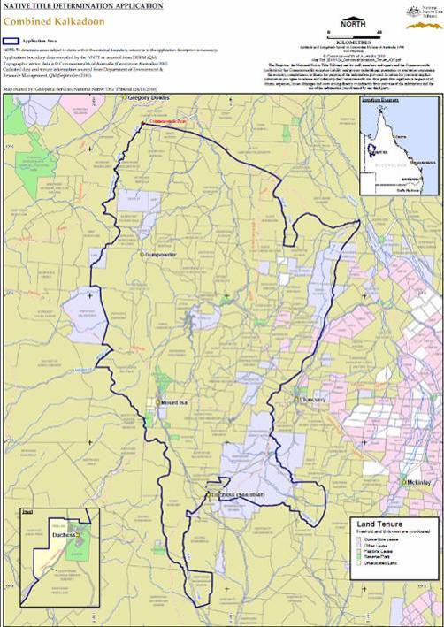 SCHEDULE 5B – Determination Maps
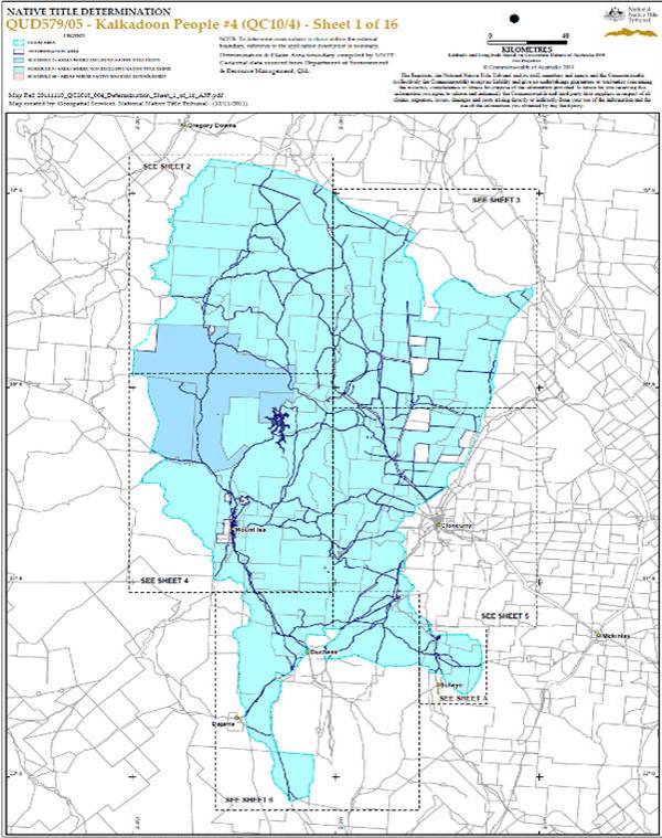
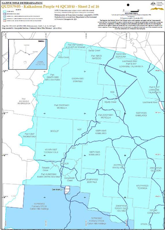
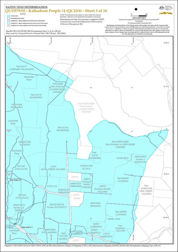
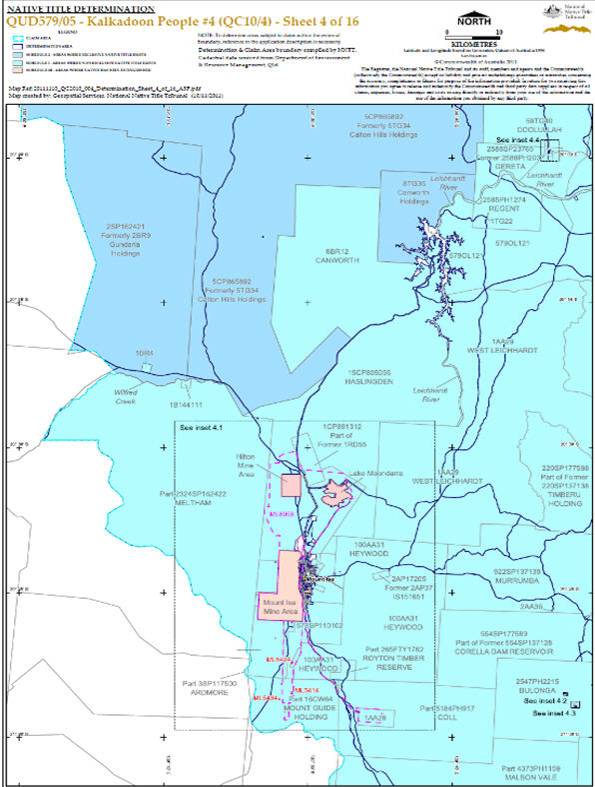
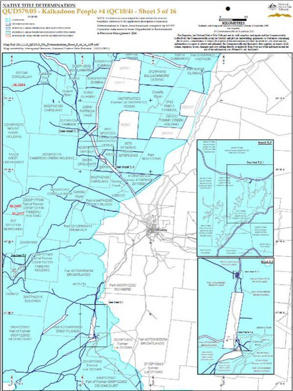

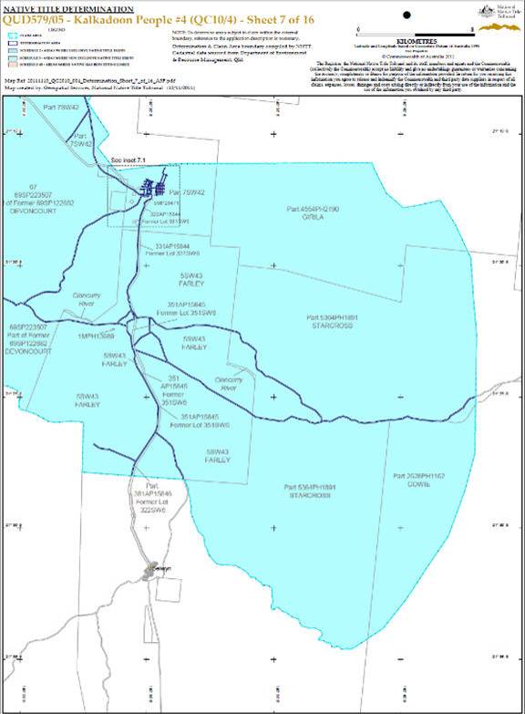
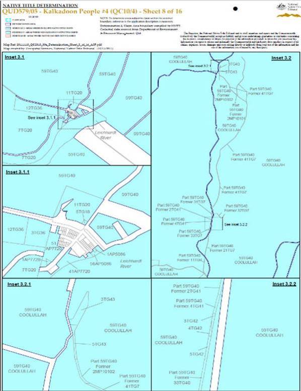
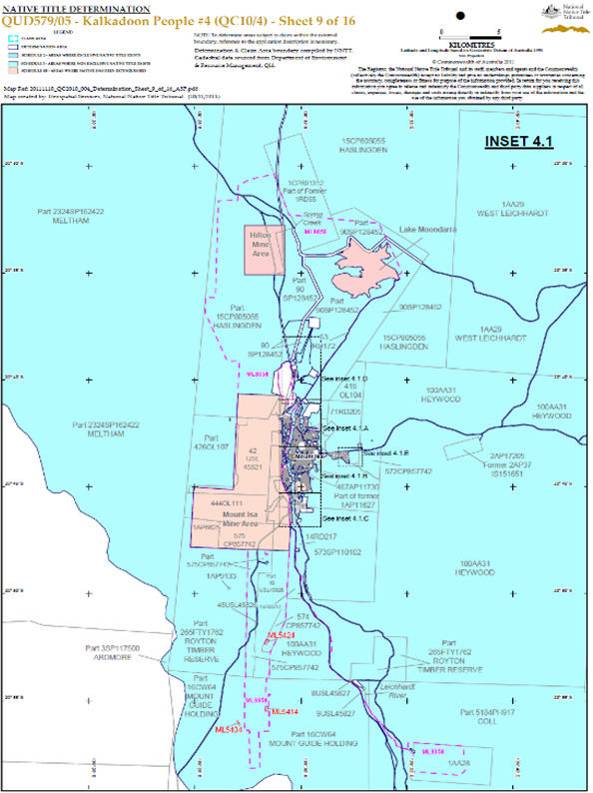
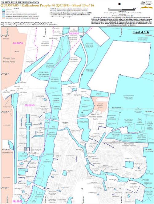
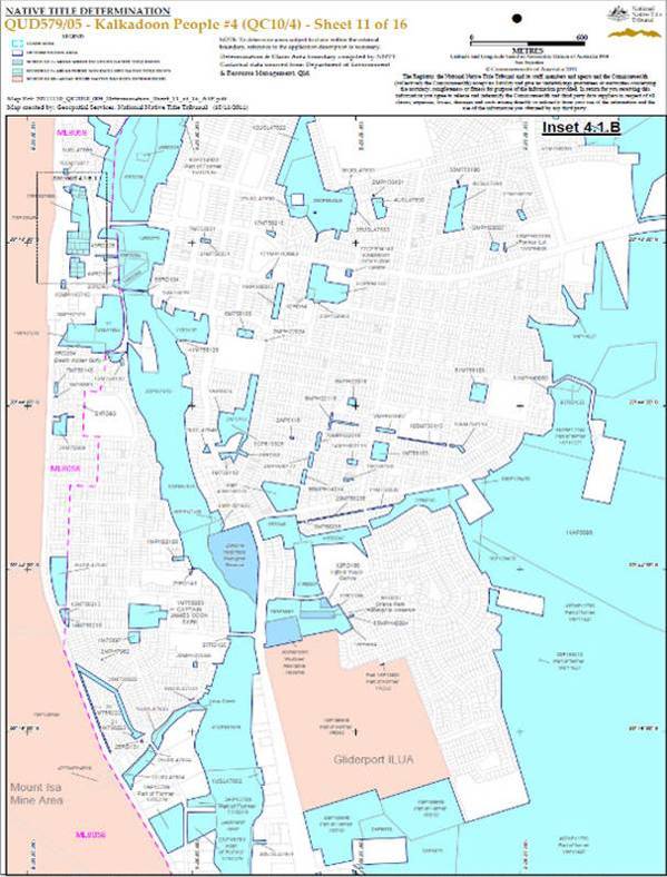
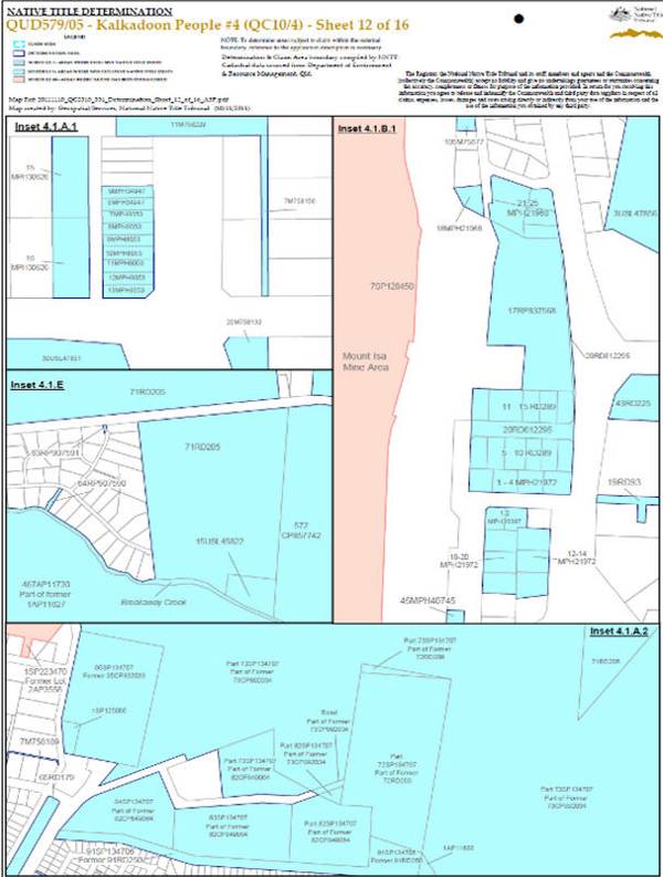
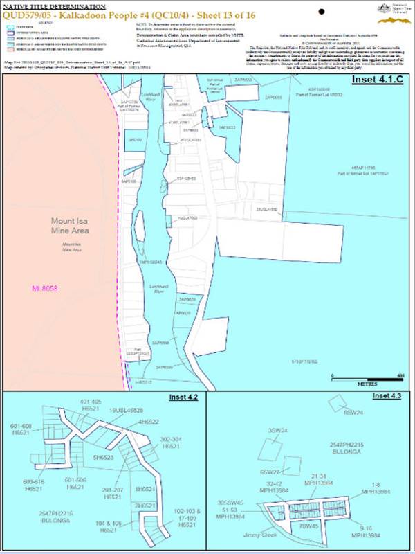
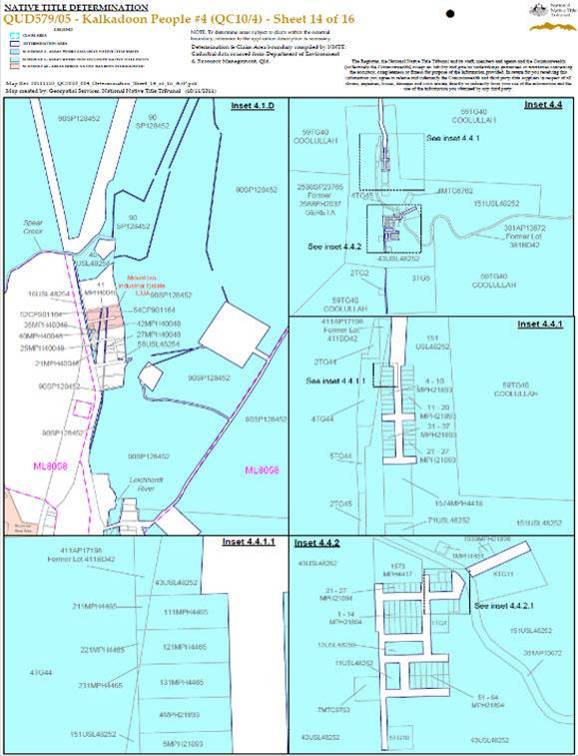
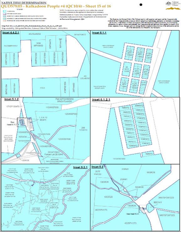
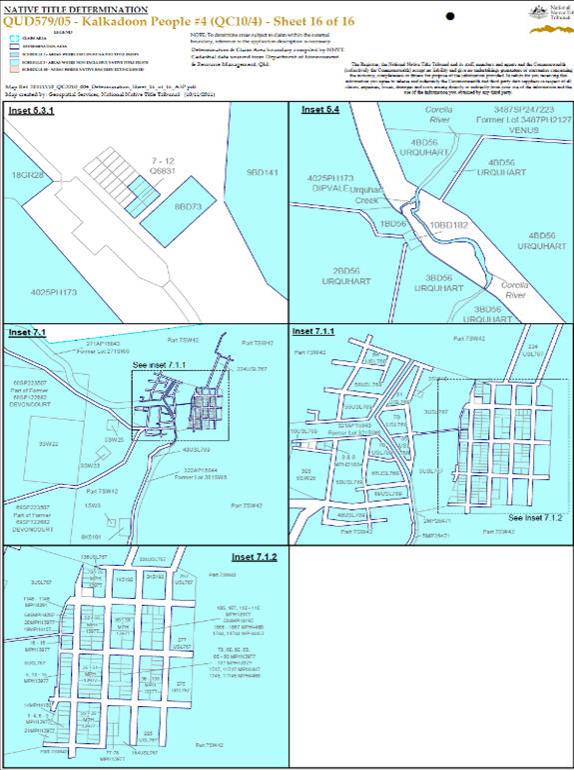 SCHEDULE 6 – Other interests in the Determination Area
The following interests current at the date of this determination:
1. The rights and interests of the parties under the following Indigenous Land Use Agreements (“ILUAs”):
(a) between the Applicant and the State of Queensland executed on 1 December 2011 – “Kalkadoon People/State of Queensland Pre-Determination ILUA”;
(b) between Lawrence (Sonny) Condren, Thelma Sullivan, James Watts Taylor (Wadtija) Richard Percy, Cornelia Craigie, Ethel Page and Patricia Kyle on behalf of the Kalkadoon People and Mount Isa City and the State of Queensland registered on 8 September 2003 as QI2002/064 - “Kalkadoon/Mount Isa Northridge Industrial Estate ILUA”; and
(c) between William Doyle, Noeleen Dempsey, Illona Parker, Lawrence (Sonny) Condren, Hazel Munro, Sue Sarmardin (Jr), Patricia Kyle, Cornelia Craigie and Douglas Bruce on behalf of the Kalkadoon People and Mount Isa City and the State of Queensland registered on 13 June 2008 as QI2007/015 - “Kalkadoon/Gliderport ILUA”.
2. The rights and interests of the State of Queensland, Boulia Shire Council, Burke Shire Council, Cloncurry Shire Council, McKinlay Shire Council and Mount Isa City Council to access, use, operate, maintain and control the dedicated roads in the Determination Area and the rights and interests of the public to use and access roads.
3. The rights and interests of each of Boulia Shire Council, Burke Shire Council, Cloncurry Shire Council, McKinlay Shire Council and Mount Isa City Council:
(a) under its local government jurisdiction and functions under the Local Government Act 2009 (Qld), under the Land Protection (Pests and Stock Route Management) Act 2002 (Qld) and under any other legislation, for that part of the Determination Area within the area declared to be Council's local government area;
(b) as the:
(i) lessor under any leases whether separately particularised in this determination or not;
(ii) grantor of any licences or other rights and interests whether separately particularised in this determination or not;
(iii) holder of any estate or interest in land, and as trustee of any reserves, that exist in the in the Determination Area;
(c) as the owner and operator of infrastructure, facilities and other improvements located in the Determination Area including but not limited to:
(i) dedicated roads operated by Council;
(ii) gravel pits operated by Council;
(iii) undedicated but constructed roads except for those not operated by Council;
(iv) water pipelines and other water supply infrastructure;
(v) drainage facilities; and
(vi) cemetery and cemetery related facilities;
(d) to enter the land described in paragraphs (a), (b) and (c) above by its employees, agents or contractors to:
(i) exercise any of the rights and interests referred to in paragraph 3 of this Schedule;
(ii) inspect, maintain and repair the infrastructure, facilities and other improvements referred to in paragraph (c) above; and
(iii) undertake operational activities in its capacity as a local government such as feral animal control, weed control, erosion control, waste management and fire management; and
(e) under an ILUA with the Applicant executed on 7 December 2011 – “Kalkadoon People and Local Government ILUA”.
4. The powers and responsibilities of the Carpentaria Shire Council under “Local Government Acts” as that term is defined in the Local Government Act 2009 (Qld) which apply to the Determination Area including any rights the Council or its employees or agents have:
(a) as the owner and operator of infrastructure, facilities and other improvements (including gravel pits and road related infrastructure located outside dedicated roads) which are in the Determination Area; and
(b) to enter and exercise rights within the Determination Area in accordance with the Local Government Act 2009 (Qld).
5. The rights and interests of Telstra Corporation Limited:
(a) as the owner or operator of telecommunications facilities within the Determination Area;
(b) created pursuant to the Post and Telegraph Act 1901 (Cth), the Telecommunications Act 1975 (Cth), the Australian Telecommunications Corporation Act 1989 (Cth), the Telecommunications Act 1991 (Cth) and the Telecommunications Act 1997 (Cth) including rights:
(i) to inspect land;
(ii) to install and operate telecommunication facilities;
(iii) to alter, remove, replace, maintain, repair and ensure the proper functioning of its existing and any new telecommunication facilities; and
(iv) for its employees, agents or contractors to access the Determination Area for the purposes of exercising the rights in (i), (ii) and (iii) above in respect of telecommunications facilities in and in the vicinity of the Determination Area;
(c) under any licences, access agreements or easements relating to its telecommunication facilities in the Determination Area, including the Access Agreement between William Doyle, Noeleen Dempsey, Illona Parter, Lawrence (Sonny) Condren, Hazel Munro, Sue Sarmardin (Jr), Patricia Kyle, Cornelia Craigie and Douglas Bruce on behalf of the Kalkadoon People and Telstra Corporation Limited dated on or about 9 December 2011; and
(d) under lease TL231057 in respect of Lot 2 on SP183412 (Healy CMTS).
6. The rights and interests of MMG Australia Limited:
(a) as the holder of mining leases ML2467 to 2471, ML2477 to ML2482, ML2496 to 2502, ML 2556 to 2559, ML 2599, ML2596, ML2601, ML2638, ML2684, ML2685, ML7496, ML90047 and ML90049 to ML90051 granted under the Mineral Resources Act 1989 (Qld);
(b) as the holder of exploration permits and mineral development licences granted under the Mineral Resources Act 1989 (Qld);
(c) arising under the Dugald River Project Agreement dated 6 April 2009 between MMG Australia Limited, and the Kalkadoon People (Project Agreement) as varied; and
(d) arising under the Cultural Heritage Management Plan – Dugald River Project between MMG Australia Limited, the Kalkadoon People and Kalkadoon Cultural Heritage Services Pty Ltd (MMG Kalkadoon CHMP) (approved on 15 February 2010).
7. The rights and interests of CST Minerals Lady Annie Pty Limited:
(a) as the holder of mining leases ML5426, ML5435, ML5446, ML5447, ML5448, ML5474, ML5476, ML5478, ML90168, ML90169, ML90170 and ML90179 granted under the Mineral Resources Act 1989 (Qld);
(b) as the beneficial owner of mining leases ML90178 and ML90184;
(c) as the holder of exploration permits granted under the Mineral Resources Act 1989 (Qld); and
(d) arising under the “Lady Annie/Mount Kelly Project – Agreement relating to native title and mining” dated on or about 5 October 2006 between CST Minerals Lady Annie Pty Limited (as assigned) and the Kalkadoon People.
8. The rights and interests of Roverton Pty Ltd:
(a) as the owner and operator of gaseous petroleum and associated liquid petroleum distribution facilities within the Determination Area;
(b) as the holder of Pipeline Licence No 41 dated 20 March 1997 granted under the Petroleum Act 1923 (Qld);
(c) created pursuant to the Miscellaneous Transport Infrastructure Corridor easement under the Transport Infrastructure Act 1994 (Qld); and
(d) as the holder of a Corridor Licence dated 27 March 1997 between Roverton Pty Ltd and the Chief Executive under the Transport Infrastructure Act 1994 (Qld) including rights:
(i) to access, inspect and patrol (including aerial patrol) the land;
(ii) to construct and operate gaseous petroleum and associated liquid petroleum distribution facilities both above ground and under ground;
(iii) to maintain, repair, replace, alter, remove and ensure the proper functioning of its existing and any new gaseous petroleum and associated liquid petroleum distribution facilities;
(iv) to install any new gaseous petroleum and associated liquid petroleum distribution facilities within the areas referred to in the Corridor Licence; and
(v) for its employees, agents or contractors to access the Determination Area for the purpose of exercising the rights in (i), (ii), (iii) and (iv) above in respect of gaseous petroleum and associated liquid petroleum distribution facilities in the Determination Area.
9. The rights and interests of Mount Isa Mines Limited:
(a) as the holder of mining lease ML 8058 granted under the Mount Isa Mines Limited Agreement Act 1985 (Qld), and ML 5432, ML 5434, ML 2484, ML 5414, ML 5424, ML 5576, ML 2485, ML 2687, ML 2455, ML 2696 and ML 2453 granted under the Mineral Resources Act 1989 (Qld);
(b) as the holder of exploration permits and mineral development licences granted under the Mineral Resources Act 1989 (Qld);
(c) as lessee under pastoral holding PH 13/5563 on Lot 15 on CP805055 (otherwise known as Haslingden Pastoral Lease);
(d) under an ILUA with the Applicant authorised on 20 November 2011 – “Kalkadoon People/Xstrata ILUA”; and
(e) under the "Kalkadoon/MIM Indigenous Land Use Agreement" entered between the Applicant and the State, and the "Kalkadoon/MIM Explorer Deed" entered between the Applicant and Mount Isa Mines Limited, both dated 13 September 2001.
10. The rights and interests of Noranda Pacific Pty Ltd:
(a) as the holder of mining lease ML 5568 granted under the Mineral Resources Act 1989 (Qld);
(b) arising under the McNamara's Highway Agreement dated 26 October 2001 as originally between Calton Hills Pty Ltd, Noranda Pacific Pty Ltd and Buka Minerals (Lady Loretta No. 2) Pty Ltd;
(c) arising under the Cultural Heritage Management Plan – Lady Loretta project ML5568 between Noranda Pacific Pty Ltd and William Doyle, Noeleen Dempsey, Illona Parter, Sonny Condren, Hazel Munro, Sue Sarmardin (Jr), Patricia Kyle, Connie Craigie and Douglas Bruce on their own behalf and on behalf of the Kalkadoon People; and
(d) under an ILUA with the Applicant authorised on 20 November 2011 – “Kalkadoon People/Xstrata ILUA”.
11. The rights and interests of Xstrata Copper Exploration Pty Ltd:
(a) as the holder of mining lease ML 5566 granted under the Mineral Resources Act 1989 (Qld); and
(b) under an ILUA with the Applicant authorised on 20 November 2011 – “Kalkadoon People/Xstrata ILUA”.
12. The rights and interests of Ergon Energy Corporation Ltd:
(a) as the owner and operator of any “Works” as that term is defined in the Electricity Act 1994 (Qld) within the Determination Area;
(b) as a distribution entity and the holder of a distribution authority under the Electricity Act 1994 (Qld); and
(c) created under the Electricity Act 1994 (Qld) and the Government Owned Corporations Act 1993 (Qld) including:
(i) rights in relation to any agreement relating to the Determination Area existing or entered into on or before the date on which these orders are made; and
(ii) rights to enter the Determination Area by its employees, agents or contractors to exercise any of the rights and interests referred to in this paragraph; and to inspect, maintain and manage any Works in the Determination Area; and
(d) under an ILUA between the native title holders and Ergon Energy Corporation Limited executed on 20 June 2011 – “Kalkadoon People/Ergon ILUA”.
13. The rights and interests of CS Energy Mica Creek Pty Ltd:
(a) as the owner or operator of electricity generation and associated facilities within the Determination Area, including as owner and operator of the Mica Creek Power Station;
(b) as sub-lessee of mining lease 8058 pursuant to the sub-lease registered with the Queensland Department of Employment, Economic Development and Innovation as dealing number 979051;
(c) as holder of petroleum pipeline licence number 49; and
(d) the rights of access over the Determination Area or parts thereof by its officers, employees, agents and contractors to, from and around its generation, pipeline and other facilities in, and in the vicinity of the Determination Area.
14. The rights and interests of the Commonwealth of Australia and its licensees under the grant of a Permissive Use in respect of the whole of Lot 2 on Crown Plan AP17205.
15. The rights and interests of A A Company Pty Ltd under:
(a) Pastoral Holding 13/3522 comprising Lot 3522 on PH1192 and known as Alcala Pastoral Lease;
(b) Pastoral Holding 13/50 comprising Lot 50 on SP158585 and known as Canobie; and
(c) an ILUA between the lessee and the Applicant authorised on 20 November 2011 – “Kalkadoon People/Alcala and Canobie ILUA”.
16. The rights and interests of Argylla Mountains Pastoral Pty Ltd under:
(a) Pastoral Holding 13/5345 comprising Lot 100 on AA31 and known as Heywood;
(b) Pastoral Holding 13/2555 comprising Lot 922 on SP137139 and Occupation Licence 13/573 comprising Lot 572 on CP857742, Lot 574 on CP857742, Lot 575 on CP857742 and Lot 573 on SP110102 and known as Murrumba; and
(c) an ILUA between the lessee and the Applicant authorised on 23 October 2011 – “Kalkadoon People/Heywood and Murrumba ILUA”.
17. The rights and interests of Bezuma Pastoral Company Pty Ltd under:
(a) Pastoral Holding 8/2516 comprising Lot 1 on UN7 and known as Thorntonia; and
(b) an ILUA between the lessee and the Applicant authorised on 23 October 2011 – “Kalkadoon People/Thorntonia ILUA”.
18. The rights and interests of Cameron Creek Pastoral Company Pty Ltd under:
(a) Pastoral Holding 13/3635 comprising Lot 3635 on PH2175 and known as Hillside; and
(b) an ILUA between the lessee and the Applicant authorised on 23 October 2011 – “Kalkadoon People/Hillside ILUA”.
19. The rights and interests of Ian Charles Campbell under:
(a) Pastoral Holding 13/4414 comprising Lot 554 on SP177589 and known as Angus (aka Rosebud);
(b) Pastoral Holding 13/5184 comprising Lot 5184 on PH917 and known as Coll (aka Rifle Creek); and
(c) an ILUA between the lessee and the Applicant authorised on 23 October 2011 – “Kalkadoon People/ Angus (aka Rosebud) and Coll (aka Rifle Creek) ILUA”.
20. The rights and interests of Graham Curley and Marie Curley under:
(a) Pastoral Holding 13/5183 comprising Lot 5183 on PH921 and known as Bendigo Park ( aka Yadthor); and
(b) an ILUA between the lessee and the Applicant authorised on 23 October 2011 – “Kalkadoon People/Bendigo Park (aka Yadthor) ILUA”.
21. The rights and interests of Andrew William Jesse Daniels, Samuel Donald James Daniels and Gabrielle Kennedy under:
(a) Pastoral Holding 13/4893 comprising Lot 4893 on PH2202 and known as Roxmere; and
(b) an ILUA between the lessee and the Applicant authorised on 23 October 2011 - “Kalkadoon People/Roxmere ILUA”.
22. The rights and interests of Walter George Hacon under:
(a) Pastoral Holding 13/3721 comprising Lot 3721 on PH810 and known as Ballaghmore Downs;
(b) Pastoral Holding 13/3743 comprising Lot 3743 on PH811 and known as Tyndool; and
(c) an ILUA between the lessee and the Applicant authorised on 23 October 2011 - “Kalkadoon People/Ballaghmore Downs and Tyndool ILUA”.
23. The rights and interests of Peter Eric Hacon under:
(a) Preferential Pastoral Holding 13/85 comprising Lot 85 on PH1944 and Preferential Pastoral Holding 13/3740 comprising Lot 1 on GR14, Lot 2 on GR27 and Lot 3 on GR27 and known as Granada; and
(b) an ILUA between the lessee and the Applicant authorised on 19 November 2011 - “Kalkadoon People/Granada ILUA”.
24. The rights and interests of Hacon Holdings Pty Ltd under:
(a) Pastoral Development Holding 13/2999 comprising Lot 2999 on PH1926 and known as Buckingham Downs; and
(b) an ILUA between the lessee and the Applicant authorised on 19 November 2011 - “Kalkadoon People/Buckingham Downs ILUA”.
25. The rights and interests of Ronald Leslie Hall under:
(a) Pastoral Holding 13/2588 comprising Lot 2588 on PH2037 and known as Gereta;
(b) Pastoral Holding 13/2585 comprising Lot 2585 on PH1274 and Occupation Licence 13/579 comprising Lot 579 on OL121 and known as Regent; and
(c) an ILUA between the lessee and the Applicant authorised on 23 October 2011 - “Kalkadoon People/Gereta and Regent ILUA”.
26. The rights and interests of Ronald Leslie Hall and Copelan Rose Hall under:
(a) Term Lease 0/221467 comprising Lot 7 on TG20; and
(b) an ILUA between the lessee and the Applicant authorised on 23 October 2011 - “Kalkadoon People/Gereta and Regent ILUA”.
27. The rights and interests of Scott Fisher Harrington under:
(a) Preferential Pastoral Holding 13/1496 comprising Lot 4196 on PH339 and known as Ibis Creek; and
(b) an ILUA between the lessee and the Applicant authorised on 23 October 2011 - “Kalkadoon People/Ibis Creek ILUA”.
28. The rights and interests of Lionel Albert Hudson under:
(a) Pastoral Holding 13/3768 comprising Lot 2 on GR16 and Lot 4 on GR16 and known as The Nobbies (aka Dugald); and
(b) an ILUA between the lessee and the Applicant authorised on 23 October 2011 - “Kalkadoon People/The Nobbies (aka Dugald) ILUA”.
29. The rights and interests of Jersey Plains Pastoral Company Pty Ltd under:
(a) Pastoral Holding 13/5211 comprising Lot 521 on CP905413 and known as Chum Vale;
(b) Pastoral Holding 13/4144 comprising Lot 4144 on PH2265 and known as Jersey Plains;
(c) Pastoral Holding 13/5219 comprising Lot 1 on BD102 and known as Bloodwood; and
(d) an ILUA between the lessee and the Applicant authorised on 23 October 2011 - “Kalkadoon People/Chum Vale, Jersey Plains and Bloodwood ILUA”.
30. The rights and interests of Thomas Goodwin Keats under:
(a) Pastoral Holding 13/2965 comprising Lot 2965 on PH1525 and known as Gleeson; and
(b) an ILUA between the lessee and the Applicant authorised on 23 October 2011 - “Kalkadoon People/Gleeson ILUA”.
31. The rights and interests of Alfred Arthur Lanskey under:
(a) Pastoral Holding 8/5553 comprising Lot 4 on UN803944 and known as Barr Creek;
(b) Pastoral Holding 8/4511 comprising Lot 4511 on PH1667 and known as Toorah Vale; and
(c) an ILUA between the lessee and the Applicant authorised on 23 October 2011 - “Kalkadoon People/Barr Creek and Toorah Vale ILUA”.
32. The rights and interests of Edgar Alfred Lanskey under:
(a) Pastoral Holding 13/2658 comprising Lot 2658 on PH1622 and Occupation Licence 8/835 comprising Lot 385 on OL28 and known as Bortala (aka Alsace); and
(b) an ILUA between the lessee and the Applicant authorised on 23 October 2011 - “Kalkadoon People/Bortala (aka Alsace) ILUA”.
33. The rights and interests of James Lyne Lord and Marjorie Annette Lord under:
(a) Pastoral Holding 13/2324 comprising Lot 2324 on SP162422 and known as may downs (aka Meltham); and
(b) an ILUA between the lessee and the Applicant authorised on 23 October 2011 - “Kalkadoon People/May Downs (aka Meltham) ILUA”.
34. The rights and interests of Lorraine Pastoral Company Pty Ltd under:
(a) Pastoral Holding 8/3705 comprising Lot 5 on LS17 and known as Lorraine/Talawanta; and
(b) an ILUA between the lessee and the Applicant authorised on 12 December 2011 - “Kalkadoon People/Lorraine/Talawanta ILUA”.
35. The rights and interests of Robert John McConachy under:
(a) Pastoral Holding 13/5470 comprising Lot 7 on CW67 and known as Ashover; and
(b) an ILUA between the lessee and the Applicant authorised on 23 October 2011 - “Kalkadoon People/Ashover ILUA”.
36. The rights and interests of Archibald James McDonald under:
(a) Term Lease 233216 comprising Lot 427 on SW805054 and known as Brightlands;
(b) Pastoral Holding 13/2547 comprising Lot 2547 on PH2215, Term Lease 0/210349 comprising Lot 7 on SW42 and Term Lease 0/0233884 comprising Lot 12 on SW807930 and known as Bulonga; and
(c) an ILUA between the lessee and the Applicant authorised on 23 October 2011 - “Kalkadoon People/Brightlands and Bulonga ILUA”.
37. The rights and interests of Donald Francis James McDonald under:
(a) Pastoral Holding 13/1384 comprising Lot 5 on SW43 and Lot 1 on MPH13989 and known as Farley;
(b) Pastoral Holding 13/4554 comprising Lot 4554 on PH2190 and known as Girla (aka Girila); and
(c) an ILUA between the Lessee and the Applicant authorised on 23 October 2011 – “Kalkadoon People/Farley and Girla (aka Girila) ILUA”.
38. The rights and interests of Harold Henry McMillan under:
(a) Preferential Pastoral Holding 13/3692 comprising Lot 3692 on PH2168 and known as Carsland;
(b) Preferential Pastoral Holding 13/2846 comprising Lot 2 on GR41 and known as Patricia Vale;
(c) Preferential Pastoral Holding13/3742 comprising Lot 1 on GR42 and known as Quamby;
(d) Preferential Pastoral Holding 13/3712 comprising Lot 2 on BD56, Lot 3 on BD56 and Lot 4 on BD56 and known as Evandean;
(e) Pastoral Holding 13/2577 comprising Lot 2577 on PH139, Term Lease 0/221462 comprising Lot 18 on GR28 and Term Lease 0/208859 comprising Lot 6 on GR33 and known as Yambini; and
(f) an ILUA between the lessee and the Applicant authorised on 23 October 2011 - “Kalkadoon People/Carsland, Patricia Vale, Quamby, Evandean, Yambini and Venus (aka Jessivale) ILUA”.
39. The rights and interests of Harold Henry McMillan and Catherine Patricia McMillan under:
(a) Pastoral Holding 13/3487 comprising Lot 3487 on PH2127 and Term Lease 0/214868 comprising Lot 10 on BD182 and known as Venus (aka Jessivale); and
(b) an ILUA between the lessee and the Applicant authorised on 23 October 2011 - “Kalkadoon People/Carsland, Patricia Vale, Quamby, Evandean, Yambini and Venus (aka Jessivale) ILUA”.
40. The rights and interests of McMillan Pastoral Company Pty Ltd under:
(a) Term Lease 0/232052 comprising Lot 3942 on PH2162 and known as Corella Park;
(b) Preferential Pastoral Holding 13/4126 comprising Lot 4126 on PH1069 and known as Ginburra (aka Lanark);
(c) Pastoral Holding 13/5214 comprising Lot 5214 on PH1272 and known as Mount Maggie;
(d) Pastoral Holding 13/2200 comprising Lot 220 on SP177588 and Special Lease 13/51258 comprising Lot 12 on BD121 and known as Timberu; and
(e) an ILUA between the lessee and the Applicant authorised on 23 October 2011 - “Kalkadoon People/Corella Park, Ginburra (aka Lanark), Mount Maggie and Timberu ILUA”.
41. The rights and interests of MDH Pty Ltd under:
(a) Pastoral Holding 13/69 comprising Lot 69 on SP122682 and known as Devoncourt;
(b) Pastoral Holding 13/5398 comprising Lot 16 on CW62 and known as Stradbroke (aka Stanbroke); and
(c) an ILUA between the lessee and the Applicant authorised on 23 October 2011 - “Kalkadoon People/Devoncourt and Stradbroke (aka Stanbroke) ILUA”.
42. The rights and interests of William Thomas Mitchell under:
(a) Pastoral Holding 13/3192 comprising Lot 3192 on PH2082 and known as Bannockburn (aka Koolamarra); and
(b) an ILUA between the lessee and the Applicant authorised on 23 October 2011 - “Kalkadoon People/Bannockburn (aka Koolamarra) ILUA”.
43. The rights and interests of North Australian Pastoral Company Pty Ltd under:
(a) Pastoral Holding 13/5430 comprising Lot 3 on LS18 and known as Boomara;
(b) Pastoral Holding 13/64 comprising Lot 59 on TG40 and known as Coolullah; and
(c) an ILUA between the lessee and the Applicant authorised on 19 November 201 - “Kalkadoon People/Boomara and Coolullah ILUA”.
44. The rights and interests of Paraway Pastoral Company Pty Ltd under:
(a) Pastoral Holding 13/57 comprising Lot 8 on GR49 and known as Clonagh;
(b) Pastoral Holding 0/233456 comprising Lot 10 on SP223544 and known as Corella; and
(c) an ILUA between the lessee and the Applicant authorised on 23 October 2011 - “Kalkadoon People/Clonagh and Corella ILUA”.
45. The rights and interests of Ronald Arthur Power and Neville Joseph Power under:
(a) Pastoral Holding 13/342 comprising Lot 342 on 1337 and known as Bushy Park; and
(b) an ILUA between the lessee and the Applicant authorised on 23 October 2011 - “Kalkadoon People/Bushy Park ILUA”.
46. The rights and interests of Stanbroke Pastoral Company Pty Ltd under:
(a) Pastoral Holding 8/41 comprising Lot 4 on SP120452 and known as Augustus Downs;
(b) Pastoral Holding 13/80 comprising Lot 80 on SP112345 and known as Fort Constantine;
(c) Pastoral Holding 8/100 comprising Lot 100 on PH1945 and known as Kamilaroi;
(d) an ILUA between the lessee and the Applicant dated 1 December 2011 - “Stanbroke Kalkadoon State of Queensland ILUA”; and
(e) an ILUA between the lessee and the Applicant dated 1 December 2011 - “Kalkadoon People and Stanbroke and State of Queensland – Kamilaroi ILUA”.
47. The rights and interests of Tom Keats & Co Pty Ltd under:
(a) Pastoral Holding 13/2657 comprising Lot 2657 on PH533 and known as Whites Hill; and
(b) an ILUA between the lessee and the Applicant authorised on 23 October 2011 - “Kalkadoon People/Whites Hill ILUA”.
48. The rights and interests of Venlock Pty Ltd under:
(a) Pastoral Holding 0/212277 comprising Lot 3 on SP117500 and known as Ardmore; and
(b) an ILUA between the lessee and the Applicant authorised on 23 October 2011 - “Kalkadoon People/Ardmore ILUA”.
49. The rights and interests of Alan James Webber under:
(a) Pastoral Holding 8/2984 comprising Lot 2984 on PH1906 and known as Mellish Park; and
(b) an ILUA between the lessee and the Applicant dated 12 December 2011 - “Kalkadoon People/Mellish Park ILUA”.
50. The rights and interests of Peter John Woollett and Ann Teresa Woollett under:
(a) Preferential Pastoral Holding 8/5498 comprising Lot 8 on TW8 and known as Berguna;
(b) Pastoral Holding 8/5448 comprising Lot 1 on BK33 and known as Nardoo; and
(c) an ILUA between the lessee and the Applicant authorised on 19 November 2011 - “Kalkadoon People/Berguna and Nardoo ILUA”.
51. The rights and interests of Ivanhoe Cloncurry Mines Pty Ltd under:
(a) Pastoral Holding 13/5364 comprising Lot 5364 on CP1891 and known as Starcross; and
(b) an ILUA between the lessee and the Applicant dated 12 December 2011 - “Kalkadoon People/Starcross ILUA”.
52. The rights and interests of the holders of any permits, claims, licences or leases granted under the Mineral Resources Act 1989 (Qld).
53. The rights and interests of the holders of any permit, licence, lease, other authority, agreement or contract issued or made under the Forestry Act 1959 (Qld) as may be current as at the date of this determination.
54. The rights and interests of the holders of any leases, licences, reservations, permits, easements or authorities granted under the Land Act 1994 (Qld), and any relevant regulations or subordinate legislation made under that Act.
55. The rights and interests of the holders of any licences, permits or allocations under the Water Act 2000 (Qld) and any relevant regulations or subordinate legislation made under that Act.
56. The rights and interests of members of the public arising under the common law, including but not limited to the following:
(a) any subsisting public rights to fish; and
(b) the public right to navigate.
57. So far as confirmed pursuant to s 212(2) of the Native Title Act 1993 (Cth) and s 18 of the Native Title Act (Queensland) Act 1993 (Qld) as at the date of this Determination, any existing public access to, and enjoyment of, the following places in the Determination Area:
(a) waterways;
(b) beds and banks of waterways; and
(c) areas that were public places at the end of 31 December 1993.
58. Any other rights and interests held by the State of Queensland or Commonwealth of Australia, or by reason of the force and operation of the Laws of the State or the Commonwealth.
Note: Entry of orders is dealt with in Rule 39.32 of the Federal Court Rules 2011.
QUEENSLAND DISTRICT REGISTRY | |
GENERAL DIVISION | QUD 579 of 2005 |
BETWEEN: | WILLIAM DOYLE, DOUG BRUCE, SONNY CONDREN, CONNIE CRAIGIE, NOELENE DEMPSEY, PATRICIA KYLE, HAZEL MUNRO, ILONA PARTER AND SUE SAMARDIN JR ON BEHALF OF THE KALKADOON PEOPLE #4 Applicant
|
AND: | STATE OF QUEENSLAND First Respondent COMMONWEALTH OF AUSTRALIA Second Respondent MOUNT ISA CITY COUNCIL Third Respondent BOULIA SHIRE COUNCIL Fourth Respondent BURKE SHIRE COUNCIL Fifth Respondent CARPENTARIA SHIRE COUNCIL Sixth Respondent CLONCURRY SHIRE COUNCIL Seventh Respondent MCKINLAY SHIRE COUNCIL Eighth Respondent ERGON ENERGY CORPORATION LIMITED Ninth Respondent TELSTRA CORPORATION LIMITED Tenth Respondent CS ENERGY MICA CREEK PTY LTD Eleventh Respondent MICHAEL JOSEPH MCKEON Twelfth Respondent MMG AUSTRALIA LIMITED Thirteenth Respondent MOUNT ISA MINES LIMITED Fourteenth Respondent NORANDA PACIFIC PTY LTD Fifteenth Respondent ROVERTON PTY LTD Sixteenth Respondent XSTRATA COPPER EXPLORATION PTY LTD (FORMERLY MIM EXPLORATION PTY LTD) Seventeenth Respondent A A COMPANY PTY LTD Eighteenth Respondent ARGYLLA MOUNTAINS PASTORAL PTY LTD Nineteenth Respondent BEZUMA PASTORAL CO PTY LTD Twentieth Respondent CAMERON CREEK PASTORAL COMPANY PTY LTD Twenty-First Respondent HACON HOLDINGS PTY LTD Twenty-Second Respondent PETER HACON Twenty-Third Respondent WALTER GEORGE HACON Twenty-Fourth Respondent SCOTT FISHER HARRINGTON Twenty-Fifth Respondent LIONEL ALBERT HUDSON Twenty-Sixth Respondent JERSEY PLAINS PASTORAL COMPANY PTY LTD Twenty-Seventh Respondent THOMAS GOODWIN KEATS Twenty-Eighth Respondent LORRAINE PASTORAL CO PTY LTD Twenty-Ninth Respondent M.D.H. PTY LTD Thirtieth Respondent ROBERT JOHN MCCONACHY Thirty-First Respondent ARCHIBALD JAMES MCDONALD Thirty-Second Respondent MCMILLAN PASTORAL COMPANY PTY LTD Thirty-Third Respondent CATHERINE PATRICIA MCMILLAN Thirty-Fourth Respondent HAROLD HENRY MCMILLAN Thirty-Fifth Respondent WILLIAM THOMAS MITCHELL Thirty-Sixth Respondent NORTH AUSTRALIAN PASTORAL COMPANY PTY LTD Thirty-Seventh Respondent NEVILLE JOSEPH POWER Thirty-Eighth Respondent RONALD ARTHUR POWER Thirty-Ninth Respondent STANBROKE PASTORAL COMPANY PTY LTD Fortieth Respondent TOM KEATS & CO PTY LTD Forty-First Respondent ALAN JAMES WEBBER Forty-Second Respondent
|
JUDGE: | DOWSETT J |
DATE: | 12 DECEMBER 2011 |
PLACE: | MOUNT ISA |
REASONS FOR JUDGMENT
1 On 30 May 1995 the Kalkadoon people lodged a claim to Native Title pursuant to the Native Title Act 1993 (Cth) (the “Act”). Six further claims were filed. Following a research project commissioned by the Carpentaria Land Council the current claim, known as Kalkadoon #4, was filed on 22 December 2005. The Kalkadoon #5 claim was filed on 13 January 2006.
2 Kalkadoon #4 and #5 claims were accepted for registration on 4 September 2006 and 11 December 2006 respectively. On 28 March 2007 both claims were notified in accordance with the Act. On 8 December 2010 the Court ordered that the Kalkadoon #4 and #5 claims be combined. The remaining respondents to the combined claim are the State of Queensland, the Commonwealth of Australia, the Boulia, Bourke, Carpentaria, Cloncurry and McKinlay Shire Councils, the Mt Isa City Council, Ergon Energy Corporation Limited, Telstra Corporation Limited, CS Energy Mica Creek Pty Ltd, Michael McKeon, MMG Australia Limited, Mt Isa Mines Limited, Noranda Pacific Pty Ltd, Roverton Pty Ltd, Xstrata Copper Exploration Pty Ltd (formerly MIM Exploration Pty Ltd) and a large number of pastoralists.
3 The combined claim covers an area of about 38,720 square kilometres. It includes low lying plains in the north, north east and southern sections; the Cloncurry Ranges in the mountainous centre; the City of Mt Isa; the townships of Gunpowder, Kajabbi, Quamby, Mary Kathleen and Duchess; branches and tributaries of the Leichhardt River; the south western headwaters of the Cloncurry River; and the middle and upper reaches and tributaries of the Georgina River.
4 The parties to these proceedings have been involved in long and complex negotiations concerning the terms of this proposed consent determination. On 5 October 2009, the Court ordered that the matter be set down for trial, and that mediation in the Tribunal cease. Since that time, the case has been in intensive case-management under the supervision of court staff. As a result, the parties have reached final agreement pursuant to Part 4 Division 1C of the Act. The agreement was filed in the Court on 6 December 2011. Where, at any time after notification, the parties agree upon the orders to be made in relation to such proceedings, the Court may make orders without holding a full hearing, provided that it is satisfied that the proposed orders are within its power, and that it is appropriate that they be made. This Court resolves disputes between parties, which disputes are identified by the parties. Only disputes so identified fall for resolution by the Court. When parties make admissions or concessions, the issues in dispute are narrowed. In some cases, the Court may decline to act on such admissions or concessions. Where, as here, the proceedings have significance for people other than the parties, I must give careful consideration to the appropriateness of the proposed consent orders. Further, the agreement reached between the parties must be freely made, on an informed basis, by all parties. I accept that the State and all other parties, after consideration of the available evidence and archival material, support the orders sought by the applicant. The parties have provided extensive expert and non-expert evidence in support of the claim. I have also been assisted by written submissions filed by the applicant.
5 Sixteen Kalkadoon claimants, ranging in age from 50 to 78 years, and drawn from six different descent groups, have provided affidavit evidence attesting to the continued acknowledgement and observance of traditional laws and customs by the Kalkadoon people. The deponents display a detailed knowledge of their lines of descent and their respective relationships to the claim area. The deponents are:
Richard Percy;
Thelma Sullivan;
Alec Sullivan;
Pat Donovan;
Hazel Munro;
Judy Sam;
Lawrence “Sonny” Condren;
Doug Bruce;
Dawn Sam;
Cornelia Craigie;
Clive Sam;
Cecil Moonlight;
Ron Nemo;
Noleen Dempsey;
Keith Percy; and
James Watts Taylor.
6 The affidavits contain valuable evidence which supports the asserted exercise of continuing native title rights and interests by the claim group. They also contain comprehensive descriptions of traditional law and customs, dreaming stories, spiritual matters, language and significant sites, as well as detail concerning the methods of transmission of such knowledge.
7 Dr Gavin Breen has studied the Kalkatungu language since 1967. He considers that it is not closely related to any other language, a fact which re-inforces the perception of the claim group as a discrete group or nation. Historians Dr Jonathan Richards and Dr Roslyn Kidd have provided reports which detail the history of European contact with the Kalkadoon people. The first European contact was probably with the Burke and Wills party which entered the claim area in 1861. S.E. Pearson, writing in 1948, recorded that he had spoken to Kalkadoon people who recalled seeing that party. Wills recorded evidence of indigenous presence in the claim area, but the party saw few people. In 1861 and 1862 search parties looking for Burke and Wills, encountered many aboriginal groups.
8 George Sutherland brought sheep into the area in 1864, finding a substantial aboriginal settlement and evidence of fishing by line and net. He established the “Rocklands” station. Initially, there was little hostility between European settlers and the indigenous population, but this situation was not to continue. In 1864, William Campbell established a station at Clifton. He experienced at least one raid upon his camp and saw evidence of savage retribution visited upon the indigenous people as punishment for similar raids. In 1866, Ernest Henry commenced to explore the area. In 1867, with the assistance of aboriginal people, he found a copper oxide deposit. Thus the indigenous people contributed to the establishment of Queensland’s present wealth. They also played an important role in establishing the grazing industry in north-west Queensland. By 1868, many sheep stations had been established in the area. As early as the 1870s, the local indigenous people were identified by European settlers as Kalkadoon.
9 The influx of European settlers led to increased hostility between them and the Kalkadoon people. Curiously, Ernest Henry continued to have good relations with indigenous people, suggesting that the hostility was not directed against all European interlopers. Henry was, himself, to be attacked, but he refused to permit retaliation. Hostilities seem to have commenced in about 1881. The settlers sought to resolve the problem by driving the Kalkadoon out of their traditional homeland. By the mid-1890s, aboriginal people in the north-west, including the Kalkadoon, were suffering severely from the effects of such displacement, leading to the introduction of protective legislation in 1897. Pursuant to that legislation, Dr Walter Roth was appointed Northern Protector of Aboriginal People. His writing is frequently cited in Native Title cases. Curiously, he seems to have foreseen the Native Title process as we now know it. In 1900, he wrote, in opposition to the practice of driving aboriginal people off leasehold runs:
These runs are held only on grazing rights – the right to the grass – and can only be upheld as against people taking stock, &c., through them. It certainly is illegal for station-managers, &c., to use physical force and threats to turn blacks (or Europeans) so travelling off such lands. Carrying the present practice (might against right) to a logical conclusion, it would simply mean that, were all the land in the north to be thus leased, all the blacks would be hunted into the sea.
10 Roth also observed:
In their day the Kalkadoons formed the most warlike and desperate of the tribes that the early pioneers had to contend with.
11 There is much additional material concerning the history of the Kalkadoon through the 20th century. Dr Kevin Mayo has prepared detailed genealogies of the descent groups from the apical ancestors and other Kalkadoon ancestors. Mr Peter Blackwood has prepared a three volume connection report as well as a supplementary report, addressing specific issues relating to the succession of the Kalkadoon people to lands of neighbouring groups. Mr Blackwood acknowledges the benefit of extensive earlier research carried out by anthropologists such as Dr Lee Sackett, Dr Paul Memmott and Dr Sandra Pannell. The State of Queensland has obtained a report from Professor Peter Sutton. It is in evidence. The anthropological evidence demonstrates that the Kalkadoon people lawfully hold rights and interests in the claim area in accordance with traditional laws and customs, including areas which were occupied by neighbouring groups at the assertion of British sovereignty.
12 I infer from the evidence that the Kalkadoon occupied much of the claim area at the time of first European contact in 1861, and that they similarly occupied that area in 1788. They have also succeeded earlier occupiers in other areas. The evidence demonstrates continued association with the claim area since 1861. Despite the sad consequences of European settlement, the Kalkadoon have continued to observe traditional laws and customs in their relationship with the claim area.
13 Dr Mayo’s genealogies clearly identify descent groups, tracing their ancestry from first contact with European settlement in the claim area to the present time. The claim group is described as all of those persons who are descended from the following ancestors:
Lardie Roberts (aka Lardie Moonlight);
Dolly Prosser;
Kitty Frogg;
Annie Whip (mother of Martin Connelly (Snr));
Ida (aka Ada) Elston;
Leichardt Toby;
Rosie Waddibungera (mother of George Thorpe);
Willy Malcolm;
Nancy Daniels;
Fanny (Nellie) McLennan;
Nellie and Jimmy (parents of Topsy Harry, Annie Sam and Jack Kippen);
Maggie Sautelle;
Daisy Barton (nee McLean);
Mundi MacDonald (aka King Mundie);
Charlie Caldwell (Snr);
Carbine;
Jimmy Rolleston and Louisa Muni (parents of Bessie Mowbray);
Gypsy Reid (aka Gypsy Ryan);
Nellie Monkira;
Polly Wilson (nee Hopkins) Marajundu;
Jack Elston;
Jessie Frogg (Snr);
Polly Alroy (aka Polly George);
Nobie Clay;
Spider;
Maryann (mother of Annie Reid and Eva Patterson);
Sophie MacDonald;
Julie (mother of Eulie and Lizzie Hickson); and
Bessie Ah Fat.
14 That part of the determination area which is identified in schedule 2 to the proposed orders, is unallocated State land. The parties agree that Native Title rights and interests (other than in relation to water) in that area are the rights to possession, occupation, use and enjoyment to the exclusion of all others, subject to paras 5, 6 and 7 of the proposed orders. The nature and extent of native title rights and interests in that part of the determination area identified in schedule 3 (the “Area”) (other than in relation to water) are, subject to paras 5, 6 and 7 of the proposed orders, the non-exclusive rights to:
(i) be present on, including by accessing, traversing and Camping on, the Area;
(ii) take (including by hunting), use, share and exchange Traditional Natural Resources from the Area for personal, domestic and non-commercial communal purposes;
(iii) conduct cultural and spiritual activities and ceremonies on the Area;
(iv) be buried and to bury native title holders in the ground, within the Area;
(v) maintain places of importance and areas of significance to the native title holders under their traditional laws and customs and protect those places and areas, by lawful means, from physical harm;
(vi) teach on the Area the physical and spiritual attributes of the Area; and
(vii) hold meetings on the Area.
15 I do not doubt the appropriateness of the parties’ identification of the issues or their consensual resolution of them. They have had the benefit of legal advice and substantial anthropological and other research. The proceedings have been on foot for a long time and have been publicised in accordance with the Act. The proposed orders have been drafted with regard to the public interest, represented by the Commonwealth, the State and the local authorities. I thank and congratulate all of the parties. The level of co-operation over the last two or three years has been remarkable, evidencing real respect for the Native Title process and the Kalkadoon people.
16 I should say a little more about such co-operation. It is only in recent years that we have been able to bring Native Title cases in north Queensland to the point at which consent determinations are possible. Recent determinations, and some which will occur in the near future, have reached that point only through the efforts of many people. The parties, particularly claim groups, miners, pastoralists and local authorities have played a large part by their pragmatic and co-operative approaches.
17 Those responsible for Native Title matters within the Queensland government have also played a key role through their constructive and timely participation in the process.
18 Curiously, it has fallen to a body known as the Queensland South Native Title Services Aboriginal Corporation to conduct Native Title cases in north-west Queensland. Their lawyers, past and present, both in-house and in private practice, have done sterling work. I mention in particular Mr Colin Hardie whose willingness to have this matter listed for trial did much to bring about its resolution today. I acknowledge too the efforts made by the National Native Title Tribunal, particularly in the earlier stages of processing of the application.
19 Finally, I wish to acknowledge the efforts of our Native Title registrar in Queensland, Ms Chris Fewings. Her efforts have also contributed significantly to today’s determination. Her family is from this part of the world. Her satisfaction at the outcome rivals that of the Kalkadoon people, themselves.
ORDERS AND DETERMINATION
20 For the purposes of s 94A of the Act I find that the Kalkadoon people are descended from a society of aboriginal people who were in occupation of the land and waters of the determination area at the time of first assertion of British sovereignty. Those people formed a society, united in and by their acknowledgement and observance of traditional laws and customs. Through the observance of these traditional laws and customs, the Kalkadoon people have maintained a connection with the claim area. The proposed orders recognise that the Kalkadoon people, as holders of Native Title in that area, are entitled to the exclusive use and enjoyment of the area identified in schedule 2 of the orders and the non-exclusive use and enjoyment of the area described in schedule 3. The orders recognise, at schedule 6, other interests in the claim area and the relationships of those interests to the Native Title interests. Pursuant to order 12(b) the Kalkadoon Native Title Aboriginal Corporation (ICN7639) is to be the prescribed body corporate for the purposes of s 57(2) of the Act and is to perform the functions set out in s 57(3). I am satisfied that it is within the power of the Court to make the orders sought, and that such orders may properly be made without a full hearing of the application.
21 Mount Isa and its mines are important Queensland icons. The grazing industry here is also very much part of the Queensland story. As the evidence demonstrates, the Kalkadoon have played a significant role in the development of both industries and, as a result, of this city. Indeed, the Kalkadoon people are, themselves, an important part of the same Queensland story. The evidence demonstrates that they were willing to fight to defend their country and culture, just as other peoples have done for thousands of years all over the world. Their efforts to achieve recognition of their traditional ownership have not been unopposed. Very many problems have been overcome in order to permit me to make the orders which I am about to make. The Kalkadoon have borne the adverse consequences of the clash of cultures which inevitably accompanies mass migration, of which the European settlement of Australia is a typical example. The recognition of Kalkadoon traditional ownership of this land goes only a small way towards the recognition of their suffering since 1861.
22 I do not come here today to give anything to the Kalkadoon people. I come on behalf of the Australian people to recognize their traditional ownership of this land in a way which will bind all people and for all time. My order binds the Commonwealth of Australia, the State of Queensland, the Mt Isa City Council and the Boulia, Bourke, Carpentaria, Cloncurry and McKinlay Shire Councils, together with all other people and companies.
23 I now make orders in terms of the draft which I initial and place with the papers.
24 On behalf of all Australians, I congratulate the Kalkadoon people upon this recognition of their traditional rights. Particularly, I congratulate you on behalf of the Judges of this Court and our staff. We all wish you well for the future and express our determination that your contribution to our history, and the price which you have paid for our prosperity, will not be forgotten. We look forward to sharing the future with you.
I certify that the preceding twenty-four (24) numbered paragraphs are a true copy of the Reasons for Judgment herein of the Honourable Justice Dowsett. |
Associate:

