FEDERAL COURT OF AUSTRALIA
Delaney on behalf of the Quandamooka People v State of Queensland
[2011] FCA 741
IN THE FEDERAL COURT OF AUSTRALIA |
|
DATE OF ORDER: |
|
WHERE MADE: |
Being satisfied that an order in the terms set out below is within the power of the Court, and it appearing appropriate to the Court to do so, pursuant to s 87 of the Native Title Act 1993 (Cth)
BY CONSENT THE COURT ORDERS THAT:
1. There be a determination of native title in the terms set out below (“the determination”).
2. The determination will take effect on the agreements referred to in items 1(a) and 1(b) of Schedule 7 of the determination being registered on the Register of Indigenous Land Use Agreements.
3. In the event that the agreements referred to in order 2 are not registered on the Register of Indigenous Land Use Agreements within 6 (six) months of the date of this order or such later time as the Court may order, the matter is to be listed for further directions.
4. Each party to the proceeding is to bear its own costs.
THE COURT DETERMINES THAT:
1. Native title exists in the part of the Determination Area identified in Part A of Schedule 2 and does not exist in the part of the Determination Area identified in Part B of Schedule 2.
2. The native title is held communally by the group of people described in Schedule 1 (“the native title holders”).
3. Subject to paragraphs 4, 5, 6, 7 and 8 the nature and extent of the native title rights and interests, other than in relation to Water, are:
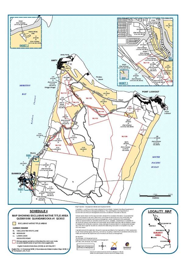
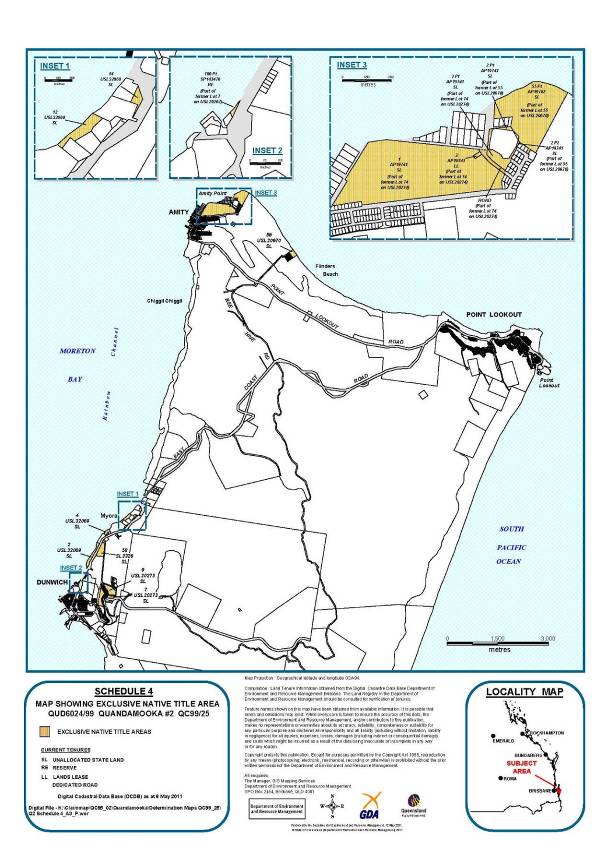
(a) in relation to that part of the Determination Area identified in Schedule 4, the rights to possession, occupation, use and enjoyment to the exclusion of all others;
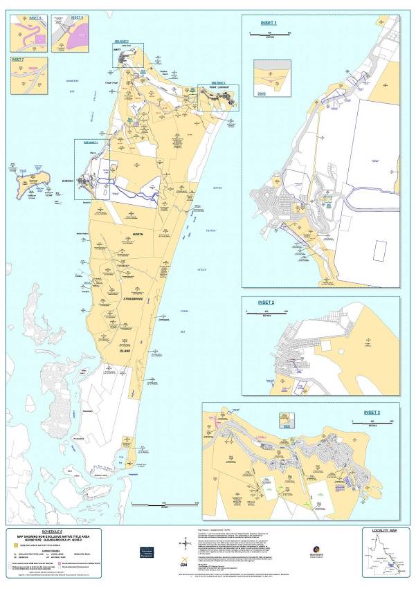
(b) in relation to that part of the Determination Area identified in Schedule 5, the non-exclusive rights to:
(i) Live and be present on the area;
(ii) take, use, share and exchange Traditional Natural Resources for personal, domestic and non-commercial communal purposes;
(iii) conduct burial rites;
(iv) conduct ceremonies;
(v) teach on the area about the physical and spiritual attributes of the area;
(vi) maintain places of importance and areas of significance to the native title holders under their traditional laws and customs and protect those places and areas from physical harm;
(vii) light fires for domestic purposes including cooking, but not for the purpose of hunting or clearing vegetation; and
(viii) be accompanied into the area by non-Quandamooka people being:-
1. people required by traditional law and custom for the performance of ceremonies or cultural activities; and
2. people required by the Quandamooka people to assist in observing or recording traditional activities on the area.
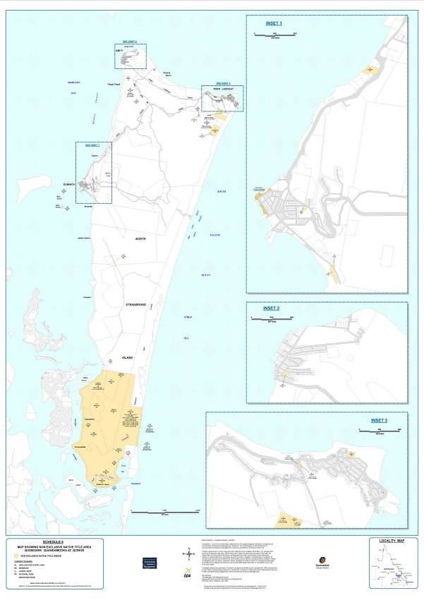
(c) in relation to that part of the Determination Area identified in Schedule 6, the non-exclusive rights to:
(i) be present on the area, including by accessing and traversing the area;
(ii) take, use, share and exchange Traditional Natural Resources and seawater for any non-commercial purpose.
4. Subject to paragraphs 5, 6, 7 and 8 in relation to any parts of the Determination Area which fall within Schedule 4 or Schedule 5 but which extend from the High Water Mark to the Highest Astronomical Tide, the native title rights and interests, except in relation to Water, are the non-exclusive rights and interests set out in paragraph 3(c).
5. Subject to paragraphs 6, 7 and 8, the nature and extent of the native title rights and interests in relation to Water within the Determination Area are the non-exclusive rights to:
(a) take and use Traditional Natural Resources from the Water for personal, domestic and non-commercial communal purposes; and
(b) take and use the Water for personal, domestic and non-commercial communal purposes.
6. There are no native title rights in ‘minerals’ as defined by the Mineral Resources Act 1989 (Qld) and ‘petroleum’ as defined by the Petroleum Act 1923 (Qld) and the Petroleum and Gas (Production and Safety) Act 2004 (Qld).
7. The native title rights and interests are subject to and exercisable in accordance with:
(a) the Laws of the State and the Commonwealth; and
(b) the traditional laws acknowledged and traditional customs observed by the native title holders.
8. The native title rights and interests referred to in paragraphs 3(b), 3(c), 4 and 5 do not confer possession, occupation, use or enjoyment to the exclusion of all others.
9. The nature and extent of other rights and interests in relation to the Determination Area (or respective parts thereof) are the rights and interests set out in Schedule 7 (“Other Interests”).
10. The relationship between the native title rights and interests described in paragraphs 3, 4 and 5 and the Other Interests described in Schedule 7 in so far as they validly affect native title, is that:
(a) the Other Interests continue to have effect, and the rights conferred by or held under the Other Interests may be exercised notwithstanding the existence of the native title rights and interests;
(b) to the extent the Other Interests are inconsistent with the continued existence, enjoyment or exercise of the native title rights and interests in relation to any part of the Determination Area identified in Schedules 4, 5 and 6, the native title continues to exist in its entirety but the native title rights and interests have no effect in relation to the Other Interests to the extent of the inconsistency for so long as the Other Interests exist; and
(c) the Other Interests and any activity that is required or permitted by or under, and done in accordance with, the Other Interests, or any activity that is associated with or incidental to such an activity, prevail over the native title rights and interests and any exercise of the native title rights and interests to the extent of any inconsistency, but do not extinguish them except in accordance with the law.
11. Pursuant to section 56 of the Native Title Act 1993 (Cth), the Court determines that the native title is not to be held in trust.
12. The Quandamooka Yoolooburrabee Aboriginal Corporation ICN 7564, incorporated under the Corporations (Aboriginal and Torres Strait Islander) Act 2006 (Cth), is to:
(a) be the prescribed body corporate for the purposes of s 56, 57(2) and 57(3) of the Native Title Act 1993 (Cth);
(b) act as agent for the native title holders; and
(c) perform the functions set out in the Native Title Act 1993 (Cth) and the Native Title (Prescribed Bodies Corporate) Regulations 1999 (Cth) after becoming a registered native title body corporate.
Definitions and Interpretation
13. The words and expressions used in this determination have the same meanings as they have in Part 15 of the Native Title Act 1993 (Cth) except for the following defined words and expressions:
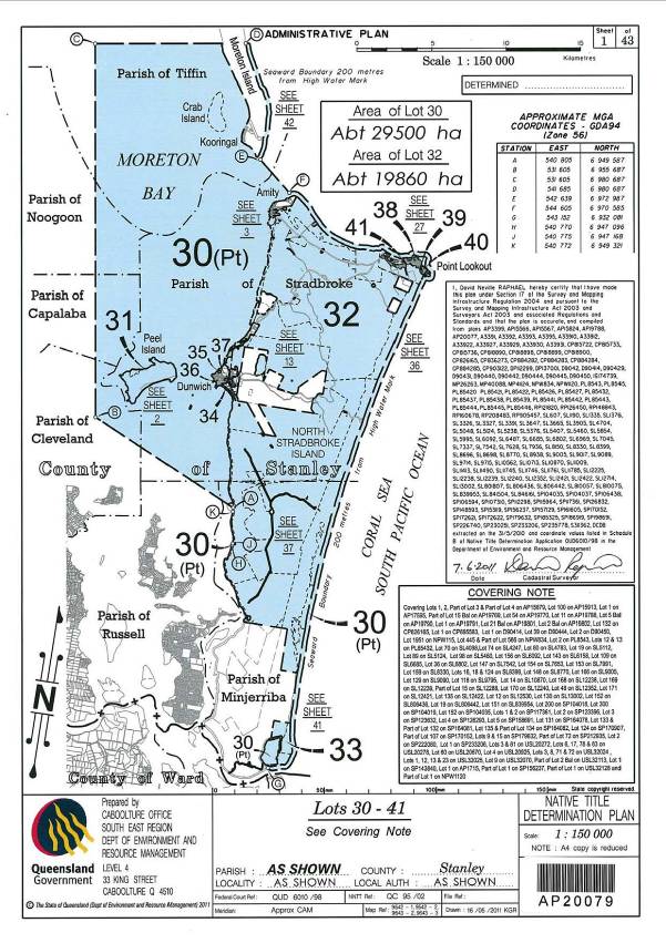
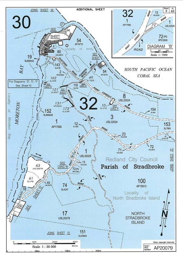
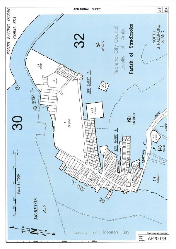
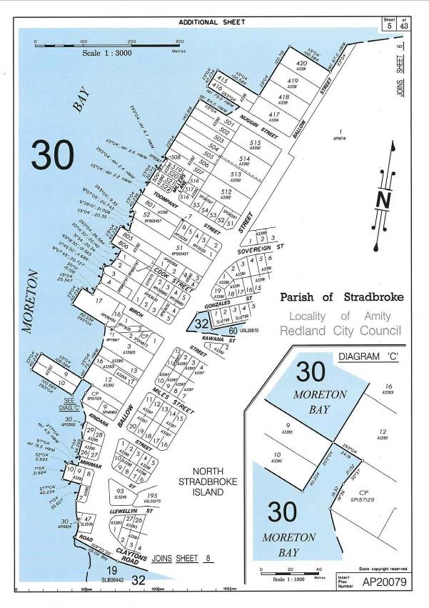
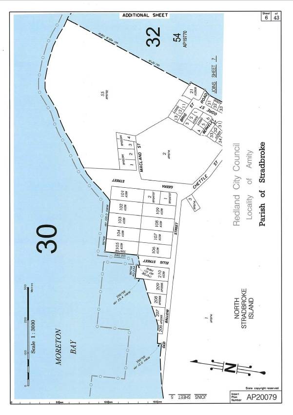
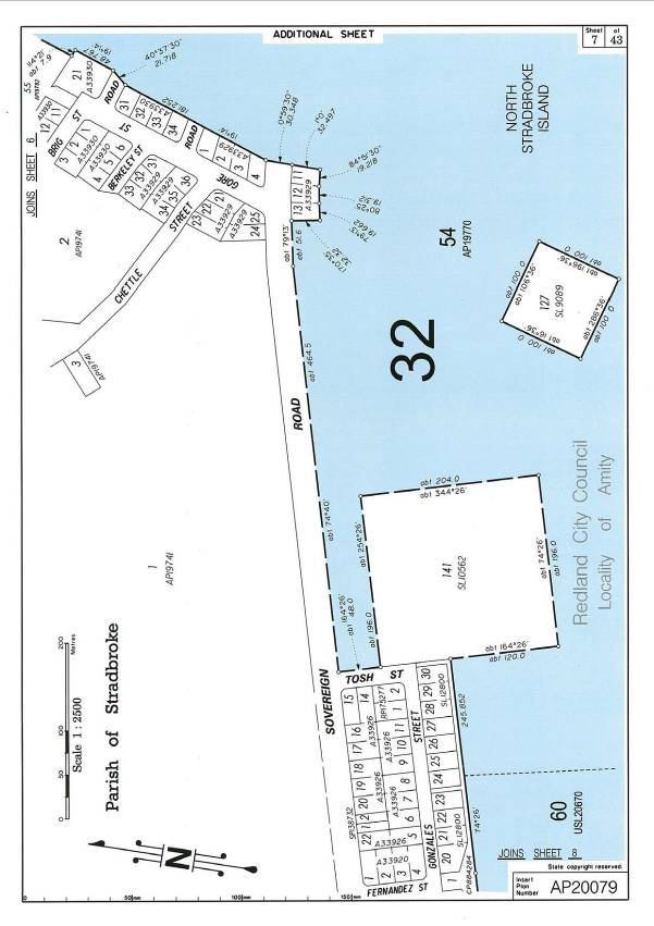
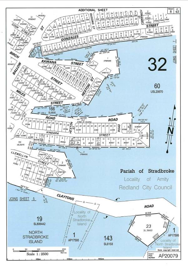
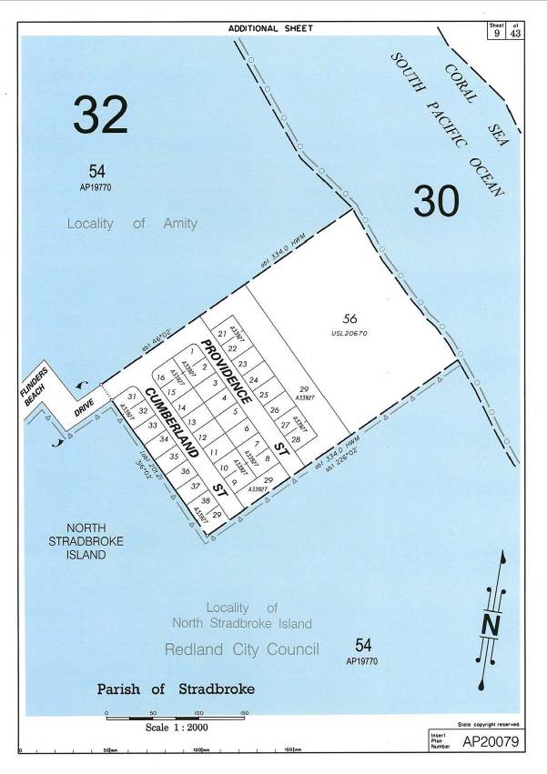
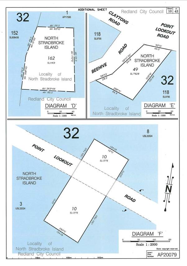
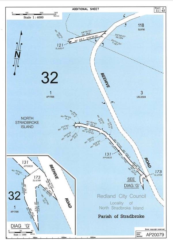
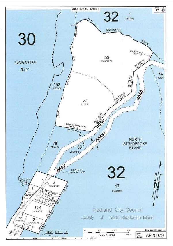
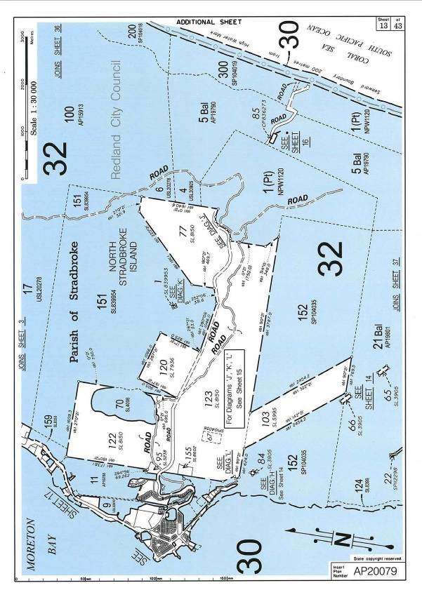
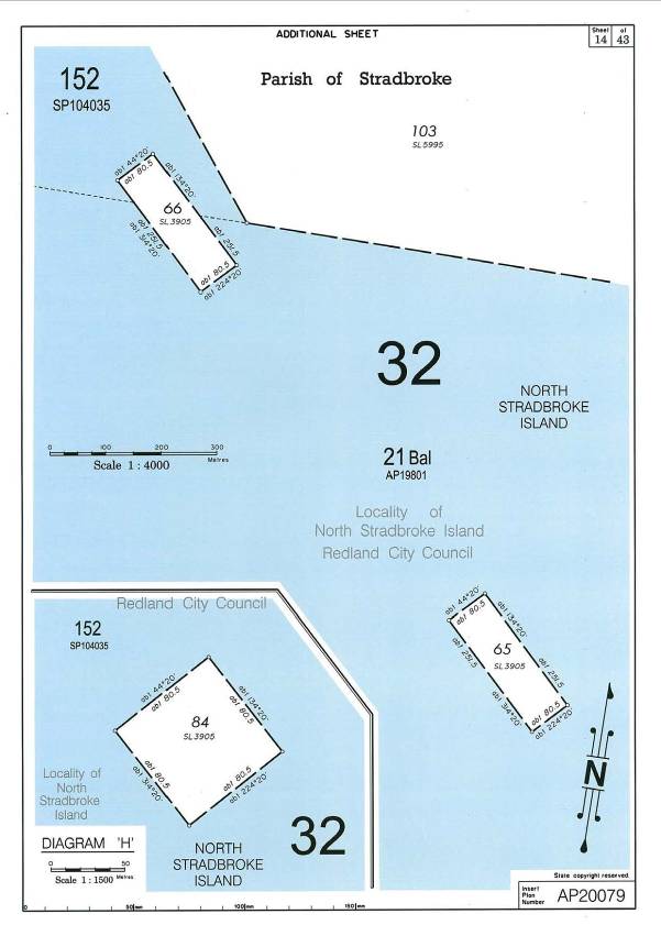
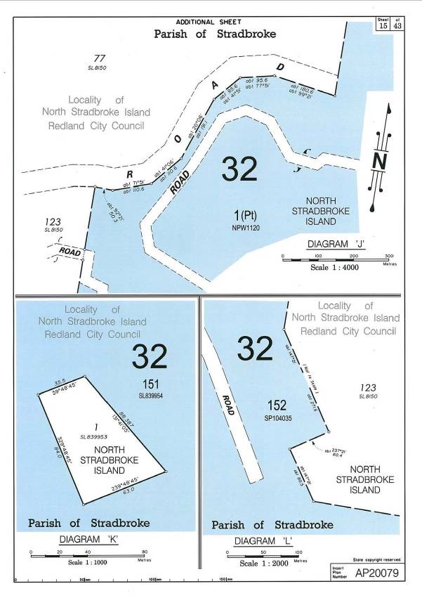
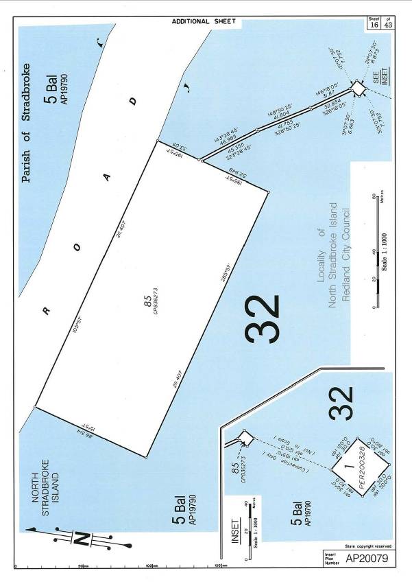
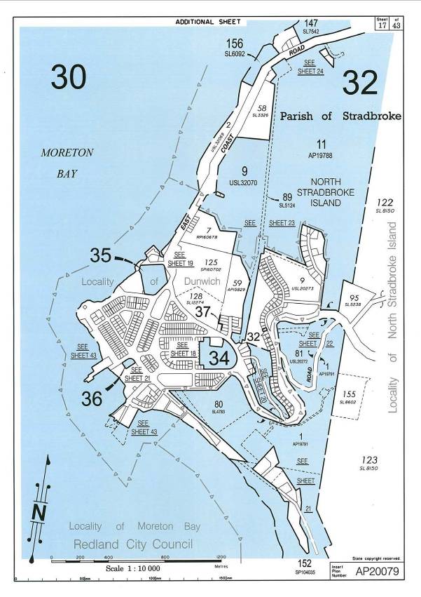
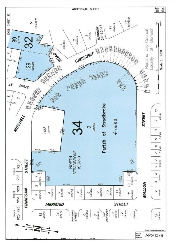
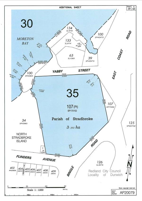
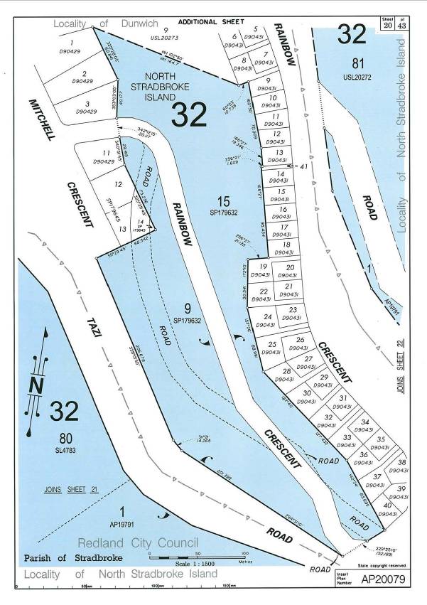
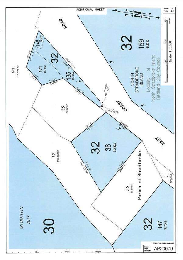
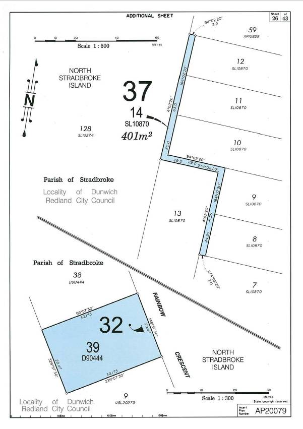
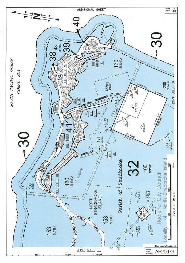
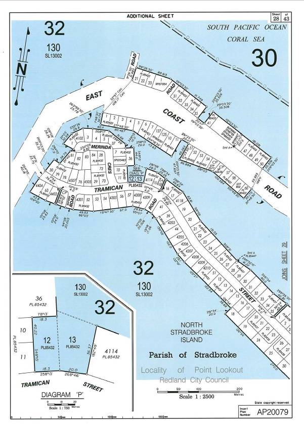
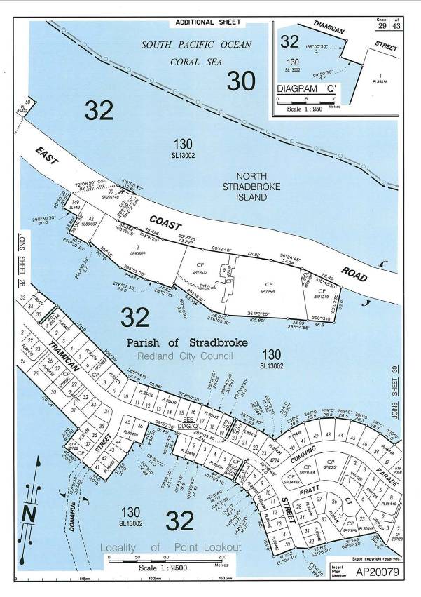
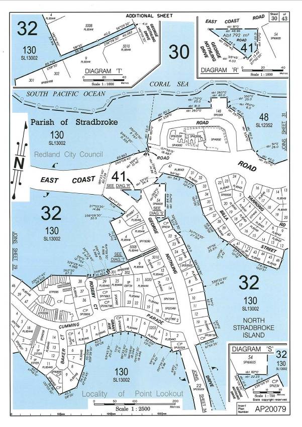
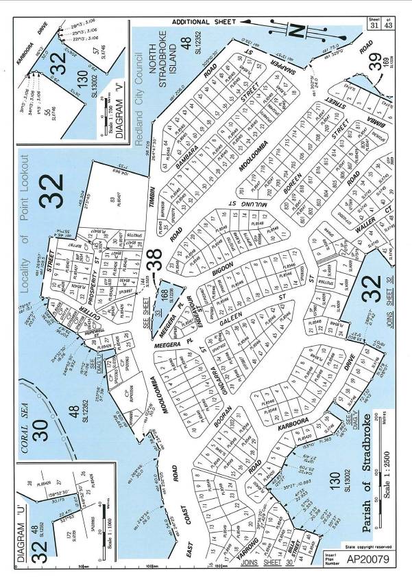
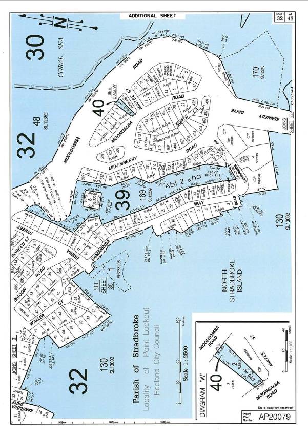
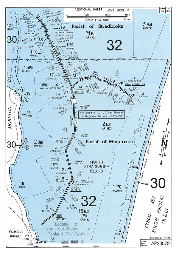
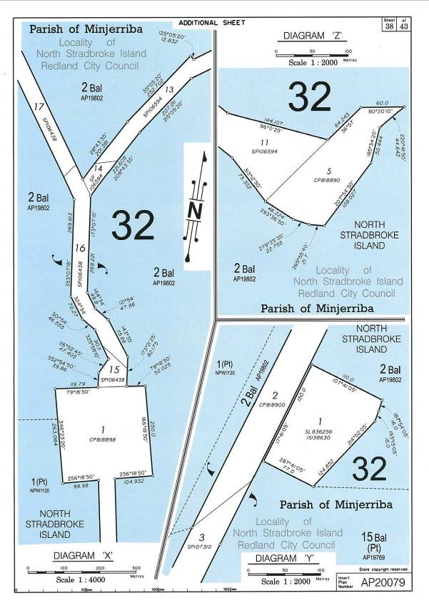
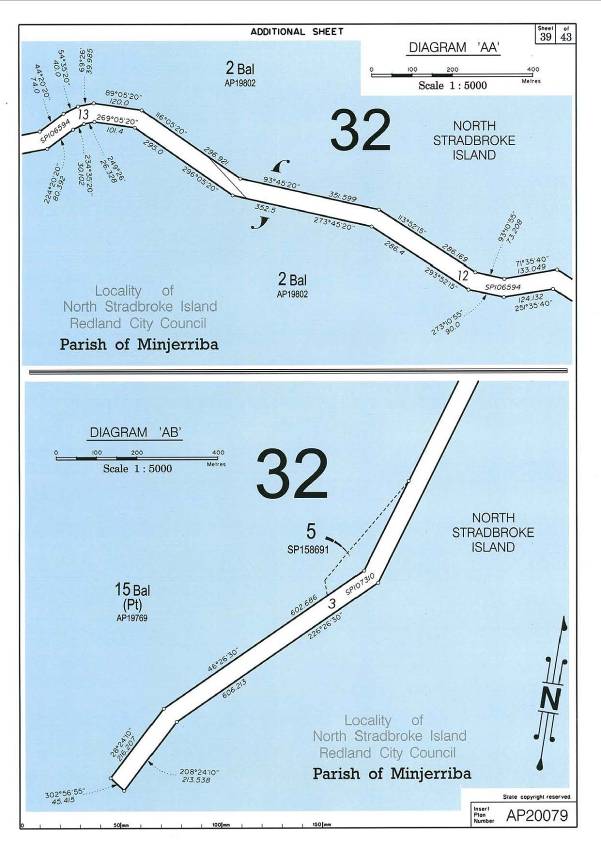
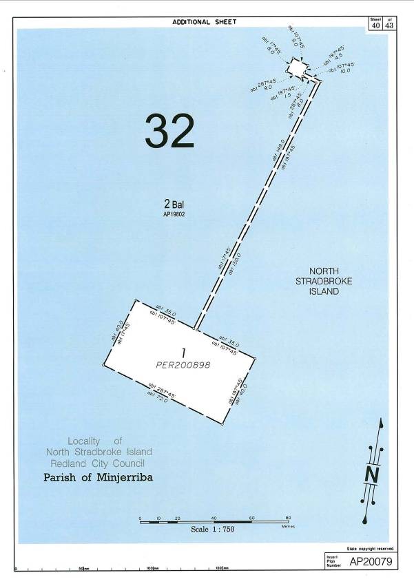
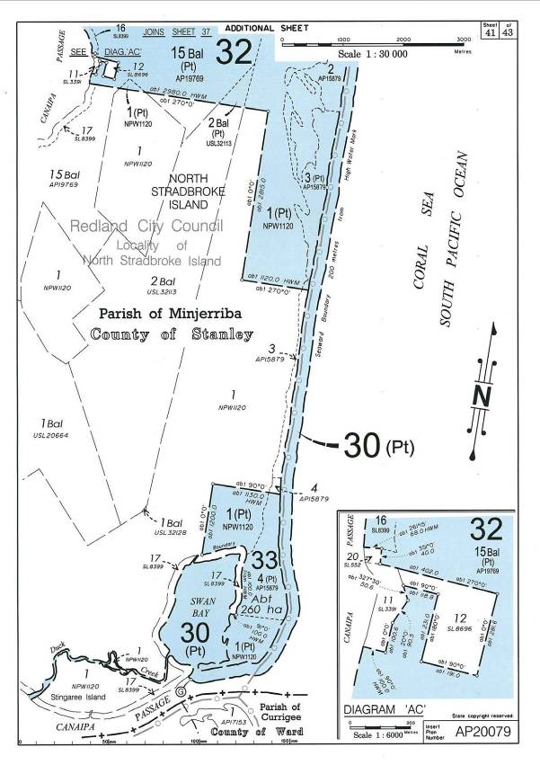
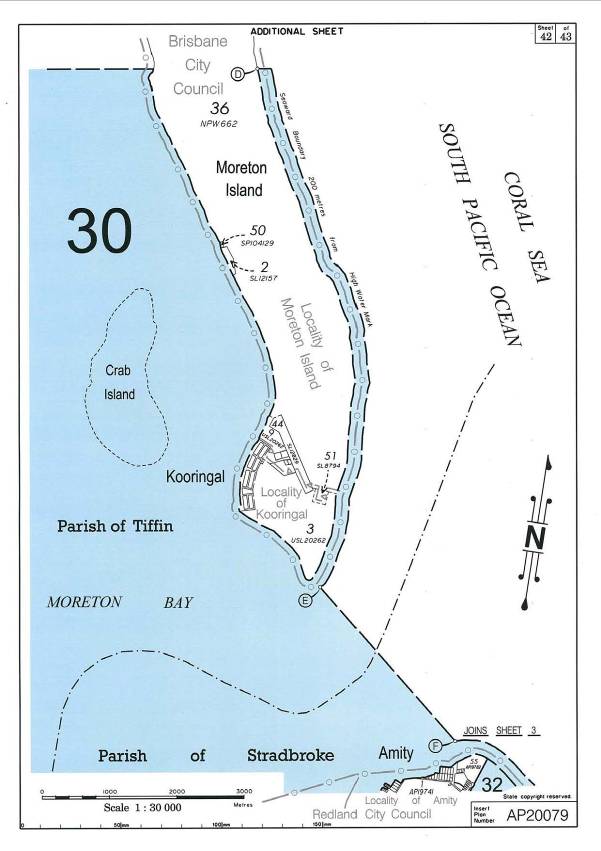
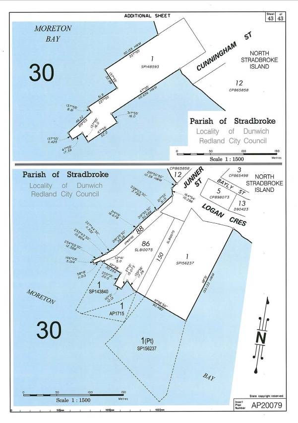
“Determination Area” means the land and waters described in Part A and Part B of Schedule 2 and shown on Native Title Determination Plan AP20079 (excluding those areas identified at Schedule 3);
“High Water Mark” has the meaning given in the Land Act 1994 (Qld);
“Highest Astronomical Tide” means the highest level of the tides that can be predicted to occur under average meteorological conditions and under any combination of astronomical conditions;
“Laws of the State and the Commonwealth” means the common law and the laws of the State and the Commonwealth of Australia, and includes legislation, regulations, statutory instruments, local planning instruments and local laws;
“Live” means to reside and for that purpose to erect shelters and temporary structures but does not include a right to construct permanent structures;
“Traditional Natural Resources” means:
(i) “animals” as defined in the Nature Conservation Act 1992 (Qld);
(ii) “plants” as defined in the Nature Conservation Act 1992 (Qld);
(iii) seaweed, charcoal, shells and resin; and
(iv) any clay, soil, sand, ochre, gravel or rock on or below the surface of the Determination Area.
“Water” means water as defined by the Water Act 2000 (Qld).
SCHEDULE 1 – NATIVE TITLE HOLDERS
SCHEDULE 2 – DETERMINATION AREA – PART A AND PART B
SCHEDULE 3 – AREAS NOT INCLUDED IN THE DETERMINATION AREA
SCHEDULE 4 – EXCLUSIVE NATIVE TITLE AREA
SCHEDULE 5 – NON-EXCLUSIVE NATIVE TITLE AREA (ONSHORE)
SCHEDULE 6 – NON-EXCLUSIVE NATIVE TITLE AREA (OFFSHORE)
SCHEDULE 7 – OTHER INTERESTS
SCHEDULE 1
NATIVE TITLE HOLDERS
The native title holders for the Determination Area are the Quandamooka People who are the biological descendants, of the following people:-
a. Nellie/Lilly Kidgeree
b. Mary Indoole Compignie
c. Elizabeth Ruska
d. Charlie Moreton (Dandruba)
e. Sidney Rollands (Kingal/Winyeeaba)
f. Lillian Lyons (Dungoo)
g. King Billy Toompani
h. Juno (Gonzales)
i. Liza Jungerboi (mother of Rose Martin nee Bain)
j. Tommy Nuggin (Gendarieba)
k. Tilly (mother of Tommy Dalton, Richard Dalton and Henry Lea)
l. Kindarra
who identify as and are accepted by other Quandamooka People as Quandamooka People according to Quandamooka traditional law and custom.
SCHEDULE 2
THE DETERMINATION AREA
Excluding the areas in Schedule 3, the Determination Area comprises:-
PART A
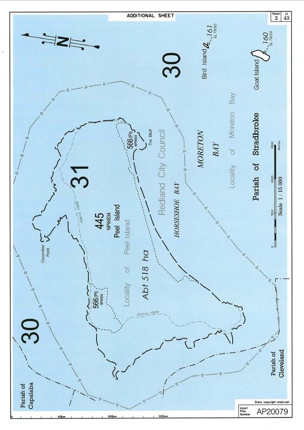
The land and waters within the area described as Lots 30 – 41 on AP20079 covering:
(i) All fresh and sea water, shores and tidal waters, littoral zones, beaches and foreshores within the following boundary description -
Commencing at point, in Moreton Bay, at 531 605 mE, 6 980 687 mN (MGA – Zone 56 – GDA94), being the north-western corner of the Determination Area and extending east to a point on the High Water Mark of the western shoreline of Moreton Island at 6 980 687 mN; then generally south easterly and generally northerly along that High Water Mark, around the southern end of Moreton Island, to 6 980 687 mN; then east to a point 200m seaward of that High Water Mark at 6 980 687 mN; then generally southerly along a line 200m seaward of that High Water Mark to 6 972 987 mN; then south westerly to intersect a line 200m seaward of the High Water Mark of North Stradbroke Island at 544 605 mE; then generally north easterly , generally south easterly, generally southerly and generally westerly along that line, 200 metres seaward of the High Water Mark, to a point southwest of Swan Bay at 543 152 mE; then north westerly to the High Water Mark on Stingaree Island at 543 110 mE; then generally south westerly and generally north westerly along that High Water Mark to the southern bank of Duck Creek; then north westerly across that creek to the High Water Mark of North Stradbroke Island; then generally north westerly and generally northerly along that High Water Mark of the western shorelines of that Island to 6 947 096 mN; then northerly again to a point on the High Water Mark of that Island at 6 947 168 mN; then generally northerly again along that High Water Mark to 6 949 321 mN; then generally northerly passing through the following coordinate points:
540 792mE 6 949 416 mN
540 792 mE 6 949 505 mN
540 805 mE 6 949 587 mN
Then north westerly to a point at 531 605 mE, 6 955 687 mN; then northerly back to the commencement point,
exclusive of former Mt Scott Holding No.2721 and that part of Lot 17 on SL8399 not subject to former Mt Scott Holding No.2721.
(ii) Part of Lot 107 on SP170152 (former Lot 107 on SP115964);
(iii) Lot 109 on SL6685;
(iv) Lot 11 on AP19788 (part of former Lot 11 on USL32070);
(v) An area identified as road (Industrial Court) and delineated by stations 1-5-8-9-12-15-1 on SP104037 (part of former Lot 11 on USL32070);
(vi) Lot 118 on SL9795;
(vii) Lot 124 on SL8399;
(viii) Lot 129 on SL9090;
(ix) Lot 12 on PL85432;
(x) Lot 12 on USL32025:
(xi) Lot 445 on NPW834;
(xii) Lot 566 on NPW834;
(xiii) Part of Lot 130 balance on SL13002 (that part of former Lot 130 on SL13002 exclusive of an area identified as road (part of George Nothling Drive) and delineated by stations numbers B-F-E-D-C-B on SP161605, an area identified as road (part of East Coast Road) and delineated by stations numbers 16-17-A-16 on SP161605, an area identified as road (part of Donohue Street) and delineated by stations numbers 2-3-4-5-6-7-8-20-21-22-23-24-2 on SP170907, an area identified as road (part of Bimba Street) and delineated by stations numbers 10-10-a-11-12-10 on SP233206, an area identified as road (part of George Nothling Drive) and delineated by stations numbers A-B-C-D-E-F-G-A on SP230251, Lot 1 on SP233206, Lot 131 on SP164078, Lot 133 on SP164081, part of Lot 132 on SP164081 & part of Lot 134 on SP164082);
(xiv) An area identified as road (part of George Nothling Drive) and delineated by stations numbers B-F-E-D-C-B on SP161605 (part of former Lot 130 on SL13002);
(xv) An area identified as road (part of East Coast Road) and delineated by stations numbers 16-17-A-16 on plan SP161605 (part of former Lot 130 on SL13002);
(xvi) An area identified as road (part of Donohue Street) and delineated by stations numbers 2-3-4-5-6-7-8-20-21-22-23-24-2 on SP170907 (part of former Lot 130 on SL13002);
(xvii) An area identified as road (part of Bimba Street) and delineated by stations numbers 10-10-a-11-12-10 on SP233206 (part of former Lot 130 on SL13002);
(xviii) An area identified as road (part of George Nothling Drive) and delineated by stations numbers A-B-C-D-E-F-G-A on SP230251 (part of former Lot 130 on SL13002);
(xix) Lot 1 on SP233206 (part of former Lot 130 on SL13002);
(xx) Lot 131 on SP164078 (part of former Lot 130 on SL13002 and part of former Lot 1 on PER5572);
(xxi) Lot 133 on SP164081 (part of former Lot 130 on SL13002);
(xxii) Part of Lot 132 on SP164081 (part of former Lot 130 on SL13002);
(xxiii) Part of Lot 134 on SP164082 (part of former Lot 130 on SL13002);
(xxiv) Lot 132 on CP826165;
(xxv) Lot 135 on SL12422;
(xxvi) Lot 13 on PL85432;
(xxvii) Lot 13 on USL32025;
(xxviii) Lot 14 on SL10870;
(xxix) Lot 143 on SL6158;
(xxx) Lot 147 on SL7542;
(xxxi) Lot 148 on SL8770;
(xxxii) Lot 200 on SP104018 (part of former Lot 14 on USL20341;
(xxxiii) Lot 100 on AP15913 (part of former Lot 14 on USL20341, former Lot 12 on USL20278, former Lot 3 on USL32025 and part of former Lot 1 on PER5572;
(xxxiv) Lot 15 on SP179632 (former Lot 15 on USL20272);
(xxxv) An area identified as road (part of Rainbow Crescent) and delineated by stations numbers 12-11-10-9-7-2-3-6-8-12 on SP179632 (part of former Lot 15 on USL20272);
(xxxvi) Lot 151 on SL839954;
(xxxvii) Lot 152 on SL806436;
(xxxviii) Lot 152 on SP104035 (part of former Lot 152 on SL839954);
(xxxix) An area identified as road (part of Ballow Road) and delineated by stations numbers 3-4-5-7-13-12-9-6-3 on SP104035 (part of former Lot 152 on SL839954);
(xl) Lot 153 on SL7991;
(xli) Lot 154 on SL7653;
(xlii) Lot 156 on SL6092;
(xliii) Lot 159 on SL8330;
(xliv) Part of Lot 15 on SL12288 (that part of the lot within the external boundary of the application);
(xlv) Lot 166 on SL9005;
(xlvi) Lot 168 on SL12238;
(xlvii) Lot 169 on SL12239;
(xlviii) Lot 16 on SL8399;
(xlix) Lot 170 on SL12240;
(l) Lot 171 on SL12421;
(li) Lot 17 on USL20278;
(lii) Lot 18 on SL8399;
(liii) That part of Lot 1 on NPW1120 subject to former Lot 19 on SL5112, that part of former Lot 1 on USL32128 not subject to former Mt Scott Holding No.2721, that part of former Lot 1 on USL32114 not subject to Mt Scott Holding No.2721, part of former Lot 2 on USL20675, part of former lot 5 on USL20925, that part of former Lot 2 on USL32113 not subject to former Mt Scott Holding No.2721, former Lot 1951 on NPW115, part of former Lot 21 on USL20674;
(liv) Lot 19 on SL806442;
(lv) Lot 54 on AP19770 (former Lot 1 on PER5571);
(lvi) Lot 2 on SP123396 (part of former Lot 1 on PER5572);
(lvii) Lot 3 on SP123632 (part of former Lot 1 on PER5572);
(lviii) Lot 4 on SP126293 (part of former Lot 1 on PER5572);
(lix) Lot 124 on SP170907 (part of former Lot 1 on PER5572);
(lx) Lot 1 on CP895583 (part of former Lot 1 on PER5572);
(lxi) Lot 135 on SP164082 (part of former Lot 1 on PER5572);
(lxii) An area identified as road (part of Donohue Street) and delineated by stations numbers 8-9-10-12-13-20-8 on SP170907 (part of former Lot 1 on PER5572);
(lxiii) Lot 1 on AP17595 (part of former Lot 1 on USL20277);
(lxiv) Lot 2 on SP222080 (part of former Lot 1 on USL20277);
(lxv) Part of Balance Lot 15 on AP19769 being that part of former Lot 1 on USL32114 not subject to former Mt Scott Holding No.2721;
(lxvi) Lot 5 on SP158691 (part of former Lot 1 on USL32114);
(lxvii) Lot 1 on D90414;
(lxviii) Lot 1 on AP15879 (part of former Lot 1 on PER5573);
(lxix) Lot 2 on AP15879 (part of former Lot 1 on PER5573);
(lxx) Part of Lot 3 on AP15879 being that part of former Lot 1 on PER5573 not subject to former Mt Scott Holding No.2721;
(lxxi) Part of Lot 4 on AP15879 being that part of former Lot 1 on PER5573 not subject to former Mt Scott Holding No.2721;
(lxxii) Lot 1 on USL32025;
(lxxiii) Balance Lot 21 on AP19801 (former Lot 21 on USL20674);
(lxxiv) Lot 23 on USL32025;
(lxxv) Lot 2 on D90450;
(lxxvi) Balance Lot 2 on AP19802 (former Lot 2 on USL20675);
(lxxvii) That part of Balance Lot 2 on USL32113 not subject to former Mt Scott Holding No.2721;
(lxxviii) Lot 2 on PL8543;
(lxxix) Lot 36 on SL6802;
(lxxx) Lot 39 on D90444;
(lxxxi) Lot 3 on USL32024;
(lxxxii) Lot 3 on USL20272;
(lxxxiii) Lot 48 on SL12352;
(lxxxiv) Lot 4 on USL20925;
(lxxxv) Balance Lot 5 on AP19790 (part of former Lot 5 on USL20925);
(lxxxvi) Lot 300 on SP104019 (part of former Lot 5 on USL20925);
(lxxxvii) An area identified as road and delineated by stations numbers 1-HWM-HWM-2-1 on SP104019 (part of former Lot 5 on USL20925);
(lxxxviii) Lot 60 on USL20670;
(lxxxix) Lot 6 on USL20278;
(xc) Lot 70 on SL4098;
(xci) Lot 71 on USL32024;
(xcii) That part of lot 72 on SP212935 subject to former Lot 72 on SL4234);
(xciii) An area identified as road and delineated by stations numbers 7-12-Y-9-8-7 on SP212935 (part of former Lot 72 on SL4234);
(xciv) Lot 72 on USL32024;
(xcv) Lot 74 on SL4247;
(xcvi) Lot 78 on USL20278;
(xcvii) Lot 80 on SL4783;
(xcviii) Lot 81 on USL20272;
(xcix) Lot 1 on AP19791 (part of former Lot 82 on USL20272);
(c) Lot 1 on SP117361 (part of former Lot 82 on USL20272);
(ci) Lot 2 on SP117361 (part of former Lot 82 on USL20272);
(cii) Lot 83 on USL20278;
(ciii) Lot 89 on SL5124;
(civ) Lot 8 on USL32024;
(cv) Lot 98 on SL5460;
(cvi) Lot 9 on USL32070;
(cvii) Lot 9 on SP179632 (former Lot 9 on USL20272);
(cviii) An area of identified as road (part of Rainbow Crescent) and delineated by stations 44-32-33-34-35-36-37-21-20-19-38-39-40-41-42-43-44 on SP179632 (part of former Lot 9 on USL20272);
(cix) An area of identified as road (part of Rainbow Crescent) and delineated by stations 27-26-25-24-23-23a-28-29-29a-50a-50-27 on SP179632 (part of former Lot 9 on USL20272); and
(cx) An area of identified as road (part of Rainbow Crescent) and delineated by stations 15-14-16-15 on SP179632 (part of former Lot 9 on USL20272).
and
PART B
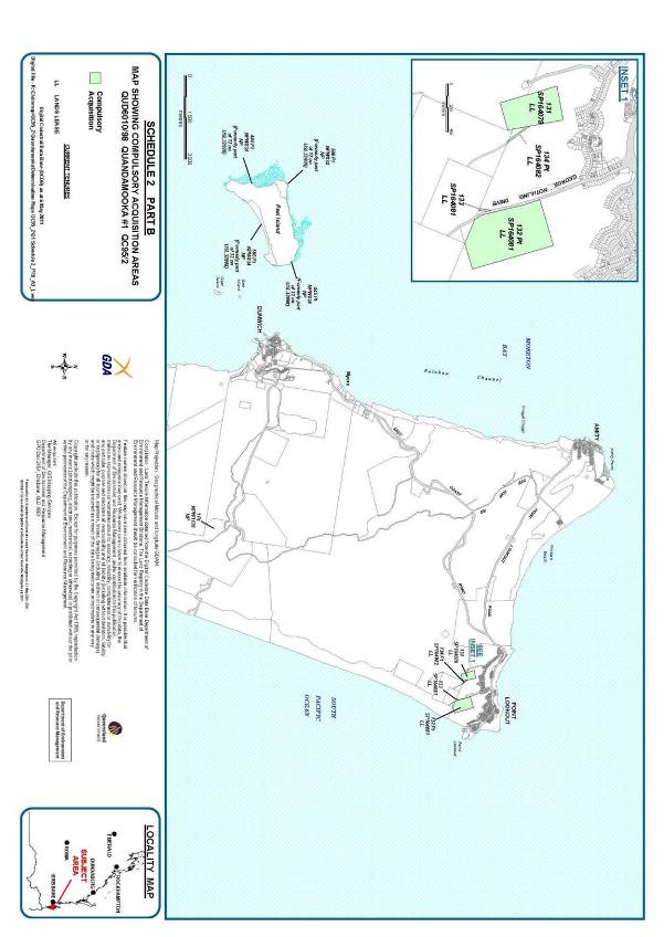
The areas acquired under s 24MD of the Native Title Act 1993 (Cth) and shown on attached map Schedule 2 Part B being:
(i) Lot 131 on SP164078 (part of former Lot 130 on SL13002 and part of former Lot 1 on PER5572);
(ii) Lot 133 on SP164081 (part of former Lot 130 on SL13002);
(iii) Part of Lot 132 on SP164081 (part of former Lot 130 on SL13002); and
(iv) Part of Lot 134 on SP164082 (part of former Lot 130 on SL13002).
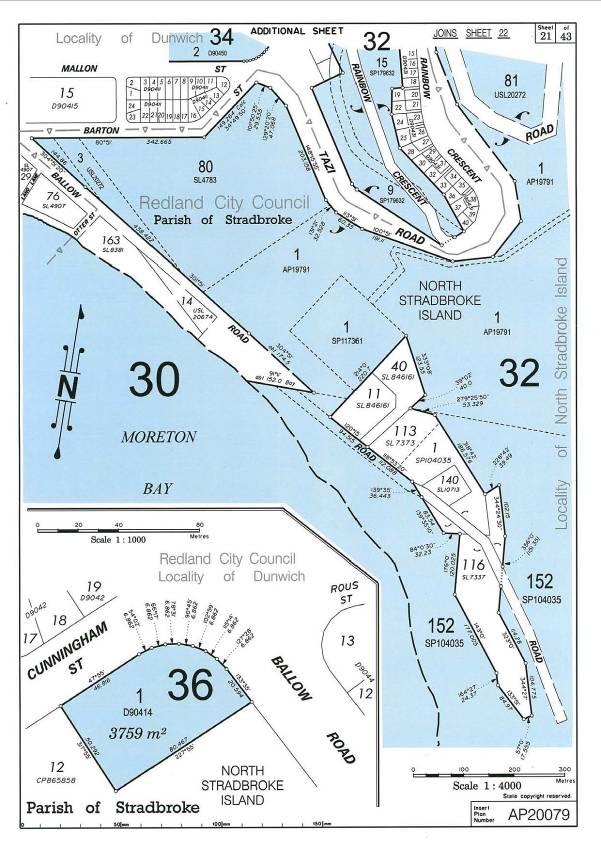
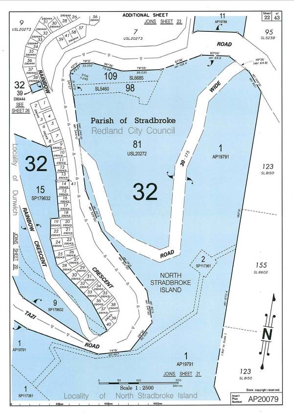
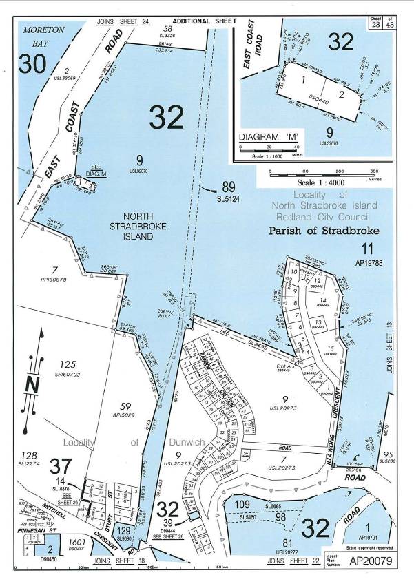
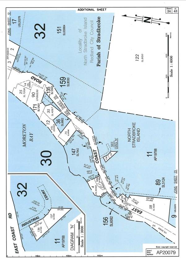
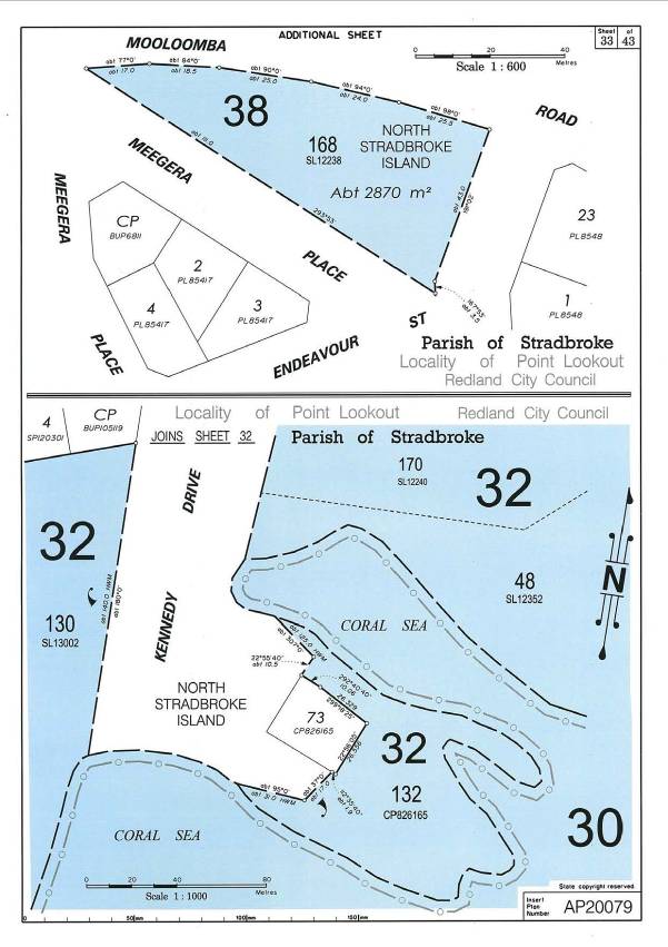
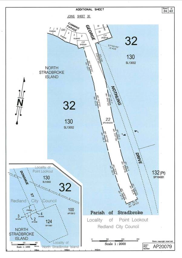
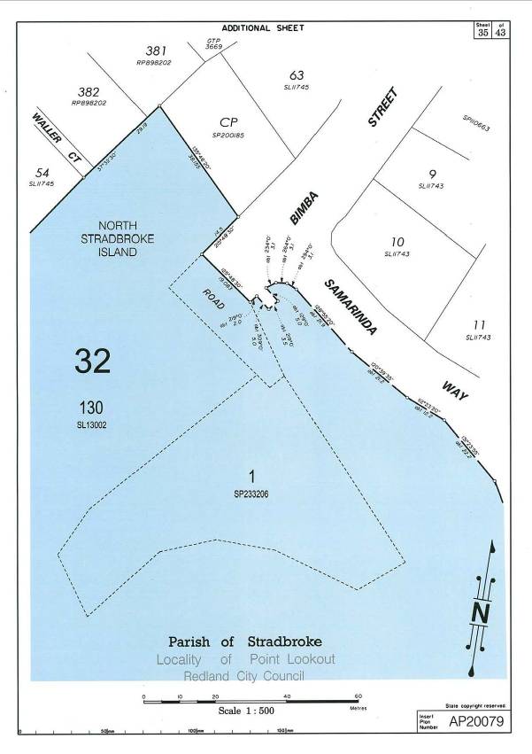
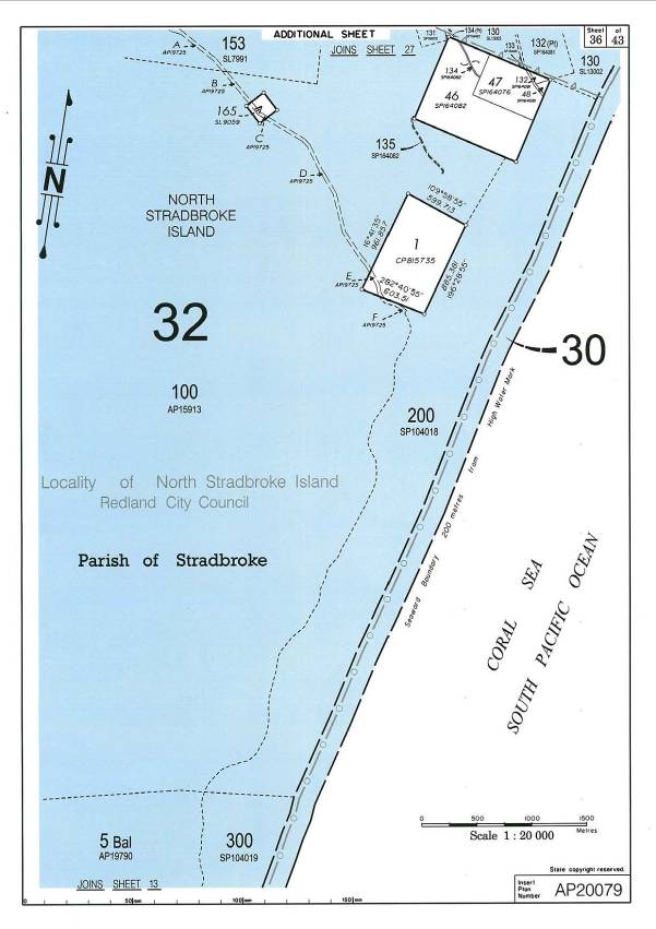
 SCHEDULE 3
AREAS NOT INCLUDED IN THE DETERMINATION AREA
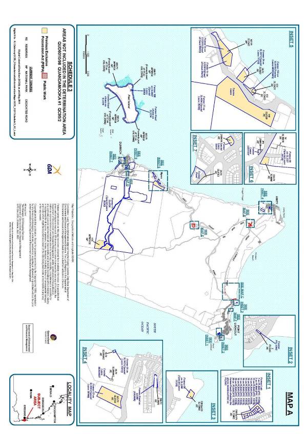
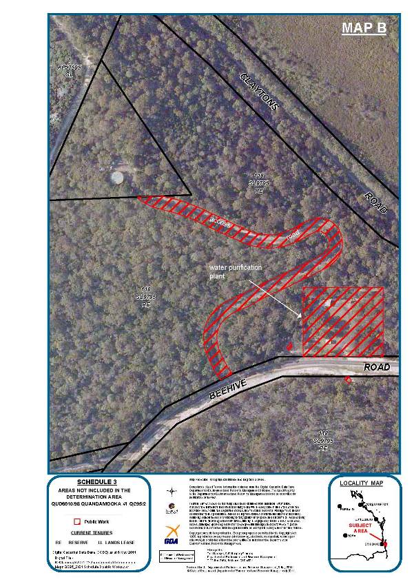
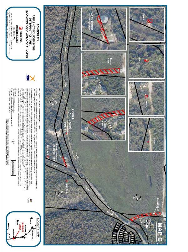
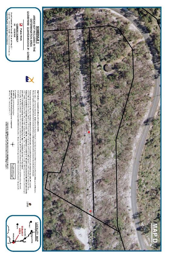
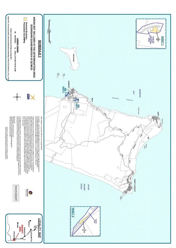
The following areas are wholly excluded from the determination area on the grounds that they have been the subject of a previous exclusive possession act, as defined in section 23B of the Native Title Act 1993 (Cth), that none of sections 47A or 47B of the Native Title Act 1993 (Cth) applied to them at the time at which the Application was made and therefore, in accordance with section 61A of the Native Title Act 1993 (Cth), could not be claimed. The following areas are also delineated within the red boundary on the attached map A Schedule 3 “Areas not included in the Determination Area”.
1. The areas described below covered by public works that are agreed to be previous exclusive possession acts:-
(i) Part of Lot 118 on SL9795 containing the water purification plant within compound, bores 1 and 2 and bitumen road as shown on attached map B Schedule 3;
(ii) Part of Lot 153 on SL7991 containing the supply, treatment and storage plant, bores 1, 2, 3 and 4, bitumen road as shown on attached map C Schedule 3;
(iii) Part of Lot 98 on SL5460 containing the 2 electricity poles as shown on attached map D Schedule 3;
(iv) Part of Lot 130 Bal on SL13002 containing the bitumen road as shown on attached map C Schedule 3;
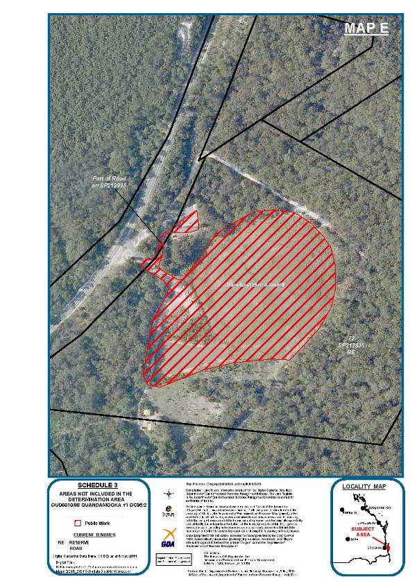
(v) Part of Lot 72 on SP212935 containing the transfer station and landfill as shown on attached map E Schedule 3; and
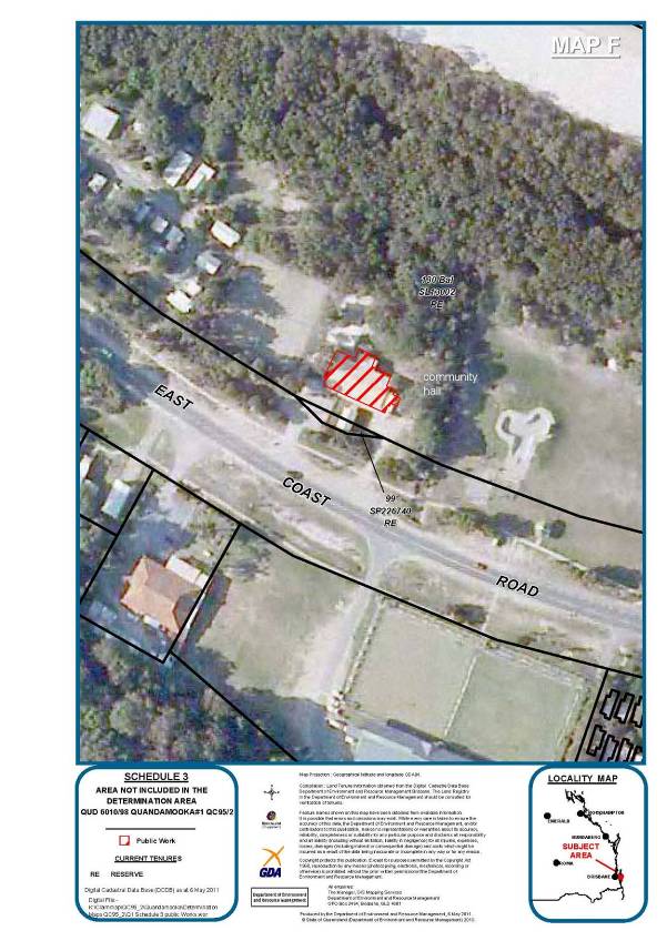
(vi) Part of Lot 130 on SL13002 containing the community hall as shown on attached map F Schedule 3.
2. The land or waters on which any other public work that is a previous exclusive possession act (as defined in section 23B of the Native Title Act 1993 (Cth)) was, on or before 23 December 1996, constructed or established, including (in accordance with section 251D of the Native Title Act 1993 (Cth)) any adjacent land the use of which is or was necessary for, or incidental to, the construction, establishment or operation of the work.
3. The area covered by the following lots or parts of lots as described:-
(i) Part of Lot 129 on SL9090 (that part of the lot subject to former Lot 59 on SL3327 – Special Lease No. 24154);
(ii) Part of Lot 445 on NPW834 (that part of former Lot 12 on USL32998 above High Water Mark subject to former Road on SL5314);
(iii) Part of Lot 566 on NPW834 (that part of former Lot 12 on USL32998 above High Water Mark subject to former Road on SL5314 and former Lot 100 on SL6487 – Special Lease No. 32680);
(iv) Lot 135 on SL12422 (former Lot 135 on SL8770 – Trustee Lease 602825685);
(v) Part of Lot 143 on SL6158 (that part of the lot subject to former Lot 12 on SL2663 – Special Lease No. 20166);
(vi) Lot 14 on SL10870 (former Lot 59 on SL3327 – Special Lease No. 24154);
(vii) Part of Lot 147 on SL7542 (that part of the lot subject to former Lots 1v & 2v on S312978 - Deed of Grant No. 89425);
(viii) Lot 159 on SL8330 (former Lot 19 on SL8330 - Trustee Lease);
(ix) Part of Lot 166 on SL 9005 (that part of the lot subject to former Road on A3399);
(x) Lot 171 on SL12421 (former Lot 135 on SL8770 – Trustee Lease 60282685);
(xi) Part of Lot 1 on NPW1120 being that part of former Lot 1951 on NPW115 to former Lot 77 on SL4704 - Special Lease No. 29280);
(xii) Part of Lot 19 on SL806442 (that part of the lot subject to former Lot 26 on SL1423- Special Lease No.13833 and Trustee Lease 602824887);
(xiii) Lot 1 on D90414 (Lot 1 on D90414 - former Special Lease No. 18419);
(xiv) Part of Lot 2 on D90450 (that part of the lot subject to Lot B on SL12818 - Trustee Lease L661254F);
(xv) Lot 2 on PL8543 (Lot 2 on PL8543 - former Perpetual Town Lease No. 12962);
(xvi) Part of Lot 36 on SL6802 (that part of the lot subject to former Lot 36 on SL2671 – Special Lease No. 17358);
(xvii) Part of Lot 80 on SL4783 (that part of the lot subject to former Road);
(xviii) Parts of Balance Lot 130 on SL13002 (that part of the lot subject to former Lot 1, 2, 12 to 20 subject to Perpetual Town Leases No’s. 17786, 17787, 17819, 17820, 17821, 17822, 17823, 17824, 17825, 17826, 11821 respectively, all on PL8545 & former Roads abutting the above mentioned lots on PL8545 and former Lot 96 on SL5398 - Special Lease No. 31320).
 SCHEDULE 4
EXCLUSIVE NATIVE TITLE AREA
This area is covered by the following lots or parts of lots and delineated on the attached map Schedule 4 Exclusive Native Title Area.
(i) Lot 11 on AP19788 (former Lot 11 on USL32070);
(ii) An area identified as road (Industrial Court) and delineated by stations numbers 1-5-8-9-12-15-1 on SP104037 (part of former Lot 11 on USL32070);
(iii) Lot 200 on SP104018 (part of former Lot 14 on USL20341);
(iv) Part of Lot 100 on AP15913 (that part of former Lot 14 on USL20341 not subject to Mining Lease 1109);
(v) Lot 15 on SP179632 (former Lot 15 on USL20272);
(vi) An area identified as road (part of Rainbow Crescent) and delineated by stations numbers 12-11-10-9-7-2-3-6-8-12 on SP179632 (part of former Lot 15 on USL20272);
(vii) Part of Lot 17 on USL20278 not subject to Mining Leases 1123 and 1124;
(viii) Part of Lot 1 on AP17595 (that part of former Lot 1 on USL20277 not subject to Mining Leases 1112, 1160 and 1172);
(ix) Lot 2 on SP222080 (part of former Lot 1 on USL20277);
(x) Part of Lot 3 on USL32024 not subject to Mining Leases 1109 and 1132;
(xi) Lot 60 on USL20670;
(xii) Part of Lot 78 on USL20278 not subject to Mining Lease 1124);
(xiii) Lot 81 on USL20272;
(xiv) Part of Lot 1 on AP19791 (that part of former Lot 82 on USL20272 not subject to Mining Leases 1103 and 1118);
(xv) Part of Lot 2 on SP117361 (that part of former Lot 82 on USL20272 not subject to Mining Lease 1118);
(xvi) Part of Lot 83 USL20278 not subject to Mining Lease 1124;
(xvii) Lot 8 on USL32024;
(xviii) Lot 9 on USL32070;
(xix) Lot 9 on SP179632 (former Lot 9 on USL20272);
(xx) An area identified as road (part of Rainbow Crescent) and delineated by stations 44-32-33-34-35-36-37-21-20-19-38-39-40-41-42-43-44 on SP179632 (part of former Lot 9 on USL20272);
(xxi) An area identified as road (part of Rainbow Crescent) and delineated by stations 27-26-25-24-23-23a-28-29-29a-50a-50-27 on SP179632 (part of former Lot 9 on USL20272); and
(xxii) An area identified as road (part of Rainbow Crescent) and delineated by stations 15-14-16-15 on SP179632 (part of former Lot 9 on USL20272).
 SCHEDULE 5
NON-EXCLUSIVE NATIVE TITLE AREA (ONSHORE)
This area is covered by the following lots or parts of lots and delineated on the attached map Schedule 5 “Non-Exclusive Native Title Area”.
(i) Part of Lot 107 on SP170152 (former Lot 107 on SP115964);
(ii) Lot 109 on SL6685;
(iii) Part of Lot 118 on SL9795 (that part of the lot not subject to public works being the water purification plant, bores 1 and 2 and bitumen road);
(iv) Lot 124 on SL8399;
(v) Part of Lot 129 on SL9090 (that part of the lot not subject to former Lot 59 on SL3327 – Special Lease No. 24154);
(vi) Lot 12 on PL85432;
(vii) Lot 12 on USL32025;
(viii) Part of Lot 445 on NPW834 (that part of former Lot 12 on USL32998 above High Water Mark not subject to former Road on SL5314);
(ix) Part of Lot 556 on NPW834 (that part of former Lot 12 on USL32998 above High Water mark not subject to former Road on SL5314 and former Lot 100 on SL6487 – Special Lease No. 32680);
(x) Part of Lot 130 balance on SL13002 (that part of former Lot 130 on SL13002 not subject to an area identified as road (part of George Nothling Drive) and delineated by stations numbers B-F-E-D-C-B on SP161605, an area identified as road (part of East Coast Road) and delineated by stations numbers 16-17-A-16 on SP161605, an area identified as road (part of Donohue Street) and delineated by stations numbers 2-3-4-5-6-7-8-20-21-22-23-24-2 on SP170907, an area identified as road (part of Bimba Street) and delineated by stations numbers 10-10-a-11-12-10 on SP233206, an area identified as road (part of George Nothling Drive) and delineated by stations numbers A-B-C-D-E-F-G-A on SP230251, Lot 1 on SP233206, former lots 1, 2, 12 to 20 on PL8545 and former roads abutting these lots on PL8545, former Lot 96 on SL5398, Lot 131 on SP164078, Lot 132 and 133on SP164081, 134 on SP164082, an area of public work being the bitumen road and an area of public work being the community hall);
(xi) An area identified as road (part of George Nothling Drive) and delineated by stations numbers B-F-E-D-C-B on SP161605 (part of former Lot 130 on SL13002);
(xii) An area identified as road (part of East Coast Road) and delineated by stations numbers 16-17-A-16 on SP161605 (part of former Lot 130 on SL13002);
(xiii) An area identified as road (part of Donohue Street) and delineated by stations numbers 2-3-4-5-6-7-8-20-21-22-23-24-2 on SP170907 (part of former Lot 130 on SL13002);
(xiv) An area identified as road (part of Bimba Street) and delineated by stations numbers 10-10-a-11-12-10 on SP233206 (part of former Lot 130 on SL13002);
(xv) An area identified as road (part of George Nothling Drive) and delineated by stations numbers A-B-C-D-E-F-G-A on SP230251 (part of former Lot 130 on SL13002);
(xvi) Lot 1 on SP233206 (part of former Lot 130 on SL13002);
(xvii) Lot 132 on CP826165;
(xviii) Lot 13 on PL85432;
(xix) Lot 13 on USL32025;
(xx) Part of Lot 143 on SL6158 (that part of the lot not subject to former Lot 12 on SL2663 – Special Lease No. 20166) ;
(xxi) Part of Lot 147 on SL7542 (that part of the lot not subject to former Lots 1v & 2v on S312978 - Deed of Grant No. 89425);
(xxii) Lot 148 on SL8770;
(xxiii) Lot 151 on SL839954;
(xxiv) Lot 152 on SL806436;
(xxv) Lot 152 on SP104035 (part of former Lot 152 on SL839954);
(xxvi) An area identified as road (part of Ballow Road) and delineated by stations numbers 3-4-5-7-13-12-9-6-3 on SP104035 (part of former Lot 152 on SL839954);
(xxvii) Part of Lot 153 on SL7991 (that part of the lot not subject to public works being the supply, treatment and storage plant, bores 1, 2, 3 and 4, and bitumen road);
(xxvii) Lot 154 on SL7653;
(xxviii) Lot 156 on SL6092;
(xxix) Part of Lot 15 on SL12288 (that part of the lot within the external boundary of the application);
(xxx) Part of Lot 166 on SL9005 (that part of the lot not subject to former Road on A3399);
(xxxi) Lot 168 on SL12238;
(xxxii) Lot 169 on SL12239;
(xxxiii) Lot 16 on SL8399;
(xxxiv) Lot 170 on SL12240;
(xxxv) Part of Lot 17 on USL20278 (that part of the lot subject to Mining Lease’s 1123 and1124);
(xxxvi) Lot 18 on SL8399;
(xxxvii) That part of Lot 1 on NPW1120 subject to former Lots 19 on SL5112, that part of former Lot 1 on USL32128 not subject to former Mt Scott Holding No.2721, that part of former Lot 1 on USL32114 not subject to Mt Scott Holding No.2721, part of former Lot 2 on USL20675, part of former lot 5 on USL20925, that part of former Lot 2 on USL32113 not subject to former Mt Scott Holding No.2721, that part of former Lot 1951 on NPW115 not subject to former Lot 77 on SL4704 – Special Lease No. 29280, part of former Lot 21 on USL20674;
(xxxviii) Part of Lot 19 on SL806442 (that part of the lot not subject to former Lot 26 on SL1423 - Special Lease No.13833 and Trustee lease 602824887);
(xxxix) Lot 54 on AP19770 (former Lot 1 on PER5571);
(xl) Lot 2 on SP123396 (part of former Lot 1 on PER5572);
(xli) Lot 3 on SP123632 (part of former Lot 1 on PER5572);
(xlii) Lot 4 on SP126293 (part of former Lot 1 on PER5572);
(xliii) Lot 124 on SP170907 (part of former Lot 1 on PER5572);
(xliv) Lot 1 on CP895583 (part of former Lot 1 on PER5572);
(xlv) Lot 135 on SP164082 (part of former Lot 1 on PER5572);
(xlvi) An area identified as road (part of Donohue Street) and delineated by stations numbers 8-9-10-12-13-20-8 on SP170907 (part of former Lot 1 on PER5572);
(xlvii) Part of Lot 100 on AP15913 excluding that part of former Lot 14 on USL20341 that is not subject to Mining Lease 1109 (part of former Lot 14 on USL20341, former Lot 12 on USL20278, former Lot 3 on USL32025 and part of former Lot 1 on PER5572 subject to Mining Lease 1109;
(xlviii) Part of Lot 1 on AP17595 (part of former Lot 1 on USL20277 subject to Mining Lease’s 1112, 1123, 1160 and 1172);
(xlix) Part of Balance Lot 15 on AP19769 being that part of former Lot 1 on USL32114 not subject to former Mt Scott Holding No.2721;
(l) Lot 5 on SP158691 (part of former Lot 1 on USL32114);
(li) Lot 1 on AP15879 (part of former Lot 1 on PER5573);
(lii) Lot 2 on AP15879 (part of former Lot 1 on PER5573);
(liii) Part of Lot 3 on AP15879 being that part of former Lot 1 on PER5573 not subject to former Mt Scott Holding No.2721;
(liv) Part of Lot 4 on AP15879 being that part of former Lot 1 on PER5573 not subject to former Mt Scott Holding No.2721;
(lv) Lot 1 on USL32025;
(lvi) Balance Lot 21 on AP19801 (former Lot 21 on USL20674);
(lvii) Lot 23 on USL32025;
(lviii) Part of Lot 2 on D90450 (that part of the lot not subject to Lot B on SL12818 - Trustee Lease L661254F);
(lix) Balance Lot 2 on AP19802 ( former Lot 2 on USL20675);
(lx) That part of Balance Lot 2 on USL32113 not subject to former Mt Scott Holding No.2721;
(lxi) Part of Lot 36 on SL6802 (that part of the lot not subject to former Lot 36 on SL2671 – Special Lease No. 17358);
(lxii) Lot 39 on D90444;
(lxiii) Part of Lot 3 on USL32024 subject to Mining Lease 1132;
(lxiv) Lot 3 on USL20272;
(lxv) Lot 48 on SL12352;
(lxvi) Lot 4 on USL20925;
(lxvii) Balance Lot 5 on AP19790 (part of former Lot 5 on USL20925);
(lxviii) Lot 300 on SP104019 (part of former Lot 5 on USL20925);
(lxix) An area identified as road and delineated by stations numbers 1-HWM-HWM-2-1 on SP104019 (part of former Lot 5 on USL20925);
(lxx) Lot 6 on USL20278;
(lxxi) Lot 70 on SL4098;
(lxxii) Lot 71 on USL32024;
(lxxiii) Part of lot 72 on SP212935 (that part subject to former Lot 72 on SL4234 not subject to public works being the transfer station and landfill);
(lxxiv) An area identified as road and delineated by stations numbers 7-12-Y-9-8-7 on SP212935 (part of former Lot 72 on SL4234);
(lxxv) Lot 72 on USL32024;
(lxxvi) Lot 74 on SL4247;
(lxxvii) Part of Lot 78 on USL20278 subject to Mining Lease 1124;
(lxxviii) Part of Lot 80 on SL4783 (that part of the lot not subject to former Road);
(lxxix) Part of Lot 1 on AP19791 (that part of former Lot 82 on USL20272 subject to Mining Lease’s 1103 and 1118);
(lxxx) Lot 1 on SP117361 (part of former Lot 82 on USL20272);
(lxxxi) Part of Lot 2 on SP117361 (that part of former Lot 82 on USL20272 subject to Mining Lease 1118);
(lxxxii) That part of Lot 83 on USL20278 subject to Mining Lease 1124;
(lxxxiii) Lot 89 on SL5124;
(lxxxiv) Part of Lot 98 on SL5460 (that part of the lot not subject public works being the power poles.
 SCHEDULE 6
NON-EXCLUSIVE NATIVE TITLE AREA (OFFSHORE)
This area comprises that part of Lots 30 and 31 on AP20079 which covers offshore areas including tidal waters, shores, littoral zones, beaches and foreshores to the High Water Mark and further described as being within the following boundary description.
Commencing at a point, in Moreton Bay, at 531 605 mE, 6 980 687 mN (MGA – Zone 56 – GDA94), being the north-western corner of the Determination Area and extending east to a point on the High Water Mark of the western shoreline of Moreton Island at 6 980 687 mN; then generally south-easterly and generally northerly along that High Water Mark, around the southern end of Moreton Island, to 6 980 687 mN; then east to a point 200m seaward of that High Water Mark at 6 980 687mN; then generally southerly along a line 200m seaward of that High Water Mark to 6 972 987 mN; then south westerly to intersect a line 200m seaward of the High Water Mark of North Stradbroke Island at 544 605 mE; then generally north easterly, generally south easterly, generally southerly and generally westerly along that line, 200 metres seaward of the High Water Mark, to a point southwest of Swan Bay at 543 152 mE; then north westerly to the High Water Mark on Stingaree Island at 543 110 mE; then generally south westerly and generally north westerly along that High Water Mark to the southern bank of Duck Creek; then north westerly across that creek to the High Water Mark of North Stradbroke Island; then generally north westerly and generally northerly along that High Water Mark of the western shorelines of that Island to 6 947 096 mN; then northerly to again a point on the High Water Mark of that Island at 6 947 168 mN; then generally northerly again along that High Water Mark to 6 949 321 mN; then generally northerly passing through the following coordinate points:
540 792 mE 6 949 416 mN
540 792 mE 6 949 505 mN
540 805 mE 6 949 587 mN
Then north westerly to a point at 531 605 mE, 6 955 687 mN; then northerly back to the commencement point.
Including those parts of Lots 445 and 556 on NPW834 that are below High Water Mark.
SCHEDULE 7
OTHER INTERESTS IN THE DETERMINATION AREA
The nature and extent of Other Interests in relation to the Determination Area are the Other Interests current at the date of this determination which comprise the following:
1. The rights and interests of the parties under the following agreements and authorities:
(a) The Indigenous Land Use Agreement (“ILUA”) between Ian Delaney on behalf of the Quandamooka People, the Quandamooka Yoolooburrabee Aboriginal Corporation and the State of Queensland entitled the “Quandamooka People’s Land and Sea ILUA” executed on 15 June 2011; and
(b) The Indigenous Land Use Agreement (“ILUA”) between Ian Delaney on behalf of the Quandamooka People, the Quandamooka Yoolooburrabee Aboriginal Corporation and the Redland City Council entitled the “Quandamooka Peoples and Local Government ILUA” executed on 4 July 2011.
2. The following interests held by Stradbroke Rutile Pty Ltd:
(a) Mining Leases ML1103, ML1105, ML1109, ML1112, ML1113, ML1117, ML1118, ML1119, ML1120, ML1121, ML1122, ML1129, ML1130, ML1140, ML1153 and ML1163;
(b) Term lease 0/218144 over part of Lot 1 on SP156237; and
(c) Permit to Occupy PO 0/233333 in Lots A,B,C,D,E and F on Crown plan AP 19725.
3. The following interests held by ACI Operations Pty Ltd:
(a) Mining Leases ML1124 and ML7064.
4. The following interest held by Sibelco Australia Limited:
(a) ML1108.
5. The rights and interests of the State of Queensland in the following protected areas pursuant to the Nature Conservation Act 1992 (Qld) and relevant regulations and conservation plans made under that Act; and the rights and interests of the persons in whom they are vested and interests of the persons entitled to access and use those protected areas for the respective purposes for which they are dedicated:
(a) Blue Lake National Park;
(b) Peel Island National Park;
(c) Naree Budjong Djara; and
(d) Myora Conservation Park.
6. The rights and interests of the State of Queensland and any other person existing under or by reason of the force and operation of:
(a) The Nature Conservation Act 1992 (Qld) and relevant regulations and conservation plans made under that Act;
(b) The Marine Parks Act 2004 (Qld) and relevant regulations, declarations and management plans made under that Act;
(c) the Fisheries Act 1994 (Qld) and relevant regulations, declarations and management plans made under that Act;
(d) the Coastal Protection and Management Act 1995 (Qld) and relevant regulations and management plans made under that Act;
(e) the Transport Operations (Marine Safety) Act 1994 (Qld) and any relevant regulations or subordinate legislation made under that Act;
(f) the Transport Operations (Marine Pollution) Act 1995 (Qld) and any relevant regulations or subordinate legislation made under that Act;
(g) the Transport Infrastructure Act 1994 (Qld) and relevant regulations made under that Act;
(h) the Integrated Planning Act 1997 (Qld) or the Sustainable Planning Act 2009 (Qld);
(i) the Forestry Act 1959 (Qld) and any subordinate legislation, declarations or management plans made under that Act; and
(j) the Fire and Rescue Services Act 1990 (Qld) and the Ambulance Service Act 1991 (Qld) and any subordinate legislation or regulations made under those Acts.
7. The rights and interests of the holders of any licences, permits or allocations under the Water Act 2000 (Qld) and any relevant regulations or subordinate legislation made under that Act.
8. The rights and interests of the holders of any leases, licences, reservations, permits, easements or authorities granted under the Land Act 1994 (Qld), and any relevant regulations or subordinate legislation made under that Act.
9. The rights and interests of holders of any permits, claims, licences or leases under the Mineral Resources Act 1989 (Qld) and any subordinate legislation, declarations or management plans made under that Act.
10. The rights and interests of Telstra Corporation Limited (or its corporate successor):
(a) as the owner or operator of telecommunications facilities installed within the Determination Area;
(b) created pursuant to the Post and Telegraph Act 1901 (Cth), the Telecommunications Act 1975 (Cth), the Australian Telecommunications Corporation Act 1989 (Cth), the Telecommunications Act 1991 (Cth) and the Telecommunications Act 1997 (Cth), including rights:
(i) to inspect land;
(ii) to install and operate existing and new telecommunication facilities, including cabling, customer terminal sites, customer radio sites and ancillary facilities;
(iii) to alter, remove, replace, maintain, repair and ensure the proper functioning of its existing and any new telecommunications facilities including cabling, customer terminal sites, customer radio sites, and ancillary facilities;
(iv) for its employees, agents or contractors to access the Determination Area for the purposes of exercising the rights in (i)(ii) and (iii) above in respect of telecommunication facilities in and in the vicinity of the Determination Area;
(c) under any licences, leases, access agreements or easements relating to its telecommunications facilities in the Determination Area; and
(d) as lessee of term lease TLO/214132 in respect of Lot 1 on CP895583.
11. The rights and interests of Energex Limited:
(a) as the owner and operator of electricity distribution, generation and transmission facilities within the Determination Area;
(b) as an Electricity Entity under the Electricity Act 1994 (Qld), including but not limited to:
(i) as the holder of a distribution authority;
(ii) rights to enter the Determination Area by its employees, agents or contractors to exercise any of the rights and interests referred to in this paragraph; and to inspect, maintain and manage any distribution, generation and transmission facilities in the Determination Area;
(c) in relation to any connection contract, way leave agreement, permit to occupy or easement relating to the Determination Area existing as at the date of these orders.
12. The rights and interests of Stradbroke Ferries Limited:
(a) as lessee of Term Lease TL216885 and permittee of Permit to Occupy PO216884;
(b) to use the waters adjacent to Lot 86 on CP SL810075, the ferry terminal and water taxi pontoon for marine facility purposes; and
(c) as a vessel operator, under the Transport Operations (Marine Safety) Act 1994 (Qld) and Regulations (including national and international standards, codes and conventions referred to in the Act and Regulations) and any other act, regulation or statutory authority or direction from time to time applicable to:-
(i) the operation of ferry and water taxi services; and/or
(ii) the safe navigation of waterways;
to, from and within the Determination Area.
13. The rights and interests of Redland City Council:
(a) under its local government jurisdiction and functions under the Local Government Act 2009 (Qld), including undertaking operational activities in its capacity as a local government including feral animal control, weed control, erosion control, waste management and fire management and any other legislation, for that part of the Determination Area within the area declared to be Council’s local government area;
(b) as the:
(i) lessor under any leases which were validly entered into before the date on which these Orders are made and whether separately particularised in these Orders or not;
(ii) grantor of any licences or other rights and interests which were validly granted before the date on which these Orders were made and whether separately particularised in these Orders or not;
(c) as the owner and operator of infrastructure, and those facilities and other improvements located in the Determination Area validly constructed or established on or before the date on which these Orders are made, including but not limited to:
(i) undedicated but constructed roads except for those not operated by Council;
(ii) drainage facilities;
(iii) the cemetery and cemetery related facilities on North Stradbroke Island; and
(iv) camping and holiday park facilities on North Stradbroke Island; and
(d) to enter the land for the purposes described in paragraphs (a), (b) and (c) above by its employees, agents or contractors to:-
(i) exercise any of the rights and interests referred to in paragraph 13 of this Schedule; and
(ii) inspect, maintain and repair the infrastructure, facilities and other improvements referred to in paragraph 13(a), (b) and (c) of this Schedule.
14. The rights and interests of Brisbane City Council under its local government jurisdiction and functions under the City of Brisbane Act 2010 (Qld) and any other legislation, for that part of the Determination Area within the area declared to be Council’s local government area under the City of Brisbane (Operations) Regulations 2010 (Qld), including any rights and interests it or its employees, or agents have to enter land to perform those functions.
15. The rights and interests of members of the public arising under the common law, including but not limited to the following:
(a) any subsisting public right to fish; and
(b) the public right to navigate.
16. The rights under the international right of innocent passage.
17. So far as confirmed pursuant to section 212(2) of the Native Title Act 1993 (Cth) and section 18 of the Native Title Act (Queensland) Act 1993 (Qld) as at the date of this Determination, any existing public access to, and enjoyment of, the following places in the Determination Area:
(a) waterways;
(b) beds and banks or foreshores of waterways;
(c) coastal waters;
(d) beaches; and
(e) areas that were public places at the end of 31 December 1993.
18. Rights and interests granted by the Commonwealth pursuant to statute or otherwise in the exercise of its executive power including, but not limited to, the rights and interests of persons holding licences, permits, statutory fishing rights, or other statutory rights pursuant to:
(a) the Fisheries Management Act 1991 (Cth), or regulations or management plans made under that Act; and
(b) any other legislative scheme for the control, management and exploitation of the living resources within the Determination Area.
19. For the avoidance of doubt, rights or interests existing pursuant to the Historic Shipwrecks Act 1976 (Cth) (and regulations made there under), including (without being limited to) restrictions relating to historic shipwrecks, historic relics and protected zones within the Determination Area, noting that historic shipwrecks within the Determination Area include (but are not necessarily limited to):
(a) the Cambus Wallace;
(b) the Prosperity; and
(c) the Rufus King.
20. The rights and interests of the Commonwealth of Australia represented by the Bureau of Meteorology including:
(a) as the owner and operator of meteorological facilities within the Determination Area at Point Lookout; and
(b) for its employees, agents and contractors to access its facilities referred to in (a) in the exercise of powers and functions under the Meteorology Act 1955 (Cth).
21. The rights and interests of Australian Maritime Safety Authority:
(a) as the holder of rights under registered lease 702542791 to access land comprising Lot 169 on SL 12239; and
(b) as a statutory authority exercising powers and functions under the Lighthouses Act 1911 (Cth).
22. The rights and interests of the Commonwealth of Australia pursuant to the Environment Protection and Biodiversity Conservation Act 1999 (Cth) (“EPBC Act”) and relevant regulations, declarations and plans made under the Act relating to the use and management of that part of the Determination Area that is a declared RAMSAR wetland within the meaning of the EPBC Act.
23. Any other rights and interests:
(a) held by the State or Commonwealth; or
(b) existing by reason of the force and operation of the Laws of the State or the Commonwealth.
Note: Settlement and entry of orders is dealt with in Order 36 of the Federal Court Rules. The text of entered orders can be located using Federal Law Search on the Court’s website.
IN THE FEDERAL COURT OF AUSTRALIA |
|
QUEENSLAND DISTRICT REGISTRY |
|
GENERAL DIVISION |
QUD 6024 of 1999 |
BETWEEN: |
IAN DELANEY ON BEHALF OF THE QUANDAMOOKA PEOPLE #2 Applicant |
AND: |
STATE OF QUEENSLAND First Respondent REDLAND CITY COUNCIL Second Respondent ENERGEX LIMITED Third Respondent TELSTRA CORPORATION LIMITED Fourth Respondent ACI OPERATIONS PTY LTD Fifth Respondent CONSOLIDATED RUTILE LIMITED Sixth Respondent QUEENSLAND SEAFOOD INDUSTRY ASSOCIATION Seventh Respondent MICHAEL JOSEPH CONNOLLY Eighth Respondent TERENCE JAMES CONNOLLY Ninth Respondent ELLIE DURBIDGE Tenth Respondent JAMES EDWARD SOMMER Eleventh Respondent |
JUDGE: |
DOWSETT J |
DATE OF ORDER: |
4 JULY 2011 |
WHERE MADE: |
STRADBROKE ISLAND |
Being satisfied that an order in the terms set out below is within the power of the Court, and it appearing appropriate to the Court to do so, pursuant to s 87 of the Native Title Act 1993 (Cth)
BY CONSENT THE COURT ORDERS THAT:
1. There be a determination of native title in the terms set out below (“the determination”).
2. The determination will take effect on the agreements referred to in items 1(a) and 1(b) of Schedule 6 of the determination being registered on the Register of Indigenous Land Use Agreements.
3. In the event that the agreements referred to in order 2 are not registered on the Register of Indigenous Land Use Agreements within 6 (six) months of the date of this order or such later time as the Court may order, the matter is to be listed for further directions.
4. Each party to the proceeding is to bear its own costs.
THE COURT DETERMINES THAT:
1. Native title exists in that part of the Determination Area identified in Part A of Schedule 2 and does not exist in that part of the Determination Area identified in Part B of Schedule 2.
2. The native title is held communally by the group of people described in Schedule 1 (“the native title holders”).
3. Subject to paragraphs 4, 5, 6, 7 and 8, the nature and extent of the native title rights and interests, other than in relation to Water, are:
(a) in relation to that part of the Determination Area identified in Schedule 4, the rights to possession, occupation, use and enjoyment to the exclusion of all others;
(b) in relation to that part of the Determination Area identified in Schedule 5, the non-exclusive rights to:
(i) Live and be present on the area;
(ii) take, use, share and exchange Traditional Natural Resources for personal, domestic and non-commercial communal purposes;
(iii) conduct burial rites;
(iv) conduct ceremonies;
(v) teach on the area about the physical and spiritual attributes of the area;
(vi) maintain places of importance and areas of significance to the native title holders under their traditional laws and customs and protect those places and areas from physical harm;
(vii) light fires for domestic purposes including cooking, but not for the purpose of hunting or clearing vegetation; and
(viii) be accompanied into the area by non-Quandamooka people being:-
1. people required by traditional law and custom for the performance of ceremonies or cultural activities; and
2. people required by the Quandamooka people to assist in observing or recording traditional activities on the area.
4. Subject to paragraphs 5, 6, 7 and 8 in relation to any parts of the Determination Area which fall within Schedule 4 or Schedule 5 but which extend from the High Water Mark to the Highest Astronomical Tide, the native title rights and interests, except in relation to Water, are the non-exclusive rights and interests to:
(a) be present on the area, including by accessing and traversing the area; and
(b) take, use, share and exchange Traditional Natural Resources and seawater for any non-commercial purpose.
5. Subject to paragraphs 6, 7 and 8, the nature and extent of the native title rights and interests in relation to Water within the Determination Area are the non-exclusive rights to:
(a) take and use Traditional Natural Resources from the Water for personal, domestic and non-commercial communal purposes; and
(b) take and use the Water for personal, domestic and non-commercial communal purposes.
6. There are no native title rights in ‘minerals’ as defined by the Mineral Resources Act 1989 (Qld) and ‘petroleum’ as defined by the Petroleum Act 1923 (Qld) and the Petroleum and Gas (Production and Safety) Act 2004 (Qld).
7. The native title rights and interests are subject to and exercisable in accordance with:
(a) the Laws of the State and the Commonwealth; and
(b) the traditional laws acknowledged and traditional customs observed by the native title holders.
8. The native title rights and interests referred to in paragraphs 3(b), 4 and 5 do not confer possession, occupation, use or enjoyment to the exclusion of all others.
9. The nature and extent of any other rights and interests in relation to the Determination Area (or respective parts thereof) are set out in Schedule 6 (“Other Interests”).
10. The relationship between the native title rights and interests described in paragraphs 3, 4 and 5 and the Other Interests described in Schedule 6 , in so far as they validly affect native title, is that:
(a) the Other Interests continue to have effect, and the rights conferred by or held under the Other Interests may be exercised notwithstanding the existence of the native title rights and interests;
(b) to the extent the Other Interests are inconsistent with the continued existence, enjoyment or exercise of the native title rights and interests in relation to any part of the Determination Area identified in Schedules 4 and 5, the native title continues to exist in its entirety but the native title rights and interests have no effect in relation to the Other Interests to the extent of the inconsistency for so long as the Other Interests exist; and
(c) the Other Interests and any activity that is required or permitted by or under, and done in accordance with, the other Interests, or any activity that is associated with or incidental to such an activity, prevail over the native title rights and interests and any exercise of the native title rights and interests to the extent of any inconsistency but do not extinguish them except in accordance with the law.
11. Pursuant to section 56 of the Native Title Act 1993 (Cth), the Court determines that the native title is not to be held in trust.
12. The Quandamooka Yoolooburrabee Aboriginal Corporation (ICN 7564), incorporated under the Corporations (Aboriginal and Torres Strait Islander) Act 2006 (Cth), is to:
(a) be the prescribed body corporate for the purpose of sections 56, 57(2) and 57(3) of the Native Title Act 1993 (Cth);
(b) act as agent for the native title holders; and
(c) perform the functions set out in the Native Title Act 1993 (Cth) and the Native Title (Prescribed Body Corporate) Regulations 1999 (Cth) after becoming a registered native title body corporate.
Definitions and Interpretation
13. The words and expressions used in this determination have the same meanings as they have in Part 15 of the Native Title Act 1993 (Cth) except for the following defined words and expressions:
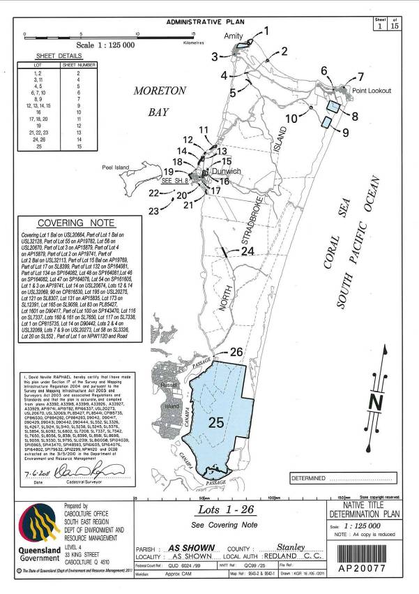
“Determination Area” means the land and waters described in Part A and Part B of Schedule 2 and shown on Native Title Determination Plan AP20077 (excluding those areas identified at Schedule 3);
“High Water Mark” has the meaning given in the Land Act 1994 (Qld);
“Highest Astronomical Tide” means the highest level of the tides that can be predicted to occur under average meteorological conditions and under any combination of astronomical conditions;
“Laws of the State and the Commonwealth” means the common law and the laws of the State and the Commonwealth of Australia, and includes legislation, regulations, statutory instruments, local planning instruments and local laws;
“Live” means to reside and for that purpose to erect shelters and temporary structures but does not include a right to construct permanent structures;
“Traditional Natural Resources” means:
(i) “animals” as defined in the Nature Conservation Act 1992 (Qld);
(ii) “plants” as defined in the Nature Conservation Act 1992 (Qld);
(iii) seaweed, charcoal, shells and resin; and
(iv) any clay, soil, sand, ochre, gravel or rock on or below the surface of the Determination Area.
“Water” means water as defined by the Water Act 2000 (Qld).
SCHEDULE 1 – NATIVE TITLE HOLDERS
SCHEDULE 2 – DETERMINATION AREA – PART A AND PART B
SCHEDULE 3 – AREAS NOT INCLUDED IN THE DETERMINATION AREA
SCHEDULE 4 – EXCLUSIVE NATIVE TITLE AREA
SCHEDULE 5 – NON-EXCLUSIVE NATIVE TITLE AREA
SCHEDULE 6 – OTHER INTERESTS
SCHEDULE 1
NATIVE TITLE HOLDERS
The native title holders for the Determination Area are the Quandamooka People who are the biological descendents, of the following people:-
a. Nellie/Lilly Kidgeree
b. Mary Indoole Compignie
c. Elizabeth Ruska
d. Charlie Moreton (Dandruba)
e. Sidney Rollands (Kingal/Winyeeaba)
f. Lillian Lyons (Dungoo)
g. King Billy Toompani
h. Juno (Gonzales)
i. Liza Jungerboi (mother of Rose Martin nee Bain)
j. Tommy Nuggin (Gendarieba)
k. Tilly (mother of Tommy Dalton, Richard Dalton and Henry Lea)
l. Kindarra
who identify as and are accepted by other Quandamooka People as Quandamooka People according to Quandamooka traditional law and custom.
SCHEDULE 2
DETERMINATION AREA
Excluding the areas in Schedule 3, the Determination Area comprises:-
PART A
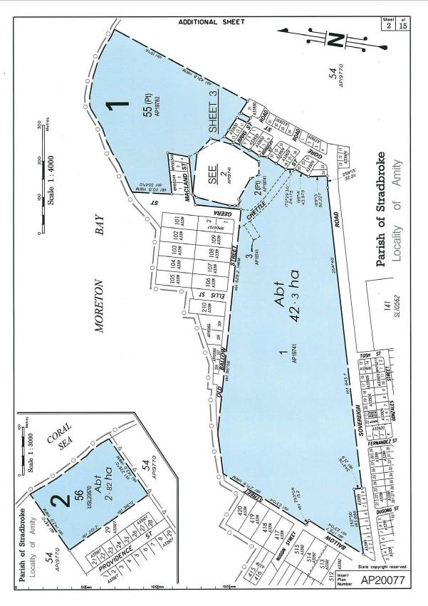
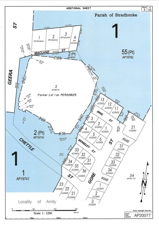
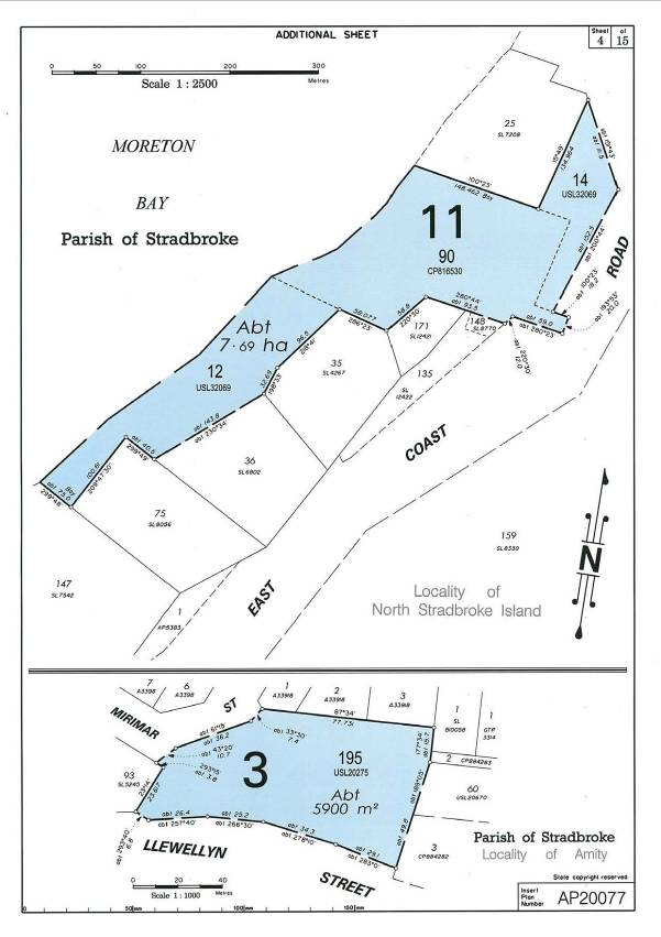
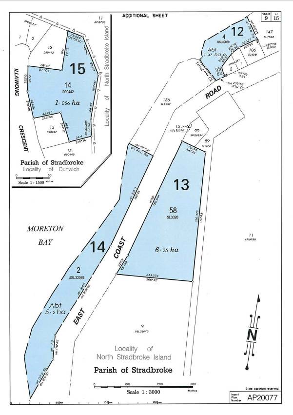
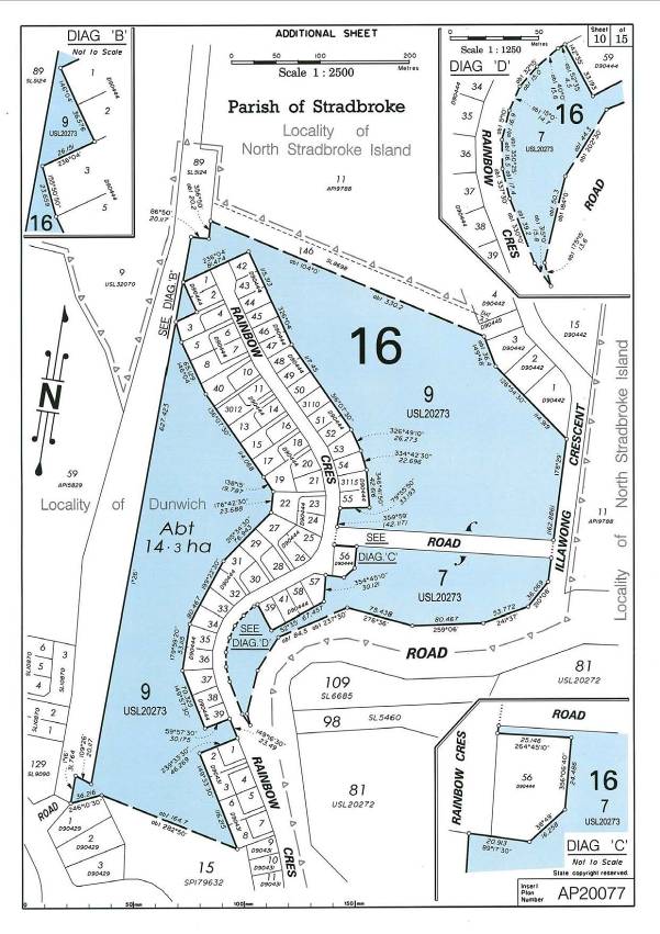
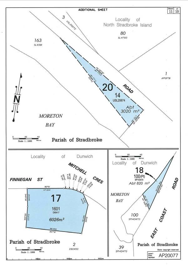
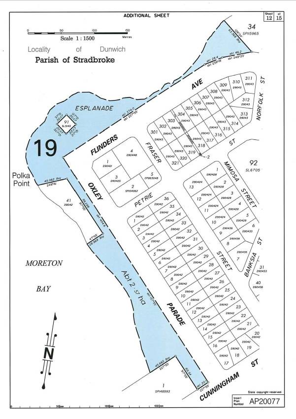
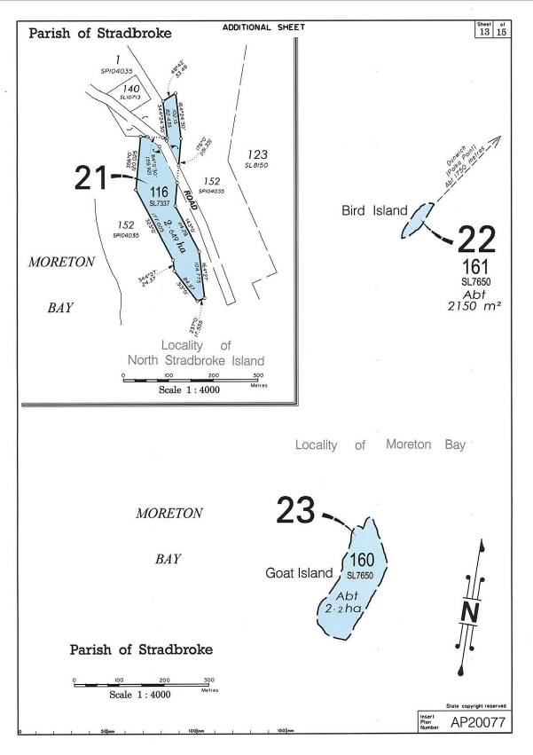
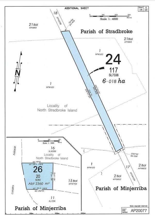
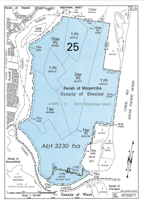
The land and waters within the area described as Lots 1 - 26 on AP20077 covering:
(i) Lot 1 on CP815735;
(ii) Part of Lot 3 on AP15879 being that part of Lot 1 on PER207993 subject to former Mt Scott Holding No. 2721;
(iii) Part of Lot 4 on AP15879 being that part of Lot 1 on PER207993 subject to former Mt Scott Holding No. 2721;
(iv) That part of Lot 1 on NPW1120 subject to former Lots 1 to 4 on SL607, part of former Lot 1 on USL20664, former Lot 2 on USL32112, former Lot 3 on USL32112, that part of former Lot 2 on USL32113 subject to former Mt Scott Holding No.2721, part of former Lot 1 on USL32114, that part of former Lot 1 on USL32128 subject to former Mt Scott Holding No.2721 and former Lot 3 on USL32129;
(v) Balance Lot 1 on USL20664;
(vi) Part of Balance Lot 15 on AP19769 being that part of former Lot 1 on USL32114 subject to former Mt Scott Holding No.2721;
(vii) That part of Balance Lot 1 on USL32128 subject to former Mt Scott Holding No.2721;
(viii) Lot 20 on SL552;
(ix) That part of Lot 2 on USL32113 subject to former Mt Scott Holding No.2721;
(x) Lot 46 on SP164082 (part of former Lot 46 on SL2482);
(xi) Lot 47 on SP164076 (part of former Lot 46 on SL2482);
(xii) Part of Lot 132 on SP164081 (part of former Lot 46 on SL2482);
(xiii) Part of Lot 134 on SP164082 (part of former Lot 46 on SL2482);
(xiv) Lot 48 on SP164081 (part of former Lot 46 on SL2482);
(xv) An area identified as road (part of George Nothling Drive) and delineated by stations 4, 5, 12, 14, 15, 16, 7, 8, 16a, 15a, 14a, 12a, 4 on Plan SP164076 (part of former Lot 46 on SL2482);
(xvi) Lot 83 on PL85427;
(xvii) That part of Lot 17 on SL8399 subject to former Mt Scott Holding No.2721;
(xviii) Lot 116 on SL7337;
(xix) Lot 117 on SL7338;
(xx) Lot 121 on SL8307;
(xxi) Lot 131 on AP15835 (part of former Balance Lot 131 on SL9330);
(xxii) Lot 14 on D90442;
(xxiii) Lot 1601 on D90417;
(xxiv) Lot 160 on SL7650 being Goat Island;
(xxv) Lot 161 on SL7650 being Bird Island;
(xxvi) Lot 165 on SL9059;
(xxvii) Lot 173 on SL12391;
(xxviii) Lot 2 on USL32069;
(xxix) Lot 4 on USL32069;
(xxx) Lot 7 on USL20273;
(xxxi) Part of Lot 100 on SP143470 (former Lot 7 on USL20267);
(xxxii) Lot 9 on USL20273;
(xxxiii) Lot 12 on USL32069;
(xxxiv) Lot 14 on USL32069;
(xxxv) Lot 14 on USL20674;
(xxxvi) An area of Esplanade (former Lot 55 on USL20268);
(xxxvii) Lot 58 on SL3326;
(xxxviii) Lot 90 on CP816530;
(xxxix) Lot 54 on SP161605 (part of former Lot 54 on SL2991);
(xl) An area identified as road (part of George Nothling Drive) and delineated by stations 35, 34, F, B, 35 on SP161605 (part of former Lot 54 on SL2991);
(xli) Lot 55 on AP19782 (part of former Lot 55 on USL20670);
(xlii) Lot 56 on USL20670;
(xliii) Lot 1 on AP19741 (part of former Lot 74 on USL20274);
(xliv) Part of Lot 2 on AP19741 (part of former Lot 74 on USL20274 and part of former Lot 55 on USL20670 exclusive of that part which is subject to former Lot 1 on PER208125);
(xlv) Lot 3 on AP19741 (part of former Lot 74 on USL20274);
(xlvi) An area identified as road (Chettle Street) and delineated by stations 3, 7, 8, 10, 14, 16, 3 on SP104039 (part of former Lot 74 on USL20274); and
(xlvii) Lot 195 on USL20275.
and
PART B
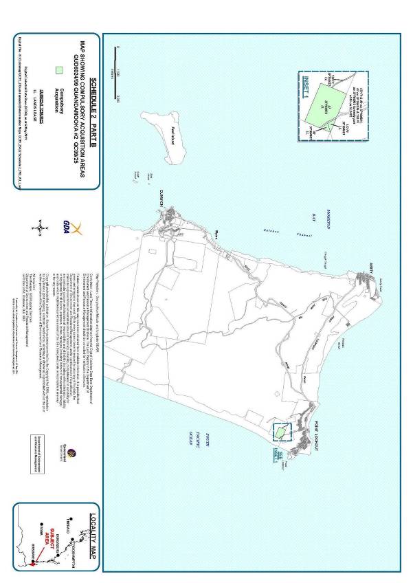
The areas acquired under s 24MD Native Title Act 1993 (Cth) and shown on attached map Schedule 2 Park B being:
(i) Lot 47 on SP164076 (part of former Lot 46 on SL2482);
(ii) Lot 48 on SP164081 (part of former Lot 46 on SL2482);
(iii) Part of Lot 132 on SP164081 (part of former Lot 46 on SL2482); and
(iv) Part of Lot 134 on SP164082 (part of former Lot 46 on SL2482).
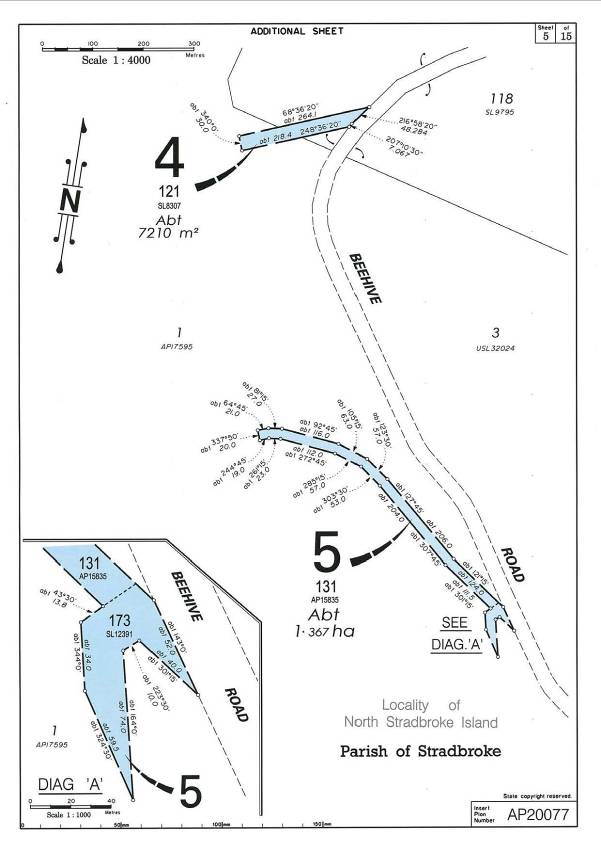
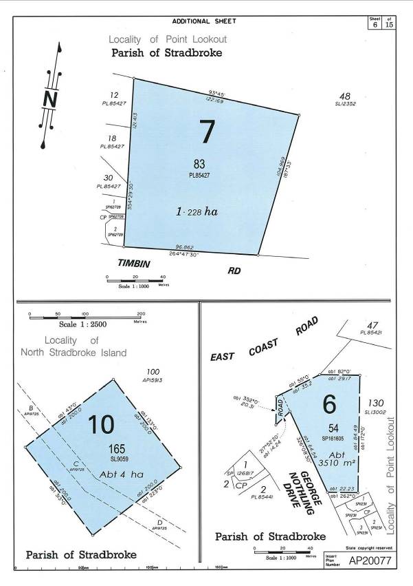
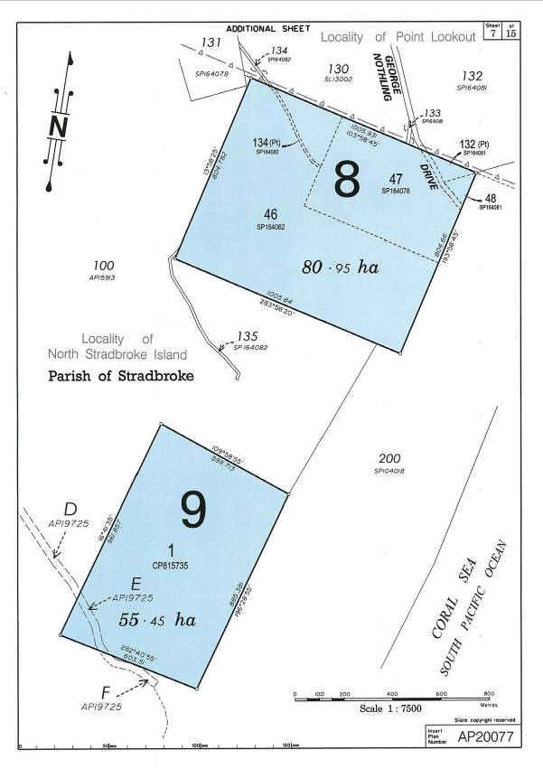
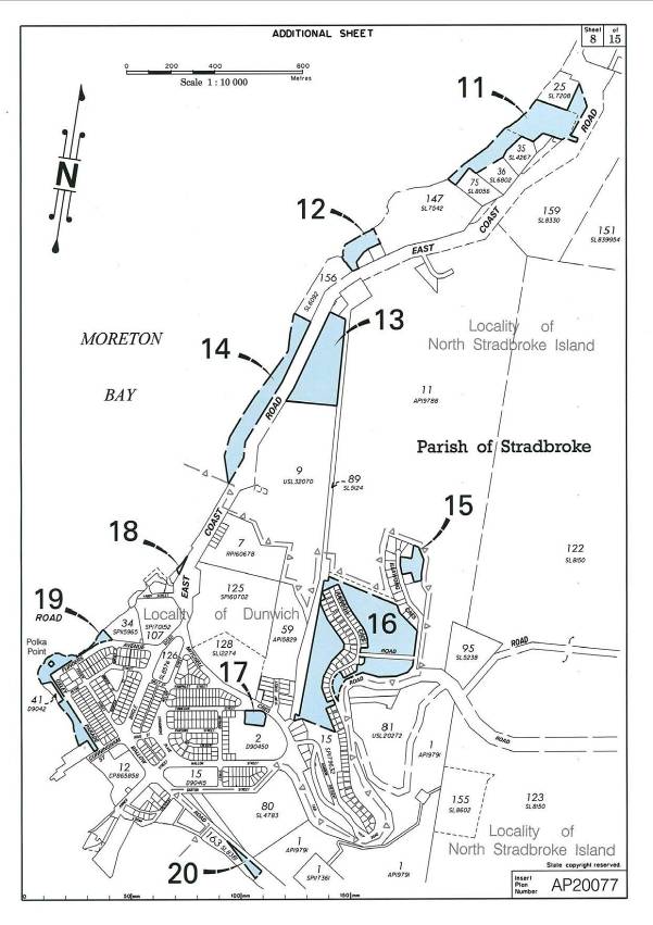
 SCHEDULE 3
AREAS NOT INCLUDED IN THE DETERMINATION AREA
The following areas are wholly excluded from the determination area on the grounds that they have been the subject of a previous exclusive possession act, as defined in section 23B of the Native Title Act 1993 (Cth), that none of sections 47A or 47B of the Native Title Act 1993 (Cth) applied to them at the time the Application was made and therefore, in accordance with section 61A of the Native Title Act 1993 (Cth), could not be claimed. The following areas are also delineated on the attached map Schedule 3 “Areas not included in the Determination Area”.
1. The land or waters on which any other public work that is a previous exclusive possession act (as defined in section 23B of the Native Title Act 1993 (Cth)) was, on or before 23 December 1996, constructed or established, including (in accordance with section 251D of the Native Title Act 1993 (Cth)) any adjacent land the use of which is or was necessary for, or incidental to, the construction, establishment or operation of the work.
2. The area covered by the following lots or parts of lots as described:-
(i) Lot 14 on USL20674;
(ii) Lot 14 on D90442.
 SCHEDULE 4
EXCLUSIVE NATIVE TITLE AREA
This area is covered by the following lots or parts of lots and delineated on attached map - Schedule 4 “Exclusive Native Title Area”.
(i) Lot 2 on USL32069;
(ii) Lot 4 on USL32069;
(iii) Lot 7 on USL20273;
(iv) Part of Lot 100 on SP143470 (former Lot 7 on USL20267);
(v) Lot 9 on USL20273;
(vi) Lot 12 on USL32069;
(vii) Lot 14 on USL32069;
(viii) Lot 58 on SL3326;
(ix) Lot 55 on AP19782 (part of former Lot 55 on USL20670);
(x) Lot 56 on USL 20670;
(xi) Lot 1 on AP19741 (part of former Lot 74 on USL20274);
(xii) Part of Lot 2 on AP19741 (part of former Lot 74 on USL20274 and part of former Lot 55 on USL20670 exclusive of that part which is subject to former Lot 1 on PER208125);
(xiii) Lot 3 on AP19741 (part of former Lot 74 on USL20274); and
(xiv) An area identified as road (Chettle Street) and delineated by stations 3, 7, 8, 10, 14, 16, 3 on SP104039 (part of former Lot 74 on USL20274).
 SCHEDULE 5
NON-EXCLUSIVE NATIVE TITLE AREA
This area is covered by the following lots or parts of lots and delineated on attached Map Schedule 5 “Non-exclusive Native Title Area”.
(i) Lot 1 on CP815735;
(ii) Part of Lot 3 on AP15879 being that part of Lot 1 on PER207993 subject to former Mt Scott Holding No.2721;
(iii) Part of Lot 4 on AP15879 being that part of Lot 1 on PER207993 subject to former Mt Scott Holding No.2721;
(iv) That part of Lot 1 on NPW1120 subject to former Lots 1 to 4 on SL607, part of former Lot 1 on USL20664, former Lot 2 USL32112, former Lot 3 on USL32112, that part of former Lot 2 on USL32113 subject to former Mt Scott Holding No.2721, part of former Lot 1 on USL32114, that part of former Lot 1 on USL32128 subject to former Mt Scott Holding No.2721, and former Lot 3 on USL32129;
(v) Balance Lot 1 on USL20664;
(vi) Part of Balance Lot15 on AP19769 being that part of former Lot 1 on USL32114 subject to former Mt Scott Holding No.2721;
(vii) That part of Balance Lot 1 on USL32128 subject to former Mt Scott Holding No.2721;
(viii) Lot 20 on SL552;
(ix) That part of Lot 2 on USL32113 subject to former Mt Scott Holding No.2721;
(x) Lot 46 on SP164082 (part of former Lot 46 on SL2482);
(xi) An area identified as road (part of George Nothling Drive) and delineated by stations 4, 5, 12, 14, 15, 16, 7, 8, 16a, 15a, 14a, 12a, 4 on Plan SP164076 (part of former Lot 46 on SL2482);
(xii) Lot 4 on SL607;
(xiii) Lot 83 on PL85427;
(xiv) That part of Lot 17 on SL8399 subject to former Mt Scott Holding No.2721;
(xv) Lot 116 on SL7337;
(xvi) Lot 117 on SL7338;
(xvii) Lot 121 on SL8307;
(xviii) Lot 131 on AP15835 (part of former Balance Lot 131 on SL9330;
(xix) Lot 1601 on D90417;
(xx) Lot 160 on SL7650 being Goat Island;
(xxi) Lot 161 on SL7650 being Bird Island;
(xxii) Lot 165 on SL9059;
(xxiii) Lot 173 on SL12391;
(xxiv) An area of Esplanade(former Lot 55 on USL20268);
(xxv) Lot 90 on CP816530;
(xxvi) Lot 54 on SP161605 (part of former Lot 54 on SL2991);
(xxvii) An area of identified as road ( part of George Nothling Drive) and delineated by stations 35, 34, F, B, 35 on SP161605 (part of former Lot 54 on SL2991); and
(xxviii) Lot 195 on USL20275.
 SCHEDULE 6
OTHER INTERESTS IN THE DETERMINATION AREA
The nature and extent of other interests in relation to the Determination Area are those Other Interests current at the date of this determination which comprise the following:
1. The rights and interests of the parties under the following agreements and authorities:
(a) The Indigenous Land Use Agreement (“ILUA”) between Ian Delaney on behalf of the Quandamooka People, the Quandamooka Yoolooburrabee Aboriginal Corporation and the State of Queensland entitled the “Quandamooka People’s Land and Sea ILUA” executed on 15 June 2011;
(b) The Indigenous Land Use Agreement (“ILUA”) between Ian Delaney on behalf of the Quandamooka People, the Quandamooka Yoolooburrabee Aboriginal Corporation and the Redland City Council entitled the “Quandamooka Peoples and Local Government ILUA” executed on 4 July 2011; and
(c) The Indigenous Land Use Agreement (“ILUA”) between Dale Ruska and Ian Delaney on behalf of the Quandamooka People, the State of Queensland and the Redland City Council entitled the “Dunwich Sewage Treatment Plant ILUA QIA2000/011” registered on 22 June 2001.
2. The following interests held by Stradbroke Rutile Pty Ltd:
(a) Mining Leases ML1109, ML1121 and ML1153;
(b) Permit to Occupy 0/233333 in Lots A,B,C,D,E and F on Crown plan AP 19725;
(c) Permit to Occupy 0/218885 affecting Lot 173 SL12391;
(d) Permit to Occupy 0/232180 affecting Lot 117 SL7338;
(e) Permit to Occupy 0/232180 affecting Lot 116 SL7337; and
(f) Permit to Occupy 219075 affecting Lot 121 SL8307.
3. The rights and interests of the State of Queensland in the Naree Budjong Djara National Park pursuant to the Nature Conservation Act 1992 (Qld) and relevant regulations and conservation plans made under that Act; and the rights and interests of the persons in whom the Naree Budjong Djara National Park is vested and interests of the persons entitled to access and use the Naree Budjong Djara National Park for the purpose for which it is dedicated.
4. The rights and interests of the State of Queensland and any other person existing under or by reason of the force and operation of:
(a) The Nature Conservation Act 1992 (Qld) and relevant regulations and conservation plans made under that Act;
(b) the Marine Parks Act 2004 (Qld) and relevant regulations, declarations and management plans made under that Act;
(c) the Fisheries Act 1994 (Qld) and relevant regulations, declarations and management plans made under that Act;
(d) the Coastal Protection and Management Act 1995 (Qld) and relevant regulations and management plans made under that Act.
(e) the Transport Operations (Marine Safety) Act 1994 (Qld) and any relevant regulations or subordinate legislation made under that Act;
(f) the Transport Operations (Marine Pollution) Act 1995 (Qld) and any relevant regulations or subordinate legislation made under that Act;
(g) the Transport Infrastructure Act 1994 (Qld) and relevant regulations made under that Act;
(h) the Integrated Planning Act 1997 (Qld) or the Sustainable Planning Act 2009 (Qld)
(i) the Forestry Act 1959 (Qld) and any subordinate legislation, declarations or management plans made under that Act; and
(j) the Fire and Rescue Services Act 1990 (Qld) and the Ambulance Service Act 1991 (Qld) and any subordinate legislation or regulations made under those Acts.
5. The rights and interests of the holders of any licences, permits or allocations under the Water Act 2000 (Qld) and any relevant regulations or subordinate legislation made under that Act.
6. The rights and interests of the holders of any leases, licences, reservations, permits, easements or authorities granted under the Land Act 1994 (Qld), and any relevant regulations or subordinate legislation made under that Act.
7. The rights and interests of holders of any permits, claims, licences or leases under the Mineral Resources Act 1989 (Qld) and any subordinate legislation, declarations or management plans made under that Act.
8. The rights and interests of Telstra Corporation Limited (or its corporate successor):
(a) as the owner or operator of telecommunications facilities installed within the Determination Area;
(b) created pursuant to the Post and Telegraph Act 1901 (Cth), the Telecommunications Act 1975 (Cth), the Australian Telecommunications Corporation Act 1989 (Cth), the Telecommunications Act 1991 (Cth) and the Telecommunications Act 1997 (Cth), including rights:
(i) to inspect land;
(ii) to install and operate existing and new telecommunication facilities, including cabling, customer terminal sites, customer radio sites and ancillary facilities;
(iii) to alter, remove, replace, maintain, repair and ensure the proper functioning of its existing and any new telecommunications facilities including cabling, customer terminal sites, customer radio sites, and ancillary facilities;
(iv) for its employees, agents or contractors to access the Determination Area for the purposes of exercising the rights in (i), (ii) and (iii) above in respect of telecommunication facilities in and in the vicinity of the Determination Area;
(c) under any licences, lease, access agreements or easements relating to its telecommunications facilities in the Determination Area.
9. The rights and interests of Energex Limited:
(a) as the owner and operator of electricity distribution, generation and transmission facilities within the Determination Area;
(b) as an Electricity Entity under the Electricity Act 1994 (Qld), including but not limited to:
(i) the holder of a distribution authority;
(ii) rights to enter the Determination Area by its employees, agents or contractors to exercise any of the rights and interests referred to in this paragraph; and to inspect, maintain and manage any distribution, generation and transmission facilities in the Determination Area;
(c) in relation to any connection contract, way leave agreement, permit to occupy or easement relating to the Determination Area existing as at the date of these orders.
10. The rights and interests of Redland City Council:
(a) under its local government jurisdiction and functions under the Local Government Act 2009 (Qld), including undertaking operational activities in its capacity as a local government, including feral animal control, weed control, erosion control, waste management and fire management; and any other legislation, for that part of the Determination Area within the area declared to be Council’s local government area;
(b) as the:
(i) lessor under any leases which were validly entered into before the date on which these Orders are made and whether separately particularised in these Orders or not;
(ii) grantor of any licences or other rights and interests which were validly granted before the date on which these Orders were made and whether separately particularised in these Orders or not;
(c) as the owner and operator of infrastructure, and those facilities and other improvements located in the Determination Area validly constructed or established on or before the date on which these Orders are made, including but not limited to:
(i) undedicated but constructed roads except for those not operated by Council;
(ii) drainage facilities;
(iii) the cemetery and cemetery related facilities on North Stradbroke Island; and
(iv) camping and holiday park facilities on North Stradbroke Island; and
(d) to enter the land for the purposes described in paragraphs (a), (b) and (c) above by its employees, agents or contractors to:-
(i) exercise any of the rights and interests referred to in paragraph 10 of this Schedule; and
(ii) inspect, maintain and repair the infrastructure, facilities and other improvements referred to in paragraph 10 (a), (b) and (c) of this Schedule.
11. The rights and interests of members of the public arising under the common law, including but not limited to the following:
(a) Any subsisting public rights to fish; and
(b) the public right to navigate.
12. So far as confirmed pursuant to section 212(2) of the Native Title Act 1993 (Cth) and section 18 of the Native Title Act (Queensland) Act 1993 (Qld) as at the date of this Determination, any existing public access to, and enjoyment of, the following places in the Determination Area:
(a) waterways;
(b) beds and banks or foreshores of waterways;
(c) coastal waters;
(d) beaches; and
(e) areas that were public places at the end of 31 December 1993.
13. Rights and interests granted by the Commonwealth pursuant to statute or otherwise in the exercise of its executive power including, but not limited to, the rights and interests of persons holding licences, permits, statutory fishing rights, or other statutory rights pursuant to:
(a) the Fisheries Management Act 1991 (Cth), or regulations or management plans made under that Act; and
(b) any other legislative scheme for the control, management and exploitation of the living resources within the Determination Area.
14. For the avoidance of doubt, rights or interests existing pursuant to the Historic Shipwrecks Act 1976 (Cth) (and regulations made there under), including (without being limited to) restrictions relating to historic shipwrecks, historic relics and protected zones within the Determination Area, noting that historic shipwrecks within the Determination Area include (but are not necessarily limited to):
(a) the Cambus Wallace;
(b) the Prosperity; and
(c) the Rufus King.
15. The rights and interests of the Commonwealth of Australia represented by the Bureau of Meteorology including:
(a) as the owner and operator of meteorological facilities within the Determination Area at Point Lookout; and
(b) for its employees, agents and contractors to access its facilities referred to in (a) in the exercise of powers and functions under the Meteorology Act 1955 (Cth).
16. The rights and interests of Australian Maritime Safety Authority as a statutory authority exercising powers and functions under the Lighthouses Act 1911 (Cth).
17. The rights and interests of the Commonwealth of Australia pursuant to the Environment Protection and Biodiversity Conservation Act 1999 (Cth) (“EPBC Act”) and relevant regulations, declarations and plans made under the Act relating to the use and management of that part of the Determination Area that is a declared Ramsar wetland within the meaning of the EPBC Act.
18. Any other rights and interests:
(a) held by the State or Commonwealth; or
(b) existing by reason of the force and operation of the Laws of the State or the Commonwealth.
Note: Settlement and entry of orders is dealt with in Order 36 of the Federal Court Rules. The text of entered orders can be located using Federal Law Search on the Court’s website.
QUEENSLAND DISTRICT REGISTRY |
|
GENERAL DIVISION |
QUD 6010 of 1998 |
BETWEEN: |
IAN DELANEY ON BEHALF OF THE QUANDAMOOKA PEOPLE #1 Applicant
|
AND: |
STATE OF QUEENSLAND First Respondent COMMONWEALTH OF AUSTRALIA Second Respondent REDLAND CITY COUNCIL Third Respondent BRISBANE CITY COUNCIL Fourth Respondent ENERGEX LIMITED Fifth Respondent TELSTRA CORPORATION LIMITED Sixth Respondent ACI OPERATIONS PTY LTD Seventh Respondent CONSOLIDATED RUTILE LIMITED Eighth Respondent STRADBROKE FERRIES PTY LTD Ninth Respondent KEVIN G ALECKSON, KENNETH W BARRATT, TIMOTHY C BEUTEL, JEFFREY W BLANEY, BRENDAN JAMES BOWMAN, THELMA EM BOWMAN, ROBERT BROCK, GEORGE JAMES CARRINGTON, DARCY CASTNER, HERBERT CASTNER, SHANE CASTNER, WILLIAM CORNEY, PETER DOUGLAS GRAHAM, RICHARD G HACK, LAURENCE A HOLT, DENIS WR HOSKIN, ANDREW EDWARD KOY, DAVID McDERMID, PETER MILLER, ALAN JOHN PRICKETT, NORMAN PETER RABJOHNS, MARK EDWARD SMYTHE, PETER L SPINNER, JEFF STONE, JOHN STONE, RACHEL STONE, VINCENT CHARLES STURDY, MICHAEL W WOOD AND LINDSAY ROBERT ZINK Tenth Respondents ROBERT H ARNOLD, BLUE HOLE OYSTER FARMING PTY LTD, JOHN PHILLIP FLYNN, SPENCER L JOLLY, LAWRENCE EDMUND McGRATH, KEITH FAU-VEL PARKES AND PATRICK C VERNER Eleventh Respondents |
IN THE FEDERAL COURT OF AUSTRALIA |
|
QUEENSLAND DISTRICT REGISTRY |
|
GENERAL DIVISION |
QUD 6024 of 1999 |
BETWEEN: |
IAN DELANEY ON BEHALF OF THE QUANDAMOOKA PEOPLE #2 Applicant |
AND: |
STATE OF QUEENSLAND First Respondent REDLAND CITY COUNCIL Second Respondent ENERGEX LIMITED Third Respondent TELSTRA CORPORATION LIMITED Fourth Respondent ACI OPERATIONS PTY LTD Fifth Respondent CONSOLIDATED RUTILE LIMITED Sixth Respondent QUEENSLAND SEAFOOD INDUSTRY ASSOCIATION Seventh Respondent MICHAEL JOSEPH CONNOLLY Eighth Respondent TERENCE JAMES CONNOLLY Ninth Respondent ELLIE DURBIDGE Tenth Respondent JAMES EDWARD SOMMER Eleventh Respondent |
JUDGE: |
DOWSETT J |
DATE: |
4 JULY 2011 |
PLACE: |
STRADBROKE ISLAND |
REASONS FOR JUDGMENT
1 On 17 May 1770 Captain Cook sailed by Stradbroke Island (Minjerriba), naming both Moreton Bay and Point Lookout. He saw smoke rising from the island, almost certainly from fires started by the inhabitants. However the first contact between island people and European settlers occurred when Flinders visited the island in 1799. He returned in 1803, well before European settlement in what is now south-east Queensland. Flinders found substantial huts and saw people in canoes driving fish into nets. A nearby island was being exploited for edible nuts. When he returned in 1803 he anchored near Point Lookout and went ashore for water. Point Lookout continues to be a watering place, but in a somewhat different sense. He encountered island people who were friendly and good-humoured.
2 As is well-known, in 1823 three convicts from Port Phillip were shipwrecked on Moreton Island, finding their way to Stradbroke Island and then to the mainland. Oxley arrived in 1823, and the penal settlement was established in 1824 at Redcliffe, then moving to the present site of Brisbane. Stradbroke Island quickly became closely involved in the settlement, partly for navigational reasons. It became the site of a pilot station and a quarantine station. At that time there was a substantial indigenous population from which the Quandamooka People are descended. The members of that society were then asserting some form of dominance over the general area and continued to do so, notwithstanding the arrival of European settlers. Of course, their activities were increasingly limited as European occupation and use extended. Amity Point and Dunwich became centres of European activity on the island. The former had been, and continued to be a major centre for the indigenous inhabitants. Initially, the indigenous and European peoples enjoyed good relations, including some commercial dealings. However the indigenous people remained self-sufficient in this resource-rich area.
3 From the early 1830s relations declined and, inevitably, the indigenous people suffered the consequences. There was considerable disruption to their community, particularly after 1880, with the development of a mission, a school and housing. Between 1912 and 1938, there were some removals, but many people remained on the island, and others returned. Some Europeans continued to have good relations with the indigenous people and left records of their association. They include names which are well-known in the history of south-east Queensland such as Welsby and Petrie. The Quandamooka People have, on numerous occasions since 1916, tried to persuade government that, by virtue of historical connection and descent, they are entitled to legal title over at least part of the island.
4 The anthropological evidence describes in some detail the Quandamooka society as at the time of first assertion of British Sovereignty.
5 Dr Whalley says:
(a) When the British Penal Colony first arrived in Quandamooka, Europeans found, but refused to officially recognise, a stable socio-political order and an easily apparent number of autonomous Indigenous peoples, each with their distinct spheres of authority and law and rights to land. They found well developed and stable settlement patterns, large populations, and on the coast small territories, large trade and ceremonial networks and clear systems of territorial, linguistic and political affiliation. High population figures were still noted some twenty years after European occupation while it is still fairly clear that during this time, if not before, we have one, possibly two, smallpox epidemics through the area.
(b) In Quandamooka itself large gatherings of huts and relatively permanent structures spaced a few kilometres apart were regularly reported along the western side of Gnoorganpin, north western side of Minjerriba … and around the west coast of the Bay. These reports are confirmed by the extant archaeological record and we might here note most of these Aboriginal ‘villages’ occur around the mouth of freshwater creeks and streams emptying into Quandamooka, providing an environment rich in a wide range of resources.
6 From the above it emerges that the word “Quandamooka” has a geographical significance in addition to its demographic significance. Mr Wood says:
(a) The people of those parts of Moreton Bay stretching from Moreton Island and the Wynnum area southwards were distinguished as mostly dialect-named drainage groups that held proprietary countries around the Bay rim.
(b) They also had a distinctively marine oriented economy and culture.
(c) Their laws and customs … cohered with and were essentially the same as those diffuse over coastal southeast Queensland and adjacent New South Wales.
(d) A degree of Moreton Bay autonomy had more to do with the island and marine geography which contributed to some isolation, and was also resource rich and so lent a degree of economic self-sufficiency and capacity for reproductive self-sufficiency.
(e) The Moreton Bay people were numerous and self-sufficient enough, and certainly united by common laws and customs, to form a small-scale society in their own right.
(f) This was most pronounced on Moreton Island, between which and Bribie Island there was little or no social fabric, so that Moreton’s social contacts were largely with and via Stradbroke Island and thence to the southern mainland of the Bay.
7 The evidence also demonstrates in some detail the continued connection between the Quandamooka People and the island. Various witnesses attest to the connection as follows:
Margaret Iselin said –
[We] all shared our tracks and waterways, no one had certain parts they called their own.
Sid Coolwell said –
I recall that when we were young, we would often go to Russell Island and get vegetables such as tomatoes, potatoes and cabbage. My grandfather told me that all those islands, including Moreton Island, North and South Stradbroke Islands were joined together and this was all my country. We would often go to Peel and Goat Island where we would get quampies, mud crabs, oysters and fish. My grandfather would often say to me ‘this is your land’. I wouldn’t take any notice much as a kid, but I know that all of that land is my land. I know that all of the water around that land is my water too. When I was a child, I always believed that all the aboriginal people living at North Stradbroke Island, Dunwich, One Mile and Two Mile were all the one mob. By this I mean we were all the same people and this was all of our country.
It has always been known to me that all the islands in Moreton Bay was our country and that it was our responsibility to look after it, and if anyone came to the island they needed our permission to stay, if they didn’t ask for permission or they played up while they were there, they would be told to go away and be put off the island. That is still the case today. Our spirits have always been on that island and they will always stay there.
Ian Delaney said –
Quandamooka Country as I have been taught by the grannies and my uncles includes Wynnum, Cleveland, Moreton Island across to Doboy Creek then to the ranges at Belmont, down to the Logan River, all the foreshores, the whole bay and all the Moreton bay islands down to Southport.
Darren Burns said –
I have always understood that all of the Moreton Bay, the Bay Islands are my country. I have learned about this from my grandfather.
It is my understanding that South Stradbroke Island, Peel Island and Moreton Island, and all the southern bay islands are part of my country. I have learned this from my grandfather and it is what I tell my children.
8 The following paragraphs from the applicant’s submissions further demonstrate the point:
38. The current Quandamooka community consists of the resident population and those living on the mainland. Many Quandamooka people have lived in the claim area for their lifetime. Whalley noted (in 1991) “that the majority of the Aboriginal people who today reside on Minjerriba are in fact descendants of the original indigenous landowners and can conclusively demonstrate their Ancestral title to the lands and waters of Quandamooka.”
39. The contemporary group of Quandamooka people who are entitled to speak for and make decisions about Quandamooka country are the descendants of identified apical ancestors all of whom were Quandamooka people and were present in or on Stradbroke or Moreton Island in the period between 1830 and 1880.
40. Memmott and Stacy list and discuss the functions of some 13 organisations the members of which are Quandamooka people. These include the Quandamooka Land Council, the Minjerribah Mulgumpin Elders Council, the Noonuccal Land Council and various other associations many providing particular services to Quandamooka people. They also refer to a number of other means by which Quandamooka people engage with each other including public meetings, family histories, funerals and cultural events, and sport.
41. Memmott and Stacy note that many functions and decisions require the attendance of a wide range of Quandamooka people. “When cultural matters arise that are of significance to several or more families, involving such laws and customs, they are frequently dealt with using a process of community debate and action that may encompass either Elders-in-Council or the Quandamooka Land Council or the Men’s Council or all of them. They refer to processes of consultations with families for the purpose of achieving consensus or a vote, and for the need for their representatives to “take decisions back to their community for resolution.”
42. They conclude this section by saying:
This again demonstrates:
(a) how social Law and decision-making is maintained at a communal level through communal decision-making;
(b) how the concept of community is constantly re-represented back to its members, and hence is a self-maintaining concept.
43. The evidence noted and summarised above of continued use and occupation of areas in the vicinity of the claim area and a significant number of biological links with previous generations and other evidence of continued connection between Quandamooka people and their country, shows the existence, acknowledgement and observance of a body of laws and customs over many generations extending beyond first contact, and by inference prior to sovereignty.
9 The applications are brought pursuant to the Native Title Act 1993 (Cth) (the “Act”) by Ian Delaney on his own behalf and for and on behalf of the members of the Quandamooka native title claim group. Membership of the claim group depends upon descent from one or more of the identified apical ancestors who are described in the material. The following is an edited version of that material. The apical ancestors are:
Nellie/Lilly Kidgeree who married a European man, Harry Thompson. Their daughter, Margaret Thompson, was born in about 1867. Her death was recorded in the diary of Gustavus Birch of Amity Point in the year 1873.
Mary Indoole Compignie who was born in about 1854 and married George Costello (Snr) in 1898. Following his death in 1901, she married Henry Jarrett. She died on 25 July 1921.
Elizabeth Ruska was the daughter of an aboriginal woman and a Filipino man, Fernando Gonzales. Historical accounts conflict as to whether her mother was Juno or a sister of Juno, Elizabeth (Snr). She is known to have married Frederick Ruska, with whom she had four children.
Charlie Moreton (Dandruba) who was born on Stradbroke Island in about 1871. In 1898 he married Daisy Thompson, with whom he had ten children. He died in 1949.
Sidney Rollands (Kingal/Winyeeaba) who was born in 1837 on Moreton Island. She died in 1917 at Dunwich. Welsby’s historical account suggests that she was well known in Brisbane as an experienced nurse.
Lillian Lyons (Dungoo) who was born in about 1869 and married a New Caledonian man, John Roberts. When she died in 1943, she was thought to be 74 years of age, although some records indicate that she was closer to 80 years of age.
King Billy Toompani who was born in about 1810 and died on 5 September 1886. His wives were Kindara Sambo, Scroggins and Timgil. King Billy helped to save the lives of 40 people when the Sovereign, an iron paddle steamer, was ship-wrecked on the Amity bar. The Queensland Government gave him a brass plate and a fishing boat in recognition of his heroic conduct.
Juno (Gonzales) who married Fernando Gonzales. There is no recorded date of birth or death for Juno, however, her first child was born in about 1856, and she was still living in 1882.
Liza Jungerboi (mother of Rose Martin nee Bain) who is thought to have been born on Stradbroke Island, although there is no direct evidence in relation to her birth or death. She married Jim Bain, with whom she had a daughter in 1866.
Tommy Nuggin (Gendarieba) who was born in about 1850 and married a woman of aboriginal descent identified as Sarah. He died on 14 December 1914.
Tilly or Matilda (mother of Tommy Dalton, Richard Dalton and Henry Lea), who was born on Stradbroke Island. There is no evidence as to her date of birth or death, but her sons were born between 1875 and 1878.
Kindarra who was born in the mid 1800s and died on 3 October 1934.
10 The first of the present applications was commenced in the National Native Title Tribunal (the “Tribunal”) on 3 January 1995. It came to the Federal Court on 30 September 1998. A second application was made in 1998. The two applications relate to different claim areas. The State of Queensland, Redland City Council, Energex Limited, Telstra Corporation Limited, ACI Operations Pty Ltd and Consolidated Rutile Limited are respondents to both applications. The Brisbane City Council, the Commonwealth of Australia, Stradbroke Ferries Pty Ltd, a number of fishing parties and a number of oyster growers are respondents to the first application only. The Queensland Seafood Industry Association, Michael and Terence Connolly, Ellie Durbidge and James Sommer are respondents to the second application only.
11 Pursuant to s 13 and Parts 3 and 4 of the Act, the Court may make determinations concerning native title in relation to areas where there is no existing approved determination. The relevant areas are not the subject of any other application or determination. The State of Queensland has, for the purposes of both applications, admitted that:
(a) a pre-sovereignty society existed and that there has been continuity from sovereignty to the present day;
(b) the Quandamooka People have maintained their connection and have connection with North Stradbroke Island and the surrounding waters but not with Peel Island, Bird Island, Goat Island and Lot 32 on Plan SL12751 in Cleveland;
(c) in respect of the sea part of the claim the Quandamooka People hold native title rights similar to those determined to exist in tidal waters in previous sea claims such as Yarmirr 1, Lardil 2 and Gumana 3.
12 Telstra Corporation Limited, Consolidated Rutile Limited, ACI Operations Pty Ltd, and the fishing parties have adopted the State’s admissions. The Redland City Council has made similar admissions.
13 With the Court staff closely involved in the supervision and co-ordination of numerous anticipated consent determinations throughout Queensland and the rest of Australia, on 5 May 2010, I asked the Tribunal to facilitate negotiations amongst the parties as to consent determinations in these matters. Final agreement was reached this year. The recent enthusiasm and co-operation leading to these consent determinations compares favourably with the endemic inactivity which attended almost all Native Title proceedings for many years prior to the Court’s decision in 2003 to become closely involved in the management of Queensland Native Title claims. The Court appreciates the assistance provided by the Tribunal in this case.
14 Section 87 of the Act provides that the Court may, in some circumstances, make a determination of native title by consent over an area covered by a native title application without holding a hearing. The requirements of s 87 of the Act have been satisfied. This Court resolves disputes between parties, which disputes are identified by the parties. Only disputes so identified fall for resolution by the Court. When parties make admissions or concessions, the issues in dispute are narrowed. In some cases the Court may decline to act on such admissions or concessions. Where, as here, the proceedings have significance for people other than the parties, the Court must give especial consideration to the appropriateness of making consent orders. In this case, I see no reason to doubt the appropriateness of the parties’ identification of the issues or of their consensual resolution of them. They have had the benefit of appropriate legal advice. The proceedings have been on foot for a long time and have been appropriately publicized. I also see no reason to doubt that the proposed orders have been drafted with appropriate regard to the public interest, represented by the State and the local authorities.
15 The agreement recognizes exclusive rights to possess, occupy, use and enjoy the area identified in Schedule 4, other than in relation to water. The proposed orders in relation to non-exclusive native title rights (other than in relation to water) are:
(b) in relation to that part of the Determination Area identified in Schedule 5, the non-exclusive rights to:
(i) Live and be present on the area;
(ii) take, use, share and exchange Traditional Natural Resources for personal, domestic and non-commercial communal purposes;
(iii) conduct burial rites;
(iv) conduct ceremonies;
(v) teach on the area about the physical and spiritual attributes of the area;
(vi) maintain places of importance and areas of significance to the native title holders under their traditional laws and customs and protect those places and areas from physical harm;
(vii) light fires for domestic purposes including cooking, but not for the purpose of hunting or clearing vegetation; and
(viii) be accompanied into the area by non-Quandamooka people being: −
i. people required by traditional law and custom for the performance of ceremonies or cultural activities; and
ii. people required by the Quandamooka people to assist in observing or recording traditional activities on the area.
(c) in relation to that part of the determination area identified in Schedule 6, the non-exclusive rights to:
(i) be present on the area, including by accessing and traversing the area;
(ii) take, use, share and exchange traditional natural resources and seawater for any non-commercial purpose.
16 The extensive material filed in this matter provides ample grounds for the findings required by s 94A of the Act. That material is described in Exhibit 1 and I should only add the names of the various deponents:
Dale Alfred Eugene Ruska;
Ian Delaney;
Sidney Coolwell;
Vincent George Martin;
Darren John Burns;
Evelyn Parkin (nee Delaney);
Shirley Rose Borey;
Joshua Jude Walker;
Margaret Iselin dated;
Darren John Burns dated;
Darren John Burns dated;
Evelyn Parkin dated;
Irene Paula Clarey nee Tippo;
Peter Barney Delaney; and
Shirley Rose Borey.
17 In considering this material, I have been greatly assisted by a summary filed by the applicant on 3 June 2011. It provides a very clear overview of the anthropology, archaeology and history of the Quandamooka People, based upon the material referred to above, describing the Quandamooka society from pre-sovereignty to present times.
ORDERS AND DETERMINATION
18 I find that the Quandamooka People are descended from a society of aboriginal people who were in occupation of the land and waters of the determination area at the time of first assertion of British sovereignty. Those people formed a society, united in and by their acknowledgment and observance of traditional laws and customs. Through the observance of these traditional laws and customs, the Quandamooka People have maintained a connection with the Determination Area. The proposed orders recognize that the Quandamooka People, as holders of native title in the determination area, are entitled to the exclusive use and enjoyment of the land and waters identified in Schedule 4 of the orders, and the non-exclusive use and enjoyment of the land and waters described in Schedule 5. The orders recognize, at Schedule 7, other interests in the determination area and the relationships of those interests to the native title interests.
19 Section 55 of the Act requires the Court to make a determination pursuant to either s 56 or s 57 of the Act. Proposed Order 11 provides that native title is not to be held in trust. Proposed Order 12 provides that the Quandamooka Yoolooburrabee Aboriginal Corporation (ICN7564) be the prescribed body corporate for the purposes of s 57(2) of the Act and perform the functions set out in s 57(3). The applicant has nominated that corporation as the prescribed body corporate to perform the functions set out in the Act and the Native Title (Prescribed Bodies Corporate) Regulations 1999 (Cth), and for the other objects and purposes set out in its rules. The corporation was registered on 1 June 2011. On 20 June 2011, the applicant filed all relevant material, including submissions setting out the steps taken by the applicant to satisfy the requirements of s 57 of the Act.
20 I make the orders set out in the drafts which I now initial and place with the papers. Those orders recognize the Quandamooka People’s native title rights and interests within the Australian legal system and extend the protection of that system to those rights and interests.
21 I have not come here today to give anything to the Quandamooka people. These orders give them nothing. Rather, I come on behalf of all Australian people to recognize their existing rights and interests, which rights and interests have their roots in times before 1788, only some of which have survived European settlement. Those surviving rights and interests I now acknowledge. In so doing I bind all people for all time. This includes the Commonwealth of Australia, the State of Queensland, the Redlands City Council and the Brisbane City Council.
22 I congratulate the Quandamooka people upon their achievements today. I do so on behalf of all Australian people, but particularly on behalf of the Judges of this Court and our staff. We know that the years since first European settlement have not been kind to you and to those who have gone before you. There has been much sadness for which the belated recognition of ancient rights offers little compensation. Nonetheless we hope that with this step today, you will have a firm basis for a brighter future in which we hope to help rather than hinder, and in which we hope to share.
I certify that the preceding twenty-two (22) numbered paragraphs are a true copy of the Reasons for Judgment herein of the Honourable Justice Dowsett. |
Associate:


