
DETERMINATION
BEING SATISFIED that a determination in the terms sought by the parties is within the power of the Court, and it appearing to the Court appropriate to do so and by the consent of the parties:
THE COURT ORDERS, DECLARES AND DETERMINES THAT:
Existence of native title (s225)
1. The Determination Area is the land and waters described in Schedule 1 and depicted on the maps comprising Schedule 2.
2. Native title exists in those parts of the Determination Area identified in Schedules 3, 4, and 5 (Native Title Area).
3. Native title does not exist in those parts of the Determination Area identified in Schedule 6.
Native title holders (s225(a))
The nature and extent of native title rights and interests (s225(b)) and exclusiveness of native title (s225(e))
Exclusive native title rights and interests
(a) except in relation to flowing and underground waters, an entitlement as against the whole world to possession, occupation, use and enjoyment of the land and waters of that part to the exclusion of all others; and
(b) in relation to flowing and underground waters, the right to use and enjoy the flowing and underground waters, including:
(i) the right to hunt on and gather and fish from the flowing and underground waters for personal, domestic or non-commercial communal needs; and
(ii) the right to take and use the flowing and underground waters for personal, domestic or non-commercial communal needs.
Non-exclusive rights and interests
6. Subject to paragraphs 9, 10 and 11, the nature and extent of the native title rights and interests in relation to each part of the Determination Area referred to in Schedule 4 (being areas where there has been a partial extinguishment of native title, where any extinguishment is not required to be disregarded and that are not inter-tidal or sea areas) are that they confer the following non-exclusive rights on the Native Title Holders, including the right to conduct activities necessary to give effect to them:
(a) the right to access and move freely through and within each part of the Determination Area referred to in Schedule 4;
(b) the right to live, being to enter and remain on the land, to camp and erect shelters and other structures for that purpose;
(c) the right to do the following activities:
(i) hunt and fish for personal, domestic and non-commercial communal needs;
(ii) take flora and fauna;
(iii) take other natural resources of each part of the Determination Area referred to in Schedule 4 including soil, sand, clay, gravel, ochre, timber and stone for personal, domestic and non-commercial communal needs,;
(iv) share and exchange natural resources of each part of the Determination Area referred to in Schedule 4 including soil, sand, clay, gravel, ochre, timber and stone for personal, domestic and non-commercial communal needs;
(v) engage in cultural activities in the area, including the transmission of cultural heritage knowledge;
(vi) conduct ceremonies;
(vii) conduct burials and burial rites;
(viii) hold meetings;
(ix) visit, maintain and protect from physical harm, places and sites of importance in each part of the Determination Area referred to in Schedule 4; and
(x) access and take water for personal, domestic or non-commercial communal purposes, and for the sake of clarity and the avoidance of doubt, this right does not include the right to take or use water lawfully captured or controlled by the holders of pastoral leases numbered 3114/485 (Mandora), 3114/1079 (Wallal Downs) and 3114/1154 (Anna Plains).
(d) the right to be accompanied onto each part of the Determination Area referred to in Schedule 4 by those people who, though not native title holders and who (for the avoidance of doubt) cannot themselves exercise any native title right set out in this determination, are:
(i) spouses, parents, children of native title holders, or
(ii) people required by traditional law and customs for the performance of ceremonies or cultural activities on any part of the Determination Area referred to in Schedule 4; or
(iii) people who have rights in relation to any part of the Determination Area referred to in Schedule 4 according to the traditional laws and customs acknowledged by the native title holders.
7. Subject to paragraphs 8, 9, 10 and 11, the nature and extent of the native title rights and interests in relation to each part of the Determination Area referred to in Schedule 5 (being inter-tidal areas) are that they confer the following non-exclusive rights on the Native Title Holders, including the right to conduct activities necessary to give effect to them:
(a) the right to access, remain within, and move freely through and within each part of the Determination Area referred to in Schedule 5;
(b) the right to do the following activities:
(i) fish and hunt fish for personal, domestic and non-commercial communal needs;
(ii) take flora and fauna;
(iii) take the traditional resources of each part of the Determination Area referred to in Schedule 5 including shells for personal, domestic or non-commercial communal needs;
(iv) share and exchange natural resources of each part of the Determination Area referred to in Schedule 5 including soil, sand, clay, gravel, ochre, timber and stone for personal, domestic and non-commercial communal needs;
(v) engage in cultural activities in the area, including the transmission of cultural heritage knowledge;
(vi) conduct ceremonies;
(vii) hold meetings; and
(viii) visit, maintain, and protect from physical harm, places and sites of importance in each part of the Determination Area referred to in Schedule 5.
(a) the right to take live adult P. maxima for the purpose of:
(i) sustenance; and
(ii) using its shell for the ceremonial activities of the Nyangumarta people, including the ceremonial exchange of goods (including items made from P. maxima shell), to the extent that such exchange is effected in accordance with a traditional ceremony.
(b) the right to take shell of dead P. maxima for the purpose of using its shell for the ceremonial activities of the Nyangumarta people including the ceremonial exchange of goods (including items made from P. maxima shell), to the extent that such exchange is effected in accordance with a traditional ceremony.
PROVIDED THAT the native title rights and interests to take adult P. maxima (including shell of live or dead P. maxima) in accordance with the preceding parts of this paragraph 8:
(c) does not include the taking of it while using artificial breathing apparatus, such as but not limited to scuba or hookah apparatus (surface supplied compressed air) but not including apparatus such as snorkels;
(d) for the avoidance of doubt, do not include any right to use P. maxima (including shell of live or dead P. maxima) for sale, barter or exchange, other than exchanges made in accordance with traditional ceremonies conforming with paragraphs 8(a) and 8(b) above.
9. The native title rights and interests referred to in paragraphs 5(b), 6 and 7 do not confer:
(a) possession, occupation, use and enjoyment on the Native Title Holders to the exclusion of all others, nor
(b) a right to control the access of others to the land or waters of those parts of the Determination Area referred to in paragraphs 5(b), 6 and 7.
10. Notwithstanding anything in this Determination the native title rights and interests include the right to take and use ochre to the extent that ochre is not a mineral pursuant to the Mining Act 1904 (WA), but do not include other minerals and petroleum as defined in the Mining Act 1904 (WA), the Mining Act 1978 (WA) as in force at the date of this determination, the Petroleum Act 1936 (WA) and the Petroleum and Geothermal Energy Resources Act 1967 (WA) as in force at the date of this determination.
11. The native title rights and interests are subject to and exercisable in accordance with:
(a) the laws of the State and the Commonwealth, including the common law; and
(b) the traditional laws and customs of the Native Title Holders for personal, domestic and non-commercial communal purposes (including social, cultural, religious, spiritual and ceremonial purposes).
Areas to which s47A and s47B of the Native Title Act apply
12. Section 47A and section 47B of the Native Title Act apply to disregard any prior extinguishment in relation to the areas described in Schedule 8.
The nature and extent of any other interests
13. The nature and extent of other rights and interests in relation to the Determination Area are those set out in Schedule 9.
Relationship between native title rights and other interests
14. Subject to paragraph 15 the relationship between the native title rights and interests described in paragraphs 5, 6, and 7 and the other rights and interests referred to in paragraph 13 (excepting Reserves, which are dealt with in paragraph 15) (“the other rights and interests”) is that:
(a) to the extent that any of the other rights and interests are inconsistent with the continued existence, enjoyment or exercise of the native title rights and interests, the native title rights and interests continue to exist in their entirety, but the native title rights and interests have no effect in relation to the other rights and interests to the extent of the inconsistency during the currency of the other rights and interests; and otherwise,
(b) the existence and exercise of the native title rights and interests do not prevent the doing of any activity required or permitted to be done by or under the other rights and interests, and the other rights and interests, and the doing of any activity required or permitted to be done by or under the other rights and interests, prevail over the native title rights and interests and any exercise of the native title rights and interests, but do not extinguish them.
15. The relationship between the native title rights and interests described in paragraphs 5, 6, and 7 and the reserves referred to in paragraph 14 (“reserves”) is that:
(a) to the extent that:
(i) any of the reserves; or
(ii) any act (not being the construction, establishment or operation of a public work) done after this Determination, and done under or in accordance with a reserve; or
(iii) any act (not being the construction, establishment or operation of a public work) done after this Determination is made, and done in the area covered by a reserve, so long as the act's impact on the native title rights and interests is no greater than the impact that any act that could have been done under or in accordance with the reserve would have had,
is inconsistent with the continued existence, enjoyment or exercise of the native title rights and interests, the native title rights and interests continue to exist in their entirety, but the native title rights and interests have no effect in relation to the reserve or the act (as the case may be) to the extent of the inconsistency during the currency of the reserve or the act; and otherwise,
(b) the construction, establishment or operation of anypublic work under or in accordance with a reserve, or in the area covered by a reserve (so long as the impact of the public work on the native title rights and interests is no greater than the impact that any act that could have been done under or in accordance with the reserve would have had), extinguishes the native title rights and interests in accordance with Part 2 Division 3 Subdivision J and section 251D of the Native Title Act.
Definitions and interpretation
16. In this Determination, unless the contrary intention appears:
“Determination Area” means the land and waters described in Schedule 1 and depicted on the maps at Schedule 2;
“flowing waters” means the following water within the Determination Area:
(a) water which flows, whether permanently, intermittently or occasionally, within any river, creek, stream or brook; and
(b) any natural collection of water into, through, or out of which a river, creek, stream or brook flows;
"high water mark" means the mean high water mark.
"inter-tidal area" includes:
(a) the shore, or subsoil under or airspace over the shore between lowest astronomical tide and high water mark, which area is described in Schedule 5; and
(b) any intertidal or navigable waters landward of the lowest astronomical tide;
“land” has the same meaning as in the Native Title Act, and includes those parts of islands which are above the high water mark;
“Native Title Act” means the Native Title Act 1993 (Cth);
“Native Title Holders” means the persons described in paragraph 4;
“underground water” means water from and including an underground water source, including water that percolates from the ground.
“waters” has the same meaning as in the Native Title Act; and includes flowing and underground water;
17. In the event of any inconsistency between the written description of an area in Schedule 1 or Schedules 3 to 6 and the area as depicted on the maps at Schedule 2, the written description prevails.
SCHEDULE 1
DETERMINATION AREA
The Determination Area, generally shown as bordered in black on the maps at Schedule 2, comprises all that land and waters bounded by the following description:
Commencing at a point on the Lowest Astronomical Tide at Longitude 120.980063 East and extending southeasterly to the southernmost south west corner of the Native Title Determination WAD6100/98 Karajarri People (WC00/002) Area B; then generally easterly and southeasterly along southern boundaries of that determination and Native Title Determination WAD6100/98 Karajarri People (WC00/002) Area A to Longitude 123.241712 East; then southeasterly and generally southwesterly through the following coordinate positions:
| Latitude (South) | Longitude (East) |
| 20.101175 | 123.458306 |
| 20.998619 | 123.343914 |
| 21.021841 | 123.340954 |
Then northwesterly to the northeastern boundary of Native Title Determination WAD6110/98 Martu (Part A) (WC96/078) at Latitude 122.841718 East; then generally westerly along northern boundaries of that determination to its northwestern corner; then northwesterly to a northern boundary of Native Title Determination Application WAD6028/98 Njamal (WC99/008) at Longitude 120.951753 East; then generally northwesterly through the following coordinate positions:
| Latitude (South) | Longitude (East) |
| 20.124404 | 120.633182 |
| 20.031726 | 120.064758 |
Then northerly to the Lowest Astronomical Tide at Longitude 120.064097 East; then generally northeasterly along that Lowest Astronomical Tide back to the commencement point.
1.
(i) Note:
· Geographic Coordinates provided in Decimal Degrees.
· Lowest Astronomical Tide is based on and sourced from AMB data, 6th Edition released in February 2006.
· Native Title Determination WAD6100/98 Karajarri People (Area A), as determined by the Federal Court on 12 February 2002 and Native Title Determination WAD6100/98 Karajarri People (Area B), as determined by the Federal Court on 8 September 2004.
· Native Title Determination WAD6110/98 Martu (Part A), as determined by the Federal Court on 27 September 2002.
· Native Title Determination Application WAD6028/98 Njamal (WC99/008) as accepted for Registration on the 28/09/2007.
(ii) Datum: Geocentric Datum of Australia 1994 (GDA94)
(iii) Prepared by: Native Title Spatial Services (Landgate) 28 April 2009
Use of Co-ordinates:
Where co-ordinates are used within the description to represent cadastral or topographical boundaries or the intersection with such, they are intended as a guide only. As an outcome to the custodians of cadastral and topographic data continuously recalculating the geographic position of their data based on improved survey and data maintenance procedures, it is not possible to accurately define such a position other than by detailed ground survey.
NTSS 004 GW
G:\WAG\Wag6281_98\Determination\2009\WAD6281_98_&_WAD234_07_CD_PART_A_TD.doc
SCHEDULE 2
MAPS OF THE DETERMINATION AREA
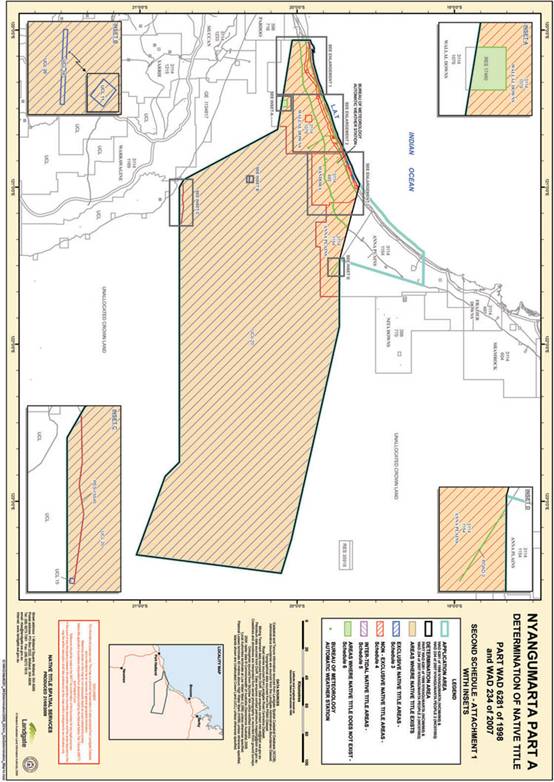
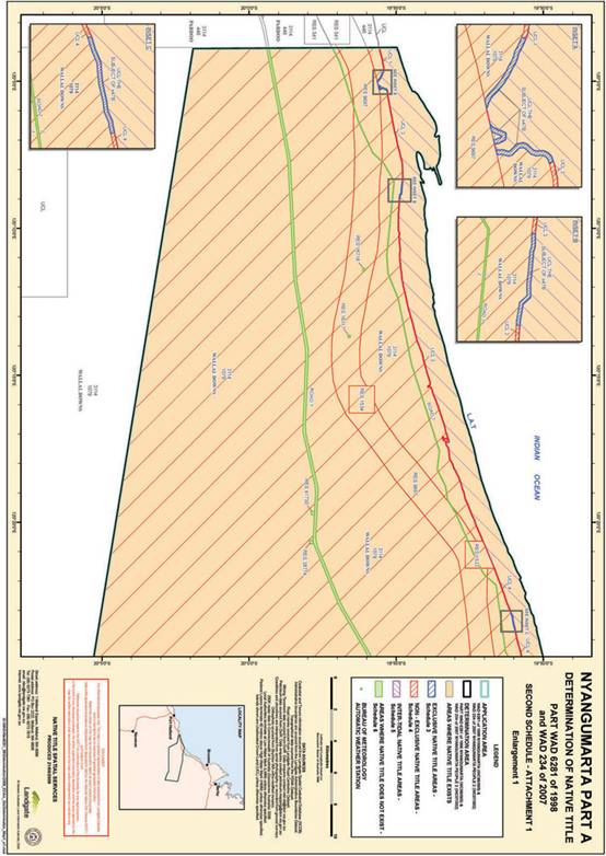
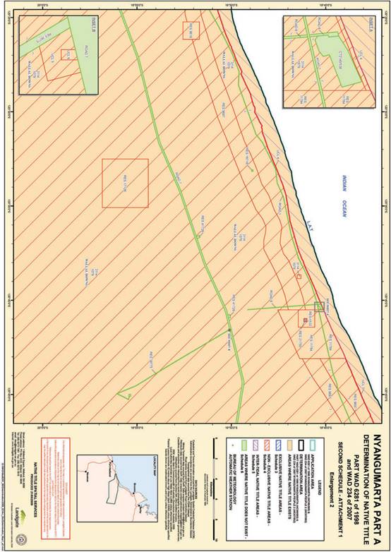
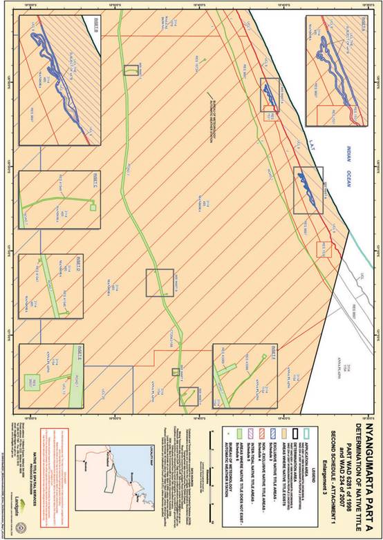
SCHEDULE 3
EXCLUSIVE NATIVE TITLE AREAS
Areas where native title comprises the rights set out in paragraph 5
The following land and waters (generally shown as hachured blue on the maps at Schedule 2):
Unallocated Crown Land ("UCL") 10 being an area formerly subject to Special Lease 37(L)/863 to the Commonwealth for the purpose of "Airstrip" granted on 5 October 1984 and surrendered on 17 January 1990 in the desert area of the claim.
UCL 11 being an area formerly subject to Special Lease 3116/4540 to the Commonwealth for the purpose of "Country Automatic Exchange Site" from 7 September 1970 to 30 June 1971 and Reserve 37179 for the purpose of "Country Automatic Exchange Site" vested in the Commonwealth created and vested on 8 May 1981 and cancelled on 9 October 1987 within the desert beside UCL 10
UCL 15 being an area close to the southern boundary of the claim formerly subject to Reserve 15441 for the purpose of "Water and Camping and Rabbit Proof Fence"
UCL 20 being the large area of desert in the eastern portion of the claim formerly subject to Temporary Reserve 70/1643
Reserve 21750 for the purpose of Use and Benefit of Aboriginal Inhabitants
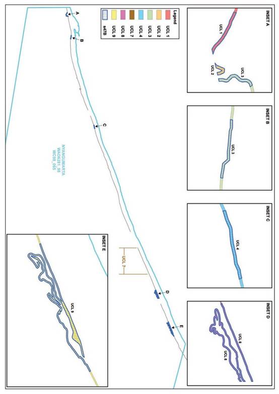
Those forty metre wide strips of UCL (being UCL 2 and parts of UCL 1, 3, 4, 8 and 9) situated immediately landward of the High Water Mark depicted on annexure 1 to this Schedule and being:
A. Within a 600 metre radius of Paruwuturr at Latitude 19.924889 South, Longitude 120.083789 East;
B. Within a 500 metre radius of Jurnta at Latitude 19.914117 South, Longitude 120.145161 East;
C. Within a 500 metre radius of Kunyjartijirri-jukujuku at Latitude 19.851094 South, Longitude 120.389488 East;
D. Within a 2000 metre radius of Waru at Latitude 19.678229 South, Longitude 120.852450 East;
E. Within a 2200 metre radius of Pilyarlkarra at Latitude 19.643477 South, Longitude 120.940725 East.
SCHEDULE 4
NON - EXCLUSIVE NATIVE TITLE AREAS
Areas where native title comprises the rights set out in paragraph 6
The following land and waters (generally shown as hachured red on the maps at Schedule 2):
Pastoral Leases:
Portion of Pastoral Lease 3114/485, Mandora falling within the Determination Area
Portion of Pastoral Lease 3114/1079, Wallal Downs falling within the Determination Area
Portion of Pastoral Lease 3114/1154, Anna Plains falling within the Determination Area
Non-vested Reserves:
Reserve 1530 - Watering Place
Reserve 1531 - Watering Place
Reserve 1532 - Watering Place
Reserve 1533 - Watering Place
Reserve 1534 - Watering Place
Reserve 9618 - Water
Reserve 9697 - portion of Kimberley De Grey Stock Route falling within the Determination Area
Reserve 11784 - Travellers
Reserve 15540 - Protection of Rabbit Proof Fence
Reserve 17128 - Water
Areas of Unallocated Crown Land
Those parts of UCL 1, 3, 4, 8 and 9 not included within the 40 metre strip areas described in Schedule 3 and depicted on Annexure 1 to Schedule 3, and UCL 7.
UCL 5, being an area within Wallal Pastoral Lease near Reserve 38775 formerly subject to Pastoral Lease 3114/634
UCL 6, being an area within Wallal Pastoral Lease near Reserve 38775 formerly subject to Pastoral Lease 3114/634
UCL 13, being an area within Anna Plains Pastoral Lease beside Reserve 38937 formerly subject to Pastoral Lease 3114/1082
SCHEDULE 5
INTER-TIDAL NATIVE TITLE AREAS
Areas where native title comprises the rights set out in paragraph 7
All that land and water hachured purple on the maps at Schedule 2commencing at the intersection of the Lowest Astronomical Tide with the south western corner of Native Title Determination Application WAD0280/08 Yawinya (WC08/004) at Longitude 120.980063 East; Thence extending southeasterly along the boundary of that Native Title Determination Application to the intersection of the High Water Mark at longitude 121.007158 East; Thence generally southwesterly along that High Water Mark to longitude 120.064154 East; Thence northerly to the Lowest Astronomical Tide at Longitude 120.064097 East; Thence generally northeasterly along that Lowest Astronomical Tide back to the commencement point.
(iv) Geographic Coordinates provided in Decimal Degrees.
(v) Lowest Astronomical Tide is based on and sourced from AMB data, 6th Edition released in February 2006.
Native Title Determination Application WAD0280/08 Yawinya (WC08/004) as filed in the Federal Court on the 3 December 2008.
(vi) Datum: Geocentric Datum of Australia (1994)
(vii) Prepared by: Native Title Spatial Services (Landgate) 8 April 2009
Use of Co-ordinates:
Where co-ordinates are used within the description to represent cadastral or topographical boundaries or the intersection with such, they are intended as a guide only. As an outcome to the custodians of cadastral and topographic data continuously recalculating the geographic position of their data based on improved survey and data maintenance procedures, it is not possible to accurately define such a position other than by detailed ground survey.
NTSS 004 GW
G:\WAG\Wag6281_98\Determination\2009\WAD6281_98_CD_SCHEDULE_5_TD.doc
SCHEDULE 6
AREAS WHERE NATIVE TITLE DOES NOT EXIST
Native title does not exist in the following land and waters. With the exception of those public works which are captured by the definition at paragraphs 3.2 and 3.3 of this Schedule, all of the following areas are generally shown as shaded in green on the maps at Schedule 2:
The areas the subject of the following interests:
1. Freeholds:
Certificate of Title 2043/188
Certificate of Title 2140/538
2. Vested Reserves:
Reserve 16716 for the purpose of water vested in Water & Rivers Commission
Reserve 16717 for the purpose of water vested in Water & Rivers Commission
Reserve 16718 for the purpose of water vested in Water & Rivers Commission
Reserve 16724 for the purpose of water vested in Water & Rivers Commission
Reserve 17460 for the purpose of water vested in Water & Rivers Commission
Reserve 38774 for the purpose of Microwave Translator Site vested in Telstra
Reserve 38775 for the purpose of Microwave Translator Site vested in Telstra
Reserve 38937 for the purpose of Microwave Translator Site vested in Telstra
Reserve 41546 for the purpose of Water Supply vested in Commissioner of Main Roads
Reserve 41547 for the purpose of Water Supply vested in Commissioner of Main Roads
Reserve 41548 for the purpose of Water Supply vested in Commissioner of Main Roads
Reserve 41728 for the purpose of Water Bore and Campsite vested in Commissioner of Main Roads
Reserve 41729 for the purpose of Water Bore and Campsite vested in Commissioner of Main Roads
Reserve 41730 for the purpose of Water Bore and Campsite vested in Commissioner of Main Roads
Reserve 43088 for the purpose of Water Bore vested in Commissioner of Main Roads
Reserve 43089 for the purpose of Water Bore vested in Commissioner of Main Roads
3. The areas the subject of the following works:
| Road Number | Location |
| 1 | "Main Road from Yeeda Station to the boundary of the Kimberley District … along the lines of wells already sunk. |
| 3. | Runs from 90 Mile Beach inland |
| 6. | Road running south-east from Eighty Mile Beach through Wallal Station |
| 7 | Great Northern Highway (excluding those areas adjacent to the Great Northern Highway that were subject to Taking Order J 150599 YA dated 29 December 2004 that was stated to preserve any native title rights and interests). |
3.2 Any other public works as that expression is defined in the Native Title Act and the Titles (Validation) and Native Title (Effect of Past Acts) Act 1995 (WA) and to which section 12J of the Titles (Validation) and Native Title (Effect of Past Acts) Act 1995 (WA) or section 23C(2) of the Native Title Act applies, within the external boundary of the Determination Area including the land and waters defined in section 251D of the Native Title Act.
3.3 For the avoidance of doubt, the Bureau of Meteorology Automatic Weather Station which is located at Mandora Station, Latitude 19.7419, Long 120.8436, is included in "public work" for the purposes of this Schedule.
SCHEDULE 7
DESCRIPTION OF THE NATIVE TITLE HOLDERS
Nyangumarta people (referred to in paragraph 4) are:
(a) descendants of the following sets of apical ancestors:
1. Karrar,[1] Purtita,[2] Pinganiny[3] and Ngajularti[4];
2. Warrakampanya,[5] Karikaniny;[6]
3. Yakutartu;[7]
4. Pilypakurru[8] and Minyawi;[9]
5. Latara;[10]
6. Jawayipala;[11]
7. Walypijina;[12]
8. Kanykurr[13] and Yirangkamantakarri;[14]
9. Ngajiyarra aka Nginykirrititi;[15]
10. Yinti[16] and Kayikayi; Yankurna and Pitiny-Pitiny;[17]
11. Punykirriti;[18]
12. Nganalakawangu.[19]
(b) Aboriginal persons who
(i) self-identify as Nyangumarta in preference to any other group; and
(ii) are generally accepted by other members of the Nyangumarta community as Nyangumarta under traditional law and custom.
Nothing in this definition excludes persons from being included as a member of the native title holding group who are or may be identified as other than Nyangumarta in accordance with traditional laws and customs of a group other than the Nyangumarta community.
SCHEDULE 8
AREAS TO WHICH SECTIONS 47A AND 47B NATIVE TITLE ACT 1993 (CTH) APPLY
Areas to which section 47A applies
Reserve 21750 for the Use and Benefit of Aboriginal Inhabitants
Areas to which section 47B applies
UCL 10 being an area formerly subject to Special Lease 37(L)/863 to the Commonwealth for the purpose of "Airstrip" granted on 5 October 1984 and surrendered on 17 January 1990 in the desert area of the claim
UCL 11 being an area formerly subject to Special Lease 3116/4540 to the Commonwealth for the purpose of "Country Automatic Exchange Site" from 7 September 1970 to 30 June 1971 and Reserve 37179 for the purpose of "Country Automatic Exchange Site" vested in the Commonwealth created and vested on 8 May 1981 and cancelled on 9 October 1987 within the desert beside UCL 10
UCL 15 being an area close to the southern boundary of the claim formerly subject to Reserve 15441 for the purpose of "Water and Camping and Rabbit Proof Fence"
UCL 20 being the large area of desert in the eastern portion of the claim formerly subject to Temporary Reserve 70/1643
to pastoral leases
Those forty metre wide strips of Unallocated Crown Land situated immediately landward of the High Water Mark depicted on Annexure 1 to Schedule 3 and being:
A. Within a 600 metre radius of Paruwuturr at Latitude 19.924889 South, Longitude 120.083789 East;
B. Within a 500 metre radius of Jurnta at Latitude 19.914117 South, Longitude 120.145161 East;
C. Within a 500 metre radius of Kunyjartijirri-jukujuku at Latitude 19.851094 South, Longitude 120.389488 East;
D. Within a 2000 metre radius of Waru at Latitude 19.678229 South, Longitude 120.852450 East;
E. Within a 2200 metre radius of Pilyarlkarra at Latitude 19.643477 South, Longitude 120.940725 East.
SCHEDULE 9
OTHER INTERESTS
1. Pastoral Leases
Pastoral Lease 3114/485, Mandora
Pastoral Lease 3114/1079, Wallal Downs
Pastoral Lease 3114/1154, Anna Plains
2. Reserves
The interests of persons who have the care, control and management of the following reserves, and the interests of persons entitled to access and use these reserves for the respective purposes for which they are reserved, subject to any statutory limitations upon those rights:
Reserve 21750 - Use and Benefit of Aboriginal Inhabitants
Reserve 1530 - Watering Place
Reserve 1531 - Watering Place
Reserve 1532 - Watering Place
Reserve 1533 - Watering Place
Reserve 1534 - Watering Place
Reserve 9618 - Water
Reserve 9697 - Kimberley De Grey Stock Route
Reserve 11784 - Travellers
Reserve 15540 - Protection of Rabbit Proof Fence
Reserve 17128 - Water
3. The interests of persons holding leases over areas of the reserves identified in paragraph 1 above.
4. Existing petroleum interests under the Petroleum and Geothermal Energy Resources Act 1967 (WA)
| Nature and number of interest | Grantee | Date of grant and term |
| Exploration Permit 448 | Gulliver Productions Pty Ltd, Indigo Oil Pty Ltd, and United Orogen Limited | 16 June 2006 – 6 years |
| Exploration Permit EP 456 | Buru Energy Limited and New Standard Exploration Pty Ltd | 16 October 2007 – 6 years |
5. Existing Interests under the Mining Act 1978 (WA)
| Tenement type and number | Grantee | Date of grant and term |
| Exploration licence 4502576 | Brumby Creek NL | 14 October 2005 for a term from 14 October 2005 to 13 October 2010 |
| Exploration licence 4502577 | Brumby Creek NL | 14 October 2005 for a term from 14 October 2005 to 13 October 2010 |
| Exploration licence 4502874 | Glengarry Resources Ltd | 8 January 2007 for a term from 8 January 2007 to 7 January 2012 |
| Exploration licence 4502901 | Glengarry Resources Ltd | 28 March 2007 for a term from 28 March 2007 to 27 March 2012 |
| Exploration licence 4503021 | Oakover Gold Ltd | 27 August 2008 for a term from 27 August 2008 to 26 August 2013 |
| Exploration licence 4503085 | Pandell Pty Ltd | 13 May 2008 for a term from 13 May 2008 to 12 May 2013 |
| Exploration licence 4503086 | De Silva, Niraan Punnya Quaalup Investments Pty Ltd | 1 August 2008 for a term from 1 August 2008 to 31 July 2013 |
| Exploration licence 4503087 | De Silva, Niraan Punnya Quaalup Investments Pty Ltd | 1 August 2008 for a term from 1 August 2008 to 31 July 2013 |
6. Other Rights and Interests
(a) Rights and interests, including licences and permits, granted by the Crown in right of the Commonwealth or the State pursuant to statute or otherwise in the exercise of its executive power, including but not limited to the interests of the holders of statutory fishing and pearling interests granted under the Fish Resources Management Act 1994 (WA), the Pearling Act 1990 (WA), and the Fisheries Management Act 1991 (Cth) and any regulations made pursuant to such legislation.
(b) Rights or interests held by reason of the force and operation of the laws of the State or of the Commonwealth including the force and operation of the Rights in Water and Irrigation Act 1914 (WA);
(c) Rights and interests of members of the public arising under the common law, including but not limited to the public right to fish and the public right to navigate;
(d) The right to access land by:
(i) an employee or agent or instrumentality of the State;
(ii) an employee or agent or instrumentality of the Commonwealth;
(iii) an employee or agent or instrumentality of any local Government authority;
(iv) as required in the performance of his or her statutory or common law duties where such access would be permitted to private land.
(e) Rights of any person to access and enjoy (subject to the laws of the State):
(i) any roads within the Determination Area existing as at the date of this determination where members of the public have access to such roads according to the common law;
(ii) the Kimberley De Grey Stock Route.
(f) (i) Without limiting the operation of any other paragraph in the Ninth Schedule, but subject to paragraph (f)(ii), rights of the holders from time to time of petroleum interests under the Petroleum and Geothermal Energy Resources Act 1967 (WA), petroleum pipelines under the Petroleum Pipelines Act 1969 (WA) and mining tenements under the Mining Act 1978 (WA) to use (including by servants, agents and contractors) the roads and tracks in the Determination Area existing as at the date of this determination, in order to have access to such petroleum, pipeline and mineral interests.
(ii) Nothing in paragraph (f)(i) above allows any upgrade, extension, widening or other improvement to the road or track other than work done to maintain such road or track in reasonable repair.
(g) So far as confirmed pursuant to section 14 of the Titles (Validation) and Native Title (Effect of Past Acts) Act 1995 (WA) as at the date of this determination, any existing public access to and enjoyment of:
(i) waterways; or
(ii) the beds and banks or foreshores of waterways;
(iii) coastal waters; or
(iv) beaches; or
(v) stock routes; or
(vi) areas that were public places at the end of 31 December 1993.
(h) Any other:
(i) legal or equitable estate or interest in the land or waters; or
(ii) any other right (including a right under an option and a right of redemption), charge, power or privilege over, or in connection with:
(A) the land or waters; or
(B) an estate or interest in the land or waters; or
(iii) restriction on the use of the land or waters, whether or not annexed to other land or waters
(i) The rights and interests of Telstra Corporation Limited:
(a) As the owner or operator of telecommunications facilities within the Determination Area,;
(b) As the holder of a carrier licence under the Telecommunications Act 1997 (Cth);
(c) Created pursuant to the Post and Telegraph Act 1901 (Cth), the Telecommunications Act 1975 (Cth), the Australian Telecommunications Corporation Act 1989 (Cth), the Telecommunications Act 1991 (Cth) and the Telecommunications Act 1997 (Cth) including:
(i) the right to establish a telecommunications facility on, and remain in occupation of, UCL 13 (Pardu Location 60); and
(ii) the right to install cabling, customer terminal facilities and ancillary facilities; and
(d) For its employees, agents or contractors to enter the Determination Area to access its facilities in and in the vicinity of the Determination Area.
(j) An agreed right of access granted by the Native Title Holders to the lessees of the above pastoral leases to access the 40 metre strip areas described in Schedule 8.
[1] Kararr’s English name was Charlie and his section was Parrjarri. His wives were Purtita, Pingananiny, Ngajularti and Jujukujarra.
[2] Purtita’s English name was Bridget and her section was Karrimarra.
[3] Pingananiny’s section was Purungu.
[4] Ngajularti’s English name was Kitty and her section was Parrjarri.
[5] Warrakampanya’s wives were Kartikaniny, Yurryurr/Pilpurr and Nyula. His section was Panaka.
[6] Kartikaniny’s section was Purungu.
[7] Yakutartu’s English name was Lucy. Her husband was Wupiyala. Yakutartu’s section was Parrjarri/Milangka.
[8] Pilypakurru’s English name was Old Charlie. His wives were Puji, Yajiki, Latara and Minyawi. His section was Purungu/Karimarra.
[9] Minyawi’s English name was Pussycat. Her section was Parrjarri/Milangka.
[10] Latara’s husbands were Pilypakurru and Papalyala. Her section was Parrjarri/Milangka.
[11] Jawayipala’s wife was Julungu. His section was Panaka.
[12] Walypijina’s English name was Ruby. Her husband was Wantipina and her section was Milangka/Parrjarri.
[13] Kanykurr’s English names were Sam and Tom. His wife was Yirangamantakarri and his section was Panaka.
[14] Yirangamantakarri’s English names were Polly and Annie. Her section was Purungu.
[15] Ngajiyarra’s was also known as Nginykirriti. His English name was Tom. His wife was Yupujayi and his section was Parrjarri.
[16] Yinti’s wives were Kayikayi and Pimpurratin. Yinti’s section was Panaka. Kayikayi’s section was Purungu.
[17] Pitiny-Pitiny was the daughter of Yinti and Kayikayi. Pitiny-Pitiny’s husband was Yankurna. Pitiny-Pitiny’s section was Panaka. Yankurna’s section was Purungu.
[18] Punykirriti’s wife was Kiju. His section was Parajarri.
[19] Nganalakawangu’s wife was Kungangarra. His section was Panaka.

