
FEDERAL COURT OF AUSTRALIA
Billy Patch and Others on behalf of the Birriliburu People v State of Western Australia [2008] FCA 944
Native Title Amendment Act 1998 (Cth)
Native Title Amendment Act 2007 (Cth)
Brown (On behalf of the Ngarla People) v State of Western Australia[2007] FCA 1025 cited
BILLY PATCH AND OTHERS ON BEHALF OF THE BIRRILIBURU PEOPLE v STATE OF WESTERN AUSTRALIA
WAD6284 OF 1998
FRENCH J
20 JUNE 2008
GOOD CAMP ROCKHOLE – WESTERN DESERT
| IN THE FEDERAL COURT OF AUSTRALIA |
|
| WESTERN AUSTRALIA DISTRICT REGISTRY | WAD6284 OF 1998 |
| BETWEEN: | BILLY PATCH AND OTHERS ON BEHALF OF THE BIRRILIBURU PEOPLE Applicant
|
| AND: | STATE OF WESTERN AUSTRALIA Respondent
|
| FRENCH J | |
| DATE OF ORDER: | 20 JUNE 2008 |
| WHERE MADE: | Good camp rockhole – western desert |
THE COURT NOTES THAT:
A. The Applicants in proceeding WAD 6284 of 1998 have made a native title determination application that relates to an area of land and waters (the Birriliburu Application”), part of which comprises the subject of the proposed determination of native title (“the Determination”).
B. The Applicants in the Birriliburu Application (“the Birriliburu Applicants”) and the State of Western Australia as parties to the proceeding (“the parties”) have reached an agreement as to the terms of the Determination which is to be made in relation to part of the land and waters covered by the Birriliburu Application (“the Determination Area”). The external boundaries of the Determination Area are described in the First Schedule to the Determination.
C. The parties have agreed that no determination should be made in relation to the balance of the land and waters the subject of the Birriliburu Application, and that the proceeding in relation to that area should remain on foot.
D. Pursuant to section 87A of the Native Title Act 1993 (Cth) the parties have filed with this Court an agreement in writing setting out the terms of the agreement reached. The agreement has been signed by or on behalf of each of those parties who are required to be parties to the agreement pursuant to section 87A(1)(c) of the Native Title Act.
E. The terms of the agreement involve the making of consent orders for a determination of native title pursuant to sections 87A and 94A of the Native Title Act that native title exists in relation to the Determination Area as set out in the Determination.
F. In relation to the areas set out in Schedule 2 of the Minute of Consent Determination of Native Title, the State has agreed with the Birriliburu Applicants that, but for the complete extinguishment of native title effected over those areas, the Birriliburu Applicants would have held native title rights and interests in relation to those areas comprising:
(a) the right to possession, occupation, use and enjoyment of the land to the exclusion of all others; and
(b) the right to take flowing and subterranean water for personal, domestic, or non-commercial communal purposes,
on the same terms as those described in the Determination.
G. The parties to the proceeding have agreed to the terms of the Determination and are on notice that the Determination has been filed with the Court.
H. The parties acknowledge that the effect of the making of the Determination is that the members of the native title claim group, in accordance with the traditional laws acknowledged and the traditional customs observed by them, should be recognised as the Native Title Holders for the Determination Area as set out in the Determination.
I. The parties have requested the Court to hear and determine the proceeding that relates to the Determination Area.
J. No nomination has yet been made under either section 56(2) or section 57(2) of the Native Title Act. The Birriliburu Applicants intend to have their native title held in trust. They will soon complete the formalities necessary to establish a prescribed body corporate with a view to nominating that prescribed body corporate to be trustee of the native title under section 56(2). At this stage, the parties have agreed to ask the Court to proceed to make a determination of native title, and to allow the Birriliburu Applicants a further period of 6 months within which to comply with the requirements of section 56(2).
BEING SATISFIED that a determination of native title in the terms set out in the attached Minute of Proposed Consent Determination of Native Title in respect of WAD6284 of 1998 would be within the power of the Court and, it appearing to the Court appropriate to do so, pursuant to section 87A of the Native Title Act and by the consent of the parties:
THE COURT ORDERS THAT:
1. In relation to the Determination Area, there be a determination of native title in WAD6284 of 1998 in terms of the attached Minute of Proposed Consent Determination of Native Title.
2. Within 6 months of the date of this order, a representative of the Native Title holders (as defined in the Determination) is to file and serve a notice nominating a prescribed body corporate to hold the native title in trust and include with that notice the written consent of the body corporate.
3. Subject to further order, if a prescribed body corporate is nominated in accordance with Order 2 there will, without the need for a further order, be a determination that the prescribed body corporate so nominated is to hold the native title rights and interests the subject of the Determination in trust for the Native Title Holders in accordance with section 56(2)(b) of the Native Title Act.
4. If no nomination is made in accordance with Order 2 within the period specified, or any further period the Court may order, the matter is to be listed for further directions.
5. The proceeding in relation to the balance of the area the subject of native title determination application WAD 6284 of 1998 be adjourned to a directions hearing on a date to be fixed.
6. There be liberty to apply.
7. There be no order as to costs.
DETERMINATION
Being satisfied that a determination in terms sought by the parties would be within the power of the Court, and it appearing to the Court appropriate to do so and by consent of the parties:
THE COURT ORDERS, DECLARES AND DETERMINES THAT:
Existence of Native Title (s 225)
1. Native title exists in relation to the Determination Area.
The Native Title Holders (s 225(a))
2. The native title is held by the Native Title Holders.
The nature and extent of native title rights and interests (s 225(b) and s 225(e))
3. Subject to paragraphs 4, 5, 6 and 7 the nature and extent of the native title rights and interests is:
(a) except in relation to flowing and subterranean water – the right of possession, occupation, use and enjoyment to the exclusion of all others; and
(b) the right to take flowing and subterranean water for personal, domestic, or non-commercial communal purposes.
4. The native title rights and interests described in subparagraph 3(a) confer possession, occupation, use and enjoyment on the Native Title Holders to the exclusion of all others.
5. The native title rights and interests in subparagraph 3(b) do not confer possession, occupation, use and enjoyment on the Native Title Holders to the exclusion of all others.
6. The native title rights and interests are:
(a) exercisable in accordance with the traditional laws and customs of the Native Title Holders; and
(b) subject to the laws of the State and the Commonwealth including the common law.
7. Notwithstanding anything in this determination the native title rights and interests include the right to take and use ochre to the extent that ochre is not a mineral pursuant to the Mining Act 1904 (WA), but do not include the right to take other minerals and petroleum as defined in the Mining Act 1904 (WA), the Mining Act 1978 (WA) as in force at the date of this determination, the Petroleum Act 1936 (WA) and the Petroleum and Geothermal Energy Resources Act 1967 (WA) as in force at the date of this determination.
Areas to which ss 47A and 47B apply
8. Sections 47A and 47B of the Native Title Act apply to disregard any prior extinguishment in relation to the areas described in Schedule 4.
Nature and extent of other rights and interests in relation to the Determination Area
(s 225(c))
9. The nature and extent of the other interests in the Determination Area is described in Schedule 5.
Relationship between the native title rights and interests and other interests (s 225(d))
10. The relationship between the native title rights and interests described in paragraph 3 and the other interests referred to in paragraph 9 is that:
(a) to the extent that any of the other interests are inconsistent with the continued existence, enjoyment or exercise of the native title rights and interests, the native title rights and interests continue to exist in their entirety, but the native title rights and interests have no effect in relation to the other interests to the extent of the inconsistency during the currency of the other interests; and otherwise,
(b) the existence and exercise of the native title rights and interests do not prevent the doing of any activity required or permitted to be done by or under the other interests, and the other interests, and the doing of any activity required or permitted to be done by or under the other interests, prevail over the native title rights and interests and any exercise of the native title rights and interests, but do not extinguish them.
Definitions and interpretation
11. In this determination, unless the contrary intention appears:
“Determination Area” is the land and waters described in Schedule 1 and shown on the map at Attachment 1 to Schedule 1;
“flowing and subterranean water” means the following water within the Determination Area:
(a) water which flows, whether permanently, intermittently or occasionally, within any river, creek, stream or brook;
(b) any natural collection of water into, through, or out of which a river, creek, stream or brook flows; and
(c) water from and including an underground water source, including water that percolates from the ground;
“land” and “waters” respectively have the same meanings as in the Native Title Act;
“Native Title Act” means the Native Title Act 1993 (Cth); and
“Native Title Holders” are the persons described in Schedule 3.
12. In the event of any inconsistency between the written description of the area in Schedule 1 and the area as shown in the map at Attachment 1 to Schedule 1, the written description prevails.
SCHEDULE 1
DETERMINATION AREA
(Schedule referred to in paragraphs 11 and 12)
The Determination Area, generally shown as bordered in blue on the map at Attachment 1 to this Schedule, comprises all of the land and waters bounded by the following description except land and waters of the areas described in Schedule 2:
All those lands and waters commencing at Longitude 120:501359 East, Latitude 23.998656 South and extending easterly through the following coordinate positions:
| Longitude (East) | Latitude (South) |
| 120.508828 | 23.998656 |
| 123.001349 | 23.998637 |
| 124.003581 | 23.998626 |
| 125.001343 | 23.998615 |
Thence south to the northern boundary of Reserve 34606, thence westerly and southerly along boundaries of that reserve to its southwestern corner and onwards to Longitude 124.668029 East, Latitude 25.889711 South; thence generally northwesterly passing through the following coordinate positions:
| Longitude (East) | Latitude (South) |
| 124.666235 | 25.885943 |
| 124.664922 | 25.883344 |
| 124.659017 | 25.871353 |
| 124.653749 | 25.861548 |
| 124.650089 | 25.856520 |
| 124.645801 | 25.848911 |
| 124.642198 | 25.841320 |
| 124.638561 | 25.835306 |
| 124.634004 | 25.824337 |
| 124.630401 | 25.816747 |
| 124.628394 | 25.814523 |
| 124.621144 | 25.801313 |
| 124.620164 | 25.799117 |
| 124.614176 | 25.790871 |
| 124.611211 | 25.785467 |
| 124.607551 | 25.780438 |
| 124.606216 | 25.778825 |
| 124.603263 | 25.772829 |
| 124.601950 | 25.770230 |
| 124.592961 | 25.758156 |
| 124.589965 | 25.754132 |
| 124.588664 | 25.750941 |
| 124.583999 | 25.744900 |
| 124.583336 | 25.743896 |
| 124.581403 | 25.738322 |
| 124.580409 | 25.736717 |
| 124.580444 | 25.735141 |
| 124.579192 | 25.729782 |
| 124.577869 | 25.727577 |
| 124.574957 | 25.719807 |
| 124.573375 | 25.713848 |
| 124.572039 | 25.712234 |
| 124.567822 | 25.701471 |
| 124.566205 | 25.697088 |
| 124.563231 | 25.692078 |
| 124.559607 | 25.685472 |
| 124.558944 | 25.684468 |
| 124.558970 | 25.683286 |
| 124.553772 | 25.670327 |
| 124.550134 | 25.664313 |
| 124.548188 | 25.659331 |
| 124.545222 | 25.653926 |
| 124.539919 | 25.645698 |
| 124.534933 | 25.638662 |
| 124.532609 | 25.635247 |
| 124.528993 | 25.628248 |
| 124.523669 | 25.621005 |
| 124.519333 | 25.615564 |
| 124.512660 | 25.607299 |
| 124.509009 | 25.601877 |
| 124.508075 | 25.600807 |
| 124.500697 | 25.590215 |
| 124.495052 | 25.581978 |
| 124.491401 | 25.576556 |
| 124.490434 | 25.573769 |
| 124.485435 | 25.567324 |
| 124.484789 | 25.565531 |
| 124.481125 | 25.560700 |
| 124.479508 | 25.556318 |
| 124.475172 | 25.550877 |
| 124.473828 | 25.549658 |
| 124.467888 | 25.539243 |
| 124.464237 | 25.533821 |
| 124.457291 | 25.522393 |
| 124.446286 | 25.508490 |
| 124.439601 | 25.500817 |
| 124.433942 | 25.493171 |
| 124.432928 | 25.492552 |
| 124.423618 | 25.479484 |
| 124.418329 | 25.470664 |
| 124.415354 | 25.465654 |
| 124.407346 | 25.455776 |
| 124.401358 | 25.447530 |
| 124.399728 | 25.443739 |
| 124.389404 | 25.430052 |
| 124.388060 | 25.428833 |
Thence northwesterly to a southern boundary of General Lease I126373 at Longitude 124.375651 East; thence westerly along that boundary to the eastern boundary of Reserve 34604; thence northerly, westerly and southerly along boundaries of that reserve to again a southern boundary of General Lease I126373; thence westerly along that boundary to a southwestern corner of General Lease I126373 at Longitude 124.003527 East; thence generally westerly and generally southwesterly passing through the following coordinate positions:
| Longitude (East) | Latitude (South) |
| 123.992285 | 25.411111 |
| 123.987581 | 25.412121 |
| 123.981344 | 25.413637 |
| 123.975320 | 25.414601 |
| 123.973251 | 25.415138 |
| 123.971759 | 25.415205 |
| 123.967761 | 25.415384 |
| 123.964665 | 25.415893 |
| 123.954032 | 25.416199 |
| 123.949565 | 25.416671 |
| 123.944075 | 25.416918 |
| 123.938238 | 25.417353 |
| 123.936512 | 25.417899 |
| 123.933429 | 25.417816 |
| 123.927934 | 25.418260 |
| 123.920740 | 25.418067 |
| 123.915250 | 25.418314 |
| 123.908386 | 25.418722 |
| 123.903919 | 25.419194 |
| 123.896703 | 25.419986 |
| 123.895320 | 25.420540 |
| 123.888446 | 25.421342 |
| 123.886048 | 25.421278 |
| 123.880883 | 25.422322 |
| 123.878485 | 25.422258 |
| 123.877787 | 25.422831 |
| 123.875723 | 25.423170 |
| 123.874695 | 25.423143 |
| 123.873312 | 25.423697 |
| 123.871599 | 25.423651 |
| 123.870901 | 25.424224 |
| 123.865749 | 25.424677 |
| 123.862657 | 25.424989 |
| 123.855094 | 25.425969 |
| 123.843398 | 25.427824 |
| 123.837210 | 25.428644 |
| 123.830324 | 25.430038 |
| 123.827570 | 25.430555 |
| 123.824487 | 25.430472 |
| 123.818285 | 25.431884 |
| 123.809001 | 25.433212 |
| 123.799348 | 25.435714 |
| 123.793155 | 25.436731 |
| 123.790063 | 25.437043 |
| 123.785597 | 25.437515 |
| 123.784898 | 25.438088 |
| 123.774564 | 25.440374 |
| 123.768007 | 25.442367 |
| 123.755600 | 25.445387 |
| 123.746636 | 25.447710 |
| 123.739403 | 25.449291 |
| 123.734243 | 25.450139 |
| 123.732873 | 25.450102 |
| 123.727369 | 25.450940 |
| 123.725999 | 25.450904 |
| 123.719108 | 25.452493 |
| 123.713605 | 25.453332 |
| 123.709824 | 25.453822 |
| 123.707404 | 25.454743 |
| 123.698457 | 25.456278 |
| 123.694324 | 25.457153 |
| 123.686090 | 25.457524 |
| 123.682998 | 25.457835 |
| 123.681614 | 25.458390 |
| 123.676120 | 25.458834 |
| 123.666506 | 25.459562 |
| 123.654845 | 25.459841 |
| 123.645938 | 25.459602 |
| 123.635318 | 25.459317 |
| 123.629152 | 25.459151 |
| 123.616819 | 25.458820 |
| 123.607226 | 25.458563 |
| 123.600375 | 25.458379 |
| 123.593523 | 25.458195 |
| 123.591125 | 25.458131 |
| 123.587370 | 25.457439 |
| 123.581191 | 25.457864 |
| 123.572956 | 25.458235 |
| 123.566091 | 25.458642 |
| 123.559916 | 25.458871 |
| 123.540705 | 25.459539 |
| 123.523225 | 25.459464 |
| 123.513619 | 25.459798 |
| 123.506412 | 25.460196 |
| 123.501937 | 25.461062 |
| 123.496798 | 25.460924 |
| 123.488220 | 25.461286 |
| 123.485480 | 25.461212 |
| 123.478615 | 25.461619 |
| 123.471764 | 25.461436 |
| 123.460779 | 25.462127 |
| 123.454257 | 25.462544 |
| 123.439513 | 25.462739 |
| 123.433668 | 25.463569 |
| 123.423733 | 25.463302 |
| 123.416183 | 25.463691 |
| 123.415155 | 25.463664 |
| 123.412059 | 25.464172 |
| 123.403143 | 25.464328 |
| 123.401430 | 25.464282 |
| 123.399361 | 25.464818 |
| 123.390099 | 25.465161 |
| 123.386309 | 25.466045 |
| 123.381855 | 25.465926 |
| 123.377718 | 25.466998 |
| 123.368104 | 25.467726 |
| 123.361218 | 25.469119 |
| 123.357423 | 25.470200 |
| 123.356396 | 25.470173 |
| 123.355697 | 25.470746 |
| 123.352592 | 25.471648 |
| 123.351222 | 25.471611 |
| 123.343637 | 25.473577 |
| 123.340528 | 25.474677 |
| 123.338815 | 25.474631 |
| 123.335710 | 25.475534 |
| 123.335012 | 25.476107 |
| 123.326048 | 25.478430 |
| 123.322952 | 25.478939 |
| 123.316039 | 25.481514 |
| 123.310510 | 25.483535 |
| 123.306022 | 25.484993 |
| 123.300471 | 25.487999 |
| 123.297704 | 25.489108 |
| 123.296676 | 25.489080 |
| 123.295297 | 25.489438 |
| 123.287664 | 25.493572 |
| 123.280739 | 25.496738 |
| 123.276229 | 25.499181 |
| 123.270664 | 25.502779 |
| 123.266124 | 25.506601 |
| 123.260551 | 25.510593 |
| 123.256024 | 25.513824 |
| 123.255317 | 25.514791 |
| 123.253578 | 25.515928 |
| 123.252871 | 25.516895 |
| 123.251487 | 25.517449 |
| 123.247979 | 25.521103 |
| 123.240974 | 25.527817 |
| 123.236425 | 25.532034 |
| 123.235714 | 25.533198 |
| 123.232574 | 25.535677 |
| 123.231863 | 25.536841 |
| 123.230128 | 25.537781 |
| 123.226619 | 25.541434 |
| 123.224182 | 25.543143 |
| 123.217885 | 25.548890 |
| 123.213349 | 25.552516 |
| 123.208457 | 25.556723 |
| 123.203908 | 25.560940 |
| 123.198677 | 25.564941 |
| 123.196240 | 25.566651 |
| 123.192380 | 25.570688 |
| 123.186070 | 25.577027 |
| 123.182206 | 25.581262 |
| 123.180458 | 25.582793 |
| 123.179747 | 25.583957 |
| 123.177669 | 25.584887 |
| 123.174477 | 25.589732 |
| 123.169551 | 25.595516 |
| 123.167447 | 25.597629 |
| 123.163548 | 25.603441 |
| 123.161033 | 25.608698 |
| 123.156435 | 25.615083 |
| 123.150802 | 25.621834 |
| 123.144491 | 25.628173 |
| 123.140640 | 25.631816 |
| 123.138550 | 25.633338 |
| 123.134343 | 25.637564 |
| 123.132946 | 25.638709 |
Thence southwesterly to an eastern boundary of the eastern severance of Pastoral Lease 3114/1070 (Carnegie) at Latitude 25.645049 South; thence northerly and generally westerly along boundaries of that severance to an eastern boundary of the eastern severance of Pastoral Lease 3114/1062 (Glenayle); thence northerly, easterly, again northerly and generally westerly along boundaries of that eastern severance to its westernmost northwestern corner; thence west to an eastern boundary of the western severance of Pastoral Lease 3114/1062 (Glenayle); thence northwesterly along boundaries of that severance, to an eastern boundary of Reserve 36469, thence northerly and westerly along boundaries of that reserve to Longitude 121.583250 East; thence north to an eastern boundary of the northwestern severance of Pastoral Lease 3114/1062 (Glenayle); thence generally northerly, westerly, southerly, again westerly and again southerly to the southernmost southwestern corner of that severance; thence south to the westernmost northwestern corner of the western severance of Pastoral Lease 3114/1062 (Glenayle); thence southerly and generally easterly along the boundaries of that severance to its easternmost southeastern corner, being a point on the south western boundary of a parcel of UCL (Stock Route); thence southeasterly along that boundary to the northern corner of the southeastern severance of Pastoral Lease 3114/1062 (Glenayle), thence southerly and easterly along boundaries of that severance to its southeastern corner; thence southeasterly again along the southwestern boundary of a parcel of UCL (Stock Route) to the northwestern corner of the western severance of Pastoral Lease 3114/1070 (Carnegie), thence southerly and easterly along boundaries of that severance to its southeastern corner, thence east to a southwestern corner of the eastern severance of Pastoral Lease 3114/1070 (Carnegie); thence easterly and southerly along boundaries of that severance to the easternmost northeastern corner of Unallocated Crown Land parcel, being Lot 3 on Deposited Plan 220354; thence westerly, northerly, westerly, southerly, and generally westerly, to the northeastern corner of Unallocated Crown Land parcel; being Lot 4 on Deposited Plan 220354. Thence westerly along the northern boundary of that lot to the easternmost northeastern corner of the eastern severance of Pastoral Lease 3114/654 (Granite Peak); thence westerly, northerly, again westerly and again northerly along boundaries of that severance to an intersection with a southern boundary of Exploration Mining Licence E69/1134 (as at 29/9/1998); thence easterly, northerly, westerly, again northerly, again westerly, again northerly, again westerly, southerly, again westerly, again southerly, again westerly and again southerly along boundaries of that mining licence to an intersection with a northern boundary of the eastern severance of Pastoral Lease 3114/654 (Granite Peak); thence westerly, northerly, again westerly, and again northerly along boundaries of that severance to the northernmost northwestern corner; thence north to Longitude 121.034533 East, Latitude 25.376667 South; thence westerly to the easternmost northeastern corner of the western severance of Pastoral Lease 3114/654 (Granite Peak); thence westerly along the northern boundary of that severance to its northwestern corner; thence westerly, north westerly and northerly through the following coordinate positions:
| Longitude (East) | Latitude (South) |
| 120.645401 | 25.376673 |
| 120.501379 | 25.248666 |
| 120.501360 | 24.012185 |
Thence northerly back to the commencement point.
Exclusion(s): Excludes all land and waters within the external extent of:
Reserve 34604,
Reserve 36469,
Reserve 42068,
Exploration Licence E69/1092 (as at 29/09/1998)
Exploration Licence E69/1134 (as at 29/09/1998) and,
Exploration Licence E69/1135 (as at 29/09/1998).
Note: Geographic Coordinates provided in Decimal Degrees
Cadastral Boundaries sourced from Landgate
Spatial Cadastral Data dated February 2008.
Exploration Mining Licences sourced from DOIR, boundaries as at 29 September 1998.
Datum: Geocentric Datum of Australia (1994)
Prepared by: Native Title Spatial Services (Landgate) 15th April 2008
LC05 MAD
G:\WAG\WAG6284_98\Determination\2008_03\wc98_068_cdtd_revised0408.doc
Use of Coordinates
Where coordinates are used within the description to represent cadastral or topographical boundaries or the intersection with such, they are intended as a guide only. As an outcome to the custodians of cadastral and topographic data continuously recalculating the geographic position of their data based on improved survey and data maintenance procedures, it is not possible to accurately define such a position other than by detailed ground survey.
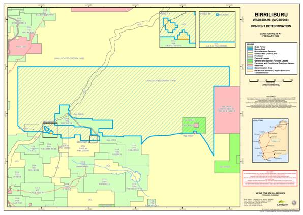
SCHEDULE 1 – ATTACHMENT 1
MAP OF THE DETERMINATION AREA
SCHEDULE 2
EXCLUSIONS
The following areas are land and waters where previous exclusive possession acts have been done and native title has been completely extinguished. These areas are not covered by the Birriliburu Application (sections 61A and 23C of the Native Title Act and sections 12I and 12J of the Titles (Validation) and Native Title (Effect of Past Acts) Act 1995 (WA)) and are excluded from the Determination Area on that basis.
With the exception of public works (paragraph 2 of this Schedule), these areas are shown on the map at Attachment 1 to Schedule 1 as excluded from the Determination Area:
1. Reserves
(a) Reserve 42068 for the purpose of “Communications Site” vested under section 33(2) of the Land Act 1933 (WA) in the Australian Telecommunications Commission on 3 April 1992;
(b) Reserve 36469 for the purpose of “Protection of Historic Site” vested under section 33 of the Land Act 1933 (WA) in the Western Australian Museum on 15 February 1980; and
(c) Reserve 34604 (Mangkili Claypan Nature Reserve) for the purpose of “Conservation of Flora and Fauna” vested under section 33 of the Land Act 1933 (WA) in the Western Australian Wildlife Authority on 22 April 1977.
2. Public works
Public works as defined in the Native Title Act and the Titles (Validation) and Native Title (Effect of Past Acts) Act 1995 (WA) (including the land and waters on which a public work is constructed, established or situated as described in section 251D of the Native Title Act) and to which section 12J of the Titles (Validation) and Native Title (Effect of Past Acts) Act 1995 (WA) or section 23C(2) of the Native Title Act applies.
SCHEDULE 3
NATIVE TITLE HOLDERS
(Schedule referred to in Paragraph 11)
The Native Title Holders are the descendants of:
Milpuntu/Jack Abbott
Kiliya/Amy Anderson
Tjirili
Lunmu, Yingi
Wakukutjara, Piparntjukurr, Tartu, Tjirrilttjukul
Matja/Maudie Hill, Lefthand/Willy Hill, Maize Hill/Beaman, Snowy Hill, Johnny Hill, Roly Hill
Wogabu Jimmy Walker (Wakapu), Maraputa/Jenny Jones
Kunamalaya/Jackie Jackman
Yungkutjuru/Kitty Hill, Tulkiwa/Gennie Elliott
Puuka
Lenny Morrison, Wally Morrison
Minnie Wongawol, Hitler Richards, Mitika, Yarltat/Joe Finch, Longfella, Katapurna/George Finch
Billy & Tilbie
Yungka
Ivy Ward, Yatjuwunga/Peter Edjurrong
Bob Ward, Yinyipapa/Ruby Jackson/Barker, Wungkatju/George Wongajoe
Wuli/Jimmy Wongawol
Mickey Wonyabong, Nyabung/Minnie Ashley, Tommy Ingebong;
AND persons generally acknowledged by them as having rights in part or all of the Determination Area through kinship, marriage, conception, birth, high ritual knowledge or responsibility for sites, including, at the time of this determination:
Mad-Dog/Jimmy Morgan
Matuwa/Norman Thompson
Mr P/Billy Patch
Ngarankut/Louie Thompson
Nyari-Nyari Morgan
Tilly Stevens
Mirta Mirta/Andy Campbell
Norman Stewart
SCHEDULE 4
AREAS TO WHICH SECTIONS 47A AND 47B NATIVE TITLE ACT APPLY
(Schedule referred to in Paragraph 8)
1. Section 47A of the Native Title Act applies to disregard any extinguishment by the creation of prior interests in relation to areas within the Determination Area the subject of the following interests:
(a) Reserve 40859 for the purpose of “Use and Benefit of Aboriginal Inhabitants” the subject of a Management Order under section 46 of the Land Administration Act 1997 (WA) in favour of the Aboriginal Lands Trust on 31 August 2006;
(b) Reserve 40930 for the purpose of “Use and Benefit of Aboriginal Inhabitants” vested under section 33 of the Land Act 1933 (WA) in the Aboriginal Lands Trust on 21 April 1989; and
(c) General Purpose Lease I126373 (previously Special Lease 3116/10366) between the Minister for Lands (Lessor) and the Aboriginal Lands Trust (Lessee) for the purpose of “Use and Benefit of Aboriginal Inhabitants” granted under section 116 of the Land Act 1933 (WA) on 30 January 1990 for a term of 50 years commencing 1 July 1989.
2. Section 47B of the Native Title Act applies to disregard any extinguishment by the creation of prior interests in relation to those areas within the Determination Area which were not covered by an interest described in section 47(1)(b)(i) or (ii), or subject to a resumption process as described in section 47(1)(c), when the Birriliburu Application was made, including any extinguishment by the creation of the following interests:
(a) Reserve 5277 set apart under the Land Act 1898 (WA) for the purpose of camping by notice dated 5 August 1908 published in the Government Gazette on 14 August 1908;
(b) the following pastoral leases;
| 288/97 | 3307/97 | 395/0929 | 70/0435 |
| 333/97 | 3338/97 | 395/0950 | 70/0436 |
| 362/97 | 3404/97 | 395/0974 | 70/0440 |
| 363/97 | 3497/97 | 395/1061 | 70/0448 |
| 540/97 | 3519/97 | 4/0740 | 70/0449 |
| 541/97 | 3624/97 | 4/0749 | 70/0457 |
| 562/97 | 3637/97 | 4/0750 | 70/0479 |
| 3174/97 | 395/0851 | 70/0340 | 70/0480 |
| 3198/97 | 395/0906 | 70/0341 |
|
| 3281/97 | 395/0917 | 70/0342 |
|
(c) exploration permits EP 380 and 380 R1.
SCHEDULE 5
OTHER RIGHTS AND INTERESTS
(Schedule referred to in Paragraph 9)
The nature and extent of the other rights and interests in relation to the Determination Area as they exist at the date of this determination are:
Reserves
1. The interests of persons who have the care, control and management of the following reserves, and the interests of persons entitled to access and use the reserves for the respective purposes for which they are reserved, subject to any statutory limitations upon those rights:
(a) Reserve 40859 for the purpose of “Use and Benefit of Aboriginal Inhabitants” the subject of a Management Order under section 46 of the Land Administration Act 1997 (WA) in favour of the Aboriginal Lands Trust on 31 August 2006; and
(b) Reserve 40930 for the purpose of “Use and Benefit of Aboriginal Inhabitants” vested under section 33 of the Land Act 1933 (WA) in the Aboriginal Lands Trust on 21 April 1989.
2. The rights and interests of persons holding leases over areas of the reserves identified in subparagraphs 1(a) and (b) above.
Leases
3. The rights and interests of the holders from time to time of General Purpose Lease I126373 (previously Special Lease 3116/10366) between the Minister for Lands (Lessor) and the Aboriginal Lands Trust (Lessee) for the purpose of “Use and Benefit of Aboriginal Inhabitants” granted under section 116 of the Land Act 1933 (WA) on 30 January 1990 for a term of 50 years commencing 1 July 1989.
Mining Tenements
4. The rights and interests of the holders from time to time of the following mining tenements under the Mining Act 1978 (WA):
(a) Exploration Licences
| Tenement ID | Holder | Date Granted |
| E 69/1486 | Adrian Martin Lambert Jessup | 29/05/2006 |
| E 69/1699 | Quadrio Resources Pty Ltd | 15/06/2001 |
| E 69/1728 | Empire Resources Ltd | 29/05/2006 |
| E 69/1729 | Empire Resources Pty Ltd | 21/11/2006 |
| E 69/1780 | Ausquest Ltd | 30/05/2002 |
| E 69/1782 | Ausquest Ltd | 30/05/2002 |
| E 69/1783 | Ausquest Ltd | 30/05/2002 |
| E 69/1784 | Ausquest Ltd | 30/05/2002 |
| E 69/1785 | Ausquest Ltd | 30/05/2002 |
| E 69/1792 | Ucabs Pty Ltd | 25/09/2007 |
| E 69/1826 | Empire Resources Ltd | 21/11/2006 |
| E 69/1897 | Giralia Resources NL | 23/10/2006 |
| E 69/1930 | Quadrio Resources Pty Ltd | 31/05/2005 |
| E 69/1952 | Ausquest Ltd | 02/05/2006 |
| E 69/1963 | Amerod Holdings Pty Ltd | 18/11/2005 |
| E 69/1964 | Amerod Holdings Pty Ltd | 18/11/2005 |
| E 69/2040 | St Barbara Ltd | 01/05/2006 |
| E 69/2041 | St Barbara Ltd | 01/05/2006 |
| E 69/2042 | St Barbara Ltd | 01/05/2006 |
| E 69/2043 | St Barbara Mines Ltd | 01/05/2006 |
| E 69/2044 | St Barbara Mines Ltd | 01/05/2006 |
| E 69/2045 | St Barbara Ltd | 28/12/2005 |
| E 69/2052 | Finching Pty Ltd | 12/05/2006 |
| E 69/2055 | St Barbara Ltd | 23/03/2006 |
| E 69/2056 | St Barbara Ltd | 23/03/2006 |
| E 69/2057 | St Barbara Ltd | 01/05/2006 |
| E 69/2058 | Geodex Resources Pty Ltd | 05/04/2006 |
| E 69/2060 | Quadrio Resources Pty Ltd | 13/03/2006 |
| E 69/2061 | Louise Minerals Pty Ltd | 22/06/2007 |
| E 69/2062 | Louise Minerals Pty Ltd | 22/06/2007 |
| E 69/2064 | Louise Minerals Pty Ltd | 22/06/2007 |
| E 69/2065 | Louise Minerals Pty Ltd | 22/06/2007 |
| E 69/2118 | Swancove Enterprises Pty Ltd | 03/08/2006 |
5. The rights and interests of any of the holders of the above exploration licences may have under an access agreement entered into with the Native Title Holders (in their previous capacity as registered native title claimants) to use and maintain any existing roads and tracks which are within the Determination Area but outside the area of the particular exploration licence, in accordance with that access agreement.
Petroleum Titles
6. The rights and interests of the holders from time to time of the following petroleum title under the Petroleum and Geothermal Energy Resources Act 1967 (WA):
(a) Exploration permits
| Title ID | Holder | Date Granted |
| EP 380 R2 | Amadeus Energy Limited & Jagen Nominees Pty Ltd | 19/07/2004 |
Other
7. Rights and interests, including licences and permits, granted by the Crown in right of the State or of the Commonwealth pursuant to statute or otherwise in the exercise of its executive power.
8. Rights or interests held by reason of the force and operation of the laws of the State or of the Commonwealth including the force and operation of the Rights in Water and Irrigation Act 1914 (WA).
9. Rights and interests of members of the public arising under common law.
10. The right to access the Determination Area by an employee, agent or instrumentality of:
(a) the State;
(b) the Commonwealth;
(c) any local government authority,
as required in the performance of his or her statutory or common law duty where such access would be permitted to private land.
11. So far as confirmed pursuant to section 14 of the Titles (Validation) and Native Title (Effect of Past Acts) Act 1995 (WA) as at the date of this determination, any existing public access to and enjoyment of:
(a) waterways;
(b) beds and banks or foreshores of waterways; and
(c) stock routes.
12. The right of any person to use and enjoy (subject to the laws of the State) the Canning Stock Route.
13. The rights and interests of Telstra Corporation Limited:
(a) as the owner or operator of telecommunications facilities installed within the Determination Area;
(b) as the holder of a carrier licence under the Telecommunications Act 1997 (Cth);
(c) created pursuant to the Post and Telegraph Act 1901 (Cth), the Telecommunications Act 1975 (Cth), the Australian Telecommunications Corporation Act 1989 (Cth), the Telecommunications Act 1991 (Cth) and the Telecommunications Act 1997 (Cth), including:
(i) the right to install customer radio terminals;
(ii) the right to install cabling; and
(d) for its employees, agents or contractors to enter the Determination Area in the performance of their duties, to access its telecommunications facilities in, and in the vicinity of, the Determination Area.
| IN THE FEDERAL COURT OF AUSTRALIA |
|
| WESTERN AUSTRALIA DISTRICT REGISTRY | WAD6284 OF 1998 |
| BETWEEN: | BILLY PATCH AND OTHERS ON BEHALF OF THE BIRRILIBURU PEOPLE Applicant
|
| AND: | STATE OF WESTERN AUSTRALIA Respondent
|
| JUDGE: | FRENCH J |
| DATE: | 20 JUNE 2008 |
| PLACE: | GOOD CAMP ROCKHOLE – WESTERN DESERT |
REASONS FOR JUDGMENT ON PROPOSED CONSENT DETERMNATION
Introduction
1 On 29 September 1998 a native title determination application was lodged with the National Native Title Tribunal (the Tribunal) by a number of applicants seeking a determination of native title over an area of some 66,698 square kilometres in the Western Desert lying in the centre of Western Australia. The application became a proceeding in the Federal Court (the Court) on 30 September 1998 by operation of the Native Title Amendment Act 1998 (Cth) (the Amendment Act 1998). The application was amended on 9 September 1999 by further particularisation of the native title claim group. On 24 September 1999 the Native Title Registrar accepted the application for registration under the Native Title Act 1993 (Cth) (the Act) on the basis that it satisfied all of the conditions in ss 190B and 190C. The period of three months following the notification date referred to in ss 66(8) and 66(10)(c) ended on 4 July 2000. On 18 July 2000 the application was referred, by order of the Court, to mediation by the Tribunal under s 86B of the Act.
2 The application is designated by the applicants as the Birriliburu Native Title Claim. It takes that name from Pirilipurru which is a soak in the central north of the claim area. The claim area itself lies in the centre of Western Australia, south east of Newman and north east of Meekatharra. It is crossed from the south west to the central north by the southern portion of the Canning Stock Route. The site of the determination, Good Camp Rockhole, is in the south west corner of the claim area and about 150 kilometres north north east of Wiluna.
3 The application names as applicants Billy Patch and a number of other persons on behalf of the Native Title Claim Group. Annexure 2 to the application sets out a list of some 181 names of persons included in the Native Title Claim Group.
4 The applicants and the State of Western Australia (the State), who are now the only parties, have reached an agreement on the terms of a determination to be made in relation to part of the land and waters covered by the application. They have agreed that no determination should be made over the balance of the land and waters and that the proceeding in relation to that area should remain on foot. The parties have filed with the Court a minute of a proposed consent order. They have done this pursuant to s 87A of the Act. It proposes a determination pursuant to ss 87A and 94A of the Act that native title exists in relation to the determination area.
5 The external boundaries of the proposed determination area are described in Schedule 1 to the Consent Minute. Excluded from that area are three vested reserves, each of which has been the subject of a previous exclusive possession act as a result of which native title has been extinguished. They were not claimed in the application.
6 The parties seek the determination under s 87A of the Act because strictly speaking it relates only to part of the land and waters covered by the application. However, that part covers 99.99% of the area under the application. The balance of the land not affected by the determination comprises two areas in the south west of the claim area amounting to 105.10 square kilometres which were formerly covered by three exploration licences. Those licences were current when the application was made but have since been surrendered. Applicants representing the claimants have made a new native title determination application over that area to which it appears s 47B will apply. Those areas remain the subject of ongoing mediation with the State. For the reasons that follow, I am prepared to make the determination upon which the parties have agreed.
Statutory framework
7 The application for a consent determination is made primarily under s 87A of the Act. The parties, however, submit that it could equally be made under s 87. They say that the agreement they have reached relates both to “an area … included in the area covered by the application” (s 87A(1)(b)) and “part of the proceedings” (s 87(1)(a)(ii); s 87(3)). In this connection reference is made to Brown (On behalf of the Ngarla People) v State of Western Australia [2007] FCA 1025 at [14]. The parties note that following the repeal of s 87(1)(d) the Court no longer has first to consider whether an order should be made under s 87A rather than under s 87. They submit, however, that where it is possible for an order to be made under both sections it is preferable to use s 87A. This is because the balance of the application is deemed to have been amended to remove the area covered by the proposed determination (s 64(1B)) and is exempt from the reapplication of the registration test (s 190A(1A)). The application would remain registered following the amendment and the Registrar would be obliged to amend the Register of Native Title Claims even though the registration test has not been applied (s 190(3)(a)). In this connection the Court was referred to the Explanatory Memorandum to the Native Title Amendment Act 2007 (Cth) at [2.62]:
If an order can be made under section 87A, the order should be made under that provision rather than section 87. This is because an order under section 87A will give rise to other measures which will assist in promoting expeditious resolution of claims, including automatic amendment of the claim and exemption from the registration test being reapplied to the amended claim.
8 I accept that it is preferable for the order proposed in these circumstances to be made under s 87A rather than under s 87.
Formal requirements of s 87A
9 In their joint submission the State and the applicants have identified a number of formal requirements in s 87A, each of which they say has been satisfied. The requirements and the basis upon which it is said they have been satisfied are as follows:
1. The period specified in the notice given under s 66 of the Act has ended (s 87A(1)(b)).
The notification day referred to in ss 66(8) and 66(10)(c) of the Act ended on 4 July 2000.
2. There is an agreement for a proposed determination of native title in relation to an area included in that covered by the application (s 87A(1)(b)).
The terms of the agreement are reflected in the consent minute.
3. All necessary persons comprising the applicant, the State and other parties to the proceeding whose interest is relevant to the determination area are parties to the agreement.
The applicant and the State are the only parties to the proceeding. Both are parties to the agreement.
4. The terms of the proposed determination are in writing and signed by, or on behalf of, each of the parties (s 87A(1)(d)).
The minute of the proposed determination is in writing and is signed on behalf of the State and the applicants.
5. The Registrar of the Federal Court has given notice to other parties to the proceeding that the proposed determination has been filed with the Court (s 87A(3)).
The terms of the proposed determination have been filed with the Court. The only parties to the proceeding are also the parties to the determination. There is therefore no need for notification under s 87A(3).
Substantive requirements of s 87A
10 Section 87A(4) authorises the Court to make an order in, or consistent with, the proposed determination of native title without holding a hearing if the Court considers that:
(a) an order in, or consistent with, the proposed determination would be within its power; and
(b) it would be appropriate to do so.
11 In their joint submissions the parties have made a number of points relevant to the power of the Court. In short summary they are as follows:
1. The application is valid as having been made under s 61 of the Act as it stood prior to the amendments made by the Amendment Act 1998.
2. There is no pre-existing approved determination in relation to the area the subject of the proposed determination.
3. The form of the proposed determination complies with ss 94A and 225 of the Act.
4. The parties are agreed:
(a) the conditions for the application of s 47A of the Act have been met in relation to Reserves 40859 and 40930 and General Purpose Lease I126373; and
(b) the conditions for the application of s 47B of the Act have been met in relation to areas which were not covered by an interest described in s 47B(1)(b)(i) or (ii), or subject to a resumption process as described in s 47B(1)(b)(iii), when the application was made,
with the result that any extinguishment of native title in relation to those areas must be disregarded in accordance with these provisions.
12 The parties submit that the requirements of s 87A are otherwise satisfied. I accept that the proposed order is within power.
13 The appropriateness of the proposed determination does not require that the Court undertake an inquiry into the merits of the claim made in the application. The State, which has its own competent and well-resourced legal representation, is satisfied as to the cogency of the evidence upon which the applicants rely. A comprehensive anthropological report was prepared by Dr Lee Sackett, at the request of the representative body and submitted to and considered by the State in September 2006. The State was also given audio-visual materials relevant to the connection between the native title claim group and the claim area. A supplementary report entitled “Custodianship in the Claim Group” by Dr Lee Sackett was supplied in July 2007.
14 The connection report was assessed by the Director of Research in the Office of Native Title, Ms Debbie Fletcher. She carried out the assessment during the period September 2006 to May 2007. She conducted a preliminary internal review of the connection material to identify fundamental issues, engaged an independent expert anthropologist to assess the material and obtained legal advice on the merits of the application in light of the connection material. The Office of Native Title was satisfied that the information contained in the connection material met its guidelines and on that basis the Deputy Premier accepted the advice and recommendation of the Executive Director of the Office that the State should enter into negotiations toward an agreed determination of native title. The Office of Native Title was satisfied that the connection material supplied by the applicants supported the existence of a body of traditional laws and customs under which they held rights and interests within the area covered by the application. This was on the basis that:
(a) the ancestors of the Birriliburu claimants held native title rights and interests in relation to the claim area at settlement, and by inference, at sovereignty;
(b) there is evidence of continuity of acknowledgment and observance of traditional laws and customs in relation to the claim area by the claimants and their predecessors from settlement to the present day; and
(c) the claimants form a sub-group of Western Desert society whose members have continued to observe a normative system of laws and customs by which the claimants hold exclusive native title rights and interests in the claim area.
The native title claim group’s connection to their country
15 It is helpful to set out briefly the nature of the native title claim group’s connection to the land and waters the subject of the application as set out in the joint submission. That is based upon the material contained in the connection reports prepared by Dr Sackett.
16 The members of the native title claim group are said to be members of the broader Western Desert cultural bloc, which is the relevant “society” for the purposes of the determination. There are three Western Desert dialects associated with the determination area, namely: Putijara, Kartutjara and Mantjiltjara. The soak after which the application takes its name is described by the claimants as “mix-up country” where the three dialects overlap.
17 Most of the claimants reside at Wiluna, Jigalong, Patjarr, Warnarn, Warakurna and Parngurr which are close to, but not inside, the proposed determination area. Together with people from other parts of the Western Desert they describe themselves as Martu. They share a body of laws and customs with other Western Desert groups. They acknowledge shared beliefs and rituals and gather for ceremonial purposes. Some of them are recognised native title holders in neighbouring Western Desert areas. It is agreed between the parties, however, that the claimants are identifiable as a subset of the wider Western Desert society, being members of 17 family groups and other individuals recognised as custodians with rights and responsibilities in relation to the proposed determination area in accordance with Western Desert laws and customs. They recognise, in accordance with their traditional laws and customs, that certain individuals and family groups are associated with particular areas of country within the proposed determination area. The final description of the native title holders has been altered between application and determination to define them by reference, inter alia, to descendants. Following an inquiry from the Court, about the change, the State Solicitor’s Office wrote a letter dated 17 June 2008. The solicitors for the applicants agree with the contents of the letter which stated, inter alia:
Both the Applicants and the State agreed that the description of the native title claim group in the amended application by reference to 181 named individuals was problematic, principally because of the absence of any reference to the descendants of those named individuals. That description wrongly implies, firstly, that the claim was made by the Applicants on behalf of individuals holding individual rights and, secondly, that native title will cease to exist on the death of the last surviving individual.
Also, the description of the native title claim group in the amended application does not differentiate between native title holders who hold rights through descent from an apical ancestor, and those ‘custodians’ who hold rights by reason of being particularly knowledgeable about country…
The parties settled on the description of native title holders in the minute having satisfied themselves that the description accurately reflects the position as described in the connection materials (principally the connection report and the genealogies) and captures all native title holders. That process included the Applicants providing the State with a supplementary report by Dr Lee Sackett to address certain issues arising from the proposed description … The parties identified a slight inconsistency between membership of the native title claim group as described in the amended application and the native title claim group as described in the minute, but those inconsistencies were explained by the Applicants to the State’s satisfaction. Ultimately, the parties formed the view that, for the purposes of the Native Title Act, nothing turned on those inconsistencies in any event …
18 The letter from the State Solicitor pointed out that the amended application had not been further amended. The position of the parties was that provided the application were valid, the Court could proceed to make a determination in such form as it sees fit based on the evidence. It was not limited to making a determination in the form sought in the application. In any event, it argued that in circumstances in which the group of proposed native title holders is, in substance, the same group as the native title claim group, an amendment is unnecessary. I accept these contentions.
19 A fundamental belief in the Tjukurrpa (“the Dreaming” or “the Law”) is the basis of all understanding, according to the traditional laws and customs of the group. It is the source of laws and customs to which the members of the native title holders group adhere. It governs their religious practices, social rules, systems of land tenure and other aspects of their life.
20 The association of individuals and groups with particular areas of country comes about through a variety of mechanisms. These include conception, birth, growing up or initiation on the country, acquisition of knowledge through long residence or descent from a person who has had such a connection. Landholding groups are not patrilineally-patrilocally structured. The members of the groups are landholders through their shared association with and to the land. The groups are open and inclusive so people have potential access to a number of areas through the mechanisms mentioned above.
21 There are still living senior claimants connected to country by one or more of these means. Various of the custodians specifically named in Schedule 3 to the Determination have rights in country because they are recognised as particularly knowledgeable. The movement away from the proposed determination area as a result of European settlement has resulted in group membership and rights being asserted primarily through descent from a parent or grandparents associated with the country. There are now more fixed family group associations with country.
22 The parties are agreed that the narrowing of pathways to group membership and rights in land does not represent an interruption in the acknowledgment and observance of traditional laws and customs. It may represent a change or adaptation of those laws and customs, but it is agreed that the change or adaptation is not of such a kind that the rights or interests now asserted are no longer held under traditional laws and customs. Descent remains the means by which people acquire rights.
23 It is also common ground that although the applicants do not live on the proposed determination area, they continue to assert their rights and carry out their responsibilities in accordance with their laws and customs.
Conclusion
24 I am satisfied that the proposed determination is both within power and appropriate. I propose therefore to make it in terms of the minute submitted to the Court.
| I certify that the preceding twenty-four (24) numbered paragraphs are a true copy of the Reasons for Judgment herein of the Honourable Justice French. |
Acting Associate:
Dated: 20 June 2008
| Counsel for the Applicant: | Mr M O'Dell |
|
|
|
| Solicitor for the Applicant: | Central Desert Native Title Services Ltd |
|
|
|
| Counsel for the Respondent: | Mr A Rorrison |
|
|
|
| Solicitor for the Respondent: | State Solicitor for Western Australia |
| Date of Joint Submissions: | 10 June 2008 |
|
|
|
| Date of Judgment: | 20 June 2008 |

