
ANNEXURE ‘A’
DETERMINATION
THE COURT ORDERS, DECLARES AND DETERMINES THAT:
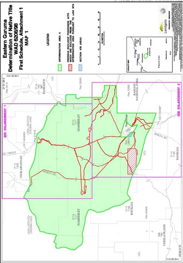
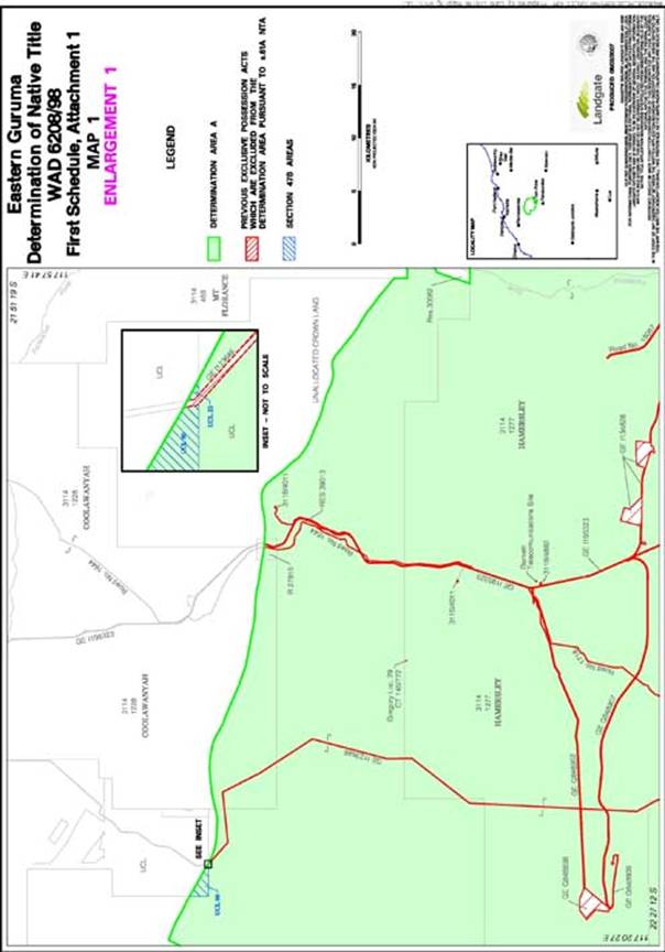
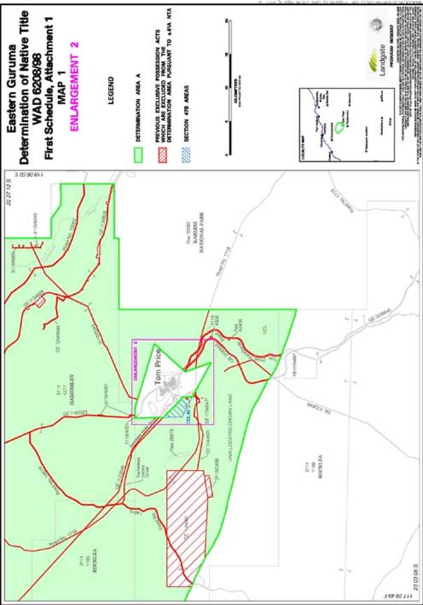
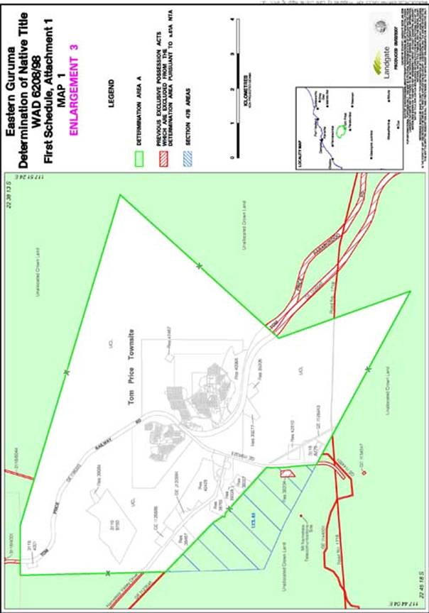
1. The Eastern Guruma Determination Area A ("Determination Area A") is the land and waters within the external boundary described in the First Schedule and depicted on the maps at Attachment 1 to the First Schedule other than the exclusions from the area as described in the First Schedule. In the event of any inconsistency between the written description in Schedule 1 and the areas depicted on the maps at Attachment 1, the written description prevails.
2. Native title exists in relation to Determination Area A.
3. The native title rights and interests are held by the persons described in the Third Schedule ("native title holders").
4. Subject to paragraphs 5 to 10:
(1) the nature and extent of the native title rights and interests held by the native title holders are non-exclusive rights to:
(a) enter and remain on the land, camp, erect temporary shelters, and travel over and visit any part of the land and waters;
(b) hunt, fish, gather or take and to use, share and exchange the resources of the land and waters such as food, water and medicinal plants and trees, timber, charcoal, ochre, stone and other traditional resources (excluding minerals);
(c) engage in ritual and ceremony on and in relation to the land and waters; and
(d) care for, maintain and protect from physical harm, particular objects, sites and areas of significance to the native title holders.
(2) The native title rights and interests set out in sub-paragraph (1) are exercisable in accordance with the traditional laws and customs of the native title holders for personal, domestic and non-commercial communal purposes (including social, medicinal, cultural, religious, spiritual and ceremonial purposes).
(3) The native title rights and interests set out in sub-paragraph (1) do not confer:
(a) possession, occupation, use and enjoyment on the native title holders to the exclusion of all others; nor
(b) a right to control the access of others to the land and waters of Determination Area A.
5. Notwithstanding anything in this determination the native title rights and interests include the right to take and use ochre to the extent that ochre is not a mineral pursuant to the Mining Act 1904 (WA), but do not include other minerals and petroleum as defined in the Mining Act 1904 (WA), Mining Act 1978 (WA), the Petroleum Act 1936 (WA) and the Petroleum Act 1967 (WA).
6. Section 47B of the Native Title Act 1993 (Cth) applies with the effect that any prior extinguishment in relation to the areas described in the Fourth Schedule is to be disregarded.
7. The native title rights and interests are subject to and exercisable in accordance with the laws of the State and the Commonwealth including the common law.
8. The nature and extent of other rights and interests in relation to Determination Area A in existence at the date of this determination are those set out in the Second Schedule.
9. The relationship between the native title rights and interests described in sub-paragraph 4(1) and the other rights and interests referred to in paragraph 8 ("the other rights and interests") is that:
(1) to the extent that any of the other rights and interests is inconsistent with the continued existence, enjoyment or exercise of the native title rights and interests, the native title rights and interests continue to exist in their entirety, but the native title rights and interests have no effect in relation to the other rights and interests to the extent of the inconsistency during the currency of the other rights and interests; and otherwise,
(2) the existence and exercise of the native title rights and interests do not prevent the doing of any activity required or permitted to be done by or under the other rights and interests, and the other rights and interests, and the doing of any activity required or permitted to be done by or under the other rights and interests, prevail over the native title rights and interests and any exercise of the native title rights and interests, but do not extinguish them.
10. Nothing in paragraph 9 is intended to affect the operation of Part F of the Hamersley Iron Pty Ltd – Eastern Guruma Indigenous Land Use Agreement (Area Agreement) ("ILUA") dated 27 November 2002 and registered on the Register of Indigenous Land Use Agreements on 5 March 2004 (Tribunal No. WI01/1). For the avoidance of doubt, to the extent that the native title rights and interests co-exist with the "Agreed Interests" in the "Agreement Area" (as those terms are defined in the ILUA), the native title rights and interests can only be exercised in a manner that is consistent with the ILUA.
FIRST SCHEDULE
DESCRIPTION OF DETERMINATION AREA A
Determination Area A, shown on Attachment 1 to this Schedule, comprises all of the land and waters bounded by the following description of the External Boundaries, except those areas described in this Schedule under the headings "Internal Boundaries" and "Exclusions from Determination Area A".
External Boundaries
Commencing at the intersection of Latitude 22.705647 South and Longitude 117.334829Eastand extending generally northwesterly, generally northeasterly and generally southeasterly passing through the following coordinate positions:
| LATITUDE (SOUTH) | LONGITUDE (EAST) |
| 22.700554 | 117.333330 |
| 22.696324 | 117.332070 |
| 22.691344 | 117.329640 |
| 22.684674 | 117.325919 |
| 22.678464 | 117.322629 |
| 22.673354 | 117.319819 |
| 22.667144 | 117.316349 |
| 22.662154 | 117.312669 |
| 22.657734 | 117.309169 |
| 22.652494 | 117.304369 |
| 22.644944 | 117.300039 |
| 22.638644 | 117.298309 |
| 22.628284 | 117.295499 |
| 22.621864 | 117.294208 |
| 22.616954 | 117.293578 |
| 22.610474 | 117.292718 |
| 22.605384 | 117.291408 |
| 22.600404 | 117.289228 |
| 22.596864 | 117.287528 |
| 22.591664 | 117.286838 |
| 22.587434 | 117.285828 |
| 22.581874 | 117.283088 |
| 22.574504 | 117.278878 |
| 22.566604 | 117.274298 |
| 22.560054 | 117.271268 |
| 22.550894 | 117.266888 |
| 22.544814 | 117.264778 |
| 22.536354 | 117.260958 |
| 22.528474 | 117.257377 |
| 22.522394 | 117.256137 |
| 22.516374 | 117.254397 |
| 22.513194 | 117.253757 |
| 22.509614 | 117.253167 |
| 22.507244 | 117.252767 |
| 22.504524 | 117.252237 |
| 22.502154 | 117.251767 |
| 22.499434 | 117.251487 |
| 22.496664 | 117.250897 |
| 22.493654 | 117.250677 |
| 22.490544 | 117.250777 |
| 22.487254 | 117.251007 |
| 22.482754 | 117.251807 |
| 22.479074 | 117.253658 |
| 22.475803 | 117.255998 |
| 22.472593 | 117.257658 |
| 22.466723 | 117.260279 |
| 22.462873 | 117.261879 |
| 22.457243 | 117.264999 |
| 22.453613 | 117.266229 |
| 22.449293 | 117.267649 |
| 22.446133 | 117.268429 |
| 22.442093 | 117.268730 |
| 22.437003 | 117.268290 |
| 22.432133 | 117.265920 |
| 22.428413 | 117.262599 |
| 22.425433 | 117.258589 |
| 22.422613 | 117.253199 |
| 22.420713 | 117.247179 |
| 22.418753 | 117.241159 |
| 22.416394 | 117.235208 |
| 22.413974 | 117.229638 |
| 22.412654 | 117.224048 |
| 22.410804 | 117.218147 |
| 22.408735 | 117.211947 |
| 22.408355 | 117.208146 |
| 22.407785 | 117.203296 |
| 22.407656 | 117.194576 |
| 22.406606 | 117.187426 |
| 22.405096 | 117.179476 |
| 22.403776 | 117.173886 |
| 22.402156 | 117.167916 |
| 22.400306 | 117.161096 |
| 22.398856 | 117.154065 |
| 22.397516 | 117.146046 |
| 22.396186 | 117.139026 |
| 22.394756 | 117.133686 |
| 22.392155 | 117.128056 |
| 22.389805 | 117.122656 |
| 22.388535 | 117.116756 |
| 22.389036 | 117.108155 |
| 22.389826 | 117.099425 |
| 22.391486 | 117.091555 |
| 22.392356 | 117.085315 |
| 22.392277 | 117.077035 |
| 22.392367 | 117.067315 |
| 22.392307 | 117.060905 |
| 22.390757 | 117.055445 |
| 22.388697 | 117.050735 |
| 22.386397 | 117.045405 |
| 22.383177 | 117.040515 |
| 22.380197 | 117.037005 |
| 22.377117 | 117.033925 |
| 22.372407 | 117.030995 |
| 22.366897 | 117.027695 |
| 22.363527 | 117.025745 |
| 22.359997 | 117.024225 |
| 22.357207 | 117.021895 |
| 22.354057 | 117.018505 |
| 22.350267 | 117.014995 |
| 22.346717 | 117.011305 |
| 22.341247 | 117.006696 |
| 22.332977 | 117.004546 |
| 22.325246 | 117.005446 |
| 22.319716 | 117.006576 |
| 22.316256 | 117.007056 |
| 22.310496 | 117.008486 |
| 22.306296 | 117.009976 |
| 22.302036 | 117.012017 |
| 22.297375 | 117.014127 |
| 22.291285 | 117.016317 |
| 22.286275 | 117.018307 |
| 22.281555 | 117.019607 |
| 22.277064 | 117.021157 |
| 22.270554 | 117.022727 |
| 22.265414 | 117.022977 |
| 22.261083 | 117.022587 |
| 22.255533 | 117.021537 |
| 22.248243 | 117.019317 |
| 22.243203 | 117.017877 |
| 22.238113 | 117.016876 |
| 22.235973 | 117.016596 |
| 22.231352 | 117.016086 |
| 22.227252 | 117.015696 |
| 22.222802 | 117.015006 |
| 22.221873 | 117.014791 |
| 22.220969 | 117.016828 |
| 22.219019 | 117.018327 |
| 22.216021 | 117.020127 |
| 22.215271 | 117.022826 |
| 22.215571 | 117.025075 |
| 22.215421 | 117.026425 |
| 22.214371 | 117.028974 |
| 22.213022 | 117.031973 |
| 22.213320 | 117.034222 |
| 22.214520 | 117.036171 |
| 22.216469 | 117.039920 |
| 22.216769 | 117.042619 |
| 22.216619 | 117.045318 |
| 22.213770 | 117.048317 |
| 22.209722 | 117.051166 |
| 22.206573 | 117.052216 |
| 22.203424 | 117.053715 |
| 22.202524 | 117.056265 |
| 22.202075 | 117.059414 |
| 22.202824 | 117.062113 |
| 22.204174 | 117.063762 |
| 22.205973 | 117.065711 |
| 22.208672 | 117.069460 |
| 22.210621 | 117.073058 |
| 22.211221 | 117.077857 |
| 22.211071 | 117.082655 |
| 22.212121 | 117.086704 |
| 22.213920 | 117.090003 |
| 22.214520 | 117.092852 |
| 22.216619 | 117.095701 |
| 22.218269 | 117.097050 |
| 22.220222 | 117.100937 |
| 22.209805 | 117.106227 |
| 22.202459 | 117.107707 |
| 22.194499 | 117.108363 |
| 22.184443 | 117.109553 |
| 22.174179 | 117.110857 |
| 22.166156 | 117.111048 |
| 22.156822 | 117.113840 |
| 22.150839 | 117.115724 |
| 22.146221 | 117.117609 |
| 22.141414 | 117.118906 |
| 22.136307 | 117.121729 |
| 22.129313 | 117.123675 |
| 22.121760 | 117.124385 |
| 22.113248 | 117.125660 |
| 22.108900 | 117.129344 |
| 22.105642 | 117.135853 |
| 22.104939 | 117.144671 |
| 22.103383 | 117.147342 |
| 22.100838 | 117.153263 |
| 22.097182 | 117.159694 |
| 22.092215 | 117.166353 |
| 22.088563 | 117.176706 |
| 22.086138 | 117.188310 |
| 22.084678 | 117.200028 |
| 22.084040 | 117.211778 |
| 22.082129 | 117.221886 |
| 22.077935 | 117.229913 |
| 22.072144 | 117.236299 |
| 22.064936 | 117.241509 |
| 22.057633 | 117.249382 |
| 22.052635 | 117.256706 |
| 22.047173 | 117.265259 |
| 22.042482 | 117.271821 |
| 22.041632 | 117.277535 |
| 22.040094 | 117.283998 |
| 22.039728 | 117.286431 |
| 22.037543 | 117.295748 |
| 22.034773 | 117.303681 |
| 22.032779 | 117.311913 |
| 22.032139 | 117.320558 |
| 22.031913 | 117.325380 |
| 22.028705 | 117.329889 |
| 22.023323 | 117.333139 |
| 22.015178 | 117.339913 |
| 22.009426 | 117.343064 |
| 22.004443 | 117.345337 |
| 22.003438 | 117.346277 |
| 22.005342 | 117.351166 |
| 22.008242 | 117.358606 |
| 22.010242 | 117.363066 |
| 22.013172 | 117.368136 |
| 22.016702 | 117.374947 |
| 22.020522 | 117.382877 |
| 22.023632 | 117.387947 |
| 22.025502 | 117.391167 |
| 22.027852 | 117.395497 |
| 22.031552 | 117.401927 |
| 22.035362 | 117.408867 |
| 22.039002 | 117.415047 |
| 22.041762 | 117.420247 |
| 22.044232 | 117.425947 |
| 22.045662 | 117.430727 |
| 22.046822 | 117.437127 |
| 22.047332 | 117.443357 |
| 22.047632 | 117.450137 |
| 22.047852 | 117.455677 |
| 22.047662 | 117.459797 |
| 22.046272 | 117.465667 |
| 22.044992 | 117.471228 |
| 22.043491 | 117.477658 |
| 22.042721 | 117.482768 |
| 22.041711 | 117.491509 |
| 22.041191 | 117.498429 |
| 22.040731 | 117.504720 |
| 22.041101 | 117.507710 |
| 22.041071 | 117.510140 |
| 22.042121 | 117.517790 |
| 22.043921 | 117.526170 |
| 22.046761 | 117.533050 |
| 22.049511 | 117.537510 |
| 22.052921 | 117.543820 |
| 22.055811 | 117.551451 |
| 22.059181 | 117.559571 |
| 22.062481 | 117.567380 |
| 22.066901 | 117.577290 |
| 22.070571 | 117.587460 |
| 22.074001 | 117.597010 |
| 22.075951 | 117.607580 |
| 22.078431 | 117.620440 |
| 22.080551 | 117.631320 |
| 22.082131 | 117.640451 |
| 22.082551 | 117.648361 |
| 22.082781 | 117.654521 |
| 22.083301 | 117.661121 |
| 22.084101 | 117.666281 |
| 22.085181 | 117.671000 |
| 22.086331 | 117.676780 |
| 22.087071 | 117.683000 |
| 22.087931 | 117.687970 |
| 22.088431 | 117.692140 |
| 22.089691 | 117.698170 |
| 22.090431 | 117.703020 |
| 22.091061 | 117.709240 |
| 22.091401 | 117.714840 |
| 22.091701 | 117.722119 |
| 22.091371 | 117.730219 |
| 22.090781 | 117.735769 |
| 22.089231 | 117.742329 |
| 22.088541 | 117.749009 |
| 22.088531 | 117.754739 |
| 22.089721 | 117.758329 |
| 22.092592 | 117.763159 |
| 22.098292 | 117.768009 |
| 22.103002 | 117.771689 |
| 22.105562 | 117.773719 |
| 22.107942 | 117.775439 |
| 22.111612 | 117.778759 |
| 22.118072 | 117.784719 |
| 22.121492 | 117.786919 |
| 22.124642 | 117.790439 |
| 22.128912 | 117.796549 |
| 22.130902 | 117.799579 |
| 22.133492 | 117.805159 |
| 22.137042 | 117.813899 |
| 22.140102 | 117.820589 |
| 22.142633 | 117.826599 |
| 22.144663 | 117.833799 |
| 22.146693 | 117.840999 |
| 22.149003 | 117.847889 |
| 22.151063 | 117.852349 |
| 22.152893 | 117.855879 |
| 22.153863 | 117.861409 |
| 22.154023 | 117.866389 |
| 22.153422 | 117.870759 |
| 22.153472 | 117.875799 |
| 22.156582 | 117.881618 |
| 22.159852 | 117.885318 |
| 22.163702 | 117.890258 |
| 22.167732 | 117.895248 |
| 22.170882 | 117.898887 |
| 22.173512 | 117.902597 |
| 22.177081 | 117.907657 |
| 22.179541 | 117.912057 |
| 22.182361 | 117.916626 |
| 22.185871 | 117.922066 |
| 22.190131 | 117.927126 |
| 22.193111 | 117.931136 |
| 22.196440 | 117.935705 |
| 22.200580 | 117.940585 |
| 22.203500 | 117.943905 |
| 22.206480 | 117.947795 |
Thence southeasterly to the intersection of a western boundary of pastoral lease 3114/465 (Mount Florance) with Latitude 22.210019 South. Thence southerly and easterly along the boundaries of that pastoral lease, to Longitude 117.966611 East. Thence generally southeasterly through the following coordinate points:
| LATITUDE (SOUTH) | LONGITUDE (EAST) |
| 22.224921 | 117.969875 |
| 22.229931 | 117.974365 |
Thence southeasterly to the intersection of a western boundary of reserve 30082 (Karijini National Park) with Latitude 22.230431 South. Thence generally southwesterly and easterly along the boundaries of that reserve to Longitude 118.016010 East. Thence generally southwesterly to Latitude 22.283661 South, Longitude 118.018147 East. Thence southeasterly to the intersection of a western boundary of reserve 30082 (Karijini National Park) with Latitude 22.288220 South. Thence southerly, westerly and again southerly along boundaries of that reserve to Latitude 22.347871 South. Thence generally southwesterly and generally southeasterly through the following coordinate points:
| LATITUDE (SOUTH) | LONGITUDE (EAST) |
| 22.347891 | 118.002685 |
| 22.348850 | 117.999755 |
| 22.350791 | 117.997545 |
| 22.354361 | 117.996015 |
| 22.357921 | 117.994535 |
| 22.361091 | 117.993505 |
| 22.364491 | 117.993275 |
| 22.367561 | 117.994486 |
| 22.370531 | 117.996946 |
| 22.373621 | 118.000266 |
Thence southeasterly to the intersection of a western boundary of reserve 30082 (Karijini National Park) with Latitude 22.375657 South. Thence southerly and easterly along boundaries of that reserve to Longitude 118.030827 East. Thence generally southeasterly and generally easterly through the following coordinate points:
| LATITUDE (SOUTH) | LONGITUDE (EAST) |
| 22.524335 | 118.036370 |
| 22.527665 | 118.041000 |
| 22.530885 | 118.045260 |
| 22.533405 | 118.049721 |
| 22.534596 | 118.053501 |
| 22.535056 | 118.059971 |
| 22.534706 | 118.066461 |
| 22.534256 | 118.073311 |
| 22.534026 | 118.079861 |
Thence easterly to the intersection of a western boundary of reserve 30082 (Karijini National Park) with Latitude 22.533953 South. Thence southerly, generally westerly and again southerly along the boundaries of that reserve to Latitude 22.874031 South. Thence generally northwesterly and generally southwesterly through the following coordinate points:
| LATITUDE (SOUTH) | LONGITUDE (EAST) |
| 22.872848 | 117.895783 |
| 22.872428 | 117.894094 |
| 22.872362 | 117.892391 |
| 22.869444 | 117.884162 |
| 22.867949 | 117.879101 |
| 22.865819 | 117.872927 |
| 22.863668 | 117.866186 |
| 22.861392 | 117.859259 |
| 22.858231 | 117.850849 |
| 22.855358 | 117.843755 |
| 22.853478 | 117.837951 |
| 22.850170 | 117.828789 |
| 22.847709 | 117.823195 |
| 22.845624 | 117.818156 |
| 22.843553 | 117.813495 |
| 22.839014 | 117.806083 |
| 22.834275 | 117.799625 |
| 22.832558 | 117.797982 |
| 22.829080 | 117.790531 |
| 22.824865 | 117.782349 |
| 22.822440 | 117.777701 |
| 22.819994 | 117.772485 |
| 22.815196 | 117.764514 |
| 22.811386 | 117.757643 |
| 22.808896 | 117.751293 |
| 22.806243 | 117.743812 |
| 22.804902 | 117.739693 |
| 22.803023 | 117.733888 |
| 22.802190 | 117.730698 |
| 22.802154 | 117.729752 |
| 22.800009 | 117.723200 |
| 22.798816 | 117.716802 |
| 22.796200 | 117.707235 |
| 22.795066 | 117.702352 |
| 22.792377 | 117.693925 |
| 22.789761 | 117.684359 |
| 22.788155 | 117.676459 |
| 22.786248 | 117.666867 |
| 22.784317 | 117.659738 |
| 22.782056 | 117.650159 |
| 22.780803 | 117.645279 |
| 22.778976 | 117.637768 |
| 22.777098 | 117.631964 |
| 22.774828 | 117.622196 |
| 22.773156 | 117.612595 |
| 22.770828 | 117.604344 |
| 22.769458 | 117.599469 |
| 22.767948 | 117.594030 |
| 22.765376 | 117.585598 |
| 22.763483 | 117.579416 |
| 22.760034 | 117.572721 |
| 22.756461 | 117.565842 |
| 22.754766 | 117.561736 |
| 22.750241 | 117.554702 |
| 22.745835 | 117.547664 |
| 22.743735 | 117.545279 |
| 22.742305 | 117.541921 |
| 22.738208 | 117.533733 |
| 22.735703 | 117.530036 |
| 22.732985 | 117.523883 |
| 22.730796 | 117.519227 |
| 22.727974 | 117.513457 |
| 22.724813 | 117.505047 |
| 22.721593 | 117.498155 |
| 22.720554 | 117.495730 |
| 22.718800 | 117.493142 |
| 22.716346 | 117.487737 |
| 22.714268 | 117.482887 |
| 22.711653 | 117.473321 |
| 22.709163 | 117.466971 |
| 22.707321 | 117.462112 |
| 22.703725 | 117.451634 |
| 22.701787 | 117.444316 |
| 22.700292 | 117.439256 |
| 22.697301 | 117.429134 |
| 22.696969 | 117.426684 |
| 22.695540 | 117.423326 |
| 22.694258 | 117.417689 |
| 22.690611 | 117.405887 |
| 22.688371 | 117.396875 |
| 22.686456 | 117.390125 |
| 22.685167 | 117.381268 |
| 22.684607 | 117.375984 |
| 22.684570 | 117.375038 |
| 22.685639 | 117.369126 |
| 22.687747 | 117.365639 |
| 22.693010 | 117.358248 |
| 22.698162 | 117.351051 |
| 22.701198 | 117.347151 |
| 22.702798 | 117.345766 |
| 22.703690 | 117.344408 |
| 22.704324 | 117.342490 |
| 22.705577 | 117.335245 |
And thence southwesterly back to the commencement point.
Internal Boundaries (Tom Price townsite)
Determination Area A does not include Tom Price townsite, being all that portion of land bounded by lines starting from the northwestern corner of the northwestern severance of Gregory Location 26 and extending easterly along the northern boundary of that severance and onwards to the westernmost, northwestern corner of the northeastern severance of location 26. Thence easterly, southeasterly and southwesterly along boundaries of that severance and onwards to the easternmost, northeastern corner of the southeastern severance of location 26. Thence southwesterly, southeasterly and northwesterly along boundaries of that severance and onwards to the southernmost corner of a southwestern severance of location 26. Thence northwesterly along the southwestern boundary of that severance to the southernmost corner of the western severance of lot 36, as shown on Department of Land Information Deposited Plan 51845. Thence northwesterly along the southwestern boundary of that severance and onwards to a western boundary of Gregory location 9, as shown on Department of Land Information Deposited Plan 216332. Thence generally northerly along boundaries of that location to the southernmost, southeastern corner of Gregory location 57, as shown on Department of Land Information Deposited Plan 216345. Thence generally northwesterly, westerly, northerly, again generally northwesterly and again northerly along boundaries of that location to the southwestern corner of a western severance of location 26. Thence northerly along the western boundary of that severance and onwards to and along the western boundary of the northwestern severance of that location back to the commencement point.
Notes:
1. Geographic Coordinates provided in Decimal Degrees
2.Cadastral boundaries sourced from Landgate
3.Spatial cadastral data dated January 2007
4.Datum: Geocentric Datum of Australia (1994)
5.Prepared by Land Claims Mapping Unit (Landgate), 6 February 2007
EXCLUSIONS FROM DETERMINATION AREA A
The following areas, having been excluded from the native title determination application, are excluded from Determination Area A in accordance with section 61A of the Native Title Act 1993 (Cth) (and section 23C of the Native Title Act 1993 (Cth), and section 12I and 12J of the Titles (Validation) and Native Title (Effect of Past Acts) Act 1995 (WA)) because they are areas where previous exclusive possession acts have occurred and native title has been completely extinguished in relation to the whole of these areas. With the exception of those public works which are captured by the definition at paragraph 6 of this Schedule, all of the following areas are hatched in red on the maps at Attachment 1 to the First Schedule:
1. Freehold
(a) Gregory Location 29 (CT 145/772).
2. Vested Reserves
(a) Reserve 39013 (Gregory Location 47) for the purpose of a repeater station site vested pursuant to section 33 of the Land Act 1933 (WA) in the Australian Telecommunications Commissions on 9 August 1991;
(b) Reserve 39204 (Gregory Location 52) for the purpose of a pistol club and range vested pursuant to section 33 of the Land Act 1933 (WA) in the Shire of West Pilbara on 20 September 1985, and re-vested in the Shire of Ashburton for the purpose of "recreation – archery" on 19 April 1991; and
(c) Reserve 42406 (Gregory Location 93) for the purpose of soil extraction vested pursuant to section 33 of the Land Act 1933 (WA) in the Shire of Ashburton on 27 November 1992.
3. Special Leases
(a) Special Lease 3116/3466 granted on 4 November 1966 pursuant to section 116 of the Land Act 1933 (WA) and the Iron Ore (Hamersley Range) Agreement Act 1963-1964 for the special purpose of the construction, operation and use of an aerodrome;
(b) Special Lease 3116/3467 (GE I144501) granted on 4 November 1966 pursuant to section 116 of the Land Act 1933 (WA) and the Iron Ore (Hamersley Range) Agreement Act 1963-1964 for the special purpose of boring for, conserving, reticulating and drawing water;
(c) Special Lease 3116/4001 granted on 31 March 1969 pursuant to section 116 of the Land Act 1933 (WA) and the Iron Ore (Hamersley Range) Agreement Act 1963-1964for the special purpose of ballast stockpile sites;
(d) Special Lease 3116/4011 granted on 18 September 1969 pursuant to section 116 of the Land Act 1933 (WA) and the Iron Ore (Hamersley Range) Agreement Act 1963-1964for the special purpose of radio communications and ancillary installations and facilities;
(e) Special Lease 3116/4592 (GE I206646) granted on 15 November 1974 pursuant to section 116 of the Land Act 1933 (WA) and the Iron Ore (Hamersley Range) Agreement Act 1963-1972 for the special purpose of a railway and associated works;
(f) Special Lease 3116/4595 granted on 29 April 1974 pursuant to section 116 of the Land Act 1933 (WA) and the Iron Ore (Hamersley Range) Agreement Act 1963-1972 for the special purpose of a quarry for the production of road metal and railway ballast;
(g) Special Lease 3116/4892 granted on 11 February 1972 pursuant to section 116 of the Land Act 1933 (WA) and the Iron Ore (Hamersley Range) Agreement Act 1963-1964 for the special purpose of permanent campsites for use in connection with the railway;
(h) Special Lease 3116/4984 (GE I195323) granted on or about 21 October 1975 pursuant to section 116 of the Land Act 1933 (WA) and the Iron Ore (Hamersley Range) Agreement Act 1963-1972 for the special purpose of a railway and associated works;
(i) Special Lease 3116/6044 granted on 13 September 1977 pursuant to section 116 of the Land Act 1933 (WA) and the Iron Ore (Hamersley Range) Agreement Act 1963-1968 for the special purpose of water pipes and power lines from bore to Tom Price townsite;
(j) Special Lease 3116/6045 granted on 13 September 1977 pursuant to section 116 of the Land Act 1933 (WA) and the Iron Ore (Hamersley Range) Agreement Act 1963-1968 for the special purpose of boring for, and conserving, reticulating and drawing water;
(k) Special Lease 3116/6868 granted on 28 May 1981 pursuant to section 116 of the Land Act 1933 (WA) and the Iron Ore (Hamersley Range) Agreement Act 1963-1979 for the special purpose of boring for, conserving, reticulating and drawing water;
(l) Special Lease 3116/7842 (GE I123646) granted on 8 March 1984 pursuant to section 116 of the Land Act 1933 (WA) and the Iron Ore (Hamersley Range) Agreement Act 1963-1982 for the special purpose of a power transmission line between Dampier, Tom Price and Paraburdoo and control equipment on an access track;
(m) Special Lease 3116/11603 (GE I134647) granted on 18 September 1995 pursuant to section 116 of the Land Act 1933 (WA) and the Iron Ore (Hamersley Range) Agreement Act 1963 for the special purpose of a bulk fuel depot and associated works and operations;
(n) Special Lease 3116/11805 (GE G848907) granted on 15 February 1998 pursuant to section 116 of the Land Act 1933 (WA) and the Iron Ore (Hamersley Range) Agreement Act 1963 for the special purpose of a railway spurline and railway and associated facilities;
(o) Special Lease 3116/11806 (GE G848909) granted on 15 February 1998 pursuant to section 116 of the Land Act 1933 (WA) and the Iron Ore (Hamersley Range) Agreement Act 1963 for the special purpose of a communications tower and railway and associated facilities;
(p) Special Lease 3116/11807 (GE G848902) granted on 15 February 1998 pursuant to section 116 of the Land Act 1933 (WA) and the Iron Ore (Hamersley Range) Agreement Act 1963for the special purpose of access roads and railway and associated facilities;
(q) Special Lease 3116/11808 (GE G848898) granted on 15 February 1998 pursuant to section 116 of the Land Act 1933 (WA) and the Iron Ore (Hamersley Range) Agreement Act 1963for the special purpose of a campsite and services corridor, railway and associated facilities;
(r) Special Lease 3116/11869 (GE I134828) granted on 13 August 1997 pursuant to section 116 of the Land Act 1933 (WA) and the Iron Ore (Hamersley Range) Agreement Act 1963 for the special purpose of the development, construction, provision, upgrading, operation and use of a railway power transmission line and communications system and associated facilities including borrow pits; and
(s) Special Lease 3116/11913 (GE G848899) granted on 15 February 1998 pursuant to section 116 of the Land Act 1933 (WA) and the Iron Ore (Hamersley Range) Agreement Act 1963 for the special purpose of the construction, development, maintenance, use and operation of Communication Repeater Station 830 including access road thereto and ancillary installations and facilities.
4. Dedicated roads and roads set aside, taken or resumed
(a) Road No.1644 (with a width of 20.12 metres) set aside, taken, or resumed under section 17 of the Public Works Act 1902 (WA), gazetted on 31 July 1903, p.1963;
(b) Road No.1718 (with a width of 20.12 metres) set aside, taken, or resumed under section 17 of the Public Works Act 1902 (WA), gazetted on 18 December 1903, p.3310;
(c) Road No.14619 (with a width of 100.6 metres) dedicated pursuant to section 288 of the Local Government Act 1960 (WA), gazetted on 3 March 1972, p.489;
(d) Road No.15057 (with a width of 100.58 metres) dedicated pursuant to section 288 of the Local Government Act 1960 (WA), gazetted on 14 March 1975, p.875;
(e) Public Road (Tom Price Paraburdoo Road) dedicated pursuant to section 56 of the Land Administration Act 1997 (WA), marked on Deposited Plans No.242848 and 242851; and
(f) Road No.1644 (Nameless Valley Drive), (with a width of 20.12 metres) dedicated at common law and, marked on Miscellaneous Plan 470 sheet 2.
5. Telecommunications Facilities
The following sites on which public works, as that expression is defined in the Native Title Act 1993 (Cth), have been constructed:
(a) Barnett Telecommunications Site, being a rectangular area of 500m2 (25m x 20m), the station mark of which is located approximately at Longitude 117°40'23.96" Latitude 22°20'28.99"; and
(b) Mt Nameless Telecommunications Site, being a square shaped area of 8,361m2 (91.44m x 91.44m), the station mark of which is located approximately at Longitude 117°45'37.51" Latitude 22°43'12.40".
6. Public Works
Any public works as that expression is defined in the Native Title Act 1993 (Cth) and the Titles (Validation) and Native Title (Effect of Past Acts) Act 1995 (WA) within the external boundary of Determination Area A including the land and waters defined in section 251D of the Native Title Act 1993 (Cth), are excluded from Determination Area A.
FIRST SCHEDULE – ATTACHMENT 1
MAPS SHOWING DETERMINATION AREA A,
EXCLUSIONS FROM DETERMINATION AREA A,
AND AREAS TO WHICH SECTION 47B OF THE NATIVE TITLE ACT 1993 (CTH) APPLIES
SECOND SCHEDULE
The nature and extent of other rights and interests in relation to Determination Area A are:
1. Reserves
The interests of persons who have the care, control and management of the following reserves, and the interests of persons entitled to access and use these reserves for the respective purposes for which they are reserved, subject to any statutory limitations upon those rights:
(a) Reserve 27915 (Gregory Location 3) for the purpose of a resting place for travellers and stock; and
(b) Reserve 29879 (Gregory Location 18) for the purpose of a rifle range.
2. Pastoral Leases
The rights and interests of the holders from time to time of the following pastoral leases:
(a) pastoral lease 3114/1166 being Rocklea Station;
(b) pastoral lease 3114/1228 being Coolawanyah Station; and
(c) pastoral lease 3114/1277 being Hamersley Station.
3. Mining Tenements
The interests of the holders of the following mining tenements granted under the Mining Act 1978 (WA):
(a) Mining Leases
| Tenement ID | Holder | Date Granted |
| M47/193 | Aradon Pty Ltd | 18.11.1988 |
| M47/194 | Barry Neil Kayes and National Gemstones Australia Pty Ltd | 16.12.1988 |
| M47/299 | Rinker Australia Pty Ltd | 24.12.1992 |
| M47/369 | Hamersley Iron Pty Ltd | 29.09.1995 |
| M47/370 | Hamersley Iron Pty Ltd | 29.09.1995 |
| M47/371 | Hamersley Iron Pty Ltd | 29.09.1995 |
| M47/372 | Hamersley Iron Pty Ltd | 29.09.1995 |
| M47/459 | Cape Lambert Iron Associates, Mitsui Iron Ore Development Pty Ltd, North Mining Ltd, Pannawonica Iron Associates and Robe River Mining Co Pty Ltd | 09.06.2000 |
| M47/460 | Cape Lambert Iron Associates, Mitsui Iron Ore Development Pty Ltd, North Mining Ltd, Pannawonica Iron Associates and Robe River Mining Co Pty Ltd | 09.06.2000 |
| M47/461 | Cape Lambert Iron Associates, Mitsui Iron Ore Development Pty Ltd, North Mining Ltd, Pannawonica Iron Associates and Robe River Mining Co Pty Ltd | 09.06.2000 |
(b) General Purpose Leases
| Tenement | Holder | Date Granted |
| G47/1226 | Hamersley Iron Pty Ltd | 16.08.2005 |
| G47/1228 | Hamersley Iron Pty Ltd | 16.08.2005 |
(c) Miscellaneous Licences
| Tenement ID | Holder | Date Granted |
| L47/18 | Hamersley Iron Pty Ltd and Hamersley Resources Ltd | 22.01.1992 |
| L47/19
| Hamersley Iron Pty Ltd and Hamersley Resources Ltd | 22.01.1992 |
| L47/48 | Cape Lambert Iron Associates, Mitsui Iron Ore Development Pty Ltd, North Mining Ltd, Pannawonica Iron Associates and Robe River Mining Co Pty Ltd | 05.09.2000 |
| L47/49 | Cape Lambert Iron Associates, Mitsui Iron Ore Development Pty Ltd, North Mining Ltd, Pannawonica Iron Associates and Robe River Mining Co Pty Ltd | 05.09.2000 |
| L47/64 | Cape Lambert Iron Associates, Mitsui Iron Ore Development Pty Ltd, North Mining Ltd, Pannawonica Iron Associates and Robe River Mining Co Pty Ltd | 05.09.2000 |
| L47/65 | Cape Lambert Iron Associates, Mitsui Iron Ore Development Pty Ltd, North Mining Ltd, Pannawonica Iron Associates and Robe River Mining Co Pty Ltd | 05.09.2000 |
| L47/66 | Cape Lambert Iron Associates, Mitsui Iron Ore Development Pty Ltd, North Mining Ltd, Pannawonica Iron Associates and Robe River Mining Co Pty Ltd | 05.09.2000 |
| L47/79 | Cape Lambert Iron Associates, Mitsui Iron Ore Development Pty Ltd, North Mining Ltd, Pannawonica Iron Associates and Robe River Mining Co Pty Ltd | 05.09.2000 |
| L47/82 | Cape Lambert Iron Associates, Mitsui Iron Ore Development Pty Ltd, North Mining Ltd, Pannawonica Iron Associates and Robe River Mining Co Pty Ltd | 05.09.2000 |
| L47/83 | Cape Lambert Iron Associates, Mitsui Iron Ore Development Pty Ltd, North Mining Ltd, Pannawonica Iron Associates and Robe River Mining Co Pty Ltd | 05.09.2000 |
| L47/84 | Cape Lambert Iron Associates, Mitsui Iron Ore Development Pty Ltd, North Mining Ltd, Pannawonica Iron Associates and Robe River Mining Co Pty Ltd | 05.09.2000 |
| L47/86 | Cape Lambert Iron Associates, Mitsui Iron Ore Development Pty Ltd, North Mining Ltd, Pannawonica Iron Associates and Robe River Mining Co Pty Ltd | 05.09.2000 |
| L47/89 | Cape Lambert Iron Associates, Mitsui Iron Ore Development Pty Ltd, North Mining Ltd, Pannawonica Iron Associates and Robe River Mining Co Pty Ltd | 05.09.2000 |
| L47/100 | Hamersley Iron – Yandi Pty Ltd | 08.10.2001 |
| L47/121 | Cape Lambert Iron Associates, Mitsui Iron Ore Development Pty Ltd, North Mining Ltd, Pannawonica Iron Associates and Robe River Mining Co Pty Ltd | 20.05.2004 |
| L47/122 | Cape Lambert Iron Associates, Mitsui Iron Ore Development Pty Ltd, North Mining Ltd, Pannawonica Iron Associates and Robe River Mining Co Pty Ltd | 20.05.2004 |
| L47/127 | Cape Lambert Iron Associates, Mitsui Iron Ore Development Pty Ltd, North Mining Ltd, Pannawonica Iron Associates and Robe River Mining Co Pty Ltd | 07.05.2004 |
| L47/128 | Cape Lambert Iron Associates, Mitsui Iron Ore Development Pty Ltd, North Mining Ltd, Pannawonica Iron Associates and Robe River Mining Co Pty Ltd | 07.05.2004 |
| L47/129 | Cape Lambert Iron Associates, Mitsui Iron Ore Development Pty Ltd, North Mining Ltd, Pannawonica Iron Associates and Robe River Mining Co Pty Ltd | 20.05.2004 |
| L47/136 | Hamersley Iron Pty Ltd | 11.03.2005 |
| L47/137 | Hamersley Iron Pty Ltd | 09.06.2005 |
| L47/139 | Hamersley Iron Pty Ltd | 25.05.2005 |
| L47/140 | Hamersley Iron Pty Ltd | 25.05.2005 |
| L47/141 | Hamersley Iron Pty Ltd | 27.09.2006 |
| L47/143 | Hamersley Iron Pty Ltd | 25.05.2005 |
| L47/144 | Hamersley Iron Pty Ltd | 25.05.2005 |
| L47/151 | Hamersley Iron Pty Ltd | 25.05.2005 |
| L47/152 | Hamersley Iron Pty Ltd | 25.05.2005 |
| L47/153 | Hamersley Iron Pty Ltd | 27.09.2006 |
| L47/159 | Hamersley Iron Pty Ltd | 27.01.2006 |
| L47/160 | Hamersley Iron Pty Ltd | 27.01.2006 |
| L47/161 | Hamersley Iron Pty Ltd | 13.04.2006 |
(d) Exploration Licences
| Tenement ID | Holder | Date Granted |
| E47/31 | Hamersley Exploration Pty Ltd | 18.12.1982 |
| E47/45 | Hamersley Exploration Pty Ltd | 18.12.1982 |
| E47/47 | Hamersley Exploration Pty Ltd | 18.12.1982 |
| E47/48 | Hamersley Exploration Pty Ltd | 18.12.1982 |
| E47/53 | Hamersley Exploration Pty Ltd | 18.12.1982 |
| E47/56 | Hamersley Exploration Pty Ltd | 18.12.1982 |
| E47/473 | Hamersley Exploration Pty Ltd | 22.08.1989 |
| E47/474 | Hamersley Exploration Pty Ltd | 22.08.1989 |
| E47/475 | Hamersley Exploration Pty Ltd | 22.08.1989 |
| E47/537 | Hamersley Iron Pty Ltd and Hamersley Resources Ltd | 16.10.1990 |
| E47/538 | Hamersley Iron Pty Ltd and Hamersley Resources Ltd | 16.10.1990 |
| E47/656 | Cape Lambert Iron Associates, Mitsui Iron Ore Development Pty Ltd, North Mining Ltd, Pannawonica Iron Associates and Robe River Mining Co Pty Ltd | 16.08.1993 |
| E47/661 | Hamersley Exploration Pty Ltd | 24.11.1993 |
| E47/707 | Cape Lambert Iron Associates, Mitsui Iron Ore Development Pty Ltd, North Mining Ltd, Pannawonica Iron Associates and Robe River Mining Co Pty Ltd | 25.08.1994 |
| E47/731 | Cape Lambert Iron Associates, Mitsui Iron Ore Development Pty Ltd, North Mining Ltd, Pannawonica Iron Associates and Robe River Mining Co Pty Ltd | 24.04.1996 |
| E47/733 | Cape Lambert Iron Associates, Mitsui Iron Ore Development Pty Ltd, North Mining Ltd, Pannawonica Iron Associates and Robe River Mining Co Pty Ltd | 24.04.1996 |
| E47/882 | Flinders Diamonds and Prenti Exploration Pty Ltd | 31.10.1997 |
| E47/892 | Hamersley Iron Pty Ltd | 13.07.1998 |
| E47/1011 | Flinders Diamonds and Prenti Exploration Pty Ltd | 19.06.2001 |
| E47/1022 | Fortescue Resources Pty Ltd | 06.10.2004 |
| E47/1037 | Hamersley Iron Pty Ltd | 02.01.2001 |
| E47/1054 | Hamersley Iron Pty Ltd | 04.10.2001 |
| E47/1065 | Hamersley Iron Pty Ltd | 29.05.2003 |
| E47/1106 | Cape Lambert Iron Associates, Mitsui Iron Ore Development Pty Ltd, North Mining Ltd, Pannawonica Iron Associates and Robe River Mining Co Pty Ltd | 14.02.2003 |
| E47/1136 | Talisman Mining Ltd | 20.02.2003 |
| E47/1142 | Hamersley Iron Pty Ltd | 30.11.2002 |
| E47/1155 | FMG Pilbara Pty Ltd | 20.02.2003 |
| E47/1206 | Ausquest Ltd | 23.01.2006 |
| E47/1294 | Ausquest Ltd | 30.03.2004 |
| E47/1306 | Flinders Diamonds Ltd | 17.11.2005 |
| E47/1373 | FMG Pilbara Pty Ltd | 21.08.2006 |
| E47/1390 | Poondano Exploration Pty Ltd | 21.06.2006 |
| E47/1391 | Poondano Exploration Pty Ltd | 21.06.2006 |
| E47/1411 | Aquila Steel Pty Ltd and Westiron Pty Ltd | 23.03.2005 |
| E47/1412 | Aquila Steel Pty Ltd and Westiron Pty Ltd | 23.03.2005 |
| E47/1416 | Aquila Steel Pty Ltd and Westiron Pty Ltd | 23.03.2005 |
| E47/1455 | Poondano Exploration Pty Ltd | 11.06.2006 |
| E47/1479 | Poondano Exploration Pty Ltd | 23.05.2006 |
| E47/1480 | Poondano Exploration Pty Ltd | 23.05.2006 |
| E47/1485 | Ausquest Ltd | 20.03.2006 |
(e) Prospecting Licences
| Tenement ID | Holder | Date Granted |
| P47/1067 | David Edward Vaughan | 22.01.1996 |
| P47/1101 | Barry Neil Kayes | 31.07.2000 |
| P47/1105 | Tamas Kapitany and Johan Pieter Pas | 31.07.2000 |
4. State Agreement Act
The agreement as amended and ratified by the Iron Ore (Hamersley Range) Agreement Act 1963 and rights and interests comprised in, conferred under or in accordance with or pursuant to that agreement, including the following:
(a) Mineral Leases
| Tenement ID | Section | Holder | Date Granted |
| AML 70/4 [ML4SA] | 1 | Hamersley Iron Pty Ltd | 25.03.1965 |
| AML 70/4 [ML4SA] | 2 | Hamersley Iron Pty Ltd | 25.03.1965 |
| AML 70/4 [ML4SA] | 3 | Hamersley Iron Pty Ltd | 25.03.1965 |
| AML 70/4 [ML4SA] | 4 | Hamersley Iron Pty Ltd | 25.03.1965 |
| AML 70/4 [ML4SA] | 5 | Hamersley Iron Pty Ltd | 25.03.1965 |
| AML 70/4 [ML4SA] | 6 | Hamersley Iron Pty Ltd | 25.03.1965 |
| AML 70/4 [ML4SA] | 7 | Hamersley Iron Pty Ltd | 25.03.1965 |
| AML 70/4 [ML4SA] | 8 | Hamersley Iron Pty Ltd | 25.03.1965 |
| AML 70/4 [ML4SA] | 9 | Hamersley Iron Pty Ltd | 25.03.1965 |
| AML 70/4 [ML4SA] | 10 | Hamersley Iron Pty Ltd | 25.03.1965 |
| AML 70/4 [ML4SA] | 11 | Hamersley Iron Pty Ltd | 25.03.1965 |
| AML 70/4 [ML4SA] | 12 | Hamersley Iron Pty Ltd | 25.03.1965 |
| AML 70/4 [ML4SA] | 13 | Hamersley Iron Pty Ltd | 25.03.1965 |
| AML 70/4 [ML4SA] | 14 | Hamersley Iron Pty Ltd | 25.03.1965 |
| AML 70/4 [ML4SA] | 15 | Hamersley Iron Pty Ltd | 25.03.1965 |
| AML 70/4 [ML4SA] | 53 | Hamersley Iron Pty Ltd | 25.03.1965 |
| AML 70/4 [ML4SA] | 55 | Hamersley Iron Pty Ltd | 25.03.1965 |
| AML 70/4 [ML4SA] | 66 | Hamersley Iron Pty Ltd | 25.03.1965 |
| AML 70/4 [ML4SA] | 67 | Hamersley Iron Pty Ltd | 25.03.1965 |
| AML 70/4 [ML4SA] | 69 | Hamersley Iron Pty Ltd | 25.03.1965 |
| AML 70/4 [ML4SA] | 70 | Hamersley Iron Pty Ltd | 25.03.1965 |
| AML 70/4 [ML4SA] | 72 | Hamersley Iron Pty Ltd | 25.03.1965 |
| AML 70/4 [ML4SA] | 75 | Hamersley Iron Pty Ltd | 25.03.1965 |
| AML 70/4 [ML4SA] | 78 | Hamersley Iron Pty Ltd | 25.03.1965 |
| AML 70/4 [ML4SA] | 105 | Hamersley Iron Pty Ltd | 25.03.1965 |
| AML 70/4 [ML4SA] | 106 | Hamersley Iron Pty Ltd | 25.03.1965 |
| AML 70/4 [ML4SA] | 107 | Hamersley Iron Pty Ltd | 25.03.1965 |
| AML 70/4 [ML4SA] | 108 | Hamersley Iron Pty Ltd | 25.03.1965 |
| AML 70/4 [ML4SA] | 109 | Hamersley Iron Pty Ltd | 25.03.1965 |
| AML 70/4 [ML4SA] | 110 | Hamersley Iron Pty Ltd | 25.03.1965 |
| AML 70/4 [ML4SA] | 112 | Hamersley Iron Pty Ltd | 25.03.1965 |
| AML 70/4 [ML4SA] | 113 | Hamersley Iron Pty Ltd | 25.03.1965 |
| AML 70/4 [ML4SA] | 115 | Hamersley Iron Pty Ltd | 25.03.1965 |
| AML 70/4 [ML4SA] | 116 | Hamersley Iron Pty Ltd | 25.03.1965 |
| AML 70/4 [ML4SA] | 117 | Hamersley Iron Pty Ltd | 25.03.1965 |
| AML 70/4 [ML4SA] | 118 | Hamersley Iron Pty Ltd | 25.03.1965 |
| AML 70/4 [ML4SA] | 119 | Hamersley Iron Pty Ltd | 25.03.1965 |
| AML 70/4 [ML4SA] | 120 | Hamersley Iron Pty Ltd | 25.03.1965 |
| AML 70/4 [ML4SA] | 121 | Hamersley Iron Pty Ltd | 25.03.1965 |
| AML 70/4 [ML4SA] | 122 | Hamersley Iron Pty Ltd | 25.03.1965 |
| AML 70/4 [ML4SA] | 232 | Hamersley Iron Pty Ltd | 08.12.1982 |
| AML 70/4 [ML4SA] | 233 | Hamersley Iron Pty Ltd | 08.12.1982 |
| AML 70/4 [ML4SA] | 234 | Hamersley Iron Pty Ltd | 08.12.1982 |
| AML 70/4 [ML4SA] | 235 | Hamersley Iron Pty Ltd | 08.12.1982 |
| AML 70/4 [ML4SA] | 239 | Hamersley Iron Pty Ltd | 13.04.1991 |
| AML 70/4 [ML4SA] | 240 | Hamersley Iron Pty Ltd | 11.12.2003 |
| AML 70/4 [ML4SA] | 241 | Hamersley Iron Pty Ltd | 11.12.2003 |
| AML 70/4 [ML4SA] | 242 | Hamersley Iron Pty Ltd | 11.12.2003 |
| AML 70/4 [ML4SA] | 243 | Hamersley Iron Pty Ltd | 11.12.2003 |
| AML 70/4 [ML4SA] | 257 | Hamersley Iron Pty Ltd | 11.12.2003 |
| AML 70/4 [ML4SA] | 258 | Hamersley Iron Pty Ltd | 11.12.2003 |
| AML 70/4 [ML4SA] | 264 | Hamersley Iron Pty Ltd | 11.12.2003 |
| AML 70/4 [ML4SA] | 265 | Hamersley Iron Pty Ltd | 11.12.2003 |
| AML 70/4 [ML4SA] | 266 | Hamersley Iron Pty Ltd | 11.12.2003 |
| AML 70/4 [ML4SA] | 267 | Hamersley Iron Pty Ltd | 11.12.2003 |
| AML 70/4 [ML4SA] | 268 | Hamersley Iron Pty Ltd | 11.12.2003 |
| AML 70/4 [ML4SA] | 269 | Hamersley Iron Pty Ltd | 11.12.2003 |
| AML 70/4 [ML4SA] | 270 | Hamersley Iron Pty Ltd | 11.12.2003 |
(b) Mining Leases
| Tenement ID | Section | Holder | Date Granted |
| AM 70/272 [M272SA] | 2 | Hamersley Iron Pty Ltd | 23.11.1992 |
| AM 70/272 [M272SA] | 3 | Hamersley Iron Pty Ltd | 23.11.1992 |
(c) General Purposes Leases
| Tenement ID | Holder | Date Granted |
| Part AG70/3 [G 3SA] | Hamersley Iron Pty Ltd | 03.08.1993 |
5. Indigenous Land Use Agreements
The Hamersley Iron Pty Ltd – Eastern Guruma Indigenous Land Use Agreement (Area Agreement) relating to part of Determination Area A, dated 27 November 2002, and registered on the Register of Indigenous Land Use Agreements on 5 March 2004 (Tribunal No.WI01/1), and the rights and interests comprised in, conferred under, or in accordance with, or pursuant to, that ILUA.
6. Intra-Indigenous Agreements
(a) The Intra-Indigenous Deed of Agreement Between Eastern Guruma Native Title Claimants and Kuruma Marthudunera Native Title Claimants annexed as Attachment 1 to this Schedule; and
(b) The Intra-Indigenous Deed of Agreement Between Eastern Guruma Native Title Claimants and Puutu Kunti Kurrama and Pinikura Native Title Claimants annexed as Attachment 2 to this Schedule.
7. Statutory Licences and Permits
The holders of licences and permits issued under the:
(a) Land Act 1933 (WA) and the Land Administration Act 1997 (WA);
(b) Fish Resources Management Act 1994 (WA);
(c) Mining Act 1978 (WA);
(d) Wildlife Conservation Act 1950 (WA);
(e) Conservation and Land Management Act 1984(WA);
(f) Rights in Water and Irrigation Act 1914 (WA);
(g) Transport Co-ordination Act 1966 (WA); and
(h) Water Services Coordination Act 1995 (WA).
8. Other Rights and Interests
Other rights and interests:
(a) Valid or validated rights and interests granted by the Crown pursuant to statute or otherwise in the exercise of its executive power.
(b) Rights and interests held by reason of the force and operation of the laws of the State or of the Commonwealth.
(c) Access to Determination Area A by any:
(i) employee or agent of the State Government;
(ii) employee or agent of the Commonwealth Government;
(iii) employee or agent of any local government authority;
as required in the performance of his or her statutory or common law duties where such access would be permitted to private land.
(d) Existing rights of the public to access and enjoy:
(i) waterways; or
(ii) beds and banks or foreshores of waterways; or
(iii) stock routes.
(e) The rights and interests of Telstra Corporation Limited:
(i) as the owner or operator of telecommunications facilities within Determination Area A;
(ii) as the holder of a carrier licence under the Telecommunications Act 1997 (Cth);
(iii) created pursuant to the Post and Telegraph Act 1901 (Cth), the Telecommunications Act 1975 (Cth), the Australian Telecommunications Corporation Act 1989 (Cth), the Telecommunications Act 1991 (Cth) and the Telecommunications Act 1997 (Cth), including
A. the right to occupy the Marandoo Telecommunications Site, being a rectangular area of 700m2 (50m x 14m), the station mark of which is located at Longitude 118004'39.82" Latitude 22036'35.61"; and
B. the right to install cabling and customer terminal sites.
(iv) for its employees, agents or contractors to enter Determination Area A in the performance of their duties, to access its facilities in, and in the vicinity of, Determination Area A.
(f) Rights of any person to access and enjoy (subject to the laws of the State) any existing roads within Determination Area A where members of the public have access to such roads according to the common law.
(g) Without limiting the operation of any other paragraph in the Second Schedule, but subject to paragraph (h) below, rights of the holders from time to time of mining tenements under the Mining Act 1978 (WA) to use (including by servants, agents and contractors) the existing roads and tracks in Determination Area A.
(h) Nothing in paragraph (g) above allows any upgrade, extension, widening or other improvement to the road or track in reasonable repair or where a road or track is rehabilitated, the later reinstatement of the road or track to substantially the same condition as prior to the rehabilitation.
(i) Nothing in paragraphs (f), (g) and (h) above will limit the rights of the holders from time to time of mining tenements, petroleum interests or other interests granted under a law of the State or Commonwealth, including without limitation any right to exclude members of the public from entering onto the land and waters the subject of any mining tenements, petroleum interests or other interests.
SECOND SCHEDULE – ATTACHMENT 1
INTRA-INDIGENOUS DEED OF AGREEMENT
BETWEEN
EASTERN GURUMA NATIVE TITLE CLAIMANTS
AND KURUMA MARTHUDUNERA NATIVE TITLE CLAIMANTS
Dated this day of 2006
NELSON HUGHES and EVA CONNORS
EASTERN GURUMA APPLICANTS
and
MARK LOCKYER, NEIL FINLAY, JEAN LOCKYER, GLORIA LOCKYER, JACK ALEXANDER,
KURUMA MARTHUDUNERA APPLICANTS
INTRA-INDIGENOUS DEED OF AGREEMENT BETWEEN
EASTERN GURUMA NATIVE TITLE CLAIMANTS,
AND KURUMA MARTHUDUNERA NATIVE TITLE CLAIMANTS
CONTENTS
| Clause |
| Page
|
|
| Index | 1
|
|
| Parties | 2
|
|
| Background | 2
|
| 1 | Authority to enter into this Deed of Agreement | 4 |
| 2 | KM Claimants to have access to area
| 5 |
| 3 | Area to remain subject to Eastern Guruma claim | 6
|
| 4 | Agreement on existing common boundary | 6
|
| 5 | Protection of Native Title rights and interests | 8
|
| 6 | Agreement is about land use, not benefits | 9
|
| 7 | Assignment and transfer | 10
|
| 8 | ILUA | 10
|
| 9 | Conditions Precedent
| 11 |
|
| Schedule 1 Map of the area of special KM interest in Eastern Guruma Claim | 13 |
DATED this day of 2006
BETWEEN
NELSON HUGHES of 102 Wellard Way, Karratha Western Australia, registered native title applicant and EVA CONNORS of 61A Burrup Road, Roebourne Western Australia, registered native title applicant for themselves and for and on behalf of the members of the native title group for the Eastern Guruma native title determination application (WG 6208 of 1998) (referred to in this Deed as the Eastern Guruma claimants)
AND
MARK LOCKYER, NEIL FINLAY, JEAN LOCKYER, GLORIA LOCKYER, JACK ALEXANDER, care of Pilbara Native Title Service, of Unit 1, 24 De Grey Place Karratha WA 6714,
registered native title applicant for themselves and for and on behalf of the members of the Kuruma Marthudunera native title determination application (WAD6090 of 1998) (referred to in this Deed of Agreement as “the KM claimants”).
BACKGROUND
A. The Eastern Guruma claimants are the claimants in Native Title Determination Application number WG 6208 of 1998 which is registered on the Register of Native Title Claims (referred to in this Deed as the Eastern Guruma claim). The term Eastern Guruma claim shall also include any determination in favour of the Eastern Guruma claimants over the area of the Eastern Guruma claim;
B. The KM claimants are the claimants in Native Title Determination Applications number WAD 6090 of 1998which are registered on the Register of Native Title Claims (referred to in this Deed as the KM claim). The term KM claim shall also include any determination in favour of the KM claimants over the area of the KM claim;
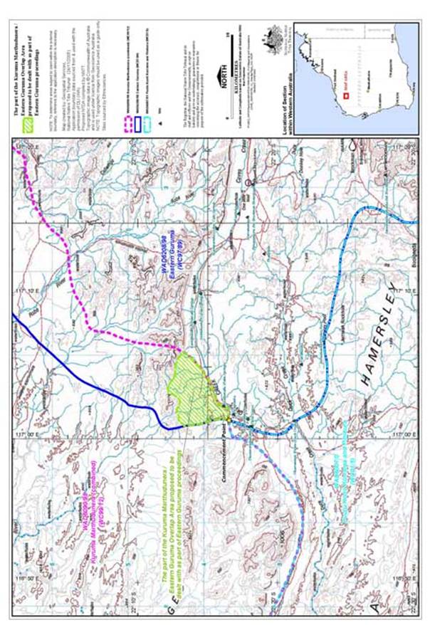
C. The Eastern Guruma claim and the KM claim currently overlap each other, which overlap area is shown in the map contained in Schedule 1 to this Deed;
D. The Eastern Guruma claim and the KM claim have agreed to remove overlap between the claims and create a common boundary which is shown in the map contained in Schedule 1 to this Deed;
E. For the purposes of the Deed, the terms "Eastern Guruma Claim area" and the "KM claim area" shall mean the claim areas as they would appear with the common boundary and the overlaps removed;
F. The members of the Eastern Guruma claimant group and the members of the KM claimant group have a relationship of mutual friendship, trust and respect for each other and both groups wish to preserve that good relationship;
G. There are members of the KM claimant group who throughout their lives have visited, exercised the Traditional Rights (as defined in clause 2.1 of this Deed) and maintained a traditional relationship with an area of country that is now within the Eastern Guruma claim area, and which includes a place known as Palm Springs. That area is referred to in this Deed as “the area of special KM interest”.
H. It is important that the members of the KM claimant group be able to keep visiting the area of special KM interest;
I. The Eastern Guruma claimants are willing for KM people to maintain their traditional relationship with the area of special KM interest and for KM claimants to exercise their Traditional Rights in the said area ;
J. The KM claimants are willing for the Eastern Guruma claimants to maintain and continue with their Native Title claim to the area of special KM interest;
K. The Eastern Guruma claimants and the KM claimants have agreed on the terms in this Deed for the purposes of
a. enabling the Eastern Guruma claim and the KM claim to each continue towards determination of Native Title and
b. enabling the KM people to maintain their traditional relationship with the area of special KM interest and for KM claimants to visit that area and engage in ceremonies and other traditional cultural practices there.
L. This Deed is about land use, not about benefits under the Native Title Act.
AGREEMENT
1. AUTHORITY TO ENTER INTO THIS DEED OF AGREEMENT
1.1 Each of the Eastern Guruma applicants and each of the KM applicants signs this Deed for themselves and in their capacities as their claimant group’s registered applicants, with the authority and on behalf of all the members of their claimant group.
1.2 The Eastern Guruma applicants warrant that they have consulted with the Eastern Guruma claimants and that they have the authority to act for and legally bind all the Eastern Guruma claimants to the obligations set out in this agreement and that all the Eastern Guruma claimants will be bound by the terms of this agreement.
1.3 The term "Eastern Guruma claimants" shall include any persons who are included as native title holders in the Third Schedule of any determination of native title in the Eastern Guruma claim.
2. KM CLAIMANTS TO HAVE ACCESS TO AREA
2.1 The KM claimants have the right to access the area of special KM interest including for the purposes of hunting, fishing, camping, collecting bush medicines and bush tucker and to practice traditional law and culture there ("the Traditional Rights") and the Eastern Guruma claimants acknowledge and agree to respect the exercise of Traditional Rights of the KM people in the area of special KM interest.
2.2 The Eastern Guruma claimants will not do anything or agree to anything with anyone else which could lessen the KM people’s Traditional Rights in the area of special KM interest without first consulting and providing all available information to the KM people about anything which could have that effect and giving consideration to what the KM people say, including, giving to KM people the reasonable opportunity to address the Eastern Guruma claimants at meetings of the Eastern Guruma claimants at which decisions may be made about matters which will lessen the KM's Traditional Rights in the area of special KM interest
2.3 The KM Traditional Rights in the area of special KM interest will continue in full force and effect if the Eastern Guruma claimants are determined by the Federal Court of Australia to hold native title rights and interests in the area of special KM interest of any part of it.
3. AREA TO REMAIN SUBJECT TO EASTERN GURUMA CLAIM
3.1 The area of special KM interest will continue to be part of the country claimed by the Eastern Guruma claimants.
3.2 The KM claimants will consent to a determination of native title in favour of the Eastern Guruma claimants and will not seek to maintain nor make any further Native Title claim under the Native Title Act over any part of the area of special KM interest.
3.3 The KM claimants agree to the Eastern Guruma claimants being recognised as native title holders over the area of special KM interest.
4 AGREEMENT ON EXISTING COMMON BOUNDARY
4.1 The Eastern Guruma claimants and the KM claimants have agreed to create and not to dispute the common boundary between their claims, which is depicted in the map contained in Schedule 1 to this Deed.
4.2 The Eastern Guruma claimants will agree to the dismissal or removal of any part of the Eastern Guruma claim which is on the KM claim side of the common boundary and take any additional action which may be necessary to effect such a removal;
4.3 Neither the Eastern Guruma claimants nor the KM claimants will take any action to change that common boundary in any way that would bring about an overlapping of any portion of the Eastern Guruma claim by the KM claim or an overlapping of any portion of the KM claim by the Eastern Guruma claim;
4.4 Neither the Eastern Guruma claimants nor the KM claimants will make any new or additional Native Title claim which would have the practical effect of changing the position of that common boundary without the prior consent of the other claimants;
4.5 The Eastern Guruma claimants and the KM claimants will each support the other claimant group by confirming the agreement as to that boundary, if requested to do so by the other claimant group.
5 PROTECTION OF NATIVE TITLE RIGHTS AND INTERESTS
5.1 The KM claimants agree that nothing mentioned in this Deed, and nothing which any of the KM claimants is able to do as a result of the signing of this agreement can have the effect of altering or taking anything away from the Eastern Guruma claimants’ traditional rights and interests in the area of special KM interest or from the Eastern Guruma claim over that area;
5.2 The Eastern Guruma claimants agree that nothing mentioned in this Deed, and nothing which any of the Eastern Guruma claimants is able to do as a result of the signing of this Deed can have the effect of altering or taking anything away from the KM claimants’ Traditional Rights and interests in the area of the KM claim or, subject to clause 2.2, the area of special KM interest.
5.3 The Eastern Guruma claimants will not do anything to inhibit or prevent the KM claimants from exercising or protecting their right to exercise their Traditional Rights in the area of special KM interest or from protecting any of the rights granted to them by this Deed in respect of their Traditional Rights in the area of special KM interest.
5.4 The KM claimants will not, without the consent of the Eastern Guruma claimants, get involved in or seek membership in the Eastern Guruma claim nor lodge a native title claim that overlaps with the area of the Eastern Guruma determination, nor seek to establish or have any recognition of native title rights within the Eastern Guruma determination area.
5.5 The Eastern Guruma claimants will not, without the consent of the KM claimants, get involved in the KM claim nor lodge a native title claim that overlaps with the area of the KM claim nor seek to establish or have any recognition of native title rights within the KM claim area and hereby waive any rights under and for the purposes of the Native Title Act within the area of the KM claim.
5.6 The Eastern Guruma claimants agree to not seek membership of the KM claim group without the consent of the KM claimants.
5.7 If for any reason the Eastern Guruma claimants are included or are recognised as members of the KM claim group or native title holders in the area of the KM claim, the Eastern Guruma claimants agree that they will not, without the consent of the KM claimants seek to:
(a) become members of any prescribed body corporate for the KM claim area;
(b) receive any benefits in relation to future act agreements or compensation in relation to any activities in the KM claim area; or
(c) participate in any decision-making process of the KM claimants in relation to any matters relating to native title of future acts in relation to the KM claim area.
6 AGREEMENT ABOUT LAND USE, NOT BENEFITS
6.1 The KM claimants and the Eastern Guruma claimants agree that this Deed of Agreement:
(a) shall enable both KM people and Eastern Guruma people to maintain their traditional relationship to land;
(b) does not mean that the KM claimants or the Eastern Guruma claimants may obtain benefits payable by mining companies or other developers for projects carried out on any part of the other claimant group’s Native Title claim area; and
(c) does not enable the KM claimants or the Eastern Guruma claimants to become members of each other’s claimant group or Prescribed bodies corporate or to seek to have a share of benefits from future acts in each others claim or determination areas.
7. ASSIGNMENT OR TRANSFER
7.1 This Deed will be binding upon the KM and Eastern Guruma claimants, and any prescribed body corporate appointed by the KM and Eastern Guruma claimants as agent or trustee of native title rights held by them and the KM and Eastern Guruma claimants shall each ensure and procure that any such prescribed body corporate appointed by them will first agree to be bound by all the obligations of the respective claimants under this Deed.
7.2 The KM and the Eastern Guruma claimants shall not assign or transfer any of their native title rights or their rights and obligations under this Deed without first procuring the transferee or assignee to enter into a Deed with the KM or Eastern Guruma claimants agreeing to be bound by all the obligations of the transferor and assignor under this Deed.
8. ILUA
8.1 Eastern Guruma claimants agree that within a reasonable time of the request of the KM claimants to do so and the presentation of the form of an Indigenous Land Use Agreement containing the terms of clause 2 of this Deed, that they and any PBC appointed for the Eastern Guruma claim area will enter into the said agreement and agree that it may, at the option of the KM claimants, be registered as an Indigenous Land Use Agreement under the Native Title Act (“the ILUA agreement”)
8.2 The Eastern Guruma claimants agree that they and any PBC appointed for the Eastern Guruma claim area shall, on the request of the PPKP claimants, do all things and sign all documents reasonably necessary in order to enable the ILUA agreement to be registered as an Indigenous Land Use Agreement under the Native Title Act.
8.3 The Eastern Guruma claimants and their members shall not take any steps to challenge or object to the registration of the ILUA agreement as an Indigenous Land Use Agreement under the Native Title Act.
9. Conditions Precedent
9.1 The provisions and obligations in Clauses 3 and 4 of this Deed are subject to the conditions precedent set out in clauses 9.2 and 9.3.
9.2 The Eastern Guruma claimants must ensure and procure that any corporation to be nominated by the Eastern Guruma claimants as the prescribed body corporate or registered native title body corporate for the Eastern Guruma claim area shall, prior to the making of any consent determination and prior to any removal of the KM claim over the area of special KM interest, execute and deliver to the KM claimants a deed agreeing to also be bound by all of the obligations of the Eastern Guruma claimants under this Deed.
9.3 The parties to the Eastern Guruma claim agreeing to request the Federal Court to attach a copy of this Deed to the determination of native title in favour of the Eastern Guruma people, or alternatively, if agreed to by the KM claimants through their representatives, to request the Federal Court to attach or annex a copy of this Deed to an alternative official and public Court document.
SCHEDULE 1
TO THE DEED OF AGREEMENT
BETWEEN EASTERN GURUMA NATIVE TITLE APPLICANTS AND KM NATIVE TITLE APPLICANTS
MAP OF EASTERN GURUMA CLAIM
EXECUTED BY THESE EASTERN GURUMA ELDERS:
NELSON HUGHES ) ________________________________
Nelson Hughes
in the presence of:
Signature of Witness
Name of Witness (BLOCK LETTERS)
Address of Witness
_______________________________
Occupation of Witness
EVA CONNORS ) ________________________________
Eva Connors
in the presence of:
Signature of Witness
Name of Witness (BLOCK LETTERS)
Address of Witness
_______________________________
Occupation of Witness
EXECUTED BY THESE KM ELDERS:
MARK LOCKYER )________________________________
in the presence of
Signature of Witness
Name of Witness (BLOCK LETTERS)
Address of Witness
_______________________________
Occupation of Witness
NEILFINLAY) ________________________________
in the presence of
Signature of Witness
Name of Witness (BLOCK LETTERS)
Address of Witness
_______________________________
Occupation of Witness
JEAN LOCKYER) ________________________________
in the presence of
Signature of Witness
Name of Witness (BLOCK LETTERS)
Address of Witness
_______________________________
Occupation of Witness
GLORIA LOCKYER) ________________________________
in the presence of
Signature of Witness
Name of Witness (BLOCK LETTERS)
Address of Witness
_______________________________
Occupation of Witness
JACK ALEXANDER) ________________________________
in the presence of
Signature of Witness
Name of Witness (BLOCK LETTERS)
Address of Witness
_______________________________
Occupation of Witness
SECOND SCHEDULE – ATTACHMENT 2
INTRA-INDIGENOUS DEED OF AGREEMENT
BETWEEN
EASTERN GURUMA NATIVE TITLE CLAIMANTS
AND PUUTU KUNTI KURRAMA AND PINIKURA NATIVE TITLE CLAIMANTS
Dated this day of 2006
NELSON HUGHES and EVA CONNORS
EASTERN GURUMA APPLICANTS
and
ANGELINA COX, ANGIE COX, ANNABELLE STEWART, ARNESS JAMES, CHARLESTON COX, CHLOE HAYES, DARRYL HUGHES, GARY HUGHES, HAROLD ASHBURTON. LILY MACKAY, MAUDIE DOWTON, MITCHELL DRAGE and
MAURICE DAUBLIN
PKKP APPLICANTS
INTRA-INDIGENOUS DEED OF AGREEMENT
BETWEEN
EASTERN GURUMA NATIVE TITLE CLAIMANTS
AND
PUUTU KUNTI KURRAMA AND PINIKURA NATIVE TITLE CLAIMANTS
CONTENTS
| Clause |
| Page
|
|
| Index
| 1 |
|
| Parties | 2
|
|
| Background | 2
|
| 1 | Authority to enter into this Deed of Agreement | 4
|
| 2 | PKKP Claimants to have access to area
| 5 |
| 3 | Area to remain subject to Eastern Guruma claim | 6
|
| 4 | Agreement on existing common boundary | 6
|
| 5 | Protection of Native Title rights and interests | 7
|
| 6 | Agreement is about land use, not benefits | 9
|
| 7 | Assignment and transfer | 10
|
| 8 | ILUA | 10
|
| 9 | Conditions Precedent
| 11 |
|
| Schedule 1 Map of the area of special PKKP interest in Eastern Guruma Claim | 13 |
|
| Execution clauses
|
|
DATED this day of 2006
BETWEEN
NELSON HUGHES of 102 Wellard Way, Karratha Western Australia, registered native title applicant and EVA CONNORS of 61A Burrup Road, Roebourne Western Australia, native title applicant for themselves and for and on behalf of the members of the native title group for the Eastern Guruma native title determination application (WG 6208 of 1998) (referred to in this Deed as the Eastern Guruma claimants)
AND
ANGELINA COX, ANGIE COX, ANNABELLE STEWART, ARNESS JAMES, CHARLESTON COX, CHLOE HAYES, DARRYL HUGHES, GARY HUGHES, HAROLD ASHBURTON, LILY MACKAY, MAUDIE DOWTON, MITCHELL DRAGE and MAURICE DAULBIN all care of Pilbara Native Title Service, Unit 1, 24 De Grey Place Karrratha WA 6714 native title applicant, for themselves and for and on behalf of the members of the Puutu Kunti Kurrama & Pinikura native title determination application (WAD6007/2001 and WAD 126/2005) (referred to in this Deed of Agreement as “the PKKP claimants”).
BACKGROUND
A. The Eastern Guruma claimants are the claimants in Native Title Determination Application number WG 6208 of 1998 which is registered on the Register of Native Title Claims (referred to in this Deed as the Eastern Guruma claim). The term Eastern Guruma claim shall also include any determination in favour of the Eastern Guruma claimants over the area of the Eastern Guruma claim;
B. The country within the Eastern Guruma claim is shown in the map contained in Schedule 1 to this Deed;
C. The PKKP claimants are the claimants in Native Title Determination Applications number WAD6007/01 and WAD 126/05 which are registered on the Register of Native Title Claims (referred to in this Deed as the PKKP claim). The term PKKP claim shall also include any determination in favour of the PKKP claimants over the area of the PKKP claim;
D. The Eastern Guruma claim and the PKKP claim share a common boundary, a portion of which is shown in the map contained in Schedule 1 to this Deed;
E. The members of the Eastern Guruma claimant group and the members of the PKKP claimant group have a relationship of mutual friendship, trust and respect for each other and both groups wish to preserve that good relationship;
F. There are members of the PKKP claimant group who throughout their lives have visited, exercised the Traditional Rights (as defined in clause 2.1 of this Deed) and maintained a traditional relationship with an area of country that is now within the Eastern Guruma claim, and which includes the places known as Palm Springs, Duck Creek, Johnny Cake Springs and Mt Brockman. That area is referred to in this Deed as “the area of special PKKP interest”.
G. It is important that the members of the PKKP claimant group be able to keep visiting the area of special PKKP interest;
H. The Eastern Guruma claimants are willing for PKKP people to maintain their traditional relationship with the area of special PKKP interest and for PKKP claimants to exercise their Traditional Rights in the said area;
I. The PKKP claimants are willing for the Eastern Guruma claimants to maintain and continue with their Native Title claim to the area of special PKKP interest;
J. The Eastern Guruma claimants and the PKKP claimants have agreed on the terms in this Deed for the purposes of
a. enabling the Eastern Guruma claim and the PKKP claim to each continue towards determination of Native Title and
b. enabling the PKKP people to maintain their traditional relationship with the area of special PKKP interest and for PKKP claimants to visit that area and engage in ceremonies and other traditional cultural practices there.
L. This Deed is about land use, not about benefits under the Native Title Act.
AGREEMENT
1. AUTHORITY TO ENTER INTO THIS DEED OF AGREEMENT
1.1 Each of the Eastern Guruma applicants and each of the PKKP applicants signs this Deed for themselves and in their capacities as their claimant group’s registered applicants, with the authority and on behalf of all the members of their claimant group.
1.2 The Eastern Guruma applicants warrant that they have consulted with the Eastern Guruma claimants and that they have the authority to act for and legally bind all the Eastern Guruma claimants to the obligations set out in this agreement and that all the Eastern Guruma claimants will be bound by the terms of this agreement.
1.3 The term "Eastern Guruma claimants" shall include any persons who are included as native title holders in the Third Schedule of any determination of native title in the Eastern Guruma claim.
2. PKKP CLAIMANTS TO HAVE ACCESS TO AREA
2.1 The PKKP claimants have the right to access the area of special PKKP interest including for the purposes of hunting, fishing, camping, collecting bush medicines and bush tucker and to practice traditional law and culture there ("the Traditional Rights") and the Eastern Guruma claimants acknowledge and agree to respect the exercise of Traditional Rights of the PKKP people in the area of special PKKP interest.
2.2 The Eastern Guruma claimants will not do anything or agree to anything with anyone else which could lessen the PKKP people’s Traditional Rights in the area of special PKKP interest without first consulting and providing all available information to the PKKP people about anything which could have that effect and giving consideration to what the PKKP people say, including, giving to PKKP people the reasonable opportunity to address the Eastern Guruma claimants at meetings of the Eastern Guruma claimants at which decisions may be made about matters which will lessen the PKKP's Traditional Rights in the area of special PKKP interest
2.3 The PKKP Traditional Rights in the area of special PKKP interest will continue in full force and effect if the Eastern Guruma claimants are determined by the Federal Court of Australia to hold native title rights and interests in the area of special PKKP interest of any part of it.
3. AREA TO REMAIN SUBJECT TO EASTERN GURUMA CLAIM
3.1 The area of special PKKP interest will continue to be part of the country claimed by the Eastern Guruma claimants.
3.2 The PKKP claimants will not make a Native Title claim under the Native Title Act over any part of the area of special PKKP interest.
3.3 The PKKP claimants agree to the Eastern Guruma claimants being recognised as native title holders over the area of special PKKP interest.
4. AGREEMENT ON EXISTING COMMON BOUNDARY
4.1 The Eastern Guruma claimants and the PKKP claimants have agreed not to dispute the common boundary between their claims, which is depicted in the map contained in Schedule 1 to this Deed.
4.2 Neither the Eastern Guruma claimants nor the PKKP claimants will take any action to change that common boundary in any way that would bring about an overlapping of any portion of the Eastern Guruma claim by the PKKP claim or an overlapping of any portion of the PKKP claim by the Eastern Guruma claim;
4.3 Neither the Eastern Guruma claimants nor the PKKP claimants will make any new or additional Native Title claim which would have the practical effect of changing the position of that common boundary without the prior consent of the other claimants;
4.4 The Eastern Guruma claimants and the PKKP claimants will each support the other claimant group by confirming the agreement as to that boundary, if requested to do so by the other claimant group.
5. PROTECTION OF NATIVE TITLE RIGHTS AND INTERESTS and TRADITIONAL RIGHTS AND INTERESTS
5.1 The PKKP claimants agree that nothing mentioned in this Deed, and nothing which any of the PKKP claimants is able to do as a result of the signing of this Deed can have the effect of altering or taking anything away from the Eastern Guruma claimants’ traditional rights and interests in the area of special PKKP interest or from the Eastern Guruma claim over that area;
5.2 The Eastern Guruma claimants agree that nothing mentioned in this Deed, and nothing which any of the Eastern Guruma claimants is able to do as a result of the signing of this Deed can have the effect of altering or taking anything away from the PKKP claimants’ Traditional Rights and interests in the area of the PKKP claim or, subject to clause 2.2, the area of special PKKP interest.
5.3 Subject to this Deed, the Eastern Guruma claimants will not do anything to inhibit or prevent the PKKP claimants from exercising or protecting their right to exercise their Traditional Rights in the area of special PKKP interest or from protecting any of the rights granted to them by this Deed in respect of their Traditional Rights and interests in the area of special PKKP interest.
5.4 The PKKP claimants will not, without the consent of the Eastern Guruma claimants, get involved in or seek membership in the Eastern Guruma claim nor lodge a native title claim that overlaps with the area of the Eastern Guruma determination, nor seek to establish or have any recognition of native title rights within the Eastern Guruma determination area.
5.5 The Eastern Guruma claimants will not, without the consent of the PKKP claimants, get involved in the PKKP claim nor lodge a native title claim that overlaps with the area of the PKKP claim nor seek to establish or have any recognition of native title rights within the PKKP claim area and hereby waive any rights under and for the purposes of the Native Title Act within the area of the PKKP claim.
5.6 The Eastern Guruma claimants agree to not seek membership of the PKKP claim group without the consent of the PKKP claimants.
5.7 If for any reason the Eastern Guruma claimants are included or are recognised as members of the PKKP claim group or native title holders in the area of the PKKP claim, the Eastern Guruma claimants agree that they will not, without the consent of the PKKP claimants seek to:
(a) become members of any prescribed body corporate for the PKKP claim area;
(b) receive any benefits in relation to future act agreements or compensation in relation to any activities in the PKKP claim area; or
(c) participate in any decision-making process of the PKKP claimants in relation to any matters relating to native title of future acts in relation to the PKKP claim area.
5.8 If for any reason the PKKP claimants are included or are recognised as members of the Eastern Guruma claim group or native title holders in the area of the Eastern Guruma claim, the PKKP claimants agree that they will not, without the consent of the Eastern Guruma claimants seek to:
(a) become members of any prescribed body corporate for the Eastern Guruma claim area;
(b) receive any benefits in relation to future act agreements or compensation in relation to any activities in the Eastern Guruma claim area; or
(c) participate in any decision-making process of the Eastern Guruma claimants in relation to any matters relating to native title of future acts in relation to the Eastern Guruma claim area.
6 AGREEMENT ABOUT LAND USE, NOT BENEFITS
6.1 The PKKP claimants and the Eastern Guruma claimants agree that this Deed of Agreement:
(a) shall enable both PKKP people and Eastern Guruma people to maintain their traditional relationship to land;
(b) does not mean that the PKKP claimants or the Eastern Guruma claimants may obtain benefits payable by mining companies or other developers for projects carried out on any part of the other claimant group’s Native Title claim area; and
(c) does not enable the PKKP claimants or the Eastern Guruma claimants to become members of each other’s claimant group or Prescribed bodies corporate or to seek to have a share of benefits from future acts in each others claim or determination areas.
7. ASSIGNMENT OR TRANSFER
7.1 This Deed will be binding upon the PKKP and Eastern Guruma claimants and any prescribed body corporate appointed by the PKKP and Eastern Guruma claimants as agent or trustee of native title rights held by them and the PKKP and Eastern Guruma claimants shall each ensure and procure that any such prescribed body corporate appointed by them will first agree to be bound by all the obligations of the respective claimants under this Deed.
7.2 The PKKP and the Eastern Guruma claimants shall not assign or transfer any of their native title rights or their rights and obligations under this Deed without first procuring the transferee or assignee to enter into a Deed with the PKKP or Eastern Guruma claimants agreeing to be bound by all the obligations of the transferor and assignor under this Deed.
8. ILUA
8.1 Eastern Guruma claimants agree that within a reasonable time of the request of the PKKP claimants to do so and the presentation of the form of an Indigenous Land Use Agreement containing the terms of clause 2 of this Deed, that they and any PBC appointed for the Eastern Guruma claim area will enter into the said agreement and agree that it may, at the option of the PKKP claimants, be registered as an Indigenous Land Use Agreement under the Native Title Act (“the ILUA agreement”)
8.2 The Eastern Guruma claimants agree that they and any PBC appointed for the Eastern Guruma claim area shall, on the request of the PPKP claimants, do all things and sign all documents reasonably necessary in order to enable the ILUA agreement to be registered as an Indigenous Land Use Agreement under the Native Title Act.
8.3 The Eastern Guruma claimants and their members shall not take any steps to challenge or object to the registration of the ILUA agreement as an Indigenous Land Use Agreement under the Native Title Act.
9. Conditions Precedent
9.1 The provisions and obligations in Clauses 3 and 4 of this Deed are subject to the conditions precedent set out in clauses 9.2 and 9.3.
9.2 The Eastern Guruma claimants must ensure and procure that any corporation to be nominated by the Eastern Guruma claimants as the prescribed body corporate or registered native title body corporate for the Eastern Guruma claim area shall, prior to the making of any consent determination, execute and deliver to the PKKP claimants a deed agreeing to also be bound by all of the obligations of the Eastern Guruma claimants under this Deed.
9.3 The parties to the Eastern Guruma claim agreeing to request the Federal Court to attach a copy of this Deed to the determination of native title in favour of the Eastern Guruma people, or alternatively, if agreed to by the PKKP claimants through their representatives, to request the Federal Court to attach or annex a copy of this Deed to an alternative official and public Court document.
SCHEDULE 1
TO THE DEED OF AGREEMENT
BETWEEN EASTERN GURUMA NATIVE TITLE APPLICANTS AND PKKP NATIVE TITLE APPLICANTS
MAP OF EASTERN GURUMA CLAIM
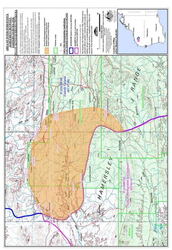
EXECUTED FOR AND ON BEHALF OF THE EASTERN GURUMA CLAIMANTS BY:
NELSON HUGHES ) ________________________________
Nelson Hughes
in the presence of:
Signature of Witness
Name of Witness (BLOCK LETTERS)
Address of Witness
_______________________________
Occupation of Witness
EVA CONNORS ) ________________________________ Eva Connors
in the presence of:
Signature of Witness
Name of Witness (BLOCK LETTERS)
Address of Witness
_______________________________
Occupation of Witness
EXECUTED FOR AND ON BEHALF OF THE PKKP CLAIMANTS BY:
ANGELINA COX ) _______________________________ Angelina Cox
in the presence of
Signature of Witness
Name of Witness (BLOCK LETTERS)
Address of Witness
_______________________________
Occupation of Witness
ANGIE COX ) _______________________________ Angie Cox
in the presence of
Signature of Witness
Name of Witness (BLOCK LETTERS)
Address of Witness
_______________________________
Occupation of Witness
ANNABELLE STUART ) ________________________________ Annabelle Stuart
in the presence of
Signature of Witness
Name of Witness (BLOCK LETTERS)
Address of Witness
_______________________________
Occupation of Witness
ARNESS JAMES ) _______________________________
Arness James
in the presence of
Signature of Witness
Name of Witness (BLOCK LETTERS)
Address of Witness
_______________________________
Occupation of Witness
CHARLESTON COX ) ___________________________________ Charleston Cox
in the presence of
Signature of Witness
Name of Witness (BLOCK LETTERS)
Address of Witness
_______________________________
Occupation of Witness
CHLOE HAYES ) ___________________________________
Chloe Hayes
in the presence of
Signature of Witness
Name of Witness (BLOCK LETTERS)
Address of Witness
_______________________________
Occupation of Witness
DARRYL HUGHES ) ________________________________
Darryl Hughes
in the presence of
Signature of Witness
Name of Witness (BLOCK LETTERS)
Address of Witness
_______________________________
Occupation of Witness
GARY HUGHES ) ________________________________
Gary Hughes
in the presence of
Signature of Witness
Name of Witness (BLOCK LETTERS)
Address of Witness
_______________________________
Occupation of Witness
HAROLD ASHBURTON ) ___________________________________ Harold Ashburton
in the presence of
Signature of Witness
Name of Witness (BLOCK LETTERS)
Address of Witness
_______________________________
Occupation of Witness
LILY MACKAY ) ___________________________________ Lily Mackay
in the presence of
Signature of Witness
Name of Witness (BLOCK LETTERS)
Address of Witness
_______________________________
Occupation of Witness
MAUDIE DOWTON ) ___________________________________ Maudie Dowton
in the presence of
Signature of Witness
Name of Witness (BLOCK LETTERS)
Address of Witness
_______________________________
Occupation of Witness
MITCHELL DRAGE ) ___________________________________
Mitchell Drage
in the presence of
Signature of Witness
Name of Witness (BLOCK LETTERS)
Address of Witness
_______________________________
Occupation of Witness
MAURICE DAUBLIN ) ___________________________________
Maurice Daublin
in the presence of
Signature of Witness
Name of Witness (BLOCK LETTERS)
Address of Witness
_______________________________
Occupation of Witness
THIRD SCHEDULE
The native title holders are:
(1) the descendants of Wirntawari who:
(a) identify and are identified by other members of the native title holding group as Muntulgura Guruma; and
(b) have a connection with the land and waters in Determination Area A, in accordance with the traditional laws acknowledged and the traditional customs observed by the Muntulgura Guruma; and
(2) the descendants of Jack Smith to whom the Muntulgura Guruma accord the right to exercise rights and interests in Determination Area A in accordance with the traditional laws acknowledged and traditional customs observed by the Muntulgura Guruma.
FOURTH SCHEDULE
Section 47B of the Native Title Act 1993 (Cth) applies to the following areas of unallocated Crown land in Determination Area A:
(a) UCL 23 (being the area formerly the subject of pastoral lease 3114/788 which was resumed and vested in the Crown pursuant to section 18 of the Public Works Act 1902 (WA));
(b) UCL 85 (part Gregory Location 26 and being the area formerly the subject of special leases 3116/3465 and 3114/5156);
(c) UCL 90 (being the area formerly the subject of pastoral lease 3114/788 which was resumed and vested in the Crown pursuant to section 18 of the Public Works Act 1902 (WA)).
Those areas of unallocated Crown land are hatched in blue on the maps attached to the First Schedule.

