FEDERAL COURT OF AUSTRALIA
Neowarra v State of Western Australia [2004] FCA 1092
NATIVE TITLE – Determination
PADDY NEOWARRA, PADDY WAMA & OTHERS v THE STATE OF WESTERN AUSTRALIA & OTHERS
WAG 6016 OF 1996
WAG 6015 OF 1999
WAG 6006 OF 2002
SUNDBERG J
27 AUGUST 2004
KUPUNGARRI
|
IN THE FEDERAL COURT OF AUSTRALIA |
|
|
WESTERN AUSTRALIA DISTRICT REGISTRY |
WAG 6016 OF 1996 WAG 6015 OF 1999 WAG 6006 OF 2002 |
|
BETWEEN: |
PADDY NEOWARRA, PADDY WAMA & OTHERS APPLICANTS
|
|
AND: |
THE STATE OF WESTERN AUSTRALIA & OTHERS RESPONDENTS
|
|
DATE OF ORDER: |
|
|
WHERE MADE: |
KUPUNGARRI |
WANJINA-WUNGGURR NATIVE TITLE DETERMINATION NO 1
THE COURT ORDERS, DECLARES AND DETERMINES THAT:
Existence of Native Title (s 225)
1. Native title exists in relation to the determination area.
2. Native title does not exist in the areas set out in Schedule 3.
The Native Title Holders (s 225(a))
3. The native title is held by the members of the Wanjina‑Wunggurr Community for their respective communal, group and individual rights and interests in the determination area. The members of the Wanjina-Wunggurr Community are the people referred to in Schedule 9.
The nature and extent of native title rights and interests (s 225(b)) and exclusiveness of native title (s 225(e))
4. Subject to Order 9, the nature and extent of native title rights and interests in relation to each part of the determination area referred to in Schedule 4 [being areas where there has been no extinguishment of native title or areas where any extinguishment must be disregarded] are an entitlement against the whole world to possession, occupation, use and enjoyment of the land and waters of that part.
5. Subject to Order 9, the nature and extent of the native title rights and interests in relation to each part of the determination area referred to in Schedule 5 [being current and historical pastoral lease areas other than areas where any extinguishment is required to be disregarded] are:
(a) the right to engage in the following activities:
(i) having access to the determination area but so that Native Title Holders may seek sustenance in their accustomed manner only from:
(A) unenclosed and unimproved parts of land that is or has previously been the subject of a pastoral lease granted after 1934; or
(B) unenclosed or enclosed but otherwise unimproved parts of land that is or has previously been the subject of a pastoral lease granted before 1934;
(ii) camping;
(iii) hunting for the purpose of satisfying the Native Title Holders’ personal, domestic or non‑commercial communal needs from:
(A) unenclosed and unimproved parts of land that is or has previously been the subject of a pastoral lease granted after 1934; or
(B) unenclosed or enclosed but otherwise unimproved parts of land that is or has previously been the subject of a pastoral lease granted before 1934;
(iv) having access to painting sites in order to freshen or repaint images there;
(v) having the use of land adjacent to those painting sites for the purpose of engaging in the preceding activity;
(vi) gathering and fishing for the purpose of satisfying the Native Title Holders’ personal, domestic or non‑commercial communal needs from:
(A) unenclosed and unimproved parts of land that is or has previously been the subject of a pastoral lease granted after 1934; or
(B) unenclosed or enclosed but otherwise unimproved parts of land that is or has previously been the subject of a pastoral lease granted before 1934;
(vii) using traditional resources for the purpose of satisfying the Native Title Holders’ personal, domestic or non‑commercial communal needs;
(viii) conducting and taking part in ceremonies;
(ix) visiting places of importance and protecting them from physical harm;
(x) manufacturing traditional items (such as spears and boomerangs) from resources of the land and waters for the purpose of satisfying personal, domestic or non‑commercial communal needs.
(b) the right to pass on and inherit the native title rights in (a).
6. Subject to Order 9, the nature and extent of the native title rights and interests in relation to each part of the determination area referred to in Schedule 6 [non‑vested reserve areas] are:
(a) the right to engage in the following activities:
(i) having access to the determination area with liberty to seek sustenance therefrom in their accustomed manner;
(ii) camping;
(iii) hunting on the land for the purpose of satisfying the Native Title Holders’ personal, domestic or non‑commercial communal needs;
(iv) having access to painting sites in order to freshen or repaint images there;
(v) having the use of land adjacent to those painting sites for the purpose of engaging in the preceding activity;
(vi) gathering and fishing on the land for the purpose of satisfying the Native Title Holders’ personal, domestic or non‑commercial communal needs;
(vii) using traditional resources for the purpose of satisfying the Native Title Holders’ personal, domestic or non‑commercial communal needs;
(viii) conducting and taking part in ceremonies;
(ix) visiting places of importance and protecting them from physical harm;
(x) manufacturing traditional items (such as spears and boomerangs) from resources of the land and waters for the purpose of satisfying the Native Title Holders’personal, domestic or non‑commercial communal needs.
(b) the right to pass on and inherit the native title rights in (a).
7. Subject to Order 9, the nature and extent of the native title rights and interests in relation to the part of the determination area referred to in Schedule 7 [reserve subject to by-laws 13 and 15 made in 1963 pursuant to s 8 of the Parks and Reserves Act 1895] are:
(a) the right to engage in the following activities:
(i) having access to the determination area;
(ii) camping;
(iii) having access to painting sites in order to freshen or repaint images there;
(iv) having the use of land adjacent to those painting sites for the purpose of engaging in the preceding activity;
(v) using traditional resources for the purpose of satisfying the Native Title Holders’ personal, domestic or non‑commercial communal needs;
(vi) conducting and taking part in ceremonies;
(vii) visiting places of importance and protecting them from physical harm;
(viii) manufacturing traditional items (such as spears and boomerangs) from resources of the land and waters for the purpose of satisfying the Native Title Holders’ personal, domestic or non‑commercial communal needs; and
(b) the right to pass on and inherit the native title rights in (a);
provided that the exercise of the native title rights in (a) and (b) do not involve hunting, fishing, or the taking of flora.
8. Subject to Order 9, the nature and extent of the native title rights and interests in relation to such part (if any) of the determination area as consists of land and waters seaward of the high water mark and referred to in Schedule 8 are:
(a) the right to engage in the following activities:
(i) having access to the area;
(ii) moving freely through and within the area;
(iii) hunting for the purpose of satisfying the Native Title Holders’ personal, domestic or non‑commercial communal needs;
(iv) gathering and fishing for the purpose of satisfying the Native Title Holders’ personal, domestic or non‑commercial communal needs;
(v) using traditional resources of the area for the purpose of satisfying the Native Title Holders’ personal, domestic or non‑commercial communal needs;
(vi) manufacturing traditional items from the resources of the area for the purpose of satisfying the Native Title Holders’ personal, domestic or non‑commercial communal needs;
(vii) conducting and taking part in ceremonies within the area;
(b) the right to pass on and inherit the native title rights in (a).
9. The native title rights and interests are subject to and exercisable in accordance with:
(a) the laws of the State and the Commonwealth, and
(b) traditional laws acknowledged and traditional customs observed by the Native Title Holders.
The nature and extent of any other interests in relation to the determination area (s 225(c))
10. The nature and extent of other interests in relation to those parts of the determination area where native title exists are:
(a) the interests comprised in or pursuant to the pastoral leases listed in Schedule 5;
(b) the interests comprised in or pursuant to the reserves listed in Schedule 6;
(c) the rights and interests comprised in, conferred under or in accordance with or pursuant to the Alumina Refinery (Mitchell Plateau) Agreement Act 1971 (WA) (“the Act”) and/or the Alumina Refinery (Mitchell Plateau) Agreement as amended and ratified by the Act;
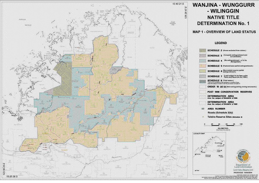
(d) the interests comprised in or pursuant to the following mining tenements within the following areas as shown on Map 1: TR70/5610 (Areas 82 and 89), M04/90 (Area 24), G04/20 (Area 25), G04/31 (Area 5), M04/84 (Area 25), M04/86 (Area 25), M04/88 (Area 25), M04/91 (Areas 25 and 54), M04/161 (Areas 25 and 68), M04/162 (to the extent not covered by Special Lease 3116/10534) (Area 25);
(e) the interests comprised in or pursuant to the following mining tenements within the following areas as shown on Map 1: M04/262 (to the extent covered by Special Lease 3116/10534) (Area 68), M80/329 (Area 17), and M80/331 (Area 17);
(f) the interests comprised in or pursuant to licences or permits issued by the Commonwealth or State and in effect at the date of this determination;
(g) the public right to fish in any waters seaward of the high water mark;
(h) the public right to navigate over any waters seaward of the high water mark;
(i) the interests comprised in or pursuant to the following by‑laws made 12 June 1957 under the Country Areas Water Supply Act 1947 (WA) in their application to the King River Pools Water Supply Reserve (affecting Area 16): by‑laws 31, 34, 35, 36, 38, 39 and 40;
(j) the interests comprised in or pursuant to by‑laws 13 and 15 made under the Parks and Reserves Act 1895 (WA) in their application to Reserve R32853 (affecting Area 29 as shown on Map 1);
(k) the interest of the Crown in the Fitzroy River Catchment Area (proclamation dated 28 October 1959 and affecting all of Areas 19, 41, 42, 57, 59, 60, 69, 70, 71, 73, 86 and 87 and parts of Areas 13, 17, 18, 20, 58 and 64 as shown on Map 1), the Ord River Catchment Area (proclamation dated 15 February 1960 and affecting part of Area 16 as shown on Map 1) and the Wyndham Water Supply Surface Water Area (proclamation dated 25 March 1997 and affecting part of Area 16 as shown on Map 1);
(l) the interests of Telstra Corporation Limited:
(i) in the Mt Deborah DRCS Repeater Site in Area 23 (noted on Map 2), being a square shaped area of 0.25 hectares (50 metres by 50 metres), with a station mark located at Longitude 125º05'52.76 Latitude 16º01'00.89. From the station mark, the northern corner points of the site are at a distance of approximately 39.7 metres;
(ii) created pursuant to the Post and Telegraph Act 1901 (Cth), the Telecommunications Act 1975 (Cth), the Australian Telecommunications Corporation Act 1989 (Cth), the Telecommunications Act 1991 (Cth) and the Telecommunications Act 1997 (Cth);
(m) rights of access to the determination area provided by a law of the State or the Commonwealth in force on the date of the determination.
Relationship between the native title rights and interests and the other interests (s 225(d))
11. The relationship between the native title rights and interests and the other interests described in paragraph 10 (“the other interests”) is that:
(a) in relation to the other interests referred to in Order 10(a) and (c) – the rights and interests under the other interest, and the doing of any activity in giving effect to them, prevail over the native title rights and interests, and
(i) both the rights under the other interest and the native title rights and interests must be exercised reasonably, and
(ii) the native title right to hunt may only be exercised on pastoral leases:
(A) if hunting is conducted with rifles or other firearms, in areas where stock are not present; and
(B) if the pastoral lessee or a person otherwise responsible for the management of the pastoral lease is given sufficient advance notice of the intention to hunt in order that safety issues can be addressed;
(b) in relation to the other interests referred to in Order 10(a), (c),(d) - (f), (i), (j) (l)(ii) and (m) – where the doing of any activity is required or permitted by any lease, licence, permit or authority referred to in Order 10, then:
(i) the requirement or permission and the doing of the activity prevail over the native title rights and interests and any exercise of those rights and interests;
(ii) the existence and exercise of the native title rights and interests do not prevent the doing of the activity;
(iii) both the rights under the other interest and the native title rights and interests must be exercised reasonably, and
(iv) the native title right to hunt may only be exercised on pastoral leases:
(A) if hunting is conducted with rifles or other firearms, in areas where stock are not present; and
(B) if the pastoral lessee or a person otherwise responsible for the management of the pastoral lease is given sufficient advance notice of the intention to hunt in order that safety issues can be addressed;
(c) in relation to the other interests referred to in Order 10(d), (e), (k) and (l)(i) ‑ native title is not extinguished but to the extent that the other interest is inconsistent with the continued existence, enjoyment or exercise of the native title rights and interests, the native title rights and interests continue to exist but have no effect except to the extent that the other interest or its effects are later removed;
(d) in relation to the other interests referred to in Order 10(g) and (h) – those rights co‑exist with the native title rights and interests, and both the rights under the other interest and the native title rights and interests must be exercised reasonably.
Definitions and Interpretation
12. The words and expressions used in this determination have the same meaning as in Part 15 of the Native Title Act except for the following defined expressions:
“determination area” means the area described in Schedule 1 and excluding those things and areas described in Schedule 2;
“laws of the State and the Commonwealth” means the common law and the laws of the State of Western Australia and the Commonwealth of Australia.
“Map” and “Maps 1 and 2” means the maps attached as Annexure 1 to Schedule 1.
13. A reference in this Determination to an “Area No.” or to the word “Area” followed by a number, is a reference to a part of the determination area or to another area referred to in the following table and as generally shown by the numbers on Map 1. References to “Name” and “Purpose” in the following table and in the tables in the Schedules are for convenience only and do not form part of the Determination:
|
Area |
Description |
Name |
Purpose |
|
Reserve R08248 |
|
Watering place for travellers and stock |
|
|
Area 2 |
Reserve R08247 |
|
Watering place for travellers and stock |
|
Reserve R41886 |
Maranbabidi Community |
Use and benefit of Aboriginal inhabitants |
|
|
Unallocated Crown land |
|
|
|
|
Pastoral Lease 398/0844 |
Drysdale River (Extension) |
Pastoral |
|
|
Reserve R27164 |
|
Conservation of flora and fauna |
|
|
Reserve R21969 |
|
Use and benefit of Aborigines |
|
|
Reserve R23079 |
|
Use and benefit of Aborigines |
|
|
Pastoral Lease 3114/0833 |
Theda |
Pastoral |
|
|
Pastoral Lease 3114/1174 |
Doongan |
Pastoral |
|
|
Pastoral Lease 398/0446 |
Drysdale River |
Pastoral |
|
|
Pastoral Lease 3114/1190 |
Ellenbrae |
Pastoral |
|
|
Pastoral Lease 3114/1204 |
Mt Elizabeth |
Pastoral |
|
|
Pastoral Lease 3114/0918 |
Pentecost Downs, Karunjie |
Pastoral |
|
|
Pastoral Lease 398/0790 |
Kachana |
Pastoral |
|
|
Pastoral Lease 3114/1180 |
El Questro |
Pastoral |
|
|
Pastoral Lease 3114/0980 |
Mt Barnett, Kupungarri |
Pastoral |
|
|
Pastoral Lease 3114/1042 |
Marion Downs |
Pastoral |
|
|
Pastoral Lease 3114/0785 |
Glenroy |
Pastoral |
|
|
Pastoral Lease 3114/0786 |
Mt House |
Pastoral |
|
|
Pastoral Lease 3114/0865 |
Beverley Springs |
Pastoral |
|
|
Pastoral Lease 398/0691 |
Charnley River |
Pastoral |
|
|
Pastoral Lease 3114/0723 |
Pantijan |
Pastoral |
|
|
Pastoral Lease 3114/1045 |
Mt Hart |
Pastoral |
|
|
Pastoral Lease 3114/0682 |
Napier Downs |
Pastoral |
|
|
Pastoral Lease 3114/0648 |
Durack River |
Pastoral |
|
|
Reserve R41320 |
Morgan DRCS – Doongan 11 |
Repeater station site |
|
|
Reserve R08258 |
|
Watering place for travellers and stock |
|
|
Reserve R32853 |
Drysdale River National Park |
Class “B” Reserve |
|
|
Reserve R08260 |
|
Watering place for travellers and stock |
|
|
Reserve R41369 |
|
Domestic satellite ground station |
|
|
Reserve R41740 |
Dale DRCS – Doongan 14 |
Repeater station site |
|
|
Reserve R33706 |
|
Government requirements |
|
|
Reserve R41402 |
Ellen DRCS – Omalinde 6 |
Repeater station site |
|
|
Reserve R08237 |
|
Watering place for travellers and stock |
|
|
Reserve R17423 |
|
Camping |
|
|
Reserve R17424 |
|
Camping |
|
|
Reserve R08238 |
|
Watering place for travellers and stock |
|
|
Reserve R22279 |
|
Stopping place for travellers and stock |
|
|
Reserve R17422 |
|
Camping |
|
|
Reserve R42999 |
Dodnun Community |
Use and benefit of Aboriginal inhabitants |
|
|
Reserve R41687 |
Lacy DRCS – Marndoc 6 |
Repeater station site |
|
|
Reserve R41921 |
|
Use and benefit of Aboriginal inhabitants |
|
|
Reserve R21328 |
|
Use and benefit of Aborigines |
|
|
Reserve R08254 |
|
Watering place for travellers and stock |
|
|
Reserve R19751 |
Munja |
Use and benefit of Aborigines |
|
|
Reserve R21968 |
Munja painting reserve |
Use and benefit of Aborigines |
|
|
Reserve R08255 |
|
Watering place for travellers and stock |
|
|
Reserve R08256 |
|
Watering place for travellers and stock |
|
|
Reserve R21327 |
|
Use and benefit of Aborigines |
|
|
Reserve R08257 |
|
Watering place for travellers and stock |
|
|
Reserve R09742 |
|
Government requirements |
|
|
Reserve R17204 |
|
Stock route |
|
|
Reserve R17205 |
|
Stock route |
|
|
Reserve R41350 |
Napier DRCS – Meda 18 |
Repeater station site |
|
|
Reserve R40911 |
King DRCS – Numalgun 15 |
Repeater station site |
|
|
Reserve R40607 |
Phillips DRCS – Numalgun 14 |
Repeater station site |
|
|
Pastoral Lease 3114/0997 |
Gibb River, Ngallanguda |
Pastoral |
|
|
Reserve R22278 |
|
Stopping place for travellers and stock |
|
|
Reserve R17421 |
|
Stock route – part only |
|
|
Reserve R17421 |
|
Stock route – part only |
|
|
Reserve R17421 |
|
Stock route – part only |
|
|
Reserve R22256 |
|
Stock route – part only |
|
|
Reserve R22256 |
|
Stock route – part only |
|
|
Reserve R22256 |
|
Stock route – part only |
|
|
Reserve R08239 |
|
Watering place for travellers and stock |
|
|
Reserve R40770 |
Synnot Range DCRS – Easton 5 |
Repeater station site |
|
|
Unallocated Crown land |
|
|
|
|
Special Lease 3116/10335 |
|
|
|
|
Special Lease 3116/10869 |
|
|
|
|
Pastoral Lease 398/0836 |
Mt Hart (former part) |
Pastoral |
|
|
Special Lease 3116/10534 |
Winjingayr Community |
Use and Benefit of Aboriginal Inhabitants |
|
|
Special Lease 3116/11701 |
|
|
|
|
Special Lease 3116/10530 |
|
|
|
|
Reserve R10773 |
|
Road |
|
|
Reserve R10773 |
|
Road |
|
|
Reserve R41150 |
Foster DCRS – Doongan 12 |
Repeater station site |
|
|
Reserve R40092 |
Kupungarri Community |
Use and benefit of Aboriginal inhabitants |
|
|
Reserve R40571 |
Imintji Community |
Use and benefit of Aboriginal inhabitants |
|
|
Pastoral Lease 398/0834 |
Kimberley Downs (part) |
Pastoral |
|
|
Pastoral Lease 3114/0962 |
Home Valley |
Pastoral |
|
|
Unallocated Crown land |
|
|
|
|
Unallocated Crown land |
|
|
|
|
Unallocated Crown land |
|
|
|
|
Unallocated Crown land |
|
|
|
|
Unallocated Crown land |
|
|
|
|
Unallocated Crown land |
|
|
|
|
Unallocated Crown land |
|
|
|
|
Unallocated Crown land |
|
|
|
|
Unallocated Crown land |
|
|
|
|
Unallocated Crown land |
|
|
|
|
Unallocated Crown land |
|
|
|
|
Unallocated Crown land |
|
|
|
|
Unallocated Crown land |
|
|
|
|
Reserve R40701 |
Pentecost DRCS – Marndoc 6 |
Repeater station site |
|
|
Area 16A |
Special Leases 3102/209, 3107/470 |
|
|
|
Area 16B |
Special Lease 3102/207 |
|
|
|
|
Tidal Waters |
|
|
SCHEDULE 1
Determination area
The determination area comprises the land and waters described in Annexure 2 to this schedule and generally shown as bordered in dark blue on the Maps which are Annexure 1 to this schedule.
SCHEDULE 1 - Annexure 1 – The Maps
SCHEDULE 1 - Annexure 2
The determination area comprises all of the land and waters bounded by the following description except the areas set out in Schedule 2:
Area the subject of WAG 6016 of 1996
Commencing at the point 125.317076’ longitude east, 15,40758’ –latitude south the boundary traverses north easterly and then easterly through the following geographic coordinates 125.336747’ E 15.376739’ S, 125.482148’E 15.148773’ S, 125.48363’ E 15.146669’S to 125.67902’ E 15.146669’ S where it meets Pastoral Lease 3114/1174.
From here the boundary traverses the westerly boundary of 3114/1174 to its intersection with pastoral lease 398/446 then follows the boundary of this lease in a counter clockwise direction to the south eastern corner of pastoral lease 398/844. From here the boundary traverses westerly initially coincidental with the southern boundary of 398/446 then through the following geographic coordinates 125.67902’ E 15.984085’S, 125.5’ E 15.984085’ S, 125.225726’ E, 15.984085’ S. From here the boundary traverses southerly until it intersects with the boundary of pastoral lease 3114/723. From here the boundary traverses counter clockwise along the boundary of 3114/723 to a position on this boundary at 125.001169’ E 15.90287’ S. From here the boundary traverses north easterly to 125.015751’ E 15.880007’ S then to 125.433333’ E 15.708333’ S then northerly to 125.43’ E 15.508333’ S and then back to the commencement point.
Geographic coordinates are reference to Australian Geodetic Datum (AGD) 84 and where referenced to cadastral features are based on the spatial position of that reference data acquired from the various custodians at the time.
Area the subject of WAG 6015 of 1999
Commencing at the north eastern corner of Theda Pastoral Lease (3114/833) the application boundary traverses southerly, easterly and then in a southerly direction following the boundary of Carson River Pastoral Lease (3114/1056) until the southernmost part of the said lease. The boundary then continues southerly following the eastern boundary of Theda until the intersection with Drysdale River National Park.
The application boundary then continues in a southerly direction, following a previous stock route boundary, to the intersection with Doongan Pastoral Lease (3114/1174). It continues in a southerly direction along this previous stock route boundary to a point located at 126.651995 longitude east, 15.260120 latitude south, which is also coincident with Doongan Pastoral Lease.
The boundary then traverses easterly to 126.914937 longitude east, 15.260119 latitude south, then continuing in an easterly direction following the southern boundary of Drysdale River National Park to the north west corner of Home Valley Pastoral Lease (3114/962).
The boundary then traverses south, east and south along this said boundary to its south west corner, then traversing easterly across a stock route reserve to an intersection between Home Valley and Durack River Pastoral Lease (3114/648). It then follows a series of coordinate points as follows:
|
Longitude East |
Latitude South |
|
127.470192 |
15.861716 |
|
127.487406 |
15.849748 |
|
127.496543 |
15.843407 |
|
127.502819 |
15.839443 |
|
127.515922 |
15.838782 |
|
127.517684 |
15.839443 |
|
127.52352 |
15.839223 |
|
127.532659 |
15.835919 |
|
127.552478 |
15.839443 |
|
127.556663 |
15.83669 |
|
127.562374 |
15.835226 |
|
127.56437 |
15.832176 |
|
127.566462 |
15.831845 |
|
127.57406 |
15.833167 |
|
127.579896 |
15.832065 |
|
127.583419 |
15.829643 |
|
127.593329 |
15.830744 |
|
127.594871 |
15.831185 |
|
127.597183 |
15.834047 |
|
127.606762 |
15.837791 |
|
127.610396 |
15.83658 |
|
127.61425 |
15.830854 |
|
127.617113 |
15.830414 |
|
127.619535 |
15.828102 |
|
127.621517 |
15.820394 |
|
127.626252 |
15.809823 |
|
127.629885 |
15.809383 |
|
127.633761 |
15.811448 |
|
127.638474 |
15.812686 |
|
127.6442 |
15.814888 |
|
127.646512 |
15.814228 |
|
127.651137 |
15.81676 |
|
127.653595 |
15.815978 |
|
127.657193 |
15.812906 |
|
127.670685 |
15.810543 |
|
127.681086 |
15.810594 |
|
127.69518 |
15.812026 |
|
127.701897 |
15.809273 |
|
127.706742 |
15.80663 |
|
127.711256 |
15.804868 |
|
127.715 |
15.804648 |
|
127.716526 |
15.80058 |
|
127.721607 |
15.798702 |
|
127.726451 |
15.79595 |
|
127.727883 |
15.793307 |
|
127.726451 |
15.790664 |
|
127.721497 |
15.78648 |
|
127.720702 |
15.780618 |
|
127.716982 |
15.777121 |
|
127.71533 |
15.767651 |
|
127.712853 |
15.759118 |
|
127.712853 |
15.755677 |
|
127.717047 |
15.753655 |
being the intersection between Home Valley and a crown reserve.
The application boundary then traverses easterly along this reserve to a point at 127.826744 longitude east, 15.725307 latitude south, then south easterly, then easterly through the following coordinates:
|
Longitude East |
Latitude South |
|
127.831611 |
15.731702 |
|
127.928968 |
15.850693 |
|
128.014305 |
15.922809 |
|
128.164547 |
15.919203 |
then to the northwestern corner of Doon Doon Pastoral Lease (3114/953), where it intersects with El Questro Pastoral Lease (3114/1180).
The application boundary then traverses south following the eastern and southern boundaries of the said lease, to its intersection with the north east corner of Kachana Pastoral Lease (398/790), then continuing to the south western corner of Doon Doon. The application boundary then traverses west following the southern boundary of Kachana to the intersection with Durack River Pastoral Lease (3114/648) and Tableland Pastoral Lease (3114/1009). Then traversing south, west and then south along the boundary of Tableland and then Bedford Downs (3114/1053) until it again meets the boundary of Tableland at approximately 127.562378 longitude east, 16.842289 latitude south.
It then traverses the northern boundary of Tableland until the intersection with Mornington Pastoral Lease (3114/1226), then traversing the northern boundary of the said lease until a point located on the boundary at approximately 126.301803 longitude east, 17.253808 latitude south. The boundary then traverses westerly along the following coordinates:
|
Longitude East |
Latitude South |
|
126.061602 |
17.248236 |
|
125.863999 |
17.152589 |
|
125.728666 |
17.152243 |
|
125.697725 |
17.068084 |
|
125.684112 |
17.068084 |
|
125.668465 |
17.044031 |
|
125.658105 |
17.035515 |
|
125.652225 |
17.041752 |
|
125.649712 |
17.043351 |
|
125.648649 |
17.043863 |
|
125.647656 |
17.044487 |
|
125.645017 |
17.04574 |
|
125.641309 |
17.048659 |
|
125.640905 |
17.048905 |
|
125.640556 |
17.049222 |
|
125.622509 |
17.062014 |
|
125.622468 |
17.062036 |
|
125.622437 |
17.062064 |
|
125.62058 |
17.063063 |
|
125.618564 |
17.064159 |
|
125.618519 |
17.064171 |
|
125.618482 |
17.064191 |
|
125.610863 |
17.0672 |
|
125.60154 |
17.071343 |
|
125.594323 |
17.076834 |
|
125.590419 |
17.083754 |
|
125.589885 |
17.084475 |
|
125.589465 |
17.085263 |
|
125.588578 |
17.086243 |
|
125.587799 |
17.087296 |
|
125.587102 |
17.087873 |
|
125.586496 |
17.088542 |
|
125.574994 |
17.098511 |
|
125.564546 |
17.108194 |
|
125.564182 |
17.108458 |
|
125.563875 |
17.108787 |
|
125.554875 |
17.116354 |
|
125.548692 |
17.127072 |
|
125.543813 |
17.135804 |
|
125.54346 |
17.136286 |
|
125.543201 |
17.136818 |
|
125.542164 |
17.138053 |
|
125.541209 |
17.139355 |
|
125.540746 |
17.139741 |
|
125.540361 |
17.1402 |
|
125.524726 |
17.154791 |
|
125.52429 |
17.155109 |
|
125.523924 |
17.155497 |
|
125.522491 |
17.156423 |
|
125.52112 |
17.157425 |
|
125.520618 |
17.157634 |
|
125.520165 |
17.157927 |
|
125.508541 |
17.163626 |
|
125.503992 |
17.1659 |
|
125.503022 |
17.16625 |
|
125.502102 |
17.166722 |
|
125.500901 |
17.167016 |
|
125.499746 |
17.167433 |
|
125.498712 |
17.167552 |
|
125.497705 |
17.167798 |
|
125.496022 |
17.168008 |
|
125.492995 |
17.169049 |
|
125.492318 |
17.169197 |
|
125.491681 |
17.169449 |
|
125.484997 |
17.171231 |
|
125.482591 |
17.171939 |
|
125.482133 |
17.172018 |
|
125.481701 |
17.172178 |
|
125.479907 |
17.1724 |
|
125.478124 |
17.172706 |
|
125.477662 |
17.172678 |
|
125.4772 |
17.172735 |
|
125.475397 |
17.17254 |
|
125.473594 |
17.17243 |
|
125.473153 |
17.172297 |
|
125.47269 |
17.172247 |
|
125.469295 |
17.171475 |
|
125.467981 |
17.17101 |
|
125.466622 |
17.170662 |
|
125.460865 |
17.168448 |
|
125.458559 |
17.168173 |
|
125.451376 |
17.168596 |
|
125.444853 |
17.170046 |
|
125.435203 |
17.172458 |
|
125.433763 |
17.172645 |
|
125.432352 |
17.17295 |
|
125.426024 |
17.173568 |
|
125.425941 |
17.173567 |
|
125.425862 |
17.173583 |
|
125.423695 |
17.173526 |
|
125.421486 |
17.173486 |
|
125.421408 |
17.173466 |
|
125.421325 |
17.173464 |
|
125.415355 |
17.172611 |
|
125.408935 |
17.17204 |
|
125.407086 |
17.171656 |
|
125.405221 |
17.171344 |
|
125.39349 |
17.167948 |
|
125.393126 |
17.167795 |
|
125.390136 |
17.169476 |
|
125.38944 |
17.169766 |
|
125.3888 |
17.17016 |
|
125.382472 |
17.173092 |
|
125.380941 |
17.173595 |
|
125.379846 |
17.174038 |
|
125.379633 |
17.174601 |
|
125.378825 |
17.175755 |
|
125.378127 |
17.17697 |
|
125.377568 |
17.177551 |
|
125.37711 |
17.178205 |
|
125.372943 |
17.182835 |
|
125.371631 |
17.183979 |
|
125.370377 |
17.185193 |
|
125.369955 |
17.18544 |
|
125.369591 |
17.185758 |
|
125.368026 |
17.186571 |
|
125.366509 |
17.187461 |
|
125.364039 |
17.188542 |
|
125.362841 |
17.188907 |
|
125.361699 |
17.189391 |
|
125.360693 |
17.189562 |
|
125.359714 |
17.18986 |
|
125.358459 |
17.189941 |
|
125.35723 |
17.190149 |
|
125.354298 |
17.190303 |
|
125.353613 |
17.19026 |
|
125.352922 |
17.190328 |
|
125.351346 |
17.190117 |
|
125.349769 |
17.190018 |
|
125.349112 |
17.189818 |
|
125.348427 |
17.189727 |
|
125.346948 |
17.189161 |
|
125.345443 |
17.188705 |
|
125.344855 |
17.188361 |
|
125.344213 |
17.188116 |
|
125.342736 |
17.187342 |
|
125.338377 |
17.188892 |
|
125.336941 |
17.189221 |
|
125.335549 |
17.189663 |
|
125.334751 |
17.189724 |
|
125.333964 |
17.189904 |
|
125.332489 |
17.189895 |
|
125.331025 |
17.190006 |
|
125.328543 |
17.189907 |
|
125.325282 |
17.190233 |
|
125.324504 |
17.190221 |
|
125.323737 |
17.190326 |
|
125.322245 |
17.190185 |
|
125.320743 |
17.190161 |
|
125.319995 |
17.189972 |
|
125.31922 |
17.189899 |
|
125,317801 |
17.189419 |
|
125.316355 |
17.189054 |
|
125.315674 |
17.188699 |
|
125.314942 |
17.188451 |
|
125.31369 |
17.187664 |
|
125.313458 |
17.187543 |
|
125.313448 |
17.187555 |
|
125.311287 |
17.189562 |
|
125.310674 |
17.190008 |
|
125.310141 |
17.190543 |
|
125.308872 |
17.191318 |
|
125.307675 |
17.192188 |
|
125.306967 |
17.192481 |
|
125.306317 |
17.192878 |
|
125.304894 |
17.193339 |
|
125.30351 |
17.193912 |
|
125.302746 |
17.194035 |
|
125.302018 |
17.194271 |
|
125.298931 |
17.194888 |
|
125.29745 |
17.195009 |
|
125.295976 |
17.195249 |
|
125.295189 |
17.195194 |
|
125.294409 |
17.195258 |
|
125.292938 |
17.195037 |
|
125.291449 |
17.194933 |
|
125.28898 |
17.19447 |
|
125.288778 |
17.194407 |
|
125.288569 |
17.194388 |
|
125.286622 |
17.193737 |
|
125.284664 |
17.193128 |
|
125.284486 |
17.193022 |
|
125.284285 |
17.192955 |
|
125.281661 |
17.19172 |
|
125.281166 |
17.191411 |
|
125.280623 |
17.191192 |
|
125.279273 |
17.190229 |
|
125.277861 |
17.189348 |
|
125.277458 |
17.188935 |
|
125.276985 |
17.188598 |
|
125.275912 |
17.187351 |
|
125.274766 |
17.186177 |
|
125.274479 |
17.185686 |
|
125.274103 |
17.185249 |
|
125.272868 |
17.183397 |
|
125.272723 |
17.183107 |
|
125.272518 |
17.182851 |
|
125.271283 |
17.180845 |
|
125.270744 |
17.179662 |
|
125.270084 |
17.178532 |
|
125.269839 |
17.177677 |
|
125.269471 |
17.17687 |
|
125.269243 |
17.175598 |
|
125.269129 |
17.175199 |
|
125.268963 |
17.175035 |
|
125.268574 |
17.174398 |
|
125.26808 |
17.173824 |
|
125.265302 |
17.169656 |
|
125.263862 |
17.167985 |
|
125.261109 |
17.166179 |
|
125.259986 |
17.165233 |
|
125.258788 |
17.164381 |
|
125.25709 |
17.162837 |
|
125.25691 |
17.162628 |
|
125.256685 |
17.162458 |
|
125.255462 |
17.160949 |
|
125.254204 |
17.159491 |
|
125.254081 |
17.159245 |
|
125.253906 |
17.15903 |
|
125.251395 |
17.155012 |
|
125.250039 |
17.156368 |
|
125.249253 |
17.156985 |
|
125.24856 |
17.157696 |
|
125.247507 |
17.158354 |
|
125.246531 |
17.15912 |
|
125.245612 |
17.159539 |
|
125.244762 |
17.160071 |
|
125.24357 |
17.160471 |
|
125.242435 |
17.160989 |
|
125.24144 |
17.161186 |
|
125.24048 |
17.161508 |
|
125.237547 |
17.162126 |
|
125.236895 |
17.162186 |
|
125.23626 |
17.162353 |
|
125.234637 |
17.162394 |
|
125.233029 |
17.162543 |
|
125.232379 |
17.162452 |
|
125.231723 |
17.162469 |
|
125.230142 |
17.162139 |
|
125.228538 |
17.161915 |
|
125.227928 |
17.161677 |
|
125.227288 |
17.161544 |
|
125.223121 |
17.160155 |
|
125.222152 |
17.159701 |
|
125.221131 |
17.159367 |
|
125.217118 |
17.157514 |
|
125.215998 |
17.156826 |
|
125.214803 |
17.156245 |
|
125.214088 |
17.155654 |
|
125.213299 |
17.15517 |
|
125.212378 |
17.154241 |
|
125.21137 |
17.153408 |
|
125.209864 |
17.151823 |
|
125.208365 |
17.150824 |
|
125.207338 |
17.149947 |
|
125.206225 |
17.149163 |
|
125.204683 |
17.147775 |
|
125.201596 |
17.144997 |
|
125.200619 |
17.143876 |
|
125.199546 |
17.142826 |
|
125.19908 |
17.142243 |
|
125.198452 |
17.14194 |
|
125.196408 |
17.140636 |
|
125.194693 |
17.139545 |
|
125.192996 |
17.138156 |
|
125.192181 |
17.137305 |
|
125.191275 |
17.136554 |
|
125.190656 |
17.135715 |
|
125.18993 |
17.134958 |
|
125.189353 |
17.133949 |
|
125.189236 |
17.13379 |
|
125.187911 |
17.13273 |
|
125.187863 |
17.132681 |
|
125.187801 |
17.132642 |
|
125.186034 |
17.131207 |
|
125.184926 |
17.131914 |
|
125.183515 |
17.132818 |
|
125.183505 |
17.132821 |
|
125.183495 |
17.132828 |
|
125.181057 |
17.133672 |
|
125.179249 |
17.1343 |
|
125.179238 |
17.134301 |
|
125.179227 |
17.134305 |
|
125.17738 |
17.134492 |
|
125.177229 |
17.134508 |
|
125.175269 |
17.13503 |
|
125.173753 |
17.135251 |
|
125.172262 |
17.135584 |
|
125.171519 |
17.135576 |
|
125.170782 |
17.135683 |
|
125.169256 |
17.135551 |
|
125.167723 |
17.135534 |
|
125.167004 |
17.135356 |
|
125.166262 |
17.135292 |
|
125.164807 |
17.134813 |
|
125.163329 |
17.134447 |
|
125.163278 |
17.134428 |
|
125.163124 |
17.134509 |
|
125.16192 |
17.135282 |
|
125.161131 |
17.135557 |
|
125.160406 |
17.135938 |
|
125.159021 |
17.136292 |
|
125.157656 |
17.136767 |
|
125.156267 |
17.137076 |
|
125.154767 |
17.137231 |
|
125.15329 |
17.137502 |
|
125.15252 |
17.137464 |
|
125.151754 |
17.137543 |
|
125.150261 |
17.137351 |
|
125.148757 |
17.137276 |
|
125.146905 |
17.136967 |
|
125.145589 |
17.136587 |
|
125.144237 |
17.136327 |
|
125.143425 |
17.135962 |
|
125.142561 |
17.135712 |
|
125.141569 |
17.13515 |
|
125.141518 |
17.135209 |
|
125.13982 |
17.136753 |
|
125.139656 |
17.13687 |
|
125.139524 |
17.137016 |
|
125.137849 |
17.138155 |
|
125.136179 |
17.139342 |
|
125.135992 |
17.139417 |
|
125.135826 |
17.13953 |
|
125.133894 |
17.140261 |
|
125.131995 |
17.141024 |
|
125.131795 |
17.141054 |
|
125.131605 |
17.141126 |
|
125.129753 |
17.141589 |
|
125.128168 |
17.141795 |
|
125.126617 |
17.142107 |
|
125.125936 |
17.142085 |
|
125.125256 |
17.142173 |
|
125.123669 |
17.142011 |
|
125.122081 |
17.141959 |
|
125.050328 |
17.164831 |
|
125.050135 |
17.16482 |
|
125.049939 |
17.16485 |
|
125.04786 |
17.164687 |
|
125.045797 |
17.164567 |
|
125.04561 |
17.164511 |
|
125.045415 |
17.164496 |
|
125.04344 |
17.163863 |
|
125.042992 |
17.163729 |
|
125.041002 |
17.163524 |
|
125.040454 |
17.163402 |
|
125.039891 |
17.163377 |
|
125.039232 |
17.16319 |
|
125.038959 |
17.163405 |
|
125.038344 |
17.16405 |
|
125.03572 |
17.166211 |
|
125.035136 |
17.166585 |
|
125.034626 |
17.167046 |
|
125.033258 |
17.167788 |
|
125.03195 |
17.168626 |
|
125.031291 |
17.168855 |
|
125.030679 |
17.169187 |
|
125.029159 |
17.169596 |
|
125.027685 |
17.170108 |
|
125.026987 |
17.17018 |
|
125.02631 |
17.170362 |
|
125.022142 |
17.170979 |
|
125.020774 |
17.171022 |
|
125.019409 |
17.171191 |
|
125.018508 |
17.171094 |
|
125.017605 |
17.171122 |
|
125.016268 |
17.170851 |
|
125.014899 |
17.170703 |
|
125.011504 |
17.169931 |
|
125.010112 |
17.169438 |
|
125.008686 |
17.169061 |
|
125.007992 |
17.168688 |
|
125.007247 |
17.168425 |
|
125.006019 |
17.167629 |
|
125.004729 |
17.166937 |
|
125.004151 |
17.166419 |
|
125.003963 |
17.166297 |
|
125.003824 |
17.166343 |
|
125.001995 |
17.166508 |
|
125.000189 |
17.166753 |
|
124.999747 |
17.16671 |
|
124.999305 |
17.16675 |
|
124.993559 |
17.166603 |
|
124.988388 |
17.166603 |
|
124.987504 |
17.1665 |
|
124.986619 |
17.166523 |
|
124.985263 |
17.16624 |
|
124.983882 |
17.16608 |
|
124.983051 |
17.165779 |
|
124.982184 |
17.165598 |
|
1124.982027 |
17.165546 |
|
124.979341 |
17.166659 |
|
124.97927 |
17.166751 |
|
124.978003 |
17.168025 |
|
124.976798 |
17.169354 |
|
124.976442 |
17.169594 |
|
124.976144 |
17.169894 |
|
124.974595 |
17.170841 |
|
124.973091 |
17.171857 |
|
124.962904 |
17.177104 |
|
124.962267 |
17.177343 |
|
124.961678 |
17.177682 |
|
124.957356 |
17.179535 |
|
124.957167 |
17.179591 |
|
124.956996 |
17.179685 |
|
124.954973 |
17.180241 |
|
124.954373 |
17.180419 |
|
124.9542 |
17.180555 |
|
124.953562 |
17.18122 |
|
124.950197 |
17.183973 |
|
124.948284 |
17.186524 |
|
124.947196 |
17.187657 |
|
124.946194 |
17.18886 |
|
124.94357 |
17.19133 |
|
124.942755 |
17.191931 |
|
124.942028 |
17.192631 |
|
124.940965 |
17.193251 |
|
124.939977 |
17.193979 |
|
124.939035 |
17.194376 |
|
124.938153 |
17.19489 |
|
124.936171 |
17.195751 |
|
124.933879 |
17.19728 |
|
124.933841 |
17.197299 |
|
124.933941 |
17.197599 |
|
124.934245 |
17.199127 |
|
124.934657 |
17.200629 |
|
124.935274 |
17.204951 |
|
124.935299 |
17.206537 |
|
124.935431 |
17.20811 |
|
124.935332 |
17.208692 |
|
124.935341 |
17.209287 |
|
124.934968 |
17.210829 |
|
124.934702 |
17.21239 |
|
124.934458 |
17.212937 |
|
124.934319 |
17.213511 |
|
124.933575 |
17.214915 |
|
124.932922 |
17.216378 |
|
124.928909 |
17.223014 |
|
124.928028 |
17.224134 |
|
124.927249 |
17.225323 |
|
124.922156 |
17.231343 |
|
124.92073 |
17.232664 |
|
124.919341 |
17.234031 |
|
124.913939 |
17.238198 |
|
124.913047 |
17.238731 |
|
124.912229 |
17.239373 |
|
124.905129 |
17.243695 |
|
124.904977 |
17.243765 |
|
124.904847 |
17.243863 |
|
124.901379 |
17.245893 |
|
124.90018 |
17.247048 |
|
124.898874 |
17.248401 |
|
124.893935 |
17.252414 |
|
124.893026 |
17.252988 |
|
124.892203 |
17.253664 |
|
124.890709 |
17.254618 |
|
124.887537 |
17.260535 |
|
124.880431 |
17.276521 |
|
124.867703 |
17.305966 |
|
124.861242 |
17.321349 |
|
124.860452 |
17.322723 |
|
124.859766 |
17.324134 |
|
124.859366 |
17.32461 |
|
124.859056 |
17.325149 |
|
124.857943 |
17.326303 |
|
124.856925 |
17.327516 |
|
124.85013 |
17.333858 |
|
124.846539 |
17.337332 |
|
124.839727 |
17.346598 |
|
124.838779 |
17.347604 |
|
124.837932 |
17.348686 |
|
124.834073 |
17.352544 |
|
124.833983 |
17.352615 |
|
124.833912 |
17.352703 |
|
124.832246 |
17.353977 |
|
124.830565 |
17.355295 |
|
124.830459 |
17.355343 |
|
124.830368 |
17.355413 |
|
124.829694 |
17.355811 |
|
124.828311 |
17.357446 |
|
124.827908 |
17.35782 |
|
124.827582 |
17.358257 |
|
124.8211 |
17.365048 |
|
124.820229 |
17.365764 |
|
124.819448 |
17.36658 |
|
124.810266 |
17.374106 |
|
124.802496 |
17.380926 |
|
124.801866 |
17.381358 |
|
124.801312 |
17.381883 |
|
124.796672 |
17.385328 |
|
124.792778 |
17.387556 |
|
124.782656 |
17.37142 |
being located on the boundary of Napier Downs (S398/833) and (3114/682). The boundary then traverses west along this said pastoral lease and then follows the boundary of Kimberley Downs (398/834) until a point at 124.448464 longitude east, 17.348550 latitude south.
The boundary then traverses through the following coordinates:
|
Longitude East |
Latitude South |
|
124.447079 |
17.345938 |
|
124.44547 |
17.344707 |
|
124.440183 |
17.341232 |
|
124.435943 |
17.337024 |
|
124.43148 |
17.331412 |
|
124.427684 |
17.328036 |
|
124.424398 |
17.323454 |
|
124.422902 |
17.319133 |
|
124.420908 |
17.316649 |
|
124.419644 |
17.316273 |
|
124.418674 |
17.315639 |
|
124.413141 |
17.313281 |
|
124.40915 |
17.312093 |
|
124.405824 |
17.310919 |
which is on the boundary of a road reserve and Kimberley Downs.
The boundary traverses northerly following this road reserve until 124.411254 longitude east, 17.275195 latitude south, then north easterly through the following coordinates:
|
Longitude East |
Latitude South |
|
124.414641 |
17.272532 |
|
124.415359 |
17.271952 |
|
124.416104 |
17.270973 |
|
124.415982 |
17.269652 |
|
124.416077 |
17.26545 |
|
124.418579 |
17.260764 |
|
124.419543 |
17.259024 |
|
124.419463 |
17.258228 |
|
124.420193 |
17.256324 |
|
124.420741 |
17.255453 |
|
124.421103 |
17.251436 |
|
124.420955 |
17.250514 |
|
124.420346 |
17.249727 |
|
124.42002 |
17.248011 |
|
124.419936 |
17.246983 |
|
124.419656 |
17.246064 |
|
124.419164 |
17.244351 |
|
124.419298 |
17.23851 |
|
124.419516 |
17.237708 |
|
124.420854 |
17.236592 |
|
124.42254 |
17.234546 |
|
124.425669 |
17.22968 |
|
124.427619 |
17.227629 |
|
124.428337 |
17.226986 |
|
124.429079 |
17.225881 |
|
124.429993 |
17.225129 |
|
124.430704 |
17.224129 |
|
124.432503 |
17.22479 |
|
124.433903 |
17.225395 |
|
124.437018 |
17.22368 |
|
124.439702 |
17.221973 |
|
124.443543 |
17.218123 |
|
124.445731 |
17.216404 |
|
124.446583 |
17.215948 |
|
124.447461 |
17.215008 |
|
124.448406 |
17.210161 |
|
124.44839 |
17.209258 |
|
124.45126 |
17.204775 |
|
124.452161 |
17.203226 |
|
124.455443 |
17.199659 |
|
124.456294 |
17.199077 |
|
124.457082 |
17.198727 |
|
124.458039 |
17.198584 |
|
124.459576 |
17.197464 |
|
124.460224 |
17.196654 |
|
124.461176 |
17.196175 |
|
124.462682 |
17.195224 |
|
124.463133 |
17.194481 |
|
124.464051 |
17.194003 |
|
124.465079 |
17.19411 |
|
124.466759 |
17.19366 |
which is coincident with Native Title Application WC99/007.
The boundary then continues in a northerly direction traversing the following coordinates, being coincident with WC99/007:
|
Longitude East |
Latitude South |
|
124.467579 |
17.193246 |
|
124.469365 |
17.191219 |
|
124.470468 |
17.189876 |
|
124.472306 |
17.185076 |
|
124.473196 |
17.182896 |
|
124.474597 |
17.181548 |
|
124.474796 |
17.177638 |
|
124.475064 |
17.175848 |
|
124.475498 |
17.174118 |
|
124.475966 |
17.172409 |
|
124.476417 |
17.169755 |
|
124.476633 |
17.168827 |
|
124.477148 |
17.167956 |
|
124.478065 |
17.167373 |
|
124.479058 |
17.167355 |
|
124.479007 |
17.166327 |
|
124.478777 |
17.164441 |
|
124.478762 |
17.16358 |
|
124.48018 |
17.161308 |
|
124.482799 |
17.155653 |
|
124.482797 |
17.149626 |
|
124.482618 |
17.148831 |
|
124.481909 |
17.146029 |
|
124.48176 |
17.145045 |
|
124.482683 |
17. 142865 |
|
124.483613 |
17.13911 |
|
124.483764 |
17.138246 |
|
124.485051 |
17.13606 |
|
124.485632 |
17.135189 |
|
124.48648 |
17.13448 |
|
124.487301 |
17.134067 |
|
124.488223 |
17.133819 |
|
124.488976 |
17.133343 |
|
124.489142 |
17.131387 |
|
124.489124 |
17.130296 |
|
124.489508 |
17.129554 |
|
124.490411 |
17.128151 |
|
124.490628 |
17.127286 |
|
124.492249 |
17.127257 |
|
124.493279 |
17.12747 |
|
124.494299 |
17.127116 |
|
124.495861 |
17.12358 |
|
124.497718 |
17.121825 |
|
124.498537 |
17.121348 |
|
124.500282 |
17.120813 |
|
124.500917 |
17.119247 |
|
124.500592 |
17.117594 |
|
124.500509 |
17.116608 |
|
124.499931 |
17.113699 |
|
124.500081 |
17.112794 |
|
124.500733 |
17.112194 |
|
124.500784 |
17.111332 |
|
124.500634 |
17.110243 |
|
124.500686 |
17.109443 |
|
124.501038 |
17.108702 |
|
124.501255 |
17.107837 |
|
124.501238 |
17.10685 |
|
124.501522 |
17.105984 |
|
124.502069 |
17.105071 |
|
124.502286 |
17.104206 |
|
124.503052 |
17.102513 |
|
124.505072 |
17.100649 |
|
124.506032 |
17.100632 |
|
124.507278 |
17.099979 |
|
124.507929 |
17.099338 |
|
124.509009 |
17.098625 |
|
124.509594 |
17.097985 |
|
124.509808 |
17.096952 |
|
124.51016 |
17.09621 |
|
124.510344 |
17.095346 |
|
124.510262 |
17.094423 |
|
124.510174 |
17.089154 |
|
124.510612 |
17.087655 |
|
124.51137 |
17.08552 |
|
124.511489 |
17.084699 |
|
124.512623 |
17.081297 |
|
124.513583 |
17.081343 |
|
124.514302 |
17.080805 |
|
124.514883 |
17.079891 |
|
124.516963 |
17.07767 |
|
124.517921 |
17.077548 |
|
124.520856 |
17.07697 |
|
124.521408 |
17.07633 |
|
124.522469 |
17.074484 |
|
124.522487 |
17.073559 |
|
124.52339 |
17.072157 |
|
124.524346 |
17.071972 |
|
124.528905 |
17.071491 |
|
124.529624 |
17.070953 |
|
124.531304 |
17.070482 |
|
124.536397 |
17.068374 |
|
124.537795 |
17.066858 |
|
124.538041 |
17.065762 |
|
124.538393 |
17.06502 |
|
124.539211 |
17.064481 |
|
124.539728 |
17.063736 |
|
124.540074 |
17.06268 |
|
124.541464 |
17.05877 |
|
124.542355 |
17.058586 |
|
124.543275 |
17.058212 |
|
124.543958 |
17.057465 |
|
124.545161 |
17.056225 |
|
124.545674 |
17.05525 |
|
124.54565 |
17.053822 |
|
124.545967 |
17.051002 |
|
124.546729 |
17.049098 |
|
124.547315 |
17.0485 |
|
124.548199 |
17.04798 |
|
124.549695 |
17.046399 |
|
124.550411 |
17.045693 |
|
124.552522 |
17.043303 |
|
124.553657 |
17.041918 |
|
124.553942 |
17.041156 |
|
124.554051 |
17.039789 |
|
124.554288 |
17.03611 |
|
124.554805 |
17.035408 |
|
124.557241 |
17.032676 |
|
124.559196 |
17.030855 |
|
124.560973 |
17.029553 |
The boundary then traverses east to 124.639200 longitude east, 17.029900 latitude south, again meeting the boundary of WC99/007 and the northern boundary of Napier Downs Pastoral Lease (3114/682), then following this boundary to the south west corner of Mt Hart (3114/1045), then traversing along the western boundary of Mt Hart to its north western corner. Continuing north to 124.780466 longitude east, 16.493656 latitude south, then to the southwestern corner of Pantijan Pastoral Lease (3114/723). The boundary then traverses the western and northern boundaries of the said lease until 125.225726 longitude east, 15.998544 latitude south.
The boundary then traverses north to the south west corner of Prince Regent Nature Reserve, traversing east along the southern boundary of this reserve and then across to the south west corner of Drysdale River Pastoral Lease (398/844), then traverses the southern and eastern boundaries of the said lease to the north eastern corner.
The boundary then traverses east to the boundary between Doongan (3114/1174) and Drysdale River (398/446), then follows the western boundary of Doongan to the north eastern corner of Prince Regent Nature Reserve. It then traverses west to 125.48363 longitude east, 15.146669 latitude south, south westerly to 125.482148 longitude east, 15.148773 latitude south and then 125.336747 longitude east, 15.376739 latitude south, then west north westerly to 125.230457 longitude east, 15.33024 latitude south then north easterly to 125.523942 longitude east, 14.950974 latitude south, and east to 125.746148 longitude east, 14.950983 latitude south. Traversing south east then north around a crown reserve to 125.757305 longitude east, 14.950983 latitude south, then east to the northern boundary of Doongan (3114/1174), continuing to 126.132422 longitude east, 14.950998 latitude south, then traversing through the following coordinates:
|
Longitude East |
Latitude South |
|
126.13548 |
14.948374 |
|
126.136726 |
14.947981 |
|
126.137666 |
14.948228 |
|
126.138853 |
14.94897 |
|
126.139892 |
14.946595 |
|
126.142465 |
14.944122 |
|
126.143949 |
14.941104 |
|
126.144345 |
14.938383 |
|
126.143998 |
14.936058 |
|
126.144889 |
14.930171 |
|
126.143553 |
14.927648 |
|
126.144097 |
14.925422 |
|
126.149727 |
14.921154 |
|
126.151419 |
14.91904 |
|
126.153299 |
14.918446 |
|
126.155228 |
14.919534 |
|
126.157108 |
14.919881 |
|
126.161066 |
14.919534 |
|
126.164875 |
14.919435 |
|
126.166656 |
14.918792 |
|
126.169328 |
14.915131 |
|
126.173879 |
14.914983 |
|
126.17848 |
14.911421 |
|
126.180261 |
14.911174 |
|
126.182289 |
14.91152 |
|
126.185752 |
14.910481 |
|
126.189067 |
14.910184 |
|
126.191194 |
14.909294 |
|
126.197329 |
14.907859 |
|
126.199555 |
14.90682 |
|
126.200544 |
14.905485 |
|
126.201846 |
14.901476 |
|
126.204564 |
14.884383 |
being the intersection between Theda (3114/833) and vacant crown land. The boundary then follows the western boundary of Theda Pastoral Lease to the Commencement Point.
Geographic coordinates are in decimal degrees and are referenced to Australian Geodetic Datum 1984 (AGD84). These have been based on the spatial reference data acquired from the various custodians at the time.
SCHEDULE 2
Exclusions from the determination area
[Areas excluded from claims]
The areas and things within the external perimeter of the determination area that are excluded from it are the following:
(a) minerals, petroleum and gas wholly owned by the Crown;
(b) the Gibb River to Wyndham and the Gibb River to Kalumburu Roads as identified in Schedule 10 and shown on the Maps including rest areas established at the date of this Determination;
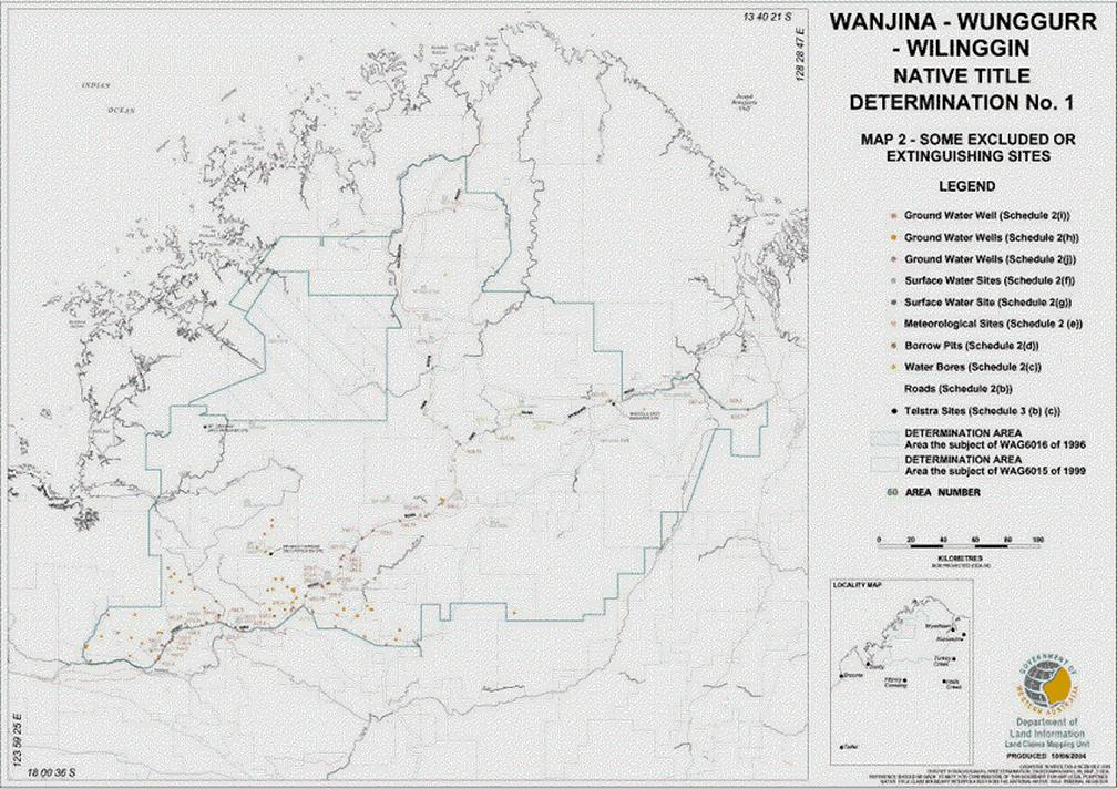
(c) the seven water bores identified in Schedule 10 and shown on Map 2;
(d) such of the borrow pits identified in Schedule 10 and shown on Map 2 as lie within the external perimeter of the determination area and have been established and are not exhausted at the date of this Determination, excluding those involving river sand;
(e) the fifteen meteorological sites identified in Schedule 10 and shown on Map 2;
(f) the seventeen surface water sites identified in Schedule 10 and shown on Map 2;
(g) the surface water site identified in Schedule 10 and shown on Map 2;
(h) the seventy four groundwater wells identified in Schedule 10 and shown on Map 2;
(i) the groundwater well identified in Schedule 10 and shown on Map 2;
(j) the three groundwater wells identified in Schedule 10 and shown on Map 2;
(k) land or waters comprising the following Areas:
|
Area No. |
Description |
Name |
Purpose |
|
Area 6 |
Reserve R27164 |
|
Conservation of flora and fauna |
|
Area 27 |
Reserve R41320 |
Morgan DRCS – Doongan 11 |
Repeater station site |
|
Area 31 |
Reserve R41369 |
|
Domestic satellite ground station |
|
Area 32 |
Reserve R41740 |
Dale DRCS – Doongan 14 |
Repeater station site |
|
Area 34 |
Reserve R41402 |
Ellen DRCS – Omalinde 6 |
Repeater station site |
|
Area 42 |
Reserve R41687 |
Lacy DRCS – Marndoc 6 |
Repeater station site |
|
Area 55 |
Reserve R41350 |
Napier DRCS – Meda 18 |
Repeater station site |
|
Area 56 |
Reserve R40911 |
King DRCS – Numalgun 15 |
Repeater station site |
|
Area 57 |
Reserve R40607 |
Phillips DRCS – Numalgun 14 |
Repeater station site |
|
Area 61a |
Reserve R22256 |
|
Stock route – part only |
|
Area 61b |
Reserve R22256 |
|
Stock route – part only |
|
Area 61c |
Reserve R22256 |
|
Stock route – part only |
|
Area 63 |
Reserve R40770 |
Synnot Range DRCS – Easton 5 |
Repeater station site |
|
Area 65 |
Special Lease 3116/10335 |
|
|
|
Area 66 |
Special Lease 3116/10869 |
|
|
|
Area 69 |
Special Lease 3116/11701 |
|
|
|
Area 70 |
Special Lease 3116/10530 |
|
|
|
Area 72 |
Reserve R41150 |
Foster DRCS – Doongan 12 |
Repeater station site |
|
Area 90 |
Reserve R40701 |
Pentecost DRCS – Marndoc 6 |
Repeater station site |
SCHEDULE 3
Areas where native title does not exist
[Complete extinguishment and not excluded]
The parts of the determination area where native title does not exist are the following Areas:
(a) the following areas:
|
Area No. |
Description |
Name |
Purpose |
|
Area 7 |
Reserve R21969 |
|
Use and benefit of Aborigines |
|
Area 8 |
Reserve R23079 |
|
Use and benefit of Aborigines |
|
Area 16A |
Special Leases 3102/209, 3107/470 |
|
|
|
Area 43 |
Reserve R41921 |
|
Use and benefit of Aboriginal inhabitants |
|
Area 44 |
Reserve R21328 |
|
Use and benefit of Aborigines |
|
Area 46 |
Reserve R19751 |
Munja |
Use and benefit of Aborigines |
|
Area 47 |
Reserve R21968 |
Munja painting reserve |
Use and benefit of Aborigines |
|
Area 50 |
Reserve R21327 |
|
Use and benefit of Aborigines |
(b) Beverley Springs DRCS Repeater Station in Area 21 described in Schedule 10 and shown on Map 2;
(c) Bindoola DRCS Repeater Station in Area 26 described in Schedule 10 and shown on the Map 2;
(d) access tracks established at the date of this Determination to the areas and things in paragraphs (c) to (j) in Schedule 2 from the nearest road (see Map 2 and Schedule 10 for site descriptions);
(e) access tracks established at the date of this Determination to Areas 27, 32, 34, 42, 55, 56, 57, 63, 72 and 90 (see Map 1 for Area locations) from the nearest road;
(f) access tracks established at the date of this Determination to the Bindoola DRCS Repeater Site in Area 26 and the Beverley Springs DRCS Repeater Site in Area 21 from the nearest road (see Map 2 and Schedule 10 for site descriptions);
(g) land that has been appropriated as at the date of this Determination for use (whether by dedication, setting aside, reservation or other valid means) and used for roads.
SCHEDULE 4
Areas where native title comprises the rights set out in Order 4
[No extinguishment – or to be disregarded]
The parts of the determination area where native title comprises the rights and interests set out in Order 4 are the following areas:
|
Area |
Description |
Name |
Purpose |
|
Area 3 |
Reserve R41886 |
Maranbabidi Community |
Use and benefit of Aboriginal inhabitants |
|
Area 4 |
Unallocated Crown land |
|
|
|
Area 14 |
Pastoral Lease 3114/0918 |
Pentecost Downs, Karunjie |
Pastoral |
|
Area 17 |
Pastoral Lease 3114/0980 (including the areas of M80/329 and M80/331) |
Mr Barnett, Kupungarri |
Pastoral (and mining) |
|
Area 23 |
Pastoral Lease 3114/0723 |
Pantijan |
Pastoral |
|
Area 26 |
Pastoral Lease 3114/0648 |
Durack River |
Pastoral |
|
Area 41 |
Reserve R42999 |
Dodnun Community |
Use and benefit of Aboriginal inhabitants |
|
Area 58 |
Pastoral Lease 3114/0997 |
Gibb River, Ngallanguda |
Pastoral |
|
Area 64 (part) |
Unallocated Crown land (to the extent it is not covered by the Fitzroy River proclamation) |
|
|
|
Area 68 |
Special Lease 3116/10534 (including part of the area of M04/161) |
Winjingayr Community |
Use and Benefit of Aboriginal inhabitants (and mining) |
|
Area 71a (part) |
Reserve R10773 (to the extent it is within Area 17 and to the extent (if any) it is not within the present alignment of the Gibb River Road) |
|
Road |
|
Area 73 |
Reserve R40092 |
Kupungarri Community |
Use and benefit of Aboriginal inhabitants |
|
Area 74 |
Reserve R40571 |
Imintji Community |
Use and benefit of Aboriginal inhabitants |
|
Area 77 (part) |
Unallocated Crown land ( to the extent it was not covered by historical pastoral leases and the historical reserve) |
|
|
|
Area 80 (part) |
Unallocated Crown land (first leg of third strip of land, and second leg of third strip to the extent it is within Area 58) |
|
|
|
Area 83 |
Unallocated Crown land |
|
|
|
Area 84 (part) |
Unallocated Crown land (to the extent it was not covered by former pastoral lease K733) |
|
|
|
Area 85 (part) |
Unallocated Crown land (to the extent it was not covered by former pastoral leases) |
|
|
|
Area 86 |
Unallocated Crown land |
|
|
|
Area 87 |
Unallocated Crown land |
|
|
SCHEDULE 5
Areas where native title comprises the rights set out in Order 5
[Pastoral lease partial extinguishment]
The parts of the determination area where native title comprises the rights and interests set out in Order 5 are the following areas:
|
Area |
Description |
Name |
Purpose |
|
Area 1 |
Reserve R08248 |
|
Watering place for travellers and stock |
|
Area 2 |
Reserve R08247 |
|
Watering place for travellers and stock |
|
Area 5 |
Pastoral Lease 398/0844 (including the area of G04/31) |
Drysdale River (Extension) |
Pastoral (and mining) |
|
Area 9 |
Pastoral Lease 3114/0833 |
Theda |
Pastoral |
|
Area 10 |
Pastoral Lease 3114/1174 |
Doongan |
Pastoral |
|
Area 11 |
Pastoral Lease 398/0446 |
Drysdale River |
Pastoral |
|
Area 12 |
Pastoral Lease 3114/1190 |
Ellenbrae |
Pastoral |
|
Area 13 |
Pastoral Lease 3114/1204 |
Mr Elizabeth |
Pastoral |
|
Area 15 |
Pastoral Lease 398/0790 |
Kachana |
Pastoral |
|
Area 16 |
Pastoral Lease 3114/1180 |
El Questro |
Pastoral |
|
Area 18 |
Pastoral Lease 3114/1042 |
Marion Downs |
Pastoral |
|
Area 19 |
Pastoral Lease 3114/0785 |
Glenroy |
Pastoral |
|
Area 20 |
Pastoral Lease 3114/0786 |
Mr House |
Pastoral |
|
Area 21 |
Pastoral Lease 3114/0865 |
Beverley Springs |
Pastoral |
|
Area 22 |
Pastoral Lease 398/0691 |
Charnley River |
Pastoral |
|
Area 24 |
Pastoral Lease 3114/1045 (including the area of M04/90) |
Mr Hart |
Pastoral (and mining) |
|
Area 25 |
Pastoral Lease 3114/0682 (including the area of each of G04/2, M04/84, M04/86, M04/88, M04/91, M04/162 and part of M04/161) |
Napier Downs |
Pastoral (and mining) |
|
Area 28(part) |
Reserve R08258 (to the extent covered by historical pastoral lease K921) |
|
Watering place for travellers and stock |
|
Area 30 |
Reserve R08260 |
|
Watering place for travellers and stock |
|
Area 33 |
Reserve R33706 |
|
Government requirements |
|
Area 35 |
Reserve R08237 |
|
Watering place for travellers and stock |
|
Area 36 |
Reserve R17423 |
|
Camping |
|
Area 37 |
Reserve R17424 |
|
Camping |
|
Area 38 |
Reserve R08238 |
|
Watering place for travellers and stock |
|
Area 39 |
Reserve R22279 |
|
Stopping place for travellers and stock |
|
Area 40 |
Reserve R17422 |
|
Camping |
|
Area 45 |
Reserve R08254 |
|
Watering place for travellers and stock |
|
Area 48 |
Reserve R08255 |
|
Watering place for travellers and stock |
|
Area 49 |
Reserve R08256 |
|
Watering place for travellers and stock |
|
Area 51 |
Reserve R08257 |
|
Watering place for travellers and stock |
|
Area 52 |
Reserve R09742 |
|
Government requirements |
|
Area 53 |
Reserve R17204 |
|
Stock route |
|
Area 54 |
Reserve R17205 (including the area of M04/161) |
|
Stock route (and mining) |
|
Area 59 |
Reserve R22278 |
|
Stopping place for travellers and stock |
|
Area 60a |
Reserve R17421 |
|
Stock route – part only |
|
Area 60b |
Reserve R17421 |
|
Stock route – part only |
|
Area 60c(part) |
Reserve R17421(to the extent covered by historical pastoral leases 5/11,5/17,5/45,5/104,5/105,5/111,K485, K655, and K656 |
|
Stock route – part only |
|
Area 62 |
Reserve R08239 |
|
Watering place for travellers and stock |
|
Area 64(part) |
Unallocated Crown land (to the extent it is covered by the Fitzroy River Proclamation) |
|
|
|
Area 67 |
Pastoral Lease 398/0836 |
Mt Hart (former part) |
Pastoral |
|
Area 71a (part) |
Reserve R10773 (to the extent it is not within Area 17 and to the extent (if any) it is not within the present alignment of the Gibb River Road) |
|
Road |
|
Area 71b |
Reserve R10773 (to the extent (if any) it is not within the present alignment of the Gibb River Road |
|
Road |
|
Area 75 |
Pastoral Lease 398/0834 |
Kimberley Downs (Part) |
Pastoral |
|
Area 76 |
Pastoral Lease 3114/0962 |
Home Valley |
Pastoral |
|
Area 77(part) |
Unallocated Crown land (to the extent it was covered by historical pastoral leases) |
|
|
|
Area 78 |
Unallocated Crown land |
|
|
|
Area 79 |
Unallocated Crown land |
|
|
|
Area 80 (part) |
Unallocated Crown land ( to the extent it is not within Schedule 4 or Schedule 6) |
|
|
|
Area 81 |
Unallocated Crown land |
|
|
|
Area 82 (part) |
Unallocated Crown land (including the area of TR70/5610) |
|
|
|
Area 84 (part) |
Unallocated Crown land ( to the extent it was covered by historical pastoral lease K733) |
|
|
|
Area 85 (part) |
Unallocated Crown land (to the extent it was covered by former pastoral leases |
|
|
|
Area 88 |
Unallocated Crown land |
|
|
|
Area 89 |
Unallocated Crown land |
|
|
SCHEDULE 6
Areas where native title comprises the rights set out in Order 6
[Non‑vested reserve partial extinguishment]
The parts of the determination area where native title comprises the rights and interests set out in Order 6 are the following areas:
|
Area |
Description |
Name |
Purpose |
|
Area 28 (part) |
Reserve R08258 (to the extent not covered by historical pastoral lease K921) |
|
Watering place for travellers and stock |
|
Area 60c (part) |
Reserve R17421( to the extent not covered by historical pastoral leases 5/11,5/17,5/45,5/104,5/105, 5/111, K485, K655 and K656) |
|
Stock route – part only |
|
Area 77 (part) |
Unallocated Crown land (to the extent covered by historical Reserve R8262) |
|
|
|
Area 80 (part) |
Unallocated Crown land (to the extent covered by historical Reserve R8265) |
|
|
SCHEDULE 7
Areas where native title comprises the rights set out in Order 7
[By-Laws 13 and 15 made in 1963 pursuant to s8 of the Parks and Reserves Act 1895]
The part of the determination area where native title comprises the rights and interests set out in Order 7 is:
|
Area |
Description |
Name |
Purpose |
|
Area 29 (part) |
Reserve 32853 |
Drysdale River National Park |
National Park Class “B” Reserve |
SCHEDULE 8
Areas where native title comprises the rights set out in Order 8
[Tidal Waters]
The parts of the determination area where native title comprises the rights and interests set out in Order 8 are: so much, if any, of the determination area in the vicinity of the mouth of the Calder River and in the vicinity of the mouth of the Roe and Moran Rivers as are seaward of the high water mark.
SCHEDULE 9
The members of the Wanjina-Wunggurr Community referred to in Order 3
The descendants of Manumordja, Bulun, Muduu, Banganjaa, Djanghara, Yamara, Baangngayi, Miyaawuyu, Juugaariitor, Djurog-gal, Gilingii, Buunduunguu, Awololaa, Baarrbarrnguu, Angaarambuu, Liinyang, Maanduu-Nuunda, Yuulbal, Freddie Yauubidi, Djalalarmarra, Biljimbirii, Didjingul and Jimmy Manguubangguu.
The descendants of Bandilu, Jarara, Garnag, Momolindij, Galadna, Wanbalug, Burrimbalu, Niyalgarl, Janggara, Ngambijmoro Birramang-nguray, Marala, Gayroog, Buunbuun, Bunngn-guuluu, Djanban, Ngaul-gnarli, Wuungulaa, Maamaandil, Djalanoo, Djilawalaa, Gunagang-ngarii, Mirgngala,, Wabilu, Babirri, Morndignali, Wulagudan, Balangurr, Nyolgodi, Bagumaya, Banggulmoro, Bundungumen, Bagurrngumen, Jilbidij, Bulyuriyali, Brarnggun, Moundi Nirrin,. Molabayng, King O'Malley, Ulinji, Nyaminjenman, Nyalangun, Nalawaru, Bumangul Jarngulay, Bandibej, Munbara, Didburr, Gungala, Wundij, Larburr, Mandi Bandumar, Omboni, Wama, Jalimburr, Bundanali, Umbawinali, Dinamoro, Yalwamurrngarri, Milarbiyar, Mudarwin, Larungumen, Gunduran, Warrwarr, Dandangumen, Didburrngomen, Naranyalgan, Jimmy Bird, Monarriyali, Ngarburrngu, Yanbongu, Dudungungga, Jimmy Wawawawarri, together with the descendants of Dalbi, who was adopted into the native title claimant group; and
The descendants of Bulun/Mauckie, Luwirr, Binjirrngu/Kadi, Djamai, Marnpiny, Munguwadawoi, Kanaway, Arai Djinbari, Maudie Kaiimbinya, Nyanggawana, Ernie Nyimandum and Ruby, Manumortja, Peter Malanaby, Old Jacob, Miyardu, Jerry Jangoot, Jabadayim, Nalawaru, Junggara and Murunguny together with Kenny Oobagooma, Jacob Sesar and Evelyn Bandora, who were adopted into the native title claimant group, and their descendants.
SCHEDULE 10
Location and Description of certain items mentioned in Schedules 2 and 3
|
Schedule Reference |
Item |
Location |
|
Schedule 2(b) |
Gibb River to Wyndham and Gibb River to Kalumburu Roads and rest areas |
|
|
Schedule 2(c) |
Seven water bores |
|
|
Schedule 2(d) |
Borrow pits |
|
|
Schedule 2(e) |
Fifteen meteorological sites |
|
|
Schedule 2(f) |
Seventeen surface water sites |
|
|
Schedule 2(g) |
Surface water site |
|
|
Schedule 2(h) |
Seventy four groundwater wells |
|
|
Schedule 2(i) |
Groundwater well |
|
|
Schedule 2(j) |
Three groundwater wells |
|
|
Schedule 3(b) |
Beverley Springs DRCS Repeater Site |
Beverley Springs DRCS Repeater Site in Area 21, being a square shaped area of 0.36 hectares (60 metres by 60 metres), the corner points of which are located 42.43 metres from a central station mark located at Longitude 125º28'03 Latitude 16º43'53. |
|
Schedule 3(c) |
Bindoola DRCS Repeater Site |
Bindoola DRCS Repeater Site in Area 26, being a square shaped area of 0.36 hectares (60 metres by 60 metres), the corner points of which are located 42.43 metres from a central station mark located at Longitude 127º23'23 Latitude 15º53'23. |
AND THE COURT FURTHER ORDERS THAT:
How the Native Title is Held
14. The native title is not to be held in trust.
The Native Title Body Corporate
15. Within six months of the date of this Determination the Registered Native Title Claimants are to nominate in writing to the Court a prescribed body corporate to:
(a) be the prescribed body corporate for the purposes of s 57(2) of the Native Title Act; and
(b) perform the functions mentioned in s 57(3) of the Native Title Act after becoming a registered native title body corporate,
as to which there is liberty to apply.
16. In the event that there is no nomination within the time specified in Order 14 or such later time as the Court may order, the Registered Native Title Claimants are to forthwith apply to the Court for further directions.
17. Until such time as there is a registered native title body corporate in relation to the determination area any notices required under the Native Title Act or otherwise to be served on the Native Title Holders, the native title claim group or the Registered Native Title Claimants may be served upon the solicitors for the Applicants and the representative Aboriginal body for the determination area, and such service shall be deemed to be sufficient.
18. In respect of land and waters other than that referred to in paragraph 2, Applications WAG 6016 of 1996, WAG 6015 of 1999 and WAG 6006 of 2002 are not “finalised” within the meaning of s 190(4)(e) of the Native Title Act until a prescribed body corporate has been determined, in accordance with s 57(2) of the Native Title Act, to perform the functions mentioned in s 57(3) of that Act.
DEPUTY DISTRICT REGISTRAR