
FEDERAL COURT OF AUSTRALIA
Sampi on behalf of the Bardi and Jawi People v State of Western Australia (No 2) [2010] FCAFC 99
| Citation: | Sampi on behalf of the Bardi and Jawi People v State of Western Australia (No 2) [2010] FCAFC 99 | |
| | | |
| Appeal from: | Sampi v State of Western Australia [2005] FCA 1716 | |
| | | |
| Parties: | ||
| | | |
| File number: | WAD 188 of 2006 | |
| | | |
| Judges: | NORTH AND MANSFIELD JJ | |
| | | |
| Date of judgment: | 18 August 2010 | |
| | | |
| Catchwords: | NATIVE TITLE – form of determination – Right to care for, maintain and protect – Brue Reef - Lalariny | |
| | | |
| Legislation | Native Title Act 1993 (Cth) | |
|
|
| |
| Date of last submissions: | 1 July 2010 | |
|
|
| |
| Place: | Perth | |
|
|
| |
| Division: | GENERAL DIVISION | |
|
|
| |
| Category: | Catchwords | |
|
|
| |
| Number of paragraphs: | 20 | |
|
|
| |
| Counsel for the Appellants: | Mr R. Blowes SC & Mr T. Keely | |
|
|
| |
| Representatives of the Appellants: | Kimberley Land Council | |
|
|
| |
| Counsel for State of Western Australia: | Ms R. Webb QC & Mr T. Creewel | |
|
|
| |
| Solicitor for State of Western Australia: | State Solicitor for Western Australia | |
|
|
| |
| Counsel for the Commonwealth: | Mr K. Pettit SC & Mr A. Rorrison | |
|
|
| |
| Solicitor for the Commonwealth: | Australian Government Solicitors Office | |
|
|
| |
| Counsel for the Western Australian Fishing Industry Council: | Mr M. McKenna & Ms M. Watts | |
|
|
| |
| Solicitor for the Western Australian Fishing Industry Council: | Hunt & Humphry | |
| IN THE FEDERAL COURT OF AUSTRALIA |
|
| WESTERN AUSTRALIA DISTRICT REGISTRY |
|
| ON APPEAL FROM THE FEDERAL COURT OF AUSTRALIA |
| PAUL SAMPI AND OTHERS ON BEHALF OF THE BARDI AND JAWI PEOPLE Appellant
| |
| AND: | THE STATE OF WESTERN AUSTRALIA First Respondent
COMMONWEALTH OF AUSTRALIA Second Respondent
WESTERN AUSTRALIAN FISHING INDUSTRY COUNCIL Third Respondent
B & L BROWN AND BLUE SEAS PEARLING COMPANY Fourth Respondent
|
| NORTH AND MANSFIELD JJ | |
| DATE OF ORDER: | |
| WHERE MADE: | PERTH |
THE COURT ORDERS AND DETERMINES THAT:
ORDER
1. The appeal is allowed in part.
2. The primary judge’s Determination made in Order B on 30 November 2005 is set aside and the Determination that follows is made in lieu thereof.
3. The cross-appeals by the State of Western Australia and the Western Australian Fishing Industry Council are dismissed.
DETERMINATION
Existence of native title (s 225)
1. Native title rights and interests exist in relation to those parts of the Determination Area described in Schedule 3, Schedule 4 and Schedule 4A.
2. Native title does not exist in relation to those parts of the Determination Area described in Schedule 5.
The Native Title Holders (s 225(a))
3. The native title is held by the Bardi and Jawi people being the persons described in Schedule 6 (native title holders).
The nature and extent of native title rights and interests (s 225(b) and s 225(e))
4. Subject to paragraphs 6 and 7 the nature and extent of the native title rights and interests in relation to each part of the Determination Area referred to in Schedule 3 [being areas where there has been no extinguishment of native title or areas where any extinguishment must be disregarded] is the right of possession, occupation, use and enjoyment of that part as against the whole world, including the following rights:
(a) the right to live on the land;
(b) the right to access, move about on and use the land and waters;
(c) the right to hunt and gather on the land and waters;
(d) the right to engage in spiritual and cultural activities on the land and waters;
(e) the right to access, use and take any of the resources of the land and waters (including ochre) for food, shelter, medicine, fishing and trapping fish, weapons for hunting, cultural, religious, spiritual, ceremonial, artistic and communal purposes;
(f) the right to refuse, regulate and control the use and enjoyment by others of the land and its resources;
(g) the right to have access to and use the water of the land for personal, domestic, social, cultural, religious, spiritual, ceremonial and communal purposes.
5. Subject to paragraphs 6 and 7, the nature and extent of the native title rights and interests held in relation to each part of the Determination Area referred to in Schedule 4 [being areas seaward of mean high watermark other than the features known as Lalariny and Alarm Shoals] are:
(a) the right to access, move about in and on and use and enjoy those areas;
(b) the right to hunt and gather including for dugong and turtle;
(c) the right to access, use and take any of the resources thereof (including water and ochre) for food, trapping fish, religious, spiritual, ceremonial and communal purposes.
5A. Subject to paragraphs 6 and 7, the nature and extent of the native title rights and interests held in relation to those parts of the Determination Area referred to in Schedule 4A [being the features known as Lalariny and Alarm Shoals] is the right to care for, maintain and protect those parts, but not including the following rights:
(a) the right to access, move about in or on, and use those parts;
(b) the right to hunt and gather on those parts;
(c) the right to access, use or take any of the resources on those parts.
6. The native title rights and interests are exercisable in accordance with and subject to the:
(a) traditional laws and customs of the native title holders; and
(b) laws of the State and the Commonwealth, including the common law.
7. Notwithstanding anything in this determination there are no exclusive native title rights or interests in:
(a) waters which flow, whether permanently, intermittently or occasionally, within any river, creek, stream or brook;
(b) any natural collection of water into, through, or out of which a river, creek, stream or brook flows; and
(c) waters from and including an underground water source, including water that percolates from the ground.
Nature and extent of other rights and interests in relation to the Determination Area (s 225(c))
8. The nature and extent of other rights and interests in relation to the Determination Area are those set out in Schedule 7.
Relationship between the native title rights and interests and other interests (s 225(d))
9. The relationship between the native title rights and interests described in paragraphs 4 and 5 and the other interests referred to in paragraph 8 (‘the other rights and interests’) is that:
(a) to the extent that any of the other rights and interests are inconsistent with the continued existence, enjoyment or exercise of the native title rights and interests, the native title rights and interests continue to exist in their entirety, but the native title rights and interests have no effect in relation to the other rights and interests to the extent of the inconsistency during the currency of the other rights and interests; and otherwise,
(b) the existence and exercise of the native title rights and interests do not prevent the doing of any activity required or permitted to be done by or under the other rights and interests, and the other rights and interests, and the doing of any activity required or permitted to be done by or under the other rights and interests, prevail over the native title rights and interests and any exercise of the native title rights and interests, but do not extinguish them.
Areas to which s 47A and s 47B apply
10. Sections 47A and 47B of the Native Title Act respectively apply to the areas described in Schedule 9.
Definitions and interpretation
11. In this determination, unless the contrary intention appears:
‘Determination Area’ means the land and waters described in Schedule 1 and excluding those areas described in Schedule 2. In the event of an inconsistency between the written descriptions of areas in the Schedules and the areas depicted on the Maps in Schedule 8, the written descriptions shall prevail;
‘land’ and ‘waters’ respectively have the same meanings as in the Native Title Act; and
‘Native Title Act’ means the Native Title Act 1993 (Cth).
12. The native title is to be held in trust by Bardi and Jawi Niimidiman Aboriginal Corporation.
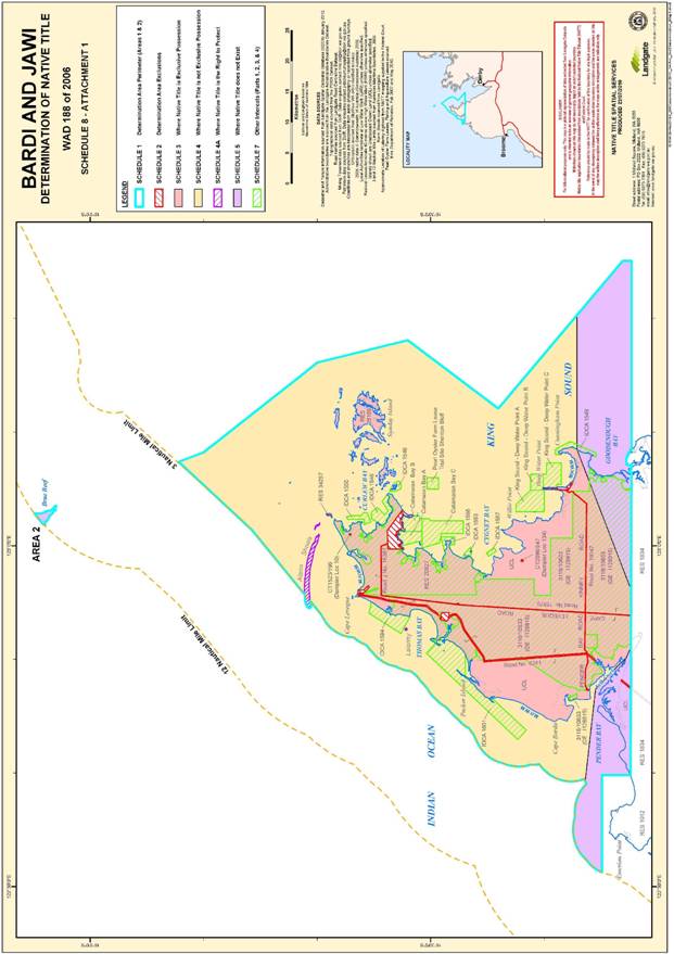
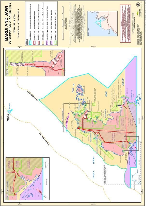
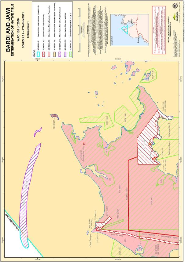
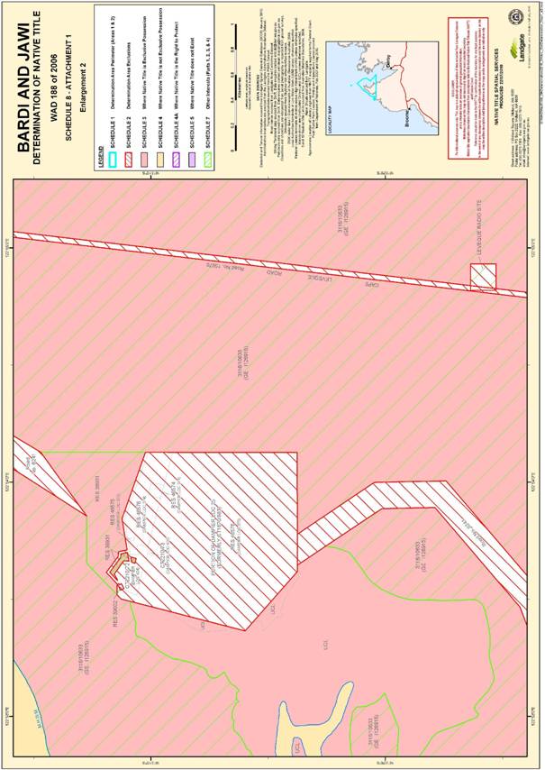
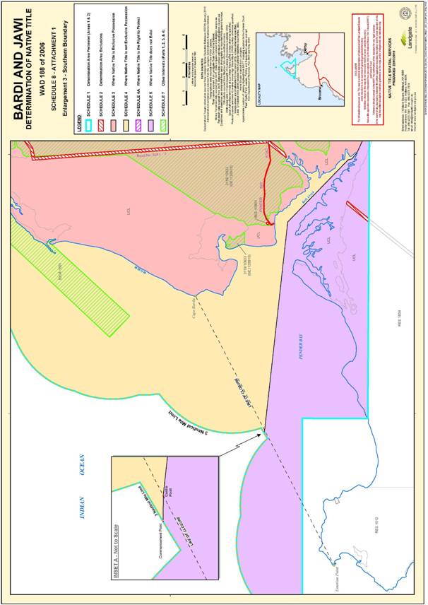
SCHEDULE 1 – DETERMINATION AREA PERIMETER
External Perimeter
The external perimeter of the Determination Area is described in this Schedule and generally shown on the Maps in Schedule 8.
Area 1
Commencing at the point of Latitude 16.130035°S, Longitude 123.122964°E, and extending generally southerly, passing through the following points:
| Latitude S° | Longitude E° |
| 16.166376 | 123.136837 |
| 16.311724 | 123.251283 |
| 16.333598 | 123.268504 |
| 16.466374 | 123.301283 |
| 16.599152 | 123.201283 |
| 16.748595 | 123.378165 |
| 16.782207 | 123.417948 |
| 16.794801 | 123.417959 |
Then west to a point on the northern boundary of Reserve 1834 (as it was at 1st September 1995) at Longitude 123.140564°E, then generally westerly along the northern boundaries of that reserve to Longitude 122.663627°E.
Then north to a point in Pender Bay at Latitude 16.751355°S, then west to intersect the three nautical mile limit, then generally north-easterly along the three nautical mile limit to a southern boundary of Alarm Shoal at Latitude 16.322907°S, then generally westerly and generally north-easterly along the boundaries of Alarm Shoal to again intersect the three nautical mile limit, passing through the following points:
| Latitude S° | Longitude E° |
| 16.322907 | 122.916127 |
| 16.324328 | 122.910444 |
| 16.323144 | 122.908550 |
| 16.320776 | 122.908550 |
| 16.318172 | 122.911155 |
| 16.315330 | 122.918732 |
| 16.315093 | 122.926072 |
| 16.315162 | 122.928403 |
Again, generally north-easterly along the three nautical mile limit back to the commencement point.
Area 2
That part of Brue Reef that lies within the 12 nautical mile limit[1].
Note Reference Data and Source:
Geographical coordinates have been provided by the NNTT Geospatial Unit and are referenced to the Geocentric Datum of Australia 1994 (GDA94), in decimal degrees and are based on the spatial reference data acquired from the various custodians at the time.
SCHEDULE 2 – DETERMINATION AREA EXCLUSIONS
Exclusions from the area described in Schedule 1
[Areas and things not covered by the native title determination application]
The following are not included in the Determination Area:
(a) minerals, petroleum and gas wholly owned by the Crown;
(b) Reserve 34257 for the purpose of ‘Conservation of Flora and Fauna’ vested in and held in trust by the National Parks and Nature Conservation Authority pursuant to s 33 of the Land Act 1933 on 5 May 1989 generally shown on the Maps in Schedule 8;
(c) Reserve 39002 for the purpose of hospital and allied purposes vested in and held in trust by the Minister of Public Health pursuant to s 33 of the Land Act 1933 on 15 February 1985 generally shown on the Maps in Schedule 8;
(d) Reserve 41904 for the purpose of camping vested in the Shire of Broome pursuant to s 33 of the Land Act 1933 on 18 October 1991 generally shown on the Maps in Schedule 8;
(e) Reserve 45490 (formerly comprised in Certificate of Title Volume 1744 Folio 119) generally shown on the Maps in Schedule 8;
(f) the Leveque Radio Site located on Dampier Location 297, being a square shaped area of four hectares (200 metres x 200 metres), the right side corner points of which are located 138.59 metres from a station mark located at Longitude 122054’52.6 Latitude 16032’25 and the left side corner points of which are located 141.42 metres from the same station mark, generally shown on the Maps in Schedule 8;
(g) the areas comprised in Certificates of Title Volume 1711 Folio 767, Volume 1436 Folio 128, Volume 1436 Folio 176, Volume 1523 Folio 196 (Dampier Location 10) and Volume 2096 Folio 847 (Dampier Location 134), generally shown on the Maps in Schedule 8;
(h) the areas comprised in Special Leases 3116/10384, 3116/11169 and 3116/11749, generally shown on the Maps in Schedule 8;
(i) the following gazetted and dedicated roads as generally shown in the Maps in Schedule 8:
(i) Road No. 6241, the Broome to Cape Levique (sic) road, gazetted pursuant to the Lands Act 1911 on 5 September 1919 (page 1566) and 12 September 1919 (page 1600);
(ii) Road No. 15970, Cape Leveque Road, gazetted pursuant to the Local Government Act 1960 on 1 July 1988 (page 2138);
(iii) Road No. 16387, within Reserve 20927, gazetted pursuant to the Local Government Act 1960 on 24 April 1980 (page 1197);
(iv) Road No. 18047, Kinney Road, gazetted pursuant to the Local Government Act 1960-1979 on 2 June 1989 (page 1613);
(v) Road No. 18048, Kinney Road, gazetted pursuant to the Local Government Act 1960-1979 on 2 June 1989 (page 1613);
(vi) Crown Survey OP 16514, Pender Bay Road, dedicated pursuant to s 294A of the Local Government Act 1960-1979;
(j) those portions of Dampier Location 25 as were comprised in Certificate of Title Volume 1670 Folio 883 when the native title determination application the subject of proceeding WAD 49 of 1998 was made, including Dampier Locations 371, 372, 373, 374, 404 and 405 generally shown on the Maps in Schedule 8; and
(k) the areas comprised in Certificates of Title Volume 1744 Folio 116 (Portion of Dampier Location 19), Volume 1744 Folio 117 (Portion of Dampier Location 69) and Volume 1744 Folio 118 (Dampier Location 21) generally shown on the Maps in Schedule 8.
SCHEDULE 3 – WHERE NATIVE TITLE IS EXCLUSIVE POSSESSION
Areas where native title comprises the rights set out in Order 4
[No extinguishment or extinguishment disregarded]
The parts of the Determination Area where native title comprises the rights and interests set out in Order 4 are those parts landward of mean high water mark that lie north of the southern boundary, and are generally shown on the Maps in Schedule 8.
In this and other Schedules, ‘southern boundary’ means a line commencing at the commencement point then proceeding easterly to the centre point of the line of closure of Pender Bay, generally south-easterly along a line bisecting Pender Bay to the mouth of Kelk Creek, then generally south easterly along the centre line of Kelk Creek to the point of intersection between that line and the northern boundary of Reserve 1834, then easterly following that boundary for approximately 10 kilometres to Longitude 122.935502 E° then north easterly to a point on the mean high watermark of the mainland coast on the eastern side of the Dampier Peninsula at Latitude 16.714603 S° and then due east to the point of intersection with the external perimeter of the Determination Area, as generally shown on the Maps in Schedule 8.
In the definition of the southern boundary ‘commencement point’ means a point on the western side of the Dampier Peninsula at which a line drawn due west from the centre point of the line of closure of Pender Bay intersects the 3 nautical mile limit.
SCHEDULE 4 – WHERE NATIVE TITLE IS NOT EXCLUSIVE POSSESSION
Areas where native title comprises the rights set out in Order 5
[Areas seaward of mean high water mark other than the features known as Lalariny and Alarm Shoals]
Those parts of the Determination Area seaward of mean high water mark that lie north of the southern boundary, other than those included in Schedule 4A or Schedule 5, as generally shown on the Maps in Schedule 8.
SCHEDULE 4A – WHERE NATIVE TITLE IS THE RIGHT TO PROTECT
Areas where native title comprises the rights set out in Order 5A
[Areas of the features known as Lalariny and Alarm Shoals]
Those parts of the Determination Area comprising the features known as Alarm Shoals and Lalariny, as generally shown on the Maps in Schedule 8.
SCHEDULE 5 – WHERE NATIVE TITLE DOES NOT EXIST
[Areas not excluded but where native title does not exist]
The parts of the Determination Area where native title does not exist are the lands and waters of the Determination Area other than those described in Schedules 3, 4 and 4A.
SCHEDULE 6 – NATIVE TITLE HOLDERS
The Native Title Holders referred to in Order 3
The persons referred to in Order 3 are:
(a) the descendants of the following people:
Agimo, Albert Balib, Banalm, Bayid, Bidnid, Bulam also called 'Plum', Daygan; Dibi, Dilay, Dingga or Tinker also known as Jungurinjan, Emilie Amilij Williams, Ernest Ralph Anij, Gagi, Gardad also known as Gardada, Gawrri, Gregory Girrigwarr also known as Ngalgun, Igab also known as Igabo, Irene Nyunggu, Irrigul, Jambu, Jarni also known as Johnny Wangal, Jinerrb, Jurni, Malumbo Jack Junduwarra, Mandirr aka Judunbur, Mandirr, Marraliny, Miyardi, Nayp, Nayard, Ngunya, Nubul also known as Mardinganbur, Nyamwa, Panj also known as Ngarlgarrman, Peter Wambalag, Raphael Phillips, Willie Gunggunbur and Benedict Dilay; and
(b) those persons adopted by those descendants, in accordance with the traditional laws and customs of the native title holders.
SCHEDULE 7 – OTHER INTERESTS
Other interests referred to in Paragraph 8
The nature and extent of other interests in relation to those parts of the Determination Area described in Schedules 3 and 4 are the following as they exist as at the date of this determination:
Reserves
1. The interests of persons who have the care, control and management of the following reserves, and the interests of persons entitled to access and use these reserves for the respective purposes for which they are reserved, subject to any statutory limitations upon those rights:
(a) Reserve 20927 for the ‘Use and Benefit of Aborigines’ vested pursuant to s 33 of the Land Act 1933 (WA), in the Aboriginal Lands Trust on 29 June 1973, for the designated purpose of ‘Use and Benefit of Aborigines’; and
(b) Reserve 38931 for the ‘Use and Benefit of Aboriginal Inhabitants’ vested pursuant to s 33 of the Land Act 1933 (WA) in the Aboriginal Lands Trust on 30 November 1984.
Leases
2. The rights and interests of the holders of the following leases:
(a) Special Lease 3116/10633 in Dampier Location 297 for the special purpose of ‘Use and Benefit of Aboriginal Inhabitants’ granted pursuant to s 116 of the Land Act 1933 for a term commencing on 1 July 1991; and
(b) Special Lease 3116/10656 in Dampier Location 290 for the special purpose of ‘Use and Benefit of Aboriginal Inhabitants’ granted pursuant to s 116 of the Land Act 1933 for a term commencing on 1 July 1991.
Fishing and Aquaculture licences
3. The interests of the holders of statutory interests and exemptions granted under the Fisheries Management Act 1991 (Cth), the Fish Resources Management Act 1994 (WA) and the Pearling Act 1990 (WA), including the following aquaculture licences granted under the Fish Resources Management Act 1994 (WA):
| Licence No | Holder |
| IDCA 1546 | Bardi Aborigines Association Inc |
| IDCA 1549 | Gudumul Aboriginal Corporation |
| IDCA 1550 | Gumbarnun Aboriginal Corporation |
| IDCA 1593 | Nyumwah Aboriginal Corporation |
| IDCA 1594 | Ngamakoon Aboriginal Corporation |
| IDCA 1597 | Djarajung Aboriginal Corporation |
| IDCA 1598 | Mudnun Aboriginal Corporation |
| IDCA 1601 | Chile Creek Aboriginal Corporation |
Pearl Oyster Farm Leases
4. The rights and interests of the holders of Pearl Oyster Farm Leases granted under the Pearling Act 1990 (WA), including (to the extent that they are wholly or partly within either of the area described in Schedule 3 or the area described in Schedule 4):
| Lease name | Holder | Date Granted |
| Catamaran Bay A, Catamaran Bay B and Catamaran Bay C | BR & LM Brown | 20 July 2001 |
| King Sound - Deep Water Point A[2] | Blue Seas Pearling Company | 25 May 2007 |
| King Sound - Deep Water Point B | Blue Seas Pearling Company | 11 December 2008 |
| King Sound - Deep Water Point C | Blue Seas Pearling Company | 25 May 2007 |
| Pearl Oyster Farm Lease Trial Site Shenton Bluff | BR & LM Brown | 10 September 2009 |
Telstra
5. The interests of Telstra Corporation Limited:
(a) rights and interests as the owner and operator of telecommunications facilities installed within the Determination Area, including customer radio terminals and telecommunications cabling;
(b) rights and interests created pursuant to the Post and Telegraph Act 1901 (Cth), the Telecommunications Act 1975 (Cth), the Australian Telecommunications Corporation Act 1989 (Cth), the Telecommunications Act 1991 (Cth) and the Telecommunications Act 1997 (Cth); and
(c) rights of access by employees, agents or contractors of Telstra Corporation Limited to its telecommunications facilities in, and in the vicinity of, the Determination Area, in the performance of their duties.
Other
6. The following rights and interests:
(a) rights and interests held under valid and validated grants from the Crown pursuant to statute or in the exercise of its executive power or otherwise conferred by statute;
(b) rights or interests held by reason of the force and operation of the laws of the State or of the Commonwealth including the force and operation of the Rights in Water and Irrigation Act 1914 (WA) and the Aboriginal Communities Act 1979 (WA); and
(c) the right to access the Determination Area by:
(i) an employee or agent or instrumentality of the State;
(ii) an employee or agent or instrumentality of the Commonwealth;
(iii) an employee or agent or instrumentality of any local government authority
as required in the performance of his or her statutory or common law duty where such access would be permitted to private land;
(d) the rights of members of the public under the following
(i) the public right to fish in tidal waters; and
(ii) the public right to navigate over tidal waters;
(e) the rights under the international right of innocent passage;
(f) so far as confirmed pursuant to s 14 of the Titles (Validation) and Native Title (Effect of Past Acts) Act 1995 (WA) as at the date of this determination, any existing public access to and enjoyment of:
(i) waterways;
(ii) beds and banks or foreshores of waterways
(iii) coastal waters;
(iv) beaches
SCHEDULE 8 – THE MAPS


SCHEDULE 9 – AREAS TO WHICH s 47A and s 47B APPLY
| Description | Name | Purpose | S 47A or 47B |
| Special Lease 3116/10633 | Dampier Location 297 | Djarindjin Corporation | s 47A |
| Special Lease 3116/10656 | Dampier Location 290 | Pender Aboriginal Corporation | s 47A |
| Reserve 20927 | Dampier Locations 76, 89 | Use and Benefit of Aborigines | s 47A |
| Reserve 38931 | Dampier Location 145 | Use and Benefit of Aboriginal Inhabitants | s 47A |
| Unallocated Crown land | Dampier Location 289 |
| s 47B |
| Unallocated Crown land | Dampier Location 211 |
| s 47B |
| Unallocated Crown land | Dampier Location 243 |
| s 47B |
| All other areas of unallocated Crown land |
|
| s 47B |
Note: Settlement and entry of orders is dealt with in Order 36 of the Federal Court Rules.
The text of entered orders can be located using Federal Law Search on the Court’s website.
| IN THE FEDERAL COURT OF AUSTRALIA |
|
| WESTERN AUSTRALIA DISTRICT REGISTRY |
|
| GENERAL DIVISION | WAD 188 of 2006 |
| ON APPEAL FROM THE FEDERAL COURT OF AUSTRALIA |
| BETWEEN: | PAUL SAMPI AND OTHERS ON BEHALF OF THE BARDI AND JAWI PEOPLE Appellant
|
| AND: | THE STATE OF WESTERN AUSTRALIA First Respondent
COMMONWEALTH OF AUSTRALIA Second Respondent
WESTERN AUSTRALIAN FISHING INDUSTRY COUNCIL Third Respondent
B & L BROWN AND BLUE SEAS PEARLING COMPANY Fourth Respondent
|
| JUDGES: | NORTH AND MANSFIELD JJ |
| DATE: | 18 AUGUST 2010 |
| PLACE: | PERTH |
REASONS FOR JUDGMENT
1 On 18 March 2010, the Full Court handed down its reasons in this matter: Sampi on behalf of the Bardi and Jawi People v State of Western Australia [2010] FCAFC 26. These reasons foreshadowed orders allowing in part an appeal brought by the Bardi and Jawi people, and dismissing the cross-appeals brought by the State of Western Australia (the State) and the Western Australian Fishing Industry Council (WAFIC).
2 Orders were made on that day for the parties, excluding the fourth respondent, to seek agreement on the form of orders and determination reflecting the conclusions reached in those reasons for judgment by 23 April 2010. In the event that no agreement could be reached, the parties were to file individual submissions and proposed determinations for consideration by the Court.
3 The appellants, the State, the Commonwealth and WAFIC filed further submissions and comments upon the terms of the proposed determination. Whilst substantial agreement had been reached between the parties, three areas of disagreement remained. Broadly, these issues were:
· The manner in which the right to care for, maintain and protect should be defined;
· The clarity with which Brue Reef should be defined; and
· Whether or not the Determination should identify the location of the rock feature known as Lalariny.
4 The Full Court has now considered the detailed submissions from the parties on those issues. These reasons address those issues.
THE RIGHT TO CARE FOR, MAINTAIN AND PROTECT
5 In the judgment of 18 March 2010, the Full Court recognised a right to care for, maintain and protect two areas known as Lalariny and Alarm Shoals. In the draft determination filed by the appellants, the right to care for, maintain and protect was set out in paragraph 5A in the following manner:
5A. Subject to paragraphs 6 and 7, the nature and extent of native title rights and interests held in relation to those parts of the determination area referred to in Schedule 4A [being the features known as Lalariny and Alarm Shoals] is the right to care for, maintain and protect those parts.
6 The respondents contended that this did not adequately describe the activities which comprise the specified right, and proposed inserting the following at the end of the paragraph proposed by the appellants:
but not including any right to:
i. move about in or on, and use and enjoy, the area;
ii. hunt and gather including for dugong and turtle;
iii. access, use or take any of the resources thereof for food, trapping fish, religious, spiritual, ceremonial and communal purposes.
7 Following further discussions between the parties, the appellants accepted those proposals, but with some minor amendments in the following form:
5A. Subject to paragraphs 6 and 7, the nature and extent of native title rights and interests held in relation to those parts of the determination area referred to in Schedule 4A [being the features known as Lalariny and Alarm Shoals] is the right to care for, maintain and protect those parts, but not including the following rights:
(a) the right to access, move about in or on, and use those parts;
(b) the right to hunt and gather in those parts;
(c) the right to access, use or take any of the resources on those parts;
(d) except in relation to any part of the feature known as Lalariny that extends above the mean high water mark – the right to exclude others from that part.
8 No objection to those essentially editorial changes suggested by the appellant has been made to the Court, except for the insertion of subclause (d). That was met with significant objection, by both the State, the Commonwealth (which adopted the submissions of the State) and WAFIC. The inclusion of subclause (d), the respondents claim, amounts to an assertion by the appellants of a right to exclude persons from access to the area known as Lalariny, a right which was not argued in the course of the hearing, and which was not recognised by the Full Court in its reasons of 18 March 2010.
9 Whilst the Full Court did not explicitly state that the right to care for, maintain and protect was non-exclusive, the reasons make it clear that this is the intention. Reference was made to Attorney General (NT) v Ward (2003) 134 FCR 16; [2003] FCAFC 283, Neowarra v State of Western Australia [2003] FCA 1402, Alyawarr, Keytetye, Warumungu, Wakay Native Title Claim Group v Northern Territory of Australia (2004) 207 ALR 539; [2004] FCA 472 and Daniel v Western Australia [2005] FCA 536, all of which referenced non-exclusive rights to care for, maintain and protect certain parts of those claim areas.
10 The right to protect does not amount to an exclusive right. The inclusion of the appellant’s proposed subclause 5A(d) does not reflect the Court’s decision and should not be included in the Determination.
11 Accordingly, paragraph 5A of the Determination will read:
5A. Subject to paragraphs 6 and 7, the nature and extent of native title rights and interests held in relation to those parts of the determination area referred to in Schedule 4A [being the features known as Lalariny and Alarm Shoals] is the right to care for, maintain and protect those parts, but not including the following rights:
(a) the right to access, move about in or on, and use those parts;
(b) the right to hunt and gather in those parts;
(c) the right to access, use or take any of the resources on those parts;
BRUE REEF
12 Brue Reef is an area some 12 nautical miles off the coast of the Dampier Peninsula. No native title was recognised over that area. In the appellant’s draft determination, Brue Reef is the subject of paragraph 2, which refers to schedule 5, in which areas are identified over which there is no recognised native title.
13 The State and the Commonwealth contend that this does not sufficiently describe the status of Brue Reef. They seek the express exclusion of Brue Reef from schedule 4, which refers to parts of the determination area seaward of the high water mark. Such an express exclusion is, according to the appellants, unnecessary and apt to confuse. Further, they contend that as Brue Reef was not an issue that was the subject of the appeal, the determination should reflect the form of the Determination made by the primary judge, which included Brue Reef in schedule 5 in the manner proposed by the appellants.
14 We accept the position of the appellants in this regard. Brue Reef, as an area over which there is no recognised native title is rightly included in the schedule which identifies those areas. Its inclusion in other schedules is unnecessary. There is no reason why the Determination should not follow the form accepted by the primary judge on issues that were not the subject of the Full Court appeal.
LALARINY
15 In their submissions, the appellants request that the exact location of the rock feature known as Lalariny not be given in the Determination. They base this request on two points. First, the appellants argue that the location of Lalariny was not included in the Determination delivered by the primary judge, and should therefore not be included in the Full Court Determination, and second, the appellant’s submit that it would be culturally problematic to disclose the precise location of the feature. In the event that the Full Court does not accept this argument, the appellants contend that it simply be identified on the maps by an arrow pointing to the “general location of Lalariny”.
16 The State contends that, in order to have properly enforceable and effective rights, the determination must be comprehensive, complete and precise, and should therefore include the precise location of Lalariny. It is important that those who might be in the area should be able to know the area over which such rights have been granted. A failure to properly define its location, would, according to the State, create difficulties with possible future acts in relation to Lalariny and any negotiations which flow from them, and may create difficulties with enforcement.
17 Having regard to the significance that the appellants place on Lalariny, the Court well understands the concerns of the appellants. However, it would not be appropriate for the Court to avoid inclusion of the location of Lalariny in the Determination. As the respondents contend, its omission may create significant difficulties in both the enforcement of the native title rights and interests in relation to it, and potentially in relation to any future act processes under s 29 of the Native Title Act 1993 (Cth), should that process be enlivened. The Court is mindful to avoid disclosure of culturally sensitive material, but in this instance the location of Lalariny in our view must be described in the Determination. We propose to do so in the manner proposed by the State. We do not think that such a description is at all likely to encourage or facilitate those who have no proper reason to be in the vicinity now to go there, or those who have a proper reason to be in the vicinity to do otherwise than to have due regard to the rights and interests in Lalariny which the Court has determined in favour of the appellants. As a result, the location of Lalariny should be included in the determination as proposed by the respondents, subject to Schedule 4A being altered to read:
Those parts of the Determination Area comprising the features known as Alarm Shoals and Lalariny, as generally shown on the Maps in Schedule 8.
18 We note that the identification of Lalariny in that manner does not depict the contours of the site, that is one protection from its too ready identification which the appellants sought.
CONCLUSION
19 There were some minor drafting issues which were debated by the parties in submissions. They have been resolved. Accordingly, in accordance with these reasons and the reasons given on 18 March 2010, there will now be a Determination of native title rights and interests in the terms of the Orders which accompany these reasons.
20 The Court records its appreciation to the parties and their representatives for their assistance in the process of fixing the terms of the Determination to give effect to our reasons on the appeal.
| I certify that the preceding twenty (20) numbered paragraphs are a true copy of the Reasons for Judgment herein of the Honourable Justices North and Mansfield. |
Associate:
Dated: 13 August 2010
[1] Note that “Area 2” includes the part of Brue Reef that was included in Proceeding WAD 49 of 1998 as well as the part that was included in proceeding WAD6001 of 2004, which parts fall respectively west and east of a line defined by the following coordinate points:
| Longitude E° | Latitude S° |
| 123.034613 | 15.898597 |
| 123.136837 | 16.166376 |
[2] Mapping of Pearl Oyster Farm Leases described as King Sound – Deep Water Point A, B and C suggests that all or some of those pearling leases may extend landward of the low water mark. The holders of those Pearl Oyster Farm Leases do not contend that those leases so extend. To the extent that the Pearl Oyster Farm Leases in question extend landward of the low water mark, they are invalid to the extent that they are in an area landward of the low water mark and to the extent that they affect native title in that area.

