FEDERAL COURT OF AUSTRALIA
Attorney-General of the Northern Territory v Ward [2003] FCAFC 283
NATIVE TITLE – Terms of determination basically agreed but disputes on some items – Whether it is necessary exhaustively to identify the holders of native title rights and interests – Whether it is necessary to identify all those rights and interests – Discussion of other contested words and phrases.
Western Australia v Ward [2002] HCA 28; 191 ALR 1 applied.
Native Title Act 1993 (Cth) s 225
ATTORNEY-GENERAL OF THE NORTHERN TERRITORY v BEN WARD & ORS ON BEHALF OF THE MIRIUWUNG AND GAJERRONG PEOPLE, CECIL NINGARMARA & ORS, DELORES CHEINMORA & ORS ON BEHALF OF THE BALANGARRA PEOPLES
WAG 6296 of 1998
CECIL NINGARMARA & ORS v NORTHERN TERRITORY OF AUSTRALIA & STATE OF WESTERN AUSTRALIA
W 6020 of 1999
WILCOX, NORTH and WEINBERG JJ
9 DECEMBER 2003
KUNUNURRA (HEARD IN PERTH)
| IN THE FEDERAL COURT OF AUSTRALIA |
|
| WESTERN AUSTRALIA DISTRICT REGISTRY | WAG 6296 of 1998 |
ON REMITTER FROM THE HIGH COURT IN P62 of 2000 and P63 of 2000
| BETWEEN: | ATTORNEY-GENERAL OF THE NORTHERN TERRITORY APPELLANT
|
| AND: | BEN WARD & ORS ON BEHALF OF THE MIRIUWUNG AND GAJERRONG PEOPLE FIRST RESPONDENT
CECIL NINGARMARA & ORS SECOND RESPONDENT
DELORES CHEINMORA & ORS ON BEHALF OF THE BALANGARRA PEOPLES THIRD RESPONDENT
|
| IN THE FEDERAL COURT OF AUSTRALIA |
|
| WESTERN AUSTRALIA DISTRICT REGISTRY | W 6020 of 1999 |
ON REMITTER FROM THE HIGH COURT IN P62 of 2000 and P63 of 2000
| BETWEEN: | CECIL NINGARMARA & ORS APPELLANT
|
| AND: | NORTHERN TERRITORY OF AUSTRALIA FIRST RESPONDENT
STATE OF WESTERN AUSTRALIA SECOND RESPONDENT
|
| JUDGES: | WILCOX, NORTH and WEINBERG JJ |
| DATE OF ORDER: | 9 DECEMBER 2003 |
| WHERE MADE: | KUNUNURRA (HEARD IN PERTH) |
THE COURT NOTES THAT:
A. In April 1994, Ben Ward and others (‘the first applicants’) lodged a native title application in relation to a claim area covering approximately 7,900 square kilometres in the north-west of Western Australia and certain lands in the Northern Territory (‘the NT claim area’).
B. In the course of proceedings in the Federal Court of Australia, Cecil Ningarmara and other Aboriginal people who claimed to have an interest in the NT claim area became the second applicants in the proceedings.
C. On 24 November 1998, following a lengthy trial, Lee J handed down judgment and made a determination that native title existed in relation to the whole of the area under claim (other than certain areas where native title had been extinguished), including the NT claim area.
D. Various parties before the trial judge appealed to the Full Court of the Federal Court, which handed down judgment in relation to the appeals on 3 March 2000. The Full Court set aside the determination made by the trial judge and substituted its own determination of native title which differed from that of the trial judge.
E. Pursuant to special leave granted by the High Court of Australia, certain matters were taken on appeal to that Court, which delivered its judgment on 8 August 2002. Order 2 of the orders made by the High Court reads as follows:
‘Paragraphs 4 and 6 of the orders of the Full Court of the Federal Court made on 3 March 2000, the whole of the order of the Full Court of the Federal Court made on 11 May 2000 and the determination of native title made on 11 May 2000 are set aside and the matters remitted to the Full Court for further hearing and determination.’
F. The parties that have an interest in the NT claim area are the first and second applicants, the Northern Territory of Australia and the entities identified in clause 8 of the determination set out below.
G. The parties have reached an agreement as to the terms of a determination of native title to be made in relation to the NT claim area.
H. Those parties referred to in Recital F acknowledge that the rights and interests of the native title holders in the land and waters of the NT claim area, possessed under their traditional laws and customs, but not all of which may be recognised by the common law, are:
(a) ownership of the land and waters;
(b) giving or refusing permission to non-native title holders to occupy or use the land and waters;
(c) speaking for and making decisions about the land and waters;
(d) hunting, gathering and using the natural resources and giving or refusing permission to non-native title holders to do so;
(e) managing the spiritual forces associated with the land and waters;
(f) protecting places of significance, and caring for the land and waters; and
(g) safeguarding the cultural knowledge associated with them.
I. The parties acknowledge that in relation to those parts of the NT claim area comprising Northern Territory Portions 3541, 3542 and 3863, being Aboriginal community living areas within the Miscellaneous Acts Amendment (Aboriginal Community Living Areas) Act (NT), it was the conclusion of the Full Court of the Federal Court that:
(a) s 47A of the Native Title Act 1993 (Cth) (‘the Act’) applied, with the effect that any extinguishment of native title rights and interests by the grants themselves, or by the creation of any other prior interest in relation to the areas, must be disregarded; and
(b) the native title rights and interests in those portions of land comprise possession, occupation, use and enjoyment to the exclusion of all others, subject, however, to s 47A(3) of the Act.
J. The parties have further agreed to apply to the Federal Court for a consent order for a determination that native title exists in relation to the NT claim area.
K. The parties accept that the effect of this determination is that the members of the estate groups identified in clause 3, and the persons identified in clause 4, of the determination, are acknowledged as the native title holders for the NT claim area in accordance with the traditional laws acknowledged and the traditional customs observed by them.
L. No nomination pursuant to section 56(2) of the Act in relation to the holding of native title in trust has been made.
BEING SATISFIED that a determination in the terms sought by those parties would be within the power of the Court, and it appearing to the Court appropriate to do so, and by consent of those parties,
THE COURT ORDERS THAT:
1. There be a determination of native title in terms of the determination set out below.
2. The native title is not to be held in trust.
3. An Aboriginal corporation whose name is to be provided within 12 months, or such further time as a judge of the Court may allow, is to:
(a) be the prescribed body corporate for the purposes of s 57(2) of the Act; and
(b) perform the functions outlined in s 57(3) of the Act after becoming a registered native title body corporate.
4. Appeal WAG 6296 of 1998 is allowed and leave is granted for appeal W 6020 of 1999 to be discontinued.
5. There be no order as to the costs of appeals WAG 6296 of 1998 or W 6020 of 1999.
THE COURT DETERMINES THAT:
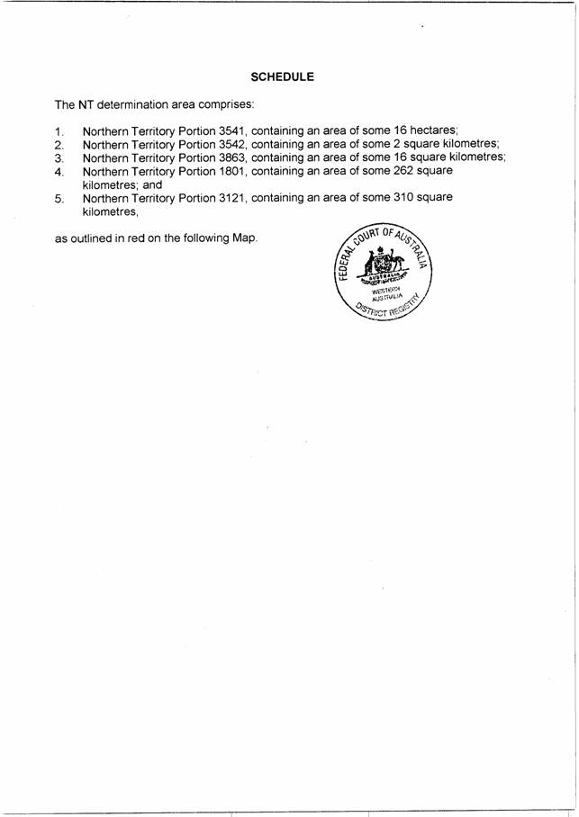
1. Native title exists in the areas of land and waters claimed in the Northern Territory and described in the Schedule (‘the NT determination area’).
2. The land and waters of the NT determination area are part of three estates (the Damberal estate, the Bindjen estate and the Nyawamnyawam estate), each of which estates is held by the members of the three respective estate groups (the Damberal estate group, the Bindjen estate group, and the Nyawamnyawam estate group). They, together with the Aboriginal people referred to in clause 4 below, are collectively referred to as ‘the native title holders’.
3. Each of the three estate groups referred to in clause 2 includes members by reason of patrilineal descent and matrifiliates, who are members by reason of descent from mother and mother’s father (djawidji), and persons adopted into such descent relationships (‘the estate group members’).
4. In accordance with traditional laws and customs, other Aboriginal people have rights in respect of the land and waters of an estate which is not their own, subject to the rights and interests of the estate group members, such people being:
(a) members of estate groups from neighbouring estates;
(b) spouses of the estate group members; and
(c) members of other estate groups with ritual authority.
5. Subject to clause 9, the nature and extent of the native title rights and interests of the estate group members in relation to the NT determination area, recognised by the common law, are non-exclusive rights to use and enjoy the land and waters in accordance with their traditional laws and customs, being:
(a) the right to hunt on the land, to gather and use the natural resources of the land such as food, medicinal plants, wild tobacco, timber, stone and resin, and to have access to and use of natural water on the land;
(b) the right to live on the land, to camp, to erect shelters, and to move about the land;
(c) the right to engage in cultural activities on the land, to conduct ceremonies, to hold meetings, and to participate in cultural practices relating to birth and death;
(d) the right to have access to, maintain and protect the sites of significance on the land of the NT determination area; and
(e) the right to make decisions about the use and enjoyment of the NT determination area by Aboriginal people who recognise themselves to be governed by Aboriginal traditional laws and customs.
These native title rights and interests do not confer possession, occupation, use and enjoyment of the land or waters on the native title holders to the exclusion of all others.
6. Subject to clause 9, the nature and extent of the native title rights and interests held, in accordance with their traditional laws and customs, by the native title holders referred to in clause 4 hereof, in relation to the NT determination area, recognised by the common law are:
(a) in relation to members of estate groups from neighbouring estates – rights of access to, and rights to hunt, fish and gather the natural resources on the land and waters of their neighbouring estate group members, subject to the permission, implied or express, of the relevant senior estate group members;
(b) in relation to spouses of estate group members – rights of access to, and to hunt, fish and gather the natural resources on, the land and waters of their spouse’s estate; and
(c) in relation to members of other estate groups who hold ritual authority – rights to act, in accordance with traditional laws and customs, in relation to the maintenance and protection of sites associated with the travels of an ancestral being associated with a Dreaming which passes through the estates in the NT determination area.
These native title rights and interests do not confer possession, occupation, use and enjoyment of the land or waters on the native title holders to the exclusion of all others.
7. There are no native title rights and interests in:
(a) minerals (as defined in s 2 of the Minerals (Acquisition) Act (NT));
(b) petroleum (as defined in s 5 of the Petroleum Act (NT)); and
(c) prescribed substances (as defined in s 3 of the Atomic Energy (Control of Materials) Act 1946 (Cth) and/or s 5(1) of the Atomic Energy Act 1953 (Cth)),
in the NT determination area.
8. The nature and extent of other interests in relation to the NT determination area are the interests, created by the Crown or otherwise, as follows:
(a) in relation to Northern Territory Portion 3541 (Policeman’s Hole), the interests of the Nyawamnyawam Dawang Aboriginal Corporation under its fee simple estate granted on 18 December 1990;
(b) in relation to Northern Territory Portion 3542 (Bucket Springs), the interests of the Binjen Ningguwung Aboriginal Corporation under its fee simple estate granted on 18 December 1990;
(c) in relation to Northern Territory Portion 3863 (Bubble Bubble), the interests of the Dumbral Aboriginal Community Association under its fee simple estate granted on 4 October 1993;
(d) in relation to Northern Territory Portions 1801 and 3121:
(i) the interests of the Conservation Land Corporation under Special Purposes Lease 475 and Crown Lease Perpetual 581; and
(ii) the interests of the Parks and Wildlife Commission of the Northern Territory pursuant to its functions and powers of management and control of these areas under the Territory Parks and Wildlife Conservation Act (NT) (and subsidiary legislation, and including under any Plan of Management in force in relation to these areas from time to time) and the Parks and Wildlife Commission Act (NT), including interests in any buildings, works or other structures constructed or established by the Commission within these areas;
(e) in relation to Northern Territory Portions 1801 and 3121, the interests of members of the public arising from rights of access to and use of these areas as a national park, subject to any statutory limitations upon these rights, including those under the Northern Territory Aboriginal Sacred Sites Act (NT);
(f) in relation to the NT determination area, the interests of Telstra Corporation Limited, including:
(i) rights and interests as the owner or operator of telecommunications facilities installed within the NT determination area, including customer radio terminals and overhead and underground cabling;
(ii) rights and interests created pursuant to the Post and Telegraph Act 1901 (Cth), the Telecommunications Act 1975 (Cth),the Australian Telecommunications Corporation Act 1989 (Cth), the Telecommunications Act 1991 (Cth) and the Telecommunications Act 1997 (Cth); and
(iii) rights of access by employees, agents or contractors of Telstra Corporation Limited to its telecommunications facilities in and in the vicinity of the NT determination area in the performance of their duties.
9. In relation to the parts of the NT determination area identified as:
(a) the whole of NT Portion 3541 (Policeman’s Hole);
(b) the whole of NT Portion 3542 (Bucket Springs); and
(c) the whole of NT Portion 3863 (Bubble Bubble);
the rights of the native title holders are an entitlement to possession, occupation, use and enjoyment of those parts of the NT determination area to the exclusion of all others provided, however, that rights and interests in flowing and subterranean waters are non-exclusive.
10. In relation to those parts of the NT determination area other than the portions identified in clause 9 above, the rights of the native title holders (identified in s 122 of the Territory Parks and Wildlife Conservation Act (NT) and in the Northern Territory Aboriginal Sacred Sites Act (NT)):
(a) to use the land or waters for hunting and gathering of food for domestic purposes;
(b) to use the land or waters for ceremonial and religious purposes;
(c) to be present on the land for the purpose of conducting such activities; and
(d) to take appropriate steps to protect sacred sites from damage, disturbance or interference;
continue to be enjoyed, and, subject to the principle of reasonable use, may be exercised notwithstanding the interests referred to in clause 8 above, but are not exclusive of the rights of others.
11. Subject to clause 10, the rights and interests of the persons referred to in clause 8(d) are wholly inconsistent with the native title rights and interests (other than the right referred to in clause 5(e)), but do not extinguish them. During the currency of the interests referred to in clause 8(d), the native title rights and interests (other than the right referred to in clause 5(e)) have no effect in relation to the rights and interests referred to in clause 8(d). If the interests referred to in clause 8(d) are later removed or otherwise cease to operate, either wholly or partly, the native title rights and interests will again have full effect, wholly or partly as appropriate.
12. To the extent, if at all, that the exercise of the native title right referred to in clause 5(e) conflicts with the exercise of the rights and interests of the persons referred to in clauses 8(d) and (e), the rights and interests of the persons referred to in clauses 8(d) and (e) prevail over, but do not extinguish, the native title rights referred to in clause 5(e).
13. To the extent that the rights and interests of the persons referred to in clause 8(a), (b), (c) and (e) are inconsistent with native title rights and interests, the native title rights and interests have no effect during the currency of, but are not extinguished by, the interests referred to in clause 8(a), (b), (c) and (e). If the interests referred to in clause 8(a), (b), (c) and (e) are later removed or otherwise cease to operate, either wholly or partly, the native title rights and interests will again have full effect, wholly or partly as appropriate.
14. To the extent, if at all, that native title rights and interests are inconsistent with the rights and interests of Telstra Corporation Limited referred to in clause 8(f), the rights and interests of Telstra Corporation Limited will prevail over, but will not extinguish, the native title rights and interests.
15. The native title rights and interests are subject to and exercisable in accordance with the valid laws of the Northern Territory of Australia and the Commonwealth of Australia.
DATED: 9 December 2003
_______________________
JUDGE
Note: Settlement and entry of orders is dealt with in Order 36 of the Federal Court Rules.
| IN THE FEDERAL COURT OF AUSTRALIA |
|
| WESTERN AUSTRALIA DISTRICT REGISTRY | WAG 6296 of 1998 |
ON REMITTER FROM THE HIGH COURT IN P62 of 2000 and P63 of 2000
| BETWEEN: | ATTORNEY-GENERAL OF THE NORTHERN TERRITORY APPELLANT
|
| AND: | BEN WARD & ORS ON BEHALF OF THE MIRIUWUNG AND GAJERRONG PEOPLE FIRST RESPONDENT
DELORES CHEINMORA & ORS ON BEHALF OF THE BALANGARRA PEOPLES SECOND RESPONDENT
CECIL NINGARMARA & ORS THIRD RESPONDENT
|
| IN THE FEDERAL COURT OF AUSTRALIA |
|
| WESTERN AUSTRALIA DISTRICT REGISTRY | W 6020 of 1999 |
ON REMITTER FROM THE HIGH COURT IN P62 of 2000 and P63 of 2000
| BETWEEN: | CECIL NINGARMARA & ORS APPELLANT
|
| AND: | NORTHERN TERRITORY OF AUSTRALIA FIRST RESPONDENT
STATE OF WESTERN AUSTRALIA SECOND RESPONDENT
|
| JUDGES: | |
| DATE: | |
| PLACE: | KUNUNURRA (HEARD IN PERTH) |
REASONS FOR JUDGMENT
THE COURT:
History of the litigation
1 These reasons concern two of six appeals that were remitted to this Court by the High Court of Australia.
2 The six appeals were originally filed in this Court in 1998 and 1999 in order to challenge aspects of the decision of Lee J in Ward v State of Western Australia [1998] FCA 1478; 159 ALR 483. That decision concerned claims for determination of native title, under the Native Title Act 1993 (Cth) (‘the Act’), in respect of a substantial area of land in the Kimberley Region, predominantly in the State of Western Australia but extending into the Northern Territory of Australia.
3 The six appeals were considered by a Full Court of this Court (Beaumont, von Doussa and North JJ) in July and August 1999. On 3 March 2000, the Full Court delivered judgment and made orders allowing, in part, five of the appeals and dismissing the other appeal: see Western Australia v Ward [2000] FCA 191; 99 FCR 316. Amongst the appeals allowed in part was one of the appeals with which we are presently concerned, WAG 6296 of 1998. This was an appeal by the Attorney-General of the Northern Territory (‘the Attorney-General’) raising issues relevant to the portion of the claim area that lies within the Northern Territory (‘the NT claim area’). By para 4 of its orders, the Full Court set aside the orders, declarations and determination made by Lee J and, in lieu thereof, ordered that there be orders, declarations and a determination that reflected the reasons for judgment of the majority (Beaumont and von Doussa JJ) of the Full Court.
4 The other appeal with which we are presently concerned, W 6020 of 1999, was brought by Cecil Ningarmara and others, claimants to the NT claim area. That appeal was dismissed by the Full Court.
5 Pursuant to grants of special leave, four appeals against the Full Court’s orders were taken to the High Court. They included appeals in relation to the NT claim area by both the Attorney-General (P62 of 2000) and Cecil Ningarmara and others (P63 of 2000). In P62 of 2000, the Attorney-General contended that native title was extinguished over the portion of the NT claim area that is now within the Keep River National Park, by leases granted to the Conservation Land Corporation in order to establish the National Park. In P63 of 2000, Cecil Ningarmara and others challenged rulings by the Full Court concerning partial extinguishment of native title by reason of earlier pastoral leases over the NT claim area.
6 After a hearing in March 2001, the High Court delivered judgment on 8 August 2002: see Western Australia v Ward [2002] HCA 28; 191 ALR 1. By majority, the Court held that the earlier pastoral leases did not totally extinguish native title in the NT claim area. The majority expressed views about the extent of extinguishment but felt unable, by reason of inadequate relevant factual findings, accurately to determine the native title rights and interests that were unaffected by the grant of the pastoral leases. In relation to the first issue, their Honours held that the leases to the Conservation Land Corporation did not extinguish whatever native title remained after the grant of the pastoral leases.
7 Having regard to their views in regard to these issues, and the more numerous issues that arose in relation to that part of the claim area that was located in Western Australia (‘the WA claim area’), the High Court ordered (by majority) inter alia that para 4 of the Full Court’s orders, and the determination made by the Full Court, be set aside and the matters remitted to the Full Court for further hearing and determination.
8 After this remittal, Beaumont, von Doussa and North JJ made directions in respect of the further hearing. However, before that hearing could take place, Beaumont J had to stand aside from the appeals on account of illness and von Doussa J retired from the Court in order to take up another appointment. Accordingly, the Chief Justice reconstituted the Court so as to comprise the present Bench.
9 On 31 July 2003, we conducted a lengthy directions hearing. We were informed, amongst other things, that the parties had been attending settlement conferences conducted by Deputy Registrar Efthim. These had, apparently, progressed well (more so in relation to the NT claim area than the WA claim area), but it was too early to say whether full agreement would be reached. Accordingly, we made directions fixing a timetable for the amendment of any notice of appeal and the filing of contentions as to the extent of the issues falling for determination by the Full Court. We also fixed Tuesday, 30 September 2003 for the commencement of a hearing concerning those issues ‘and also any issues arising out of the Northern Territory claim’.
10 In fact, the hearing commenced on Wednesday, 1 October 2003; the settlement conference was still proceeding on the Tuesday. We were asked to defer dealing with the issues concerning the WA claim area, pending further negotiations, but the parties wished us to deal with the outstanding issues in relation to the NT claim area; that is, appeals WAG 6296 of 1998 and W 6020 of 1999.
Form of the proposed determination
11 The parties told us they had agreed on the form of a determination subject to some issues which they wished the Court to resolve. They handed to us a document containing proposed consent orders and a proposed determination. The proposed determination recites the history of the litigation and then proceeds as follows:
‘1. Native title exists in the areas of land and waters claimed in the Northern Territory (“the NT determination area”) and described in the Schedule.
2. The land and waters of the NT determination area are part of three estates, namely, the Damberal estate, the Bindjen estate and the Nyawamnyawam estate each of which estates is held by the members of the three respective estate groups, namely the Damberal estate group, the Bindjen estate group, and the Nyawamnyawam estate group, who, together with the Aboriginal people referred to in clause 4 below, are collectively referred to as “the native title holders”.
3. Each of the three estate groups referred to in clause 2 includes members by reason of patrilineal descent and matrifiliates, who are members by reason of descent from mother and mother’s father (djawidji), and persons adopted into such descent relationships (“the estate group members”).
4. In accordance with traditional laws and customs, other Aboriginal people have rights in respect of the land and waters of an estate which is not their own, subject to the rights and interests of the estate group members, including:
(a) members of estate groups from neighbouring estates;
(b) spouses of the estate group members; and
(c) members of other estate groups with ritual authority.
5. Subject to clause 9, as at the date of this determination, the nature and extent of the native title rights and interests of the native title holders referred to in clause 3 hereof in relation to the NT determination area recognised by the common law are non-exclusive rights to occupy, use and enjoy the land and waters in accordance with their traditional laws and customs, including, as incidents of that entitlement:
(a) the right to hunt on the land, to gather and use the natural resources of the land such as food, medicinal plants, wild tobacco, timber, stone and resin, and to have access to and use of natural water on the land;
(b) the right to live on the land, to camp, to erect shelters, and to move about the land;
(c) the right to engage in cultural activities on the land, to conduct ceremonies, to hold meetings, and to participate in cultural practices relating to birth and death;
(d) the right to have access to, maintain and protect the sites of significance on the land of the NT determination area; and
(e) the right to make decisions about the use and enjoyment of the NT determination area by Aboriginal people who are governed by the traditional laws and customs acknowledged and observed by the native title holders.
These native title rights and interests do not confer possession, occupation, use and enjoyment of the land or waters on the native title holders to the exclusion of all others.
6. Subject to clause 9, the nature and extent of the native title rights and interests held, in accordance with their traditional laws and customs, by the native title holders referred to in clause 4 hereof in relation to the NT determination area recognised by the common law include:
(a) in relation to members of estate groups from neighbouring estates – rights of access to, and rights to hunt, fish and gather the natural resources on the land and waters of their neighbouring estate group members, subject to the permission, implied or express, of the relevant senior estate group members;
(b) in relation to spouses of estate group members – rights of access to, and to hunt, fish and gather the natural resources on, the land and waters of their spouse’s estate; and
(c) in relation to members of other estate groups who hold ritual authority – rights to act, in accordance with traditional laws and customs, in relation to the maintenance and protection of sites associated with the travels of an ancestral being associated with a Dreaming which passes through the estates in the NT determination area.
These native title rights and interests do not confer possession, occupation, use and enjoyment of the land or waters on the native title holders to the exclusion of all others.
7A. There are no native title rights and interests in:
(a) minerals (as defined in the Minerals Acquisition Act (NT));
(b) petroleum (as defined in the Petroleum Act 1984 (NT));and
(c) prescribed substances (as defined in the Atomic Energy (Control of Materials) Act 1946 (Cth) and/or Atomic Energy Act 1953 (Cth));
in the NT determination area.
7B. Notwithstanding anything in this determination, there are no exclusive native title rights and interests in flowing and subterranean waters.
8. The nature and extent of other interests in relation to the NT determination area are the interests created by the Crown or otherwise, as follows:
(a) in relation to Northern Territory Portion 3541 (Policeman’s Hole), the interests of the Nyawamnyawam Dawang Aboriginal Corporation under its fee simple estate granted on 18 December 1990;
(b) in relation to Northern Territory Portion 3542 (Bucket Springs), the interests of the Binjen Ningguwung Aboriginal Corporation under its fee simple estate granted on 18 December 1990;
(c) in relation to Northern Territory Portion 3863 (Bubble Bubble), the interests of the Dumbral Aboriginal Community Association under its fee simple estate granted on 4 October 1993;
(d) in relation to Northern Territory Portions 1801 and 3121:
(i) the interest of the Conservation Land Corporation under Special Purposes Lease 475 and Crown Lease Perpetual 581; and
(ii) the interests of the Parks and Wildlife Commission of the Northern Territory pursuant to its functions and powers of management and control of these areas under the Parks and Wildlife Conservation Act (and subsidiary legislation, and including under any Plan of Management in force in relation to these areas from time to time) and the Parks and Wildlife Commission Act, including interests in any buildings, works or other structures constructed or established by the Commission within these areas;
(e) in relation to Northern Territory Portions 1801 and 3121, the interests of members of the public arising from rights of access to and use of these areas as a national park, subject to any statutory limitations upon these rights including those under the Northern Territory Aboriginal Sacred Sites Act;
(f) in relation to the NT determination area, the interests of Telstra Corporation Limited, including:
(i) rights and interests as the owner or operator of telecommunications facilities installed within the NT determination area, including customer radio terminals and overhead and underground cabling;
(ii) rights and interests created pursuant to the Post and Telegraph Act 1901 (Cth), the Telecommunications Act 1975 (Cth), the Australian Telecommunications Corporation Act 1989 (Cth), the Telecommunications Act 1991 (Cth) and the Telecommunications Act 1997 (Cth); and
(iii) rights of access by employees, agents or contractors of Telstra Corporation Limited to its telecommunications facilities in and in the vicinity of the NT determination area in the performance of their duties.
9. In relation to the parts of the NT determination area identified as:
(a) the whole of NT Portion 3541 (Policeman’s Hole);
(b) the whole of NT Portion 3542 (Bucket Springs); and
(c) the whole of NT Portion 3863 (Bubble Bubble);
the rights of the native title holders are an entitlement to possession, occupation, use and enjoyment of those parts of the NT determination area to the exclusion of all others.
10. In relation to those parts of the NT determination area other than the portions identified in clause 9 above, the rights of the native title holders (identified in s. 122 of the Territory Parks and Wildlife Conservation Act and the Northern Territory Aboriginal Sacred Sites Act):
(a) to use the land or waters for hunting and gathering of food for domestic purposes;
(b) to use the land or waters for ceremonial and religious purposes;
(c) to be present on the land for the purpose of conducting such activities; and
(d) to take appropriate steps to protect sacred sites from damage, disturbance or interference;
continue to be enjoyed, and, subject to the principle of reasonable use, may be exercised notwithstanding the interests referred to in clause 8 above, but are not exclusive of the rights of others.
11. Subject to clause 10, the rights and interests of the persons referred to in clause 8(d) are wholly inconsistent with the native title rights and interests (other than the right referred to in clause 5(e)), but do not extinguish them. During the currency of the interests referred to in clause 8(d), the native title rights and interests (other than the right referred to in clause 5(e)) have no effect in relation to the rights and interests referred to in clause 8(d). If the interests referred to in clause 8(d) are later removed or otherwise cease to operate, either wholly or partly, the native title rights and interests will again have full effect, wholly or partly as appropriate.
12. To the extent, if at all, that the exercise of the native title right referred to in clause 5(e) conflicts with the exercise of the rights and interests of the persons referred to in clauses 8(d) and (e), the rights and interests of the persons referred to in clauses 8(d) and (e) prevail over, but do not extinguish, the native title rights referred to in clause 5(e).
13. To the extent that the rights and interests of the persons referred to in clause 8(a), (b), (c) and (e) are inconsistent with the native title rights and interests, the native title rights and interests have no effect during the currency of, but are not extinguished by, the interests referred to in clause 8(a), (b), (c) and (e). If the interests referred to in clause 8(a), (b), (c) and (e) are later removed or otherwise cease to operate, either wholly or partly, the native title rights and interests will again have full effect, wholly or partly as appropriate.
14. To the extent, if at all, that the native title rights and interests are inconsistent with the rights and interests of Telstra Corporation Limited referred to in clause 8(f), the rights and interests of Telstra Corporation Limited will prevail over, but will not extinguish, the native title rights and interests.
15. The native title rights and interests are subject to and exercisable in accordance with the valid laws of the Northern Territory and the Commonwealth.’
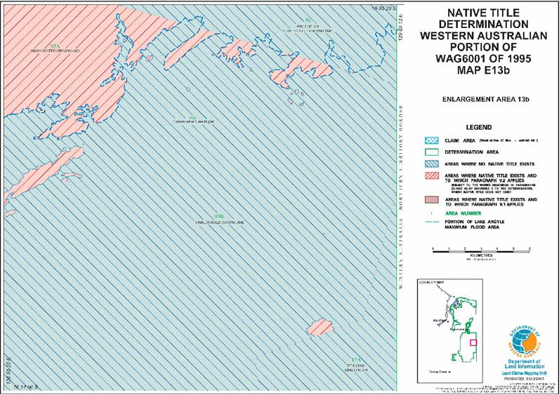
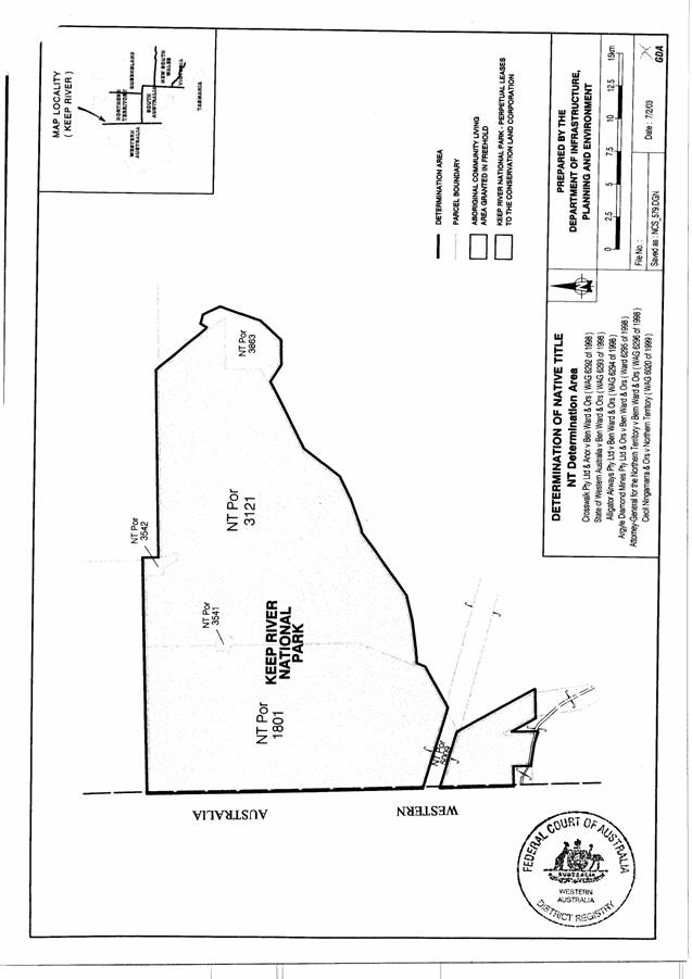
12 The Schedule to the document identifies the ‘NT determination area’ by reference to the numbers of its five constituent Portions and states the area is that which is outlined on an attached map. That map shows almost all of the area is located in Keep River National Park. The remainder comprises three comparatively small areas which are, apparently, Aboriginal community living areas granted in freehold.
13 Counsel identified seven issues in relation to the form of the determination. As we understand the position, the parties are agreed that there should be a determination in the proposed form but subject to such amendments as we may think appropriate in relation to the seven identified issues. We will deal with each of those issues separately.
Identification of native title holders
14 Clauses 2 and 3 of the proposed determination identify as primary native title holders the members of three estates, the Damberal estate, the Bindjen estate and the Nyawamnyawam estate. Clause 4 states that ‘other Aboriginal people’ have rights subject to the interests of the estate group members. Those people (‘the secondary native title holders’) are identified in sub-clauses (a), (b) and (c). However, because of the word ‘including’ immediately before those three sub-clauses, this is not presented as an exhaustive identification of secondary native title holders. A determination in this form leaves open the possibility of there being other, unidentified, secondary native title holders. Counsel for the Commonwealth of Australia and the State of Western Australia argue the result is a failure to comply with the description of ‘determination of native title’ in s 225 of the Act. That section relevantly provides:
‘A determination of native titleis a determination whether or not native title exists in relation to a particular area (the determination area) of land or waters and, if it does exist, a determination of:
(a) who the persons, or each group of persons, holding the common or group rights comprising the native title are; and
(b) the nature and extent of the native title rights and interests in relation to the determination area; and
(c) the nature and extent of any other interests in relation to the determination area; and
(d) the relationship between the rights and interests in paragraphs (b) and (c) (taking into account the effect of this Act); and
(e) to the extent that the land or waters in the determination area are not covered by a non-exclusive agricultural lease or a non-exclusive pastoral lease —whether the native title rights and interests confer possession, occupation, use and enjoyment of that land or waters on the native title holders to the exclusion of all others.’ (Original highlighting)
15 It will be noted that para (a) of s 225 requires determination of ‘the persons, or each group of persons, holding the common or group rights comprising the native title’. It is not necessary to identify the native title holders by name; it is sufficient that the persons be members of an identified group or groups. Clauses 2 and 3 of the proposed determination proceed on that basis. No issue is raised about them. However, clause 4 leaves open the possibility that there are native title holders who are neither members of an estate group identified in clause 2 or of a secondary group identified in sub-clause (a), (b) or (c) of clause 4. We agree with counsel that this is impermissible. Clause 4 should be turned into an exhaustive identification of secondary native title holders. This can be effected by omitting the word ‘including’ and substituting ‘such people being’. We propose to make that amendment. We point out that a determination may be varied: see s 13(5) of the Act. This would allow the addition of other native title holders if this subsequently appeared to be appropriate.
Statement of holders’ rights
16 The opening words of clause 5 of the proposed determination identify the native title holders’ rights as being ‘non-exclusive rights to occupy, use and enjoy the land and waters in accordance with their traditional laws and customs, including, as incidents of that entitlement’ certain identified rights. Counsel for the Commonwealth and the State of Western Australia argue for two changes to these words: the omission of the word ‘occupy’ and the substitution of ‘being’ for the words ‘including, as incidents of that entitlement’. These changes are resisted by counsel for the claimants, Mr J Basten QC.
17 As was pointed out by Gleeson CJ, Gaudron, Gummow and Hayne JJ in the High Court (at [89]), the expression ‘possession, occupation, use and enjoyment’, used in s 225(e) of the Act, ‘is a composite expression directed to describing a particular measure of control over access to land’. The words of the proposed determination, ‘occupy, use and enjoy’ are not identical to, but are reminiscent of, this composite expression. They might be understood as conveying the notion discussed by their Honours, including control of access. This would be inappropriate in this case. The right of absolute control of access must have been extinguished by the grant of the pastoral leases. There might be a surviving right to make decisions, pursuant to Aboriginal laws and custom, about the use and enjoyment of the land by Aboriginal people. That right would not be affected by the grant of a pastoral lease. However, that matter is specifically addressed by sub-para (e) of para 5. We think the word ‘occupy’ should be omitted from the opening words of para 5.
18 The argument for an exhaustive, rather than inclusive, list of the incidents of the entitlement is based on para (b) of s 225 of the Act. That paragraph requires ‘a determination of … the nature and extent of the native title rights and interests in relation to the determination area’.
19 In their High Court joint judgment, Gleeson CJ, Gaudron, Gummow and Hayne JJ said (at [51]):
‘A determination of native title must comply with the requirements of s 225. In particular, it must state the natureand extentof the native title rights and interests in relation to the determination area. Where, as was the case here in relation to some parts of the claim area, native title rights and interests that are found to exist do not amount to a right, as against the whole world, to possession, occupation, use and enjoyment of land or waters, it will seldom be appropriate, or sufficient, to express the nature and extent of the relevant native title rights and interests by using those terms.’ (Original emphasis)
20 Mr Basten argues that s 225(b) is satisfied by the reference in clause 5 of the proposed determination to ‘non-exclusive rights to occupy, use and enjoy the land and waters in accordance with their traditional laws and customs’. He says this is the required specification of the nature and extent of the rights and interests; sub-clause (a) to (e) merely identify some incidents of those rights and interests.
21 We cannot agree with this approach. A statement about the right to ‘occupy, use and enjoy’ (or merely ‘use and enjoy’) in accordance with traditional laws and customs conveys no information as to the nature and extent of the relevant rights and interests. It is equivalent to a statement that the holders of the traditional rights and interests are entitled to exercise their traditional rights and interests. Something more is obviously required. There must be a specification of the content of the relevant rights and interests. That is why the parties included sub-clauses (a) to (e). It is to those sub-clauses that a reader may look in considering the effect of the determination. They must exhaustively indicate the determined incidents of the right to use and enjoy.
22 Mr Basten protested that his clients had not had an opportunity to consider whether any other incidents should be indicated, if the list was to be made exhaustive. We accepted it was reasonable for them to have this opportunity. After we reached the conclusion that the list should be exhaustive we advised Mr Basten, and the representatives of the other parties, of our view. We invited Mr Basten to indicate whether his clients wished to add to the list. He indicated they did not, but suggested the formula ‘and, as incidents of that entitlement’. However, that formula is essentially the same as that rejected by us. We think it is preferable to use the word ‘being’. We pointed out, once again, that s 13(5) would be available if needed.
23 The opening words of clause 5 of the prepared determination should be amended in the manner argued by counsel for the Commonwealth and the State of Western Australia.
The right to ‘protect’ sites
24 Sub-clause (d) of clause 5 refers to the holders’ ‘right to have access to, maintain and protect the sites of significance on the land’. Counsel for the Commonwealth argues for the omission of the word ‘protect’. He says this word would give the holders an entitlement to exclude others from the land.
25 We do not agree. The notion of protection of significant Aboriginal sites is well understood. It may involve physical activities on the site to prevent its destruction, but it also extends to control of ceremonial activities. Particularly having regard to the existence of sub-clause (e), we do not think the words would be read as implying a general control of access.
Decisions about Aboriginal use and enjoyment of the determination area
26 Mr J D Allanson, counsel for the Commonwealth of Australia, argues that sub-clause (e) of clause 5 should be omitted from the determination. The Commonwealth is an intervener in both the appeals that are before us. Counsel for the State of Western Australia supports that argument.
27 The argument is that the right to make decisions about the use and enjoyment of the area cannot be recognised because the right to control access was extinguished by the grant of the pastoral leases. However, there is a clear distinction between a right to control access, generally and as a matter of law, and a right to make decisions about the use and enjoyment of land by Aboriginal people who will recognise those decisions and observe them pursuant to their traditional laws and customs. The continued existence of the former right is incompatible with a pastoral lease entitling the pastoral lessee to determine who has access to the land; the latter right is not. We think sub-clause (e) should remain.
Rights and interests subject to traditional laws and customs
28 Mr Allanson points out that native title rights and interests are possessed under traditional Aboriginal laws and customs. He recognises that clause 5 refers to ‘non-exclusive rights to occupy, use and enjoy the land and waters in accordance with their traditional laws and customs’. However, he argues that any sufficient and accurate description of the rights and interests requires that the determination state those rights and interests are ‘subject to and exercisable in accordance with traditional law and custom’.
29 We see no merit in this point. The present draft makes plain that the nature and extent of the activities that may be undertaken as incidents of the relevant native title rights and interests is governed by the native title holders’ traditional laws and customs.
Use of ‘include’ in clause 6
30 Counsel argue that the opening words of clause 6 should be amended by substituting the word ‘are’ for ‘include’. The argument is that, otherwise, the nature and extent of the native title rights and interests is not stated in the determination. The argument is the same as that put in relation to ‘including’ in the opening words of clause 5. For the reasons we indicated in relation to that clause, we agree it is necessary to have an exhaustive identification of the relevant rights. The word ‘include’ should be deleted and ‘are’ substituted.
The right to water
31 Clause 7B of the proposed determination states that, notwithstanding anything in the determination, ‘there are no exclusive native title rights and interests in flowing and subterranean waters’. The substance of this clause is uncontroversial; all parties accept that the native title holders cannot obtain exclusive water rights. However, it is argued that the provision fits awkwardly into this position. It is suggested that the substance of the clause should be added as a proviso to clause 9, which gives exclusive rights over the three Aboriginal freehold areas, or deleted altogether, relying on the general override in clause 15.
32 It would be possible to delete the material set out in clause 7B and rely entirely on clause 15. However, in order to avoid any possible dispute, it seems preferable to make explicit reference to water. We propose to delete clause 7B but add to clause 9 the words ‘provided, however, that rights and interests in flowing and subterranean waters are non-exclusive’.
Disposition
33 We will make orders (including a determination of native title) in the form agreed by the parties, but subject to some re-arrangement in structure and amended in accordance with the rulings set out above.
| I certify that the preceding thirty-three (33) numbered paragraphs are a true copy of the Reasons for Judgment herein of the Court. |
Associate:
Dated: 9 December 2003
|
WAG 6296 of 1998 | |
| | |
| Counsel for the appellant: | Mr T Pauling QC, Ms S Brownhill |
| | |
| Solicitor for the appellant: | Solicitor-General for the Northern Territory |
| | |
| Counsel for the first and third respondents: | Mr R Blowes, Ms E Lacey |
| | |
| Solicitor for the first and third respondents: | Mr I Irving |
| | |
| Counsel for the second respondent: | Mr J Basten QC |
| | |
| Solicitor for the second respondent: | Mr R Levy |
| | |
| Counsel for the Commonwealth of Australia: | Mr J Allanson |
| | |
| Solicitor for the Commonwealth of Australia: | Australian Government Solicitor |
| | |
| Counsel for the State of Western Australia: | Mr K Pettit SC, Mr S Wright |
| | |
| Solicitor for the State of Western Australia: | Crown Solicitor for the State of Western Australia |
| | |
| Counsel for Argyle Diamond Mines Pty Ltd: | Mr K Jagger |
| | |
| Solicitor for Argyle Diamond Mines Pty Ltd: | Freehills |
| | |
| Counsel for Crosswalk Pty Ltd and Carlton | |
| Carlton Hill Pty Ltd: | Mr M McKenna |
| | |
| Solicitor for Crosswalk Pty Ltd and Carlton Hill Pty Ltd: | Hunt & Humphry |
| | |
| W 6020 of 1999 | |
|
| |
| Counsel for the appellant: | Mr J Basten QC |
| | |
| Solicitor for the appellant: | Mr I Irving |
| | |
| Counsel for the first respondent: | Mr T Pauling QC, Ms S Brownhill |
| | |
| Solicitor for the first respondent: | Solicitor-General for the Northern Territory |
| | |
| Counsel for the second respondent: | Mr K Pettit SC, Mr S Wright |
| | |
| Solicitor for the second respondent: | Crown Solicitor for the State of Western Australia |
| | |
| Date of hearing: | 1 October 2003 |
| | |
| Date of judgment: | 9 December 2003 |
IN THE FEDERAL COURT OF AUSTRALIA
WESTERN AUSTRALIA DISTRICT REGISTRY
GENERAL DIVISION
On Remitter from the High Court in P59; P62; P63 and P67 of 2000
B E T W E E N:
THE STATE OF WESTERN AUSTRALIA v BEN WARD & ORS
WAG 6293 of 1998
CROSSWALK PTY LTD & ANOR v BEN WARD & ORS
WAG 6292 of 1998
ALLIGATOR AIRWAYS PTY LTD v BEN WARD & ORS
WAG 6294 of 1998
ARGYLE DIAMOND MINES PTY LTD & ORS v BEN WARD & ORS
WAG 6295 of 1998
ATTORNEY-GENERAL FOR THE
NORTHERN TERRITORY v BEN WARD & ORS
WAG 6296 of 1998
CECIL NINGAMARA & ORS v NORTHERN TERRITORY
W 6020 of 1999
ORDER
JUDGES: WILCOX, NORTH AND WEINBERG JJ
DATE OF ORDER: 9 DECEMBER 2003
WHERE MADE: KUNUNURRA
THE COURT ORDERS BY CONSENT THAT:
(1) Appeals WAG 6292 of 1998, 6293 of 1998, 6294 of 1998 and 6295 of 1998 be allowed.
(2) The determination of native title made by Lee J on 24 November 1998 be set aside to the extent that it relates to land and waters in Western Australia.
(3) The order as to costs of the trial made by Lee J on 6 May 1999 be set aside and in lieu thereof there be no order as to costs.
(4) There be a determination of native title in the terms set out below (the determination), the determination to take effect:
(a) as to paragraph 3 of the determination – immediately upon the making of these Orders; and
(b) as to the balance of the determination – immediately upon the making of a determination under section 57(2) of the Native Title Act 1993 (Cth)in accordance with orders (6) or (7).
(5) Upon the determination taking effect, native title is not held in trust but is held by the common law holders of native title being the persons referred to in paragraph 8 of the determination.
(6) Within twelve months of the date of this order, the Applicants in WAG 6001 of 1995 and WAG 6027 of 1998 are to file and serve a notice nominating a prescribed body corporate to:
(a) be the prescribed body corporate for the purposes of section 57(2) of the Native Title Act 1993 (Cth); and
(b) perform the functions mentioned in section 57(3) of the Native Title Act 1993 (Cth) after becoming a registered native title body corporate.
(7) In the event that there is no nomination within the time specified in accordance with order (6) or such later time as this Court may order, the matter is to be listed for further directions.
(8) There be no order as to costs in appeals WAG 6292 of 1998, 6293 of 1998, 6294 of 1998 and 6295 of 1998, both before and after the proceedings in the High Court in P59; P62; P63 and P67 of 2000.
(9) Leave is given for the applicants in WAG 6001 of 1995 to discontinue the application insofar as it relates to land and waters west of the J7 Line (as defined in the determination).
AND THE COURT DECLARES THAT:
(10) The applications WAG 6001 of 1995 and WAG 6027 of 1998 are not finalised, within the meaning of section 190(4)(e) Native Title Act 1993 (Cth), in respect of the land and waters the subject of paragraph 2 of the determination, until a prescribed body corporate has been determined, in accordance with section 57(2) Native Title Act 1993 (Cth), to perform the functions mentioned in subsection 57(3) of that Act.
DATED: _____________________________
DEPUTY DISTRICT REGISTRAR
CONSENT DETERMINATION OF NATIVE TITLE
IN RESPECT OF LAND AND WATERS
IN WESTERN AUSTRALIA
DETERMINATION
The Court Notes:
A. On 6 April 1994 Ben Ward and other Aboriginal people (the First Applicants) lodged an application for determination of native title on behalf of the Miriuwung and Gajerrong peoples (the application). The area covered by the application is approximately 7,900 square kilometres of land and waters in the north east of the State of Western Australia including Boorroongoong (Lacrosse Island); and in the north west of the Northern Territory of Australia (Claim Area). The Claim Area is identified in Schedule 1.
B. In the course of the proceedings in the Federal Court at first instance (the proceeding), Cecil Ningarmara and other Aboriginal people who claimed an interest in the Claim Area in the Northern Territory became the Second Applicants in the proceeding (Second Applicants).
C. On 24 July 1995 an application for determination of native title was made by Delores Cheinmora and other Aboriginal people on behalf of the Balanggarra people. The area covered by that application overlapped with that of the First Applicants' application in respect only of Boorroongoong (Lacrosse Island). To the extent of the area of overlap, it was ordered that the applications be heard together and that the applicants in respect of that overlapping application become the Third Applicants in the proceeding (Third Applicants).
D. On 24 November 1998, following a lengthy trial, his Honour Lee J handed down judgment and made a determination that native title existed in relation to the whole of the Claim Area other than an area west of a line known as the J7 line (J7 Line) and certain parcels of land and waters in respect of which he found native title had been wholly extinguished. The J7 Line is identified in Schedule 1.
E. Some of the parties before the trial judge appealed to the Full Court of the Federal Court, which handed down judgment in relation to the various appeals on 3 March 2000. The Full Court set aside the determination of Lee J and substituted its own determination of native title dated 11 May 2000.
F. Pursuant to special leave granted by the High Court of Australia on 3 March 2000 certain matters were taken on appeal to that Court. The High Court delivered its judgment on 8 August 2002. The High Court set aside the determination of the Full Court of the Federal Court and remitted the matters for further hearing and determination by the Full Court.
G. The parties have reached an agreement as to the terms of a determination of native title to be made in relation to the land and waters within the Claim Area in Western Australia.
H. The parties have agreed to make an application to the Court for a determination of native title in relation to the land and waters of the Claim Area in Western Australia, but not including land and waters west of the J7 Line (Determination Area). The Determination Area is identified in Schedule 1.
I. The parties accept that the effect of the determination is that the people referred to in paragraph 8, in accordance with the traditional laws acknowledged and the traditional customs observed by them, are recognised as the native title holders for that part of the Determination Area where native title is determined to exist.
J. No nomination pursuant to section 56(2) of the Native Title Act 1993 (Cth) in regard to the holding of native title in trust has been made.
K. The parties consent to the making of the determination without prejudice to any assertion or denial of native title rights and interests, and to any determination as to who holds native title, in relation to any land and waters other than those described in Schedule 1. In particular, the determination in favour of the Balangarra reflects the finding made by his Honour Lee J at trial, and the judgment of the Full Court of the Federal Court handed down on 3 March 2000, in relation to Boorroongoong (Lacrosse Island). The parties’ consent to the determination is not an admission in relation to whether native title exists in the balance of application WAG 6027 of 1998, and if so, who holds it.
Being satisfied that the determination of native title in the terms sought by the parties is within the power of the Court, and it appearing to the Court to be appropriate to do so, and by consent:
THE COURT ORDERS, DECLARES AND DETERMINES THAT:
Existence of native title
1. The Determination Area is the land and waters described in Schedule 1.
2. Native title exists in those parts of the Determination Area identified in Schedule 2 (Native Title Area).
3. Native title does not exist in those parts of the Determination Area identified in Schedule 3.
Native title holders
4. The Native Title Area comprises countries or parts of countries variously identified as Miriuwung, Yirralalem, Ngamoowalem, Wiram, Yardanggarlm, Nganalam Mandangala, Gajerrong, Doolboong, Wardenybeng, Gija, and in respect of Boorroongoong (Lacrosse Island), also as Balangarra.
5. Each of Miriuwung, Gajerrong, Doolboong, Wardenybeng and Gija is a group and country identified with a language or dialect. Membership of the groups is by descent from a person who is also identified with such language or dialect and country or by adoption by such a person, in accordance with traditional laws and customs. Persons identified with such language or dialect and country include those described in Schedule 5.
6. Each of Yirralalem, Ngamoowalem, Wiram, Yardanggarlm, Nganalam and Mandangala is a Miriuwung group and country. Membership of the groups is by patrilineal descent, or descent from mother or mother’s father orby adoption into such relationships, in accordance with traditional law and custom.
7. Balangarra is a group identified with Boorroongoong (Lacrosse Island). The Balangarra are described in Schedule 5.
8. The native title holders in respect of the Native Title Areas are:
(a) in respect of the land and waters referred to in paragraphs (4), (6) and (8) of Schedule 2:
(i) Aboriginal persons referred to in paragraph 5 above who identify themselves as Gajerrong, or as Doolboong or Wardenybeng, under traditional law and custom, and who are so identified by other members of the respective Gajerrong, Doolboong and Wardenybeng groups; and
(ii) other Aboriginal persons who are acknowledged by the respective Gajerrong, Doolboong and Wardenybeng groups as having rights in that country through descent, marriage, spiritual conception, birth or responsibility for sites of significance;
(b) in respect of the land and waters referred to in paragraphs (2), (3) and (9) of Schedule 2:
(i) Aboriginal persons referred to in paragraphs 5 and 6 above who identify themselves as Miriuwung under traditional law and custom, and who are so identified by other members of the respective Miriuwung groups; and
(ii) other Aboriginal persons who are acknowledged by the respective Miriuwung groups as having rights in that country through descent, membership of other Miriuwung groups, marriage, spiritual conception, birth or responsibility for sites of significance;
(c) in respect of the land and waters referred to in paragraph (1) of Schedule 2 (Glen Hill):
(i) Aboriginal persons referred to in paragraphs 5 and 6 above who identify themselves as members of the Mandangala Miriuwung group, or Gija, under traditional law and custom, and who are so identified by other members of the Mandangala Miriuwung group and members of the Gija group; and
(ii) other Aboriginal persons who are acknowledged by the Mandangala Miriuwung group and the Gija group as having rights in that country through descent, membership of other Miriuwung groups, marriage, spiritual conception, birth or responsibility for sites of significance; and
(d) in respect of the land and waters referred to in paragraphs (5) and (7) of Schedule 2:
(i) the persons identified in paragraph 8(a) above; and
(ii) Aboriginal persons referred to in paragraph 7 above who identify themselves as Balangarra and who are so identified by other members of the Balangarra group.
The nature and extent of native title rights and interests
9. Subject to paragraphs 10 to 13 inclusive, the native title rights and interests which exist in the Native Title Area are as follows:
9.1 In relation to the land and waters referred to in paragraphs (1), (2), (3), (5) and (6) of Schedule 2, the native title is a right in accordance with traditional laws and customs to possession, occupation, use and enjoyment to the exclusion of all others.
9.2 In relation to the land and waters referred to in paragraphs (4), (7), (8) and (9) of Schedule 2, non-exclusive rights to occupy, use and enjoy the land and waters in accordance with traditional laws and customs as follows:
(a) the right of access to the land and waters;
(b) the right to take fauna from the land and waters;
(c) the right to take fish from the waters;
(d) the right to take flora from the land and waters;
(e) the right to take other natural resources of the land such as ochre, stones, soils, wood and resin;
(f) the right to enter and remain on the land and waters;
(g) the right to take water;
(h) the right to engage in cultural activities on the land and waters, including to conduct ceremonies; and
(i) the right to care for and maintain sites and areas that are of significance to the native title holders under their traditional laws and customs.
These native title rights and interests do not confer possession, occupation, use and enjoyment of those land and waters on the native title holders to the exclusion of others.
10. Notwithstanding anything in the determination, there are no native title rights and interests in or in relation to:
(a) minerals as defined in the Mining Act 1904 (WA) (including such ochres and stonesas are minerals), or in the Mining Act 1978 (WA) as in force at the date of the determination; or
(b) petroleum as defined in the Petroleum Act 1936 (WA), or in the Petroleum Act 1967 (WA) as in force at the date of the determination.
11. There are no exclusive native title rights in or to flowing or subterranean water in the Determination Area.
12. There is no native title right to hunt fauna or to gather plants within 800 metres of Lake Kununurra or of Lake Argyle.
13. The native title rights and interests are subject to and exercisable in accordance with the laws of the State and the Commonwealth, and the common law.
The nature and extent of any other interests
14. The nature and extent of other interests in relation to the Native Title Area are the following, as they exist as at the date of the determination:
(a) the interests of the holder of the pastoral lease listed in paragraph (1) of Schedule 4;
(b) the interests of persons in whom the reserves listed in paragraph (2) and (3) of Schedule 4 are vested and of persons who have the care, control and management of the reserves, and interests of persons entitled to access and use those reserves for the respective purposes for which they are reserved, subject to any statutory limitations upon those rights, and interests of persons in the leases of reserves listed in paragraph (4) of Schedule 4;
(c) the interests of the holders of the mining and petroleum tenements listed in paragraphs (5) and (6) of Schedule 4 including the interests of those holders in statutory rights of access to such tenements;
(d) the interests of the holder of the licences described in paragraph (7) of Schedule 4;
(e) the interests of holders of the permits described in paragraph (8) of Schedule 4;
(f) the interests of the Crown, Water Corporation and the local government in the enforcement of, and the exercise of rights and responsibilities under, the by-laws listed in paragraph (9) of Schedule 4;
(g) the public right to fish in tidal waters;
(h) the public right to navigate in tidal waters;
(i) the interests of persons to whom valid and validated rights and interests have been granted by the Crown pursuant to statute or otherwise in the exercise of its executive power;
(j) the right to access land by an employee or agent or instrumentality of the State, Commonwealth or any local government or other statutory authority as required in the performance of his or her statutory or common law duties where such access would be permitted to private land;
(k) the interest of the Crown, or any other person having responsibility from time to time for the operation or maintenance of the Ord Irrigation Project or any part of it, in the operation and maintenance of the "Works" (as defined in the Rights in Water and Irrigation Act 1914 (WA)) which form part of the Ord Irrigation Project as at the date of the determination;
(l) so far as confirmed pursuant to section 14 of the Titles (Validation) and Native Title (Effect of Past Acts) Act 1995 (WA) as at 5 May 1999, public access to and enjoyment of:
(i) waterways;
(ii) beds and banks or foreshores of waterways;
(iii) coastal waters;
(iv) beaches;
(v) areas that were public places at the end of 31 December 1993;
(m) public access to all tracks and roads shown on the maps attached to Schedule 1 (except those referred to in paragraph (4) of Schedule 3);
(n) the interests of Telstra Corporation Limited, being:
(i) rights and interests as the owner or operator of telecommunications facilities within the Native Title Area, including customer radio terminals and overhead and underground cabling;
(ii) rights and interests pursuant to the Post and Telegraph Act 1901 (Cth), the Telecommunications Act 1975 (Cth), the Australian Telecommunications Corporation Act 1989 (Cth), the Telecommunications Act 1991 (Cth) and the Telecommunications Act 1997 (Cth); and
(iii) rights of access by employees, agents or contractors of Telstra Corporation Limited to its facilities in or surrounded by the Native Title Area in the performance of their duties;
(o) any interests of the Crown in any capacity, or of any statutory authority, in any works referred to in paragraph (3) of Schedule 3 which were constructed or commenced to be constructed or used on any area referred to in paragraph (2) or (3) of Schedule 2, including the works listed in Schedule 4; and
(p) the rights of access to King location 813 (formerly known as King location 230) under the lease dated 1 December 2000 from the State of Western Australia to the Australian Maritime Safety Authority.
Relationship between native title rights and other interests
15. The relationship between the native title rights and interests in the Native Title Area and the other rights and interests referred to in paragraph 14 (other interests) is that:
(a) in relation to the other interests referred to in paragraph 14(a)-(f), (i)-(k), (m), (n) and (p) – the other interests, and the doing of any activity required or permitted to be done by or under the other interests, prevail over the native title rights and interests and any exercise of the native title rights and interests, but do not extinguish them, and the existence and exercise of the native title rights and interests does not prevent the doing of the activity;
(b) in relation to the other interests referred to in paragraph 14(a)-(f), (i), (o)and (p) – to the extent that the other interests are inconsistent with the continued existence, enjoyment or exercise of the native title rights and interests, the native title continues to exist in its entirety, but the native title rights and interests have no effect in relation to the other interests to the extent of the inconsistency during the currency of those other interests. If those other interests are later removed or otherwise cease to operate, either wholly or partly, the native title rights and interests will again have full effect, wholly or partly as the case may be;
(c) in relation to the other interests referred to in paragraphs 14(g), (h) and (l) – those rights co-exist with the native title rights and interests; and
(d) in relation to the other interests referred to in paragraph 14(o) – the determination does not affect those interests.
SCHEDULE 1
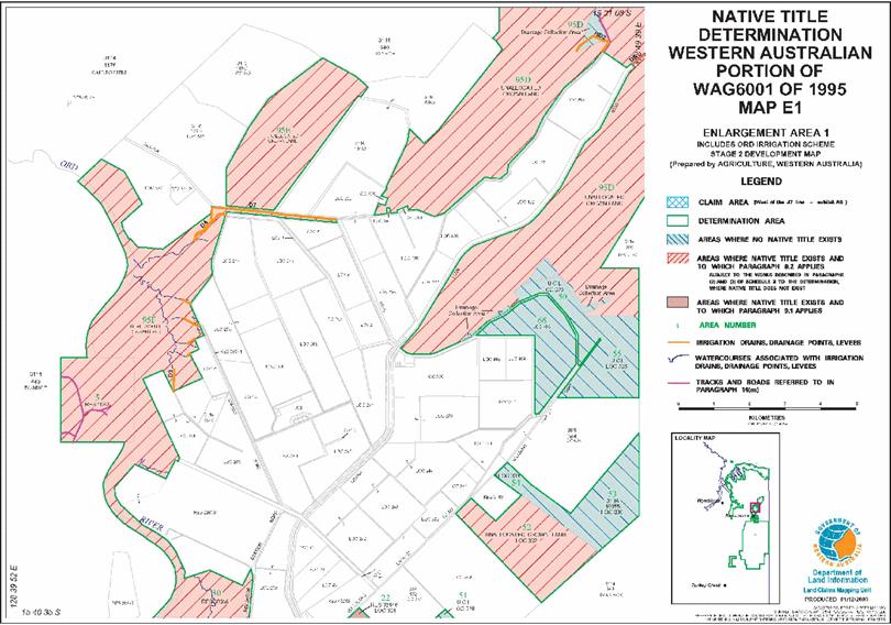
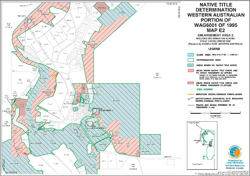
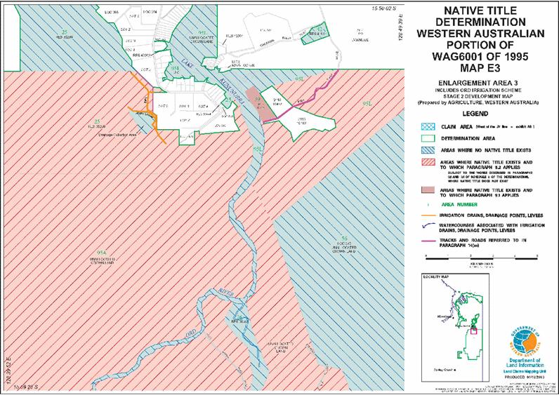
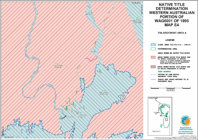
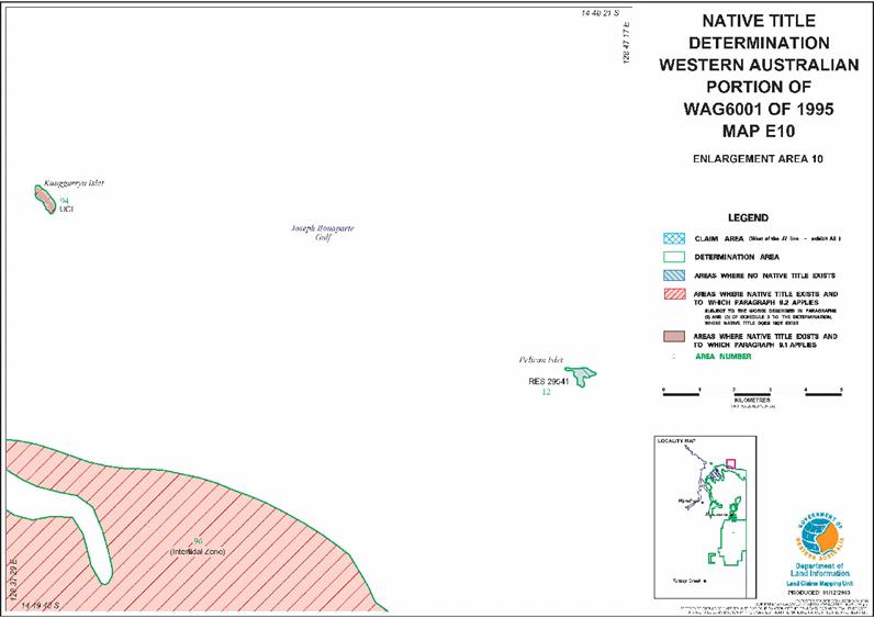
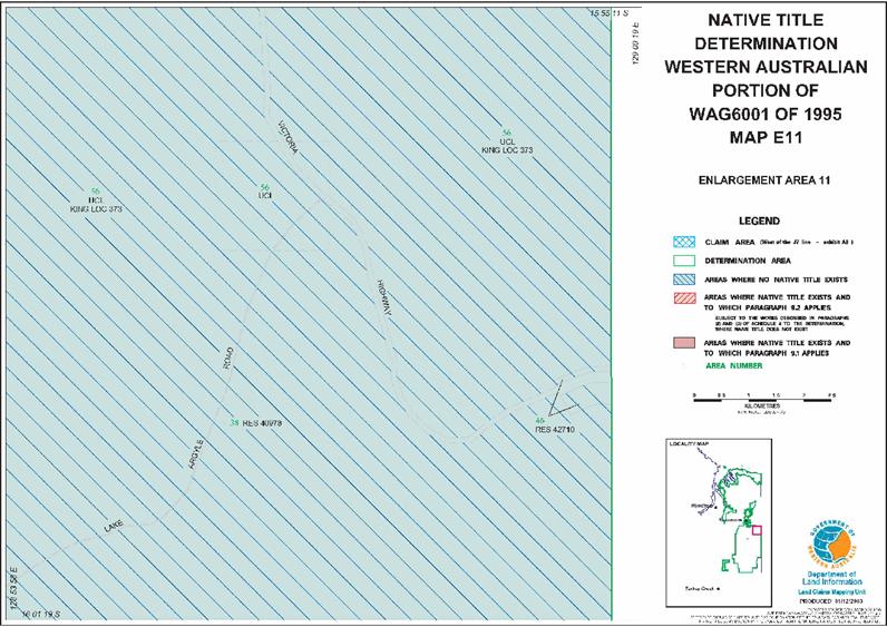
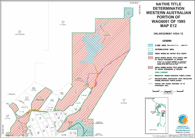
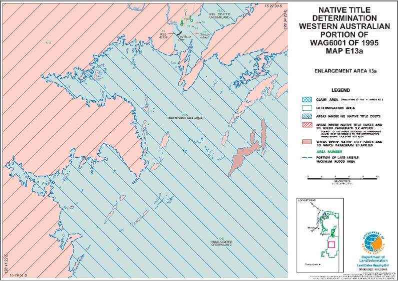
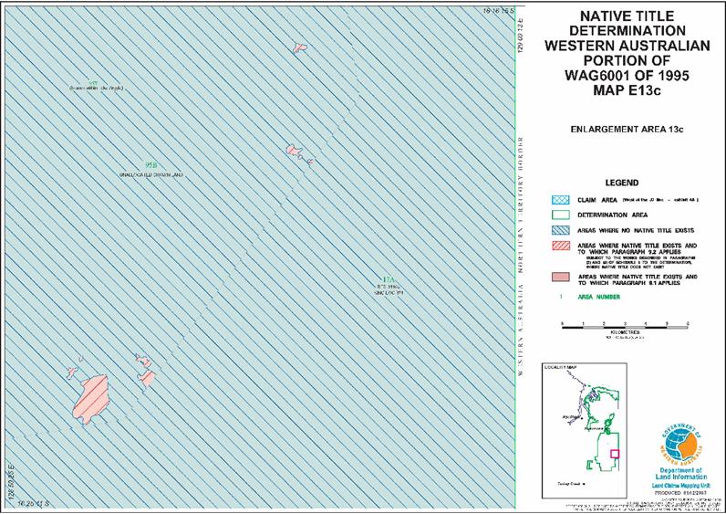
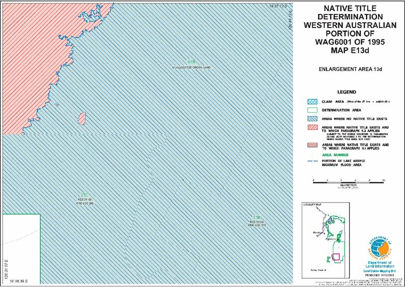
CLAIM AREA, DETERMINATION AREA AND THE J7 LINE
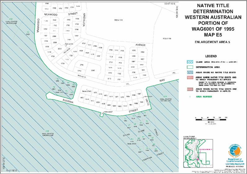
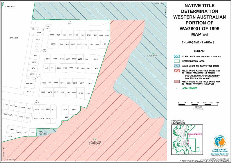
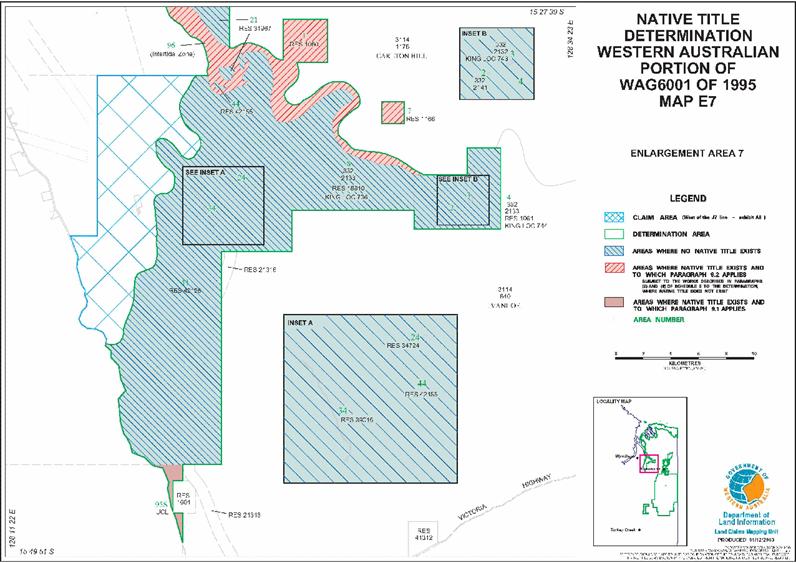
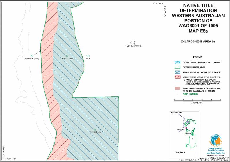
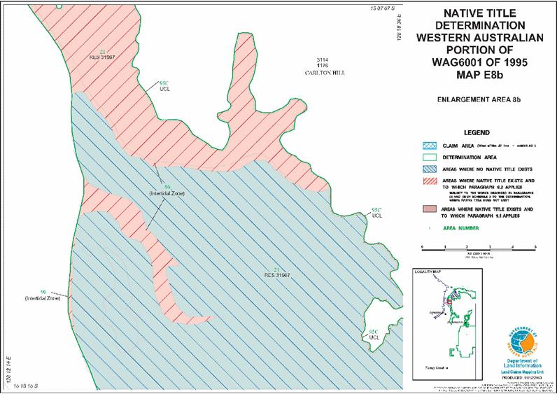
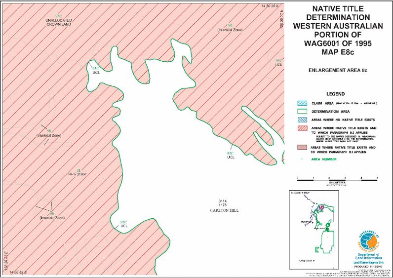
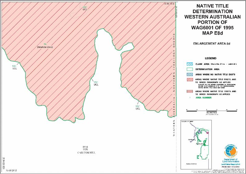
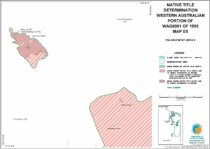
The Claim Area comprises the Determination Area, together with the land and waters which lie to the west of the J7 Line and which are hatched in blue on the maps.
The Determination Area comprises all of the land and waters within the external boundaries described in Annexure 2 to this schedule and generally shown as bordered in dark green on the maps which are Annexure 1 to this schedule (the maps).
The J7 Line is the line marked “J7” on the maps in the north west of the Claim Area.
Note: the map references given in the tables in the Schedules are for ease of reference only and do not form part of the Determination.
Note: a reference in this Determination to an Area No. is a reference to a part of the Determination Area as defined under the heading "Area No Description" in Annexure 2 to this schedule and as generally shown on the maps.
SCHEDULE 1 - ANNEXURE 2
EXTERNAL BOUNDARY DESCRIPTION
Portion A
All that land and water comprised in Pastoral Lease 3114/425 (Glen Hill), being King Location 701.
Portion B
All that land and water commencing from the intersection of the northernmost northern boundary of King Location 618 with the northernmost western boundary of Location 380 (Reserve 31165) and extending southerly, easterly, generally southerly and again easterly along boundaries of that location to the southernmost southwestern corner of Luman Location 12 (Reserve 31165); Thence easterly and northerly along boundaries of that location to a southern boundary of King Location 374 (Reserve 31165); Thence easterly, generally northerly and again easterly along boundaries of that location to the eastern boundary of Western Australian; Thence northerly along that boundary to the prolongation easterly of the southernmost southern boundary of the eastern severance of Pastoral Lease 3114/640 (Ivanhoe), being Location 711; Thence westerly to and along the southern boundary of that location to the eastern boundary of Location 588; Thence southerly, generally southwesterly, westerly and northeasterly along boundaries of that location to a southeastern corner of the eastern severance of Pastoral Lease 3114/640 (Ivanhoe), being Location 711; Thence westerly and northerly along boundaries of that location to the eastern boundary of Location 469; Thence generally southwesterly along boundaries of that location to an eastern side of Crossing Falls Road reserve; Thence southerly, southwesterly, northwesterly and northerly along sides of that road reserve to a southern side of Perch Crescent; Thence southwesterly and northwesterly along sides of that crescent to the easternmost corner of Location 451; Thence southwesterly, westerly, northwesterly and northeasterly along sides of that location and to the westernmost western corner of Location 452; Thence generally northeasterly along the western boundary of that location and continuing along the western boundary of Location 453 and the western and northern boundaries of Location 454 to a southwestern corner of Cherubin Road reserve; Thence northerly, easterly, southeasterly and northeasterly along sides of that road reserve to a western side of Crossing Falls Road reserve; Thence generally northeasterly along sides of that road reserve to a western boundary of the eastern severance of Pastoral Lease 3114/640 (Ivanhoe), being Location 711; Thence northerly along the western boundary of that location to the northernmost southwestern corner of Location 720 (Reserve 42304); Thence northerly along the western boundary of that location to a southwestern corner of the eastern severance of Pastoral Lease 3114/640 (Ivanhoe), being Location 711; Thence northerly along the western boundary of that location to the southwestern corner of Location 448 (Reserve 31780); Thence easterly and northerly along boundaries of that location to a southern side of Old Darwin Road reserve; Thence westerly, northerly, northwesterly, southwesterly and again northwesterly along sides of that road reserve to the easternmost eastern corner of Location 707 (Reserve 30290); Thence westerly and generally southerly along boundaries of that location to Latitude 15.812501 South; Thence southwesterly, generally northerly, generally northeasterly and generally southeasterly through the following co- ordinate positions:
| LATITUDE (SOUTH) | LONGITUDE (EAST) |
| 15.814674 | 128.744284 |
| 15.812743 | 128.743801 |
| 15.811846 | 128.743660 |
| 15.810760 | 128.743566 |
| 15.809721 | 128.743471 |
| 15.808352 | 128.743330 |
| 15.807219 | 128.743235 |
| 15.806606 | 128.743377 |
| 15.805851 | 128.743613 |
| 15.805378 | 128.743943 |
| 15.804954 | 128.744321 |
| 15.804670 | 128.744745 |
| 15.804434 | 128.745217 |
| 15.804293 | 128.745878 |
| 15.804293 | 128.746491 |
| 15.804387 | 128.746963 |
| 15.804623 | 128.747482 |
| 15.804954 | 128.748095 |
Thence southeasterly to a western side of Old Darwin Road reserve at Latitude 15.805096 East; Thence northwesterly along the western side of that road reserve to a southern boundary of Kununurra Town Lot 1519; Thence southwesterly, northwesterly, again southwesterly and again northwesterly along boundaries of that town lot to a southern side of Victoria Highway road reserve; Thence generally westerly along sides of that highway road reserve to a southeastern side of Lakeview Drive; Thence southwesterly along the southeastern side of that drive to the northernmost northern corner of Location 274; Thence southeasterly along the northern boundary of that location to the westernmost corner of Location 441, being a southwestern corner of a severance of Location 667 (Reserve 41812); Thence northeasterly, southeasterly, southerly, westerly, again northeasterly, northwesterly and generally southwesterly along boundaries of that severance to its westernmost northwestern corner; Thence southwesterly to the easternmost northeastern corner of a severance of King Location 667 (Reserve 41812); Thence westerly and northwesterly along northern boundaries of that severance to the easternmost corner of Location 734 (Reserve 29167); Thence westerly and generally northeasterly along boundaries of that location to a southern side of Lakeview Drive; Thence generally northwesterly, generally southwesterly, westerly and northerly along southern and western sides of that drive to a northern side of Victoria Highway road reserve; Thence generally northeasterly along sides of that highway road reserve to a western side of Cyril Kleinig Drive; Thence northerly along the western side of that drive to the southeastern corner of Lot 313 as shown on Office of Titles Plan 21744; Thence westerly along the southern boundary of that lot to the southernmost southeastern corner of Location 327; Thence generally westerly along southern boundaries of that location to the southeastern corner of Location 735 (Reserve 41793); Thence westerly, northerly and easterly along boundaries of that location to a western boundary of Location 327; Thence northerly and northwesterly along boundaries of that location to the southeastern corner of Location 684; Thence northwesterly, northeasterly and southeasterly along boundaries of that location and continuing southeasterly along the northern boundary of Location 327 to the westernmost western corner of Location 317; Thence northeasterly along the western boundary of that location to a southwestern boundary of Location 697 (Reserve 37078); Thence northwesterly and northeasterly along boundaries of that location to the westernmost western corner of Location 572; Thence generally northeasterly along western boundaries of that location and generally northerly along western boundaries of Location 574 to a southwestern side of Ivanhoe Road reserve; Thence northwesterly along the southwestern side of that road reserve to the southeastern corner of Location 566; Thence southwesterly and northwesterly along boundaries of that location to the southeastern corner of Location 516; Thence southwesterly along the southern boundary of that lot to the easternmost eastern corner of Location 511; Thence generally southwesterly, northwesterly and northeasterly along boundaries of that location to the southeastern corner of Location 510; Thence westerly along the southern boundary of that location to a eastern corner of Location 483; Thence southerly and northwesterly along boundaries of that location to a southeastern corner of Location 221; Thence northwesterly along the southern boundary of that location and generally northwesterly along the southern boundaries of Locations 220 to 217 inclusive to the southeastern corner of Lot 1 as shown on Office of Titles Diagram 73470; Thence northwesterly along the southern boundary of that lot and the southern boundary of Lot 2 to the southeastern corner of Lot 22 as shown on Office of Titles Diagram 97610; Thence northwesterly along the southern boundary of that lot and the southern boundary of Lot 21 to the southeastern corner of Location 822; Thence northwesterly along the southern boundary of that location to the southeastern corner of Lot 11 as shown on Office of Titles Plan 37576; Thence northwesterly and northeasterly along boundaries of that lot to the southeastern boundary of Location 210; Thence northwesterly along the southern boundary of that location to the eastern boundary of Location 209; Thence southwesterly and northwesterly along boundaries of that location and generally northwesterly along the southern boundaries of Locations 208 to 206 inclusive and northwesterly and northeasterly along the southern and western boundaries of Location 205 to the southeastern corner of Location 389 (Reserve 31676); Thence generally northwesterly along southwestern boundaries of that location to the southwestern corner of Location 421 (Reserve 32852); Thence northwesterly along the southwestern boundary of that location to the southwestern corner of Location 420 (Reserve 32851); Thence generally northwesterly, northeasterly and southeasterly along boundaries of that location to a western corner of River Farm Road reserve; Thence northerly along the western side of that road reserve to the southern boundary of Location 591; Thence westerly, northwesterly and northeasterly along boundaries of that location to a northwestern corner of Location 245; Thence northeasterly along the northwestern boundary of that location to a northwestern corner of a Drain Reserve as shown on Department of Land Information Deposited Plan 209536; Thence northeasterly along the northwestern boundary of that drain reserve to a northwestern corner of Ivanhoe Road reserve; Thence northeasterly and southeasterly along sides of that road reserve to the westernmost corner of Location 649; Thence northeasterly along the northwestern boundary of that location to the southwestern boundary of Location 246; Thence northwesterly and northeasterly along boundaries of that location to a southern boundary of Location 227 (Reserve 38358); Thence southeasterly, northeasterly, northwesterly, northerly, again northeasterly, again northerly generally northwesterly, generally northeasterly, generally southeasterly, again generally northeasterly, generally northerly and northwesterly along boundaries of that location to a eastern corner of Location 203 (Reserve 22609); Thence southwesterly, northwesterly, again southwesterly, northerly and generally northwesterly along boundaries of that location to the southernmost southern corner of Location 228 (Reserve 22609); Thence generally northwesterly, northeasterly and southeasterly along boundaries of that location to a western side of Location 203 (Reserve 22609); Thence northeasterly and southeasterly along boundaries of that location to a northwestern corner of Location 831; Thence northeasterly along the northwestern boundary of that location to a southwestern corner of the southern severance of Location 254; Thence northwesterly along the southwestern boundary of that severance to its westernmost western corner; Thence northwesterly to the southernmost southern corner of the northwestern severance of Location 254 and continuing northwesterly, northeasterly and southeasterly along boundaries of that severance to the prolongation southwesterly of the northern boundary of the northeastern severance of Location 254; Thence northeasterly to and along the northern boundary of that severance to the southwestern boundary of Lot 4 as shown on Office of Titles Plan 18105; Thence northwesterly, northeasterly, again northwesterly and again northeasterly to the southwestern side of Research Station Road reserve; Thence northwesterly, northeasterly, generally northerly and generally easterly along western and northern sides of that road reserve to a western side of Carlton Hill Road reserve; Thence northwesterly and generally westerly along western and southern sides of that road reserve to the easternmost corner of Location 687; Thence southerly, southwesterly, westerly, generally northwesterly, northeasterly and again generally northwesterly to a eastern boundary of Pastoral Lease 3114/1175 (Carlton Hill), being Location 709; Thence southwesterly along the eastern boundary of that location to a northern boundary of the western severance of Pastoral Lease 3114/640 (Ivanhoe), being Location 710; Thence southwesterly and generally southerly along boundaries of that location to the northernmost northern corner of Location 599; Thence generally southeasterly along boundaries of that location to a northwestern corner of Location 514 (Reserve 36951); Thence generally southeasterly and generally southwesterly along boundaries of that location to the northern boundary of the southern severance of Lot 102 as shown on Office of Titles Plan 31532; Thence southeasterly, southwesterly and northwesterly along boundaries of that severance to a southeastern corner of Location 719; Thence westerly and southwesterly along boundaries of that location to a northern side of Victoria Highway road reserve; Thence generally southeasterly, generally southerly, again generally southeasterly, southwesterly, southeasterly, easterly, southerly and westerly along sides of that highway road reserve to a eastern side of Packsaddle Road reserve; Thence generally southerly, generally easterly and southeasterly to a southwestern boundary of a Drain Reserve as shown on Department of Land Information Deposited Plan 213513; Thence northwesterly and northeasterly along boundaries of that reserve to the westernmost western corner of Location 383; Thence generally northeasterly, generally southeasterly and southwesterly along boundaries of that location to the eastern boundary of a Drain Reserve as shown on Department of Land Information Deposited Plan 213513; Thence southeasterly along the northeastern boundary of that reserve to the prolongation southwesterly of the northwestern boundary of the western severance of Location 482; Thence northeasterly to and along the northwestern boundary of that severance to the northwestern corner of Location 676 (Reserve 40143); Thence northeasterly along the northern boundary of that location to the northwestern corner of the eastern severance of Location 482; Thence northeasterly and southerly along boundaries of that severance to the northernmost corner of Lot 201 as shown on Office of Titles Diagram 97945; Thence southerly along the eastern boundary of that lot and continuing southerly along the eastern boundary of Lot 202 to the northernmost corner of Brolga Road reserve; Thence southerly along the eastern side of that road reserve to the northernmost corner of Location 479; Thence generally southerly and southwesterly along eastern boundaries of that location to the easternmost corner of Location 564; Thence southwesterly along the southeastern boundary of that location and continuing generally southwesterly along the southeastern boundaries of Locations 478, 477, 444 to 447 inclusive, 407 to 409 inclusive, 816, 412 and 413 to the northwestern corner of Location 619; Thence southwesterly, southerly, southwesterly, northwesterly and generally westerly along the boundaries of that location to its westernmost southwestern corner; Thence southwesterly to the northernmost northwestern corner of Location 752; Thence generally easterly and southeasterly along boundaries of that location to the northeastern corner of Location 753; Thence southwesterly, easterly and westerly along boundaries of that location to a eastern side of Packsaddle Road reserve; Thence southerly along the eastern side of that road reserve to the northwestern corner of Lot 11 as shown of Office of Titles Plan 21350; Thence easterly and southerly along boundaries of that lot and continuing southerly along the eastern boundary of Lot 12 to the northern boundary of Location 693; Thence easterly, southerly and westerly along boundaries of that location to the northeastern corner of Location 537; Thence southerly and southwesterly along boundaries of that location to the northeastern corner of Location 538; Thence southwesterly along the eastern boundary of that location to the northeastern corner of Location 868; Thence southeasterly and westerly along boundaries of that location to the southeastern corner of Location 539; Thence southerly along the prolongation of the eastern boundary of that location to a northern boundary of Location 541; Thence northeasterly and southeasterly along boundaries of that location to the northwestern corner of Location 542; Thence easterly along the northern boundary of that location to a western boundary of Location 543; Thence northerly and easterly along boundaries of that location to the northwestern corner of Location 750; Thence easterly along the northern boundary of that location to a western boundary of Location 545; Thence northerly, easterly and southerly along boundaries of that location to the northeastern corner of the parcel of Unallocated Crown Land as shown on Department of Land Information Deposited Plan 191142; Thence easterly along the northern boundary of that parcel to the western boundary of Location 872; Thence northerly, easterly and southerly along boundaries of that location to the northwestern corner of Location 548; Thence easterly along the northern boundary of that location to the northwestern corner of Location 549; Thence easterly along the northern boundary of that location to a western side of an unnamed Road reserve as shown on Department of Land Information Deposited Plan 214769; Thence generally northeasterly along sides of that road reserve to a western side of a Drain Reserve as shown on Department of Land Information Deposited Plan 213514; Thence northwesterly, generally northeasterly and southeasterly along boundaries of that drain reserve to a northwestern boundary of Location 512 (Reserve 35289); Thence generally southwesterly, generally southeasterly, generally westerly, generally northerly, generally northwesterly, northeasterly, southeasterly and again generally northerly along boundaries of that location to a southern side of Victoria Highway road reserve; Thence westerly, northwesterly, southwesterly, generally northwesterly, northeasterly, northerly, easterly and again generally northwesterly along sides of that highway road reserve to a eastern boundary of the western severance of Pastoral Lease 3114/640 (Ivanhoe), being Location 710; Thence southerly, generally southwesterly, southeasterly, again southerly, westerly, generally southerly, generally southwesterly, southerly and again westerly along boundaries of that location to the easternmost northeastern corner of Pastoral Lease 3114/953 (Doon Doon), being Location 703; Thence southerly, westerly and again southerly along boundaries of that location to the northernmost northern boundary of Location 618 and thence easterly along the northern boundary of that location back to the commencement point.
Exclusions from Portion B:
All that land comprising King Location 633 (Reserve 39391)
All that land comprising King Location 718
All that land comprising King Location 729
All that land comprising King Locations 378, 381, 382, 394, 395, 396, 397, 398, 400, 418, 419 and 617 (Reserve 31887)
Portion C
All that land and water commencing from the easternmost corner of King Location 328 and extending northwesterly along the northeastern boundary of that location to the prolongation northeasterly of the southeastern boundary of Location 651; Thence southwesterly to and southwesterly, westerly and northwesterly along boundaries of that location to the southeastern boundary of Location 334 (Reserve 32446); Thence northeasterly, northwesterly, southwesterly and southeasterly along boundaries of that location to a northwestern boundary of Location 328; Thence southwesterly and southeasterly along boundaries of that location to the easternmost corner of Lot 14 as shown on Office of Titles Plan 16971; Thence generally southwesterly along boundaries of that lot to the northeastern corner of Lot 13 as shown on Office of Titles Plan 16971; Thence southwesterly along the eastern boundary of that lot to the northeastern corner of Lot 12 as shown on Office of Titles Plan 16971; Thence southwesterly and northwesterly along boundaries of that lot to the northeastern corner of Lot 11 as shown on Office of Titles Plan 16971; Thence southwesterly and northwesterly along boundaries of that lot to the eastern side of Weaber Plain Road reserve; Thence southwesterly along the eastern side of that road reserve to the northernmost corner of Lot 36 as shown on Office of Titles Diagram 85422; thence southeasterly along the northern boundary of that lot to the northernmost corner of Lot 40 as shown on Office of Titles Diagram 88016; Thence southeasterly, southwesterly and northwesterly along boundaries of that lot to the northeastern corner of Lot 44 as shown on Office of Titles Plan 20495; Thence southeasterly along the eastern boundary of that lot to the northeastern corner of Lot 45 as shown on Office of Titles Plan 20495; Thence southeasterly along the eastern boundary of that lot to the northeastern corner of Location 620; Thence southeasterly and westerly along boundaries of that location to the northeastern corner of Location 357; Thence southeasterly along the eastern boundary of that location and continuing generally southeasterly along the eastern boundaries of Locations 358 to 362 inclusive to the southeastern corner of the last mentioned location; Thence southwesterly along the southern boundary of that location to a southeastern corner of Cotton Gin Road reserve; Thence southwesterly along the southern side of that road reserve to a eastern side of Weaber Plain Road reserve; Thence southeasterly along the eastern side of that road reserve to the prolongation westerly of the northern boundary of Kununurra Town Lot 1636 (Reserve 37883); Thence easterly to the northernmost northwestern corner of that town lot; Thence southerly, generally southeasterly, generally southwesterly, again southerly, again southeasterly, generally easterly, generally northeasterly, easterly, again southerly and again easterly along boundaries of that town lot to the northeastern corner of Town Lot 1624; Thence southerly along the eastern boundary of that town lot to the northernmost northeastern corner of Dryandra Road reserve; Thence southerly along the eastern side of that road reserve to the northeastern corner of Town Lot 1634; Thence southerly along the eastern boundary of that town lot and continuing southwesterly along the eastern boundary of Town Lot 1488 to the northeastern corner of Wilga Place; Thence southwesterly along the eastern side of that place to the easternmost northeastern corner of Town Lot 2266; Thence southwesterly along the eastern boundary of that town lot and continuing southwesterly along the eastern boundary of Town Lot 1461 to the easternmost northeastern corner of Mallee Court; Thence southwesterly along the eastern side of that court to the easternmost northeastern corner of Town Lot 1441; Thence southwesterly along the eastern boundary of that town lot and continuing southwesterly along the eastern boundary of Town Lot 2398 to the easternmost northeastern corner of Barringtonia Avenue; Thence southwesterly and westerly along eastern and southern sides of that avenue to the easternmost northeastern corner of Town Lot 1425; Thence southerly, southwesterly and westerly along boundaries of that town lot to the northeastern corner of Town Lot 2231; Thence southwesterly and westerly along boundaries of that town lot to a eastern side of Boobialla Way; Thence southerly, southwesterly and westerly along sides of that way to the northeastern corner of Town Lot 1431; Thence southerly and westerly along boundaries of that town lot to the southeastern corner of Town Lot 1521; Thence westerly and southwesterly along boundaries of that town lot and continuing generally southwesterly along the southern boundaries of Town Lots 1428 and 1426 to the easternmost southeastern corner of Acacia Court; Thence southwesterly along a southern side of that court to the northeastern corner of Town Lot 1501; Thence southerly along the eastern boundary of that town lot to the northeastern corner of Town Lot 1502; Thence southerly and southwesterly along boundaries of that town lot to the southeastern corner of Calatropis Court; Thence southwesterly along the southern side of that court to the easternmost corner of Town Lot 1495; Thence southwesterly along the southern boundary of that town lot to the southeastern corner of Town Lot 1375; Thence southwesterly along the southern boundary of that town lot to the eastern boundary of Town Lot 2459 (Reserve 42706); Thence southeasterly along the eastern boundary of that town lot to a northern side of Victoria Highway road reserve; Thence generally southeasterly along sides of that highway road reserve to a northern side of Stockman Road reserve; Thence southeasterly and easterly along sides of that road reserve to a western side of Bull Run Road reserve; Thence northeasterly, northerly and again northeasterly along sides of that road reserve to the northwestern corner of Town Lot 1126; Thence northeasterly and southerly along northern and eastern boundaries of that town lot and continuing southerly along the eastern boundaries of Town Lots 2447 and 2204 to the northeastern corner of Stockman Road reserve; Thence southerly and southwesterly along sides of that road reserve to the easternmost northeastern corner of Town Lot 2257 as shown of Department of Land Information Deposited Plan 187861; Thence southeasterly and southwesterly along boundaries of that town lot to the eastern boundary of Town Lot 2425 (Reserve 40258); Thence northwesterly and southwesterly along boundaries of that town lot to a eastern side of Victoria Highway road reserve; Thence generally southeasterly along sides of that highway road reserve to the prolongation southerly of the southernmost eastern boundary of Town Lot 2238 (Reserve 40260); Thence northerly to and along the eastern boundary of that town lot to the southwestern corner of Location 321 (Reserve 1063); Thence easterly along the southern boundary of that location to a northwestern corner of the eastern severance of Pastoral Lease 3114/640 (Ivanhoe), being Location 711 and thence easterly, northerly, westerly, southerly, again westerly, again northerly, again westerly, again northerly and northeasterly along boundaries of that location back to the commencement point.
Portion D
All that land and water commencing from the southernmost corner of King Location 332 and extending northeasterly along the eastern boundary of that location to the southernmost corner of Location 330; Thence northeasterly, northerly, southwesterly and northwesterly along boundaries of that location to the easternmost corner of Location 333; Thence northwesterly, southwesterly and southeasterly along boundaries of that location to the northernmost corner of Location 332 and thence southwesterly, northwesterly, again southwesterly and southeasterly along boundaries of that location back to the commencement point.
Portion E
All that land comprising King Locations 282, 399 and the one chain Drain Reserve as shown on Department of Land Information Deposited Plan 210381.
Portion F
All that land and water commencing from the intersection of the southern boundary of King Location 335 with a western boundary of the eastern severance of Pastoral Lease 3114/640 (Ivanhoe), being Location 711 and extending northerly, westerly, northeasterly, generally northerly, westerly, southerly, again westerly, again southerly, again westerly, again southerly and southwesterly along boundaries of that location to a northeastern boundary of Location 354; Thence generally southeasterly, generally southwesterly and northwesterly along boundaries of that location to the northernmost northeastern corner of Location 681; Thence southerly, southwesterly, southeasterly and southwesterly along boundaries of that location to the northeastern corner of Yamandil Road reserve; Thence southwesterly along the eastern side of that road reserve to the northernmost corner of Location 608; Thence southeasterly, southwesterly and northwesterly along boundaries of that location to a eastern side of Yamabdil Road reserve; Thence southwesterly along the eastern side of that road reserve to a northern side of the one chain Road reserve as shown on Department of Land Information Deposited Plan 210041; Thence easterly along the northern side of that road reserve to the southwestern corner of Location 290; Thence northerly, easterly and southerly along boundaries of that location to the northern boundary of the one chain Road reserve as shown on Department of Land Information Deposited Plan 210041; Thence easterly along the northern side of that road reserve to the southwestern corner of Location 291; Thence northerly, northeasterly and southerly along boundaries of that Location to a northern boundary of a two chain Drain Reserve as shown on Department of Land Information Deposited Plans 210041 and 171679; Thence easterly, southeasterly, generally northeasterly and southeasterly along boundaries of that drain reserve to the northernmost corner of Cave Springs Road reserve; Thence southeasterly along the northern side of that road reserve to the northernmost corner of Location 283; Thence southeasterly along the northern boundary of that location to a western side of a three chain Drain Reserve as shown on Department of Land Information Deposited Plan 171679; Thence northeasterly and southwesterly along boundaries of that drain reserve to the northernmost corner of Weaber Plain Road reserve; Thence southeasterly and generally southwesterly along northern and eastern sides of that road reserve to the northern side of Martins Gap Road reserve; Thence generally southeasterly, generally easterly and generally northeasterly along sides of that road reserve to the westernmost southwestern corner of the Drain Reserve as shown on Department of Land Information Deposited Plan 218662; Thence generally northeasterly, easterly, generally southeasterly and southerly along boundaries of that drain reserve to the southernmost southwestern corner of Location 323; Thence southeasterly and northeasterly along boundaries of that location to a western boundary of Location 335 and thence southeasterly, southwesterly and easterly along boundaries of that location back to the commencement point.
Portion G
All that land comprising King Location 825.
Portion H
All that land comprising King Location 664 (Reserve 41617).
Portion I
All that land comprising the southern severance of Kununurra Town Lot 976 (Reserve 30356).
Portion J
All that land and water commencing from the intersection of a northeastern side of Old Darwin Road reserve with the southernmost southwestern corner of the northern severance of Kununurra Town Lot 976 (Reserve 30356) and extending generally northeasterly, generally northwesterly, southwesterly, northwesterly, northeasterly, southeasterly and again northeasterly along boundaries of that town lot to a southwestern side of Victoria Highway road reserve; Thence generally northwesterly along sides of that highway road reserve to the prolongation northeasterly of the easternmost southeastern side of Banyan Street; Thence southwesterly to and generally southwesterly and generally westerly along the southeastern and southern sides of that street to a eastern side of Hibiscus Drive; Thence generally southwesterly, southeasterly and again generally southwesterly and generally westerly along sides of that drive to a eastern side of Gardenia Drive; Thence southwesterly, generally southerly, generally southeasterly, southwesterly and generally northwesterly along sides of that drive to a southern side of Casuarina Way; Thence northwesterly and southwesterly along southern sides of that way to a eastern side of Celtis Street; Thence southwesterly and southeasterly along eastern sides of that street to the prolongation northeasterly of the northwestern boundary of Town Lot 1651; Thence southwesterly to and southwesterly along the northwestern boundary of that town lot to its northwestern corner, being a point on a southern side of Eugenia Street; Thence generally southwesterly and generally northwesterly along sides of that street to the northeastern corner of Kununurra Town Lot 1646 (Reserve 38657); Thence southwesterly, northwesterly and northeasterly along boundaries of that town lot to a southern side of Eugenia Street; Thence northwesterly, westerly, again northwesterly, northeasterly and generally southeasterly along sides of that street to a western side of Alba Street; Thence generally northeasterly and northwesterly along sides of that street to a southern side of Casuarina Way; Thence generally northwesterly and generally northerly along sides of that way to the southeastern corner of Town Lot 2312; Thence westerly, northerly and easterly along boundaries of that town lot to a western side of Casuarina Way; Thence northerly along the western side of that way to the southernmost southeastern corner of Town Lot 2263; Thence westerly, southwesterly, northwesterly, northeasterly and southeasterly along boundaries of that town lot to a western side of Casuarina Way; Thence generally northeasterly and generally easterly along sides of that way to a western side of Water Lily Place; Thence northeasterly, northerly, easterly, generally northeasterly, southeasterly and southwesterly along sides of that place to the northeastern corner of Town Lot 1990; Thence southeasterly along the eastern boundary of that town lot and continuing southeasterly along the eastern boundary of Town Lot 1975 to a northwestern side of Casuarina Way; Thence generally northeasterly and northerly along sides of that way to a southwestern side of Victoria Highway road reserve; Thence northwesterly along the southwestern side of that highway road reserve to the easternmost corner of Town Lot 974; Thence generally westerly along southern boundaries of that town lot to a southeastern side of Victoria Highway road reserve; Thence generally southwesterly along southeastern sides of that highway road reserve to the northernmost corner of Town Lot 2370 (Reserve 42371); Thence southerly, southeasterly and southwesterly along boundaries of that town lot to a northeastern side of Old Darwin Road reserve and thence southeasterly along the northeastern side of that road reserve back to the commencement point.
Portion K
All that land and water commencing from the intersection of the northernmost northern boundary of the northeastern severance of Kununurra Town Lot 2422 (Reserve 42441) with a western side of Old Darwin Road reserve and extending northwesterly along the western side of that road reserve to the prolongation easterly of the northern boundary of Town Lot 1180 (Reserve 31504), a point on the northern boundary of Kununurra Townsite; Thence westerly, southeasterly, southerly and southwesterly along boundaries of that townsite to the southwestern corner of Town Lot 1209 (Reserve 41401); Thence easterly along the southern boundary of that town lot to the southernmost southwestern corner of the southern severance of Town Lot 2229 (Reserve 31221); Thence easterly along the southern boundary of that severance to a western side of Ironwood Drive; Thence generally northeasterly along sides of that drive to the southwestern corner of Town Lot 1125 (Reserve 31213); Thence northerly and generally easterly along western and northern boundaries of that town lot to the northwestern corner of Town Lot 967 (Reserve 28413); Thence easterly along the northern boundary of that town lot to a western side of Speargrass Road reserve; Thence northerly, easterly and southwesterly along sides of that road reserve to a northwestern corner of the northeastern severance of Town Lot 2422 (Reserve 42441) and thence southwesterly, southerly, easterly, generally southeasterly, again easterly, again southerly, westerly, again southerly, generally southwesterly, again generally southeasterly, generally northeasterly, southeasterly, northeasterly and generally northerly along boundaries of that town lot back to the commencement point.
Exclusions from Portion K:
All that land comprising Kununurra Town Lot 1204 (Reserve 33363).
All that land comprising Kununurra Town Lot 232.
Portion L
All that land comprising the southwestern severance of Kununurra Town Lot 2422 (Reserve 42441).
Portion M
All that land comprising the western severance of Kununurra Town Lot 77 (Reserve 29799).
Portion N
All that land and water commencing from the intersection of a northern side of Victoria Highway road reserve with the southernmost southwestern corner of King Location 719 and extending northeasterly along the western boundary of that location to a southern corner of Location 781; Thence southwesterly along the southern boundary of that location to a eastern side of the western severance of Pastoral Lease 3114/640 (Ivanhoe), being Location 710; Thence southerly along the eastern boundary of that location to a northern side of Victoria Highway road reserve and thence southeasterly along the northern side of that highway road reserve back to the commencement point.
Portion O
All that land comprising King Locations 792 and 793 (Reserve 38368).
Portion P
All that land comprising Reserve 1166.
Portion Q
All that land and water commencing from the intersection of the eastern boundary of Western Australia with Latitude 14.877606 South and extending generally northwesterly, generally southwesterly, generally southeasterly and generally southerly passing through the following co-ordinate positions:
| LATITUDE (SOUTH) | LONGITUDE (EAST) |
| 14.877743 | 128.999828 |
| 14.878152 | 128.994946 |
| 14.878156 | 128.989212 |
| 14.878038 | 128.984187 |
| 14.877518 | 128.979098 |
| 14.877221 | 128.974661 |
| 14.877853 | 128.969171 |
| 14.878645 | 128.964805 |
| 14.877786 | 128.959357 |
| 14.875074 | 128.955546 |
| 14.872999 | 128.951091 |
| 14.871916 | 128.945109 |
| 14.871635 | 128.939196 |
| 14.870507 | 128.931972 |
| 14.868664 | 128.927401 |
| 14.866813 | 128.923481 |
| 14.864847 | 128.919617 |
| 14.862542 | 128.915279 |
| 14.859534 | 128.912351 |
| 14.856192 | 128.908532 |
| 14.855676 | 128.903148 |
| 14.855908 | 128.897476 |
| 14.856308 | 128.892219 |
| 14.856604 | 128.885957 |
| 14.856822 | 128.881585 |
| 14.857081 | 128.873430 |
| 14.857364 | 128.868350 |
| 14.857583 | 128.863978 |
| 14.858090 | 128.859372 |
| 14.858442 | 128.853288 |
| 14.858442 | 128.847909 |
| 14.858373 | 128.843534 |
| 14.858081 | 128.838684 |
| 14.857730 | 128.833892 |
| 14.857676 | 128.828158 |
| 14.858356 | 128.823554 |
| 14.859209 | 128.818835 |
| 14.859158 | 128.812805 |
| 14.857493 | 128.807645 |
| 14.856275 | 128.803553 |
| 14.856466 | 128.801782 |
| 14.858234 | 128.797249 |
| 14.858076 | 128.795947 |
| 14.855653 | 128.791961 |
| 14.854154 | 128.787335 |
| 14.853708 | 128.786089 |
| 14.850886 | 128.781803 |
| 14.849559 | 128.777238 |
| 14.845365 | 128.772583 |
| 14.841268 | 128.769584 |
| 14.837682 | 128.767064 |
| 14.836698 | 128.762561 |
| 14.836341 | 128.758361 |
| 14.835714 | 128.752621 |
| 14.836333 | 128.748312 |
| 14.836613 | 128.743527 |
| 14.836603 | 128.739094 |
| 14.835340 | 128.733819 |
| 14.832812 | 128.728887 |
| 14.830558 | 128.725139 |
| 14.827619 | 128.721089 |
| 14.823567 | 128.719273 |
| 14.815362 | 128.714399 |
| 14.812703 | 128.711001 |
| 14.809991 | 128.707190 |
| 14.806833 | 128.702132 |
| 14.804020 | 128.697078 |
| 14.801717 | 128.692561 |
| 14.799871 | 128.688168 |
| 14.798423 | 128.684133 |
| 14.796634 | 128.679859 |
| 14.795247 | 128.675411 |
| 14.794209 | 128.670553 |
| 14.793173 | 128.665576 |
| 14.792886 | 128.660194 |
| 14.792817 | 128.655879 |
| 14.792124 | 128.650965 |
| 14.791082 | 128.646402 |
| 14.789525 | 128.641894 |
| 14.788021 | 128.637681 |
| 14.786413 | 128.632581 |
| 14.785435 | 128.627487 |
| 14.785094 | 128.621809 |
| 14.785262 | 128.616786 |
| 14.786166 | 128.612658 |
| 14.786578 | 128.611657 |
| 14.787846 | 128.611021 |
| 14.789694 | 128.615178 |
| 14.790966 | 128.619624 |
| 14.792920 | 128.624610 |
| 14.795739 | 128.629132 |
| 14.797532 | 128.633052 |
| 14.798962 | 128.638801 |
| 14.799832 | 128.643303 |
| 14.802827 | 128.647413 |
| 14.808822 | 128.649899 |
| 14.814310 | 128.651494 |
| 14.819001 | 128.652548 |
| 14.820837 | 128.652449 |
| 14.822509 | 128.651580 |
| 14.822975 | 128.650876 |
| 14.822872 | 128.649752 |
| 14.818199 | 128.647043 |
| 14.814081 | 128.645994 |
| 14.809736 | 128.644826 |
| 14.805521 | 128.642121 |
| 14.805294 | 128.636563 |
| 14.806205 | 128.631725 |
| 14.804937 | 128.626983 |
| 14.801779 | 128.621984 |
| 14.799651 | 128.617115 |
| 14.800570 | 128.611627 |
| 14.801250 | 128.606965 |
| 14.801816 | 128.602301 |
| 14.801232 | 128.597921 |
| 14.799899 | 128.593828 |
| 14.799034 | 128.588854 |
| 14.797244 | 128.584579 |
| 14.793402 | 128.579277 |
| 14.791322 | 128.575295 |
| 14.787169 | 128.572178 |
| 14.785859 | 128.571337 |
| 14.783207 | 128.567348 |
| 14.781182 | 128.563603 |
| 14.779398 | 128.558797 |
| 14.777381 | 128.554342 |
| 14.776424 | 128.552677 |
| 14.771975 | 128.550443 |
| 14.767934 | 128.547622 |
| 14.767487 | 128.546494 |
| 14.768349 | 128.540947 |
| 14.772400 | 128.537384 |
| 14.775476 | 128.533929 |
| 14.778325 | 128.530294 |
| 14.781408 | 128.526129 |
| 14.782776 | 128.521474 |
| 14.781111 | 128.516255 |
| 14.779779 | 128.512103 |
| 14.779482 | 128.507726 |
| 14.779829 | 128.502055 |
| 14.782161 | 128.498415 |
| 14.785435 | 128.492538 |
| 14.787731 | 128.486829 |
| 14.787834 | 128.482574 |
| 14.785074 | 128.477875 |
| 14.785179 | 128.473384 |
| 14.785417 | 128.472559 |
| 14.788177 | 128.471878 |
| 14.788873 | 128.471117 |
| 14.789150 | 128.466628 |
| 14.790075 | 128.465928 |
| 14.794560 | 128.464793 |
| 14.798762 | 128.463301 |
| 14.801619 | 128.453400 |
| 14.802983 | 128.449218 |
| 14.805211 | 128.444631 |
| 14.808354 | 128.440230 |
| 14.810286 | 128.436527 |
| 14.809471 | 128.432203 |
| 14.808166 | 128.430948 |
| 14.803762 | 128.429779 |
| 14.794718 | 128.417448 |
| 14.794499 | 128.416559 |
| 14.797629 | 128.413400 |
| 14.800197 | 128.409171 |
| 14.801455 | 128.404041 |
| 14.802662 | 128.398439 |
| 14.803809 | 128.393013 |
| 14.806213 | 128.387954 |
| 14.809635 | 128.384326 |
| 14.812424 | 128.380867 |
| 14.816457 | 128.379136 |
| 14.821198 | 128.380841 |
| 14.826567 | 128.382907 |
| 14.830793 | 128.384489 |
| 14.838847 | 128.387470 |
| 14.843353 | 128.389704 |
| 14.847406 | 128.391461 |
| 14.852711 | 128.394058 |
| 14.857679 | 128.396002 |
| 14.858723 | 128.394949 |
| 14.859419 | 128.394247 |
| 14.861940 | 128.389013 |
| 14.865670 | 128.383378 |
| 14.869045 | 128.378744 |
| 14.871547 | 128.375341 |
| 14.874867 | 128.370411 |
| 14.877959 | 128.365478 |
| 14.880177 | 128.361837 |
| 14.882567 | 128.358138 |
| 14.885646 | 128.354387 |
| 14.889587 | 128.350469 |
| 14.892604 | 128.347131 |
| 14.896026 | 128.343561 |
| 14.899217 | 128.339989 |
| 14.902411 | 128.336299 |
| 14.905893 | 128.332375 |
| 14.908969 | 128.328920 |
| 14.913201 | 128.324590 |
| 14.916851 | 128.321082 |
| 14.920907 | 128.317164 |
| 14.923979 | 128.314005 |
| 14.925893 | 128.312015 |
| 14.929660 | 128.308272 |
| 14.932626 | 128.304342 |
| 14.935036 | 128.298812 |
| 14.938507 | 128.295952 |
| 14.943438 | 128.296004 |
| 14.947804 | 128.295222 |
| 14.953947 | 128.294518 |
| 14.959061 | 128.293567 |
| 14.964002 | 128.292733 |
| 14.968664 | 128.291126 |
| 14.974156 | 128.286928 |
| 14.977155 | 128.279926 |
| 14.977496 | 128.275398 |
| 14.978326 | 128.270975 |
| 14.979156 | 128.270423 |
| 14.980262 | 128.268488 |
| 14.981921 | 128.267935 |
| 14.984687 | 128.264618 |
| 14.985240 | 128.263789 |
| 14.986623 | 128.259090 |
| 14.988835 | 128.254668 |
| 14.990495 | 128.250522 |
| 14.990969 | 128.247138 |
| 14.994231 | 128.243280 |
| 14.997019 | 128.239940 |
| 14.997813 | 128.236736 |
| 15.001230 | 128.234074 |
| 15.006066 | 128.230853 |
| 15.010504 | 128.227817 |
| 15.015787 | 128.225470 |
| 15.021974 | 128.223222 |
| 15.028396 | 128.219968 |
| 15.032661 | 128.217466 |
| 15.038061 | 128.214469 |
| 15.044432 | 128.210333 |
| 15.048244 | 128.207840 |
| 15.052851 | 128.204859 |
| 15.058706 | 128.201734 |
| 15.062457 | 128.199772 |
| 15.066823 | 128.198858 |
| 15.071987 | 128.197279 |
| 15.076756 | 128.195532 |
| 15.081067 | 128.194501 |
| 15.087018 | 128.193730 |
| 15.091947 | 128.193334 |
| 15.098744 | 128.192958 |
| 15.103385 | 128.193274 |
| 15.104910 | 128.193832 |
| 15.107248 | 128.199437 |
| 15.108747 | 128.203646 |
| 15.112518 | 128.206807 |
| 15.116862 | 128.209073 |
| 15.120918 | 128.211875 |
| 15.126437 | 128.216119 |
| 15.130889 | 128.219089 |
| 15.137101 | 128.221375 |
| 15.142646 | 128.221968 |
| 15.147064 | 128.221758 |
| 15.152441 | 128.222001 |
| 15.158831 | 128.223164 |
| 15.164650 | 128.225106 |
| 15.169010 | 128.225074 |
| 15.174398 | 128.223844 |
| 15.180977 | 128.222295 |
| 15.185398 | 128.221674 |
| 15.189703 | 128.221467 |
| 15.195879 | 128.220869 |
| 15.200295 | 128.220954 |
| 15.204760 | 128.222040 |
| 15.209559 | 128.224002 |
| 15.215260 | 128.226593 |
| 15.219269 | 128.228101 |
| 15.223448 | 128.229722 |
| 15.227965 | 128.231513 |
| 15.233326 | 128.233994 |
| 15.238293 | 128.236247 |
| 15.242358 | 128.237929 |
| 15.246310 | 128.239497 |
| 15.250936 | 128.241874 |
| 15.255496 | 128.245608 |
| 15.258531 | 128.248902 |
| 15.261270 | 128.253793 |
| 15.262998 | 128.257644 |
| 15.265176 | 128.261956 |
| 15.268247 | 128.267958 |
| 15.271565 | 128.271188 |
| 15.275729 | 128.274812 |
| 15.280297 | 128.277426 |
| 15.285541 | 128.280380 |
| 15.290502 | 128.283458 |
| 15.294954 | 128.286487 |
| 15.299349 | 128.289517 |
| 15.303411 | 128.291613 |
| 15.308326 | 128.293160 |
| 15.313469 | 128.294467 |
| 15.314939 | 128.294849 |
| 15.315734 | 128.294538 |
| 15.315514 | 128.293542 |
| 15.320886 | 128.294668 |
| 15.326095 | 128.294678 |
| 15.330339 | 128.294944 |
| 15.334699 | 128.294971 |
| 15.339909 | 128.294864 |
| 15.345855 | 128.294741 |
| 15.351125 | 128.294220 |
| 15.355659 | 128.293714 |
| 15.361216 | 128.292481 |
| 15.366151 | 128.291319 |
| 15.370517 | 128.290404 |
| 15.374992 | 128.290253 |
| 15.379179 | 128.290638 |
| 15.384047 | 128.290832 |
| 15.388520 | 128.290916 |
| 15.392934 | 128.291237 |
| 15.398082 | 128.292014 |
| 15.403056 | 128.293207 |
| 15.407803 | 128.294464 |
| 15.412663 | 128.295777 |
| 15.418097 | 128.296018 |
| 15.422616 | 128.297514 |
| 15.426873 | 128.300239 |
| 15.427966 | 128.300551 |
| 15.429840 | 128.300395 |
| 15.431557 | 128.299927 |
| 15.435773 | 128.299147 |
| 15.436778 | 128.298566 |
| 15.437419 | 128.298274 |
| 15.438033 | 128.298131 |
| 15.438540 | 128.297815 |
| 15.439334 | 128.297771 |
| 15.440475 | 128.297526 |
| 15.440865 | 128.297021 |
| 15.440669 | 128.296660 |
| 15.441532 | 128.296365 |
| 15.445023 | 128.294682 |
| 15.445335 | 128.294609 |
| 15.446255 | 128.294529 |
| 15.446985 | 128.294409 |
| 15.447325 | 128.294269 |
| 15.447715 | 128.294219 |
| 15.448435 | 128.294189 |
| 15.449025 | 128.294069 |
| 15.450315 | 128.293879 |
| 15.451595 | 128.293849 |
| 15.452035 | 128.293849 |
| 15.452335 | 128.293919 |
| 15.452775 | 128.293939 |
| 15.452835 | 128.293959 |
| 15.453365 | 128.293989 |
| 15.453595 | 128.294059 |
| 15.453875 | 128.294219 |
| 15.454035 | 128.294239 |
| 15.455325 | 128.294329 |
| 15.455555 | 128.294309 |
| 15.456425 | 128.294449 |
| 15.456865 | 128.294609 |
| 15.457155 | 128.294799 |
| 15.457505 | 128.295109 |
| 15.457895 | 128.295529 |
| 15.458125 | 128.295699 |
| 15.458585 | 128.295839 |
| 15.459645 | 128.296159 |
| 15.460405 | 128.296439 |
| 15.460795 | 128.296679 |
| 15.461625 | 128.297079 |
| 15.462265 | 128.297599 |
| 15.462795 | 128.297899 |
| 15.464105 | 128.298509 |
| 15.465145 | 128.299189 |
| 15.465215 | 128.299239 |
| 15.465535 | 128.299449 |
| 15.466405 | 128.299809 |
| 15.467075 | 128.300089 |
| 15.467495 | 128.300369 |
| 15.468435 | 128.301339 |
| 15.469384 | 128.302419 |
| 15.469794 | 128.302819 |
| 15.470184 | 128.303549 |
| 15.470354 | 128.303839 |
| 15.470904 | 128.304379 |
| 15.471134 | 128.304549 |
| 15.471734 | 128.304849 |
| 15.472234 | 128.304989 |
| 15.472334 | 128.305009 |
| 15.472924 | 128.305199 |
| 15.473524 | 128.305269 |
| 15.473774 | 128.305269 |
| 15.474354 | 128.305149 |
| 15.474814 | 128.304959 |
| 15.475014 | 128.304769 |
| 15.475134 | 128.304479 |
| 15.475544 | 128.303869 |
| 15.475724 | 128.303649 |
| 15.476204 | 128.302889 |
| 15.476204 | 128.302819 |
| 15.476224 | 128.302749 |
| 15.476574 | 128.302609 |
| 15.476704 | 128.302609 |
| 15.476864 | 128.302699 |
| 15.476874 | 128.302839 |
| 15.476644 | 128.303199 |
| 15.476344 | 128.303959 |
| 15.475914 | 128.304459 |
| 15.475654 | 128.304759 |
| 15.475294 | 128.304929 |
| 15.475154 | 128.305049 |
| 15.475064 | 128.305429 |
| 15.475114 | 128.305859 |
| 15.475274 | 128.306279 |
| 15.475414 | 128.306489 |
| 15.475874 | 128.306919 |
| 15.476424 | 128.307579 |
| 15.477144 | 128.308309 |
| 15.477394 | 128.308469 |
| 15.477464 | 128.308549 |
| 15.478504 | 128.309249 |
| 15.479534 | 128.310169 |
| 15.480204 | 128.310669 |
| 15.480504 | 128.311069 |
| 15.480294 | 128.311019 |
| 15.479424 | 128.310529 |
| 15.478734 | 128.310059 |
| 15.478244 | 128.309609 |
| 15.477234 | 128.308809 |
| 15.476594 | 128.308409 |
| 15.476174 | 128.307859 |
| 15.475784 | 128.307369 |
| 15.475294 | 128.306919 |
| 15.475234 | 128.306869 |
| 15.474584 | 128.306259 |
| 15.474144 | 128.305999 |
| 15.473504 | 128.305669 |
| 15.472924 | 128.305529 |
| 15.472584 | 128.305509 |
| 15.472444 | 128.305559 |
| 15.472374 | 128.305649 |
| 15.472404 | 128.305869 |
| 15.472744 | 128.306269 |
| 15.473734 | 128.307089 |
| 15.474954 | 128.308149 |
| 15.475004 | 128.308219 |
| 15.475674 | 128.308689 |
| 15.476084 | 128.309169 |
| 15.477174 | 128.309939 |
| 15.478164 | 128.310479 |
| 15.478364 | 128.310649 |
| 15.478944 | 128.311549 |
| 15.479124 | 128.311849 |
| 15.479264 | 128.312229 |
| 15.479494 | 128.312559 |
| 15.479774 | 128.313129 |
| 15.480264 | 128.313959 |
| 15.480494 | 128.314359 |
| 15.481044 | 128.315089 |
| 15.481904 | 128.316249 |
| 15.482704 | 128.317309 |
| 15.483374 | 128.318369 |
| 15.483444 | 128.318439 |
| 15.483704 | 128.318769 |
| 15.484134 | 128.319219 |
| 15.484464 | 128.319459 |
| 15.485224 | 128.320539 |
| 15.485704 | 128.321199 |
| 15.486094 | 128.321559 |
| 15.486354 | 128.321789 |
| 15.487114 | 128.322329 |
| 15.487644 | 128.322709 |
| 15.488284 | 128.322969 |
| 15.488954 | 128.323229 |
| 15.489414 | 128.323299 |
| 15.490584 | 128.323499 |
| 15.491094 | 128.323639 |
| 15.491684 | 128.323669 |
| 15.492054 | 128.323789 |
| 15.492744 | 128.323879 |
| 15.493014 | 128.323859 |
| 15.493844 | 128.324009 |
| 15.494424 | 128.324149 |
| 15.494974 | 128.324359 |
| 15.495614 | 128.324679 |
| 15.496074 | 128.324849 |
| 15.496674 | 128.325169 |
| 15.496924 | 128.325229 |
| 15.497204 | 128.325349 |
| 15.498074 | 128.325849 |
| 15.498304 | 128.325929 |
| 15.498514 | 128.326059 |
| 15.498564 | 128.326109 |
| 15.498914 | 128.326449 |
| 15.499274 | 128.326659 |
| 15.499594 | 128.326709 |
| 15.499924 | 128.326689 |
| 15.500354 | 128.326779 |
| 15.500624 | 128.326739 |
| 15.501204 | 128.326429 |
| 15.501564 | 128.326319 |
| 15.502134 | 128.326109 |
| 15.502914 | 128.325989 |
| 15.503724 | 128.325959 |
| 15.504084 | 128.325839 |
| 15.504964 | 128.325729 |
| 15.505264 | 128.325589 |
| 15.505404 | 128.325469 |
| 15.505694 | 128.325039 |
| 15.505904 | 128.324569 |
| 15.506064 | 128.324329 |
| 15.506134 | 128.324279 |
| 15.506314 | 128.324329 |
| 15.506564 | 128.324589 |
| 15.506524 | 128.324899 |
| 15.506154 | 128.325139 |
| 15.506084 | 128.325209 |
| 15.506064 | 128.325349 |
| 15.506274 | 128.325629 |
| 15.506484 | 128.325749 |
| 15.506644 | 128.325749 |
| 15.507034 | 128.325579 |
| 15.507264 | 128.325439 |
| 15.507317 | 128.325439 |
Thence west to the southernmost southeastern corner of the southwestern severance of King Location 755 (Reserve 31967); Thence westerly along the southern boundary of that severance to Longitude 128.317929 East; Thence generally southerly and westerly along the J7 line passing through the following co-ordinate positions:
| LATITUDE (SOUTH) | LONGITUDE (EAST) |
| 15.508078 | 128.317101 |
| 15.508763 | 128.316478 |
| 15.509219 | 128.316070 |
| 15.510133 | 128.315422 |
| 15.511048 | 128.314988 |
| 15.511964 | 128.314577 |
| 15.512880 | 128.314191 |
| 15.513796 | 128.313852 |
| 15.514710 | 128.313251 |
| 15.515167 | 128.313010 |
| 15.516311 | 128.312288 |
| 15.517225 | 128.311688 |
| 15.518138 | 128.310991 |
| 15.519304 | 128.310222 |
| 15.520218 | 128.309621 |
| 15.521133 | 128.309116 |
| 15.522048 | 128.308634 |
| 15.522276 | 128.308418 |
| 15.523189 | 128.307674 |
| 15.524106 | 128.307383 |
| 15.525046 | 128.307258 |
| 15.525298 | 128.307137 |
| 15.526214 | 128.306846 |
| 15.526673 | 128.306843 |
| 15.527591 | 128.306766 |
| 15.528510 | 128.306761 |
| 15.529428 | 128.306779 |
| 15.530347 | 128.306845 |
| 15.531266 | 128.306934 |
| 15.532209 | 128.307095 |
| 15.533152 | 128.307328 |
| 15.534072 | 128.307632 |
| 15.535108 | 128.308031 |
| 15.536052 | 128.308382 |
| 15.536973 | 128.308781 |
| 15.537895 | 128.309228 |
| 15.538816 | 128.309651 |
| 15.539738 | 128.310194 |
| 15.540684 | 128.310807 |
| 15.541607 | 128.311516 |
| 15.542486 | 128.312345 |
| 15.543110 | 128.313032 |
| 15.543920 | 128.313932 |
| 15.544524 | 128.314881 |
| 15.545081 | 128.315831 |
| 15.545570 | 128.316780 |
| 15.546128 | 128.317730 |
| 15.546336 | 128.317967 |
| 15.546984 | 128.318606 |
| 15.547907 | 128.319362 |
| 15.548853 | 128.319952 |
| 15.549773 | 128.320280 |
| 15.550694 | 128.320608 |
| 15.551659 | 128.320745 |
| 15.552601 | 128.320787 |
| 15.553519 | 128.320782 |
| 15.554437 | 128.320753 |
| 15.555355 | 128.320604 |
| 15.555813 | 128.320411 |
| 15.556729 | 128.320048 |
| 15.557414 | 128.319567 |
| 15.558076 | 128.318896 |
| 15.558989 | 128.318247 |
| 15.559904 | 128.317766 |
| 15.561070 | 128.316972 |
| 15.561298 | 128.316733 |
| 15.561526 | 128.316565 |
| 15.562187 | 128.315894 |
| 15.562870 | 128.314937 |
| 15.563209 | 128.314220 |
| 15.563455 | 128.313266 |
| 15.563517 | 128.312312 |
| 15.563422 | 128.311837 |
| 15.563094 | 128.310886 |
| 15.562815 | 128.310411 |
| 15.562234 | 128.309462 |
| 15.561562 | 128.308513 |
| 15.560891 | 128.307850 |
| 15.559968 | 128.307117 |
| 15.559045 | 128.306479 |
| 15.558122 | 128.305842 |
| 15.557199 | 128.305204 |
| 15.556483 | 128.304613 |
| 15.555790 | 128.303974 |
| 15.554866 | 128.303241 |
| 15.554173 | 128.302626 |
| 15.553480 | 128.301988 |
| 15.552855 | 128.301300 |
| 15.552253 | 128.300589 |
| 15.551604 | 128.299641 |
| 15.550931 | 128.298692 |
| 15.550419 | 128.297742 |
| 15.550092 | 128.297030 |
| 15.549741 | 128.296079 |
| 15.549669 | 128.295603 |
| 15.549731 | 128.294650 |
| 15.549932 | 128.293696 |
| 15.550109 | 128.292742 |
| 15.550561 | 128.291786 |
| 15.550789 | 128.291618 |
| 15.551932 | 128.290920 |
| 15.552872 | 128.290724 |
| 15.553791 | 128.290718 |
| 15.554710 | 128.290808 |
| 15.555629 | 128.290898 |
| 15.556547 | 128.290916 |
| 15.557466 | 128.290910 |
| 15.558384 | 128.290881 |
| 15.559326 | 128.290994 |
| 15.560246 | 128.291226 |
| 15.561190 | 128.291554 |
| 15.562111 | 128.291953 |
| 15.563034 | 128.292519 |
| 15.563979 | 128.293181 |
| 15.564672 | 128.293748 |
| 15.565619 | 128.294457 |
| 15.566542 | 128.295166 |
| 15.567466 | 128.295970 |
| 15.568159 | 128.296586 |
| 15.568807 | 128.297272 |
| 15.569503 | 128.298221 |
| 15.570292 | 128.299407 |
| 15.571033 | 128.300356 |
| 15.571797 | 128.301304 |
| 15.572445 | 128.301991 |
| 15.572676 | 128.302156 |
| 15.573599 | 128.302794 |
| 15.574519 | 128.303122 |
| 15.574979 | 128.303214 |
| 15.575899 | 128.303327 |
| 15.576817 | 128.303322 |
| 15.577735 | 128.303316 |
| 15.578653 | 128.303263 |
| 15.579594 | 128.303186 |
| 15.580512 | 128.303109 |
| 15.581452 | 128.302912 |
| 15.582392 | 128.302669 |
| 15.582849 | 128.302427 |
| 15.583764 | 128.301850 |
| 15.584677 | 128.301082 |
| 15.585428 | 128.300125 |
| 15.585996 | 128.299382 |
| 15.586585 | 128.298188 |
| 15.586762 | 128.297234 |
| 15.586801 | 128.296281 |
| 15.586794 | 128.295327 |
| 15.586719 | 128.294375 |
| 15.586852 | 128.293659 |
| 15.587348 | 128.292441 |
| 15.587846 | 128.291485 |
| 15.588461 | 128.290767 |
| 15.588918 | 128.290454 |
| 15.590062 | 128.289851 |
| 15.590979 | 128.289607 |
| 15.591897 | 128.289578 |
| 15.592815 | 128.289549 |
| 15.593733 | 128.289543 |
| 15.594653 | 128.289680 |
| 15.595572 | 128.289841 |
| 15.596491 | 128.289955 |
| 15.597411 | 128.290044 |
| 15.598330 | 128.290158 |
| 15.599249 | 128.290295 |
| 15.600191 | 128.290384 |
| 15.601110 | 128.290450 |
| 15.602028 | 128.290469 |
| 15.602947 | 128.290558 |
| 15.603866 | 128.290624 |
| 15.604785 | 128.290690 |
| 15.605705 | 128.290875 |
| 15.606625 | 128.291059 |
| 15.607589 | 128.291125 |
| 15.608508 | 128.291143 |
| 15.609426 | 128.291161 |
| 15.610368 | 128.291179 |
| 15.611310 | 128.291245 |
| 15.612252 | 128.291359 |
| 15.613193 | 128.291353 |
| 15.614157 | 128.291347 |
| 15.615121 | 128.291293 |
| 15.616039 | 128.291240 |
| 15.616958 | 128.291187 |
| 15.617898 | 128.291014 |
| 15.618380 | 128.291011 |
| 15.619298 | 128.290958 |
| 15.620216 | 128.290976 |
| 15.621181 | 128.291089 |
| 15.622124 | 128.291226 |
| 15.623066 | 128.291387 |
| 15.624032 | 128.291524 |
| 15.624951 | 128.291638 |
| 15.625869 | 128.291680 |
| 15.626811 | 128.291674 |
| 15.627752 | 128.291596 |
| 15.628692 | 128.291448 |
| 15.629678 | 128.291275 |
| 15.630618 | 128.291102 |
| 15.631535 | 128.290882 |
| 15.632475 | 128.290709 |
| 15.633392 | 128.290466 |
| 15.634331 | 128.290078 |
| 15.635016 | 128.289693 |
| 15.635930 | 128.288972 |
| 15.636135 | 128.288733 |
| 15.636750 | 128.288062 |
| 15.636930 | 128.287584 |
| 15.637153 | 128.286629 |
| 15.637536 | 128.285650 |
| 15.637943 | 128.284694 |
| 15.638395 | 128.283714 |
| 15.638732 | 128.282711 |
| 15.639115 | 128.281708 |
| 15.639476 | 128.280753 |
| 15.639928 | 128.279796 |
| 15.640495 | 128.278840 |
| 15.641156 | 128.278192 |
| 15.642322 | 128.277446 |
| 15.643489 | 128.276915 |
| 15.644429 | 128.276694 |
| 15.645369 | 128.276498 |
| 15.646379 | 128.276420 |
| 15.647343 | 128.276366 |
| 15.648306 | 128.276289 |
| 15.649271 | 128.276259 |
| 15.650188 | 128.276182 |
| 15.651107 | 128.276176 |
| 15.652048 | 128.276122 |
| 15.652988 | 128.276045 |
| 15.653929 | 128.275991 |
| 15.654893 | 128.275938 |
| 15.655857 | 128.275860 |
| 15.656844 | 128.275783 |
| 15.657784 | 128.275634 |
| 15.658702 | 128.275509 |
| 15.659642 | 128.275384 |
| 15.660628 | 128.275139 |
| 15.661589 | 128.274800 |
| 15.662552 | 128.274508 |
| 15.663491 | 128.274263 |
| 15.664431 | 128.273995 |
| 15.665346 | 128.273608 |
| 15.666262 | 128.273269 |
| 15.667201 | 128.272882 |
| 15.668116 | 128.272471 |
| 15.669032 | 128.272060 |
| 15.669971 | 128.271696 |
| 15.670909 | 128.271381 |
| 15.672099 | 128.270777 |
| 15.673015 | 128.270414 |
| 15.673931 | 128.270051 |
| 15.674893 | 128.269782 |
| 15.675856 | 128.269514 |
| 15.676795 | 128.269246 |
| 15.677734 | 128.268978 |
| 15.678652 | 128.268829 |
| 15.679570 | 128.268823 |
| 15.680511 | 128.268817 |
| 15.681429 | 128.268716 |
| 15.682369 | 128.268544 |
| 15.683286 | 128.268371 |
| 15.684202 | 128.267984 |
| 15.685116 | 128.267382 |
| 15.686030 | 128.266781 |
| 15.686235 | 128.266541 |
| 15.687009 | 128.265582 |
| 15.687576 | 128.264626 |
| 15.687913 | 128.263670 |
| 15.688113 | 128.262715 |
| 15.688198 | 128.261761 |
| 15.688237 | 128.260808 |
| 15.688230 | 128.259854 |
| 15.688108 | 128.258901 |
| 15.687944 | 128.258426 |
Thence westerly to a eastern side of Great Northern Highway road reserve at Latitude 15.687701 South; Thence generally southeasterly along sides of that highway road reserve to a western boundary of Location 497 (Reserve 1601); Thence northerly and easterly along boundaries of that location to the southwestern corner of the westernmost northwestern severance of Pastoral Lease 3114/640 (Ivanhoe), being Location 710; Thence northerly along the western boundary of that severance to the southernmost southwestern corner of Location 739 (Reserve 42155); Thence easterly along the southern boundary of that location to the southernmost southwestern corner of the southeastern severance of Location 749 (Reserve 42155); Thence easterly and northerly along southern and eastern boundaries of that severance to its northernmost northern corner; Thence north to a eastern corner of the northwestern severance of Location 749 (Reserve 42155); Thence northerly, easterly and again northerly along boundaries of that severance to the southwestern corner of Location 736 (Reserve 18810); Thence easterly along the southern boundary of that location to the western boundary of Location 744 (Reserve 1061); Thence southerly, easterly, northerly and westerly along boundaries of that location to a southern boundary of Pastoral Lease 3114/1176 (Carlton Hill), being Location 709; Thence westerly, southerly, again westerly, generally northwesterly, generally northerly, again generally northwesterly, generally northeasterly, generally southeasterly, generally northeasterly, again generally northerly and again generally southeasterly along boundaries of that location to its easternmost northeastern corner; Thence northeasterly onwards to the eastern boundary of Western Australia at Latitude 15.072472 South and thence northerly along that boundary back to the commencement point.
Portion R
All that land and water commencing from the intersection of the southern boundary of King Location 497 (Reserve 1601) with a eastern side of Great Northern Highway road reserve and extending generally southeasterly along sides of that highway road reserve to a western boundary of the western severance of Pastoral Lease 3114/640 (Ivanhoe), being Location 710; Thence northerly along the western boundary of that severance to the southern boundary of Location 497 (Reserve 1601) and thence westerly along the southern boundary of that location back to the commencement point.
Portion S
All that land to the Low Water Mark comprising the following offshore islands:
Kanggurryu Island
Pelican Island (Reserve 29541)
Lacrosse Island (Excluding King Location 813, which was formerly known as King Location 230)
AREA NO. DESCRIPTION
| Area No. | Area | Map |
| 1 | R 1060 | E7 |
| 2 | Part R 1061, King Location 742, Lease area 332/2141 to Harman | E7 |
| 3 | King Location 743 | E7 |
| 4 | R 1061, King Location 744 (public Utility), lease to Crosswalk | E7 |
| 5 | R 1062 (Public utility) | E1 |
| 6 | R 1063 (Agriculture Research Station) | E2 |
| 7 | R 1166 | E7 |
| 8 | R 18810 (Tropical Agriculture), being King location 736 | E7 |
| 9 | R 26600 (Mirima Village, Use and benefit of Aboriginal inhabitants) | E2 |
| 10 | R 29277 (Irrigation Works) | E2 |
| 11 | R 29297 (Public Recreation & Foreshore) | E2 |
| 12 | R 29541 (Pelican Island) | E10 |
| 13 | R 29799 (Recreation) | E2 |
| 14 | R 30290 (Racecourse and Pony Club) | E2 |
| 15 | R 30356 (Cattle Experiments) | E2 |
| 16 | R 30804 (Gravel) | E2 |
| 17A | Part R 31165 (King Location 374) | 1 |
| 17B | Part R 31165 (Luman Location 12) | 1 |
| 17C | Part R 31165 (King Location 380) | 1 |
| 18 | R 31221 (Use and benefit of Aborigines) | E2 |
| 19 | R 31504 (Use and benefit of Aboriginal inhabitants, Arts and Historical) | E2 |
| 20 | R 31780 | E2 |
| 21 | R 31967 (Conservation of flora and fauna) (identified in Government Gazette 4 May 1973 p.1120) | E7, E8a |
| 22 | R 32446 (Native Paintings) | E1, E2 |
| 23 | R 34585 Points Springs Nature Reserve (Conservation of Flora and Fauna) | E12 |
| 24 | R 34724 (Preservation of historical relics) | E7 |
| 25 | R 35289 (Natural Regeneration) | E2, E3 |
| 26 | R 36551 (Irrigation) | E3, E4 |
| 27 | R 36951 (Quarry) | E2 |
| 28 | R 37380 (Protection of Diversion Dam) | E2 |
| 29 | R 37883 (Mirima National Park) | E2, E6 |
| 30 | R 38358 (Parkland) | E1, E2 |
| 31 | R 38368 (Tropical Gardens) | E2 |
| 32 | R 38955 (Trigonometrical station) | E9 |
| 33 | R 39000 (Drainage) | E2 |
| 34 | R 39016 (Repeater Station) | E7 |
| 35 | R 39128 (Park) | E2 |
| 36 | R 40258 (Buffer Strip) | E2 |
| 37 | Reserve 40260 | E2 |
| 38 | R 40978 (Repeater Station Site) | E11 |
| 39 | R 40536 (Use and benefit of Aboriginal inhabitants) (Mudd Springs/Rowena Downs) | E3 |
| 40 | R 41273 (Recreation (Ord River Yacht Club)) | E4 |
| 41 | R 41401 (Use and benefit of Aboriginal inhabitants) | E2 |
| 42 | R 41617 (Recreation) | E3 |
| 43 | R 41812 (Foreshore and Recreation) (Swim beach etc) | E2 |
| 44 | R 42155 (Conservation of Flora and Fauna) | E7 |
| 45 | R 42441 (Landscape Protection and Recreation (Kelly’s Knob)) | E2 |
| 46 | R 42710 (Quarantine Checkpoint) | E11 |
| 47 | R 42998 (Park and drainage) | E6 |
| 48 | R 43140 (Power Station) | E4 |
| 49 | R 43196 (Water Supply and Electricity Generation) | E4 |
| 50 | King Location 323 | E1, E12 |
| 51 | King Location 328 | E1, E2 |
| 52 | King Location 332 | E1 |
| 53 | King Location 330 (lease to D McGinty) | E1 |
| 54 | King Location 333 (lease to D McGinty) | E1 |
| 55 | King Location 335 | E1, E12 |
| 56 | King Location 373 | E11, E3 |
| 57 | King Location 406 Freehold | E4 |
| 58 | King Location 612 | E4 |
| 59 | King Location 613 (Unallocated Crown land) | E4 |
| 60 | King Location 654 | E4 |
| 61 | King Location 655 | E4 |
| 62 | King Location 675 | E4 |
| 63 | Glen Hill pastoral lease (3114/425) | 1 |
| 64 | King Location 715 | E2 |
| 65 | King Location 716 | E2 |
| 66 | King Location 788 | E12 |
| 67 | Lakeside subdivision freehold grant (Kununurra Lot 1647) | E5 |
| 68 | Lakeside subdivision freehold grant (Kununurra Lot 1648) | E5 |
| 69 | Lakeside subdivision freehold grant (Kununurra Lot 1649) | E5 |
| 70 | Lakeside subdivision freehold grant (Kununurra Lot 1650) | E5 |
| 71 | Lakeside subdivision freehold grant (Kununurra Lot 1651) | E5 |
| 72 | Lakeside subdivision freehold grant (Kununurra Lot 1652) | E5 |
| 73 | Lakeside subdivision freehold grant (Kununurra Lot 1653) | E5 |
| 74 | Lakeside subdivision freehold grant (Kununurra Lot 1654) | E5 |
| 75 | Lakeside subdivision freehold grant (Kununurra Lot 1678) | E5 |
| 76 | Lakeside subdivision freehold grant (Kununurra Lot 1679) | E5 |
| 77 | Lakeside subdivision freehold grant (Kununurra Lot 1680) | E5 |
| 78 | Lakeside subdivision freehold grant (Kununurra Lot 1681) | E5 |
| 79 | Lakeside subdivision freehold grant (Kununurra Lot 1682) | E5 |
| 80 | Lakeside subdivision freehold grant (Kununurra Lot 1683) | E5 |
| 81 | Lakeside subdivision freehold grant (Kununurra Lot 1684) | E5 |
| 82 | Lakeside subdivision freehold grant (Kununurra Lot 1685) | E5 |
| 83 | Lakeside subdivision freehold grant (Kununurra Lot 2399) | E5 |
| 84 | Lakeside subdivision freehold grant (Kununurra Lot 2400) | E5 |
| 85 | Lakeside subdivision freehold grant (Kununurra Lot 2401) | E5 |
| 86 | Lakeside subdivision freehold grant (Kununurra Lot 2402) | E5 |
| 87 | Lakeside subdivision freehold grant (Kununurra Lot 2403) | E5 |
| 88 | Lakeside subdivision freehold grant (Kununurra Lot 2404) | E5 |
| 89 | Lakeside subdivision freehold grant (Kununurra Lot 2405) | E5 |
| 90 | Lakeside subdivision freehold grant (Kununurra Lot 2406) | E5 |
| 91 | Lakeside subdivision freehold grant (Kununurra Lot 2407) | E5 |
| 92 | Lakeside subdivision freehold grant (Kununurra Lot 2420) | E5 |
| 93 | Lacrosse Island (landward of low water mark) | E9 |
| 94 | Kanggurryu Island (landward of low water mark) | E10 |
| 95A | Unallocated Crown land within External Boundary portion B as shown on the attached diagram | E3 |
| 95B | Unallocated Crown land within External Boundary portion B as shown on the attached diagram | 1 |
| 95C | Unallocated Crown land landward of the high water mark, on the seaward side of the northern and western boundary of pastoral lease 3114/1176 between the Western Australian / Northern Territory border and the northernmost point where R 31967 extends landward of the high water mark | E8a-d |
| 95D | Unallocated Crown land within External Boundary portion F | E1, E12 |
| 95E | King location 825 | E1, E12 |
| 95F | Unallocated Crown land within that part of External Boundary portion B which is north of Reserve 36951 but not including Reserves 1062 and 38538 | E1, E2, E12 |
| 95G | Unallocated Crown land within that part of External Boundary portion B which is east or Reserves 36951 and 37380, and north of Reserve 29277 | E2 |
| 95H | Unallocated Crown land within that part of External Boundary portion B which is the northernmost portion entirely encircled by Reserve 36951 | E2 |
| 95I | Unallocated Crown land within that part of External Boundary portion B which is the southernmost portion entirely encircled by Reserve 36951 | E2 |
| 95J | Unallocated Crown land within that part of External Boundary portion B which is west of Reserves 36951 and 37380 and north of Reserve 35289; and unallocated Crown land within External Boundary portion N | E2 |
| 95K | Unallocated Crown land within that part of External Boundary portion B which is east of Reserve 29277 | E2 |
| 95L | Unallocated Crown land within External Boundary portion B as shown on the attached diagram | E2, E3 |
| 95M | Unallocated Crown land within that part of External Boundary portion C which is north of Reserve 37883 | E2 |
| 95N | The southern portion of unallocated Crown land within that part of External Boundary portion C which is south of Reserve 37883 and west of Reserves 1063 and 40260; and parts of Crown Grant 2257 | E2 |
| 95O | The northern portion of unallocated Crown land within that part of External Boundary portion C which is south of Reserve 37883 and west of Reserve 1063 | E2 |
| 95P | Unallocated Crown land within External Boundary portion J | E2, E5 |
| 95Q | Does not exist | |
| 95R | Unallocated Crown land within that part of External Boundary portion B which is south and east of Lake Argyle Road reserve, west of Reserve 31887 and north of Reserve 43196 and King loc 612 | E4 |
| 95S | Unallocated Crown land within External Boundary portion R | E7 |
| 95T | unallocated Crown land within that part of External Boundary portion B which is south of Reserve 36951 and north of Reserve 37380 | E2 |
| 95U | Unallocated Crown land within that part of External Boundary portion K which is west of Reserve 31504 | E2 |
| 95V | Unallocated Crown land within that part of External Boundary portion B which is west and south of Reserve 31780 and east of Area No.95L | E2 |
| 95W | Unallocated Crown land within that part of External Boundary portion K which is east of Reserve 31504 | E2 |
| 95X | Unallocated Crown land within External Boundary portion B, being islands within Lake Argyle at maximum flood level (109 AHD) but not within Reserve 31165. | 1, E13a-d |
| 96 | Waters (as defined in the Native Title Act 1993 (Cth)) within the Determination Area seaward of the high water mark | E7, E8a-d, E9, E10 |
Note: Geographic Co-ordinates provided in Decimal Degrees
Cadastral boundaries sourced from Department of Land Administration Spatial Cadastral Data dated May 1996.
Datum: Geocentric Datum of Australia 1994 (GDA94)
SCHEDULE 2
AREAS WHERE NATIVE TITLE EXISTS
The land and waters shaded in red and brown on the maps, being:
(1) Area to which section 47 Native Title Act 1993 (Cth) applies:
| Area No. | Area | Map |
| 63 | Glen Hill pastoral lease (3114/425) | 1 |
(2) Areas to which section 47A Native Title Act 1993 (Cth) applies:
| Area No. | Area | Map |
| 9 | R 26600 (Mirima Village, Use and benefit of Aboriginal inhabitants) | E2 |
| 18 | R 31221 (Use and benefit of Aborigines) | E2 |
| 19 | R 31504 (Use and benefit of Aboriginal inhabitants, Arts and Historical) | E2 |
| 22 | R 32446 (Native Paintings) | E1, E2 |
| 37 | Reserve 40260 | E2 |
| 39 | R 40536 (Use and benefit of Aboriginal inhabitants) (Mudd Springs/Rowena Downs) | E3 |
| 41 | R 41401 (Use and benefit of Aboriginal inhabitants) | E2 |
(3) Areas to which section 47B Native Title Act 1993 (Cth) applies:
| Area No. | Area | Map |
| 95J (part) | Unallocated Crown land shaded in brown on the maps | E2 |
| 95S | Unallocated Crown land | E7 |
| 95X (part) | Hagan Island as shaded in brown on the maps | E13a |
(4) The following Areas:
| Area No. | Area | Map |
| 21 (part) | R 31967 (not including that part identified in Government Gazette 4 May 1973 page 1120) | E8b and 8c |
| 32 | R 38955 (Trigonometrical station) | E9 |
| 96 | Intertidal zone | E7, E8a-d, E9, E10 |
| 95C | Unallocated Crown land | E8a-d |
(5) The following Area:
| Area No. | Area | Map |
| 93 (part) | Lacrosse Island (not including King location 813, being former King location 230), above high water mark. | E9 |
(6) The following Area:
| Area No. | Area | Map |
| 94 (part) | Kanggurryu Island above high water mark | E10 |
(7) The following Area:
| Area No. | Area | Map |
| 93 (part) | Lacrosse Island, between high water mark and low water mark | E9 |
(8) The following Area:
| Area No. | Area | Map |
| 94 (part) | Kanggurryu Island, between high water mark and low water mark | E10 |
(9) The following areas (excluding any part of those areas where native title has been extinguished by any of the works listed in paragraphs (2), (3) and (4) of Schedule 3):
| Area No. | Area | Map |
| 1 | R 1060 | E7 |
| 5 | R 1062 (Public utility) | E1 |
| 7 | R 1166 | E7 |
| 20 (part) | R 31780 (not including King Location 375 and the portion resumed in 1972 and 1975 for Packsaddle) | E2 |
| 25 (part) | R 35289 (other than portions resumed in 1972 and 1975 for Packsaddle) | E2, E3 |
| 30 | R 38358 (Parkland) | E1, E2 |
| 36 | R 40258 (Buffer Strip) | E2 |
| 52 | King Location 332 | E1 |
| 59 | King Location 613 | E4 |
| 60 | King Location 654 | E4 |
| 61 | King Location 655 | E4 |
| 95A | Unallocated Crown land | E3 |
| 95B | Unallocated Crown land | 1 |
| 95D | Unallocated Crown land | E1, E12 |
| 95E | Unallocated Crown land | E1, E12 |
| 95F | Unallocated Crown land | E1, E2, E12 |
| 95G | Unallocated Crown land | E2 |
| 95J (part) | Unallocated Crown land (not including area referred to in paragraph (3) of this Schedule) | E2 |
| 95K | Unallocated Crown land | E2 |
| 95L | Unallocated Crown land | E3 |
| 95M | Unallocated Crown land | E2 |
| 95N (part) | Unallocated Crown land (other than the area of Crown grant 2257 to Murlroam Pty Ltd) | E2 |
| 95O | Unallocated Crown land | E2 |
| 95R | Unallocated Crown land | E4 |
| 95U | Unallocated Crown land | E2 |
| 95W | Unallocated Crown land | E2 |
| 95X (part) | Unallocated Crown land (not including Hagan Island referred to in paragraph (3) of this Schedule) | 1 |
SCHEDULE 3
AREAS WHERE NATIVE TITLE DOES NOT EXIST
(1) Native title does not exist in the areas the subject of the following interests:
| Area No. | Area | Map |
| 2 | Part R 1061, King Location 742, Lease area 332/2141 to Harman | E7 |
| 4 | R 1061, King Location 744 (public Utility), lease to Crosswalk | E7 |
| 6 | R 1063 (Agriculture Research Station) | E2 |
| 8 | R 18810 (Tropical Agriculture), lease to Crosswalk | E7 |
| 10 | R 29277 (Irrigation Works) | E2 |
| 11 | R 29297 (Public Recreation & Foreshore) | E2 |
| 12 | R 29541 (Pelican Island) | E10 |
| 13 | R 29799 (Recreation) | E2 |
| 14 | R 30290 (Racecourse and Pony Club) | E2 |
| 15 | R 30356 (Cattle Experiments) | E2 |
| 16 | R 30804 (Gravel) | E2 |
| 17A | Part R 31165 (King Location 374) | 1 |
| 17B | Part R 31165 (Luman Location 12) | 1 |
| 17C | Part R 31165 (King Location 380) | 1 |
| 20 (part) | R 31780 (King Location 375 and part resumed in 1972 and 1975 for Packsaddle) | E2 |
| 21 (part) | R 31967 (Conservation of flora and fauna) (identified in Government Gazette 4 May 1973 p.1120) | E7, E8a |
| 23 | R 34585 Points Springs Nature Reserve (Conservation of Flora and Fauna) | E12 |
| 24 | R 34724 (Preservation of historical relics) | E7 |
| 25 (part) | R 35289 (Natural Regeneration), part resumed in 1972 and 1975 for Packsaddle | E2, E3 |
| 26 | R 36551 (Irrigation) | E3, E4 |
| 27 | R 36951 (Quarry) | E2 |
| 28 | R 37380 (Protection of Diversion Dam) | E2 |
| 29 | R 37883 (Mirima National Park) | E2, E6 |
| 31 | R 38368 (Tropical Gardens) | E2 |
| 33 | R 39000 (Drainage) | E2 |
| 34 | R 39016 (Repeater Station) | E7 |
| 35 | R 39128 (Park) | E2 |
| 38 | R 40978 (Repeater Station Site) | E11 |
| 40 | R 41273 (Recreation (Ord River Yacht Club)) | E4 |
| 42 | R 41617 (Recreation) | E3 |
| 43 | R 41812 (Foreshore and Recreation) (Swim beach etc) | E2 |
| 44 | R 42155 (Conservation of Flora and Fauna) | E7 |
| 45 | R 42441 (Landscape Protection and Recreation (Kelly’s Knob)) | E2 |
| 46 | R 42710 (Quarantine Checkpoint) | E11 |
| 47 | R 42998 (Park and drainage) | E6 |
| 48 | R 43140 (Power Station) | E4 |
| 49 | R 43196 (Water Supply and Electricity Generation) | E4 |
| 50 | King Location 323 | E1, E12 |
| 51 | King Location 328 | E1, E2 |
| 53 | King Location 330 (lease to D McGinty) | E1 |
| 54 | King Location 333 (lease to D McGinty) | E1 |
| 55 | King Location 335 | E1, E12 |
| 56 | King Location 373 | E11, E3 |
| 57 | King Location 406 Freehold | E4 |
| 58 | King Location 612 | E4 |
| 66 | King Location 788 Freehold grant to Inness Holdings Pty Ltd | E12 |
| 67 | Lakeside subdivision freehold grants (Kununurra townsite) | E5 |
| 68 | Lakeside subdivision freehold grants (Kununurra townsite) | E5 |
| 69 | Lakeside subdivision freehold grants (Kununurra townsite) | E5 |
| 70 | Lakeside subdivision freehold grants (Kununurra townsite) | E5 |
| 71 | Lakeside subdivision freehold grants (Kununurra townsite) | E5 |
| 72 | Lakeside subdivision freehold grants (Kununurra townsite) | E5 |
| 73 | Lakeside subdivision freehold grants (Kununurra townsite) | E5 |
| 74 | Lakeside subdivision freehold grants (Kununurra townsite) | E5 |
| 75 | Lakeside subdivision freehold grants (Kununurra townsite) | E5 |
| 76 | Lakeside subdivision freehold grants (Kununurra townsite) | E5 |
| 77 | Lakeside subdivision freehold grants (Kununurra townsite) | E5 |
| 78 | Lakeside subdivision freehold grants (Kununurra townsite) | E5 |
| 79 | Lakeside subdivision freehold grants (Kununurra townsite) | E5 |
| 80 | Lakeside subdivision freehold grants (Kununurra townsite) | E5 |
| 81 | Lakeside subdivision freehold grants (Kununurra townsite) | E5 |
| 82 | Lakeside subdivision freehold grants (Kununurra townsite) | E5 |
| 83 | Lakeside subdivision freehold grants (Kununurra townsite) | E5 |
| 84 | Lakeside subdivision freehold grants (Kununurra townsite) | E5 |
| 85 | Lakeside subdivision freehold grants (Kununurra townsite) | E5 |
| 86 | Lakeside subdivision freehold grants (Kununurra townsite) | E5 |
| 87 | Lakeside subdivision freehold grants (Kununurra townsite) | E5 |
| 88 | Lakeside subdivision freehold grants (Kununurra townsite) | E5 |
| 89 | Lakeside subdivision freehold grants (Kununurra townsite) | E5 |
| 90 | Lakeside subdivision freehold grants (Kununurra townsite) | E5 |
| 91 | Lakeside subdivision freehold grants (Kununurra townsite) | E5 |
| 92 | Lakeside subdivision freehold grants (Kununurra townsite) | E5 |
| 95L (part) | Part resumed in 1972 and 1975 for Packsaddle | E2, E3 |
| 95N (part) | Area of Crown grant 2257 to Murlroam Pty Ltd | E2 |
| 95V | Resumed in 1972 and 1975 for Packsaddle | E2 |
(2) Native title does not exist in the area of the following works:
| Area No. | Area | Map |
| 3 | Whole of King Location 743 | E7 |
| 25 (part) | R 35289, portion adjacent to King Location 550-555, 638 as shown on the maps | E3 |
| 62 | Whole of King Location 675 | E4 |
| 64 | Whole of King Location 715 | E2 |
| 65 | Whole of King Location 716 | E2 |
| 95A (part) | Unallocated Crown land. · Lake Kununurra and Ord River, between the north eastern boundary of Area 95A and the boundary of Area 49, as shown on the maps. · The area of Lake Argyle, bounded to the north and west by the maximum flood level (being 109 AHD) as shown on the maps, and to the south and east by the boundary of Reserve 31165. · The area including the Old Laboratory Building between R43196 and King Location 406 adjacent to Lake Argyle Road | E4 |
| 95B (part) | Unallocated Crown land. The area of Lake Argyle, bounded to the north and west by the maximum flood level (being 109 AHD) as shown on the maps, and to the south and east by the boundary of Reserve 31165. | 1 |
| 95F | Unallocated Crown land. Strip adjacent to Riverfarm Road farms extending 20 metres south westerly from the south-west boundary of those farms (or in the case of farms with a south west boundary further north east of their neighbouring lots, then extending 20 metres from a line joining the corners of the south west boundaries of their neighbouring lots), as generally shown on the maps. | E2 |
| 95H | Whole of unallocated Crown land | E2 |
| 95I | Whole of unallocated Crown land | E2 |
| 95J (part) | Unallocated Crown land · Communications tower as shown on the maps, including an area extending 10 metres from the fence surrounding the tower, and the area of the gravel track leading to the communications tower from Victoria Highway. · Weero Road, including the area 5 metres either side of the bitumen. | E2 |
| 95L (part) | Unallocated Crown land. Lake Kununurra and banks from the Diversion Dam south to approximately King Location 729, being the area identified in the maps. | E3 |
| 95P | Whole of unallocated Crown land | E2, E5 |
| 95R (part) | Unallocated Crown land. The area of reserve 31887 as identified in the maps. | E4 |
| 95T | Whole of unallocated Crown land | E2 |
(3) Native title does not exist in any portions of the Determination Area (except the areas specified in paragraphs (2) and (3) of Schedule 2) which were the subject of works of the following kind constructed or commenced to be constructed or used within the Determination Area before 23 December 1996:
(a) power lines, including the land or waters immediately below power lines and the land or waters four (4) metres either side of the power poles;
(b) Packsaddle pumping station to the extent of the fencing surrounding the pumping station;
(c) piezometres, wells and bores, including the land within a one (1) metre radius;
(d) irrigation drains, drainage points, levees, irrigation supply channels, access roads, watercourses, and the retention basins associated with irrigation drains and levees, each identified on the maps;
(e) land or waters adjacent to the irrigation drains, drainage points, levees and irrigation supply channels in (d) above the use of which is or was necessary for, or incidental to, the construction, establishment or operation of those works;
(f) drainage collection areas identified on the maps; and
(g) other constructed irrigation pipes, sewers, drains, drainage points, pumping stations and associated infrastructure.
(4) Native title does not exist in respect of the following roads:
| Road |
| Celtis Street |
| Cycas Street |
| Durack's Folly Road |
| Eugenia Street |
| Ibis Road |
| Lake Argyle Road |
| Livistonia Street |
| Long Michael Plains Road |
| Victoria Highway (portion within the Determination Area) |
SCHEDULE 4
OTHER INTERESTS
(1) Pastoral lease 3114/425 (Glen Hill) to which section 47 Native Title Act 1993 (Cth) applies.
(2) Reserves to which section 47A Native Title Act 1993 (Cth) applies:
| Area | Reserve no. and purpose |
| 9 | R 26600 (Mirima Village, Use and benefit of Aboriginal inhabitants) |
| 18 | R 31221 (Use and benefit of Aborigines) |
| 19 | R 31504 (Use and benefit of Aboriginal inhabitants, Arts and Historical) |
| 22 | R 32446 (Native Paintings) |
| 37 | R 40260 |
| 39 | R 40536 (Use and benefit of Aboriginal inhabitants (Mudd Springs/Rowena Downs)) |
| 41 | R 41401 (Use and benefit of Aboriginal inhabitants) |
(3) Other reserves:
| Area | Reserve no. and purpose |
| 1 | R 1060 (Public utility) |
| 5 | R 1062 (Public utility) |
| 7 | R 1166 (Public utility) |
| 20 | R 31780 (Conservation and Recreation) |
| 21 | R 31967 (Conservation of Flora and Fauna) |
| 25 | R 35289 (Natural Regeneration) |
| 30 | R 38538 (Parkland) |
| 32 | R 38955 (Trigonometrical station) |
| 36 | R 40258 (Buffer Strip) |
(4) The following leases of reserves:
(a) lease of Reserve 26600 from the Aboriginal Lands Trust to Mirima Council Incorporated dated 6 November 1986;
(b) lease of Reserve 40536 to Ribinyung Dawang Aboriginal Corporation dated 11 November 1992, and sublease to Wulbonj Aboriginal Corporation dated 20 September 2000;
(c) lease of Reserve 40260 to Gulgagulganeng Aboriginal Corporation dated 3 November 1988.
(5) The following mining tenements under the Mining Act 1978 (WA):
E80/2503, E80/3126, E80/3127, E80/1187, E80/3224, E80/3167, E80/3168, E80/3196, E80/3253, E80/2778, E80/2573, E80/2477, E80/3243, E80/2389, E80/1329, E80/1842, E80/3134, E80/2511, G80/5, L80/38, L80/36, L80/34, M80/42, M80/403, M80/477, M80/494, M80/474, M80/530, M80/476, M80/360, M80/396, M80/20, P80/1463, P80/1461, P80/1464, P80/1465, P80/1466, P80/1518
(6) The following petroleum tenement under the Petroleum Act 1967 (WA):
EP386
(7) Licenses issued under the:
(a) Land Act 1933 (WA) and the Land Administration Act 1997 (WA);
(b) Fish Resources Management Act 1994 (WA);
(c) Mining Act 1978 (WA);
(d) Jetties Act 1926 (WA);
(e) Wildlife Conservation Act 1950 (WA);
(f) Conservation and Land Management Act 1984(WA);
(g) Rights in Water and Irrigation Act 1914 (WA);
(h) Transport Co-ordination Act 1966 (WA); and
(i) Water Services Coordination Act 1995 (WA).
(8) Permits issued under the:
(a) Land Act 1933 (WA);
(b) Land Administration Act 1997 (WA); and
(c) Ord Irrigation District By-laws under the Rights in Water and Irrigation Act 1914 (WA);
(9) The following by-laws:
(a) Ord Irrigation District By-laws under the Rights in Water and Irrigation Act 1914 (WA);
(b) The Municipality of the Shire of Wyndham - East Kimberley By-laws relating to the use of reserves and foreshores under the Local Government Act 1960 (WA).
(10) The following works in the following areas:
| Area No. | Area | Works |
| 18 (part) | R 31221 | Sewerage system and drains. |
| 19 (part) | R 31504 | Power line. |
| 9, 22, 37, 39, 41 | Areas listed in paragraph (2) of Schedule 2 | Any works of the kind referred to in paragraph (3) of Schedule 3. |
| 95J (part), 95S, 95X (part) | Areas listed in paragraph (3) of Schedule 2 | Any works of the kind referred to in paragraph (3) of Schedule 3. |
SCHEDULE 5
DESCRIPTION OF THE NATIVE TITLE HOLDERS
Persons identified with Miriuwung, Gajerrong, Doolboong, Wardenybeng and Gija language or dialect and country as at the date of this determination include descendants of the following persons, which persons were identified as:
Gajerrong/Doolboong/Wardenybeng
Linmirr, Dambilik, Noongmarria, Bungara Boongara, Ngabitj, Jerad Djerad, Goolingin and Clement Tjulan
Miriuwung
Mialiny, Tjebelying Djibulyerring, Nilkbarria, Kulalbainy, Waniwung, Biwugin Biwoogin, Kutji, Wulgoi, Wungawyi, Gulbuk, Yirrimaliny, Djuburl, Gubering, Gungui, Dandji, Wunmi, Birrwi, Dunmi, Wumbi, Argyler, Wiyuga, Jungurangan and Kneevil
Gija
Jungurangan, Kneevil, Wajali, Djuderriny, Nadurur, Banggarrabainy, Lammuiy Lamoin, Ngarri and Biyuwin
Persons identified with Balangarra as at the date of this determination include descendants of the following persons:
Wundangana, Waina, Wuju, Amburu, Djirlarmuru, Mitilber/Njorda, Jiani, Akingungka/Nakmara, Rugben, Moolpan/Kandarworl, Boongottor, Matilda Moorajayi, Joonpan/Moorajayi, Maraltadj, Miuron, Moongkama, Purwan, Waapa, Makumuku, Torto/Yilimbiri, Yarluwutj, Nandjimara, Jalalarimiri/Kolorumari, Puraru, Koolberi, Angela, Moongkama, Yoolyool, Mutumutu, Murungga, Bundamiri, Vernon Dah, Mayaltor, Malangnari, Dz^ngal, Naringa, Wolarmbar, Murlu, Zamin^elli, Mandomiri, G^nambul, Nganawongka, W^gamiri, Waibela, ^Nuwija, Jidei-ida/Wugad^r, N^lamiri, Ng^lnari, Malnuben, Gootimurri, Junbabara, Linound^ri, Wungur^ru, Judu, Dalza-ungnari, Zigalu, Mangular, Linound^ri, Jumbabera, Bo, Do^lu, Lau-uri, Wiju/Baluga, Wanguben, Mundjangal, D^lnga, Mud^ta, Rebern, D^lnga, Med^rda, Aruwund^rdzera, Mal^ngu, Mal^Ngunawal, Glamiri, Angular, Benmiri, Ziranim/Ganggu, M^labu, ^m]ra, Wulangan, Jura/Juradide, Njama Weni, Madamal, Dagi, Zunggalima, Jeduri, Mandurga, Charlie Plateman, Dickie Kooyoo, Timothy, Baija, W^Ngadju, Nitil, W^nu, Lura/Gurul, Birim, Ngari, Dumalbon/Tumelben, Merliman, Wangooloo, Wamblma, W^rga, Bangudenanga,Lumbia, Birra-rar-raa, Wanjuwila, Gumbol, Wungarur, Wurawungedzi, Zuandi, Z^lubern G^mura, W^mbu/Njurnji, Waneigera, J^wan, Z^lnga, Guri, Banmon, Warin.