
FEDERAL COURT OF AUSTRALIA
I.S. (Deceased) on behalf of the Wajarri Yamatji People (Part A) v State of Western Australia [2017] FCA 1215
Table of Corrections | |
27 November 2017 | At paragraph (b) of Schedule Five, the reference to (b) has been deleted and the references to (c) and (d) have been replaced with references to (b) and (c) respectively |
At paragraph 5 of Attachment A to the Orders, the text “[4]” has been replaced with the text “paragraph (4)”. | |
7 November 2017 | At paragraph 8(a) of Attachment A to the Orders, the words “other interests” have been capitalised. |
7 November 2017 | In the table headers in Schedule One to the Orders, the word “(SOUTH)” has been inserted after the word “LATITUDE” and the word “(EAST)” has been inserted after the word “LONGITUDE”. |
7 November 2017 | In the opening paragraph of Schedule Three, the reference to “clause 0” has been replaced with “clause 6”. |
7 November 2017 | In the table at paragraph 2 of Schedule Three to the Orders, the text “’;ol/06YUIUZ[” to the right of Reserve 15076 has been deleted, and the text “S15/04/1988” to the right of Reserve 40501 has been replaced with the words “Station Site”. |
7 November 2017 | In the table at paragraph 4 of Schedule Three to the Orders, the word “sown” to the right of Road 34 has been replaced with the word “shown”. |
7 November 2017 | In the first paragraph of Schedule Four to the Orders, the word “Part A” has been inserted before the words “Determination Area”. |
7 November 2017 | In paragraph (2)(b) of Schedule Four to the Orders, the word “subparagraph” has been replaced with the word “subclause”. |
7 November 2017 | At paragraph 6(a) of Schedule Four to the Orders, the text “clause (1)(b)” has been replaced with the text “subclause 6(b)”. |
7 November 2017 | At paragraph 6(b) of Schedule Four to the Orders, the two references to “clause 1(a)” have been replaced with “subclause 6(a)” |
7 November 2017 | At paragraph 7(c)(iii) the words “Named Roads” have been replaced with the words “Public Roads Not Formally Dedicated”. |
7 November 2017 | At paragraph 7(e) of Schedule Four to the Orders, the reference to subparagraphs (iii), (iv) and (v) have been replaced with subparagraphs A, B and C respectively. The reference to subparagraphs (vi) and (vii) have been replaced with (iii) and (iv), respectively. |
7 November 2017 | At paragraph 7(f) of Schedule Four to the Orders, the reference to “Titles (Validation) and Native Title (Effect of Past Acts) Act 1995 (WA)” has been replaced with “WA Titles Act”. |
7 November 2017 | At paragraph 7(g) of Schedule Four to the Orders, references to subparagraphs (iii) and (iv) have been deleted and replaced with A and B respectively and the reference to subparagraph (v) has been replaced with (iii). |
7 November 2017 | At subparagraph (a)(xxix) of Schedule Five to the Orders, a space has been inserted between “Bunnabuddy” and “(also known as Daisy)”. |
7 November 2017 | Subparagraph (a)(xxxvi) of Schedule Five to the Orders has been replaced with (b), and the references to (b) and (c) have been replaced with (c) and (d) respectively. |
ORDERS
DATE OF ORDER: |
THE COURT NOTES THAT:
A. The applicant in this proceeding has made a native title determination application (the Wajarri Yamatji Application) that relates to an area of land and waters including the area the subject of a proposed determination of native title (Part A Determination).
B. The applicant in the Wajarri Yamatji Application, the State of Western Australia and the other Respondents to the proceedings (collectively, the parties) have reached an agreement as to the terms of the Part A Determination, which is to be made in relation to part of the land and waters covered by the Wajarri Yamatji Application. The parties have designated the determination area as ‘Wajarri Yamatji (Part A)’ (Part A Determination Area). The external boundaries of the Part A Determination Area are described in Schedule One to the Part A Determination.
C. The parties also agree that, in respect of the balance of the area of land and waters covered by the Wajarri Yamatji Application:
(i) no determination should be made at present in relation to those areas which are also covered by proceeding WAD 382 of 2017 which the parties have designated ʻWajarri Yamatji (Part B)ʼ; and
(ii) no determination should be made at present in relation to those areas which are also covered by proceedings WAD 6119 of 1998 (Mullewa Wadjari), and WAD 6193 of 1998 (Widi Mob) which the parties have designated ʻWajarri Yamatji (Part C)ʼ.
D. Pursuant to ss 87A(1) and (2) of the Native Title Act 1993 (Cth) the parties have filed with this Court an agreement in writing setting out the terms of the agreement reached by the parties in relation to part of the Wajarri Yamatji Application.
E. The terms of the agreement involve the making of consent orders for a determination pursuant to ss 87A and 94A of the Native Title Act 1993 (Cth) that native title exists in relation to the land and waters of the Part A Determination Area.
F. The pastoral respondents have agreed to the terms of the Part A Determination on the basis of having reached agreements with the applicant in relation to those portions of their respective pastoral leases that are situated within the Part A Determination Area. Following the Part A Determination taking effect, those agreements will be executed and an application will be made for the agreements to be registered as Indigenous Land Use Agreements on the Register of Indigenous Land Use Agreements as body corporate agreements pursuant to s 24BG of the Native Title Act 1993 (Cth).
G. The parties acknowledge that the effect of the making of the determination is that the members of the native title claim group, in accordance with the traditional laws acknowledged and the traditional customs observed by them, should be recognised as the native title holders for the Part A Determination Area as set out in the determination.
H. Pursuant to ss 87A(4) of the Native Title Act 1993 (Cth), the parties have requested that the Court determine the proceedings that relate to the Part A Determination Area without holding a hearing.
BEING SATISFIED that a determination of native title in the terms set out in Attachment A would be within the power of the Court and, it appearing to the Court appropriate to do so, pursuant to ss 87A and 94A of the Native Title Act 1993 (Cth) and by the consent of the parties:
THE COURT ORDERS THAT:
1. In relation to the Part A Determination Area, there be a determination of native title in the Wajarri Yamatji Application in terms of the Part A Determination as provided for in Attachment A. The Part A Determination is to take effect immediately upon the making of a determination under s 56(1) or s 57(2) of the Native Title Act 1993 (Cth) as the case may be.
2. Within 9 months of the date upon which these orders are made, a representative of the common law holders of the native title rights and interests shall indicate whether they intend to have the native title rights and interests held in trust and, if so, by whom. They are invited to do so by:
(a) nominating in writing to the Court a prescribed body corporate to be trustee of the native title rights and interests; and
(b) including within the nomination the written consent of the body corporate.
3. If a prescribed body corporate is nominated in accordance with order 2, it will hold the native title rights and interests referred to in order 1 in trust for the common law holders of the native title rights and interests.
4. If there is no nomination within the time specified in order 2, or such later time as the Court may order, the matter is to be listed for further directions.
5. There be no determination made at this time in relation to the balance of the area of land and waters covered by the Wajarri Yamatji Application which remains in case management by a Registrar of the Court.
6. There be no order as to costs.
ATTACHMENT A
PART A DETERMINATION
THE COURT ORDERS, DECLARES AND DETERMINES THAT:
Existence of native title (s.225 Native Title Act)
(1) Subject to paragraph 2, native title exists in the Part A Determination Area in the manner set out in paragraph 4 of this determination.
(2) Native title does not exist in those parts of the Part A Determination Area the subject of the interests identified in Schedule Three which are shown as generally shaded pink on the maps at Schedule Two.
Native title holders (s.225(a) Native Title Act)
(3) The native title in the Part A Determination Area is held by the Wajarri Yamatji. The Wajarri Yamatji are the people referred to in Schedule Five.
The nature and extent of native title rights and interests and exclusiveness of native title (ss.225(b) and 225(e) Native Title Act)
(4) Subject to paragraphs 2, 5, 6 and 8 the nature and extent of the native title rights and interests in relation to the Part A Determination Area are that they confer the following non-exclusive rights on the Wajarri Yamatji, including the right to conduct activities necessary to give effect to them:
(a) the right to enter and remain on the land, camp, erect temporary shelters, and travel over and visit any part of the land and waters of the Part A Determination Area;
(b) the right to hunt, fish, gather, take and use the resources of the land;
(c) the right to take and use water;
(d) the right to engage in cultural activities on the Part A Determination Area, including:
(i) visiting places of cultural or spiritual importance and maintaining, caring for, and protecting those places by carrying out activities to preserve their physical or spiritual integrity; and
(ii) conducting and participating in ceremony and ritual, and the transmission of cultural knowledge.
(e) the right to light contained and controlled fires for domestic, cultural and spiritual purposes but not for the clearance of vegetation;
(f) the right to conduct burials and burial rites and other ceremonies in relation to death; and
(g) the right to be accompanied on to the Part A Determination Area by those persons who, though not native title holders, are:
(i) spouses, partners, parents or children of the native title holders;
(ii) people who are members of the immediate family of a spouse, partner, parent or child of a native title holder; or
(iii) people entering the Part A Determination Area in connection with the performance of ceremonies or cultural activities in accordance with traditional laws and customs.
Qualifications on the native title rights and interests
(5) The native title rights and interests set out in paragraph (4) above:
(a) are subject to and exercisable in accordance with:
(i) the laws of the State and the Commonwealth, including the common law; and
(ii) the traditional laws and customs of the Wajarri Yamatji for personal, domestic and communal purposes (including social, cultural, religious, spiritual and ceremonial purposes); and
(b) do not confer any rights in relation to:
(i) minerals as defined in the Mining Act 1904 (WA) (repealed) and in the Mining Act 1978 (WA);
(ii) petroleum as defined in the Petroleum Act 1936 (WA) (repealed) and in the Petroleum and Geothermal Energy Resources Act 1967 (WA) (WA Petroleum Act);
(iii) geothermal energy resources and geothermal energy as defined in the WA Petroleum Act; or
(iv) water captured by the holders of the Other Interests pursuant to those Other Interests.
(6) The native title rights and interests set out in paragraph 4 do not confer:
(a) possession, occupation, use and enjoyment on the Wajarri Yamatji to the exclusion of all others; or
(b) a right to control the access to, or use of, the land and waters of the Part A Determination Area or its resources.
The nature and extent of any other interests
(7) The nature and extent of the Other Interests are described in Schedule Four.
Relationship between native title rights and other interests
(8) Except as otherwise provided for by law, the relationship between the native title rights and interests described in paragraph 4 and the Other Interests is that:
(a) to the extent that any of the Other Interests are inconsistent with the continued existence, enjoyment or exercise of the native title rights and interests, the native title rights and interests continue to exist in their entirety, but the native title rights and interests have no effect in relation to the Other Interests to the extent of the inconsistency during the currency of the Other Interests; and otherwise,
(b) the existence and exercise of the native title rights and interests do not prevent the doing of any activity required or permitted to be done by or under the Other Interests, and the Other Interests, and the doing of any activity required or permitted to be done by or under the Other Interests, prevail over the native title rights and interests and any exercise of the native title rights and interests but do not extinguish them.
Liberty to apply
(9) The parties have liberty to apply to establish the precise location and boundaries of the public works and adjacent land and waters identified in relation to any part or parts of the Part A Determination Area referred to in paragraph 6 of Schedule Three of this determination.
Definitions and interpretation
(10) In this determination, unless the contrary intention appears:
“land” has the same meaning as in the Native Title Act and, for the avoidance of doubt, includes any natural collection of water found on the land which does not fall within the definition of “waters”;
“Native Title Act” means the Native Title Act 1993 (Cth);
“Other Interests” means the legal or equitable estates or interests and other rights in relation to the Determination Area described in Schedule Four and referred to in paragraph 7;
“Part A Determination Area” means the land and waters described in Schedule One and depicted on the maps at Schedule Two;
“resources” means flora, fauna, and other natural resources such as charcoal, stone, soil, wood, resin and ochre (except, for the avoidance of doubt, ochres for use in the manufacture of porcelain, fine pottery or pigments which are minerals pursuant the Mining Act 1904 (WA) (repealed));
“waters” has the same meaning as in the Native Title Act.
(11) In the event of any inconsistency between the written description of an area in Schedule One, Three, Four or Five and the area as depicted on the maps at Schedule Two the written description prevails.
SCHEDULE ONE
PART A DETERMINATION AREA
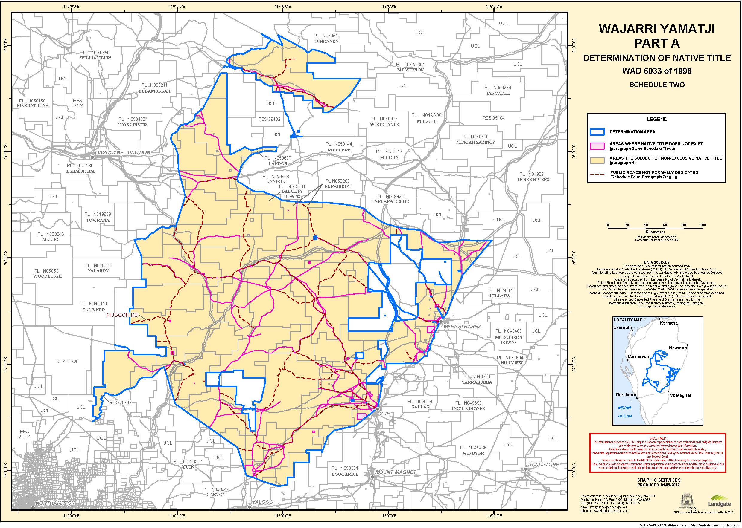
The Part A Determination Area, generally shown as bordered in blue on the maps at Schedule Two, comprises all land and waters bounded by the following description:
Portion 1
All those lands and waters commencing at Latitude 24.071240° South, Longitude 117.235663° East and extending northeasterly, generally southeasterly, generally southwesterly and again generally southeasterly passing through the following coordinate points:
LATITUDE (SOUTH) | LONGITUDE (EAST) |
24.036509 | 117.280692 |
24.042589 | 117.306382 |
24.057299 | 117.352882 |
24.079938 | 117.418562 |
24.108478 | 117.458333 |
24.131228 | 117.535182 |
24.141658 | 117.590912 |
24.164417 | 117.620050 |
24.172287 | 117.681094 |
24.161876 | 117.722234 |
24.166926 | 117.745066 |
24.178726 | 117.774969 |
24.178955 | 117.793139 |
24.197835 | 117.793560 |
24.221195 | 117.790821 |
24.247595 | 117.780183 |
24.281006 | 117.759736 |
24.307786 | 117.740917 |
24.333316 | 117.722709 |
24.355446 | 117.709771 |
24.384165 | 117.690502 |
24.407605 | 117.673753 |
24.435774 | 117.655006 |
24.456354 | 117.644388 |
24.478824 | 117.621949 |
24.500924 | 117.593319 |
24.525235 | 117.566989 |
24.547195 | 117.547150 |
24.558216 | 117.530720 |
24.574936 | 117.505290 |
24.590586 | 117.491590 |
24.603746 | 117.471889 |
24.630097 | 117.425700 |
24.646047 | 117.395771 |
24.672208 | 117.354921 |
24.698319 | 117.327271 |
24.723789 | 117.303471 |
24.750799 | 117.282691 |
24.790720 | 117.260251 |
24.822310 | 117.247900 |
24.840700 | 117.239190 |
24.850641 | 117.223370 |
24.854001 | 117.188191 |
24.858992 | 117.150191 |
24.864632 | 117.103251 |
24.871532 | 117.055882 |
24.877963 | 117.017772 |
24.883313 | 116.993382 |
24.919904 | 116.961843 |
24.925134 | 116.948363 |
24.933904 | 116.946303 |
24.969084 | 116.940713 |
24.973874 | 116.939963 |
24.999784 | 116.934333 |
24.994975 | 116.890303 |
24.994115 | 116.880693 |
24.994225 | 116.844603 |
24.995445 | 116.817843 |
25.006986 | 116.778663 |
25.015046 | 116.740713 |
25.021136 | 116.718393 |
25.028266 | 116.704404 |
25.043946 | 116.681584 |
25.068506 | 116.662334 |
25.095026 | 116.637894 |
25.113127 | 116.622995 |
25.127207 | 116.611675 |
25.148067 | 116.602455 |
25.168317 | 116.596806 |
25.185187 | 116.591996 |
25.203657 | 116.586776 |
25.219687 | 116.580726 |
25.236577 | 116.574336 |
25.253107 | 116.569986 |
25.263798 | 116.569456 |
25.273128 | 116.572757 |
25.284618 | 116.579937 |
25.294488 | 116.595007 |
25.303868 | 116.614397 |
25.317988 | 116.635187 |
25.332348 | 116.658177 |
25.346228 | 116.681057 |
25.359968 | 116.702547 |
25.371858 | 116.718257 |
25.372149 | 116.734656 |
25.377019 | 116.755996 |
25.374009 | 116.782036 |
25.373999 | 116.817116 |
25.386049 | 116.834666 |
25.395338 | 116.860707 |
25.404128 | 116.887397 |
25.409448 | 116.908877 |
25.461248 | 117.000506 |
25.461458 | 117.021906 |
25.463018 | 117.045626 |
25.465337 | 117.062556 |
25.468347 | 117.079346 |
25.470317 | 117.107546 |
25.473617 | 117.131675 |
25.475087 | 117.153245 |
25.477177 | 117.196774 |
25.474936 | 117.231894 |
25.473771 | 117.246912 |
25.471906 | 117.270964 |
25.476286 | 117.314194 |
25.476955 | 117.359204 |
25.478974 | 117.409514 |
25.484334 | 117.467604 |
25.488284 | 117.513253 |
25.496363 | 117.572883 |
25.502213 | 117.622043 |
25.508723 | 117.661314 |
25.518022 | 117.710334 |
25.529792 | 117.751984 |
25.538962 | 117.773474 |
25.557452 | 117.791115 |
25.573552 | 117.811075 |
25.592092 | 117.835815 |
25.616772 | 117.868356 |
25.638082 | 117.898416 |
25.656702 | 117.928906 |
25.678121 | 117.973536 |
25.690481 | 118.016046 |
25.702011 | 118.049276 |
25.708341 | 118.080187 |
25.714090 | 118.107567 |
25.721510 | 118.130357 |
25.723020 | 118.147167 |
25.726160 | 118.169267 |
25.730749 | 118.199137 |
25.732699 | 118.226017 |
25.733059 | 118.246217 |
25.736679 | 118.269197 |
25.737049 | 118.289957 |
25.746099 | 118.314677 |
25.763079 | 118.342987 |
25.778039 | 118.359997 |
25.789959 | 118.376747 |
25.807139 | 118.398848 |
25.825089 | 118.422958 |
25.840988 | 118.444958 |
25.853718 | 118.469798 |
25.855698 | 118.498448 |
25.844047 | 118.628638 |
25.841397 | 118.646647 |
25.836246 | 118.670657 |
25.830436 | 118.691877 |
25.830106 | 118.715097 |
25.830566 | 118.729647 |
25.831295 | 118.748807 |
25.834305 | 118.772357 |
25.838634 | 118.794507 |
25.838545 | 118.817667 |
25.839895 | 118.838727 |
25.837735 | 118.862946 |
25.836865 | 118.881476 |
25.836935 | 118.890956 |
25.837184 | 118.915186 |
25.836624 | 118.940606 |
25.835144 | 118.968186 |
Then easterly to Latitude 25.834935° South, Longitude 118.979625° East, being a point on the boundary of Native Title Determination Application WAD6132/1998 Yugunga-Nya People (WC1999/046); then generally southwesterly, generally westerly and again generally southwesterly along that native title determination application to a corner on the northern boundary of Native Title Determination WAD6123/98 Badimia People (WCD2015/001), further described as:
Then southwesterly to a western side of Road Number 2854, being the original alignment of Great Northern Highway (former alignment before road widenings) at Latitude 26.165366° South; then southerly and generally southwesterly along western sides of Road Number 2854 to the intersection with a northwestern boundary of Lot 500 as shown on Deposited Plan 406913; then generally southwesterly along boundaries of that lot again to a western side of Road Number 2854; then generally southwesterly along western sides of Road Number 2854 and Road Number 703 to a northern boundary of the Meekatharra Townsite boundary; then northwesterly and generally southwesterly along boundaries of that townsite to an intersection with the northwestern boundary of a Lot 1031 on Deposited Plan 218692 at approximate Latitude 26.601406° South; then southerly across that lot to an intersection with the western side of Road Number 703, being the original alignment of Great Northern Highway (former alignment before road widenings) at Latitude 26.602045° South; then generally southwesterly along western sides of Road Number 703 to a northern corner of Lot 274 as shown on Deposited Plan 218692; then southwesterly along the western boundary of that lot to again a western side of Road Number 703; then generally southwesterly along sides of that road to a northern boundary of Pastoral Lease N050578 (Annean) at approximate Longitude 118.435112° East; then easterly, southerly, westerly, generally southwesterly and northwesterly along boundaries of that pastoral lease to its intersection with an eastern side of Road Number 703 at approximate Longitude 118.397087° East; then generally southwesterly along eastern sides of Road Number 703 to an eastern boundary of Pastoral Lease N050578 (Annean); then southerly, easterly, again southerly, westerly, generally southerly and generally southwesterly along boundaries of that pastoral lease to its intersection with an eastern boundary of Pastoral Lease N050577 (Annean); then southerly and westerly along boundaries of that pastoral lease to an eastern side of Road Number 457, then generally southwesterly along sides of Road Number 457 to a northern boundary of Pastoral Lease N050576 (Annean); then westerly to a southeastern corner of Pastoral Lease N050577 (Annean); then generally westerly and southerly along boundaries of that pastoral lease to its intersection with an eastern boundary of Reserve 10367 (Wandry Springs Cue Stock Route); then south along the prolongation southerly of the eastern boundary of Pastoral Lease N050577 (Annean) to the prolongation east of the southern boundary of the southwestern severance of that pastoral lease at approximate Latitude 27.043457° South, Longitude 117.983824° East; then westerly to the southernmost south eastern corner of the south western severance of Pastoral Lease N050577 (Annean); then southwesterly to the northernmost corner of Cue Townsite; then southwesterly along the northwestern boundary of that townsite to its westernmost corner; then southwesterly to Latitude 27.579253° South, Longitude 117.685671° East, being a point on the northern boundary of Native Title Determination WAD6123/98 Badimia People (WCD2015/001);
Then generally southwesterly along the northern boundary of that native title determination passing through the following coordinate points:
LATITUDE (SOUTH) | LONGITUDE (EAST) |
27.624055 | 117.489396 |
27.684915 | 117.419178 |
27.700825 | 117.417588 |
Then southwesterly again along the northern boundary of that native title determination to the northernmost eastern boundary of Pastoral Lease N050333 (Murrum) at approximate Latitude 27.832600° South; then northerly, westerly, and generally southerly and again westerly along northern and western boundaries of that pastoral lease to a northeastern corner of Pastoral Lease N049595 (Edah); then westerly and southerly along boundaries of that pastoral lease to a northeastern corner of Pastoral Lease N049400 (Wagga Wagga); then westerly, southerly and southwesterly along boundaries of that pastoral lease to the intersection with a northern boundary of Native Title Determination Application WAD6193/1998 Widi Mob (WC1997/072) at approximate Latitude 28.150138° South, Longitude 116.962738° East; then generally northwesterly along the northern boundary of that native title determination application passing through the following coordinate points:
LATITUDE (SOUTH) | LONGITUDE (EAST) |
28.149497 | 116.960465 |
28.147182 | 116.951890 |
28.144548 | 116.943738 |
28.142580 | 116.935563 |
28.140264 | 116.926988 |
28.137283 | 116.918437 |
28.133968 | 116.909897 |
28.131319 | 116.901334 |
28.129018 | 116.893171 |
28.126368 | 116.884608 |
28.124052 | 116.876033 |
28.121752 | 116.867870 |
28.118755 | 116.858907 |
28.116090 | 116.849932 |
28.113441 | 116.841369 |
28.111125 | 116.832794 |
28.109157 | 116.824620 |
28.106508 | 116.816056 |
28.103875 | 116.807905 |
28.099909 | 116.799800 |
28.095611 | 116.791708 |
28.092296 | 116.783168 |
28.088981 | 116.774628 |
28.086331 | 116.766065 |
28.083031 | 116.757937 |
28.079385 | 116.749409 |
28.076085 | 116.741281 |
28.072770 | 116.732741 |
28.070119 | 116.724178 |
28.067486 | 116.716027 |
28.065184 | 116.707864 |
28.062535 | 116.699301 |
28.060234 | 116.691138 |
28.057600 | 116.682986 |
28.054634 | 116.674846 |
28.051001 | 116.666730 |
28.048019 | 116.658179 |
Then northwesterly to the intersection with an eastern boundary of Native Title Determination Application WAD6119/1998 Mullewa Wadjari Community (WC1996/093) at approximate Latitude 28.046721° South, Longitude 116.654161° East; then generally northwesterly and generally southwesterly along boundaries of that native title determination application passing through the following coordinate points:
LATITUDE (SOUTH) | LONGITUDE (EAST) |
27.786236 | 116.570922 |
27.374955 | 115.982805 |
27.025313 | 115.876680 |
27.031588 | 115.870154 |
27.032741 | 115.866284 |
27.034945 | 115.858951 |
27.037267 | 115.851613 |
27.039368 | 115.847697 |
27.042561 | 115.844331 |
27.052147 | 115.834431 |
27.058421 | 115.827905 |
27.064735 | 115.822381 |
27.070939 | 115.817062 |
27.080359 | 115.808978 |
27.086634 | 115.802452 |
27.096242 | 115.793155 |
27.105946 | 115.783251 |
27.112205 | 115.776323 |
Then southwesterly to an eastern boundary of Pastoral Lease N050041 (New Forest) at Latitude 27.117491° South; then generally southwesterly passing through the following coordinate points:
LATITUDE (SOUTH) | LONGITUDE (EAST) |
27.117958 | 115.768617 |
27.122533 | 115.761170 |
27.124103 | 115.749853 |
27.124166 | 115.742422 |
27.125989 | 115.731496 |
27.126287 | 115.724054 |
27.126001 | 115.716842 |
27.126563 | 115.713001 |
27.126064 | 115.709412 |
27.124473 | 115.702263 |
27.124179 | 115.694849 |
27.125553 | 115.687557 |
27.126808 | 115.680270 |
27.128174 | 115.672777 |
27.130480 | 115.665037 |
27.133752 | 115.657653 |
27.139267 | 115.649960 |
27.142680 | 115.646181 |
27.149208 | 115.640043 |
27.155553 | 115.635320 |
27.158700 | 115.633763 |
27.165085 | 115.630041 |
27.174877 | 115.625351 |
27.184376 | 115.619270 |
27.190739 | 115.614948 |
27.197085 | 115.610224 |
27.203660 | 115.605289 |
27.210021 | 115.600967 |
27.213072 | 115.597006 |
27.219401 | 115.585860 |
27.223011 | 115.578057 |
27.225902 | 115.570089 |
27.228936 | 115.562716 |
27.229030 | 115.559098 |
27.229954 | 115.555440 |
27.231202 | 115.547954 |
Then southwesterly to an eastern boundary of Pastoral Lease N050041 (New Forest) at Latitude 27.231234° South; then generally southwesterly passing through the following coordinate points:
LATITUDE (SOUTH) | LONGITUDE (EAST) |
27.233168 | 115.540632 |
27.234534 | 115.533139 |
27.236129 | 115.525434 |
27.237842 | 115.517724 |
27.240393 | 115.510174 |
27.244020 | 115.502772 |
27.248951 | 115.495307 |
27.254854 | 115.488397 |
27.260740 | 115.481087 |
27.268966 | 115.469850 |
27.273177 | 115.462219 |
27.277753 | 115.454771 |
27.282675 | 115.447105 |
27.286657 | 115.439686 |
27.290520 | 115.432273 |
27.292479 | 115.424750 |
27.294446 | 115.417429 |
27.295313 | 115.406345 |
27.293920 | 115.395172 |
27.293025 | 115.387588 |
27.291267 | 115.376233 |
27.289677 | 115.369084 |
27.287723 | 115.361752 |
27.284828 | 115.354666 |
27.280977 | 115.347425 |
27.276540 | 115.340413 |
27.272696 | 115.333372 |
27.272047 | 115.325977 |
27.271759 | 115.318764 |
27.271888 | 115.318058 |
27.273566 | 115.315221 |
27.276867 | 115.310883 |
27.281656 | 115.310810 |
27.290159 | 115.308465 |
27.292147 | 115.307876 |
Then southerly to the northernmost northeastern corner of Reserve 1807; then generally southwesterly along boundaries of that reserve to its southernmost southeastern corner; then generally southwesterly passing through the following coordinate points:
LATITUDE (SOUTH) | LONGITUDE (EAST) |
27.311258 | 115.285324 |
27.314895 | 115.283381 |
27.318110 | 115.283984 |
27.318608 | 115.288872 |
27.321223 | 115.288179 |
27.324286 | 115.288296 |
27.324258 | 115.286011 |
27.324371 | 115.283398 |
27.327540 | 115.280248 |
27.329814 | 115.275480 |
27.331840 | 115.274306 |
27.335865 | 115.281425 |
27.337239 | 115.286464 |
27.340922 | 115.289672 |
27.344333 | 115.294354 |
27.350038 | 115.295899 |
27.354411 | 115.295995 |
27.358863 | 115.290539 |
27.365262 | 115.289298 |
27.368717 | 115.285816 |
27.372651 | 115.285593 |
27.374132 | 115.287530 |
27.376047 | 115.289133 |
27.378368 | 115.288281 |
27.378931 | 115.286639 |
27.380193 | 115.282537 |
27.381909 | 115.279898 |
27.385846 | 115.280000 |
27.385579 | 115.281964 |
27.388656 | 115.283223 |
27.390101 | 115.282221 |
27.391560 | 115.282362 |
27.395554 | 115.283320 |
27.398015 | 115.283347 |
27.399875 | 115.282386 |
27.402119 | 115.282438 |
27.404743 | 115.281877 |
27.404706 | 115.278930 |
27.404740 | 115.275376 |
27.405022 | 115.273205 |
27.406167 | 115.271887 |
27.408476 | 115.270984 |
27.413331 | 115.269435 |
27.417359 | 115.269807 |
Then southwesterly to the northernmost northwestern corner of Reserve 1806; then generally southerly and southeasterly along boundaries of that reserve to its southernmost southwestern corner; then generally southerly and southwesterly passing through the following coordinate points:
LATITUDE (SOUTH) | LONGITUDE (EAST) |
27.439043 | 115.283610 |
27.440094 | 115.284697 |
27.441134 | 115.284913 |
27.442327 | 115.284895 |
27.443306 | 115.284416 |
27.444024 | 115.283708 |
27.444538 | 115.283351 |
27.445259 | 115.282991 |
27.445986 | 115.282980 |
27.446765 | 115.283084 |
27.447493 | 115.283247 |
27.448794 | 115.283634 |
27.450039 | 115.283614 |
27.451540 | 115.283418 |
27.451954 | 115.283295 |
27.453105 | 115.283006 |
27.455499 | 115.277205 |
27.457240 | 115.273907 |
27.459165 | 115.271549 |
27.463960 | 115.268903 |
27.467081 | 115.262903 |
27.468765 | 115.261922 |
27.472413 | 115.262801 |
27.475096 | 115.260297 |
27.476663 | 115.261603 |
27.479017 | 115.264396 |
27.482739 | 115.264920 |
27.485592 | 115.265961 |
27.488488 | 115.268351 |
27.492064 | 115.269363 |
27.497096 | 115.266804 |
27.498767 | 115.265266 |
27.500121 | 115.263182 |
27.501247 | 115.262062 |
27.502892 | 115.258965 |
27.504187 | 115.258200 |
27.505893 | 115.258188 |
27.507893 | 115.254990 |
27.508363 | 115.253441 |
27.508134 | 115.251405 |
27.506303 | 115.248564 |
27.506388 | 115.246905 |
27.510055 | 115.245109 |
27.511208 | 115.244545 |
27.512060 | 115.244349 |
27.513210 | 115.244080 |
27.514449 | 115.242963 |
27.514858 | 115.241102 |
27.514370 | 115.239268 |
27.514354 | 115.237478 |
27.514996 | 115.236328 |
27.515345 | 115.234671 |
27.515653 | 115.232538 |
27.516047 | 115.230934 |
Then southwesterly to the intersection with a western boundary of Pastoral Lease N049486 (Yallalong) at Latitude 27.516422° South; then generally northerly along boundaries of that pastoral lease to the southernmost south eastern corner of Reserve 40628; then generally northerly along boundaries of that reserve to the southernmost south eastern corner of Pastoral Lease N049949 (Talisker); then generally northerly along the eastern boundaries of Pastoral Lease N049949 (Talisker) to a southern boundary of Pastoral Lease N050597 (Ballythunna); then easterly along the southern boundary of that pastoral lease to the prolongation southerly of the westernmost western boundary of Pastoral Lease N050480 (Byro); then northerly along that prolongation and the western boundary of that pastoral lease to the westernmost north western corner of that pastoral lease; Then generally northwesterly passing through the following coordinate points:
LATITUDE (SOUTH) | LONGITUDE (EAST) |
25.953106 | 115.649792 |
25.909379 | 115.629441 |
25.872378 | 115.611745 |
25.837441 | 115.597212 |
Then northwesterly to the intersection of the centreline of Wooramel River with Longitude 115.594032° East; then generally northeasterly along the centreline of Wooramel River to the intersection with Bilung Creek; then generally northeasterly along the centreline of that creek to Longitude 115.984267° East (near Bilung Pool); then generally northerly and generally easterly (around Bilung Pool) passing through the following coordinate points:
LATITUDE (SOUTH) | LONGITUDE (EAST) |
25.706446 | 115.984192 |
25.706386 | 115.984141 |
25.706328 | 115.984052 |
25.706269 | 115.984010 |
25.706209 | 115.983969 |
25.706125 | 115.983972 |
25.706027 | 115.983969 |
25.705963 | 115.983984 |
25.705940 | 115.983996 |
25.705906 | 115.983981 |
25.705838 | 115.983944 |
25.705738 | 115.983978 |
25.705662 | 115.984010 |
25.705616 | 115.984003 |
25.705468 | 115.983911 |
25.705451 | 115.983863 |
25.705468 | 115.983821 |
25.705404 | 115.983833 |
25.705235 | 115.983927 |
25.705216 | 115.983949 |
25.705177 | 115.984080 |
25.705117 | 115.984180 |
25.705049 | 115.984386 |
25.705043 | 115.984419 |
25.705045 | 115.984426 |
25.705080 | 115.984549 |
25.705115 | 115.984751 |
25.705144 | 115.984864 |
25.705153 | 115.984877 |
25.705155 | 115.984961 |
25.705189 | 115.985252 |
25.705242 | 115.985515 |
25.705254 | 115.985640 |
25.705237 | 115.985893 |
Then generally northerly passing through the following coordinate points:
LATITUDE (SOUTH) | LONGITUDE (EAST) |
25.418962 | 116.077138 |
25.160900 | 116.009280 |
25.154289 | 116.011050 |
25.037522 | 116.009054 |
Then northwesterly to the intersection of Latitude 24.939474° South and the centreline of Cobra Dairy Creek Road, being a point on the eastern boundary of Native Title Determination Application WAD6161/1998 Gnulli (WC1997/028); then generally northwesterly along that road and boundaries of that native title determination application to Latitude 24.652803° South; then again generally northeasterly along that native title determination application passing through Latitude 24.589108° South, Longitude 116.245187° East, and onwards to the intersection of the centreline of Wanna Road (approximately at Latitude 24.190484° South, Longitude 116.446724° East), being a southeastern corner of Native Title Determination Application WAD464/2016 Combined Thiin-Mah Warriyangka, Tharrkari, Jiwarli (WC2016/003); then generally northeasterly, generally easterly, again generally northeasterly and generally northwesterly along eastern boundaries of that native title determination application to its intersection with Native Title Determination Application WAD62/2016 Jurrurru People 3# (WC2016/001), further described as;
Then generally northeasterly passing through the following coordinate points:
LATITUDE (SOUTH) | LONGITUDE (EAST) |
24.121114 | 116.481796 |
24.119908 | 116.489642 |
Then northeasterly to an intersection with Koorabooka Creek at Longitude 116.512528° East, then generally easterly and northeasterly along the centreline of that Creek to Ericoothara Spring at approximate Latitude 23.943560° South; then generally northwesterly along the high points of the Godfrey Range, generally identified as passing through the following approximate coordinate points:
LATITUDE (SOUTH) | LONGITUDE (EAST) |
23.943141 | 116.899759 |
23.942722 | 116.895388 |
23.942303 | 116.891017 |
23.940679 | 116.887136 |
23.939055 | 116.883255 |
23.937430 | 116.879375 |
23.935806 | 116.875494 |
23.934182 | 116.871613 |
23.932557 | 116.867733 |
23.930635 | 116.863754 |
23.928712 | 116.859776 |
23.926789 | 116.855797 |
23.924867 | 116.851819 |
23.922944 | 116.847840 |
23.921021 | 116.843862 |
23.920514 | 116.839949 |
23.920008 | 116.836035 |
23.919501 | 116.832122 |
23.916371 | 116.828698 |
23.913240 | 116.825274 |
23.910110 | 116.821850 |
23.907838 | 116.818582 |
23.905567 | 116.815314 |
23.903295 | 116.812047 |
23.901023 | 116.808779 |
23.898751 | 116.805512 |
23.895844 | 116.802626 |
23.892937 | 116.799740 |
23.890030 | 116.796854 |
23.887123 | 116.793968 |
23.885155 | 116.791179 |
23.883187 | 116.788391 |
23.880284 | 116.785712 |
23.877380 | 116.783033 |
Then northwesterly to Latitude 23.874477° South, Longitude 116.780354° East, being a point on the boundary of Native Title Determination Application WAD62/2016 Jurrurru People #3 (WC2016/001);
Then southeasterly to the boundary of Native Title Determination WAD6007/2000 Jurruru People Part A (WCD2015/002) at Latitude 23.903982° South, Longitude 116.957147° East, then southeasterly along that native title determination to Latitude 24.031719° South, Longitude 117.199411° East, and then southeasterly back to the commencement point.
Portion 2
All those lands and waters comprising those parts of Lot 235 as shown on Deposited Plan 238014 that are southeasterly of a line joining Latitude 27.544635° South, Longitude 115.190358° East and Latitude 27.520530° South, Longitude 115.228852° East.
Exclusions
All the lands and waters within the parcels identified below are excluded to the extent they fall within the WAD6033/1998 Part A External Boundary:
All that land comprising Pastoral Lease N049563 (Belele).
All that land comprising Pastoral Lease N049656 (Buttah).
All that land comprising Pastoral Lease N049470 (Mt Wittenoom).
All that land comprising Pastoral Lease N050049 (Karbar).
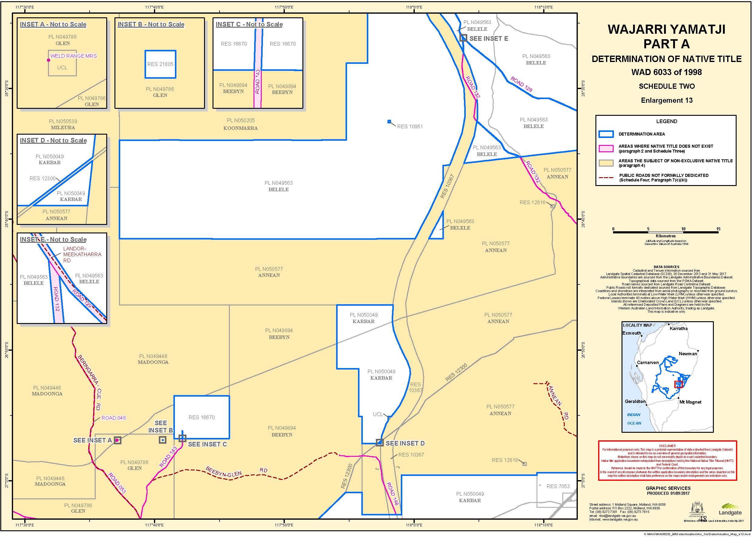
All that land comprising Reserve 297, Reserve 16670, Reserve 21805, Reserve 39182 and Reserve 42783.
All that land comprising Lot 1 as shown on Deposited Plan 49991 and being the land described in certificate of title volume 2602 folio 964.
All that land comprising Lot 37 as shown on Deposited Plan 36256.
All that land comprising Lot 38 as shown on Deposited Plan 221065.
All that land comprising those portions of Lot 40 as shown on Deposited Plan 238030.
All that land comprising those portions of Lot 25 as shown on Deposited Plan 238030.
All that land comprising Lot 58 as shown on Deposited Plan 194566.
All that land comprising Lot 60 as shown on Deposited Plan 194660.
All that land comprising Lot 214 as shown on Deposited Plan 220375.
All that land comprising Lot 334 as shown on Deposited Plan 30446.
All that land comprising Lot 12629 as shown on Deposited Plan 28859.
All that land comprising Lot 382 as shown on Deposited Plan 243003.
All that land comprising Lot 30 as shown on Deposited Plan 77647.
All that land comprising Lots 22, 25, 26, 27, 29, 30, 31, 34, 35, 74 and 75 as shown on Deposited Plan 222348.
All that land comprising Lots 100, 264, 265 and 266 as shown on Deposited Plan 100155.
All that land comprising Lots 112, 267, 268, 269, 270, 271, 272, 273, 274 and 275 as shown on Deposited Plan 222880.
All that land comprising Lot 276 as shown on Deposited Plan 130065.
All that land comprising Lots 166, 167, 277, 278, 279, 280, 281 and 282 as shown on Deposited Plan 222882.
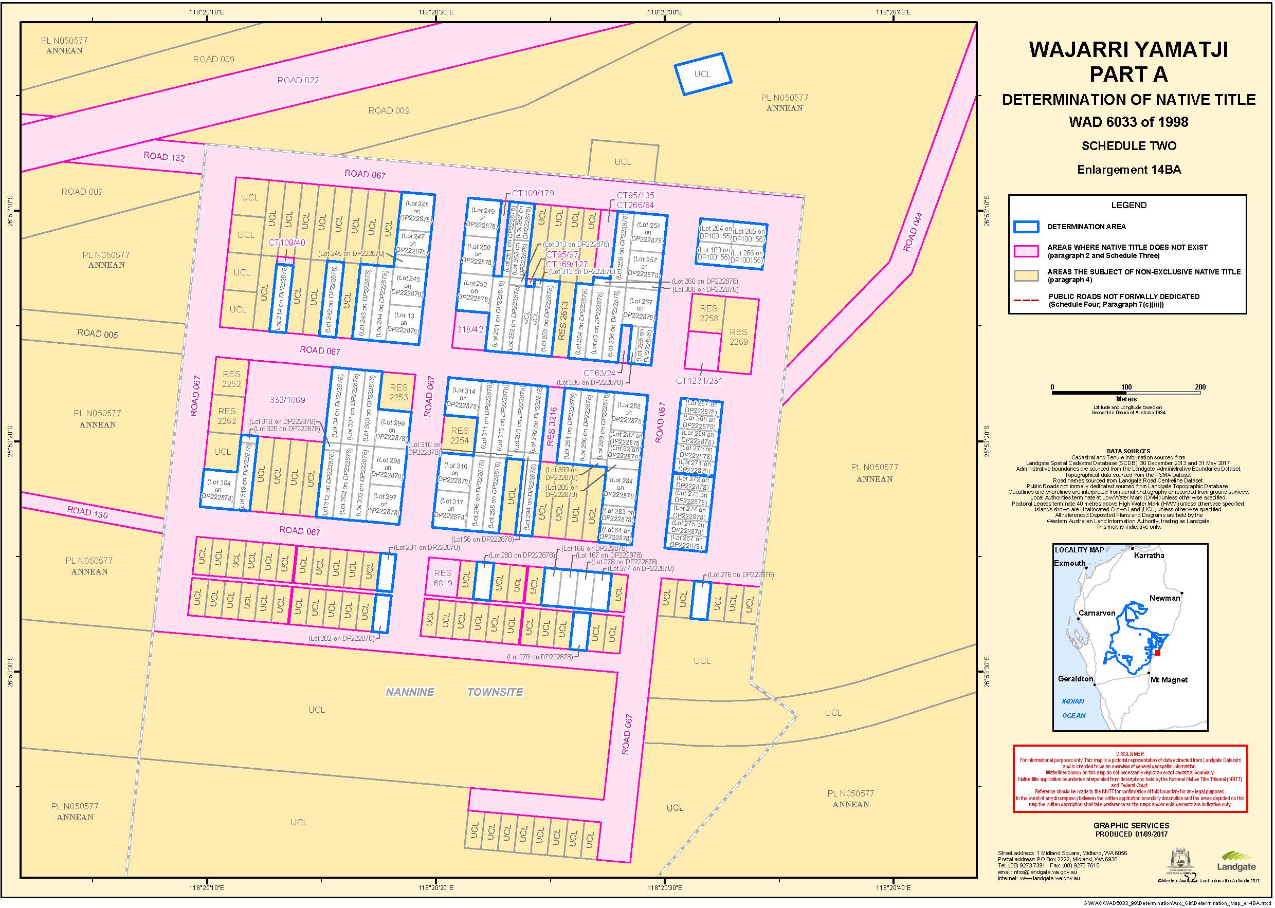
All that land comprising Lots 13, 34, 56, 62, 64, 74, 83, 241, 242, 243, 244, 245, 246, 247, 248, 249, 250, 251, 252, 253, 254, 255, 257, 258, 259, 260, 261, 262, 263, 283, 284, 285, 287, 288, 289, 290, 291, 292, 293, 294, 295, 296, 297, 298, 299, 300, 301, 302, 303, 304, 305, 306, 307, 308, 309, 310, 311, 312, 313, 314, 315, 316, 317, 318, 319 and 320 as shown on Deposited Plan 222878.
UCL 1 - that Unallocated Crown Land parcel in vicinity of Bangemall Well surrounded by Lot 38 on Deposited Plan 221065 with an approximate centroid of Longitude 116.475303° East, Latitude 24.199295° South.
UCL 2 - that Unallocated Crown Land parcel bound on the east and north by Pastoral Lease N050510 (Pingandy) and bound to the west and south by Pastoral Lease N050364 (Mt Vernon) and in the south by UCL 3.
UCL 3 - that Unallocated Crown Land parcel bound on the north by Pastoral Lease N050510 (Pingandy) and UCL2, bound to the south by Pastoral Lease N050129 (Mt Augustus) and bound to the west by Pastoral Lease N050044 (Dooley Downs).
UCL 4 - that Unallocated Crown Land parcel in vicinity of Clever Mary Hills bound in the north, west and southeast by Lot 58 on Deposited Plan 194566 and on the east and south east by Lot 40 on Deposited Plan 238040 with an approximate centroid of Longitude 116.762443° East, Latitude 24.845220° South.
UCL 5 - that Unallocated Crown Land parcel in vicinity of Mt Gould Well surrounding Reserve 1412 and surrounded by Pastoral Lease N050153 (Mt Gould) with an approximate centroid of Longitude 117.308147° East, Latitude 25.810297° South.
UCL 6 – that Unallocated Crown Land parcel north of Nannine Townsite, south of the Great Northern Highway surrounded by Pastoral Lease N050577 (Annean) with an approximate centroid of Longitude 118.342132° East, Latitude 26.884458° South.
UCL 7 – that Unallocated Crown Land parcel within the Nannine Townsite, immediately east of Lot 252 on DP222878 with an approximate centroid of Longitude 118.339984° East, Latitude 26.887429° South.
UCL 8 – that Unallocated Crown Land parcel within the Nannine Townsite, immediately west of Lot 253 on Deposited Plan 222878 with an approximate centroid of Longitude 118.340085° East, Latitude 26.887438° South.
UCL 9 – that Unallocated Crown Land parcel (closed road) surrounded by N049522 (Youthapina) extending generally northwesterly from the Meekatharra – Mount Clere Road to a southern boundary of Lot 300 on Deposited Plan 48595 (Youthapina P/L).
UCL 10 – that Unallocated Crown Land parcel (closed road) surrounded by Pastoral Lease N049522 (Youthapina) and Pastoral Lease N049924 (Sherwood) and extending generally northwesterly from the northern boundary of Reserve 9469 to the southern boundary of Reserve 10633.
UCL 11 – that Unallocated Crown Land parcel (closed road) surrounded by Pastoral Lease N049522 (Youthapina) extending northeasterly from the Carnarvon Meekatharra Road to a western boundary of Reserve 9469.
UCL 12 – that Unallocated Crown Land parcel (Closed Road) at the end of an un-named road bound on the north and south by Pastoral Lease N050085 (Meeberrie) and the east by Pastoral Lease N049906 (Wooleen) with an approximate centroid of Longitude 116.072513° East, Latitude 26.998873° South.
Note: Geographic Coordinates provided in Decimal Degrees.
All referenced Deposited Plans and Diagrams are held by the Western Australian Land Information Authority, trading as Landgate.
Cadastral boundaries sourced from Landgate’s Spatial Cadastral Database dated 31st May 2017.
Topographic vector data is © Commonwealth of Australia (Geoscience Australia) 2015.
For the avoidance of doubt the determination excludes any land and waters subject to:
Native Title Determination Application WAD6123/1998 Badimia People (WCD2015/001) as Determined in the Federal Court on the 25/05/2015.
Native Title Determination Application WAD6007/2000 Jurruru People Part A (WCD2015/002) as Determined in the Federal Court on the 1/09/2015.
Native Title Determination Application WAD72/1998 Nharnuwangga Wajarri and Ngarlawangga (WCD2000/001) as Determined in the Federal Court on the 29/08/2000.
Native Title Determination Application WAD6132/1998 Yugunga-Nya People (WC1999/046) as accepted for registration 21/01/2015.
Native Title Determination Application WAD6136/1998 Nanda People (WC2000/013) as accepted for registration 1/03/2001.
Native Title Determination Application WAD6161/1998 Gnulli (WC1997/028) as accepted for registration 13/05/2014.
Native Title Determination Application WAD464/2016 Combined Thiin-Mah Warriyangka, Tharrkari, Jiwarli (WC2016/003) as accepted for registration 21/10/2016.
Native Title Determination Application WAD6193/1998 Widi Mob (WC1997/072) as accepted for registration 01/02/2017.
Native Title Determination Application WAD6119/1998 Mullewa Wadjari Community (WC1996/093) as accepted for registration 5/01/2017.
Native Title Determination Application WAD6236/1998 The Malgana Shark Bay Peoples (WC1998/017) as accepted for registration 30/06/2017.
Native Title Determination Application WAD62/2016 Jurruru #3 (WC2016/001) as accepted for registration 04/08/2016.
Datum: Geocentric Datum of Australia 1994 (GDA94)
Prepared By: Graphic Services (Landgate) 25th August 2017
Use of Coordinates:
Where coordinates are used within the description to represent cadastral or topographical boundaries or the intersection with such, they are intended as a guide only. As an outcome to the custodians of cadastral and topographic data continuously recalculating the geographic position of their data based on improved survey and data maintenance procedures, it is not possible to accurately define such a position other than by detailed ground survey.
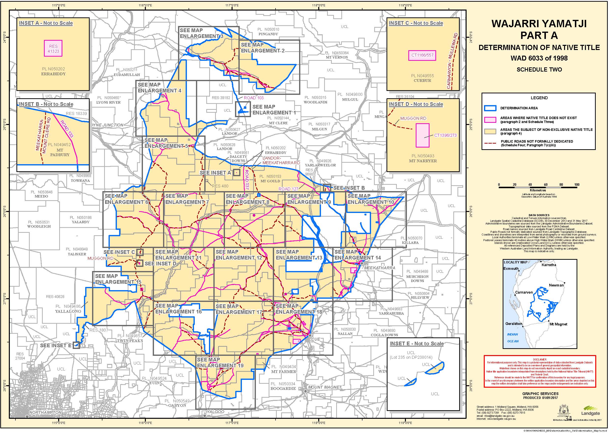
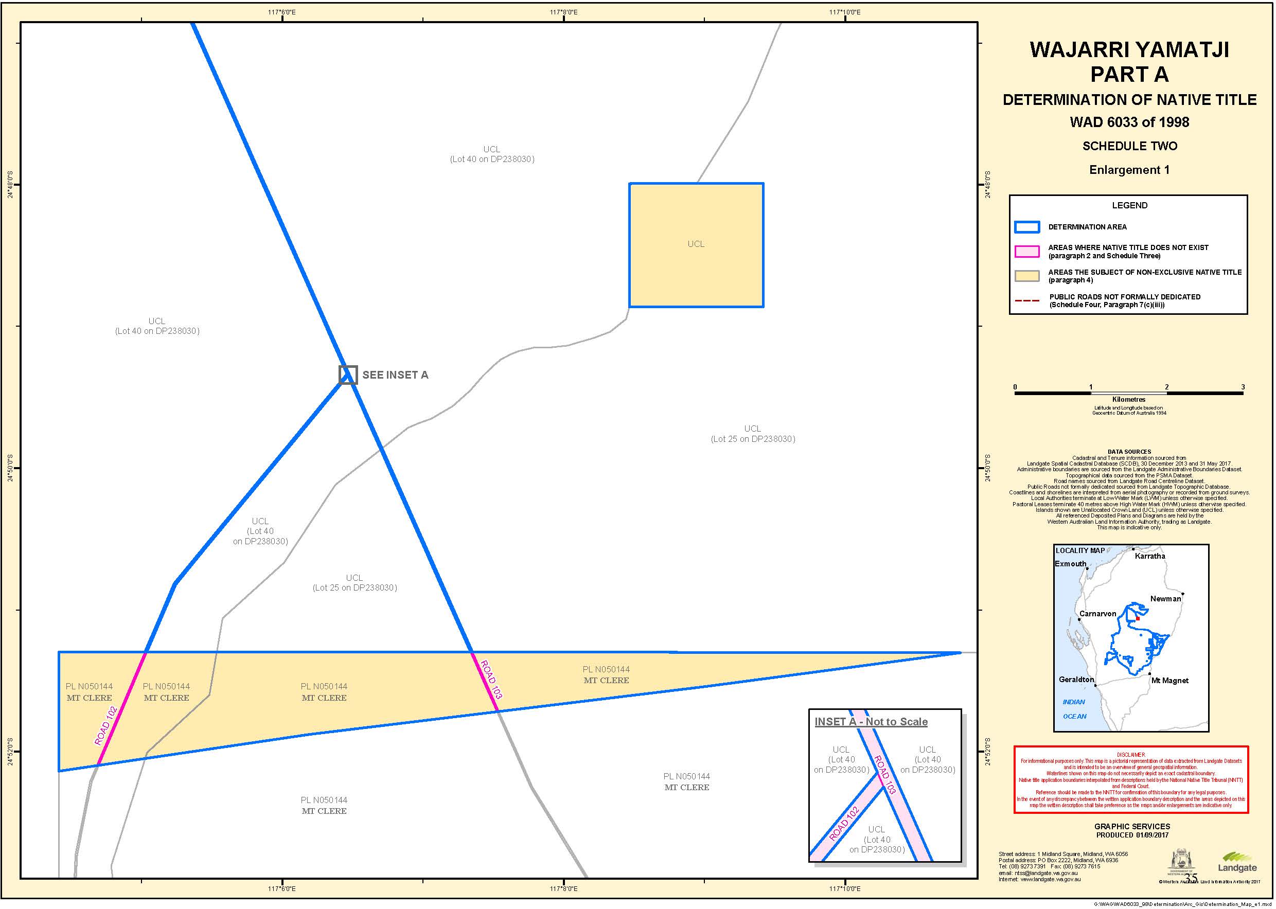
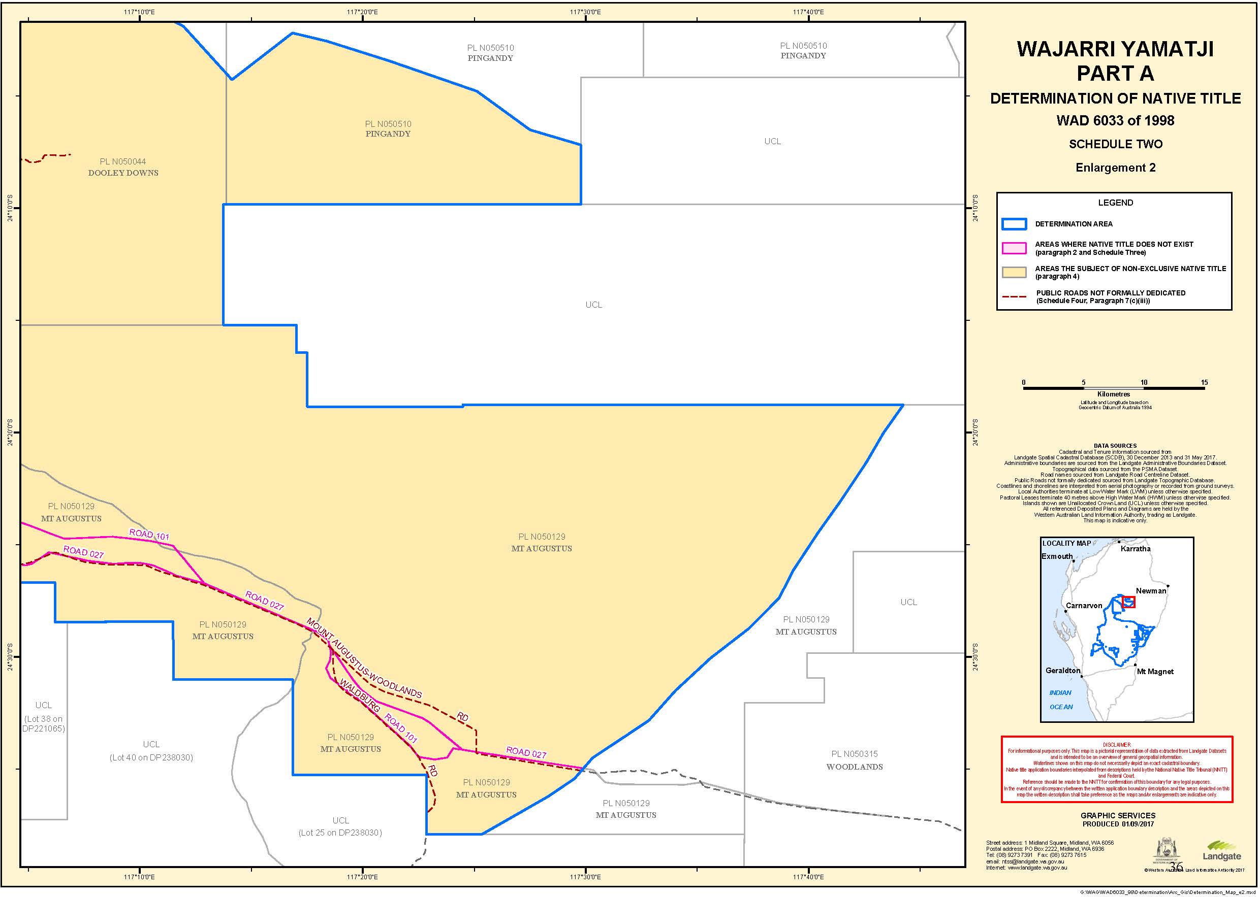
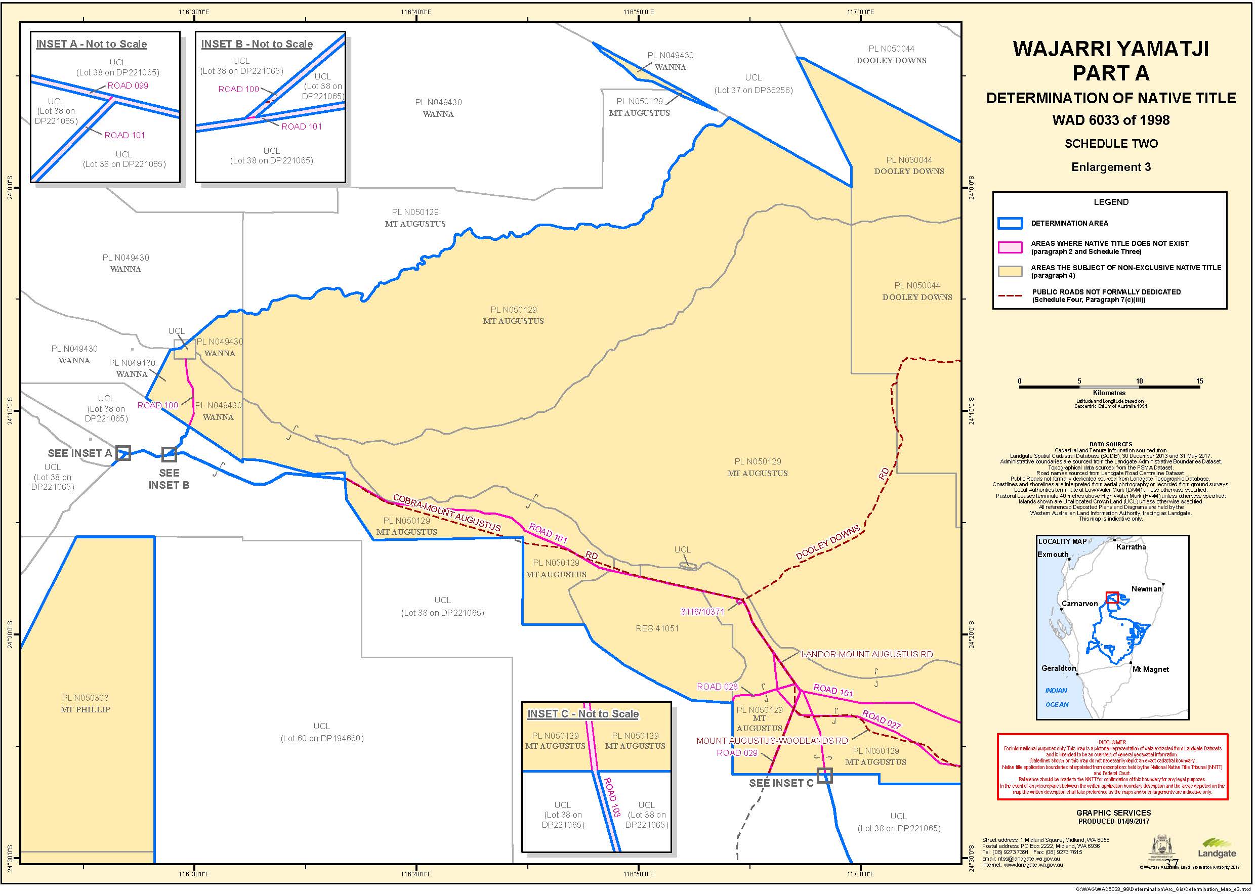
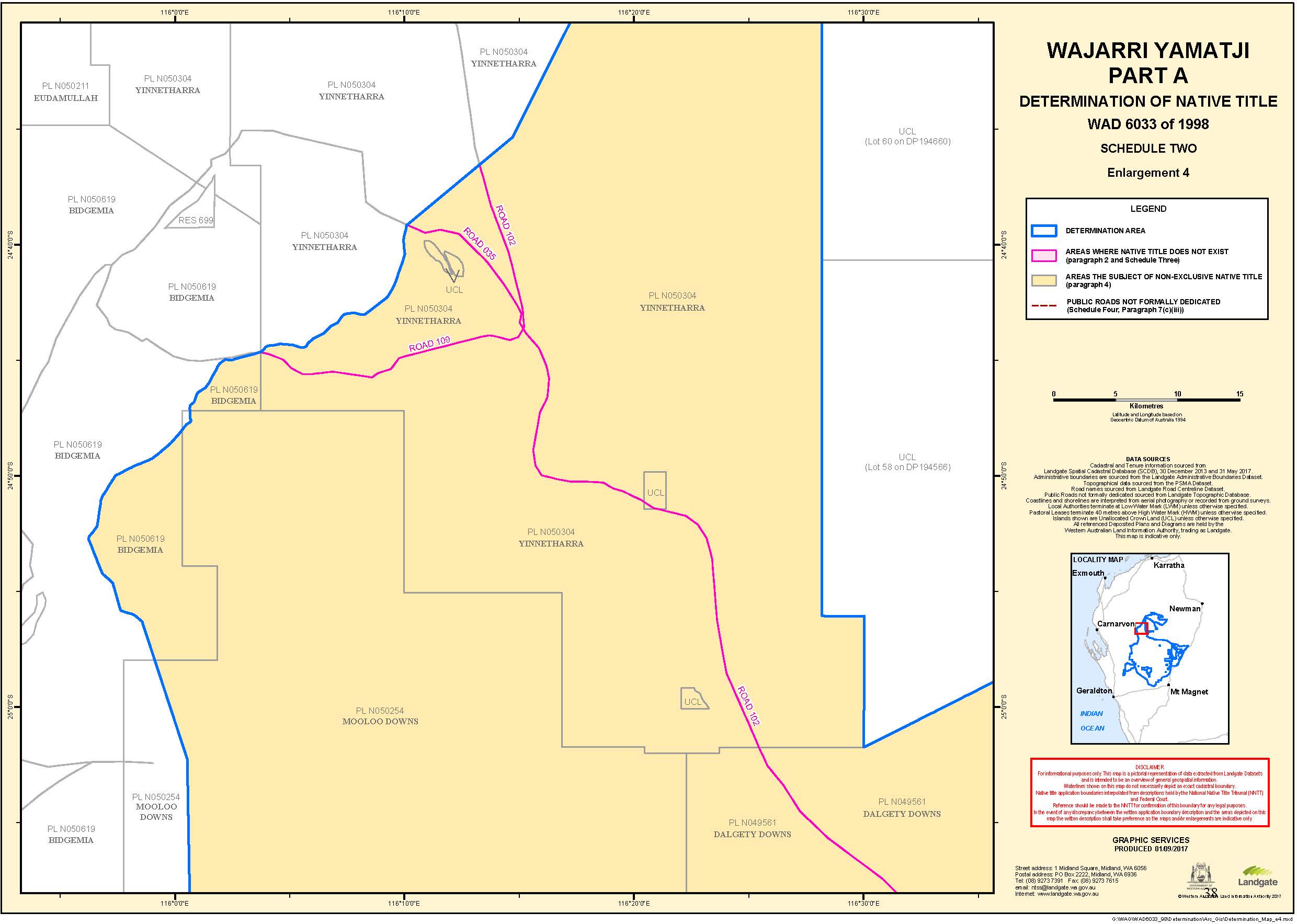
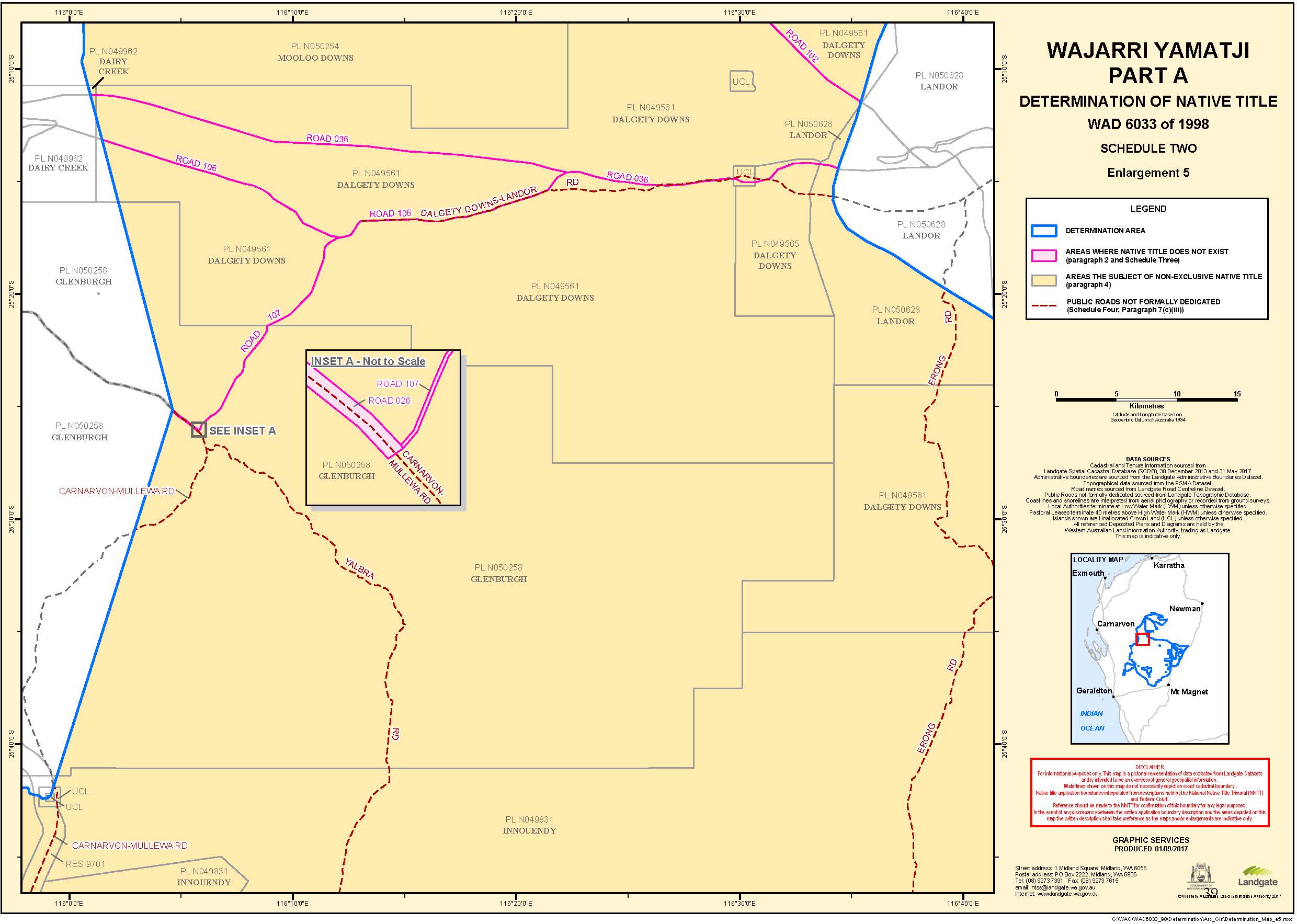
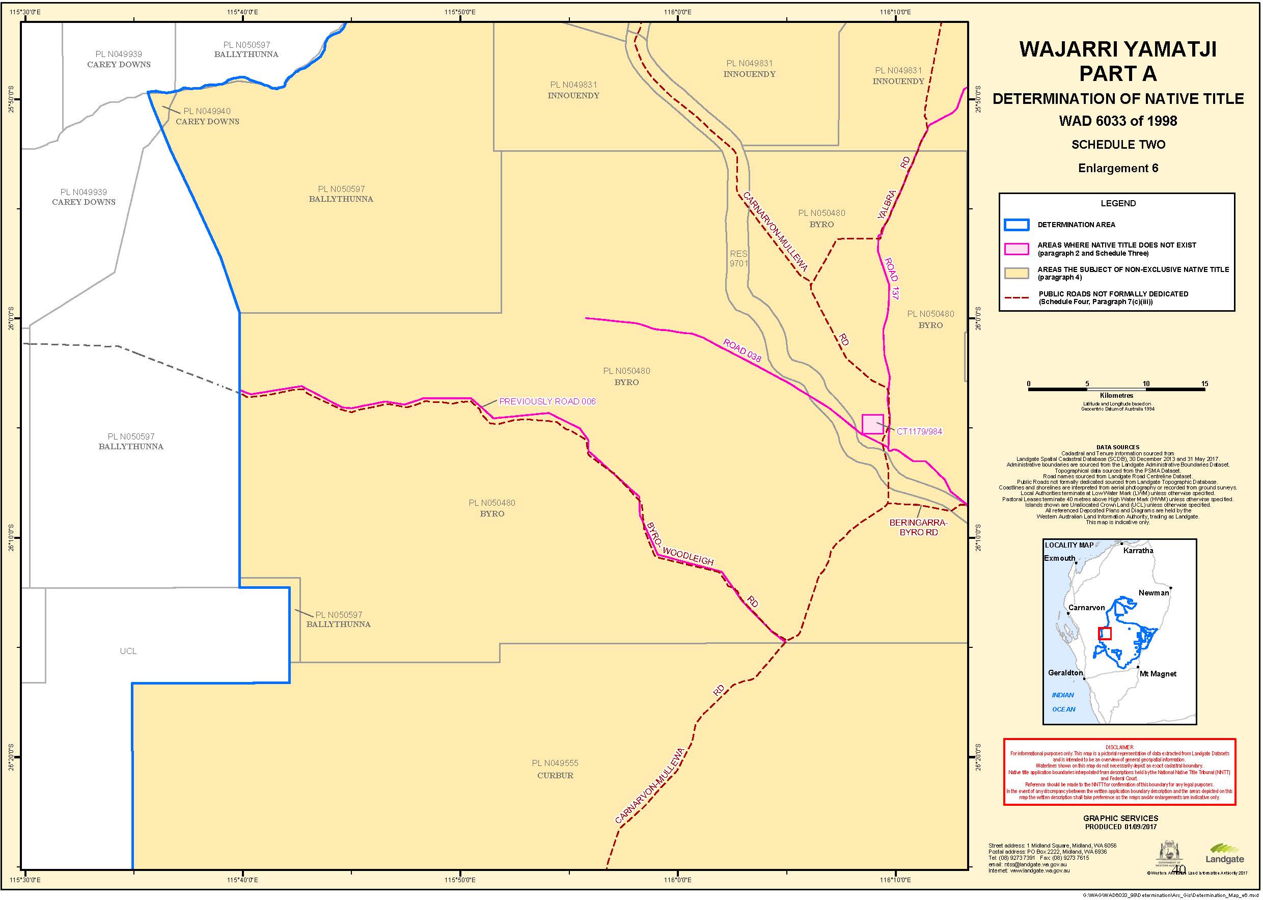
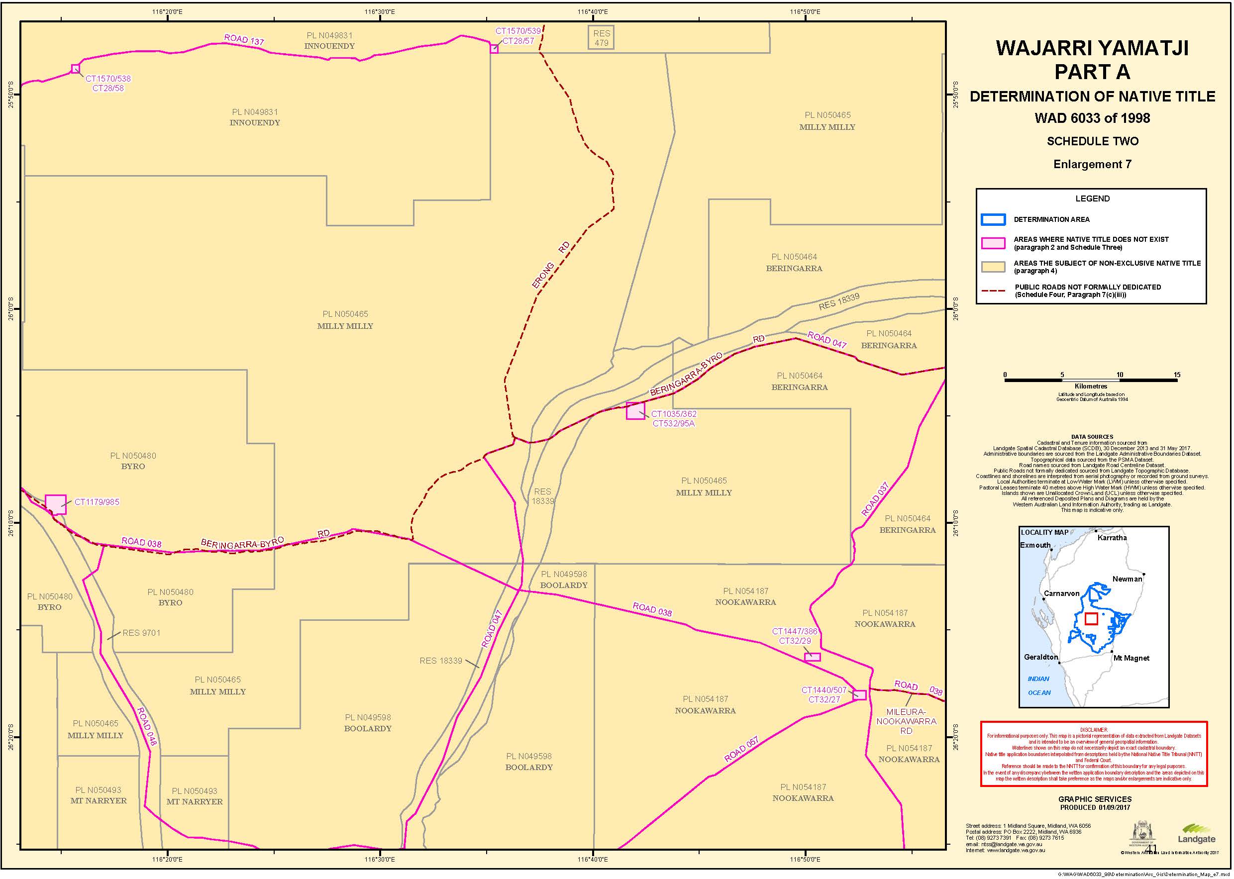
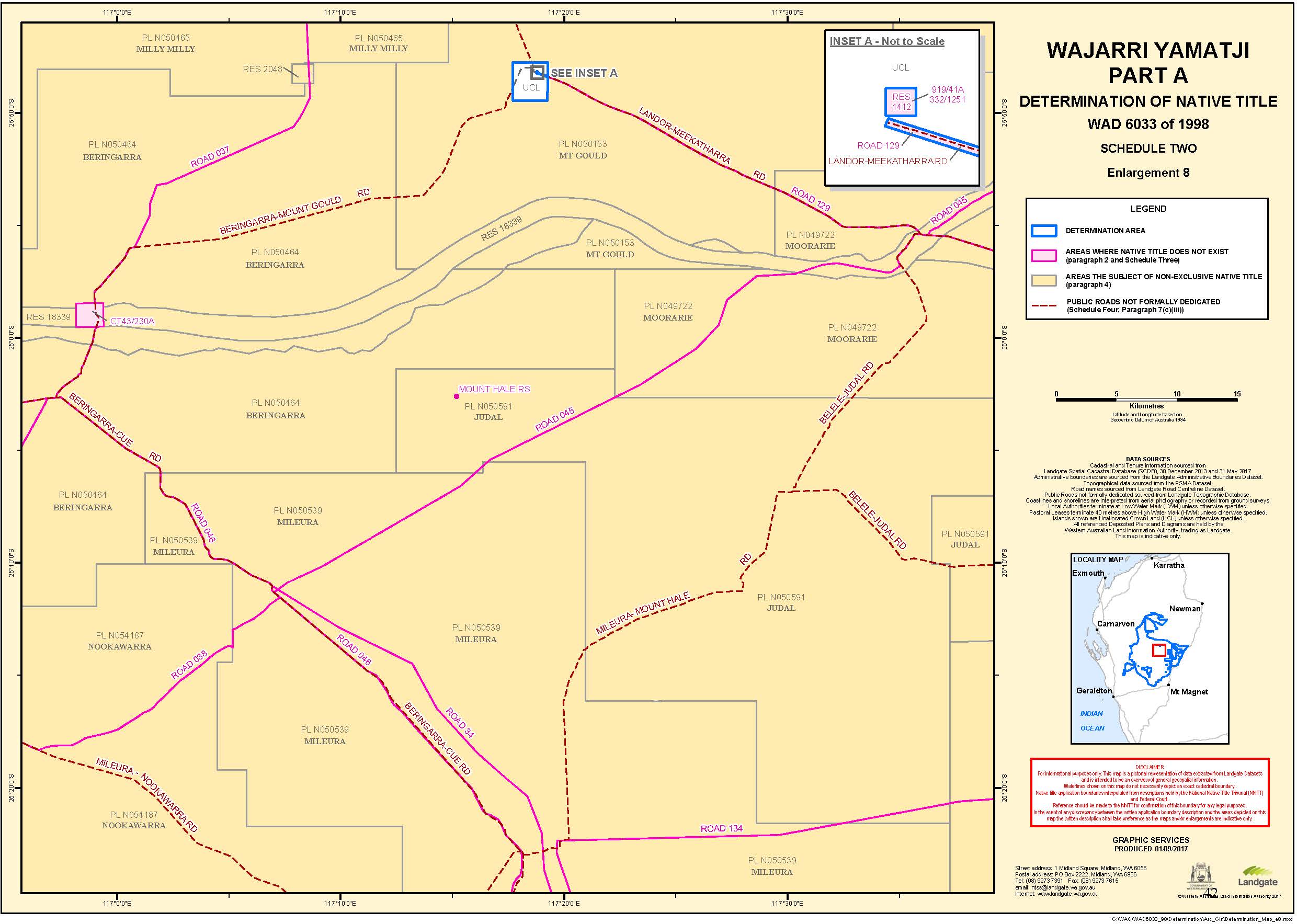
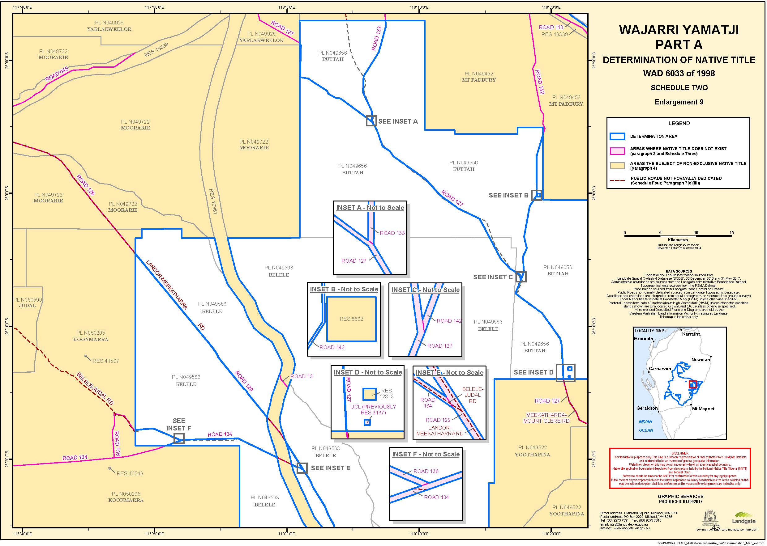
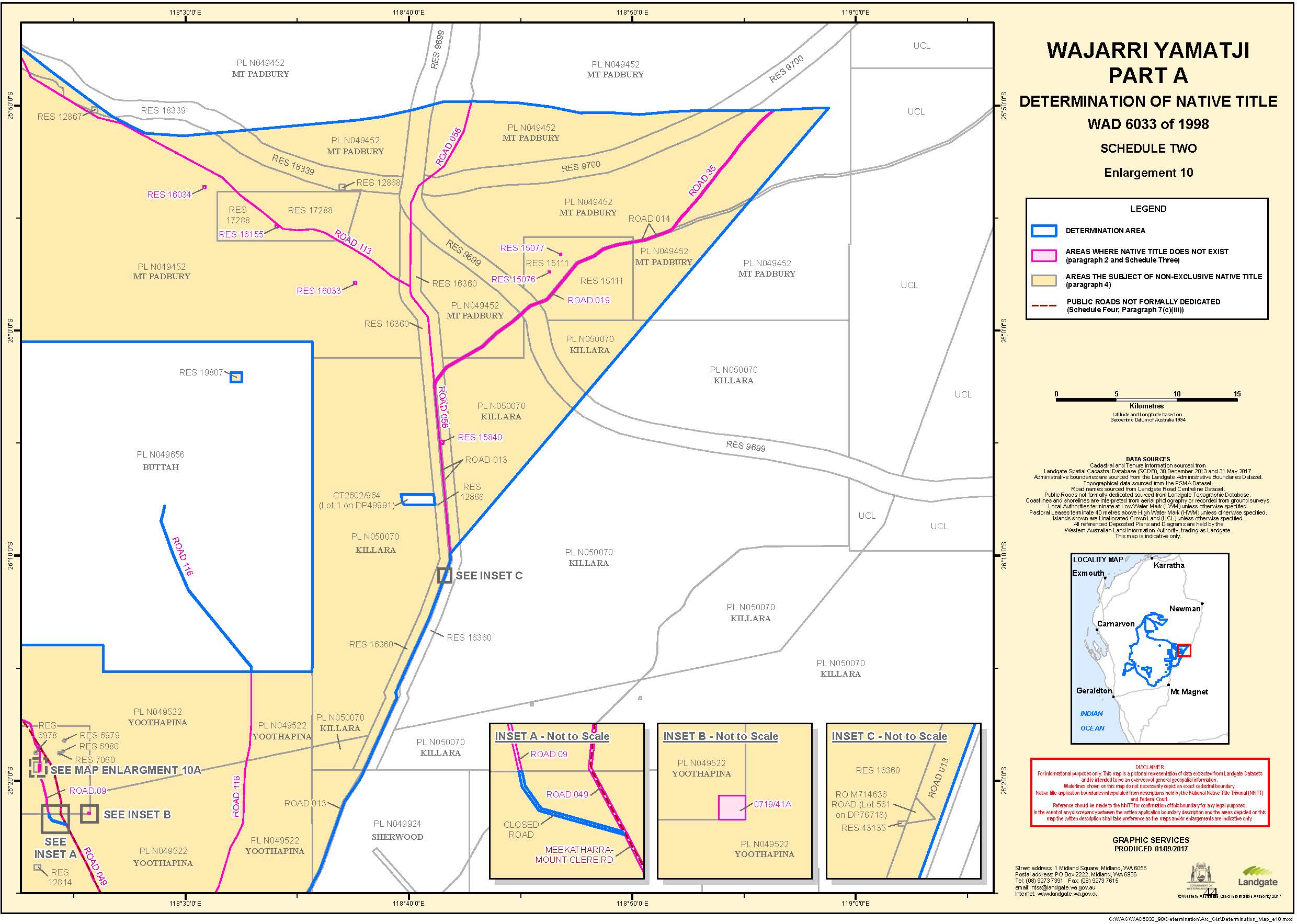
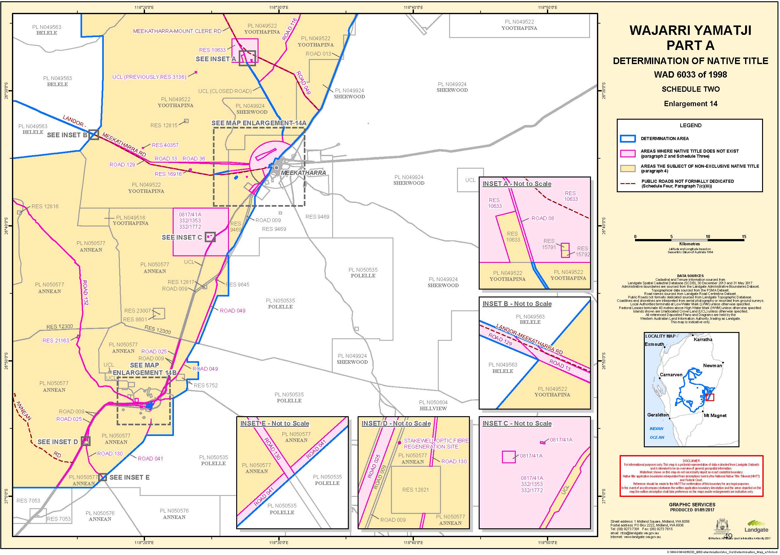
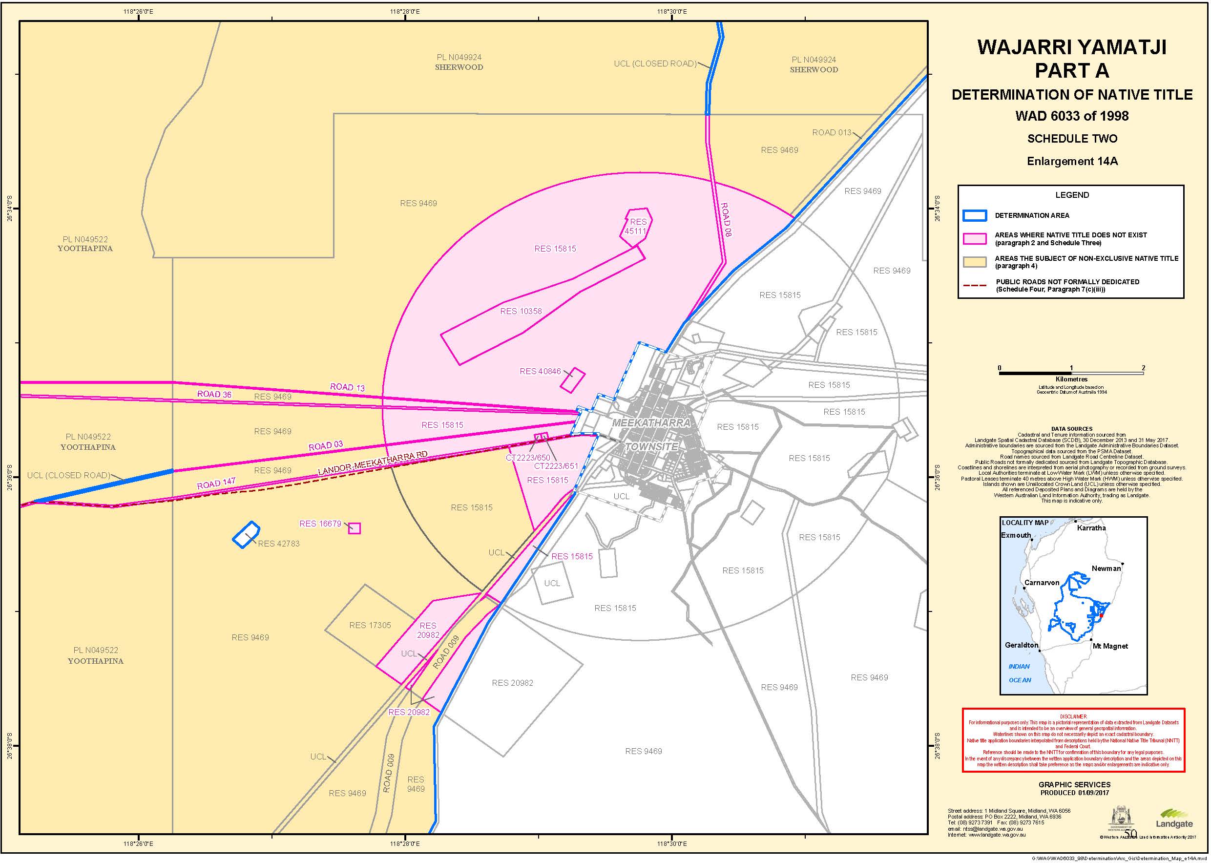
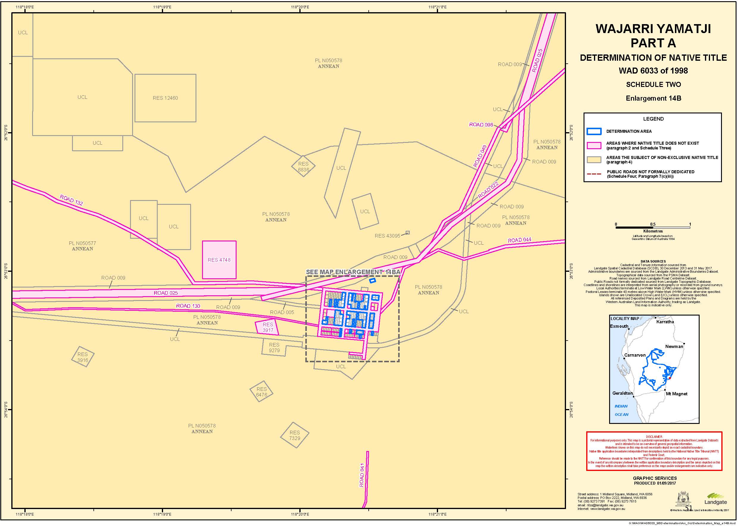
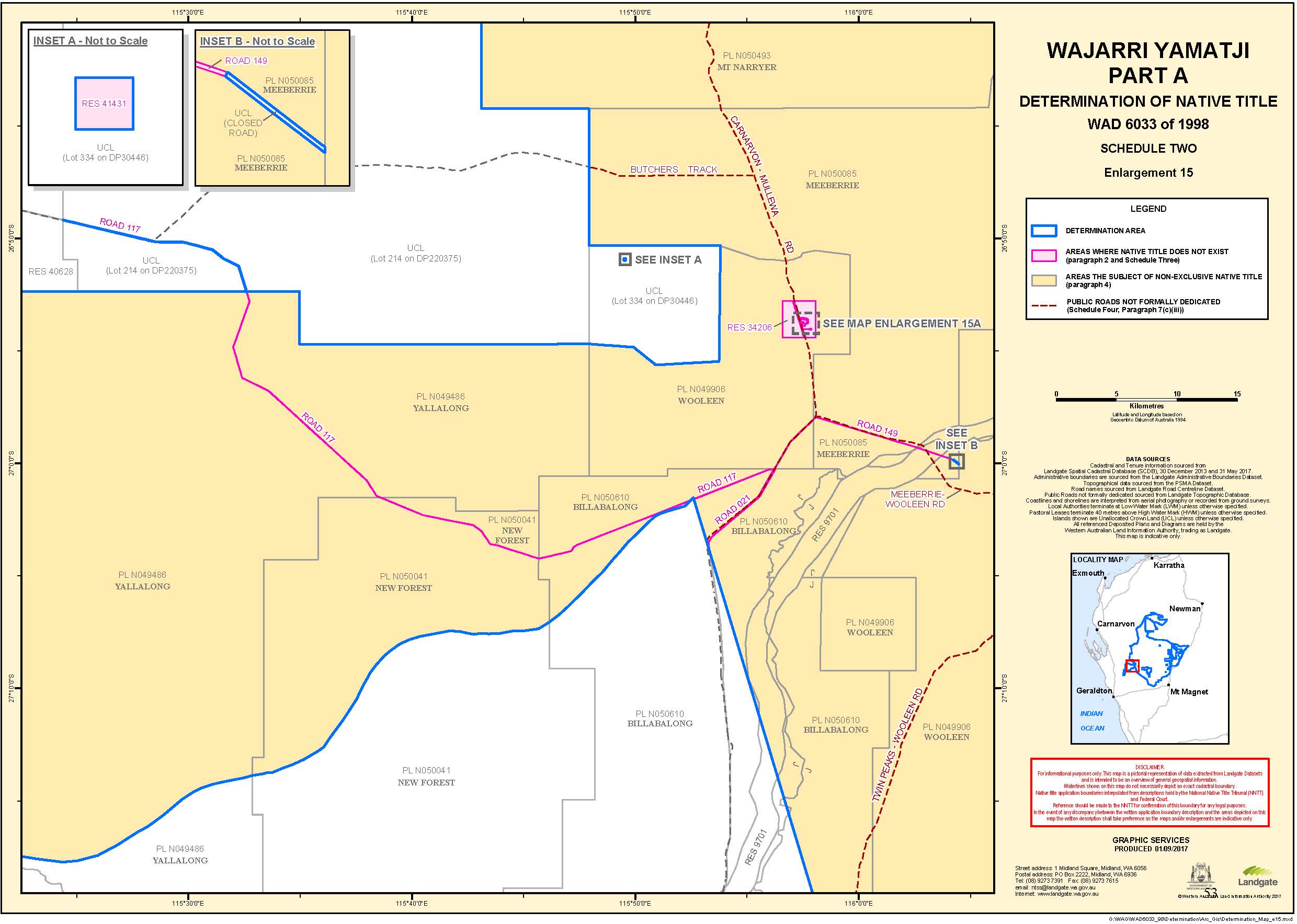
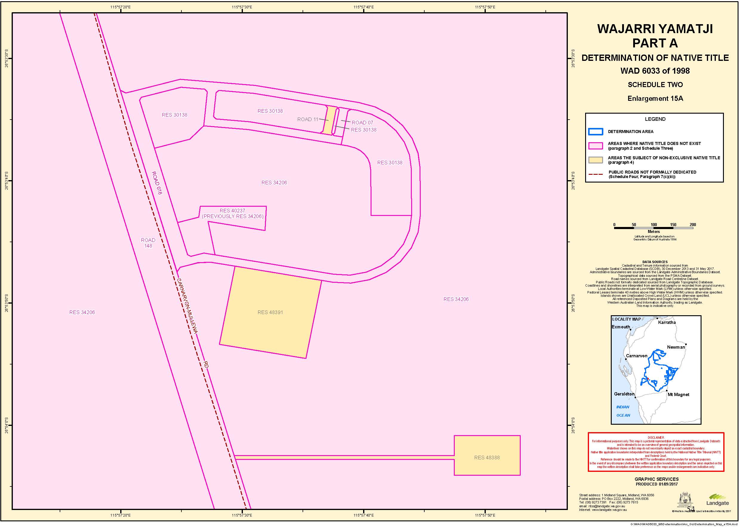
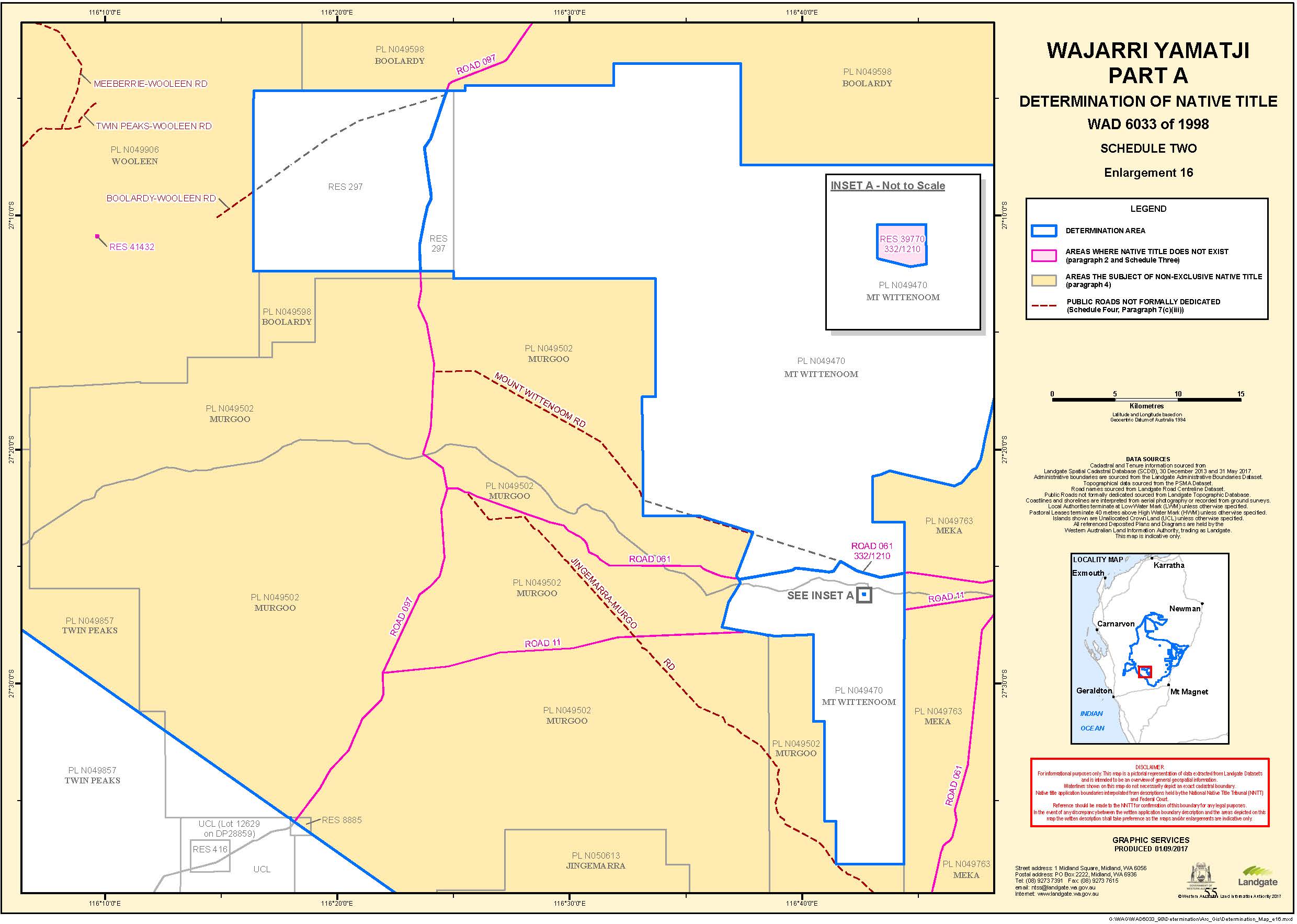
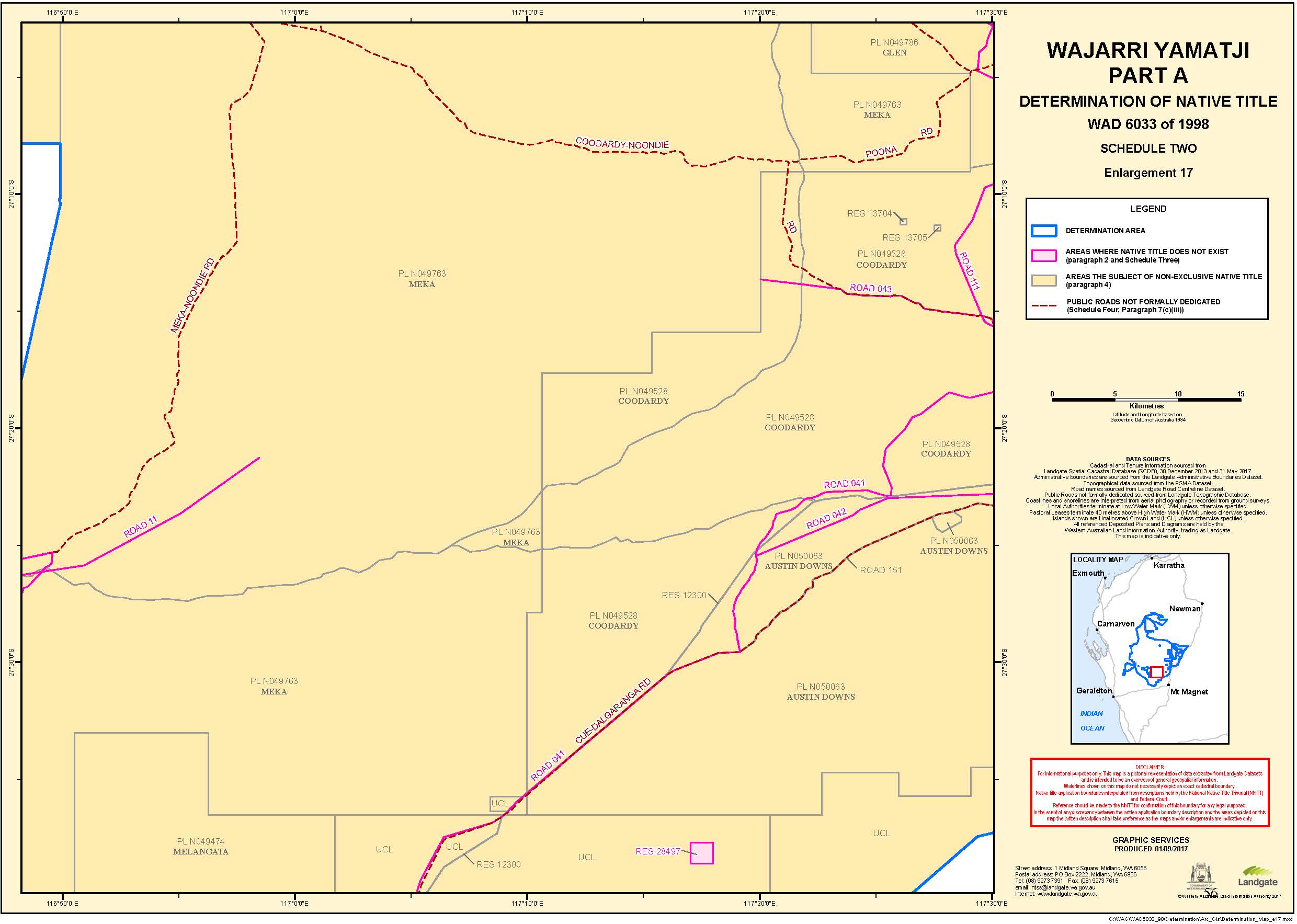
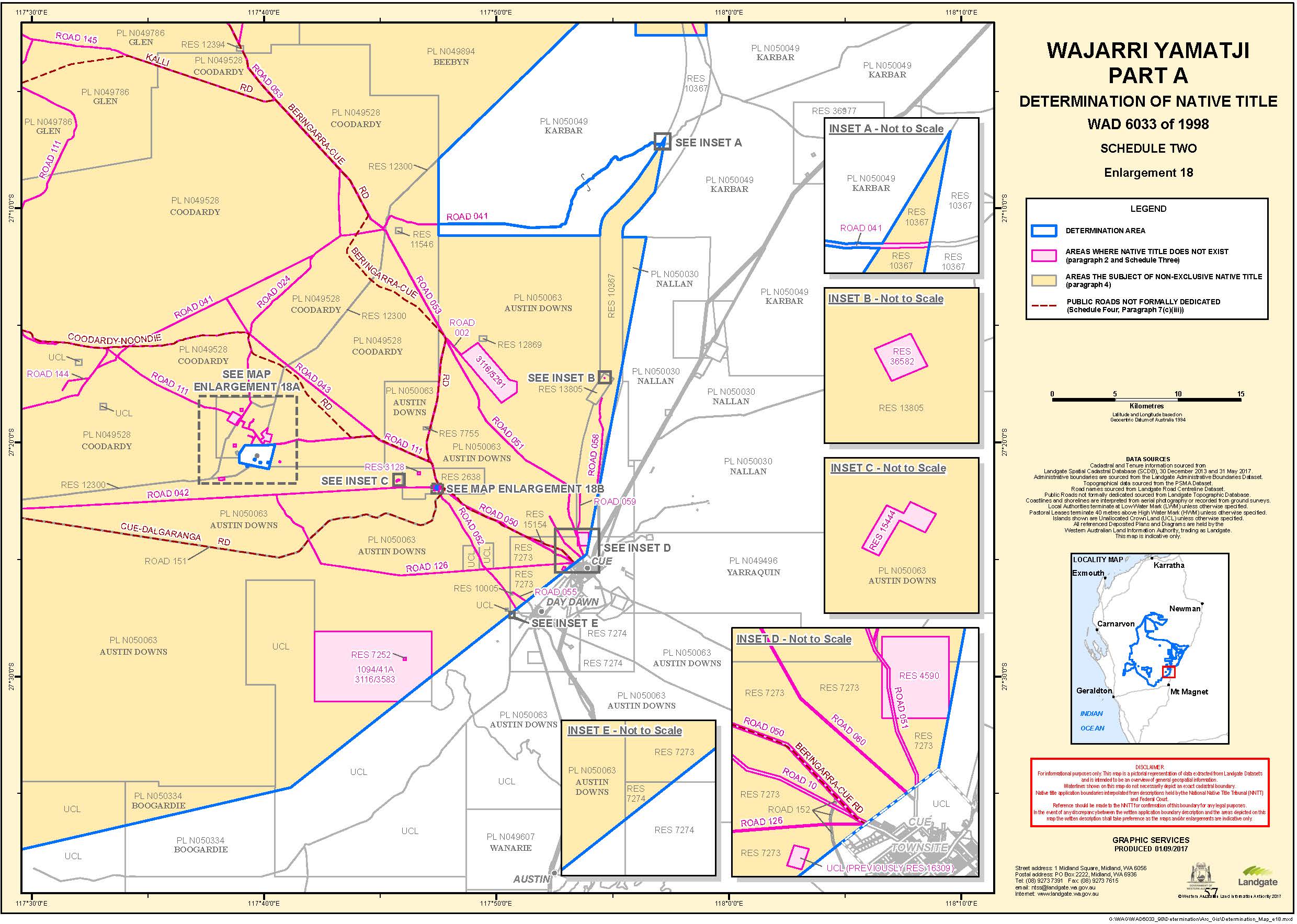
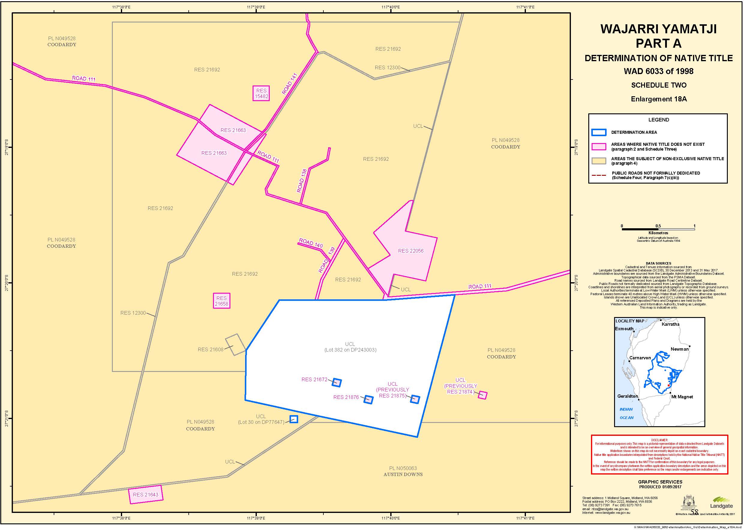
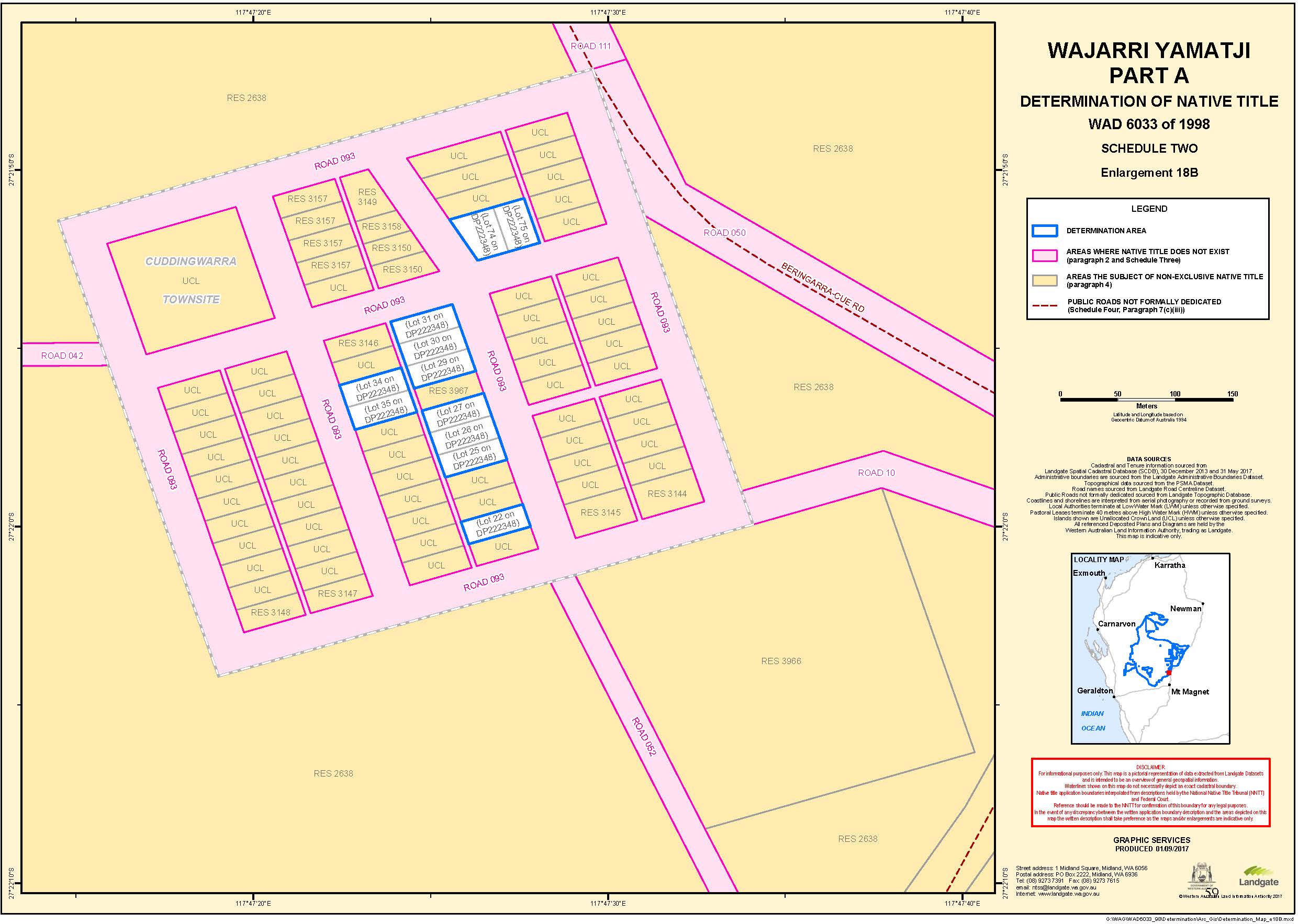
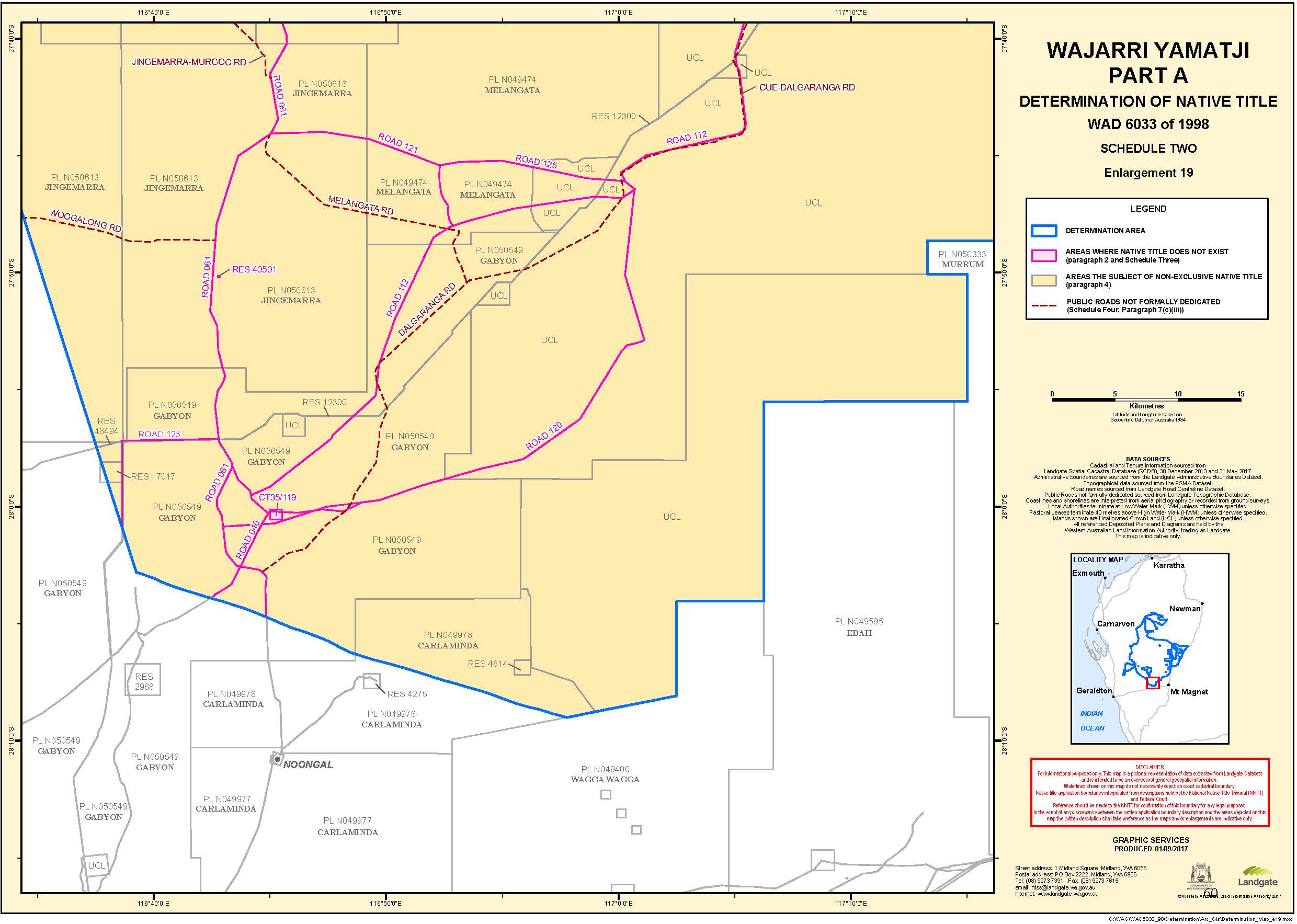
SCHEDULE TWO
MAPS OF THE PART A DETERMINATION AREA
SCHEDULE THREE
AREAS WHERE NATIVE TITLE DOES NOT EXIST (PARAGRAPH 2)
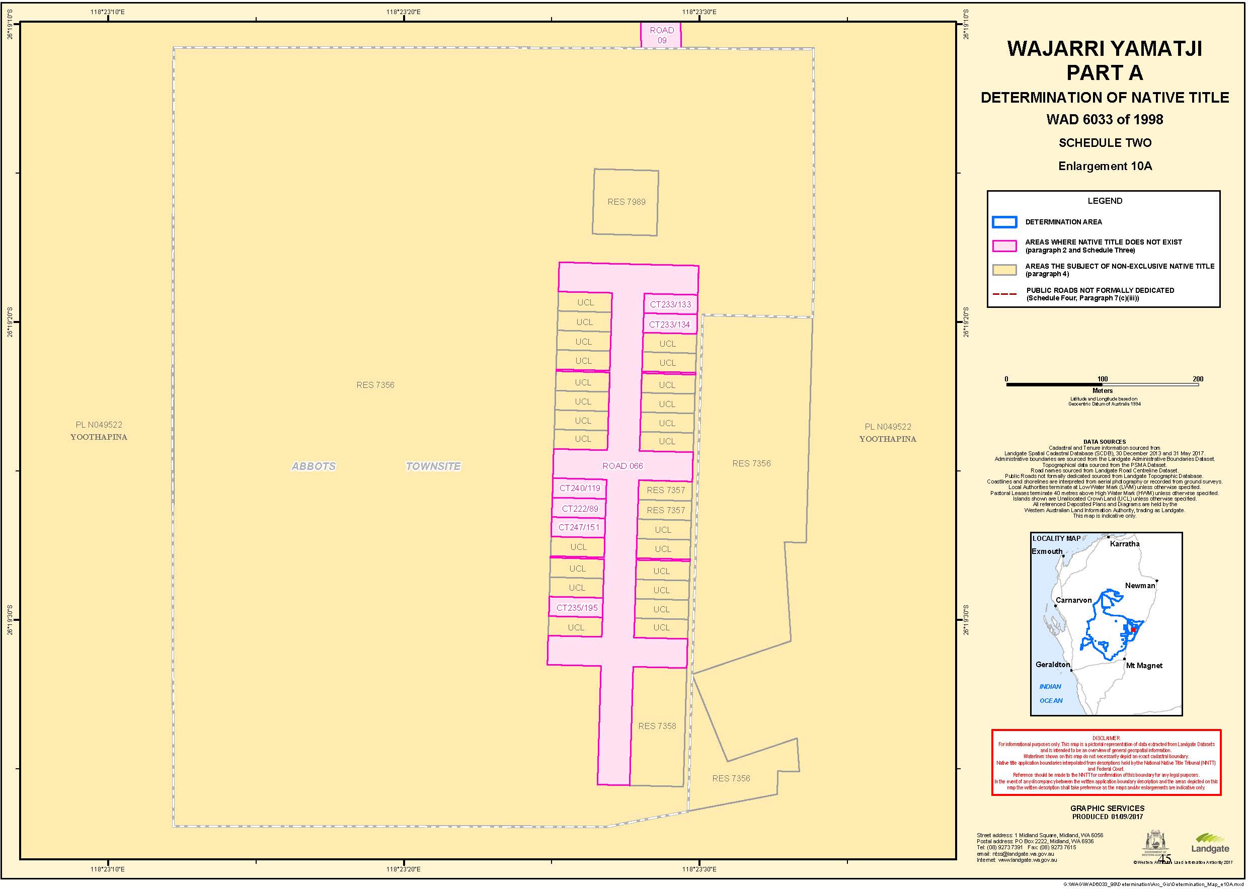
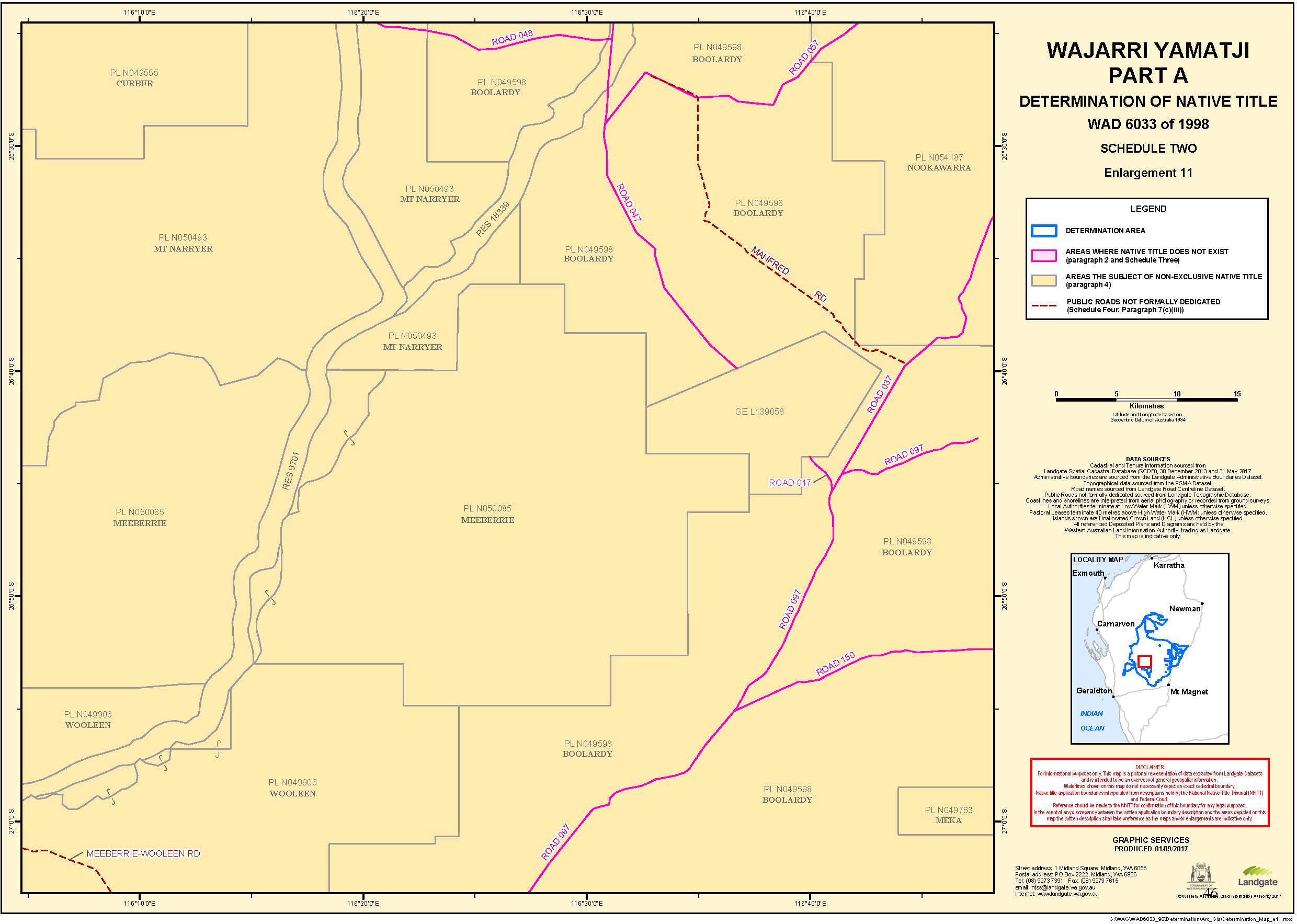
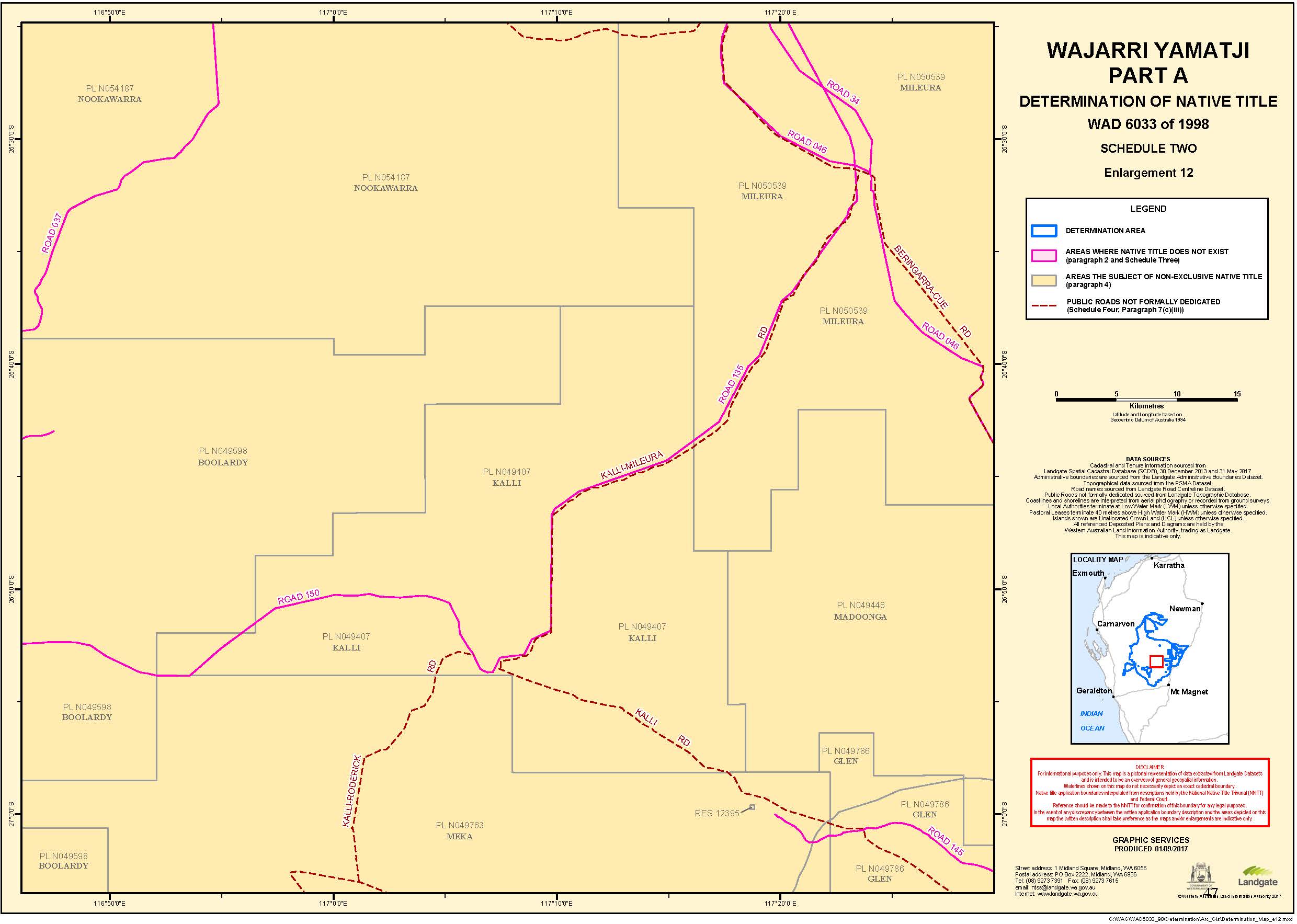
Native title does not exist in relation to land and waters the subject of the following interests within (or partly within) the Part A Determination Area which, with the exception of the public works described in clause 6 of this Schedule, are generally shown as shaded in pink on the maps at Schedule Two:
Historical
CT 28/57 | CT 32/27 |
CT 28/58 | CT 32/29 |
CT 95/97 | CT 1035/362 |
CT 95/135 | CT 1166/557 |
CT 109/40 |
Current
CT 35/119 | CT 266/84 |
CT 43/230A | CT 532/95A |
CT 63/24 | CT 1179/984 |
CT 109/40 | CT 1179/985 |
CT 109/179 | CT 1231/231 |
CT 169/127 | CT 1396/273 |
CT 222/89 | CT 1440/507 |
CT 233/133 | CT 1447/386 |
CT 233/134 | CT 1570/538 |
CT 235/195 | CT 1570/539 |
CT 240/119 | CT 2223/650 |
CT 247/151 | CT 2223/651 |
2. Reserves
Historical
Reserve No | Purpose |
Reserve 3128 | Water |
Reserve 15482 | Water |
Reserve 15815 | Protection of the Indigenous Flora |
Reserve 15840 | Water |
Reserve 21658 | Camping |
Reserve 21663 | Explosives Magazine and Safety Zone |
Reserve 21672 | Water (No 9 Bore) |
Current
Reserve No | Purpose |
Reserve 1412 | Historical Purposes |
Reserve 3136 | Water (Red Well) |
Reserve 3137 | Water |
Reserve 3216 | Miners' Institute |
Reserve 3917 | Recreation |
Reserve 4590 | Racecourse |
Reserve 6819 | Pound Site |
Reserve 4748 | Explosives Magazine |
Reserve 10358 | Rifle Range Rifle Club |
Reserve 10633 (part)1 | Water |
Reserve 15076 | Water |
Reserve 15077 | Water |
Reserve 15444 | Water |
Reserve 16033 | Water |
Reserve 16034 | Water |
Reserve 16155 | Water |
Reserve 16309 | Water |
Reserve 16679 | Water |
Reserve 16916 | Water |
Reserve 20982 | Water Supply |
Reserve 21163 | Water |
Reserve 21643 | Sanitary Site |
Reserve 21874 | Water (Bore No 11) |
Reserve 21875 | Water (Bore No 10) |
Reserve 21876 | Water (Bore No 12) |
Reserve 22056 | Aerial Landing Ground |
Reserve 28497 | Protection of Geological Monument |
Reserve 30138 | Municipal Buildings |
Reserve 34206 | Recreation and Aerial Landing Ground |
Reserve 36582 | Historical Graves |
Reserve 39770 | Repeater Station Site |
Reserve 40237 | Roadhouse and Caravan Park |
Reserve 40357 | Repeater Station Site |
Reserve 40501 | Repeater Station Site |
Reserve 40846 | Effluent Disposal Site |
Reserve 41323 | Repeater Station Site |
Reserve 41431 | Repeater Station Site |
Reserve 41432 | Repeater Station Site |
3. Leases
Historical Leases
719/41A | 332/1069 |
817/41A | 332/1210 |
919/41A | 332/1251 |
1094/41A | 332/1353 |
318/42 | 332/1772 |
Special Leases
3116/03583 |
3116/52912 |
3116/103713 |
4. Dedicated roads and roads set aside, taken or resumed
Historical
Tenure ID | Road |
ROAD 03 | Public Road No 8427 |
ROAD 07 | Lot 310 on DP46745 |
ROAD 08 | Road No 703 (Meekatharra-Mt Clere Road) |
ROAD 09 | Road No 703 (Meekatharra-Mt Clere Road) |
ROAD 10 | Road No 734 as shown on DP 227849 |
ROAD 11 | Road No 401 as shown on PP 503998 |
ROAD 13 | Road No 6252 as shown on PPs 502338 and 503030 |
ROAD 34 | Road No 672 as shown on PP 503028 |
ROAD 35 | Road No 5463 as shown on PPs 59, 60, 71/300 |
ROAD 36 | Road No 6252 as shown on PPs Meekatharra Townsite and 501/80 |
Current
Tenure ID | Road |
ROAD 002 | Road No 860 |
ROAD 006 | Byro-Woodleigh Rd |
ROAD 018 | Mulga Crescent and Kurara Way (Murchison Settlement) (DP 216410) |
ROAD 019 | Road 5463 (Great Northern Highway) as shown on DP 211015 |
ROAD 021 | Road No 13660 as shown on DP 210929 |
ROAD 022 | Road No 13915 as shown on 466/80 (CPP 502337) and DP 210612 |
ROAD 024 | Road No 14452 as shown on Cue 1: 250 000 and 221/80 (CPP 501750) |
ROAD 025 | Road No 14576 as shown on Belele 1:250 000 |
ROAD 026 | Road No 15664 as shown on Glenburgh 1:250 000 |
ROAD 027 | Road No 16666 as shown on Mt Phillips 1:250 000 and Mt Egerton 1:250 000 |
ROAD 028 | Road No 18496 as shown on DP 216602 |
ROAD 029 | Road No 18558 as shown on DP 216601 |
ROAD 035 | Road 348 as shown on 78/300 (CPP 503096) |
ROAD 036 | Road 345 as shown on 73/300 (CPP 506800) |
ROAD 037 | Road 346 as shown on 58/300 (CPP 503027) |
ROAD 038 | Road 347 as shown on 59/300 (CPP 503036) |
ROAD 041 | Road No 457 as shown on 54/300 (CPP 502996) |
ROAD 040 | Road No 400 as shown on CPP 506706 |
ROAD 042 | Road No 458 as shown on 54/300 (CPP 502997) |
ROAD 043 | Road No 459 as shown on 54/300 (CPP 502997) |
ROAD 044 | Road No 665 as shown on Plan of Road Survey Murchison Kariyarra |
ROAD 045 | Road No 671 as shown on 3M (CPP 505449) |
ROAD 046 | Road No 672 as shown on 58/300 (CPP 503025) and 59/300 (CPP 503028) |
ROAD 047 | Road No 673 as shown on 2M (CPP 505445) & 3M (CPP 505449) |
ROAD 048 | Road No 674 as shown on 2M (CPP 505445) |
ROAD 049 | Road No 703 as shown on DP 214762 & DP 214763 |
ROAD 050 | Road No 734 as shown on DP 205514 |
ROAD 051 | Road No 848 as shown on 200/80 (CPP 501747) and 221/80 (CPP 501750) |
ROAD 052 | Road No 849 as shown on 200/80 (CPP 501747) and 221/80 (CPP 501750) |
ROAD 053 | Road No 860 as shown on 54/300 (CPP 502997) and 221/80 (CPP 501750) |
ROAD 055 | Road No 2537 as shown on 200/80 (CPP 501746) and Cue SE 1:25 000 |
ROAD 056 | Road No 1963 as shown on 59/300 (CPP 503036) and 72/300 (CPP 506510) |
ROAD 057 | Road No 4027 as shown on 58/300 (CPP 503027) |
ROAD 058 | Road No 4143 as shown on 221/80 (CPP 501750) and 200/80 (CPP 501748) |
ROAD 059 | Road No 4144 as shown on Cue 1:100 000 |
ROAD 060 | Road No 4145 as shown on 200/80 (CPP 501748) |
ROAD 061 | Road No 5083 as shown on 55/300 (CPP 503007) and 163/80 (CPP 501697) |
ROAD 066 | Roads in Abbotts Townsite |
ROAD 067 | Roads in Nannine Townsite |
ROAD 093 | Roads in Cuddingwarra Townsite |
ROAD 097 | Road 398 as shown on 162/80 (CPP 501694), 55/300 (CPP 503007), 58/300 (CPP 503027) and Byro 1:100 000 |
ROAD 098 | Road 703 as shown on CPP 502335 |
ROAD 099 | Road 3608 as shown on CPP 503096 |
ROAD 100 | Road 3611 as shown on CPP 503096 |
ROAD 101 | Road 3612 as shown on CPP 503096 |
ROAD 102 | Road 3615 as shown on CPPs 503094 and 503070 |
ROAD 103 | Road 3616 as shown on CPPs 503096 and 506516 |
ROAD 106 | Road No 3621 as shown on 73/300 (CPP 503069) |
ROAD 107 | Road 3623 as shown on CPP 506800 |
ROAD 109 | Road 3627 as shown on CPP 503096 |
ROAD 111 | Road No 3679 as shown on 54/300 (CPP 502997) and 221/80 (CPP 501750) |
ROAD 112 | Road 5383 as shown on CPP 503007 and CPP 502997 |
ROAD 113 | Road 5464 as shown on 72/300 (CPP 506510) and 59/300 (CPP 503036) |
ROAD 116 | Road 7024 as shown on 501/80 (CPP 502340) and 59/300 (CPP 503036) |
ROAD 117 | Road 7095 as shown on 55/300 (CPP 503007) and 58/300 (CPP 503027) |
ROAD 120 | Road 7171 as shown on 54/300 (CPP502997) and 55/300 (CPP 503007) |
ROAD 121 | Road 7172 as shown on 55/300 (CPP 503007) |
ROAD 123 | Road 7175 as shown on 55/300 (CPP 503007) and 163/80 (CPP 501696) |
ROAD 125 | Road 8087 as shown on 54/300 (CPP 502997) and 55/300 (CPP 503007) |
ROAD 126 | Road 8099 as shown on 200/80 (CPP 501746) |
ROAD 127 | Road 8170 as shown on 72/300 (CPP 506510), 59/300 (CPP 503036) and 501/80 (CPP 502340) |
ROAD 129 | Road 8427 as shown on 59/300 (CPP 503036) and 501/80 (CPP 502340) |
ROAD 130 | Road 8579 as shown on 466/80 (CPP 600275) and Meekatharra 1:100 000 |
ROAD 132 | Road 9090 as shown on 59/300 (CPP 503034), Nannine 466/80 (CPP 502337) and Nannine Public Plan (CPP 504831) |
ROAD 133 | Road 9091 as shown on 72/300 (CPP 506507) |
ROAD 134 | Road 9099 as shown on 59/300 (CPP 503036) |
ROAD 135 | Road 9137 as shown on 59/300 (CPP 503036) |
ROAD 136 | Road 9142 as shown on 59/300 (CPP 503036) |
ROAD 137 | Road 9197 as shown on 73/300 (CPP 506800) and 58/300 (CPP 503027) |
ROAD 138 | Road 10281 as shown on 221/80 (CPP 501750) |
ROAD 139 | Road 10282 as shown on 221/80 (CPP 501750) |
ROAD 140 | Road 10283 as shown on 221/80 (CPP 501750) |
ROAD 141 | Road 10284 as shown on 221/80 (CPP 501750) |
ROAD 142 | Road 10687 as shown on 72/300 (CPP 506510) and 59/300 (CPP 506036) |
ROAD 143 | Road 10835 as shown on 221/80 (CPP 501749A) and 59/300 (CPP 506036) |
ROAD 144 | Road 11209 as shown on 54/300 (CPP 502997) |
ROAD 145 | Road 11526 as shown on 221/80 (CPP 501750), 54/300 (CPP 502997) and 59/300 (CPP 503036) |
ROAD 146 | Road 11527 as shown on 221/80 (CPP 501750) and 59/300 (CPP 503036) |
ROAD 147 | Road 15981 as shown on PPs Meekatharra Regional 1:25 000 and Meekatharra 1:100 000 |
ROAD 148 | Carnarvon-Mullewa as shown on 58/300 (CPP 503026) and Byro 1: 250 000 |
ROAD 149 | Meeberri to Wooleen Road as shown on Byro 1: 250 000 |
ROAD 150 | Boolardy to Kalli Road as shown on Byro 1: 250 000 and Belele 1: 250 000 |
CLRD 1 | Road No 8427 |
5. Telstra Corporation Limited's Interests
Name | Asset Type | Location details |
Mt Hale RS | Repeater Station | Latitude -26.0433; Longitude 117.2533 on Lot 36 on Plan 238366 |
Stakewell Optic Fibre Regeneration Site | Optic Fibre Regeneration Site | Latitude -26.929773; Longitude 118.259958 |
Weld Range MRS | Microwave Repeater Station | Latitude -26.9483; Longitude 117.6183 on Lot 6 on Plan 187846 |
6. Other Public Works
Any other public works as that expression is defined in the Native Title Act and the Titles (Validation) and Native Title (Effect of Past Acts) Act 1995 (WA) (WA Titles Act) (including the land and waters on which a public work is constructed, established or situated as described in s 251D of the Native Title Act) and to which s 12J of the WA Titles Act or ss 23C(2) of the Native Title Act applies.
SCHEDULE FOUR
OTHER INTERESTS (PARAGRAPH 7)
The nature and extent of the Other Interests in relation to the Part A Determination Area as at the date of this determination are:
1. Reserves
(a) The following reserves:
Reserve No | Purpose |
Reserve 479 | Water & Stopping Place for Travellers & Stock |
Reserve 480 | Watering & Stopping Place for Travellers & Stock |
Reserve 1807 | Resting Place for Travellers & Stock |
Reserve 2048 | Stopping Place for Travellers & Stock |
Reserve 2252 | Public Utility |
Reserve 2253 | Trades Hall |
Reserve 2254 | Public Utility |
Reserve 2258 | Public Utility |
Reserve 2259 | Public Utility |
Reserve 2613 | Church Site Methodist |
Reserve 2638 | Parkland |
Reserve 3144 | Public Utility |
Reserve 3145 | Public Utility |
Reserve 3146 | Public Utility |
Reserve 3147 | Public Utility |
Reserve 3148 | Public Utility |
Reserve 3149 | Public Utility |
Reserve 3150 | Post & Telegraph Office |
Reserve 3157 | Public Utility |
Reserve 3158 | Public Utility |
Reserve 3916 | Cemetery |
Reserve 3966 | Recreation |
Reserve 3967 | Miners Institute |
Reserve 4614 | Water |
Reserve 5752 | Racecourse |
Reserve 6476 | Rubbish Disposal Site |
Reserve 6836 | Water |
Reserve 6978 | Recreation |
Reserve 6979 | Sanitary Depot |
Reserve 6980 | Cemetery |
Reserve 7060 | Rubbish Depot |
Reserve 7273 | Common |
Reserve 7274 | Common |
Reserve 7329 | Sanitary Depot |
Reserve 7356 | Common |
Reserve 7357 | Post Office |
Reserve 7358 | Public Buildings |
Reserve 7755 | Water Act 57 Vic No 20 |
Reserve 7989 | Water Act 57 Vic No 20 |
Reserve 8601 | Preservation of Buildings |
Reserve 8632 | Water Act 57 Vic No 20 |
Reserve 8885 | Water Act 57 Vic No 20 |
Reserve 9279 | Railway Purpose |
Reserve 9469 | Common |
Reserve 9645 | Water |
Reserve 9698 | Fortescue Cue Stock Route |
Reserve 9699 | Peak Hill Stock Route |
Reserve 9700 | De Grey Peak Hill Stock Route |
Reserve 9701 | De Grey Mullewa Stock Route |
Reserve 10005 | Rubbish Depot |
Reserve 10367 | Wandry Springs Cue Stock Route |
Reserve 10549 | Water Act 57 Vic No 20 |
Reserve 10633 (part)4 | Recreation |
Reserve 10951 | Water |
Reserve 11546 | Water Act 57 Vic No 20 |
Reserve 12300 | Vermin Proof Fence |
Reserve 12394 | Water Act 57 Vic No 20 |
Reserve 12395 | Water Act 57 Vic No 20 |
Reserve 12460 | Recreation |
Reserve 12813 | Water |
Reserve 12814 | Water |
Reserve 12815 | Water |
Reserve 12816 | Water |
Reserve 12817 | Water |
Reserve 12818 | Water |
Reserve 12821 | Water |
Reserve 12867 | Water |
Reserve 12868 | Water |
Reserve 12869 | Water |
Reserve 13704 | Water Act 57 Vic No 20 |
Reserve 13705 | Water Act 57 Vic No 20 |
Reserve 13805 | Recreation & Timber |
Reserve 15111 | Common |
Reserve 15154 | Water |
Reserve 15791 | Sanitary |
Reserve 15792 | Rubbish Disposal Site |
Reserve 16360 | Stock Route |
Reserve 17017 | Depot Site |
Reserve 17288 | Common |
Reserve 17305 | Camping |
Reserve 18339 | Stock Route |
Reserve 19807 | Water |
Reserve 21608 | Cemetery |
Reserve 21692 | Common |
Reserve 23007 | Memorial Site |
Reserve 41051 | National Park |
Reserve 41537 | Repeater Station Site |
Reserve 43095 | Regenerator Site |
Reserve 43135 | Regenerator Site |
Reserve 48388 | Cemetery |
Reserve 48391 | Power Station and Water Supply |
Reserve 48494 | Rabbit Proof Fence No 3 |
(b) The rights and interests of persons who have the care, control and management of the reserves identified in subparagraph (a) above;
(c) The rights and interests of persons entitled to access and use the reserves identified in subclause (a) above for the respective purposes for which they are reserved, subject to any statutory limitations upon those rights; and
(a) The following pastoral leases and the rights and interests of the holders from time to time of those pastoral leases:
Station Name | Pastoral Lease No |
Annean | PL N050577 |
PL N050578 | |
Austin Downs | PL N050063 |
Ballythunna | PL N050597 |
Beebyn | PL N049894 |
Beringarra | PL N050464 |
Bidgemia | PL N050619 |
Billabalong | PL N050610 |
Boogardie | PL N050334 |
Boolardy | PL N049598 |
Byro | PL N050480 |
Carey Downs | PL N049939 |
PL N049940 | |
Carlaminda | PL N049978 |
Coodardy | PL N049528 |
Curbur | PL N049555 |
Dairy Creek | PL N049962 |
Dalgety Downs | PL N049561 |
PL N049565 | |
Dooley Downs | PL N050044 |
Errabiddy | PL N050202 |
Gabyon | PL N050549 |
Glen | PL N049786 |
Glenburgh | PL N050258 |
Innouendy | PL N049831 |
Jingemarra | PL N050613 |
Judal | PL N050590 |
PL N050591 | |
Kalli | PL N049407 |
Killara | PL N050070 |
Koonmarra | PL N050205 |
Landor | PL N050628 |
PL N050627 | |
Madoonga | PL N049446 |
Meeberrie | PL N050085 |
Meka | PL N049763 |
Melangata | PL N049474 |
Mileura | PL N050539 |
Milly Milly | PL N050465 |
Mooloo Downs | PL N050254 |
Moorarie | PL N049722 |
Murgoo | PL N049502 |
Mt Augustus | PL N050129 |
Mt Clere | PL N050144 |
Mt Gould | PL N050153 |
Mt Farmer | PL N049434 |
Mt Narryer | PL N050493 |
Mt Padbury | PL N049452 |
Mt Phillip | PL N050303 |
Nallan | PL N050030 |
New Forest | PL N050041 |
Nookawarra | PL N054187 |
Pingandy | PL N050510 |
Sherwood | PL N049924 |
Twin Peaks | PL N049857 |
Wanna | PL N049430 |
Wooleen | PL N049906 |
Yallalong | PL N049486 |
Yarlaweelor | PL N049926 |
Yinnetharra | PL N050304 |
Yoothapina | PL N049522 |
PL N049516 |
(b) Any rights and obligations of the pastoralists pursuant to the pastoral leases referred to in subclause (a) above to adopt and exercise best practice management of the pasture and vegetation resources, livestock and soils within the boundaries of the pastoral leases in order to manage stock and for the management, conservation and regeneration of pasture for permitted uses.
3. Leases
(a) General Lease L139058 over Lot 502 on Deposited Plan 55945 dated and registered on 13 November 2009, being a lease granted to Commonwealth Scientific and Industrial Research Organisation (ABN 41 687 119 230) pursuant to the Murchison Radio-astronomy Observatory Agreement (entered on the Register of Indigenous Land Use Agreements on 13 November 2009), including the rights and interests of the holders of that lease from time to time.
(b) Road Lease M 714636 over Lot 561 on Deposited Plan 76718 dated 21 July 2014 and registered on 23 July 2014.
4. Roads
(a) The following roads:
Tenure ID | Road |
ROAD 009 | Great Northern Highway Road Widening |
ROAD 011 | Murchison Settlement |
ROAD 013 | Public Road No 2854 |
ROAD 014 | Public Road 5463 |
ROAD 151 | Cue-Dalgaranga Rd |
ROAD 152 | Miners Pass Rd |
(b) The rights and interests of persons who have the care, control and management of the roads identified in subclause (a) above; and
(c) The rights and interests of persons entitled to access and use the roads identified in subclause (a) above subject to any statutory limitations upon those rights.
5. Mining Tenements and Petroleum Interests
(a) The following mining tenements under the Mining Act 1904 (WA) (repealed) and the Mining Act 1978 (WA) and the rights and interests of the holders from time to time of those mining tenements:
(i) Mining Leases
M 9/28 |
M 9/58 |
M 9/148 |
M 20/16 |
M 20/17 |
M 20/21 |
M 20/22 |
M 20/31 |
M 20/46 |
M 20/50 |
M 20/78 |
M 20/91 |
M 20/98 |
M 20/99 |
M 20/102 |
M 20/103 |
M 20/104 |
M 20/105 |
M 20/118 |
M 20/128 |
M 20/129 |
M 20/160 |
M 20/171 |
M 20/192 |
M 20/197 |
M 20/202 |
M 20/218 |
M 20/246 |
M 20/252 |
M 20/256 |
M 20/275 |
M 20/286 |
M 20/288 |
M 20/292 |
M 20/293 |
M 20/297 |
M 20/299 |
M 20/301 |
M 20/305 |
M 20/307 |
M 20/311 |
M 20/327 |
M 20/332 |
M 20/333 |
M 20/354 |
M 20/360 |
M 20/392 |
M 20/402 |
M 20/403 |
M 20/418 |
M 20/419 |
M 20/435 |
M 20/456 |
M 20/494 |
M 20/503 |
M 20/506 |
M 20/513 |
M 20/518 |
M 20/520 |
M 21/7 |
M 21/74 |
M 21/86 |
M 21/94 |
M 21/95 |
M 21/102 |
M 21/125 |
M 21/143 |
M 51/6 |
M 51/12 |
M 51/27 |
M 51/28 |
M 51/31 |
M 51/33 |
M 51/35 |
M 51/38 |
M 51/39 |
M 51/40 |
M 51/51 |
M 51/53 |
M 51/62 |
M 51/75 |
M 51/79 |
M 51/91 |
M 51/96 |
M 51/121 |
M 51/122 |
M 51/132 |
M 51/134 |
M 51/161 |
M 51/180 |
M 51/187 |
M 51/190 |
M 51/199 |
M 51/203 |
M 51/209 |
M 51/211 |
M 51/280 |
M 51/281 |
M 51/291 |
M 51/320 |
M 51/321 |
M 51/322 |
M 51/325 |
M 51/334 |
M 51/374 |
M 51/385 |
M 51/386 |
M 51/390 |
M 51/393 |
M 51/409 |
M 51/418 |
M 51/419 |
M 51/433 |
M 51/434 |
M 51/437 |
M 51/438 |
M 51/439 |
M 51/441 |
M 51/442 |
M 51/443 |
M 51/447 |
M 51/451 |
M 51/457 |
M 51/459 |
M 51/463 |
M 51/471 |
M 51/472 |
M 51/477 |
M 51/481 |
M 51/482 |
M 51/483 |
M 51/484 |
M 51/485 |
M 51/486 |
M 51/489 |
M 51/491 |
M 51/492 |
M 51/493 |
M 51/494 |
M 51/495 |
M 51/496 |
M 51/498 |
M 51/500 |
M 51/501 |
M 51/502 |
M 51/503 |
M 51/516 |
M 51/523 |
M 51/524 |
M 51/525 |
M 51/526 |
M 51/528 |
M 51/535 |
M 51/539 |
M 51/555 |
M 51/557 |
M 51/560 |
M 51/561 |
M 51/567 |
M 51/568 |
M 51/569 |
M 51/570 |
M 51/571 |
M 51/572 |
M 51/573 |
M 51/575 |
M 51/576 |
M 51/579 |
M 51/580 |
M 51/581 |
M 51/582 |
M 51/584 |
M 51/586 |
M 51/587 |
M 51/604 |
M 51/613 |
M 51/628 |
M 51/637 |
M 51/638 |
M 51/639 |
M 51/640 |
M 51/644 |
M 51/645 |
M 51/654 |
M 51/666 |
M 51/668 |
M 51/669 |
M 51/670 |
M 51/671 |
M 51/672 |
M 51/674 |
M 51/677 |
M 51/678 |
M 51/679 |
M 51/680 |
M 51/688 |
M 51/718 |
M 51/719 |
M 51/737 |
M 51/738 |
M 51/740 |
M 51/780 |
M 51/782 |
M 51/783 |
M 51/784 |
M 51/793 |
M 51/794 |
M 51/795 |
M 51/805 |
M 51/811 |
M 51/819 |
M 51/820 |
M 51/834 |
M 51/835 |
M 51/847 |
M 51/869 |
M 51/871 |
M 51/872 |
M 51/873 |
M 51/874 |
M 51/875 |
M 51/876 |
M 52/58 |
M 52/106 |
M 52/236 |
M 59/45 |
M 59/138 |
M 59/208 |
(ii) General Purpose Leases
G 20/1 |
G 20/2 |
G 20/3 |
G 20/11 |
G 20/16 |
G 20/17 |
G 20/20 |
G 51/9 |
G 51/28 |
(iii) Exploration Licences
E 8/2712 |
E 9/1323 |
E 9/1325 |
E 9/1507 |
E 9/1552 |
E 9/1618 |
E 9/1637 |
E 9/1639 |
E 9/1640 |
E 9/1641 |
E 9/1676 |
E 9/1764 |
E 9/1781 |
E 9/1865 |
E 9/1866 |
E 9/1938 |
E 9/1985 |
E 9/2025 |
E 9/2062 |
E 9/2079 |
E 9/2096 |
E 9/2099 |
E 9/2100 |
E 9/2101 |
E 9/2103 |
E 9/2104 |
E 9/2121 |
E 9/2128 |
E 9/2131 |
E 9/2133 |
E 9/2138 |
E 9/2139 |
E 9/2140 |
E 9/2143 |
E 9/2147 |
E 9/2148 |
E 9/2149 |
E 9/2150 |
E 9/2158 |
E 9/2159 |
E 9/2160 |
E 9/2161 |
E 9/2164 |
E 9/2168 |
E 9/2169 |
E 9/2170 |
E 9/2171 |
E 9/2177 |
E 9/2178 |
E 9/2179 |
E 9/2180 |
E 9/2183 |
E 9/2187 |
E 9/2190 |
E 9/2191 |
E 9/2192 |
E 9/2193 |
E 9/2197 |
E 9/2198 |
E 9/2202 |
E 9/2205 |
E 9/2206 |
E 9/2207 |
E 9/2208 |
E 20/422 |
E 20/457 |
E 20/458 |
E 20/459 |
E 20/492 |
E 20/546 |
E 20/625 |
E 20/627 |
E 20/633 |
E 20/634 |
E 20/635 |
E 20/641 |
E 20/727 |
E 20/742 |
E 20/753 |
E 20/789 |
E 20/830 |
E 20/840 |
E 20/842 |
E 20/844-I |
E 20/851 |
E 20/854 |
E 20/871 |
E 20/873 |
E 20/876-I |
E 20/877-I |
E 20/885 |
E 20/894 |
E 20/897 |
E 20/900 |
E 20/901 |
E 20/907 |
E 21/195 |
E 21/196 |
E 51/906 |
E 51/907 |
E 51/1033 |
E 51/1053 |
E 51/1120 |
E 51/1209 |
E 51/1217 |
E 51/1290 |
E 51/1295 |
E 51/1301 |
E 51/1303 |
E 51/1354 |
E 51/1391 |
E 51/1496 |
E 51/1512 |
E 51/1567 |
E 51/1590 |
E 51/1604 |
E 51/1609 |
E 51/1616 |
E 51/1617 |
E 51/1625 |
E 51/1641 |
E 51/1647 |
E 51/1648 |
E 51/1653 |
E 51/1661 |
E 51/1671 |
E 51/1672 |
E 51/1673 |
E 51/1677 |
E 51/1681 |
E 51/1688 |
E 51/1697 |
E 51/1699 |
E 51/1702 |
E 51/1703 |
E 51/1705 |
E 51/1706 |
E 51/1708 |
E 51/1709 |
E 51/1715 |
E 51/1721 |
E 51/1729 |
E 51/1730 |
E 51/1737 |
E 51/1738 |
E 51/1740 |
E 51/1759 |
E 51/1781 |
E 51/1790 |
E 51/1791 |
E 52/1552 |
E 52/1553 |
E 52/1554 |
E 52/2509 |
E 52/2840 |
E 52/2880 |
E 52/2881 |
E 52/3001 |
E 52/3045 |
E 52/3048 |
E 52/3064 |
E 52/3250 |
E 52/3273 |
E 52/3330 |
E 52/3339 |
E 52/3392 |
E 52/3393 |
E 52/3403 |
E 52/3452 |
E 59/999 |
E 59/1709 |
E 59/1904 |
E 59/1905 |
E 59/1906 |
E 59/2053 |
E 59/2089 |
E 59/2150 |
E 59/2167 |
E 59/2175 |
E 59/2195 |
(iv) Miscellaneous Licences
L 9/20 |
L 9/28 |
L 9/29 |
L 9/33 |
L 9/34 |
L 9/35 |
L 20/21 |
L 20/38 |
L 20/39 |
L 20/40 |
L 20/41 |
L 20/52 |
L 20/53 |
L 20/54 |
L 20/58 |
L 20/59 |
L 20/67 |
L 20/69 |
L 21/14 |
L 51/18 |
L 51/33 |
L 51/34 |
L 51/43 |
L 51/55 |
L 51/56 |
L 51/71 |
L 51/79 |
L 51/84 |
L 51/85 |
L 51/87 |
L 51/88 |
L 51/89 |
L 51/94 |
L 51/95 |
L 52/68 |
L 52/107 |
L 52/111 |
L 52/139 |
L 52/158 |
L 59/40 |
L 59/141 |
L 59/142 |
L 59/152 |
(v) Prospecting Licences
P 20/1988 |
P 20/1989 |
P 20/2005 |
P 20/2006 |
P 20/2007 |
P 20/2009 |
P 20/2025 |
P 20/2027 |
P 20/2030 |
P 20/2031 |
P 20/2045 |
P 20/2053 |
P 20/2081 |
P 20/2088 |
P 20/2089 |
P 20/2093 |
P 20/2095 |
P 20/2096 |
P 20/2108 |
P 20/2109 |
P 20/2110 |
P 20/2111 |
P 20/2112 |
P 20/2113 |
P 20/2114 |
P 20/2115 |
P 20/2116 |
P 20/2134 |
P 20/2153 |
P 20/2160 |
P 20/2165 |
P 20/2166 |
P 20/2174 |
P 20/2175 |
P 20/2176 |
P 20/2177 |
P 20/2179 |
P 20/2208 |
P 20/2211 |
P 20/2212 |
P 20/2214 |
P 20/2215 |
P 20/2218 |
P 20/2220 |
P 20/2221 |
P 20/2222 |
P 20/2225 |
P 20/2226 |
P 20/2227 |
P 20/2229 |
P 20/2230 |
P 20/2235 |
P 20/2236 |
P 20/2237 |
P 20/2239 |
P 20/2242 |
P 20/2244 |
P 20/2245 |
P 20/2246 |
P 20/2247 |
P 20/2248 |
P 20/2249 |
P 20/2250 |
P 20/2252 |
P 20/2253 |
P 20/2277 |
P 20/2278 |
P 20/2281 |
P 20/2282 |
P 20/2286 |
P 20/2287 |
P 20/2291-S |
P 21/712 |
P 21/718 |
P 21/719 |
P 21/720 |
P 21/721 |
P 21/722 |
P 21/723 |
P 21/724 |
P 21/742 |
P 51/2539 |
P 51/2551 |
P 51/2570 |
P 51/2578 |
P 51/2579 |
P 51/2629 |
P 51/2716 |
P 51/2730 |
P 51/2760 |
P 51/2761 |
P 51/2762 |
P 51/2763 |
P 51/2764 |
P 51/2765 |
P 51/2781 |
P 51/2782 |
P 51/2784 |
P 51/2800 |
P 51/2801 |
P 51/2802 |
P 51/2825 |
P 51/2826 |
P 51/2831 |
P 51/2835 |
P 51/2877 |
P 51/2878 |
P 51/2879 |
P 51/2886 |
P 51/2887 |
P 51/2888 |
P 51/2890 |
P 51/2909 |
P 51/2910 |
P 51/2911 |
P 51/2912 |
P 51/2913 |
P 51/2914 |
P 51/2941 |
P 51/2948 |
P 51/2952 |
P 51/2953 |
P 51/2958 |
P 51/2959 |
P 51/2960 |
P 51/2961 |
P 51/2962 |
P 51/2963 |
P 51/2966 |
P 51/2976-S |
P 51/2993 |
P 52/1514 |
P 59/1772 |
P 59/1775 |
P 59/1776 |
P 59/2027 |
P 59/2082 |
(vi) Temporary Reserves
TR 70/3902 |
(vii) Retention Licences
R 21/1 |
R 51/2 |
(b) The following pipeline licence under the Petroleum Pipelines Act 1969 (WA) and the rights and interests of the holders from time to time of that pipeline licence:
PL 89 |
6. Access to Mining and Petroleum Areas
(a) Without limiting the operation of any other clause in Schedule Four, but subject to clause (6)(b) below, the rights of the holders from time to time of a mining tenement or petroleum interest referred to in clause 5 of Schedule Four to use (including by servants, agents and contractors) such portions of existing roads and tracks in the Part A Determination Area as necessary to have access to the area the subject of the mining tenement or petroleum interest for the purposes of exercising the rights granted by that tenement or interest.
(b) Nothing in subclause (6)(a) above allows any upgrade, extension, widening or other improvement to the road or track other than work done to maintain it in reasonable repair and in order to leave it in substantially the same condition as it was prior to its use pursuant to subclause (6)(a).
7. Other
The following rights and interests:
(a) Rights and interests, including licences and permits, granted by the Crown in right of the State or of the Commonwealth pursuant to statute or otherwise in the exercise of its executive power and any regulations made pursuant to such legislation.
(b) Rights and interests held by reason of the force and operation of the laws of the State or of the Commonwealth, including but not limited to, the force and operation of the Rights in Water and Irrigation Act 1914 (WA).
(c) Rights and interests of members of the public arising under the common law, including but not limited to:
(i) the public right to fish;
(ii) the public right to navigate; and
(iii) the right of any person to use and enjoy any roads in the Part A Determination Area (subject to the laws of the State) over which, as at the date of this determination, members of the public have a right of access under the common law including but not limited to the following roads shown generally on the maps in Schedule Two and described in the Legend as "Public Roads Not Formally Dedicated":
A. Annean Road;
B. Beebyn-Glen Road;
C. Belele-Judal Road;
D. Beringarra-Byro Road;
E. Beringarra-Cue Road;
F. Beringarra-Mount Gould Road;
G. Boolardy-Wooleen Road;
H. Byro-Woodleigh Road;
I. Butchers Track;
J. Carnarvon-Mullewa Road;
K. Cobra-Mount Augustus Road;
L. Coodardy-Noondie Road;
M. Cue-Dalgaranga Road;
N. Dalgaranga Road;
O. Dalgety Downs-Landor Road;
P. Dooley Downs Road;
Q. Erong Road;
R. Jingemarra-Murgoo Road;
S. Kalli Road;
T. Kalli-Mileura Road;
U. Kalli-Roderick Road;
V. Landor-Meekatharra Road;
W. Landor-Mount Augustus Road;
X. Manfred Road;
Y. Meeberrie-Wooleen Road;
Z. Meekatharra-Mount Clere Road;
AA. Meka-Noondie Road;
BB. Melangata Road;
CC. Mileura-Nookawarra Road;
DD. Mileura-Mount Hale Road;
EE. Mount Augustus-Woodlands Road;
FF. Mount Wittenoom Road;
GG. Muggon Road;
HH. Poona Road;
II. Twin Peaks-Wooleen Road;
JJ. Waldburg Road;
KK. Woogalong Road; and
LL. Yalbra Road.
(d) The right to access the Part A Determination Area by:
(i) an employee, agent or instrumentality of the State;
(ii) an employee, agent or instrumentality of the Commonwealth;
(iii) an employee, agent or instrumentality of any local government authority,
as required in the performance of his or her statutory or common law duty.
(e) The rights and interests of Telstra Corporation Limited (ACN 051 775 556):
(i) as the owner or operator of telecommunications facilities within the Part A Determination Area;
(ii) created pursuant to the Post and Telegraph Act 1901 (Cth), the Telecommunications Act 1975 (Cth), the Australian Telecommunications Corporation Act 1989 (Cth), the Telecommunications Act 1991 (Cth) and the Telecommunications Act 1997 (Cth), including rights:
A. to inspect land;
B. to install and operate telecommunications facilities; and
C. to alter, remove, replace, maintain, repair and ensure the proper functioning of its telecommunications facilities;
(iii) for its employees, agents or contractors to access its telecommunications facilities in and in the vicinity of the Part A Determination Area in performance of their duties; and
(iv) under any lease, licence, access agreement or easement relating to its telecommunications facilities in the Part A Determination Area.
(f) So far as confirmed pursuant to s 212(2) of the Native Title Act and s 14 of the WA Titles Act as at the date of this Determination, any existing public access to, and enjoyment of, the following places in the Part A Determination Area:
(i) waterways;
(ii) beds and banks or foreshores of waterways;
(iii) stock routes; and
(iv) areas that were public places at the end of 31 December 1993.
(g) Any other:
(i) legal or equitable estate or interest in the land or waters; or
(ii) any other right (including a right under an option and a right of redemption), charge, power or privilege over, or in connection with:
A. the land or waters; or
B. an estate or interest in the land or waters; or
(iii) restriction on the use of the land or waters, whether or not annexed to other land or waters.
SCHEDULE FIVE
NATIVE TITLE HOLDERS (PARAGRAPH 3)
The Wajarri Yamatji means those persons who:
(a) are descended from one or more of the following ancestors:
(i) Kia (also known as Murgoo Fred), Innie (also known as Annie), Rosie English (also known as Yangudgi), Badja and Kadjba (siblings)
(ii) Baljarba (also known as Jim Crow) (married Badja)
(iii) Mogagee (also known as Daniel Dann) (married Annie)
(iv) Jinatharra (also known as Bobby Clark)
(v) Tommy Glass
(vi) Wannanu (also known as Waurene Porter)
(vii) Billelia (also known as Nellie) (mother of Fred Simpson)
(viii) English Edwards and Mary Jane (also known as Mununmarie)
(ix) Yanbaree
(x) Kitty Gilbert
(xi) Dija
(xii) Mary from Twin Peaks
(xiii) Emily (mother of Lizzie Worth)
(xiv) Ivy, Robby and Simon Walgar (siblings)
(xv) Tommy and Fanny Jones
(xvi) Frances, Tiger, unnamed and Boomer Ryan (siblings)
(xvii) Molly (married unnamed Ryan)
(xviii) Caroline (mother of Lena Sullivan)
(xix) Budjeeyona and Jinny
(xx) Jinty (also known as Cindy Tyson nee Sullivan)
(xxi) Amy Porter and Jigaroo
(xxii) Polly Parker
(xxiii) Frank Franklin (also known as Punch)
(xxiv) Charlie Dongara
(xxv) Eniwani Jimmy and Jenny (also known as Jinnie)
(xxvi) William Jones and Sarah
(xxvii) Julia (mother of Cecil Lane)
(xxviii) Jimmy and Judy
(xxix) Bunnabuddy (also known as Daisy) and Molly (siblings)
(xxx) Jibija (also known as Rosie Jones)
(xxxi) Moweramarra (also known as Caroline) (mother of Ruby Nairn)
(xxxii) Nyuga and Isaac
(xxxiii) Jane Towser
(xxxiv) Coolya (also known as Judy)
(xxxv) Jubyjub (also known as Janie Narry)
where descent can be either by birth or adoption in accordance with the traditional laws acknowledged and the traditional customs observed by the Wajarri Yamatji;
(b) identify themselves as Wajarri Yamatji in accordance with the traditional laws acknowledged and the traditional customs observed by the Wajarri Yamatji; and
(c) are accepted as Wajarri Yamatji in accordance with the traditional laws acknowledged and the traditional customs observed by the Wajarri Yamatji.
Note: Entry of orders is dealt with in Rule 39.32 of the Federal Court Rules 2011.
GRIFFITHS J:
1 The Court will make orders by consent which recognise that the Wajarri Yamatji People have, and always have had, native title rights and interests in land within the subject area of this determination. The claim area is approximately 225km east of Carnarvon and approximately 400km north of Perth. The Wajarri Yamatji native title claim area covers approximately 97,676 square kilometres of land and waters in the City of Greater Geraldton and the Shires of Chapman Valley, Cue, Meekatharra, Mount Magnet, Murchison, Northampton, Shark Bay, Upper Gayscone and Yalgoo, of which 68,743 square kilometres of land and waters is the subject area of this determination (Part A Determination Area). The traditional owners have been assisted by the Yamatji Marlpa Aboriginal Corporation (YMAC) throughout the process.
2 The Native Title Act 1993 (Cth) is one of the most significant pieces of legislation in Australia. It was passed by the Commonwealth Parliament after the High Court handed down its momentous Mabo decision. This year is the 25th anniversary of that landmark decision. The reasons why the Native Title Act was enacted and what it intended to achieve are clearly stated in its Preamble, which records that:
The people whose descendants are now known as Aboriginal peoples and Torres Strait Islanders were the inhabitants of Australia before European settlement.
They have been progressively dispossessed of their lands. This dispossession occurred largely without compensation, and successive governments have failed to reach a lasting and equitable agreement with Aboriginal peoples and Torres Strait Islanders concerning the use of their lands.
As a consequence, Aboriginal peoples and Torres Strait Islanders have become, as a group, the most disadvantaged in Australian society.
...
The people of Australia intend:
(a) to rectify the consequences of past injustices by the special measures contained in this Act, announced at the time of introduction of this Act into the Parliament, or agreed on by the Parliament from time to time, for securing the adequate advancement and protection of Aboriginal peoples and Torres Strait Islanders; and
(b) to ensure that Aboriginal peoples and Torres Strait Islanders receive the full recognition and status within the Australian nation to which history, their prior rights and interests, and their rich and diverse culture, fully entitle them to aspire.
...
A special procedure needs to be available for the just and proper ascertainment of native title rights and interests which will ensure that, if possible, this is done by conciliation and, if not, in a manner that has due regard to their unique character.
…
3 This year, the Federal Court celebrated its own 40th anniversary. A ceremonial sitting of the Court was conducted in Sydney in February. The importance the Court attaches to native title is reflected in the fact that the Chief Justice invited Professor Mick Dodson AM to address the Court on the role of the Court in native title cases. Professor Dodson, a member of the Yawuru People, traditional owners of the land and waters around Broome, and Australian of the Year in 2009, commented on how the Court had responded to its important jurisdiction under the Native Title Act. He mentioned the use of specialist Native Title Registrars and the Court's encouragement to the parties to finalise consent determinations rather than become trapped in costly and lengthy litigation. These developments are intended to minimise the risk of undue delay in recognising native title rights and interests. He commented, however, that although it is encouraging that there are now more consent determinations, the fact remains that approximately 300 applications for recognition under the Act remain to be determined. Professor Dodson urged the Court to be supportive of agreed outcomes wherever possible. I endorse that objective.
4 It is desirable to now set out some relevant background matters. It is appropriate to warn Aboriginal and Torres Strait Islander people that this document contains names and material about deceased persons.
Wajarri Yamtji Application
5 The Wajarri Yamatji Application was filed in the Court on 30 September 1998 and is a combination of seven native title applications consolidated by orders made 14 April 1999, 22 September 2000 and 4 February 2005. Since the consolidation, the Wajarri Yamatji Application has been amended four times on 24 August 2005, 31 July 2014, 8 October 2014 and most recently on 14 July 2017. These multiple amendments partly explain the delay in finalising the application.
6 The applicant, the State of Western Australia and the other respondents required under s 87A of the Native Title Act to be parties to the proposed determination have reached an agreement as to the terms of a determination and form of orders (Part A Determination) that is appropriate to provide recognition of the native title rights and interests held by the Wajarri Yamaji People in relation to the Part A Determinations Area, being that part of the land and waters covered by the Part A Application.
7 A joint submission was filed by the applicant and the State in support of a consent determination being made in respect of the Part A Application.
Documents filed
8 The State has filed a Minute of Proposed Consent Determination of Native Title (Minute) which has been signed by each of the parties to the proceedings who holds an interest in relation to the Part A Determination Area.
9 The Principal Legal Officer of the YMAC, on behalf of the applicant, has filed an affidavit of David Hamilton Taft affirmed on 9 October 2017 in relation to the authorisation by the Wajarri Yamatji claim group of the Part A Determination.
Procedural history
10 The Wajarri Yamatji Application is the result of the combination between 1999 and 2005 of a number of native title determinations filed in this Court or lodged with the National Native Title Tribunal. It has a lengthy procedural history.
11 Five applications were made under the Native Title Act as it stood prior to the commencement of the Native Title Amendment Act 1998 (Cth) (being the old Native Title Act) and were notified by the Registrar pursuant to s 66 of that Act, being:
(a) the Bundiyath Wadjari #2 Application (WAD 6068 of 1998) lodged with the Tribunal on 13 February 1996;
(b) the Bundiyath Wadjari Application (WAD 6213 of 1998) lodged with the Tribunal on 20 November 1997;
(c) the Ike Simpson Application (WAD 6226 of 1998) lodged with the Tribunal on 16 February 1998;
(d) the Ike Simpson Application (WAD 6251 of 1998) lodged with the Tribunal on 12 June 1998; and
(e) the Walgar Rock Tribe Application (WAD 6282 of 1998) lodged with the Tribunal on 29 September 1998.
12 The Wajarri Elders’ Application (WAD 6042 of 1999) was filed in the Court on 21 December 1999 and notified pursuant to s 66 of the Native Title Act.
13 On 23 February 2000 the Court granted leave to combine the native title determination applications listed at [10] and [11] above to form the Wajarri Elders Application. The applications continued under application WAD 6042 of 1999.
14 The Tharlirrang Wadjari People Application (WAD 6046 of 1998) was lodged with the Tribunal on 3 October 1995 and notified by the Registrar pursuant to s 66 of the old Native Title Act.
15 On 4 December 2000 the Court granted leave to combine the Tharlirrang Wadjari People Application (WAD 6046 of 1998) with the Wajarri Elders Application (WAD 6042 of 1999) to form the Wadjarri People Application. The applications continued under Application WAD 6042 of 1999.
16 The Wajarri People Application (WAD 6002 of 2001) was filed in the Court on 15 March 2001.
17 On 12 April 2001 the Court granted leave to combine the Wajarri People Application (WAD 6002 of 2001) with the Wadjarri People Application (WAD 6042 of 1999) to form the Wajarri Elders Application. The applications continued under Application WAD 6042 of 1999.
18 The following applications were made under s 61 of the old Native Title Act and were notified by the Registrar pursuant to s 66 of that Act:
(a) The Ngoonooru Wadjari People #1 Application (WAD 6033 of 1998) lodged with the Tribunal on 7 August 1995;
(b) The Ngoonooru Wadjari People #2 Application (WAD 6058 of 1998) lodged with the Tribunal on 28 November 1995;
(c) The Ngoonooru Wadjari People #3 Application (WAD 6075 of 1998) lodged with the Tribunal on 15 March 1996;
(d) The Ngoonooru Wadjari People #4 Application (WAD 6092 of 1998) lodged with the Tribunal on 24 May 1996; and
(e) The Ngoonooru Wadjari People #5 Application (WAD 6140 of 1998) lodged with the Tribunal on 30 December 1996.
19 On 14 April 1999 the Court granted leave to combine the native title determination applications listed at [14] above to form the Ngoonooru Wadjari Application. The applications continued under Application WAD 6033 of 1998.
20 The Baumgarten Application (WAD 6231 of 1998) was lodged with the Tribunal on 13 March 1998 and notified by the Registrar pursuant to s 66 of the old Act.
21 On 22 September 2000 the Court granted leave to combine the Ngoonooru Wadjari Application (WAD 6033 of 1998) and the Baumgarten Application (WAD 6231 of 1998) to form the Ngoonooru Wadjari People Application. The two applications were continued under Application WAD 6033 of 1998.
22 Finally on 4 February 2005 the Court granted leave to combine the Wajarri Elders Application (WAD 6042 of 1999) and the Ngoonooru Wadjari People Application (WAD 6033 of 1998) to form the present Wajarri Yamatji Application (WAD 6033 of 1998).
23 The application WAD 6033 of 1998 (then the pre-combination Ngoonooru Wadjari People #1 Application) was notified by the Registrar pursuant to s 66 of the old Native Title Act on 6 September 1995. The notification period ended on 20 November 1995.
24 The Court provided a copy of the Wajarri Yamatji Application to the Native Title Registrar on 21 December 2004 pursuant to s 63 of the Native Title Act.
25 The Wajarri Yamatji Application was subsequently considered by the Native Title Registrar pursuant to s 190A of the Native Title Act (commonly known as the registration test). The Native Title Registrar was satisfied that the Wajarri Yamatji Application addressed the criteria of the registration test and the application was entered on the Register of Native Title Claims on 5 December 2005.
26 On 8 July 2014 an interlocutory application was filed by the applicant in the Court seeking leave to amend the Wajarri Yamatji Application. The amendment sought, inter alia, to reduce the area of the Wajarri Yamatji Application in the north-west of the claim area. The Court granted leave to amend the application on 31 July 2014. The combined Thiin-Mah Warriyangka, Tharrkari, Jiwarli Application (WAD 464 of 2016) has subsequently been filed over this area.
27 On 3 July 2017 a further interlocutory application was filed by the applicant seeking leave to amend the Wajarri Yamatji Application. The amendment sought, inter alia, to reduce the area of the Wajarri Yamatji Application in the west of the claim area. The Court granted leave to amend on 14 July 2017.
28 The Court has actively monitored the progress of the proceedings, and negotiations in relation to the proceedings, through case management.
29 On 7 June 2017 McKerracher J made an order referring the outstanding issues in the Wajarri Yamatji Application to mediation before a Registrar of the Court.
Assessment of Connection
30 Between 10 December 2010 and 12 September 2017, YMAC on behalf of the applicant provided the State of Western Australia with various material, on a without prejudice basis, in support of the Wajarri Yamatji connection with the claim area (connection materials), including:
(a) an anthropological report authored by Professor James F. Weiner titled Wajarri Yamatji Connection Report dated December 2010;
(b) genealogies for twenty-eight apical ancestors or apical sets authored by Professor Weiner and dated December 2010;
(c) a site map and site register compiled by Professor Weiner dated December 2010;
(d) a supplementary anthropological report authored by Professor Weiner dated August 2012;
(e) a supplementary anthropological report authored by Dr Barbara Ashford dated August 2013;
(f) supplementary anthropological materials dated January 2014;
(g) legal submissions in relation to various connection issues;
(h) supplementary anthropological materials and claimant affidavits dated September 2016;
(i) a supplementary anthropological report authored by Ms Sarah Bell dated November 2016;
(j) a further supplementary anthropological report authored by Ms Bell dated June 2017; and
(k) three further supplementary anthropological reports authored by Ms Bell dated September 2017.
31 The connection materials were assessed by the State in accordance with its Guidelines for the Provision of Connection Material, with the State’s response being informed by independent expert anthropological advice from Dr David Martin and legal advice from the State Solicitor's Office.
Description of the Native Title Holders
32 Schedule A of Form 1 for the Wajarri Yamatji Application states that the group on whose behalf the application is made consists of the biological descendants of fifty-six listed apical ancestors (excluding duplicate ancestors).
33 During the course of consent determination negotiations, the applicant and the State settled on the description of native title holders in Schedule Five of the Minute, having satisfied themselves that the description accurately reflects the position as described in the connection materials and captures all the native title holders.
34 The discrepancy between the description of native title holders in Schedule A of Form 1 of the Wajarri Yamatji Application and the description in Schedule Five of the Minute is explained in the affidavit of Mr Taft affirmed on 9 October 2017.
35 Mr Taft deposed that since the Wajarri Yamatji Application was filed, further anthropological research has been conducted by YMAC to properly identify the native title holders. This research includes the Wajarri Yamatji Connection Report authored by Professor Weiner dated December 2010 and the five supplementary anthropological reports authored by Sarah Bell dated between November 2016 and September 2017 as described at [29] above.
36 Mr Taft deposed that the applicant has reached agreement with respondent parties on the description of the native title holders set out at Schedule Five of the Minute. The description of the native title holders in the Minute accords with the outcomes of the research listed at [34] above.
37 In his affidavit, Mr Taft described the substantive differences between the description of the native title holders in the Minute and the description in Schedule A of the Form 1 as:
(a) the Minute provides that descent can be either by birth or adoption in accordance with traditional law and custom, rather than just biological descent as provided for in the Form 1;
(b) the Minute includes the additional qualifications of identification and acceptance as Wajarri Yamatji in accordance with traditional law and customs;
(c) the apical ancestors listed in the Minute include persons who are not included under Schedule A of the Form 1; and
(d) a number of apical ancestors listed at Schedule A of the Form 1 are not listed in the Minute.
38 The parties agreed to the description of native title holders in Schedule Five of the Minute recognising that:
(a) in two cases (Simon Walgar and Boomer Ryan), an apical ancestor is included even though it is not known whether that person had any descendants to allow for the possibility that such descendants exist;
(b) in one case (Charlie Dongara), a listed apical ancestor married the daughter (Minnie Jones) of other apical ancestors (Tommy and Fanny Jones), with the result that all descendants of that apical ancestor are otherwise included. Notwithstanding this, the apical ancestor is listed separately to reflect a family connection to particular country within the Part A Determination Area.
39 Further research undertaken during the course of consent determination negotiations revealed the identity of one apical ancestor's parents, meaning they were substituted as the relevant apical ancestors for that family (Williams Jones and Sarah, substituted for Grace Jones).
40 The parties gave particular attention to apical ancestors Nyuga and Isaac who are listed on the current Form 1. Those apical ancestors both identified primarily as Thawarda (or No:kan), a group that Professor Weiner considered, in his expert opinion, to be the westernmost dialectical sub group of Wajarri. While the facts on which that opinion were based reveal that different views may have been expressed about that in the past, that does not present difficulty. As is typical in Aboriginal Australia, traditional boundaries are fluid and not fixed and the status of those within neighbouring groups will often change over time.
Proposed Determination Area
41 As noted above, the Wajarri Yamatji Application covers approximately 97,676 square kilometres of land and waters in the Mid-West and Gascoyne regions of Western Australia.
42 The Part A Determination Area does not include the areas of the Wajarri Yamatji Application subject to the following overlapping native title determination applications:
(a) the Wajarri Yamatji #2 Application (WAD 382 of 2017);
(b) the Mullewa Wadjari Community Application (WAD 6119 of 1998); and
(c) the Widi Mob Application (WAD 6193 of 1998).
43 The Part A Determination Area covers approximately 68,743 square kilometres of land and waters. The external boundaries of the Part A Determination Area are described in Schedule One of the Minute and shown on the maps in Schedule Two of the Minute.
44 The Part A Determination Area extends from north of Mount Augustus (Burringurrah); to Meekatharra in the east; west to Yallalong station and south towards Mount Magnet. The Part A Determination Area covers stretches of the Murchison, Gascoyne and Wooramel Rivers.
45 The Part A Determination Area contains 56 pastoral leases as well as areas of Crown reserve and unallocated Crown land. It also includes the area subject to the lease granted to the Commonwealth Scientific and Industrial Research Organisation (CSIRO) pursuant to the Murchison Radio-astronomy Observatory Agreement, as well as a large number of mining tenements.
Connection to Country
46 The Wajarri Yamatji form part of an overarching Wajarri society, which also encompasses those Nharnuwangga Wajarri persons whose native title rights and interests were recognised in Clarrie Smith v State of Western Australia [2000] FCA 1249; 104 FCR 494.
47 Wajarri Yamatji traditional laws and customs connect the Wajarri Yamatji to their country. The Wajarri Yamatji believe that the ancestral beings created the features of the landscape and laid down the laws and customs when the world was soft.
48 Under Wajarri Yamatji traditional laws and customs, the Part A Determination Area is, and has been since prior to sovereignty, the traditional country of the Wajarri Yamatji. The current Wajarri Yamatji can trace their lineage to a Wajarri Yamatji ancestor. Membership of the Wajarri Yamatji requires descent from such a Wajarri Yamatji ancestor (either by birth or adoption in accordance with traditional laws and customs), self-identification as a Wajarri Yamatji and acceptance by other members of the Wajarri Yamatji in accordance with traditional laws and customs.
49 While the Wajarri Yamatji attracted the attention of early ethnographers, it is not possible to definitively state the nature and content of the normative body of laws and customs under which rights and interests in land were held at sovereignty. It is likely that they comprised local family groups whose territories (or “runs”) were associated with a series of sites and waterholes (bimara). These ritually and mythologically important sites were the focus of cultural activity including the transmission of knowledge from one generation to the next. The local family group had subsistence rights in respect of the territory comprising that family's run. While the local family groups may have been discrete in terms of their membership, their respective territories were not. There was a degree of overlap. A number of sites and waterholes were known throughout the region.
50 Today, rights in Wajarri Yamatji country are still localised, but within the proposed determination area decision-making occurs at a sub-group level. The sub-groups are themselves comprised of a number of “station groups”. Authority within the Wajarri society is dependent upon having first-hand knowledge of, and experience of, the country to which one is entitled by birth.
51 For most of the 20th century, Wajarri Yamatji continued to subsist in traditional ways and look after their country while they were engaged in full-time labour on the pastoral stations. They have passed this knowledge on to their family members over successive generations.
52 As is typical elsewhere, the emergence of the station groups through the pastoral era has involved something of a structural shift in the composition of the land holding groups (i.e. from patrilineal to cognatic descent). However, these changes do not represent an interruption in the acknowledgement and observance of traditional laws and customs. To the extent that they represent a change or adaptation of the laws and customs which were acknowledged and observed by the claimants' ancestors, the parties agree that change or adaptation is not of such a kind that the rights or interests now asserted by the Wajarri Yamatji are no longer held under traditional laws and customs.
53 Wajarri Yamatji refer to their traditional lands as their “country” or barna. Wajarri barna is believed to have retained an active spiritual potency despite the many social and economic upheavals that resulted from non-Aboriginal colonisation of the area. The spirits of deceased Wajarri enforce correct behaviour on country and protect against trespass of inappropriate people on specific sites of importance.
54 The connection materials reveal that the proposed determination area is replete with culturally important sites for which the Wajarri Yamatji are responsible. The Weld Range is mythologically and culturally significant. It is also known for the ochre mines at Wilgie Mia (Thouarri Thar) and Little Wilgie Mia. Wilgie Mia is a traditional ochre mine that is renowned throughout Australia. It is described on the Australian Government Department of Environment and Heritage website as “the largest and deepest underground Aboriginal ochre mine in Australia” and was added to the National Heritage List on 24 February 2011. Walga Rock (Walganha) is a traditional meeting place for Aboriginal people travelling across Australia and is one of the State's most significant rock art sites. Mount Augustus (Burringurrah) in the far north of the Part A Determination Area is the most important site for the Burringurrah Wajarri.
Prescribed Body Corporate
55 The parties have informed the Court that the applicant is not in a position to seek a determination that their native title be held in trust by a prescribed body corporate at this time. Accordingly, the Court is not currently requested to make a determination in accordance with ss 55, 56 and 57 of the Native Title Act.
56 The Minute provides that the determination of native title will not take effect until a prescribed body corporate is nominated under s 56 of the Native Title Act. The applicant expects to be in a position to make that nomination within nine months of the determination, and will remain as the registered native title claimant in the interim period until the determination takes effect.
Authorisation of the applicant
57 Section 61(1) of the Native Title Act permits the making of a native title determination application by those persons who are authorised “by all the persons (the native title claim group) who, according to their traditional laws and customs, hold the common or group rights and interests comprising the particular native title claimed…”.
58 Further, the Native Title Act vests in the persons comprising the applicant the carriage of a native title determination application. Section 62A of the Native Title Act relevantly provides that in the case of a claimant application, “the applicant may deal with all matters arising under this Act in relation to the application”. This includes consenting to a determination of native title rights and interests pursuant to s 87A of the Native Title Act.
59 The claimants considered and authorised the Part A Determination at a community meeting on 9 September 2017 and authorised YMAC to do all things necessary to finalise the Part A Determination. The relevant events are described in the affidavit of Mr Taft affirmed on 9 October 2017.
60 Mr Taft deposed that he attended the meeting along with 344 group members, according to the records maintained by YMAC. At the meeting, he provided information and advice to, and answered questions from, the claim group about the terms of the Part A Determination. In his affidavit, Mr Taft set out the following resolution passed by the Warjarri Yamatji claim group at the meeting:
The traditional laws and customs of the Wajarri Yamatji claim native title claim group (WAD6033/1998) do not provide for a decision making process that must be complied with to authorise a replacement applicant or to authorise a consent determination of native title under the Native Title Act 1993 (Cth).
The agreed and adopted process of decision-making is by way of resolutions made by a majority vote, where a vote is conducted by a show of hands from those people present at a Wajarri Yamatji community meeting.
61 Following the passage of this resolution, Mr Taft deposed that the Wajarri Yamatji claim group unanimously authorised the Part A Determination (including any technical or minor amendments that needed to be negotiated by YMAC) as presented at the claim group meeting. The claim group instructed YMAC to do all things necessary to give effect to its authorisation.
62 On the basis of this evidence, the Court considers that the applicant is authorised to consent to the proposed determination of native title rights and interests in respect of the Part A Determination.
Section 87A of the Native Title Act
63 The Minute relates only to part of the land and waters the subject of the Wajarri Yamatji Application. As such, the Court may make the relevant order under either s 87 (see ss 87(1)(a)(ii) and (3)) or s 87A of the Native Title Act. With the repeal of s 87(1)(d) of the Native Title Act, the Court no longer has to first consider whether the order should be made under s 87A rather than s 87 of the Native Title Act.
64 The parties submitted that where, such as here, it is possible for an order to be made under both ss 87 and 87A, it is preferable to use s 87A. This is because the balance of the Wajarri Yamatji Application (i.e. the portion overlapped by the Wajarri Yamatji #2, Mullewa Wadjari Community and Widi Mob Applications) will then be deemed to be amended to remove the area covered by the proposed determination (s 64(1B) of the Native Title Act) and will also be exempt from the re-application of the registration test (s 190A(1A) of the Native Title Act). The application will remain registered following the amendment, and the Native Title Registrar will be obliged to amend the Register of Native Title Claims even though the registration test has not been re-applied (s 190(3)(a) of the Native Title Act).
65 The Explanatory Memorandum to the Native Title Amendment Act 2007 (Cth) notes at [2.62]:
If an order can be made under section 87A, the order should be made under that provision rather than section 87. This is because an order under s 87A will give rise to other measures which will assist in promoting expeditious resolution of claims, including automatic amendment of the claim and exemption from the registration test being reapplied to the amended claim.
66 Section 87A of the Native Title Act provides, in effect, that the Court may make a determination of native title by consent over part of an application area without holding a hearing where:
(a) the period specified in the notice given under s 66 of the Native Title Act has ended (s 87A(1)(b));
(b) there is an agreement for a proposed determination of native title in relation to part of an area covered by the native title application (s 87A(1)(b));
(c) the terms of the proposed determination are in writing, signed by or on behalf of all of the parties required to be parties to the agreement pursuant to s 87A(1)(c) and are filed with the Court (ss 87A(1)(c), 87A(1)(d) and 87A(2));
(d) the Federal Court Chief Executive Officer has given notice to the other parties to the proceeding that the proposed determination of native title has been filed with the Court (s 87A(3));
(e) the Court has taken into account any objection made by the other parties to the proceeding (s 87A(8));
(f) the Court is satisfied that an order in, or consistent with, those terms would be within the power of the Court (s 87A(4)(a)); and
(g) it would be appropriate to the Court to make the orders sought (s 87A(4)(b)).
Relevant statutory requirements satisfied
67 The Court is satisfied that each of the first three requirements is satisfied in the circumstances here. As to the first, the notification period for the Wajarri Yamatji Application referred to in ss 66(8) and 66(10)(c) of the Native Title Act ended on 20 November 1995.
68 The second requirement is also satisfied. The proposed determination is in respect of only part of the land and waters the subject of the Wajarri Yamatji Application.
69 As to the third requirement, the Court is satisfied that there is an agreement in writing, which has been filed in the Court, for a proposed determination of native title, the terms of which are reflected in the Minute. That agreement has been signed by the applicant, as required by s 87A(1)(c)(i).
70 Further, all respondent parties who are required by ss 87A(1)(c)(ii) – (ix) to be parties to the proposed determination have signed the agreement. In particular:
(a) there are no other registered native title claimants or persons who claim to hold native title in relation to the Part A Determination Area (s 87A(1)(c)(ii) and (vi));
(b) the representative Aboriginal and Torres Strait Islander body (YMAC) is a party to the Wajarri Yamatji Application and has signed the agreement (s 87A(1)(c)(iv));
(c) the State of Western Australia and the Commonwealth of Australia are parties and have signed the agreement, but neither the Commonwealth Minister nor the State Minister individually are parties (s 87A(1)(c)(vii) and (viii));
(d) the local government bodies for the Part A Determination Area who are parties to the Wajarri Yamatji Application are the Shires of Yalgoo, Mount Magnet and Meekatharra. These parties have signed the agreement (s 87A(1)(ix)); and
(e) all respondent parties who claim to hold an interest in relation to the Part A Determination Area are parties to the agreement and have signed it (s 87A(1)(c)(v)).
71 For completeness, the parties to the agreement are:
(a) the applicant;
(b) the State of Western Australia;
(c) the Commonwealth of Australia;
(d) the following pastoral lessees:
Station | Pastoral Lease No | Pastoral Respondent |
Austin Downs | PL N050063 | T S & B W Jackson |
Ballythunna | PL N050597 | Revive Nominees Pty Ltd |
Beringarra | PL N050464 | Feysville Pty Ltd & Senghoo Australia Pty Ltd |
Bidgemia | PL N050619 | Laver Pty Ltd |
Billabalong | PL N050610 | Oakville Nominees Pty Ltd |
Byro | PL N050480 | Revive Nominees Pty Ltd |
Carey Downs | PL N049939 | D C & L A McKeough |
PL N049940 | ||
Carlaminda | PL N049978 | E C Rowe |
Coodardy | PL N049528 | L M Price |
Curbur | PL N049555 | Karoo Bush Pty Ltd |
Dalgety Downs | PL N049561 | T R & K A Bleechmore |
PL N049565 | ||
Dooley Downs | PL N050044 | D R Hammarquist |
Gabyon | PL N050549 | G L, H M & M T Cripps and M T Trant |
Glen | PL N049786 | M V & K E Seivwright |
Glenburgh | PL N050258 | R M Collins |
Innouendy | PL N049831 | Ozwize Investments Pty Ltd |
Jingemarra | PL N050613 | J M & L G Jenour |
Judal | PL N050590 | Judal Pastoral Co Pty Ltd |
PL N050591 | ||
Kalli | PL N049407 | R V & A L Ariti |
Killara | PL N050070 | L T & W E Johns |
Meeberrie | PL N050085 | Laststar Investments Pty Ltd |
Meka | PL N049763 | K R & M S Wark |
Melangata | PL N049474 | J M Clews & K J Darnell |
Milly Milly | PL N050465 | Feysville Pty Ltd & Senghoo Australia Pty Ltd |
Mooloo Downs | PL N050254 | D P & B M Smith |
Moorarie | PL N049722 | Kirkham, M |
Murgoo | PL N049502 | J L & J C Pumpa |
Mt Augustus | PL N050129 | Mt Augustus Station (1980) Pty Ltd |
Mt Narryer | PL N050493 | Oku Pty Ltd |
Mt Phillip | PL N050303 | Smith-Wright Pty Ltd |
Nallan | PL N050030 | D J, C A & S I Marett and D G Cronin |
Pingandy | PL N050510 | D J & J G Hastie |
Twin Peaks | PL N049857 | Kimberley Pty Ltd |
Wanna | PL N049430 | Bagden Pty Ltd |
Wooleen | PL N049906 | Rainstar Holdings Pty Ltd |
Yallalong | PL N049486 | Dain Pty Ltd |
Yinnetharra | PL N050304 | Smith-Wright Pty Ltd |
Yoothapina | PL N049522 | J D & S B Hayes |
PL N049516 |
(e) the following local government bodies:
(i) Shire of Meekatharra;
(ii) Shire of Mount Magnet; and
(iii) Shire of Yalgoo.
(f) Telstra Corporation Limited; and
(g) YMAC.
72 As to the fourth requirement, a Registrar of the Court gave notice on behalf of the Federal Court Chief Executive Officer on 9 October 2017 of the proposed determination to the applicant to the Mullewa Wadjari Community Application (WAD 6119 of 1998) and the following pastoral lessees who do not hold an interest in the Part A Determination Area:
Station | Pastoral Lease No | Pastoral Respondent |
Tallering | PL N050667 | |
Wandina | PL N049424 | |
Yuin | PL N049524 | Foulkes-Taylor, Emma-Jane and Ross Edmund |
Pinegrove | PL N050489 | Mulcahy, Angela Marie-Therese; Anthony Benedict Vandeleur; Caitlin Vandeleur; Michael Lawrence Vandeleur |
Tardie | M061659 | Foulkes-Taylor, HMJ and J F |
73 As to the fifth requirement, the Court, as well as the applicant and the State, are not aware of any objections for the Court to take into account under s 87A(8) of the Native Title Act.
74 As to the sixth requirement, the Court is satisfied that an order consistent with the terms of the Minute is within the power of the Court because:
(a) the Wajarri Yamatji Application is valid;
(b) the Wajarri Yamatji Application is for a determination of native title in relation to an area for which there is no approved determination of native title (s 13(1)(a) of the Native Title Act) and there remains no approved determination in relation to the area the subject of the proposed determination (s 68 of the Native Title Act);
(c) there are no other proceedings before the Court relating to native title determination applications that cover any part of the area the subject of the proposed determination which would otherwise require orders to be made under s 67(1) of the Native Title Act;
(d) the form of the proposed determination complies with ss 94A and 225 of the Native Title Act; and
(e) the requirements of s 87A of the Native Title Act are otherwise satisfied.
Why the order is appropriate
75 The final requirement is that the Court must consider it is appropriate to make the determination sought by the parties.
76 The exercise of the Court’s discretion pursuant to s 87A(4)(b) of the Native Title Act imports the same principles as those applying to the making of a consent determination of native title under s 87. As noted by Bennett J in Brown (on behalf of the Ngarla People) v State of Western Australia [2007] FCA 1025; 203 FCR 505 (Brown) at [22]:
The exercise of the Court’s discretion pursuant to s 87A imports the same principles as those applying to the making of a consent determination of native title under s 87. The discretion conferred by s 87A and by s 87 must be exercised judicially and within the broad boundaries ascertained by reference to the subject matter, scope and purpose of the Act…
77 Similarly, North J in Ward v State of Western Australia [2006] FCA 1848 (Ward) at [6] – [9] observed that the Native Title Act is designed to encourage parties to take responsibility for the resolution of native title proceedings, without the need for litigation. His Honour stated at [8] that:
The Act makes mediation the primary means of resolution of native title cases. It is designed to encourage parties to take responsibility for resolution of proceedings without the need for litigation. Section 87 must be construed in this context. The section provides a power which is exercisable only when an agreement has been made. The power must be exercised flexibly and with regard to the purpose for which the section is designed. The section should not be construed to require parties in agreement to produce evidence as if in a trial.
78 Accordingly, in order to make a consent determination of native title under s 87A of the Native Title Act, the Court is not necessarily required to receive evidence, make findings or embark on its own inquiry on the merits of the claim made in the application, or form a concluded view as to whether the legal requirements for proving native title have been met. Rather, the Court must be satisfied, inter alia, that it is appropriate to make the orders sought. The indicia that will be sufficient to satisfy the Court of the appropriateness in making a consent determination will be determined on a case by case basis. In some cases it may be appropriate to make orders under s 87A where the Court has received no evidence of the primary facts substantiating native title if the Court is satisfied that the parties have freely and on an informed basis come to an agreement: see Brown at [23], Hughes (on behalf of the Eastern Guruma People) v State of Western Australia [2007] FCA 365 at [9] and Ward at [9].
79 Further, the requirements of s 87A(4)(b) may, and will likely, be met where the Court is satisfied that a relevant government respondent (including the State), through competent legal representation, is satisfied as to the cogency of the evidence upon which the applicant relies. Generally this will not involve the Court making findings on the evidence on which the government respondent relies, but it might consider that evidence for the limited purpose of being satisfied that the government respondent is acting in good faith and rationally: see Munn for and on behalf of the Gunggari People v State of Queensland [2001] FCA 1229; 115 FCR 109 at [29]-[30] per Emmett J (Munn) and Lovett on behalf of the Gunditjmara People v State of Victoria [2007] FCA 474 at [37] per North J.
80 In relation to this proceeding, the applicant and the State have been legally represented throughout the negotiation process. All respondent parties who are parties to the Part A Determination have also had the benefit of legal representation, with the exception of the Shire of Mount Magnet and three pastoral respondents (Ozwize Investments Pty Ltd, Rainstar Holdings Pty Ltd and Revive Nominees Pty Ltd).
81 Further, the State has played an active role in the negotiation of the proposed consent determination. This was an important factor referred to by Emmett J in Munn at [29]. In doing so, the State (acting on behalf of the community generally), having regard to the requirements of the Native Title Act, has satisfied itself that the determination is justified in all the circumstances.
82 The connection materials are sufficient to demonstrate that, in respect of the Part A Determination Area, the Wajarri Yamatji Application has a credible basis. The Court is satisfied that the materials presented are sufficient to establish the maintenance of connection according to traditional laws and customs in the Part A Determination Area.
83 The State has also conducted searches of land tenure, mining and petroleum registries to determine the nature and extent of “other interests” within the Part A Determination Area, and those interests are included in the proposed determination (see Schedule Four of the Minute).
84 Accordingly, the Minute sets out a description of the nature and extent of the native title rights and interests and the “other interests” in relation to the Part A Determination Area which complies with s 225 of the Native Title Act.
85 For those reasons, the Court is satisfied that the proposed determination is appropriate and that an order under s 87A of the Native Title Act is both within power and appropriate to be made.
86 The Court will now make orders by consent in accordance with the Minute.
I certify that the preceding eighty-six (86) numbered paragraphs are a true copy of the Reasons for Judgment herein of the Honourable Justice Griffiths. |
Limited to the area vested in the Minister for Water Resources under s 33 of the Land Act 1933 (WA) (repealed) by Order in Council published in the Government Gazette on 1 August 1980 (p.2540).
Now the subject of current general lease GE K709547.
Now the subject of current general lease GE I126328.
Limited to the area not vested in the Minister for Water Resources under s 33 of the Land Act 1933 (WA) (repealed) by Order in Council published in the Government Gazette on 1 August 1980 (p.2540).

