FEDERAL COURT OF AUSTRALIA
Tasmanian Aboriginal Centre Incorporated v Secretary, Department of Primary Industries, Parks, Water and Environment (No 2) [2016] FCA 168
TASMANIAN ABORIGINAL CENTRE INCORPORATED Applicant | |
AND: | SECRETARY, DEPARTMENT OF PRIMARY INDUSTRIES, PARKS, WATER AND ENVIRONMENT First Respondent DIRECTOR, PARKS AND WILDLIFE SERVICE Second Respondent |
DATE OF ORDER: |
THE COURT DECLARES THAT:
1. The opening to recreational vehicles of tracks numbered 501, 503 and 601 in the Western Tasmania Aboriginal Cultural Landscape (WTACL) by the respondents pursuant to regulations 18 and 33 of the National Parks and Reserved Land Regulations 2009 (Tas), and the management of those tracks and the surrounding areas by:
(a) constructing new sections of track;
(b) spreading gravel;
(c) laying rubber matting; and
(d) installing culverts, fencing or track markers,
is likely to have a significant impact on the National Heritage values, being indigenous heritage values, of the WTACL contrary to s 15B(4) of the Environment Protection and Biodiversity Conservation Act 1999 (Cth).
THE COURT ORDERS THAT:
1. The interlocutory injunction granted by Kerr J on 23 December 2014 be discharged.
2. The respondents pay the applicant’s costs of and incidental to the proceeding, including any reserved costs.
Note: Entry of orders is dealt with in Rule 39.32 of the Federal Court Rules 2011 (Cth).
REASONS FOR JUDGMENT
MORTIMER J:
1 This proceeding concerns the proposed opening of three tracks to recreational vehicles in an area known as the Western Tasmania Aboriginal Cultural Landscape (WTACL). This area is a coastal strip of land approximately 2 kilometres wide located on the northern part of the west coast of Tasmania. It was designated as a “National Heritage place” on 7 February 2013 by a Ministerial declaration made under s 324JJ of the Environment Protection and Biodiversity Conservation Act 1999 (Cth) (EPBC Act).
2 Each of those tracks is also wholly located within the Arthur-Pieman Conservation Area (APCA), parts of which overlap with the WTACL. The APCA forms part of the Tarkine Wilderness Area and is a declared reserve under the Nature Conservation Act 2002 (Tas). The Tarkine is named after the Tarkinener, a community of Aboriginal people who were the traditional owners and inhabitants of the area around Sandy Cape. The Tarkine itself, a much larger area of 439,000 hectares, was listed on the National Estate Register on 24 September 2002, although this listing gives it no specific protection under the EPBC Act.
3 Tracks in the APCA are assigned numbers by the Tasmanian Department of Primary Industries, Parks, Water and Environment. The three tracks which are the subject of this proceeding are:
• part of track 501. Track 501 extends from Sandy Cape to the Interview River Track. The section in issue is a section from Sea Devil Rivulet to Interview River;
• track 503 – the Interview Mine Track;
• track 601 – the Interview River to Pieman River Track.
4 A map showing the three tracks and their location within the WTACL, the APCA and the Tarkine is Annexure A to these reasons for judgment.
5 The applicant submits, and the respondents do not contest, that track 503 may only be accessed via the part of track 501 which is proposed to be opened. Tracks 501 and 601 are accessible from areas to the north of the area in dispute.
6 There is no dispute that there are a number of known specific Aboriginal heritage sites on or in the immediate vicinity of tracks 501 and 601. Indeed, the presence of sites of significance to Aboriginal people, and the significance to the national heritage of Australia of the landscape of the WTACL as a whole, is why the area was declared under the EPBC Act, and it is also one of the reasons why the area forms part of the APCA.
7 The applicant, the Tasmanian Aboriginal Centre Incorporated, seeks declaratory relief and injunctions under the EPBC Act restraining the respondents from engaging in conduct said to be associated with the proposed opening of the three tracks to recreational vehicles. No challenge to the applicant’s standing was made and I accept the applicant has standing under the Act to bring the application. The applicant contends the respondents’ conduct, in the opening and management of the tracks, will have a significant impact on the national heritage values protected by the 2013 Ministerial declaration.
8 At trial the office of the first and second respondents was occupied by the same natural person, Mr John Whittington, named in his different capacities as the Secretary of the Department of Primary Industries, Parks, Water and the Environment (the first respondent) and as the Director of the Parks and Wildlife Service (the second respondent). In his capacity as Secretary, Mr Whittington is responsible for the management of the Department, including the Tasmanian Parks and Wildlife Service as a division of the Department. In his capacity as Director of Parks and Wildlife, Mr Whittington is the managing authority for the APCA under the National Parks and Reserves Management Act 2002 (Tas). Unless the context requires otherwise, I shall refer to Mr Whittington as “the respondents”.
9 The proceeding was defended by the respondents principally on two questions of statutory construction concerning the statutory concept of “action” in the EPBC Act. Their primary contention was that the respondents’ conduct was within the terms of s 524 of the Act and therefore not an “action” for the purposes of the Act at all. Their secondary contention was that the applicant had not identified any conduct which could be described as an “action” within the meaning of s 523 of the Act. In the alternative to those legal contentions, the respondents’ case was that if the tracks are opened and the protections provided by the EPBC Act otherwise apply, there will be no significant impact on the national heritage values protected by the declaration under the EPBC Act, because the values protected are not affected by the proposed action, and because of the safeguarding and protective measures which are intended to be put in place.
10 For the reasons that follow, I have found the applicant is entitled to relief.
The decision of Kerr J and the interlocutory injunction
11 This proceeding was commenced by way of an originating application dated 19 December 2014 and was listed urgently before Kerr J on 22 December 2014, because the materials filed with the application foreshadowed the possible imminent reopening of the three tracks: Tasmanian Aboriginal Centre Inc v Secretary, Department of Primary Industries, Parks, Water and Environment [2014] FCA 1443. His Honour granted an interlocutory injunction pending the trial and determination of the application. That injunction has remained in place until judgment.
12 On 23 February 2015 I made orders listing the matter for trial commencing on 31 August 2015 in Hobart for a period of five days. The applicant filed an amended statement of claim on 1 May 2015 and the respondents filed an amended defence on 28 May 2015. These amendments did not necessitate any change to the trial date. However, on 4 August 2015, just over a week before the applicant was due to file an outline of its submissions ahead of the trial, the respondents filed an interlocutory application seeking leave to file a further amended defence. The basis for the interlocutory application was what was described as a “pleading error”. The respondents had pleaded in several paragraphs of their amended defence that they did not admit certain allegations made by the applicant. Rule 16.07(2) of the Federal Court Rules 2011 (Cth) provided that they would be taken to have admitted those allegations having not specifically denied them. This included certain allegations made by the applicant about the impact of the respondents’ action. The respondents contended they had not intended their pleading to have this consequence and sought to amend their pleading to express accurately which allegations they admitted and which they denied.
13 The applicant opposed the interlocutory application, but on 14 August 2015 I allowed it and gave short oral reasons for my decision. I also ordered that the respondents pay the applicant’s costs of and incidental to the interlocutory application, costs thrown away by reason of the amendments, and costs of any further expert evidence responsive to the further amended defence. The respondents filed their further amended defence on 14 August 2015, necessitating the vacation of the 31 August 2015 trial date. A new timetable was set down for the filing of submissions and further evidence and the matter proceeded to trial over four days in Hobart commencing on 12 October 2015. The respondents accepted it was a consequence of their application to amend and the resultant delay that the injunction granted by Kerr J would continue for a longer period than might otherwise have been the case.
14 Prior to trial, the applicant filed an application pursuant to s 53 of the Evidence Act 1995 (Cth) for a view to take place as part of this proceeding. The applicant proposed that the Court travel by helicopter from Hobart to the WTACL and APCA, accompanied by legal practitioners and persons nominated by each of the parties. The respondents did not oppose the proposal for a view. After some arrangements were confirmed, the application was granted, on the basis that my associate would prepare a note of the view to be settled and agreed between the parties, and which would then be admitted into evidence together with a detailed itinerary.
15 Accordingly, on 13 October 2015 the Court conducted a view at the WTACL and the APCA. The Court was accompanied by counsel and solicitors for both parties as well as persons nominated by both parties, including Mr Caleb Pedder, a witness for the applicant with archaeological expertise and who is familiar with the area viewed. No transcript was taken on the view, but Mr Pedder subsequently gave some oral evidence about the sites, tracks and landscapes the Court was shown during the view.
16 In accordance with my orders, a note was prepared of the sites shown to the Court (with GPS coordinates where appropriate), together with a schedule of photographs taken on the view, a detailed itinerary and maps of the area viewed. Those documents were all tendered by consent. The following description is taken from the note of the view as tendered.
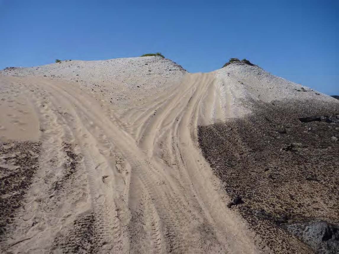
17 The Court and the parties’ representatives and witnesses travelled from Hobart in a convoy of two helicopters landing at the mouth of the Interview River and then at Dago Plains, in both cases landing close to midden sites located near track 501. At those landing points, the Court was shown midden sites including a range of shellfish, bone fragments and stone artefacts, as well as what appeared to be vehicle tracks running close by or in some cases directly over the midden sites. En route to and from the landing points, the helicopters flew over tracks 601 and 503, including areas of track braiding where vehicles had deviated from the track, and a Parks and Wildlife sign at Sea Devil Rivulet indicating the point from which track 501 was closed.
18 The parties’ accepted, and it is the case that, in accordance with s 54 of the Evidence Act, I am able to draw any reasonable inference from what I have seen, heard or otherwise noticed during the view. Where I do so, I indicate my reliance on the view.
RELEVANT LEGISLATIVE PROVISIONS AND LEGAL PRINCIPLES
The general legislative scheme and relevant concepts
19 The parts of the EPBC Act relevant in this proceeding operate on conduct identified by the term “action”. That term is central to the resolution of the issues in this proceeding, just as it is central to the regulatory scheme of the Act.
20 By a series of prohibitions, coupled with a permission regime as well as exclusions and exemptions to the prohibitions, the Act seeks first to prohibit and second to regulate conduct which has, or is likely to have, a “significant impact” on subject matter protected by the Act. The regulatory scheme includes civil penalty and criminal provisions, as well as remedial orders and injunctive relief.
21 The subject matter protected by the Act can be found in Part 3. The overarching description of that subject matter is “matters of national environmental significance”. Those matters are then divided into nine specific categories (Subdivisions A – FB), together with a category the content of which may be filled by regulatory prescription (see Subdivision G).
22 The protected subject matter includes matters falling under headings such as “World Heritage”, “National Heritage”, “Wetlands of international importance” and “Listed threatened species and communities”. The protections themselves are directed variously at persons, constitutional corporations, persons engaged in trade or commerce between Australia and another country or between Australian States and Territories, conduct occurring in Commonwealth areas, and conduct that is likely to have a significant impact on subject matter in respect of which Australia has obligations under international agreements including the Biodiversity Convention: see, eg, s 15B. As Kenny J explained in Secretary, Department of Sustainability and Environment (Vic) v Minister for Sustainability, Environment, Water, Population and Communities (Cth) [2013] FCA 1299; 209 FCR 215 at [123]-[125], this structure is intended to ensure that the protections in the Act are supported by at least one, and preferably multiple, heads of power under the Constitution.
23 The structure of each of the subject matter prohibitions is substantially the same. I extract s 15B, which is the relevant prohibition, at [36] below. Between each of the nine specific categories, the subject matter protected varies widely and I return to the importance of identifying exactly what is protected at several points in these reasons.
24 The permission regime comprises a somewhat complex approvals process (see Chapter 4) and a series of exemptions from that approvals process (see Part 4). The prohibitions in respect of each protected subject matter will not operate if a Chapter 4 approval has been obtained and any conditions adhered to. Nor will they operate if one of the exemptions in Part 4 applies.
25 Conduct which contravenes these civil penalty or criminal provisions not only has the consequences for which those provisions provide, that conduct also becomes, by the operation of s 67 of the Act, a “controlled action”. This is reflected in a further general prohibition in the Act, found in s 67A:
A person must not take a controlled action unless an approval of the taking of the action by the person is in operation under Part 9 for the purposes of the relevant provision of Part 3.
Note: A person can be restrained from contravening this section by an injunction under section 475.
26 Thus, although the prohibitions may result in a civil penalty or in criminal liability, or in the grant of injunctions, another consequence of the successful invocation of one of the prohibitions in Part 3 may be that it will trigger an application for approval under Chapter 4. In other words, the taking of an impugned action may eventually occur, if approval is granted under Chapter 4, although there may be a variety of conditions imposed: see Part 9. Of course, a grant of approval is far from inevitable under the scheme and depends fundamentally on the assessment of the impact of a proposed action.
27 Each of the prohibitions in Part 3, and the controlled action prohibition in s 67A, provides a basis for the grant of injunctions under s 475, to which I now turn.
28 Under s 475 of the Act, this Court has the power to grant an injunction restraining conduct constituting an offence (for example, s 15C(8)) or a contravention (for example, s 15B(4) and s 67A) of the Act. Section 475 relevantly provides:
Applications for injunctions
(1) If a person has engaged, engages or proposes to engage in conduct consisting of an act or omission that constitutes an offence or other contravention of this Act or the regulations:
(a) the Minister; or
(b) an interested person (other than an unincorporated organisation); or
(c) a person acting on behalf of an unincorporated organisation that is an interested person;
may apply to the Federal Court for an injunction.
Prohibitory injunctions
(2) If a person has engaged, is engaging or is proposing to engage in conduct constituting an offence or other contravention of this Act or the regulations, the Court may grant an injunction restraining the person from engaging in the conduct.
Additional orders with prohibitory injunctions
(3) If the court grants an injunction restraining a person from engaging in conduct and in the Court’s opinion it is desirable to do so, the Court may make an order requiring the person to do something (including repair or mitigate damage to the environment).
…
29 The applicant initially sought final relief under s 475, although in light of the respondents’ concession, to which I refer at [299] below, it accepts that declaratory relief would be sufficient.
30 As I have noted, the statutory concept of “action” in the Act is critical to the determination of this proceeding, and to the reach of the Act. The word is not defined in the Act. Section 523 sets out five kinds of conduct which the Act expressly includes in the statutory concept:
(1) Subject to this Subdivision, action includes:
(a) a project; and
(b) a development; and
(c) an undertaking; and
(d) an activity or series of activities; and
(e) an alteration of any of the things mentioned in paragraph (a), (b), (c) or (d).
31 Section 524, on which the respondents rely in this proceeding, then provides that certain things are excluded from the concept of “action”:
(1) This section applies to a decision by each of the following kinds of person (government body):
(a) the Commonwealth;
(b) a Commonwealth agency;
(c) a State;
(d) a self-governing Territory;
(e) an agency of a State or self-governing Territory;
(f) an authority established by a law applying in a Territory that is not a self-governing Territory.
(2) A decision by a government body to grant a governmental authorisation (however described) for another person to take an action is not an action.
(3) To avoid doubt, a decision by the Commonwealth or a Commonwealth agency to grant a governmental authorisation under one of the following Acts is not an action:
(a) the Customs Act 1901;
(b) the Export Control Act 1982;
(c) the Export Finance and Insurance Corporation Act 1991;
(d) the Fisheries Management Act 1991;
(e) the Foreign Acquisitions and Takeovers Act 1975;
(f) the Offshore Petroleum and Greenhouse Gas Storage Act 2006;
(g) the Quarantine Act 1908;
(h) the Competition and Consumer Act 2010.
This subsection does not limit this section.
32 By crafting an exclusion around a decision of a particular kind, the scheme contemplates, it would seem to me, that a decision may otherwise be within the statutory concept of action. However, not all decisions will be actions, as the Full Court made clear in Esposito v Commonwealth [2015] FCAFC 160 at [97]-[110]. In that case, the Court held that neither a rezoning decision nor the enactment of the legislation on which it was based were an “action” for the purposes of s 523 of the Act. At [103] the Court held:
Returning then to s 523 of the EPBC Act, we do not accept, and it was not suggested that we should, that an exercise of State legislative power which does not relate to any development in particular and which merely empowers a Council to grant its approval to future developments thereby engaging s 76A can be described as a project, development, undertaking or activity or series of activities within the meaning of s 523. Nor, should we say for completeness, do we accept that the Council’s role as a ‘consent authority’, or its obligation to prepare a draft planning instrument for the Minister, leads to any different outcome.
33 The final critical statutory concept in the Act, insofar as the contested issues in this proceeding are concerned, is the concept of “impact”. It is the subject of an almost impenetrable definition in s 527E:
(1) For the purposes of this Act, an event or circumstance is an impact of an action taken by a person if:
(a) the event or circumstance is a direct consequence of the action; or
(b) for an event or circumstance that is an indirect consequence of the action—subject to subsection (2), the action is a substantial cause of that event or circumstance.
(2) For the purposes of paragraph (1)(b), if:
(a) a person (the primary person) takes an action (the primary action); and
(b) as a consequence of the primary action, another person (the secondary person) takes another action (the secondary action); and
(c) the secondary action is not taken at the direction or request of the primary person; and
(d) an event or circumstance is a consequence of the secondary action;
then that event or circumstance is an impact of the primary action only if:
(e) the primary action facilitates, to a major extent, the secondary action; and
(f) the secondary action is:
(i) within the contemplation of the primary person; or
(ii) a reasonably foreseeable consequence of the primary action; and
(g) the event or circumstance is:
(i) within the contemplation of the primary person; or
(ii) a reasonably foreseeable consequence of the secondary action.
34 Even if there is an “impact”, for the prohibitions to operate it must be a significant impact. The adjective “significant” is not defined, but there is an established understanding in the authorities of the threshold that adjective imposes. I set out those authorities at [240] below.
The protection of “National Heritage places”
35 The categories of matters of national environmental significance have expanded since the enactment of the EPBC Act in 1999. The subject matter of this proceeding is an example. The category of “National Heritage place” was added to the Act by the Environment and Heritage Legislation Amendment Act (No. 1) 2003 (Cth). In his second reading speech, the Minister for the Environment and Heritage stated:
The National Heritage List creates opportunities to remember, celebrate and conserve places that recall significant themes in Australian history. We should respect and value the development of our industries by recognising and protecting early mining, industrial and pastoral sites. Our national historic built heritage includes places that give an insight into the development of our own sense of Australian identity and our sense of place and, as such, should be recognised and protected for their national heritage significance. Natural heritage places that may be considered by the Australian Heritage Council include those that tell the story of our continent’s natural diversity and ancient past.
The bill moves forward in the protection of the heritage of Aboriginal and Torres Strait Islander people. Indigenous cultural heritage exists throughout Australia and all aspects of the landscape may be important to Indigenous people as part of their heritage. The effective protection and conservation of this heritage is important in maintaining the identity, health and wellbeing of Indigenous people. This bill provides new opportunities for developing agreed strategies to protect Indigenous heritage places after consultation and discussion with traditional owners on management arrangements. The rights and interests of Indigenous people in their heritage arise from their spirituality, customary law, original ownership, custodianship, developing Indigenous traditions and recent history.
36 The relevant prohibitions are contained in s 15B of the Act, which provides:
15B Requirement for approval of activities with a significant impact on a National Heritage place
(1) A constitutional corporation, the Commonwealth or a Commonwealth agency must not take an action that has, will have or is likely to have a significant impact on the National Heritage values of a National Heritage place.
Civil Penalty:
(a) for an individual—5,000 penalty units;
(b) for a body corporate—50,000 penalty units.
(2) A person must not, for the purposes of trade or commerce:
(a) between Australia and another country; or
(b) between 2 States; or
(c) between a State and Territory; or
(d) between 2 Territories;
take an action that has, will have or is likely to have a significant impact on the National Heritage values of a National Heritage place.
Civil Penalty:
(a) for an individual—5,000 penalty units;
(b) for a body corporate—50,000 penalty units.
(3) A person must not take an action in:
(a) a Commonwealth area; or
(b) a Territory; that has, will have or is likely to have a significant impact on the National Heritage values of a National Heritage place.
Civil Penalty:
(a) for an individual—5,000 penalty units;
(b) for a body corporate—50,000 penalty units.
(4) A person must not take an action that has, will have or is likely to have a significant impact on the National Heritage values, to the extent that they are indigenous heritage values, of a National Heritage place.
Civil Penalty:
(a) for an individual—5,000 penalty units;
(b) for a body corporate—50,000 penalty units.
Note: For indigenous heritage value, see section 528.
(5) A person must not take an action that has, will have or is likely to have a significant impact on the National Heritage values of a National Heritage place in an area in respect of which Australia has obligations under Article 8 of the Biodiversity Convention.
Civil Penalty:
(a) for an individual—5,000 penalty units;
(b) for a body corporate—50,000 penalty units.
(6) Subsection (5) only applies to actions whose prohibition is appropriate and adapted to give effect to Australia’s obligations under Article 8 of the Biodiversity Convention. (However, that subsection may not apply to certain actions because of subsection (8).)
(8) Subsections (1) to (5) (inclusive) do not apply to an action if:
(a) an approval of the taking of the action by the constitutional corporation, Commonwealth agency, Commonwealth or person is in operation under Part 9 for the purposes of this section; or
(b) Part 4 lets the constitutional corporation, Commonwealth agency, Commonwealth or person take the action without an approval under Part 9 for the purposes of this section; or
(c) there is in force a decision of the Minister under Division 2 of Part 7 that this section is not a controlling provision for the action and, if the decision was made because the Minister believed the action would be taken in a manner specified in the notice of the decision under section 77, the action is taken in that manner; or
(d) the action is an action described in subsection 160(2) (which describes actions whose authorisation is subject to a special environmental assessment process).
37 Although a National Heritage “place” appears, at first impression, to be the subject matter of the Act’s protection, taking into account the text of other provisions and reading s 15B as a whole, it is apparent what is being protected is not simply a “place”, but the “values” of that place which warranted the place’s inclusion on the National Heritage List. That this is so should also be apparent from the use of the term “heritage”, which is a term directing attention to, again, what a “place” stand for, signifies or embodies. Part of the “heritage” of a place may relate to historical events, to activities undertaken by people in a place but it can also involve ideas, aspirations, beliefs and practices. The broader subject matter protected is also apparent from the terms of s 324C, which I set out below: a “place” can, under this legislative scheme, only become a National Heritage place if, in the responsible Minister’s opinion, it embodies particular “values”.
38 A “National Heritage place” is a place recorded in the National Heritage List, in accordance with the process set out in Part 15 of the Act. Section 324C describes the National Heritage List. It provides:
(1) The Minister must keep a written record of places and their heritage values in accordance with this Subdivision and Subdivisions BA, BB and BC. The record is called the National Heritage List.
(2) A place may be included in the National Heritage List only if:
(a) the place is within the Australian jurisdiction; and
(b) the Minister is satisfied that the place has one or more National Heritage values (subject to the provisions in Subdivision BB about the emergency process).
(3) A place that is included in the National Heritage List is called a National Heritage place.
(4) The National Heritage List is not a legislative instrument.
39 What can constitute a “place” for the purposes of this subject matter protection is dealt with, inclusively rather than exhaustively, by the definition of “place” in s 528. “Place” includes:
(a) a location, area or region or a number of locations, areas or regions; and
(b) a building or other structure, or group of buildings or other structures (which may include equipment, furniture, fittings and articles associated or connected with the building or structure, or group of buildings or structures); and
(c) in relation to the protection, maintenance, preservation or improvement of a place—the immediate surroundings of a thing in paragraph (a) or (b).
40 The inclusion of a place on the National Heritage List is a function conferred on the responsible Minister pursuant to s 324JJ of the Act. There is a process set out in Subdivision BA of Div 1A of Part 15 which leads up to this determination. Places may be nominated and nominations are given to the Australian Heritage Council (see ss 324J and 324JA). The Council then provides the Minster with a list of places it considers should be assessed (see ss 324JB, 324JC and 325JD). After other steps not presently relevant, the Council then provides a written assessment of the places on the finalised list and gives those assessments to the Minster (see ss 324JH and 324JI). The Council’s assessment is made against specified “National Heritage criteria”, which I set out at [42] below.
41 The Minister then determines, pursuant to s 324JJ, whether or not an assessed place will be included on the National Heritage List. The determination turns on the Minister’s satisfaction that the place has one or more National Heritage values, the content of those values being those set out in s 324D, read with the applicable regulations, to which I return below. In forming her or his satisfaction, the Minister is required to have regard to the Council’s assessment and any public comments (see s 324JJ(5)). Since it is central to this proceeding, I set out the whole of s 324JJ:
Minister to decide whether or not to include place
(1) After receiving from the Australian Heritage Council an assessment under section 324JH whether a place (the assessed place) meets any of the National Heritage criteria, the Minister must:
(a) by instrument published in the Gazette, include in the National Heritage List:
(i) the assessed place or a part of the assessed place; and
(ii) the National Heritage values of the assessed place, or that part of the assessed place, that are specified in the instrument; or
(b) in writing, decide not to include the assessed place in the National Heritage List.
Note: The Minister may include a place in the National Heritage List only if the Minister is satisfied that the place has one or more National Heritage values (see subsection 324C(2)).
(2) Subject to subsection (3), the Minister must comply with subsection (1) within 90 business days after the day on which the Minister receives the assessment.
(3) The Minister may, in writing, extend or further extend the period for complying with subsection (1).
(4) Particulars of an extension or further extension under subsection (3) must be published on the internet and in any other way required by the regulations.
(5) For the purpose of deciding what action to take under subsection (1) in relation to the assessed place:
(a) the Minister must have regard to:
(i) the Australian Heritage Council’s assessment whether the assessed place meets any of the National Heritage criteria; and
(ii) the comments (if any), a copy of which were given to the Minister under subsection 324JH(1) with the assessment; and
(b) the Minister may seek, and have regard to, information or advice from any source.
Additional requirements if Minister decides to include place
(6) If the Minister includes the assessed place, or a part of the assessed place (the listed part of the assessed place), in the National Heritage List, he or she must, within a reasonable time:
(a) take all practicable steps to:
(i) identify each person who is an owner or occupier of all or part of the assessed place; and
(ii) advise each person identified that the assessed place, or the listed part of the assessed place, has been included in the National Heritage List; and
(b) if the assessed place:
(i) was nominated; or
(ii) was included in a place that was nominated; or
(iii) includes a place that was nominated;
by a person in response to a notice under subsection 324J(1)—advise the person that the assessed place, or the listed part of the assessed place, has been included in the National Heritage List; and
(c) publish a copy of the instrument referred to in paragraph (1)(a) on the internet; and
(d) publish a copy or summary of that instrument in accordance with any other requirements specified in the regulations.
(7) If the Minister is satisfied that there are likely to be at least 50 persons referred to in subparagraph (6)(a)(i), the Minister may satisfy the requirements of paragraph (6)(a) in relation to those persons by including the advice referred to in that paragraph in one or more of the following:
(a) advertisements in a newspaper, or newspapers, circulating in the area in which the assessed place is located;
(b) letters addressed to “The owner or occupier” and left at all the premises that are wholly or partly within the assessed place;
(c) displays in public buildings at or near the assessed place.
Additional requirements if Minister decides not to include place
(8) If the Minister decides not to include the assessed place in the National Heritage List, the Minister must, within 10 business days after making the decision:
(a) publish the decision on the internet; and
(b) if the assessed place:
(i) was nominated; or
(ii) was included in a place that was nominated; or
(iii) includes a place that was nominated;
by a person in response to a notice under subsection 324J(1)—advise the person of the decision, and of the reasons for the decision.
Note: Subsection (8) applies in a case where the Minister decides that none of the assessed place is to be included in the National Heritage List.
42 Section 324D specifies what needs to exist for a place to have a “National Heritage value”. It should be noted that as between the specified “value” and the relevant criterion, or criteria, sub-section (1) contemplates some kind of causal relationship. It should also be noted that the scheme requires the particular value or values identified for a place to be specified in the entry in the National Heritage List for that place. It is this specification, or inclusion, which in my opinion controls the assessment of significant impact for the purposes of s 15B(4). Section 324D provides:
(1) A place has a National Heritage value if and only if the place meets one of the criteria (the National Heritage criteria) prescribed by the regulations for the purposes of this section. The National Heritage value of the place is the place’s heritage value that causes the place to meet the criterion.
(2) The National Heritage values of a National Heritage place are the National Heritage values of the place included in the National Heritage List for the place.
(3) The regulations must prescribe criteria for the following:
(a) natural heritage values of places;
(b) indigenous heritage values of places;
(c) historic heritage values of places.
The regulations may prescribe criteria for other heritage values of places.
(4) To avoid doubt, a criterion prescribed by the regulations may relate to one or more of the following:
(a) natural heritage values of places;
(b) indigenous heritage values of places;
(c) historic heritage values of places;
(d) other heritage values of places.
43 Thus, three specific kinds of heritage values are contemplated as relevant for protection of a place: natural, indigenous and historic. A further more open “other” category exists, although its existence and use is more discretionary, as the differences between “must” and “may” in s 324D(3) indicate.
44 The term “heritage value” is in turn defined under s 528:
heritage value of a place includes the place’s natural and cultural environment having aesthetic, historic, scientific or social significance, or other significance, for current and future generations of Australians.
45 The term “indigenous heritage value” is given a particular meaning. Section 528 defines “indigenous heritage value” as follows:
indigenous heritage value of a place means a heritage value of the place that is of significance to indigenous persons in accordance with their practices, observances, customs, traditions, beliefs or history.
46 It can be seen that while s 324D uses the plural “values”, the two definitions use the singular “value”. No party submitted that anything turned on the difference and I agree with the parties’ approach.
47 The fact that each of the statutory terms “heritage values” and “indigenous heritage values” are both defined could lead, in their use and application, to some circularity and confusion. Construed in context, it seems to me that the latter being a more specific defined term than the former, its statutory definition should be applied as it is expressed, without an overlay of the more general defined term “heritage value”. Accordingly, I consider (for reasons more fully set out below) that it is the “indigenous heritage values” of the WTACL which control the assessment of significant impact, for the purpose of the actions as alleged by the applicant.
48 The current criteria for a Ministerial declaration are set out at reg 10.01A of the Environment Protection and Biodiversity Conservation Regulations 2000 (Cth). Discerning a rational and clear construction and operation of this regulation is not easy. Regulation 10.01A provides:
(1) For section 324D of the Act, subregulation (2) prescribes the National Heritage criteria for the following:
(a) natural heritage values of places;
(b) indigenous heritage values of places;
(c) historic heritage values of places.
(2) The National Heritage criteria for a place are any or all of the following:
(a) the place has outstanding heritage value to the nation because of the place’s importance in the course, or pattern, of Australia’s natural or cultural history;
(b) the place has outstanding heritage value to the nation because of the place’s possession of uncommon, rare or endangered aspects of Australia’s natural or cultural history;
(c) the place has outstanding heritage value to the nation because of the place’s potential to yield information that will contribute to an understanding of Australia’s natural or cultural history;
(d) the place has outstanding heritage value to the nation because of the place’s importance in demonstrating the principal characteristics of:
(i) a class of Australia’s natural or cultural places; or
(ii) a class of Australia’s natural or cultural environments;
(e) the place has outstanding heritage value to the nation because of the place’s importance in exhibiting particular aesthetic characteristics valued by a community or cultural group;
(f) the place has outstanding heritage value to the nation because of the place’s importance in demonstrating a high degree of creative or technical achievement at a particular period;
(g) the place has outstanding heritage value to the nation because of the place’s strong or special association with a particular community or cultural group for social, cultural or spiritual reasons;
(h) the place has outstanding heritage value to the nation because of the place’s special association with the life or works of a person, or group of persons, of importance in Australia’s natural or cultural history;
(i) the place has outstanding heritage value to the nation because of the place’s importance as part of indigenous tradition.
(3) For subregulation (2), the cultural aspect of a criterion means the indigenous cultural aspect, the non-indigenous cultural aspect, or both.
49 It is apparent that sub-reg 10.01A(2) does not expressly link each criterion with one, or more than one, of the three national heritage values listed in paragraph (1). Thus, each criterion might, depending on the place concerned, operate against more than one value, or against different values for different places. Thus, criterion 2(c) – the place’s potential to yield information that will contribute to an understanding of Australia’s natural or cultural history – might be used to identify a place’s historic value, or indigenous value. Even criterion 2(i) could, in my opinion, lead to a place being identified as having historic value, not only indigenous value although the latter might occur more often.
50 There is also nothing in the way the scheme is structured to prevent the Minister identifying a place as having (for example) both historic and indigenous values; or natural and indigenous values, to take but two possible combinations.
51 In this case, as I set out in more detail below, the WTACL was found by the Minister to meet the first criterion of sub-reg 10.01A(2) – sub-reg (a). That is: “outstanding heritage value to the nation because of the place’s importance in the course, or pattern, of Australia’s natural or cultural history”. This is what the Minister specified in the left hand column of his declaration (see Gazette Notice S 24 of 2013, Schedule, 4).
52 However, in the right hand column of the declaration is the second part of the exercise under this aspect of the legislative scheme. This is the part where the Minister must make the causal link between the characteristic of this area as a place of outstanding heritage value to the nation because of its importance in the course, or pattern, of Australia’s natural or cultural history on the one hand, and one or more of the three values set out in s 324D(3) on the other. The obligation to do so arises from the terms of s 324JJ(1)(a)(ii).
53 Here, the Minister chose to identify indigenous heritage values as the causal link. How that choice is revealed by the evidence requires a little explanation. The conclusion derives from reading, together, the Ministerial declaration and the Briefing Note to the Minister, which were in evidence before me. The declaration itself states that the Minister is satisfied the WTACL “has the National Heritage values” specified in the Schedule. In the Schedule, in the right hand column under the heading “Value” is a three paragraph statement which I have reproduced at [95] in these reasons. That description is wholly concerned with the importance of the WTACL as an expression of the way of life of the Aboriginal people who inhabited the area for the last several thousand years, but it does not expressly employ the statutory term “indigenous heritage values”. However, on the decision page of the Ministerial Briefing Note, the Minister was given five options in terms of specifying the values for which the WTACL (only, the Minister decided) should be listed. The Minister circled that he “Agreed” to “Aboriginal Values”, and the map attached to the Briefing Note shows a hatched area co-extensive with the WTACL, which in the legend on the map is described as “Aboriginal values”.
54 That is, it is the indigenous heritage values of the WTACL which in the Minister’s opinion cause it to have importance in the course, or pattern, of Australia’s natural or cultural history. That is, applying the definition of indigenous heritage values as I have set out at [45] above, the Minister determined that the cause (or reason) for the WTACL having the importance it does is its significance to indigenous persons in accordance with their practices, observances, customs, traditions, beliefs or history. The submissions of both the applicant and the respondents were premised on an acceptance that this was the choice made by the Minister.
THE IMPUGNED ACTION AND THE RESPONDENTS’ CASE
55 The applicant impugns both on a collective and an individual basis three interrelated phases of what it says is conduct proposed to be undertaken by the respondents. Those phases are described in the applicant’s outline of submissions:
(a) designation of parts of the APCA in accordance with regulations 18 and 33 of the National Parks and Reserved Land Regulations (Tas) 2009 to remove the prohibition on recreational vehicles being driven on the tracks, subject to certain conditions (Designation Phase);
(b) works in and around the tracks such as spreading gravel, placing rubber matting over Aboriginal cultural heritage sites and constructing new sections of track (Works Phase);
(c) selling permits to individual drivers to drive on the tracks, collecting fees, attaching and removing GPS devices for recreational vehicles, collecting and refunding bonds (Operating Phase).
56 Those phases are set out (in slightly different order) at paragraph 7 of the applicant’s amended statement of claim, where the proposed conduct is described:
The Respondents have engaged in, or propose to engage in conduct, namely:
a. the Second Respondent, as managing authority of the APCA, designating parts of the APCA as a “designated vehicle area” in accordance with Regulations 18 and 33 of the National Parks and Reserved Land Regulations 2009 (Tas).
i. Such designation will provide for recreational vehicles to be driven on the tracks and/or any newly constructed tracks or sections of track in the WTACL;
ii. Conditions attached to the designation include:
1. a fee being levied on each driver;
2. each driver attaching a GPS device to their vehicle; and
3. a Recreational Driver - Special Pass being issued to each driver.
b. carrying out actions to implement conditions attached to the designation in relation to individual drivers by:
i. offering to the public for purchase a Recreational Driver - Special Pass for the Pieman River Track (south of Sea Devil Rivulet to the Pieman River) and Interview Mine Track;
ii. collecting $50 per driver for each pass sold;
iii. ensuring a GPS device is fitted to the vehicle to be driven by each person who purchases a Recreational Driver – Special Pass;
iv. collecting a $100 bond for the GPS device from the person who purchases a Recreational Driver – Special Vehicle Pass;
v. removing the GPS device form the vehicle;
vi. refunding the bond to the person who purchased the Recreational Driver – Special Pass.
c. carrying out, or directing their employees, officers, agents or representatives to carry out works in the WTACL in and around the tracks for the purposes of facilitating recreational vehicles to be driven on the tracks by:
i. constructing new sections of track;
ii. spreading gravel over Aboriginal cultural heritage; and/or
iii. placing rubber matting over Aboriginal cultural heritage with star pickets or other means of fastening the rubber matting in place;
iv. installing culverts, fencing or track markers;
v. carrying out rehabilitation works; and/or
vi. other works as directed by the Respondents.
57 The applicant impugns the whole of that proposed conduct, on the basis that collectively these phases constitute a project or a series of activities within the meaning of s 523, and is therefore a single “action” under the Act. Further, the applicant also separately impugns each of the designation (with its conditions), the works phase and the operating phase as constituting individually an “action” under the Act.
58 The applicant then contends that whether considered individually or collectively, the proposed action will have a significant impact on the indigenous values of the WTACL.
59 The respondents contend that the applicant’s case fails in respect of each element required under s 15B(4), being the requirements that there be an “action”, that there be an impact on National Heritage values in so far as they are indigenous heritage values, and that the impact be significant.
60 The parties worked cooperatively prior to trial to agree as much of the factual basis for the proceeding as possible, and an agreed statement of facts was admitted into evidence pursuant to s 191 of the Evidence Act. No evidence was filed on behalf of the respondents. The absence of any evidence from the respondents, and limited cross examination of the applicant’s witnesses, meant that most of the factual foundation for the applicant’s claims was not the subject of positive challenge.
61 The applicant called a number of witnesses, both expert and lay. Each lay witness had given evidence by way of affidavit, and there were reports filed by the expert witnesses.
62 Objection was taken to the affidavits and reports of two witnesses from whom the applicant proposed to lead expert evidence: namely, Mr Henry Turnbull and Dr Susan McIntyre-Tamwoy. Mr Turnbull’s report related to the physical consequences of vehicles driving in the relevant areas, while Dr McIntyre-Tamwoy’s report related to methodologies for assessing the impact of a proposal on indigenous heritage values.
63 The basis for both objections was twofold. First, that the reports failed to identify or assumed the facts upon which the opinions in them were based and second, that the reports were not based on specialised knowledge. I ruled that the expert evidence proposed to be given by each of Mr Turnbull and Dr McIntyre-Tamwoy was inadmissible. In the case of Mr Turnbull, I was not satisfied that he had the necessary specialised knowledge to express opinions concerning the construction of bypass tracks or the physical consequences of driving recreational vehicles in the relevant areas. In the case of Dr McIntyre-Tamwoy, while I accepted that she had the expertise set out in her report, I was not satisfied that her opinions on the assessment of heritage significance for the purposes of management and administrative decision-making was relevant to the issues in the proceeding.
Applicant’s witnesses not called for cross-examination
64 Mr Mansell is Chair of the Aboriginal Land Council of Tasmania and a member of the Tasmanian Aboriginal community. He gave evidence, in his personal capacity, regarding a visit he made to the WTACL and the importance of the area to Aboriginal people in Tasmania.
65 Mr Hughes worked as an Aboriginal Heritage Officer at the Tasmanian Aboriginal Land and Sea Council (TALSC) for more than 20 years. He is also member of the Tasmanian Aboriginal community and gave evidence regarding the cultural value of the WTACL to his community, as well as the various trips he has taken to the area.
66 Mr Edwards is employed by the applicant as a land management supervisor and is a member of the Tasmanian Aboriginal community. His evidence focused on his personal and cultural connection with the WTACL and surrounding areas, which was originally established during trips to the area with his family when Mr Edwards was a child.
67 Mr Mansell is a member of the Tasmanian Aboriginal community and gave evidence regarding a visit he made to the WTACL and surrounding areas in 2013, including his observations regarding the importance of the area as a source of knowledge about the Aboriginal people who lived in the area over many generations.
68 Mr Sainty is a member of the Tasmanian Aboriginal community and Deputy Regional Director of the Office of Prime Minister and Cabinet in Hobart, as well as Chair of the Interim Aboriginal Heritage Council. He previously worked as a ranger and spent time in the APCA and the area that is now the WTACL. Mr Sainty gave evidence regarding the cultural and historical connections that the artefacts and environment in the WTACL provide to him and other Aboriginal people in Tasmania.
69 Ms Sainty is a Senior Project Officer, Culture and Curriculum at the Tasmanian Department of Education. She also works as a consultant in respect of Aboriginal languages and is a member of the Tasmanian Aboriginal community. She and Mr Rocky Sainty are married. She gave evidence regarding the cultural value of the WTACL to her and other Aboriginal people, and the impact of opening the area to vehicles on that value.
70 Mr Harwin holds tertiary qualifications in surveying and has conducted research into GPS and other techniques for fine-scale mapping. He filed an expert report on behalf of the applicant regarding the accuracy of GPS data that would be used to monitor vehicles in the WTACL if the respondents were to open the area to recreational drivers.
Applicant’s witnesses who gave oral evidence
71 Ms Sculthorpe is the Chief Executive Officer of the applicant. Ms Sculthorpe affirmed an affidavit in the proceeding on 19 December 2014. Ms Sculthorpe’s evidence related to the history and objectives of the applicant, the Tasmanian Government’s proposal to open the WTACL to off-road vehicles, and the applicant’s response to that proposal.
72 I found Ms Sculthorpe to be a careful witness. Although she did not appear to me to have a detailed personal knowledge of the WTACL, based on her previous experience in dealing with Aboriginal heritage issues in Tasmania she did have clear ideas about what might be necessary for harm minimisation, and how effective that might be.
73 Mr Thompson is employed as an education worker at the Tasmanian Aboriginal Centre. He identifies as Aboriginal. Mr Thompson filed two affidavits in the proceeding, the first sworn on 19 December 2014 and the second sworn on 11 June 2014. Mr Thompson’s first affidavit was filed in support of the applicant’s application for an interim injunction. It describes a visit he made to the APCA during which he spoke to Parks and Wildlife staff about how the area was to be managed. It was Mr Thompson’s evidence that he observed the impact of four wheel drive tracks in the reserve. Annexed to Mr Thompson’s affidavit are photographs that were taken at that time. Mr Thompson’s second affidavit identifies the WTACL and surrounding areas as important to him, his identity and his heritage.
74 Mr Thompson’s evidence was given in an informal way, but I found him a reliable witness, although his evidence often lacked detail. The main relevance of his evidence to the contentious issues in this case were the conversations he described having with officers of the Tasmanian Parks and Wildlife Service, concerning the reopening of the three tracks.
75 Mr Huys has 22 years’ experience as a consultant archaeologist and is the Director of CHMA Pty Ltd, a company that specialises in the assessment and management of Aboriginal and historic heritage. Mr Huys has considerable experience in conducting Aboriginal heritage assessments in Tasmania. The applicant tendered without objection an expert report of Mr Huys dated 26 May 2015. In his expert report, Mr Huys relied on a 2010 report prepared by CMHA Pty Ltd after being engaged by the Tasmanian Parks and Wildlife Service to undertake an Aboriginal heritage assessment and develop an Aboriginal Heritage Management Plan for identified vehicle tracks within the APCA. Mr Huys was the principal archaeologist on the project. The 2010 report included but was not limited to surveys of tracks 501 and 601. Track 503 was not part of the 2010 report. The 2010 report collated the findings of the surveys undertaken by CHMA Pty Ltd and identified cultural sites on tracks 601 and 501.
76 Mr Huys was an impressive witness, both in terms of his experience and command of relevant material and in terms of his preparedness to place reasonable limits on what he could say.
77 Dr Stone is an archaeologist and geomorphologist. Dr Stone appeared via video link from Sydney on the second day of the hearing. The applicant tendered an expert report of Dr Stone dated 12 June 2015. Dr Stone’s expert evidence related to the impact of driving vehicles in dunes and dune fields, middens and other Aboriginal heritage sites.
78 Dr Stone was a careful and reliable witness. Although he has not actually been to the WTACL, his depth of experience as an archaeologist specialising in the management of Aboriginal cultural heritage led to what I accept was justified confidence in the opinions he expressed about the presence, and importance, of middens and other Aboriginal heritage in the relevant areas and the impact of the respondents’ proposed conduct.
79 Professor Ryan is a Research Professor at the Centre for the History of Violence at the University of Newcastle, Australia. In 1976, Ms Ryan completed a PhD on the history of Tasmanian Aborigines and has since become a world authority on the subject.
80 The applicant tendered an expert report of Professor Ryan filed in the proceeding on 12 June 2015. Dr Ryan’s evidence included information on the history of European colonisation in Tasmania and the impact on Tasmanian Aborigines. Dr Ryan’s evidence also addressed the significance of sites and landscapes containing evidence of Tasmanian Aboriginal life prior to colonisation, including the area between the Pieman River and Sandy Cape.
81 Professor Ryan was obviously well-qualified and experienced. She was in charge of her material and gave careful answers. Her evidence was almost entirely dependent on G.A. Robinson’s diaries, which is unsurprising since there are so few written historical sources concerning European observations of Aboriginal people living in the APCA. I explain at [90] and [146] below who G.A. Robinson was, and why his travels in the APCA came to feature in the evidence given in this proceeding.
82 Despite her obvious expertise and knowledge, I do not consider Professor Ryan’s opinions to be of much relevance to the issues the Court must determine in this case. I understood the purpose of her evidence was to rebut the reliance the respondents asked the Court to place on the diaries of G.A. Robinson, in terms of making findings about where hut depressions and seal hides were located within the WTACL. For reasons which I explain in more detail below, that approach involves a misunderstanding of the task of assessing whether there is a likely contravention of s 15B(4), because it focuses on particular and isolated surviving manifestations of the way of life of Aboriginal people in the entire landscape which is the WTACL.
83 Mr Pedder swore two affidavits in the proceeding, the first on 10 June 2015 and the second on 15 October 2015. Mr Pedder is member of the Aboriginal community and has worked in the cultural heritage field for many years, including as manager of TALSC and in the Indigenous Heritage Section of the Commonwealth Department of the Environment, Water, Heritage and the Arts.
84 Mr Pedder was a sincere, honest and helpful witness. His opinions were genuinely held and felt, and he was not given to exaggeration, but his views about the protection of Aboriginal heritage are strong. He is entitled to them given his experience, and to the extent they are relevant to the matters I must determine, I have relied on them.
85 In the following part of my reasons, I set out the factual findings I make about the WTACL, the proposal to open the tracks, the proposed mitigation and protective measures and their likely effectiveness, and the evidence about the nature and extent of Aboriginal sites in the WTACL and its surrounds – the latter issue arising because of the emphasis the respondents submit is to be placed on where hut depression sites, as opposed to middens, occur in the WTACL.
The regime for the protection of indigenous values and heritage in the area
86 The Arthur-Pieman Conservation Area comprises some 100,135 hectares in the north-west of Tasmania. The APCA was initially established as the Arthur-Pieman Protected Area under the Crown Lands Act 1976 (Tas) in 1982 and declared a conservation area (a type of reserved land) on 30 April 1999 under the Nature Conservation Act 2002 (Tas).
87 The part of the APCA relevant to this proceeding is located along the coast between Sandy Cape and Pieman River, as shown in the map at Annexure A to this judgment.
88 The APCA is managed by the Tasmanian Parks and Wildlife Service under the National Parks and Reserves Management Act 2002 (Tas), which sets out the management objectives for the APCA. In January 2002, the Arthur-Pieman Conservation Area Management Plan 2002 (prepared pursuant to Pt IV of the predecessor National Parks and Wildlife Act 1970 (Tas)) took effect, and that Plan is in evidence before me. In accordance with s 23 of the then National Parks and Wildlife Act and its current equivalent s 30 of the National Parks and Reserves Management Act, the respondents (holding office as the managing authority for the reserve) are required to manage the APCA for the purpose of giving effect to the Plan.
89 The summary part of the Plan relevantly records that:
The reserve provides protection to an extraordinary richness of Aboriginal cultural heritage, to highly significant and diverse ecosystems, and to spectacular coastal landscapes and wilderness values.
The conservation area has been described as ‘... one of the world’s great archaeological regions’ (Richards & Richards in Harries 1992) on account of its Aboriginal heritage values.
…
The reserve will be managed to protect values, while providing for a range of activities. The major management initiatives for the reserve are summarised below.
• Far greater emphasis will be placed upon careful management and interpretation of the reserve’s Aboriginal heritage values.
…
• The use of off-road recreation vehicles in the reserve will continue, but with careful regulation and emphasis on the education of users about low impact use.
…
90 Section 3.5 of the Plan sets out the Aboriginal values of the Arthur-Pieman Conservation Area. It states:
European knowledge of human history in the Arthur–Pieman area, prior to contact, is restricted to a combination of historical records and archaeological investigation of the sites created by thousands of years of Aboriginal occupation and use. There is now evidence which shows that Aboriginal people have lived in Tasmania continuously from at least 37,000 years ago, spanning at least the last two ice-ages.
Jones (1974) describes a North-West Tribe that occupied the coast between Table Cape and Cape Grim and down the west coast to Macquarie Harbour. The Tribe comprised nine or ten bands, with three of those bands the Peerapper, the Manegin and Tarkinener occupying sections of the coast in the Arthur– Pieman region (Ryan 1996). The people comprising the bands were semisedentary, living for long periods of the year in semi-permanent coastal settlements, but moving seasonally to exploit a large range of coastal and inland resources (Collett et al. 1998). Both archaeological surveys and ethnographic evidence suggest that the local Aboriginal populations were numerous. In addition the groups of huts observed by Robinson (Plomley 1966) at West Point and elsewhere show that several ‘villages’ of a dozen or so huts existed in the area. The conservation area can be considered an Aboriginal landscape where no doubt many of the landforms and plant communities were altered, managed and maintained through past Aboriginal land management practices.
Post-contact, competition for resources very quickly brought the North-West Tribe and white invaders into direct conflict. The first conflicts were with sealers, and then with pastoral interests, chiefly the Van Diemens Land Company. Aboriginal deaths and massacres were reported. G.A. Robinson, acting on behalf of the colonial administration, first as a ‘conciliator’ then as a ‘captor’ (Ryan 1996) made several visits to the Arthur-Pieman between 1830 and 1834. During his last visit in 1834, Robinson removed the last officially recognised Aborigines of the North-West Tribe from their traditional land. According to Ryan, Robinson:
on 6 March set off to find the two remaining families. He crossed the Arthur River again, camping at Sundown Point. The next morning the mission Aborigines set off, and on 14 March found one family near the Arthur River. On 7 April they found the other family at Sandy Cape.
There is now a significant Aboriginal community living in the north-west. They, and indeed the entire Tasmanian Aboriginal community, have a strong association with the Arthur–Pieman Conservation Area. The coastal zone of the conservation area contains a richness of Aboriginal sites and landscapes that make this area unique and important to the Aboriginal community.
Scientific interest in the richness of cultural heritage material is also high. The Arthur–Pieman has been described as ‘...one of the world’s great archaeological regions’ by the Australian Heritage Commission (Richards & Richards in Harries 1992). Extensive parts of the Arthur–Pieman Conservation Area are listed on the Register of the National Estate (see Map 7) because of Aboriginal heritage values including:
• Bluff Hill Point;
• the Greenes Creek area;
• the Interview Art Site;
• the Nelson Bay area;
• the Norfolk Range, particularly the Sandy Cape and Johnsons Head area;
• the Ordnance Point area;
• the Temma coastal area.
Aboriginal sites are numerous and extensive. Sites include innumerable middens, artefact scatters and hut depressions, several art sites including rare examples of rock engravings, and ceremonial stone arrangements.
Aboriginal heritage objects are all protected by the Aboriginal Relics Act 1975.
91 The Plan required a new system for the management of recreational vehicles to be established and operational within 12 months, and shown to be effective within three years. The Plan further records as the first of several “General Prescriptions to apply for the life of the plan”:
• Use or construction of access routes and infrastructure which adversely impacts on Aboriginal sites is prohibited.
92 In 2010 (that is, prior to any determination under s 324JJ of the EPBC Act), Cultural Heritage Management Australia (CHMA) was engaged by the Tasmanian Parks and Wildlife Service to undertake an Aboriginal heritage assessment and to develop an Aboriginal Heritage Management Plan in respect of vehicle tracks in the APCA. Mr Huys was the principal archaeologist on this project and the author of the CHMA report. The report is dated 18 December 2010 and entitled “An Aboriginal Cultural Heritage Assessment of Designated Vehicle Tracks within the Arthur Pieman Conservation Area”. The report was in evidence in this proceeding. The first section of the report is marked “Draft”, but Mr Huys explained in oral evidence that this was the form in which he submitted the report to Parks and Wildlife and that he understood the report would subsequently have been finalised. The respondents did not contend that a final version existed, nor that this version was incomplete, inaccurate or unreliable in any way. The report records at least 94 identified vehicle tracks that traverse the APCA.
93 The CHMA report notes that the natural environment in the APCA was such that it was in a constant state of flux and change, including because of regular tidal storm surges and periodic flooding. In addition, there are in the APCA a series of extensive mobile dune systems which are regularly deflated and recreated, and because of that movement Aboriginal sites in those areas are periodically exposed to the surface and then reburied through the movement of sand deposits. In some instances, the report stated, these natural impacts had been accelerated by human activity, most particularly through the erosion and associated destabilisation caused by vehicle and stock activity. Each of those matters was confirmed and adopted by Mr Huys in his expert report in this proceeding.
94 According to the schedule to the Minister’s declaration (made on 7 February 2013), the WTACL is an area of about 21,000 hectares, considerably smaller than the APCA.
95 The schedule to the Ministerial declaration describes the indigenous heritage value of the area in the following terms:
During the late Holocene Aboriginal people on the west coast of Tasmania and the southwestern coast of Victoria developed a specialised and more sedentary way of life based on a strikingly low level of coastal fishing and dependence on seals, shellfish and land mammals (Lourandos 1968; Bowdler and Lourandos 1982).
This way of life is represented by Aboriginal shell middens which lack the remains of bony fish, but contain ‘hut depressions’ which sometimes form semi-sedentary villages. Nearby some of these villages are circular pits in cobble beaches which the Aboriginal community believes are seal hunting hides (David Collett pers. comm.; Stockton and Rodgers 1979; Cane 1980; AHDB RNE Place ID 12060).
The Western Tasmania Aboriginal Cultural Landscape has the greatest number, diversity and density of Aboriginal hut depressions in Australia. The hut depressions together with seal hunting hides and middens lacking fish bones on the Tarkine coast (Legge 1929:325; Pulleine 1929:311-312; Hiatt 1967:191; Jones 1974:133; Bowdler 1974:18-19; Lourandos 1970: Appendix 6; Stockton and Rodgers 1979; Ranson 1980; Stockton 1984b:61; Collett et al 1998a and 1998b) are a remarkable expression of the specialised and more sedentary Aboriginal way of life.
96 After this description there is a hyperlink or cross reference to the recommendation of the Australian Heritage Council in relation to the WTACL. That recommendation stated:
Indigenous heritage values - above threshold
Specialised way of life:
While not claimed by the nominator, the Tarkine contains a suite of specialised coastal sites on the west coast that include large and complex multi layered shell middens containing well preserved depressions which are the remains of dome-shaped Aboriginal huts. These sites represent the best evidence of an Aboriginal economic adaptation which included the development of a semi-sedentary way of life with people moving seasonally up and down the north west coast of Tasmania. This way of life began approximately 1 900 years ago and lasted until the 1830s (Jones 1978:25).
From the late 1960s through to the 1980s, archaeological research demonstrated that the coasts of western Tasmania and southwest Victoria were areas where a specialised and more sedentary Aboriginal way of life developed during the late Holocene. The semi-sedentary Aboriginal way of life was based on a strikingly low level of coastal fishing and a dependence on seals, shellfish and land mammals of the region (Lourandos 1968; Bowdler and Lourandos 1982). Both these areas have ethnographic evidence that documents the presence of Aboriginal huts in the early 1830s (Plomley 1966; 1991, Mitchell 1988:14). The ethnographic records also reveal that huts were not only commonly found in coastal environments, but also found inland (Bowdler and Lourandos 1982:126; Plomley 1966 and 1991; Hiatt 1968b:191).
Seal Point, located on the Cape Otway coastline in southwest Victoria, is the only known published record of Aboriginal hut depressions on the mainland (Lourandos 1968). The midden at Seal Point contains the remains of 13 circular hut depressions clustered on a hillock with another set approximately 200m west (Mitchell 1988:13). The depressions themselves were approximately 2 metres in diameter and 20 centimetres in depth and date from about 1 450 years ago up until the 1830s (Lourandos 1968:85; Mitchell 1988:13).
Unlike southwest Victoria, the west coast of Tasmania has no less than 40 hut depression sites exhibiting considerable diversity in the number of hut depressions at each site (Jones 1947:133; Bowdler 1974:18-19; Legge 1929:325; Lourandos 1970: Appendix 6; Pulleine 1929:311-312; Ranson 1980; Collett et al 1998a and 1998b; Prince 1990 and 1992; Caleb Pedder pers. comm.) as well as inland (Hiatt 1967:191; Stockton 1984b:61).
The Tarkine area has the highest density of known hut sites on the west coast with just under half of the recorded sites occurring between the Pieman River and West Point. This includes West Point (five sets of depressions including a village of nine huts and three single huts), Rebecca Creek (village of eight huts), Pollys Bay North (village of seven huts with one outlier to the south), Bluff Hill Point (at least one hut), Couta Rocks (two huts), Ordnance Point (three huts), Nettley Bay (one hut), Brooks Creek (village of nine huts), Temma (village of three huts), Gannet point (village of seven huts), Mainwaring River (at least one hut), Sundown Point (one hut) (Legge 1928; Reber 1965; Lourandos 1968; Stockton 1971; Jones 1974; Ranson 1978; Ranson 1980; Stockton 1982; Stockton 1984a; Stockton 1984b; Collett et al l998a; Collett et al 1998b ). This diversity is greater than is found in southwest Victoria where only one site with hut depressions has been identified (Lourandos 1968).
A group of shell middens at West Point (at the northern end of the Tarkine) includes the best examples of these large, complex shell middens which contain the remains of 100s of seals, 10 000s of shellfish and to a lesser extent terrestrial mammals which were hunted in the hinterland just behind the foredunes. The main West Point shell midden is exceptional in terms of its size, measuring 90 metres long, 40 metres wide and 2.7 metres deep. It is densely packed with shells and animal bones with its total volume being estimated at 1 500 m3 (Jones 1981:7/88). The midden is some six metres above the general lay of the land giving a commanding all round view of the coast and surrounding hinterland (Jones 1981:7/88). At its highest point there is a cluster of nine hut depressions in the upper portion of the midden which date to less than 1 330±80 years BP (Jones 1971:609 in Stockton 1984a:9, 28). The depressions are circular, measuring approximately four metres in diameter and half a meter in depth (Jones 1981:7/88).
Based upon the analysis of the excavated archaeological remains from a hut depression at West Point, Jones concluded that the hut depressions were the remnants of a semi-sedentary ‘village’ (Jones 1981:7/88-9). The village was established approximately 1 900 years ago next to an elephant seal (Mirounga leonina) colony located on the varied littoral rocky embayments below the midden (Jones 1981:7/88). Based upon the large number of seal bones found in the midden, the elephant seals were a rich resource and a major component of the Aboriginal people’s diet in terms of gross energy (65% of the calories) (Jones 1981:7/88). The midden surrounding the hut depression at Sundown Point also contained a substantial number of fur seal bones (Stockton 1982:135). The Aboriginal community believes that the depressions in cobble banks were used as seal hunting hides (David Collett pers. comm.). Often these hunting hides are located in cobble beaches near seal colonies such as those at West Point and Bluff Hill Point (Stockton and Rodgers 1979; Cane 1980; AHBD RNE Place ID 12060).
Analysis of the faunal remains from the West Point midden indicates that mainly young calves were killed; indicating that between 1 900 and 1 300 years ago Aboriginal people inhabited the area in summer when young seals are being weaned. Calculations of the food energy derived from the quantity of shell and bone remains, 40 Aboriginal people could have inhabited the huts permanently, spending up to four months of every year for 500 years at West Point midden (Jones 1981:7/88-9). Sometime after 1 300 years ago the archaeological evidence indicates that the West Point midden was no longer used by Aboriginal people as they moved away from hunting seals (Jones 1981:7/88). Huts, however, continued to be built and used elsewhere in the Tarkine with a focus on gathering shellfish and the hunting of fur seals (Ranson 1978:156; Stockton 1982:135).
The extensive suite of shell middens along the north west coast reflect the specialised way of life developed by Aboriginal people in the late Holocene as they travelled up and down the coastline hunting seals, other land mammals and gathering shellfish. In particular, the apparent absence of fish bones, the presence of marine and terrestrial animal bones in some middens, when taken in conjunction with the hut sites, are an important expression of this specialised way of life.
The suite of Aboriginal shell middens, hut depressions sites and seal hunting hides in the Tarkine best represent a specialised and more sedentary Aboriginal way of life that developed on the coasts of west Tasmania and southwest Victoria during the late Holocene, based on a strikingly low level of coastal fishing and dependence on seals, shellfish and land mammals.
97 The correlation, even down to the language used, between the Council’s recommendation and the Ministerial declaration is apparent. I infer that the Minister placed significant reliance on the terms of the Council’s recommendation in making his decision.
98 In evidence which I accept and rely upon, Mr Huys explained how the WTACL represents a “specialised and sedentary way of life” for Aboriginal people not found in many other places in Australia.
So you – you have a – quite an extensive seasonal movement pattern with – with most groups across the country. So there will be a broad territorial range, and then people will move throughout that range, based on ceremonial activities; based on seasonal abundance; changes in resources; and so it is – it was a – for – for most of the annual cycle, it was a period of movement throughout the range. I think what’s being referred to here is, you’ve got – got a set of environmental factors along that west coast that – that are conducive to a more restricted range of movement. So in this particular instance, you’ve got a littoral zone which is very rich with – with marine resources, so it can sustain people for longer periods of time along that littoral zone. You’ve also got very dense inland vegetation which – which is really difficult to get through, in terms of moving through the landscape. So whilst – whilst there’s no doubt that there was movement inland for – for particular reasons, whether it might be getting stone resources or, again, ceremonial activity, or whatever, much of the movement was along that littoral zone and much of the activity was along that littoral zone. So I think that’s what’s being referred to here, and that’s where you get these hut depressions and hut villages. So it’s people being able to concentrate their activities in certain locations for longer periods of the seasonal cycle.
99 He also explained the reference in the Ministerial declaration to what the surviving archaeological indicators reveal to be a “strikingly low level of coastal fishing”:
Well, I think – I think what’s being alluded to there is, within a lot of midden sites across – across Australia, you – you get fishbone appearing in the middens, and with these particular north-west coast middens where they have been excavated, there appears to be an absence of fishbone in the midden material. So, on the basis of that absence, it has been suggested – and I think it has been suggested by more than one researcher – that fish didn’t form a component of the diet, that there was another dietary resource that was perhaps taking that position of fish.
100 I see no difficulty in relying on Mr Huys’ explanations as an expert, in explaining aspects of the description in the Ministerial declaration. As I explain in these reasons, in my opinion, the description given in the schedule to the declaration is just that: it is a description. It is not a statutory definition. It is the Minister’s explanation or reasons, by way of some expanded text, describing what it is about the landscape of the WTACL which, in his opinion, gives it importance to the natural and cultural history of Australia because of its significance to Aboriginal people. The terminology it uses – including the two phrases I refer to at [98] and [99] – is taken from the Council’s recommendations. The description should not to be parsed and separated, it is to be read as a whole, and in its context as presenting an intangible concept – the values of the WTACL.
101 The parties made competing submissions about whether the description set out in the schedule to the Ministerial declaration could or should be interpreted by reference to what appeared in the hyperlink at the bottom of the schedule taking the reader to the larger description by the Council. The respondents contended no recourse could be had to the larger description for the purpose of determining the interpretation of the “value” for which the WTACL is listed, and that such recourse could only occur if there was ambiguity in the text in the schedule itself, which there was not. The applicant contended to the contrary.
102 In my respectful opinion, the parties’ competing contentions somewhat misunderstand the way this aspect of the legislative scheme operates. I accept the respondents’ contention that there must be some certainty in the meaning of terms used in a Ministerial declaration, because the identification of national heritage values forms the basis for a statutory prohibition, and also creates a criminal offence.
103 The certainty comes, in my opinion, from reading the prescription of the meaning of “National Heritage values” in s 324D together with the regulations contemplated by s 324D(3). For a place to be registered, the Minister must be satisfied that at least one criterion prescribed by the regulations (relevantly here, “outstanding heritage value to the nation because of the place’s importance in the course, or pattern, of Australia’s natural or cultural history”) is met, and that must be because one or more of the three values set out in s 324D is present, or inheres, in the place to be registered. Here, the Minister decided the criterion in reg 10.01A(2)(a) was met because of the indigenous heritage values of the WTACL, and that term is given a specific statutory meaning in s 528. That the WTACL was listed for its indigenous heritage values is also apparent from the map attached to the Ministerial briefing note, as approved by the Minister. The whole of the hatched area – being the WTACL – is specified to have “Aboriginal Values.” The necessary certainty for the operation of the prohibition exists at this level.
104 The explanation or description given by the Minister in the right hand column of the schedule is thus not definitional (that work having been performed by a combination of the Act and the regulations) but it is descriptive. It fills out, by way of explanation or description, the particular content of one or more of the three values identified in s 324D(3) by reference to the place to be registered. It gives transparency to the Minister’s decision to list a place under s 324JJ and assists in the understanding of the place’s values.
105 The distinction is that while the description may have a role to play in deciding whether an action has or is likely to have a significant impact on a national heritage value of a place, the description is not itself the value. The value is the broader statutory concept: here, indigenous heritage values.
106 This construction is confirmed by the terms of provisions such as s 324JL. Sub-section (1) provides:
(1) If the Minister believes that:
(a) a place has or may have one or more National Heritage values; and
(b) any of those values is under threat of a significant adverse impact; and
(c) that threat is both likely and imminent;
the Minister may, by instrument published in the Gazette, include in the National Heritage List the place and the National Heritage values the Minister believes the place has or may have.
107 The reference to “one or more National Heritage values” is a reference to the three specific National Heritage values set out in s 324D(3). See also the similar terms of s 324JQ(3) and (8); s 324N(1); and in particular s 324Q, which expressly indicates that an entry in a schedule to a Ministerial declaration (or in the Australian Heritage List itself) is a “description” and that, where the Minister considers that the heritage values of a place could be “significantly damaged” by the disclosure of, inter alia, those heritage values, the description can be “general” in order to prevent that damage.
108 For those reasons whether one looks at the entry in the schedule to the Ministerial declaration, or the longer entry appearing on following the hyperlink in the Ministerial declaration, both have the same character – they are descriptions or explanations of the National Heritage value of the WTACL. The National Heritage value itself is the WTACL’s outstanding heritage value to the nation because of its importance and significance to Aboriginal people in accordance with their practices, observances, customs, traditions, beliefs or history (being the meaning of indigenous heritage values in the Act). That value attaches to the whole of the WTACL as a landscape in which Aboriginal people lived.
109 Track 501 is some 10km in length and runs along the coast from Sandy Cape in the north to the Interview River, not far from the first landing point on the view undertaken by the Court. Track 501 then joins track 601, which is some 7.15km in length and runs along the coast south to the Pieman River. The third track in issue in this proceeding is track 503, the Interview Mine Track, some 5km in length running inland from track 501 north of the Interview River, and accessible only from track 501 (whether travelling south from its northern end at Sandy Cape or travelling north from Pieman River along track 601 to reach the southern end of track 501). Each of these tracks is shown on the map at Annexure A to these reasons for judgment.
110 Mr Huys gave evidence that at the direction of Parks and Wildlife a total of 66 tracks were surveyed as part of CHMA’s 2010 assessment, including a large section of track 501 and all of track 601. Track 503 was not included within the scope of works and was not assessed by CHMA. The CHMA report recommended the partial closure of track 501 south of Skull Creek, and the closure of track 601, in both instances on the basis that vehicle usage along the tracks was having significant impacts on Aboriginal heritage values. Mr Huys confirmed that the impact with which he, and the CHMA report, was concerned was the impact on the middens and other sites on the tracks in terms of their scientific and archaeological significance.
111 The CHMA report included the following as general recommendations for heritage management in the APCA:
3) Although it is acknowledged that to some extent the implementation of track specific and site specific management recommendations is linked to the availability of funding, it is crucial that the presented management recommendations are implemented as quickly as is feasible. The rationale for this is that the impacts to the identified sites are ongoing, and these sites will continue to deteriorate further if procedures are not implemented quickly. Moreover, it is very likely that with time delays, more informal vehicle tracks will continue to be created and more braiding of existing tracks will occur, which inevitably will result in additional sites (that are at present comparatively intact) being impacted.
4) The effectiveness of the track and site specific management recommendations is to a very large extent dependent on not only the timely implementation of these recommendations, but also the policing of the recommendations. This is particularly the case with the proposed closure of designated tracks. It is therefore urged that adequate funding and provisions be made available to enforce track closures.
5) As previously highlighted, many of the existing tracks within the APCA traverse highly erodible terrain from sand dune slopes through to peat bogs, and sections of tracks become virtually un-usable in these areas, because wheel ruts become too deep or areas become too eroded and boggy. As a consequence, vehicles divert around these impassable areas, creating a braiding of tracks. This braiding is having and will continue to have adverse impacts on Aboriginal heritage sites. To address this issue, it is recommended that funding be directed towards repairing and formalising those tracks that are designated to remain open to vehicle traffic, in order to encourage vehicle users to stick to designated tracks.
6) The APCA is an ever-changing environment, with changes occurring both through natural processes, and as a result of human activities. Because of this, it will be necessary to continue to monitor on a regular basis, the ongoing condition of identified Aboriginal sites. The purpose of this monitoring process will be to not only assess the effectiveness of the prescribed management recommendations, but also to determine if there are any new impacts or threats to sites, and if so, to develop additional management strategies to address these impacts or threats.
7) The ongoing monitoring and assessment of sites prescribed above should be implemented by suitably qualified practitioners in conjunction with PWS staff. The findings of the assessment and the proposed management strategies should be communicated to and discussed with Aboriginal community groups.
8) The enormous extent of present impacts on Aboriginal heritage values within the APCA, incurred through vehicle activity, indicates that either vehicle users are unaware of the presence of these sites, or that they are dismissive of the impacts caused to these sites. …
112 The following findings about each of the tracks are taken from Mr Huys’ evidence and from the 2010 CHMA report.
113 In 2010, a survey of this track found a total of eight middens along track 501. In most instances, the midden sites are extensive and comprise dense deposits of midden material, including stratified midden material.
114 The southern part of track 501, from its southern end point at Interview River traverses an extensive sandy beachfront with an associated series of highly mobile sand dune systems for the entire distance up to Lagoon River, at the southern part of Dago Plains. This part of track 501 was not surveyed by CHMA, but based on the patterning of Aboriginal site distributions observed along similar coastal environments within the APCA, in the 2010 report, Mr Huys was of the opinion that Aboriginal site densities in this area were anticipated to be low.
115 North of the Lagoon River through to Italian River, there is a series of prominent extensive coastal dune systems which interface with tidal rock platforms. A number of very large and dense shell midden sites are located along this section of track. Mr Huys’ opinion, which I accept, is that there are two tracks in existence along this stretch of coast. The formal track 501 runs further inland (to the east) of the coast and avoids impacting the vast majority of Aboriginal sites along the coast. A second branch of the track runs closer to the coast, and the level of impact on sites is high. There is evidence of significant vehicle usage of this second westerly track.
116 From Italian River through to Skull Creek, the track traverses a very extensive and mobile dune system that fronts a sandy beach. Visible Aboriginal sites along this section of track are very low. Mr Huys’ opinion is that it may be possible that sites are buried beneath shifting sand deposits, however, even within blowouts and deflations there is very little material evident. North of Skull Creek, for about 1 km, Mr Huys reports that the track runs just inland from the coast, across a series of fore-dune systems which interface with extensive tidal rock platforms. Mr Huys’ opinion, which I accept, is that large midden deposits are located on the prominent fore-dune system on the northern margins of Skull Creek. Track 501 then runs along the high tide mark of a sandy beach through to Sea Devil Rivulet and Mr Huys does not believe there are any sites on this section of track.
117 The parties are agreed that the part of track 501 in issue in this proceeding is that part north of Interview River through to Sea Devil Rivulet. In his oral evidence, Mr Huys clarified that the informal inland track north of Lagoon River impacted Aboriginal sites along that part of the track.
118 In respect of each of the identified Aboriginal heritage sites, CHMA recommended management strategies including mitigatory measures as an alternative to track closure. The recommended strategies for various sites included closing down the section of track around each site (where close to or on the track), erecting fencing to prevent vehicle access, and the laying of protective geo-fabric. In respect of two sites, CHMA recommended either track closure or rerouting.
119 In his expert report Mr Huys identifies, in addition to the eight sites the subject of the CHMA survey in 2010, an additional 58 Aboriginal sites registered on the Aboriginal Heritage Register in the vicinity of track 501. I take judicial notice of the fact that the Register is a record of Aboriginal heritage sites maintained by Aboriginal Heritage Tasmania, a branch of the Department of Primary Industries, Parks, Water and Environment. The additional 58 sites are predominantly shell middens as well as a smaller number of artefact scatters. Maps as provided by the Register showing those sites were included in Mr Huys’ expert report.
120 The 2010 CHMA report identified a total of 12 Aboriginal heritage sites on this track, comprising ten middens and two stone artefact scatters. Mr Huys described four of those midden sites as comparatively large, comprising extensive and dense midden material deposits. He described that the general pattern of site and artefact distributions along track 601 was that the largest and most extensive sites occurred in those areas where sand dune systems interfaced with extensive tidal rock platforms.
121 Mr Huys described track 601 as traversing the coastal margins for its entire length, within 200 metres of the foreshore. In his expert report he described this part of the coastline as:
characteristically a rocky coastal foreshore with a series of small bays and extensive tidal rock platforms present, particularly in the area around Rupert Point. Sand dune systems only occur along the section of coast line within 1km of the Interview River, and in the vicinity of Rupert Point. Numerous creek lines drain this section of the coast.
122 In respect of all but one of the 12 sites in the vicinity of track 601, the 2010 CHMA report recommended alternative management strategies of either closing down or placing protective geo-fabric and gravel as a mitigatory measure along that part of the track. For one site, a shell midden, CHMA recommended track closure and monitoring of the site on an absolute basis, without proposing any alternative management plan. In cross-examination, Mr Huys accepted it was not however impossible to have an alternative management strategy in place for that site, such as fencing or the placement of gravel. It is fair to say that in my opinion he showed no enthusiasm for such measures as a form of protection for the site.
123 However, Mr Huys indicated that despite the recommended mitigatory strategies, in respect of both tracks 501 and 601 “we made it very clear in our assessment, that the preferred management option was to close those tracks, but we had to keep in mind that there were a range of other studies being undertaken and, in that context, alternate management recommendations were required.” In particular, CHMA had had an obligation as part of the assessment performed for Parks and Wildlife to provide alternative management strategies.
124 Mr Huys made it clear that in respect of those management strategies proposed as alternatives to track closure:
those lesser measures were designed to attempt to reduce the impact on the sites. So if they were implemented properly, that was – that was the – the anticipated outcome: that they would reduce the impacts; not eliminate the impacts, but reduce. What – what we were cognisant of and what we were primarily attempting to address was confining the impacts to the existing impact zone, so in other words, forming – or formalising that particular section of track and the impact – impacts that had already occurred to that particular site, trying to put recommendations in place that restricted any further impacts to that already disturbed area. To clarify that, your Honour, one of the – one of the major problems that we saw when we were out doing these surveys was the issue of braiding of tracks. So you have your main vehicle track. Certain sections of that track become unpassable. The ruts get too deep and – and four-wheel drives or recreational vehicles tend to braid off that existing track and create new tracks and – and the impacts on – on the sites that we recorded through there were heaviest where that occurred so that you don’t just have a four metre or – four-metre wide linear impact on a site. You start to get this braiding where, you know, several hundreds of the site is disturbed and that also accelerates the erosional impacts for that area.
125 Mr Huys said that, at the time the report was prepared by the CHMA, the kinds of vehicle use contemplated by the CHMA based on its conversations with Parks and Wildlife were:
along the lines of some tracks, and not these in particular, but as a general conversation, may be kept open for Parks’ use only in terms of accessing various parts of the APCA, fire management, that type of thing. So it wasn’t necessarily keeping these tracks open for recreational vehicle use.
126 In cross examination he accepted the potential of having the tracks open generally to recreational four-wheel driver use was acknowledged by CHMA. Nevertheless, it is clear from the whole of his evidence that first, in his opinion there is a degree of incompatibility between opening the tracks to recreational vehicle use and protection and preservation of the sites and second, he harbours real doubts about the likelihood that mitigation measures will be fully applied and then fully policed.
127 As for track 601, there are other sites in the vicinity of this track which are registered on the Aboriginal Heritage Register. Mr Huys identified a further 38 registered sites in the search he conducted. These were mostly shell middens or artefact scatter but also included one rock engraving site. A map showing the location of those sites was included in Mr Huys’ expert report.
128 Track 503 is in a somewhat different position to track 501 and track 601. There was no clear evidence about the presence of Aboriginal sites in the vicinity of track 503, and as it runs inland, the likelihood of shell middens is reduced. However, as a matter of geography track 503 can only be reached by recreational vehicles via track 601 and track 501. In other words, to open track 503, one of track 501 or track 601 must also be opened.
Features of Aboriginal heritage in the WTACL
The nature of the Aboriginal sites observed on the view
129 Mr Pedder gave oral evidence after the view, describing the nature of the middens observed on the view. His evidence accorded with my observations and was not challenged by the respondents, and I accept it. I set out below what I consider to be the critical aspects of his evidence, upon which I rely to form the conclusions I reach later in these reasons.
130 The word “midden” is, speaking in general terms, a European term for rubbish dump, such as those found outside castles in the European context. In that sense, it is a misnomer to use the term to describe the sites the Court observed on the view and which are the subject of protection under the Act. In this part of Tasmania, middens were living and socialising areas for Aboriginal people. They were, to use Mr Pedder’s description, “houses without walls”.
131 The middens have been in the places the Court observed them for a variable period of time. Mr Pedder’s evidence was that the sea level in the area of the coast viewed by the Court stabilised approximately 6,000 years ago, so that the middens in the area were likely to date from anywhere between 200 years ago to up to five or six thousand years.
132 They also vary in size, and visibility. Some parts are clearly visible with concentrated collections of shells. The movement of sand means there may be pockets of shells, and then areas of sand without shells, but in circumstances where the pockets are clearly all part of one midden. The sand movement also makes it obvious that parts of one midden may be entirely obscured from view. Equally probably, subsequent sand movements may expose parts never seen by non-Aboriginal people before. Thus, the outer boundaries of a midden are difficult to identify precisely, although the visible extent of shells is used as an approximate guide.
133 On the view, Mr Pedder showed the Court the “lens” of a midden. Mr Pedder described the lens as the in situ untouched part of a midden, where the midden material has been compacted into a hardened layer. Once exposed, the lens allows one to see a midden in profile, which in turn reveals how the area was used by Aboriginal people, and what was consumed there, over very long periods of time.
What can be discerned from the presentation of a midden and its composition
134 Middens in this area are highly variable in their composition. That composition, which can be discerned from their presentation (for example, different shell species and the extent of stone artefacts), is an indicator of the dietary habits and lifestyle of the community that lived on the midden sites. Typically, 70 to 90 per cent of a midden will be composed of a single shell species. Where middens contain a mixture of material such as different shell species, bird and mammal bones and stone, that mixture indicates an important location where many families have lived.
135 At the first site viewed by the Court, a darkened area was visible, with a concentration of brown mussel shells. Mr Pedder’s evidence, which I accept, was that this area was likely to have been used as a fireplace for cooking brown mussels. At another site, Mr Pedder described the predominance of abalone and werrina, the latter being a shell species that was a staple of Aboriginal people throughout Tasmania. He also described the presence of welk, which Mr Pedder considered to be of interest because it is not generally found in the seas around the midden, as well as various other shell species.
136 Various stone artefacts could be seen at the midden sites. There were hammer stones, displaying pitting from their use in manufacturing artefacts, and flakes and worked pieces of notched stone which were used as blades and scrapers for cutting meat, shaving or making spears. There were spongolite artefacts with a distinct caramel appearance. Spongolite was valued for its appearance and strength as a particularly hard stone, from which durable artefacts could be made. It was traded between Aboriginal communities. Spongolite does not naturally occur in the WTACL coastal area, but is found only inland in Rebecca Creek State Forest, approximately 50 kilometres from the sites visited during the view. Also visible at both of the landing sites during the view were river cobblestones which were used as throwing stones to bring down birds.
137 Mr Pedder gave evidence that artefact scatters were typically created by men, and that women gathered the food materials such as abalone and other shellfish which made up much of the midden material, generally from the wash zone or in waist-deep water.
138 Although the midden sites viewed by the Court were mostly devoid of vegetation, Mr Pedder gave evidence that at the time they were being used by Aboriginal people the area would have been well vegetated, possibly with low level scrub or mature forest, with bare patches of sand. He gave evidence that the midden sites would have been well managed over thousands of years, and would have been used as good places to sit and live.
The importance of middens and their relationship to hut depressions
139 Mr Huys gave oral evidence about the scientific value of midden lenses displaying stratification:
So if it’s stratified we can get material from the base of that midden deposit, and we can get potentially a date from that midden material. We can get a date from the top material, top lense of material, and we can get dates at various components down through the stratigraphy of a midden. So that gives us an idea of when the site was first occupied, when it might have ceased to be occupied and different occupation zones during that period. And then we can look at any potential changes in that midden deposit: what’s the composition of shellfish material in there, what’s the composition of seal bone – that type of thing. So you look at changes in dietary habits, changes in occupation over time.
140 In Mr Huys’ opinion, hut depressions were typically quite difficult to pick up:
In terms of the hut depressions, what does a hut depression look like when you come on it?---Well, it can be quite subtle, you know, you – you think of hut depressions as being a really obvious site when you come across them, but often they’re not. You’re looking at – at circular or roughly circular depressions in the ground; can be – can be one depression, can be more; can range in diameter from a couple of metres to three or four metres, typically; can be delineated at times with stones, may not be delineated with stones; and depending – depending on the condition of the hut depressions, they can be quite difficult to pick up, you know, if you’ve got vegetation that’s overgrown in these depressions or you’ve had sand blown on deposits. As we mentioned before, there’s a lot of movement of sand through that APCA. So if you’ve got sand deposits that have blown across these hut depressions, they – they infill to some degree. So they can be difficult sites to – to pick up.
141 In his opinion, the probability that there were undetected hut depression sites within the Western Tasmania Aboriginal Cultural Landscape between Sandy Cape and the Pieman River was high. Mr Huys gave evidence that hut depressions were more likely to be found in areas with high density midden deposits:
… some site types are reasonably easy to predict for. You get a pattern of site distribution that becomes very clear with some – some more commonly recorded sites in the region, so you can start to predict where these sites might occur. With hut sites, it’s a little more difficult because they’re such a rare site type, but certainly – certainly the pattern that I’ve observed and what I would expect to be repeated is that they would tend to be located where there’s a confluence of resources. So where you get sandy shoreline interfacing with a rocky shoreline, you get both types of shellfish material occurring in that littoral zone and where you’ve got reliable fresh water. So you’re talking about areas where people would be occupying a particular section of the coast – for some people. So there would have to be extensive resources available there and there would have to be reliable water. So I would be looking – I would be starting to look around areas – well, my indicator thing would be, for a start, looking at areas where you’ve got high-density midden deposits. That’s – that’s your automatic indicator that people have concentrated their activity in that particular area, so you know that at that point in time there was a lot of shellfish resources in that area. I would be starting around there, looking around there and – and I would be particularly honing in on areas where there is reliable fresh water at those interface points.
142 Mr Huys also stated that it was feasible that sub-surface hut depressions might be detected by using ground penetrating radar technology, for example by detecting the delineation of hut depressions with stones or midden deposits within a hut depression.
143 In a general way, Mr Huys also described how the dynamic nature of the sand movements in the mobile dune systems in the WTACL impeded the detection of Aboriginal sites:
You would see a lot of de-vegetated dune systems where the sand is constantly moving and – and when you walk in that landscape, you know, your best indicator – for example, any fencing that has been established in that area recently, maybe to barricade off Aboriginal sites or for other – you know, stock-management purposes and what-have-you. And you can see with these fence lines, you know, the amount of sand build-up against these sand lines. So it really gives you a very good indicator as to just the amount of – volume of sand that has moved on an annual basis across that landscape and what that means is that – with that – that dynamic environment, you always – your surface representations of the midden deposits and other site types that occur through that landscape constantly change. So you might walk through that environment at one point and you’ve got swales where the sand has been completely blown away and you’re back down to almost at bedrock or a very condensed sand base and you will find high densities of artefacts and midden material and then, you know, a blow will come through and that area will get covered up by sand and there’s no evidence of that until the next blow. And so it changes dramatically. In terms of how we – how that influences our predictive statements, there are some constants. So if we’re dealing with just Holocene occupation, so the last seven or eight thousand years, certain elements of that shoreline are fairly stable. So you’ve got things like the large points and bluffs and sandy capes and certainly some of the river alignments are fairly stable and we can predict, to some degree, where sites are in relation to those more constant elements of the landscape. Where it becomes difficult, and we got caught out with this a couple of times, is you will come across large lagoon areas and you will think, “There has got to be sites here”; wonderful, you know, fresh-water resource, lagoon system, plenty of aquatic resources there; and – and you won’t find any sites and then you go back to some of the aerial photographs and you will see that lagoon system had formed, you know, maybe 50 or 60 years ago, sand just blocked a channel – a drainage channel, the water backs up and you’ve – you know, you’ve got this lagoon. And those – so those elements constantly change in the landscape, but I think my comments were directed towards where we might expect to find hut sites. I think in that regard some of the – some of the constants that I would use – as I said to Mr Walters before, I would be looking at prominent features like – like Sandy Cape, some of the – some of the bluffs further south where you’ve got a stone bluff interfacing with a sandy beach, and some kind of stable water source that comes through that area. That’s where I would be looking.
Limitations of surveys to date
144 The CHMA report noted that the project’s scope did not extend beyond the identification of sites on, or intersected by, vehicle tracks, or those in the immediate vicinity of tracks:
Determining Which Sites to Record
The field survey assessment was concentrated along designated vehicle tracks within the APCA. The recording of sites was therefore limited to those sites that were situated on, or were intersected by vehicle tracks. In some instances where sites were located in the immediate vicinity of vehicle tracks, but were not directly impacted by the track, then these sites were also recorded; the rationale being that if track braiding occurred in the future, then these sites were also at risk of vehicle impact. With the exception of these sites, any other Aboriginal sites that were located in off track situations were not recorded as part of the present assessment.
145 In cross-examination, Mr Huys indicated that the only areas surveyed for the CHMA report were the tracks and the area immediately adjacent to the tracks. This meant that the width of the surveyed area was some five to seven metres, or less where the density of vegetation obstructed access and visibility. In respect of the sites recorded on the Aboriginal Heritage Register but not identified in the CHMA survey, Mr Huys indicated “it could easily be that certain sites were on the tracks, or covered up”, given the nature of sand movements in the area.
146 Mr Huys accepted that from an archaeological perspective, the ethnographic records of G.A. Robinson, who had travelled through the area in the early to mid-1800s on a small number of occasions, were the kind of material that might be consulted when looking for huts and that indeed that material referred to some additional sites which do not appear on the Aboriginal Heritage Register. He was careful, and in my opinion correctly so, to emphasise that such ethnographic records could not be treated as any kind of early European “audit” of hut depressions in the area because of both their nature and the small amount of time spent by Mr Robinson in the area.
147 Mr Huys was not aware of any comprehensive archaeological survey of the WTACL between Sandy Cape and the Pieman River, which in his experience with CHMA was a more remote part of the WTACL. No other evidence suggested there had been one. I find the area has not been subject to any comprehensive archaeological survey.
The proposed permit system if the tracks are opened
148 As Kerr J noted in his interlocutory decision at [18], the broad policy decision by the Tasmanian Government to open the three tracks is set out in a press release by the Member for Braddon Adam Brooks dated 8 November 2014. In that release, which is in evidence, Mr Brooks stated:
By Christmas this year, recreational off-road vehicle drivers will be able to access the full length of the Arthur-Pieman conservation area from the Arthur River in the north to the Pieman River in the south.
…
The reopening of a 90 kilometre route along the remote, spectacular and wild West Coast will deliver one of the truly great off-road experiences on offer in Australia.
…
Our investment of $300,000 will ensure recreational off-road vehicle users will once again be able to enjoy one of Australia’s iconic off-road vehicle experiences, while the unique natural and cultural values in the Arthur-Pieman are appropriately managed and protected.
This decision is about striking a better balance between providing access to this area that the Tasmanian community has enjoyed for generations, while also ensuring that the globally significant Aboriginal cultural heritage values are protected.
The funding we are providing will facilitate the re-routing of some tracks to ensure natural and cultural values are protected.
Access to this remote area will be subject to a range of conditions aimed at protecting the environmental and cultural values of the area. Conditions will include obtaining a special permit, adherence to strict rules around driver behaviour, and access only during the non-winter months. For visitor safety and to assist with compliance, GPS vehicle tracking units will be trialled.
149 At the time of the proposal to open the tracks, it appears there was an intention to limit the number of recreational vehicles per day to a maximum of 12, as part of the conditions imposed under the National Parks and Reserved Land Regulations 2009 (Tas). It is unclear for how long that maximum number might stay in place, and what processes might be employed to change it. In a factsheet circulated by Parks and Wildlife, this limit was described in the following way:
Trip Numbers
It is important that a precautionary approach is taken to find the number of vehicles the track can sustainably carry. For this reason the number of departures will be limited to 12 per day, meaning that at any one time the maximum number of vehicles south of Sea Devil Rivulet will not exceed 36. This ensures that visitors can enjoy this special area safely and the feeling of the wild, west coast is maintained by it not being too crowded.
150 No evidence was adduced about how the number 12 was arrived at. Nor was any evidence adduced about how the maximum number of 36 vehicles was, to use the language of the fact sheet, “precautionary”.
151 The factsheet also described how the proposed recreational vehicle special passes would operate, and how vehicles in the area would be monitored. I note that aspects of this fact sheet read as if the tracks are already opened, and the pass system is in place, which is not in fact the case.
The APCA has been a popular place for recreational 4WD enthusiasts for many years. Tracks cross highly erodible terrain wind-blown sands, steep slopes and deep organic soils prone to bogginess. The impacts of this activity, if care is not taken, can include threats to shore birds, the aboriginal cultural landscape, landforms and rare vegetation. A recent expansion of the track network provides recreational users to access from Sea Devil Rivulet to the Pieman River under a special Recreational Vehicle Pass. In order to ensure this activity does not detrimentally impact on reserve values and is sustainable into the future certain protocols must be adhered to.
TRIP PROTOCOL
In consideration of visitor safety and impact to the environment, Recreational Vehicle Passes for Sea Devil Rivulet to the Pieman River are available only over the summer season in order to avoid the wettest conditions. The 2014/15 Season is as follows:
SEASON | date | Comments |
OPEN Shoulder | 1 Dec - 31 Mar* 1 Apr – 30 Apr | Exact closure date dependent on track conditions |
NO ACCESS | 1 May - 30 Sept | NO ACCESS |
shoulder | 1 Oct – 30 Nov | Exact opening date dependent on track conditions |
*Tracks may be temporarily closed for maintenance due to extreme conditions
Passes are obtained by booking through the Arthur River PWS Field Office (ph 6457 1225), 1409 Main Road, Arthur River at a cost of $50 per vehicle (payable at the time of booking). Passes will be valid for a single day trip over a three day period. If it becomes necessary to cancel your booking, please do so 48 hours in advance to obtain a refund.
All fees are put directly back into managing the Arthur-Pieman Conservation Area.
In order to apply for a Recreational Vehicle Passes for Sea Devil Rivulet to the Pieman River drivers must:
• Have a current drivers licence for the vehicle driven along with a current APCA Recreational Vehicle Pass
• Agree to the conditions of the Pass that requires you to attend the Arthur River PWS Field Office in regular business hours to have a monitoring device fitted to your vehicle and removed at the completion of your trip by PWS staff.
A Pass is valid for single day trip only over three day period, during which you can choose the day when the conditions are most suitable. There will be no refunds if a trip does not go ahead once the Pass is issued.
152 Given the respondents adduced no evidence in the proceeding, but relied on the applicant’s evidence and the agreed facts, and given there was no cross examination of any witness, nor any submissions, disputing the accuracy of the statements in the fact sheet and in other documentation produced by or on behalf of the respondents and tendered by the applicant, I am satisfied it is appropriate to take that evidence as representing the intended plans of the respondents if the tracks are to be opened up. This accords with paragraphs 15 to 17 of the amended agreed statement of facts, but those agreed facts provide no real detail about the pass system, the proposed monitoring of vehicles in the area nor the proposed protection and mitigation works on the tracks. There is no evidence about the potential drivers of the recreational vehicles, their capacity or inclination to adhere to restrictions and conditions, the numbers of officers who will be managing monitoring and compliance work, or ongoing funding for these matters. There is some general hearsay evidence from Mr Thompson about what he was told by Parks and Wildlife officers, to the effect that $300,000 had been allocated for the mitigation and protection works, but there is no evidence about how this will be spent, whether it remains available, whether it is adequate to complete the necessary works, or what ongoing funding for maintenance and monitoring will be available. The respondents’ decision not to adduce evidence about all these issues means there is an insufficient basis to make findings about what works will in fact occur, when they will occur, how they will be funded, and how ongoing mitigatory and protective measures would be implemented. The agreed facts enable the court to make findings about the respondents’ intention, but whether that intention can or will be translated into specific and implemented mitigatory and protective measures, and if so which ones, is not something about which there is sufficient evidence to make any findings.
153 To that extent, a matter weighing in favour of the applicant’s argument about significant impact is that there is insufficient certainty about the mitigatory and protective measures for such measures to be found to offset any likely significant impact.
154 If I am wrong about this conclusion, I have in any event dealt at [241] to [254] with what evidence there is about the kinds of mitigatory and protective measures the respondents intend to implement, at some unspecified time, and subject to sufficient funding and resources being available.
155 The legal method by which the respondents propose to open the part of track 501 south of Sea Devil Rivulet and tracks 503 and 601 is by designating parts of the APCA a “designated vehicle area” in accordance with regs 18 and 33 of the National Parks and Reserved Land Regulations 2009 (Tas).
156 Regulation 18 provides:
18. Use of vehicles
(1) The managing authority may designate areas for the driving of vehicles on reserved land in the class of conservation area, regional reserve or nature recreation area.
(2) A person must not drive a vehicle on any reserved land except –
(a) on a road on that reserved land; or
(b) in a designated vehicle area.
Penalty:
Fine not exceeding 20 penalty units.
(3) A person who drives a vehicle in a designated vehicle area must comply with the conditions of that designated area.
Penalty:
Fine not exceeding 20 penalty units.
designated vehicle area means an area of reserved land designated under subregulation (1) as an area where the driving of vehicles is permitted; …
157 Regulation 33 provides:
33. Designated areas
(1) The managing authority may designate an area under the regulations by –
(a) a public notice published in a newspaper; or
(b) a sign on reserved land displayed in the area being designated.
(2) The designation of an area may permit, restrict or prohibit a specified activity or use and may be subject to one or more of the following conditions as the managing authority considers appropriate:
(a) restrictions or measures to minimise impact on –
(i) the area; or
(ii) the natural and cultural values of the reserved land; or
(b) precautions to be observed in carrying out the activity or use;
(c) the safety or convenience of any person;
(d) any other matter the managing authority considers appropriate.
(a) comprise all or part of a specified area or region, walking track, vehiculal track or road, beach, or area of reserved land; and
(b) be a declared area at all times or during the periods specified.
(4) A public notice used to designate an area is to specify –
(a) that conditions may apply to the designated area; and
(b) where details of the designated area and conditions may be found if those details are not contained in the notice.
(5) If practicable, the managing authority is to erect and maintain at least one sign at the entrance of the reserved land, or in the vicinity of the designated area, indicating –
(a) that the area is a designated area and identifying the designated area; and
(b) the activities that are permitted, or prohibited, in the area by virtue of the fact it is a designated area; and
(c) where details of the designated area and conditions may be found if those details are not contained in the sign; and
(d) any relevant period where the area is, or is not, a designated area.
(6) The managing authority may do one or more of the following:
(a) amend or revoke any designated areas declared under subregulation (1);
(b) add a condition to a designated area declared under subregulation (1);
(c) amend or revoke any condition attached to a designated area declared under subregulation (1).
158 Paragraph 16 of the agreed facts sets out the proposed conditions to attach to the designation: levying of fees on drivers; a requirement that drivers attach a GPS tracking device to their vehicle; and a requirement that each driver hold a Recreational Driver Special Pass. The respondents also propose to implement conditions attached to the designation in relation to individual drivers by:
1. offering to the public for purchase a Recreational Driver Special Pass for the Pieman River Track (south of Sea Devil Rivulet to the Pieman River) and Interview Mine Track;
2. collecting a fee per driver for each pass sold;
3. ensuring a GPS tracking device is fitted to the vehicle to be driven by each person who purchases a Recreational Driver Special Pass, which will be the subject to the payment of a bond to be refunded upon returning the GPS device.
159 The works which the respondents propose to have carried out in the WTACL in and around the three tracks for the purposes of facilitating recreational vehicle access are set out in paragraph 17 of the agreed facts:
a. constructing new sections of track;
b. spreading gravel over Aboriginal cultural heritage;
c. placing rubber matting over Aboriginal cultural heritage using star pickets or other means of fastening the rubber matting in place;
d. installing culverts, fencing or track markers;
e. rehabilitation works; and/or
f. other works as directed by the Respondents.
160 The term “Aboriginal cultural heritage” as used in the agreed facts appears to be intended to refer to specific sites or places which have so far been identified as having significance to Aboriginal people by reason of their role in the Aboriginal history and occupation of the WTACL. Obviously, the works can only operate in respect of known and specific sites.
161 At the time that Kerr J granted an injunction on 22 December 2014, no such works had yet taken place beyond erecting signage. That situation remained at the time of the trial in this proceeding.
162 The applicant submitted the Court could infer from this state of affairs that were its application dismissed, and the injunction dissolved, the tracks would be opened without all the proposed works having been completed, or perhaps even started. The respondents did not submit that, were there no further legal impediment to the opening of the tracks, they would nevertheless not do so until all proposed protective works were completed. Nor did they adduce any evidence to this effect. The uncertain state of the evidence on this issue weighs in favour of a finding, which I make below, that the opening of the three tracks is likely to have a significant impact on the indigenous heritage values of the WTACL because on the evidence before me I have no confidence that all the measures set out in paragraph 17 of the agreed facts will be carried out prior to the tracks being opened. Nor am I satisfied on the evidence that all those measures remain fully funded in a way which would enable them to be completed before the tracks are opened. Nor, as I have noted above, is there any satisfactory evidence about what precisely will be done on each part of each track which requires protection. Nor, as I set out below, am I satisfied that even if measures were taken in accordance with what is revealed by the evidence, those measures would protect the area from significant impact.
163 Evidence concerning some of the planning for the opening of the tracks reveals a consciousness within the respondents’ departmental officers that there were real challenges in opening the tracks and yet maintaining appropriate levels of protection for the area. In November 2014, at a planning meeting, the following was recorded:
We have to accept that damage is going to occur and the emphasis will be on monitoring and the ability to measure whether allowing this type of recreational use is ‘sustainable’.
164 The minutes of that meeting also recognised the limits on funding and resources:
On ground track works and planning (materials and resources needed)
• Release of resources?
• Use of totems to delineate track
• Track marking system for dune areas/bog holes – use of volunteers to assist – track cutting
• Do not expect additional staffing as resources are scarce but it will be looked at on a case by case basis
165 An internal Parks and Wildlife email in evidence in this proceeding with the subject line “Proposed Works Program – Sea Devil Rivulet” set out the following proposed works:
Works Plan: 2014
• Install preliminary signage identifying track start, and,
• Investigate options of the proposed re-routes and flag (refer attached maps).
Proposed Works Plan: 2015-2017
• Re-route existing vehicle track (totally approx 1.5 km of new track), at Johnsons Head and Dago Plains (refer attached maps) to avoid aboriginal heritage and fragile coastal dune systems. This will require assessment by a representative from Aboriginal Heritage Tasmania (AHT) and use of a slasher and contractor;
• Clear vegetation in overgrown sections to ensure vehicles ‘stay on track’ and do not create braiding (13km along track), primarily on 601;
• Undertake assessment and develop drainage works plan for wet areas and undertake necessary management actions including parallel drains and water bars to divert water off the track;
• Install track markers in mobile dune environments to guide vehicles away from both environmentally and culturally sensitive sites (5 sites);
• Monitor and replace track markers as required;
• Install plastic grid lock matting in wet areas to avoid the placement of culverts (3 sites currently identified). Place and remove matting at the start and end of each season;
• Installation of barrier fencing in any areas where vehicles can easily ‘stray’ off track where damage can potentially occur to both environmentally and culturally sensitive sites (preliminary assessment: 3km of fencing required);
• Monitoring and replace barrier fencing as required;
• Undertake planning and develop a signage strategy;
• Install necessary signage ensuring compliance and a high quality user experience;
• Undertake Annual Track inspection and develop recommendations and implement adaptive management actions and routine maintenance;
• Implement actions of the Track Monitoring System, develop recommendations and
• implement adaptive management actions;
• Monitor and close track seasonally and/or in response to weather extremes;
• A track closure strategy is in place within the APCA in which a track or sections of track can be closed if damage is occurring. The closure remains in place until either management works can occur or environmental conditions allow for access without further damage, and,
• Install and monitor surveillance cameras in place to ensure that recreational vehicle users are compliant with both seasonal and track closure strategies.
166 The two maps attached to that email were also in evidence. The first map showed a proposed inland reroute of track 501 at Dago Plains, avoiding two of the sites identified in the 2010 CHMA report (including the midden site shown to the Court during the view at the second landing point) and an additional 12 Aboriginal Heritage Register sites. The second map showed a proposed inland reroute of track 501 further north at Johnsons Head, which would avoid four of the sites identified in the 2010 CHMA report and an additional seven Aboriginal Heritage Register sites.
167 There was some documentary evidence suggesting the Tasmanian Government had committed $300,000 in funding to be available over the 2015-16 and 2016-17 financial years to implement the “Arthur-Pieman Sustainable Access Project”, which had the stated aim of “manag[ing] the Arthur-Pieman for sustainable 4WD vehicle access, providing cultural heritage and environmental protection and community involvement in on-ground works”. Whether that funding allocation was sufficient for the planned works was not the subject of any evidence. Nor was there evidence whether that funding commitment was current at the time of trial.
Impact of vehicles and vandalism
168 At the first landing site on the view undertaken by the Court at the mouth of the Interview River, there was a midden site approximately 100 metres long and 50 metres wide on exposed dune, but which extended down to a river crossing point for the Interview River. Shells were evident on the side of the bank at the river crossing. Mr Pedder described the track at the river crossing as having two panels: one eroded substantially so that it was almost vertical and no longer usable as a vehicle track, and the second still able to be used by vehicles. Mr Pedder gave evidence that, by reason of the terrain, there was no way for a vehicle travelling south from the Interview River to avoid this river crossing and the midden site on which it was located. In other words, vehicles had to drive up and over the midden site itself.
169 At the second landing point on the view, at Dago Plains, Mr Pedder also described the impact of vehicles. Here, there was a midden lens on a high part of the dune, and vehicle tracks passing directly over what Mr Pedder said would have been the highest part of the midden. Mr Pedder stated he had seen a number of times over the years instances where vehicles had driven over the highest part (or what had been the highest part) of the midden, and created a notch from the impact of crushing the midden, exposing it to wind erosion. At this site, the Court was shown one such notch and other vehicle tracks created from vehicles going around the notch.
170 Mr Pedder described the impact on the lens where the notch had been created. Where a lens is disturbed, Mr Pedder stated the wind tends to grab the softer matrix or sand and erode it away, so that the lens becomes undercut and eventually collapses. When the lens collapses, it begins to break up and over time exposes the contents of the midden to wind and rain, and harder material also begins to break up and blow away. By driving over the midden lens, vehicles churn up the site causing the compacted sand to dry out and blow away to a greater extent.
171 In relation to the proposed track reroute of track 503, Mr Pedder also described the “wetness” of the vegetated dune terrain viewed by the Court inland from the second landing site as indicative of the land through which the proposed reroute would run.
172 Finally, Mr Pedder described a nearby petroglyph site, which had been visible from the air on the view. Track 501, Mr Pedder stated, runs right past the petroglyph site, which is presently intact. Mr Pedder’s evidence was that petroglyph sites in the APCA have previously been vandalised and pieces of petroglyph engravings have been chiselled away and stolen.
173 As I set out above, the contentious aspects of this case revolve around the proper construction of the Act, and its application to evidence which was largely uncontroverted and unchallenged.
Whether there is an action for the purposes of the Act
174 This issue can be divided into two parts. First, as the respondents correctly contend, the applicant must identify conduct by or on behalf of the respondents which is within the statutory concept of “action” provided for by s 523 of the Act.
175 Second, if the terms of s 524 apply, then there is no “action” for the purposes of the Act and the prohibition in s 15B(4) is not engaged.
176 I consider each of those issues in turn.
The applicant’s broader concept of action should be accepted
177 The applicant contends that the conduct set out in paragraphs 7(a)-(c) of the amended statement of claim is, cumulatively, a “project” undertaken by the respondents within the inclusive definition set out in s 523 of the Act.
178 The applicant also contended that each of the three sets of conduct in paragraphs 7(a)-(c) respectively constituted an action. Given the findings I make below concerning the totality of the respondents’ conduct, and my conclusion below that s 524 is not applicable, there is no need to examine the three sets of conduct individually. To do so would be antithetical to the view I have taken about the appropriate characterisation of the respondents’ conduct.
179 What each of four inclusive definitions of “action” in s 523(1)(a)-(d) have in common is that they are nouns which embody the concept of a number of smaller activities, or steps, or stages of conduct, which should be considered together as forming a greater whole. For example, the construction and operation of a coal fired power plant involves a large number of individual activities, from surveys, to clearing of a site, to excavations, to investigations prior to construction, and then many steps in a construction process, testing of the power plant and so forth before it becomes operational. It also involves a series of decisions, possibly by a range of people. Once operational, again the operation of the plant can be seen as the sum of a large number of smaller steps or activities, or pieces of conduct which are appropriately considered together in the functioning of the whole. An example can be seen in Minister for the Environment and Heritage v Queensland Conservation Council Inc [2004] FCAFC 190; 139 FCR 24 at [58] where the Full Court described the relevant “action” in issue in that case (my emphasis):
In the present case the proposed action was described in the referral form from the proponent as being:
To construct and operate the Nathan Dam on the Dawson River in Central Queensland. The dam will have a capacity of 880,000ML. Once in operation it will make controlled discharges of water for agricultural, industrial, urban and environmental uses.
180 Aside from the contention that s 524 operated to exclude their conduct from s 523, the respondents otherwise did not make any specific contentions about the construction of s 523 which would result in their conduct being excluded from the statutory concept of action.
181 Even from the inclusive definitions in s 523, it is clear the statutory concept of “action” is deliberately broad. It may, as I have outlined above, be constituted by a series of steps, conduct and processes that are properly to be considered as a whole rather than individually and in isolation from one another. On the other hand, an “action” may comprise a single piece of conduct – to take an extreme example, the bulldozing of a building which is a national heritage place. Save for recognising the role of the express exclusions, there is in my opinion no warrant in the text, context or purpose of the EPBC Act for confining the statutory concept. Each case will raise its own particular evidentiary considerations in order to reach an appropriate characterisation of what is, or is not, the “action” of a respondent or respondents: see, for example, Esposito [2015] FCAFC 160, in which the Full Court held at [104] that a legislative amendment to a zoning rule, replacing a prohibition on development with a prohibition on development without Council approval, was not an “action” within the meaning of s 523 of the EPBC Act.
182 The identification of the “action” is a separate and anterior stage to any assessment of significant impact. The “action” must be identified before it will be possible to answer the question posed by the statute about significant impact: it is important these two stages are neither confused nor conflated. In the present circumstances, for the reasons I develop below, it would not be accurate to characterise the respondents’ conduct as simply the making of a decision – whether it be a decision to open the three tracks or a decision to designate the relevant area as a “designated vehicle area” under the National Parks and Reserved Land Regulations.
183 I turn to the largely uncontested evidence adduced by the applicant about how the decision to open tracks 501, 503 and 601 was made. It is necessary to examine this in order to determine whether the applicant’s characterisation of the “action” in its broader sense is correct.
184 Recalling that the Ministerial declaration was only made in February 2013, prior to that date, environmental and other management of the land now comprising the WTACL was conducted on the basis that the area was part of the APCA, and had been so since 1999. In this context, between approximately 2009 and 2012 a number of reports (which I have summarised elsewhere) were produced about how to manage the significant Aboriginal and environmental heritage values of the area. Over this time, and it seems for a considerable period beforehand, there was a lobbying effort by drivers of recreational vehicles for tracks in the area to be reopened for four wheel driving and off road recreational activities. It is clear from a report prepared by Mr Pedder for Parks and Wildlife in 2007 report that as early as 2007 there was a view within Parks and Wildlife, within the Tasmanian Aboriginal community and within other sections of the community, that some of the vehicle tracks in the APCA that were open should be closed, and others should not be opened, because of the actual and potential damage to Aboriginal heritage sites and to the integrity of the landscape as a whole. This view continued to be expressed, as I have noted in the extracts above, in the 2012 Parks and Wildlife report. In his evidence, Mr Jarrod Edwards refers to a rally in Smithton held by four wheel drive groups campaigning for the reopening of the tracks. He also refers to the reopening as an election issue in the 2014 Tasmanian state election.
185 The only evidence which sets out how the tracks came to be the subject of a proposed designation which would have the effect of opening them to recreational vehicles is set out in the press release of the Member for Braddon and Parliamentary Secretary for Small Business and Trade, Adam Brooks. Like Kerr J (see [2014] FCA 1443 at [18]) I accept, and I find, this was a statement made on behalf of the Tasmanian Government. The intention, and policy, of the Tasmanian Government as expressed in this press release was, I find, the reason that steps were taken by and on behalf of Mr Whittington as the person holding the two responsible offices charged with implementing the policy decision taken by the Government.
186 Consequent upon this policy decision there were, as the evidence reveals at least in general terms, a number of steps taken in relation to planning for the opening of the tracks, allocation of funding and some investigations by the respondents’ staff of what needed to occur for the tracks to be opened while the Aboriginal heritage of the area was adequately protected. None of those steps are alleged to form part of the “action” impugned by the applicant and which is said to be controlled by the EPBC Act.
187 Seen in its context, in my opinion it is correct to characterise the opening of these three tracks as an “undertaking” (if one wishes to apply one of the inclusive definitions in s 523), or simply as an action constituted by a number of steps or stages, not necessarily taken in a particular order but comprising:
(1) Physical works to be carried out in and around the tracks, to reinforce the tracks, protect middens and their surrounds, change the routes of the tracks to avoid sensitive areas, fence off areas, place gravel over parts of the tracks under which middens or other areas with Aboriginal heritage value can be found. The evidence is that none of this work has yet been carried out. As I have noted above, this proceeding, and the injunction no doubt explain why there has been no work on and from 19 December 2014, but the evidence is there was no work prior to this date either. Nevertheless the respondents’ submissions appeared to accept that this preparatory, preventative, mitigatory and protective work is an integral part of the opening of the three tracks and the management of the area once the tracks are opened.
(1) The change in status or character of the three tracks, and the area in which they are located, from “reserved land” to which the prohibition in reg 18(2) applies to “reserved land” to which the exception in reg 18(2)(b) applies.
(2) The ongoing administration and management of the area as a “designated vehicle area” through the introduction of a permit system and the monitoring of vehicles, including by GPS.
188 In my opinion, each of these steps, stages or activities is properly seen as forming a connected series (although, as I have said, not necessarily occurring in any particular order in respect of the physical works) of smaller activities or instances of conduct, that form a greater whole. There is a single subject matter which connects all these smaller activities – namely, the opening of the three tracks in the WTACL and APCA to recreational vehicle use and the consequent management of the area with the tracks open. Just like the construction and operation of a power station, that whole subject matter can be broken down into a series of stage or steps but that would be to deprive the conduct of its appropriate character. Its appropriate character is as a whole undertaking, with a particular outcome: namely, that recreational vehicles will be driving on these three tracks under conditions set by or on behalf of the respondents.
189 One could use the words of the Parliamentary Secretary himself, in the press release, to convey the character of a larger, single undertaking:
The reopening of a 90 kilometre route along the remote, spectacular and wild West Coast will deliver one of the truly great offroad experiences on offer in Australia.
190 For those reasons, I am satisfied that the respondents, as the authorities responsible for implementing the decision of the Tasmanian Government to which I have referred, propose to take an “action” within the meaning of that concept in s 523 of the EPBC Act. A convenient shorthand description of the “action”, as I have found it to be, would be “the opening and operation of tracks 501, 503 and 603 in the WTACL for recreational vehicle use and the management of those tracks”.
Section 524 does not apply to the respondents’ conduct
191 At the outset it can be noted that there was no dispute that each of the respondents could be characterised as a “government body” as that term is understood in s 524. Each is an executive office carrying responsibilities and performing functions which are governmental in nature.
192 At [19]-[20] of Save the Ridge Inc v Commonwealth [2005] FCAFC 203; 147 FCR 197, Black CJ and Moore J set out their understanding of the purpose of s 524:
The apparent purpose of s 524 is to take the process of authorisation by governments or government agencies outside the purview of the EPBC Act by excluding certain decisions by those bodies from the concept of relevant “action”. The categories of decision identified in s 524 as deserving of specific mention to “avoid doubt” show that authorisations of many different types are contemplated as being potentially within the exclusionary ambit of s 524. The same conclusion is suggested by the circumstance that the section refers to authorisation “however described”, thus directing attention to the real substance and effect of a decision and also by the circumstance that the provision does not refer to an authorisation “to” another person but “for” another person to take an action.
It may well be that the section was drawn on the assumption that, as here, there will be some process of consideration and deliberation before an authorisation is granted and that this will involve consideration of the consequences of authorising what might otherwise be an “action”. More fundamentally, though, the section may be seen as reflecting a policy of removing from the reach of the EPBC Act certain decisions of governments, including State and territory governments, made pursuant to statutory authority. Without such a provision the administration of planning laws, and laws in many other fields as well, could become subject to the EPBC. Views will no doubt differ as to whether this would be a good or a bad thing but s 524 would appear to reflect a clear policy choice by the Parliament to restrict the operation of the section.
193 At [21], their Honours concluded that for the section to do the work it was intended to do, conduct or deliberative processes leading up to a final or operative decision to grant a governmental authorisation should be considered within the scope of the exclusion for which s 524 provides.
194 The issue on appeal in Save the Ridge was whether two amendments of the National Capital Plan, in accordance with ss 14 to 21 and s 23 of the Australian Capital Territory (Planning and Land Management) Act 1988 (Cth), were capable of constituting the taking of “an action that has, will have or is likely to have a significant impact on the environment” within the meaning of s 28(1) of the EPBC Act. That issue raised the potential application of s 524.
195 It should be recalled that the framework of the EPBC Act contemplates that actions with a significant impact will be controlled actions, subject to the assessment and permission regime under the Act. Provisions such as s 15B do not, in the scheme of the whole Act, impose an absolute prohibition. They operate to forbid (and if necessary restrain and punish) conduct which has a significant impact on a protected matter unless and until the conduct has been assessed and the identified repository (here, the Minister) has determined whether the conduct should be allowed to occur and if so on what terms or conditions.
196 When that context is recalled, it is apparent that a decision in the nature of a planning decision, as Black CJ and Moore J observed in Save the Ridge, is not intended to be caught by the Part 3 prohibitions. The very use of the word “authorisation” to describe the kind of government decision exempted by s 524 confirms a legislative intention to exclude decisions in the nature of planning and assessment decisions.
197 In such cases, the authority or permission is given by a government body, as the language of the exclusion indicates, “for” another person to take an action. The exclusion expressly contemplates there will be an “action” as that term is used in the Act, whether by reference to the examples set out in s 523 or otherwise. What is excluded is the determination to allow or permit the action to occur, and (as Black CJ and Moore J in Save the Ridge found) any deliberative processes leading up to such a determination. The exclusion contemplates that the scheme of the Act will otherwise regulate the “action” which a government body has authorised, and so the protected subject matter of the Act will not be endangered. In that way, although a government decision may be a necessary precursor to conduct which is likely to have a significant impact on a protected matter, the scheme of the Act revolves around the Minister’s assessment of the conduct itself within the structure and purpose of the Act, in a sense regardless of whether another government body has decided to permit the conduct. Similarly, where a government decision is the culmination or aftermath of an impact or risk assessment process outside the EPBC Act, the scheme of this Act is not to require a further assessment of that government decision, and s 524 can operate to ensure that does not occur. The “action” authorised by the government decision may nevertheless still be a controlled action, but that will depend on specific facts. This approach does not necessarily lead to the entire controlled action assessment process occurring. The Minister is able to endorse other management arrangements or authorisation processes for approval of actions by the Commonwealth or a Commonwealth agency if the Minister is satisfied those management options offer the requisite protection: see ss 33 and 34BA of the EPBC Act. State or Territory management arrangements or authorisation processes may be similarly endorsed by bilateral agreements between the Commonwealth and the State or Territory in question: see s 29 of the Act.
198 The respondents contend that the designation of the three tracks is a “complex of governmental action” which both designates the area and permits people to use it on specified conditions, and that the “action” authorised for the purposes of s 524 is the entry of each individual vehicle into the WTACL and the use by each individual vehicle driver and passengers of the area. In my opinion, neither of those contentions bring the respondents’ conduct within the terms of s 524.
199 It is correct to say that the designation under reg 18 of the National Parks and Reserved Land Regulations has the effect of permitting the driving of a vehicle on reserved land within the designated vehicle areas under reg 18(1). To otherwise drive a vehicle in such areas would constitute an offence under reg 18(2). I accept that the imposition of conditions and restrictions under reg 33(2), given the connection particularly between reg 33(1) and reg 18, means that any exercise of power under reg 33 must be considered together with an exercise of power under reg 18, for both provisions to operate effectively and as intended. Although the agreed facts refer to the issuing of a special “pass” to individual drivers, no legislative foundation for this was identified outside reg 18 and reg 33. It appears such a pass will be issued pursuant to conditions imposed under reg 33. In that sense the proposed pass system is but one manifestation of the executive’s ability under reg 33 to regulate the way in which vehicles may use a designated vehicle area.
200 A designation under reg 18(1) is not in my opinion an “authorisation”. It is not a permission, which is in my opinion what the word “authorisation” means in s 524. It is, by an exercise of executive power, a change in the character of an area from “reserved land” on which a prohibition against driving vehicles operates to “reserved land” which is a “designated vehicle area”. By that change in character, any and all persons are able to drive vehicles in that area, provided they adhere to the restrictions and conditions imposed.
201 Further, the designation is not the grant of permission to an individual driver. Section 524(2) applies to the grant of “a governmental authorisation (however described) for another person to take an action” (my emphasis), indicating that a decision by a government body will fall within the sub-section only if it authorises an action by another “person”. The use of the word “grant” in s 524(2) also conveys an intention to give to another person a kind of permission specific to that person, and to what that person intends to do. That is not what occurs through an exercise of power under reg 18, read with reg 33.
202 Rather, what will occur if the WTACL becomes a designated vehicle area under reg 18(1) cannot be ascertained by reference to any identifiable person, nor what that person will do. While there is evidence of a proposed upper limit to the number of vehicles which will be permitted at any one time to be driving in the WTACL (i.e. 12), there is no evidence about how many vehicles are likely to be driven in the area on a weekly, monthly, six monthly, or yearly basis, nor where they might drive within the WTACL. There is a real element of speculation in identifying how many vehicles may use the area, and over what period of time. Such a situation is not in my opinion a decision to grant an authorisation to another person to take an action, even if the driving of an individual vehicle might be considered an activity or conduct. There is a decision to designate. There is a decision to attach certain conditions to the designation, including requirements for drivers to obtain passes, and to obey certain restrictions and conditions. But the specificity which in my opinion s 524 requires is absent – both as to what the designation decision “grants” and to whom it is granted. Section 524 is not intended to operate in the absence of such specificity. Its text requires specificity, and for good reason. The purpose of the exclusion is, as I have explained above, to ensure that the controlled action provisions do not attach to decisions about actions, but rather to the actions themselves. The EPBC Act is not intended to require an assessment of an assessment process or its outcome. For that reason, s 524 assumes a clear line can be drawn between a decision to grant permission to a person to do something, and the doing of that thing by the person. No such clear line exists with the respondents’ conduct here: rather their conduct is a series of steps beginning with the change of the character of reserved land, involving regulation of vehicle drivers but also involving a series of activities by or on behalf of the respondents to manage the area in which the tracks are located, and to attempt to mitigate the effects of the conduct of those vehicle drivers.
203 It is no part of the purpose of s 524 to confer on the taking of an action any immunity from assessment under the EPBC Act. Yet, that would be the effect of accepting the respondents’ contentions in this proceeding. If the respondents are correct, the opening of the three tracks to a presently imprecise number of vehicles, driven in a presently unknown manner by a presently unknown cohort of drivers, with a presently unclear suite of mitigation measures which may or may not be properly funded and capable of completion before vehicles are allowed onto the three tracks would not be assessed for any impact these activities are likely to have on the indigenous values of the WTACL. The extension of s 524 to such circumstances does not fulfil, and indeed frustrates the purpose of the scheme established by the EPBC Act. The conclusion I have reached on an application of the text of s 524 to the respondents’ conduct is also supported by a consideration of the purpose of s 524.
204 This situation is unlike the situation in Save the Ridge, where the majority held that s 524 applied to the making of two amendments of the National Capital Plan, and preparatory work leading up those amendments. Without those amendments, the performance of works (including road construction) by or at the direction of the National Capital Authority in the “designated areas” covered by the Plan would have been unlawful. The National Capital Plan amendments were seen by the majority in Save the Ridge to grant authorisation to the National Capital Authority as the entity responsible for performing the works (and constructing the roads) to engage in that conduct, in circumstances where such works were otherwise prohibited by ss 11 and 12 of the Planning Act. The effect of the two amendments was to render the National Capital Authority’s road construction works “in accordance with” the National Capital Plan.
205 In my opinion, it is clear that the activities involved in the construction of the road would nevertheless have fallen to be assessed under the EPBC Act if they met the “controlled action” definition. In Save the Ridge, there was a clear separation between the government authorisation “granted” through the amendments to the National Capital Plan, and what would be done (by an identifiable person – namely, the National Capital Authority) pursuant to that authorisation. That is not the case here, as I have explained. The applicant also submitted there were some parallels with the circumstances in Brown v Forestry Tasmania (No 4) [2006] FCA 1729; 157 FCR 1. In that case, Marshall J (at [53]) agreed with the applicant’s submission that s 524 had no application because the applicant did not attack the permission granted by Forestry Tasmania to Gunns Ltd to log the forest coupes in issue. Marshall J accepted the attack was directed at the forestry operations in the coupes themselves. However, the circumstances in the present case are different again. Here, the applicant does directly attack the proposed designation – but as part of, indeed the first step in, a broader project or undertaking of opening the three tracks to recreational vehicles. I do not consider Brown is of any assistance in resolving the application of s 524 to the impugned conduct in this case.
Assuming an “action”, is there an impact on protected subject matter?
What is the protected subject matter
206 I have noted above that a critical aspect of the scheme is that the impact which is to be assessed must be on the subject matter that is protected by the Act. In the present case, what is protected by s 15B(4) are the “National Heritage values”, to the extent they are “indigenous heritage values”, of a “National Heritage place”. Unlike some of the other subject matters protected by Part 3 (such as s 18A – threatened species or ecological communities; s 24A or s 24B – marine areas and the Great Barrier reef), the subject matter protected by s 15B is the more intangible concept of the value, or values of a National Heritage place.
207 Further, by s 15B(4), the indigenous heritage values of a place are singled out by the scheme for special and more specific protection by the creation of a separate offence for significant impact caused in contravention of the terms of the Act.
208 It is the indigenous heritage values which the Minister has chosen as the causal link between the criterion selected by him (“outstanding heritage value to the nation because of the place’s importance in the course, or pattern, of Australia’s natural or cultural history”), and the importance of the WTACL.
209 Thus, the indigenous heritage values of the WTACL (being the National Heritage place for the purposes of s 15B) are (applying the language of the definition of indigenous heritage values in s 528) the significance of that area to Aboriginal people in accordance with their practices, observances, customs, traditions, beliefs or history. That is the subject matter protected by s 15B(4). It is because of the significance of the area to Aboriginal people in accordance with their practices, observances, customs, traditions, beliefs or history that the WTACL has “outstanding heritage value to the nation because of the place’s importance in the course, or pattern, of Australia’s natural or cultural history”. The legislative scheme leaves the determination of the value, and the reason for its value, to the executive. However having carefully considered all relevant material, and once the Minister makes a declaration under s 324JJ what occurs is the identification of the value which becomes the subject matter of the protection under s 15B, and integral to that value is the reason the Minister has identified for the value of the place. Here, the Minister identified the reason as the significance of the WTACL to Aboriginal people in accordance with their practices, observances, customs, traditions, beliefs or history.
210 The assessment of significant impact must be directed at that subject matter.
211 This distinction is important because much of the evidence concentrated on the likely physical impact of the driving of recreational vehicles over the three tracks, and on such matters as drivers deviating from the tracks and creating braiding. Such physical impact is not to be discounted or disregarded. It is part of what makes up an impact on a value. But just as the desecration of a holy temple by the drawing of graffiti on one wall of the temple has a physical impact, so the impact on the significance of that temple to those who believe it to be sacred is not necessarily measured by the extent of the graffiti: it is measured by, at least in part, the effect of the act of desecration itself. In determining the question of impact, it is important to recall that what is protected is the value of an entire landscape. So much is inherent in the name of the Western Tasmania Aboriginal Cultural Landscape itself. It is also apparent from the description in the Minister’s declaration: the area represents an entire “way of life” for a community of Aboriginal people over thousands of years. It represents some aspects of how that community lived, foraged, hunted, and came together within a coastal area that presented unique opportunities and challenges with respect to how that community needed to live in order to survive and flourish. It is true, as the respondents submit, that some of the features of this way of life are highlighted and emphasised in the Minister’s declaration – in particular, hut depressions, seal hunting hides and middens lacking fish bones. These are some of the surviving physical, identifiable manifestations of the “way of life” which makes the area so important to “the course, or pattern, of Australia’s natural or cultural history” (the criterion upon which the Minister relied). But they are not, in and of themselves, the whole of the protected subject matter.
212 Mr Pedder’s evidence described his perspective of the WTACL in similar terms, by the use of an analogy with the historic Hobart suburb of Battery Point:
I try to explain the concept of how Aboriginal heritage sites are linked by using an example such as Battery Point. Battery Point is a suburb of Hobart that was settled early in European occupation of Tasmania. It is an area that has historic heritage protections, as well as local council heritage protections. It is an area that represents a living space from the past and was reserved to celebrate and reflect that use. Aboriginal heritage sites are no different; they just cover a bigger area.
My ancestors used the land as their living space. The sites are linked, they shouldn’t be treated as an individual place, but as part of a whole. They are part of a living zone like Battery Point.
In the same way as Battery Point, you get a human link when you come across Aboriginal heritage places. And when you go there, you know that place wouldn’t exist without your ancestors having been there.
This is my experience of my heritage. People don’t seem to understand that one site is linked to another site. They are not just individual sites in the archaeological sense. Together they show how people lived and moved through their land.
213 Two points which are critical to the resolution of this proceeding arise from the terms of s 15B, and the legislative scheme built around it in relation to National Heritage places.
214 First, the protected subject matter is larger, and less tangible than the approach of both parties at some points in evidence and submissions might have suggested. Protection is given to values, indigenous values in this case, which attach to a place. The “place” which is protected is to be identified by reference to the Ministerial decision but the whole of the area covered by the declaration is the “place”, not just specific sites within the area covered by the declaration.
215 Second, the question that the Court is required to answer, having regard to the evidence, about significant impact must be carefully drawn by reference to the statutory text, in terms of identifying what the impact is referable to. The impact is not, in the case of s 15B(4), referable to specific sites within the WTACL. It is an impact on indigenous heritage values. Damage to sites may be strong evidence of significant impact on values, but it is just that, evidence. An absence of damage to sites may not preclude significant impact on indigenous heritage values, depending on the evidence.
216 Similar nuances can be seen in the prohibitions relating to the protected subject matter in Part 3 of the Act. For example, the prohibitions in s 17B(1) and (2), dealing with Ramsar wetlands, are not expressed by reference simply to impact on the Ramsar wetland, but rather on the “ecological character” of the wetland, again emphasising that the task is to look at the impact on the whole of a protected area, having regard to the reason for its protection. The text in s 15A, dealing with World Heritage property, exhibits the same intention. The statutory question relates to the impact on the “world heritage values” of such a property.
217 Thus, in the matters below where I consider the identified physical consequences of the action, in my opinion that consideration must occur bearing in mind that what is important about the physical consequences is how those physical consequences affect the indigenous values of the area – that is, how those physical consequences affect the significance of that area to Aboriginal people in accordance with their practices, observances, customs, traditions, beliefs or history.
218 For those reasons, the views and opinions expressed by Aboriginal witnesses in evidence in this proceeding are relevant to the assessment of whether s 15B(4) has been contravened. That is one of the consequences of the protected subject matter being a value, and of how the Act defines that value.
The respondents’ submissions on both impact and significant impact
219 The respondents’ submissions on both these issues concentrated on one contention: namely that there is no “geographical proximity” between the designated areas and the elements of the area giving rise to the area’s national heritage listing. The premise in this submission is that the “elements” which give the area its national heritage value are the identified hut depressions and seal hides located in specific sites throughout the WTACL. As a matter of geography, all these identified sites are located north of Sandy Cape. Thus, the argument goes, the opening of any tracks south of Sandy Cape could not have an impact on these sites, and therefore on the values for which the WTACL was listed.
220 It will be apparent from what I have said at [206] to [218] above that I do not accept the premise on which the contention is based. The value of the WTACL is not to be found only in what can be seen at specific sites that have been identified through an incomplete survey of the area’s archaeological history. The area has been recognised as having the value it does as an entire landscape: the whole of the area being identified as an area in which Aboriginal people lived, hunted, fished, traded and cared for their land in a way which was significantly more sedentary than the way of life adopted by Aboriginal people in other areas. The landscape and the environment as a whole (its seas, its dunes, its vegetation, its topography, its aspect and its climate) all contributed to encouraging Aboriginal people to live as they did, to live in and on the landscape in a sustainable way over many thousands of years with continuity and connection. Seal hides and hut depressions are some of the manifestations of that way of life which have, against significant odds, been preserved as evidence of that way of life.
221 I am supported in the view I have taken by what might be, it seems to me, one of the consequences of the respondents’ approach. On that approach, there is no apparent or rational reason for the Minster’s declaration under the Act extending south of Sandy Cape. Yet in the declaration, no distinction is made between the areas to the north and the areas to the south of Sandy Cape. In my opinion, the Minister’s declaration is better read as embodying his opinion that the whole of the area declared holds the values he has identified.
222 For this reason, I also do not accept the respondents’ submissions concerning Professor Ryan’s evidence and the weight the Court should place on evidence of the diaries and short travels of G.A. Robinson through the area which is now part of the WTACL. The respondents contended that the Court could be satisfied from the evidence about G.A. Robinson’s visits to the area in 28 May to 2 June 1830 that there was a settlement on the southern side of the mouth of Pieman; a burial ground at Sandy Cape; and two large beehive huts one mile inland from Sandy Cape. Between 2 and 6 September 1833 several huts were seen by Aboriginal members of Robinson’s party, who had been sent “forward” to see if they could find Aboriginal people. Professor Ryan commented that the huts were seen to the south of Sandy Cape, but the respondents contended, and I accept, that Professor Ryan agreed her comment was conjecture. The respondents contended the most likely interpretation of the text of Robinson’s diaries is that the Aboriginal members of Robinson’s party had been sent north. Between 29 March and 6 April 1834, a large “native hut” was observed inland of Sandy Cape. Again, the respondents correctly submitted that Professor Ryan agreed it was conjecture to suggest the hut was south of Sandy Cape.
223 The respondents contended, on the basis of this evidence, that G.A. Robinson did not record an observation of any hut or settlement from the northern bank of the Pieman River to Sandy Cape, and that no part of the areas to be designated touches on any area to the north of Sea Devil Rivulet, or south of the Pieman River. For there to be a likelihood of an impact on a hut depression or seal hide, the applicant would need to establish its existence in a place where it is likely to be impacted. The respondents contended there is no evidence to support that conclusion.
224 For the reasons I have outlined in this judgment, I do not accept that the respondents’ approach to the construction and operation of s 15B is correct. The emphasis in the respondents’ submissions on the necessity for the applicant to prove significant impact on “a hut depression, or seal hide” is misplaced.
225 Further, even if I had been persuaded that the respondents’ approach was correct, the kind of evidence upon which the respondents invited me to rely would, in my opinion, be wholly insufficient for the Court to make any positive finding that there are no specific surviving manifestations of the “way of life” for which the area is protected south of Sandy Cape. It is unnecessary to expand on the reasons for that conclusion in detail, given my other findings. Suffice to say the evidence establishes, at best, what was seen by Robinson on visits to the area for three to four day periods on three occasions in the mid nineteenth century. There is no evidence about how Robinson conducted his visits to the area, how his Aboriginal trackers decided what to show him, how comprehensive his “searches” were and how much of the land he traversed. Caution is also required when relying on historical records and observations of Aboriginal culture and heritage made by non-Aboriginal people in the colonial era because the observations are likely to be affected by an ethnocentric perspective and an incomplete understanding of what was observed: Daniel v Western Australia [2003] FCA 666, [149]; Risk v Northern Territory [2006] FCA 404, [120]-[123], [133]; Harrington-Smith on behalf of the Wongatha People v Western Australia (No 9) [2007] FCA 31; 238 ALR 1, [438]-[444]. Even putting all these issues to one side, the landscape in the WTACL is one that has been inhabited by Aboriginal people for thousands of years. What survives of their life there is not limited to what survived when a white man visited the area for a few days in the late nineteenth century. The shifting nature of the dunes, the size of the area and the lack of comprehensive surveys means there is no reliable way to ascertain what physical manifestations of Aboriginal life in the area are still there. That may never be completely ascertained. In one sense, as much of the evidence in this proceeding makes clear, it does not matter what is currently visible and what is not because the value to Aboriginal people is in the whole of the landscape. The connection to their ancestors’ way of life arises as much from the dunes, the beaches, the vegetation, and the sea life as from the artefacts which may be found in dedicated surveys.
226 There were also aspects of the respondents’ submissions which sought to treat what was said in the Ministerial declaration, sentence by sentence and in a divisible way, as the “indigenous heritage value” for the purposes of the assessment of significant impact. I do not accept that is the function of the text of the Ministerial declaration. That text provides the Minister’s reasons, or explanation, based on all the material submitted to him, for what the Minister has identified as the particular indigenous heritage value of the area that is sufficient to place it on the National Heritage List. The operative part of the declaration in terms of its correlation with the preconditions for the exercise of power under s 324JJ is the specification by the Minister of the “National Heritage values” of the WTACL. The content of “National Heritage values” is expressed in s 324D by reference to the criteria prescribed in the regulations. Thus, the operative part of the s 324JJ declaration is the specification in the instrument of declaration of the place itself (here, the WTACL) and the National Heritage values for which it is being listed – here, the specification of the criterion in sub-reg 10.01A(2)(a) – that the area has outstanding heritage value to the nation because of the place’s importance in the course, or pattern, of Australia’s natural or cultural history. The “importance” the Minister identified was the indigenous heritage value of the WTACL: namely, the significance of the area to Aboriginal people in accordance with their practices, observances, customs, traditions, beliefs or history. The entry under the heading “Value” in the Ministerial determination explains that significance in more detail, understandably so that the Minister’s reasons for listing (and its consequence) are transparent. Neither the whole of that entry, nor its constituent parts, are to be read in the limiting way suggested by the respondents, as if the entry is definitional in terms of limiting the subject matter of the protection afforded.
What are the impacts of the respondents’ action, for the purposes of s 527E?
227 Complicating the analysis further is the tortured statutory meaning of “impact” set out in s 527E of the EPBC Act. This provision divides “events” or “circumstances” which might constitute an impact into two kinds: direct and indirect consequences of an action. It further provides that an event or circumstance that is an indirect consequence of an action will be an “impact” only if the action is “a substantial cause of that event or circumstance” and makes provision for when this requirement will be met in the case of a “primary action” that has as its consequence a “secondary action”.
228 Applying that here, the question becomes what are the direct and indirect consequences (by way of events or circumstances) which follow from the “action” (or, as I have also described it, the “undertaking”) to reopen tracks 501, 503 and 601 in the WTACL?
229 The applicant submits that the direct consequences of the respondents’ action will include the crushing and compaction of cultural materials, de-stabilisation of landscape features, increased erosion, disturbance of Aboriginal cultural heritage sites and diminution of indigenous cultural values in the WTACL, a submission which mirrors the allegations at paragraph 9 of the amended statement of claim. The nature of the last impact referred to in that paragraph (diminution of indigenous cultural values) was touched on in oral submissions, with Mr Walters contending that the uniqueness and intangibility of the indigenous heritage values inhering in the WTACL meant those values were in some ways more fragile than natural environments that might regenerate themselves after being damaged. Mr Walters also emphasised that cultural heritage values are held by members of a community and that impact on those values must be measured by reference to those individuals.
230 I accept the applicant’s submissions that these are direct consequences of the respondents’ action as I have described it. No intermediate or interposed conduct or activity occurs between the preparatory and protective works to be undertaken by or on behalf of the respondents and the crushing and compaction and the like. I refer to the evidence on these matters in more detail below. Similarly, no intermediate or interposed conduct or activity occurs between the undertaking as a whole and the effect that undertaking is likely to have on the value of the WTACL to Tasmanian Aboriginal people in accordance with their practices, observances, customs, traditions, beliefs and history. I also refer to the evidence on this matter in more detail below.
231 The applicant’s submissions then proceed on the assumption that the conduct of people driving vehicles in the WTACL falls within the terms of s 527E(2), on the basis that the driving of the vehicles (and any non-compliance by those drivers with restrictions and conditions imposed) is a “secondary action” within the terms of that sub-section. As I understand it, this contention is put on the basis that the respondents’ designation of the area and introduction of a permit system is part of the “action”, an indirect consequence of which is that individual recreational vehicle drivers will drive vehicles over tracks in the area, are likely to deviate from the tracks and create braiding effects, and are likely not to observe conditions and restrictions imposed on them.
232 In those circumstances, the applicant contends that the three matters set out in s 527E(2)(e)-(g), which must be satisfied for the drivers’ conduct to be an “impact” within the terms of s 527E, are in fact satisfied. The applicant contends that:
(1) the respondents’ conduct (described by the applicant as the “designation, works and operating phases”) facilitates, to a major extent, the driving of vehicles along the tracks and whatever non-compliance occurs (being the secondary action) (s 527E(2)(e));
(3) that people would drive vehicles along the tracks and may engage in non-compliance was within the respondents’ contemplation or was a reasonably foreseeable consequence of the proposed action (s 527E(2)(f)); and
(4) the damage caused by people driving the vehicles, and the likely non-compliance, were within the contemplation of the respondents, or are a reasonably foreseeable consequence of the secondary action (s 527E(2)(g).
233 The applicant contends that the respondents’ own documents prior to the decision to close two of the tracks in 2012 demonstrate these effects were within his contemplation (or that of his officers acting on his behalf) and were reasonably foreseeable (again, either by him or his officers). A 2012 Parks and Wildlife report on the APCA states that many Aboriginal heritage sites in the area are “significantly impacted by recreational vehicle use” and contains photographs of midden damage and track braiding. The report also states that, in the context of rising numbers of recreational vehicles in the area, the existing tracks are “too numerous to manage sustainably”. Similarly, the 2010 CHMA report provided Parks and Wildlife with detailed information and recommendations regarding impacts on Aboriginal heritage in the area, including that an increase in driving and other forms of human activity was likely to exacerbate those impacts. The 2002 Management Plan also recognised that legal and illegal off-road vehicle use was causing increased damage in the APCA. A 2007 report prepared for Parks and Wildlife by Mr Pedder and others at TALSC also warned of the impact on Aboriginal Heritage sites caused by off-road vehicles driving in prohibited areas. A 2014 draft vehicle track assessment prepared by the Department was also in evidence and contains findings that track braiding and associated damage was present in the WTACL and contributed to erosion. Various other reports in the possession of the Department were in evidence and contained similar findings, including a 2012 progress report on vehicle track monitoring in the APCA and a 1998 report to the Australian Heritage Commission prepared by the Tasmanian Aboriginal Land Council.
234 These matters combine, the applicant contends, to bring the conduct of the individual recreational vehicle drivers within the terms s 527E and the statutory concept of “impact”.
235 I accept the premise of these submissions. In my opinion, the conduct of individual drivers falls outside the “action” as I have found it to be in relation to the respondents’ conduct. Although any work done by Parks and Wildlife on or around the tracks in the WTACL, or done by other agencies on behalf of Mr Whittington in either of his capacities or at his direction, comprises the “action” as it is part of the overall undertaking of opening the three tracks and managing them, what individual vehicle recreational vehicle drivers do once they have obtained a permit to enter the newly designated area, and how they comply with the restrictions and conditions imposed upon then must, it seems to me, be characterised as the taking of another action as a consequence of the opening of the tracks to such drivers.
236 Further, in my opinion the applicant has proven the three matters set out in [232] above. The actual driving of vehicles over the tracks is the intended consequence of the action proposed to be taken by Mr Whittington in each of his capacities. The likely consequences of recreational vehicles driving over the tracks (including the need or tendency for vehicles to deviate from the tracks, together with high past levels of non-compliance – including recreational vehicles driving on tracks such as 601 which have always been closed) were well known to Mr Whittington, at least through his officers: see [163]-[165] above. There was no submission made on behalf of the respondents that the knowledge of Mr Whittington’s staff and officers should not be attributed to him for the purposes of deciding what was within his contemplation, nor what was reasonably foreseeable.
237 Accordingly, I accept the applicant’s submissions that the scope of what should be considered “impacts” for the purposes of the assessment required by s 15B(4) should include the impacts which are contended to be likely to arise from the conduct of recreational vehicle drivers who use the tracks under the permit system which the respondents propose to introduce.
238 I turn now to consider the five kinds of impact which in the Court’s opinion are likely to occur because of the respondents taking the action as I have characterised it. Taking into what I have said about the indirect consequences being within the terms of s 527E, I consider the impacts to fall into the following categories:
(1) The consequences of the planned works ( I consider these direct consequences).
(2) The consequences of vehicles driving over the tracks (indirect).
(3) The consequences of likely deviations by drivers (indirect).
(4) The consequences of non-compliance by drivers with directions and permits (indirect).
(5) The consequences for Aboriginal people of the opening of the tracks (direct). This consequence is, in my opinion, the one which is most central to the operation of s 15B(4) in its terms.
239 It is convenient, in describing and making findings about each of these consequences, to do so while considering whether any or all of them mean there is a significant impact on the indigenous heritage values of the WTACL.
The nature of the consequences and whether there is a significant impact on the indigenous heritage values of the WTACL
240 It is not contentious that the approach to significant impact is correctly set out in Booth v Bodsworth [2001] FCA 1453; 114 FCR 39 at [99]-[100]. A significant impact is one which is important, or notable, or of consequence, having regard to its context and intensity. See also Northern Inland Council for the Environment Inc v Minister for the Environment [2013] FCA 1419; 218 FCR 491 at [91]-[92], [118]. As a word of limitation, the purpose of the adjective “significant” is to exclude impacts that are properly seen as minor or unlikely: Krajniw v Brisbane City Council (No 2) [2011] FCA 563 at [10]; Northern Inland Council at [117]-[118].
The consequences of the planned works
241 Mr Huys deals with these impacts in Part 8.0 of his expert report. As he points out, there is in fact very little documentary evidence about what the proposed mitigation measures will comprise. He examined only a report into track 501 entitled “501 Johnsons Head to Interview River – RAA Track opening and monitoring”, which he described as a draft document. “RAA” stands for “Reserve Activity Assessment”, which is an assessment of environmental impact undertaken by the Parks and Wildlife Service.
242 The mitigatory works expressly referred to in this report are as follows:
Undertake track works to protect Aboriginal heritage:
• Geo-fabric and gravel at five Aboriginal heritage sites as per Arthur Pieman Conservation Area: Section 2 (Aboriginal Heritage Management Plan) CHMA 2010. A Permit to Conceal will be required.
Site 501/1 75m
Site 501/4 140m
Site 501/6 55 m
Site 501/7 95m
Site 501/8 75m
• Close and divert traffic to alternative alignment at 4 sites as per Arthur Pieman Conservation Area: Section 2 (Aboriginal Heritage Management Plan) CHMA 2010.
Site 501/2
Site 501/3
Site 501/5
Site 501/6 55m
• Barricade edge of track at 2 sites as per Arthur Pieman Conservation Area: Section 2 (Aboriginal Heritage Management Plan) CHMA 2010
Site 501/1 75m
Site 501/4 140m
• Divert track away from coast south of Italian River, eastward around the Johnson’s Head Midden Complex as per Aboriginal Heritage Investigation - Johnston’s Head, Colin J Hughes, 2013
243 Mr Huys notes that these plans have been taken in large part from the management recommendations made in the 2010 CHMA report.
244 There does seem to be some other evidence about these measures, although without much detail. In Dr Tim Stone’s report (at p 3) he refers to an email exchange, supplied to him for the purposes of preparing his report, that sets out some of the preventative measures. It does not appear to be specific to one track. The substance of the email as set out by Dr Stone is as follows:
• Re-route existing vehicle track (~1.5 km of new track) at Johnsons Head and Dago Plains (refer attached maps) to avoid Aboriginal heritage and fragile coastal dune systems. This will require assessment by a representative from Aboriginal Heritage Tasmania (AHT) and use of a slasher and contractor;
• Clear vegetation in overgrown sections to ensure vehicles ‘stay on track’ and do not create braiding (~13 km along track), primarily on 601;
• Undertake assessment and develop drainage works plan for wet areas and undertake necessary management actions including parallel drains and water bars to divert water off the track;
• Install track markers in mobile dune environments to guide vehicles away from both environmentally and culturally sensitive sites (5 sites);
• Monitor and replace track markers as required;
• Install plastic grid lock matting in wet areas to avoid the placement of culverts (3 sites currently identified). Place and remove matting at the start and end of each season;
• Installation of barrier fencing in any areas where vehicles can easily ‘stray’ off track where damage can potentially occur to both environmentally and culturally sensitive sites (~3km of fencing required);
• Monitoring and replace barrier fencing as required;
• Undertake planning and develop a signage strategy;
• Install necessary signage ensuring compliance and a high quality user experience;
• Undertake Annual Track inspection and develop recommendations and implement adaptive management actions and routine maintenance;
• Implement actions of the Track Monitoring System, develop recommendations and implement adaptive management actions;
• Monitor and close track seasonally and/or in response to weather extremes;
• A track closure strategy is in place within the APCA in which a track or sections of track can be closed if damage is occurring. The closure remains in place until either management works can occur or environmental conditions allow for access without further damage;
• Install and monitor surveillance cameras in place to ensure that recreational vehicle users are compliant with both seasonal and track closure strategies.
245 Mr Huys considers the impact of the proposed works together with the mitigatory measures proposed in the draft RAA, and concludes that there is a “reasonable possibility” that vehicle impacts around track 501 could be reduced with the whole suite of measures – he then expresses some doubt whether the level of mitigation would take the impact below one that is significant for the purposes of the Act, basing his opinion on this on the content of the Guidelines on Significant Impact issued by the Commonwealth Department of Environment, which were also in evidence before me. Since that determination is one for the Court, I note Mr Huys’ opinion, but base my determination on all of the evidence.
246 On the impact of the works themselves, Mr Huys’ opinion is that it is “possible” that the placement of geo-fabric, matting and gravels across parts of sites traversed by vehicle tracks may be likely to cause a significant impact.
247 In cross examination (and by reference to track 601), it was put to Mr Huys that the 2010 CHMA report had in fact referred to mitigation measures such as placing gravel over the tracks, using matting, and fencing as measures that might be taken. Mr Huys’ response was that those measures were certainly contemplated in the report on the basis that a decision might be made to open the tracks, contrary to the report’s principal recommendation, but that the overall context was not as uniform as the opening of the tracks to public recreational vehicles, but was much more in the context of the Tasmanian Parks employees, and other similar officers (eg fire officers), being able to use the tracks. He accepted there was no ruling out of members of the public using vehicles on the tracks and indeed accepted he saw evidence of this having (unlawfully) occurred.
248 He was also cross examined about one particular site on track 601 (site 601/9) and he agreed that there was no stand-out feature at that site that would make it unmanageable if the track was opened, and that the use of fencing, gravel and matting were possible measures.
249 In re examination, Mr Huys noted that it was made clear to him that the provisions of management recommendations should the tracks be opened was to form part of the assessment he undertook – that is, a required part, even if he formed the view (as he did) that the tracks should not be opened.
250 Overall, Mr Huys was in my opinion distinctly unenthusiastic about the prospects that the mitigation measures proposed would provide an enduring and appropriate level of protection for the sites. However, this lack of enthusiasm stems not only from the particular use of matting and fencing, but because of his pessimism about how compliance and monitoring of what recreational vehicle drivers were actually doing in and around the tracks would be achieved. I return to this matter below.
251 Suffice to say I find nothing in Mr Huys’ evidence, which I found overall to be measured and reliable, to suggest that the placement of gravel over the middens and tracks, the use of matting on middens and the erection of fences would be effective to protect the sites and prevent them being damaged or degraded.
252 There was no evidence about the kind of matting to be used, how long it would last, how well it would stay in place once vehicles were driving over it, what effect the rather tumultuous weather conditions in the area might have on the stability and longevity of the matting, and how often its condition would be checked.
253 The thrust of the respondents’ cross examination of Ms Sculthorpe accepted that a “permit to conceal” would be necessary under the Aboriginal Relics Act 1975 (Tas) for the placement of matting and the spreading of gravel. It seemed to be inherent in the questions that something about the permit regime under this Act could give greater assurance to the promised protection of the middens and other sites. Ms Sculthorpe’s answers, and the scepticism in them, suggested that reasonable minds might differ on that assumption. It seems to me that the fact that a permit is required at all is, in part, recognition of an impact on matters covered by the state legislation which is more than slight and transient. That inference is supported by the fact that s 14(1)(a) of the Act provides that it is unlawful to “destroy, damage, deface, conceal, or otherwise interfere with a relic” otherwise than in accordance with the Act or a permit granted under the Act.
254 I am satisfied the evidence supports a finding that there will be a tangible impact on the indigenous heritage values of the area from these measures. The use of matting to cover up parts of middens on which there are tracks, or near tracks, has, in my opinion, several effects. First, it alters in a fundamental way the appearance of the midden, and it conceals (in part) the very things that are of value to Aboriginal people about it – the evidence of the life of their ancestors. The impression, even to a non-Aboriginal person, is in my opinion that the Aboriginal heritage is being subjugated to the needs of the non-Aboriginal community to pursue their recreational desires. Aboriginal heritage is covered up so non-Aboriginal activity can occur.
255 Aboriginal witnesses share this perspective. Mr Clyde Mansell’s evidence was:
But it’s not just about the individual sites. The State Government over a number of years have thought if you conceal heritage you are protecting it. But what you are doing is destroying it also. It covers the relationship between that site and the broader landscape. Because they cover it up, what they are doing is they are interfering with that continuance, that connection. They are destroying the overall spiritual connection.
256 Mr Adam Thompson’s evidence was:
The decision, I believe, is all about trying to satisfy the values of the non-indigenous people. They value going to the area – they value going wherever they want. They want the freedom to explore in their vehicles. Yet the area was added to the national heritage register because of its significant Aboriginal heritage values.
I understand there is a proposal to open new track routes. I can’t really comment because I haven’t seen the specific areas they plan to re-route. However it seems to me all that would do is shift the track from a place of known disturbance of Aboriginal cultural heritage to a place of potential disturbance of previously undisturbed Aboriginal cultural heritage. It also does nothing for the appearance of the landscape – there will be more disturbance of the visual aesthetics because we’ll have old tracks and then these new ones.
257 As to the gravel, that is, on the evidence, a foreign material to the area. The tracks are naturally comprised of sand, naturally compacted in some places but not others over thousands of years but always subject to significant shifts with the effects of weather. By putting gravel on a track, this essential character is altered. No longer can the effects of nature take their course on a landscape as they have for thousands of years, and indeed as they did while Aboriginal people used the area. Rather, something akin to a permanent road is imposed on the landscape. Having seen representative examples of the middens, and tracks on or near them, in my opinion laying gravel over the tracks changes not only the visual impression of the area, but facilitates the mixing of a foreign material with the natural features of the landscape and thus changes the landscape in a way that is adverse to the values for which it is being protected. There is a risk of degradation of the shell composition of the middens – which can be quite fragile – if it is mixed with a harder material such as gravel. That mixing may occur over time as gravel is moved – whether by the use of vehicles or the effects of the weather or both – from the precise position in which it is laid.
258 Fencing will have a tangible effect on the landscape as a whole. Again, it is something which is foreign to the area, something imposed on the landscape rather than naturally occurring in it. Mr Thompsons’s evidence is that he saw fences which had been cut, so that vehicles could enter the fenced off areas. To erect unnatural features into a landscape, such as fences, and to then have them also damaged and destroyed adds to the damage done to the value of the area because it is a clear message of a lack of respect for the value of the area.
259 On the evidence, these consequences are of concern to Aboriginal people and degrade and diminish the integrity of the area. Most of the Aboriginal witnesses in this proceeding had been to the WTACL, but not all of them. I do not consider that it necessarily affects the weight of their evidence about the consequences for them of the proposal to open the tracks if they have not visited the area. Connection to country and places of significance can exist without a person having visited an area. That is especially so in a culture, such as Aboriginal culture, which uses oral tradition to maintain connections to country and to ancestors. Analogies can be dangerous, but it seems to me that many members of the Australian community would say on oath they had a strong connection with a place such as Gallipoli, even if they had never visited it, and reasons for that connection may well be based on connection with that place through their ancestors. The place and the landscape hold significance which is not derived only from visiting it, although connection may be enhanced by doing so. One witness, Mr Colin Hughes, drew a parallel with Port Arthur, in voicing his opinion about the disparate funding for the protection of Aboriginal heritage and places such as Port Arthur. While the accuracy of that comparison is not material for the purposes of the matters the Court must decide, the identification of a place such as Port Arthur is relevant. There will be particular sites at Port Arthur that are surviving manifestations of particular events that occurred there, or which demonstrate what occurred there. However, it is the place in its whole landscape to which heritage values may adhere.
260 Ms Sculthorpe’s evidence was:
The maps show the locations of middens, art, hut sites and artefact scatters. All these sites individually and as a landscape have significance to the Tasmanian Aboriginal community. They are connected to the rest of the west coast where our ancestors lived and died over many generations until my own ancestor Nikiminc and others of his tribal group were removed to Flinders Island in the 1830s following their dispossession by the Van Diemans Land Company in the early 1820s. The physical signs of their presence in that landscape have not been totally obliterated as in so many other places in Tasmania and so it is especially important for our continuing connection with our own history that those cultural values be maintained. It is widely believed in the Aboriginal community that the region contains many traditional burials and we have recently brought home from Germany the skeletal remains of a young woman from the area who we will return to her own country so her spirit may finally be at rest.
261 Mr Michael Mansell’s evidence was:
The next day we set off for Sandy Cape, country of the Tarkinener. We stopped at a large midden the size of a sizeable hill, covered with sand. When we got to Sandy Cape we walked along the three or four access tracks from the beach over Sandy Cape and could see they all went over middens. The Sandy Cape tracks are like a network of roads, absolutely unnecessary in their number. We fed on wild cherries over near the lighthouse.
We stopped at one place that was north of Temma, but still within the west coast landscape zone, where middens had been fenced off. Quad bike tracks had gone around the fence and straight over the midden. Near to Greene’s Creek the track off the beach goes straight though a midden.
These so-called middens are where Aboriginal families gathered, slept, cooked and ate over thousands of generations. They evidence a lifestyle of a people whose ownership of the country and all its resources sustained them from the beginning of time. Until the invasion. 700 Aboriginals, probably from the Petemidic were seen by an escaped convict in this area in the 1820’s but they had all disappeared within 10 years. Now their historical and cultural legacy is under threat by modem vehicle use for the convenience of adventurers and motor bike enthusiasts. While the Tasmanian landscape is dotted with monuments to the fallen from Gallipoli and elsewhere, there is not a single mention of the hundreds of Aboriginal lives lost on the west coast of Tasmania. And their legacy is often seen as a nuisance for 4 wheel drivers.
Even redirecting tracks away from middens is not the answer. It is not enough. The heritage of Aboriginal people rests in everything our people used, not just the shells discarded after eating. That heritage is in the berries we ate at Sandy Cape, the kanikung and warina, limpets and abalone. It is in the permanent markings of rocks depicting signs, messages, history and totems. Aboriginal heritage protection is measured by the quality and extent of traditional areas preserved for generations to connect with and learn from.
262 Re-routing in order to minimise the amount of preventative work necessary is also problematic. The evidence of Dr Tim Stone, which I accept and which was not the subject of any challenge or cross examination, makes this clear:
It follows that accelerated erosion caused by increased vehicle traffic will have negative effect on Aboriginal cultural heritage, although track closures and barrier fencing may be effective in protecting sites in small, localized areas, at least in the short term. The most damaging effects are likely to come from the proposed Johnsons Head and Dago Plains re-routes. These pass through very sensitive and fragile back-beach dune fields that in my experience are highly likely to contain large and relatively intact Aboriginal shell middens, where not already blown out. Re-routing through these landforms will only hasten destruction of the wider dune field.
The consequences of vehicles driving over the tracks
263 The respondents’ counsel conceded that the driving of four wheel drive vehicles over a midden “without anything else” covering the midden would have a significant impact. That was a proper concession: it is apparent from what the Court saw on the view that the dunes are unstable and fragile, and that the condition of the middens and other places with artefacts (such as stone tools), whether those places are currently known or unknown, will inevitably be adversely altered.
264 The photographs at pp 37-38 of Mr Huys’ expert report bore out what the Court was shown during the view, in terms of the effects where tracks cross a midden site. This is the most obvious kind of consequence. One of the photographs is Annexure B to these reasons for judgment.
265 The most comprehensive evidence about the consequences of driving vehicles in an area such as the WTACL was given by Dr Stone. His evidence was:
It is axiomatic that driving vehicles in dune fields is detrimental to dunes and dune fields as a whole (e.g. Godfrey and Godfrey, 1980; Anders and Leatherman, 1987). In fact, of all human uses of dune fields (with the possible exception of sand mining and grazing), the driving of vehicles is the single most damaging human activity.
While dune landforms are also susceptible to erosion by natural processes, such as wind, waves, currents and frost, and biogenic processes, such as animal burrowing, the frequent traffic of vehicles accelerates this erosion causing fragile dune soil profiles to collapse, which then leads to scalding, dune blow-outs (deflation) and habitat loss. Specific vehicle impacts include loss of soil cover (including any stabilizing vegetation), mobilization of exposed dune sand by wind and water and if a track is frequently used excavation of deep wheel ruts, which forces vehicles to the track sides to avoid the ruts in a phenomenon known as ‘braiding’. Braiding is the transformation of a single thread vehicle track into a network of laterally extensive multi-thread tracks that have the potential to impact the entire dune field.
Removal of the soil cover by vehicle traffic may also trigger gully erosion. Gullying is the excavation of a landform along drainage lines by surface water runoff. Sandy land forms are particularly prone to gully erosion. Once initiated, gullying spreads by headward erosion, which removes even more of the soil cover. With the loss of soil and vegetation, surface water runoff accelerates and gully erosion quickly spreads both vertically and horizontally. The gully side walls are also exposed to wind erosion. If left unchecked, a relatively stable dune system may quickly blow-out into an active dune field or ‘sand sea’. An active dune field is one with virtually no soil cover or vegetation and where sand blows constantly across the surface (e.g. the Sahara).
The only natural process that has a similar impact to driving vehicles on coastal dunes is rising sea level over geological time. In some parts of Australia during the Holocene period (past 10,000 years), periodic marine transgressions have de-stabilized shorelines causing dune fields to migrate landward forming a succession of overlapping parabolic dunes. Repeated vehicle traffic on dunes has the potential to mimic destructive geological processes that would otherwise not be at play.
My reasoning is based on common scientific knowledge and direct observation of the impact of vehicle traffic on dunes in Tasmania (Schlacher and Thompson, 2008; Stone, 2001; Stone and Stanton, 2006).
266 Dr Stone’s evidence about the consequences of driving vehicles across midden areas was:
Removal of the soil cover from a dune surface by vehicle traffic immediately impacts on any underlying midden, unless the midden is present at great depth. For middens exposed on, or near, the surface an individual vehicle may fragment the contents (usually shell) making species recognition impossible. However, it is the cumulative impact of repeated vehicle traffic that has the greatest impact.
Surface or near-surface middens are part of the fragile dune soil profile. When this collapses because of vehicle impact, the midden structure collapses (or deflates) with it. Track braiding and gullying extends this impact to the point where the entire midden may be dispersed or lost.
Deeply buried middens are not immune either. Once deflation takes hold, parabolic dunes may form, with deflation corridors many metres deep between the trailing arms of the dune. Previously buried middens cut through by these wind-eroded corridors then collapse onto the hollowed-out floor of the deflation corridor.
A midden that is intact usually holds the most scientific interest. This enables archaeologists to reconstruct past human behavior and if the midden is stratified to show how cultural practices, economy and technology changed through time. Once the layers that make up a midden have been driven over, churned and/or destroyed, these questions cannot be answered and the midden is of diminished scientific value.
Other Aboriginal heritage in dune fields typically includes open campsites represented by scatters of stone artefacts and burials. Stone artefact scatters are usually surface or near-surface features but because dune sands may shift under natural conditions, stone artefact assemblages (including ‘flaking floors’ or ‘workshops’) may also be stratified at depth. Aboriginal skeletal remains (individual burials or cemeteries) may also be encountered in dunes because the Aboriginal population concentrated on the resource rich shoreline and bone preservation is enhanced in calcareous dune sand. The impact of driving vehicles on these two site types is as damaging as that described above for middens. In the case of burials, Aboriginal skeletal remains may be easily recognized by drivers and removed from the site, skulls especially.
267 This evidence was unchallenged. I find it persuasive, and am reinforced in that view from my own observations of the fragility of the landscape as observed on the view, especially movement apparent in the dunes, as well as the very obvious effects where it could be seen that vehicles had driven over the dunes and the middens, and along other parts of the tracks, through creeks and in vegetated areas.
268 Added to this was similar evidence from Mr Huys, in a supplementary report:
As specified in section 4.3 of this supplementary statement of evidence, the observed impacts of vehicle tracks use on Aboriginal heritage sites were both direct and indirect. Direct impacts included the crushing and compaction of cultural materials associated with site types such as midden deposits and stone artefact scatters, and the compaction damage to such site types as seal hides and hut depressions. These types of direct impacts were observed at many of the Aboriginal sites recorded by CHMA (2010) within the APCA. It is my observation that shell midden material was the most prone to crushing from vehicle activity. This is simply due to the brittle nature of shell. In most instances, the shell material identified on vehicle tracks was crushed and highly fragmented, as opposed to shell material in off track settings which was typically more in-tact. Stone artefacts, being more robust, were typically less prone to crushing and fracturing. Overall, crushing was most pronounced in areas where the sites were located on tracks that traversed hard surfaces, such as rock platforms, or the harder paleo sands underlying sand dune deposits.
In-direct impacts include the de-stabilisation of landscape features such as dune systems which leads to exacerbated erosion issues or accelerated dune migration. The displacement of sand deposits and deep wheel rutting along tracks are all contributing factors to this erosional activity. Again, these types of in-direct impacts were noted by CHMA (2010) at numerous locations within the APCA.
…
In summary, my observations made during the CHMA (2010) assessment of designated vehicle tracks within the APCA were that recreational vehicle activity was resulting in all of the impacts listed below.
a. Crushing of shells and other material.
b. Crushing of cultural materials.
c. Compaction of sand and other material.
d. Compaction of cultural materials.
e. Displacement of sand.
f. Wheel ruts.
g. Destabilisation of landscape features.
h. Increased erosion activity.
269 Mr Huys provided photographs in his supplementary report of the kind of damage he described, which is obvious even to the untrained eye.
The consequences of likely deviations by drivers
270 There was no real attempt on behalf of the respondents to suggest that there would be no likelihood of drivers deviating from defined tracks, if the three tracks were opened. Again, that position was responsible and correct. It is apparent from the Parks and Wildlife evidence to which I have earlier referred at [110] and following that the nature of the activity of recreational vehicle driving, the motivation of drivers to either experience particular challenges in their driving, or their motivation to access particular places, together with the inevitable consequences of weather in the area making certain parts of a track impassable at certain times of the year all combine to make it highly likely that there will be regular deviations by drivers of recreational vehicles from the specified tracks.
271 I add that on the view, in some places it was difficult to in fact discern where the track was, although once vehicles drive regularly over an area, this difficulty may disappear, to be replaced by well-defined ruts and the like. As Dr Stone’s evidence shows, the creation of ruts is then likely to lead to the creation of more ruts as vehicles manoeuvre to avoid the existing ruts. This creates “braiding”, which Dr Stone described as “the transformation of a single thread vehicle track into a network of laterally extensive multi-thread tracks that have the potential to impact the entire dune field.”
272 Evidence was given by Mr Thompson about statements made by Parks officers during an inspection by Mr Thompson, Mr Jarrod Edwards, Mr Pedder and another gentleman of the WTACL in December 2015. After overruling an objection, I allowed the following evidence, which records Mr Thompson’s recollection of what two Parks officers said to him:
Both Jamie and Brian said Parks didn’t have enough staff to adequately manage the recreational vehicles and tracks that are open now. They said drivers are constantly removing the Parks signage, creating their own alternative routes, going off the existing tracks and driving through dunes, middens and wetlands.
273 Mr Thompson’s evidence about this conversation was not seriously challenged. He also gave evidence that he saw rubbish strewn along the (currently open) track between Temma and Sandy Cape, mainly beer cans. This evidence was unchallenged. He gave evidence about a midden which had been fenced off on this open part of the track, near ordinance Point, to prevent vehicles driving over a midden. His evidence was it was clear drivers had otherwise been going over a midden. He also stated that he saw fences cut, and places where vehicle users had made their own tracks up the dunes.
274 Not all such deviations from tracks will be simply unilateral decisions to disregard conditions and restrictions. Sometimes, the condition of the track and the weather may combine to make decisions necessary. Ms Theresa Sainty gave evidence about this from her own experience:
We know from driving in those areas in similar places that even though there might be a track, we know the weather and we know it’s really difficult to get into those areas on designated tracks. If there are potholes etc you have to go around. I know this from my experience of going on trips on the West coast.
275 Mr Huys’ opinion, which was unchallenged in this respect and which I accept, is that track braiding was common in the APCA and was observed when he prepared his 2010 report, including sections along tracks 501 and 601. It commonly occurs, on his evidence, where sections of a track degrade and drivers use informal routes to bypass the degraded sections. The Court observed some of this braiding on the view and there is no doubt about how the landscape is altered by such activities.
The consequences of non-compliance by drivers with directions and permits
276 There was unchallenged evidence about examples of non-compliance in other areas, with disastrous consequences. Mr Pedder’s evidence was:
I try not to let it get to me at work and I try and do what I can but it makes me really pissed off that it just happens over and over again. I can give you lots of examples where vehicles are going straight through Aboriginal heritage in Tasmania, or where it has been vandalised. One of our rehabilitated sites at Copper Creek in the Southwest Conservation Area was destroyed by quad bikes when PWS allowed them to access the area just north of the World Heritage Area. The site was being successfully rehabilitated and protected till the quad bike drivers cut themselves a track through the bush to get access to a beach.
277 As Dr Stone observed, the motivation for recreational vehicle users to seek their “own” space, and their own pathways, which provide the challenges and enjoyment in off road driving that they come to the area to experience, is likely to mean that the more restrictions are imposed, the further off road users may go to avoid the restrictions.
278 Some of the evidence from internal Parks documents confirms the accuracy of the evidence of Mr Pedder and Dr Stone. As I have noted at [163] above, one internal communication was in the following terms:
We have to accept that damage is going to occur and the emphasis will be on monitoring and the ability to measure whether allowing this type of recreational use is ‘sustainable’.
The consequences for the significance of the WTACL to Aboriginal people arising from the opening of the tracks
279 There was clear and unchallenged evidence from Aboriginal people about the importance of the WTACL and their connection to it.
280 Mr Clyde Mansell’s evidence was:
To me this place is the country that holds the connection to our traditional forebears. The place is the cultural landscape that gives our people the ability to retain a spiritual relationship with a land practically untouched since invasion. It is a very spiritual place. When I look at the landscape itself- whilst my traditional connection is more to the east coast – I still feel a strong spiritual connection to the coastal area down the west coast because of what’s in existence, the middens, the petroglyphs and known burial sites. They are all crucial components that go to make up this wonderful landscape.
If you look at the existence of middens and those other cultural components that make up this broader landscape it’s as though the only thing missing is the traditional people. If you look at the descriptions of the landscape even from early white intruders they were able to see the beauty of this, it’s an exhibition of the relationship of traditional people to that cultural place.
281 I found Mr Pedder’s evidence particularly persuasive and reliable, in part because Mr Pedder is an Aboriginal person, but also because he brings a perspective from his training in Aboriginal archaeology, and his work with the Tasmanian Parks and Wildlife Service. That is not to diminish the evidence of other Aboriginal witnesses in the least. However it means that Mr Pedder’s evidence combines a number of different perspectives and experience – each perspective informed by different matters. However, his evidence was clear about which perspective best described his attitude to the WTACL:
When I look at an Aboriginal site I don’t look at it as an individual place except when I need to look at it for work. I look at it in the context of an area as well as in the context of other places, and what it tells me about what my ancestors did there. It doesn’t matter what distance there is between sites, they are all part of the use of the area, they are all linked.
282 In a like way, there was clear and unchallenged evidence about the consequences of opening the tracks.
283 Mr Michael Mansell’s evidence was:
Increasing vehicle access based on the comfort of the travellers seriously threatens the landscape of Aboriginal history and culture. If it was good enough for Aboriginal people to walk the area, then let visitors, in a managed manner, do the same.
284 Ms Theresa Sainty’s evidence about the importance of the landscape as a whole, and the connections of Aboriginal people to the whole of the landscape, illustrates the significance of the whole of the WTACL to Aboriginal people, and illustrates that significance stems from the beliefs, traditions and history of Aboriginal people:
Generally speaking non Aboriginal people don’t seem to get it when we talk about these places that we may not have been too. They don’t understand how we can have a connection when we have never been there. You’ve got the physical evidence that our people were there – the living places – the middens, the markings in rock, the hut depressions, actually the whole landscape. You’ve got that physical evidence that connects us to the old fellas. That intangible stuff knowing that those old fellas lived there, generally peacefully, they were there since the beginning of time. Our stories tell us our people have been here since the beginning of time, since Moihernee created Palawa. That’s what those stories tell us.
Although I have not been to the area from Johnsons Head to Pieman River it is important to me and the rest of our community. What we do have there I believe is part of what remains – a visible part – of our people and our people’s existence. I’ve been to a lot of other places on the West coast – West Point, Preminghana, Bluff Hill Point that have visible evidence such as hut depressions, seal hides, middens and markings made on the rocks. If they are not there my grandchildren will not be able to see them. We need to be able to sit where our people have sat for thousands of years before us and do what our families have always done.
The integrity of the landscape has already been impacted on severely in the areas on the West coast I have visited. The integrity of the landscape needs to be maintained. I want my grandchildren and their grandchildren to be able to have the opportunity to go to these places – to walk in the footsteps of our ancestors and look at material in the middens. I want them to sit there as our people always have done until invasion and connect with the Ancestors and country. My grandson who is 9 – he knows that the Ancestors are always with us - he hasn’t been to those places yet.
We know from driving in those areas in similar places that even though there might be a track, we know the weather and we know it’s really difficult to get into those areas on designated tracks. If there are potholes etc you have to go around. I know this from my experience of going on trips on the West coast. When we talk about damage we are not just talking about each site, we are talking about the landscape. This includes not just physical evidence of old fellas, there is also a whole range of resources there, in particular vegetation. The habitat of the animals is being impacted too – the vegetation and animals are part of the integrity of the landscape. Those old fellas shaped that landscape. Being able to see that area of this island as much as is possible intact the way the old fell as left it is a big part of what is important about it.
The integrity of the landscape is important. When people talk about sites – this is part of the issue – non-Aboriginal people compartmentalise – there’s this site and that site. It’s completely the opposite to how Aboriginal people see country. Country is part of us and we are part of it. It’s not just this site or that site, it’s the whole place. There are places within that landscape to do particular things in. I understand the area south of Sandy Cape has integrity at the moment as a landscape. There should not be vehicles at all there because of the risk to the integrity of the landscape.
285 Mr Rocky Sainty’s evidence was:
The WTACL is a special place for me, in particular because I’ve seen the rock engravings, the middens, the hut depressions, the seal hides – you have a connection with country – you always do – but you can go there and see what our old people did. You can pick up an artefact that may not have been held for hundreds of years. It allows me to connect with the old people. You are sitting there at a midden site and you could almost see the children and the women in the water getting abs (abalone) and diving. It’s unbelievable, it’s something you can’t really describe. It’s so beautiful, not only to Aboriginal people but to the world, it’s largely intact.
When I heard the three tracks were going to be opened it was gut wrenching. There is no need for it. There is already a large area now where the recreational vehicle users can go there and drive and camp. In doing that that they will continue to destroy heritage and the environment – they cut down trees to make their camps bigger. Given the national listing I just didn’t believe they would open the tracks, especially knowing that it had been listed for cultural values and also that there are nesting birds there too. I’m bewildered.
Culture, heritage and environment are all one. This area was occupied for thousands of years before invasion. Midden sites are rich evidence of stone materials, seal bones and other things and all that has a story to tell. Once you damage it or take it away you can’t get it back.
The government in wanting to open the tracks shows a disregard for protection of Aboriginal heritage – it’s disrespectful of the Tasmanian Aboriginal community and others. This is a kick in the guts – they seem hell bent on further destroying Aboriginal heritage – in particular in an area that is nationally listed it’s appalling, it’s shameful.
I know from being a ranger that if you try and move a track you’re only moving it to another cultural heritage site the area is so rich. Re-routing tracks shouldn’t happen as it will just open another area to damage. Moving tracks is not going to solve the problem. The fact that they think that by routing a track it is not going to damage Aboriginal heritage tells you something. The area is nationally listed going from West Point to Granville Harbour it’s a 2km wide area. It’s a rich area – one continuous site, not just small, individual sites. The evidence of the old people living there is just so rich. It is a place where we can go and reconnect with the old people. At this place that feeling is really strong.
286 Mr Colin Hughes’ evidence was:
The area between Sandy Cape to the Pieman River is a beautiful aboriginal landscape that shows evidence of our past people where they lived what they ate and traded. That evidence is important to me because it shows the old people were very resourceful – they knew what resources could be taken and the best places to go and live. It was an area they practiced culture and buried their people.
I heard in the media the tracks were going to open. I was on Cape Barren Island where I live now – I saw it on the news. I immediately knew which area they were talking about. I was devastated. …
…
North of Sandy Cape there are big dunes there. They are mobile dunes. We’ve recorded sites in the past and then when we went back they’ve been covered up.
…
The values isn’t just about what’s on the ground. That helps to build the story. It’s also about when you go to a place and you get a sense of belonging and you can go and get a sense that the old people are here – it’s about spiritual values which is hard to put down on a piece of paper. It comes from a feeling you get from being at these sites from being in this area on the landscape. I get this feeling in this area and also in other areas of Tasmanian I’ve been to – cave sites in the World Heritage area for example. You get different feelings at different sites. Each Aboriginal person has their own spiritual awareness – some people talk about it, some people keep it to themselves.
287 Notwithstanding what I have said above about there being no necessity for a person to have visited the area in order to have a genuine and strong connection to it, for witnesses who had visited the area, sometimes on many occasions, the consequences for their perception of the significance of the area were quite particular. Mr Jarrod Edwards’ evidence was:
I was born in Burnie and raised in Rosebery. My father, who is Aboriginal, was a miner at the Rosebery mine. We used to spend a lot of time at Granville and Trial Harbour on the West Coast. This is south of the Pieman River. We went there on holidays and weekends. We used to go to those places and practice our culture and connect to country. We would get mutton birds, shellfish and crayfish. We’d look at the petroglyphs at Trial Harbour. It was part of who we were, it was connection to country.
I went to the area around Sandy Cape as a child but I can’t recall exactly where we went and when it was. In 1999 I went to the area with my father and brother and we camped at Jack Smith’s which is north of Sandy Cape. We went south of Sandy Cape on that trip but didn’t get far because our vehicle broke down. The purpose of this trip was healing and reconnection.
In 2007 I went to the Pieman River from Sandy Cape for 4 or 5 days when I was working on a cultural heritage assessment survey, documenting Tasmanian Aboriginal cultural heritage with Colin Hughes and Caleb Pedder.
When there was public discussion around re-opening tracks 501, 503 and 601 I attended a rally in Smithton with two other Tasmanian Aboriginal people. The rally was organised by the four-wheel drive groups who supported the re-opening. We stood in the middle of the crowd with an Aboriginal flag to show our disapproval of this decision. I spoke to Adam Brooks that day and explained who I was and why I was there. He said “when” the Liberal Party is elected they intend to open the tracks. When he told me about this election promise to re-open the tracks I felt both physically and emotionally sick.
When I found out in 2014 that a decision had been made to open the three tracks to recreational vehicles it felt like someone had kicked me in the guts.
I felt that way because as an Aboriginal person – land is who we are – it’s part of our spirituality and it’s part of our community – the decision hurt me personally. As an Aboriginal person it’s my home both my spiritual and physical home. The west coast is part of me. It’s a part of my being. When I see the country it’s like I’m complete, it’s that missing part of me as a person. When I heard the decision to open the tracks it was like they were cutting a little part of me out and desecrating it.
…
I think recreational vehicles accessing the area south of Greenes Creek and especially Sea Devil Rivulet to the Pieman River is unsustainable in every way. I’m from the West Coast, I have a 4wd and I like going driving and I like showing my son country. But when it impacts on our heritage in such a dramatic way it’s not sustainable and it has to be reviewed. Everyone has the right to pursue their interests but not at the expense of another culture, my culture in this instance.
I say it’s “unsustainable” because I believe the arrangements for access will impact in such a dramatic way that allowing it will mean there will be nothing for me to show my son in the future except vehicle tracks and photos. This is a pristine place where we can see how our ancestors lived. If vehicles are allowed to drive there I believe the middens and other heritage will be damaged or destroyed. I don’t want there to be nothing left for me to show my son. I believe he has the right to the same connection to country that I enjoy.
It breaks my heart to think that vehicles will be allowed again to go into this area. To me it’s the same as driving a bulldozer through Westminster Abbey. This is a place I can go to connect to my god and my ancestors. It’s akin to bulldozing Port Arthur. Port Arthur provides a similar connection to the past for non-Aboriginal people as this area does for Aboriginal people. People can trace their heritage to Port Arthur, that’s a tangible connection. To me that’s the west coast landscape – it’s a tangible connection to everything I am.
288 All this evidence demonstrates how the importance and significance of the WTACL to Aboriginal people is adversely affected by the respondents’ proposed conduct. The importance of the area remaining as a landscape of the kind that existed for thousands of years, in which their ancestors forged a particular and sustainable way of life from the area’s resources and maintained consistent and absolute connection with that landscape is adversely affected by the respondents’ conduct. The more the landscape, and the surviving evidence of their ancestor’s way of life, remains intact and unchanged, the more the significance of the area in accordance with Aboriginal beliefs is preserved. The more the landscape is changed, foreign features are introduced and harm caused to surviving evidence of that way of life, the more the significance of the area is disturbed.
The respondents’ actions are likely to have a significant impact on the indigenous heritage values of the WTACL
289 It will be apparent from the findings I have made in relation to the nature and extent of the consequences flowing from the action of opening the three tracks to recreational vehicles that I am satisfied the impacts (including direct and indirect consequences, and including the consequences of the actions of recreational vehicle drivers which are secondary impacts within the meaning of s 527E) are properly characterised as significant. They are wide-ranging, long term consequences which include obvious and notable changes to the whole of the landscape of the WTACL south of Sandy Cape. Track 601 has never been open to reactional vehicles although the evidence makes it clear vehicles have been using the tracks unlawfully, and there is damage present. Further deterioration and damage caused by vehicles driving over such a fragile landscape is a consequence of significant proportions. The fragility of this dune landscape, the way it shifts due to the effects of natural forces is not only part of its inherent character but is what makes it especially susceptible to damage, meaning it requires a high level of protection. There is on the evidence great uncertainty about what other surviving manifestations of the way of life of Aboriginal people might exist in this landscape, hidden by the shifting sands and vegetation and currently unknown if for no other reason than lack of comprehensive surveys. There is evidence from Mr Peddder, Mr Huys, Dr Stone and the Department’s own report, all of which is reliable and unchallenged, suggesting that what is required for the protection of this landscape is for it to be left alone, so that nature can do its work in rehabilitating the area through the constant process of dune shifting. Dr Stone accepts that some areas may be beyond complete rehabilitation: I do not consider this to be a warrant for further damage.
290 The conclusion that the impact from opening the tracks is a significant one is, somewhat ironically, supported by the 2012 Department of Primary Industries, Parks, Water and Environment report into all the tracks in the APCA. The background to the preparation of the report and its recommendations is set out in the introduction to the report in the following terms:
The Arthur-Pieman Conservation Area is managed by Parks and Wildlife Service under the National Parks and Reserves Management Act 2002.
This report has been prepared with reference to section 6.4 of the Arthur-Pieman Conservation Area Management Plan 2002. It documents the system for management of sustainable recreational vehicle access in the reserve.
Preparation of the report has involved extensive surveys of natural, cultural and social values associated with recreational vehicle access.
The draft Arthur-Pieman Conservation Area Sustainable Recreational Vehicle Access report was released for public comment between 1 April and 7 May 2010. Public response to the draft report was considerable, with 2354 submissions received from a total of 2434 individuals, families and organisations.
All comments were carefully considered and several follow-up workshops were conducted to take into account all the varied interests as far as possible. The findings of all reports and public responses, together with prescribed legislative frameworks, have been considered in arriving at the decisions in this report.
291 The report was approved by the Hon Brian Wightman, Minister for Environment, Parks and Heritage, on 9 February 2012. The care and detail involved in the preparation of the report, public consultations and considerations of each individual track, is apparent. The report recommended the closure of each of the three tracks in issue in this proceeding. The recommendations were:
(1) For track 501:
Open (partial)
Track to be closed South of Johnson’s Head. The cost of site specific recommendations for both natural and cultural heritage values are prohibitive.
Close access from Johnson’s Head to Interview River due to environmental damage, steep gradients, dynamic coastal changes, creation of sand blows, erosion, and damage to Poa grasslands, wetlands, shorebirds and Aboriginal sites.
Allow; PWS-led tag-a-long tours. Allow volunteer and/or event access. Maintain access for cultural management. Monitor compliance and impacts over the first two years to assess future management.
(2) For track 503:
Closed
Track to be closed, due to track 501 closure.
NB: There are significant values under threat, which prevent this track from being open.
Allow; PWS-led tag-a-long tours. Allow volunteer events access. Maintain access for cultural management.
(3) For track 601:
Closed
Reassessment shows that numerous natural and cultural values are at threat from 4WDs.
Track to be closed, due to track 501 closure south of Johnson’s Head.
Remove all stored and abandoned vehicles from the area north of the Pieman River, including the Pieman River State Reserve.
292 In other words, those state officers with the responsibility of managing these tracks so as to preserve and conserve their heritage values recommended their closure as the way to protect them, seeing their opening as likely to be too damaging to their heritage values. In the Court’s opinion, that is a matter to be given weight in determining that the impact of the action is significant.
293 A further aspect of the evidence which contributes to the proper characterisation of the impacts of the opening of these three tracks as significant is the absence of any full surveys of the area. Knowledge of the nature and extent of sites in the WTACL is incomplete. Mr Huys’ evidence was clear on this point. In the past, surveys have been carried out for specific purposes only, with specific limits on what was to be surveyed. As I have said, the character and value of the WTACL comes from its attributes as a whole landscape. The fact is, knowledge about surviving manifestations of the way of life of Aboriginal people in that landscape is materially incomplete. In part this is because of a lack of surveys, but it is also due to the inherent character of the area, as a dune landscape where sands shift constantly and sites, artefacts and other surviving manifestations may be exposed for the first time, or temporarily covered up (and perhaps then susceptible to damage because no one realises they are there). Mr Pedder’s evidence explained this:
One of the problems in the WTACL is that we just don’t know exactly what is there. There has never been an extensive broad scale survey of the area. I have been down there, and some archaeologists have too. But the assessments either kept to the tracks and recorded what was immediately beside the tracks; or did small area assessments.
Another problem is that sites will be visible on one day and not visible on another. I have been south of Johnsons Head and seen sites that I had not seen on previous visits; they were revealed by the shifting sands. The next year, other sites in that same area were revealed that I had never seen before. From one year to the next, the sand shifts and new things come to the surface and sites get recovered.
The reality is that no one actually knows exactly what is down there and where it is. The sand moves and sites appear and disappear because it is sand, it is a mobile environment.
294 The expert evidence in this proceeding, together with the evidence of the Tasmanian Aboriginal witnesses confirms that the indigenous heritage values of the WTACL are diminished and adversely affected by the intrusions of recreational vehicles, the disturbance and damage to particular sites and parts of the tracks, the braiding and deviations, and the lack of respect for fencing and other restrictions which the evidence suggests, and I have accepted, is likely to occur. More critically for the way s 15B operates, the diminution of the value and integrity of the landscape as whole is clearly made out on the evidence. To employ the language of the statute, the natural and cultural environment of the WTACL will be substantially altered, adversely, by the opening of these tracks. That is so whether one looks at the question by reference to site and location-specific damage and disturbance, or by reference to how the landscape of the WTACL as a whole is altered, adversely to its character as described in the Ministerial declaration.
295 The intrusion of recreational vehicles, the disconformity of their activities and the consequences of those activities with the natural aesthetic and meaning of the landscape, the alterations produced by the mitigation works – all these things when considered cumulatively well exceed in my opinion the threshold of a significant impact on the indigenous heritage values which are the subject matter of the protection afforded by s 15B(4).
296 The WTACL is protected under the EPBC Act because the area has “outstanding heritage value to the nation because of the place’s importance in the course, or pattern, of Australia’s natural or cultural history”. The Minister identified in his declaration that this heritage value arose because of the significance of the area to Aboriginal people in accordance with their practices, observances, customs, traditions, beliefs or history. These are the National Heritage values which form the subject matter of the protection provided by s 15B(1), and in particular these are the indigenous heritage values of the WTACL which are protected by s 15B(4).
297 What the respondents propose to do, by way of opening the three tracks numbered 501, 503 and 601 in the area of the WTACL south of Sandy Cape to recreational vehicles and by managing the tracks and the area once opened, is an action for the purposes of the Act. It is a series of steps, decisions and activities which should be viewed as part of a larger whole. The “action” is not simply the designation of the area under the relevant State regulations. Further, the designation is not properly characterised as an authorisation granted to another person to take an action. The designation would allow any and all persons to drive vehicles in the area, subject to conditions attached to the designation. The terms of s 524 are not applicable to the respondents’ conduct.
298 The respondents’ action is likely to have a significant impact on the national heritage values of the WTACL, in particular insofar as those values are indigenous heritage values. I am also satisfied to the higher standard in s 15B(4) that the respondents’ action “will” have a significant impact on the national heritage values of the WTACL but it is not necessary to grant a declaration in those terms. That impact is not restricted to the physical consequences of the asserted mitigatory and protective measures (although they will in themselves have adverse consequences), nor the physical secondary consequences of recreational vehicles driving through the area (although those activities will also have clear and serious adverse consequences). The impact includes, as a central matter to which s 15B relates, damage and harm to the integrity and character of the landscape in the WTACL as a whole, and therefore to its significance to Aboriginal people. In and of itself, irrespective of the nature or efficacy of any mitigation and protection measures, this impact in my opinion exceeds both thresholds set by s 15B(4). That is because what is naturally a fragile landscape will be further altered; surviving evidence of the way of life of the ancestors of Aboriginal people will be interfered with and modified; foreign and non-conforming features such as fences and braiding will be reintroduced into or reinforced in the landscape; and there is a real risk of damage to middens and areas containing heritage material, or areas which cannot be ruled out as containing heritage material. Finally, the strong and enduring sense of connection and continuity that Tasmanian Aboriginal people have to a landscape in which their ancestors lived a particular and unique way of life will be adversely affected by the alteration of the landscape and the intrusion into it of things foreign to its natural condition, and the characteristics it possessed when, for thousands of years, Aboriginal people lived in and from that landscape. By this, the outstanding heritage value of the area to the Australian nation as a whole is also damaged.
299 The applicant has proven it is entitled to relief. There will be a declaration accordingly. Senior counsel for the respondents quite properly accepted that nothing more than a declaration would be required because, subject to their rights of appeal, the respondents would abide by the law as declared by the Court.
300 I see no reason that the usual orders as to costs should not follow upon the making of the declaration.
I certify that the preceding three hundred (300) numbered paragraphs are a true copy of the Reasons for Judgment herein of the Honourable Justice Mortimer. |
Associate:
ANNEXURE A – MAP OF THE WESTERN TASMANIA ABORIGINAL CULTRUAL LANDSCAPE
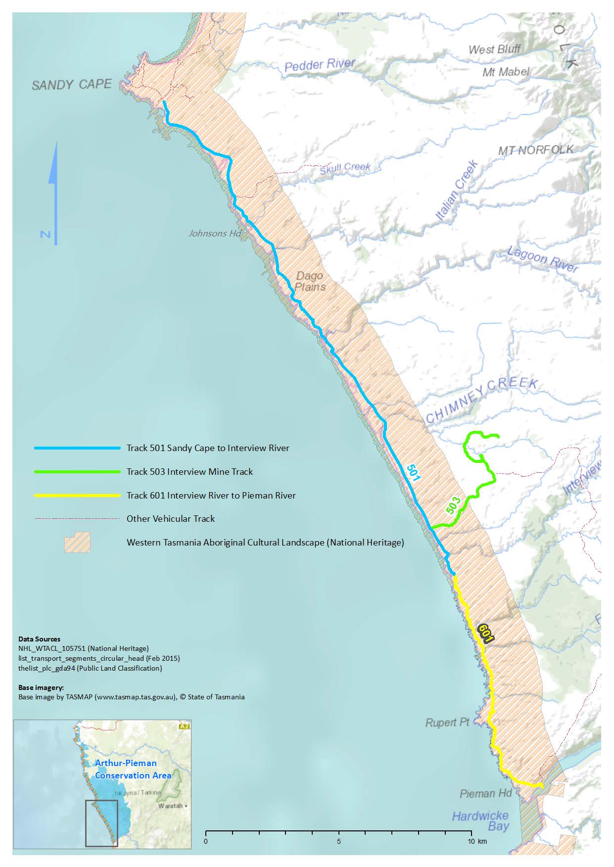
ANNEXURE B – PHOTOGRAPH OF TRACK CUTTING THROUGH MIDDEN SITE ON TRACK 501