
FEDERAL COURT OF AUSTRALIA
Daphney on behalf of the Kowanyama People v State of Queensland [2014] FCA 1149
| IN THE FEDERAL COURT OF AUSTRALIA | |
| DATE OF ORDER: | |
| WHERE MADE: |
THE COURT NOTES THAT:
A. A Native Title Determination Application was lodged in the Federal Court of Australia on 30 September 1998, QUD 6119 of 1998 (“the Application”) which relates to an area which includes the land and waters the subject of the proposed determination.
B. On 22 October 2009 a determination that native title exists was made by consent by the Federal Court of Australia over the land and waters of Part A of the area covered by the Application (“the Part A determination”).
C. On 5 December 2012 a determination that native title exists was made by consent by the Federal Court of Australia over the land and waters of Parts B and C of the area covered by the Application (“the Parts B and C determinations”).
D. The parties to the Application that hold an interest in relation to the land or waters of Part D of the area covered by the Application have asked the Federal Court of Australia to make a consent order for a determination of native title over the land and waters of Part D of the area covered by the Application.
E. The land and waters of Part D of the area covered by the Application include the land and waters covered by Native Title Determination Application QUD 282/2012 and by Native Title Determination Application QUD 743/2013, which applications were combined with the Application on 5 December 2013.
BEING SATISFIED that a determination in the terms sought by the parties is within the power of the Court, and it appearing appropriate to the Court to do so, pursuant to s 87 of the Native Title Act 1993 (Cth),
BY CONSENT THE COURT ORDERS THAT:
1. There be a determination of native title in the terms set out below (“the determination”).
2. The determination will take effect upon the agreement referred to in para 4(c) of Sch 4 being registered on the Register of Indigenous Land Use Agreements.
3. In the event that the agreement referred to in para 4(c) of Sch 4 is not registered on the Register of Indigenous Land Use Agreements within six months of the date of this order or such later time as this Court may order, the matter is to be listed for further directions.
4. Native title exists in relation to that part of the Determination Area described in Pts 1, 2 and 4 of Sch 2.
5. The native title is held by the persons described in Sch 1 (“the native title holders”).
6. Subject to paras 8, 9 and 10 the nature and extent of the native title rights and interests in relation to that part of the Determination Area identified in Pt 1 of Sch 2 are:
(a) other than in relation to Water, the rights to possession, occupation, use and enjoyment of the area to the exclusion of all others; and
(b) in relation to Water, the non-exclusive rights to:
(i) hunt, fish and gather from the Water of the area;
(ii) take and use the Natural Resources of the Water in the area; and
(iii) take and use the Water of the area for personal, domestic and non-commercial communal purposes.
7. Subject to paras 8, 9 and 10 the nature and extent of the native title rights and interests in relation to land and waters within that part of the Determination Area identified in Pts 2 and 4 of Sch 2 as the non-exclusive rights to:
(a) access, be present on, move about on and travel over the area;
(b) hunt and fish in or on, and gather from, the land and Water for non-commercial, cultural, spiritual, personal, domestic or communal purposes;
(c) take, use, share and exchange Natural Resources for non-commercial, cultural, spiritual, personal, domestic or communal purposes;
(d) take and use the Water for cultural, personal, domestic and non-commercial communal purposes;
(e) live and camp on the area and for those purposes erect shelters and other structures on the area;
(f) light fires on the area for cultural, spiritual or domestic purposes, including cooking, but not for the purpose of hunting or clearing vegetation;
(g) be buried and bury native title holders within the area;
(h) conduct ceremonies on the area;
(i) hold meetings on the area;
(j) teach on the area the physical and spiritual attributes of the area;
(k) maintain places of importance and areas of significance to the native title holders under their traditional laws and customs and protect those places and areas from harm; and
(l) be accompanied on to the area by those persons who, though not native title holders, are:
(i) spouses or partners of native title holders;
(ii) people who are members of the immediate family of a spouse or partner of a native title holder;
(iii) people reasonably required by the native title holders under traditional law and custom for the performance of ceremonies or cultural activities on the Determination Area; or
(iv) people who have specialised knowledge based on their training, study or experience who are requested by native title holders to observe or record traditional activities or otherwise to investigate matters of cultural significance on the Determination Area.
8. There are no native title rights in or in relation to minerals as defined by the Mineral Resources Act 1989 (Qld) and petroleum as defined by the Petroleum Act 1923 (Qld) and the Petroleum and Gas (Production and Safety) Act 2004 (Qld) and other resources legislation.
9. The native title rights and interests are subject to and exercisable in accordance with:
(a) the Laws of the State and the Commonwealth; and
(b) the traditional laws acknowledged and traditional customs observed by the native title holders.
10. The native title rights and interests referred to in paras 6(b) and 7 do not confer possession, occupation, use or enjoyment to the exclusion of all others.
11. The nature and extent of any other rights and interests in relation to the Determination Area (or respective parts thereof) are set out in Sch 4.
12. The relationship between the native title rights and interests described in paras 6 and 7 and the other rights and interests described in Sch 4 (“the other rights and interests”) is that:
(a) the other rights and interests continue to have effect, and the rights conferred by or held under the other rights and interests may be exercised notwithstanding the existence of the native title rights and interests;
(b) where the non-extinguishment principle applies to the other rights and interests, to the extent the other rights and interests are inconsistent with the continued existence, enjoyment or exercise of the native title rights and interests:
(i) the native title continues to exist in its entirety but the native title rights and interests have no effect in relation to the other rights and interests to the extent of the inconsistency; and
(ii) if the other rights and interests are later removed or otherwise permanently cease to operate, either wholly or partly, the native title rights and interests will again have effect to the extent of the removal or cessation of the other rights and interests; and
(c) the other rights and interests and any activity that is required or permitted by or under and done in accordance with the other rights and interests, prevail over the native title rights and interests and any exercise of the native title rights and interests.
13. If a word or expression is not defined in this order and is defined in the Native Title Act 1993 (Cth), it has the meaning given to it in the Native Title Act 1993 (Cth). In addition, unless the contrary intention appears:
“Determination Area” means the land and waters described in Pts 1, 2 and 4 of Sch 2 excluding the areas described in Pt 3 of Sch 2, and shown on the map in Sch 3, and to the extent of any inconsistency between them, Sch 2 prevails;
“High Water Mark” means the ordinary high-water mark at spring tides;
“Laws of the State and the Commonwealth” means the common law and the laws of the State of Queensland and the Commonwealth of Australia, and includes legislation, regulations, statutory instruments, local planning instruments and local laws;
“Local Government” has the meaning given in the Local Government Act 2009 (Qld);
“native title determination applications” means the Application, QUD 282/2012 and QUD 743/2013;
“Natural Resources” includes:
(a) animals;
(b) plants; and
(c) charcoal, wax, resin, clay, soil, sand, shell, gravel, rock or other such material naturally occurring in the land and waters of the Determination Area,
that have traditionally been taken and used by the native title holders, but does not include:
(d) animals that are the private personal property of another;
(e) crops that are the private personal property of another; and
(f) minerals as defined in the Mineral Resources Act 1989 (Qld) or petroleum as defined by the Petroleum Act 1923 (Qld) and the Petroleum and Gas (Production and Safety) Act 2004 (Qld);
“Tidal River” means a river, creek or stream, connecting to the sea, whether in a natural state or otherwise, as far up as the spring tide ordinarily flows and reflows;
“Tidal Water” means any part of the sea (including any Tidal River and the beds and banks of such river) ordinarily within the ebb and flow of the tide at spring tides; and
“Water” has the meaning giving in the Water Act 2000 (Qld) and Tidal Water.
THE COURT FURTHER ORDERS THAT:
14. The native title is not held in trust.
15. The Abm Elgoring Ambung Aboriginal Corporation RNTBC (ICN 7163), incorporated under the Corporations (Aboriginal and Torres Strait Islander) Act 2006 (Cth) is to:
(a) be the prescribed body corporate for the purpose of s 57(2) of the Native Title Act 1993 (Cth); and
(b) perform the functions mentioned in s 57(3) of the Native Title Act 1993 (Cth).
16. Each party to the proceeding is to bear its own costs.
SCHEDULE 1 – NATIVE TITLE HOLDERS
The native title holders are the Kowanyama People who comprise those people known as the Yir Yoront (sometimes called Kokomenjen), Koko Bera, Kunjen and Koko Berrin Peoples. The Yir Yoront, Koko Bera, Kunjen and Koko Berrin Peoples are those Aboriginal people who are:
1. the cognatic descendants of:
(i) Solomon Minyalk;
(ii) Thin Mitin Mart;
(iii) Min Yal Panaurin;
(iv) Art Kadlaurin
(v) any of the siblings Kal Koral, Kor Mart, Min Koko Taren or Mad Len;
(vi) Pow Mon Alithanem;
(vii) Kauan Kor Mar’pen;
(viii) any of the siblings Paul, Rio or Biddy;
(ix) Yor Kantl Yamen;
(x) any of the siblings Mark, Barnabas or Kate;
(xi) Arthur, the father of Smiler Misson;
(xii) Luke;
(xiii) any of the siblings Native, Wilson, Akul Edngan, Uyan or Ginger;
(xiv) any of the siblings Major, Sergeant, Bobella or Gregory;
(xv) Mickey;
(xvi) Boandonolly (aka Puntanolli);
(xvii) George Black (aka Thamil Polp);
(xviii) either of the brothers “Barramundi” Charlie or Lamp;
(xix) Gilbert;
(xx) Eagleman, the father of Barney Jubilee;
(xxi) Joe Highbury;
(xxii) Jackson;
(xxiii) Tent (aka Thol Kol Kith);
(xxiv) Bruno (aka Wurrpwin)
(xxv) Min Kawlto Tower Moilin;
(xxvi) Wo Pam Mal Yamin;
(xxvii) Mokara Hudson;
(xxviii) either of the siblings George or Purt Ngon;
(xxix) Bob Patterson;
(xxx) Moses (aka War’luran);
(xxxi) Yowalyamen;
(xxxii) Jolly;
(xxxiii) either Mailman or his siblings;
(xxxiv) any of the siblings Stephen, Louie, Reubin (aka Robin), Jimmy Braddsley, Mabel Rio or Poppy;
(xxxv) Old Mokara;
(xxxvi) Taw Wil Yir;
(xxxvii) Colin Dinghy;
(xxxviii) Fred Dunbar;
(xxxix) Alick (aka Alec and Kauwunbengk);
(xl) Goanna (aka Melder);
(xli) Pluto;
(xlii) either Mundie Shalfo or his sister;
(xliii) Piper;
(xliv) Willie Daphney;
(xlv) any of the siblings Fanny, Lucy Tommy, Waterloo, Elsie or Tommy Burns;
(xlvi) Nipper;
(xlvii) Dick;
(xlviii) Peppo;
(xlix) Ben;
(l) Smiler;
(li) Bernard;
(lii) Monday;
(liii) Kangaroo;
(liv) Mosquito;
(lv) either of the brothers Billy Flower or Goggle-Eye or their siblings;
(lvi) Jimmy;
(lvii) either of the brothers Rainbow Christie or Bowyang Charlie;
(lviii) Nellie;
(lix) either of the brothers Bob Dunbar or Bendigo or their siblings;
(lx) any of the siblings Jimmy Koolatah, Coglin Dick, Kunjen Dick or George Murray;
(lxi) Frank Yam;
(lxii) Brumby (aka Jack Brumby)
(lxiii) Old Mud;
(lxiv) Charlie Inkerman;
(lxv) any of the siblings Mimosa, Alison or May; or
(lxvi) Maggie; or
2. recruited by adoption, in accordance with the traditional laws and customs of the Yir Yoront, Koko Bera, Kunjen and Koko Berrin Peoples.
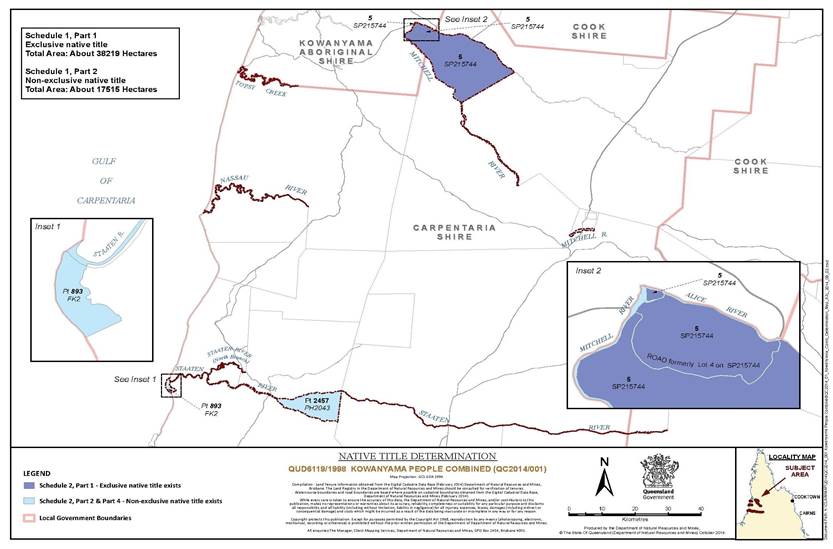
SCHEDULE 2 – DETERMINATION AREA
The Determination Area comprises all of the land and waters described in Pts 1, 2 and 4 below, and depicted on the determination map in Sch 3, excluding the areas described in Pt 3 below.
All of the land and waters described in the following table and depicted in dark blue on the determination map:
| Area description (as at date of determination) |
| Lot 5 on Plan SP215744 |
Part 2 – Non-exclusive areas
All of the land and waters described in the following table and depicted in light blue on the determination map:
| Area description (as at date of determination) | |
| The area of road formerly described as Lot 4 on Plan SP215744 | |
| That part of Lot 2457 on Plan PH2043 south of the centreline of the Staaten River. | |
| That part of Lot 893 on Plan FK2 that is within the area described as: Commencing at the intersection of the southern bank of the Staaten River and the western bank of an unnamed creek at approximate Longitude 141.301517° East, being on the northern boundary of Lot 893 on Plan FK2; then generally southerly along the western bank of that creek to Latitude 16.431035° South; then south westerly to the High Water Mark at Latitude 16.438868° South; then generally northerly along the coastline of the Gulf of Carpentaria at the High Water Mark, also being the western boundary of Lot 893 on Plan FK2, and onwards to the southern bank of the Staaten River; then generally south easterly along the southern bank of the Staaten River back to the commencement point. | |
| That part of Topsy Creek, Mitchell River, Nassau River, Alice River and Staaten River as described in Part 4. | |
Part 3 – Areas excluded from the Determination Area
The areas in this Part are excluded from the Determination Area on the grounds that at the times at which the native title determination applications were made these areas were the subject of one or more previous exclusive possession acts, as defined in s 23B of the Native Title Act 1993 (Cth), despite the fact that the areas, or parts of them, may have been subject to earlier acts that extinguished native title and, therefore, in accordance with s 61A of the Native Title Act 1993 (Cth), these areas could not be claimed.
The land or waters on which any other public work, as defined in s 253 of the Native Title Act 1993 (Cth), is constructed, established or situated, and to which ss 23B(7) and 23C(2) of the Native Title Act 1993 (Cth) and/or s 23B(7) of the Native Title Act 1993 (Cth) and s 21 of the Native Title (Queensland) Act 1993 (Qld), applies, together with any adjacent land or waters in accordance with s 251D of the Native Title Act 1993 (Cth).
Part 4 – Non-exclusive watercourse descriptions
All the land and waters within the areas described as:
Nassau River
Commencing at the north east corner of Lot 2480 on PH2046 (Kuparee) and extending generally westerly and generally south westerly along the northern boundary of that lot, being the southern bank of the Nassau River, to the High Water Mark of the Gulf of Carpentaria; then northerly across the mouth of that river between the seaward extremities at High Water Mark of each of the opposite banks; then generally north easterly and generally easterly along the southern boundary of Lot 1796 on PH1651, being the northern bank of the Nassau River back to the commencement point.
Alice River
Commencing at the southwest corner of Lot 12 on CTH804427 (Helmsley), being a point on the northern bank of the Alice River, and extending south westerly along the prolongation of the western boundary of Lot 12 on CTH804427 across the Alice River to its southern bank; then generally westerly along that bank to the intersection of the south eastern bank of the Mitchell River; then north westerly to again the northern bank of the Alice River at approximate Longitude 141.968323° East; then generally easterly along that bank, being the boundary of Lot 19 on SP224321, back to the commencement point.
Mitchell River Part 1
Commencing at the intersection of the northern bank of the Alice River and approximate Longitude 141.968323° East and extending south easterly to the intersection of the southern bank of the Alice River and eastern bank of the Mitchell River; then generally south westerly and generally south easterly along that bank, being the north west and south west boundaries of Lot 5 on SP215744 and southwest boundary of Lot 13 on CTH3 (Kulata), to Lot 3 on MM2 (Dunbar); then south westerly along the northern boundary of that lot to the south western bank of the Mitchell River; then generally north westerly and generally north easterly along the south western and north western bank of the Mitchell River back to the commencement point. This area includes the anabranch of the Mitchell River adjacent to Lot 5 on SP215744.
Mitchell River Part 2
Commencing at the southeast corner of Lot 2 on CTH1 and extending south westerly, generally south westerly and north easterly along the boundaries of Lot 3 on MM2 (Dunbar Pastoral Lease) to the northern bank of the Mitchell River; then generally north easterly along the northern bank of that river back to the commencement point.
Staaten North Branch
Commencing at the southeast corner of Lot 2322 on SP254319 (Alma) and extending generally north westerly and generally south westerly along the northern boundaries of Lot 2457 on PH2043 (Galbraith) and Lot 746 on OL298, being the southern bank of the Staaten River (North Branch), to the eastern bank of the Staaten River; then northerly across the mouth of that North Branch to its northern bank; then generally north easterly and generally south easterly along the southern boundary of Lot 2322 on SP254319 (Alma), being the northern bank of the Staaten River (North Branch) back to the commencement point.
Staaten River (Western Section)
Commencing at the intersection of the centreline of the Staaten River and the southern boundary of Lot 2457 on PH2043 , being near the confluence with Wyaaba Creek and extending generally westerly along the centreline of the Staaten River to its intersection with a line from the junction of the southern bank of the Staaten River and the western bank of an unnamed creek on the northern boundary of Lot 893 on Plan FK2 at approximate Longitude 141.301517° East and a point on the southern boundary of Lot 2322 on Plan 254319 at Longitude 141.301818° East, then south westerly along that line to the southern bank of the Staaten river; then north westerly along that bank, also being the northern boundary of Lot 893 on Plan FK2 to the mouth of the Staaten River at the High Water Mark on the Gulf of Carpentaria and extending north easterly across the mouth of that river between the seaward extremities at the High Water Mark of each of the opposite banks; then generally easterly along the northern bank of that river back to the commencement point.
Staaten River (Eastern Section)
Commencing at the intersection of the centreline of the Staaten River and eastern boundary of Lot 2457 on PH2043 (Galbraith Pastoral Holding) and extending northerly along the eastern boundary of that lot to the northern bank of the Staaten River; then generally easterly along that northern bank to Lot 2 on NPW123 (Staaten River National Park); then southerly along a western boundary of that lot to the centreline of the Staaten River; then generally westerly along that centreline back to the commencement point.
Topsy Creek
Commencing at the north west corner of Lot 1796 on PH1651 (Rutland Plains), being a point on the southern bank of Topsy Creek and the High Water Mark of the Gulf of Carpentaria and extending northerly across the mouth of that creek between the seaward extremities at High Water Mark of each of the opposite banks; then generally easterly along the southern boundary of Lot 19 on SP224321 (Kowanyama), eastern boundary of Topsy Road, southern boundary of Lot 20 on SP224321 and again the southern boundary of Lot 19 on SP224321 (Kowanyama) to Lot 1796 on PH1651; then generally westerly along the northern boundary of that lot, being the southern bank of Topsy Creek, back to the commencement point.
For the avoidance of doubt, the Determination Area excludes any areas subject to the Part A determination and the Parts B and C determinations.
NOTE
Data Reference and source
• Application boundary data compiled by Client Mapping, Department of Natural Resources and Mines.
• Maritime boundaries data is © Commonwealth of Australia (Geoscience Australia) 2006. AMB 6th Edition released in February 2006.
• Rivers/Creeks where available are based on Casement data sourced from the Department of Natural Resources and Mines, Qld (February 2014) – else Topographic vector data is © Commonwealth of Australia (Geoscience Australia) 2003.
• Cadastral data sourced from Department of Natural Resources and Mines, Qld (February 2014).
Reference datum
Geographical coordinates have been provided by Client Mapping, Department of Natural Resources and Mines and are referenced to the Geocentric Datum of Australia 1994 (GDA94), in decimal degrees and are based on the spatial reference data acquired from the various custodians at the time.
Use of Coordinates
Where coordinates are used within the description to represent cadastral or topographical boundaries or the intersection with such, they are intended as a guide only. As an outcome to the custodians of cadastral and topographic data continuously recalculating the geographic position of their data based on improved survey and data maintenance procedures, it is not possible to accurately define such a position other than by detailed ground survey.
Prepared by Client Mapping, Department of Natural Resources and Mines (20 May 2014).
SCHEDULE 3 – DETERMINATION MAP
SCHEDULE 4 – OTHER RIGHTS AND INTERESTS IN THE DETERMINATION AREA
The nature and extent of the other rights and interests in the Determination Area are the following as they exist at the date of this determination:
1. The rights and interests of:
(a) the lessee and others under a term lease being title reference No. 17668080 comprising Lot 2457 on PH2043; and
(b) the lessee and others under a term lease being title reference No. 17668055 comprising part of Lot 893 on FK2.
2. The rights and interests of the State of Queensland and the Carpentaria Shire Council to access, use, operate and maintain the area delineated as road on plan SP215744 for its dedicated purpose and the rights and interests of the public to access and use the road.
3. The rights and interests of Carpentaria Shire Council including any rights the Council, its employees, agents or contractors have:
(a) under its local government jurisdiction and functions under the Local Government Act 2009 (Qld), under the Land Protection (Pest and Stock Route Management) Act 2002 (Qld) and under any other legislation, for that part of the Determination Area within its local government area, as defined in the Local Government Act 2009 (Qld);
(b) as the:
(i) holder of any validly granted licences, permits or other rights and interests which were granted as at the date of the determination;
(ii) trustee of any validly gazetted reserves that exist in the Determination Area as at the date of the determination;
(c) as the owner and operator of infrastructure, facilities and other improvements located in the Determination Area as at the date of the Determination including but not limited to:
(i) dedicated roads controlled by Council;
(ii) gravel pits operated by Council;
(d) as the manager of undedicated but constructed roads except for those not operated by Council;
(e) to enter the land described in paras 3(a) to 3(d) in compliance with any legislative requirements regarding notice or otherwise to:
(i) exercise any of the rights and interests referred to in paras 3(a) to 3(d);
(ii) inspect, maintain and repair the infrastructure facilities and other improvements referred to in paras 3(c) and 3(d); and
(iii) undertake operational activities in its capacity as a local government such as feral animal control, weed control, erosion control, waste management and fire management.
4. The rights and interests of the parties under the following agreements:
(a) the Indigenous Management Agreement between the Errk Oykangand National Park Land Trust and State of Queensland for Errk Oykangand National Park (Cape York Peninsula Aboriginal Land) dated 23 October 2009;
(b) the Indigenous Land Use Agreement for Errk Oykangand National Park (Cape York Peninsula Aboriginal Land) dated 23 October 2009; and
(c) the Indigenous Land Use Agreement between Lawrence Daphney and Ors on behalf of the Kowanyama People and Carpentaria Shire Council authorised by the Kowanyama People on 14 October 2014 and dated 21 October 2014.
5. The rights and interests of the State of Queensland in those parts of the Staaten-Gilbert and Nassau River declared fish habitat areas within the Determination Area, as shown on Plan FHA-059 and Plan FHA-061 held by the Department of National Parks, Recreation, Sport and Racing and the interests of persons entitled to access and use those habitats.
6. The rights and interests granted by the State of Queensland pursuant to statute or otherwise in the exercise of its executive power including, but not limited to, the rights and interests of persons holding licenses, permits or authority pursuant to the Fisheries Act 1994 (Qld) and regulations, declarations or management plans made under that Act.
7. The rights and interests granted by the Commonwealth pursuant to statute or otherwise in the exercise of its executive power including, but not limited to, the rights and interests of persons holding licences, permits, statutory fishing rights, or other statutory rights pursuant to:
(a) the Fisheries Management Act 1991 (Cth), or regulations or management plans made under that Act; and
(b) any other legislative scheme for the control, management and exploitation of the living resources within the Determination Area.
8. The rights and interests of members of the public arising under the common law, including but not limited to:
(a) the public right to fish; and
(b) the public right to navigate.
9. So far as confirmed pursuant to s 212(2) of the Native Title Act 1993 (Cth) and s 18 of the Native Title (Queensland) Act 1993 (Qld) as at the date of this determination any existing rights of the public to access and enjoy, the following places in the Determination Area:
(a) waterways;
(b) beds and banks or foreshores of waterways;
(c) coastal waters;
(d) beaches;
(e) stock routes; and
(f) areas that were public places at the end of 31 December 1993.
10. Any other rights and interests:
(a) held by the State or Commonwealth; or
(b) existing by reason of the force and operation of the Laws of the State and the Commonwealth.
Note: Entry of orders is dealt with in Rule 39.32 of the Federal Court Rules 2011.
| QUEENSLAND DISTRICT REGISTRY | |
| GENERAL DIVISION | QUD 6119 of 1998 |
| BETWEEN: | LAWRENCE DAPHNEY, CHRIS HENRY, CHARLOTTE YAM, MICHAEL MITCHELL, ARTHUR LUKE SNR, TEDDY BERNARD, COLIN LAWRENCE JNR, CHARMAINE LAWRENCE, LAVINIA INKERMAN, CELZA INKERMAN AND HILTON NOBLE ON THEIR OWN BEHALF AND ON BEHALF OF THE KOWANYAMA PEOPLE |
| AND: | STATE OF QUEENSLAND First Respondent GREG HOOK Second Respondent JUSTIN HOOK Third Respondent PETER TONON Fourth Respondent CLAUDINE ELIZABETH WARD Fifth Respondent GARY DAVID WARD Sixth Respondent SHANE ANDREW WARD Seventh Respondent YAN WARD Eighth Respondent CARPENTARIA SHIRE COUNCIL Ninth Respondent |
| JUDGE: | GREENWOOD J |
| DATE: | 31 OCTOBER 2014 |
| PLACE: | CAIRNS |
REASONS FOR JUDGMENT
1 The Kowanyama People lodged a native title determination application in the National Native Title Tribunal on 25 March 1997 which, following amendments to the Native Title Act 1993 (Cth) (the “Act”) on 30 September 1998, became Federal Court proceeding QUD 6119 of 1998. Today, the Court sitting here in Cairns makes orders that give finality to that application over the remaining portion of the original application, known as Part D, which has been combined with the Kowanyama #2 application (QUD 282/2012) and the Kowanyama #3 application (QUD 743/2013).
2 The native title claim group is comprised of all persons descended from the identified apical ancestors whose names are set out in Sch 1 to the orders made today.
3 The initial Kowanyama application was progressed through mediation and otherwise, in three parts. On 22 October 2009, I made orders at Kowanyama that recognised native title over the land and waters in Part A (Kowanyama People v State of Queensland [2009] FCA 1192) (the “Kowanyama Part A reasons”). On 5 December 2012, Dowsett J also travelled to Kowanyama to make orders in respect of Parts B and C (Greenwool for and on behalf of the Kowanyama People v State of Queensland [2012] FCA 1377).
4 The original application has been amended by orders of the Court both before and after the two earlier determinations referred to above. On 1 April 2011, leave was granted to amend the application to remove the area that is now known as Errk Oykangand National Park (the “National Park”). On 29 November 2012, the Court partitioned the Kowanyama People’s application to reduce the area of Part B and, from that area, created a new Part D which is now part of the land and waters of the proposed orders.
5 On 13 June 2012, the Kowanyama #2 application (QUD 282 of 2012) was filed over the land and waters of the National Park.
6 On 8 November 2013, the Kowanyama #3 (QUD 743 of 2013) application was filed to include areas within the external boundary of the original Kowanyama application that were omitted from the determination area in Parts B and C that had been determined by Dowsett J.
7 On 5 December 2013, leave was granted to amend the application pursuant to s 64(2) of the Act, to combine the remaining Part D area of the original Kowanyama application with Kowanyama #2 and Kowanyama #3 applications. The combined application area concerns the Determination Area which is the subject of the proposed orders. On 7 February 2014, the application was further amended to change the composition of the applicant group.
8 On 7 April 2014, the combined application passed the registration test pursuant to s 190A of the Act and remains on the Register of Native Title Claims. The notification period for Part D ended on 6 August 2014 pursuant to s 66 of the Act.
9 The parties who have joined the proceedings as respondents and remain as respondents to the combined application are the State of Queensland, Carpentaria Shire Council and the fishing parties Greg Hook, Justin Hook, Peter Tonon, Claudine Elizabeth Ward, Gary David Ward, Shane Andrew Ward and Yan Ward.
10 The orders made today recognise non-exclusive native title rights and interests over the areas currently subject to pastoral leases and portions of land and waters inadvertently omitted from the earlier determinations, identified in Pt 2 of Sch 2 to the orders.
11 The balance of the Determination Area is comprised of the Errk Oykangand National Park identified in Pt 1 of Sch 2 where exclusive native title rights are recognised pursuant to s 47A of the Act and an internal road within the National Park where non-exclusive rights are recognised. The rights and interests of the parties in respect of the National Park are identified in para 4 of Sch 4 to the orders.
12 The applicant group presently consists of Lawrence Daphney, Chris Henry, Charlotte Yam, Michael Mitchell, Arthur Luke Snr, Teddy Bernard, Colin Lawrence Jnr, Charmaine Lawrence, Lavinia Inkerman, Celza Inkerman and Hilton Noble on their own behalf and on behalf of the members of the Kowanyama People who comprise those people known as Yir Yoront (sometimes called Kokomenjen), Koko Bera, Kunjen and Koko Berrin.
13 The Cape York Land Council is the native title representative body for the area and is the legal representative for the Kowanyama People in relation to the application and the proposed Part D determination.
14 An agreement signed by the remaining parties was filed under s 87A(2) of the Act by the Cape York Land Council on 24 October 2014. The consent orders which the parties ask the Court to make are attached to the agreement.
15 Section 13(1) of the Act provides that an application for a determination of native title may be made under Pt 3 of the Act in relation to an area for which there is no approved determination of native title. The present application is made under s 61 of the Act within Pt 3 and there is no approved determination in relation to the land and waters within the Determination Area. I am familiar with the material in this application having been involved in the case management of the Kowanyama proceedings since May 2006.
16 The orders made today concern the land and waters of claim areas comprising the earlier Part D portion of the original application (QUD 6119/1998), the land and waters of the National Park (Kowanyama #2, QUD 282/2012) and the areas comprised within the Kowanyama #3 claim (QUD 743/2013), being all of the land and waters described in Pts 1, 2 and 4 of Sch 2 to the Orders made today and depicted on the determination map in Sch 3 (excluding the areas described in Pt 3 of Sch 2).
17 I am satisfied that the four factors prescribed by s 87A(1) have been satisfied.
18 The section applies if firstly there is a proceeding for a determination of native title on foot; secondly, an agreement has been reached on a proposed determination for a part of the claim area after the s 66 notification period; thirdly, all of the relevant persons are parties to the agreement (namely, the applicant, each registered native title claimant in relation to any part of the determination area who is a party to the proceeding, each representative Aboriginal/Torres Strait Islander body for any part of the determination area, each person who holds an interest in any part of the determination area, each person who claims to hold native title in relation to land or waters in the determination area, the Commonwealth, and the relevant state and local government bodies); and fourthly, the terms of the proposed determination are in writing and signed by or on behalf of those parties.
19 Further, s 87A(4) requires the Court to be satisfied that the orders are within power and that it would be appropriate to make the orders sought.
20 Orders made under s 87A of the Act not only take effect inter-parties in the resolution of the claims made in the proceedings but represent an independent judicial determination, in the exercise of the judicial power of the Commonwealth, that may be asserted, as a matter of law, against anyone. Although the Act by s 223(1)(c) in part defines native title or native title rights and interests by reference to the rights and interests recognised by the common law of Australia, a determination of native title expresses the recognition and protection of those rights and interests in relation to land and waters defined and described in s 223 of the Act which find their origin in traditional laws and customs, not the Act: Members of the Yorta Yorta Aboriginal Community v State of Victoria (2002) 214 CLR 422 (“Yorta Yorta”) at [75] and [76] per Gleeson CJ, Gummow and Hayne JJ.
21 I am satisfied that the proposed orders are consistent with the proposed determination and within power.
22 A number of considerations are to be taken into account in determining whether the proposed orders appear appropriate to the Court.
23 Firstly, the Act recognises and encourages the resolution of applications by mediation, negotiation and ultimately agreement without the need for a hearing and the assessment of evidence and fact-finding by the Court necessary in the course of resolving a controversy. Similarly, the Act recognises and encourages the determination of native title in relation to an area within the area covered by an application, by mediation, negotiation and ultimately agreement without the need for a hearing.
24 Secondly, the Court will be concerned to understand and place emphasis upon whether the agreement is freely made on an informed basis by all parties to the determination and whether the parties are represented by experienced independent lawyers. In the case of a State party representing the public interest, the Court will consider whether appropriate consideration has been given to the issues raised by the proposed consent determination.
25 Thirdly, so far as the State is concerned, the Court recognises that a State has access to its own archival material and generally has had a long period of engagement with Aboriginal communities and is therefore likely to be familiar with the historical arrangements within those communities.
26 Fourthly, although it is not necessary for the Court to consider the body of material that would be available to it in the course of a contested hearing, the Court ought to have regard to sufficient material which is capable of demonstrating that the agreement and the proposed orders are “rooted in reality” (“Native Title – A Constitutional Shift?”, University of Melbourne Law School, JD Lecture Series, Chief Justice French, 24 March 2009): Wik and Wik Way Native Title Claim Group v State of Queensland (2009) 258 ALR 306.
27 In that sense, the Court ought to be satisfied that the proposed orders are prima facie appropriate in order to satisfy the test under s 87A(4) of the Act.
28 In this case, the parties to the proposed determination are represented by lawyers experienced in the conduct of native title proceedings and the analysis of issues arising in such proceedings. During the course of these proceedings which have led to the proposed consent determination, the State of Queensland has been provided with extensive material between May 1996 and August 2009. It is not necessary to set out the content of that material in these reasons.
29 I am entirely satisfied that the parties to this agreement have been represented by lawyers experienced in these issues and that the parties have come to a fully informed agreement.
30 In addition, the State of Queensland has had a long engagement with the Aboriginal people of the Determination Area.
31 In the Kowanyama Part A reasons I referred to the extensive work done by Dr John Taylor at [26] to [28] in these terms:
[26] Dr Taylor has been retained as an anthropological consultant in relation to the Kowanyama native title claim since 1997. More importantly, Dr Taylor has carried out studies of the Kowanyama native title claim group and worked with members of the group and their predecessors since 1971. During the course of his studies of the Kowanyama native title claim group, Dr Taylor has carried out research into the anthropological, historical, linguistic, genealogical and cultural materials that relate to members of the group and their predecessors in the Kowanyama region. Dr Taylor has mapped Aboriginal landscapes and ownership patterns which has involved extensive site mapping and the study of the principles of land ownership in the Kowanyama region. The nature and extent of Dr Taylor’s research work in relation to the Kowanyama region including the land and waters the subject of the primary application is the subject of a document described as “Overview of Connection Materials in support of the Kowanyama Part A Native Title Determination”. That report was filed in the Court on 28 September 2009.
[27] Dr Taylor in his affidavit filed on 28 September 2009 expresses this opinion at paragraph 12:
I am of the opinion that the research conducted in relation to the Kowanyama native title claim group’s determination application demonstrates that:
(a) the members of the Kowanyama native title claim group are descended from the traditional society in occupation of the land and waters identified as the determination area at the time of sovereignty;
(b) the society in occupation of the determination area at the time of sovereignty observed traditional laws and customs which have continued to be acknowledge and observed by the members of the Kowanyama native title claim group and their predecessors;
(c) through the continued acknowledgement and observation of the traditional laws and customs, the members of the Kowanyama native title claim group and their predecessors have maintained a connection to the determination area;
(d) the activities undertaken by the members of the Kowanyama native title claim group on the determination area are referable to the rights and interests identified in the proposed consent determination of native title, as regulated by their traditional laws and customs.
[28] The facts on which Dr Taylor relies in asserting that opinion either lie within his own knowledge based on his own field work with the Kowanyama People or alternatively derive from findings and data assembled by other researchers or facts contained in historical, government or mission records which Dr Taylor has considered in the course of his own research. Dr Taylor’s work on these anthropological questions is the subject of many publications.
32 I have considered the detailed Overview of Connection Materials in support of the determination application. I am entirely satisfied that it is appropriate to make the proposed orders.
33 My reference in the Kowanyama Part A reasons to the archaeological and anthropological evidence has direct relevance to my consideration of the elements supporting the determination on behalf of the Kowanyama People. In the Kowanyama Part A reasons I said this:
[31] The archaeological evidence demonstrates that Aboriginal people have occupied Cape York Peninsula for over 37,000 years. The first European contacts with Aboriginal people inhabiting the claim area were recorded in the logs of the second Dutch expedition from Batavia to the Gulf of Carpentaria in 1623. The Pera and the Arnhem under the direction of Carstenez made landfall on 12 April 1623 on Cape York Peninsula near Cape Keerweer. Aboriginal people were observed burning grass near the shoreline. On 17 April 1623, the Pera stood off the coast just south of the mouth of the Mitchell River in the vicinity of Topsy Creek which now forms the northern boundary between the DOGIT lands and Rutland Plains Station. The Carstenez log contains this entry for 18 April 1623:
About midday (of the 18th) having seen persons on the beach, we anchored, and the skipper of the Pera was ordered to row ashore with both boats armed for defence. Later in the afternoon, when the boats returned, the skipper reported that as soon as the party had landed a great mob of blacks, some with arms and some without, had come up to them and were so bold and free as to touch the men’s muskets and try to take them off their shoulders, and in fact, wanted to take everything they thought they might have a use for. These being kept interested with iron and beads, an opportunity was espied, and one of them was seized by a string which he had round his neck and taken on board the boat. The others who were on the beach made a great hubbub and outcry, but those who were concealed in the bush remained there. The said people are pitch black, thin in body, and stark naked, with basketwork or nets around their heads. As regards their hair and figure, they are like the blacks of the coast of Coromandel, but they seem to be less cunning, bold and wicked than the blacks at the west end of New Guinea. Their weapons, some of which we are bringing with us, are assegais, shields, clubs and sticks about 1½ fathoms in length, and are not as formidable as those we have seen among other blacks. As regards their manners and policy, and the nature of their country, Your Worships will in time perhaps be able to elicit some information from the captured blacks to whom I refer you.
[32] These engagements took place in and around the areas the subject of the primary claim. In June 1845, Ludwig Leichhardt’s expedition entered the claim area. He observed Aboriginal people diving for water lily bulbs, and engaged in other activities. In 1864 and 1865, the Jardine brothers took a herd of 250 cattle from Carpentaria Downs to Somerset at the tip of Cape York Peninsula. The Jardine party entered the claim area along the Staaten River which they followed westwards until they reached the coastal plains. The party noted many signs of human occupation at campsites and fish weirs and often came upon Aboriginal groups hunting or fishing.
[33] Permanent European settlement commenced during the 1880s when large areas of land around the lower reaches of the Mitchell River were taken up for pastoral purposes including the Dunbar Station Selection in 1882. In 1897, Queensland’s colonial legislature took steps to set aside significant areas of coastal land stretching from below the Mitchell River to the tip of Cape York Peninsula for the purpose of forming Aboriginal reserves. In 1902, Dr Gilbert White, the Anglican Bishop of the newly created diocese of Carpentaria, declared his intention to set up missions dedicated to the pastoral and physical care of Aboriginal people within the diocese. Dr White chose an area of 1,300 square kilometres between the Mitchell and Nassau Rivers observing that the area was:
… The most densely populated Aboriginal centre in Queensland and probably the only one where the natives have not come into more or less disastrous contact with civilisation.
[emphasis added]
[34] Mission workers also set up their tents on a fresh water lagoon not far from the tidal reaches of Topsy Creek in the claim area. The mission was abandoned in 1915. A new site was chosen by J.W. Chapman on a creek in the western end of Koko Bera country. The site was called Kowanyama which was an English rendering of the Yir Yoront “kawn yama” meaning “many waters”. In the 1950s, the Anglican Church began to critically examine its role in the advancement of the Aboriginal communities of Cape York Peninsula and its capacity to sustain its missions and pastoral role. In 1967, the Anglican Church transitioned the administrative control of Kowanyama and Pormpuraaw to the State of Queensland. Aboriginal people have consistently asserted access to their homelands for traditional owners which, on the anthropological evidence, has not been denied by station managers. In 1987, following the enactment of the Land Act (Aboriginal and Islander Land Grants) Amendment Act 1982 (Qld), the Land Act (Aboriginal and Islander Land Grants) Amendment Act 1984 (Qld) and the Community Services (Aborigines) Act 1984 (Qld), the title to the Mitchell River Aboriginal Reserve was vested in the Kowanyama Aboriginal Council as a Deed of Grant in Trust. This initiated a period of increasing community autonomy and control over lands and resources.
[35] Anthropological field research began in the claim area in the mid 1930s when Lauriston Sharp commenced his studies among the Yir Yoront and neighbouring groups (1934, 1937, 1939, 1940, 1952, 1958). Donald Thompson conducted brief kinship research among the “Koko Minjena” at the Mitchell River Mission (1929, 1933, 1972). For several months Thompson camped on the Coleman River in company with a large party of Aborigines. Dr Taylor, stationed at Kowanyama as a medical anthropologist attached to the Queensland Institute of Medical Research, commenced his work in 1971. The work included detailed genealogical studies and work to document land affiliations. Dr Veronica Strang commenced fieldwork at Kowanyama and on neighbouring pastoral properties in 1992. Work was undertaken by Dr Bruce Sommer in 1998 in relation to linguistic and communication patterns. Dr Taylor also prepared indexed family trees based on patrilines to assist others in coming to terms with Kowanyama families and their members. In 1996, Dr Taylor’s genealogies were converted to digital format. Most family lines extend back to apical ancestors whose birth dates occurred well before the establishment of the Mitchell River Mission and the pastoral properties in the claim area. Dr Taylor also documented the landscape in such a way as to reflect the understandings and meanings that Aboriginal people project onto the landscape. These landscape mapping processes are called “close-grained mapping”.
[36] Based on the anthropological research and access to historical documents and records, the Kowanyama People are properly understood as comprising those people known as the Yir Yoront (sometimes called Kokomenjen), Koko Bera, Kunjen and Koko Berrin Peoples, including the applicants and other claimants who together form the native title group. The Kowanyama People are those people who are the cognatic descendents of the individuals identified in Schedule 1 to the orders and those people recruited by adoption in accordance with the traditional laws and customs of the Yir Yoront, Koko Bera, Kunjen and Koko Berrin.
[37] The anthropological material demonstrates that the laws and traditions of the Kowanyama People flow from a totemic ideology constituting a normative system that is widely shared and has been reproduced over generations. The system of laws and traditions specifies obligations and duties and provides for sanctions and punishment. The interests of the claimants in land are acquired through descent which is why identifying family lines (patrilines) associated with parcels of land (estates) in the claim area has been important to identifying the scope of the claimant group. The material demonstrates that the regulation of land tenure has been one of the most important aspects of the totemic system in relating clans to clan domains and individual members to individual clan domains. The contemporary native title rights and interests of the claimants derive from what is described as a “uniquely Aboriginal world view” which has been substantially maintained by the Kowanyama community since it was first described. Dr Taylor identifies 10 central features characterising that world view as the foundation of the Kowanyama system of fundamental laws and principles and traditional ideology. Dr Taylor documents the substantial continuity of practice of Kowanyama traditional law and custom. Dr Taylor concludes that it is reasonable to infer that just as the contemporary system is descended from the classical system, so the classical system is descended from the traditional laws and customs in operation at the time of sovereignty. Dr Taylor identifies eight separate reasons why that is so.
[38] The four “interdependent and interlocking” traditional and customary “general rights” identified by Dr Taylor are:
1. The physical possession, occupation, use and enjoyment of the claim area as of right.
2. The carriage of responsibility for the care and maintenance of the claim area.
3. The right to hold the claim area as the cultural property of the native title group and the source of its identity.
4. The right to act as sole authority to speak for the country.
[39] Dr Taylor identifies the scope and content of each of those four general rights in considerable detail in his reports.
[40] Dr Taylor concludes that the anthropological material establishes that:
(a) The claimants are members of a continuously vital society identified as the Kowanyama People.
(b) The claimants possess a body of traditional laws and customs that constitute a body of normative rules or a normative system.
(c) The claimants’ systems of rules have continued to operate without any substantial interruption from the time of the assertion of sovereignty by the British Crown over the claim area to the present.
(d) The claimants’ laws and customs that make up their contemporary system have their origins in the laws and customs observed and acknowledged by those who held native title to the claim area at the time of the assertion of sovereignty.
(e) The claimants’ rights and interests in land and waters, originate in the rights and interests observed and acknowledged by their predecessors at the time of the assertion of sovereignty.
(f) The claimants’ rights and interests in relation to the land and waters of the claim area have their origins in traditional laws and customs that also specify the collection of individuals and families to that land and those waters.
34 In addition to the anthropological material and affidavits previously filed in respect to Parts A, B and C of the application, I have now read the affidavits of John Clark, Charlotte Yam and Michael Yam filed on 22 July 2014 that demonstrate the exercise of rights and interests in the National Park, where exclusive native title will be recognised. The deponents are members of the Kowanyama claim group.
35 John Clark identifies as a Koko Bera man from his father. His stepfather was a Kunjen person. He says that he speaks for the southern side of Kowanyama right down to the Nassau River.
36 John Clark says this at paras 11 to 19 of his affidavit:
Supervisory and protective activities
There are certain stories you need to pay attention to. There are poison places on the National Park where you aren’t supposed to drive or walk. If you muck around with a story place in the National Park and other sacred places it will make you sick. Not straight away, but years later. It is like a curse. It doesn’t hit you straight away. We try not to put signs near those places, because the moment you put a sign people will try and go there and interfere with places and that is not culturally appropriate.
Nowadays we try and restrict movement around that park to protect our traditional sites. To do that we are closing off the old tracks and keeping people onto the main track. There is also a fair bit of fencing going on around the south of the park at the moment.
Burials in the National Park
Victor Highbury got buried up at the National Park. However, before he got buried he asked me to go up there and find a place where he could be buried. I asked him why he selected me to choose his burial place and he said because he and his wife Annie adopted Uncle Jimmy from George Town.
At the moment when his mum Clara Clark gave birth to Uncle Jimmy she knew she was going to die. Victor and Annie had no son so they adopted uncle Jimmy to become their son and so he took the name Jimmy Clarke-Victor. Now Uncle Jimmy was my mum’s youngest brother and as he didn’t have any sons I became the next in line to become Victor Highbury’s grandson.
I was close to the old fellow and knew about his country and he told me about the old massacre sites and where the stone axes were to be found and where his ancestors were buried. He said that if he was going to die he wanted to be near his people who got murdered in the National Park. He passed away in 2011.
When old man Paddy goes he says that he wants to be buried in Koolatah because that is his country. When my dad died I buried him on Rutland Plains.
When I get up there I always go and visit other places in the National Park such where the Brolga and Emu had a fight.
The National Park is named after Victor’s totem, the Emu Lagoon. Old man Victor told me when his father died the lagoon dried up because he was the main boss of that country and so, Victor knew it was his place through his father Old Joe Highbury.
There are coolabah trees in the National Park and when they grow big the ground around them is hard to dig so if a child died they were sometimes placed in a hollow. Because of that, some of those trees in the park are sacred to us because we don’t know whether the old people have put a baby in there.
37 Michael Yam identifies as a Kunjen-Olkola man who traces his connection and his rights to visit and speak for the National Park from his ancestors. He says that his rights are passed down from his ancestors to their children. He speaks of the exercise of rights in the National Park saying (at paras 9 to 11):
We go back to the park to hunt and gather fish and turtle on both sides of the Mitchell and Alice Rivers. Every second weekend and school holidays during the dry season we go to Shelfo, an important area and make camp and then go and hunt. We catch catfish, saratoga, jewfish, barra and bream. We get red claws and big fresh water prawns. They go straight from the catch and onto the hot coals. Five to ten minutes is all it needs to cook the red claws and fresh water prawn.
As well as collecting firewood, we hunt wallaby and kangaroo and goanna, porcupine and possum. We gather bush tucker for the old people and for those who can’t visit the park anymore. It’s our way of giving back to the old people as they gave us the traditional knowledge.
My mother and her sisters often go to the park. I accompany them when they go out to the bush to gather medicines and take that opportunity to keep an eye on things.
38 Charlotte Yam’s affidavit contains a comprehensive description of her observation of traditional law and custom through her strong belief in the spirits and totems, the use of bush medicine for her family, maintenance of significant sites and care for country. The exercise of the rights that are derived from the traditional laws and customs referred to in the evidence before the Court demonstrate a continued observance of the laws and customs of the Kowanyama people.
39 Accordingly, the parties to the s 87A(2) Agreement have agreed that the native title rights and interests in that part of the Determination Area identified in Pt 1 of Sch 2 to the orders (other than in relation to water), are the rights to possession, occupation, use and enjoyment to the exclusion of all others, subject to paras 8, 9 and 10 of the orders. The nature and extent of the native title rights and interests in relation to that part of the Determination Area identified in Pt 2 of Sch 2 to the orders (other than in relation to water), are the non-exclusive rights to:
1. access, be present on, move about on and travel over the area;
2. hunt and fish in or on, and gather from, the land and Water for non-commercial, cultural, spiritual, personal, domestic or communal purposes;
3. take, use, share and exchange Natural Resources for non-commercial, cultural, spiritual, personal, domestic or communal purposes;
4. take and use the Water for cultural, personal, domestic and non-commercial communal purposes;
5. live and camp on the area and for those purposes erect shelters and other structures on the area;
6. light fires on the area for cultural, spiritual or domestic purposes, including cooking, but not for the purpose of hunting or clearing vegetation;
7. be buried and bury native title holders within the area;
8. conduct ceremonies on the area;
9. hold meetings on the area;
10. teach on the area the physical and spiritual attributes of the area;
11. maintain places of importance and areas of significance to the native title holders under their traditional laws and customs and protect those places and areas from harm; and
12. be accompanied on to the area by those persons who, though not native title holders, are:
(a) spouses or partners of native title holders;
(b) people who are members of the immediate family of a spouse or partner of a native title holder;
(c) people reasonably required by the native title holders under traditional law and custom for the performance of ceremonies or cultural activities on the Determination Area; or
(d) people who have specialised knowledge based on their training, study or experience who are requested by native title holders to observe or record traditional activities or otherwise to investigate matters of cultural significance on the Determination Area.
40 Section 94A of the Act requires that an order for a determination of native title must set out details of the matters mentioned in s 225 of the Act which must be read together with s 223 of the Act.
41 These sections give meaning to the terms “determination of native title” and “native title” and “native title rights and interests”. In Yorta Yorta at [76], Gleeson CJ, Gummow and Hayne JJ treated the statutory elements contained in s 223 as central. The mandatory requirements for a determination of native title are these. The native title rights and interests must be communal, group or individual. They must be rights and interests in relation to land or waters. They must be possessed under the traditional laws acknowledged and the traditional customs observed by Aboriginal peoples; Aboriginal people by their law and customs must have a connection with the land or waters; and the native title rights and interests must be recognised by the common law of Australia.
42 I am satisfied for the purposes of this application that the observations I made in the reasons for judgment in relation to the Kowanyama Part A Determination have equal force in relation to the claims of native title rights in this proceeding. At [45] of the reasons in Kowanyama Part A, I observed that the anthropological material demonstrates:
that the Kowanyama People are descended from a society of Aboriginal people who were in occupation of the land and waters of the Determination Area, being a part of the claim area, at sovereignty and who formed a society united by their acknowledgement and observance of a normative body of traditional laws, customs and beliefs. Through their continued acknowledgement and observance of these normative laws and customs, the Kowanyama People have, since sovereignty, maintained a connection with the Determination Area. I am satisfied that the content of those native title rights and interests which derive from the practice of traditional laws and customs have been identified and established through the anthropological material. The agreement provides for orders entirely consistent with the anthropological material.
43 I am satisfied the proposed orders address each of the elements of s 225 of the Act.
44 Thus, I am satisfied that the orders appear appropriate in accordance with s 87A of the Act.
45 Order 14 of the proposed orders provides that the native title is not held in trust. In the Nomination under s 57(2) of the Act, filed on 21 October 2014, Mr Teddy Bernard nominates the Abm Elgoring Ambung Aboriginal Corporation (the “AEAA Corporation”) to be the prescribed body corporate for the purposes of s 57 of the Act.
46 In an affidavit filed on 22 October 2014, Mr Philippe Savidis, a Senior Legal Officer in the Cape York Land Council who has the carriage of this matter, says that at an authorisation meeting held in Kowanyama on 14 October 2014, a resolution was passed approving the nomination of the AEAA Corporation as the entity to hold the native title pursuant to s 57(2) and (3) of the Act. I am satisfied that the Kowanyama People have approved that nomination and the AEAA Corporation is a prescribed body corporate for the purposes of s 57 of the Act and reg 4(1), and that reg 4(2) is satisfied.
47 In my earlier judgment in Kowanyama Part A, I referred, at [49] to [51], to the steps taken by the Kowanyama People to establish the AEAA Corporation to be the prescribed body corporate for the purposes of s 57(2) of the Act and to perform the functions set out in s 57(3) of the Act. I will not repeat my analysis of those steps.
48 For the reasons I have indicated, the Court makes the orders and the determination sought by the parties. I acknowledge those members of the Kowanyama People who have passed away on the very long journey by the Yir Yoront (sometimes called Kokomenjen), Koko Bera, Kunjen and Koko Berrin People in their quest for recognition of native title over their traditional lands and waters.
49 By these orders, the Federal Court of Australia gives recognition within the Australian legal system to the native title rights and interests of the Kowanyama People in relation to the land and waters of the Determination Area. These native title rights and interests are born out of traditions honoured, and customs practised, by the ancestors of the claimants, and observed and practised by their descendants continuously over time, recognised and protected under the Native Title Act 1993 (Cth).
| I certify that the preceding forty-nine (49) numbered paragraphs are a true copy of the Reasons for Judgment herein of the Honourable Justice Greenwood. |
Associate:

